natural areas of manaia ecological district€¦ · are committed to the vision that has thus far...
TRANSCRIPT

2010
Natural areas of Manaia Ecological District
Reconnaissance survey report for the Protected Natural Areas Programme


i
Report prepared Wildland Consultants Ltd for:
Department of Conservation
Te Papa Atawhai
Northland Conservancy
PO Box 842
149-151 Bank Street
Whangarei 0140
New Zealand
Natural areas of Manaia Ecological District (Northland Conservancy)
Reconnaissance Survey Report for the Protected Natural Areas Programme
Nick Goldwater and Sarah Beadel
2010

i i
© Copyright 2010
New Zealand Department of Conservation
Te Papa Atawhai
Print ISBN: 978-0-478-14755-1
Web ISBN: 978-0-478-14756-8
Cover photo: Bream Head aerial photograph (courtesy of the Bream Head
Conservation Trust).
Natural areas of Manaia Ecological District: reconnaissance survey
report for the Protected Natural Areas Programme / Nick Goldwater
and Sarah Beadel.
Whangarei, N.Z. : Dept. of Conservation, Northland Conservancy,
2010.
1 v. : maps ; 30 cm.
(New Zealand Protected Natural Areas Programme (Series))
1. Ecological surveys 2. Natural areas 3. New Zealand 4.
Northland Region (N.Z.) 5. Manaia Ecological District (N.Z.)
I. Goldwater, Nick
II. Beadel, Sarah M. III. Wildland Consultants Ltd. IV. New
Zealand.
Dept. of Conservation. Northland Conservancy.
Notes Report prepared by Wildland Consultants Ltd. for
Department of Conservation, Northland Conservancy. Includes
bibliographical references.

i i i
Foreword
The Manaia Ecological District PNAP survey report was prepared by
Wildland Consultants Ltd under contract to the Department of Conservation.
This report forms part of a series of reconnaissance survey reports for the
Protected Natural Areas Programme (PNAP) in the Northland Conservancy
of the Department of Conservation. It describes the significant natural
areas of the Manaia Ecological District (ED). Natural areas within the ED
were surveyed by the Department of Conservation from 1997 to 1999,
and subsequently by Wildland Consultants in September 2009. There
has been no previous comprehensive survey and review of ecological
information of this geographical area.
Manaia is the smallest ecological district in the Northland Region, although
its size is very much disproportionate to its rich biodiversity and number
of habitat types. The Ecological District contains several relatively large
and semi-contiguous natural areas, including Manaia Ridge Scenic Reserve
and Surrounds and Bream Head Scenic Reserve and Surrounds, the latter of
which is considered to be the finest example of coastal forest remaining
in Northland. Approximately 52% of the natural areas identified within
this report are formally protected, which equates to around 21.8% of the
total extent of the Ecological District.
Manaia Ecological District takes its name from the sacred maunga/
mountain Manaia, the eponymous ancestor of many Northland iwi
including Ngäti Wai and Ngäti Kahu. The maunga/mountain Manaia also
forms the southeastern boundary of Te Whare Tapu o Ngäpuhi/The Sacred
House of Ngäpuhi. Bream Head Scenic Reserve and Surrounds is of special
significance to iwi, as local Mäori regard the reserve’s mountain Te Whara
as an ancestor and consider the whole area, including the tracks passing
through, as wahi tapu. The area from Home Point to Smugglers Bay
contains much evidence of Mäori occupation, including a defensive pä
on Busby Head, many house terraces, food storage pits and numerous
middens reflecting the wealth of food resources in Whangarei Harbour.
Te Whara and Mt Manaia were once used as urupa or burial grounds.
Local residents take a tremendous amount of pride in the natural assets
and biodiversity present in Manaia Ecological District. As such, there has
been a groundswell in community-based conservation, such as the many
landcare groups coordinated by the Whangarei Heads Landcare Forum
(WHLF) and the formation of the Bream Head Conservation Trust (BHCT).
Both organisations work closely with the Department of Conservation.
Feral pigs and goats have been removed from large natural areas of the
Ecological District, while possums, feral cats and mustelids are kept
at low densities over large areas. There is now a concerted effort to
reduce rat numbers in high value areas. These initiatives, including work
carried out as part of the Whangarei Kiwi Sanctuary and Operation Nest
Egg, have seen North Island brown kiwi numbers in Manaia ED rise to
approximately 300 individuals. In addition, much work has also been
undertaken to control invasive weeds that threaten the natural areas of
Northland.
iv
Success breeds success. Each milestone reached makes the people
involved in local conservation more eager to achieve larger, far-reaching
goals. For example, there are plans to transform Bream Head Scenic
Reserve into a pest-free mainland island with the construction of a pest
exclusion fence. If this became a reality, we would see species such
as red-crowned kakariki, NI kaka and NI bellbird successfully breeding
within the reserve, and the way would be paved for re-introductions of
other threatened birds, lizards and invertebrates.
Manaia Ecological District will continue to be a focus for restoration in
the Northland Region. This mandate is being actioned by the Department
of Conservation, local authorities, and community groups, each of whom
are committed to the vision that has thus far allowed Manaia’s indigenous
biodiversity to flourish in a way that is rarely seen on the mainland.
Chris Jenkins
Conservator Northland
v
Abstract
Manaia Ecological District (ED) covers c.6,444 ha, comprising most of the
area known as the Whangarei Heads. It adjoins Whangarei ED to the west
and Whangaruru ED to the north. In 1996 it was recognised as a distinct
ecological district (Brook 1996). It is characterised by the spectacular
formations of Bream Head and Mt. Manaia, which support some of the
finest examples of coastal forest remaining in the North Island. Bream
Head Scenic Reserve and Surrounds (Q07/074) and Manaia Ridge Scenic
Reserve and Surrounds (Q07/069) are the most significant ecological
features of Manaia ED. Proportionately, Manaia ED has the greatest length
of coastline of any ecological district in Northland, with its sheltered,
rocky bays to the west contrasting with the extensive dunelands and
sandfields of Ocean Beach Recreation Reserve (Q07/075) in the east.
Twenty-seven natural areas of ecological significance covering c.2,736 ha
(42.5% of the ED) were identified from a field reconnaissance survey
undertaken from 1997-1999, and in September 2009, together with
information from existing databases and reports. These natural areas
comprise forest (c.1,834.8 ha; 67%), shrubland (c.531.1 ha; 19%), duneland/
sandfield (c.251.6 ha; 9%), freshwater wetland (c.42.2 ha; 1.5%), rockland
(c.32.3 ha; 1.2%), and estuarine habitat (c.9.8 ha; < 0.1%).
Manaia ED contains a high diversity of indigenous flora and fauna,
including one locally endemic plant species. There are high numbers of
rare or threatened species in the ED, as well as rare ecosystem types.
At present, ‘Threatened’ species include six plants, ten birds, three land
snail taxa, one spider, three lizards, and one fish. ‘At Risk’ species include
27 plants, 17 birds, three land snail taxa (including one endemic species),
three lizards, and three other terrestrial invertebrates, There are also a
further 83 regionally significant species, which are considered rare or
threatened in Northland (72 plant, five bird, five reptile, and one fish
species).
Manaia ED is a stronghold for North Island brown kiwi, with key areas
of forest and shrubland forming part of the Whangarei Kiwi Sanctuary.
Intensive predator trapping, translocations and advocacy by the Whangarei
Heads Landcare Forum and Department of Conservation have seen the
local kiwi population reach approximately 300 birds. The survival rate
of wild-fledged kiwi chicks has increased, which together with call-count
monitoring suggests that sustained predator control is working.
Coastal forests and shrublands are the dominant vegetation types in
Manaia ED, but natural communities on gumland soils and coastal dunes,
which are nationally rare ecosystem types, are also an important feature.
Freshwater wetlands are poorly represented in the ED, and most have
become degraded following the invasion of weeds such as Mexican devil.
Wetlands, however, provide habitat for several threatened bird species
and form an important part of a greater habitat network outside the ED,
particularly around the Taiharuru River system to the north.

vi
Virtually all natural areas in Manaia ED are of significant conservation and
ecological value. Due to the presence of endemic1 species, threatened
species, rare ecosystem types, and outstanding examples of coastal
forest, several natural areas of Manaia ED are of national ecological
significance. Approximately 52% of the extent of natural areas identified
are formally protected. Priorities for protection in Manaia ED include:
the formal protection of (i) Taurikura Ridge Bush (Q07/073); (ii) coastal
shrubland in the north-west of the ED (which includes The Nook); (iii) an
excellent example of gumland located within McDonald Coastal Shrubland
(Q07/068); (iv) important wetlands such as Kerr Road Swamp (Q07/076)
and Harambee Road Swamp Q07/172); and (v) the protection of critical
buffers and linkages.
1 Endemic to Manaia ED.

vi i
C O N T E N T S
Foreword iii
Abstract v
1. Introduction 3
1.1 The Protected Natural Areas Programme 3
1.2 Ecological Regions and Districts 4
1.3 Contents of this report 4
2. Methodology 6
2.1 General approach 6
2.2 Consultation with landowners 7
2.3 Data acquisition and analysis 7
2.3.1 Vegetation and flora 7
2.3.2 Fauna 8
2.4 Nationally Threatened and At Risk and regionally significant
species classifications 9
2.5 Criteria for assessing ecological significance 10
2.6 Change over time 11
2.7 Land Environments of New Zealand 12
3. Ecological character 13
3.1 Location and setting 13
3.2 Topography/geology 14
3.3 Climate 15
3.4 Vegetation and flora 16
3.4.1 Historic vegetation 16
3.4.2 Present day vegetation 17
3.4.3 Main vegetation types 17
3.4.4 Nationally Threatened and At Risk plants 21
3.4.5 Regionally significant plants 29
3.4.6 Threatened and regionally significant plant species not
recorded recently in Manaia Ecological District 42
3.4.7 Plant species reaching their distributional limits in
Manaia Ecological District 43
3.5 Fauna 43
3.5.1 Nationally Threatened and At Risk birds 43
3.5.2 Regionally significant birds 52
3.5.3 Nationally Threatened bat species 53
3.5.4 Nationally Threatened and At Risk land snail species 53
3.5.5 Other nationally Threatened and At Risk terrestrial
invertebrates 55
3.5.6 Nationally Threatened and At Risk herpetofauna 56
3.5.7 Regionally significant herpetofauna 57
3.5.8 Threatened fish species 58
3.5.9 Regionally significant fish species 58
3.5.10 Nationally Threatened fauna not recorded recently in
Manaia Ecological District 58

vi i i
3.6 Threats 59
3.7 Restoration work undertaken by the community 62
3.7.1 Bream Head Conservation Trust 63
4. Site descriptions 65
4.1 Level 1 sites 66
4.2 Level 2 sites 152
5. Summary and conclusions 158
6. Protected Natural Areas Network 159
6.1 Analysis of existing protected areas 159
6.1.1 Overview 159
6.1.2 Ecological units protected 159
6.1.3 Threatened land environments of Manaia
Ecological District 160
6.2 Priority natural areas for protection in Manaia Ecological
District 162
Acknowledgments 189
Bibliography 190
Appendix 1 194
Field survey form
Appendix 2 196
Letter to ratepayers
Appendix 3 197
Categories of threat
Appendix 4 211
Categories of importance for geological sites and soils
Appendix 5 212
Checklist of vascular plant species in Manaia Ecological District
Appendix 6 227
Common plant names used in text
Appendix 7 232
Checklist of fauna species in Manaia Ecological District
Appendix 8 237
Glossary of terms
Index of sites 245

ix
Maps
Map 1. Location map: Manaia Ecological District 1
Map 2. Map of surveyed sites: Manaia Ecological District 2
Tables
Table 1: Links between the PNAP criteria and Levels 1 and 2 11
Table 2: Threatened plant taxa (de Lange et al. 2009) recorded in
Manaia Ecological District 22
Table 3: Regionally significant plant taxa (DOC 2007 in prep.) recorded
in Manaia Ecological District 29
Table 4: Area (ha) of LENZ Level IV environments within Manaia PNA
sites and their respective threat categories 161
Table 5: Protected Natural Areas Network in Manaia Ecological District
(area in ha) 162
Table 6: Ecological units recorded in Manaia Ecological District and
protection status 169
Table 7: Summary of site evaluations 186

x

1
Figure 1. Location of Manaia Ecological District (Brook 1996)

2
Figure 2. Map of surveyed sites, Manaia Ecological District

3
1. Introduction
1 . 1 T h E P R O T E C T E D N A T u R A l A R E A S P R O g R A M M E
The Protected Natural Areas Programme (PNAP) was established in 1982
to implement s3 (b) of the Reserves Act 1977:
“Ensuring, as far as possible, the survival of all indigenous species
of flora and fauna, both rare and commonplace, in their natural
communities and habitats, and the preservation of representative
examples of all classes of natural ecosystems and landscape which
in the aggregate originally gave New Zealand its own recognisable
character.”
The goal of the programme is:
“To identify and protect representative examples of the full range
of indigenous biological and landscape features in New Zealand,
and thus maintain the distinctive New Zealand character of the
country” (Technical Advisory Group 1986).
The specific aim of the PNAP is to identify by a process of field survey
and evaluation, natural areas of ecological significance throughout New
Zealand which are not well represented in existing protected natural
areas, and to retain the greatest possible diversity of landform and
vegetation patterns consistent with what was originally present. To
achieve this, representative biological and landscape features that are
common or extensive within an ecological district are considered for
protection, as well as those features which are special or unique.
As knowledge and information about the presence and distribution of
fauna and flora such as invertebrates and bryophytes is limited, the
protection of the full range of habitat types is important to maintaining
the diversity of lesser known species.
This report is based on reconnaissance surveys undertaken between 1997
and 1999, and in 2009, and existing published and unpublished data,
and includes descriptions of most natural areas within Manaia Ecological
District.
The natural areas described have been evaluated according to two levels
of significance based on specified criteria (see Section 2).
This approach was adopted so that the survey report meets the broader
information requirements of the Department of Conservation arising from
the Resource Management Act 1991 (RMA), the Convention on Biological
Diversity (1992) and the New Zealand Biodiversity Strategy (2000).
The Purpose and Principles of the RMA are set out in Part II of the act
and include:
• safeguarding the life-supporting capacity of air, water, soil and
ecosystems,
• the preservation of the natural character of the coastal environment,
wetlands and lakes and rivers and their margins,

4
• the protection of outstanding natural features and landscapes,
• the protection of areas of significant indigenous vegetation and
significant habitats of indigenous fauna,
• the protection of intrinsic values of ecosystems, and
• maintenance and enhancement of the quality of the environment.
Of particular relevance is Section 6(c) of the RMA, which lists as a
‘matter of national importance’:
‘The protection of areas of significant indigenous vegetation and
significant habitats of indigenous fauna.’
The Convention on Biological Diversity (1992), under the auspices of the
United Nations Environment Programme, has promoted the concepts of
biodiversity and ecosystems. These concepts are reflected in this report
by the number of sites, their size, and the emphasis on buffers and
linkages in the identification and assessment of sites.
1 . 2 E C O l O g I C A l R E g I O N S A N D D I S T R I C T S
New Zealand’s physical environment is very diverse, and this is reflected
in the diversity of indigenous plant and animal communities. In recognition
of the biogeographic differences between various parts of New Zealand, a
map and classification of ecological regions and districts was developed
(McEwen 1987).
An ecological district is a local part of New Zealand where the
topographical, geological, climatic, soil and biological features, including
the broad cultural pattern, produce a characteristic landscape and range
of biological communities. Ecological districts are grouped together into
a series of ecological regions on the basis of shared general ecological
and geological characteristics. In some cases, a single very distinctive
ecological district is given the status of ecological region to emphasise
its uniqueness (Technical Advisory Group 1986).
The New Zealand Biological Resources Centre coordinated the mapping
of the country into more than 268 ecological districts in 1982. Ecological
regions and districts in northern New Zealand were redefined in 1996
to more accurately classify ecological variation within the Northland and
Auckland areas (Brook 1996).
The PNAP uses the division of ecological districts as a national framework
for determining ecological significance, including representativeness.
1 . 3 C O N T E N T S O F T h I S R E P O R T
This report presents the findings of the reconnaissance phase of the
PNAP survey of Manaia Ecological District. It includes maps and brief
descriptions of most of the indigenous natural areas within Manaia
Ecological District, together with an analysis of the main vegetation types
and information on threatened species and other taxa of scientific interest.

5
Natural areas within Manaia ED were originally surveyed by DOC between
1997 and 1999, and subsequently in 2009 by Wildland Consultants Ltd.
The natural areas described have been assessed according to ecological
criteria outlined in Section 2.5. Sites meeting any of these criteria have
been defined as Level 1 and Level 2 sites.
Aerial photography from 2008 was used to prepare the site maps using
the original survey maps and maps from the current study. In a few cases,
the site boundaries have changed from the site boundaries identified in
the original survey, and hence the vegetation description presented in
the report may not match the current extent of the site. Generally site
boundaries changed very little or not at all whilst the site boundary
of some sites was improved upon with the benefit of an aerial view
compared to the topographical interpretation used for the original survey.
Where the site boundary changed significantly, this is indicated at the
beginning of the site report in the ‘Area’ section.
Soil descriptions are given only for sites listed as being of international,
national or regional significance in Arand et al. (1993). Significant
geological sites and landforms of international, national or regional
importance have been derived from Kenny and Hayward (1996) (See
Appendix 4).
6
2. Methodology
2 . 1 g E N E R A l A P P R O A C h
Information on the composition, extent and ecological values of
indigenous natural areas1within 132 ecological districts in Northland was
gathered during rapid reconnaissance surveys using semi-quantitative
methods between 1994 and 1997. Since 1997 survey work on a further
five3 ecological districts was started.
The survey of Manaia Ecological District was part of this larger study.
Field work was carried out mainly by Diana Manning and Andrea Booth
from the Department of Conservation and co-ordinated in the Whangarei
Office of the Northland Conservancy between 1997 and 1999.
Natural areas were identified from topographic maps, existing databases,
published and unpublished reports, aerial photographs and field and
aerial observations. Areas were identified without regard for tenure.
Consequently, many natural areas which are administered by the
Department of Conservation, as well as other protected areas, were
also surveyed using the same methodology. This provided a consistent
approach to determine representativeness of unprotected natural areas.
Each site was mapped and described. Having evaluated the sites (see
assessment criteria in Section 2.5 below) they were grouped according
to one of two levels of ecological significance (see Section 4). Scientific
names of species for which common names have been used are given in
Appendix 6 (Flora) and Appendix 7 (Fauna).
In the writing of this report, extensive use was made of information from
existing biological databases such as the Northland Conservancy Sites
of Special Biological Interest (SSBI) Information System, DOC Bioweb
Threatened Plants Database, Bioweb Herpetofauna Database, NIWA New
Zealand Freshwater Fish Database, published information, and Department
of Conservation internal reports.
In order to compile up-to-date plant records for Manaia ED, herbarium
records were consulted from the Auckland Institute and Museum (AK)
and Te Papa Museum (WELT). Information on invertebrate collections was
received from Auckland Museum. Geographical and geological information
was gained from existing published and unpublished maps. Landform/
geological descriptions for each site were compiled by Dr. Fred Brook.
Although several sites were not surveyed in detail during 1997-1999, large
amounts of data were collected, considerably expanding the information
2 Northland contains 19 mainland EDs: Te Paki, Aupouri, Maungataniwha, Ahipara, Whangaroa, Hokianga, Puketi, Kerikeri, Kaikohe, Tutamoe, Tangihua, Whangaruru, Whangarei, Otamatea (part), Rodney (part; Rodney ED was one of the original PNAP surveys to be conducted in the country with work carried out in 1983/84), Waipu, Kaipara (part), Tokatoka, and Manaia. The first 13 were surveyed/or survey was started by Northland Conservancy between 1994-1997. To date 17 reports have been published.
3 The EDs are Manaia, Tokatoka, Otamatea (part), Waipu, and Kaipara (part). It is also expected that Rodney ED (part) will be re-surveyed using the methodology outlined in this report.
7
base for Manaia Ecological District. It is important to note that, because
of time and budgetary constraints, some important features within natural
areas may have been overlooked.
2 . 2 C O N S u l T A T I O N w I T h l A N D O w N E R S
Personal contact with all landowners was not possible because of the
magnitude and geographic range of the surveys being undertaken.
Therefore all ratepayers were advised by way of a leaflet delivered by
mail (Appendix 2) informing them of the programme and the reasons
for it. The leaflet was signed by the then Regional Conservator of the
Department of Conservation, Northland Conservancy, and provided
contacts for further information. The Conservancy’s then Protection
Manager undertook iwi consultation throughout Tai Tokerau advising of
the pending PNAP surveys.
In many instances permission for access was sought from landowners
either by telephone or direct visit, and was generally given. In very few
cases was access refused.
2 . 3 D A T A A C q u I S I T I O N A N D A N A l y S I S
2.3.1 Vegetation and flora
A rapid reconnaissance field survey was carried out to record and map
the ecological and geomorphological characteristics, habitat types and
canopy vegetation of each identified natural area. Most of this work was
carried out from roads, foreshores or high points using telescopes and
binoculars.
Some sites were not sighted or surveyed in full, due to failure to obtain
landowner permission for access. In these instances, sites were identified
and described from aerial photographs. Information on some of these
sites, therefore, remains limited, and it is likely that some ecological
units have not been recorded.
Natural areas were mapped using six broad categories of habitat class:
forest, shrubland, wetland, estuarine, duneland/sandfield, and rockland
(see Appendix 8 for a glossary of terms). The original 1997-99 surveys
did not differentiate between manuka and kanuka in many sites, possibly
because the sites were observed from too great a distance. In such cases,
‘kanuka/manuka’ has been used to describe the ecological unit.
At each site, the composition and relative abundance of canopy plant
species was recorded on the field survey sheet (Appendix 1) in the
following four categories: greater than 50% cover was defined as
‘abundant’; 20-50% cover as ‘common’; 5-20% cover as ‘frequent’; and
less than 5% cover as ‘occasional’.
Canopy composition based on percentage cover abundance is widely
considered to be a valuable approach for description of forest stands.

8
This technique, and variations of it, has been used to describe canopy
composition both within New Zealand (see Atkinson 1962, 1985;
Leathwick and Rogers 1996; Park and Walls 1978) and in other parts of
the world (see Kershaw and Looney 1985; Mueller-Dombois and Ellenberg
1974). The specific technique for vegetation description at each site is
based on the approach set out in Myers et al. (1987).
This semi-quantitative method was favoured because of the time constraints
for the field survey, the extensive areas to be covered and because it
could be applied to all vegetation types. More detailed, and therefore
more time-consuming and expensive methods, would not necessarily
provide more useful information for assessing representativeness. The
disadvantage of this survey approach is that it did not provide a great
deal of information on the distribution of uncommon and threatened
species or understorey species.
Landform and geology was described by Dr. Fred Brook using information
from published and unpublished maps, reports and topographical maps.
This information was combined with vegetation types to determine
ecological units defined by particular vegetation-geomorphological
characteristics, e.g. kanuka forest on hillslope, spinifex grassland on
dunes. Most sites contain a range of ecological units.
Other relevant information such as fauna observations, threats and
landowner information was collected incidentally and recorded on the
survey sheet for each site. Once the field reconnaissance or survey
had been completed, sites were numbered, and information from other
databases, e.g. SSBI and threatened species information, was added to
the report forms.
Completed survey forms are held by the Department of Conservation,
Northland Conservancy Office, Whangarei.
2.3.2 Fauna
Information on indigenous fauna in this report has been compiled from
the following sources:
• Sites of Significant Biological Interest (SSBI) files held at the Northland
Conservancy office, Department of Conservation.
• The Bioweb Herpetofauna database (DOC 2009).
• ‘Uncommon and rare land snails in the Northland Region of New
Zealand, and an assessment of conservation management priorities’
(Brook 2002).
• The New Zealand Freshwater Fish Database (NIWA 2009).
• Incidental field observations during this PNAP survey by the Department
of Conservation (1997-1999) and Wildland Consultants Ltd in 2009.
• Biodiversity report prepared for the Whangarei Heads Landcare Forum
(Pierce et al. 2002).
• Te Whara (Bream Head) Restoration Plan for 2001-02 (Pierce et al.
2001).
• New Zealand Bird Atlas (Robertson et al. 2007).
9
2 . 4 N A T I O N A l l y T h R E A T E N E D A N D A T R I S k A N D R E g I O N A l l y S I g N I F I C A N T S P E C I E S C l A S S I F I C A T I O N S
The most recent national threat classifications are Miskelly et al. (2008)
for birds, de Lange et al. (2009) for vascular plants, and Hitchmough et
al. (2007) for remaining biota. The classification system used in this report
for birds and vascular plants is based on Townsend et al. (2008) (see
Appendix 3). The classification system for remaining biota (i.e. aquatic
fauna, reptiles and terrestrial invertebrates) is based on the older system of
Molloy et al. (2002) (see Appendix 3), which uses different threat categories
and selection criteria and is currently in the process of being updated.
Therefore, lists of threatened species in Manaia ED will include a mixture of
threat categories from both systems. For example, North Island fernbird (‘At
Risk-Declining’ in Miskelly et al. 2008) uses the most recent threat
classification system, while koura (‘Chronically Threatened – Gradual
Decline’) is classed under the now outdated system. It should be noted
that threat categories from the two systems with similar names may appear
to be similar, but may not be due to changes in their defining criteria.
Townsend et al. (2008) considers species classified as Nationally Critical,
Nationally Endangered, or Nationally Vulnerable to be ‘Threatened’ and
Declining, Recovering, Relict and Naturally Uncommon species to be ‘At
Risk’ (currently only applied to vascular plants and birds). Molloy et al.
(2002) also considers Nationally Critical, Nationally Endangered, Nationally
Vulnerable, Serious Decline, Gradual Decline, At Risk, Range Restricted,
and Sparse categories all to be ‘Threatened’ (currently applied to aquatic
fauna, reptiles and terrestrial invertebrates). This report therefore uses the
appropriate terminology to describe species as being either ‘Threatened’
or ‘At Risk’.
Species classified as ‘regionally significant’ by DOC Northland Conservancy
(DOC, in prep.; W. Holland pers. comm.) are those which are not
nationally threatened or uncommon, but which are currently considered
to be uncommon or threatened within the Northland Region.
Nomenclature follows Miskelly et al. (2008) for threatened indigenous
bird species and Hitchmough et al. (2007) for all other threatened
indigenous fauna. Status of bird species or subspecies (i.e. endemic
- found only in New Zealand; indigenous - also breeds outside New
Zealand) is taken from Heather & Robertson (1996). The individual site
descriptions detail known significant fauna only. Most of the common
bird species of Northland, both indigenous and introduced, are to be
found in Manaia Ecological District.

10
2 . 5 C R I T E R I A F O R A S S E S S I N g E C O l O g I C A l S I g N I F I C A N C E
The natural areas described in this report meet at least one of the
following criteria:
• They are predominantly indigenous in character, by virtue of plant
species composition and abundance.
• They provide habitat for a threatened indigenous plant or animal
species.
• They include an indigenous vegetation community or ecological unit,
in any condition, that is nationally uncommon and/or much reduced
from its former extent.
The conservation value of these areas was then assessed using a two-
level classification of ecological significance based on the PNAP criteria
of representativeness, rarity and special features, diversity and pattern,
habitat structure and characteristics important for the maintenance of
ecosystems (buffer, linkage or corridor, size, and shape).
The highest value areas (Level 1) are those which contain significant
vegetation and/or significant habitats of indigenous fauna in terms of the
RMA and are defined by the presence of one or more of the following
ecological characteristics:
1. Contain or is regularly used by nationally threatened or uncommon
taxa, including subspecies and indeterminate taxa.
2. Contain or is regularly used by indigenous or endemic taxa that are
threatened, rare, or of local occurrence in Northland or in Manaia
Ecological District (i.e. ‘regionally significant’ species).
3. Contain the best representative examples in Manaia Ecological
District of a particular ecological unit or combination of ecological
units.
4. Have high diversity of taxa or habitat types for Manaia Ecological
District.
5. Form ecological buffers, linkages or corridors to other areas of
significant vegetation or significant habitats of indigenous fauna.
6. Contain habitat types that are rare or threatened in Manaia Ecological
District or regionally or nationally.
7. Support good populations of taxa which are endemic to Northland
or Northland-Auckland.
8. Are important for indigenous or endemic migratory taxa.
9. Cover a large geographic area relative to other similar habitat types
within Manaia Ecological District.
Level 2 sites are natural areas supporting populations of indigenous flora
and fauna not identified as meeting the criteria for Level 1. They are
sites which:
1. Contain common indigenous species.
2. May be small and isolated from other habitats.
3. May contain a high proportion of pest species.

11
4. May be structurally modified e.g. forest understorey grazed.
5. Have not been surveyed sufficiently to determine whether they meet
the criteria for Level 1 sites.
TABlE 1: lINkS BETwEEN ThE PNAP CRITERIA AND lEVElS 1 AND 2
PNAP CRITERIA lEVEl 1 lEVEl 2
Representativeness4 Contains the best representative
examples in the Ecological District
of a particular ecological unit or
combination of ecological units (3).
Supports good populations of taxa
which are endemic to Northland (7).
Not one of the best examples
of its type in the Ecological
District.
Rarity and special
features
Contains or is regularly used by
critical, endangered, vulnerable or
declining or naturally uncommon taxa
(i.e. species and subspecies), or taxa
of indeterminate threatened status
nationally (1).
Contains or is regularly used by
indigenous or endemic taxa that
are threatened, rare, or of local
occurrence in Northland or in the
Ecological District (2).
Contains habitat types that are rare or
threatened in the Ecological District
or regionally or nationally (6).
Is important for endemic and
indigenous migratory taxa (8).
Does not regularly contain,
or there is no currently
known threatened, rare, or
species of local occurrence.
Contains common habitat
types.
No currently known special
features.
Diversity and Patterns Has a high diversity of taxa or habitat
types for the Ecological District. (4).
May contain only one habitat
type and/or have a low
diversity of taxa relative to
other areas of a similar type.
Naturalness Exhibits a higher level of naturalness
than other examples of its type.
Exhibits a lower level of
naturalness than other
examples of its type.
Buffering/Corridors
and Linkages
Forms ecological buffers, linkages or
corridors to other areas of significant
vegetation or significant habitats of
indigenous fauna (5).
May be heavily impacted by
external influences or may be
fragmented and isolated from
other natural areas
Size and Shape Covers a large geographic area relative
to other similar habitat types within
the Ecological District. (9)
Is likely to be small relative
to other similar examples of
its type, or if large, is not the
best example of its type and
meets no other criteria for a
Level 1 site.
Long-term Ecological
Viabilit
If the long-term viability of the site is
high or medium, it is likely to meet
one or more of the other criteria
above, or if low, may nevertheless be
the best or only example of its type in
the Ecological District.
May require a high degree
of management to achieve
viability or may never
be viable under present
circumstances or if viable,
may not meet any other
criteria for a Level 1 site.
4 Best representative examples include sites with the highest level of naturalness, diversity, in the best condition, and with values other than ecological values such as cultural and amenity values (where known).

12
2 . 6 C h A N g E O V E R T I M E
Natural ecosystems and habitats are dynamic, both physically and
biologically. Some areas change over short time scales, e.g. dunes, whilst
others change more gradually, e.g. climax forest. Changes may include
the status and composition of species present, which could alter the
significance of some habitats.
Human activities, both within or adjoining significant natural areas, can
rapidly speed up the processes of change. Fire, followed by weeds, can
dramatically modify shrublands. Drainage of adjoining land can alter the
water tables of wetlands, thus lowering the quality of the habitat and
facilitating the establishment of weeds. Ongoing piecemeal destruction,
modification, and sustained grazing of indigenous habitats will mean that
some will be lost in the long term.
The natural areas identified in this survey will require regular monitoring
in order to observe changes in both species and habitat composition and
condition.
2 . 7 l A N D E N V I R O N M E N T S O F N E w Z E A l A N D
Land Environments of New Zealand (LENZ) is an environmental classification
system that uses modelling techniques to classify New Zealand into
broadly similar environments based on climatic, landform and soil factors,
and the distribution of species. The Threatened Environment Classification
is a combination of three national databases: Land Environments of New
Zealand (LENZ), the Land Cover Database 2 (LCDB2), and Protected Areas
of New Zealand (PANZ). Threatened land environments are assigned one
of six threat categories on the basis of past habitat loss (percentage
indigenous cover remaining) and current legal protection (Walker et al.
2007). Threatened Environment status is included in each site description
in Section 4 (also see 5.1.3 and Table 5).

13
3. Ecological character
3 . 1 l O C A T I O N A N D S E T T I N g
Manaia Ecological District covers approximately 6,444 ha and is the
smallest and one of the most distinct ecological districts in Northland
(Brook 1996). The Ecological District is dominated by the spectacular
landscape features of Mt Manaia and Bream Head, which define the
skyline with their jagged ridges and volcanic rocky outcrops. Manaia
ED comprises most of the Whangarei Heads area, bordering Whangarei
Harbour and Whangarei ED to the west and Whangaruru ED to the North.
The northern boundary of the ED spans from Kirikiri Point in the west
across to a small headland south of Awahoa Bay in the east. A significant
part of this boundary follows the road, just south of Taiharuru River.
Mt Manaia stands alongside Bream Head as one of Northland’s most
significant coastal forests. These sites are complemented by smaller but
biologically important natural areas such as Kauri Mountain, Taurikura
Ridge, and Mt Aubrey. Bream Head contains a full zonation of communities
from sandy and rocky shores to high forest slopes and rocky outcrops,
and has been identified by the Department of Conservation as having
outstanding conservation value.
Key habitat types in Manaia ED include coastal forests and shrubland,
dunelands, freshwater wetlands, saltmarsh, rocklands, cliffs and rocky
headlands, and coastal islands. In addition, Manaia ED is strategically
placed for recolonisation to the mainland of threatened bird species from
the nearby Hen and Chicken Islands (Conning 2001).
The first European settlement of the Whangarei Heads area began in the
1830s. The Manaia Block, which stretched from Munro Bay to Taurikura
and across to Ocean Beach, was purchased by the Crown for £200 in
1855. The area was soon settled by Scots from Nova Scotia, followers of
the non-conformist Rev. Norman McLeod. Local historic notables, including
the MacGregors, McKenzies, Urquharts and Harrisons, all owned parts of
Taurikura Ridge at different times. The area was soon part of a thriving
Whangarei Harbour/Head community of settlers with a school and regular
church services by the late 1850s (DOC internal report.). Manaia ED was
an important link in coastal communications during the development of
Northland. Many residents gained their living from the sea; lime was
extracted close to the water’s edge, and a freezing works plant was
built to take advantage of the deep-water anchorage (McManaway 1983).
There was little Maori settlement in the area when the Scots arrived,
however, the very large number of archaeological sites is indicative of
intensive occupation since the time of early Polynesian settlement, at
least 700 years ago (Ritchie 2008).
Despite the impacts of human activities, the biodiversity values of Manaia
ED are very high and distinctive. This is partly a result of the diverse
physical nature of the area, with topography, geology, soil and climate
14
interacting to shape the extent and composition of the distinct ecosystems
that are present.
3 . 2 T O P O g R A P h y / g E O l O g y
Topography
Manaia ED contains a series of prominent, steep-sided, and commonly
bluffed hills, separated by low, rolling country. The Manaia and Bream
Head (Te Whara) - Mt Lion (Matariki) ridges dominate the skyline, rising
to highpoints at 420 m and 476 m respectively, with distinctive eroded
rock spires and pinnacles present on the narrow ridge crests. Other hills
in this ED range between 100 m and 250 m in altitude.
The eastern coast of the ED between Kauri Mountain and Busby Head
faces the open sea, whereas the western coast lies within the lower
reaches of Whangarei Harbour. Ocean Beach and Proctors4Beach5 on the
eastern coast is a 7 km-long sandy beach backed by dunes and wetlands,
and Smugglers Bay on the eastern side of Busby Head is a sandy pocket
beach backed by dunes. Most of the rest of the eastern coast of the
ED is backed by cliffs or steep rocky slopes. On the sheltered western
coast there are a series of gravely and sandy pocket beaches separated
by rocky headlands.
Several small, rocky islands are scattered around the coastline, including
the Bream Islands (Guano, Mauitaha, Tarakanahi and Moturaki Islands)
at the southern end of Ocean Beach, Frenchman Island off Busby Head,
and High, Calliope, and Motukararo Islands within Whangarei Harbour.
geology
The Manaia ED contains a diverse range of rock types (Thompson 1961;
Isaac et al. 1994; Hayward et al. 2001). The oldest rocks represented
are Waipapa Terrane greywacke and chert of Mesozoic age, which
were accreted to the New Zealand Gondwana margin during the Middle
Triassic to Late Jurassic. In Manaia ED the Waipapa Terrane forms a fault-
bounded wedge extending between Parua Bay and the northern end of
Ocean Beach. It is locally overlain by thin sequences of Te Kuiti Group
glauconitic and calcareous sandstones, which were deposited in a shallow
marine environment during the Late Eocene.
These sedimentary rocks are in turn structurally overlain by Northland
Allochthon mélange, comprising a chaotically-jumbled mix of sedimentary
rocks (including mudstone, sandstone and fine-grained limestone) ranging
in age from Late Cretaceous to Oligocene. The various rock units
incorporated in the Northland Allochthon were originally deposited in
shallow to deep marine settings of the northeast coast of Northland,
and were tectonically-emplaced southwestwards over Northland at the
beginning of Miocene time. The Northland Allochthon in the Whangarei
Heads area was subsequently uplifted and eroded, forming a low-lying
5 Proctors is the name locally given to the beach north of Ocean Beach settlement.

15
landmass, upon which volcanic eruptions built a series of andesitic and
dacitic volcanoes (Taurikura Subgroup) during the Early Miocene. In
the present day landscape, the eroded remnants of these volcanoes and
associated subvolcanic intrusions form most of the prominent hills of
the Manaia ED, and the Northland Allochthon rocks form the intervening
lowlands.
Manaia Ridge, Mt Aubrey, Castle Rock, the hill above Home Point, and
much of the Matariki (Mt Lion)-Te Whara (Bream Head) ridge consist
of intercalated volcaniclastic breccia and lava flows cut by dikes. These
rock sequences originally formed parts of the flanks of large andesitic
stratovolcanoes that have since been mostly eroded away. Andesitic dikes
and laccoliths at Kauri Mountain, Reserve Point, Darch Point, Motukaroro,
High Island, Home Point, Peach Cove, and the south end of Ocean Beach,
and microdiorite laccloliths at Bream Islands and east of Smugglers Bay,
are subvolcanic intrusions that formed within and at the bases of these
volcanoes. The eroded remnants of smaller dacitic volcanoes form hills
on the eastern side of Munro Bay, north of Timperley Road, between
McKenzie Bay and Ocean Beach, at Busby Head, and on the spur west
of Mt Lion. Many of the volcanic hills in Manaia ED are prone to slope
failures. The lower flanks of Mt Aubrey, Manaia Ridge, and the Matariki
(Mt Lion)-Te Whara (Bream Head) ridge in particular are fringed by
landslide and rock fall deposits.
An extensive dunefield and associated wetland behind Proctors Beach,
and a small dunefield behind Smugglers Bay, formed in mid-late Holocene
time, following the post-glacial sea level rise.6
Soils
The soils of Manaia ED reflect the diversity of topography and rock type.
They range from clay loams in the steeplands, through a range of loamy
soils and clays in the rolling hill country, to sandy loams and sands in
the lowlands. Steepland clay loams occur on the southern slopes of Bream
Head, much of Manaia Ridge and the coastal flanks of Kauri Mountain,
the latter of which includes stony clay loam. Clay soils dominate at Busby
Head and Kauri Mountain. Lowland soils include extensive clays and peaty
soils behind the sands of Ocean Beach.
3 . 3 C l I M A T E
The Manaia Ecological District experiences a warm temperate climate
with mild winters and warm summers, with summer temperatures often
reaching 30°C. The altitude ranges from sea level to the highest point
of Te Whara at 476 m asl. The closest weather station is located at
Whangarei Airport (Onerahi) in Whangarei ED.
The Northland Region has the highest mean annual temperature in New
Zealand. In eastern areas of Northland mean annual temperatures vary
from about 15.5° to 16.0°C, and the mean annual temperature range
for the region is small, averaging 8.5°C. At Whangarei Airport the mean
6 Geological information provided by Dr. Fred Brook.
16
monthly temperature reaches 20°C in January and February, and drops
to a minimum of 12°C in July. Relative humidity is high in all seasons
due to the influence of the surrounding sea and the lack of any large
mountain masses (Whangarei City has a mean annual humidity of 82%).
Mean annual rainfall at Whangarei Airport is 1,555 mm, with the winter
months normally have significantly higher rainfall than summer months.
In Manaia ED, rainfall is generally higher in La Nina years when cyclonic
conditions bring frequent easterly and northerly rainfall. In El Nino years,
cooler south-westerly conditions prevail, which in summer can bring
desiccating conditions to the area (from Pierce et al. 2002).
Daily air temperature variations are small, with low extremes of
temperatures and few frosts.
The ED has approximately 2,000 hours of bright sunshine per year.
(Source: Moir et al. 1986).
3 . 4 V E g E T A T I O N A N D F l O R A
A preliminary plant species checklist for Manaia Ecological District is
presented in Appendix 5. Herbarium records largely concentrate on the
threatened, uncommon or unusual plants present in Manaia ED, and
therefore it is likely that some common species have been omitted from
this preliminary list. Common names used in the text are listed with
their species names in Appendix 6.
3.4.1 historic vegetation
Before humans arrived in the ED, the original vegetation would have
largely comprised coastal forest with wetland complexes in low-lying land
behind coastal dunes and ridges (Conning 2001). According to historical
logging records, kauri forest would have once been abundant on the
slopes of Mt Manaia.
European settlement in the middle of the 19th century saw a dramatic
change in the landscape, with much of the forest being developed for
agricultural purposes. Kauri and other mature forest trees were removed
from both sides of Mt Manaia and elsewhere in the early years of the
20th century, with kauri logs being hauled into McLeod Bay and then
rafted to Auckland for sale. More than three million feet of timber was
removed from the ED. Kauri gum also sustained a local industry, with
192 acres of land between Mt Manaia and Ocean Beach being established
as a kauri gum reserve for gumdigging (McManaway 1983).
From the 1850s to the 1950s the combination of repeated burning,
logging and grazing, which was necessary for the early farmers to earn
a living from their farmlands, had significant adverse impacts on the
ecology of the surviving forests and other ecosystems in the area (Pierce
et al. 2002). During this period extensive wetland and dune lake systems,
which would have once occupied the land behind the dunes of Ocean
Beach, were drained and converted to pasture.

17
3.4.2 Present day vegetation
Manaia ED has a relatively large proportion of indigenous forest and
shrubland remaining compared with what remains in other ecological
districts in Northland. This can partly be attributed to its precipitous
topography, which discouraged clearance and protected some vegetation
from fire.
Coastal forest near the shoreline, including forest and treeland on cliffs
and scarps, is dominated by pohutukawa. Coastal forest on hillslopes
contains many different forest types; common canopy species include
pohutukawa, puriri, taraire, kowhai, karaka, kanuka, and mamaku.
Secondary forest in Manaia ED is dominated by kanuka/manuka.
Mixed stands of manuka and kanuka dominate shrubland areas. Areas of
manuka-dominant shrubland are rare in Manaia ED.
Gumland vegetation typically occurs on more impoverished soils. Low-
growing manuka is abundant in association with species such as Gleichenia
microphylla, Dracophyllum spp., Baumea teretifolia, Schoenus tendo,
Epacris pauciflora, Drosera auriculata, and a range of orchid species.
Foredunes support a variety of indigenous species including pingao,
spinifex, tauhinu, Zoysia pauciflora, and the rare sand daphne Pimelea
villosa subsp. villosa. Harakeke, pohuehue, coastal toetoe, knobby
clubrush, and isolated stands of Kunzea ericoides var. linearis shrubland
occur behind the foredunes on consolidated dunes.
Although wetlands are very under-represented in Manaia ED, there’s a
range of wetland types present. These include fertile swamps which
support raupo reedland, harakeke flaxland, and a range of sedges;
saltmarshes; and one area of gumland (see above). Seeps are common
but most are too small or degraded to record as PNAP sites (L. Forester,
NRC, pers. comm.).
3.4.3 Main vegetation types
F O R E S T S
Coastal forest is the most abundant indigenous habitat type in Manaia ED,
with four relatively large tracts of forest remaining (Q07/069, Q07/073,
Q07/074, and Q07/078).
Most of the forest that occurs in Manaia ED can be classed as coastal
forest because of its close proximity to the sea.
Broadleaved forest
Coastal forest
Dominant and co-dominant forest types include kowhai, taraire, puriri,
mamaku, and pohutukawa.
Kowhai forest is present on steep hills at Bream Head Scenic Reserve and
Surrounds (Q07/074) with ti kouka, karaka, rewarewa, kohekohe, nikau,
and mapou. Kowhai is co-dominant with pohutukawa, puriri, and taraire

18
at the same site, while at Taurikura Ridge Bush (Q07/073), kowhai is
co-dominant with puriri, taraire, and rewarewa.
Taraire forest occurs on the south-facing slopes of Bream Head Scenic
Reserve and Surrounds (Q07/074), immediately above the coastal margin
and in gullies. Puriri, rewarewa, kowhai, ti kouka, tawa (including
tawaroa), nikau, and mamaku are associated species. Taraire is co-
dominant with puriri at Taurikura Ridge Bush (Q07/073), occurring with
rewarewa, ti kouka, karaka, and mamaku.
Puriri is another common canopy species in coastal forest associations,
occurring in steep gullies at Taurikura Ridge Bush (Q07/073) and Bream
Head Scenic Reserve and Surrounds (Q07/074), and on steep hillslopes
at Manaia Ridge Scenic Reserve and Surrounds (Q07/069). Puriri is co-
dominant with kanuka, taraire, and totara.
Mamaku forest is common at Manaia Ridge Scenic Reserve and Surrounds
(Q07/069), where it occupies recently disturbed areas. It is co-dominant
with kauri, nikau, pohutukawa, totara, and rewarewa. At Kauri Mountain
Conservation Area and Surrounds (Q07/078), mamaku occurs with
tanekaha.
Pohutukawa is a feature of the coastal cliffs along The Nook peninsula,
the southern shoreline of Bream Head Scenic Reserve and Surrounds
(Q07/074), and cliffs and scarps at the northern end of Ocean Beach
Recreation Reserve and Surrounds (Q07/075). On cliff faces and scarps,
the canopy is usually fragmented with pohutukawa occurring over
harakeke, Astelia banksii, taupata, knobby clubrush, houpara, rengarenga
lily, coastal toetoe, pohuehue, grasses, and herbaceous plants such
remuremu, makaokao, Lobelia anceps, and glasswort.
In areas of forested hillslope, pohutukawa is co-dominant with a range
of species, including puriri, taraire, totara, puriri, and tawa.
Other broadleaved forest types
Forest types that are likely to be beyond the immediate influence of
coastal conditions are restricted to Kauri Mountain Conservation Area
and Surrounds (Q07/078) and Timperly Road Bush (Q07/077). Kanuka/
manuka is co-dominant with kauri, kohuhu, puriri, totara, tanekaha, and
towai at Q07/078, while mamaku treefernland (included as a forest type)
predominates at Q07/077. Totara, towai, kanuka, manuka, kahikatea, ti
kouka, gorse, and pampas are associated species.
Kauri forest
Kauri forest has been recorded from Manaia Ridge Scenic Reserve and
Surrounds (Q07/069), Bream Head Scenic Reserve and Surrounds (Q07/074),
and Kauri Mountain Conservation Area and Surrounds (Q07/078), although
it also occurs in other parts of Manaia ED which have not been fully
surveyed. Kauri forest occupies ridges, steep slopes, and the tops of
bluffs, where it commonly occurs with species such as totara, tanekaha,
rewarewa, kanuka, and mamangi.
19
S h R u B l A N D S
Manuka and kanuka shrublands comprise the second largest indigenous
vegetation type (after coastal forest) in Manaia ED. These shrublands
provide important linkages between other habitats and buffering
for large tracts of indigenous forest. Shrublands often contain high
biodiversity values and provide important habitat for threatened
and uncommon fauna and flora. For the purposes of this report,
areas of kikuyu grassland present in Bream Head Scenic Reserve and
Surrounds (Q07/074) have been categorised as shrubland. At the
western end of the reserve, some areas of kikuyu grassland are being
revegetated by the Bream Head Conservation Trust with predominantly
manuka, which will then allow natural regeneration to take over
(W. Holland, DOC, pers. comm.). In the eastern end, areas of kikuyu
have been invaded by gorse, which over time may encourage the natural
regeneration of indigenous plants.
Kanuka or manuka shrubland
Much of this shrubland type has formed on areas formerly covered in
mixed forest, which were cleared by early human settlers. Kanuka/
manuka shrubland occurs in all of the larger mainland sites in Manaia ED.
Commonly associated species include pohutukawa, puriri, kauri, totara,
rewarewa, kowhai, ti kouka, mamaku, mingimingi, gorse, and woolly
nightshade.
Taupata shrubland
On Mauitaha Island (part of Q07/080), taupata shrubland occurs with
harakeke, coastal mahoe, and emergent pohutukawa. Taupata is co-
dominant with kikuyu on Tarakanahi Island (part of Q07/079).
Harakeke flaxland
On Guano Island (part of Q07/080), harakeke flaxland occurs with
taupata, Cyperus ustulatus, native iceplant, Crassula sieberiana, and
shore groundsel. On Moturaka Island (part of Q07/089), harakeke is
present with Cyperus ustulatus, taupata, pohuehue, Baumea juncea,
knobby clubrush, Asplenium haurakiense, and A. northlandicum.
E S T u A R I N E w E T l A N D S
Areas of saltmarsh are very uncommon in Manaia ED and are summarised
as below:
• Mangroves occur in Kiteone Road Saltmarsh (Q07/168), south-east of
Parua Bay. Mangroves grade into sea rush and oioi salt meadow.
• Two discrete areas of saltmarsh dominated by sea rush occur near
the creek at the northern end of Ocean Beach Recreation Reserve
and Surrounds (Q07/075).

20
F R E S h w A T E R w E T l A N D S
Fertile wetlands
Fertile wetlands (or swamps) are fed by nutrient-rich ground and surface
water, as well as rainwater. Their water levels vary seasonally and they
are often flooded by water loaded with silt and nutrient when river
or lake levels are high. In Manaia ED, raupo reedland and associations
of Baumea sp., harakeke, and Bolboschoenus fluviatilis are the most
common ecological units within fertile wetlands. The only example of
a freshwater wetland grading into saltmarsh occurs at Kiteone Road
Saltmarsh (Q07/168). A representative example of harakeke flaxland in
swamp is present in Whangarei Heads Road Wetland (Q07/083). This
habitat type is particularly rare in Northland.
Gumland
Gumland is a very uncommon wetland type in Manaia ED and throughout
Northland; there is only one known site in the ED. Gumlands are typically
dominated by manuka occurring on strongly leached, podzolised, infertile
soils where drainage is impeded. Seasonally these areas become waterlogged
in winter and are very dry in summer (Lux et al. 2009). Pure manuka
stands on gumland are found at one site in Manaia ED: McDonald Coastal
Shrubland (Q07/068). Associated species include Gleichenia microphylla,
Sticherus flabellatus, Dracophyllum lessonianum, Drosera auriculata,
Baumea teretifolia, Schoenus tendo, S. brevifolius, Lepidospermum
laterale, L. australe, Lycopodiella cernua, Microtis unifolia agg.,
Orthoceras novae-zeelandiae, Pterostylis graminea, Singularybas
oblongus, Thelymitra carnea, Thelymitra longifolia, and prickly hakea.
R O C k l A N D S
Rockland occurs mainly on the exposed coastal margins of Bream Head
Scenic Reserve and Surrounds (Q07/074), Kauri Mountain Conservation
Area and Surrounds (Q07/078), and islands and rock stacks. Exposed rocky
outcrops and rock stacks are present at Manaia Ridge Scenic Reserve and
Surrounds (Q07/069), Mt Aubrey Coastal Forest and Shrubland (Q07/070),
and Bream Head Scenic Reserve and Surrounds (Q07/074). Rockland
vegetation is dominated by salt-resistant herbs such as native iceplant,
glasswort, makaokao, remuremu, NZ celery, NZ spinach, Mercury Bay
weed, shore groundsel, and Pseudognaphalium luteoalbum. Woody
species such as pohutukawa, karo, and taupata occur on Peach Rock
Stack A and B (Q07/173 and Q07/174).

21
D u N E l A N D S
Dunelands in Manaia ED are restricted to Smugglers Bay in Bream Head
Scenic Reserve and Surrounds (Q07/074) and Ocean Beach Recreation
Reserve and Surrounds (Q07/075), the latter of which is approximately
6.5 km in length and comprises most of the eastern boundary of the
Ecological District. The dunelands are relatively small and narrow, but
support a distinctive plant and animal community and provide habitat
for many threatened species. The dunes are typical in being shaped and
reshaped by erosion and deposition of sand brought about by wind and
sometimes water movement (Pierce et al. 2002).
• Dunes which are largely unvegetated may have sparse or frequent
spinifex, while pingao, tauhinu, shore bindweed, Zoysia pauciflora,
knobby clubrush, and Pimelea villosa subsp. villosa, lupin, catsear,
and purple groundsel are scattered throughout.
• Where foredunes are vegetated, spinifex is generally dominant, with
occasional tauhinu, pingao, Pimelea villosa subsp. villosa, knobby
clubrush, shore bindweed, pohuehue, lupin, purple groundsel, and
marram grass.
• On back dunes, clumps of knobby clubrush are frequent. An interesting
feature of this habitat type is the presence of the threatened
Northland kanuka (Kunzea ericoides var. linearis), which occurs
in discrete patches in the mid to northern part of the site. Flax and
coastal toetoe are locally frequent, while Coprosma macrocarpa and
karo are scattered throughout. Pampas, smilax, moth plant, and gorse
are invading this part of the site.
• On consolidated dunes situated between the back dunes and
farmland, pohuehue and kikuyu grow in dense swards. Large patches
of gorse are frequent, while lupin and apple of Sodom, and clumps
of harakeke and knobby clubrush, are scattered throughout. The
regionally significant fireweed Senecio biserratus occurs rarely.
Where dunes have been heavily modified by stock, kikuyu, lotus,
and buffalo grass are locally dominant.
• Saltwater paspalum is locally common along the shallow estuarine
margins of the creek at the northern end of Ocean Beach Recreation
Reserve and Surrounds. It also occurs in occasional clumps in dune
hollows.
3.4.4 Nationally Threatened and At Risk plants
Manaia ED has a high number of nationally threatened and uncommon
plant species for its size (6,444 ha). Six ‘Threatened’ and 27 ‘At Risk’
plant taxa (de Lange et al. 2009) have been recorded. Three are classed as
Nationally Critical, one Nationally Endangered, two Nationally Vulnerable,
five Declining, 19 Naturally Uncommon, and three Relict (Table 2).
There is one plant species endemic to Manaia ED: Pseudowintera
insperata (Nationally Critical) recorded from Manaia Ridge Scenic Reserve
and Surrounds (Q07/069) and Bream Head Scenic Reserve and Surrounds
(Q07/074).

22
TABlE 2: NATIONAlly ThREATENED AND AT RISk PlANT TAXA (AS PER
ClASSIFICATIONS IN DE lANgE eT al. 2009) RECORDED IN MANAIA ECOlOgICAl
DISTRICT.
*=not recorded for sometime – see section 3.4.6
TAXON COMMON NAME PlANT gROuP ThREAT CATEgORy quAlIFIER
*Juncus holoschoenus var. holoschoenus
Rush Nationally Critical CD, DP, EF, SO
Pseudowintera insperata Northland horopito Dicot tree Nationally Critical DP
Senecio scaberulus Composite herb Nationally Critical EF
Lepidium oleraceum Grass Nationally Endangered CD, EF, RR, Sp
Dactylanthus taylorii Dicot herb Nationally Vulnerable CD, PD, RF, Sp
Pimelea tomentosa Dicot shrub Nationally Vulnerable PD
Brachyglottis kirkii var. kirkii Dicot shrub Declining DP
Coprosma acerosa sand coprosma Dicot shrub Declining DP
Kunzea ericoides var. linearis Northland kanuka Dicot tree Declining HI
Pimelea villosa subsp. villosa sand daphne Dicot tree/shrub Declining PD, RF
Scandia rosifolia kohepiro Dicot shrub Declining DP
Calystegia marginata Vine Naturally Uncommon SO, Sp
Celmisia adamsii var. rugulosa Dicot herb Naturally Uncommon Sp
Chionochloa bromoides Coastal tussock Grass Naturally Uncommon RR, Sp
Coprosma neglecta Dicot tree/shrub Naturally Uncommon RR
Doodia mollis Fern Naturally Uncommon Sp
Doodia squarrosa Fern Naturally Uncommon Sp
Fucshia procumbens Dicot liane Naturally Uncommon Sp
Hymenophyllyum atrovirens mauku, filmy fern Fern Naturally Uncommon DP, RR, Sp
Libocedrus plumosa kawaka Gymnosperm Naturally Uncommon Sp
Microlaena carsei Grass Naturally Uncommon DP
Myosotis spathulata Dicot herb Naturally Uncommon DP, EF, Sp
Olearia angulata Dicot tree Naturally Uncommon Sp
Peperomia tetraphylla Dicot herb Naturally Uncommon SO, Sp
Pimelea acra Dicot shrub Naturally Uncommon RR
Pittosporum ellipticum Dicot tree Naturally Uncommon Sp
Pittosporum virgatum Dicot tree Naturally Uncommon Sp
Pomaderris paniculosa subsp.
novae-zelandiae Dicot shrub Naturally Uncommon RR, Sp
Sophora fulvida kowhai Dicot shrub Naturally Uncommon RR
Tetragonia tetragonioides kokihi Dicot herb Naturally Uncommon EF, SO
Ficinia spiralis pingao Sedge Relict CD, Inc, Sp
Pisonia brunoniana parapara Dicot tree Relict TO
Streblus banksii turepo Dicot tree Relict Sp
23
T h R E A T E N E D
Pseudowintera insperata Northland horopito (Nationally Critical
DP)
Pseudowintera insperata is a shrub or small tree up to 7 m tall which
occupies lowland forest and exposed ridge tops within low windshorn
shrubland. Its former range included all the northern Whangarei Harbour
high points from Maungatapere to Bream Head7, but the species is now
only known from Manaia Ridge Scenic Reserve and Surrounds (Q07/069)
(2003, CHR 569931A) and Bream Head Scenic Reserve and Surrounds
(Q07/074) (2004, CHR 573382).
Senecio scaberulus (Nationally Critical EF
)
Senecio scaberulus is a grey-green, hairy-leaved fireweed found in open
coastal and offshore island habitats from Auckland northwards. Formerly
widespread, it is now rare in the wild with few recent records (E.K.
Cameron pers. comm.). It is also known to hybridise with S. hispidulus.
Although known from the neighbouring Whangaruru ED at Matapouri,
it has only been recorded once in Manaia ED, from Bream Head Scenic
Reserve and Surrounds (Q07/074) (Clunie 1993). It may have been
overlooked in the field so additional survey of suitable habitats would
be worthwhile (L. Forester, NRC, pers. comm. 2009).
lepidium oleraceum Cook’s scurvy grass (Nationally Vulnerable
CD, EF, RR, Sp)
Cook’s scurvy grass is a sprawling, upright, fleshy-leaved herb in the
Brassiceae family, which was once common on the coast and islands
throughout New Zealand. It is now largely restricted to offshore islands.
In Manaia ED, it has only been recorded on Mauitaha Island (part of
Q07/080) (1990-1991, SSBI Q07/R07/H079). It was reconfirmed at this
site in May 2010, with a very healthy population recorded (W. Holland,
DOC, pers. comm.).
Pimelea tomentosa (Nationally Vulnerable PD
)
A slender, finely hairy shrub endemic to open shrubland from Three Kings
Islands to Nelson/Marlborough (Poole & Adams 1990). Although there are
very few records from Northland, this species has been recorded from
Manaia Ridge Scenic Reserve and Surrounds (Q07/069) (1995, SSBI Q07/
R07/H042; reconfirmed in 2007) and Bream Head Scenic Reserve and
Surrounds (Q07/074) (G. Coulston, DOC, pers. comm.).
7 A manuscript currently in submission with the journal Phytochemistry (October 2009; P.J. de Lange & N.B. Perry pers. comm.) has shown that the Logues Bush Pseudowintera are not P. insperata but closest to P. axillaris. Their sesquiterpene dialdehyde chemistry indicates that they are P. axillaris × P. colorata - though functionally stable and so to all intensive purposes P. axillaris type plants. That work confirms the belief expressed by Heenan & de Lange (2006) that P. insperata is a local endemic of the Whangarei Basin, extant today at only two sites, Mt Manaia and Bream Head, and that chemically P. insperata is distinct from all other Pseudowintera possessing alone the sesquiterpene dialdehyde coumarate-10 (P.J. de Lange & N.B. Perry pers. comm.).

24
A T R I S k
Coprosma acerosa sand coprosma (Declining DP
)This endemic shrub occurs on coastal sands throughout New Zealand
(Allan 1961), but is rapidly becoming scarce in large parts of its range
as a result of dune reclamation and competition by marram grass (NZPCN
2009). In Manaia ED, there are two records of Coprosma acerosa from
Ocean Beach Recreation Reserve and Surrounds (Q07/075): 1956 (WELT
SP9021) and 1997 (recorded during this PNAP survey).
Kunzea ericoides var. linearis Northland kanuka (Declining)
Kunzea ericoides var. linearis is a variety of kanuka endemic to
the northern North Island where it is most abundant from Kaitaia
northwards on sandy coastal soils. In the west it extends south to
the Pouto Peninsula but it is disjunct and generally scarce. In the east
it extends almost to Pakiri, then occurs locally around the Waitemata
Harbour with spot occurrences on Great Barrier Island, near Miranda
and on the Hapuakohe Range. There is some evidence to suggest that
these southerly occurrences are not natural (NZPCN 2009). As it is not
especially distinct from kanuka (Kunzea ericoides var. ericoides), past
surveys may have simply recorded it as Kunzea ericoides. Its main threat
is loss of habitat through coastal development (NZPCN 2009). In Manaia
ED, it is only known from the dunelands of Ocean Beach Recreation
Reserve and Surrounds (Q07/075) (1956, WELT 14118, reconfirmed by
Wildland Consultants during this survey, 2009).
Pimelea villosa subsp. villosa sand daphne (Declining PD, RF
)
This is a low, spreading, silky-haired shrub that grows on coastal sand
dunes. It is endemic to the North Island and two distinct forms have
recently been recognised (Burrows 2009) of which one is further
restricted to Northland (P. villosa subsp. villosa). Its major threats are
habitat loss (e.g. through development of dunes and plantings to stabilise
moving sand) and disturbance of habitat by vehicles (Forester & Townsend
2004). It is also be adversely affected by browsing and grazing mammals,
seed destruction by rodents, and competition from marram grass (NZPCN
2009). In Manaia ED, it only occurs at Ocean Beach Recreation Reserve
and Surrounds (Q07/075) (1999, AK 248037) and was reconfirmed during
the 2009 survey by Wildland Consultants. This species was formerly
known as the northern form of Pimelea arenaria.
Scandia rosifolia kohepiro (Declining DP
)
This sprawling, woody, and aromatic shrub is endemic to the North Island
and is found in coastal to subalpine areas (0-1400 m asl), usually on cliff
faces, clay banks or amongst boulders. It also occurs along cliffs lining
river gorges and more rarely in scrub (NZPCN 2009). In Manaia ED,
it has been recorded from Manaia Ridge Scenic Reserve and Surrounds
(Q07/069) (1970, AK 126104; reconfirmed in 2008, SSBI Q07/R07/H042)
and Bream Head Scenic Reserve and Surrounds (Q07/074) (Young 2007).
25
Calystegia marginata (Naturally uncommon SO, Sp
)
This slender climber, which has narrow, arrow-shaped leaves, is found on
the margins of open, low shrubland (Wilson & Given 1987) and forest
throughout Northland and in eastern Australia, and is often associated
with disturbed land. Calystegia marginata occurs in Manaia ED in Mt
Aubrey Coastal Forest and Shrubland (Q07/070) (W. Holland, DOC, pers.
comm.) and Manaia Ridge Scenic Reserve and Surrounds (Q07/069) (Clunie
1993) and was recorded at Bream Head Scenic Reserve and Surrounds
(Q07/074) in February 2010 (W. Holland, DOC, pers. comm.).
Celmisia adamsii var. rugulosa (Naturally uncommon Sp
)
This endemic tufted daisy is restricted to Manaia ED and nearby Pataua,
where it is usually found on the steep, sparsely vegetated, rock outcrops,
cliff faces and rock tors along the ridgelines of Mt Manaia, Mt Aubrey,
and Bream Head. It has also been recorded from rough pasture, reverting
shrubland, and pine plantations. In Manaia ED, this species is known from
four localities: Manaia Ridge Scenic Reserve and Surrounds (Q07/069)
(1999, AK 300271), Mt Aubrey Coastal Forest and Shrubland (Q07/070)
(Young 2007), Bream Head Scenic Reserve and Surrounds (Q07/074)
(2004, AK 286208), and Kauri Mountain Conservation Area and Surrounds
(Q07/078) (2001, AK 252592).
Chionochloa bromoides coastal tussock (Naturally uncommon
RR, Sp)
An endemic grass found in the North Island where virtually confined to
northern offshore islands and easterly headlands from the Bay of Islands
south to the Poor Knights, Chickens and Mokohinau Islands. There is one
westerly outlier occurs at Maunganui Bluff. In Manaia ED, coastal tussock
has been recorded from Smugglers Bay in Bream Head Scenic Reserve
and Surrounds (Q07/074) (2007, SSBI Q07/R07/H046).
Coprosma neglecta (Naturally uncommon RR
)
A shrub restricted to Northland, found in scattered populations at Three
Kings Islands, North Cape, Whangaroa, Maunganui Bluff (Tutamoe ED)
and in Manaia ED, Manaia Ridge Scenic Reserve and Surrounds (Q07/069)
(1999, AK 292693, reconfirmed in 2008, Q07/R07/H042).
Doodia mollis (Naturally uncommon Sp
)
This small tufted fern is usually found in North Island coastal to lowland
forest, often along river margins or in alluvial forest, especially in damp
sites or in deep highly fertile forest soils (NZPCN 2009). It has been
recorded from Manaia Ridge Scenic Reserve and Surrounds (Q07/069)
(Young 2007, SSBI Q07/R07/H042) and Taurikura Ridge Bush (Q07/073)
(Forester & Tyson 2008, in SSBI Q07/R07/H044).
Doodia squarrosa (Naturally uncommon Sp
)
In Northland, this fern is very local in lowland areas, usually in rocky
forest and scrub (Brownsey & Smith-Dodsworth 2000). It has been
recorded from Manaia Ridge Scenic Reserve and Surrounds (Q07/069)
(1995, SSBI Q07/R07/H042).

26
Fuchsia procumbens (Naturally uncommon Sp
)
This prostrate, sprawling fuchsia is endemic to open coastal habitats on
the mainland from North Cape to Maunganui Bluff on the west coast and
Coromandel and Great Barrier Island on the east coast (Godley & Berry
1995). In Manaia ED, it is known from Bream Head Scenic Reserve and
Surrounds (Q07/074) (Clunie 1993, reconfirmed in 2010, W. Holland,
DOC, pers. comm.) and Kauri Mountain Conservation Area and Surrounds
(Q07/078) (2001, AK 282046).
Hymenophyllum atrovirens (Naturally uncommon DP, RR, Sp
)
An endemic species of filmy fern that is usually a rheophytic species
typically found throughout New Zealand in dark overhangs and holds
along the flood zone of steep sided rivers, river gorges and along the
banks of narrow streams in dense forest. It is rarely (if ever) found
away from water, and is often found near or under water falls (NZPCN
2009). In Manaia ED, Hymenophyllyum atrovirens has been recorded
from Manaia Ridge Scenic Reserve and Surrounds (Q07/069) (Clunie 1993,
reconfirmed 2008, SSBI Q07/R07/H042).
libocedrus plumosa kawaka (Naturally uncommon Sp
)
This endemic cypress has a disjunct distribution, being restricted to
Northland and northwest Nelson, where it is found locally within coastal
to lowland forest. In Northland, it often occurs in association with kauri,
often on ridge lines, spurs, or areas of major wind throw damage (NZPCN
2009). Within Manaia ED, it is only known from forest remnants in the
Manaia Ridge Scenic Reserve and Surrounds (Q07/069) (Clunie 1993,
reconfirmed 2008, SSBI Q07/R07/H042), Kauri Mountain Conservation Area
and Surrounds (Q07/078) (2000, SSBI Q07/R07/H038), and Bream Head
Scenic Reserve and Surrounds (W. Holland, DOC, pers. comm. 2010).
Microlaena carsei (Naturally uncommon DP
)
This diminuitive, creeping perennial grass is seemingly endemic to kauri
dominated forest where it usually found in damp, shaded hollows amongst
tree roots and in shaded sites on the margins of fast flowing streams and/
or river banks. In Manaia ED, Microlaena carsei has been recorded from
Taurikura Ridge Bush (Q07/073) (Forester & Tyson 2008, in SSBI Q07/
R07/H044).
Myosotis spathulata (Naturally uncommon DP, EF, Sp
)
An endemic, widely spreading, perennial herb that is usually found
throughout New Zealand on or near rock outcrops, under rock overhangs,
on ledges or amongst rubble in forest or shrubland (NZPCN 2009). Within
Manaia ED, it is known from forest remnants in the Manaia Ridge Scenic
Reserve and Surrounds (Q07/069) (1980, AK 269600).
Olearia angulata (Naturally uncommon Sp
)
This small, endemic tree is often represented at any one site by only
a handful of trees. It occurs on rocky headlands, cliff faces, ultramafic
shrublands, and dune forests in coastal areas. There is only one record

27
of Olearia angulata from Manaia ED: Manaia Ridge Scenic Reserve and
Surrounds (1997, SSBI Q07/R07/H042).
Peperomia tetraphylla (Naturally uncommon SO,
Sp
)
In New Zealand, this indigenous succulent herb has been recorded from
Northland, the Bay of Plenty and East Cape areas. It occurs in coastal to
lowland areas where it is usually epiphytic on tree trunks, but also found
amongst tree roots, shaded cliff faces and ledges and on boulders within
forest (NZPCN 2009). In Manaia ED, there is one record from Taurikura
Ridge Bush (Q07/073) (1996, SSBI Q07/R07/H043).
Pimelea acra (Naturally uncommon RR
)
Pimelea acra was until recently, known as Pimelea (b) (AK 165780;
Mt Manaia) (Burrows 2009). It is a small shrub akin to P. eremitica but
differing by having coarse hairs on the leaf margins. It inhabits south-
to east-facing bluffs, occurring on the open face or in shallow gullies
amongst other shrubland vegetation and bare clay and moss (A. Townsend,
DOC, pers. comm.) and only occurs in the Manaia ED (Whangarei Heads)
and Little Barrier. It has been recorded from Mt Aubrey Coastal Forest
and Shrubland (Q07/070) (Young 2007), Manaia Ridge Scenic Reserve
and Surrounds (Q07/069) (2003, AK 284501), and Bream Head Scenic
Reserve and Surrounds (Q07/074) (1997, CHR 469709, reconfirmed in
2009 during this survey).
Pittosporum ellipticum (Naturally uncommon Sp
)
This endemic tree occurs from Te Paki to Mt Pirongia in the west and the
Karangahake and Waioeka gorges in the east (NZPCN 2009). Within this
range it is very uncommon, most often being found associated with kauri
forest, and always in relatively open vegetation (ibid). In Manaia ED, it
is known from Manaia Ridge Scenic Reserve and Surrounds (Q07/069)
(1980, AK 269603; reconfirmed in 2008, SSBI Q07/R07/H042) and Bream
Head Scenic Reserve and Surrounds (Q07/074) (Clunie 1993).
Pittosporum virgatum (Naturally uncommon Sp
)
A slender tree which is usually associated with kauri forest, often on ridge
lines, slips scars or in secondary regrowth within cut-over kauri forest.
It prefers relatively open vegetation, where it typically forms apparently
evenly-aged cohorts (NZPCN 2009). It has been recorded once in Manaia
ED at Bream Head Scenic Reserve and Surrounds (Q07/074) (Clunie 1993).
Pomaderris paniculosa subsp. novae-zelandiae
(Naturally uncommon RR, Sp
)
This subspecies is endemic to Northland and known from only two
localities: North Cape (Te Paki Ecological District) and Mt Manaia. In
Manaia ED, it has been recorded from the summit of Manaia Ridge Scenic
Reserve and Surrounds (Q07/069) (1977, AK 269401; reconfirmed in
2008, SSBI Q07/R07/H042).

28
Sophora fulvida kowhai (Naturally uncommon RR
)
This small, endemic species of kowhai grows to 10 m tall and has
hairy, small, crowded, yellow-green or grey leaflets. It occurs in open
or disturbed sites, on base-rich volcanic rock, rubble and outcrops, and
amongst mixed podocarp-broadleaved forest in Northland, Auckland and the
Waikato (NZPCN 2009). Sophora fulvida is a common forest component
at Manaia Ridge Scenic Reserve and Surrounds (Q07/069) (SSBI Q07/R07/
H042) (1997, CHR 513392) and Bream Head Scenic Reserve and Surrounds
(Q07/074) (1997, CHR 513396), and also occurs at Mt Aubrey Coastal
Forest and Shrubland (Q07/070) (W. Holland, DOC, pers. comm. 2010).
Tetragonia tetragonioides kokihi (Naturally uncommon EF, SO
)
Commonly known as NZ spinach, this species occurs in the coastal
strand zone, often growing along beaches amongst driftwood and sea
weed but also in sand dunes, on boulder and cobble beaches, on cliff
faces, and rock ledges (NZPCN 2009). In Manaia ED, it is present at
Ocean Beach Recreation Reserve and Surrounds (Q07/075) (recorded by
Wildland Consultants during this survey, 2009) and Mauitaha Island (part
of Q07/080) (recorded in May 2010, W. Holland, DOC, pers. comm.).
Ficinia spiralis pingao (Relict CD, Inc, Sp
)
Pingao is an endemic sand-binding sedge which has declined in abundance
throughout New Zealands’s coastal dunes as a result of weed competition
(especially with marram grass), dune stabilisation and compaction, harvesting,
trampling, vehicle traffic, and browsing animals (NZPCN 2009). In Manaia
ED, pingao is restricted to Ocean Beach Recreation Reserve and Surrounds
(Q07/075), where it was recorded during this survey in 1997 and 2009.
Pisonia brunoniana parapara (Ak 294655) (Relict TO
)
Parapara is a small coastal broadleaved tree that is now uncommon on
the Northland mainland due to browsing impacts. It currently occurs on
Raoul Island, Three Kings Islands, and other offshore islands off the North
Island, but is also known from scattered mainland locations from Te Paki
to Mangawhai. It formerly occurred in Coromandel and on the East Cape.
It is now virtually extinct on the mainland, usually only represented by
one or a few trees. A significant population of parapara is present (200+
plants of which about 30% are mature) at Bream Head Scenic Reserve and
Surrounds (Q07/074) (1994, AK 294655, reconfirmed in 2009, W. Holland,
DOC, pers. comm.) and is the largest known mainland population extant
today (W. Holland, DOC, pers. comm.).
Streblus banksii turepo (Relict Sp
)
This endemic tree is found in coastal and lowland forests (0-200 m asl),
preferring deep and fertile soils. Large trees are often found on alluvial
terraces. On offshore islands it seems more able to tolerate drier conditions
and skeletal soils and may at times be found on steep cliff faces, rock
ledges, or as stunted shrubs on cobble/boulder beaches (NZPCN 2009).
In Manaia ED, turepo has been recorded from Bream Head Scenic Reserve
and Surrounds (Q07/074) (2006, AK 297658) and Manaia Ridge Scenic
Reserve and Surrounds (Q07/069) (2010, SSBI Q07/R07/H042).
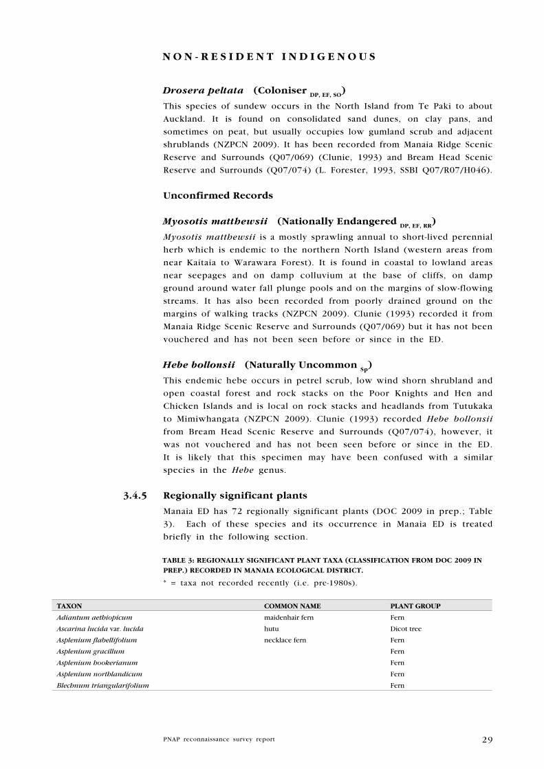
29
N O N - R E S I D E N T I N D I g E N O u S
Drosera peltata (Coloniser DP, EF, SO
)
This species of sundew occurs in the North Island from Te Paki to about
Auckland. It is found on consolidated sand dunes, on clay pans, and
sometimes on peat, but usually occupies low gumland scrub and adjacent
shrublands (NZPCN 2009). It has been recorded from Manaia Ridge Scenic
Reserve and Surrounds (Q07/069) (Clunie, 1993) and Bream Head Scenic
Reserve and Surrounds (Q07/074) (L. Forester, 1993, SSBI Q07/R07/H046).
unconfirmed Records
Myosotis matthewsii (Nationally Endangered DP, EF, RR
)
Myosotis matthewsii is a mostly sprawling annual to short-lived perennial
herb which is endemic to the northern North Island (western areas from
near Kaitaia to Warawara Forest). It is found in coastal to lowland areas
near seepages and on damp colluvium at the base of cliffs, on damp
ground around water fall plunge pools and on the margins of slow-flowing
streams. It has also been recorded from poorly drained ground on the
margins of walking tracks (NZPCN 2009). Clunie (1993) recorded it from
Manaia Ridge Scenic Reserve and Surrounds (Q07/069) but it has not been
vouchered and has not been seen before or since in the ED.
Hebe bollonsii (Naturally uncommon Sp
)
This endemic hebe occurs in petrel scrub, low wind shorn shrubland and
open coastal forest and rock stacks on the Poor Knights and Hen and
Chicken Islands and is local on rock stacks and headlands from Tutukaka
to Mimiwhangata (NZPCN 2009). Clunie (1993) recorded Hebe bollonsii
from Bream Head Scenic Reserve and Surrounds (Q07/074), however, it
was not vouchered and has not been seen before or since in the ED.
It is likely that this specimen may have been confused with a similar
species in the Hebe genus.
3.4.5 Regionally significant plants
Manaia ED has 72 regionally significant plants (DOC 2009 in prep.; Table
3). Each of these species and its occurrence in Manaia ED is treated
briefly in the following section.
TABlE 3: REgIONAlly SIgNIFICANT PlANT TAXA (ClASSIFICATION FROM DOC 2009 IN
PREP.) RECORDED IN MANAIA ECOlOgICAl DISTRICT.
* = taxa not recorded recently (i.e. pre-1980s).
TAXON COMMON NAME PlANT gROuP
Adiantum aethiopicum maidenhair fern Fern
Ascarina lucida var. lucida hutu Dicot tree
Asplenium flabellifolium necklace fern Fern
Asplenium gracillum Fern
Asplenium hookerianum Fern
Asplenium northlandicum Fern
Blechnum triangularifolium Fern
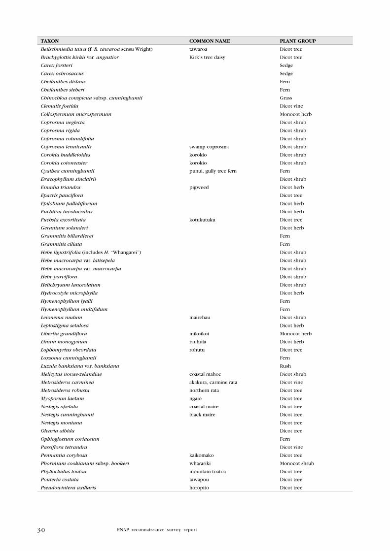
30
TAXON COMMON NAME PlANT gROuP
Beilschmiedia tawa (f. B. tawaroa sensu Wright) tawaroa Dicot tree
Brachyglottis kirkii var. angustior Kirk’s tree daisy Dicot tree
Carex forsteri Sedge
Carex ochrosaccus Sedge
Cheilanthes distans Fern
Cheilanthes sieberi Fern
Chinochloa conspicua subsp. cunninghamii Grass
Clematis foetida Dicot vine
Collospermum microspermum Monocot herb
Coprosma neglecta Dicot shrub
Coprosma rigida Dicot shrub
Coprosma rotundifolia Dicot shrub
Coprosma tenuicaulis swamp coprosma Dicot shrub
Corokia buddleioides korokio Dicot shrub
Corokia cotoneaster korokio Dicot shrub
Cyathea cunninghamii punui, gully tree fern Fern
Dracophyllum sinclairii Dicot shrub
Einadia triandra pigweed Dicot herb
Epacris pauciflora Dicot tree
Epilobium pallidiflorum Dicot herb
Euchiton involucratus Dicot herb
Fuchsia excorticata kotukutuku Dicot tree
Geranium solanderi Dicot herb
Grammitis billardierei Fern
Grammitis ciliata Fern
Hebe ligustrifolia (includes H. “Whangarei”) Dicot shrub
Hebe macrocarpa var. latisepela Dicot shrub
Hebe macrocarpa var. macrocarpa Dicot shrub
Hebe parviflora Dicot shrub
Helichrysum lanceolatum Dicot shrub
Hydrocotyle microphylla Dicot herb
Hymenophyllum lyalli Fern
Hymenophyllum multifidum Fern
Leionema nudum mairehau Dicot shrub
Leptostigma setulosa Dicot herb
Libertia grandiflora mikoikoi Monocot herb
Linum monogynum rauhuia Dicot herb
Lophomyrtus obcordata rohutu Dicot tree
Loxsoma cunninghamii Fern
Luzula banksiana var. banksiana Rush
Melicytus novae-zelandiae coastal mahoe Dicot shrub
Metrosideros carminea akakura, carmine rata Dicot vine
Metrosideros robusta northern rata Dicot tree
Myoporum laetum ngaio Dicot tree
Nestegis apetala coastal maire Dicot tree
Nestegis cunninghamii black maire Dicot tree
Nestegis montana Dicot tree
Olearia albida Dicot tree
Ophioglossum coriaceum Fern
Passiflora tetrandra Dicot vine
Pennantia corybosa kaikomako Dicot tree
Phormium cookianum subsp. hookeri wharariki Monocot shrub
Phyllocladus toatoa mountain toatoa Dicot tree
Pouteria costata tawapou Dicot tree
Pseudowintera axillaris horopito Dicot tree

31
TAXON COMMON NAME PlANT gROuP
Rubus schmidelioides var. schmidelioides bush lawyer Dicot vine
Rubus squarrosus bush lawyer Dicot vine
Senecio biserratus Dicot herb
Senecio quadridentatus Dicot herb
Sticherus cunninghamii Fern
Suaeda novae-zelandiae Dicot herb
Tetraria capillaris Sedge
Triglochin striata arrow grass Monocot herb
Toronia toru toru Dicot tree
Urtica ferox ongaonga, tree nettle Dicot shrub
Zoysia minima Grass
adiantum aethiopicum maidenhair fern
This indigenous maidenhair fern is fairly common in the northern North
Island, but becomes uncommon south of Waikato (Brownsey & Smith-
Dodsworth 2000). In Manaia ED, it has been collected from Bream Head
Scenic Reserve and Surrounds (Q07/074) (Clunie 1993).
ascarina lucida var. lucida hutu
An attractive shrub or small tree that is common in the western South
Island, but only has scattered populations in the North Island. It has been
recorded from Manaia Ridge Scenic Reserve and Surrounds (Q07/069)
(1984, SSBI Q07/R07/H042).
asplenium flabellifolium necklace fern
This small fern is widely distributed throughout New Zealand, although
it is usually confined to the east coast of both major islands, where it
grows on dry, rocky ground (Brownsey & Smith-Dodsworth 2000). In
Manaia ED, it has only been recorded along track margins in Bream
Head Scenic Reserve and Surrounds (Q07/074) (recorded by Wildland
Consultants during this survey, 2009); however, it is probably more
common than collections suggest.
asplenium gracillimum
This fern, which has also been known as Asplenium bulbiferum subsp.
gracillimum, is known from Manaia ED (Wright 1980). A. gracillum
(var. laxum) has been recorded from Manaia Ridge Scenic Reserve and
Surrounds (Q07/069) (2007, SSBI Q07/R07/H042).
asplenium hookerianum
A fern that occurs throughout New Zealand, although it is scarce north
of Waikato. It is usually found on shaded clay banks or rocky outcrops
in scrub and open forest, or on the ground in disturbed forest remnants
(NZPCN 2009). In Manaia ED, it has been recorded from Manaia Ridge
Scenic Reserve and Surrounds (Q07/069) (Clunie 1993, reconfirmed in
Young 2007).
32
asplenium northlandicum
This fern is confined to coastal cliffs and rocks in the northern North
Island (Brownsey & Smith Dodsworth 2000). It has been recorded from
Motukaroro Island (Q07/071) (1992, SSBI Q07/R07/H128), Mauitahi Island
(part of Q07/080) (1990-1991, SSBI Q07/R07/H079), Moturaka Island (part
of Q07/079) (reconfirmed in May 2010, W. Holland, DOC, pers. comm),
and there is an historical record from Ocean Beach Recreation Reserve
and Surrounds (Q07/075) (1956, WELT P2110).
Beilschmiedia tawa (f. B. tawaroa sensu wright) tawaroa
Some authorities do not recognise Beilschmiedia tawaroa as separate
from tawa (B. tawa) (NZPCN 2009). In Northland, tawaroa merges into
tawa on the mainland closest to the Poor Knights Islands (E. Cameron
pers. comm.). For the purposes of this report, tawaroa has been referred
to as ‘Beilschmiedia tawa (including B. tawaroa)’. This entity has been
recorded from several sites within Manaia ED: Taurikura Ridge Bush
(Q07/073) (Forester & Tyson 2008, in SSBI Q07/R07/H044), Manaia Ridge
Scenic Reserve and Surrounds (Q07/069) (Clunie 1993, reconfirmed in
2008, SSBI Q07/R07/H042), and Bream Head Scenic Reserve and Surrounds
(Q07/074) (Clunie 1993, reconfirmed in 2007, SSBI Q07/R07/H046).
Blechnum triangularifolium
This endemic fern species is found in drier, coastal to montane areas
throughout the North Island, and in coastal districts of the South Island
from Cape Farewell to north Canterbury; on slopes, banks, cliffs and road
cuttings under light scrub or coastal forest, and sometimes in the open
(Brownsey & Smith-Dodsworth 2000). In Manaia ED, it has been recorded
from Bream Head Scenic Reserve and Surrounds (Q07/074) (Young 2007).
Brachyglottis kirkii var. angustior kirk’s tree daisy
An endemic tree daisy that is restricted to the north of the North Island,
typically found from Te Puke and Ngaruawahia northwards (NZPCN 2009).
In Manaia ED, it has only been recorded from Manaia Ridge Scenic Reserve
and Surrounds (Q07/069) (2007, in SSBI Q07/R07/H042) and Bream Head
Scenic Reserve and Surrounds (Q07/074) (2007, SSBI Q07/R07/H046),
however, this species is probably more common than records suggest.
Carex forsteri
A sedge that is found throughout the North Island and South Island
where it usually inhabits dense forest within high rainfall areas, favouring
wet seepages, depressions and along stream banks (NZPCN 2009).
Carex forsteri has been recorded from Manaia Ridge Scenic Reserve and
Surrounds (Q07/069) (Clunie 1993).
Carex ochrosaccus
This sedge is endemic to the North Island, where it mostly occurs
from Whangarei and Dargaville South to the Bay of Plenty and Mokau
River. Further southwards, it becomes sparsely distributed, ranging about
as far south as the Manawatu Gorge. It occupies coastal to lowland
habitats, usually in damp situations within alluvial forest, but also along

33
stream banks and within coastal seepages. It sometimes forms extensive
sedgelands within willow carr (NPCN 2010). Carex ochrosaccus has
only been recorded from Manaia Ridge Scenic Reserve (Q07/069) (A.
Townsend, DOC, pers. comm.) in Manaia ED.
Cheilanthes distans
Commonly known as woolly cloak fern, Cheilanthes distans occurs in
the eastern parts of the North Island and South Island, from coastal to
montane areas in dry, rocky places, usually in full sun (Brownsey & Smith-
Dodsworth 2000). In Manaia ED, it has been recorded from Bream Head
Scenic Reserve and Surrounds (Q07/074) (Clunie 1993) and Manaia Ridge
Scenic Reserve and Surrounds (Q07/069) (2008, SSBI Q07/R07/H042).
Cheilanthes sieberi
The taxonomic identity of this small, non-endemic fern has been the
subject of some debate, and it is also recognised as Cheilanthes sieberi
subsp. sieberi. It is found in dry coastal to montane areas of the North
Island and South Island, usually along the east coasts (Brownsey & Smith-
Dodsworth 2000). In Manaia ED, it has been recorded from Mt Aubrey
Coastal Forest and Shrubland (Q07/070) (2001, SSBI Q07/R07/H043).
Chionochloa conspicua subsp. cunninghamii
This endemic tussock is found in the North Island only, occurring from
sea level to 1500m in forest, scrub, cliff faces and rocky clearings (Edgar
& Connor 2000). In Manaia ED, this species has only been recorded Bream
Head Scenic Reserve and Surrounds (Q07/074) (2007, SSBI Q07/R07/H046).
Clematis foetida
This large woody climber is found on forest margins throughout New
Zealand. In Manaia ED, it was recorded from Manaia Ridge Scenic Reserve
and Surrounds (Q07/069) by Clunie (1993).
Collospermum microspermum
This ephiphyte is only found in North Island montane forests above 300m
(Moore & Edgar 1970). In Manaia ED, it has only been recorded from
Manaia Ridge Scenic Reserve and Surrounds (Q07/069) (Young 2007).
Coprosma propinqua
Coprosma propinqua is a divaricating shrub found in swamp, scrub, and
forest throughout New Zealand (Poole & Adams 1994). It was recorded
from Manaia Ridge Scenic Reserve and Surrounds (Q07/069) by Clunie
(1993).
Coprosma rigida
Coprosma rigida is a divaricating shrub with small leaves and reddish
bark (Poole & Adams 1994). It is relatively uncommon in Northland, and
in Manaia ED it is only known from Manaia Ridge Scenic Reserve and
Surrounds (Q07/069) (Clunie 1993; reconfirmed in 2008, SSBI Q07/R07/
H042) and Taurikura Ridge Bush (Q07/073) (2006, DOC internal report).
34
Coprosma rotundifolia
Coprosma rotundifolia is a shrub with roundish, softly hairy leaves that
occupies forests and shrublands on hill slopes and alluvial flats. It is
uncommon in Northland due to habitat loss. In Manaia ED, it has been
recorded from Manaia Ridge Scenic Reserve and Surrounds (Q07/069) by
Clunie (1993).
Coprosma tenuicaulis swamp coprosma
This endemic shrub occurs in the North Island and South Island,
occupying lowland swamps and boggy ground, poorly drained shrubland
and riparian forest (NZPCN 2009) and is becoming local in Northland
due to habitat loss. It has been recorded from Taurikura Ridge Bush
(Q07/073) (Forester & Tyson 2008, in SSBI Q07/R07/H044) and Kauri
Mountain Road Seep (Q07/177) (recorded by Wildland Consultants during
this survey, 2009)
Corokia buddleioides korokio
Corokia buddleioides is a much branched shrub up to 4m tall. It occurs
in lowland to montane forest and forest margins from North Cape to East
Cape and Rotorua (Poole & Adams 1990). In Manaia ED, it is known from
Mt Lion in Bream Head Scenic Reserve and Surounds (Q07/074) (1999,
AK 300278).
Corokia cotoneaster korokio
This divaricating shrub is found throughout New Zealand and on the
Three Kings Islands. It occurs in lowland and montane shrubland and
scrub, especially in drier rocky places (Wilson & Galloway 1993). In
Manaia ED, it has been recorded from Manaia Ridge Scenic Reserve and
Surrounds (Q07/069) (1999, AK 292396) and Bream Head Scenic Reserve
and Surrounds (Q07/074) (2007, SSBI Q07/R07/H046).
Cyathea cunninghamii puniu, gully tree fern
This indigenous tree fern is of local distribution in the North and South
Islands, occurring usually in damp gullies or near river banks (Brownsey
& Smith-Dodsworth 2000). In Manaia ED, it has been recorded from
Manaia Ridge Scenic Reserve and Surrounds (Q07/069) (Clunie 1993).
Dracophyllum sinclairii
This species is endemic to the North Island where it occurs from Te
Paki south to Kawhia Harbour in the west and East Cape in the east
(NZPCN 2009). In Manaia ED, this species has been recorded from
Manaia Ridge Scenic Reserve and Surrounds (Q07/069) (SSBI Q07/R07/
H042) and Bream Head Scenic Reserve and Surrounds (Q07/074), (2007,
SSBI Q07/R07/H046).
einadia triandra pigweed
This endemic herb is found on the New Zealand mainland, the Three
Kings Islands, Stewart Island, and the Chatham Islands (NZPCN 2009).
It has been recorded from three localities in Manaia ED: Ocean Beach

35
Recreation Reserve and Surrounds (Q07/075) (1997, AK 233425), Mauitahi
Island (Q07/080) (1990-1991, SSBI Q07/R07/H079), Guano Island (Q07/080)
(1990, SSBI Q07/R07/H080), and Peach Cove Stack A (Q07/173) (1992,
SSBI Q07/R07/H126).
epacris pauciflora
An endemic, flowering shrub found in the North Island and South Island
from Te Paki to Charleston (NZPCN 2009). This species was recorded from
McDonald Coastal Shrubland (Q07/068) (recorded in 2009 by Wildland
Consultants during this survey).
euchiton involucratus
An annual to biennial herb that is distributed throughout forests in New
Zealand. It is occasionally found in open ground (Allan 1961). In Manaia
ED, this species has only been recorded from Manaia Ridge Scenic Reserve
and Surrounds (Q07/069) (Clunie 1993).
Fuchsia excorticata kotukutuku
The largest member of the Fuchsia genus, kotukutuku is common
throughout much of New Zealand as far south as the Auckland Islands, but
is uncommon in Northland. It grows from sea level up to about 1000 m
asl, particularly alongside creeks and rivers. The species is highly palatable
to browsing mammals. In Manaia ED, it has been recorded from Manaia
Ridge Scenic Reserve and Surrounds (Q07/069) (Clunie 1993) and Bream
Head Scenic Reserve and Surrounds (Q07/074) (Clunie 1993).
Geranium solanderi
This indigenous perennial herb occurs in the North Island, South Island,
Chatham Islands, and many northern offshore islands. It is found in
coastal to montane areas, and was formerly widespread in short tussock
grasslands, on lava fields, clay pans and on rocky coastal headlands
(NZPCN 2009). In Manaia ED, Geranium solanderi has been recorded
from Motukaroro Island (Q07/071) (1991, SSBI Q07/R07/H070).
Grammitis billardierei
A widespread, indigenous fern with erect to short-creeping rhizomes. It
commonly occurs as a low epiphyte, on rocks or occasionally on the
ground, in lowland forest to alpine scrub (Brownsey & Smith-Dodsworth
2000). Grammitis billardeirei has been recorded in Manaia Ridge Scenic
Reserve and Surrounds (Q07/069) (2008, SSBI Q07/R07/H042).
Grammitis ciliata
An endemic fern with erect to short-creeping rhizomes and hairy stipes. It
is usually found on clay banks, damp earth or rock in lowland to montane
forest (Brownsey & Smith-Dodsworth 2000). Grammitis ciliata has been
recorded from Manaia Ridge Scenic Reserve and Surrounds (Q07/069)
(2008, SSBI Q07/R07/H042).
36
Hebe ligustrifolia (includes H. “whangarei”)
Hebe ligustrifolia is endemic to Northland and Hebe “Whangarei”
represents the southern part of this variable species. Hebe “Whangarei”
occupies open scrub and forest margins from about the Bay of Islands
to Manaia ED where it is common in Munro Bay Coastal Bush (Q07/067)
(A. Townsend, DOC, pers. comm. 2010), Manaia Ridge Scenic Reserve
and Surrounds (Q07/069) (2008, SSBI Q07/R07/H042), Bream Head Scenic
Reserve and Surrounds (Q07/074) (2007, SSBI Q07/R07/H046), and Mt
Aubrey Coastal Forest and Shrubland (Q07/070) (W. Holland pers. comm.)
Hebe macrocarpa var. latisepala
An endemic shrub that occurs on Mt Manaia and Bream Head in Northland,
Great Barrier Island, Little Barrier Island, Coromandel Pensinsula (Te
Moehau to Kauaeranga Valley), and Kohukohunui (Hunua Ranges). It
inhabits coastal forest and shrubland (Eagle 2008).
Hebe macrocarpa var. macrocarpa
This subspecies is endemic to the northern North Island, but is not
common in Northland. In Manaia ED, it has been recorded from Manaia
Ridge Scenic Reserve and Surrounds (Q07/069) (2008, Q07/R07/H042)
where it is an uncommon component of shrublands and the forest
understorey on higher ridges, and Bream Head Scenic Reserve and
Surrounds (Q07/074) (2007, Q07/R07/H046).
Hebe parviflora
Commonly known as tree hebe, Hebe parviflora grows in lowland to
mountain sites from near Russell in Northland to Marlborough in the
South Island. It is a tall shrub to small tree up to 7.5m tall, usually with
several trunks (Dawson & Lucas 2000). In Northland, H. parviflora is
known from Bream Head Scenic Reserve and Surrounds (Q07/074) (2008,
SSBI Q07/R07/H046) and there is a record from near Russell8 (in the
Whangaruru ED).
Helichrysum lanceolatum
This endemic shrub is typically found in coastal and lowland shrublands
throughout the North Island and South Island (Allan 1961). In Manaia ED,
it has been recorded from Manaia Ridge Scenic Reserve and Surrounds
(Q07/069) (Clunie 1993) and Bream Head Scenic Reserve and Surrounds
(Q07/074) (Clunie 1993).
Hydrocotyle microphylla
This species of creeping herb is locally distributed throughout the North,
South, and Stewart Islands. It occurs in coastal to lowland open places
on damp ground (Allan 1961). In Manaia ED, it has been recorded from
Manaia Ridge Scenic Reserve and Surrounds (Q07/069) (Clunie 1993).
8 Bayley & Kellow (2006).

37
Hymenophyllum lyalli
This small species of filmy fern is usually epiphytic on tree fern trunks or
at the base of other trunks, more rarely on rock or mossy banks (Brownsey
& Smith-Dodsworth 2000). It has been recorded from Manaia Ridge Scenic
Reserve and Surrounds (Q07/069) (2008, SSBI Q07/R07/H042).
Hymenophyllum multifidum
An endemic fern that is common throughout New Zealand in lowland
forest to alpine shrubland. It occurs on the ground, on rock or as an
epiphyte, favouring damp areas (Brownsey & Smith-Dodsworth 2000). In
Manaia ED, this species is only known from Manaia Ridge Scenic Reserve
(Q07/069) (A. Townsend, DOC, pers. comm.).
leionema nudum mairehau
This small, endemic shrub is confined to the North Island where it
is locally distributed from Te Paki south to Kawhia and the northern
Kaimai Range (NZPCN 2009). In Manaia ED, it is a frequent component
of shrublands and the forest understorey on higher ridges at Bream Head
Scenic Reserve and Surrounds (Q07/074) (Clunie 1993, reconfirmed in
2009 by Wildland Consultants during this survey) and Manaia Ridge Scenic
Reserve and Surrounds (Q07/069) (2007, SSBI Q07/R07/H042).
leptostigma setulosa
This creeping herb is endemic to the New Zealand mainland and Stewart
Island, but is often absent from large areas. It can be locally common
(NZPCN 2009). In Manaia ED, this species has only been recorded from
Bream Head Scenic Reserve and Surrounds (Q07/074) (Clunie 1993).
libertia grandiflora mikoikoi
Endemic to North Island, occurring in coastal to montane areas where
it favours open, lowland forest remnants, forest margins, steep slopes,
ridgelines, bluffs, cliffs, stream banks, and river terraces (NZPCN 2009).
Libertia grandiflora has been recorded from bluffs near Summit Lookout
and along the ridge towards Peach Cove Saddle in Bream Head Scenic
Reserve and Surrounds (Q07/074) (2007, SSBI Q07/R07/H046) and
previously from Manaia Ridge Scenic Reserve and Surrounds (Q07/069)
(1994, AK 240211).
linum monogynum rauhuia
A perennial herb or sub-shrub that occurs on rocky places and duneland
in coastal to inland areas (Allan 1961). In Manaia ED, rauhuia has been
recorded from Bream Head Scenic Reserve and Surrounds (Q07/074)
(Clunie 1993).
lophomyrtus obcordata rohutu
This endemic shrub occurs in coastal to lowland forests throughout New
Zealand from Kaitaia (35º S) southwards, but is very local in Northland.
In Manaia ED, there is an historical record from Manaia Ridge Scenic
Reserve and Surrounds (Q07/069) (1957, WELT SP64915) and a more

38
recent record from Bream Head Scenic Reserve and Surrounds (Q07/074)
(1980, AK 157361).
loxsoma cunninghamii
This uncommon fern is found only in lowland forests from Kaitaia to
Thames. The record from McDonald’s Coastal Shrubland (Q07/068)
(recorded by Wildland Consultants during this survey, 2009) is the first
since the 1930s in the Whangarei Heads area.
luzula banksiana var. banksiana
This endemic rush is found throughout much of mainland New Zealand.
It reaches its northern limit at Bream Head Scenic Reserve and Surrounds
(Q07/074) (2004, AK 286203; reconfirmed in 2007, SSBI Q07/R07/H046).
Melicytus novae-zelandiae coastal mahoe
A stout, endemic shrub that is found mainly on coastal islands in the
north of the North Island (Allan 1961). In Manaia ED, coastal mahoe
was recorded from Mauitaha Island in the Bream Islands Nature Reserve
(Q07/080) (1990-1991, SSBI Q07/R07/H079) (recconfirmed in May 2010,
W. Holland, DOC, pers. comm.) and Guano Island (part of Q07/080)
(recorded in May 2010, W. Holland, DOC, pers. comm.).
Metrosideros carminea akakura, carmine rata
This endemic climbing rata with carmine-coloured flowers is distributed
from Te Paki south to Taranaki in the west and Mahia Peninsula in
the east (NZPCN 2009). It has been recorded from Manaia Ridge Scenic
Reserve and Surrounds (Q07/069) (2008, Q07/R07/H042) and Bream
Head Scenic Reserve and Surrounds (Q07/074) (recorded by Wildland
Consultants during this survey, 2009).
Metrosideros robusta northern rata
This distinctive tall tree, which can begin life as an epiphyte or as a
terrestrial plant, was once widespread from Te Paki south to Wellington,
but it is now uncommon over large parts of this area mainly due to
defoliation by possums, which causes tree mortality. In Manaia ED, it
has been recorded from Manaia Ridge Scenic Reserve and Surrounds
(Q07/069) (recorded during this survey), Taurikura Ridge Bush (Q07/073)
(recorded during this PNAP survey), and Kauri Mountain Conservation
Area and Surrounds (Q07/078) (2001, SSBI Q07/R07/H038).
Myoporum laetum ngaio
This coastal tree is found throughout New Zealand as far south as
Dunedin (Allan 1961) but is uncommon in Northland. In Manaia ED,
it has been recorded from Bream Head Scenic Reserve and Surrounds
(Q07/074) (2007, AK 298397) and Ocean Beach Recreation Reserve and
Surrounds (Q07/075) (1997, SSBI Q07/R07/H041).
Nestegis apetala coastal maire
Coastal maire is a shrub or small tree up to 6 m tall with spreading
39
or sometimes twisted branches, which is found on cliffs and in coastal
forest and shrubland. Its national distribution is limited to the Whangarei
Heads, Cape Brett, and islands off the east coast of North Auckland
and Coromandel Peninsula (Poole & Adams 1994). In Manaia ED, it has
been recorded from Bream Head Scenic Reserve and Surrounds (Q07/074)
(Clunie 1993) and reconfirmed in 2009 (W. Holland, DOC, pers. comm.).
Nestegis cunninghamii black maire
Black maire is scattered throughout lowland forests in the North Island
and the northern South Island, but is very uncommon in Northland. Its
dark green leaves are long and broadly lanceolate, and its bark is rough
and fissured. Within Manaia ED, it is known from Manaia Ridge Scenic
Reserve and Surrounds (Q07/069) (Clunie 1993), Bream Head Scenic
Reserve and Surrounds (Q07/074) (AK 255812), and Kauri Mountain
Conservation Area and Surrounds (Q07/078) (2001, SSBI Q07/R07/H038).
Nestegis montana
Nestegis montana occurs in forest throughout the North Island and has
a local distribution in the South Island. In Manaia ED, it is known from
Manaia Ridge Scenic Reserve and Surrounds (Q07/069) (Clunie 1993).
Olearia albida
This small coastal tree occurs locally from Te Paki ED to Tokomaru
Bay, East Cape (Salmon 1980). It is generally larger and more common
than Olearia angulata (Naturally Uncommon), which occurs in similar
habitats. It has been recorded from Mauitaha Island (part of Q07/080)
(1982, AK 159415), the coastal margin in Kauri Mountain Conservation
Area and Surrounds (Q07/078) (2001, AK 282041), and Manaia Ridge
Scenic Reserve and Surrounds (Q07/069) (2007, SSBI Q07/R07/H042)
Ophioglossum coriaceum
This small fern is widely distributed on the New Zealand mainland, and
is also present on the Chatham Islands, Kermadecs, and Stewart Island
(Brownsey & Smith-Dodsworth 2000). It was recorded from Manaia Ridge
Scenic Reserve and Surrounds (Q07/069) (Young 2007).
Oxalis magellanica
Oxalis magellanica is an indigenous herb found throughout New Zealand
and also Australia and parts of South America. It occurs in coastal to
montane habitats, where it is mostly found in indigenous forested and
riparian areas. It prefers semi-shaded areas, but can be found in full-sun
if permanently moist (NZPCN 2010). This species was recorded from
Bream Head Scenic Reserve and Surrounds (Q07/074) in September 2009
during this survey.
Passiflora tetrandra kohia
This endemic liane grows to c.10 m tall and climbs by means of tendrils
(modified branches rising from leaf axils). It occurs in lowland forest in
the North Island and South Island. In Manaia ED, it has only been recorded

40
from Manaia Ridge Scenic Reserve and Surrounds (Q07/069) (Clunie 1993)
and Taurikura Ridge Bush (Q07/073) (2001, SSBI Q07/R07/H049).
Pennantia corymbosa kaikomako
Kaikomako is widespread throughout lowland New Zealand, but is
uncommon in Northland due to habitat loss. This small, slender tree has
a divaricating juvenile stage and grows up to 10 m tall. The only record
of kaikomako in Manaia ED is from from Taurikura Ridge Bush (Q07/073)
(W. Holland, DOC, pers. comm.).
Phormium cookianum subsp. hookeri wharariki
Wharariki is smaller than harakeke (Phormium tenax) and is characterised
by its drooping and twisted capsules. Found throughout the South Island
and locally in the North Island, it is uncommon in Northland, occurring
at higher altitudes. In Manaia ED, it is known from Manaia Ridge Scenic
Reserve and Surrounds (Q07/069) (2008, SSBI Q07/R07/H042), Bream Head
Scenic Reserve and Surrounds (Q07/074) (2007, SSBI Q07/R07/H046) and Mt
Aubrey Coastal Forest and Shrubland (Q07/070) (2001, SSBI Q07/R07/H043).
Pouteria costata tawapou
Tawapou is a coastal, shiny-leaved tree (up to 20 m tall) restricted to the
north of the North Island and adjacent islets (Allan 1961). As a result of
seed and seedling predation by rats and other herbivores, these trees are
becoming increasingly uncommon on the Northland mainland. In Manaia
ED, it is present at Mt Aubrey Coastal Forest and Shrubland (Q07/070)
(W. Holland, DOC, pers. comm. 2010) and Bream Head Scenic Reserve
and Surrounds (Q07/074) (recorded during this survey, 2009), particularly
around Peach Cove.
Pseuodowintera axillaris horopito
This erect shrub or tree (up to 8 m) occurs in the North and South Islands
in lowland and lower montane forests (Allan 1961), but is uncommon
in Northland. In Manaia ED, it was recorded from Bream Head Scenic
Reserve and Surrounds (Q07/074), near the summit of Mt Lion (Matariki)
(2007, AK 301842).
Rubus schmidelioides var. schmidelioides bush lawyer
A liane with stout stems to 10m or more, sometimes forming a dense
intertwining bush. It occurs in the North and South Islands in lowland
and montane forest and shrublands (Eagle 2008). This species has been
recorded from Kauri Mountain Conservation Area and Surrounds (Q07/078)
(2001, SSBI Q07/R07/H038) but was possibly mis-identified (W. Holland,
DOC, pers. comm.).
Rubus squarrosus bush lawyer
Relatively common south of the Manawatu (NZPCN 2009), Rubus
squarrosus is a yellow-prickled, leafless, scrambling climber with a
scattered distribution in Northland. In Manaia ED, it has been recorded
from Bream Head Scenic Reserve and Surrounds (Q07/074) in 1980
(AK 157364) and in recent years (W. Holland, DOC, pers. comm.), and

41
Timperley Road Bush (Q07/073) (Pierce 2006, in SSBI Q07/R07/H090),
where it is relatively common in localised areas on the lower northern
face (W. Holland, DOC, pers. comm.).
Senecio biserratus
An annual to short-lived perennial herb up to 1 m tall that is often
associated with dune systems, where it usually grows amongst
Muehlenbeckia complexa (NZPCN 2010). In Manaia ED, Senecio biserratus
was recorded during this survey in 2009 from the back dunes of Ocean
Beach Recreation Reserve and Surrounds (Q07/075).
Senecio quadridentatus
Senecio quadridentatus is a short-lived, perennial herb found throughout
New Zealand in coastal to subalpine habitats, where it always occupies
recently disturbed ground (NZPCN 2009). In Manaia ED, there is a
record of this species from Manaia Ridge Scenic Reserve and Surrounds
(Q07/069) (Clunie 1993).
Sticherus cunninghamii waekura
An endemic fern that is found throughout New Zealand but is uncommon
in the east and south of the South Island. It occurs in lowland to montane
areas but generally at higher altitudes in the North Island, growing on
roadside banks or on the floor of open, dry forest (Brownsey & Smith-
Dodsworth 2000). In Manaia ED, Sticherus cunninghammi is known from
Manaia Ridge Scenic Reserve (Q07/069) (A. Townsend, DOC, pers. comm.).
Suaeda novae-zelandiae
A fleshy, much-branched sub-shrub that occupies salt marshes and rocky
and gravelly coasts within range of high tide (Allan 1961). Suaeda
novae-zelandiae was recorded from Kiteone Road Saltmarsh (Q07/168)
(recorded by Wildland Consultants during this survey, 2009).
Tetraria capillaris
Tetraria capillaris occurs in North Island from Te Paki south to about
Taranaki and Hawkes Bay, and in the South Island recorded from the
Nelson area and Westland. This species usually occurs in seral vegetation
within swamps, peat bogs, pakihi, gumland scrub, on sand podzols, in
dune slacks or in open ground within regenerating kauri forest (NZPCN
2009). In Manaia ED, it was collected from McDonald Coastal Shrubland
(Q07/068) (recorded by Wildland Consultants during this survey, 2009).
Toronia toru toru
Toru is a small tree reaching 10 m tall which is found in lowland to
mountain forest and shrubland from North Cape south to East Cape and
west of Taupo (Poole & Adams 1994). The genus has only this species,
which is restricted to New Zealand. In Manaia ED, there are records of
toru from Bream Head Scenic Reserve and Surrounds (Q07/074) (Clunie
1993) and Kauri Mountain Conservation Area and Surrounds (Q07/078)
(2001, SSBI Q07/R07/H038).
42
Triglochin striata arrow grass
This is a small grass-like (although it is not a grass) monocotyledon, which
grows on mudflats in sparse swards, often mixed with other salt meadow
herbs such as makaokao and remuremu. Its main threat is competition
from invasive weeds, for example saltwater paspalum. In Manaia ED, it
has been recorded from Kiteone Road Saltmarsh (Q07/168) (recorded by
Wildland Consultants during this survey, 2009).
Urtica ferox ongaonga
Ongaonga is a shrub reaching 3 m tall that is armed with long stinging
hairs. It is found on shrubland and forest margins in the North Island
and South Island (Poole & Adams 1994), however, there are very few
records from Northland (W. Holland, DOC, pers. comm.). In Manaia ED,
it has been recorded from Bream Head Scenic Reserve and Surrounds
(Q07/074) (2006, AK 297659).
Zoysia minima
An endemic grass that is locally distributed throughout the North Island
and South Island, but is uncommon in Northland. It occurs on sand
dunes, sandy ground, and gravel from sea level to 600 asl (NZPCN 2009).
In Manaia ED, it has been recorded in the foredunes at Ocean Beach
Recreation Reserve and Surrounds (Q07/075) (recorded by Wildland
Consultants during this survey, 2009).
unconfirmed records
Griselinia littoralis kapuka
This shrub or tree occurs in forest throughout New Zealand where it is
usually found at higher altitudes, although it is uncommon in Northland. It
is highly palatable to browsing mammals. There is a record of Griselinia
littoralis from Manaia Ridge Scenic Reserve and Surrounds (Q07/069)
(Clunie 1993), but it has not been vouchered and has not been recorded
before or since in the ED.
3.4.6 Threatened and regionally significant plant species not recorded recently in Manaia Ecological District
Juncus holoschoenus var. holoschoenus
(Nationally Critical CD, DP, EF, SO
)
There is one historic record of the rush Juncus holoschoenus from
Manaia ED (from Kerr Point by Dumbleton in 1967, CHR 174857). This
species is also indigenous to Australia, however, it is considered to be
a species complex, with taxonomy not fully resolved. It is not clear
whether this specimen (CHR 174857) is the threatened variety. Currently,
Juncus holoschoenus var. holoschoenus is only known with certainty from
relatively weed free sub-alpine mires and frost flats in inland Bay of Plenty,
so it is unlikely that this specimen is the Nationally Critical species.

43
Dactylanthus taylorii pua o te reinga, wood rose
(Nationally Vulnerable CD, PD, RF, Sp
)
This endemic root parasite is distributed from Northland to Wairarapa,
and occurs on the roots of about 30 species of indigenous broadleaved
trees. The plant prefers damp but well-drained places and is often found
at the head of small streams. Dactylanthus taylorii is threatened by
habitat destruction, trampling by cattle, collectors of wood roses, and
browsing animal such as possums, rats and pigs (NZPCN 2009). There
is one record of this plant from Manaia ED: Mt Aubrey Coastal Forest
and Shrubland (Q07/070) (1985, AK 306983), however, it is unknown
if this plant still occurs at this site. Currently, there is only one extant
population of Dactylanthus taylorii known in Northland from the Puketi/
Omahuta Forest in Puketi ED.
epilobium pallidiflorum swamp willowherb
(regionally significant)
This indigenous herb inhabits swamps, marshes and river banks (Allan
1961). It is found throughout the South Island and North Island, the
Chatham Islands, and Australia (NZPCN 2009). In Manaia ED, it was
recorded from Urquharts Bay in 1967 (AK 128959).
3.4.7 Plant species reaching their distributional limits in Manaia ED
Luzula banksiana var. banksiana and Hebe macrocarpa var. latisepala
reach their northern limit in Manaia ED at Bream Head Scenic Reserve
and Surrounds (Q07/074), and Pomaderris paniculosa subsp. novae-
zelandiae reaches its southern limit in Manaia ED at Manaia Ridge Scenic
Reserve and Surrounds (Q07/069).
3 . 5 F A u N A
Manaia ED has 24 nationally ‘Threatened’ and 25 ‘At Risk’ fauna species,
including one unconfirmed record of long-tailed bat (Chalinolobus tuberculatus). A checklist of fauna recorded in Manaia ED is included
in Appendix 7.
3.5.1 Nationally Threatened and At Risk birds
Four key features of Manaia ED make it important for birds, including
many threatened species:
• Close proximity of the Hen and Chicken Islands and the Poor Knights
Islands.
• Coastal breeding and feeding sites for seabirds and wetland birds.
• Nearby presence of shellbanks in Whangarei Harbour, which are
important feeding grounds for many shorebird species.
• Large, significant areas of semi-contiguous forest.
Manaia ED has records of ten nationally ‘Threatened’ bird species (one
Nationally Critical, one Nationally Endangered, eight Nationally Vulnerable)
and 17 ‘At Risk bird species (six Declining, five Naturally Uncommon, two

44
Recovering, and four Relict) in Miskelly et al. (2008). The distributions
of these species in Manaia ED are described briefly below.
T h R E A T E N E D
grey duck anas superciliosa superciliosa
(Nationally Critical) Endemic9
The preferred habitat of grey duck includes small lakes, slow-flowing
rivers, and tidal water surrounded by forest (Heather & Robertson
1996), with recent records from wetlands and streams surrounding Kauri
Mountain Conservation Area and Surrounds (Q07/078) (Pierce & Kerr
2007). There is also an historical record from Ocean Beach Recreation
Reserve and Surrounds (Q07/075) (1979, SSBI Q07/R07/H041).
Australasian bittern Botaurus poiciloptilus (Nationally Endangered
Sp, TO) Indigenous10
Bittern has been recorded from three sites within Manaia ED: Kauri
Mountain Wetland (Q07/081), Harambee Road Wetland (Q07/172), and
Kauri Mountain Road Pond and Raupo Swamp (Q07/175) (all records from
Pierce & Kerr 2007). It is also known to visit many ephemeral wetlands
and streams including the southern side of Kauri Mountain Conservation
Area and Surrounds (Q07/078), Robinson Road, and the slopes of the
Bream Head Scenic Reserve and Surrounds (Q07/074) (Pierce et al. 2001).
Bush falcon Falco novaeseelandiae
(Nationally Vulnerable DP, St
) Endemic
The only confirmed record of bush falcon in Manaia ED is a bird which
was killed after flying into a window at Urquharts Bay in February 2006
(N. Miller, DOC, pers. comm.). In August 2008, a bush falcon was heard
near Peach Cove, Bream Head Scenic Reserve and Surrounds (Q07/074)
(A. Townsend, DOC, pers. comm.).
Caspian tern Hydroprogne caspia
(Nationally Vulnerable SO
) Indigenous11
A semi-cosmopolitan species that breeds in temperate Holarctic and
some tropical regions, and Australasia. In New Zealand, Caspian terns
usually breed on the coast of both main islands, with Northland being
the stronghold (R. Pierce, pers. comm.). Recent national declines in bird
numbers can be attributed to increased human activity and planting of
pine trees and marram on favoured bare sandspits (Heather & Robertson
1996) and the ongoing impacts of carnivourous mammals. In Manaia
ED, Caspian terns have been recorded roosting and fishing at Taurikura
Bay and Urquharts Bay (Pierce 2005) and historically from Ocean Beach
Recreation Reserve and Surrounds (Q07/075) (1979, SSBI Q07/R07/H041).
9 Different subspecies are present in the south western Pacific (Heather & Robertson 1996).10 Breeds in Australia, New Caledonia and the Loyalty Islands (Heather & Robertson 1996). The
NZ populations are the healthiest of the species (R. Pierce, pers. comm.).11 Breeds locally in temperate parts of all continents except South America (Heather & Robertson
1996).

45
North Island brown kiwi apteryx mantelli
(Nationally Vulnerable CD, PD RF
) Endemic
North Island brown kiwi originally occurred throughout Northland,
including the Aupouri Peninsula. In the 1970s, they were found
throughout most forest and shrubland areas from the Brynderwyn Range
to Awanui in the Far North (Bull et al. 1985). However, by the early
1990s, kiwi had all but disappeared from the Brynderwyn, Mareretu, and
Tangihua Ranges and most other forest remnants south of a line between
Whangarei and Dargaville (Pierce et al. 2006). There are currently about
six main geographical groupings of kiwi in Northland, and within each
there are several local concentrations or clusters, including Manaia ED
(Pierce et al. 2006). Manaia ED supports four main sites for kiwi – Bream
Head Scenic Reserve and Surrounds (Q07/074), Manaia Ridge Scenic
Reserve and Surrounds (Q07/069), Kauri Mountain Conservation Area and
Surrounds (Q07/078), and The Nook Peninsula (part of site Q07/067),
plus some linkages comprising shrubland and forest, including Taurikura
Ridge Bush (Q07/073) (R. Pierce, pers. comm. 2010).
The Manaia ED includes sites which are within the Whangarei Kiwi
Sanctuary. The Whangarei Heads Landcare Forum (WHLF), in conjunction
with DOC, has been managing kiwi across this area for many years
undertaking predator control, advocacy, kiwi releases, and monitoring.
There have been 62 kiwi released in Bream Head Scenic Reserve and
Surrounds (Q07/074) since 2000; 24 on Mt Manaia since 2004 (within
site Q07/069); and nine birds in Taurikura Ridge Bush (Q07/073) since
2005. Over the last six years, the WHLF has also released sub-adults
in the Kauri Mountain Conservation Area and Surrounds (Q07/078) and
The Nook. Fifteen of those birds released are being monitored by
radio transmitter. Kiwi are also present at Mt Aubrey Coastal Forest and
Shrublands (Q07/070), with one monitored pair recorded breeding in
2009 by WHLF (T. Hamilton, WHLF, pers. comm.).
After initially losing kiwi to dogs, advocacy by WHLF has lead to
improved dog control by locals, resulting in no transmitter-carrying birds
having been killed by dogs between November 2006 and December 2009.
Between October 2008 and December 2009, there have been five known
deaths of kiwi which were not carrying transmitters: three by vehicles
and two by dogs. Most of the kiwi call counts are trending up, with
the population now estimated to be in the order of 300 birds. Chick
survival is no longer monitored because of costs (T. Hamilton, WHLF,
pers. comm.). There are encouraging signs of kiwi recovery based on
call count results and survival of released birds. The long-term survival
of kiwi throughout Manaia ED is in the hands of the community, which
to date has done a good job (R. Pierce pers. comm.).
North Island kaka Nestor septentrionalis
(Nationally Vulnerable CD, PD, RF
) Endemic
North Island kaka still occur in some mainland forest tracts from
Coromandel Peninsula to the Aorangi Range in the southern Wairarapa,
but they are heavily impacted by stoats and possums (Greene et al.
2004). They are most numerous on the larger offshore islands, e.g. Hen
46
and Chickens, Great Barrier, Little Barrier, Mayor and Kapiti (Heather &
Robertson 2006). In Manaia ED, kaka have been recorded visiting forest
remnants in Manaia Ridge Scenic Reserve and Surrounds (Q07/069) (SSBI
Q07/R07/H042), Taurikura Ridge Bush (Q07/073) (recorded during this
PNAP survey, 1998), and Bream Head Scenic Reserve and Surrounds
(Q07/074) (1992, SSBI Q07/R07/H046). In recent years, kaka have been
present year round at Manaia ED and flock sizes have increased, notably
at Bream Head Scenic Reserve and Surrounds (Q07/074), where breeding
has also been suspected. The predator control undertaken by DOC and
the Whangarei Heads community will be benefiting this species locally
(R. Pierce, pers. comm. 2010). Whangarei Heads residents regularly hear
kaka flying overhead (W. Holland, DOC, pers. comm.).
Northern New Zealand dotterel Charadrius obscurus aquilonius (Nationally Vulnerable
CD) Endemic
This species breeds on sandspits, at stream mouths, on beaches, shellbanks
and sandbanks and among low dunes. Dotterel populations are threatened
by coastal development, pine plantations and plantings of marram grass to
stabilise foredunes and sandspits (Heather & Robertson 1996). In Manaia
ED, this species is mostly seen at Ocean Beach Recreation Reserve and
Surrounds (Q07/075) where they also breed. Two pairs were observed in
September 2009 at the northern end of Proctors Beach during this survey
by Wildland Consultants, although they were not seen to be nesting.
Northern New Zealand dotterel is also known to visit Bream Head Scenic
Reserve and Surrounds (Q07/074) (Pierce et al. 2001).
Pied shag Phalacrocorax varius varius
(Nationally Vulnerable) Indigenous
In New Zealand, pied shags have a patchy breeding distribution, mainly in
warmer areas on sheltered coasts, harbours and offshore islands. Colonies
are commonly in pines, pohutukawa or northern rata growing on cliffs
and overhanging the sea (Heather & Robertson 1996). In Manaia ED, pied
shags have been recorded from High Island (Q07/072) (1992, SSBI Q07/
R07/H123), Bream Head Scenic Reserve and Surrounds (Q07/074) (1979,
SSBI Q07/R07/H046), on Moturaka Island within the Bream Islands Scenic
Reserve (Q07/079) (1992-94, SSBI Q07/R07/H128), on Mauitahi and Guano
Islands within the Bream Islands Nature Reserve (Q07/080) (1990-1991,
SSBI Q07/R07/H079), on Awaroa Island (Q07/170) (1991, Q07/R07/H078),
and there is a roost site on the harbour’s edge at Mt Aubrey Coastal
Forest and Shrubland (Q07/070) (W. Holland, DOC, pers. comm.). They
breed at nearby Taiharuru Estuary and elsewhere in Whangarei Harbour
(R. Pierce pers. comm.).
Red-billed gull larus novaehollandiae scopulinus
(Nationally Vulnerable) Endemic12
A highly gregarious species that is widespread and locally common in
New Zealand, frequenting estuaries, harbours and open coastlines, parks
12 Different subspecies are present in South Africa, Australia, and the south western Pacific (Heather & Robertson 1996).

47
of coastal cities, and occasionally wet paddocks and sportsfields. A
reduction in winter food supplies (offal and sewage discharged into the
sea) is likely to have adversely affected red-billed gull numbers (Heather
& Robertson 1996). Red-billed gulls have been recorded from High Island
(Q07/072) (1992, SSBI Q07/R07/H123), Bream Head Scenic Reserve and
Surrounds (Q07/074) (recorded by Wildland Consultants during this
survey, 2009), Ocean Beach Recreation Reserve and Surrounds (Q07/075)
(recorded by Wildland Consultants during this survey, 2009), on Moturaka
and Tarakanahi islands within the Bream Islands Scenic Reserve (Q07/079)
(1990 and 1999, SSBI Q07/R07/H128), on Mauitaha and Guano Islands
within the Bream Islands Nature Reserve (Q07/080) (1990-1991, SSBI
Q07/R07/H079), Frenchman Island (Q07/171) (breeding) (1991-1992, SSBI
Q07/R07/H125), and on Awaroa Island (Q07/170) (recorded by Wildland
Consultants during this survey, 2009). They probably breed elsewhere in
the ED (R. Pierce pers. comm.).
Reef heron egretta sacra sacra
(Nationally Vulnerable SO, St
) Indigenous
Reef herons are usually solitary, nesting in caves, crevices, on rock
shelves, in cliff-side vegetation under clumps of flax or Astelia, or among
the roots of pohutukawa (Heather & Robertson 1996). Nationally the
species is less widespread than it used to be, most probably because of
increased human disturbance on the coast (Heather & Robertson 1996).
However, many birds occur on Whangarei Harbour and nearby coastlines
including in the Manaia ED, where they have been recorded from several
locations, including McLeod Bay, Reotahi Bay, Taurikura Bay, Urquharts
Bay, Busby Head (part of Bream Head Scenic Reserve and Surrounds,
Q07/074), Frenchman Island (Pierce 2005), and Moturaka Island (Q07/089)
(1991, SSBI Q07/R07/H070).
A T R I S k
New Zealand pied oystercatcher Haematopus finschi
(Declining) Endemic13
Pied oystercatchers breed inland in the South island, mainly east of the
Southern Alps, on braided riverbeds, farmland, fringes of lakes and in
subalpine bogs. Over 1,000 birds use Whangarei Harbour as a wintering
site (Heather & Robertson 1996). In Manaia ED, pied oystercatchers are
known to roost and feed at several beaches including Mcleod Bay, Urquhart
Bay, Ocean Beach Recreation Reserve and Surrounds (Q07/075), and Bream
Head Scenic Reserve and Surrounds (Q07/074) (Pierce et al. 2001).
New Zealand pipit anthus novaeseelandiae (Declining)
The species has a wide distribution with many subspecies, four of which
are only in New Zealand, where they favour open habitats such as
beaches, road verges and rough pasture. In Manaia ED, pipits have been
13 The ‘Declining’ status of this species is incongruous to the fact that bird numbers have increased dramatically since the late 1940s (R. Pierce, pers. comm.).

48
recorded from Ocean Beach Recreation Reserve and Surrounds (Q07/075)
(W. Holland, DOC, pers. comm.), Timperley Road Bush (Q07/077) (Pierce
2006, in SSBI Q07/R07/H090), Kauri Mountain Conservation Area and
Surrounds (Q07/078) (2001, SSBI Q07/R07/H038), and Bream Head Scenic
Reserve and Surrounds (Q07/074) near Smugglers Bay (W. Holland, DOC,
pers. comm. 2009).
Northern little blue penguin eudyptula minor iredalei (Declining
DP, EF) Endemic14
The northern little blue penguin is one of up to six subspecies of blue
penguin which occurs around coastal New Zealand and southern Australia.
Populations undergo severe crashes, and many dead birds are washed
ashore in some years, probably as a result of food shortage or biotoxins
(Heather & Robertson 1996). Islands off eastern Northland are one of the
main breeding areas because they are relatively free of dogs, possums,
mustelids, and cats. Nesting occurs at Bream Head Scenic Reserve and
Surrounds (Q07/074) (Pierce 2005) and on Mauitahi Island within the
Bream Islands Nature Reserve (Q07/080) (1990-1991, SSBI Q07/R07/H079).
Birds have also been recorded ashore at Kauri Mountain Conservation
Area and Surrounds (Q07/078), Ocean Beach Recreation Reserve and
Surrounds (Q07/075), and The Nook (included in Q07/067). Predator
and dog control may be benefitting this species locally (R. Pierce pers.
comm.). One dead bird was recorded from Kiteone Saltmarsh (Q07/168)
in September 2009 during this survey.
North Island fernbird Bowdleria punctata vealeae
(Declining RR, St
) Endemic
Fernbird numbers have declined dramatically from historic levels with
the loss of wetland and fernland through agricultural development, and
the introduction of mammalian predators (Heather & Robertson 1996).
North Island fernbird has been recorded from three locations in Manaia
ED: McDonald Coastal Shrubland (Q07/068) (1994, SSBI Q07/R07/H091),
Kerr Road Swamp (Q07/076) (L. Forester, NRC, pers. comm. 2009), and
an historical record from Kauri Mountain Wetland (Q07/081) (1978, SSBI
Q07/R07/H037).
Pied stilt Himantopus himantopus leucocephalus
(Declining SO
) Indigenous
Pied stilts are probably a relatively recent colonist of New Zealand. They
are coastal breeders in both main islands and birds breeding in the north
are usually sedentary (Heather & Robertson 1996). In Manaia ED, this
species is known to visit and breed at ephemeral wetlands and permanent
throughout, e.g. northern Ocean Beach, Kiteone Road, Robinson Road
and flooded pasture adjoining Bream Head Scenic Reserve and Surrounds
(Q07/074) (Pierce et al. 2001).
14 Different subspecies are present in other parts of New Zealand, and in Australia (Heather & Robertson 1996).

49
white-fronted tern Sterna striata striata
(Declining DP
) Endemic
A common species in Whangarei Harbour and adjacent coastline. A
survey in March 2005 recorded over 1,200 white-fronted terns throughout
Whangarei Harbour, with 460 birds roosting on jetties and feeding at
Parua Bay and 520 birds in the Marsden Point-Busby Head area. Smaller
groups were observed roosting at other sites, including the beaches at
McLeod Bay, Urquharts Bay, and near One Tree Point (Pierce 2005).
Numbers of this species have been greatly reduced over the past 20 years
(Pierce 2005). White-fronted tern frequently breeds on Frenchman Island
(Q07/171) (R. Pierce, pers. comm.), and six individuals were recorded
from Awaroa Island (Q07/170) in 1991 (SSBI Q07/R07/H078).
Banded rail Rallus philippensis
(Naturally uncommon DP
) Indigenous 15
In New Zealand, banded rail was formerly common throughout the main
islands but declined by the 1930s due to habitat loss and the introduction
of mammalian predators. They are now mainly found in mangrove forests,
saltmarshes, and rushland in Northland (including the Three Kings, Poor
Knights, and Great Barrier Islands), Coromandel Peninsula, and Bay of
Plenty (Heather & Robertson 1996). The nearest stronghold to Maniaia
ED is in the Taiharuru estuary (Pierce & Kerr 2007) in neighbouring
Whangaruru ED, while in Manaia ED there have only been occasional
reports from saltmarsh habitat at Ocean Beach Recreation Reserve and
Surrounds (Q07/075) (R. Pierce pers. comm.).
Black shag Phalacrocorax carbo novaehollandiae
(Naturally uncommon SO, Sp
) Indigenous 16
Black shags occur throughout the main islands and Chatham Islands,
where they are found in sheltered coastal waters, estuaries, harbours,
rivers, streams, dams, and lakes up to the subalpine zone. They are
often caught in fishing nets and occasionally on hooked lines (Heather
& Robertson 1996). In Manaia ED, this species is known to visit small
streams and coastal waters, including Whangarei Harbour and off Bream
Head Scenic Reserve and Surrounds (Q07/074) (Pierce et al. 2001).
little shag Phalacrocorax melanoleucos
(Naturally uncommon Inc
) Indigenous17
Little shags are found in sheltered coastal waters, estuaries, harbours,
rivers, dams and lakes up to the subalpine zone (Heather & Robertson
1996). In Manaia ED, two little shags have been recorded from High
Island (Q07/072) (1992, SSBI Q07/R07/H123) and they are also
known to utilise the largest streams and ponds throughout the ED
(R. Pierce pers. comm.).
15 Breeds in Indonesia, Phillipines, Melanesia, Australasia, Niue, and western Polynesia ( Heather & Robertson 1996).
16 Subspecies also breeds in Australia and New Guinea (Heather & Robertson 1996).17 Breeds in Australasia east of Borneo and Java, and in New Caledonia ( Heather & Robertson
1996).

50
little black shag Phalacrocorax sulcirostris
(Naturally uncommon RR, SO
) Indigenous18
Little black shags are a regular visitor to fresh and salt water habitats
around the ED with the nearest known colony being a mixed (three)
species shag colony at Taiharuru Estuary in Whangaruru ED (Pierce &
Kerr 2007). In Manaia ED, 22 birds were recorded from High Island
(Q07/072) in 1992 (SSBI Q07/R07/H123).
long-tailed cuckoo eudynamys taitensis
(Naturally uncommon DP) Migrant
Birds pass through Manaia ED on their migration north to the tropical
Pacific. A few birds have been known to overwinter in the far north of
New Zealand, but breeding does not occur here as the area is beyond the
range of whitehead (Mohoua albicilla), its key host species in the North
Island (Heather & Robertson 1996). Long-tailed cuckoo has only ever been
recorded from Bream Head Scenic Reserve and Surrounds (Q07/074) in
Manaia ED (R. Pierce pers. comm.), but the neighbouring Mt Tiger Ridge
in Whangarei ED is part of a regular flyway during the northern migration
in February-March. Therefore, Manaia Ridge Scenic Reserve and Surrounds
(Q07/069) is also likely to be part of this flyway (R. Pierce, pers. comm.).
Pycroft’s petrel Pterodroma pycroftii (Recovering) Endemic
This species breeds only in New Zealand, on islands off the northeastern
coast of the North Island. Birds nest in small, localised colonies,
interspersed with other burrowing petrels (Heather & Robertson 1996).
Single dead birds have been recorded from Kauri Mountain Conservation
Area and Surrounds (Q07/078) and Peach Cove within Bream Head Scenic
Reserve and Surrounds (Q07/074) (R. Pierce pers. comm.).
Variable oystercatcher Haematopus unicolor
(Recovering) Endemic
Variable oystercatchers inhabit the coasts of the North Island, South
Island and offshore islands, but not the outlying islands. Northland is
a stronghold for this species (Heather & Robertson 1996) and it has
been recorded from five sites within Manaia ED: High Island (Q07/072)
(1992, SSBI Q07/R07/H123), Moturaka Island within the Bream Islands
Scenic Reserve (Q07/079) where they were recorded breeding with
chicks present in January 2010 (W. Holland, DOC, pers. comm.), Mauitahi
Island within the Bream Islands Nature Reserve (Q07/080) (SSBI Q07/
R07/H079), and Bream Head Scenic Reserve and Surrounds (Q07/074),
including nesting and roosting at Smugglers Bay and Peach Cove (Pierce
et al. 2001). Two breeding pairs raised chicks at Smugglers Bay in the
summer of 2009/10 (W. Holland, DOC, pers. comm.). Also roosts and
feeds at McLeod Bay and Urquharts Bay (R. Pierce pers. comm.).
18 Breeds in Australasia east of Borneo and Java, and in New Caledonia ( Heather & Robertson 1996).

51
Cook’s petrel Pterodroma cookii (Relict Inc RR
) Endemic
This species breeds only in New Zealand, on Little Barrier, Great Barrier and
Codfish Islands, and is the commonest small gadfly petrel beach-wrecked
on the NZ coast. Cook’s petrels nest in large colonies, often interspersed
with black petrels in the north (Heather & Robertson 1996). A Cook’s
petrel skull was recorded from Peach Cove within Bream Head Scenic
Reserve and Surrounds (Q07/074) (N.Miller, DOC, pers. comm. 2008).
Fluttering shearwater Puffinus gavia (Relict RR
) Endemic
This species breeds on islands and islets along the northeastern coast of
the North Island from the Three Kings Islands to islands near Gisborne,
and on islands in the Marlborough Sounds. Fluttering shearwaters are
common only on islands free of cats and rats (Heather & Robertson 1996).
In Manaia ED, breeding pairs have been recorded from Mauitaha Island
(1990-1991, SSBI Q07/R07/H079) and Guano Island (Q07/080) (1990, SSBI
Q07/R07/H080), and one predated bird was found on Moturaka Island
(Q07/079) (1992, SSBI Q07/R07/H128).
Red-crowned kakariki Cyanoramphus novaezelandiae novaezelandiae (Relict) Endemic
In Northland, red-crowned kakariki are mainly restricted to pest-free
offshore islands (Hen and Chickens, Poor Knights and Three Kings
Islands), but they do also visit mainland forest along the eastern coast
and inland. This species is particularly susceptible to predators such as
stoats, cats and ship rats because they often feed on the ground and nest
in holes close to the ground (Heather & Robertson 1996). The species
is known from Manaia Ridge Scenic Reserve and Surrounds (Q07/069)
(R. Pierce, pers. comm.), Bream Head Scenic Reserve and Surrounds
(Q07/074) (W. Holland, DOC, pers. comm.), and Mauitaha Island within
the Bream Islands Nature Reserve (Q07/080) (recorded in May 1977, SSBI
Q07/R07/H079). A pair was recently recorded from forest remnants and
gardens at Urquharts Bay (N. Miller, DOC, pers. comm.) on the boundary
of Bream Head Scenic Reserve (Q07/074).
Spotless crake Porzana tabuensis plumbea
(Relict SO
) Indigenous19
Spotless crake has a restricted distribution and, on the mainland, is
largely confined to dense reed beds. It has recently been recorded from
Harambee Road Swamp (Q07/172) (Pierce & Kerr 2007), Kauri Mountain
Conservation Area and Surrounds (Q07/078) (L. Forester, NRC, pers.
comm. 2009), and there is an historical record from Kauri Mountain
Wetland (Q07/081) (1978, SSBI Q07/R07/H037). It has also been recorded
at a stream fringing the Bream Head Scenic Reserve and Surrounds
(Q07/074) (Pierce et al. 2001).
19 Also in Australia ( Heather & Robertson 1996).
52
3.5.2 Regionally significant birds
The following five species are included in a draft list of regionally significant
avifauna prepared by the Northland Conservancy (DOC, in prep.).
grey-faced petrel Pterodroma macroptera gouldi Endemic
In 1991, two individuals of grey-faced petrel were recorded in Manaia ED
on Mauitahi Island, within the Bream Islands Nature Reserve (Q07/080)
(SSBI Q07/R07/H079). Petrel burrows (probably grey-faced) were recorded
at Bream Head Scenic Reserve and Surrounds (Q07/074) in summer 2007,
near ‘Cabbage Tree Flat’20, although no birds were seen (N. Miller, DOC,
pers. comm.). A grey-faced petrel was heard circling above Peach Cove
in Autumn 2003 (A. Booth, DOC, pers. comm.).
kukupa Hemiphaga novaeseelandiae Endemic
The survival and productivity of kukupa can be adversely affected by illegal
hunting of birds, competition for fruit from possums, and the predation
of eggs and chicks by introduced predators (Heather & Robertson 1996).
In Manaia ED, kukupa are known from throughout the ED, with records
from Manaia Ridge Scenic Reserve and Surrounds (Q07/069) (1997, SSBI
Q07/R07/H042), Mt Aubrey Coastal Forest and Shrubland (Q07/070) (W.
Holland, DOC, pers. comm.), Taurikura Ridge Bush (Q07/073) (2006, SSBI
Q07/R07/H044), Bream Head Scenic Reserve and Surrounds (Q07/074)
(recorded during this survey by Wildland Consultants, 2009), Timperley
Road Bush (Q07/077) (Pierce 2006, in SSBI Q07/R07/H090), and Kauri
Mountain Conservation Area and Surrounds (Q07/078) (recorded during
this survey, 1998), together with many suburban backyards.
North Island bellbird anthornis melanura melanura Endemic
Bellbirds inhabit forest and scrub areas on the North Island, South
Island, Stewart Island, Auckland Islands, and many offshore islands.
On the mainland north of the Waikato, they became extinct in 1860s
(Heather & Robertson 1996) but a population has recently re-established
in the predator-free Tawharanui Open Sanctuary (mid-2000s). In Manaia
ED, NI bellbirds are regular visitors from the Hen and Chicken Islands
and they have been recorded from Manaia Ridge Scenic Reserve and
Surrounds (Q07/069) (W. Holland, pers. comm. 2010), Taurikura Ridge
Bush (Q07/073) (1996, SSBI Q07/R07/H044), and Bream Head Scenic
Reserve and Surrounds (Q07/074) (1992, SSBI Q07/R07/H046). They
are also known to frequent many backyards in McLeod Bay, Urquharts
Bay, and Ocean Beach settlement. NI bellbird is one species that
is benefiting from pest control at Bream Head Scenic Reserve and
Surrounds (Q07/074), where breeding has been recently confirmed
(N. Miller, DOC, pers. comm.). A nest with three fledglings was also
discovered on private property in the foot hills of Manaia Ridge Scenic
Reserve and Surrounds (Q07/069) (recorded in February 2010) and
bellbirds are often seen in suburban gardens in spring (W. Holland, DOC,
pers. comm.).
20 Not a formal place name.

53
North Island tomtit Petroica macrocephala toitoi Endemic
North Island tomtit numbers declined throughout the North Island after
historic lowland forest clearance and the introduction of predatory
mammals, but the subspecies was able to adapt in many areas and
continued to persist in forest remnants (Heather & Robertson 2000). In
Manaia ED, NI tomtit are now resident in Bream Head Scenic Reserve and
Surrounds (Q07/074) (1994, SSBI Q07/R07/H046) where they are regularly
seen (W. Holland, DOC, pers. comm.), Kauri Mountain Conservation Area
and Surrounds (Q07/078), and Manaia Ridge Scenic Reserve and Surrounds
(Q07/069) (R. Pierce pers. comm.).
Northern diving petrel Pelecanoides urinatrix urinatrix
Indigenous21
Northern diving petrel is a circumpolar species, which has been recorded
from Mauitahi Island within the Bream Islands Nature Reserve (Q07/080)
(1990-1991, SSBI Q07/R07/H079) in Manaia ED. It is not known if the
species currently breeds on Guano Island (included in Q07/080).
3.5.3 Nationally Threatened bat species
u N C O N F I R M E D R E C O R D
long-tailed bat Chalinolobus tuberculatus (Nationally Vulnerable)
This bat species is found throughout the country and roosts in a diverse
range of habitat such as mature pine stands and indigenous shrubland and
wetlands (Moore 2001). There is an unconfirmed record of long-tailed bat
from Peach Cove in the early 1990s at Bream Head Scenic Reserve and
Surrounds (Q07/074) (SSBI Q07/R07/H046). Bats have also been sighted
by a resident at Ocean Beach on two occasions during 2008 (I. Pritchard,
pers. comm.). DOC will be undertaking follow-up surveys to determine
bat species present at Bream Head (W. Holland, DOC, pers. comm.).
3.5.4 Nationally Threatened and At Risk land snail species
The distributions of land snail species in Manaia Ecological District are
described by Brook (2002). A total of 12 indigenous species is known
(Appendix 7), including the flax snail Placostylus hongii, which reaches
its southern limit at Bream Head. The numbers preceeded by ‘NMNZ
M.’ refer to voucher specimens in the Museum of New Zealand Te Papa
Tongarewa.
Six indigenous land snail taxa present in Manaia Ecological District are
considered to be nationally ‘Threatened’ or ‘At Risk’. The majority of
these species are only known from forest remnants, but one unnamed
species (Punctidae sp. 223 NMNZ M.151458) is restricted to duneland and
prostrate shrubland vegetation at just one site (Smugglers Bay) in Manaia
ED (Brook 2002). Two species of land snail are endemic to Manaia ED.
The main existing threats to indigenous land snail species in Manaia
Ecological District are predation, especially by rodents and hedgehogs,
21 Also breeds on islands off Tasmania and Bass Strait ( Heather & Robertson 1996).
54
loss of habitat through fires and vegetation clearance, and modification
of habitats as a result of browsing and trampling by introduced mammals
(i.e. rabbits, cattle, horses, pigs, and possums). However, Argentine ants
could have a very serious impact on populations of land snails if they
were to get established at new sites (A. Booth, DOC, pers. comm.). Land
snail populations in some coastal sites are also threatened by habitat
modification resulting from smothering of indigenous shrubland vegetation
by the introduced invasive kikuyu.
Threatened and uncommon indigenous land snail taxa in Manaia ED are
listed below, based on information from Brook (2002) or as otherwise
stated. The categories of threat follow the New Zealand classification
system of Molloy et al. (2002).
A C u T E l y T h R E A T E N E D
Punctidae sp. 223 (NMNZ M.151458) (Nationally Critical)
This undescribed snail was formerly widely distributed on coastal dunefields
in eastern Northland between Cape Reinga and Bream Tail. Its decline
has presumably been caused by anthropic modification and clearance
of indigenous vegetation on dunefields. It is presently known from two
small extant populations only, including one in Manaia ED at Smugglers
Bay within Bream Head Scenic Reserve and Surrounds (Q07/074) (Brook
2002), and the other occurring in Te Paki ED. Phrixgnathus “Smugglers”
in McGuinness (2001) and Punctidae sp. 6 in Hitchmough et al. (2007)
are synonyms.
C h R O N I C A l l y T h R E A T E N E D
Schizoglossa worthyae (Serious Decline)
In Manaia ED, the carnivorous semi-slug Schizoglossa worthyae has an
allopatric distribution with respect to Amborhytida dunniae, being
present in indigenous forest in the Manaia Ridge Scenic Reserve and
Surrounds (Q07/069) (Brook 2002, 2004) and Bream Head Scenic Reserve
and Surrounds (Q07/074) (Brook 2004).
amborhytida dunniae (gradual Decline)
In Manaia ED, Amborhytida dunniae is present in indigenous forest
at Taurikura Ridge Bush (Q07/073) (two shells found in 2006, Q07/
R07/H044) and on Kauri Mountain Conservation Area and Surrounds
(Q07/078), but is apparently absent from other indigenous forest tracts
between southeastern Parua Bay and Bream Head (F. Brook pers. comm.).
A T R I S k
Therasiella “aff. elevata” (NMNZ M.96613) (Sparse)
This land snail species has been recorded from Bream Head Scenic
Reserve and Surrounds (Q07/074) (NMNZ M.96613).
55
liarea turriculata “Manaia” (Range Restricted)
This taxon is endemic to Manaia ED. It has been recorded from
Manaia Ridge Scenic Reserve and Surrounds (Q07/069) (1993, SSBI
Q07/R07/H042), Munro Bay Coastal Bush (Q07/067), Mt Aubrey
Coastal Forest and Shrubland (Q07/070), Taurikura Ridge Bush
(Q07/073), and Bream Head Scenic Reserve and Surrounds (Q07/074)
(F. Brook pers. comm.).
Placostylis hongii (Range Restricted)
A small extant population of this species is present in coastal broadleaved
forest near Peach Cove, Bream Head Scenic Reserve and Surrounds
(Q07/074) (Penniket 1981; Parrish et al. 1995; Brook and McArdle 1999).
Powell (1938) reported the former existence of populations, now extinct,
at Reotahi and Parua Bay. The population is being managed through
rodent control and is now recovering (N. Miller, DOC, pers. comm.).
D A T A D E F I C I E N T
liarea egea “Bream head” (NMNZ M.158257)
This undescribed snail species is known only from Bream Head Scenic
Reserve and Surrounds (Q07/074).
3.5.5 Other Nationally Threatened and At Risk terrestrial invertebrates
This is not an exhaustive list of important invertebrates for Manaia ED,
because a search of all national collections was not undertaken.
C h R O N I C A l l y T h R E A T E N E D
Black katipo spider latrodectus atritus (Serious Decline)
Black katipo was recorded at Ocean Beach Recreation Reserve and
Surrounds (Q07/075) in 2000 and 2008 (Griffiths 2000; A. Booth, DOC,
pers. comm.).
A T R I S k
Menimus oblongus (Sparse) (Broun 1880)
This species of darkling beetle has been recorded from Manaia Ridge
Scenic Reserve and Surrounds (Q07/069), although it is not known if
there are more recent records.
Peripatus sp. (Range Restricted)
Peripatus is a cryptic invertebrate which inhabits leaf litter and rotting
logs. It has been recorded from Bream Head Scenic Reserve and Surrounds
(Q07/074) (1992, SSBI Q07/R07/H046).
56
D A T A D E F I C I E N T
The beetles Menimus obscurus and M. thoracicus (Broun 1880) are
historically known from Manaia ED, while the weevil species Unas piceus
has been recorded from Manaia Ridge Scenic Reserve and Surrounds
(Q07/074) (Broun 1909).
3.5.6 Nationally Threatened and At Risk herpetofauna
C h R O N I C A l l y T h R E A T E N E D
Ornate skink Cyclodina ornata (gradual Decline DP
) Endemic
This widespread species is endemic to the North Island and offshore
islands. It has become increasingly uncommon on the mainland, although
its decline there may be partly offset by increases on islands (DOC
unpublished data 2007). There is an historical record of ornate skink
from the northern end of Ocean Beach Recreation Reserve and Surrounds
(Q07/075) (1979, SSBI Q07/R07/H041) and more recent records from
Mauitaha Island (Q07/080) (recorded in 1993), Bream Head Scenic Reserve
and Surrounds (Q07/074) (recorded in 2001), and The Nook, which is
included in Munro Bay Coastal Bush (Q07/067) (recorded in 2001) (DOC
Bioweb 2009).
Pacific gecko Hoplodactylus pacificus
(gradual Decline hI
) Endemic
Bioweb (2009) records come from Guano Island (recorded in 1968)
(Q07/080) and Bream Head Scenic Reserve and Surrounds (Q07/074)
(recorded in 2001). In 1991, many individuals were recorded on Mauitaha
Island (Q07/080) (SSBI Q07/R07/H079).
Auckland green gecko Naultinus elegans elegans
(gradual Decline hI
) Endemic
An arboreal species endemic to Auckland and Northland (north to
approximately Hokianga). It inhabits forest and shrubland, including
kanuka/manuka shrubland. There are two historical records (both 1980)
of green gecko from kanuka/manuka shrubland in McLeod Bay, on the
west coast of Manaia ED (DOC Bioweb 2009). The species has also
been recorded from Mt Aubrey Coastal Forest and Shrubland (Q07/070)
(recorded in 2004, W. Holland, DOC, pers. comm.), the northern end of
Mt Manaia (within Q07/069) (recorded in 2005, W. Holland, DOC, pers.
comm.), and Bream Head Scenic Reserve and Surrounds (Q07/074) (DOC
Bioweb 2009).

57
A T R I S k
Egg-laying skink Oligosoma suteri
(Range Restricted hI
) Endemic
This species, also known as Suter’s skink, is New Zealand’s only indigenous
egg-laying lizard. It is widespread on islands off the northeastern coast of
the North Island and also occurs at a few mainland sites (Gill & Whitaker
1996). In Manaia ED, there is one historical record (1977) from Mauitaha
Island (Q07/080) (DOC Bioweb 2009).
Macgregor’s skink Cyclodina macgregori
(Range Restricted RC, hI
) Endemic
This species is only found on mammal-free offshore islands. In Manaia
ED, two skinks were recorded on Mauitaha Island (Q07/080) (1990, SSBI
Q07/R07/H079).
Duvaucel’s gecko Hoplodactylus duvaucelii
(Sparse hI
) Endemic
Duvaucel’s gecko occurs in the North Island from Bay of Plenty north,
mostly on offshore islands with very few mainland localities (Gill &
Whitaker 1996). In Manaia ED, it is known only from Mauitaha Island
(Q07/080) (1991, SSBI Q07/R07/H079).
3.5.7 Regionally significant herpetofauna
Forest gecko Hoplodactylus granulatus Endemic
This species has been recorded at Manaia Ridge Scenic Reserve and
Surrounds (Q07/069) (2007, SSBI Q07/R07/H042) and Bream Head Scenic
Reserve and Surrounds (Q07/074) (Pierce et al. 2001).
Common gecko Hoplodactylus maculatus Endemic
Common gecko has been recorded from four locations in Manaia ED.
In 1990, it was recorded from Ocean Beach Recreation Reserve and
Surrounds (Q07/075) (DOC Bioweb 2009). In 1991, many individuals
were recorded from Mauitaha Island (SSBI Q07/R07/H079), while fewer
numbers were recorded from Guano Island in 1990 (DOC Bioweb 2009). It
is also known from Bream Head Scenic Reserve and Surrounds (Q07/074)
(2002, SSBI Q07/R07/H046) and from the settlement of Ocean Beach
(recorded in 2009, N. Miller, DOC, pers. comm.).
green turtle Chelonia mydas (Migrant TO
) Migrant
The green turtle is likely to be an occasional visitor to Whangarei
Harbour. It has been recorded at Taurikura Bay (2003) and Urquharts Bay
(2003 and 2005) (DOC Bioweb 2009). There is a migratory non-breeding
population in the Kermadecs (DOC unpublished data 2007).

58
leatherback turtle Dermochelys coriacea (Migrant TO
) Migrant
The leatherback turtle has been recorded from Smugglers Bay, Bream
Head Scenic Reserve and Surrounds (Q07/074) (1996, DOC Bioweb 2009),
and at various locations in Northland outside Manaia ED (Gill 1997).
O T h E R
yellow-bellied sea snake Pelamis platurus (Vagrant DP
)
The yellow-bellied sea snake is found in the Indian and Pacific Oceans and
is a relatively regular visitor to northern New Zealand (Gill & Whitaker
1996). A dead specimen has been recorded from Ocean Beach Recreation
Reserve and Surrounds (Q07/075) (2002, DOC Bioweb 2009).
3.5.8 Threatened fish species
C h R O N I C A l l y T h R E A T E N E D
longfin eel anguilla dieffenbachii
(gradual Decline hI
) Endemic
Longfin eels are found throughout New Zealand, but are threatened by
over-harvesting (especially of large females) and habitat modification.
Within Manaia ED, this species has only been recorded from an unnamed
stream draining from the north of Bream Head Scenic Reserve and
Surrounds (Q07/074) with its outlet at Ocean Beach (NIWA 2009).
3.5.9 Regionally significant fish species
Banded kokopu Galaxias fasciatus Endemic
This primarily coastal species occurs in shaded streams throughout New
Zealand. It has been recorded from unnamed streams within Bream
Head Scenic Reserve and Surrounds (Q07/074) (2005, SSBI Q07/R07/
H046) and at Urquharts Bay and McLeod Bay. It has also been recorded
from Taurikura Ridge Bush (Q07/073) (1992, SSBI Q07/R07/H044), Kauri
Mountain Wetland (Q07/081), and Harambee Road Wetland (Q07/172)
(Pierce & Kerr 2007). Although this species is currently not threatened,
it is listed as ‘locally in decline’ (DOC unpublished data 2007), which
can be attributed to habitat modification and loss.
3.5.10 Nationally Threatened fauna not recorded recently in Manaia Ecological District
Succinea archeyi (Serious Decline)
This species is presumed to be extinct in Manaia ED. Subfossil shells
indicate it was formerly present on the Ocean Beach and Smugglers Bay
dunefields (Brook 2000).

59
3 . 6 T h R E A T S
Manaia Ecological District contains many plant and animal species that
are threatened by competition from introduced pest plants, predation
from pest animals, and habitat loss/modification. Pests also have dramatic
impacts on the integrity of indigenous habitats.
There are 13 species of pest mammals present in Manaia ED: dogs, cats,
three rodent species, two mustelid species, hedgehogs, rabbits, hares,
possums, goats, and pigs. These are all known to have varying adverse
impacts on susceptable indigenous species. Mustelids are predators of
indigenous birds, their eggs and chicks, and of invertebrates and lizards.
Feral cats are predators of lizards, birds and many insects. Rats feed on
indigenous fruit and seeds, insects, birds, snails and lizards while house
mice and hedgehogs predate upon seeds, insects, land snails and lizards,
and along with rats can compete with indigenous birds. Rabbits damage
indigenous orchids and modify indigenous sand-binding vegetation in
fragile coastal environments through soil disturbance and direct browsing
(Department of Conservation 1999). Possums can adversely impact
nesting kiwi, kukupa and kaka either through direct predation of eggs
and nestlings or competition for resources such as food and habitat. The
marked decline of kukupa in Northland during the 1980s (Pierce et al.
1993) was likely caused by a combination of poaching and increasing
levels of possum predation exacerbated by background predation of nests
by rats and stoats and competition from possums for food (R. Pierce
pers. comm.).
Dogs are a major threat to kiwi of all ages. In Northland, between 1990
and June 1995, dogs accounted for 135 (70%) of all reported kiwi deaths,
with the greatest numbers attributed to feral or wandering/stray dogs (38
deaths) and pet dogs that are running loose during the day (29 deaths)
(Pierce & Sporle 1997). In 2006, dogs were responsible for killing two of
four kiwi that were carrying transmitters in Kauri Mountain Conservation
Area and Surrounds (Q07/078), and kiwi sign dropped significantly in
the same area during 2006/07 (T. Hamilton, WHLF, pers. comm.). Other
predators, particularly stoats, have a chronic impact on kiwi chick survival
rates and also hole nesting species such as kaka and kakariki.
Manaia ED has several islands scattered around its coastline, which support
threatened seabirds, lizards, and plants. The close proximity of these
islands to the mainland, however, makes them vulnerable to mustelids
and rat invasion and depletion of birds and other fauna. Mainland nesting
fauna e.g. northern NZ dotterel, variable oystercatcher, and other shore-
nesting bird species and lizards are threatened by combinations of cats,
mustelids, rats, hedgehogs, black-backed gulls, horses, wandering dogs,
people, vehicles (e.g. quad bikes), habitat degradation, and lack of habitat
protection.
Land snails and other invertebrates are particularly heavily preyed upon
by introduced mammals and birds (e.g. rat, mouse, possum, hedgehog,
pig, and song thrush). Fortunately, the eradication of pigs from Bream
Head Scenic Reserve and Surrounds (Q07/074) has eliminated one hazard
faced by the giant land snail, Placostylus hongii, which is restricted to
60
forest near Peach Cove. Coastal invertebrates such as black katipo and the
land snail Punctidae sp. 223 may also be threatened by the degradation
or loss of vegetation cover through wind erosion, dune encroachment,
invasion by exotic plant species (e.g. marram grass and kikuyu), and
possibly rabbit browse (Brook 1999b). Controlling rodents can have
significant benefits for land snail populations. For example, in one area
at Bream Head where rodents have been controlled to low levels over a
six year period, adult flax snail numbers have approximately doubled and
juvenile numbers have increased tenfold (N. Miller, DOC, pers. comm.).
In terms of browsing mammals, the threat to natural areas within Manaia
ED has been significantly reduced through targeted operations to decrease
goat and pig numbers. Livestock have been excluded from Bream Head22
and access is also decreasing at other reserves (Pierce et al. 2002).
The possum is the most destructive browser in Manaia ED’s forested
areas, where it primarily affects adult trees, with foliage, flowers and
sometimes fruit of a large number of species being eaten (Cowan 2001).
Many tree species in Manaia ED (e.g. kohekohe, pohutukawa, northern
rata, towai, and five-finger) are very susceptible to possum browsing.
Currently, it is thought that these species require possum indices to
be below about 5% residual trap catch23 in order to maintain growth
and/or reproduction levels adequate to sustain populations (P. Whaley,
DOC, pers.comm). Loss of foliage also contributes to a lower volume
of litter on the forest floor with consequential reductions in nutrient
cycling (Cowan 2001). Manaia ED retains a relatively high proportion
of natural areas (c.42% of total land cover), but there is the risk of
further loss and fragmentation of forest and shrubland habitat particularly
through accidental fires and subdivision development. Fragmentation can
leave natural areas vulnerable to ‘edge effects’ such as increased light
and wind, greater temperature extremes, and lower humidity. Smaller
habitats are also vulnerable to pollution from human activities, e.g. septic
tank overflows and possibly air pollution. Habitat loss for less mobile
species such as NI fernbird, lizards and land snails can result in local
extinctions, while a reduction on habitat size will inevitably lower the
carrying capacity of an area by diminishing the habitat and food resources
available. The desirability of the Whangarei Heads area as a place to live
or visit has resulted in increased subdivision pressures, particularly on
the west coast (e.g. McLeod Bay). Development has the potential to bring
new pets (especially dogs and cats) into the area which would seriously
threaten the recovery of kiwi and shorebirds locally, unless appropriate
controls on pets are taken. Residential developments can also be sources
of weed invasions through ‘garden escapees’. Land development such as
plantation forestry and residential subdivision is also a threat to some
snail populations (Brook 1999b).
22 Cattle are effectively excluded from all of Bream Head Scenic Reserve and Surrounds as of 2009; however, there is one exception to this. About 20 ha in the central north face is under a seasonal grazing “arrangement” whereby the former landowner is permitted to graze cattle in an electrically fenced and fairly modified area for a few months over winter for a period of for 20 years. There are approximately 10 years left before the arrangement expires (N. Miller, DOC, pers. comm.).
23 Indices at Bream Head Scenic Reserve and Surrounds have been below 7% since 1995 due to annual possum (and rat) control operations (N. Miller, DOC, pers. comm.).

61
The risks of smaller predators, such as Argentine ants, getting further
established in the area, are also likely to increase with expanding
subdivision. Argentine ants can adversely affect ecological processes
such as seed germination and pollination, and eat some insect
species to extinction. Unless controlled, many endemic invertebrate
species could be adversely affected by Argentine ants and local
exctinctions are likely, placing species with restricted distribution at
risk. Particularly at risk from Argentine ants are those species that
occur in coastal shrubland, for example, flax snails (Harris 2007).
Pest plants are a major threat to the indigenous biodiversity of Manaia
ED. Northland has more environmental weeds than any other region in
New Zealand due largely to the very climatic conditions that encourage
good growth of indigenous vegetation (Pierce et al. 2002). Exposed
margins of shrubland and forest areas are particularly vulnerable to weed
invasion by species such as pampas, Mexican daisy, woolly nightshade,
elaeagnus, Japanese honeysuckle, contorta pine, radiata pine, tree privet,
and Chinese privet. Shrublands are more readily invaded by weeds due to
relatively higher light levels reaching the ground, although dense, intact
areas of forest are also vulnerable to invasion by shade-tolerant plants
such as ginger and moth plant. Taiwan cherry also needs to be recognised
as a threat to mature forest; roadsides constitute a major risk corridor
for this species and others (D. McKenzie, NRC, pers. comm.). A Phoenix
palm was removed from Peach Cove in the mid 1990s, presumably seeded
from Phoenix palm plantings near Ocean Beach. Other wilding Phoenix
palms are present along Ocean Beach Road and the eastern coastal end
of Bream Head Scenic Reserve and Surrounds (Q07/074) (W. Holland,
DOC, pers. comm.). Dunefields are host to a range of invasive weeds,
including smilax, moth plant, pampas, purple groundsel, kikuyu, apple of
Sodom, and gorse. Marram grass is present on the foredunes of Ocean
Beach Recreation Reserve and Surrounds (Q07/075), and it now threatens
indigenous sand binders such as spinifex and pingao. Wherever pest
plants become dominant, the natural processes of germination and growth
of indigenous plants are impaired.
Prickly hakea, willow-leaved hakea, and contorta pine are frequent in
gumland areas. The presence of fire-resistant hakea species intensifies
the potential degradation as a result of fire, as these species are able to
out-compete the regeneration of manuka, kanuka, and other indigenous
shrubland species, whose growth rate is extremely slow on infertile soils
(Lux et al. 2009). A new pest plant, Hakea drupacea, was recorded in
recent years from the northern end of Mt Manaia. This species poses
the same threats to indigenous biodiversity as other Hakea species (T.
McCluggage, DOC, pers. comm.)24.
Wetlands comprise only a small proportion of the natural habitats present
in Manaia ED, and most of these have been degraded to varying degrees
by drainage and/or invasive weeds. Lack of buffering facilitates weed
establishment. Mexican devil is probably the most prolific pest plant within
freshwater wetlands, although the presence of hornwort (Ceratophyllum
24 Adult plants have been removed and follow-up for seedlings is ongoing (T. McCluggage, pers. comm.).
62
demersum) in Kauri Mountain Wetland (Q07/081) (G. Townsend, NRC,
pers. comm. 2010) poses a significant threat to this and other freshwater
waterbodies in the area. Species such as gorse, pampas, and crack willow
are frequent on wetland margins. Most wetlands are fenced to exclude stock.
Recent extensive weed surveys throughout Manaia ED show that it is
comparatively weed-free. However, there are still serious environmental
pest plant species present and it is important to note that there are new
and emerging weeds like Queensland poplar, selaginella and buddleja,
which need active management (D. McKenzie, NRC, pers. comm.).
3 . 7 R E S T O R A T I O N w O R k u N D E R T A k E N B y T h E C O M M u N I T y
The ecological significance of Manaia ED is highly regarded by the
local community and as such a number of landcare groups have been
established to address the key issues in ‘their back yard’. In 2001 the
Whangarei Heads Landcare Forum (WHLF) was formed to facilitate better
coordination, information sharing and integration of effort within the
area, and to enhance the effectiveness of each individual group’s efforts.
A report prepared for the WHLF by Pierce et al. (2002) highlights the
following issues that Landcare groups are currently addressing on both
privately owned and reserve land:
• Weed control.
• Possum, rat and mustelid control.
• Control of feral cats, and education of domestic cat and dog owners.
• Fencing of indigenous vegetation.
• Replanting indigenous corridors.
• Kiwi protection activities, including radio-tagging and monitoring of
kiwi, the release of sub-adult kiwi through Operation Nest Chick to
supplement the local population, and predator control on private
and reserve land.
• Enhancement of recreational resources of the area.
• Education and networking via meetings, newsletters etc.
Mustelid and feral cat control is undertaken in a management area
which spans a c.6,000 ha mosaic of private and public forest, shrubland,
wetland, duneland, and pasture. The WHLF works in and around the five
main forest habitats in Manaia ED - Bream Head, Manaia Ridge, Taurikura
Ridge Bush, The Nook, and Kauri Mountain. However, Bream Head and
parts of Manaia Ridge are trapped for mustelids and cats mainly by the
DOC Whangarei Area Office, although these areas are buffered to a
considerable extent by the WHLF operations (http://issg.org). DOC also
currently operates mustelid and cat traps in The Nook, Taurikura Ridge
Bush, and Mt Aubrey on behalf of the WHLF. These traps are in addition
to the DOC trapping program that the trappers carry out at Bream Head
and in the buffer zone to the north of the Whangarei Heads peninsula,
which extends from The Nook eastwards to the south of Pataua (P.
Graham, DOC, pers. comm.). An expansion of more integrated ecological

63
restoration via intensive possum and rat control regimes (building on the
current predator control) is currently being undertaken by several of the
Landcare groups that are a part of the WHLF.
Of note is that fact that no ferrets have been caught in the WHLF area
since 2005. It appears that all the resident ferrets have been trapped by
the programme, and DOC’s northern buffer zone has greatly reduced the
chances of ferrets reinvading the WHLF project area. Progress has also
been made in terms of reducing stoat numbers: 19 stoats were caught
in the 07/08 season, the lowest number for the six years of trapping
operation and well down from the peak of 55 in the first season (Hamilton
2008). The recovery of kiwi and other indigenous biota in Manaia ED
is therefore appropriate and achievable provided predator control is
maintained and pet-free covenants can be applied to new subdivisions
in and adjacent to the Ecological District (Pierce 2006, in SSBI Q07/
R07/H090).
The most recent landcare group to be formed in Manaia ED is the
Taurikura Ant Care Group, which aims to coordinate control of Argentine
ants in the Taurikura Bay area (Whangarei Heads Newsletter, October
2007). DOC and the local community are also in the process of developing
an Argentine ant-free buffer zone adjoining Bream Head Scenic Reserve
and Surrounds (Q07/074) in an effort to prevent their establishment
within the reserve.
Considerable progress has been made over the past ten years or so to
tackle the weed problem in Manaia ED, using a labour force made of
Work for the Dole, Job Plus, Task Force Green, community workers,
Global Plus, Polytech students and local residents. The controlled area
includes private land, land administered by DOC and the Whangarei
District Council (WDC), and land within Queen Elizabeth II Open Space
Covenants. Weed control is largely funded by Northland Regional Council
(NRC), the Lotteries Commission, and the Lion Foundation. The major
weed species targeted include ginger, moth plant, elaeagnus, woolly
nightshade, lantana, smilax, madeira vine, and palm grass (P. Harding,
pers. comm.).
It should be noted that many individual property owners are also working
to protect and enhance the biodiversity values of their land. This may
be by controlling weeds and pest animals on their property, by ensuring
that their dogs are kept under control to protect kiwi in the vicinity, or
by restoring indigenous vegetation. The scale and intensity of restoration
efforts is predicted to increase over time in Manaia ED (D. McKenzie,
NRC, pers. comm.).
3.7.1 Bream head Conservation Trust
In recognition of Bream Head’s special significance as both a cultural
and natural heritage site, the Bream Head Conservation Trust (BHCT)
was formed in 2002 to facilitate the cooperative management of the
area in partnership with DOC and other key agencies, including
Whangarei District Council, Northland Regional Council, Royal Forest and
Bird Protection Society, the local community and iwi (Ritchie 2008).
The BHCT identified animal pest eradication as the most ecologically

64
sustainable and cost effective means of achieving its key outcomes for
the reserve, which are to: restore the ecology of the reserve; preserve
its historical and archaeological features; and enhance its recreational and
educational potential in ways which are compatible with conservation
values (breamheadtrust.org.nz).
In 2008, the Trust commissioned a report which describes a proposal
to build a pest-proof fence at Bream Head Scenic Reserve and Surrounds
(Q07/074), including an assessment of effects on the environment and
an animal pest eradication programme at the reserve. The proposal is
being investigated as part of a larger community initiative to restore and
enhance an area that has been identified by DOC as being of outstanding
conservation value (Ritchie 2008), and which is identified in this report
as one of the most significant ecological features in the Manaia ED along
with Mt Manaia. In February 2010 the Trust appointed a temporary ranger
(with the aim for it to be permanent) to progress ecological gains at the
reserve (W. Holland, DOC, pers. comm.).
65
4. Site descriptions
The 27 natural areas identified in the survey are described and mapped
below. Level 1 sites (24 sites) are listed before Level 2 sites (3 sites).
Criteria for inclusion in Level 1 and Level 2 site categories are provided
in Section 2.4.
New Zealand Transverse Mercator Projection grid references are given
for all sites. Records of threatened flora and fauna have been sourced
from herbaria and other databases mentioned in Section 2.1, or were
direct observations by Department of Conservation staff and Wildland
Consultants during the course of this survey. The status of all records
was checked prior to inclusion in this report. All records included were
from the late 1970s or more recent, unless otherwise stated.
The fauna section in each site description lists incidental indigenous
fauna observations (exotic fauna are not recorded here) and identifies
significant fauna with their current New Zealand conservation status (e.g.
Gradual Decline) in capitals. ‘No information’ is stated in the fauna section
of the site description if, at the time of publication, the Department of
Conservation, Northland Conservancy, did not have any information on
indigenous fauna species from that site.
Aerial photography from 2008 was used to produce the site maps as
a check against the original 1997-1999 survey. In a few cases, the site
boundaries have changed from the site boundaries identified in the
original survey, and hence the vegetation description presented in the
report may not match the current extent of the site. Where the site
boundary changed significantly, this is indicated at the beginning of the
site report in the ‘Area’ section.

66
4 . 1 l E V E l 1 S I T E S
SITE SuRVEy NO. gRID REF.
Tahunatapu Road Coastal Forest Q07/066 1733300E 6039025N
Munro Bay Coastal Bush Q07/067 1733502E 6038425N
McDonald Coastal Shrubland Q07/068 1735100E 6038929N
Manaia Ridge Scenic Reserve and Surrounds Q07/069 1737006E 6036534N
Mt Aubrey Coastal Forest and Shrubland Q07/070 1735811E 6034632N
Motukaroro Island Q07/071 1735263E 6033861N
High Island Q07/072 1737112E 6033935N
Taurikura Ridge Bush Q07/073 1739312E 6033541N
Bream Head Scenic Reserve and Surrounds Q07/074 1740818E 6031045N
Ocean Beach Recreation Reserve and Surrounds Q07/075 1740627E 6035743N
Kerr Road Swamp Q07/076 1738199E 6039037N
Timperly Road Bush Q07/077 1735898E 6039631N
Kauri Mountain Conservation Area and Surrounds Q07/078 1739674E 6040347N
Bream Islands Scenic Reserve: Moturaka Island and Tarakanahi Island Q07/079 1742713E 6032910N
Bream Islands Nature Reserve: Mauitaha Island and Guano Island Q07/080 1743913E 6032653N
Kauri Mountain Wetland Q07/081 1738800E 6038438N
Whangarei Heads Road Wetland Q07/083 1735191E 6039100N
Kiteone Road Saltmarsh Q07/168 1733798E 6040146N
Awaroa Island Q07/170 1740699E 6038743N
Frenchman Island Q07/171 1737920E 6030438N
Harambee Road Swamp Q07/172 1739491E 6042039N
Peach Cove Stack A Q07/173 1743029E 6030650N
Peach Cove Stack B Q07/174 1742030E 6030469N
Kauri Mountain Pond and Raupo Swamp Q07/175 1739463E 6039610N
T A h u N A T A P u R O A D C O A S T A l F O R E S T
Survey no. Q07/066
Survey date 22 June 1997 and 27 January 1999
grid reference 1733300E 6039025N (AX31)
Area 124.9 ha (106.9 ha forest, 17.9 ha shrubland, 0.1 ha
wetland)
(This site has been adjusted to fit 2008 aerial
photography. The main change is the addition of
shrubland to the east).
Altitude 0-146 m asl
Ecological units
(a) Kanuka/manuka coastal forest on hillslope and in gully
(b) Puriri-totara coastal forest in gully
(c) Kauri-tanekaha coastal forest on hillslope
(d) Kanuka/manuka-woolly nightshade coastal shrubland on hillslope
(e) Kanuka/manuka-totara coastal forest in gully
(f) Gorse-woolly nightshade coastal shrubland on cliff face
(g) Kanuka/manuka-pohutukawa coastal forest on hillslope

67
(h) Kanuka/manuka-puriri coastal forest on hillslope
(i) Kanuka/manuka shrubland on hillslope
(j) Manuka-exotic grass-soft rush-Baumea sp. wetland on alluvium
landform/geology
Steep coastal hills of Mesozoic chert and greywacke (Waipapa Group)
with Lower Miocene gravelly limestone and calcareous sandstone
(Waitemata Group); melange of Cretaceous to Oligocene sedimentary
units (Mangakahia and Motatau complexes) in the shore platform and
coastal banks on the northern margin; and a small area of melange near
the junction of Nook Road and Tahunatapu Road.
Vegetation
The site comprises an area of coastal forest and shrubland on a headland
in eastern Parua Bay.
(a) South of Taihoa Road, kanuka/manuka coastal forest is dominant
on hillslope on the eastern edge of the site. Totara is frequent with
occasional tanekaha. Type (a) is also present in a gully, occurring with
frequent puriri and occasional kauri, tanekaha, kahikatea, and pohutukawa.
(b) Puriri-totara forest is present in a gully with occasional pukatea,
rewarewa, kauri, and ti kouka.
(c) Kauri-tanekaha coastal forest occupies upper slopes, with frequent
rimu, kanuka and manuka, and occasional matai, rewarewa, totara, and
pohutukawa.
(d) Kanuka/manuka-woolly nightshade shrubland occupies a steep slope
below the highest point of the site. There is occasional totara and gorse.
(e) Kanuka/manuka-totara coastal forest is dominant in a gully, while
puriri and rewarewa are frequent, and nikau, kohekohe, karaka, and
kowhai are present in low numbers.
(f) Cliff face shrubland contains abundant gorse and common woolly
nightshade.
(g) On the coastal cliffs and steep hillslopes south of Tahunatapu Road,
kanuka/manuka forest is dominant with pohutukawa common. Kowhai,
puriri, kohekohe, ti kouka, and some large kauri are frequent with
occasional rewarewa, karaka, and rimu.
(h) North of Nook Road, kanuka/manuka is dominant with common puriri
and occasional kauri, rewarewa, totara, and nikau.
(i) Kanuka/manuka shrubland is dominant in the eastern part of the
site, occurring with occasional ti kouka and emergent totara. There is
occasional hangehange, flax, gorse, pampas, and woolly nightshade on
the shrubland margins. Narrow gullies within the shrubland contain small
pockets of broadleaved forest.
(j) A narrow wetland is nestled between the north side of Nook Road and
kanuka/manuka coastal shrubland. Manuka is abundant over a ground tier
of exotic grass, Baumea sp., soft rush. Swamp millet is frequent, with
occasional totara, ti kouka, mamaku, harakeke, water fern, and gorse.
Woolly nightshade is scattered on the wetland margins.

68
69
Significant flora
No information.
Fauna
NI brown kiwi (Nationally Vulnerable) are present; the WHLF currently
monitors a sample of three transmitted adult kiwi breeding in this area.
NI Kaka (Nationally Endangered), kukupa (regionally significant), and NI
tomtit (regionally significant) are regularly seen in the site (T. Hamilton,
WHLF, pers. comm.). Pukeko was recorded during this survey by Wildland
Consultants in 2009.
Significance
The site contains a large proportion (c.86%) of coastal forest, which is an
uncommon vegetation type in the Northland Region and throughout New
Zealand. It is part of an important stepping stone that links sites such as
Manaia Ridge Scenic Reserve and Surrounds (Q07/069) to natural areas in
the north-west. Local kiwi benefit from the activities of the Papakarahi
Landcare Group, which carries out predator control throughout the site
(T. Hamilton, WHLF, pers. comm.). Forested areas supports at least two
‘Threatened’ bird species and two regionally significant bird species.
Representative for type (b) puriri-totara coastal forest. Woolly nightshade
and gorse are locally abundant, but are largely confined to the northern
slopes of the site, opposite Kirikiri Point. Areas in the west of the site,
including the headland, are at most risk of fragmentation from continued
residential development, as well as the inevitable weed incursions which
accompany new developments. Approximately 2.3 ha lie within a Queen
Elizabeth II Open Space Covenant and 0.3 ha is protected within WDC-
administered reserve. 43.4 ha of this site are within an ‘At Risk’ land
environment (A6.1b), 77.5 ha are within ‘Critically Underprotected’ land
environments (A6.1a, A6.1c), 0.02 ha lie within a ‘Chronically Threatened’
land environment (A6.1d), 0.2 ha is within an ‘Underprotected’ land
environment (D1.2b), and 0.01 has is within a ‘No Threat Category’ land
environment (D1.1b) (Walker et al. 2007).

70
M u N R O B A y C O A S T A l B u S h
Survey no. Q07/067
Survey date 27 June 1997 and 21 September 2009
grid reference 1733502E 6038425N (AX31)
Area 100.2 ha (99 ha forest, 1.2 ha shrubland)
Altitude 0-162 m asl
Ecological units
(a) Kanuka-pohutukawa coastal forest on hillslope
(b) Pohutukawa forest on steep hillslope
(c) Kanuka/manuka coastal shrubland on hillslope
(d) Kanuka forest on hillslope
landform/geology
Coastal hills and a narrow peninsula comprising a diverse suite of
rock types, including Mesozoic greywacke (Waipapa Group); Eocene
conglomerate, gravelly limestone and glauconitic sandstone (Te Kuiti
Group); melange of Cretaceous to Oligocene sedimentary units (Mangakahia
and Motatau complexes); and Lower Miocene andesitic dikes and larger
subvolcanic intrusions (Coromandel Group).
Vegetation
(a) At the western end of the site (along The Nook peninsula) is an
area of coastal forest dominated by kanuka with common pohutukawa.
Kohekohe, puriri and kowhai occur frequently with occasional rewarewa,
tanekaha, kauri, and coral tree.
(b) On the more exposed, southern side of The Nook peninsula the canopy
is dominated by a long band of mature pohutukawa, most of which are
host to numerous epiphytes (predominantly Collospermum hastatum and
Astelia solandri). The understorey is characterised by common Coprosma
macrocarpa and karamu, and frequent harakeke, with occasional ti kouka,
Gahnia lacera, toatoa, Cyperus ustulatus, and ponga.
(c) Coastal shrubland dominated by kanuka/manuka is present in the
east, with occasional emergent kauri, rimu, kahikatea, rewarewa, puriri,
and kowhai.
Towards the top of the slope type (c) continues, with frequent species
including tanekaha and totara. Remaining hillslope areas are characterised
by type (d) tall kanuka with occasional tanekaha.
Significant flora
Hebe ligustrifolia (incl. H. ‘Whangarei’) (regionally significant) (A.
Townsend, DOC, pers. comm. 2010).
Fauna
Birds
There are historical records (1978) of red-billed gull (Nationally Vulnerable),
Caspian tern (Nationally Vulnerable), white-fronted tern (Declining),
white-faced heron, black-backed gull, Australasian harrier, kingfisher, tui,

71

72
NI fantail, silvereye, and grey warbler. Up until 2007 five adult NI brown
kiwi (Nationally Vulnerable) were radio monitored (T. Hamilton, WHLF,
pers. comm.). Transmitters have now been removed, but kiwi are still at
a high density at this site (T. Hamilton, WHLF, pers. comm.). NI Kaka
(Nationally Endangered) are occasionally sited, while kukupa (regionally
significant) and NI tomtit (regionally significant) are regularly observed
(T. Hamilton, WHLF, pers. comm.). Tui, grey warbler, and silvereye were
recorded during this 2009 survey by Wildland Consultants.
lizards
Ornate skink (Gradual Decline) was recorded in 2001 (DOC Bioweb 2009).
land snails
Liarea turriculata “Manaia” (Range Restricted) is present (F. Brook pers.
comm.).
Significance
Munro Bay Coastal Bush contains some excellent examples of Northland
coastal forest and shrubland, and is important as a remnant of coastal
forest alongside the Whangarei Harbour, given that few forested areas
remain. The south side of Reserve Point, in particular, contains some
outstanding coastal pohutukawa forest, while the headland supports a
small population of Hebe ligustrifolia (incl. H. ‘Whangarei’) amongst
Astelia banksii, Austrofestuca stipoides and coastal shrubland species (A.
Townsend, DOC, pers. comm. 2010). The site has old records for two
‘Threatened’ and one ‘At Risk’ bird species. Follow-up survey is required.
Natural areas within the site also support one ‘Threatened’ species of
skink and one ‘At Risk’ species of land snail. The site includes part of The
Nook, which contains the biggest privately owned area of forest in Manaia
ED and the highest density of the Nationally Vulnerable NI brown kiwi on
private land (G. Coulston, DOC, pers. comm.). It also supports one other
‘Threatened’ bird species and two regionally significant bird species.
Papakarahi Landcare Group carries out predator and possum control over
approx 60% of The Nook peninsula as well as small areas of rat control
(T. Hamilton, WHLF, pers. comm.). The forest and shrubland are relatively
weed-free and efforts have been made to control gorse and pampas along
the south side of Reserve Point (recorded by Wildland Consultants during
this survey, 2009). This site contains representative examples of types
(a) kanuka-pohutukawa coastal forest and (b) pohutukawa forest. Coral
trees pose a risk to the coastal forest on the north side of Reserve Point,
with several trees dominating parts of the canopy towards the end of
the peninsula. 0.47 ha lies in DOC-administered scenic reserve and 0.8
ha is protected within WDC-administered reserve. 0.1 ha of the site is
within a ‘Chronically Threatened’ land environment (A6.1d), 20.3 ha are
within a ‘Critically Underprotected’ land environment (A6.1a), and 79.8
ha are within a ‘No Threat Category’ land environment (D1.1b) (Walker
et al. 2007).
73
M C D O N A l D C O A S T A l S h R u B l A N D
Survey no. Q07/068
Survey date 27 June 1997 and 23 September 2009 (Wildland
Consultants)
grid reference 1735100E 6038929N (AX31)
Area 67.3 ha (32.3 ha forest, 35 ha shrubland)
Altitude 0-114 m asl
Ecological units
(a) Manuka coastal shrubland on gumland
(b) Kanuka forest on hillslope
(c) Puriri-kanuka forest in gully
(d) Kanuka-tanekaha forest in hillslope
landform/geology
Coastal hills on an eroded, deeply weathered, Lower Miocene dacite dome
(Coromandel Group).
Vegetation
The site is situated on a volcanic dome at the north end of McLeod
Bay and comprises coastal gumland dominated by low-growing manuka
shrubland with areas of kanuka and broadleaved forest.
(a) The north-eastern part of the site is cloaked in abundant, low-
growing manuka shrubland (< 2m tall). South of the access track, the
manuka is taller and more open. Gleichenia microphylla is abundant in
the understorey, together with common Schoenus tendo and occasional
Dracophyllum lessonianum, hangehange, and emergent radiata and
contorta pine.
(b) Kanuka forest is local in the southern part of the site, occurring with
occasional tanekaha and scattered emergent radiata and contorta pine.
(c) A gully is characterised by co-dominant puriri and kanuka, with
occasional emergent pohutukawa, rimu, kauri, and Norfolk pine.
(d) Remaining areas in the south of the site comprise a canopy dominated
by kanuka, with frequent tanekaha and occasional mamaku and emergent
radiata pine.
Significant flora
Epacris pauciflora (regionally significant), Loxsoma cunninghamii
(regionally significant), and Tetraria capillaris (regionally significant)
were recorded at the site during this survey by Wildland Consultants,
2009. Several non-threatened species of orchid were also recorded.
Fauna
NI brown kiwi (Nationally Vulnerable) were radio monitored at this site
until 2007. Seven Operation Nest Chick sub-adult kiwi have been released
in the site, and it is thought there is still a local population present
(T. Hamilton, WHLF, pers. comm; R. Pierce pers. comm.). NI fernbird

74
75
(Declining) was recorded in 1994 (SSBI Q07/R07/H091). Grey warbler and
fantail were recorded during this survey by Wildland Consultants, 2009.
Significance
McDonald Coastal Shrubland contains the largest area of gumland in
Manaia ED as well as extensive areas of shrubland. Gumland was once
a relatively common habitat type in the Northland Region but is now
threatened; this site contains the only gumland area identified in Manaia
ED. The site supports three regionally significant plant species as well as
a range of orchid species. This site contains representative examples of
types (a), (c) and (d). It also supports at least one ‘Threatened’ and one
‘At Risk’ bird species. Parts of the site have been invaded by wilding pine
(radiata and contorta pine) and prickly hakea. The weed species aristea
and Gladiolus undulatus are locally common along the track margins,
while elaeagnus, pampas, ginger, onion weed, hydrangea, and mistflower
occur on the track margins leading into the area of broadleaved forest.
Approximately 0.3 ha is protected within WDC-administered reserve. 4.2
ha of the site are within ‘At Risk’ land environments (A6.1b, A6.1d),
14.6 ha are within a ‘Critically Underprotected’ land environment (A6.1c),
and 48.3 ha are within an ‘Underprotected’ land environment (D1.2b)
(Walker et al. 2007).

76
M A N A I A R I D g E S C E N I C R E S E R V E A N D S u R R O u N D S
Survey no. Q07/069
Survey date 13 February 1998
grid reference 1737006E 6036534N (AX31)
Area 594.4 ha (498.3 ha forest, 96.1 ha shrubland)25
Altitude 20-420 m asl
Ecological units
(a) Kanuka/manuka forest on coastal hillslope
(b) Mamaku-pohutukawa-totara forest on steep coastal hillslope
(c) Kanuka/manuka-puriri forest on steep coastal hillslope and in coastal
gully
(d) Puriri forest on steep coastal hillslope
(e) Kanuka/manuka-kowhai forest on moderate and steep coastal hillslope
(f) Kauri forest on steep coastal hillslope
(g) Mamaku treefernland in steep coastal gully
(h) Kauri-totara forest on steep coastal hillslope
(i) Kanuka/manuka-puriri-totara forest on steep coastal hillslope
(j) Manuka-pampas shrubland on coastal bluff
(k) Mamaku-kauri treefernland on steep coastal hillslope
(l) Mamaku-rewarewa treefernland on steep coastal hillslope
(m) Kanuka/manuka-rewarewa-totara coastal forest on steep coastal hillslope
(n) Kanuka/manuka coastal shrubland on coastal hillslope
(o) Pohutukawa-totara forest on steep coastal hillslope
(p) Pohutukawa-puriri-tawa forest on steep coastal hillslope
(q) Kanuka/manuka-kowhai-puriri forest on steep coastal hillslope
(r) Kanuka/manuka-totara forest on coastal hillslope
(s) Kanuka/manuka-kauri-totara forest on coastal hillslope
(t) Pohutukawa forest on rock coastal bluff
(u) Rewarewa forest on steep coastal hillslope
(v) Kanuka/manuka-kahikatea forest on moderate coastal hillslope
(w) Kanuka/manuka-kauri forest on coastal hillslope
(x) Nikau-puriri forest on steep coastal hillslope
(y) Mamaku-nikau treefernland on steep coastal hillslope
(z) Kanuka/manuka-tanekaha forest on coastal hillslope
(aa) Manuka shrubland on moderate coastal hillslope
(bb) Gorse-pampas shrubland on steep coastal hillslope
(cc) Kauri-tanekaha forest on steep coastal hillslope
(dd) Kanuka forest on hillslope
landform/geology
Steep, bluffed hill country with prominent rocky pinnacles, comprising
part of the deeply eroded flank of a Lower Miocene andesitic stratovolcano
25 Rockland has not been mapped or described.

77
(Coromandel Group), with much younger, unconsolidated, colluvial and
landslide deposits present locally around the margins.
Vegetation
(a) On the lower slopes of Mt Manaia kanuka/manuka forest is dominant
with frequent kowhai and ti kouka, and occasional puriri and emergent
kauri and rimu. Mamangi is frequent in the subcanopy with occasional
mahoe, mapou, putaputaweta, and kohukohu. In the understorey, species
such as mamangi, Coprosma rhamnoides and hangehange are common
with occasional scattered seedling podocarps and Leptecophylla juniperina.
Further uphill, the canopy grades into type (b) mamaku-pohutukawa-totara
forest (pohutukawa and totara are emergent) with frequent ti kouka and
nikau, and occasional puriri, rewarewa, and northern rata. Epiphytic puka
is also present.
(c) Kanuka/manuka-puriri coastal forest is also present on the lower
slopes. Kowhai is frequent with occasional kahikatea, nikau, totara,
rimu, mamaku, and epiphytic puka. Further up the slope, this grades
into type (d) puriri coastal forest with occasional rewarewa, kanuka,
manuka, kowhai, tawa, northern rata, ti kouka, nikau, mamaku, and puka.
Continuing upwards, the forest grades into type (e) kanuka/manuka-
kowhai forest with occasional kauri, totara and mamaku, while type (f)
kauri forest occupies the top of a bluff and a wide basin on the lower
slopes. Type (g) mamaku treefernland dominates a steep gully with
occasional kanuka/manuka and emergent rewarewa.
(h) Above the bluffs and below the trig, kauri and totara dominate the
open coastal forest canopy with frequent mamaku and rewarewa, and
occasional ti kouka and kiekie.
Type (i) kanuka/manuka-puriri-totara coastal forest occurs on moderately
steep slope, with frequent rewarewa, nikau and mamaku, and occasional
matai and kauri. The open canopy has considerable dieback with dead
trees visible. Further up the slope, on a rocky knoll, type (f) occurs with
occasional nikau, mamaku, and one mature kauri.
(j) On rocky bluffs are characterised by low-growing (< 2 m tall) manuka
shrubland and occasional pampas. Nearer to the ridge, the shrubland
grades into type (k) secondary mamaku-kauri coastal forest in which the
kauri is emergent in an open canopy. Totara, northern rata, tanekaha,
rimu, and rewarewa are also present.
(l) Near the ridge top, mamaku and rewarewa dominate an open canopy
with frequent nikau and occasional emergent puriri and totara.
(m) Below the ridgeline, kanuka/manuka-rewarewa-totara coastal forest
is present with occasional mamaku, tanekaha, ti kouka and emergent
puriri, kauri and rimu. The forest grades into type (n) kanuka/manuka
shrubland (4-6 m tall) on the lower slopes with occasional ti kouka and
shrubby pohutukawa.
On the lower moderate slopes southeast of the trig station, type (e)
is present with occasional puriri, ti kouka, and mamaku. Further up
the slope and below a bluff, type (o) pohutukawa-totara coastal forest
is dominant with frequent kanuka, manuka and kauri, and occasional
rewarewa, puriri, ti kouka, nikau, and mamaku.

78
(p) Pohutukawa-puriri-tawa coastal forest occupies a steep slope with
occasional rewarewa, totara, kauri, mamaku, totara, rimu, and nikau.
Further to the west, type (d) becomes dominant with frequent mamaku
and occasional totara, kanuka, manuka, rewarewa, kowhai, pohutukawa,
and ti kouka. Continuing westwards, the forest grades into type (q)
kanuka/manuka-kowhai-puriri coastal forest mid-way up the steep slope.
Other canopy species include occasional totara, kauri, matai, ti kouka,
mamaku, and puka.
(r) Other areas on the lower slopes are characterised by kanuka/manuka-
totara coastal forest with occasional rimu, kahikatea, rewarewa, ti kouka,
and mamangi. Adjacent to this, type (s) kanuka/manuka-kauri-totara coastal
forest occurs on a moderate slope with frequent mamangi occasional
rimu, kowhai, and rewarewa. Nearer to the trig station, type (r) again
becomes dominant, occurring with frequent rewarewa and occasional
tawa, karaka, kauri, kahikatea, and mamaku, while on a rocky bluff below
the trig, type (t) pohutukawa coastal forest dominates.
(u) Down from the trig on the western side of Mt Manaia, rewarewa
coastal forest occurs on a steep slope with frequent kauri and occasional
totara, tawa, rimu, mamaku, and nikau. Continuing downhill, the forest
grades into type (c) with frequent rewarewa and kowhai, and occasional
totara, mamaku, tawa, kauri, ti kouka, and epiphytic puka. Adjacent to this
is an area characterised by type (v) kanuka/manuka-kahikatea forest with
frequent totara and occasuional puriri, kauri, rimu, ti kouka, and nikau.
(w) Near the base of Mt Manaia, kanuka/manuka is present with commonly
occurring emergent kauri. There is occasional rewarewa, puriri, nikau,
pukatea, totara, kahikatea, and mamaku.
(x) Upper slopes are defined by nikau-puriri coastal forest with occasional
kowhai, tawa, rewarewa, mamaku, pukatea, karaka, and emergent kauri.
At the base of a rocky bluff type (d) occurs with frequent rewarewa,
kanuka and manuka, and occasional northern rata, tawa, rimu, totara,
kauri, kahikatea, mamaku, and nikau. Above this and near the top of
the bluff, type (y) mamaku-nikau coastal forest is present on old slip
pathways. Rewarewa is frequent with occasional ti kouka and emergent
kauri and puriri.
Steep hillslope becomes characterised by type (z) kanuka/manuka-tanekaha
coastal forest with occasional kauri and rewarewa.
(aa) At the northern end of the site, manuka shrubland is present on a
moderate hillslope with frequent mamangi and occasional ti kouka. This
is turn grades into type (n) further up the slope. Associated species
include frequent emergent rewarewa and occasional mamangi, ti kouka,
and mamaku. An adjacent area of type (bb) gorse-pampas shrubland
occurs with frequent kanuka, manuka and hangehange, and occasional
ti kouka. Type (aa) also occurs around rocky outcrops with occasional
mamaku, pampas, gorse, and emergent rewarewa.
(cc) In the separate remnant, kauri-tanekaha coastal forest occurs on
the steep northern slopes with occasional kanuka and manuka. On the
southern side of the remnant, a steep hillslope with rocky bluffs is
characterised by type (a) with frequent rewarewa, kauri and tanekaha,
and occasional mamaku.

79

80
(dd) In the north-west corner of the site, kanuka forest occurs with
occasional tanekaha off the ridge sides. The understorey comprises
gumland-type species such as Leptecophylla juniperina, Morelottia
affinis, Dianella nigra, Leucopogon fasciculatus, bracken, and locally
common Celmisia adamsii var. rugulosa (L. Forester, NRC, pers. comm.).
Significant flora
Threatened
Pseudowintera insperata (Nationally Critical) (2003, CHR 569931A) and
Pimelea tomentosa (Nationally Vulnerable) (2007, SSBI Q07/R07/H042)
at Risk
Scandia rosifolia (Declining) (1970, AK 126104; reconfirmed by in
2008, SSBI Q07/R07/H042), Calystegia marginata (Naturally Uncommon),
Celmisia adamsii var. rugulosa (Naturally Uncommon) (1999, AK 300271),
Coprosma neglecta (Naturally Uncommon) (1999, AK 292693, reconfirmed
2008, SSBI Q07/R07/H042), Doodia mollis (Naturally Uncommon)
(2007, SSBI Q07/R07/H042), D. squarrosa (Naturally Uncommon) (1995,
SSBI Q07/R07/H042), Myosotis spathulata (Naturally Uncommon) (AK
269600), Olearia angulata (Naturally Uncommon) (SSBI Q07/R07/H042),
Pomaderris paniculosa subsp. novae-zelandiae (Naturally Uncommon)
(1977, AK 269401; reconfirmed in 2008, SSBI Q07/R07/H042), Pimelia
acra (Naturally Uncommon) (2003, AK 284501), Pittosporum ellipticum
(Naturally Uncommon) (1980, AK 269603; reconfirmed in 2008, SSBI
Q07/R07/H042), Sophora fulvida (Naturally Uncommon) (1997, CHR
513392), kawaka (Naturally Uncommon) (2008, SSBI Q07/R07/H042),
Hymenophyllyum atrovirens (Naturally Uncommon) (2008, SSBI Q07/
R07/H042), and Streblus banksii (Relict) (2010, SSBI Q07/R07/H042),
The non-threatened Drosera peltata (Coloniser) is also present. All
non-referenced species are recorded in Clunie (1993). In 2009, a large
population (>200) of Celmisia adamsii var. rugulosa was recorded in
privately-owned kanuka forest at the north of the site, scattered along
an open eroding face and down hill into forest (L. Forester, NRC, pers.
comm.).
Regionally significant
Ascarina lucida var. lucida (1984, in SSBI Q07/R07/H042), Asplenium
gracillimum (2007, SSBI Q07/R07/H042), Asplenium hookerianum
(Young 2007), Beilschmiedia tawa (including B. tawaroa) (2008, SSBI
Q07/R07/H042), Brachyglottis kirkii var. angustior (2007, SSBI Q07/
R07/H042), Carex forsteri, Carex ochrosaccus (A. Townsend, DOC, pers.
comm.), Clielanthes distans (2008, SSBI Q07/R07/H042), Clematis foetida,
Collospermum microspermum (Young 2007), Coprosma propinqua, C.
rigida (SSBI Q07/R07/H042), C. rotundifolia, Corokia cotoneaster (1999,
AK 292396), Cyathea cunninghamii, Dracophyllum sinclairii (2008,
SSBI Q07/R07/H042), Euchiton involucratus, Grammitis billardierei
(2008, SSBI Q07/R07/H042), G. ciliata (2008, SSBI Q07/R07/H042),
Hebe macrocarpa var. latisepela (A. Townsend, DOC, pers. comm.), H.
macrocarpa var. macrocarpa (2008, SSBI Q07/R07/H042), H. ligustrifolia
81
(includes H. “Whangarei”) (2008, SSBI Q07/R07/H042), Helichrysum
lanceolatum (2008, SSBI Q07/R07/H042), Hydrocotyle microphylla,
Hymenophyllum lyalli (2008, SSBI Q07/R07/H042), H. multifidum (A.
Townsend, DOC, pers. comm.), kohia, kotukutuku, mairehau (2007, SSBI
Q07/R07/H042), Libertia grandiflora (1994, AK 240211), Metrosideros
carminea (2008, SSBI Q07/R07/H042), black maire, Nestegis montana,
Olearia albida (2007, SSBI Q07/R07/H042), Ophioglossum coriaceum
(Young 2007), northern rata (recorded during this survey), Senecio
quadridentatus, Sticherus cunninghamii (A. Townsend, DOC, pers.
comm.), and wharariki (2007, SSBI Q07/R07/H042). All non-referenced
species are recorded in Clunie (1993). There is an historical record of
Lophymyrtus obcordata (1957, WELT SP64915) from this site and a
unconfirmed record of Griselenia littoralis (Clunie 1993).
Fauna
Birds
NI kaka (Nationally Vulnerable) (SSBI Q07/R07/H042), NI brown kiwi
(Nationally Vulnerable), kukupa (regionally significant), NI tomtit
(regionally significant) (R. Pierce pers. comm.), NI bellbird (regionally
significant), Australasian harrier, morepork, tui, kingfisher, NI fantail,
silvereye, grey warbler and welcome swallow (SSBI Q07/R07/H042). Red-
crowned kakariki (Relict) is a frequent visitor (R. Pierce pers. comm.)
An unidentified parakeet was heard during a survey in 1987, and a
local parakeet aviary keeper reported flocks of up to nine unidentified
parakeets visiting his caged birds (date unkown) (SSBI Q07/R07/H042). A
bellbird nest with three fledglings was discovered on private property in
the foot hills of Mt Manaia in February 2010 (W. Holland, pers. comm.
2010), which demonstrates that predator control is taking effect.
lizards
Auckland green gecko (Gradual Decline) was recorded from the northern
end of Mt Manaia in 2005 (W. Holland, DOC, pers. comm.). Forest gecko
(regionally significant) was recorded in 2007 (SSBI Q07/R07/H042).
Terrestrial invertebrates
Schizoglossa worthyae (Serious Decline) (Brook 2002), Menimus oblongus
(At Risk - Sparse) (Hitchmough et al. 2007), Menimus oblongus (Sparse)
(Hitchmough et al. 2007), Liarea turriculata “Manaia” (Range Restricted)
(1993, SSBI Q07/R07/H042), the weevil species Unas piceus (Data
Deficient) (Hitchmough et al. 2007), and the stag beetle Paralissotes
planus (F. Brook, pers obs.).
Significance
Manaia Ridge Scenic Reserve and Surrounds is one of Northland’s most
important coastal forested reserves and, along with Bream Head, rates
as Manaia ED’s most significant ecological feature. It is situated in an
outstanding coastal ecosystem environs, with Bream Head Scenic Reserve
and Surrounds (Q07/074) to the south and Kauri Mountain Conservation
Area and Surrounds (Q07/078) to the north. It is an exceptional example

82
of coastal broadleaved-podocarp-kauri forest with supporting shrubland
areas, containing an unusually rich diversity of species. An unusual
feature is the ‘sub-alpine’ appearance of vegetation on the rocky summit
of Mt Manaia, which is characterised by dense wharariki, rengarenga
lily, Celmisia adamsii var. rugulosa, coprosma shrubs, various ferns
and herbaceous plants (SSBI Q07/R07/H042). The Manaia stratovolcano
breccia pinnacles, forming Mt Manaia and the ridge to the north are the
most prominent exposures of Miocene volcanic breccia, and the best of
two areas of ridge top tors in the Whangarei Heads area. They consist
of weakly stratified andesite breccia, forming bluffs and spectacular
pinnacles along Manaia ridge, and are classified as an extremely well-
defined landform of scientific/educational and scenic value (Kenny and
Hayward 1993).
The forests and shrublands of Manaia Ridge Scenic Reserve and Surrounds
support two ‘Threatened’ and 15 ‘At Risk’ plant species, 40 regionally
significant plant species, and include a nationally significant population of
the Nationally Critical endemic tree Pseudowintera insperata, which is
only known from this site and Bream Head Scenic Reserve and Surrounds
(Q07/074). Due to the size and quality of the reserve, all ecological
units within the site are considered to be representative, except types
(j) and (bb). Manaia Ridge Scenic Reserve and Surrounds provides
critical mainland habitat for two ‘Threatened’ birds, one ‘At Risk’ bird,
and three regionally significant birds, including species such as NI kaka,
red-crowned kakariki, kukupa, and NI bellbirds which disperse from the
Hen and Chicken Islands. The site supports one ‘Chronically Threatened’
and three ‘At Risk’ terrestrial invertebrate species, one ‘Data Deficient’
weevil, and one ‘Chronically Threatened’ and one regionally significant
species of gecko. As part of the Whangarei Kiwi Sanctuary, Manaia Ridge
Scenic Reserve and Surrounds is critical to the success of NI brown kiwi
on the mainland. WHLF has released 41 kiwi into the reserve since 2004
(T. Hamilton, WHLF, pers. comm.).
Within the DOC-administered reserve, sustained ground-based possum
control has reduced indices to below 10% Residual Tracking Index (RTI).
The reserve is treated every 3-4 years in order to prevent significant
population recovery. Pigs have been eradicated from the site and goats
were not present until a recent incursion of animals near Timperley Road
at the northern end of the site. Hunters were contracted to eliminate
these goats (G. Coulston, DOC, pers. comm.). Approximately 330.7 ha
of this site is within Manaia Ridge Scenic Reserve and Surrounds (DOC-
administered), 19.1 ha are protected within WDC-administered reserve,
3.7 ha within a Conservation Covenant (WDC), and 6.9 ha lie within a
Queen Elizabeth II Open Space Covenant. Approximately 0.3 of th site
is within ‘Acutely Threatened’ land environments (A5.1a, A5.1c), 12.1 ha
of the site are within ‘Chronically Threatened’ land environments (A6.1d,
A7.1a), 25.8 ha within an ‘At Risk’ land environment (A6.1b), 2.4 ha
within a ‘Critically Underprotected’ land environment (A6.1a), 51.3 ha
are within an ‘Underprotected’ land environment (D1.2b), and 501.4 ha
within ‘No Threat Category’ land environments (D1.1a, D1.1b, D1.1c,
D1.1d) (Walker et al. 2007).

83
M T A u B R E y C O A S T A l F O R E S T A N D S h R u B l A N D
Survey no. Q07/070
Survey date 27 June 1997
grid reference 1735811E 6034632N (AX31)
Area 86.4 ha (43.6 ha forest, 42.8 ha shrubland)
Altitude 5-216 m asl
Ecological units
(a) Kanuka/manuka coastal shrubland on steep hillslope
(b) Kanuka/manuka-puriri coastal forest on steep hillslope
(c) Pohutukawa coastal forest on steep hillslope
(d) Kanuka/manuka-pohutukawa coastal forest on steep hillslope and cliff
(e) Mixed fern rockland on rocky peaks
landform/geology
Steep, bluffed hill country with prominent rocky pinnacles, comprising
part of the deeply eroded flank of a Lower Miocene andesitic stratovolcano
(Coromandel Group), with much younger, unconsolidated, colluvial and
landslide deposits present locally around the margins. Darch Point (north-
west of Mt Aubrey) comprises steep coastal hillside of Lower Miocene
massive, blocky andesite (Coromandel Group) intruding melange of
Cretaceous to Oligocene sedimentary units (Mangakahia and Motatau
complexes); overlain by hummocky landslide deposits at the eastern end.
Vegetation
(a) On the south side of Mt Aubrey, coastal kanuka/manuka shrubland
up to 2 m in height occupies a steep hillslope. Frequent species include
pohutukawa, puriri, and kowhai.
(b) On the peak above, there is kanuka/manuka-puriri coastal forest with
frequent kowhai and kohekohe.
(c) To the east, near the lower edge of the site, pohutukawa coastal
forest is dominant with frequent kohekohe, kowhai, puriri, kanuka, and
manuka. To the north, the forest grades into a zone of shrubland (type
a), which occurs with frequent emergent pohutukawa and puriri, and
occasional emergent kauri, kahikatea, rewarewa, and rimu.
On the north side of Mt Aubrey, type (a) continues, with frequent totara,
ti kouka, and occasional eucalyptus and puriri.
(d) In the small, separate coastal forest remnant at Darch Point, kanuka/
manuka is dominant with common pohutukawa and frequent kowhai and
kohekohe.
(e) Rocky peaks and outcrops occur throughout the site, and are
characterised by a diverse mix of indigenous herbs, orchids and ferns.
Typical species include Peperomia urvilleana, Ctenopteris heterophylla,
Wahlenbergia littoricola, Ichthyostomum pygmaeum, Winika
cunninghamii, Crassula sieberiana, Cotula australis, and Thelymitra
pauciflora.

84

85
Significant flora
Dactylanthus taylorii (Nationally Vulnerable) (1985, AK 306983),
Calystegia marginata (Naturally Uncommon) (W. Holland, DOC, pers.
comm.), Celmisia adamsii var. rugulosa (Naturally Uncommon), Pimelea
acra (Naturally Uncommon), Sophora fulvida (Naturally Uncommon) (W.
Holland, DOC, pers. comm.), Chielanthes sieberi (regionally significant),
tawapou (regionally significant), wharariki (regionally significant) (2001,
SSBI Q07/R07/H043), and Hebe ligustrifolia (includes H. “Whangarei”)
(regionally significant) (W. Holland, DOC, pers. comm.).
Fauna
Birds
Red-billed gull (Nationally Vulnerable), pied shag (Nationally Vulnerable),
northern little blue penguin (Declining), white-fronted tern (Declining),
black shag (Naturally Uncommon), kukupa (regionally significant) black-
backed gull, NZ kingfisher, tui, silvereye and grey warbler were recorded
in 1979 (SSBI Q07/R07/H043). North Island brown kiwi (Nationally
Vulnerable) are present, with one monitored pair recorded breeding
in 2009 by WHLF (T. Hamilton, WHLF, pers. comm.). An unidentified
petrel (Pterodroma sp.) was seen circling Mt Aubrey in December 2001
(A. Booth, DOC, pers. comm.). There is a pied shag roosting site on the
harbour’s edge (W. Holland, DOC, pers. comm.). Morepork was recorded
during this survey in September 2009 by Wildland Consultants.
lizards
Auckland green gecko (Gradual Decline) was recorded by a local resident
in 2004 (W. Holland, DOC, pers. comm.).
land snails
Liarea turriculata “Manaia” (Range Restricted) (F. Brook pers. comm.).
Significance
Mt Aubrey is an important area of coastal forest and shrubland
complimenting the neighbouring forests of Manaia Ridge Scenic Reserve
and Surrounds (Q06/069), Taurikura Ridge Bush (Q07/073), and Bream
Head Scenic Reserve and Surrounds (Q07/074). The site used to be
farmed, but now the indigenous vegetation is recovering. This site has
supported one ‘Threatened’ plant26, four ‘At Risk’ plants, four regionally
significant plants, three ‘Threatened’ birds, three ‘At Risk’ birds, one
regionally significant bird, one ‘Chronically Threatened’ gecko, and one
‘At Risk’ land snail. It also provides habitat for NI kaka (and possibly NI
bellbird), which disperse from the Hen and Chicken Islands. The site
supports a breeding pair of kiwi; a NI brown kiwi (male) can occasionally
be heard on Mt Aubrey. However, predator control is not intensively
managed and roaming dogs are a threat (W. Holland, DOC, pers. comm),
although there have been no kiwi deaths at the site attributed to dogs
26 It is unknown if this site still supports Dactylanthus taylorii.
86
to date (P. Graham, DOC, pers. comm.). Representative site for types (c)
and (e). Approximately 44.2 ha of the site are within WDC-administered
scenic reserve, 2.4 ha are within a Conservation Covenant (WDC), 0.2 ha
is within a Fencing Act Covenant (WDC), 4.5 ha are within Reotahi Scenic
Reserve (DOC-administered), and 0.06 ha is protected within the Reoahi-
Taurikura Seabed (DOC-administered). Approximately 1.5 ha of the site lie
within an ‘At Risk’ land environment (A6.1b), 0.1 ha is within a ‘Critically
Underprotected’ land environment (A6.1a), and 82.5 ha are within a ‘No
Threat Category’ land environment (D1.1b) (Walker et al. 2007).
M O T u k A R O R O I S l A N D
Survey no. Q07/071
Survey date 27 June 1997
grid reference 1735263E 6033861N (AX31)
Area 1.2 ha (0.8 ha forest, 0.4 ha rockland)
Altitude 0-30 m asl
Ecological units
(a) Pohutukawa coastal forest on island
(b) Exotic grass rockland on island
landform/geology
Rocky islet comprising the eroded remnant of a Lower Miocene subvolcanic
andesite intrusion.
Vegetation
(a) Situated off Reotahi Bay, this island is covered in abundant secondary
pohutukawa coastal forest with frequent karaka and kohekohe. In
the subcanopy, ti kouka, harakeke and kawakawa are frequent, with
occasional mapou, karamu, Coprosma macrocarpa, C. rhamnoides,
houpara, karo, kanuka, kowhai, wharangi, and leather-leaf fern. The
undertstorey contains harakeke, Astelia banksii, knobby clubrush,
pohuehue, bracken, Adiantum hispidulum, Asplenium haurakiense, A.
oblongifolium, Doodia australis, Microsorum pustulatum, and a range
of exotic grasses and herbs.
(b) The remainder of the island comprises bare rock with scattered exotic
grass species, including ratstail, ripgut brome, paspalum, vulpia hair grass,
and creeping bent.
Significant flora
Geranium solanderi (regionally significant) (1991, SSBI Q07/R07/H070).
Fauna
Two pied shags (Nationally Vulnerable) and three pairs of reef heron
(Nationally Vulnerable) (reported breeding) were recorded in October
1991, together with silvereye and shining cuckoo (SSBI Q07/R07/H070).
Red-billed gull (Nationally Vulnerable), northern little blue penguin (At

87

88
Risk - Declining), gannet and black-backed gull were observed offshore
(19991, SSBI Q07/R07/H070). More recently, reef heron have been
recorded on the island (R. Pierce pers. comm.).
Significance
Islands covered with intact coastal forest are rare in Whangarei Harbour.
Despite its size and proximity to the mainland, Motukaroro Island has
remained in a relatively natural state. It supports one regionally significant
plant species and at least three species of ‘Threatened’ seabirds and one
‘At Risk’ seabird. Representative site for type (a): pohutukawa coastal
forest on island. The island is now part of Whangarei Harbour Marine
Reserve. The site is host to several weed species, the most important
being gorse, German ivy, and buffalo grass. It is not known if rodents
inhabit the island, but it is within swimming distances for rats from the
mainland. Motukararo Island is owned by the Northland Port Corporation.
Approximately 1.0 ha of this site is within an ‘Acutely Threatened’ land
environment (A7.2a) (Walker et al. 2007).
h I g h I S l A N D
Survey no. Q07/072
Survey date 27 June 1997
grid reference 1737112E 6033935N (AX31)
Area 2.6 ha
Altitude 0-30 m asl
Ecological units
(a) Kanuka/manuka coastal forest on island
landform/geology
Rocky islet comprising the eroded remnant of a Lower Miocene subvolcanic
andesite intrusion.
Vegetation
(a) The island is covered in coastal forest, which is dominated by kanuka/
manuka up to 4 m in height. Pohutukawa, kohekohe, and gorse are
frequent with occasional puriri and Prunus sp. and emergent mamaku,
ponga, and ti kouka. Pohutukawa is scattered around the fringe of the
island. Understorey species include karamu, Coprosma macrocarpa, C.
rhamnoides, mapou, hangehange, kawakawa, houpara, koromiko, toatoa,
pigeonwood, and wheki. The ground tier is characterised by Adiantum
hispidulum, A. cunninghamii, Pteris tremula, Blechnum filiforme,
Microsorum pustulatum, Asplenium haurakiense, and Carex flagellifera.
Exposed areas are occupied by Lobelia anceps, Mercury Bay weed, knobby
clubrush, Isolepis cernua, sea rush, and Lachnagrostis billardierei.
Significant flora
No information.

89
90
Fauna
Birds
Red-billed gull (breeding, Nationally Vulnerable), pied shag (Nationally
Vulnerable), little black shag (Naturally Uncommon), little shag (Naturally
Uncommon), variable oystercatcher (breeding, Recovering) , NZ kingfisher,
silvereye, and grey warbler have been recorded from the site (1992, SSBI
Q07/R07/H123).
land snails
The non-threatened Delos coresia, Lamellidea novoseelandica, Liarea
turriculata, Phenacohelix giveni, Punctid arewa, P. attenuispira, P.
corella, and P. lampra have been recorded from the site (1991-1994,
SSBI Q07/R07/H123).
Significance
Forested islands are rare in Whangarei Harbour; High Island is known
to support two ‘Threatened’ seabirds, three ‘At Risk’ seabirds, and a
range of indigenous non-threatened land snails. Past disturbances have
facilitated the establishment of invasive weeds such as ginger, smilax,
gorse, cotoneaster, and pampas. It is not known if invasive mammals
inhabit the island but the proximity to the mainland means that several
species are likely to be present or at least gain access periodically. There
are clear opportunities for restoration of this important island. The entire
site (2.6 ha) lies within a ‘No Threat Category’ land environment (D1.1b)
(Walker et al. 2007).
T A u R I k u R A R I D g E B u S h
Survey no. Q07/073
Survey date 13 February 1998 and 20 March 1998
grid reference 1739312E 6033541N (AX31)
Area 212.3 ha (166.6 ha forest, 45.1 ha shrubland, 0.6
wetland)
Altitude 0-245 m asl
Ecological units
(a) Kanuka/manuka coastal forest on hillslope
(b) Kanuka/manuka-kowhai coastal forest on steep hillslope
(c) Kowhai-rewarewa coastal forest on steep hillslope
(d) Karaka-kowhai coastal forest on steep hillslope
(e) Puriri-kanuka/manuka coastal forest on steep hillslope
(f) Kanuka/manuka-puriri coastal forest on steep hillslope
(g) Kowhai-puriri-taraire coastal forest on steep hillslope
(h) Pohutukawa-taraire coastal forest on moderate ridge
(i) Nikau-puriri-taraire coastal forest on steep hillslope
(j) Kanuka/manuka-mamangi coastal forest on moderate slope

91
(k) Kanuka/manuka coastal shrubland on moderate hillslope
(l) Kanuka/manuka-bracken coastal shrubland in gully
(m) Taraire-puriri coastal forest in steep gully
(n) Puriri coastal forest in steep gully
(o) Pohutukawa coastal treeland on hilltop
landform/geology
Coastal hill country on eroded Lower Miocene dacite dome (Coromandel
Group), with melange of Cretaceous to Oligocene sedimentary units
(Mangakahia and Motatau complexes) forming the headland between
Taurikura Bay and McKenzie Bay.
Vegetation
(a) Kanuka/manuka coastal forest is dominant on steep hillslope. Kowhai,
ti kouka, puka, and emergent rewarewa are present in low numbers, with
occasional totara present at the edge of the forest. The subcanopy consists
of occasional houhere, nikau, mamaku, mapou, mamangi, kohekohe, wheki,
kawakawa, hangehange, mahoe, ponga, Hebe sp., Coprosma rhamnoides,
harakeke, and kiekie. Ground cover species include occasional Doodia
australis, Adiantum spp., hook grass, and mistflower. Type (a) also
occupies a gully, where it occurs with frequent ti kouka and occasional
puriri, kauri, towai, kohuhu, kahikatea, mamaku, nikau, and mingimingi.
(b) Abundant kanuka/manuka occurs on the same contour with common
kowhai and occasional totara, pohutukawa, towai, puriri, karaka, ti kouka,
and mamaku.
(c) Further up the slope, kowhai-rewarewa coastal forest is present with
frequent taraire and occasional karaka, tawa, puriri, kanuka, manuka, and
mamaku.
(d) A small area of karaka-kowhai coastal forest occurs near the top
of the slope, with frequent puriri and ti kouka, and occasional taraire,
kanuka, and manuka.
(e) Adjacent to type (d), puriri-kanuka/manuka forest becomes dominant,
with occasional kowhai, karaka, totara, kohekohe, ti kouka, and nikau.
(f) Midway up the slope, type (a) grades into co-dominant kanuka/manuka
and puriri with frequent taraire and kowhai, and occasional tawa, karaka,
kohekohe, rewarewa, nikau, and epiphytic puka.
(g) Near the top of the ridge, kowhai-puriri-taraire coastal forest occurs on
a steep hillslope with frequent kanuka, manuka and nikau, and occasional
kahikatea, karaka, rewarewa, and ti kouka.
(h) Pohutukawa and taraire are co-dominant on a ridgeline, although the
canopy is fragmented at the lower end. Rewarewa, kanuka, manuka, and
mamaku are frequent with occasional karaka, puriri, nikau, and ti kouka.
(i) Nikau-puriri-taraire forest is present on a steep hillslope with frequent
rewarewa and occasional northern rata, kohekohe, karaka, kahikatea,
kanuka, manuka, mamaku, ti kouka, and puka. Two steep ridges on either
side of of this hillslope are dominated by type (a) with occasional ti
kouka and mamaku.

92
(j) Kanuka/manuka-mamangi coastal forest occurs on moderate slopes in
the eastern part of the site, with occasional towai and ti kouka.
(k) Kanuka/manuka shrubland covers moderate hillslopes at the far eastern
point of the site. Ti kouka, mamaku, and emergent kauri are also present.
(l) Kanuka/manuka and bracken dominate a gully, with frequent mingimingi
and hangehange, and occasional mamaku, pampas, and gorse.
(m) Taraire and puriri dominate another gully, with frequent rewarewa
and occasional ti kouka, karaka, tawa, and mamaku, and emergent
pohutukawa and kahikatea. Kanuka and manuka are frequent on the edges.
The subcanopy comprises frequent nikau and kohekohe, with occasional
mamaku, ponga, houhere, and pate. Kiekie and nikau are dominant in the
understorey, with occasional kawakawa, mahoe, supplejack, Coprosma
grandifolia, pigeonwood, and turepo. Groundcover species include
occasional Pteris tremula, P. saxatilis, Blechnum filiforme, pakau,
Microsorum scandens, and Adiantum viridescens. Further north, type (a)
is present on a ridge with occasional mamaku, mingimingi and ti kouka.
(n) In a steeper gully, puriri coastal forest occurs with frequent taraire.
Nikau is frequent at the bottom of the gully, while mamaku is frequent
in the gully head. Pukatea, rewarewa, kauri, kanuka, manuka, and kiekie
are also present.
On the western side of the site, in a small coastal remnant in McKenzie
Bay, type (b) occupies a moderate hillslope with frequent pohutukawa
on the shoreline and mamaku frequent throughout. There is occasional
puriri, kahikatea, mamangi, mahoe, rewarewa, and ti kouka. Pampas is
scattered along the forest margins.
(o) Further south near the wharf, there is a separate coastal forest
remnant on a small hilltop characterised by a canopy of pohutukawa
over exotic grassland.
Significant flora
at Risk
Doodia mollis (Naturally Uncommon), Microlaena carsei (Naturally
Uncommon) (both recorded by Forester & Tyson 2008, in SSBI Q07/R07/
H044), and Peperomia tetraphylla (Naturally Uncommon) (1996, SSBI
Q07/R07/H043).
Regionally significant
Coprosma rigida, kaikomako (2006, DOC internal report), kohia,
Beilschmiedia tawa (including B. tawaroa) (Forester & Tyson 2008,
in SSBI Q07/R07/H044), and northern rata (recorded during the PNAP
survey). All non-referenced records are included in SSBI Q07/R07/H043.
Fauna
Birds
NI kaka (Nationally Vulnerable), NI brown kiwi (Nationally Vulnerable),
kukupa (regionally significant), NI tomtit (regionally significant) (T.
Hamilton, WHLF, pers.comm. 2010), NI bellbird (regionally significant),

93

94
shining cuckoo (Forester & Tyson 2008, in SSBI Q07/R07/H043), tui,
grey warbler, NI fantail, kingfisher, morepork, Australasian harrier,
pukeko, spur-winged plover, and white faced heron (recorded during
the PNAP survey, 1998). WHLF has released nine kiwi at the site since
2005. Breeding of kiwi pairs was recorded in 2009. Australasian bittern
(Nationally Endangered) are regularly sighted in small wetland in the
north of the site (T. Hamilton, WHLF, pers.comm.).
Fish
Banded kokopu (regionally significant) (1992, SSBI Q07/R07/H044).
land snails
Amborhytida dunniae (Gradual Decline) (two shells founds in 2006,
SSBI Q07/R07/H044) and Liarea turriculata “Manaia” (Range Restricted)
(F. Brook pers. comm.).
Other terrestrial invertebrates
Cave weta (2006, SSBI Q07/R07/H044), green chafer, giraffe weevil, two-
spined weevil, and four-spined weevil (F. Brook, pers obs.).
Significance
Taurikura Ridge Bush contains a very prominent ridge system with the
western and southern slopes providing a highly visible back-drop to the
coastal settlements of Taurikura, McKenzie Bay, and Urquharts Bay. The
ridge includes a contiguous area of approximately 160 ha of indigenous
forest with a high content of puriri and kowhai, and is therefore of
considerable value to frugivorous and nectivorous birds. Some puriri in
particular ‘are of immense size’ (SSBI Q07/R07/H044). Another distinctive
feature of the site is the large boulders and rocky outcrops, which is
also typical of Manaia Ridge Scenic Reserve and Surrounds (Q07/069)
and Bream Head Scenic Reserve and Surrounds (Q07/074). In an area
of the southern slopes the substrate is very rocky (volcanic), which is
indicative of the forest and substrate on the Hen and Chicken Islands
(SSBI Q07/R07/H044). The site supports three ‘At Risk’ and five regionally
significant plant species, and fauna that includes four ‘Threatened’, one
‘At Risk’, and three regionally significant species (including resident and
transient kiwi). This site is representative for types (b), (c), (d), (e), (g),
(h), (i), (j), (l), (m), and (n). The site’s location between two of Northland’s
most significant coastal reserves (Mt Manaia and Bream Head) makes it an
important corridor and supporting habitat, in particular for kiwi, kukupa
and dispersing fauna from the Hen and Chicken Islands such as NI kaka,
red-crowned kakariki and NI bellbird (W. Holland, DOC, pers. comm.).
The site is included in the Whangarei Kiwi Sanctuary, which is one
of five sanctuaries in the country set up in 2000 as part of the NZ
Biodiversity Strategy. Nine kiwi have been released on Taurikura Ridge
since 2005 (T. Hamilton, WHLF, pers. comm.). Two listening stations
have been established in the site, and in 2007-2008 there was an average
of 4.4 calls per hour at Taurikura 1 station and 9.0 calls per hour at
Taurikura 2 station (Pierce 2008). Pest control activities within the site
95
are thus predominantly undertaken by local landcare groups, with DOC
targeting mustelids using a line of traps to protect resident kiwi. Before
pest control commenced, ship rat and possum numbers were high.
Evidence of this included severe browse on large pohutukawa, seeds
predated by rats, and predated land snails (e.g. Amboryhida dunniae).
Predator trapping has been carried out in the site since 2002 as part
of the wider WHLF kiwi project. In 2006, the Taurikura Ridge Project
was established with the express aim of significantly reducing possum
populations to low levels (T. Hamilton, WHLF, pers. comm.). It is being
driven by a predator and pest control group that has been formed by
local landowners and it operates as a sub-group of the WHLF. The project
area covers approximately 350 ha (T. Hamilton, WHLF, pers. comm.).
Building on the success of Stages 1 and 2 of the project, whereby possum
numbers were dramatically reduced, it is the now taking pest control to
the next level by incorporating intensive rat control alongside the possum
and predator (mustelids and cats) control (Hunt & Moodie 2008). It is
hoped that controlling rat numbers to low levels will eliminate the last
pest threat from the project area and enable the successful breeding of
‘Threatened’ and ‘At Risk’ bird species (e.g. NI kaka, Australasian bittern,
and NI fernbird), as well as protecting threatened plant species present.
It is envisaged that this project will become a template to apply similar
methodology to private land throughout the rest of Manaia ED. Taurikura
Ridge landowners have all enthusiastically attended ‘consultation’ meetings
at the draft stages of the proposal and will be further involved in bait
preparation and trapline monitoring (Hunt & Moodie 2008).
Other threats are typical to natural areas in the ED. The proximity of the
site to the coast makes it highly desirable as a residential area. Unless fully
protected, parts of Taurikura Ridge Bush - and the flora and fauna present
within it - will be under constant threat from development. Weeds are
present, including Mexican devil, smilax, pampas, eleaegnus, soft rush,
and inkweed. Some indigenous habitats have ginger infestations. Stock
incursions into forested areas have been recorded on private property in
the south-west of the site. A 7.4 ha block of broadleaved forest within
the Taurikura Landcare Project area (at the southwest end of the ridge)
is within a QEII Open Space Covenant and 0.1 ha is protected within
WDC-administered reserve. Approximately 0.5 ha of the site is within
an ‘Acutely Threatened’ land environment (A5.1a), 5.5 ha of the site
are within a ‘Chronically Threatened’ land environment (A6.1d), 19.2
ha within an ‘At Risk’ land environment (A6.1b), 172.5 ha are within
an ‘Underprotected’ land environment (D1.2b), and 14.8 ha are within
a ‘No Threat Category’ land environment (D1.1b) (Walker et al. 2007).

96
B R E A M h E A D S C E N I C R E S E R V E A N D S u R R O u N D S
Survey no. Q07/074
Survey date March – October 1998, September 2009
grid reference 1740818E 6031045N (AX31)
Area 686.5 ha (540.6 ha forest, 118.4 ha shrubland, 5.5
ha duneland, 22.1 ha rockland)
Altitude 0-476 m asl
Ecological units
(a) Kauri forest on steep coastal ridge
(b) Karaka-puriri-nikau forest in steep coastal gully
(c) Kowhai forest on steep coastal hillslope
(d) Kanuka/manuka forest on coastal hillslope
(e) Kowhai-puriri forest in steep coastal gully
(f) Karaka-nikau-pohutukawa forest on coastal hillslope
(g) Pohutukawa forest on coastal hillslope and coastal margin
(h) Taraire-tawapou forest on steep coastal hillslope and gully
(i) Kohekohe-kowhai forest on steep coastal hillslope
(j) Puriri-taraire forest in coastal gully and on coastal hillslope
(k) Kowhai-puriri-taraire forest on steep coastal hillslope
(l) Pohutukawa-puriri forest on steep coastal hillslope
(m) Taraire forest on steep coastal hillslope
(n) Ti kouka shrubland on gentle coastal hillslope
(o) Kowhai-pohutukawa forest on steep coastal hillslope
(p) Pohutukawa-taraire forest on steep coastal hillslope
(q) Kanuka/manuka-rewarewa forest on steep coastal hillslope
(r) Kanuka/manuka-taraire forest on coastal hillslope
(s) Harakeke-houpara flaxland in steep coastal gully
(t) Harakeke-gorse flaxland on coastal cliff
(u) Gorse-smilax shrubland on steep coastal hillslope
(v) Gorse shrubland on moderate coastal hillslope
(w) Kanuka/manuka shrubland on coastal hillslope
(x) Nikau-puriri-taraire forest on steep coastal hillslope
(y) Kanuka/manuka-kowhai forest on steep coastal hillslope
(z) Puriri forest in steep coastal narrow gully
(aa) Kanuka/manuka-puriri forest in steep coastal gully and on steep
hillslope
(bb) Kohekohe-taraire forest on steep coastal hillslope
(cc) Kanuka/manuka-pohutukawa forest on steep coastal hillslope and
coastal ridge
(dd) Kanuka/manuka-mamangi shrubland on coastal hillslope
(ee) Kanuka/manuka-Hebe sp. shrubland on coastal hillslope
97
(ff) Pohutukawa-houpara forest on steep coastal hillslope
(gg) Kikuyu-harestail grassland on sand dune
(hh) Houpara-karaka forest on steep coastal hillslope
(ii) Karaka-kohekohe-puriri forest in coastal gully
(jj) Manuka shrubland on coastal hillslope
(kk) Kikuyu grassland on coastal hillslope
(ll) Bare rock rockland on outcrops and bluffs
landform/geology
Steep, bluffed hill country with prominent rocky pinnacles, mostly
comprising part of the deeply eroded flank of a Lower Miocene andesitic
stratovolcano, but with the eroded remnant of a Lower Miocene dacite
dome forming the spur west of Mt Lion (Matariki) (all Coromandel Group),
and with much younger, unconsolidated, landslide deposits at Peach Cove
and Cabbage Tree Flat. The area including Home Point comprises steep,
bluffed coastal hills, mostly formed on an eroded Lower Miocene dacite
dome, but with flank deposits of a Lower Miocene andesitic stratovolcano
(all Coromandel Group) forming the northern hill. Smugglers Bay
comprises eroded Holocene foredune at the back of pocket beach.
Vegetation
The site comprises a large area of predominantly broadleaved coastal
forest and shrubland which spans the area between Busby Head in the
west and Te Whara in the east.
Type (a) emergent kauri forest occupies a steep ridge east of Smugglers
Bay, occurring with frequent rewarewa and mamangi and occasional
kanuka, manuka, and mamangi.
Type (b) karaka-puriri-nikau coastal forest is present in a gully with
frequent rewarewa and occasional kowhai, pukatea, and mamaku.
Near the top of the main ridge, type (c) kowhai forest occurs on a
steep hillslope. Ti kouka is frequent with occasional karaka, rewarewa,
kohekohe, nikau, mapou, and Coprosma macrocarpa. Type (d) kanuka/
manuka forest is present on the same ridge, further to the east. Kowhai,
houpara, ti kouka, mapou, and ti ngahere are present in low numbers.
Type (e) kowhai-puriri coastal forest is present in a steep gully midway
up the slope. Frequent species include rewarewa, nikau and karaka with
occasional kohekohe, mamangi, ti kouka, kanuka, manuka, and mamaku.
At the bottom of the slope on the coastal margin, type (f) karaka-nikau-
pohutukawa coastal forest is present with frequent kowhai and occasional
kahikatea, matai, rewarewa, puriri, kanuka, manuka, and ti kouka.
(g) Pohutukawa forest dominates the coastal margin of the site with some
very large old growth trees. Puriri and houpara are frequent and karaka,
kowhai, puriri, kohekohe, tawapou, nikau, ti kouka, and whau are also
present. Pohutukawa forest continues to dominate further up the slope
while kowhai occurs frequently.
(h) In the same area, steep coastal hillslope and coastal gully are dominated
by taraire and tawapou with occasional karaka, kohekohe, nikau, mahoe
and puriri. In the subcanopy, parapara is dominant in patches as present

98
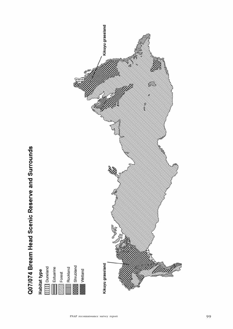
99

100
in 2009, occurring with occasional mahoe, Streblus banksii and karaka.
Parapara is also common in the understorey, occurring with kawakawa,
hangehange, nikau and turepo. The groundcover consists of common
Asplenium lamprophyllum, occasional Pteris comans and prolific parapara
seedlings.
(i) At the top of the steep slope above Peach Cove, kohekohe-kowhai
forest is present with frequent kanuka and manuka, and occasional puriri,
tawa, ti kouka, and mamaku. On the east side of Peach Cove Track, near
the top of the main ridge, type (d) is dominant with frequent ti kouka
and occasional puriri, rewarewa, karaka, kohekohe, kowhai, mamaku, and
nikau.
(j) Downhill from the ridge, puriri and taraire dominate the steep hillslope
forest. Frequent species include tawa, rewarewa, and kohekohe with
occasional karaka, kowhai, nikau, kanuka, manuka, and mamaku.
At the bottom of the slope, the coastal margin is dominated by type (g)
with frequent karaka and kohekohe, and occasional titoki, kowhai, kanuka,
manuka, and ti kouka.
(k) On the steep upper slopes, kowhai, puriri and taraire are co-dominant.
Associated species include rewarewa, nikau, ti kouka, tawa, mamaku,
titoki, karaka, and kohekohe.
Towards the top of the main ridge, type (j) puriri-taraire forest occurs on
a steep hillslope with frequent rewarewa and occasional tawa, kowhai,
nikau, mamaku, and epiphytic puka.
Type (l) pohutukawa is abundant with common puriri at the bottom of
the steep slope, with occasional taraire, kowhai, karaka, ti kouka, mahoe,
and nikau. Continuing eastwards on the coastal margin, type (g) remains
the dominant forest type. Houpara occurs frequently with occasional
tawapou, kowhai, and ti kouka.
Type (m) taraire forest becomes the dominant canopy species on steep
hillslope immediately above the coastal margin. Puriri is frequent with
occasional rewarewa, kowhai, and ti kouka. Taraire continues to dominate
further up the slope, with occasional tawa, nikau, and mamaku.
At Cabbage Tree Flat, type (n) ti kouka is abundant with frequent manuka
and harakeke, and occasional mapou. Type (o) kowhai-pohutukawa forest
dominates the steep slope above Cabbage Tree Flat, while mamaku,
manuka, ti kouka, and nikau are present in low numbers. Type (p)
pohutukawa-taraire forest is present on the northern edge of the shrubland.
Ti kouka is frequent with occasional tawa, kohekohe, manuka, nikau, and
mahoe. Type (g) occurs on steep hillslope with frequent karaka, tawapou,
houpara and Hebe parviflora, and occasional kowhai, ti kouka, puriri,
manuka, and nikau.
(q) Kanuka/manuka and rewarewa are co-dominant on the steep slope
nearer the ridgeline. Nikau is frequent with occasional karaka, puriri,
taraire, ti kouka, pigeonwood, mapou, and kiekie.
Type (r) kanuka/manuka-taraire forest is also present on a steep hillslope.
Rewarewa is frequent and totara, with occasional puriri, ti kouka, nikau,
mamaku, kowhai, lancewood, Hebe parviflora, puka, and kiekie.
101
(s) Flaxland dominated by abundant harakeke and common houpara
occupies a steep coastal gully. Frequent species include gorse and
emergent pohutukawa with occasional karaka and ti kouka.
An area of coastal cliffs is characterised by type (t) harakeke-gorse
flaxland. Smilax occurs frequently under emergent pohutukawa.
Type (u) gorse-smilax shrubland dominates a steep slope below the
lighthouse next to the beach. Pohuehue and harakeke are frequent with
occasional Calystegia sp. and emergent karaka. Type (v) gorse shrubland
is abundant on moderate slopes south of Ocean Beach Road. Also present
are frequent emergent manuka and occasional emergent mamaku. Further
up the slope, type (w) kanuka/manuka shrubland is present. Other species
present include occasional ti kouka, mamaku, and gorse.
Type (x) nikau-puriri-taraire forest is present below rocky bluffs. Mamaku
is frequent, with occasional totara, northern rata, miro, ti kouka, kanuka,
manuka, rewarewa, kowhai, puka, and emergent rimu.
Forest to the west side of the Peach Cove track, near the ridgeline, is
characterised by type (y) kanuka/manuka-kowhai forest on a steep slope.
Puriri and rewarewa are frequent with occasional pohutukawa, ti kouka,
nikau, and mamaku.
Other south-facing hillslope areas are defined by a uniform canopy of
type (d) with occasional ti kouka; type (y) with occasional ti kouka,
puka, and emergent puriri; type (bb) kohekohe-taraire forest with
frequent rewarewa and occasional karaka, puriri, kowhai, nikau, kanuka,
manuka, and puka; and type (cc) kanuka/manuka-pohutukawa forest with
occasional, mamaku, kowhai, and kauri.
Steep narrow gullies are occupied by type (z) puriri forest with frequent
kohekohe, and type (aa) kanuka/manuka-puriri forest with frequent
kowhai. Other species present include rewarewa, pohutukawa, karaka, ti
kouka, mamaku, nikau, and puka. This type of forest continues westwards
onto a steep hillslope.
(dd) On Busby Head, there is a separate area of shrubland on a moderate
east-facing slope. At the northern end, kanuka/manuka is dominant with
common mamangi and occasional houpara, ti kouka, mamaku, Clematis
paniculata, and emergent pohutukawa.
(ee) At the southern end of Busby Head, kanuka/manuka and Hebe sp.
commonly occur with frequent hangehange and mapou, and occasional
mamangi and rangiora.
(ff) The western side of the headland is characterised by abundant
pohutukawa with common houpara and kanuka/manuka commonly
occurring. On the lower coastal margin, harakeke is common with
occasional pampas.
(gg) A small area of dunelands is situated behind the beach at Smugglers
Bay. The dunelands are dominated by exotic grasses such as harestail and
kikuyu, with frequent lupin and occasional pohuehue, ratstail, hawksbeard,
knobby clubrush, and shore bindweed (F. Brook, unpub. data).
(hh) A small, discrete area of forest is present on on steep south facing
slopes on Home Point. Houpara is dominant with common karaka and
occasional puriri, whau, kowhai and wharangi.

102
(ii) A gully in the same area is dominated by karaka-kohekohe-puriri
forest with frequent pohutukawa and kanuka/manuka on the ridgeline,
and occasional whau.
(jj) Manuka shrubland (planted between 2003 and 2008) occurs on the
northern coastal margin of Home Point, with occasional pohutukawa, ti
kouka, harakeke, houpara, and karo (W. Holland, DOC, pers. comm.).
(kk) Kikuyu grassland covers large areas at Home Point and to the south
of Ocean Beach. Gorse is scattered throughout.
(ll) Extensive areas of bare rock are prominent on the exposed east coast
of the site. Rockland also flanks both sides of Busby Head.
Significant flora
Threatened
Pseudowintera insperata (Nationally Critical) (2004, CHR 573382) and
Senecio scaberulus (Nationally Critical).
at Risk
Scandia rosifolia (Declining) (Young 2007); Calystegia marginata
(2010, W. Holland, DOC, pers. comm.), Fuchsia procumbens (Naturally
Uncommon) (2010, W. Holland, DOC, pers. comm.); kawaka (Naturally
Uncommon) (W. Holland, DOC, pers. comm. 2010), Pimelea acra
(Naturally Uncommon) (1997, CHR 469709, reconfirmed in 2009 during
this survey); Pittosporum ellipticum (Naturally Uncommon), Pittosporum
virgatum (Naturally Uncommon); Celmisia adamsii var. rugulosa
(Naturally Uncommon) (2004, AK 286208); Chionochloa bromoides
(Naturally Uncommon) (2007, SSBI Q07/R07/H046); Sophora fulvida
(Naturally Uncommon) (1997, CHR 513396); parapara (Relict) (1994, AK
294655, reconfirmed 2009, W. Holland, DOC, pers. comm.) and Streblus
banksii (Relict) (1996, AK 297658), which is sparsely distributed in the
Reserve. Dianella latissima (Data Deficient) (1998, AK 300257) and
Drosera peltata (Coloniser) are also present. All other non-referenced
species are listed in Clunie (1993).
Regionally significant
Adiantum aethiopicum, Blechnum triangularifolium, Brachyglottis
kirkii var. angustior (2007, SSBI Q07/R07/H046), Cheilanthes distans,
Chionochloa conspicua subsp. cunninghamii (2007, SSBI Q07/R07/
H046), Corokia cotoneaster (2007, SSBI Q07/R07/H046) C. buddleioides
(1999, AK 300278), Dracophyllum sinclairii (2007, SSBI Q07/R07/
H046), Hebe ligustrifolia (includes H. “Whangarei”) (2008, SSBI Q07/
R07/H046), H. macrocarpa var. macrocarpa (2007, SSBI Q07/R07/H046),
H. parviflora (2007, SSBI Q07/R07/H046), Helichrysum lanceolatum,
mairehau (recorded in 2009 by Wildland Consultants during this survey),
kotukutuku, Leptostigma setulosa, Libertia aff. grandiflora (large
capsules) (2007, SSBI Q07/R07/H046), Linum monogynum, Lophomyrtus
obcordata (1980, AK 157361), Luzula banksiana var. banksiana (2004,
AK 286203), Metrosideros carminea (recorded in 2009 by Wildland
Consultants during this survey), ngaio (2007, AK 298397), black maire,
103
coastal maire (Young 2007), Oxalis magellanica (recorded during this
survey by Wildland Consultants, 2009), Pseudowintera axillaris (2007, AK
301842), Rubus squarrosus (1980, AK 157364), tawapou, Beilschmiedia
tawa (including B. tawaroa), toru, and ongaonga (2006, AK 297659). All
other non-referenced species are listed in Clunie (1993).
Fauna
Threatened birds
NI brown kiwi (Nationally Vulnerable), NI kaka (visitor, Nationally
Vulnerable), pied shag (Nationally Vulnerable), northern NZ dotterel
(visitor, Nationally Vulnerable) (Pierce et al. 2001), reef heron (Nationally
Vulnerable) (recorded from Busby Point in 1997), and red-billed gull
(Nationally Vulnerable). Bush falcon (Nationally Vulnerable) was heard
from a gully east of the Peach Cove carpark track in August 2008 (A.
Townsend, DOC, pers. comm.) and a dead specimen was found nearby
at Urquharts Bay in February 2006 (N. Miller, DOC, pers. comm.).
Australasian bittern (Nationally Endangered) has been known to visit the
reserve or its boundaries including an unnamed stream north of the site
(Pierce et al. 2001).
at Risk birds
Northern little blue penguin (Declining) (Pierce 2005), pied oystercatcher
(visitor, Declining), pied stilt (visitor, Declining) (Pierce et al. 2001), NZ
pipit (Declining), red-crowned kakariki (visitor, Relict), long-tailed cuckoo
(Naturally Uncommon), Pycroft’s petrel (Recovering) (single dead bird
recorded from Peach Cove, R. Pierce pers. comm.), variable oystercatcher
(Recovering), and Cook’s petrel (Relict) (skull recorded from Peach,
N. Miller, DOC, pers. comm. 2008). In the summer of 2009/10, two
breeding pairs of variable oystercatchers successfully raised chicks; one
at Smugglers Bay and one at a small beach around from Smugglers Bays
(W. Holland, DOC. pers. comm. 2010).
Regionally significant birds
Kukupa, NI tomtit, and NI bellbird (recorded breeding) (W. Holland,
DOC, pers. comm.), A grey-faced petrel was heard circling above Peach
Cove in Autumn 2003 (A. Booth, DOC, pers. comm.), and suspected
grey-faced petrel burrows were recorded at Bream Head in summer 2007,
near Cabbage Tree Flat, although no birds were seen (N. Miller, DOC,
pers. comm.).
Non-threatened birds
Tui, grey warbler, NI fantail, silvereye, welcome swallow, paradise
shelduck, morepork, shining cuckoo, Australasian harrier, Australasian
gannet (visitor), black-backed gull and kingfisher (1979 and 1992, SSBI
Q07/R07/H046). A breeding pair of variable oystercatchers with one chick
were observed at the southern end of Ocean Beach, near Moturaka Island
(W. Holland pers. comm.). White-faced heron was recorded during the
PNAP survey.
104
Mammals
Unconfirmed early 1990s record of a bat species seen at Peach Cove,
probably a long-tailed bat (Nationally Vulnerable) (SSBI Q07/R07/H046),
and 2008 sightings of a bat on two occasions at Ocean Beach (I. Pritchard,
pers. comm.).
land snails
Punctidae sp. 223 (#P. sp. 6) (Nationally Critical) has been recorded
from Smugglers Bay, where it lives amongst low herbaceous vegetation
dominated by exotic grasses. The population occupies c.80 sq metres
(Brook 2002)27. Schizoglossa worthyae (Serious Decline), Therasiella “aff.
elevata” (NMNZ M.96613) (Sparse), flax snail (Placostylis hongii) (Range
Restricted), which reaches its southern-most limit at Peach Cove (where it
is being managed via rodent control), Liarea turriculata “Manaia” (Range
Restricted) (F. Brook pers. comm.), and the non-threatened species Liarea
egea Bream Head” (NMNZ M.158257) (Data Deficient), Liarea hochstetteri,
Phenacohelix giveni, and Delos coresia (SSBI Q07/R07/H046).
Other invertebrates
Peripatus sp. (Range Restricted) and tree weta were recorded in 1992
(SSBI Q07/R07/H046). Also present are the carabid beetle (Mecodema cf.
aff. M. spiniferum), green chafer, giraffe weevil, two-spined weevil, and
four-spined weevil (F. Brook, pers obs.).
lizards
Auckland green gecko (Gradual Decline) (DOC Bioweb 2009), Pacific
gecko (Gradual Decline) (shed skin found on Peach Cove track in 2001,
DOC Bioweb 2009), ornate skink (Gradual Decline) (2001, DOC Bioweb
2009), forest gecko (regionally significant) (Pierce et al. 2001), common
gecko (regionally significant) (two individuals found crushed within a pile
of fenceposts along the Northern boundary, 2002) (SSBI Q07/R07/H046),
copper skink and shore skink (both recorded from Peach Cove, DOC
Bioweb 2009). A skink described as being a gravid female shore skink was
sighted near the main ridge track near the high point of Bream Head (Te
Whara) (therefore within forest and well away from the coast) in 2010
by Cathy Mitchell, a local resident (Cathy Mitchell, pers. comm.).
Other reptiles
Leatherback turtle (regionally significant) was recorded in Smugglers Bay
in 1996 (DOC Bioweb 2009).
Fish
Longfin eel (Gradual Decline), banded kokopu (regionally significant),
shortfin eel, and common bully were recorded from an unnamed stream
in the north of the site (NIWA 2009).
27 A cursory survey in November 2009 of the herbaceous vegetation along the seaward crest of the foredune did not yield any snails. Drought had caused the vegetation to brown off (F. Brook, pers. comm.).
105
Significance
Bream Head Scenic Reserve and Surrounds, along with Manaia Ridge Scenic
Reserve and Surrounds (Q07/069), are the most significant ecological
features of the Manaia Ecological District. Bream Head represents the largest
and highest quality broadleaved coastal forest remaining in Northland and
one of the best in the country. The reserve contains an outstanding coastal
headland with a rugged shoreline backed by steep forest-clad slopes and
rocky outcrops and peaks. Bream Head dominates the landscape both from
the sea and from the land, and as such its imposing form is a natural
gateway to Whangarei Harbour. In recognition of the special significance
of the site as both a cultural and natural heritage site, the Bream Head
Conservation Trust was formed in 2002 to facilitate the cooperative
management of the area in partnership with DOC and other key agencies,
including Whangarei District Council, Northland Regional Council, Royal
Forest and Bird Protection Society, the local community and iwi (Ritchie
2008). The Trust is currently working on a project to erect a predator
proof fence at the reserve and in February 2010 appointed a temporary
ranger (with the aim for it to be permanent) to progress ecological gains
at the reserve (W. Holland, DOC, pers. comm).
The reserve contains a complete sequence of vegetation types from the
sandy and rocky seashore to high forest and rocky outcrops (Clunie 1993).
Bream Head is the northernmost limit for the coastal woodrush Luzula
banksiana var. banksiana (NZPCN 2009). In total, the site supports
two ‘Threatened’, 11 ‘At Risk’, and 30 regionally significant species of
plants. This site is representative for all types, excluding those containing
adventive species (types t, u, v, and gg). It contains the country’s largest
and most healthy population of the Nationally Critical tree Pseudowintera
insperata (census completed in 2008 at 58 individuals) of which the only
other population is found at Manaia Ridge Scenic Reserve and Surrounds
(Q07/069); and also includes the largest population of parapara on the
New Zealand mainland (200+ plants of which 30% are mature).
The largest parapara tree recorded was c.6 m tall (W. Holland, DOC, pers.
comm.). The floral diversity of the reserve reflects the varied and often
steep, exposed and rocky terrain, together with its rich volcanic soils.
The reserve supports a diverse range of fauna, which includes 15
‘Threatened’ species, 12 ‘At Risk’ species, and eight regionally significant
species. The site supports the Nationally Critical land snail (Punctidae sp.
223) which, in Manaia ED, is only found in Bream Head Scenic Reserve
and Surrounds and one other location in Northland. The site also contains
the southern-most colony of flax snail in New Zealand. A continuous
poison operation targeting rodents has been underway since early 2003 to
protect the one flax snail colony known in the reserve. The health of this
population is regularly monitored, and recent observations demonstrate a
doubling of adult numbers and a tenfold increase in juveniles (N. Miller,
DOC, pers. comm.). Punctidae sp. 223, which inhabits dune habitat at
Smugglers Bay, was formerly threatened by cattle browsing and trampling,
but this area was fenced off in the 1990s. Loss of habitat due to rabbit
browse is probably the main existing threat, while predation by the
introduced snail Oxychilus alliarius is also a possible threat (Brook 2002).
Bats, provisionally identified as long-tailed bats, were seen at Peach Cove

106
in the early 1990s; in 2008 a bat species was sighted twice outside a
window at the Pritchard residence at Ocean Beach. NI kaka, NI bellbird
and red-crowned kakariki are frequent visitors from the nearby Hen and
Chicken Islands. In recent years NI bellbird has been recorded breeding
at Bream Head, despite the relatively high numbers of ship rats. The
activities of the WHLF complement the DOC-administered Whangarei Kiwi
Sanctuary, which includes Bream Head Scenic Reserve and Surrounds.
DOC have been releasing kiwi back into the reserve since 2000 (62 birds
so far) (T. Hamilton, WHLF, pers. comm.).
The main focus of DOC resources in Manaia ED goes to the Bream Head
Scenic Reserve and Surrounds, where increasing effort has been put
in over the past 17 years. This has included the sustained control of
possums and key invasive weeds (including pampas, prickly hakea, silver
wattle, Tasmanian blackwood, apple of Sodom, and Mexican daisy), forest
bird monitoring, and forest rehabilitation through planting programmes.
Ground-based possum and rodent control is undertaken every year in
the reserve. Possums are at almost undetectable levels in controlled
areas; however, ship rats are proving more difficult to suppress. DOC
has set a target of a 5% Residual Tracking Index (RTI) for ship rats,
but most operations struggle to get rats below c.20% RTI, which is
too high for species such as kakariki to breed and fledge chicks in the
reserve. Possums are known to interfere with bait stations, therefore
reducing bait availability to rats. In 2008, DOC carried out a ground-based
pest operation using 1080 to eliminate trap-shy mustelids and possums,
although this did not have a significant impact on rat numbers. DOC is
now increasing the bait station density within the reserve in an attempt
to reliably reduce rats to below 5% during the spring poison operations
(N. Miller, DOC, pers. comm.). Feral cats are present within the site and
are controlled by DOC and local landowners with a range of live and
kill traps, e.g. SA Conibear traps. ‘Threatened’ and regionally significant
birds, e.g. NI kaka, kukupa and NI bellbird, are likely to have benefited
from the 1080 poisoning operations via the secondary kills of cats and
mustelids. Traplines targeting stoats have also been set up along the
ridgeline and roadside. In terms of invasive invertebrates, Argentine ants
pose a major threat. DOC has established a buffer zone using the toxin
Fiprinol to prevent the spread of Argentine ants from Urquhart’s Bay and
Ocean Beach into Bream Head. DOC is also monitoring the boundary of
the site for new incursions, which will also be managed (A. Booth, DOC,
pers. comm.). Pigs are not present in the site (G. Coulston, DOC, pers.
comm.). Goats were common at the site until 1991, when an eradication
programme began. The control effort was intensified in 1993 and the last
goat was removed in 1994. Nearing the completion of the goat eradication
operation, in December 1993, all 15 adjacent land-owners agreed to a ban
on goat farming on all properties south of Ocean Beach Road between
Urquharts Bay and Ocean Beach. In 1995, DOC successfully submitted
that this goat farming ban be adopted into the NRC Regional Pest
Management Strategy (Pierce et al. 2001). DOC staff and local residents
occasionally shoot rabbits, given their potential to attract predators to the
site and their adverse effect on seedling survival (N. Miller, DOC, pers.
comm.). In addition, their grazing and burrowing can cause erosion and

107
impact on rare plants (Pierce et al. 2001), and destroy the habitat of
threatened land snails (Brook 2002). Dogs are prohibited from entering
the reserve unless permitted as part of a wildlife monitoring or pest
control operation. Until recently, livestock have had adverse impacts
upon sensitive habitats within the reserve, including forest, foreshore and
duneland systems. Cattle are now effectively excluded from all of Bream
Head Scenic Reserve as of 2009; however, there is one exception to this.
Approximately 20 ha in the central north face is under a seasonal grazing
“arrangement” whereby the former landowner is permitted to graze cattle
in an electrically fenced and fairly modified area for a few months over
winter for a period of 20 years. There are approximately ten years left
before the arrangement expires (N. Miller, DOC, pers. comm.).
Bream Head Scenic Reserve and Surrounds has the outstanding biodiversity
values to warrant its selection for a DOC-managed ‘mainland island’,
although it was not selected as one of the six sites established by DOC
in 1995-96 (Pierce et al. 2001). A recent study by Ritchie (2008) was
requested by the Bream Head Conservation Trust to look at the feasibility
of constructing a pest-proof fence along the northern boundary of the
reserve. There is strong community support for this idea.
Since 1994, work has been undertaken to remove large radiata pines and
ginger infestations, and moth plant and pampas on the coastal margins
are treated annually. Control operations continue for Jerusalem cherry,
pampas, Mexican devil, Mexican daisy, mist flower, wattles, and moth
plant28 around Smugglers Cove. This work is funded as part of the Island
Weed Programme to create a buffer zone and reduce the seed source
for the Poor Knights and Hen and Chicken Islands, and to maintain the
ecological integrity of the reserve (Pierce et al. 2001). Weeds such as
gorse and smilax are locally common in shrubland and on cliffs above
the beach along the north-east coast of Bream Head. Weeds are absent or
in low abundance where indigenous canopy cover is complete, although
serious weeds such as ginger can still establish in densely forested areas
(one small ginger plant was recorded during the current survey in 2009
along the ridgeline track heading east to Ocean Beach).29
Bream Head is classified as a geological site of regional significance:
“Best exposed section through the cone facies and underlying subvolcanic
intrusions in the Taurikura centre around Whangarei Heads” (Kenny and
Hayward 1996). Approximately 518.4 ha of this site lie within Bream Head
Scenic Reserve and Surrounds (DOC-administered), 4.8 ha within Bream
Head Conservation Area (DOC-administered), 22.2 ha are protected within
Bream Head Seabed (DOC-administered), and 9.7 ha are protected within
WDC-administered reserve. Approximately 1.7 of th site are within an
‘Acutely Threatened’ land environment’ (A5.1a), 54.9 ha within an ‘At
Risk’ land environment (A6.1b), 0.9 ha within a ‘Critically Underprotected’
land environment (A6.1c), 4.7 ha are within an ‘Underprotected’ land
environment (D1.2b), and 621 ha are within ‘No Threat Category’ land
environments (D1.1a, D1.1b) (Walker et al. 2007).
28 A large moth plant was removed from Peach Cove in the mid to late 1990s, although seedlings continued to be found for several years (W. Holland, DOC, pers. comm.).
29 This ginger plant was pulled out by hand.
108
O C E A N B E A C h R E C R E A T I O N R E S E R V E A N D S u R R O u N D S
Survey no. Q07/075
Survey date 28 August 1997 and 22 September 2009
grid reference 1740627E 6035743N (AX31)
Area 270 ha (1.7 ha forest, 258.6, ha duneland, 1.9 ha
wetland, 7.1 ha estuarine, 0.7 rockland)
(This site has been adjusted to fit 2008 aerial
photography. Changes include the addition of small
areas of estuarine and freshwater wetland habitat)
Altitude 0-30 m asl
Ecological units
(a) Buffalo grass-pohuehue-spinifex grassland on sand dune
(b) Buffalo grass-spinifex grassland on sand dune
(c) Spinifex grassland on sand dune
(d) Pampas-pohuehue tussockland on sand dune
(e) Harakeke-pohuehue flaxland on sand dune
(f) Gorse-kikuyu-pohuehue shrubland on sand dune
(g) Pohuehue-kikuyu-gorse vineland on sand dune
(h) Kunzea ericoides var. linearis shrubland on sand dune
(i) Sea rush rushland in marsh
(j) Saltwater paspalum grassland on stream bank
(k) Pohutukawa coastal forest on cliff
(l) Makaokao-remuremu-Mercury Bay weed herbfield on cliff
(m) Harakeke-Astelia banksii flaxland on cliff
(n) Baumea articulata-kuta-raupo sedgeland in swamp
landform/geology
Holocene coastal dunefield of fixed and active transverse dunes and dune
blowouts, with two headlands of Lower Miocene subvolcanic intrusions
(Coromandel Group) cutting melange of Cretaceous to Oligocene
sedimentary units (Mangakahia and Motatau complexes) in the southern
part of the site. Forested areas comprise coastal cliffs cut in Mesozoic
greywacke and chert (Waipapa Group); melange of Cretaceous to
Paleocene mudstone (Mangakahia Complex); and Lower Miocene andesitic
dikes (Coromandel Group). Saltmarsh occupies valley floor wetland on
Holocene alluvial deposits; remnant of formerly extensive Holocene
swamp behind coastal dune belt. Freshwater wetlands occupy hollow
on Holocene fixed sand dunes.
Vegetation
(a) At the southern end of Ocean Beach, there is a large, isolated sand
dune covered with buffalo grass, pohuehue and spinifex. Tauhinu, shore
bindweed, gorse, radiata pine, and kikuyu are frequent.
(b) Buffalo grass-spinifex grassland dominates a large, isolated sand
109
dune. Pohutukawa and harakeke are frequent with occasional houpara,
kawakawa, coastal toetoe, pingao, Astelia banksii, knobby clubrush, and
sea rocket.
(c) On foredunes, spinifex is the dominant species, occurring with
frequent pingao, oioi, and pampas, and occasional tauhinu, marram,
knobby clubrush, shore bindweed, Zoysia pauciflora, lupin, catsear,
purple groundsel, smilax, and Gladiolus undulatus.
(d) Duneslacks are characterised by pampas and pohuehue. Oioi and
buffalo grass are frequent with occasional shore bindweed, gorse, and
smilax.
(e) There are localised associations of harakeke and pohuehue on sand
dunes. Frequent species include knobby clubrush, pampas, and gorse
with occasional ti kouka, pohutukawa, Pimelea villosa subsp. villosa,
NZ spinach, Coprosma sp., Phoenix palm, and smilax.
The back dunes of the site are characterised two main vegetation types.
Type (f) comprises is a coastal association of gorse, kikuyu and pohuehue
with frequent shore bindweed and pampas, and occasional pohutukawa,
karo, karamu, Coprosma macrocarpa, knobby clubrush, harakeke, and
mapou. Type (g) comprises abundant pohuehue and kikuyu with locally
common patches of gorse. Cleavers and lotus are frequent with occasional
apple of Sodom and Senecio biserratus. In areas where the vegetation
is more open, smilax and moth plant are frequent. (h) Several discrete
patches of Kunzea ericoides var. linearis shrubland occur in the mid to
northern part of the site (at Proctors Beach). Understorey vegetation is
sparse under the canopy. Pampas and gorse are frequent on the shrubland
margins.
(i) West of the dunelands, near the upper reaches of the stream which
drains into the northern end of Proctors Beach, there are two discrete
areas of saltmarsh characterised by abundant sea rush. Gorse is frequent
on the margins.
(j) At the far northern end of the beach, along the sides of the stream,
there is coastal saltwater paspalum grassland. Frequent species include
tauhinu, pohuehue, sea rush, knobby clubrush and kikuyu, with occasional
Pimelea villosa subsp. villosa and Gladiolus undulatus.
(k) A small patch of pohutukawa-dominant forest is present on coastal
cliffs. Frequent species include harakeke, houpara, knobby clubrush, and
Astelia banksii, with occasional karo, pampas, kawakawa, taupata, NZ
spinach, NZ celery, native iceplant, glasswort, remuremu, and makaokao.
At the far northern end of the site, cliff faces are characterised by
localised patches of type (l) makaokao-remuremu-Mercury Bay weed
herbfield with occasional NZ spinach, Isolepis cernua, and glasswort;
and scattered type (m) harakeke-Astelia banksii flaxland with occasional
shore groundsel.
(n) Located in farmland near the western boundary of the site are two
small freshwater wetlands. Baumea articulata is co-dominant with kuta
while raupo is common. Gorse is frequent on the wetland margins and
on raised islands within open water, with occasional ti kouka.

110
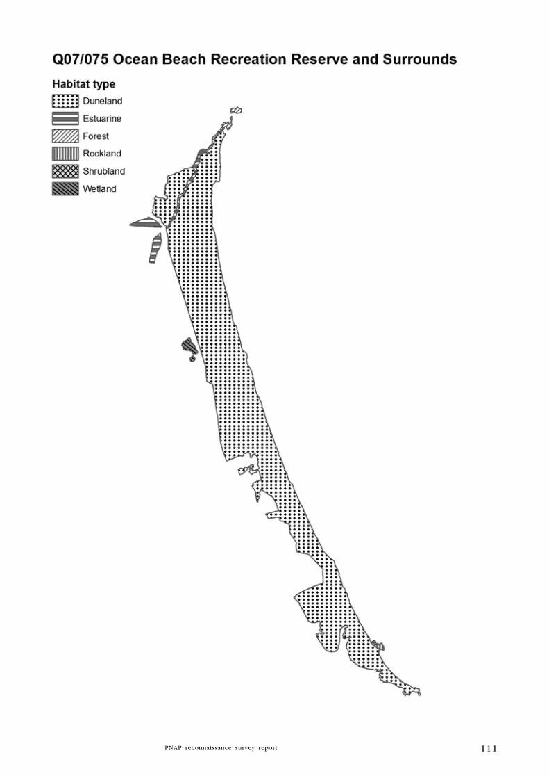
111

112
Significant flora
Coprosma acerosa (Declining) (1956, WELT SP9021; reconfirmed 1997
during this PNAP survey), Kunzea ericoides var. linearis (Declining)
(1956, WELT 14118, reconfirmed 2009 during this PNAP survey),
Pimelea villosa subsp. villosa (Declining) (1999, AK 248037), Tetragonia
tetragonioides (Naturally Uncommon) (recorded by Wildland Consultants
during this survey, 2009), pingao (Relict) (recorded during this survey
in 1997 and 2009), Einadia triandra (regionally significant), ngaio
(regionally significant) (1997, SSBI Q07/R07/H041), and Senecio biserratus
(regionally significant) (recorded by Wildland Consultants during this
survey, 2009). In September 2009, at least ten plants of Pimelea villosa
subsp. villosa were recorded from the northern half of the site. There is
an historical record of Asplenium northlandicum (regionally significant)
from this site (1956, WELT P2110).
Fauna
Threatened birdsGrey duck (Nationally Critical) (historical record, 1979), Caspian tern
(Nationally Vulnerable) (historical record, 1979), breeding northern NZ
dotterel (Nationally Vulnerable), and red-billed gull (Nationally Vulnerable)
(SSBI Q07/R07/H041). In September 2009 two pairs of northern NZ
dotterels were recorded near the stream mouth at the northern end of
Proctors Beach by Wildland Consultants.
at Risk birdsNorthern little blue penguin (Declining), pied stilt (Declining) (R. Pierce
pers. comm.), white-fronted tern (Declining) (historical record, 1979),
black shag (Naturally Uncommon) (historical record, 1979), little shag
(Naturally Uncommon) (historical record), NZ pipit (Declining), and
variable oystercatcher (Recovering) (SSBI Q07/R07/H041). There have been
occasional reports of banded rail (Naturally Uncommon) from saltmarsh
habitat at the northern end of Proctors Beach (R. Pierce pers. comm.).
Several oystercatchers were recorded near the stream mouth at the northern
end of Proctors Beach in 2009 by Wildland Consultants.
Non-threatened birdsWhite-faced heron (historical record, 1979), black-backed gull, spur-
winged plover, paradise shelduck, pukeko, kingfisher, and welcome
swallow (SSBI Q07/R07/H041).
lizardsOrnate skink (Gradual Decline) and shore skink (both recorded in 1979,
SSBI Q07/R07/H041). Common gecko (regionally significant) was recorded
in 1990 (DOC Bioweb 2009). Shore skink was most recently recorded from
the site in August 2000 (SSBI Q07/R07/H041).
OtherBlack katipo (Serious Decline) was recorded in 2000 and 2008 (Griffiths
2000; A. Booth, DOC, pers. comm.). A dead yellow-bellied seasnake
(Vagrant, regionally significant) was found in 2002 (DOC Bioweb 2009).
113
Significance
Ocean Beach Recreation Reserve and Surrounds is the only site in Manaia
ED containing an extensive duneland system. It is large and diverse,
incorporating coastal forest, shrubland, vineland, herbfield, grassland,
freshwater wetland, and saltmarsh habitat types. It contains representative
examples of vegetation units (c), (e), (h), (i), (k), (l), and (m). The site
supports five ‘At Risk’ plant species and four regionally significant species.
It also supports numerous species of birds, including four ‘Threatened’
and eight ‘At Risk’ species of seabird, as well as one ‘Threatened’ and two
regionally significant reptile species, and one ‘Threatened’ invertebrate
species. Dogs, cats, stoats, weasels, rats, and hedgehogs threaten ground-
nesting birds such as northern NZ dotterel. Predator control is currently
being undertaken in an area of covenanted dunelands near the Ocean
Beach settlement30. Signs have also been erected to educate dog owners
about the risk their pets pose to local wildlife (dogs are not permitted on
the beach). Such efforts have resulted in the slow recovery of the local
dotterel population, with three chicks fledging last year. The farmland
adjacent to the site currently supports large numbers of black-backed
gulls, and it is likely they are adversely affecting nesting dotterels. DOC
intends to talk to the local landowner soon about options for controlling
black-backed gull numbers. Rabbits are common throughout the site and
pose a threat to duneland vegetation, particularly pingao. Poisoning and
shooting are periodically carried out to reduce their numbers (P. Cornille,
DOC, pers. comm.).
Ocean Beach is a popular summer destination and has high recreational
values. At Proctors Beach, there are risks associated with high beach
usage such as disturbance of nesting birds and the trampling of nests
and duneland vegetation by people and quad/trail bikes. Walkways have
been established to lead people from the carpark to the beach in order
to protect the dunes. However, it is evident that the dunes are frequently
walked over, particularly between Proctors Beach in the north and
Lighthouse Bay31 in the south. At the northern end of Proctors Beach,
near the estuary, a local farmer helps protect variable oystercatchers and
dotterels from dogs and trail bikes. He has also fenced off some of the
dunes on his property, and as a result much of the indigenous duneland
vegetation has recovered (SSBI Q07/R07/H041). Weeds have established
throughout much of the site and there is a risk that threatened duneland
plants such as Pimelea villosa subsp. villosa will continue to be out-
competed unless management is implemented. Weeds present in coastal
dunelands include pampas, gorse, lupin, moth plant, and smilax, while in
the northern part of the site, near the stream, saltwater paspalum is locally
abundant with occasional radiata pine, kikuyu, lupin, freesia, Gladiolus
undulatus, and buffalo grass. Moth plant has adapted well to the dunelands
where it grows as a ground-cover and is protected from the elements
by pohuehue (SSBI Q07/R07/H041). Phoenix palms are also establishing.
Exotic iceplant and Norfolk pine were planted over a decade ago.
30 DOC does not currently carry out pest control at Ocean Beach Recreation Reserve and Surrounds.
31 Lighthouse Bay is a local name.

114
Despite being relatively species-poor compared with forested areas,
dunelands are key habitats for retaining the natural biodiversity of Manaia
ED. Dunelands also perform important roles in buffering shrubland,
wetlands, and developed land from adverse maritime conditions (Pierce
et al. 2002). Approximately 213.3 ha of this site are within Ocean Beach
Recreation Reserve and Surrounds (DOC-administered), a reserve type
which does not adequately provide for biodiversity protection. A further
0.6 ha is within Kauri Mountain Marginal Strip (DOC-administered),
12.7 ha are within a Queen Elizabeth II Open Space Covenant located
between Ocean Beach and Proctors, and 4.4 ha are protected within
WDC-administered reserve. In recent years, this area of covenanted land
has been actively revegetated through successive public planting days
(W. Holland, DOC, pers. comm. 2010). Approximately 5 ha of the site
are within an ‘Acutely Threatened’ land environment’ (A5.1a), 236.3 ha
within ‘At Risk’ land environments (A6.1b, G1.1a), 15.6 ha within a
‘Critically Underprotected’ land environment (A6.1a), 0.2 ha is within an
‘Underprotected’ land environment (D1.2b), and 2.9 ha lie within a ‘No
Threat Category’ land environment (D1.1a, D1.b) (Walker et al. 2007).
k E R R R O A D S w A M P
Survey no. Q07/076
Survey date 18 March 1997, 13 October 1998, 4 August 2009
and 24 September 2009
grid reference 1738199E 6039037N (AX31)
Area 3.3 ha
Altitude 15-18 m asl
Ecological units
(a) Kahikatea-Bolboschoenus fluviatilis treeland in swamp
(b) Baumea articulata-Bolboschoenus fluviatilis-Mexican devil reedland
in swamp
(c) Bolboschoenus fluviatilis-swamp millet-raupo-Mexican devil reedland
in swamp
(d) Mexican devil-raupo-Bolboschoenus fluviatilis herbfield in swamp
(e) Baumea articulata reedland in swamp
(f) Baumea sp. sedgeland in swamp
(g) Raupo reedland in swamp
(h) Harakeke-manuka-Baumea articulata flaxland in swamp
(i) Cyperus ustulatus-exotic grass spp. sedgeland in swamp
landform/geology
Remnant of formerly extensive Holocene swamp behind dune belt.
Vegetation
(a) At the head of the wetland, where the site buffers the Kauri Mountain
Conservation Area and Surrounds (Q07/078), kahikatea is emergent over

115
116
common Bolboschoenus fluviatilis reedland with occasional ti kouka,
kanuka, manuka, Cyperus ustulatus, and gorse.
The wetland area on the north side of the road is densely vegetated
with a mosaic of types (b), (c), (d), (e), (f), (g) and (h). Throughout
the northern part of the site there is occasional ti kouka, manuka,
gorse, kapungawha, Baumea teretifolia, wheki, swamp kiokio, Baumea
rubiginosa, oval sedge, Cyperus ustulatus, Centella uniflora, Carex
virgata, and Calystegia sepium.
The lower half of the swamp has been drained and is now dominated
by type (i) Cyperus ustulatus-exotic grass spp. sedgeland. Frequent soft
rush occurs with occasional raupo, manuka, and ti kouka.
Significant flora
No information.
Fauna
NI fernbird (Declining), pukeko, NZ kingfisher, and Australasian harrier
(L. Forester, NRC, pers. comm. 2009). Australasian bittern (Nationally
Endangered) and spotless crake (Relict) have been recorded nearby and
are likely to use this site (R. Pierce pers. comm.).
Significance
Freshwater wetlands are a very rare habitat type in Manaia ED, and Kerr Road
Swamp is one of best remaining examples of a fertile swamp remaining in
the ED. The site comprises a mosaic of reedland, sedgeland and herbfield
vegetation types that is bisected by a farm track. Representative for types
(a), (e), (g), and (h). The larger, northern part of the wetland is not
grazed, is well-buffered by indigenous shrubland, and forms part of a rare
freshwater wetland-terrestrial forest ecological sequence. The lower half
of the site is degraded, grazed, and lacks any buffering, resulting in the
absence of many indigenous wetland plant species and the profileration
of exotic grasses and browse-tolerant soft rush. At least one species of
threatened bird occurs at this site. Spotless crake (Relict) and Australasian
bittern (Nationally Endangered) are also likely to utilise the wetland. As
with other wetlands in Manaia ED, Mexican devil is the most abundant
weed species in Kerr Road Swamp. Approximately 0.5 ha of this site is
within a WDC-administered conservation covenant. 2.0 ha of this site
are within an ‘Acutely Threatened’ land environment (A5.1a) and 1.3 ha
are within an ‘At Risk’ land environment (A6.1b) (Walker et al. 2007).

117
T I M P E R l y R O A D B u S h
Survey no. Q07/077
Survey date 23 March 1998 and 7 October 2006
grid reference 1735898E 6039631N (AX31)
Area 38.4 ha (17.7 ha forest, 20.7 ha shrubland)
Altitude 41-160 m asl
Ecological units
(a) Totara-mahoe-kanuka forest on steep hillslope
(b) Mamaku-totara treefernland on steep hillslope
(c) Mamaku treefernland on moderate hillslope
(d) Gorse shrubland on moderate hillslope
(e) Pampas-gorse tussockland on moderate hillslope
(f) Exotic grass-gorse grassland on steep hillslope
(g) Kanuka/manuka shrubland on moderate hillslope
(h) Puriri-taraire forest on moderate hillslope
(i) Kanuka/manuka-tanekaha-totara forest on moderate hillslope
(j) Puriri-taraire-totara forest on moderate hillslope
(k) Kahikatea-totara forest on moderate hillslope
(l) Mamaku-towai treefernland on moderate hillslope
landform/geology
Steep, isolated hill comprising the eroded remnant of a Lower Miocene
dacite dome (Coromandel Group).
Vegetation
(a) The entire southern and western slopes of the site comprise secondary
forest dominated by totara-mahoe-kanuka forest, with occasional emergent
species such as kauri, tanekaha, rimu, puriri, taraire, karaka, towai, and
pohutukawa. Common understorey species include mapou, pate, ti kouka,
pigeonwood, putaputaweta, bush lawyer, and Metrosideros perforata.
(b) A small pocket of mamaku-totara treefernland is present on the
northern slopes of the site. Towai is frequent with occasional kahikatea,
kanuka, manuka, pampas, and gorse. In the shrubland area, type (c)
mamaku treefernland is abundant northwest of the highest point, with
occasional ti kouka, kanuka and manuka.
(d) Gorse is the dominant shrubland species in the site, occurring with
frequent pampas and occasional hangehange and ti kouka.
(e) Pampas-gorse tussockland is also present in disturbed areas, occurring
with occasional totara, ti kouka, gorse, and mamaku.
(f) Exotic grass-gorse grassland is common on the eastern slopes of the
rock knoll (the highest point of the site), while type (g) kanuka/manuka
shrubland occupies a small area in the south-east corner of the site,
occurring with occasional totara, ti kouka, mamaku, and gorse.
(h) A small remnant of puriri-taraire forest occurs with occasional karaka,
pohutukawa, kahikatea, and mamaku.

118

119
(i) Kanuka/manuka-tanekaha-totara forest is present with occasional kauri,
ti kouka and mamaku.
(j) Other areas of broadleaved forest on hillslope forest are characterised
by puriri-taraire-totara forest with occasional karaka, kahikatea, mamaku,
and ti kouka.
(k) A small remnant kahikatea-totara forest occurs with frequent kanuka
and manuka and occasional puriri, kauri, and mamaku.
(l) In the far north-west of the site mamaku-towai treefernland occurs
with occasional kanuka, manuka, kahikatea, ti kouka, and mahoe.
Significant flora
Rubus squarrosus (regionally significant) (2006, SSBI Q07/R07/H090).
Fauna
The WHLF monitored several transmitted NI brown kiwi (Nationally
Vulnerable) in the site until 2006, when a large fire occurred. No kiwi
have been monitored since 2006, but they are probably still present (H.
Moodie, WHLF, pers. comm.). Kiwi sign in the form of droppings and
probes were observed in the southern forest, and kukupa (regionally
significant) have been recorded (2006, SSBI Q07/R07/H090). NZ pipit
(Declining), Australasian harrier, welcome swallow, and spur-winged
plover were recorded during the survey in March 1998.
Significance
Despite having been cleared for farmland until the mid 20th century,
large areas of the site are in an advanced stage of forest regeneration,
with a high diversity of indigenous plant species. Many parts of the
forest support healthy seedling regeneration, including taraire, which
indicates that seed dispersal by kukupa and other birds is taking place
(SSBI Q07/R07/H090). Timperly Road Bush is known kiwi habitat and it
is an important corridor for kiwi movement throughout Manaia ED. The
site also supports one ‘At Risk’ bird and contains an important potential
year-round food source for kukupa. It also provides an important linkage
to surrounding habitat including Kauri Mountain (Q07/078) to the east,
Tahunatapu Road Coastal Forest (Q07/066) and Munro Bay Coastal Bush
(Q07/067) to the west, and Manaia Ridge Scenic Reserve and Surrounds
(Q07/069) to the south. Representative site for types (a), (b), (c), (i), (j),
(k), and (l). Houses have been built within the site (L. Forester, NRC, pers.
comm. 2009). Gorse and pampas are the dominant weeds throughout the
site. Approximately 13.2 ha of indigenous forest in the south-west of the
site lie within a Queen Elizebeth II Open Space Covenant. Approximately
7.3 ha of this site are within an ‘At Risk’ land environment (A6.1b), 3.2
ha are within a ‘Critically Underprotected’ land environment (A6.1c), 0.2
ha is within an ‘Underprotected’ land environment (D1.2b), and 27.7
ha are within a ‘No Threat Category’ land environment (D1.1b) (Walker
et al. 2007)

120
k A u R I M O u N T A I N C O N S E R V A T I O N A R E A A N D S u R R O u N D S
Survey no. Q07/078
Survey date 2 September 1998
grid reference 1739674E 6040347N (AX31)
Area 492.6 ha (327.2 ha forest, 152.4 ha shrubland,
0.1 ha wetland, 13 ha rockland)
(This site has been adjusted to fit 2008 aerial
photography. Main changes include the addition of
forest and shrubland remnants to the north-east)
Altitude 0-245 m asl
Ecological units
(a) Kahikatea-puriri coastal forest on toeslope
(b) Kauri coastal forest on hillslope and ridge
(c) Kanuka/manuka-tanekaha coastal forest in gully and on hillslope
(d) Kanuka/manuka coastal forest on hillslope
(e) Kahikatea coastal forest on moderate hillslope
(f) Kanuka/manuka coastal shrubland on hillslope
(g) Kanuka/manuka-tanekaha coastal shrubland on moderate hillslope
(h) Kanuka/manuka-mamangi-mapou coastal shrubland on moderate
hillslope
(i) Kanuka/manuka-mapou coastal shrubland on moderate hillslope
(j) Puriri-taraire forest on hillslope
(k) Kahikatea-kanuka/manuka-taraire coastal forest on moderate hillslope
(l) Kanuka/manuka-totara coastal forest on moderate hillslope
(m) Gorse-kanuka/manuka shrubland on moderate hillslope
(n) Kanuka/manuka-rimu forest in gully
(o) Kahikatea-kanuka/manuka-kauri forest on moderate hillslope
(p) Kanuka/manuka-totara coastal shrubland on moderate hillslope
(q) Kauri-tanekaha coastal forest on hillslope
(r) Kanuka/manuka-kohuhu forest on moderate hillslope
(s) Kanuka/manuka-kauri forest on hillslope
(t) Kanuka/manuka-towai forest on hillslope
(u) Kanuka/manuka-puriri-totara forest in moderate gully
(v) Kanuka/manuka-kauri-tanekaha forest on moderate hillslope
(w) Pohutukawa coastal forest on rock bluff
(x) Mamaku-tanekaha coastal treefernland on moderate hillslope
(y) Bolboschoenus fluviatilis reedland in swamp
landform/geology
Steep coastal hills: northeastern part predominantly Mesozoic greywacke
and chert (Waipapa Group), cut by Lower Miocene andesitic dikes
and larger subvolcanic intrusions (Coromandel Group); southwestern
part consists of a large Lower Miocene subvolcanic andesitic intrusion

121
(Coromandel Group), bounded by melange of Cretaceous to Oligocene
sedimentary units (Mangakahia and Motatau complexes).
Vegetation
(a) Kahikatea-puriri coastal forest is present at the bottom edge of the
slope on the southern side of Kauri Mountain. Nikau is frequent with
occasional rewarewa, matai, karaka, kanuka, manuka, and ti kouka. Above
this, the hillslope vegetation grades into type (b) kauri forest with
occasional pohutukawa, kahikatea, tanekaha, rimu, rewarewa, kanuka, and
manuka. Continuing up the slope, type (c) kanuka/manuka-tanekaha forest
is dominant with emergent tanekaha and occasional rewarewa, towai and
kauri, while further up the slope type (d) kanuka/manuka coastal forest
is present with frequent emergent kauri, and occasional rewarewa and
ti kouka.
Type (d) is also dominant on moderate hillslopes west of Kauri Mountain
Road, occurring with frequent mamangi and five-finger, and occasional
matai, tawa, totara, kahikatea, mamaku, and ti kouka. Type (e) kahikatea
coastal forest becomes dominant further down the slope with occasional
totara, pukatea, rimu, tawa, ti kouka, and nikau.
(f) Kanuka/manuka dominates a zone of coastal shrubland. Tanekaha is
frequent and ti kouka is present in low numbers. Further down the slope,
type (f) grades into type (g) kanuka/manuka-tanekaha coastal shrubland,
with occasional ti kouka.
Areas to the west are characterised by type (h) kanuka/manuka-mamangi-
mapou shrubland and type (i) kanuka/manuka-mapou shrubland, with
occasional ti kouka, tarata, mamaku, mamangi, harakeke, and emergent rimu.
(j) Further west, shrubland gives way to hillslopes dominated by puriri-
taraire forest with frequent rewarewa and occasional northern rata,
kauri, totara, kahikatea, rimu, mamaku, kanuka, manuka, nikau, and
epiphytic puka. To the west, the canopy changes to type (k) kahikatea-
kanuka/manuka-taraire forest with frequent ti kouka and occasional rimu,
rewarewa, totara, puriri, and nikau. Type (l) kanuka/manuka-totara coastal
forest is also present on a moderate slope with frequent mapou, ti kouka,
and rewarewa.
(m) Continuing west, coastal forest on hillslope is replaced by gorse-
kanuka/manuka coastal shrubland with occasional pampas, while a gully
is defined by type (f) with occasional totara, rimu, kohuhu, mamaku,
and ti kouka.
Type (n) kanuka/manuka-rimu forest occupies a gully with frequent
kahikatea and occasional kauri, rewarewa, towai, puriri, ti kouka, mamaku,
and kiekie. Type (n) is fringed by type (o) kahikatea-kanuka/manuka-kauri
forest on a moderate slope. Totara is frequent with occasional puriri, rimu,
ti kouka, mamaku, and kiekie. Forest reverts to shrubland (types f and
m) to the west, with frequent towai and ti kouka, and occasional puriri,
taraire, totara, mapou, mamaku, and gorse. Type (p) kanuka/manuka-totara
shrubland is also present with occasional emergent radiata pine.
Large areas of hillslope on the northern side of the site are dominated
by type (f) with frequent mapou and ti kouka, and occasional totara,
mamaku, pate, mamaku, gorse, and emergent kahikatea and radiata pine.

122

123

124
On the eastern side of Kauri Mountain Road, type (d) is dominant at the
bottom of the stream gully, with occasional kahikatea, kauri, totara, and
tanekaha. To the north and north-east, type (c) is present with occasional
mamaku and kohuhu.
North of the trig, type (d) dominates a moderate slope with occasional
totara and kauri. This in turn grades into type (q) kauri-tanekaha coastal
forest further down the slope. Kanuka and manuka are frequent with
occasional rewarewa, rimu, and emergent radiata pine.
(r) A small area of kanuka/manuka-kohuhu coastal forest occurs on a
moderate slope between the two forks of the stream.
(s) Kanuka/manuka-kauri coastal forest dominates areas of moderate
hillslope, occurring with occasional ti kouka and kohuhu.
(t) Kanuka/manuka-towai forest is also present on moderate hillslope,
with frequent ti kouka and kohuhu, and occasional mamaku.
(u) In a separate remnant in the north of the site, kanuka/manuka-puriri-
totara forest is present in a gully. Kahikatea is frequent with occasional
kauri, pohutukawa, taraire, rewarewa, nikau, kohekohe, and epiphytic
puka. Other vegetation types present in this remnant include type (v)
kanuka/manuka-kauri-tanekaha forest with frequent totara and occasional
rimu, and type (d) with occasional totara and tanekaha.
(w) In the separate, small coastal remnant in the southeast of the site,
pohutukawa is dominant over an understorey of harakeke along the rocky
bluffs. Other species include occasional puriri and mamaku.
(x) Mamaku-tanekaha coastal treefernland is present on a moderate
hillslope. Nikau is frequent with occasional rimu, mapou, and ti kouka.
(y) A small wetland situated in a gully to the west of Kauri Mountain
Road is dominated by Bolboschoenus fluviatilis. It is well-buffered by
gorse and kanuka shrubland. Wheki, manuka, kapungawha, Mexican devil,
and emergent ti kouka are scattered throughout.
Significant flora
at RiskCelmisia adamsii var. rugulosa (Naturally Uncommon) (2001, AK
252592), Fuchsia procumbens (Naturally Uncommon) (2001, AK 282046),
and kawaka (Naturally Uncommon) (2001, SSBI Q07/R07/H038).
Regionally significantBlack maire, Hebe parviflora, Olearia albida, northern rata, Rubus
schmidelioides (possibly mis-identified), and toru (all recorded in 2001,
SSBI Q07/R07/H038).
Fauna
BirdsNorth Island brown kiwi (Nationally Vulnerable) (WHLF have released 17
kiwi into the site up until 2009), NZ pipit (Declining), Pycroft’s petrel
(Recovering) (single dead bird found, R. Pierce pers. comm.), kukupa
(regionally significant), NI tomtit (regionally significant) (R. Pierce pers.
comm.), Australasian harrier, morepork, kingfisher, tui, shining cuckoo,

125
silvereye, and grey warbler (2001, SSBI Q07/R07/H038). Spotless crake
(Relict) and pukeko are present in the wetland (L. Forester, NRC, pers.
comm. 2009).
ReptilesShore skink (2001, SSBI Q07/R07/H038).
land snailsThe non-threatened species Phrixgnathus douglasi and Liarea turriculata
are known from the site (F. Brook pers. comm.).
FishBanded kokopu (regionally significant) and shortfin eel (2001, SSBI Q07/
R07/H038).
SignificanceKauri Mountain Conservation Area and Surrounds is the largest area
of coastal forest between Bream Head and Russell, and is part of the
Whangarei Kiwi Sanctuary, providing key habitat for NI brown kiwi.
Major dog problems in 2006 resulted in the deaths of two kiwi that
were carrying transmitters, and a dramatic decline in kiwi sign over the
next year. However, since WHLF eradicated pigs from the site and dealt
with the offending dogs’ owner, kiwi counts are currently trending up.
At the time of writing, there has been no dog sign since April 2008
(T. Hamilton, WHLF, pers. comm.). The site also supports two ‘At Risk’
species of threatened bird, at least two species of regionally significant
bird, and one species of regionally significant freshwater fish. The
vegetation is diverse and is regenerating well following the eradication
of goats and pigs, which was carried out three years ago (a total of 28
pigs were killed) (G. Coulston, DOC, pers. comm.). At least three ‘At
Risk’ plant species and six regionally significant plant species inhabit the
site. The site also contains one of the few areas of pohutukawa coastal
forest remaining in Northland. The site is representative for types (a),
(b), (e), (g), (h), (i), (j), (k), (l), (n), (o), (p), (r), (s), (t), (u), (v), (w),
(x), and (y).
Weeds include occasional gorse and radiata pine. Approximately 91.3 ha
of the site are protected within DOC-administered Conservation Park,
c.70.5 ha are within WDC-administered covenants, 6.0 ha are protected
within WDC-administered reserve, and c.1.6 ha are within a Queen
Elizabeth II Open Space Covenant. Approximately 2.5 ha of this site
are within ‘Acutely Threatened’ land environments (A5.1a, A5.1c), 1.1
ha are within a ‘Chronically Threatened’ land environment (A1.1d), 46.3
ha are within an ‘At Risk’ land environment (A6.1b), 12.7 ha are within
‘Critically Underprotected’ land environments (A6.1a, A6.1c), 191.7 ha are
within an ‘Underprotected’ land environment (D1.2b), and 230.8 ha are
within ‘No Threat Category’ land environments (D1.1a, D1.1b) (Walker
et al. 2007).

126
B R E A M I S l A N D S S C E N I C R E S E R V E : M O T u R A k A A N D T A R A k A N A h I I S l A N D S
Survey no. Q07/079
Survey date 18 September 1998
grid reference 1742713E 6032910N (AX31)
Area 2.4 ha (0.3 ha shrubland, 2.1 ha rockland)
Altitude 0-10 m asl
Ecological units
(a) Harakeke-coastal toetoe flaxland on island
(b) Kikuyu-taupata grassland on island
(c) Makaokao-remuremu-glasswort-native iceplant rockland on island
landform/geology
Small rocky islands, formed of eroded Lower Miocene subvolcanic
intrusions (Coromandel Group) cutting melange of Cretaceous to Oligocene
sedimentary units (Mangakahia and Motatau complexes).
Vegetation
(a) Moturaka Island (the southern island) is mostly bare rock with areas
of abundant harakeke and commonly occurring coastal toetoe. Cyperus
ustulatus is frequent with occasional taupata, pohuehue, Baumea juncea,
knobby clubrush, Asplenium haurakiense, and A. northlandicum.
(b) What little vegetation there is on Tarakanahi Island is characterised
by locally common kikuyu and taupata with frequent glasswort and
occasional makaokao.
(c) Remaining areas of bare rock are occupied by salt-tolerant herbs
such as makaokao, remuremu, glasswort, native iceplant, shore groundsel,
Lobelia anceps, NZ spinach, Pseudognaphalium luteoalbum, and
batchelor’s button.
Significant flora
A. northlandicum (regionally significant) is present on Moturaka Island
(recorded during this survey).
Fauna - Moturaka Island
Birds
Red-billed gull (Nationally Vulnerable) nesting with chicks, pied
shag (Nationally Vulnerable), white-fronted tern (Declining), variable
oystercatcher (Recovering) (a pair and chick were recorded in January
2010, W.Holland, DOC, Pers. Comm.), welcome swallow, and silvereye
were recorded in 1992-94 (SSBI Q07/R07/H128). One predated fluttering
shearwater (Relict) was found in October 1992, but it is likely that it
originated from nearby Mauitaha Island or Guano Island where they are
known to breed (1992, SSBI Q07/R07/H128). Variable oystercatcher, red-
billed gull (nesting with chicks), pied shag, white fronted tern, and black-
backed gull were also recorded in 1998 during the PNAP survey.

127
128
lizards
Two shore skinks were recorded in October 1992 (SSBI Q07/R07/H128).
Other
Golden bell frogs were recorded in one of the brackish ponds in October
1992 (SSBI Q07/R07/H128).
Fauna - Tarakanahi Island
Birds
Red-billed gull (Nationally Vulnerable) and white-fronted tern (Declining)
are known to breed on the island (1990, SSBI Q07/R07/H128). Black-
backed gulls (possibly nesting) were recorded in September 2009 by
Wildland Consultants.
Significance
The site comprises two small rocky islands. At low tide, exposed sand
joins Moturaka to the mainland. Moturaka Island and Tarakanahi Island
support one regionally significant plant species and nesting and/or
roosting habitat for two ‘Threatened’ and three ‘At Risk’ bird species.
Representative site for types (a) and (c). Moturaka’s proximity to Ocean
Beach makes it vulnerable to human and animal disturbance. Dogs are
known to visit the island (SSBI Q07/R07/H128), thus threatening nesting
and roosting seabirds. Moturaka has been burnt in the past and is now
host to a number of introduced plant species, which are mainly grasses
and herbs. No exotic plant species were recorded from Tarakanahi Island.
Approximately 1.1 ha of the site is protected within Bream Island Scenic
Reserve (DOC-administered). Approximately 1.4 ha of this site is within a
‘Chronically Threatened’ land environment (A7.1a) and 0.05 ha is within
a ‘No Threat Category’ land environment (D1.1a) (Walker et al. 2007).
B R E A M I S l A N D S N A T u R E R E S E R V E : M A u I T A h A I S l A N D A N D g u A N O I S l A N D
Survey no. Q07/080
Survey date September 1990 and 12 January 1991 (SSBI Q07/
R07/H080)
grid reference 1743913E 6032653N (AX31)
Area 6 ha (2.4 ha shrubland, 3.6 ha rockland)
Altitude 0-40 m asl
Ecological units
(a) Taupata coastal shrubland on island
(b) Harakeke-taupata coastal flaxland on island
(c) Mercury Bay weed-makaokao-NZ celery rockland on island
129
landform/geology
Rocky islets comprising the eroded remnants of a Lower Miocene
subvolcanic diorite intrusion.
Vegetation
(a) Mauitaha Island is gently sloping on the western side with cliffs
on the eastern side. The vegetation consists of dense taupata coastal
shrubland with frequent harakeke and coastal mahoe. Taupata extends
almost to sea level on the western side. Above the cliffs on the eastern
side is a flat area of native ice plant, and a few emergent pohutukawa.
Other species present include kanuka, pohuehue, Cyperus ustulatus,
Asplenium haurakiense, A. northlandicum, and Hypolepis distans.
(b) Gauno Island consists of mainly rounded bare rock with patches of
harakeke-taupata coastal shrubland with occasional Cyperus ustulatus,
native iceplant, Crassula sieberiana (2001, AK 252292), and shore
groundsel.
(c) A range of salt-resistant herbs are scattered on bare rock on both
islands. Species include Mercury Bay weed, makaokao, NZ celery, shore
groundsel, and Crassula siberiana.
Significant flora - Mauitaha Island
Cook’s scurvy grass (Nationally Vulnerable), Tetragonia tetragonioides
(Naturally Uncommon) (recorded in May 2010, W. Holland, DOC, pers.
comm.), (Asplenium northlandicum (regionally significant), coastal mahoe
(regionally significant), and Einadia triandra (regionally significant)
(1990-1991, SSBI Q07/R07/H079). Cook’s scurvy grass, Asplenium
northlandicum, and coastal mahoe were reconfirmed in May 2010 (W.
Holland, DOC, pers. comm.).
Significant flora - guano Island
Einadia triandra (regionally significant) (1990, SSBI Q07/R07/H080) and
coastal mahoe (recorded in May 2010, W. Holland, DOC, pers. comm.).
Fauna - Mauitaha Island
Birds
Red-billed gull (Nationally Vulnerable), pied shag (Nationally Vulnerable),
northern little blue penguin (breeding, Declining), fluttering shearwater
(breeding, Relict), northern diving petrel (breeding, Relict), variable
oystercatcher (Recovering), grey-faced petrel (regionally significant),
black-backed gull (breeding), Australasian harrier, kingfisher, silvereye,
and welcome swallow were recorded between 1990 and 1991 (SSBI Q07/
R07/H079). Red-crowned kakariki (Relict) were recorded in 1977 (SSBI
Q07/R07/H079).
lizards
Ornate skink (Gradual Decline) was recorded in 1993 (DOC Bioweb
2009). Pacific gecko (Gradual Decline), Duvaucel’s gecko (Sparse), egg-

130

131
laying skink (Range Restricted), MacGregor’s skink (Range Restricted),
common gecko (regionally significant) (1991, DOC Bioweb), and shore
skink were recorded in 1990 (SSBI Q07/R07/H079).
Fauna - guano Island
Birds
Red-billed gull (Nationally Vulnerable), northern little blue penguin
(Declining), fluttering shearwater (breeding, Relict), northern diving
petrel (breeding, Relict), and black-backed gull were recorded in 1990
(SSBI Q07/R07/H080).
lizards
Pacific gecko (Gradual Decline) (historical 1968 record, DOC Bioweb
2009), common gecko (regionally significant) (1990, DOC Bioweb 2009;
reconfirmed in May 2010, W. Holland, DOC, pers.comm.), and shore skink
(1990, SSBI Q07/R07/H079).
Significance
Both islands are rodent-free and provide a protected ecosystem for
threatened flora and fauna. Mauitaha Island has always been free of
mammalian pests (Pierce et al. 2002) and it is an outstanding natural
habitat that provides habitat for two ‘Threatened’ plant species, three
regionally significant plant species, two ‘Threatened’ and five ‘At Risk’
seabird species, and two ‘Threatened’, three ‘At Risk’, and one regionally
significant lizard species. MacGregor’s skink now only survives on rat-
free islands (SSBI Q07/R07/H079). Guano Island supports two regionally
significant plant species, one ‘Threatened’ and three ‘At Risk’ seabird
species, and one ‘Threatened’ and one regionally significant gecko species.
Representative site for all ecological units. The islands are important
future sources of seabird recolonisation of Bream Head Scenic Reserve
and Surrounds (Q07/074) once pests are removed. Weeds present include
pampas, black nightshade, inkweed, sow thistle, and buffalo grass. A
follow-up survey is required to establish the current ecological values
on these islands. Approximately 3.9 ha of the site are protected within
Bream Islands Nature Reserve (DOC-administered). Approximately 0.9 ha
of the site is within a ‘Chronically Threatened’ land environment (A6.1d)
and 5.1 ha are within a ‘No Threat Category’ land environment (D1.1b)
(Walker et al. 2007).
132
k A u R I M O u N T A I N w E T l A N D
Survey no. Q07/081
Survey date 13 October 1998 and 4 August 2009
grid reference 1738800E 6038438N (AX31)
Area 4.7 ha
Altitude 18-19 m asl
Ecological units
(a) Lemna minor-raupo herbfield in swamp
(b) Open water
(c) Harakeke-Baumea articulata-raupo flaxland in swamp
(d) Raupo reedland in swamp
landform/geology
Valley floor wetland on Holocene alluvial deposits.
Vegetation
The site comprises a long, thin valley floor with an artificial dam at the
lower end.
(a) The dammed lake consists of 15% vegetation and 85% open water
(type b). Lemna minor and raupo are locally common around the margins
together with occasional soft rush, Cyperus ustulatus, ti kouka, Carex
virgata, crack willow, Mexican devil, and willow weed. Harakeke is
present at the head of the lake.
(b) The open water part of this site is extensively infested with hornwort
(Ceratophyllum demersum), which when the dam overflows, also causes
minor infestations downstream (G. Townsend, NRC, pers. comm. 2010).
Northland Regional Council is proposing to eradicate this pest plant (ibid.).
(c) Above the lake there is a narrow wetland that is open in places.
Harakeke, Baumea articulata, and raupo are common with frequent
swamp sedge, soft rush, Mexican devil, and ti kouka, and occasional
swamp millet and gorse.
(d) Further upstream, the wetland becomes densely vegetated and raupo
is abundant. Baumea articulata, ti kouka, and Mexican devil are frequent
with occasional harakeke, swamp kiokio, soft rush, Juncus edgariae,
Carex secta, Cyperus ustulatus, watercress, exotic grass (Festuca sp.),
swamp millet, and pond weed (Potamogeton sp.).
Significant flora
No information.
Fauna
Birds
Large numbers of spotless crake (Relict) were recorded in 1978, together
with NI fernbird (Declining). Pukeko, white-faced heron, mallard duck,
paradise shelduck, NZ kingfisher, welcome swallow, spur-winged plover,

133

134
tui, grey warbler, and shining cuckoo were also recorded in 1978 (SSBI
Q07/R07/H037) and in 1998. Spotless crake calls were played during the
1998 survey but no response was heard; however, at least seven spotless
crake territories were found using taped playback calls in February 2007
(Pierce & Kerr 2007). Australasian bittern (Nationally Endangered) use
the pond and the stream for several hundred metres upstream. Little
shags (Naturally Uncommon) are also known to visit the pond (Pierce
& Kerr 2007). Paradise shelduck, white-faced heron, Australasian harrier,
and grey warbler were recorded in 2009.
Fish
Longfin eel (Gradual Decline), banded kokopu (regionally significant), and
shortfin eel are known from the site (Pierce & Kerr 2007).
Significance
Kauri Mountain Wetland supports two ‘Threatened’ and three ‘At Risk’
species of water birds, one species of ‘Threatened’ fish, and at least
one regionally significant fish. Freshwater wetlands are a regionally
and nationally threatened habitat type, and they are critically under-
represented in Manaia ED. The dam is partly fenced and the banks of
the pond and stream can be accessed by sheep and cattle, but currently
there is little impact on water quality and wetland habitats. The upper
third of the wetland is buffered by manuka shrubland and is contiguous
with Kauri Mountain Conservation Area and Surrounds (Q07/078). The
outlet from the dam is piped, but has good fish passage, allowing fish
movement into the forested upper reaches within Q07/078 (Pierce &
Kerr 2007). Representative site for (a) Lemna minor-raupo herbfield and
(c) harakeke-Baumea articulata-raupo flaxland. Weeds present include
hornwort in the dam, and downstream from it is occasional willow,
gorse, and Mexican devil, the latter of which is locally common in dense
raupo reedland. Approximately 0.1 ha of the site is protected within
Kauri Mountain Conservation Area and Surrounds (DOC-administered).
Approximately 3.7 ha of this site are within ‘Acutely Threatened’ land
environments (A5.1a, A5.1c) and 0.2 ha is within an ‘At Risk’ land
environment (A6.1b) (Walker et al. 2007).

135
w h A N g A R E I h E A D S R O A D w E T l A N D
Survey no. Q07/083
Survey date 14 November 1993 and 15 September 2009
grid reference 1735191E 6039100N (AX31)
Area 22.1 ha
Altitude 40 m asl
Ecological units
(a) Harakake flaxland in swamp
(b) Gorse shrubland on alluvium
(c) Crack willow treeland in swamp
(d) Raupo reedland in swamp
(e) Baumea sp. sedgeland in swamp
(f) Manuka shrubland on alluvium
landform/geology
Valley floor wetland on Holocene alluvial deposits.
Vegetation
(a) North of Timperley Road, type (a) harakeke flaxland is locally
common, occurring with occasional ti kouka, pampas, and gorse, while
type (b) gorse shrubland is common on the wetland’s drier margins with
occasional woolly nightshade. Large areas of the site are dominated by (c)
crack willow and deeper area are characterised by small clusters of type
(d) raupo reedland. Type (e) Baumea sp. sedgeland is locally common
throughout the northern part of site.
The wetland becomes more expansive to the south of Timperley Road.
Type (a) and type (f) manuka shrubland are locally common with frequent
Baumea articulata, crack willow, pampas, swamp millet, sheoak, and
occasional mamaku, ti kouka, hangehange, eucalyptus, and pine.
Significant flora
No information.
Fauna
Paradise shelduck (L. Forester, NRC, pers. comm. 2009).
Significance
Whangarei Heads Road Wetland comprises a meandering, narrow wetland
corridor that follows the c.4 km length of Waikare Creek, the longest
watercourse in Manaia ED (Pierce et al. 2002). The site has been degraded
by weed invasion, stock incursions, and farm run-off, although it still
retains significant natural areas, including representative examples of (a)
harakeke flaxland and (f) manuka shrubland on alluvium. Wetlands are
a nationally threatened habitat type and are particularly uncommon in
Manaia ED, and it is for these reasons, together with its size, that the
site has been accorded Level 1 status. Whangarei Heads Road Wetland
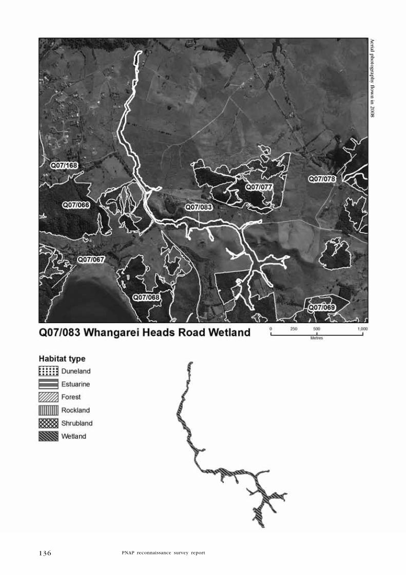
136

137
has the potential to support ‘Threatened’ and ‘At Risk’ water birds such
as Australasian bittern (Nationally Endangered), NI fernbird (Declining), and
spotless crake (Relict), and it is likely to support other common species
such pukeko, spur-winged plover, and kingfisher. Although the site is very
weedy, the willows are at least providing riparian buffering and stream
bank stability, while shading areas of open water. Access to the site is very
restricted, thus the vegetation was only partially observed. Further survey
is required to determine the site’s full ecological values. 0.8 ha of the site
is protected within WDC-administered reserve. Approximately 9.5 ha of
this site are within a ‘Chronically Threatened’ land environment (A6.1d),
9.9 ha are within an ‘At Risk’ land environment (A6.1b), and 2.8 ha are
within an ‘Underprotected’ land environment (D1.2b) (Walker et al. 2007).
k I T E O N E R O A D S A l T M A R S h
Survey no. Q07/168
Survey date 21 September 2009
grid reference 1733798E 6040146N (AX31)
Area 3.8 ha (3.6 estuarine, 0.2 wetland)
Altitude 0-2 m asl
Ecological units
(a) Mangrove forest in marsh
(b) Austrostipa stipoides tussockland on shell bank
(c) Oioi sedgeland in marsh
(d) Sea rush-mangrove rushland in marsh
(e) Makaokao-remuremu herbfield
(f) Baumea articulata sedgeland in swamp
landform/geology
Coastal wetland on Holocene estuarine deposits.
Vegetation
The site comprises a relatively large and intact saltmarsh east of Kirikiri
Point, near the northern boundary of Manaia ED. A beach access track
bisects the site towards the northern end of the bay.
(a) Mangrove forest dominates the site, covering much of the mud
flats within the embayment. A raised shellbank north of the access
track delineates the boundary between mangrove forest and most other
ecological units, while in the south of the site mangroves are common,
having spread further inland. Other species include occasional patches
of oioi, sea rush, and saltwater paspalum.
(b) Austrofestuca stipoides dominates a thin shell bank in association
with occasional saltmarsh ribbonwood, harakeke, toatoa, knobby clubrush,
glasswort, makaokao, Lobelia anceps, and Suaeda novae-zelandiae.
(c) Oioi is dominant in association with frequent sea rush and occasional
saltmarsh ribbonwood.

138

139
(d) Sea rush is common in association with scattered small mangrove
shrubs.
(e) Open areas of mudflats are characterised by locally abundant makaokao
growing in association with remuremu, glasswort, and saltwater paspalum.
(f) Type (c) grades into a small freshwater wetland characterised by
Baumea articulata with frequent Mexican devil and occasional Baumea
juncea and gorse.
Significant flora
Suaeda novae-zelandiae (regionally significant) and arrow grass (regionally
significant) (recorded by Wildland Consultants during this survey, 2009).
Fauna
One dead northern little blue penguin (Declining) was found on the shell
bank near the access track during the 2009 survey. Pied stilts (Declining)
nested here in the early 1990s (R. Pierce pers. comm.).
Significance
Kiteone Saltmarsh is the only example of a saltmarsh-freshwater wetland
sequence remaining in Manaia ED, and it represents a habitat type
which is rare in the Northland Region. The site supports two regionally
significant plant species and supports at least one ‘At Risk’ bird species.
It also provides potential habitat for NI fernbird (Declining) and banded
rail (Naturally Uncommon). The northern little blue penguin most likely
died of disease or starvation, and was subsequently washed ashore. It
is not known if this species normally frequents the site. The site is
relatively intact and not yet adversely affected by weeds, although an
adjacent sub-division development could result in weeds invading from
residential gardens. Representative site for all six ecological units. Weeds
currently present in the saltmarsh include occasional pampas, Mexican
devil, gorse, sheoak, saltwater paspalum, and dimorphotheca. 3.2 ha are
protected within a WDC reserve. Approximately 3.7 ha of this site are
within an ‘At Risk’ land environment (A4.1a) (Walker et al. 2007).

140
A w A R O A I S l A N D
Survey no. Q07/170
Survey date 11 January 1991 (SSBI Q07/R07/H078) and
22 September 2009
grid reference 1740699E 6038743N (AX31)
Area 0.43 ha (0.03 ha shrubland, 0.4 ha rockland)
Altitude 0-5 m asl
Ecological units
(a) Taupata-native iceplant rockland on island
(b) Bare rockland on island
landform/geology
Sea stack and intertidal reefs of Mesozoic chert (Waipapa Group).
Vegetation
(a) The vegetation comprises a small patch of prostrate taupata growing
with native iceplant.
(b) The remainder of the site is bare rock.
Significant flora
No information.
Fauna
Approximately 50 pairs of red-billed gull (Nationally Vulnerable) were
recorded in January 1991, along with pied shag (Nationally Vulnerable),
white-fronted tern (Declining), and white-faced heron (SSBI Q07/R07/
H078). A colony of red-billed gulls was recorded in September 2009 by
Wildland Consultants.
Significance
Awaroa Island comprises a small rocky outcrop which lies approximately
390 m offshore from the northern end of Ocean Beach Recreation Reserve
and Surrounds (Q07/075). Despite its small size, it supports at least three
threatened bird species, including a thriving red-bill gull colony. It is
not known if rodents inhabit the site. Representative site for type (a)
taupata-native iceplant shrubland on rock. Approximately 0.1 ha of this
site is within an ‘Acutely Threatened’ land environment (A7.2a) and 0.4
ha is within a ‘No Threat Category’ land environment (D1.1b) (Walker
et al. 2007).

141

142
F R E N C h M A N I S l A N D
Survey no. Q07/171
Survey date 13 May 1992 (SSBI Q07/R07/H125)
grid reference 1737920E 6030438N (AX31)
Area 0.24 ha (0.06 ha forest, 0.18 ha rockland)
Altitude 0-20 m asl
Ecological units
(a) Pohutukawa forest on island
(b) Native iceplant-glasswort rockland on island
landform/geology
Small rocky island formed of Lower Miocene dacite (Coromandel Group).
Vegetation
(a) At the time of the 1992 survey, dead pohutukawa forest fringed
the island, while taupata, knobby clubrush, and Asplenium haurakiense
occur in the understorey. Inspection of 2008 aerial photography indicates
that some pohutukawa have recovered.
(b) Most of the island is bare rock on which native ice plant and glasswort
are scattered.
Significant flora
No information.
Fauna
The island has been used as a breeding site by red-billed gulls (Nationally
Vulnerable) (c.200 pairs recorded in 1972 and c.100 pairs in 1991/92)
and a few pairs of white-fronted terns (Declining) (c.150 pairs recorded
in 1972, but only a few pairs in 1991/92) (SSBI Q07/R07/H125). Recent
observations, however, indicate that white-fronted terns frequently breed
on the island, although numbers are very erratic (R. Pierce pers. comm.).
Reef herons (Nationally Vulnerable) also visit the island (Pierce 2005).
Significance
Frenchman Island lies approximately 40 m offshore from the west edge
of Busby Head. It supports at least two ‘Threatened’ and one ‘At Risk’
seabirds, although numbers red-billed gull and white-fronted tern have
declined significantly since the first survey in 1972. No explanation for
the dead pohutukawa could be found, given there was no sign of possums
when the island was last surveyed in 1992. It is not known if rodents
and other pests inhabit or access the island. Weeds do not seem to have
had adverse impacts on the island, with Scotch thistle the only species
to have been recorded in 1992 (SSBI Q07/R07/H125). Representative for
type (b) native iceplant-glasswort rockland on island. Further survey is
recommended to determine current seabird populations and the presence
of reptiles and animal and plant pests. Frenchman Island is protected
within DOC-administered scenic reserve. Approximately 0.13 ha of this

143

144
site is within an ‘Acutely Threatened’ land environment (A7.2a) and 0.01
ha is within a ‘No Threat Category’ land environment (D1.1b) (Walker
et al. 2007).
h A R A M B E E R O A D S w A M P
Survey no. Q07/172
Survey date 4 July 2009 and 22 September 2009
grid reference 1739491E 6042039N (AX31)
Area 9.4 ha
Altitude 20-30 m asl
Ecological units
(a) Baumea rubiginosa-kapungawha-raupo sedgeland
(b) Baumea articulata-Mexican devil-harakeke sedgeland
landform/geology
Valley floor wetland on Holocene alluvial deposits.
Vegetation
(a) At the head of the valley, the vegetation is characterised by Baumea
rubiginosa, kapungawha and raupo, together with frequent harakeke,
ti kouka, and manuka, and occasional kiokio, swamp millet, Cyperus
ustulatus, and soft rush.
(b) Further north, where the wetland abuts Taiharuru Road, Baumea
articulata is dominant with common Mexican devil and harakeke. There
is occasional manuka, mapou, water fern, and Calystegia sepium.
Significant flora
No information.
Fauna
Birds
Australasian bittern (Nationally Endangered) and relatively high numbers
(10 pairs) of spotless crake (Relict) were recorded in 2006-07 (Pierce
& Kerr 2007). One spotless crake was heard calling in September 2009
during this survey. Pukeko were also recorded during the 2009 survey.
Fish
Longfin eel (Gradual Decline), banded kokopu (regionally significant), and
shortfin eel are known to the site (Pierce & Kerr 2007).
Significance
Harambee Road Wetland is the central linkage in a full ecological
sequence between indigenous forest in the upper valley and the Taiharuru
estuary. Wetland vegetation, which would have once been common on
the alluvial plains and valleys, now comprises <0.01% of landcover in

145

146
Manaia ED (MfE 2004). The small stream that runs through the wetland
drains a catchment in the north of Kauri Mountain Conservation Area
and Surrounds (Q07/078). It flows through the wetland to an area of
saltmarsh before entering Taiharuru Channel. The site is one of the best
freshwater wetlands remaining in Manaia ED; it is significant because of
its size, diversity of plant species, and the fact that it supports at least
one ‘Threatened’ and one ‘At Risk’ species of water bird, one ‘Threatened’
fish species, and one regionally significant fish species. In addition, it is
the only site in the Taiharuru estuary catchment where spotless crakes
occur (Pierce & Kerr 2007). The stream currently has no barriers to fish
movement upstream (Pierce & Kerr 2007), which will allow migration of
diadromus fish species. Most of the wetland is fenced and retired, and
downstream sections are partially buffered by shrubland and the road.
Some parts of the wetland, however, were not able to be surveyed and
thus may be vulnerable to grazing.
Representative site for type (a) Baumea rubiginosa-kapungawha-raupo
sedgeland. Weeds are scarce in the south (upstream) of the site, although
Mexican devil has become invasive further north. Other weeds present
include gorse and pampas. Approximately 0.2 ha of this site is within an
‘Acutely Threatened’ land environment (A7.2a), 7.2 ha is within an ‘At
Risk’ land environment (A6.1b), 1.2 are within a ‘Critically Underprotected’
land environment (A6.1a), and 0.9 ha is within a ‘No Threat Category’
land environment (D1.1b) (Walker et al. 2007).
P E A C h C O V E S T A C k A
Survey no. Q07/173
Survey date 13 May 1992 (SSBI Q07/R07/H126)
grid reference 1743029E 6030650N (AX31)
Area 2.1 ha
Altitude 0-3 m asl
Ecological units
(a) Pohutukawa-karo-taupata rockland on rock stack
landform/geology
Steep-sided rocky islet of Lower Miocene massive, fractured andesite
(Coromandel Group)
Vegetation
(a) The only vegetation present in the site includes a few small
pohutukawa, karo, taupata, and occasional knobby clubrush, native
iceplant, Lobelia anceps, Einadia triandra, and glasswort.
Significant flora
Einadia triandra (regionally significant) (1992, SSBI Q07/R07/H126).
Fauna
No information.
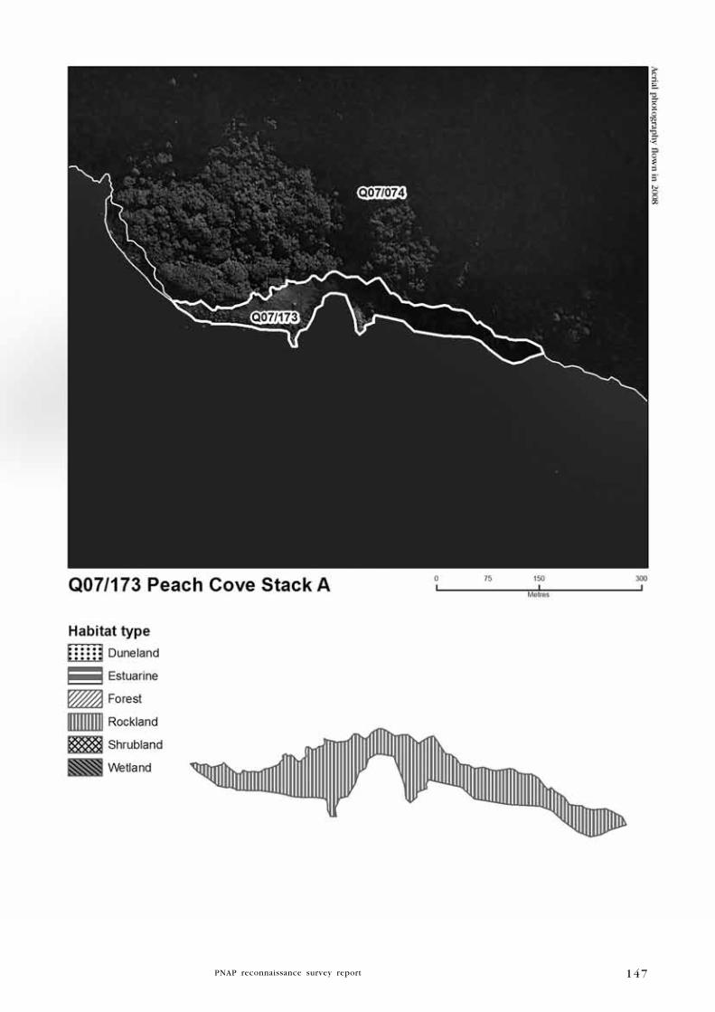
147

148
Significance
The site comprises a small low rock stack with sparse vegetation. Despite
its relatively small size, the site supports one regionally significant plant
species, and it was described as possum-free in 1992 (SSBI Q07/R07/
H126). Seabirds are likely to utilise the site intermittently. Representative
site for type (a) pohutukawa-karo-taupata rockland on rock stack. Peach
Cove Stack A is protected within the Bream Head Scenic Reserve and
Surrounds (DOC-administered). This site lies within a ‘No Threat Category’
land environment (D1.1a) (Walker et al. 2007).
P E A C h C O V E S T A C k B
Survey no. Q07/174
Survey date 13 May 1992 (SSBI Q07/R07/H127)
grid reference 1742030E 6030469N (AX31)
Area 0.1 ha
Altitude 0-3 m asl
Ecological units
(a) Taupata rockland on rock stack
landform/geology
Steep-sided rocky islet of Lower Miocene andesitic breccia (Coromandel
Group).
Vegetation
(a) The site is predominantly bare rock with some taupata and occasional
native iceplant and Lobelia anceps.
Significant flora
No information.
Fauna
Black-backed gulls have previously used the stack as a breeding site
(1992, SSBI Q07/R07/H127).
Significance
The site comprises a small, steep-sided stack with limited vegetation,
although it supports at least one species of seabird. Peach Cove Stack B
is protected within the DOC-administered Bream Head Scenic Reserve and
Surrounds (part of Q07/074). This site lies within a ‘No Threat Category’
land environment (D1.1a) (Walker et al. 2007).

149
150
k A u R I M O u N T A I N R O A D P O N D A N D R A u P O S w A M P
Survey no. Q07/175
Survey date 22 September 2009
grid reference 1739463E 6039610N (AX31)
Area 0.3 ha
Altitude 20 m asl
Ecological units
(a) Open water
(b) Raupo reedland in swamp
landform/geology
Valley floor wetland on Holocene alluvial deposits; remnant of formerly
extensive Holocene swamp behind coastal dune belt.
Vegetation
(a) Open water comprises c.90% of the site, with occasional Azolla sp.
(b) Raupo dominates the shallow margins of the pond. There is occasional
ti kouka, Cyperus ustulatus, and C. papyrus.
Significant flora
No information.
Fauna
Australasian bittern (Nationally Endangered) are known to use this pond
and neighbouring drains (R. Pierce pers. comm.). Two black shags
(Naturally Uncommon), paradise ducks with seven ducklings, pukeko,
and welcome swallow were recorded in September 2009 by Wildland
Consultants during this survey.
Significance
Despite its small size and modified state, the site is utilised by a relatively
high number of birds, including one ‘Threatened’ and one ‘At Risk’
species. It is also important in the modest network of local wetlands. The
site currently lacks buffering and its margins are grazed. Approximately
0.3 ha of this site is within a ‘Critically Underprotected’ land environment
(A6.1a) (Walker et al. 2007).

151

152
4 . 2 l E V E l 2 S I T E S
SITE SuRVEy NO. gRID REF.
High Island Stack A Q07/082 1737012E 6033936N
Kirikiri Point Coastal Forest Q07/169 1736922E 6034025N
Kauri Mountain Road Seep Q07/177 1739523E 6039530N
h I g h I S l A N D S T A C k A
Survey no. Q07/082
Survey date 13 May 1992 (SSBI Q07/R07/H122)
grid reference 1736922E 6034025N (AX31)
Area 0.14ha (0.04 ha forest, 0.1 rockland)
Altitude 0-5 m asl
Ecological units
(a) Pohutukawa treeland on rock stack
(b) NZ spinach-glasswort rockland on rock stack
landform/geology
Rocky islet comprising the eroded remnant of a Lower Miocene andesite
dike.
Vegetation
(a) The site comprises a small, low-lying rock stack characterised by
pohutukawa treeland over frequent harakeke, pampas, gorse, kikuyu,
buffalo grass, and smilax. There is occasional oioi, Austrostipa stipoides,
Astelia banksii, Asplenium oblongifolium, and leather-leaf fern.
(b) Most of the island comprises bare rock with scattered NZ spinach
and glasswort.
Significant flora
No information.
Fauna
Over 100 breeding pairs of red-billed gull (Nationally Vulnerable) were
recorded in 1978-79 (SSBI Q07/R07/H122). No red-billed gulls were
recorded during a subsequent survery in 1992.
Significance
The site is small and its proximity to the mainland has facilitated the
invasion of weeds. Weed species include gorse, pampas, kikuyu, buffalo
grass, inkweed, fleabane, smilax, dock, and black nightshade. It is not
known if pest animals are present. With appropriate restoration, the
island will provide suitable habitat for indigenous reptiles as well as a
breeding ground for seabirds. In its current state, the site is assigned a
Level 2 rank of significance. Approximately 0.1 ha of this site is within
an ‘At Risk’ land environment (A6.1b).
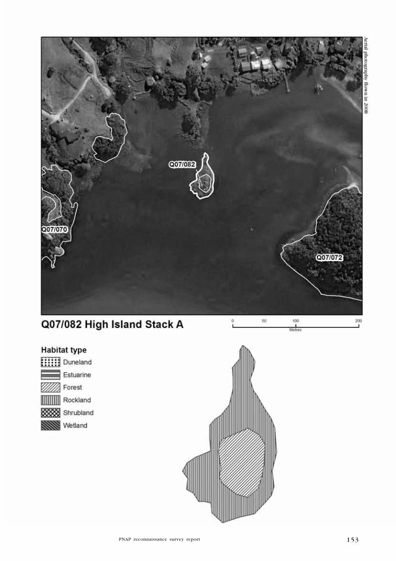
153

154
k I R I k I R I P O I N T C O A S T A l F O R E S T
Survey no. Q07/169
Survey date 21 September 2009
grid reference 1733297E 6040424N (AX31)
Area 3.0 ha
Altitude 0-20 m asl
Ecological units
(a) Pohutukawa forest on cliff
landform/geology
Coastal bank cut in melange of Cretaceous to Paleocene mudstone
(Mangakahia Complex).
Vegetation
(a) Open mature pohutukawa forest dominates the coastal vegetation from
Kirikiri Point to the easternmost beach within Parua Bay. Totara and
puriri are frequent in the canopy with occasional emergent radiata pine
and willow. In open areas the understorey is dominated by cotoneaster,
with occasional ti kouka, tarata, karo, karamu, and harakeke.
Significant flora
No information.
Fauna
Tui was recorded during this survey by Wildland Consultants, 2009.
Significance
The site is small but contains some healthy mature pohutukawa trees;
coastal pouhutukawa forest is a threatened habitat type in Northland. The
site, however, suffers from extensive weed invasion and its proximity to
private residences means garden plant escapes will be an ongoing problem
without appropriate management. The site is therefore assigned a ranking
of Level 2 significance. Other weed species present include pampas,
shrub balsam, ornamental banana, and black-eyed Susan. Approximately
1.2 ha of the site is protected within a WDC reserve. Approximately 3.0
ha of this site are within an ‘At Risk’ land environment (A6.1b) (Walker
et al. 2007).
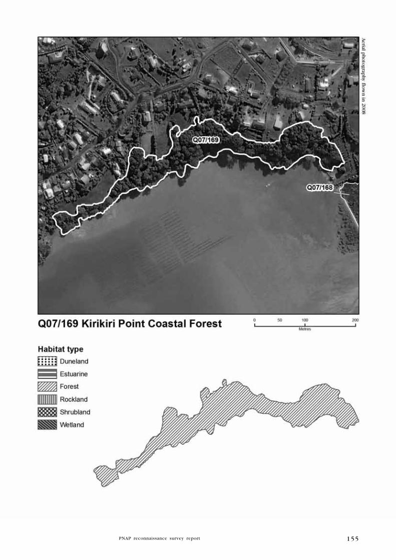
155

156
k A u R I M O u N T A I N R O A D S E E P
Survey no. Q07/177
Survey date 15 September 2009 and 22 September 2009
grid reference 1739523E 6039530N (AX31)
Area 0.5 ha
Altitude 18-20 m asl
Ecological units
(a) Manuka-ti kouka shrubland on alluvium
(b) Kapungawha reedland on alluvium
landform/geology
Valley floor wetland on Holocene alluvial deposits; remnant of formerly
extensive Holocene swamp behind coastal dune belt.
Vegetation
(a) Manuka shrubland dominates the canopy with ti kouka as a commonly
occurring emergent species. The understorey comprises common Baumea
articulata with frequent swamp millet and Baumea juncea, and occasional
kanuka, mapou, Coprosma tenuicaulis, mamangi, kiokio, wheki, mamaku,
Schoenus maschalinus, and Isolepis prolifer.
(b) The northern end of the site is characterised by a sward of
kapungawha.
Significant flora
Coprosma tenuicaulis (regionally significant) was recorded by Wildland
Consultants during the 2009 survey.
Fauna
Pukeko and NI fantail (recorded by Wildland Consultants during the 2009
survey).
Significance
The site comprises a small, fenced area of alluvial vegetation adjacent to
Kauri Mountain Road. Representative site for type (a) manuka-ti kouka
shrubland on alluvium. However, weeds are frequent throughout the site
(mist flower, pampas, kikuyu, and watercress), and despite an electric
fence, cattle are still having adverse impacts on parts of the wetland.
Animal trails (probably possum) were also observed on the wetland
margins. For these reasons this site has been given Level 2 status.
Approximately 0.04 ha of this site is within an ‘Acutely Threatened’
land environment (A5.1a) and 0.47 ha of this site is within a ‘Critically
Underprotected’ land environment (A6.1a) (Walker et al. 2007).

157
158
5. Summary and conclusionsA total of 27 significant natural areas covering 2,736 ha of significant
natural areas were identified: approximately 1,834.8 ha (67%) are forest,
531.1 ha (19%) shrubland, 251.6 ha (9%) duneland/sandfield, 42.2 ha
(1.5%) freshwater wetland, 32.3 ha (1.2%) rockland, and 9.8 ha (<
0.1%) estuarine habitat. Contained within these habitats are endemic
species only found in Manaia ED: one Nationally Critically plant species
(Pseudowintera insperata) and two species of land snail: Liarea
turriculata “Manaia” (Range Restricted) and Liarea egea “Bream Head”
(Data Deficient).
Key features of Manaia Ecological District - some of which are taken from
Pierce et al. (2002) and Ritchie (2008) - are outlined below:
• Bream Head contains the most significant remaining stand of coastal
broadleaved forest in Northland, with a full zonation of communities
from sandy and rocky shores to high forest slopes and rocky
outcrops, and has been identified by the Department of Conservation
as having outstanding conservation value.
• Mt Manaia stands alongside Bream Head as one of Northland’s
most significant coastal forests. Bream Head and Mt Manaia are
supplemented by the smaller yet significant natural areas of Kauri
Mountain, Mt Aubrey, and Taurikura Ridge.
• High number of ‘Threatened’ and ‘At Risk’ plant species.
• Examples of vegetation habitats uncommon elsewhere, such as
gumland and duneland vegetation.
• Important colonies of indigenous land snails, including the
southernmost population of the flax snail Placostylus hongii, and
only one of two sites supporting Punctidae sp. 223.
• Several sites are rated outstanding geological features, including a lava
flow at Reserve Point (The Nook) and a natural jetty at Taurikura Bay.
• Part of the Whangarei Kiwi Sanctuary (one of only five in the country).
• Physical characteristics of geography and geology, the most distinctive
being the volcanic rocky outcrops of Bream Head and Mt Manaia.
• Lengthy dunelands, which are poorly represented in the existing
protected areas network.
• High floristic diversity, with a total of 423 indigenous vascular species.
Most of Manaia ED’s biodiversity values are formally protected; however,
priorities for protection are:
• Sites containing ‘Threatened’ and ‘At Risk’ species endemic to
Manaia Ecological District or Eastern Northland Ecological Region.32
• Habitats for nationally ‘Threatened’, ‘At Risk’, and regionally
significant species.
• Uncommon terrestrial habitat types, particularly swamps and gumland.
• Islands.
• Buffers and linkages.
32 All threatened species endemic to Manaia ED have to date been recorded from formally protected areas. However, future surveys may find such species on currently unprotected land, which could then be considered for formal protection.

159
6. Protected Natural Areas Network
6 . 1 A N A l y S I S O F E X I S T I N g P R O T E C T E D A R E A S
6.1.1 Overview
Manaia Ecological District covers a total extent of c.6,444 ha, of which
natural areas cover 2,736 ha (42.5% of the Ecological District). The
natural areas comprise 1,834.8 ha forest, 531.1 ha shrubland, 251.6 ha
duneland/sandfield, 32.3 ha rockland, 42.2 ha freshwater wetland, and
9.8 ha estuarine vegetation.
Approximately 52% (1,402 ha) of the natural areas is formally protected
within reserves. This is equivalent to about 21.8% of the total extent of
Manaia ED. The various types of protection status within natural areas
are summarised in Table 4.
A list of ecological units recorded in Manaia ED and their current
protection status is set out in Table 6 and a summary of the site
evaluations is given in Table 7.
6.1.2 Ecological units protected
The field survey did not identify which ecological units within each site
were protected. Sites without protection or with very little protection
were identified as follows.
Sites with no formal protection
McDonald Coastal Shrubland (Q07/067)
High Island (Q07/072)
Kauri Mountain Wetland (Q07/081)
High Island Stack A (Q07/082)
Whangarei Heads Road Wetland (Q07/083)
Harambee Road Wetland (Q07/172)
Kauri Mountain Road Pond and Raupo Swamp (Q07/175)
Kauri Mountain Road Seep (Q07/177)
Sites mostly unprotected
Tahunatapu Road Coastal Forest (Q07/066); 1.8% protected
Munro Bay Coastal Bush (Q07/067); < 0.01% protected
Taurikura Ridge Bush (Q07/073); 3.5% protected
Kerr Road Swamp (Q07/076); 15% protected
Sites with large parts unprotected
Kauri Mountain Conservation Area and Surrounds (Q07/078); 33.2% protected
Timperley Road Bush (Q07/077); 34.4% protected
160
The remaining sites have over 45% of their area within reserves or
covenants; however, some ecological units within them may not be
protected.
6.1.3 Threatened land Environments of Manaia Ecological District
Land Environments of New Zealand (LENZ) is an environmental classification
system that uses modelling techniques to classify New Zealand into
broadly similar environments based on climatic, landform and soil factors,
and the distribution of species. The Threatened Environment Classification
is a combination of three national databases: Land Environments of New
Zealand (LENZ), the Land Cover Database 2 (LCDB2), and Protected Areas
of New Zealand (PANZ). The classification divides New Zealand into six
categories of ‘threatened environments’. Land environments are assigned
one of six threat categories on the basis of past habitat loss (percentage
indigenous cover remaining) and current legal protection (Walker et al.
2007).
Most of Manaia ED is not classified as a threatened land environment
(Figure 3). This is because a large proportion of the natural areas are
under some form of protection (Table 4). Natural areas within Manaia
ED contain 14 land environments (A5.1a, A5.1c, A6.1a, A6.1b, A6.1c,
A6.1d, A7.1a, A7.2a, D1.1a, D1.1b, D1.1c, D1.1d, D1.2b, and G1.1a).
Approximately 1,558.6 ha (c.54.8%) of the land covered by natural areas
falls into the ‘No Threat Category’ category, 15.2 ha (<0.01%) falls into
the ‘Acutely Threatened’ category, 34.3 ha (c.0.01%) into the ‘Chronically
Threatened’ category, 149.3 (c.5%) ha into the ‘Critically Underprotected’
category, 478.2 ha (c.17%) into the ‘Underprotected’ category, and 466.1
ha (c.14.5%) into the ‘At Risk’ category. Less than 0.01% of the land in
survey sites was unclassified.

161
TA
Bl
E 4
. P
RO
TE
CT
ED
NA
Tu
RA
l A
RE
AS N
ET
wO
Rk
IN
MA
NA
IA E
CO
lO
gIC
Al
DIS
TR
ICT
(A
RE
A I
N h
A)
Ke
y:
CP
=C
on
serv
atio
n
Par
k;
MS
=
Mar
gin
al
Stri
p;
NR
=N
atu
re
Re
serv
e;
QE
II=
Qu
ee
n
Eli
zab
eth
II
O
pe
n
Spac
e
Co
ve
nan
t;
RR
=
Re
cre
atio
n R
ese
rve
; SB
=Se
abe
d;
SCE
R =
Sc
en
ic R
ese
rve
; C
C =
Co
nse
rvat
ion
Co
ve
nan
t (W
DC
); R
C =
Re
stri
cti
ve
Co
ve
nan
t; F
A
= F
en
cin
g A
ct
Co
ve
nan
t; W
DC
= W
han
gar
ei
Dis
tric
t C
ou
nc
il R
ese
rve
SIT
ESu
RV
Ey
NO
STA
Tu
SSu
B-T
OT
Al
AR
EA
P
RO
TE
CT
ED
(E
XC
lu
DIN
g
RR
)
RR
TO
TA
l
AR
EA
P
RO
TE
CT
ED
(I
NC
lu
DIN
g
RR
)
TO
TA
l
SIT
EA
RE
A
PE
RC
EN
TA
gE
SIT
E
PR
OT
EC
TE
DC
PM
Sq
EII
SBF
AR
CC
CSC
ER
NR
wD
C
Tah
un
atap
u R
oad
Co
asta
l Fo
rest
Q07
/066
2.3
0.3
2.6
2.6
124.
92.
0%
Mu
nro
Bay
Co
asta
l Bu
shQ
07/0
670.
030.
470.
81.
31.
310
0.2
1.2%
Mac
Do
nal
d C
oas
tal S
hru
bla
nd
Q07
/068
0.3
0.3
0.3
67.3
<1%
Man
aia
Rid
ge S
cen
ic R
eser
ve a
nd
Su
rro
un
ds
Q07
/069
6.9
3.7
330.
719
.136
0.4
360.
459
4.4
60.6
%
Mt
Au
bre
y C
oas
tal F
ore
st a
nd
Sh
rub
lan
dQ
07/0
700.
060.
22.
444
.246
.946
.986
.454
.1%
Mo
tuka
roro
Isl
and
Q07
/071
1.2
1.2
1.2
1.2
100%
Tau
riku
ra R
idge
Bu
shQ
07/0
737.
40.
17.
57.
521
2.3
3.5%
Bre
am H
ead
Sce
nic
Res
erve
an
d
Surr
ou
nd
sQ
07/0
744.
822
.251
8.4
9.7
551.
155
5.1
686.
580
.9%
Oce
an B
each
Rec
reat
ion
Res
erve
an
d S
urr
ou
nd
sQ
07/0
750.
612
.74.
417
.721
3.3
231.
027
0.0
85.6
%
Ker
r R
oad
Sw
amp
Q07
/076
0.5
0.5
0.5
3.3
15%
Tim
per
ly R
oad
Bu
shQ
07/0
7713
.213
.213
.238
.434
.4%
Kau
ri M
ou
nta
in C
on
serv
atio
n
Are
a an
d S
urr
ou
nd
s Q
07/0
7891
.31.
61.
868
.76.
016
9.4
169.
449
2.6
34.4
%
Bre
am I
slan
ds
Scen
ic R
eser
ve:
Mo
tura
ka I
slan
d a
nd
Tar
akan
ahi
Isla
nd
Q07
/079
1.1
1.1
1.1
2.4
45.9
%
Bre
am I
slan
ds
Nat
ure
Res
erve
: M
auit
aha
Isla
nd
an
d G
uan
o I
slan
dQ
07/0
803.
93.
93.
96.
065
%
Kau
ri M
ou
nta
in W
etla
nd
Q07
/081
0.1
0.1
0.1
4.7
2.1%
Wh
anga
rei H
ead
s R
d W
etla
nd
Q07
/083
0.8
0.8
0.8
22.1
3.6%
Kit
eon
e R
oad
Sal
tmar
shQ
07/1
683.
23.
23.
23.
884
.2%
Kir
ikir
i Po
int
Co
asta
l Fo
rest
Q07
/169
1.2
1.2
1.2
3.0
40%
Fren
chm
an I
slan
dQ
07/1
710.
240.
240.
240.
2410
0%
Pea
ch C
ove
Sta
ck A
Q07
/173
2.1
2.1
2.1
2.1
100%
Pea
ch C
ove
Sta
ck B
Q07
/174
0.1
0.1
0.1
0.1
100%
TO
TA
l96.2
0.6
48
.12
2.3
0.2
1.8
75
.38
54
.33
.990.1
1150.5
213.3
1402.1
2,7
21.9

162
TABlE 5: AREA (hA) OF lENZ lEVEl IV ENVIRONMENTS wIThIN MANAIA ED PNA SITES
AND ThEIR RESPECTIVE ThREAT CATEgORIES.
SITE NAME AND NuMBER CRITERIA ThREATENED
ENVIRONMENT
lENZ
lEVEl 4
TOTAl
(ha)
Tahunatapu Road Coastal Forest
Q07/066
Total lENZ
>30% left, <10% protected
20-30% left
>30% left,and >10-20% protected
Critically Underprotected
Subtotal
At Risk
Subtotal
Underprotected
Subtotal
A6.1a
A6.1c
A6.1b
D1.2b
56.6
20.9
77.5
43.4
43.4
0.2
0.2
121.1
Munro Bay Coastal Bush
Q07/067
Total lENZ
>30% left, <10% protected
10-20% left
>30% left, >20% protected
Critically Underprotected
Subtotal
Chronically Threatened
Subtotal
No Threat Category
Subtotal
A6.1a
A6.1d
D1.1b
20.3
20.3
0.1
0.1
77.8
77.8
98.2
McDonald Coastal Shrubland
Q07/068
Total lENZ
20-30% left
>30% left and <10% protected
10-20% left
At Risk
Subtotal
Critically Underprotected
Subtotal
Underprotected
Subtotal
A6.1b
A6.1d
A6.1c
D1.2b
0.5
3.7
4.2
14.6
14.6
48.3
48.3
67.1
Manaia Ridge Scenic Reserve and Surrounds
Q07/069
Total lENZ
<10% left
>30% left and <10%
protected
20-30% left
10-20% left
>30% left and 10-20% protected
>30% left, >20% protected
Acutely Threatened
Subtotal
Critically Underprotected
Subtotal
At Risk
Subtotal
Chronically Threatened
Subtotal
Underprotected
Subtotal
No Threat Category
Subtotal
A5.1a
A5.1c
A6.1a
A6.1b
A6.1d
A7.1a
D1.2b
D1.1a
D1.1b
D1.1c
D1.1d
0.2
0.1
0.3
2.4
2.4
25.8
25.8
10.9
1.2
12.1
51.3
51.3
316.5
171.3
6.6
7.0
501.4
593.3
Mt Aubrey Coastal Forest and Shrubland
Q07/070
Total lENZ
>30% left and <10% protected
20-30% left
>30% left, >20% protected
Critically Underprotected
Subtotal
At Risk
Subtotal
No Threat Category
Subtotal
A6.1a
A6.1b
D1.1b
0.1
0.1
1.5
1.5
82.5
82.5
84.1
Motukaroro Island
Q07/071
Total lENZ
<10% left Acutely Threatened
Subtotal
A7.2a 1.0
1.0
1.0
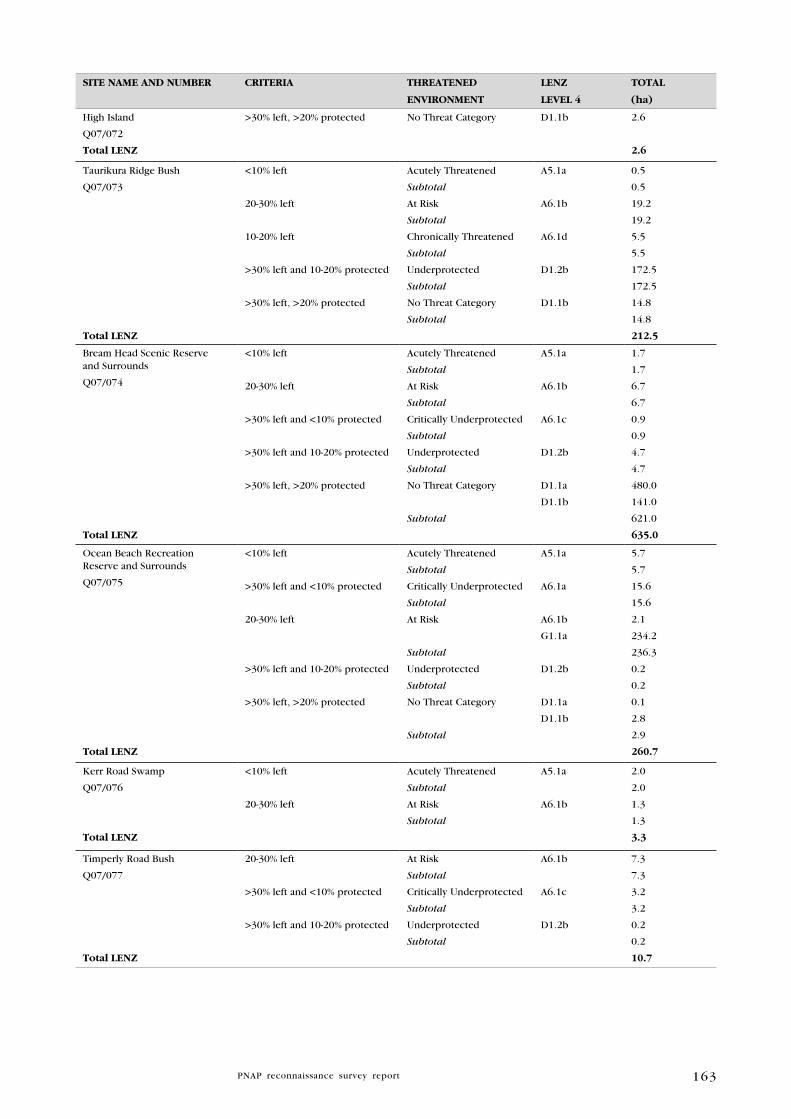
163
SITE NAME AND NuMBER CRITERIA ThREATENED
ENVIRONMENT
lENZ
lEVEl 4
TOTAl
(ha)
High Island
Q07/072
Total lENZ
>30% left, >20% protected No Threat Category D1.1b 2.6
2.6
Taurikura Ridge Bush
Q07/073
Total lENZ
<10% left
20-30% left
10-20% left
>30% left and 10-20% protected
>30% left, >20% protected
Acutely Threatened
Subtotal
At Risk
Subtotal
Chronically Threatened
Subtotal
Underprotected
Subtotal
No Threat Category
Subtotal
A5.1a
A6.1b
A6.1d
D1.2b
D1.1b
0.5
0.5
19.2
19.2
5.5
5.5
172.5
172.5
14.8
14.8
212.5
Bream Head Scenic Reserve and Surrounds
Q07/074
Total lENZ
<10% left
20-30% left
>30% left and <10% protected
>30% left and 10-20% protected
>30% left, >20% protected
Acutely Threatened
Subtotal
At Risk
Subtotal
Critically Underprotected
Subtotal
Underprotected
Subtotal
No Threat Category
Subtotal
A5.1a
A6.1b
A6.1c
D1.2b
D1.1a
D1.1b
1.7
1.7
6.7
6.7
0.9
0.9
4.7
4.7
480.0
141.0
621.0
635.0
Ocean Beach Recreation Reserve and Surrounds
Q07/075
Total lENZ
<10% left
>30% left and <10% protected
20-30% left
>30% left and 10-20% protected
>30% left, >20% protected
Acutely Threatened
Subtotal
Critically Underprotected
Subtotal
At Risk
Subtotal
Underprotected
Subtotal
No Threat Category
Subtotal
A5.1a
A6.1a
A6.1b
G1.1a
D1.2b
D1.1a
D1.1b
5.7
5.7
15.6
15.6
2.1
234.2
236.3
0.2
0.2
0.1
2.8
2.9
260.7
Kerr Road Swamp
Q07/076
Total lENZ
<10% left
20-30% left
Acutely Threatened
Subtotal
At Risk
Subtotal
A5.1a
A6.1b
2.0
2.0
1.3
1.3
3.3
Timperly Road Bush
Q07/077
Total lENZ
20-30% left
>30% left and <10% protected
>30% left and 10-20% protected
At Risk
Subtotal
Critically Underprotected
Subtotal
Underprotected
Subtotal
A6.1b
A6.1c
D1.2b
7.3
7.3
3.2
3.2
0.2
0.2
10.7

164
SITE NAME AND NuMBER CRITERIA ThREATENED
ENVIRONMENT
lENZ
lEVEl 4
TOTAl
(ha)
Kauri Mountain Conservation Area and Surrounds
Q07/078
Total lENZ
<10% left
>30% left, <10% protected
20-30% left
10-20% left
>30% left and 10-20% protected
>30% left, >20% protected
Acutely Threatened
Subtotal
Critically Underprotected
Subtotal
At Risk
Subtotal
Chronically Threatened
Subtotal
Underprotected
Subtotal
No Threat Category
Subtotal
A5.1a
A5.1c
A6.1a
A6.1c
A6.1b
A6.1d
D1.2b
D1.1a
D1.1b
0.6
1.9
2.5
7.1
4.5
11.6
46.3
46.3
1.1
1.1
191.7
191.7
5.8
225
230
492.6
Bream Islands Scenic Reserve: Moturaka Island and
Tarakanahi Island
Q07/079
Total lENZ
10-20% left
>30% left, >20% protected
Chronically Threatened
Subtotal
No Threat Category
Subtotal
A7.1a
D1.1a
1.4
1.4
0.05
0.05
1.9
Bream Islands Scenic Reserve: Mauitaha Island and
Guano Island
Q07/080
Total lENZ
10-20% left
>30% left, >20% protected
Chronically Threatened
Subtotal
No Threat Category
Subtotal
A6.1d
D1.1b
0.9
0.9
5.1
5.1
6.0
Kauri Mountain Wetland
Q07/081
Total lENZ
>10% left
20-30% left
Acutely Threatened
Subtotal
At Risk
Subtotal
A5.1a
A5.1c
A6.1b
0.2
3.5
3.7
0.2
0.2
3.9
High Island Stack A
Q07/082
Total lENZ
20-30% left At Risk
Subtotal
A6.1b 0.1
0.1
0.1
Whangarei Heads Road Wetland
Q07/083
Total lENZ
20-30% left
10-20% left
>30% left and 10-20% protected
At Risk
Subtotal
Chronically Threatened
Subtotal
Underprotected
Subtotal
A6.1b
A6.1d
D1.2b
9.9
9.9
9.5
9.5
2.8
2.8
22.1
Kiteone Road Saltmarsh
Q07/168
Total lENZ
20-30% left At Risk
Subtotal
A4.1a 3.7
3.7
3.7
Kirikiri Point Coastal Forest
Q07/169
Total lENZ
20-30% left At Risk
Subtotal
A6.1b 3.0
3.0
3.0
Awaroa Island
Q07/170
Total lENZ
<10% left
>30% left, >20% protected
Acutely Threatened
Subtotal
No Threat Category
Subtotal
A7.2a
D1.1b
0.1
0.1
0.4
0.4
0.5

165
SITE NAME AND NuMBER CRITERIA ThREATENED
ENVIRONMENT
lENZ
lEVEl 4
TOTAl
(ha)
Frenchman Island
Q07/171
Total lENZ
<10% left
>30% left, >20% protected
Acutely Threatened
Subtotal
No Threat Category
Subtotal
A7.2a
D1.1b
0.1
0.1
0.01
0.01
0.11
Harambee Road Swamp
Q07/172
Total lENZ
>30% left and <10% protected
20-30% left
<10% left
>30% left, >20% protected
Critically Underprotected
Subtotal
At Risk
Subtotal
Acutely Threatened
Subtotal
No Threat Category
Subtotal
A6.1a
A6.1b
A7.2a
D1.1b
1.2
1.2
7.2
7.2
0.2
0.2
0.9
0.9
9.5
Peach Cove Stack A
Q07/173
Total lENZ
>30% left, >20% protected No Threat Category D1.1a 2.1
2.1
Peach Cove Stack B
Q07/174
Total lENZ
>30% left, >20% protected No Threat Category D1.1a 0.1
0.1
Kauri Mountain Road Pond and Raupo Swamp
Q07/175
Total lENZ
>30% left and <10% protected Critically Underprotected A6.1a 0.3
0.3
Kauri Mountain Road Seep
Q07/177
Total lENZ
<10% left
>30% left and <10% protected
Acutely Threatened
Subtotal
Critically Underprotected
Subtotal
A5.1a
A6.1a
0.04
0.04
0.47
0.47
0.5
gRAND lENZ TOTAl 2701.7

166
Figure 3: Threatened Land Environments of Manaia Ecological District
167
6 . 2 P R I O R I T y N A T u R A l A R E A S F O R P R O T E C T I O N I N M A N A I A E C O l O g I C A l D I S T R I C T
The purpose of this section is to identify the unprotected natural areas
documented in this report that best supplement the existing protected
natural areas network.
The majority of biological diversity in Manaia ED is encompassed within
protected areas. Some authors have suggested that all major representative
ecosystems are included in protected areas (Conning 2001); however, the
nature of this legal protection should be critically examined.
Priorities for protection in Manaia ED include:
1. Protection of habitats for nationally ‘Threatened’, ‘At Risk’ and regionally significant species
Manaia ED has a comparatively diverse range of species for its size, not all
of which are adequately protected by the current protected natural areas
network. At present, ‘Threatened’ species include six plants, ten birds,
three land snail taxa, one spider, three lizards, and one fish. ‘At Risk’
species include 27 plants, 17 birds, three land snail taxa (including one
endemic species), three lizards, and three other terrestrial invertebrates,
There are also a further 83 regionally significant species, which are
considered rare or threatened in Northland (72 plant, five bird, five
reptile, and one fish species).
Large areas which are not protected or are underprotected, and contain
threatened and regionally significant species, include Tahunatapu Road
Coastal Forest (Q07/066), Munro Bay Coastal Bush (Q07/067), McDonald
Coastal Shrubland (Q07/068), Taurikura Ridge Bush (Q07/073), and Kauri
Mountain Conservation Area and Surrounds (Q07/078).
2. Protection of freshwater wetlands
While forested habitats are generally well-protected in Manaia ED, no
freshwater wetlands are formally protected. These include sites Q07/068,
Q07/076, Q07/081, Q07/083, Q07/172, and Q07/177. Wetlands in Manaia
ED provide habitat for at least three regionally significant plant species,
and at least five threatened and one regionally significant fauna species.
Gumland is a particularly uncommon type of wetland throughout
Northland, with only one example (Q07/068) recorded in Manaia ED.
3. Protection of uncommon terrestrial habitat types
Shrubland areas are becoming increasingly uncommon in Northland
as they are vulnerable to clearance, weed invasion, and fire. While
forested habitats are generally well-protected in Manaia ED, shrubland
areas are currently underprotected. Sites which contain unprotected and/
or underprotected areas of shrubland include Q07/066, Q07/073, and
Q07/078.
4. Protection of all islands
Most of the coastal islands have been invaded by plant and animals
pests. With the appropriate protection and management, these islands
168
could provide valuable habitat for threatened plants, birds, lizards, and
invertebrates. Islands in Manaia ED that are currently underprotected
include Q07/072 and Q07/082.
5. Protection of buffers and linkages to existing protected areas that are being intensively managed
‘Islands’ of shrubland linking Manaia Ridge Scenic Reserve and Surrounds
(Q07/069) with Kauri Mountain Conservation Area and Surrounds
(Q07/078).
Taurikura Ridge Bush (Q07/073), which provides a critical link between
Manaia Ridge Scenic Reserve and Surrounds (Q07/069) and Bream Head
Scenic Reserve and Surrounds (Q07/074).
Shrubland and forest which buffers the eastern boundary of DOC-
administered land in Manaia Ridge Scenic Reserve and Surrounds
(Q07/069).
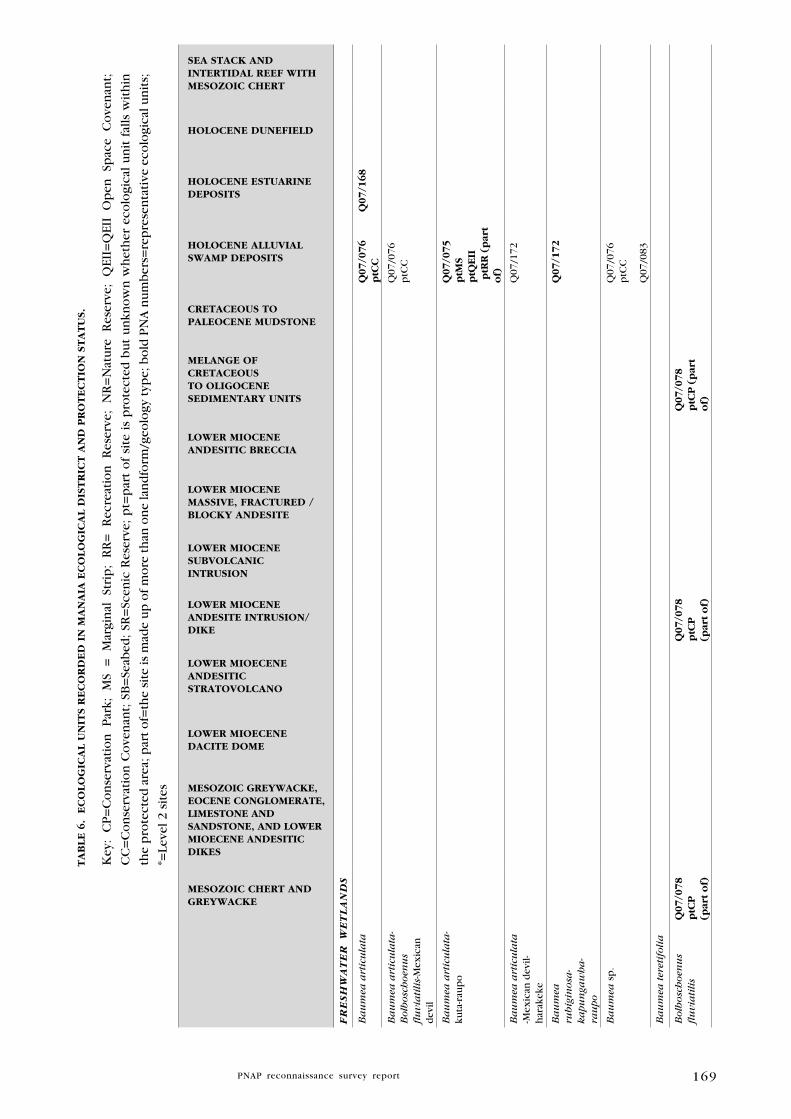
169
TA
Bl
E 6
. E
CO
lO
gIC
Al
uN
ITS R
EC
OR
DE
D I
N M
AN
AIA
EC
Ol
Og
ICA
l D
IST
RIC
T A
ND
PR
OT
EC
TIO
N S
TA
Tu
S.
Key
: C
P=
Co
nse
rvat
ion
P
ark;
M
S =
M
argi
nal
St
rip
; R
R=
R
ecre
atio
n
Res
erve
; N
R=
Nat
ure
R
eser
ve;
QEI
I=Q
EII
Op
en
Spac
e C
ove
nan
t;
CC
=C
on
serv
atio
n C
ove
nan
t; S
B=
Seab
ed;
SR=
Scen
ic R
eser
ve;
pt=
par
t o
f si
te i
s p
rote
cted
bu
t u
nkn
ow
n w
het
her
eco
logi
cal
un
it f
alls
wit
hin
the
pro
tect
ed a
rea;
par
t o
f=th
e si
te is
mad
e u
p o
f m
ore
th
an o
ne
lan
dfo
rm/g
eolo
gy t
ype;
bo
ld P
NA
nu
mb
ers=
rep
rese
nta
tive
eco
logi
cal u
nit
s;
*=Le
vel 2
sit
es
MESOZOIC ChERT AND gREywACkE
MESOZOIC gREywACkE, EOCENE CONglOMERATE, lIMESTONE AND SANDSTONE, AND lOwER MIOECENE ANDESITIC DIkES
lOwER MIOECENE DACITE DOME
lOwER MIOECENE ANDESITIC STRATOVOlCANO
lOwER MIOCENE ANDESITE INTRuSION/DIkE
lOwER MIOCENE SuBVOlCANIC INTRuSION
lOwER MIOCENE MASSIVE, FRACTuRED /BlOCky ANDESITE
lOwER MIOCENE ANDESITIC BRECCIA
MElANgE OF CRETACEOuS TO OlIgOCENE SEDIMENTARy uNITS
CRETACEOuS TO PAlEOCENE MuDSTONE
hOlOCENE AlluVIAl SwAMP DEPOSITS
hOlOCENE ESTuARINE DEPOSITS
hOlOCENE DuNEFIElD
SEA STACk AND INTERTIDAl REEF wITh MESOZOIC ChERT
FR
eS
Hw
aT
eR
w
eT
la
ND
S
Ba
um
ea a
rtic
ula
ta
q07/0
76
ptC
Cq
07/1
68
Ba
um
ea a
rtic
ula
ta-
Bolb
osc
hoen
us
flu
via
tili
s-M
exic
an
dev
il
Q07
/076
ptC
C
Ba
um
ea a
rtic
ula
ta-
kuta
-rau
po
q07/0
75
ptM
S p
tqE
II p
tRR
(p
art
of)
Ba
um
ea a
rtic
ula
ta
-Mex
ican
dev
il-h
arak
eke
Q07
/172
Ba
um
ea
rubig
inosa
-ka
pu
nga
wh
a-
rau
po
q07/1
72
Ba
um
ea s
p.
Q07
/076
ptC
C
Q07
/083
Ba
um
ea t
eret
ifoli
a
Bolb
osc
hoen
us
flu
via
tili
sq
07/0
78
ptC
P
(par
t o
f)
q0
7/0
78
ptC
P
(par
t o
f)
q07/0
78
ptC
P (
par
t o
f)
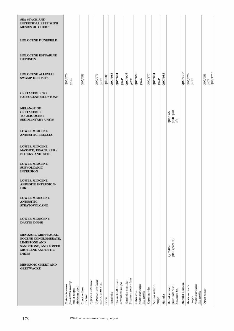
170
MESOZOIC ChERT AND gREywACkE
MESOZOIC gREywACkE, EOCENE CONglOMERATE, lIMESTONE AND SANDSTONE, AND lOwER MIOECENE ANDESITIC DIkES
lOwER MIOECENE DACITE DOME
lOwER MIOECENE ANDESITIC STRATOVOlCANO
lOwER MIOCENE ANDESITE INTRuSION/DIkE
lOwER MIOCENE SuBVOlCANIC INTRuSION
lOwER MIOCENE MASSIVE, FRACTuRED /BlOCky ANDESITE
lOwER MIOCENE ANDESITIC BRECCIA
MElANgE OF CRETACEOuS TO OlIgOCENE SEDIMENTARy uNITS
CRETACEOuS TO PAlEOCENE MuDSTONE
hOlOCENE AlluVIAl SwAMP DEPOSITS
hOlOCENE ESTuARINE DEPOSITS
hOlOCENE DuNEFIElD
SEA STACk AND INTERTIDAl REEF wITh MESOZOIC ChERT
Bolb
osc
hoen
us
flu
via
tili
s-sw
amp
m
illet
-rau
po-
Mex
ican
dev
il
Q07
/076
ptC
C
Cra
ck w
illo
w
tree
lan
dQ
07/0
83
Cyp
eru
s u
stu
latu
s
Cyp
eru
s u
stu
latu
s-ex
oti
c gr
ass
spp
.Q
07/0
76
ptC
C
Go
rse
Q07
/083
Har
akek
eq
07/0
83
Har
akek
e-B
au
mea
a
rtic
ula
ta-r
aup
oq
07/0
81
ptC
P
Har
akek
e-m
anu
ka-
Ba
um
ea a
rtic
ula
taq
07/0
76
ptC
C
Kah
ikat
ea-
Bolb
osc
hoen
us
flu
via
tili
s
q07/0
76
ptC
C
Kap
un
gaw
ha
Q07
/177
*
Lem
na
min
or-
rau
po
q07/0
81
ptC
P
Man
uka
q07/0
83
Man
uka
-ex
oti
c gr
ass-
soft
ru
sh-
Ba
um
ea s
p.
Q07
/066
ptS
R (
par
t o
f)Q
07/0
66p
tSR
(p
art
of)
Man
uka
-ti k
ou
kaq
07/1
77*
Mex
ican
dev
il-ra
up
o-
Bolb
osc
hoen
us
flu
via
tili
s
Q07
/076
ptC
C
Op
en w
ater
Q07
/081
ptC
PQ
07/1
75*

171
MESOZOIC ChERT AND gREywACkE
MESOZOIC gREywACkE, EOCENE CONglOMERATE, lIMESTONE AND SANDSTONE, AND lOwER MIOECENE ANDESITIC DIkES
lOwER MIOECENE DACITE DOME
lOwER MIOECENE ANDESITIC STRATOVOlCANO
lOwER MIOCENE ANDESITE INTRuSION/DIkE
lOwER MIOCENE SuBVOlCANIC INTRuSION
lOwER MIOCENE MASSIVE, FRACTuRED /BlOCky ANDESITE
lOwER MIOCENE ANDESITIC BRECCIA
MElANgE OF CRETACEOuS TO OlIgOCENE SEDIMENTARy uNITS
CRETACEOuS TO PAlEOCENE MuDSTONE
hOlOCENE AlluVIAl SwAMP DEPOSITS
hOlOCENE ESTuARINE DEPOSITS
hOlOCENE DuNEFIElD
SEA STACk AND INTERTIDAl REEF wITh MESOZOIC ChERT
Rau
po
q07/0
76
ptC
CQ
07/0
81p
tCP
Q07
/083
Q07
/175
*
Sa
lT
Ma
RS
H
Au
stro
stip
a
stip
oid
esq
07/1
68
Mak
aok
ao-
rem
ure
mu
q07/1
68
Man
gro
ve
q07/1
68
Oio
iq
07/1
68
Sea
rush
q07/0
75
ptM
S p
tqE
IIp
tRR
(p
art
of)
q07/1
68
Sea
rush
-m
ang
rov
e ru
shla
nd
q07/1
68
SaN
DF
iel
DS/
CO
aST
al a
SSO
Cia
TiO
NS
Bu
ffal
o g
rass
-p
oh
ueh
ue-
spin
ifex
Q07
/075
ptM
S p
tQEI
Ip
tRR
(p
art
of)
Q07
/075
ptM
S p
tQEI
Ip
tRR
par
t o
f)
Bu
ffal
o g
rass
-sp
inif
exQ
07/0
75p
tMS
ptQ
EII
ptR
R (
par
t o
f)
Q07
/075
ptM
S p
tQEI
Ip
tRR
(p
art
of)
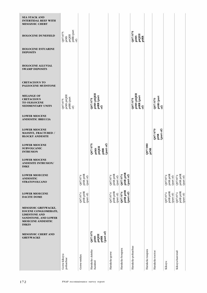
172
MESOZOIC ChERT AND gREywACkE
MESOZOIC gREywACkE, EOCENE CONglOMERATE, lIMESTONE AND SANDSTONE, AND lOwER MIOECENE ANDESITIC DIkES
lOwER MIOECENE DACITE DOME
lOwER MIOECENE ANDESITIC STRATOVOlCANO
lOwER MIOCENE ANDESITE INTRuSION/DIkE
lOwER MIOCENE SuBVOlCANIC INTRuSION
lOwER MIOCENE MASSIVE, FRACTuRED /BlOCky ANDESITE
lOwER MIOCENE ANDESITIC BRECCIA
MElANgE OF CRETACEOuS TO OlIgOCENE SEDIMENTARy uNITS
CRETACEOuS TO PAlEOCENE MuDSTONE
hOlOCENE AlluVIAl SwAMP DEPOSITS
hOlOCENE ESTuARINE DEPOSITS
hOlOCENE DuNEFIElD
SEA STACk AND INTERTIDAl REEF wITh MESOZOIC ChERT
Go
rse-
kiku
yu-
po
hu
ehu
eQ
07/0
75p
tMS
ptQ
EII
ptR
R (
par
t o
f)
Q07
/075
ptM
S p
tQEI
Ip
tRR
(p
art
of)
Go
rse-
smila
xQ
07/0
74p
tSB
ptS
R(p
art
of)
Q07
/074
ptS
B p
tSR
(par
t o
f)
Har
akek
e-A
stel
ia
ba
nksi
iq
07/0
75
ptM
S p
tqE
IIp
tRR
(p
art
of)
q0
7/0
75
ptM
S p
tqE
II
ptR
R
(par
t o
f)
q07/0
75
ptM
S p
tqE
IIp
tRR
(p
art
of)
Har
akek
e-go
rse
Q07
/074
ptS
B p
tSR
(par
t o
f)
Q07
/074
ptS
B p
tSR
(par
t o
f)
Har
akek
e-h
ou
par
aq
07
/07
4p
tSB
ptS
R(p
art
of)
q0
7/0
74
ptS
B p
tSR
(par
t o
f)
Har
akek
e-p
oh
ueh
ue
q07/0
75
ptM
S p
tqE
IIp
tRR
(p
art
of)
q07/0
75
ptM
S p
tqE
IIp
tRR
Har
akek
e-ta
up
ata
q0
7/0
80
ptN
R
Har
akek
e-to
eto
eq
07
/07
9p
tSR
(p
art
of)
q07/0
79
ptS
R (
par
t o
f)
Kik
uyu
Q07
/074
ptS
B p
tSR
(par
t o
f)
Q07
/074
ptS
B p
tSR
(par
t o
f)
Kik
uyu
-har
esta
ilQ
07/0
74p
tSB
ptS
R(p
art
of)
Q07
/074
ptS
B p
tSR
(par
t o
f)
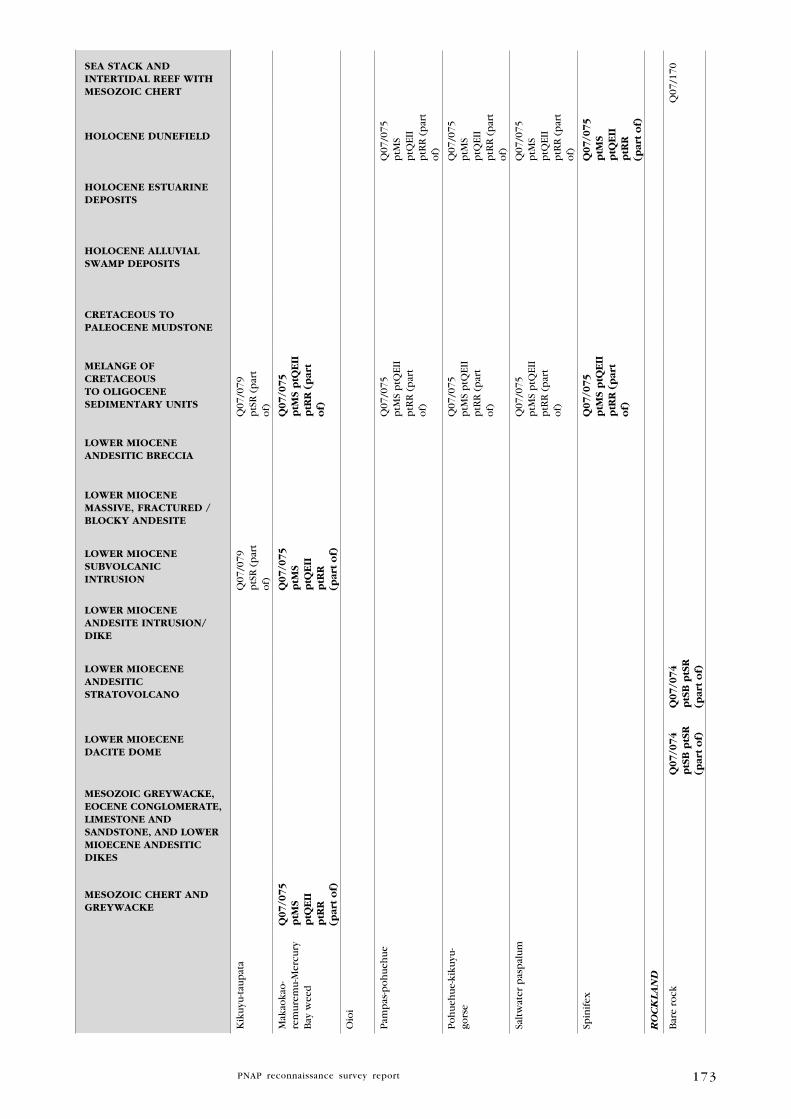
173
MESOZOIC ChERT AND gREywACkE
MESOZOIC gREywACkE, EOCENE CONglOMERATE, lIMESTONE AND SANDSTONE, AND lOwER MIOECENE ANDESITIC DIkES
lOwER MIOECENE DACITE DOME
lOwER MIOECENE ANDESITIC STRATOVOlCANO
lOwER MIOCENE ANDESITE INTRuSION/DIkE
lOwER MIOCENE SuBVOlCANIC INTRuSION
lOwER MIOCENE MASSIVE, FRACTuRED /BlOCky ANDESITE
lOwER MIOCENE ANDESITIC BRECCIA
MElANgE OF CRETACEOuS TO OlIgOCENE SEDIMENTARy uNITS
CRETACEOuS TO PAlEOCENE MuDSTONE
hOlOCENE AlluVIAl SwAMP DEPOSITS
hOlOCENE ESTuARINE DEPOSITS
hOlOCENE DuNEFIElD
SEA STACk AND INTERTIDAl REEF wITh MESOZOIC ChERT
Kik
uyu
-tau
pat
aQ
07/0
79p
tSR
(p
art
of)
Q07
/079
ptS
R (
par
t o
f)
Mak
aoka
o-
rem
ure
mu
-Mer
cury
B
ay w
eed
q07/0
75
ptM
S p
tqE
IIp
tRR
(p
art
of)
q0
7/0
75
ptM
S p
tqE
IIp
tRR
(p
art
of)
q07/0
75
ptM
S p
tqE
IIp
tRR
(p
art
of)
Oio
i
Pam
pas
-po
hu
ehu
eQ
07/0
75p
tMS
ptQ
EII
ptR
R (
par
t o
f)
Q07
/075
ptM
S p
tQEI
Ip
tRR
(p
art
of)
Po
hu
ehu
e-ki
kuyu
-go
rse
Q07
/075
ptM
S p
tQEI
Ip
tRR
(p
art
of)
Q07
/075
ptM
S p
tQEI
Ip
tRR
(p
art
of)
Salt
wat
er p
asp
alu
mQ
07/0
75p
tMS
ptQ
EII
ptR
R (
par
t o
f)
Q07
/075
ptM
S p
tQEI
Ip
tRR
(p
art
of)
Spin
ifex
q
07/0
75
ptM
S p
tqE
IIp
tRR
(p
art
of)
q07/0
75
ptM
S p
tqE
IIp
tRR
(p
art
of)
RO
CK
la
ND
Bar
e ro
ckq
07
/07
4p
tSB
ptS
R(p
art
of)
q0
7/0
74
ptS
B p
tSR
(par
t o
f)
Q07
/170

174
MESOZOIC ChERT AND gREywACkE
MESOZOIC gREywACkE, EOCENE CONglOMERATE, lIMESTONE AND SANDSTONE, AND lOwER MIOECENE ANDESITIC DIkES
lOwER MIOECENE DACITE DOME
lOwER MIOECENE ANDESITIC STRATOVOlCANO
lOwER MIOCENE ANDESITE INTRuSION/DIkE
lOwER MIOCENE SuBVOlCANIC INTRuSION
lOwER MIOCENE MASSIVE, FRACTuRED /BlOCky ANDESITE
lOwER MIOCENE ANDESITIC BRECCIA
MElANgE OF CRETACEOuS TO OlIgOCENE SEDIMENTARy uNITS
CRETACEOuS TO PAlEOCENE MuDSTONE
hOlOCENE AlluVIAl SwAMP DEPOSITS
hOlOCENE ESTuARINE DEPOSITS
hOlOCENE DuNEFIElD
SEA STACk AND INTERTIDAl REEF wITh MESOZOIC ChERT
Exo
tic
gras
sQ
07/0
71
Nat
ive
icep
lan
t-gl
assw
ort
q0
7/1
71
Mak
aoka
o-
rem
ure
mu
- gl
assw
ort
- nat
ive
icep
lan
t
q0
7/0
79
ptS
R
(par
t o
f)
q07/0
79
ptS
R (
par
t o
f)
Mer
cury
Bay
wee
d-
mak
aoka
o-N
Z c
eler
yq
07
/08
0
ptN
R
Mix
ed f
ern
q0
7/0
70
ptS
B p
t SR p
tCC
(p
art
of)
q0
7/0
70
ptS
B p
t SR p
tCC
(par
t o
f)
q07/0
70
ptS
B p
t SR
ptC
C(p
art
of)
Po
hu
tuka
wa
Q07
/082
Po
hu
tuka
wa-
karo
-ta
up
ata
q0
7/1
73
Tau
pat
aq
07
/08
0p
tNR
Q07
/174
Tau
pat
a-n
ativ
e ic
epla
nt
q07/1
70
Tet
rago
nia
im
ple
xico
ma
-gl
assw
ort
Q07
/082
CO
aST
al
SH
RU
Bla
ND
S
Go
rse
Q07
/074
ptS
B p
tSR
(par
t o
f)
Q07
/074
ptS
B p
tSR
(par
t o
f)
Go
rse-
pam
pas
Q07
/069
ptQ
EII
ptS
R

175
MESOZOIC ChERT AND gREywACkE
MESOZOIC gREywACkE, EOCENE CONglOMERATE, lIMESTONE AND SANDSTONE, AND lOwER MIOECENE ANDESITIC DIkES
lOwER MIOECENE DACITE DOME
lOwER MIOECENE ANDESITIC STRATOVOlCANO
lOwER MIOCENE ANDESITE INTRuSION/DIkE
lOwER MIOCENE SuBVOlCANIC INTRuSION
lOwER MIOCENE MASSIVE, FRACTuRED /BlOCky ANDESITE
lOwER MIOCENE ANDESITIC BRECCIA
MElANgE OF CRETACEOuS TO OlIgOCENE SEDIMENTARy uNITS
CRETACEOuS TO PAlEOCENE MuDSTONE
hOlOCENE AlluVIAl SwAMP DEPOSITS
hOlOCENE ESTuARINE DEPOSITS
hOlOCENE DuNEFIElD
SEA STACk AND INTERTIDAl REEF wITh MESOZOIC ChERT
Go
rse-
wo
olly
n
igh
tsh
ade
Q07
/066
ptS
R (
par
t o
f)
Q07
/066
ptS
R (
par
t o
f)
Kan
uka
/man
uka
Q07
/066
ptS
R (
par
t o
f)
Q07
/078
ptC
P
(par
t o
f)
Q07
/067
ptS
R (
par
t o
f)
q0
7/0
74
ptS
B p
tSR
(par
t o
f)
Q07
/077
Q07
/068
Q07
/073
ptQ
EII
(par
t o
f)
q0
7/0
74
ptS
B p
tSR
(par
t o
f)
q0
7/0
69
ptq
EII
p
tSR
Q07
/070
ptS
B p
t SR
ptC
C(p
art
of)
Q07
/078
ptC
P
(par
t o
f)
Q07
/070
ptS
B p
t SR
ptC
C(p
art
of)
Q07
/066
ptS
R (
par
t o
f)
Q07
/067
ptS
R (
par
t o
f)
Q07
/078
ptC
P (
par
t o
f)
Q07
/070
ptS
B p
t SR
ptC
C(p
art
of)
Q07
/073
ptQ
EII
(par
t o
f)
Kan
uka
/man
uka
-b
rack
enq
07
/07
3p
tqE
II(p
art
of)
q07/0
73
ptq
EII
(par
t o
f)
Kan
uka
/man
uka
-H
ebe
sp.
q0
7/0
74
ptS
B p
tSR
(par
t o
f)
q0
7/0
74
ptS
B p
tSR
(par
t o
f)
Kan
uka
/man
uka
-m
aman
giq
07
/07
4p
tSB
ptS
R(p
art
of)
q0
7/0
74
ptS
B p
tSR
(par
t o
f)
Kan
uka
/man
uka
-m
aman
gi-m
apo
uq
07/0
78
ptC
P
(par
t o
f)
q0
7/0
78
ptC
P
(par
t o
f)
q07/0
78
ptC
P (
par
t o
f)

176
MESOZOIC ChERT AND gREywACkE
MESOZOIC gREywACkE, EOCENE CONglOMERATE, lIMESTONE AND SANDSTONE, AND lOwER MIOECENE ANDESITIC DIkES
lOwER MIOECENE DACITE DOME
lOwER MIOECENE ANDESITIC STRATOVOlCANO
lOwER MIOCENE ANDESITE INTRuSION/DIkE
lOwER MIOCENE SuBVOlCANIC INTRuSION
lOwER MIOCENE MASSIVE, FRACTuRED /BlOCky ANDESITE
lOwER MIOCENE ANDESITIC BRECCIA
MElANgE OF CRETACEOuS TO OlIgOCENE SEDIMENTARy uNITS
CRETACEOuS TO PAlEOCENE MuDSTONE
hOlOCENE AlluVIAl SwAMP DEPOSITS
hOlOCENE ESTuARINE DEPOSITS
hOlOCENE DuNEFIElD
SEA STACk AND INTERTIDAl REEF wITh MESOZOIC ChERT
Kan
uka
/man
uka
-m
apo
uq
07/0
78
ptC
P
(par
t o
f)
q0
7/0
78
ptC
P
(par
t o
f)
q07/0
78
ptC
P (
par
t o
f)
Kan
uka
/man
uka
-w
oo
lly n
igh
tsh
ade
Q07
/066
ptS
R (
par
t o
f)
Q07
/066
ptS
R (
par
t o
f)
Kan
uka
/man
uka
-ta
nek
aha
q07/0
78
ptC
P
(par
t o
f)
q0
7/0
78
ptC
P
(par
t o
f)
q07/0
78
ptC
P (
par
t o
f)
Kan
uka
/man
uka
-to
tara
q07/0
78
ptC
P
(par
t o
f)
q0
7/0
78
ptC
P
(par
t o
f)
q07/0
78
ptC
P (
par
t o
f)
Ku
nze
a e
rico
ides
va
r. li
nea
ris
q07/0
75
ptM
S p
tqE
IIp
tRR
(p
art
of)
Man
uka
q
07
/06
8
q0
7/0
74
ptS
B p
tSR
(par
t o
f)
q0
7/0
69
ptq
EII
p
tSR
q0
7/0
74
ptS
B p
tSR
(par
t o
f)
Man
uka
-pam
pas
Q07
/069
ptQ
EII
ptS
R
Ti k
ou
kaq
07
/07
4p
tSB
ptS
R(p
art
of)
q0
7/0
74
ptS
B p
tSR
(par
t o
f)
iNl
aN
D
SH
RU
Bl
aN
DS
Exo
tic
gras
s-go
rse
Q07
/077
Go
rse
Q07
/077

177
MESOZOIC ChERT AND gREywACkE
MESOZOIC gREywACkE, EOCENE CONglOMERATE, lIMESTONE AND SANDSTONE, AND lOwER MIOECENE ANDESITIC DIkES
lOwER MIOECENE DACITE DOME
lOwER MIOECENE ANDESITIC STRATOVOlCANO
lOwER MIOCENE ANDESITE INTRuSION/DIkE
lOwER MIOCENE SuBVOlCANIC INTRuSION
lOwER MIOCENE MASSIVE, FRACTuRED /BlOCky ANDESITE
lOwER MIOCENE ANDESITIC BRECCIA
MElANgE OF CRETACEOuS TO OlIgOCENE SEDIMENTARy uNITS
CRETACEOuS TO PAlEOCENE MuDSTONE
hOlOCENE AlluVIAl SwAMP DEPOSITS
hOlOCENE ESTuARINE DEPOSITS
hOlOCENE DuNEFIElD
SEA STACk AND INTERTIDAl REEF wITh MESOZOIC ChERT
Go
rse-
kan
uka
/m
anu
kaQ
07/0
78p
tCP
(p
art
of)
Q07
/078
ptC
P
(par
t o
f)
Q07
/078
ptC
P (
par
t o
f)
Pam
pas
-go
rse
Q07
/077
Ho
up
ara-
kara
kaq
07
/07
4p
tSB
ptS
R(p
art
of)
q0
7/0
74
ptS
B p
tSR
(par
t o
f)
Kah
ikat
eaq
07/0
78
ptC
P
(par
t o
f)
q0
7/0
78
ptC
P
(par
t o
f)
q07/0
78
ptC
P (
par
t o
f)
Kah
ikat
ea-k
anu
ka/
man
uka
-tar
aire
q07/0
78
ptC
P
(par
t o
f)
q0
7/0
78
ptC
P
(par
t o
f)
q07/0
78
ptC
P (
par
t o
f)
Kah
ikat
ea-p
uri
riq
07/0
78
ptC
P
(par
t o
f)
q0
7/0
78
ptC
P
(par
t o
f)
q07/0
78
ptC
P (
par
t o
f)
Kan
uka
Q07
/067
ptS
R (
par
t o
f)Q
07/0
68q
07
/06
9p
tqE
II
ptS
R
Q07
/067
ptS
R (
par
t o
f)
Kan
uka
/man
uka
Q07
/066
ptS
R (
par
t o
f)
Q07
/078
ptC
P
(par
t o
f)
q0
7/0
74
ptS
B p
tSR
(par
t o
f)
Q07
/073
ptQ
EII
(par
t o
f
q0
7/0
74
ptS
B p
tSR
(par
t o
f)
q0
7/0
69
ptq
EII
p
tSR
Q07
/078
ptC
P
(par
t o
f)
Q07
/072
Q07
/066
ptS
R (
par
t o
f)
Q07
/073
ptQ
EII
(par
t o
f)
Q07
/078
ptC
P (
par
t o
f)
Kan
uka
/man
uka
-ka
hik
atea
q0
7/0
69
ptq
EII
p
tSR

178
MESOZOIC ChERT AND gREywACkE
MESOZOIC gREywACkE, EOCENE CONglOMERATE, lIMESTONE AND SANDSTONE, AND lOwER MIOECENE ANDESITIC DIkES
lOwER MIOECENE DACITE DOME
lOwER MIOECENE ANDESITIC STRATOVOlCANO
lOwER MIOCENE ANDESITE INTRuSION/DIkE
lOwER MIOCENE SuBVOlCANIC INTRuSION
lOwER MIOCENE MASSIVE, FRACTuRED /BlOCky ANDESITE
lOwER MIOCENE ANDESITIC BRECCIA
MElANgE OF CRETACEOuS TO OlIgOCENE SEDIMENTARy uNITS
CRETACEOuS TO PAlEOCENE MuDSTONE
hOlOCENE AlluVIAl SwAMP DEPOSITS
hOlOCENE ESTuARINE DEPOSITS
hOlOCENE DuNEFIElD
SEA STACk AND INTERTIDAl REEF wITh MESOZOIC ChERT
Kan
uka
/man
uka
-ka
uri
q0
7/0
69
ptq
EII
p
tSR
Kan
uka
/man
uka
-ka
uri
-to
tara
q0
7/0
69
ptq
EII
p
tSR
Kan
uka
/man
uka
-ko
wh
aiq
07
/07
3p
tqE
II(p
art
of)
q0
7/0
74
ptS
B p
tSR
(par
t o
f)
q0
7/0
69
ptq
EII
p
tSR
q0
7/0
74
ptS
B p
tSR
(par
t o
f)
q07/0
73
ptq
EII
(par
t o
f)
Kan
uka
/man
uka
-ko
wh
ai-p
uri
riq
07
/06
9
ptq
EII
p
tSR
Kan
uka
/man
uka
-m
aman
giq
07
/07
3p
tqE
II(p
art
of)
q07/0
73
ptq
EII
(par
t o
f)
Kan
uka
/man
uka
-p
oh
utu
kaw
aQ
07/0
66p
tSR
(p
art
of)
q0
7/0
74
ptS
B p
tSR
(par
t o
f)
q0
7/0
74
ptS
B p
tSR
(par
t o
f)
Q07
/070
ptS
B p
t SR
ptC
C(p
art
of)
Q07
/070
ptS
B p
t SR
ptC
C(p
art
of)
Q07
/066
ptS
R (
par
t o
f)
Q07
/070
ptS
B p
t SR
ptC
C(p
art
of)
Kan
uka
/man
uka
-p
uri
riQ
07/0
66p
tSR
(p
art
of)
q0
7/0
74
ptS
B p
tSR
(par
t o
f)
Q07
/073
ptQ
EII
(par
t o
f)
q0
7/0
74
ptS
B p
tSR
(par
t o
f)
q0
7/0
69
ptq
EII
p
tSR
Q07
/070
ptS
B p
t SR
ptC
C(p
art
of)
Q07
/070
ptS
B p
t SR
ptC
C(p
art
of)
Q07
/066
ptS
R (
par
t o
f)
Q07
/073
ptQ
EII
(par
t o
f)
Q07
/070
ptS
B p
t SR
ptC
C(p
art
of)

179
MESOZOIC ChERT AND gREywACkE
MESOZOIC gREywACkE, EOCENE CONglOMERATE, lIMESTONE AND SANDSTONE, AND lOwER MIOECENE ANDESITIC DIkES
lOwER MIOECENE DACITE DOME
lOwER MIOECENE ANDESITIC STRATOVOlCANO
lOwER MIOCENE ANDESITE INTRuSION/DIkE
lOwER MIOCENE SuBVOlCANIC INTRuSION
lOwER MIOCENE MASSIVE, FRACTuRED /BlOCky ANDESITE
lOwER MIOCENE ANDESITIC BRECCIA
MElANgE OF CRETACEOuS TO OlIgOCENE SEDIMENTARy uNITS
CRETACEOuS TO PAlEOCENE MuDSTONE
hOlOCENE AlluVIAl SwAMP DEPOSITS
hOlOCENE ESTuARINE DEPOSITS
hOlOCENE DuNEFIElD
SEA STACk AND INTERTIDAl REEF wITh MESOZOIC ChERT
Kan
uka
/man
uka
-p
uri
ri-t
ota
raq
07
/06
9
ptq
EII
p
tSR
Kan
uka
/man
uka
-re
war
ewa
q0
7/0
74
ptS
B p
tSR
(par
t o
f)
q0
7/0
74
ptS
B p
tSR
(par
t o
f)
Kan
uka
/man
uka
-re
war
ewa-
tota
raq
07
/06
9p
tqE
II
ptS
R
Kan
uka
/man
uka
-ta
nek
aha
Q07
/078
ptC
P
(par
t o
f)
q0
7/0
69
ptq
EII
p
tSR
Q07
/078
ptC
P
(par
t o
f)
Q07
/078
ptC
P (
par
t o
f)
Kan
uka
/man
uka
-ta
rair
eq
07
/07
4p
tSB
ptS
R(p
art
of)
q0
7/0
74
ptS
B p
tSR
(par
t o
f)
Kan
uka
/man
uka
-to
tara
Q07
/078
ptC
P
(par
t o
f)
Q07
/066
ptS
R (
par
t o
f)
q0
7/0
69
ptq
EII
p
tSR
Q07
/078
ptC
P
(par
t o
f)
Q07
/078
ptC
P (
par
t o
f)
Q07
/066
ptS
R (
par
t o
f)
Kan
uka
-p
oh
utu
kaw
aq
07/0
67
ptS
R (
par
t o
f)q
07/0
67
ptS
R (
par
t o
f)
Kan
uka
-tan
ehak
aq
07
/06
8
Kar
aka-
koh
eko
he-
pu
riri
q0
7/0
74
ptS
B p
tSR
(par
t o
f)
q0
7/0
74
ptS
B p
tSR
(par
t o
f)
Kar
aka-
kow
hai
q0
7/0
73
ptq
EII
(par
t o
f)
q07/0
73
ptq
EII
(par
t o
f)
Kar
aka-
nik
au-
po
hu
tuka
wa
q0
7/0
74
ptS
B p
tSR
(par
t o
f)
q0
7/0
74
ptS
B p
tSR
(par
t o
f)

180
MESOZOIC ChERT AND gREywACkE
MESOZOIC gREywACkE, EOCENE CONglOMERATE, lIMESTONE AND SANDSTONE, AND lOwER MIOECENE ANDESITIC DIkES
lOwER MIOECENE DACITE DOME
lOwER MIOECENE ANDESITIC STRATOVOlCANO
lOwER MIOCENE ANDESITE INTRuSION/DIkE
lOwER MIOCENE SuBVOlCANIC INTRuSION
lOwER MIOCENE MASSIVE, FRACTuRED /BlOCky ANDESITE
lOwER MIOCENE ANDESITIC BRECCIA
MElANgE OF CRETACEOuS TO OlIgOCENE SEDIMENTARy uNITS
CRETACEOuS TO PAlEOCENE MuDSTONE
hOlOCENE AlluVIAl SwAMP DEPOSITS
hOlOCENE ESTuARINE DEPOSITS
hOlOCENE DuNEFIElD
SEA STACk AND INTERTIDAl REEF wITh MESOZOIC ChERT
Kar
aka-
pu
riri
-nik
auq
07
/07
4p
tSB
ptS
R(p
art
of)
q0
7/0
74
ptS
B p
tSR
(par
t o
f)
Kau
riq
07/0
78
ptC
P
(par
t o
f)
q0
7/0
74
ptS
B p
tSR
(par
t o
f)
q0
7/0
74
ptS
B p
tSR
(par
t o
f)
q0
7/0
69
ptq
EII
p
tSR
q0
7/0
78
ptC
P
(par
t o
f)
q07/0
78
ptC
P (
par
t o
f)
Kau
ri-t
aneh
aka
Q07
/066
ptS
R (
par
t o
f)
q07/0
78
ptC
P
(par
t o
f)
q0
7/0
69
ptq
EII
p
tSR
q0
7/0
78
ptC
P
(par
t o
f)
Q07
/066
ptS
R (
par
t o
f)
q07/0
78
ptC
P (
par
t o
f)
Kau
ri-t
ota
raq
07
/06
9p
tqE
II
ptS
R
Ko
hek
oh
e-ko
wh
aiq
07
/07
4p
tSB
ptS
R(p
art
of)
q0
7/0
74
ptS
B p
tSR
(par
t o
f)
Ko
hek
oh
e-ta
rair
e q
07
/07
4p
tSB
ptS
R(p
art
of)
q0
7/0
74
ptS
B p
tSR
(par
t o
f)
Ko
wh
aiq
07
/07
4p
tSB
ptS
R(p
art
of)
q0
7/0
74
ptS
B p
tSR
(par
t o
f)
Ko
wh
ai-
po
hu
tuka
wa
q0
7/0
74
ptS
B p
tSR
(par
t o
f)
q0
7/0
74
ptS
B p
tSR
(par
t o
f)
Ko
wh
ai-p
uri
riq
07
/07
4p
tSB
ptS
R(p
art
of)
q0
7/0
74
ptS
B p
tSR
(par
t o
f)

181
MESOZOIC ChERT AND gREywACkE
MESOZOIC gREywACkE, EOCENE CONglOMERATE, lIMESTONE AND SANDSTONE, AND lOwER MIOECENE ANDESITIC DIkES
lOwER MIOECENE DACITE DOME
lOwER MIOECENE ANDESITIC STRATOVOlCANO
lOwER MIOCENE ANDESITE INTRuSION/DIkE
lOwER MIOCENE SuBVOlCANIC INTRuSION
lOwER MIOCENE MASSIVE, FRACTuRED /BlOCky ANDESITE
lOwER MIOCENE ANDESITIC BRECCIA
MElANgE OF CRETACEOuS TO OlIgOCENE SEDIMENTARy uNITS
CRETACEOuS TO PAlEOCENE MuDSTONE
hOlOCENE AlluVIAl SwAMP DEPOSITS
hOlOCENE ESTuARINE DEPOSITS
hOlOCENE DuNEFIElD
SEA STACk AND INTERTIDAl REEF wITh MESOZOIC ChERT
Ko
wh
ai-p
uri
ri-
tara
ire
q0
7/0
73
ptq
EII
(par
t o
f)
q0
7/0
74
ptS
B p
tSR
(par
t o
f)
q0
7/0
74
ptS
B p
tSR
(par
t o
f)
q07/0
73
ptq
EII
(par
t o
f)
Ko
wh
ai-r
ewar
ewa
q0
7/0
73
ptq
EII
(par
t o
f)
q07/0
73
ptq
EII
(par
t o
f)
Mam
aku
q0
7/0
69
ptq
EII
p
tSR
Mam
aku
-kau
riq
07
/06
9p
tqE
II
ptS
R
Mam
aku
-nik
auq
07
/06
9p
tqE
II
ptS
R
Mam
aku
-p
oh
utu
kaw
a-to
tara
q0
7/0
69
ptq
EII
p
tSR
Mam
aku
-rew
arew
aq
07
/06
9p
tqE
II
ptS
R
Mam
aku
-tan
ekah
aq
07/0
78
ptC
P
(par
t o
f)
q0
7/0
78
ptC
P
(par
t o
f)
q07/0
78
ptC
P (
par
t o
f)
Nik
au-p
uri
riq
07
/06
9p
tqE
II
ptS
R

182
MESOZOIC ChERT AND gREywACkE
MESOZOIC gREywACkE, EOCENE CONglOMERATE, lIMESTONE AND SANDSTONE, AND lOwER MIOECENE ANDESITIC DIkES
lOwER MIOECENE DACITE DOME
lOwER MIOECENE ANDESITIC STRATOVOlCANO
lOwER MIOCENE ANDESITE INTRuSION/DIkE
lOwER MIOCENE SuBVOlCANIC INTRuSION
lOwER MIOCENE MASSIVE, FRACTuRED /BlOCky ANDESITE
lOwER MIOCENE ANDESITIC BRECCIA
MElANgE OF CRETACEOuS TO OlIgOCENE SEDIMENTARy uNITS
CRETACEOuS TO PAlEOCENE MuDSTONE
hOlOCENE AlluVIAl SwAMP DEPOSITS
hOlOCENE ESTuARINE DEPOSITS
hOlOCENE DuNEFIElD
SEA STACk AND INTERTIDAl REEF wITh MESOZOIC ChERT
Nik
au-p
uri
ri-t
arai
req
07
/07
3p
tqE
II(p
art
of)
q0
7/0
74
ptS
B p
t SR
(par
t o
f)
q0
7/0
74
ptS
B p
t SR (p
art
of)
q07/0
73
ptq
EII
(par
t o
f)
Po
hu
tuka
wa
q07/0
75
ptM
S p
tqE
IIp
tRR
(p
art
of)
q07/0
78
ptC
P
(par
t o
f)
q07/0
67
ptS
R (
par
t o
f)
Q07
/171
Q07
/073
ptQ
EII
(par
t o
f)
q0
7/0
74
ptS
B p
t SR
(par
t o
f)
q0
7/0
69
ptq
EII
p
tSR
q0
7/0
70
ptS
B p
t SR p
tCC
(par
t o
f)
q0
7/0
74
ptS
B p
t SR (p
art
of)
q0
7/0
71
q0
7/0
78
ptC
P
(par
t o
f)
q0
7/0
75
ptM
S p
tqE
IIp
tRR
(p
art
of)
q0
7/0
70
ptS
B p
t SR p
tCC
(p
art
of)
q07/0
75
ptM
S p
tqE
IIp
tRR
(p
art
of)
q07/0
67
ptS
R (
par
t o
f)
q07/0
70
ptS
B p
t SR
ptC
C(p
art
of)
Q07
/073
ptQ
EII
(par
t o
f)
q07/0
78
ptC
P (
par
t o
f)
Q07
/169
*
Po
hu
tuka
wa-
ho
up
ara
q0
7/0
74
ptS
B p
t SR
(par
t o
f)
q0
7/0
74
ptS
B p
t SR (p
art
of)

183
MESOZOIC ChERT AND gREywACkE
MESOZOIC gREywACkE, EOCENE CONglOMERATE, lIMESTONE AND SANDSTONE, AND lOwER MIOECENE ANDESITIC DIkES
lOwER MIOECENE DACITE DOME
lOwER MIOECENE ANDESITIC STRATOVOlCANO
lOwER MIOCENE ANDESITE INTRuSION/DIkE
lOwER MIOCENE SuBVOlCANIC INTRuSION
lOwER MIOCENE MASSIVE, FRACTuRED /BlOCky ANDESITE
lOwER MIOCENE ANDESITIC BRECCIA
MElANgE OF CRETACEOuS TO OlIgOCENE SEDIMENTARy uNITS
CRETACEOuS TO PAlEOCENE MuDSTONE
hOlOCENE AlluVIAl SwAMP DEPOSITS
hOlOCENE ESTuARINE DEPOSITS
hOlOCENE DuNEFIElD
SEA STACk AND INTERTIDAl REEF wITh MESOZOIC ChERT
Po
hu
tuka
wa-
pu
riri
q0
7/0
74
ptS
B p
t SR
(par
t o
f)
q0
7/0
74
ptS
B p
t SR (p
art
of)
Po
hu
tuka
wa-
tara
ire
q0
7/0
73
ptq
EII
(par
t o
f)
q0
7/0
74
ptS
B p
t SR
(par
t o
f)
q0
7/0
74
ptS
B p
t SR (p
art
of)
q07/0
73
ptq
EII
(par
t o
f)
Po
hu
tuka
wa-
tota
raq
07
/06
9p
tqE
II
ptS
R
Po
hu
tuka
wa-
pu
riri
-ta
wa
q0
7/0
69
ptq
EII
p
tSR
Pu
riri
q0
7/0
73
ptq
EII
(par
t o
f)
q0
7/0
74
ptS
B p
t SR
(par
t o
f)
q0
7/0
69
ptq
EII
p
tSR
q0
7/0
74
ptS
B p
t SR (p
art
of)
q07/0
73
ptq
EII
(par
t o
f)
Pu
riri
-kan
uka
q0
7/0
68
Pu
riri
-kan
uka
/m
anu
kaq
07
/07
3p
tqE
II(p
art
of)
q07/0
73
ptq
EII
(par
t o
f)
Pu
riri
-tar
aire
q
07
/07
4p
tSB
pt
SR(p
art
of)
q0
7/0
74
ptS
B p
t SR (p
art
of)

184
MESOZOIC ChERT AND gREywACkE
MESOZOIC gREywACkE, EOCENE CONglOMERATE, lIMESTONE AND SANDSTONE, AND lOwER MIOECENE ANDESITIC DIkES
lOwER MIOECENE DACITE DOME
lOwER MIOECENE ANDESITIC STRATOVOlCANO
lOwER MIOCENE ANDESITE INTRuSION/DIkE
lOwER MIOCENE SuBVOlCANIC INTRuSION
lOwER MIOCENE MASSIVE, FRACTuRED /BlOCky ANDESITE
lOwER MIOCENE ANDESITIC BRECCIA
MElANgE OF CRETACEOuS TO OlIgOCENE SEDIMENTARy uNITS
CRETACEOuS TO PAlEOCENE MuDSTONE
hOlOCENE AlluVIAl SwAMP DEPOSITS
hOlOCENE ESTuARINE DEPOSITS
hOlOCENE DuNEFIElD
SEA STACk AND INTERTIDAl REEF wITh MESOZOIC ChERT
Pu
riri
-to
tara
q07/0
66
ptS
R
(par
t o
f)
q07/0
66
ptS
R (
par
t o
f)
Rew
arew
aq
07/0
69
ptq
EII
p
tSR
Tar
aire
q
07
/07
4p
tSB
pt
SR(p
art
of)
q07/0
74
ptS
B p
t SR (p
art
of)
Tar
aire
-pu
riri
q0
7/0
73
ptq
EII
(par
t o
f)
q07/0
73
ptq
EII
(par
t o
f)
Tar
aire
-taw
apo
uq
07/0
74
ptS
B p
t SR
(par
t o
f)
q07/0
74
ptS
B p
t SR (p
art
of)
iNl
aN
D
FO
Re
ST
Kah
ikat
ea-k
anu
ka/
man
uka
-kau
riq
07/0
78
ptC
P
(par
t o
f)
q07/0
78
ptC
P
(par
t o
f)
q07/0
78
ptC
P (
par
t o
f)
Kah
ikat
ea-t
ota
raq
07
/07
7
Kan
uka
/man
uka
-ka
uri
q07/0
78
ptC
P
(par
t o
f)
q07/0
78
ptC
P
(par
t o
f)
q07/0
78
ptC
P (
par
t o
f)
Kan
uka
/man
uka
-ka
uri
-tan
ekah
aq
07/0
78
ptC
P
(par
t o
f)
q07/0
78
ptC
P
(par
t o
f)
Kan
uka
/man
uka
-ko
hu
hu
q07/0
78
ptC
P
(par
t o
f)
q07/0
78
ptC
P
(par
t o
f

185
MESOZOIC ChERT AND gREywACkE
MESOZOIC gREywACkE, EOCENE CONglOMERATE, lIMESTONE AND SANDSTONE, AND lOwER MIOECENE ANDESITIC DIkES
lOwER MIOECENE DACITE DOME
lOwER MIOECENE ANDESITIC STRATOVOlCANO
lOwER MIOCENE ANDESITE INTRuSION/DIkE
lOwER MIOCENE SuBVOlCANIC INTRuSION
lOwER MIOCENE MASSIVE, FRACTuRED /BlOCky ANDESITE
lOwER MIOCENE ANDESITIC BRECCIA
MElANgE OF CRETACEOuS TO OlIgOCENE SEDIMENTARy uNITS
CRETACEOuS TO PAlEOCENE MuDSTONE
hOlOCENE AlluVIAl SwAMP DEPOSITS
hOlOCENE ESTuARINE DEPOSITS
hOlOCENE DuNEFIElD
SEA STACk AND INTERTIDAl REEF wITh MESOZOIC ChERT
Kan
uka
/man
uka
-p
uri
ri-t
ota
raq
07/0
78
ptC
P
(par
t o
f)
q07/0
78
ptC
P
(par
t o
f)
Kan
uka
/man
uka
-ri
mu
q07/0
78
ptC
P
(par
t o
f)
q0
7/0
78
ptC
P
(par
t o
f)
Kan
uka
/man
uka
-ta
nek
aha-
tota
raq
07
/07
7
Kan
uka
/man
uka
-to
wai
q07/0
78
ptC
P
(par
t o
f)
q07/0
78
ptC
P
(par
t o
f)
q07/0
78
ptC
P (
par
t o
f)
Mam
aku
tr
eefe
rnla
nd
q0
7/0
77
Mam
aku
-to
tara
tr
eefe
rnla
nd
q0
7/0
77
Mam
aku
-to
wai
q0
7/0
77
Pu
riri
-tar
aire
fo
rest
q07/0
78
ptC
P
(par
t o
f)
Q07
/077
q07/0
78
ptC
P
(par
t o
f)
q07/0
78
ptC
P (
par
t o
f)
Pu
riri
-tar
aire
-to
tara
q0
7/0
77
To
tara
-mah
oe-
kan
uka
q0
7/0
77

186
TA
Bl
E 7
. Su
MM
AR
y O
F S
ITE
EV
Al
uA
TIO
NS
Ke
y: r
eg
. si
gn
ific
ant
= r
eg
ion
ally
sig
nif
ican
t; e
.u.=
ec
olo
gic
al u
nit
lE
VE
l 1
SIT
ES
SuR
VE
y
Nu
MB
ER
RE
PR
ESE
NT
-A
TIV
EN
ESS
RA
RIT
y/S
PE
CIA
l F
EA
Tu
RE
SD
IVE
RSI
Ty
&
PA
TT
ER
NN
AT
uR
AlN
ESS
Bu
FFE
R/
lIN
kA
gE
SIZ
E &
Sh
AP
E
Tah
un
atap
u R
oad
Co
asta
l Fo
rest
Q07
/066
1 e.
u.
Co
asta
l fo
rest
on
hea
dla
nd
Fau
na:
2 T
hre
aten
ed.
2 re
g. s
ign
ific
ant.
10 e
.u.
Fore
st/s
hru
bla
nd
.
Som
e w
eed
s p
rese
nt.
Bo
rder
s Q
07/0
67 t
o t
he
sou
th.
124.
9 h
a, 1
larg
e an
d
3 sm
all p
arts
.
Mu
nro
Bay
Co
asta
l Bu
shQ
07/0
672
e.u
.C
oas
tal f
ore
st a
nd
sh
rub
lan
d o
n
hea
dla
nd
Flo
ra: 1
reg
. sig
nif
ican
t.
Fau
na:
4 T
hre
aten
ed, 2
At
Ris
k,
2 re
g. s
ign
ific
ant.
4 e.
u.
Fore
st/s
hru
bla
nd
.
Bo
rder
s Q
07/0
66 t
o t
he
no
rth
.10
0.2
ha,
1 la
rge
and
2
smal
l par
ts.
McD
on
ald
Co
asta
l Sh
rub
lan
dQ
07/0
683
e.u
.C
oas
tal s
hru
bla
nd
on
vo
lcan
ic
do
me.
Co
nta
ins
gum
lan
d.
Flo
ra: 3
reg
. sig
nif
ican
t.
Fau
na:
1 T
hre
aten
ed, 1
At
Ris
k.
4 e.
u.
Fore
st/s
hru
bla
nd
.
Som
e w
eed
s in
cl.
con
tort
a p
ine
and
H
akea
sp
p.
Co
asta
l lin
k b
etw
een
Q
07/0
67 a
nd
Q07
/069
.67
.3 h
a,
1 co
mp
act
area
.
Man
aia
Rid
ge S
cen
ic
Res
erve
an
d S
urr
ou
nd
s an
d S
urr
ou
nd
s
Q07
/069
30 e
.u.
Co
asta
l fo
rest
, tre
efer
nla
nd
an
d
shru
bla
nd
.
Flo
ra: 2
Th
reat
ened
, 15
At
Ris
k,
40 r
eg. s
ign
ific
ant.
Fau
na:
4 T
hre
aten
ed, 3
At
Ris
k,
4 re
g. s
ign
ific
ant.
30 e
.u.
Fore
st/s
hru
bla
nd
.
Lin
k b
etw
een
Q07
/073
an
d in
dig
eno
us
area
s in
th
e n
ort
h.
594.
4 h
a,
1 la
rge
area
an
d 6
sm
all p
arts
.
Mt
Au
bre
y C
oas
tal F
ore
st
and
Sh
rub
lan
dQ
07/0
702
e.u
.C
oas
tal f
ore
st a
nd
sh
rub
lan
d.
Flo
ra: 1
Th
reat
ened
, 4 A
t R
isk,
4 re
g. s
ign
ific
ant.
Fau
na:
4 T
hre
aten
ed, 4
At
Ris
k, 1
re
. sig
nif
ican
t.
5 e.
u.
Fore
st/s
hru
bla
nd
.
Nea
r Q
07/0
69 t
o t
he
east
.86
.4 h
a, 1
larg
e co
mp
act
area
an
d 1
0 p
erip
her
al p
arts
.
Mo
tuka
roro
Isl
and
Q07
/071
1 e.
u.
Isla
nd
co
vere
d w
ith
co
asta
l fo
rest
.
Flo
ra: 1
reg
. sig
nif
ican
t.
Fau
na:
3 T
hre
aten
ed, 1
At
Ris
k.
2 e.
u.
Fore
st.
Wee
ds
pre
sen
t.N
ear
Q07
/070
to
th
e n
ort
h-e
ast.
1.2
ha,
1 co
mp
act
area
.
Hig
h I
slan
dQ
07/0
72Is
lan
d c
ove
red
wit
h c
oas
tal f
ore
st.
Fau
na:
3 T
hre
aten
ed, 1
At
Ris
k.
1 e.
u.
Fore
st.
Wee
ds
pre
sen
t in
d
istu
rbed
are
as.
2.6
ha,
1 co
mp
act
area
.
Tau
riku
ra R
idge
Bu
shQ
07/0
73 1
1 e.
u.
Co
asta
l fo
rest
an
d s
hru
bla
nd
Flo
ra: 3
At
Ris
k,
5 re
g. s
ign
ific
ant.
Fau
na:
4 T
hre
aten
ed, 1
At
Ris
k,
4 re
g. s
ign
ific
ant.
15 e
.u.
Fore
st/s
hru
bla
nd
.
Wee
ds
pre
sen
t.Im
po
rtan
t lin
k b
etw
een
Q
07/0
69 a
nd
Q07
/074
.21
2.3
ha,
1 la
rge
con
volu
ted
ar
ea a
nd c
.14
smal
l p
arts
.
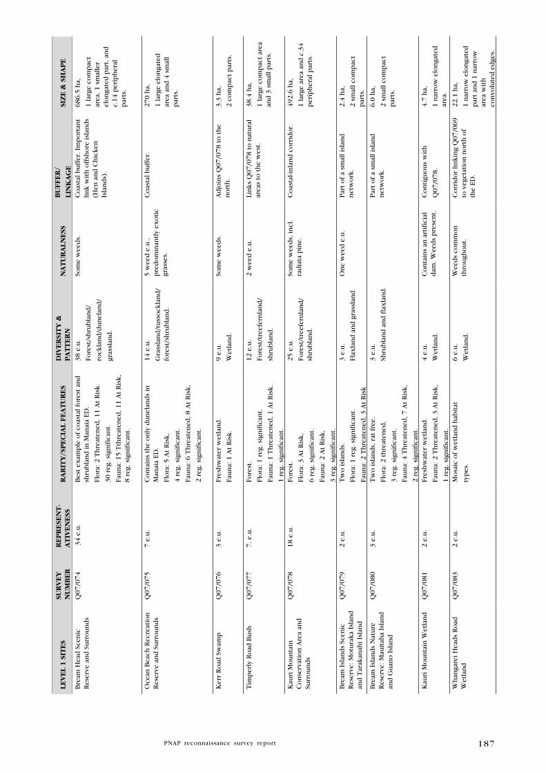
187
lE
VE
l 1
SIT
ES
SuR
VE
y
Nu
MB
ER
RE
PR
ESE
NT
-A
TIV
EN
ESS
RA
RIT
y/S
PE
CIA
l F
EA
Tu
RE
SD
IVE
RSI
Ty
&
PA
TT
ER
NN
AT
uR
AlN
ESS
Bu
FFE
R/
lIN
kA
gE
SIZ
E &
Sh
AP
E
Bre
am H
ead
Sce
nic
R
eser
ve a
nd
Su
rro
un
ds
Q07
/074
34
e.u
.B
est
exam
ple
of
coas
tal f
ore
st a
nd
sh
rub
lan
d in
Man
aia
ED.
Flo
ra: 2
Th
reat
ened
, 11
At
Ris
k.
30 r
eg. s
ign
ific
ant.
Fau
na:
15
Tth
reat
ened
, 11
At
Ris
k,
8 re
g. s
ign
ific
ant.
38 e
.u.
Fore
st/s
hru
bla
nd
/
rock
lan
d/d
un
elan
d/
gras
slan
d.
Som
e w
eed
s.C
oas
tal b
uff
er. I
mp
ort
ant
link
wit
h o
ffsh
ore
isla
nd
s (H
en a
nd
Ch
icke
n
Isla
nd
s).
686.
5 h
a,
1 la
rge
com
pac
t ar
ea, 1
sm
alle
r el
on
gate
d p
art,
an
d
c.14
per
iph
eral
p
arts
.
Oce
an B
each
Rec
reat
ion
R
eser
ve a
nd
Su
rro
un
ds
Q07
/075
7 e.
u.
Co
nta
ins
the
on
ly d
un
elan
ds
in
Man
aia
ED.
Flo
ra: 5
At
Ris
k,
4 re
g. s
ign
ific
ant.
Fau
na:
6 T
hre
aten
ed, 8
At
Ris
k,
2 re
g. s
ign
ific
ant.
14 e
.u.
Gra
ssla
nd
/tu
sso
ckla
nd
/fo
rest
/sh
rub
lan
d.
5 w
eed
e.u
., p
red
om
inan
tly
exo
tic
gras
ses.
Co
asta
l bu
ffer
. 27
0 h
a,
1 la
rge
elo
nga
ted
ar
ea a
nd
4 s
mal
l p
arts
.
Ker
r R
oad
Sw
amp
Q07
/076
3 e.
u.
Fres
hw
ater
wet
lan
d.
Fau
na:
1 A
t R
isk.
9 e.
u.
Wet
lan
d.
Som
e w
eed
s.A
djo
ins
Q07
/078
to
th
e n
ort
h.
3.3
ha,
2 co
mp
act
par
ts.
Tim
per
ly R
oad
Bu
shQ
07/0
777.
e.u
.Fo
rest
.
Flo
ra: 1
reg
. sig
nif
ican
t.
Fau
na:
1 T
hre
aten
ed, 1
At
Ris
k.
1 re
g. s
ign
ific
ant.
12 e
.u.
Fore
st/t
reef
ern
lan
d/
shru
bla
nd
.
2 w
eed
e.u
.Li
nks
Q07
/078
to
nat
ura
l ar
eas
to t
he
wes
t.38
.4 h
a,
1 la
rge
com
pac
t ar
ea
and
3 s
mal
l par
ts.
Kau
ri M
ou
nta
in
Co
nse
rvat
ion
Are
a an
d
Surr
ou
nd
s
Q07
/078
18 e
.u.
Fore
st.
Flo
ra: 3
At
Ris
k,
6 re
g. s
ign
ific
ant.
Fau
na:
2 A
t R
isk,
3 re
g. s
ign
ific
ant.
25 e
.u.
Fore
st/t
reef
ern
lan
d/
shru
bla
nd
.
Som
e w
eed
s, in
cl.
rad
iata
pin
e.C
oas
tal-i
nla
nd
co
rrid
or.
492.
6 h
a,
1 la
rge
area
an
d c
.34
per
iph
eral
par
ts.
Bre
am I
slan
ds
Scen
ic
Res
erve
: Mo
tura
ka I
slan
d
and
Tar
akan
ahi I
slan
d
Q07
/079
2 e.
u.
Tw
o is
lan
ds.
Flo
ra: 1
reg
. sig
nif
ican
t.
Fau
na:
2 T
hre
aten
ed, 3
At
Ris
k
3 e.
u.
Flax
lan
d a
nd
gra
ssla
nd
On
e w
eed
e.u
.P
art
of
a sm
all i
slan
d
net
wo
rk.
2.4
ha,
2 sm
all c
om
pac
t p
arts
.
Bre
am I
slan
ds
Nat
ure
R
eser
ve: M
auit
aha
Isla
nd
an
d G
uan
o I
slan
d
Q07
/080
3 e.
u.
Tw
o is
lan
ds,
rat
fre
e.
Flo
ra: 2
th
reat
ened
,
3 re
g. s
ign
ific
ant.
Fau
na:
4 T
hre
aten
ed, 7
At
Ris
k,
2 re
g. s
ign
ific
ant.
3 e.
u.
Shru
bla
nd
an
d f
lax
lan
d.
Par
t o
f a
smal
l isl
and
n
etw
ork
.6.
0 h
a,
2 sm
all c
om
pac
t p
arts
.
Kau
ri M
ou
nta
in W
etla
nd
Q07
/081
2 e.
u.
Fres
hw
ater
wet
lan
d.
Fau
na:
2 T
hre
aten
ed, 3
At
Ris
k,
1 re
g. s
ign
ific
ant.
4 e.
u.
Wet
lan
d.
Co
nta
ins
an a
rtif
icia
l d
am. W
eed
s p
rese
nt.
Co
nti
guo
us
wit
h
Q07
/078
.
4.7
ha,
1 n
arro
w e
lon
gate
d
area
.
Wh
anga
rei H
ead
s R
oad
W
etla
nd
Q07
/083
2 e.
u.
Mo
saic
of
wet
lan
d h
abit
at
typ
es.
6 e.
u.
Wet
lan
d.
Wee
ds
com
mo
n
thro
ugh
ou
t.C
orr
ido
r lin
kin
g Q
07/0
69
to v
eget
atio
n n
ort
h o
f th
e ED
.
22.1
ha,
1 n
arro
w e
lon
gate
d
par
t an
d 1
nar
row
ar
ea w
ith
co
nvo
lute
d e
dge
s.

188
lE
VE
l 1
SIT
ES
SuR
VE
y
Nu
MB
ER
RE
PR
ESE
NT
-A
TIV
EN
ESS
RA
RIT
y/S
PE
CIA
l F
EA
Tu
RE
SD
IVE
RSI
Ty
&
PA
TT
ER
NN
AT
uR
AlN
ESS
Bu
FFE
R/
lIN
kA
gE
SIZ
E &
Sh
AP
E
Kit
eon
e R
oad
Sal
tmar
shQ
07/1
686
e.u
.O
ne
of
two
sal
tmar
sh a
reas
in M
anai
a ED
.
Flo
ra: 1
reg
. sig
nif
ican
t.
Fau
na:
1 A
t R
isk.
6 e.
u.
Fore
st/t
uss
ock
lan
d/
rush
lan
d/s
edge
lan
d.
Ver
y go
od
man
gro
ve-
salt
mar
sh-fr
esh
wat
er
wet
lan
d s
equ
ence
. O
ccas
ion
al w
eed
s.
Co
asta
l bu
ffer
. Co
nti
gou
s w
ith
co
asta
l fo
rest
(Q
07/0
78).
3.8
ha,
1 la
rge
and
1 s
mal
l p
art.
Aw
aro
a Is
lan
dQ
07/1
701
e.u
.B
are
rock
isla
nd
.
Fau
na:
2 T
hre
aten
ed, 1
At
Ris
k.
2 e.
u.
Ro
ckla
nd
.
Ver
y lit
tle
vege
tati
on
.0.
43 h
a,
1 ve
ry s
mal
l are
a.
Fren
chm
an I
slan
dQ
07/1
711
e.u
.Is
lan
d.
Fau
na:
2 T
hre
aten
ed, 1
At
Ris
k.
2 e.
u.
Fore
st/r
ock
lan
d.
Ver
y fe
w w
eed
s.0.
24 h
a,
1 ve
ry s
mal
l are
a.
Har
amb
ee R
oad
Sw
amp
Q07
/172
1 e.
u.
Fres
hw
ater
wet
lan
d.
Fau
na:
2 T
hre
aten
ed, 1
At
Ris
k,
1 re
g. s
ign
ific
ant.
2 e.
u.
Wet
lan
d.
Som
e w
eed
s p
rese
nt.
Co
nti
guo
us
wit
h
Q07
/078
; co
nn
ects
to
sal
tmar
sh b
eyo
nd
n
ort
her
n b
ou
nd
ary
of
ED.
9.4
ha,
1 ar
ea w
ith
3 n
arro
w
con
volu
ted
arm
s.
Pea
ch C
ove
Sta
ck A
Q07
/173
1 e.
u.
Ro
ck s
tack
.
Flo
ra: 1
reg
. sig
nif
ican
t.
1 e.
u.
Ro
ckla
nd
.
2.1
ha,
1 sm
all n
arro
w a
rea.
Pea
ch C
ove
Sta
ck B
Q07
/174
Ro
ck s
tack
.1
e.u
.
Ro
ckla
nd
.
0.1
ha,
1 sm
all n
arro
w a
rea.
Kau
ri M
ou
nta
in R
oad
P
on
d a
nd
Rau
po
Sw
amp
Q07
/175
Fres
hw
ater
wet
lan
d.
Fau
na:
1 T
hre
aten
ed, 1
At
Ris
k.
2 e.
u.
Wet
lan
d.
Hig
hly
mo
dif
ied
, gr
azed
.0.
3 h
a,
1 sm
all c
om
pac
t ar
ea.
Sub
tota
l lev
el 1
Sit
es2,6
98.4
ha
lE
VE
l 2
SIT
ES
SuR
VE
y
Nu
MB
ER
RE
PR
ESE
NT
-A
TIV
EN
ESS
RA
RIT
y/S
PE
CIA
l
FE
AT
uR
ES
DIV
ER
SIT
y &
P
AT
TE
RN
NA
Tu
RA
lN
ESS
Bu
FFE
R/
lIN
kA
gE
SIZ
E &
Sh
AP
E
Kir
ikir
i Po
int
Co
asta
l Fo
rest
Q07
/169
Co
asta
l fo
rest
.1
e.u
.
Fore
st.
Ver
y w
eed
y.3.
0 h
a,
1 n
arro
w a
rea.
Hig
h I
slan
d S
tack
AQ
07/0
82R
ock
sta
ck.
Fau
na:
1 t
hre
aten
ed.
2 e.
u.
Ro
ckla
nd
.
Wee
ds
pre
sen
t.C
on
tigu
ou
s w
ith
m
ain
lan
d.
0.1
ha,
1 sm
all a
rea.
Kau
ri M
ou
nta
in R
oad
Se
epQ
07/1
771
e.u
.Fr
esh
wat
er w
etla
nd
.
Flo
ra: 1
reg
. sig
nif
ican
t.
2 e.
u.
Wet
lan
d.
Fen
ced
. So
me
wee
ds.
Rel
ativ
ely
iso
late
d.
0.5
ha,
1 sm
all n
arro
w a
rea.
Sub
tota
l lev
el 2
Sit
es3.6
ha
To
tal
area
2702.1
ha

189
Acknowledgments
We would like to gratefully acknowledge the assistance of the following
people and agencies during the survey and production of this report:
Landowners of Manaia ED who allowed access across their land to study
areas and/or who provided information. Martin Hunt provided useful site
information for Taurikura Ridge Bush.
Diane Manning (DOC) and Andrea Booth (DOC) surveyed the majority of
the Ecological District between 1997 and 1999.
Wendy Holland (DOC) initiated the completion of this report for
publication and coordinated various components, including support and
advice, and peer review. Being a proud resident of Manaia ED, Wendy
was able to share her wealth of local knowledge and experience on her
‘back yard’.
Nigel Miller (Biodiversity Assets), Glen Coulston (Biodiversity Threats),
Clea Gardiner (Kiwi Recovery Programme), Pete Graham (Kiwi Ranger),
and Paul Cornille (Kiwi Ranger), from the DOC Whangarei Area Office
all contributed their wealth of knowledge and insights. Nigel Miller and
Andrea Booth provided additional editorial comment, particularly on fauna.
Todd Hamilton and Helen Moodie (Whangarei Heads Landcare Forum)
reviewed parts of this report and provided additional information on
the activities undertaken by the WHLF, including pest control and kiwi
management. Peter Harding (WHLF) provided information on weed control
undertaken by landcare groups throughout Manaia ED.
Ewen Cameron (Auckland Museum Herbarium - AK) and Leon Perrie (Te
Papa Museum Herbarium - WELT) supplied herbarium records. Records
for Pseudowintera insperata and Sophora fulvida were obtained from
Christchurch Herbarium – CHR.
Andrew Townsend (DOC) and Lisa Forester (Northland Regional Council)
provided editorial comment and information on flora. Maureen Young
(Auckland Botanical Society) also provided supplementary material on
local flora.
Dr Ray Pierce (EcoOceania Pty Ltd) provided editorial comment and
information on local fauna.
Dr Fred Brook compiled geomorphological data for each site; he also
provided information on indigenous land snails and other invertebrates
found in Manaia ED.
Aerial orthophotography was provided courtesy of Northland Regional
Council.
Marlé Rossouw (Wildland Consultants) and Nick Goldwater (Wildland
Consultants) updated site maps according to recent aerial photography in
2008. Andrew MacDonald (DOC) prepared the final maps for publication
using ArcGIS v. 9.1.
Steve Rate (Wildland Consultants) peer reviewed a draft of the report
and Cate Bull (Wildland Consultants) assisted with collating information.

190
BibliographyAllan H.H. 1961: Flora of New Zealand Vol. 1. Indigenous Tracheophyta, Psilopsida, Lycopsida,
Filicopsida, Gymnospermae, Dicotyledones. Department of Scientific and Industrial
Research. Government Printer, Wellington, NZ.
Arand J., Basher L., Wardle R., Wardle K. 1993: Inventory of New Zealand Soil Sites of
international, national and regional importance. Part Two - North Island and northern
offshore islands (1st edition). New Zealand Society of Soil Science Occasional Publication
2. Lincoln University, NZ.
Atkinson I.A.E. 1962: Semi-quantitative measurements of canopy composition as a basis for
mapping. Proceedings of the New Zealand Ecological Society 9: 1-8.
Atkinson I.A.E. 1985: Derivation of vegetation mapping units for an ecological survey of Tongariro
National Park, North Island, New Zealand. New Zealand Journal of Botany 23: 361-178.
Bayley, M; Kellow, A. 2006: An Illustrated Guide to New Zealand Hebes. Te Papa Press,
Wellington, New Zealand.
Bioweb 2009: Department of Conservation Bioweb database. Accessed August and September
2009.
Bream Head Conservation Trust website: www.breamheadtrust.org.nz. Accessed February 2010.
Brook F.J. 1996: Classification of the Ecological Districts of Northland. Unpublished report.
Department of Conservation, Northland Conservancy, Whangarei.
Brook F.J. 1999b: Distribution and conservation status of the dune snail Succinea archeyi Powell
(Stylommatophora: Succineidae) in northern New Zealand. Science for Conservation
129. Department of Conservation, Wellington.
Brook F. J. 2000: Holocene distribution, ecology and local extinction of the endemic
New Zealand dune snail Succinea archeyi Powell (Stylommatophora: Succineidae).
Journal of the Royal Society of New Zealand 30: 209-225.
Brook F.J. 2002: Uncommon and rare land snails in the Northland region of New Zealand,
and an assessment of conservation management priorities. Department of Conservation,
Northland Conservancy, Whangarei.
Brook F.J. 2004: Distribution of Schizoglossa (Gastropoda: Rhytididae) and Mecodema (Coleoptera:
Carabidae) in the Bream Head Scenic Reserve, Whangarei Heads, northern New Zealand.
Unpublished report for Whangarei Area Office, Department of Conservation, November
2004.
Brook F.J. and McArdle B.H. 1999: Morphological variation, biogeography and local extinction
of Placostylus hongii (Gastropoda: Bulimulidae) of northern New Zealand. Journal of
the Royal Society 29: 407-434.
Brownsey P.J., Smith-Dodsworth J.C. 2000: New Zealand Ferns and Allied Plants. David Bateman,
Auckland, NZ.
Clunie N.M.U. 1993: The Whangarei Area of Central Northland: Scenic Reserve. Biological Survey
of Reserves Series. Published by the Department of Conservation.
Conning L.D. 2001: Northland Protection Strategy. Nature Heritage Fund, Wellington.
Cowan P.E. 2001: Advances in New Zealand mammalogy 1990-2000: Brushtail possum. Journal
of the Royal Society of New Zealand 31: 15-29.
Crawley M.J. 1997: The structure of plant communities. In Crawley, M.J. (ed.). Plant Ecology.
Blackwell Science, Oxford, U.K.
Dawson J., Lucas, R. 2000: Nature Guide to the New Zealand Forest. Auckland, NZ.
de Lange P.J.; Norton D.A.; Heenan P.B.; Courtney S.P.; Molloy B.P.J.; Ogle C.C.; Rance B.D.;
Johnson P.N.; Hitchmough R. 2004: Threatened and uncommon plants of New Zealand.
New Zealand Journal of Botany 42: 45-76.

191
de Lange P.J., Norton D.A., Heenan P.B., Courtney S.P., Molloy B.P.J., Ogle C.C., Rance B.D.,
Johnson P.N., Hitchmough R. 2009: Threatened and uncommon plants of New Zealand.
New Zealand Journal of Botany 47: 61–96.
Department of Conservation. Internal reports, files and databases. Northland Conservancy,
Whangarei.
Department of Conservation. Draft list of regionally significant fauna and flora in Northland (in
prep). Northland Conservancy, Whangarei.
Department of Conservation 1991: An Internal Review of the Protected Natural Areas Programme.
Internal Unpublished Report, Wellington.
Department of Conservation 1994: Protected Natural Areas Programme Draft Discussion
Document. Internal Unpublished Report, Wellington.
Department of Conservation 1999: Conservation Management Strategy. Northland Conservancy
1999-2009. Volumes 1 and 2. Department of Conservation, Northland Conservancy,
Whangarei.
DOC unpublished data 2007: Docdm-34119.
Eagle A. 2008: Eagle’s Complete Trees and Shrubs of New Zealand. Volume 1 & 2. Wellington,
NZ.
Edgar E., Connor, H.E. 2000: Flora of New Zealand Vol. 5. Grasses. Manaaki Whenua Press,
Lincoln, NZ.
Forester L., Townsend A. 2004: Threatened Plants of Northland Conservancy. DOC Science
Publishing, Science and Research Unit. Department of Conservation, Wellington.
Gardner R.O. 1984: Geranium solanderi and allies in New Zealand. New Zealand Journal of
Botany 22: 127-134.
Gill B., Whitaker, T. 1996: New Zealand Frogs and Reptiles. David Bateman, Auckland, NZ.
Gill B.J. 1997: Records of turtles and sea snakes in New Zealand, 1837-1996. New Zealand
Journal of Marine and Freshwater Research. 31: 477-486.
Greene T.C., Powlesland R.G., Dilks P.J., Moran L. 2004: Research summary and options
for conservation of kaka (Nestor meridionalis). DOC Science Internal Series 178.
Department of Conservation, Wellington.
Griffiths J. 2000: The distribution and abundance of Latrodectus atritus on the west and east
coasts of northern New Zealand. Report to the Department of Conservation, Northland
Conservancy, Whangarei.
Hamilton T. 2008: Whangarei Heads Landcare Forum Predator Trapping Report 2007/08. Report
produced for the Whangarei Heads Landcare Forum.
Harris R.J. 2002: Potential impact of the Argentine ant (Linepithema humile) in New Zealand
and options for its control. Science for Conservation 196. Department of Conservation,
Wellington.
Hayward B.W.; Black P.M.; Smith I.E.M.; Balance P.F. 2001: K-Ar ages of early Miocene arc-type
volcanoes in northern New Zealand. New Zealand Journal of Geology and Geophysics
44: 285-311.
Healy A.J.; Edgar E. 1980: Flora of New Zealand Vol III. Government Printer, Wellington, NZ.
Heather B.D., Robertson H.A. 1996: The field guide to the birds of New Zealand. Viking,
Penguin Books, Auckland, NZ.
Heenan P.B., de Lange P.J. 2006: Pseudowintera insperata (Winteraceae), an overlooked and
rare new species from northern New Zealand. New Zealand Journal of Botany 44:
89-98.
Hitchmough R., Bull L., Cromarty P. (comp.) 2007: New Zealand Threat Classification System
lists 2005. Science & Technical Publishing, Department of Conservation, Wellington.
Hunt M., Moodie H. 2008: Whangarei Heads Landcare Forum Inc. Taurikura Ridge Biodiversity
Enhancement Project, Stage 3 Operating Plan.
192
Isaac M.J., Herzer, R.H.; Brook, F.J., Hayward, B.W. 1994: Cretaceous and Cenozoic sedimentary
basins of Northland, New Zealand. Institute of Geological and Nuclear Sciences
monograph 8. 203 p. and 4 sheets.
Johnson P.J., Gerbeaux P. 2004: Wetland Types in New Zealand. Department of Conservation,
Wellington, NZ.
Kenny J.A., Hayward B.W. 1993: Inventory and Maps of Important Geological Sites and
Landforms in the Northland Region. Geological Society of New Zealand Miscellaneous
Publication 67 (2nd Edition).
Kenny J.A., Hayward B.W. 1996: Inventory and Maps of Important Geological Sites and
Landforms in the Northland Region. Geological Society of New Zealand Miscellaneous
Publication 83.
Kershaw K.A., Looney J.H.H. 1985: Quantitative and Dynamic Ecology. 3rd ed. Edward Arnold,
London.
King M. 1990: A Handbook of New Zealand Mammals. Oxford University Press, Auckland.
Leathwick J.R., Rogers G.M. 1996: Modelling relationship between environment and canopy
composition in secondary vegetation in central North Island, New Zealand. New Zealand
Journal of Ecology 20: 147-162.
McManaway D. 1983: Whangarei Heads, 125 years, 113 p. Whangarei, NZ.
McGuinness, C. A. 2001: The conservation requirements of New Zealand’s nationally
threatened invertebrates. Threatened Species Occasional Publication 20. Department
of Conservation, Wellington.
McDowall R.M. 2000: The Reed field guide to New Zealand freshwater fishes. Reed Books,
Auckland, NZ.
McEwen W.M. June 1987: Ecological Regions and Districts of New Zealand. New Zealand
Biological Resources Centre. Publication No 5.
McGlone M.S. 1985: Plant biogeography and the late Cenozoic history of New Zealand. New
Zealand Journal of Botany 23: 723-749.
Miskelly M., Dowding J.E., Elliott G.P., Hitchmough R.A., Powlesland R.G., Robertson A., Sagar
P.M., Scofield R.P. and Taylor G.A. 2008: Conservation status of New Zealand birds,
2008. Notornis 55: 117-135.
Ministry for the Environment 2004: New Zealand Land Cover Database 2 (LCDB2).
Moir R.W., Collen B., Thompson C.S. 1986: The Climate and Weather of Northland New Zealand.
Meteorological Service Misc Pub 115 (2) 2nd Ed. Ministry of Transport, Wellington.
Molloy J., Bell B., Clout M., de Lange P., Gibbs G., Given D., Norton D., Smith N., Stephens T.
2002: Classifying species according to threat of extinction. A system for New Zealand.
Threatened Species Occasional Publication 22. Department of Conservation, Wellington.
26 pp.
Moore G.E. 2001: Use of Kinleith Forest by native New Zealand bats and effects of forestry.
A thesis presented in partial fulfilment of the requirements for the degree of Master
of Science in Ecology. Massey University, Palmerston North, New Zealand. 255 pp.
Moore L.B., Edgar, E. 1970: The Flora of New Zealand Vo. 2. Indigenous Tracheophyta.
Government Printer, Wellington, NZ.
Mueller-Dombois D., Ellenberg H. 1974: Aims and Methods of Vegetation Ecology. John Wiley
& Sons, New York.
Myers S., Park G., Overmars F. 1987: A book for the Rapid Ecological Survey of Natural Areas.
New Zealand Biological Resources Centre. Publication No. 6.
NIWA 2009: New Zealand Freshwater Fish Database. Available at: http://fwdb.niwa.cri.nz/
Accessed August 2009.
NZPCN 2009: New Zealand Plant Conservation Network website: Available at: http://www.
nzpcn.org.nz/ Accessed June 2009 – March 2010.

193
Park G.N., Walls G.Y. 1978: (Unpublished). Inventory of tall forest stands on lowland plains
and terraces in Nelson and Marlborough land districts, New Zealand. Report of Botany
Division, DSIR. 127 pp.
Parrish R., Sherley G., Aviss M. 1995: Giant land snail recovery plan: Placostylus spp.,
Paryphanta sp. Threatened Species Recovery Plan Series No. 13. Threatened Species
Unit, Department of Conservation, Wellington.
Penniket A.S.W. 1981: Population studies of land snails of the genus Placostylus in the north of
New Zealand. Unpublished M.Sc. thesis, University of Auckland, Auckland, New Zealand.
115 p.
Pierce R.J., Sporle W. 1997. Causes of kiwi mortality in Northland. Conservation Advisory
Science Notes No. 169, Department of Conservation, Wellington, NZ.
Pierce R.J., Coulter G.W., Moodie H.G. 2002: Biodiversity Values and Opportunities for
Restoration at Whangarei Heads. Report prepared by Wildland Consultants Ltd for the
Whangarei Heads Landcare Forum. Report No. 463.
Pierce R.J., Gardiner, C., Moodie, H., Robertson, H.A., Sporle, W. 2006. Sustainable Management
of Brown Kiwi and other threatened birds in Northland. Wildland Consultants Ltd
contract report no. 1193.
Pierce R.J. 2006: Ecological assessment of proposed development site at Timperley Road,
Whangarei Heads. Report prepared for Timperley Road Holdings Ltd, Taurikura. 14 pp.
Pierce R.J., Atkinson R., Smith E. 1993: Changes in bird numbers in six Northland forests
1979-93. Notornis 40: 285-93.
Pierce R.J., Kerr V. 2007: Ecological Restoration of the Taiharuru Catchment. Eco Oceania Ltd
Report for Taiharuru Catchment Care Group. 56 pp.
Pierce R.J. 2008: Call-count monitoring of North Island kiwi in Northland in 2007 and 2008.
Report prepared for Department of Conservation and New Zealand Landcare Trust.
Poole L., Adams N. 1990: Trees and Shrubs of New Zealand. Revised edition. DSIR Publishing,
Wellington.
Powell A.W.B. 1938: The Paryphantidae of New Zealand 4 and the genus Placostylus in New
Zealand. Records of the Auckland Institute and Museum 2: 133–150.
Ritchie J. 2008: Description of Proposal and Assessment of Effects on the Environment for
a Pest Proof Fence and Animal Pest Eradication Programme at Bream Head Scenic
Reserve and Surrounds, Whangarei Heads, Northland. Report prepared for the Bream
Head Conservation Trust.
Salmon J.T. 1980: The Native Trees of New Zealand. Reed Books, Auckland.
Technical Advisory Group 1986: The New Zealand Protected Natural Areas Programme.
A Scientific Focus. New Zealand Biological Resources Centre Publication No. 4.
New Zealand Department of Scientific and Industrial Research, Wellington.
Thompson B.N. 1961: Sheet 2A-Whangarei. Geological map of New Zealand 1:250 000.
Wellington, New Zealand. Department of Scientific and Industrial Research.
Transpower website: www.transpower.co.nz. Accessed October 2009.
Walker S.; Cieraad E.; Grove P.; Lloyd K.; Park T.; Porteous T. 2007: Guide for Users of
the Threatened Environments Classification. Ver 1.1, August 2007. Landcare Research
Manaaki Whenua, New Zealand Ltd.
Wardle P. 1991: Vegetation of New Zealand. Cambridge University Press.
Wilson H.; Galloway, T. 1993: Small-leaved Shrubs of New Zealand. Manuka Press, Christchurch,
NZ.
Young M.E. 2007: Labour Weekend Camp: Whangarei Heads. 19/10/07. Auckland Botanical
Society Journal 62(2): 120-124.

194
Appendix 1
F I E l D S u R V E y F O R M
P R O T E C T E D N A T U R A L A R E A S P R O G R A M M E
TANGIHUA ECOLOGICAL DISTRICT
NATuRAl AREA NAME: PNA NO.:
RECORDER: SuRVEy DATE:gRID REF.: SSBI NO.:
hABITAT TyPE(S):
gEOMORPhOlOgICAl TyPE(S):
ECOlOgICAl uNIT(S):
hab
itat
C
lass
Vegetation/habitat
Structurelandform
% of Total Area
% Percentage Canopy Cover
Abundant (50-100)
Common (20-50)
Frequent(5-20)
Occasional(0-5)
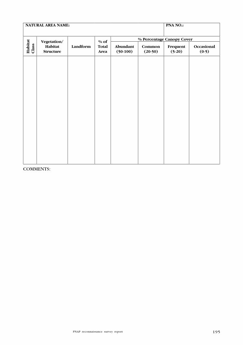
195
NATuRAl AREA NAME: PNA NO.:h
abit
at
Cla
ss
Vegetation/habitat
Structurelandform
% of Total Area
% Percentage Canopy Cover
Abundant (50-100)
Common (20-50)
Frequent(5-20)
Occasional(0-5)
COMMENTS:
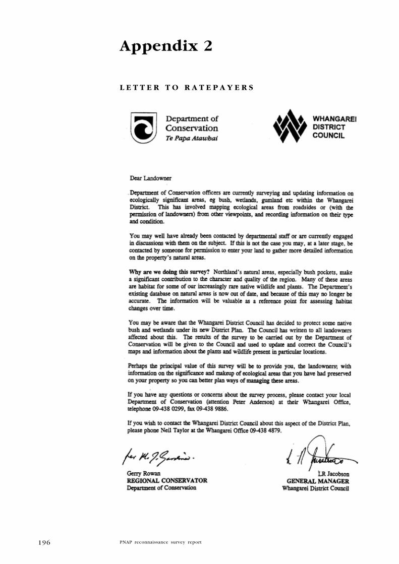
196
Appendix 2
l E T T E R T O R A T E P A y E R S
197
Appendix 3
C A T E g O R I E S O F T h R E A T
In this report the categories of threat are based on the New Zealand
Threat Classification developed by Molloy et al. (2002). The classification
system was reviewed in 2007, resulting in several new threat categories,
and redefinition of some existing categories (see Townsend et al. 2008).
This refined system is a uniquely New Zealand-based conservation status
assessment tool, which has been used to assess the conservation status of
vascular plants and birds only. In the coming three years, however, it will
be applied to the bats, marine mammals, frogs, reptiles, freshwater and
marine fish, freshwater, marine, and terrestrial invertebrates, bryophytes,
macro-algae, and fungi which are indigenous to New Zealand (Hitchmough
et al. 2007; Townsend et al. 2008). In the meantime, this report has
used threat categories from Molloy et al. (2002) to cover rankings for
everything other than plants and birds, and ‘Threatened’ and ‘At Risk’
categories from Townsend et al. 2008 for plants and birds.
Below is the structure diagram and Sections 3 and 7 from Molloy et
al. (2002) to explain the categories under this system followed by the
structure diagram and Sections 8, 9 and 10 from Townsend et al. (2008) to
explain the refined classification system. Reproduced below are sections
3 and 7 of Molloy et al. (2002) which explain the classification system.
Classification structure - Molloy et al. (2002)Below are Sections 3 and 7, taken from Molloy et al. (2002), to explain the
new species classification system. The categories are shown in Figure 4.
Figure 4. Structure of the New Zealand Threat Classification System
introduced and naturalised
Introduced and Naturalised taxa are those that have become naturalised in the wild after being deliberately or accidentally introduced to New Zealand by human agency. If an Introduced and Naturalised taxon has an IUCN Red Listing in its country (or countries) of origin, the IUCN
category and source of the listing are shown after the taxon’s name in
the New Zealand list. Current examples of this include the cress Lepidium
hyssopifolium and the southern bell frog (Litoria raniformis), both of
which are listed as Endangered in Australia; and the parma wallaby
(Macropus parma), listed as lower risk/near threatened.
Vagrant
For the purposes of this document, Vagrants are taxa that are found
unexpectedly and rarely in New Zealand, and whose presence in our
region is naturally transitory. These are taxa that do not establish
themselves beyond their point of arrival because of reproductive failure
or for specific ecological reasons. Examples include the red-kneed
dotterel (Erythrogonys cinctus) and the blue moon butterfly (Hypolimnas

198
bolina nerina), both from Australia, and the spotted sawtail (Prionurus
maculatus) from the tropical south-west Pacific Ocean. If a taxon in the
Vagrant category has been listed in an IUCN Red List in its country of
origin, the IUCN category and source of the listing are shown beside the
taxon’s name in the New Zealand list.
Coloniser
Colonisers are taxa that have arrived in New Zealand without direct or
indirect help from humans and have been successfully reproducing in the
wild for less than 50 years. Three examples are the Nankeen night heron
(Nycticorax caledonicus), the scoliid wasp Radumeris tasmaniensis and
the orchid Cryptostylis subulata. The IUCN Red List category and source
of the listing is included where this exists.
Migrant
Taxa that predictably and cyclically visit New Zealand as part of their
normal life cycle, but do not breed here are included in the category
Migrant. Examples include the Arctic skua (Stercorarius parasiticus)
and striped marlin (Tetrapturus audax). In contrast, taxa that either
breed here and migrate beyond New Zealand during their life cycle,
e.g., Chatham Island albatross (Thalassarche eremita), or taxa that are
resident in New Zealand for most of their lives, such as longfin eels
(Anguilla dieffenbachii), are not included in this category. The IUCN
Red List category and source of the listing is included where this exists.
Data deficient
The amount of information available for assessing the threat of extinction
is highly variable between taxa and groups of taxa. At one extreme there
are taxa such as kakapo, Gunnera hamiltonii and Tecomanthe speciosa
where every wild individual is known, while at the other extreme there
Biota in the wild in New Zealand
Introduced and Naturalised
Vagrant
Coloniser
Migrant
Data deficient
Extinct
NotThreatened
Nationally Critical
Nationally Endangered
Nationally Vunerable
Serious Decline
Gradual Decline
Range Restricted
Sparse
Native
Resident
Evaluated
Threatened
At Risk
Acutely Threatened
ChronicallyThreatened
Note: A box denotes a category
Figure 1. Structure of the New Zealand Threat Classification System

199
are taxa whose ecology and biology is virtually unknown (e.g. Koeleria
riguorum, a recently described grass). Certain criteria and/or definitions
must be met for a taxon to be listed in a category. Where information
is so lacking that an assessment is not possible, the taxon is assigned to
the Data Deficient category. If a taxon is listed in a category other than
Data Deficient but confidence in the listing is low due to poor quality
data, then the listing can be qualified with the letters DP (Data Poor)
to indicate this.
extinct
A taxon is listed as Extinct when there is no reasonable doubt, after
repeated urveys in known or expected habitats at appropriate times
(diurnal, seasonal and annual) and throughout the taxon’s historic range,
that the last individual has died. Examples include huia (Heteralocha
acutirostris) and Adams’s mistletoe (Trilepidea adamsii). Only taxa that
have become extinct since 1840 are included in the list. Taxa that are
extinct in the wild but occur in captivity or cultivation are not listed in
this category. These are listed as Critically Endangered and are qualified
with the letters EW (Extinct in the Wild).
Threatened
The threatened categories are grouped into three major divisions: ‘Acutely
Threatened’, ‘Chronically Threatened’ and ‘At Risk’.
acutely Threatened
The categories in the ‘Acutely Threatened’ division – Nationally Critical,
Nationally Endangered and Nationally Vulnerable – equate with the IUCN
categories of Critically Endangered, Endangered and Vulnerable. Taxa in
these three categories are facing a very high risk of extinction in the
wild, as defined by criteria that quantify:
• Total population size
• Area of occupancy
• Fragmentation of populations
• Declines in total population
• Declines in habitat area
• Predicted declines due to existing threats
Although the criteria (described in Section 6) measure similar population
features as those in the lUCN Red List criteria, numerical limits and
timeframes are tailored to suit New Zealand circumstances. These were
set through a process of testing and refinement by the project team and
as a result of feedback from New Zealand species experts. Criteria that
attempt to predict declines due to possible future threats are not included
because of the highly speculative nature of this type of assessment.
Chronically Threatened
Taxa listed in either of the two categories in the ‘Chronically Threatened’
grouping (Serious Decline and Gradual Decline) also face extinction, but are
buffered slightly by either a large total population, or a slow decline rate.
200
at Risk
Taxa that do not meet the criteria for Acutely Threatened or Chronically
Threatened, but have either restricted ranges or small scattered
subpopulations, are listed in one of two categories (Range Restricted
and Sparse) that fall under the division ‘At Risk’. Although these taxa
are not currently in decline, their population characteristics mean a new
threat could rapidly deplete their population(s). Range Restricted taxa
either occur in a small geographic area (e.g., Three Kings Islands), are
restricted to a particular habitat (e.g. geothermal areas), or require very
specific substrates (e.g. ultramafic rock), and for colonial breeders, have
fewer than 10 subpopulations. Taxa that have naturally restricted ranges
and taxa that have become restricted as a result of human activities are
both included in this category. This is because both would face the
same risk of extinction in the face of a new threat. The two groups
are differentiated by the use of a qualifier (see Section 4). Sparse taxa
have very small, widely scattered populations, e.g., New Zealand spinach
(Tetragonia tetragonoides). As with the Range Restricted category, taxa
that are either naturally sparse or have become sparse as a result of
human activities are included in this category.
Not threatened
Taxa that are assessed and do not fit any of the Threatened categories
are listed in the Not Threatened category.
Criteria for the Acutely Threatened and Chronically Threatened categories - Molloy et al.(2002)
A taxon must meet specific criteria to be listed in one of the Acutely
Threatened or Chronically Threatened categories. The criteria for each
category are set out below.
Nationally Critical
Very small population or a very high predicted decline
A taxon is ‘Nationally Critical’ when available scientific evidence indicates
that it meets any of the following three criteria:
1. The total population size is < 250 mature individuals.
2. Human influences have resulted in < 2 sub-populations and either:
a. < 200 mature individuals in the largest sub-population, or
b. the total area of occupancy is < 1 ha (0.01 km2).
3. There is a predicted decline of > 80% in the total population in the
next 10 years due to existing threats.
Nationally endangered
A: Small population and moderate to high recent or predicted decline
A taxon is Nationally Endangered when available scientific evidence
indicates that it fits at least one Status criterion and one Trend
criterion as follows:

201
Status criteria
1. The total population size is 250–1000 mature individuals.
2. There are < 5 sub-populations and either:
a. < 300 mature individuals in the largest sub-population, or
b. the total area of occupancy is < 10 ha (0. 1 km2).
Trend criteria
1. There has been a decline of > 30% in the total population
or habitat area in the last 100 years.
2. There is a predicted decline of > 30% in the total population
in the next 10 years due to existing threats.
B: Small to moderate population and high recent or predicted
decline
A taxon is Nationally Endangered when available scientific evidence indicates that it fits at least one Status criterion and one Trend
criterion:
Status criteria
1. The total population size is 1000–5000 mature individuals.
2. There are < 15 sub-populations and either:
a. 300–500 mature individuals in the largest sub-population, or
b. the total area of occupancy is 10–100 ha (0.1–1 km2).
Trend criteria
1. There has been a decline of > 60% in the total population
or habitat area in the last 100 years.
2. There is a predicted decline of > 60% in the total population
in the next 10 years due to existing threats.
Nationally Vulnerable
Small to moderate population and moderate recent or predicted
decline
A taxon is Nationally Vulnerable when scientific evidence indicates
that it fits at least one Status criterion and one Trend criterion:
Status criteria
1. The total population size is 1000–5000 mature individuals.
2. There are < 15 sub-populations and either:
a. 300–500 mature individuals in the largest sub-population, or
b. the total area of occupancy is 10–100 ha (0.1–1 km2).
Trend criteria
1. There has been a decline of 30–60% in the total population or
habitat area in the last 100 years and the total population or
habitat area is still in decline.
2. There is a predicted decline of 30–60% in the total
population in the next 10 years due to existing threats.

202
Serious Decline
A. Moderate to large population and moderate to large predicted decline
A taxon is listed in Serious Decline when scientific evidence indicates
that it fits at least one Status criterion and the Trend criterion:
Status criteria
1. The total population size is > 5000 mature individuals.
2. There are > 15 sub-populations and either:
a. > 500 mature individuals in the largest sub-population, or
b. the total area of occupancy is >100 ha (1 km2).
Trend criterion
1. There is a predicted decline of > 30% in the total
population in the next 10 years due to existing threats.
B. Small to moderate population and small to moderate predicted
decline
A taxon is listed in Serious Decline when available scientific evidence
indicates that it fits at least one Status criterion and the Trend
criterion:
Status criteria
1. The total population size is < 5000 mature individuals.
2. There are < 15 sub-populations and either:
a. < 500 mature individuals in the largest sub-population, or
b. the total area of occupancy is < 100 ha (1 km2).
Trend criterion
1. There is a predicted decline of 5–30% in the total population in
the next 10 years due to existing threats.
Gradual Decline
Moderate to large population and small to moderate decline.
A taxon is fisted in Gradual Decline when available scientific
evidence indicates that it fits at least one Status criterion and the
Trend criterion:
Status criteria
1. The total population size is > 5000 mature individuals.
2. There are > 15 sub-populations and either:
a. > 500 mature individuals in the largest sub-population,or
b. the total area of occupancy is > 100 ha (1 km2).
Trend criterion
1. There is a predicted decline of 5–30% in the total
population in the next 10 years due to existing threats,
and the decline is predicted to continue beyond 10 years.

203
Threatened and At Risk categories - Townsend et al. (2008)
Biota in the wild in New Zealand
Vagrant
Coloniser
Migrant Data deficient
Extinct
Not Threatened
Nationally Critical
Nationally Endangered
Nationally Vunerable
Recovering
Relict
Naturally uncommon
Native
Resident
Evaluated
Threatened
Note: A box denotes a category
Introduced and Naturalised
Declining
Figure 2. Structure of the New Zealand Threat Classification System
‘Threatened’ taxa are grouped into three categories: ‘Nationally Critical’, Nationally Endangered’ and ‘Nationally Vulnerable’.
Taxa with populations that are small (< 250 mature individuals) are considered highly susceptible to stochastic events and so are listed as ‘Nationally Critical’, regardless of whether their small population size is due to human-induced or natural causes
Nationally Critical
A. Very small population (natural or unnatural)
A taxon is ‘Nationally Critical’, regardless of population trend and regardless of whether the population size is natural or unnatural, when evidence indicates that:
1. There are fewer than 250 mature individuals; or
2. There are ≤ 2 sub-populations and ≤ 200 mature individuals in the largest sub-population; or
3. The total area of occupancy is ≤ 1 ha (0.01 km2).
B. Small population (natural or unnatural) with a high ongoing or predicted decline
A taxon is ‘Nationally Critical’ when evidence indicates that it fits at least one Status criterion and the Trend criterion as follows:
Status
1. The population comprises 250–1000 mature individuals; or
2. There are ≤ 5 sub-populations and ≤ 300 mature individuals in the largest sub-population; or
Not evaluated
204
3. The total area of occupancy is ≤ 10 ha (0.1 km2).
Trend
There is an ongoing or predicted decline of 50–70% in the total population due to existing threats, taken over the next 10 years or three generations, whichever is longer.
C. Population (irrespective of size or number of sub-populations)with a very high ongoing or predicted decline (> 70%)
A taxon is ‘Nationally Critical’ when the population has an ongoing trend or predicted decline of > 70% in the total population due to existing threats taken over the next 10 years or three generations, whichever is longer.
Nationally endangered
A. Small population (natural or unnatural) that has a low to high ongoing or predicted decline
A taxon is ‘Nationally Endangered’ when evidence indicates that it fits at least one Status criterion and the Trend criterion as follows:
Status
1. The total population size is 250–1000 mature individuals; or
2. There are ≤ 5 sub-populations and ≤ 300 mature individuals in the largest sub-population; or
3. The total area of occupancy is ≤ 10 ha (0.1 km2).
Trend
There is an ongoing or predicted decline of 10–50% in the total population due to existing threats, taken over the next 10 years or three generations, whichever is longer.
B. Small stable population (unnatural)
To trigger this pathway to ‘Nationally Endangered’, taxa must have current population sizes that result from unnatural causes. Such taxa are defined as ‘Nationally Endangered’ when evidence indicates that they fit at least one Status criterion and the Trend criterion as follows:
Status
1. The total population size is 250–1000 mature individuals; or
2. There are ≤ 5 sub-populations and ≤ 300 mature individuals in the largest sub-population; or
3. The total area of occupancy is ≤ 10 ha (0.1 km2).
Trend
The population is stable (± 10%) and is predicted to remain stable over the next 10 years or three generations, whichever is longer.
C. Moderate population and high ongoing or predicted decline
A taxon is ‘Nationally Endangered’ when evidence indicates that it fits at least one Status criterion and the Trend criterion as follows:
Status
1. The total population size is 1000–5000 mature individuals; or

205
2. There are ≤ 15 sub-populations and ≤ 500 mature individuals in the largest sub-population; or
3. The total area of occupancy is ≤ 100 ha (1 km2).
Trend
There is an ongoing or predicted decline of 50–70% in the total population due to existing threats, taken over the next 10 years or three generations, whichever is longer.
Nationally Vulnerable
A. Small, increasing population (unnatural)
To trigger ‘Nationally Vulnerable’, taxa must have current population sizes that result from unnatural causes. Such taxa are defined as ‘Nationally Vulnerable’ when evidence indicates that they fit at least one Status criterion and the Trend criterion as follows:
Status
1. The total population size is 250–1000 mature individuals; or
2. There are ≤ 5 sub-populations and ≤ 300 mature individuals in the largest sub-population; or
3. The total area of occupancy is ≤ 10 ha (0.1 km2).
Trend
The population is increasing (> 10%) and is predicted to continue to increase over the next 10 years or three generations, whichever is longer.
B. Moderate, stable population (unnatural)
To trigger ‘Nationally Vulnerable’, taxa must have current population sizes that result from unnatural causes. Such taxa are defined as ‘Nationally Vulnerable’ when evidence indicates that they fit at least one Status criterion and the Trend criterion as follows:
Status
1. The total population size is 1000–5000 mature individuals; or
2. There are ≤ 15 sub-populations and ≤ 500 mature individuals in the largest
sub-population; or
3. The total area of occupancy is ≤ 100 ha (1 km2).
Trend
The population is stable (± 10%) and is predicted to remain stable over the next 10 years or three generations, whichever is longer.
C. Moderate population, with population trend that is declining
A taxon is ‘Nationally Vulnerable’ when evidence indicates that it fits at least one Status criterion and the Trend criterion as follows:
Status
1. The total population size is 1000–5000 mature individuals; or
2. There are ≤ 15 sub-populations and ≤ 500 mature individuals in the largest sub-population; or
3. The total area of occupancy is ≤ 100 ha (1 km2).

206
Trend
There is an ongoing or predicted decline of 10–50% in the total population due to existing threats, taken over the next 10 years or three generations, whichever is longer.
D. Moderate to large population and moderate to high ongoing or predicted decline
A taxon is ‘Nationally Vulnerable’ when evidence indicates that it fits at least one Status criterion and the Trend criteria as follows:
Status
1. The total population size is 5000–20 000 mature individuals; or
2. There are ≤ 15 sub-populations and ≤ 1000 mature individuals in the largest sub-population; or
3. The total area of occupancy is ≤ 1000 ha (10 km2).
Trend
There is an ongoing or predicted decline of 30–70% in the total population due to existing threats, taken over the next 10 years or three generations, whichever is longer.
E. large population and high ongoing or predicted decline
A taxon is ‘Nationally Vulnerable’ when evidence indicates that it fits at least one Status criterion and the Trend criterion as follows:
Status
1. The total population size is 20 000–100 000 mature individuals; or
2. The total area of occupancy is ≤ 10 000 ha (100 km2).
Trend
There is an ongoing or predicted decline of 50–70% in the total population or area of occupancy due to existing threats, taken over the next 10 years or three generations, whichever is longer.
Criteria for ‘At Risk’ taxa - Townsend et al. (2008)Taxa that qualify as ‘At Risk’ do not meet the criteria for any of the ‘Threatened’ categories. However, they are declining (though buffered by a large total population size and/or a slow decline rate), biologically scarce, recovering from a previously threatened status, or survive only in relictual populations.
Four ‘At Risk’ categories exist: ‘Declining’, ‘Recovering’, ‘Relict’ and ‘Naturally Uncommon’. Definitions for each are provided below.
Declining
‘Declining’ taxa do not qualify as ‘Threatened’ because they are buffered by a large total population size and/or a slower decline rate. However, if the declining trends continue, these taxa may be listed as ‘Threatened’ in the future.
A. Moderate to large population and low ongoing or predicted decline
A taxon is ‘Declining’ when evidence indicates that it fits at least one Status criterion and the Trend criterion as follows:

207
Status
1. The total population size is 5000–20 000 mature individuals; or
2. The total area of occupancy is ≤ 1000 ha (10 km2).
Trend
There is an ongoing or predicted decline of 10–30% in the total population or area of occupancy due to existing threats, taken over the next 10 years or three generations, whichever is longer.
B. large population and low to moderate ongoing or predicted decline
A taxon is ‘Declining’ when evidence indicates that it fits at least one Status criterion and the Trend criterion as follows:
Status
1. The total population size is 20 000–100 000 mature individuals; or
2. The total area of occupancy is ≤ 10 000 ha (100 km2).
Trend
There is an ongoing or predicted decline of 10–50% in the total population or area of occupancy due to existing threats, taken over the next 10 years or three generations, whichever is longer.
C. Very large population and low to high ongoing or predicted decline
A taxon is ‘Declining’ when evidence indicates that it fits at least one Status criterion and the Trend criterion as follows:
Status
1. The total population size is > 100 000 mature individuals; or
2. The total area of occupancy is > 10 000 ha (100 km2).
Trend
There is an ongoing or predicted decline of 10–70% in the total
population or area of occupancy due to existing threats, taken over
the next 10 years or three generations, whichever is longer.
Recovering
Taxa that have undergone a documented decline within the last 1000 years and now have an ongoing or predicted increase of > 10% in the total population or area of occupancy, taken over the next 10 years or three generations, whichever is longer. Note that such taxa that are increasing but have a population size of < 1000 mature individuals (or total area of occupancy of < 10 ha) are listed in one of the ‘Threatened’ categories, depending on their population size.
A. Moderate population
A taxon is eligible for listing as ‘Recovering (A)’ if its total population size is between 1000 and 5000 mature individuals or its area of occupancy is ≤ 100 ha (1 km2).
B. Moderate to large population
A taxon is eligible for listing as ‘Recovering (B)’ if its total population size is between 5000 and 20 000 mature individuals or its area of
occupancy is ≤ 1000 ha (10 km2).

208
Relict
Taxa that have undergone a documented decline within the last 1000 years, and now occupy less than 10% of their former range and meet one of the following criteria:
A. have 5000–20 000 mature individuals and are stable (± 10%)
B. have more than 20 000 mature individuals and are stable or increasing at > 10%
The range of a relictual taxon takes into account the area currently occupied as a ratio of its former extent. ‘Relict’ can also include taxa that exist as reintroduced and self- sustaining populations within or outside their former known range.
Naturally Uncommon
Taxa whose distribution is naturally confined to specific substrates (e.g. ultramafic rock), habitats (e.g. high alpine fellfield, hydrothermal vents), or geographic areas (e.g. subantarctic islands, sea-mounts), or taxa that occur within naturally small and widely scattered populations. This distribution is not the result of past or recent human disturbance. Populations may be stable or increasing. Note that a naturally uncommon taxon that has fewer than 250 mature individuals qualifies for ‘Nationally Critical’. Taxa that have more than 20 000 mature individuals are not considered ‘Naturally Uncommon’, unless they occupy an area of less than 100 000 ha (1000 km2).
Other categories - Townsend et al. (2008)
introduced and Naturalised
Taxa that have become naturalised in the wild after being deliberately or accidentally introduced into New Zealand by human agency. If an ‘Introduced and Naturalised’ taxon has an IUCN Red Listing in its country or countries of origin, then the IUCN category and source of the listing are shown after the taxon’s name in the New Zealand list. Current examples of this include the southern bell frog (Litoria raniformis), which is listed as ‘Endangered’ in Australia; and the parma wallaby (Macropus parma), which is listed as ‘Lower Risk/Near Threatened’ there. These taxa are thus listed as: southern bell frog (Litoria raniformis) Introduced and Naturalised
TO, EN A2ae (IUCN 2006); and parma wallaby (Macropus
parma) Introduced and NaturalisedSO, LR/nt (IUCN 2006). Note the use of qualifiers ‘TO’ (Threatened Overseas) and ‘SO’ (Secure Overseas) as subscripts after ‘Introduced and Naturalised’.
Migrant
Taxa that predictably and cyclically visit New Zealand as part of their normal life cycle (a minimum of 15 individuals known or presumed to visit per year), but do not breed here. Where the number of individuals visiting per annum is uncertain, the evidence used by the relevant Expert Panel to determine whether a taxon is either ‘Migrant’ or ‘Vagrant’ will be documented and held on file by DOC. Examples include eastern bar-tailed godwit (Limosa lapponica baueri) and striped marlin (Tetrapturus audax).

209
In contrast, taxa that either breed here and migrate beyond New Zealand during their life cycle, e.g. Chatham Island albatross (Thalassarche eremita), or taxa that are resident in New Zealand for most of their lives, such as longfin eel (Anguilla dieffenbachii), are not included in this category. If a taxon in the ‘Migrant’ category has been listed in an IUCN Red List in its country or countries of origin, the IUCN Red List category and source of the listing is included. For example, southern bluefin tuna (Thunnus maccoyii) has an IUCN listing of Critically Endangered (CR) and is a migratory visitor to New Zealand. This taxon would then be listed as: southern bluefin tuna (Thunnus maccoyii) Migrant
TO, CR A1bd
(IUCN 2006). Note the use of the qualifier ‘TO’ (Threatened Overseas) as a subscript after ‘Migrant’.
Vagrant
Taxa that are found unexpectedly in New Zealand and whose presence in this region is naturally transitory, or migratory species with fewer than 15 individuals known or presumed to visit per year.
These are invariably taxa that have failed to establish themselves beyond their point of arrival due to reproductive failure, because they typically breed elsewhere, or for other specific ecological reasons (see de Lange & Norton 1998).
Examples include the red-kneed dotterel (Erythrogonys cinctus), blue moon butterfly (Hypolimnas bolina nerina) and ant orchid (Myrmechila trapeziformis) from Australia, the spotted sawtail (Prionurus maculatus) from the tropical southwest Pacific Ocean, and the broad-billed sandpiper (Limicola falcinellus), a holarctic migrant.
If a taxon in the ‘Vagrant’ category has been listed in an IUCN Red List in its country or countries of origin, the IUCN category and source of the listing are shown beside the taxon’s name in the New Zealand list. For example, green turtle (Chelonia mydas) has an IUCN listing of Endangered (EN), and the bristle-thighed curlew (Numenius tahitiensis) has an IUCN listing of Vulnerable (VU); both are vagrants in New Zealand. These taxa would then be listed as: green turtle (Chelonia mydas) Vagrant
TO, EN A2bd (IUCN 2006); and bristle-thighed curlew (Numenius
tahitiensis) VagrantTO
, VU C2a(ii) (IUCN 2006). Note the use of the qualifier ‘TO’ (Threatened Overseas) as a subscript after ‘Vagrant’.
Coloniser
Taxa that otherwise trigger ‘Threatened’ categories because of small population size, but have arrived in New Zealand without direct or indirect help from humans and have been successfully reproducing in the wild since 1950.
Three examples are the Nankeen night heron (Nycticorax caledonicus), the scoliid wasp Radumeris tasmaniensis, and the herb Achyranthes velutina.
If a taxon in the ‘Coloniser’ category has been listed in an IUCN Red List in its country or countries of origin, the IUCN category and source of the listing are shown beside the taxon’s name in the New Zealand list. For example, Indian yellow-nosed albatross (Thalassarche carteri) has an IUCN listing of Endangered (EN) and is a coloniser in New Zealand. This taxon would then be listed as: Indian yellow-nosed albatross (Thalassarche carteri) Coloniser
TO EN A4bde (IUCN 2006). Note the use of the qualifier
‘TO’ (Threatened Overseas) as a subscript after ‘Coloniser’.

210
Data Deficient
The amount of information available for assessing the threat of extinction is highly variable between taxa and groups of taxa. At one extreme there are taxa such as kakapo (Strigops habroptilus), Gunnera hamiltonii and Tecomanthe speciosa, where every wild individual is known, while at the other extreme there are taxa for which we have no population data, e.g. New Zealand storm-petrel (Oceanites maorianus) or the strap fern (Grammitis gunnii).
Certain criteria and/or definitions must be met for a taxon to be listed in a category. Where information is so lacking that an assessment is not possible, the taxon is assigned to the ‘Data Deficient’ category. If a taxon is listed in a category other than ‘Data Deficient’ but confidence in the listing is low due to poor-quality data, then the listing can be qualified with the letters ‘DP’ (Data Poor) to indicate this. Some data deficient taxa that have not been seen for many years may well be extinct.
Collection of sufficient demographic data to allow evaluation is a high priority for ‘Data Deficient’ taxa, as such data may confirm whether these taxa are ‘Threatened’ or ‘At Risk’.
extinct
There is no reasonable doubt, after repeated surveys in known or expected habitats at appropriate times (diurnal, seasonal and annual) and throughout the taxon’s historic range, that the last individual has died.Examples include huia (Heteralocha acutirostris) and the shrub Logania depressa. Taxa that have become extinct since human settlement (here defined as the last 1000 years) are included in the list. Taxa that are extinct in the wild but occur in captivity or cultivation are not listed in this category; these are listed instead as ‘Nationally Critical’ with qualifier ‘EW’ (Extinct in the Wild).
Not Threatened
Taxa that are assessed and do not fit any of the other categories are
listed in the ‘Not Threatened’ category.

211
Appendix 4
C A T E g O R I E S O F I M P O R T A N C E F O R g E O l O g I C A l S I T E S A N D S O I l S
Important geological sites
Ranking criteria for important geological sites and landforms in the
Northland Region follow Kenny and Hayward (1996). The importance
assessment given to each site has been assessed by those informants
familiar with the site.
Sites are listed in this inventory under three levels of importance:
(a) International – site of international scientific importance.
(b) National – site of national scientific, educational or aesthetic importance.
(c) Regional – site of regional scientific, educational or aesthetic importance.
Important soil sites
Ranking criteria for important soils in the Northland Region follow Arand
et al. (1993).
The three importance categories are:
1 international
• contains the best or a “classic” example of a soil (either a soil group
or a mapping unit) or a soil-vegetation or soil-landform association
in New Zealand.
• contains a soil or soil-vegetation or soil-landform association that is
nationally uncommon or reduced in extent.
• contains a moderate range of extensive soils with a relatively
unmodified vegetation cover.
• has been studied in detail and is known nationally.
2 National
• contains the best or a “classic” example of a soil (either a soil group
or a mapping unit) or a soil-vegetation or soil-landform association
in New Zealand.
• contains a soil or soil-vegetation or soil-landform association that is
nationally uncommon or reduced in extent.
• contains a moderate range of extensive soils with a relatively
unmodified vegetation cover.
• has been studied in detail and is known nationally.
3 Regional
• contains the best regional examples of a soil (generally a mapping
unit) or a soil-vegetation or soil-landform association.
• contains a limited range of soils under vegetation that is relatively
unmodified.

212
Appendix 5
C h E C k l I S T O F V A S C u l A R P l A N T S P E C I E S I N M A N A I A E C O l O g I C A l D I S T R I C T
This is a preliminary list is based on records from herbaria (AK, WELT),
SSBI database from the Northland Conservancy, and field surveys
undertaken between 1997-1999, and in September 2009 by Wildland
Consultants.
key
Following the format in the rest of the report, current threat classification
by de Lange et al. (2009) is listed in upper case and regionally significant
status in indicated in lower case (DOC 2007 in prep.).
Qualifiers (Molloy et al. 2002; Townsend et al. 2008):
CD Conservation Dependent Likely to move to a higher threat category if current management
ceases
DP Data Poor Confidence in the listing is low due to the poor data available for
assessment
RC Recovering Total population showing a sustained recovery
ST Stable Total population stable
SO Secure Overseas Secure in other parts of its natural range outside New Zealand
TO Threatened Overseas Threatened in those parts of its natural range outside New
Zealand
RF Recruitment Failure Current population may appear stable but the age structure is
such that catastrophic declines are likely in the future
EF Extreme Fluctuations Extreme unnatural population fluctuations, or natural fluctuations
overlaying human-induced declines, that increase the threat of
extinction
Inc Increasing There is an ongoing or predicted increase of > 10% in the total
population, taken over the next 10 years or three generations,
whichever is longer. Note that this qualifier is redundant for taxa
ranked as ‘Recovering’.
RR Range Restricted Taxa confined to specific substrates, habitats or geographic areas
of less than 1000 km2 (100 000 ha).
Sp Sparse Taxa that occur within typically small and widely scattered
populations.
SCIENTIFIC NAME COMMON NAME STATuS quAlIFIER(S)
gyMNOSPERMS
Indigenous
Agathis australis kauri
Dacrycarpus dacrydioides kahikatea
Dacrydium cupressinum rimu
Libocedrus plumosa kawaka Naturally Uncommon Sp
Phyllocladus toatoa toatoa Regionally significant
Phyllocladus trichomanoides tanekaha
Podocarpus hallii Hall’s totara
Podocarpus totara totara

213
SCIENTIFIC NAME COMMON NAME STATuS quAlIFIER(S)
Prumnopitys ferruginea miro
Prumnopitys taxifolia matai
Adventive
Pinus contorta contorta pine
Pinus pinaster maritime pine
Pinus radiata radiata pine
DICOTS
Indigenous
Acaena anserinifolia piripiri
Ackama rosifolia makamaka
Alectryon excelsus subsp. excelsus titoki
Alseuosmia quercifolia
Alseuosmia banksii
Alseuosmia macrophylla toropapa
Apium prostratum subsp. prostratum tuutae kooau, NZ celery
Aristotelia serrata makomako, wineberry
Ascarina lucida var. lucida hutu Regionally significant
Avicennia marina subsp. australasica manawa, mangrove
Beilschmiedia tarairi taraire
Beilschmiedia tawa tawa
Beilschmiedia tawa (including B. tawaroa) tawaroa Regionally significant
Brachyglottis kirkii var. kirkii kohurangi, Kirk’s tree daisy Declining DP
Brachyglottis kirkii var. angustior kohurangi, Kirk’s tree daisy Regionally significant
Brachyglottis repanda rangiora
Callitriche muelleri
Callitriche stagnalis starwort
Calystegia marginata Naturally Uncommon SO, Sp
Calystegia sepium pohue
Calystegia soldanella panahi
Calystegia tuguriorum powhiwhi, native bindweed
Cardamine debilis agg. panapana
Carmichaelia australis NZ broom
Carpodetus serratus putaputaweta
Celmisia adamsii var. rugulosa Naturally Uncommon Sp
Centella uniflora
Clematis cunninghamii ngakau-kiore
Clematis foetida akakaiku Regionally significant
Clematis forsteri poangana
Clematis paniculata puawananga
Coprosma acerosa tarakupenga, sand coprosma Declining DP
Coprosma arborea mamangi
Coprosma areolata
Coprosma grandifolia kanono
Coprosma lucida karamu, glossy karamu
Coprosma macrocarpa × C. propinqua
Coprosma macrocarpa subsp. minor
Coprosma neglecta
karamu
Naturally Uncommon RR

214
SCIENTIFIC NAME COMMON NAME STATuS quAlIFIER(S)
Coprosma propinqua
Coprosma propinqua × C. robusta
Coprosma repens taupata
Coprosma rhamnoides
Coprosma rigida Regionally significant
Coprosma robusta karamu
Coprosma rotundifolia Regionally significant
Coprosma spathulata subsp. spathulata
Coprosma tenuicaulis hukihuki, swamp coprosma Regionally significant
Coriaria arborea var. arborea tutu
Corokia buddleioides korokio Regionally significant
Corokia cotoneaster korokio Regionally significant
Corynocarpus laevigatus karaka
Cotula australis soldier’s button
Cotula coronopifolia bachelor’s button
Crassula sieberiana
Dactylanthus taylorii pua o te reinga Nationally Vulnerable CD, PD, RF, Sp
Dichondra repens Mercury Bay weed
Disphyma australe subsp. australe horokaka
Dodonaea viscosa akeake
Dracophyllum latifolium neinei
Dracophyllum sinclairii Regionally significant
Drosera auriculata wahu, sundew
Drosera peltata wahu, sundew Coloniser DP, EF, SO
Dysoxylum spectabile kohekohe
Einadia triandra Regionally significant
Elaeocarpus dentatus hinau
Entelea arborescens whau
Epacris pauciflora tumingi Regionally significant
Epilobium pallidiflorum tawarewa Regionally significant
Euchiton audax
Euchiton collinus
Euchiton delicatus
Euchiton involucratus Regionally significant
Fuchsia excorticata kotukutuku Regionally significant
Fuchsia procumbens Naturally Uncommon Sp
Gaultheria antipoda tawiniwini
Geniostoma ligustrifolium var. ligustrifolium
hangehange
Geranium homeanum pinakitere
Geranium solanderi matuia-kumara Regionally significant
Gonocarpus incanus piripiri
Gonocarpus montanus piripiri
Griselinia littoralis (unconfirmed) kapuka Regionally significant
Griselinia lucida puka
Haloragis erecta subsp. erecta toatoa
Hebe ligustrifolia (includes H. “Whangarei”) koromiko Regionally significant
Hebe macrocarpa var. latisepala koromiko Regionally significant

215
SCIENTIFIC NAME COMMON NAME STATuS quAlIFIER(S)
Hebe macrocarpa var. macrocarpa koromiko Regionally significant
Hebe parviflora tree hebe, koromiko taranga Regionally significant
Hebe stricta var. stricta koromiko
Hedycarya arborea porokaiwhiri, pigeonwood
Helichrysum lanceolatum niniao Regionally significant
Hibiscus sp.33
Hoheria populnea houhere, lacebark
Hydrocotyle elongata
Hydrocotyle microphylla Regionally significant
Hydrocotyle novae-zeelandiae var. novae-zeelandiae
Knightia excelsa rewarewa
Kunzea ericoides kanuka
Kunzea ericoides var. linearis Northland kanuka Declining
Lagenifera cuneata
Laurelia novae-zelandiae pukatea
Leionema nudum mairehau Regionally significant
Lepidium oleraceum nau, Cook’s scurvy grass Nationally Endangered CD, EF, RR, Sp
Leptecophylla juniperina var. juniperina prickly mingimingi
Leptospermum scoparium agg. manuka
Leptostigma setulosa Regionally significant
Leucopogon fasciculatus mingimingi
Leucopogon fraseri patotara
Linum monogynum rauhuia, linen flax Regionally significant
Litsea calicaris mangeao
Lobelia anceps punakuru
Lophomyrtus bullata ramarama
Lophomyrtus obcordata rohutu Regionally significant
Macropiper excelsum subsp. excelsum kawakawa
Melicope simplex poataniwha
Melicope ternata wharangi
Melicytus macrophyllus
Melicytus micranthus mahoe-wao
Melicytus novae-zelandiae coastal mahoe Regionally significant
Melicytus ramiflorus subsp. ramiflorus mahoe
Metrosideros carminea akakura Regionally significant
Metrosideros diffusa rata
Metrosideros excelsa pohutukawa
Metrosideros fulgens rata
Metrosideros perforata aka
Metrosideros robusta northern rata Regionally significant
Muehlenbeckia australis puka
Muehlenbeckia complexa pohuehue
Myoporum laetum ngaio Regionally significant
Myosotis spathulata Naturally Uncommon DP, EF, Sp
Myrsine australis mapou
Myrsine salicina toro
33 Has not been formally described as Hibiscus richardsonii, and is most likely to be the introduced species H. trionum.

216
SCIENTIFIC NAME COMMON NAME STATuS quAlIFIER(S)
Nertera dichondrifolia
Nestegis apetala coastal maire Regionally significant
Nestegis cunninghamii black maire Regionally significant
Nestegis lanceolata white maire
Nestegis montana Regionally significant
Olearia albida tanguru Regionally significant
Olearia angulata Naturally Uncommon Sp
Olearia furfuracea akepiro
Olearia rani var. rani
Oxalis exilis
Oxalis magellanica Regionally significant
Oxalis rubens sand oxalis
Ozothamnus leptophyllus tauhinu
Parietaria debilis
Parsonsia capsularis akakiore
Parsonsia heterophylla akakaikiore
Passiflora tetrandra kohia Regionally significant
Pelargonium inodorum kopata
Pennantia corymbosa kaikomako Regionally significant
Peperomia tetraphylla Naturally Uncommon SO, Sp
Peperomia urvilleana
Persicaria decipiens tutunawai
Pimelea acra Naturally Uncommon RR
Pimelea tomentosa Nationally Vulnerable PD
Pimelea villosa subsp. villosa autetaranga Declining PD, RF
Pisonia brunoniana parapara Relict TO
Pittosporum cornifolium tawhirikao
Pittosporum crassifolium karo
Pittosporum ellipticum Naturally Uncommon Sp
Pittosporum eugenioides tarata
Pittosporum tenuifolium kohukohu
Pittosporum umbellatum haekaro
Pittosporum virgatum Naturally Uncommon Sp
Plagianthus divaricatus makaka, saltmarsh ribbonwood
Pomaderris amoena
Pomaderris kumeraho kumarehou
Pomaderris paniculosa subsp. novae-zelandiae
Naturally Uncommon RR, Sp
Pomaderris. prunifolia var. egderleyi
Pouteria costata tawapou Regionally significant
Pseudognaphalium luteoalbum agg. pukatea
Pseudopanax arboreus whauwahupaku, five-finger
Pseudopanax crassifolius horoeka, lancewood
Pseudopanax crassifolius × P. lessonii
Pseudopanax lessonii houpara
Pseudowintera insperata Northland horopito Nationally Critical DP
Pseudowintera axillaris horopito Regionally Sgnificant
Quintinia serrata tawheowheo
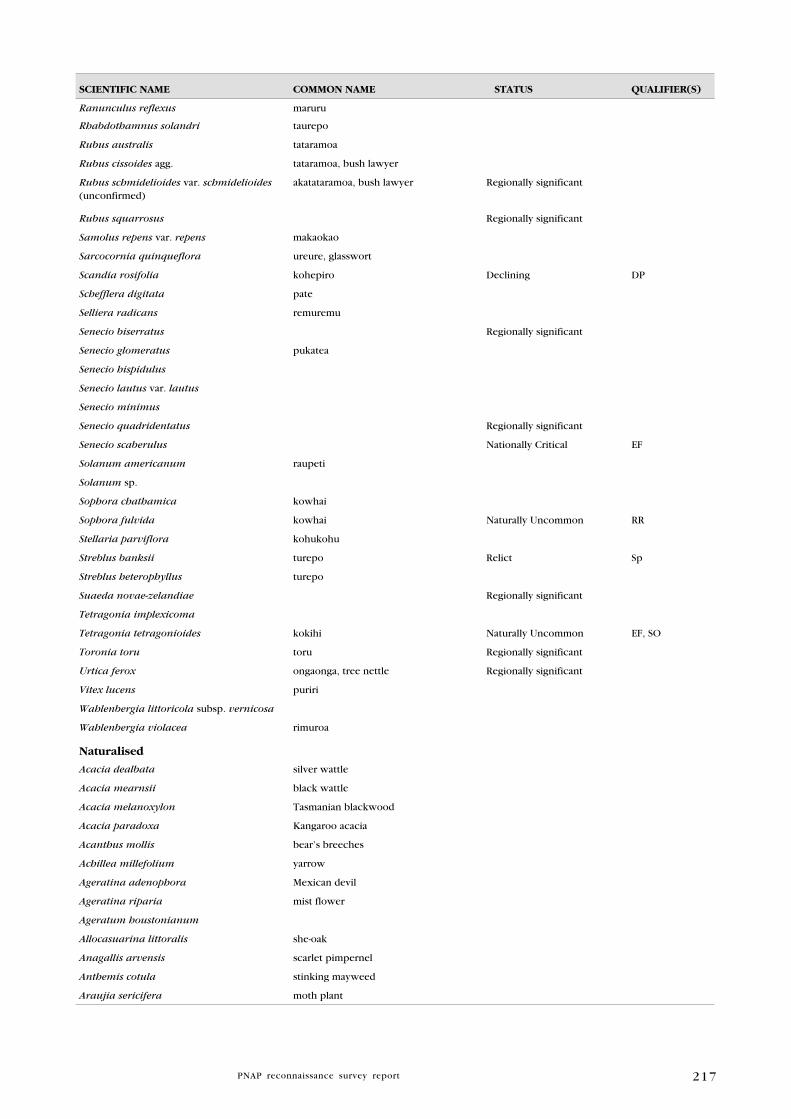
217
SCIENTIFIC NAME COMMON NAME STATuS quAlIFIER(S)
Ranunculus reflexus maruru
Rhabdothamnus solandri taurepo
Rubus australis tataramoa
Rubus cissoides agg. tataramoa, bush lawyer
Rubus schmidelioides var. schmidelioides (unconfirmed)
akatataramoa, bush lawyer Regionally significant
Rubus squarrosus Regionally significant
Samolus repens var. repens makaokao
Sarcocornia quinqueflora ureure, glasswort
Scandia rosifolia kohepiro Declining DP
Schefflera digitata pate
Selliera radicans remuremu
Senecio biserratus Regionally significant
Senecio glomeratus pukatea
Senecio hispidulus
Senecio lautus var. lautus
Senecio minimus
Senecio quadridentatus Regionally significant
Senecio scaberulus Nationally Critical EF
Solanum americanum raupeti
Solanum sp.
Sophora chathamica kowhai
Sophora fulvida kowhai Naturally Uncommon RR
Stellaria parviflora kohukohu
Streblus banksii turepo Relict Sp
Streblus heterophyllus turepo
Suaeda novae-zelandiae Regionally significant
Tetragonia implexicoma
Tetragonia tetragonioides kokihi Naturally Uncommon EF, SO
Toronia toru toru Regionally significant
Urtica ferox ongaonga, tree nettle Regionally significant
Vitex lucens puriri
Wahlenbergia littoricola subsp. vernicosa
Wahlenbergia violacea rimuroa
Naturalised
Acacia dealbata silver wattle
Acacia mearnsii black wattle
Acacia melanoxylon Tasmanian blackwood
Acacia paradoxa Kangaroo acacia
Acanthus mollis bear’s breeches
Achillea millefolium yarrow
Ageratina adenophora Mexican devil
Ageratina riparia mist flower
Ageratum houstonianum
Allocasuarina littoralis she-oak
Anagallis arvensis scarlet pimpernel
Anthemis cotula stinking mayweed
Araujia sericifera moth plant

218
SCIENTIFIC NAME COMMON NAME STATuS quAlIFIER(S)
Arctotheca calendula cape weed
Artemisia verlotiorum Chinese mugwort
Aster subulatus sea aster
Atriplex prostrata orache
Banksia intermedia
Bellis perennis lawn daisy
Berberis glaucocarpa barberry
Blackstonia perfoliata
Cakile maritima sea rocket
Calystegia silvatica greater bindweed
Cardamine sp.
Centaurium erythraea centaury
Cerastium fontanum subsp. vulgare mouse-ear chickweed
Ceratophyllum demersum hornwort
Chrysanthemum segetum corn marigold
Cirsium arvense California thistle
Cirsium vulgare Scotch thistle
Conium maculatum hemlock
Conyza sumatrensis broad-leaved fleabane
Cotoneaster glaucophyllus cotoneaster
Crepis capillaris hawksbeard
Daucus carota wild carrot
Delairea odorata cape ivy
Dipogon lignosus mile-a-minute
Elaeagnus ×reflexa elaeagnus
Epilobium tetragonum
Erigeron karvinskianus Mexican daisy
Eriobotrya japonica loquat
Erodium cicutarium storksbill
Erythrina ×sykesii coral tree
Euphorbia peplus milkweed
Foeniculum vulgare fennel
Fragaria vesca wild strawberry
Fumaria muralis scrambling fumitory
Galeobdolon luteum aluminium plant
Galium aparine cleavers
Galium divaricatum slender bedstraw
Gamochaeta coarctata purple cudweed
Geranium robertianum herb Robert
Geranium sp. geranium
Gunnera tinctoria Chilean rhubarb
Hakea drupacea
Hakea salicifolia willow-leaved hakea
Hakea sericea prickly hakea
Hedera helix ivy
Helminthotheca echioides oxtongue
Hydrangea macrophylla hydrangea
Hypochoeris radicata catsear
219
SCIENTIFIC NAME COMMON NAME STATuS quAlIFIER(S)
Impatiens sodenii shrub balsam
Jacobaea vulgaris ragwort
Jasminum sp.
Lactuca serriola prickly lettuce
Lapsana communis nipplewort
Lathyrus latifolius everlasting pea
Lepidium didymum twin cress
Leucanthemum vulgare oxeye daisy
Leontodon taraxacoides hawkbit
Ligustrum lucidum tree privet
Ligustrum sinense Chinese privet
Linum bienne pale flax
Linum monogynum rauhuia, linen flax
Lonicera japonica Japanese honeysuckle
Lotus angustissimus slender birdsfoot trefoil
Lotus pedunculatus lotus
Lupinus arboreus lupin
Lycium ferocissimum boxthorn
Lythrum hyssopifolia hyssop loosestrife
Malus ×domestica apple tree
Malva sp. mallow
Matricaria discoidea rayless chamomile
Melilotus indica King Island melilot
Mentha pulegium penny royal
Monstera deliciosa fruit salad plant
Myosotis sylvatica garden forget-me-not
Nasturtium officinale watercress
Nerium oleander oleander
Ochna serrulata Mickey Mouse plant
Orobanche minor broomrape
Osteospermum fruticosum rain daisy, dimorphotheca
Oxalis corniculata horned oxalis
Paraserianthes lophantha brush wattle
Passiflora tripartita var. mollissima banana passionfruit
Persicaria maculosa willow weed
Phytolacca octandra inkweed
Plantago australis swamp plantain
Plantago coronopus buck’s-horn plantain
Plantago lanceolata narrow-leaved plantain
Plantago major broad-leaved plantain
Populus nigra Lombardy poplar
Populus sp. poplar
Prunella vulgaris selfheal
Pyracantha sp.
Ranunculus repens creeping buttercup
Ranunculus sp.
Raphanus raphanistrum subsp. raphanistrum
wild raddish

220
SCIENTIFIC NAME COMMON NAME STATuS quAlIFIER(S)
Roldana petasitis velvet groundsel
Rosa sp. climbing rose
Rubus sp. (R. fruticosus agg.) blackberry
Rumex acetosella sheep’s sorrel
Rumex conglomeratus clustered dock
Rumex obtusifolius broad-leaved dock
Sagina procumbens pearlwort
Salix fragilis crack willow
Salix matsudana tortured willow
Schedonorus arundinaceus tall fescue
Senecio bipinnatisectus Australian fireweed
Senecio elegans purple groundsel
Senecio skirrhodon gravel groundsel
Senecio sylvaticus wood groundsel
Senecio vulgaris groundsel
Senna multiglandulosa buttercup bush
Sigesbeckia orientalis Indian weed
Silene gallica catchfly
Solanum linnaeanum Apple of Sodom
Solanum mauritianum woolly nightshade
Solanum nigrum black nightshade
Sonchus asper prickly puha
Sonchus oleraceus puha, sow thistle
Stellaria media chickweed
Taraxacum officinale dandelion
Thunbergia alata black-eyed Susan
Torilis arvensis spreading hedge parsley
Trifolium pratense red clover
Trifolium repens white clover
Tropaeolum majus garden nasturtium
Ulex europaeus gorse
Verbena bonariensis purple-top
Veronica anagallis-aquatica water speedwell
Veronica arvensis field speedwell
Veronica serpyllifolia turf speedwell
Vicia sativa vetch
Vinca major periwinkle
Wisteria sinensis wisteria
PTERIDOPhyTES
Indigenous
Adiantum aethiopicum huruhuru tapairu, maidenhair fern Regionally significant
Adiantum cunninghamii huruhuru tapairu, maidenhair fern
Adiantum diaphanum huruhuru tapairu, maidenhair fern
Adiantum fulvum huruhuru tapairu, maidenhair fern
Adiantum hispidulum huruhuru tapairu, maidenhair fern
Adiantum viridescens huruhuru tapairu, maidenhair fern
Arthropteris tenella

221
SCIENTIFIC NAME COMMON NAME STATuS quAlIFIER(S)
Asplenium bulbiferum mouku, hen and chicken fern
Asplenium flabellifolium necklace fern Regionally significant
Asplenium flaccidum makawe
Asplenium gracillimum petako-paraharaha Regionally significant
Asplenium haurakiense
Asplenium hookerianum petako-paraharaha Regionally significant
Asplenium lamprophyllum petako-paraharaha
Asplenium northlandicum Regionally significant
Asplenium oblongifolium huruhuruwhenua
Asplenium polyodon petako
Blechnum chambersii rereti
Blechnum filiforme panako
Blechnum fraseri
Blechnum membranaceum
Blechnum minus swamp kiokio
Blechnum novae-zelandiae kiokio
Blechnum procerum
Blechnum triangularifolium Regionally significant
Cheilanthes distans Regionally significant
Cheilanthes sieberi Regionally significant
Ctenopteris heterophylla
Cyathea cunninghamii punui, gully tree fern Regionally significant
Cyathea dealbata ponga, silver fern
Cyathea medullaris
Cyathea smithii katote, soft tree fern
Deparia petersenii subsp. congrua
Dicksonia squarrosa wheki
Diplazium australe
Doodia australis pukupuku
Doodia mollis Naturally Uncommon Sp
Doodia squarrosa Naturally Uncommon Sp
Gleichenia dicarpa tangle fern
Gleichenia microphylla waewaekaka, swamp umbrella fern
Grammitis billardierei Regionally significant
Grammitis ciliata Regionally significant
Histiopteris incisa matata, water fern
Huperzia varia
Hymenophyllum atrovirens maku, filmy fern Naturally Uncommon DP, RR, Sp
Hymenophyllum demissum maku, filmy fern
Hymenophyllum dilatatum maku, filmy fern
Hymenophyllum flexuosum maku, filmy fern
Hymenophyllum lyallii maku, filmy fern Regionally significant
Hymenophyllum multifidum maku, filmy fern
Hymenophyllum rarum maku, filmy fern
Hymenophyllum revolutum maku, filmy fern
Hymenophyllum sanguinolentum piripiri, filmy fern
Hypolepis ambigua
Lastreopsis glabella

222
SCIENTIFIC NAME COMMON NAME STATuS quAlIFIER(S)
Lastreopsis hispida
Lastreopsis velutina
Lindsaea linearis
Loxogramme dictyopteris
Loxsoma cunninghamii Regionally significant
Lycopodiella cernua maatukutuku
Lycopodium deuterodensum puakarimu
Lycopodium volubile waewaekoukou
Lygodium articulatum mangemange
Microsorum pustulatum kowaowao, hounds tongue fern
Microsorum scandens mokimoki
Ophioglossum coriaceum Regionally significant
Paesia scaberula matata
Pellaea rotundifolia tarawera, button fern
Pneumatopteris pennigera pakau
Polystichum neozelandicum subsp. neozelandicum
Polystichum sp.
Pteridium esculentum rarahu, bracken
Pteris comans
Pteris macilenta sweet fern
Pteris saxatilis
Pteris tremula turawera, shaking brake
Pteris comans × P. macilenta
Pyrrosia eleagnifolia leather-leaf fern
Schizaea fistulosa
Sticherus cunninghamii waekura Regionally significant
Sticherus flabellatus
Tmesipteris elongata
Tmesipteris lanceolata
Tmesipteris tannensis
Tmesipteris sigmatifolia
Trichomanes reniforme
Trichomanes sp.
Adventive
Azolla pinnata ferny azolla
Nephrolepis cordifolia tuber ladder fern
Selaginella kraussiana creeping clubmoss, selaginella
gRASSES
Indigenous
Austrostipa stipoides
Chionochloa bromoides
Chionochloa conspicua subsp. cunninghamii
Regionally significant
Cortaderia splendens
Deyeuxia avenoides
Dichelachne crinita patiti, plume grass
Isachne globosa swamp millet

223
SCIENTIFIC NAME COMMON NAME STATuS quAlIFIER(S)
Lachnagrostis billardierei perehia
Lachnagrostis filiformis perehia
Microlaena avenacea bush rice grass
Microlaena carsei Naturally Uncommon DP
Microlaena polynoda
Microlaena stipoides patiti, meadow rice grass
Oplismenus hirtellus subsp. imbecillis
Poa anceps agg.
Poa imbecilla
Rytidosperma biannulare
Rytidosperma gracile
Spinifex sericeus kowhangatara, spinifex
Zoysia minima Regionally significant
Zoysia pauciflora
Naturalised
Agrostis stolonifera creeping bent
Aira caryophyllea subsp. caryophyllea silver hairy grass
Ammophila arenaria marram
Anthoxanthum odoratum sweet vernal
Arundo donax giant reed
Axonopus fissifolius narrow-leaved carpet grass
Briza minor shivery grass
Bromus diandrus ripgut brome
Bromus willdenowii prairie grass
Cortaderia jubata purple pampas
Cortaderia selloana pampas
Cynodon dactylon Indian doab
Dactylis glomerata cocksfoot
Ehrharta erecta veldt grass
Eragrostis brownii bay grass
Festuca rubra
Glyceria declinata blue sweetgrass
Glyceria maxima reed sweetgrass
Holcus lanatus Yorkshire fog
Lagurus ovatus harestail
Lolium perenne rye grass
Miscanthus nepalensis Himalayan fairy grass
Parapholus incurva sickle grass
Paspalum dilatatum paspalum
Paspalum urvillei Vasey grass
Paspalum vaginatum saltwater paspalum
Pennisetum clandestinum kikuyu grass
Poa annua annual poa
Polypogon monspeliensis beard grass
Rytidosperma pilosum hairy wallaby grass
Rytidosperma racemosum danthonia
Sporobolus africanus ratstail
Stenotaphrum secundatum buffalo grass
224
SCIENTIFIC NAME COMMON NAME STATuS quAlIFIER(S)
SEDgES
Indigenous
Baumea articulata
Baumea juncea
Baumea rubiginosa
Baumea tenax
Baumea teretifolia
Bolboschoenus fluviatilis purua grass
Carex breviculmis
Carex dissita
Carex flagellifera manaia
Carex forsteri Regionally significant
Carex lambertiana
Carex lessoniana toetoe-rautahi
Carex ochrosaccus Regionally significant
Carex pumila
Carex raoulii
Carex solandri
Carex spinirostris
Carex testacea
Carex virgata purei
Cyperus ustulatus f. ustulatus toetoe, upokotangata
Ficinia spiralis pingao Relict CD, Inc, Sp
Eleocharis acuta
Eleocharis sphacelata kuta
Ficinia nodosa wiwi
Gahnia lacera tarangarara
Gahnia pauciflora takahikahi
Gahnia xanthocarpa tupari-maunga
Isolepis cernua
Isolepis habra
Isolepis prolifera
Lepidosperma australe
Lepidosperma laterale
Morelotia affinis
Schoenoplectus tabernaemontani kapungawha
Schoenus apogon
Schoenus brevifolius
Schoenus maschalinus
Schoenus nitens
Schoenus tendo wiwi
Tetraria capillaris Regionally significant
Uncinia banksii matau
Uncinia uncinata kamu matau a Maui

225
SCIENTIFIC NAME COMMON NAME STATuS quAlIFIER(S)
Adventive
Carex ovalis oval sedge
Cyperus brevifolius globe sedge
Cyperus congestus purple umbrella sedge
Cyperus eragrostis umbrella sedge
RuShES
Indigenous
Apodasmia similis oioi
Juncus edgariae wi
Juncus kraussii var. australiensis wi, sea rush
Juncus planifolius
Juncus sarophorus wi
Luzula picta var. picta Regionally significant
Adventive
Juncus articulatus jointed rush
Juncus bufonius var. bufonius toad rush
Juncus effusus var. effusus soft rush, leafless rush
Juncus tenuis var. tenuis track rush
ORChIDS
Indigenous
Acianthus sinclairii
Calochilus sp.
Diplodium alobulum
Drymoanthus adversus
Earina autumnalis raupeka
Earina mucronata peka-a-waka
Ichthyostomum pygmaeum piripiri
Microtis unifolia agg. maikaika
Nematoceras macranthum
Orthoceras novae-zeelandiae maikaika
Pterostylis banksii tutukiwi
Pterostylis graminea
Singularybas oblongus
Thelymitra colensoi
Thelymitra cyanea
Thelymitra longifolia maikuku
Thelymitra pauciflora slender sun orchid
Winika cunninghamii MONOCOTS (OThER ThAN gRASSES, SEDgES, RuShES AND ORChIDS)
Indigenous
Arthropodium cirratum rengarenga
Astelia banksii kakaha
Astelia solandri kowharawhara
Astelia trinervia mauri
Collospermum hastatum kahakaha
Collospermum microspermum Regionally significant

226
SCIENTIFIC NAME COMMON NAME STATuS quAlIFIER(S)
Cordyline australis ti kouka, cabbage tree
Cordyline banksii ti ngahere, forest cabbage tree
Cordyline pumilio dwarf cabbage tree
Dianella nigra turutu
Freycinetia banksii kiekie
Libertia grandiflora mikoikoi Regionally significant
Phormium cookianum subsp. hookeri wharariki, mountain flax Regionally significant
Phormium tenax harakeke, flax
Rhopalostylis sapida nikau
Ripogonum scandens kareao, supplejack
Triglochin striata arrow grass Regionally significant
Typha orientalis raupo
Naturalised
Agave sp.
Allium triquetrum onion weed
Allium vineale var. compactum
Aristea ecklonii aristea
Arum italicum Italian arum
Asparagus asparagoides smilax
Asparagus scandens climbing asparagus
Canna indica canna lily, Indian shoot
Crocosmia × crocosmiiflora montbretia
Freesia refracta freesia
Furcraea spp.
Gladiolus undulatus gladiolus
Hedychium gardnerianum kahili ginger, wild ginger
Kniphofia uvaria red hot poker
Phoenix canariensis Phoenix palm
Sisyrinchium iridifolium purple-eyed grass
Tradescantia fluminensis tradescantia
Watsonia sp. watsonia
Zantedeschia aethiopica arum lily

227
Appendix 6
C O M M O N P l A N T N A M E S u S E D I N T E X T
* = exotic species
* apple of Sodom Solanum linnaeanum
* aristea Aristea ecklonii
arrow grass Triglochin striata
* black-eyed Susan Thunbergia alata
black maire Nestigis cunninghamii
* black nightshade Solanum nigrum
bracken Pteridium esculentum
* buddleja Buddleja davidii
* buffalo grass Stenotaphrum secundatum
bush lawyer Rubus sp.
carmine rata Metrosideros carminea
* catsear Hypochoeris radicata
* cleavers Galium aparine
coastal mahoe Melicytus novae-zelandiae
coastal maire Nestegis apetala
coastal toetoe Cortaderia splendens
* contorta pine Pinus contorta
Cook’s scurvy grass Lepidium oleraceum
* coral tree Erythrina ×sykesii
* cotoneaster Cotoneaster glaucophyllus
* crack willow Salix fragilis
* creeping bent Agrostis stolonifera
* dimorphotheca Osteospermum fruticosum
* dock Rumex sp.
* elaeagnus Elaeagnus ×reflexa
* eucalyptus Eucalyptus sp.
five-finger Pseudopanax arboreus
* fleabane Conzya albida
* freesia Freesia refracta
* German ivy Senecio mikanioides
* ginger Hedychium garderanium
glasswort Sarcocornia qinqueflora
* gorse Ulex europaeus
* grey willow Salix cinerea
pakau Pneumatopteris pennigera
gully tree fern Cyathea cunninghamii
hangehangeGeniostoma ligustrifolium var.
ligustrifoliumharakeke, flax Phormium tenax
* harestail Lagurus ovatus
* hawksbeard Crepis capillaris
hook grass Uncinia unicinata

228
houhere Hoheria populnea
houpara Pseudopanax lessonii
hutu Ascarina lucida var. lucida
* hydrangea Hydrangea macrophylla
* inkweed Phytolacca octandra
* Japanese honeysuckle Lonicera japonica
* Jerusalem cherry Solanum pseudocapsicum
kahikatea Dacrycarpus dacrydioides
kaikomako Pennantia corymbosa
kanuka Kunzea ericoides
kapungawha Schoenoplectus tabernaemontani
karaka Corynocarpus laevigatus
karamu Coprosma robusta
karearea Lemna minor
karo Pittosporum crassifolium
kauri Agathis australis
kawaka Libocedrus plumosa
kawakawa Macropiper excelsum subsp. excelsum f.
excelsum
kiekie Freycinetia banksii
* kikuyu Pennisetum clandestinum
kiokio Blechnum novae-zelandiae
kohekohe Dysoxylum spectabile
kohia Passiflora tetrandra
kohuhu Pittosporum tenuifolium
koromiko Hebe stricta var. stricta
kotukutuku Fuchsia excorticata
kowhai Sophora chathamica
kowhai Sophora fulvida
knobby clubrush Ficinia nodosa
kumarehou Pomaderris kumeraho
kuta Eleocharis sphacelata
lancewood, horoeka Pseudopanax crassifolius
* lantana Lantana camara
leather-leaf fern Pyrrosia eleagnifolia
* lotus Lotus pedunculatus
* lupin Lupinus arboreus
* madeira vine Anredera cordifolia
mahoe Melicytus ramiflorus subsp. ramiflorus
mairehau Leinema nudum
makamaka Ackama rosifolia
makaokao Samolus repens
mamaku Cyathea medullaris
mamangi Coprosma arborea
mangrove Avicennia marina subsp. australasica
manuka Leptospermum scoparium
mapou Myrsine australis
* marram grass Ammophila arenaria
matai Prumnopitys taxifolia
Mercury Bay weed Dichondra repens

229
* Mexican daisy Erigeron karvinskianus
* Mexican devil Ageratina adenophora
mida Mida salicifolia
mingimingi Leucopogon fasciculatus
miro Prumnopitys ferruginea
* mist flower Ageratina riparia
* moth plant Araujia sericifera
native iceplant Disphyma australe subsp. australe
ngaio Myoporum laetum
nikau Rhopalostylis sapida
* Norfolk pine Araucaria heterophylla
northern rata Metrosideros robusta
Northland kanuka Kanuka ericoides var. linearis
NZ celery Apium prostratum subsp. prostratum var. filiforme
NZ spinach Tetragonia sp.
oioi Apodasmia similis
ongaonga, tree nettle Urtica ferox
* onion weed Allium triquetrum
* ornamental banana Ensete ventricosum
* oval sedge Carex ovalis
* palm grass Setaria palmifolia
* pampas Cortaderia selloana and C. jubata
parapara Pisonia brunoniana
* paspalum Paspalum dilatatum
pate Schefflera digitata
* Phoenix palm Phoenix canariensis
pigeonwood Hedycarya arborea
pohue Calystegia sepium
pohuehue Muehlenbeckia complexa
pingao Ficinia spiralis
pohutukawa Metrosideros excelsa
pondweed Potamogeton sp.
ponga, silver fern Cyathea dealbata
* poplar Populus sp.
* prickly hakea Hakea sericea
* privet Ligustrum lucida and L. sinense
puka Griselinia lucida
pukatea Laurelia novae-zelandiae
puriri Vitex lucens
* purple groundsel Senecio elegans
putaputaweta Carpodetus serratus
* Queensland poplar Homalanthus populifolius
* radiata pine Pinus radiata
rangiora Brachyglottis repanda
* ratstail Sporobolus africanus
rauhuia Linum monogynum
raupo Typha orientalis
remuremu Sellieria radicans
rengarenga lily Arthropodium cirratum

230
rewarewa Knightia excelsa
rimu Dacrydium cupressinum
* ripgut brome Bromus diandrus
rohutu Lophomyrtus obcordata
saltmarsh ribbonwood Plagianthus divaricatus
* saltwater paspalum Paspalum vaginatum
sand daphne Pimelea villosa subsp. villosa
* Scotch thistle Cirsium vulgare
sea rush Juncus kraussii var. australiensis
* selaginella Selaginella kraussiana
* sheoak Allocasuarina littoralis
shore bindweed Calystegia soldanella
shore groundsel Senecio lautus var. lautus
* shrub balsam Impatiens sodenii
* smilax Asparagus asparagoides
* soft rush Juncus effusus
* sow thistle Sonchus oleraceus
spinifex Spinifex sericeus
supplejack Ripogonum scandens
swamp coprosma Coprosma tenuicaulis
swamp millet Isachne globosa
swamp willowherb Epilobium pallidiflorum
* Taiwan cherry Prunus campanulata
tanekaha Phyllocladus trichomanoides var. trichomanoides
taraire Beilschmiedia tarairi
tarata Pittosporum eugenioides
tauhinu Ozothamnus leptophyllus
taupata Coprosma repens
tawa Beilschmiedia tawa
tawapou Pouteria costata
tawaroa Beilschmiedia tawa (incl. B. tawaroa)
ti kouka, cabbage tree Cordyline australis
ti ngahere, forest cabbage tree Cordyline banksii
titoki Alectryon excelsus var. excelsus
toatoa Haloragis erecta subsp. erecta
toro Myrsine salicina
toru Toronia toru
totara Podocarpus totara
towai Weinmannia silvicola
tree hebe Hebe parviflora
turepo Streblus heterophyllus
* vulpia hair grass Vulpia sp.
* watercress Nastutium officinale
water fern Histiopteris incisa
wheki Dicksonia squarrosa
* willow Salix sp.
* willow-leaved hakea Hakea salicifolia
* willow weed Persicaria persicaria
wineberry, makomako Aristotelia serrata
231
wharangi Melicope ternata
wharariki, mountain flax Phormium cookianum subsp. hookeri
whau Entelea arborescens
woolly cloak fern Cheilanthes distans
* woolly nightshade Solanum mauritianum
232
Appendix 7
C h E C k l I S T O F F A u N A S P E C I E S I N M A N A I A E C O l O g I C A l D I S T R I C T
Bird data from Dr. Ray Pierce and SSBI data. Reptile records from DOC
Herpetofauna database and SSBI data. Fish records from New Zealand
Freshwater Fish Database (NIWA 2009) and SSBI data. Land snail records
from Dr. Fred Brook and SSBI data.
SCIENTIFIC NAME COMMON NAME
MAMMAlS
Indigenous
Chalinolobus tuberculatus longtail bat unconfirmed
Introduced (feral)34
Bos taurus cattle
Canis familiaris feral dog
Capra hircus feral goat
Erinaceus europaeus occidentalis European hedgehog
Felis catus house cat
Lepus europaeus brown hare
Mus musculus house mouse
Mustela furo stoat
Mustela furo ferret
Mustela nivalis weasel
Oryctolagus cuniculus European rabbit
Rattus norvegicus Norway rat
Rattus rattus ship rat; black rat
Sus scrofa feral pig
Trichosurus vulpecula brushtail possum
BIRDS
Indigenous
Anas superciliosa grey duck, parera
Anthornis melanura North Island bellbird, korimako
Anthus n. novaeseelandiae NZ pipit, pihoihoi
Apteryx mantelli North Island brown kiwi
Ardea novaehollandiae white-faced heron
Botaurus poiciloptilus Australasian bittern, matuku
Bowdleria punctata vealeae North Island fernbird, matata
Charadrius obscurus aquilonius northern NZ dotterel, tuturiwhatu
Chrysococcyx lucidus shining cuckoo, pipiwharauroa
Circus approximans Australasian harrier, kahu
Cyanoramphus novaeseelandiae red-crowned kakariki
34 Goats and pigs have been eradicated from Bream Head (N. Miller, pers. comm. 2009).
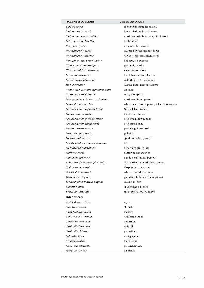
233
SCIENTIFIC NAME COMMON NAME
Egretta sacra reef heron, matuku moana
Eudynamis taitensis long-tailed cuckoo, koekoea
Eudyptula minor iredalei northern little blue penguin, korora
Falco novaeseelandiae bush falcon
Gerygone igata grey warbler, riroriro
Haematopus finschi NZ pied oystercatcher, torea
Haematopus unicolor variable oystercatcher, torea
Hemiphaga novaeseelandiae kukupa, NZ pigeon
Himantopus himantopus pied stilt, poaka
Hirundo tahitica neoxena welcome swallow
Larus dominicanus black-backed gull, karoro
Larus novaehollandiae red-billed gull, tarapunga
Morus serrator Australasian gannet, takapu
Nestor meridionalis septentrionalis NI kaka
Ninox novaeseelandiae ruru, morepork
Pelecanoides urinatrix urinatrix northern diving petrel
Pelagodroma marina white-faced storm petrel, takahikare-moana
Petroica macrocephala toitoi North Island tomtit
Phalacrocorax carbo black shag, kawau
Phalacrocorax melanoleucos little shag, kawaupaka
Phalacrocorax sulcirostris little black shag
Phalacrocorax varius pied shag, karuhiruhi
Porphyrio porphyrio pukeko
Porzana tabuensis spotless crake, puweto
Prosthemadera novaeseelandiae tui
Pterodroma macroptera grey-faced petrel, oi
Puffinus gavial fluttering shearwater
Rallus philippensis banded rail, moho-pereru
Rhipidura fuliginosa placabilis North Island fantail, piwakawaka
Hydroprogne caspia Caspian tern, taranui
Sterna striata striata white-fronted tern, tara
Tadorna variegata paradise shelduck, putangitangi
Todiramphus sanctus vagans NZ kingfisher
Vanellus miles spur-winged plover
Zosterops lateralis silvereye, tahou, whiteye
Introduced
Acridotheres tristis myna
Alauda arvensis skylark
Anas platyrhynchos mallard
Callipela californica California quail
Carduelis carduelis goldfinch
Carduelis flammea redpoll
Carduelis chloris greenfinch
Columba livia rock pigeon
Cygnus atratus black swan
Emberiza citrinella yellowhammer
Fringilla coelebs chaffinch

234
SCIENTIFIC NAME COMMON NAMEGymnorhina tibicen Australian magpie
Meleagris gallopavo feral turkey
Passer domesticus house sparrow
Phasianus colchicus ring-necked pheasant
Platycercus eximius eastern rosella
Prunella modularis dunnock, hedge sparrow
Streptopelia roseogrisea barbary dove
Sturnus vulgaris starling
Synoicus ypsilophorus brown quail
Turdus merula blackbird
Turdus philomelos song thrush
REPTIlES
Indigenous
Chelonia mydas green turtle
Cyclodina aenea copper skink
Cyclodina macgregori MacGregor’s skink
Cyclodina ornata ornate skink
Dermochelys coriacea leatherback turtle
Hoplodactylus granulatus forest gecko
Hoplodactylus maculatus common gecko
Hoplodactylus pacificus Pacific gecko
Naultinus elegans elegans Auckland green gecko
Oligosoma smithii shore skink
Pelamis platurus yellow-bellied sea snake
Introduced
Litoria aurea green and golden bell frog
FISh
Indigenous
Anguilla dieffenbachii longfin eel
Anguilla australis shortfin eel
Galaxias fasciatus banded kokopu
Gobiomorphus cotidianus common bully
lAND SNAIlS
Indigenous
Amborhytida dunniae (Gray)
Delos coresia
Liarea egea sp. “Bream Head”
Liarea turriculata “Manaia”
Phenacohelix giveni (Cumber)
Placostylus (Maoristylus) hongii (Suter)
Punctidae sp. 223 (NMNZ M.151458) (Brook 2002)
Punctid attenuispira
Punctid corella
Punctid lampra
Schizoglossa worthyae
Therasiella aff. elevata (Cumber)

235
SCIENTIFIC NAME COMMON NAME
Introduced
Helix aspersa common garden snail
Oxychilus cellarius
OThER INVERTEBRATES 35
Indigenous
Actizeta sp.
Anthicus hesperi
Arthracanthus
Bathyllus albicinctus
Brontopriscus pleuralis
Carystoterpa ikana
Chaerodes sp. seaweed darkling beetle
Clivinia sp.
Ctenognathus sulcitarsis
Dicrochile maura
Diomocoris ostiolum
Drepanacra binocula
Eucolaspis sp. bronze beetle
Gnaphalopoda brookesi
Halyles sp.
Hemiandrus furcifer cave weta
Hexanodes vulgata
Hybolasius pedator
Hypharpax sp.
Kaveinga orbitosa
Kupeus arcuatus
Lagrioida brounii
Lasiorhynchus barbicornis giraffe weevil
Lucilia sericata green blowfly
Macroscytus australis
Mecodema sp. aff. M. curvidens carabid beetle
Mecodema ? spiniferum carabid beetle
Mecyclothorax rotundicollis
Menimus oblongus darkling beetle
Menimus obscurus darkling beetle
Menimus thoracicus darkling beetle
Micromus tasmaniae Tasmanian lacewing
Novothymbris sp.
Novothymbris notata
Nyxetes bidens two-spined weevil
Oncacontias vittatus forest shield bug
Parabaris atratus
Paralissotes planus stag beetle
Phycosecis limbata
Phymatophaea fuscitarsis
Phymatophaea opiloides
35 This is not an exhaustive list of invertebrates.

236
SCIENTIFIC NAME COMMON NAMEReichardtia pedatrix
Rhytisternus miser
Rhyzodiastes proprius
Sapintus aucklandensis
Scolopterus sp. four-spined weevil
Scopodes fossulatus
Stethaspis longicornis green chafer
Tridiplous penmani
Unas piceus weevil
Xylophilus nitidus
Introduced
Radumeris tasmaniensis (Saussure, 1855) yellow flower wasp
Steatoda capensis (Hann, 1990) black cobweb spider, false katipo spider

237
Appendix 8
g l O S S A R y O F T E R M S
Allochthonous
Geologic units that have been transported to their present position.
Alluvial
Deposited by a river or other running water.
Basalt
A type of igneous rock consisting of feldspar and other silicate minerals
rich in iron and magnesium. Basalt has a relatively low silica content of
40-50 percent and is the main component of the oceanic crust of the
earth.
Conglomerate
A sedimentary rock composed of welded fine-grained and coarse-grained
rock fragments.
Biodiversity
The variability among living organisms from all sources including, inter
alia, terrestrial, marine and other aquatic ecosystems and the ecological
complexes of which they are part; this includes diversity within species,
between species and of ecosystems (IUCN 1993).
Buffer
A zone surrounding a natural area which reduces the effects of external
influences on the natural area. For example, shrubland or exotic plantations
surrounding an indigenous remnant provide physical protection to it
by reducing changes in wind and light, reducing the chance of weed
infestation and providing a corridor for the movement of wildlife into
and out of it, so that it is less isolated. Vegetation is often considered
a buffer to waterways - riparian vegetation and wetlands protect both
water quality and habitat from influences arising on the surrounding land.
Community
An association of populations of plants and animals which occur naturally
together in a common environment.
Diversity and pattern
Diversity is the variety and range of species of biological communities,
ecosystems and landforms. Pattern refers to changes in species composition,
communities and ecosystems along environmental gradients.
Dune complex/duneland/dunefield
An association of mobile and consolidated sand dunes, which may include
small interdune lakes, wetlands, and shrubland communities.

238
Dune lake
A lake formed behind a dune.
Ecological District
A local part of New Zealand where geological, topographical, climatic and
biological features and processes, including the broad cultural pattern,
interrelate to produce a characteristic landscape and range of biological
communities.
Ecological Region
A group of adjacent Ecological Districts which have diverse but closely
related characteristics, or in some cases a single very distinctive Ecological
District.
Ecological unit
Vegetation type occurring on a particular landform or soil or rock type.
Ecosystem
Any inter-related and functioning assemblage of plants, animals and other
living organisms and substrates (including air, water and soil) on any
scale, including the processes of energy flow and productivity (Myers
et al. 1987).
Endemic
Occurring naturally in, and restricted to, a particular country, region or
locality.
Exotic
Introduced to New Zealand; not indigenous.
Fernland
Vegetation in which the cover of ferns in the canopy is 20-100% and
in which the fern cover exceeds that of any other growth form or
bare ground. Tree ferns >10 cm dbh are excluded as trees (cf. forest)
(Atkinson 1985). In Manaia ED, fernlands are dominated by ferns such
as Gleichenia dicarpa and G. microphylla, bracken, and tree ferns, with
occasional woody plants also present.
Foredune
Mobile and fixed transverse dunes along coastal margins.
Forest
Woody vegetation in which the cover of trees and shrubs in the canopy
is >80% and in which tree cover exceeds that of shrubs. Trees are woody
plants >10 cm diameter at breast height (dbh) and shrubs are woody plants
<10 cm dbh. Tree ferns >10 cm dbh are treated as trees (Atkinson 1985).
gabbro
A usually coarse-grained igneous rock composed chiefly of calcic
plagioclase and pyroxene.

239
grassland
Vegetation in which the cover of grass in the canopy is 20-100% and in
which grass cover exceeds that of any other growth form or bare ground.
Tussock grasses are excluded from the grass growth-form (Atkinson 1985).
gumland
Wardle (1991) defines gumlands as wet heathlands occupying areas which
were previously kauri (Agathis australis) forests.
habitat
The part of the environment where a plant or animal lives. It includes
both the living and non-living features of the area.
herbfield
Vegetation in which the cover of herbs in the canopy is 20-100% and
in which herb cover exceeds that of any other growth form or bare
ground. Herbs include all herbaceous and low-growing semi-woody plants
that are not separted as ferns, tussocks, grasses, sedges, rushes, reeds,
plants, mosses, or lichens (Atkinson 1985).
holocene
Period of geologic time from the end of the Pleistocene Ice Age (about
10,000 years before present) until the present day.
Igneous
Formed by solidification of molten rock that has come from within the
earth.
Indigenous
Native to New Zealand. This includes species which occur naturally in
New Zealand and other places (e.g. migratory bar-tailed godwits which
return to New Zealand from Siberia every summer). Species which only
occur in New Zealand are ‘endemic’.
landform
A part of the land’s surface with distinctive naturally formed physical
characteristics e.g. hillslope, gully, ridge top, etc.
linkages/corridors
An area of habitat which links two or more other habitat areas. Depending
on the habitat type, this a linkage or corridor can comprise indigenous
vegetation (e.g. forest, shrubland), exotic vegetation (e.g. pine forest),
aquatic habitat (e.g. a farm pond) or any other feature which assists the
movement of indigenous species between habitat patches. Where a linkage
exists between habitats the opportunities for genetic exchange within a
species are greater, which enhances the viability of that population. For
many species, in particular mobile fauna such as birds, a corridor does
not have to be continuous to be utilisable. Small remnants can act as
stepping stones between two larger habitats.

240
Miocene
A geologic epoch within the Tertiary period (about 24 to 5 million years
before present).
Mudstone
A fine-grained sedimentary rock consisting mainly of clay mineral particles.
Natural area
A tract of land which supports natural landforms and predominantly
indigenous vegetation or provides habitat for indigenous species; identified
as a unit for evaluation of ecological quality and representativeness and
has potential to be ecologically significant.
Naturalness
The degree to which a habitat is modified and disturbed by human
activity or introduced plants and animals and what natural values are
retained despite these factors i.e. to what extent indigenous species are
functioning according to natural processes.
Ophiolitic
Of igneous and metamorphic rocks, rich in iron and magnesium, whose
origin is associated with an early phase of the development of a
geosyncline (continental margin downwarping in the earth’s crust that
has seen sedimentation and volcanic activity).
Pliocene
The geological epoch from 5.2 - 1.64 million years ago. The Pliocene
was a period of gradual cooling leading up to the Pleistocene ice ages.
Pleistocene
An epoch of the Quaternary period, after the Pliocene of the Tertiary
and before the Holocene. It began one to two million years ago and
lasted until the start of the Holocene, some 10,000 years ago. When the
Quaternary is designated as an era, the Pleistocene is considered to be
a period.
Plutonic
Of igneous rock that has solidified beneath the earth’s surface; granite
or diorite or gabbro.
Podzol
A soil type formed under some types of forest and characterised by very
strong vertical leaching of nutrients in the profile and the development
of whitish-grey sub-soils.
Rarity
This is a measure of commonness and may apply to entire ecosystems
through to single species. It may refer to the conservation status of a
species (see Appendix 3) or habitat type in any one of the following
ways: formerly common but now rare; confined to a limited geographic
area; at the limit of its range; or with a contracting or fragmented
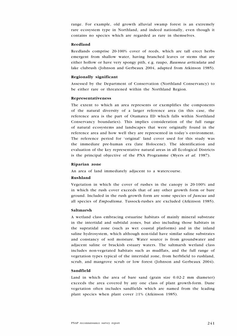
241
range. For example, old growth alluvial swamp forest is an extremely
rare ecosystem type in Northland, and indeed nationally, even though it
contains no species which are regarded as rare in themselves.
Reedland
Reedlands comprise 20-100% cover of reeds, which are tall erect herbs
emergent from shallow water, having branched leaves or stems that are
either hollow or have very spongy pith, e.g. raupo, Baumea articulata and
lake clubrush (Johnson and Gerbeaux 2004, adapted from Atkinson 1985).
Regionally significant
Assessed by the Department of Conservation (Northland Conservancy) to
be either rare or threatened within the Northland Region.
Representativeness
The extent to which an area represents or exemplifies the components
of the natural diversity of a larger reference area (in this case, the
reference area is the part of Otamatea ED which falls within Northland
Conservancy boundaries). This implies consideration of the full range
of natural ecosystems and landscapes that were originally found in the
reference area and how well they are represented in today’s environment.
The reference period for ‘original’ land cover used for this study was
the immediate pre-human era (late Holocene). The identification and
evaluation of the key representative natural areas in all Ecological Districts
is the principal objective of the PNA Programme (Myers et al. 1987).
Riparian zone
An area of land immediately adjacent to a watercourse.
Rushland
Vegetation in which the cover of rushes in the canopy is 20-100% and
in which the rush cover exceeds that of any other growth form or bare
ground. Included in the rush growth form are some species of Juncus and
all species of Empodisma. Tussock-rushes are excluded (Atkinson 1985).
Saltmarsh
A wetland class embracing estuarine habitats of mainly mineral substrate
in the intertidal and subtidal zones, but also including those habitats in
the supratidal zone (such as wet coastal platforms) and in the inland
saline hydrosystem, which although non-tidal have similar saline substrates
and constancy of soil moisture. Water source is from groundwater and
adjacent saline or brackish estuary waters. The saltmarsh wetland class
includes non-vegetated habitats such as mudflats, and the full range of
vegetation types typical of the intertidal zone, from herbfield to rushland,
scrub, and mangrove scrub or low forest (Johnson and Gerbeaux 2004).
Sandfield
Land in which the area of bare sand (grain size 0.02-2 mm diameter)
exceeds the area covered by any one class of plant growth-form. Dune
vegetation often includes sandfields which are named from the leading
plant species when plant cover ≥1% (Atkinson 1985).
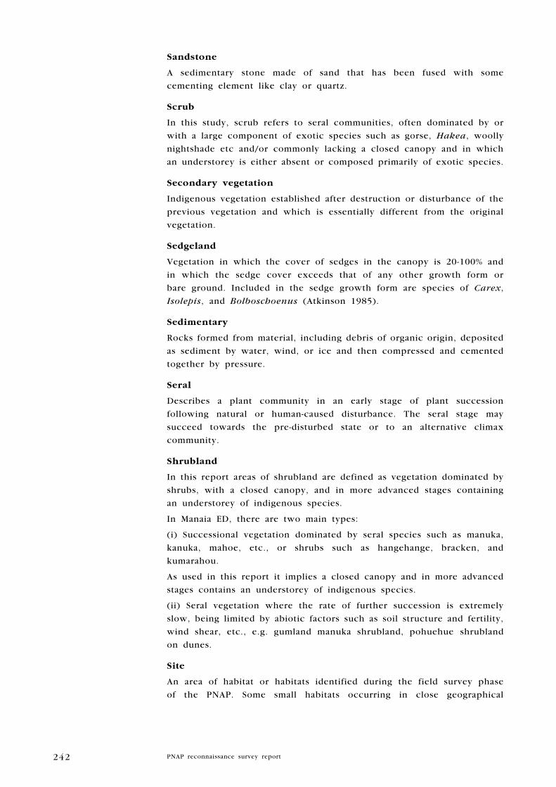
242
Sandstone
A sedimentary stone made of sand that has been fused with some
cementing element like clay or quartz.
Scrub
In this study, scrub refers to seral communities, often dominated by or
with a large component of exotic species such as gorse, Hakea, woolly
nightshade etc and/or commonly lacking a closed canopy and in which
an understorey is either absent or composed primarily of exotic species.
Secondary vegetation
Indigenous vegetation established after destruction or disturbance of the
previous vegetation and which is essentially different from the original
vegetation.
Sedgeland
Vegetation in which the cover of sedges in the canopy is 20-100% and
in which the sedge cover exceeds that of any other growth form or
bare ground. Included in the sedge growth form are species of Carex,
Isolepis, and Bolboschoenus (Atkinson 1985).
Sedimentary
Rocks formed from material, including debris of organic origin, deposited
as sediment by water, wind, or ice and then compressed and cemented
together by pressure.
Seral
Describes a plant community in an early stage of plant succession
following natural or human-caused disturbance. The seral stage may
succeed towards the pre-disturbed state or to an alternative climax
community.
Shrubland
In this report areas of shrubland are defined as vegetation dominated by
shrubs, with a closed canopy, and in more advanced stages containing
an understorey of indigenous species.
In Manaia ED, there are two main types:
(i) Successional vegetation dominated by seral species such as manuka,
kanuka, mahoe, etc., or shrubs such as hangehange, bracken, and
kumarahou.
As used in this report it implies a closed canopy and in more advanced
stages contains an understorey of indigenous species.
(ii) Seral vegetation where the rate of further succession is extremely
slow, being limited by abiotic factors such as soil structure and fertility,
wind shear, etc., e.g. gumland manuka shrubland, pohuehue shrubland
on dunes.
Site
An area of habitat or habitats identified during the field survey phase
of the PNAP. Some small habitats occurring in close geographical

243
proximity, with similar characteristics and functions, have been grouped
and addressed as one site e.g. small forest remnants and farm ponds in
the within same catchment. Its boundaries may be defined by the edge
of the habitat (where discrete), catchment or other geographical feature
e.g. river, vegetation type or legal title.
Subfossil
A partly fossilised organism.
Succession
Succession is the dynamic process whereby one plant community changes
into another, involving the immigration and local extinction of species,
coupled with changes in the relative abundance of different plants
(Crawley 1997). Change may be due to natural or human-induced factors,
or both. Primary succession refers to the colonisation of a bare surface
by vegetation (e.g. the greening of new volcano after it erupts out of
the sea). Secondary succession refers to the process of colonisation and
change after original vegetation has been destroyed e.g. by fire, human-
induced land clearance.
Survey no.
A sequential number given to each site (e.g. M02/007). The first letter
and two figures refer to the NZMS 260 topographical map sheet which
covers the site.
Swamp
A wetland that receives a relatively rich supply of nutrients and often
also sediment via surface runoff and groundwater from adjacent land.
Swamps usually have a combination of mineral and peat substrates. Leads
of standing water or surface channels are often present, with gentle
permanent or periodic flow, and the water table is usually permanently
above some of the ground surface, or periodically above much of it
(Johnson and Gerbeaux 2004). In Manaia ED, swamps are usually
dominated by raupo, Carex, Baumea articulata, harakeke, and ti kouka.
Taxonomically indeterminate
Species for which information on their taxonomic relationships has either
not been formally evaluated or remains in doubt. These species may
warrant further conservation attention once their taxonomic status is
clarified (de Lange et al. 2004).
Treeland
Vegetation in which the cover of trees in the canopy is 20-80%, with
tree cover exceeding that of any other growth form, and in which the
trees form a discontinous upper canopy above either a lower canopy of
predominantly non-woody vegetation or bare ground (Atkinson 1985), e.g.
‘totara treeland’ refers to a common type in Otamatea ED Northland in
which sparse totara trees form the canopy over an understorey of mainly
exotic grasses. Treeland is mainly induced by grazing.

244
Tussockland
Vegetation in which the cover of tussocks in the canopy is 20-100% and
in which tussock cover exceeds that of any other growth form or bare
ground. Tussocks include all grasses, sedges, rushes, and other herbaceous
plants with linear leaves that are densely clumped and >10 cm height.
Examples include toetoe and species of Cyperus (Atkinson 1985).
ultramafic
Igneous rocks or magmas that are rich in iron and magnesium and very
poor in silica. The high concentration of magnesium inhibits plant growth.
Ultramafic areas in New Zealand have a high number of endemic species.
Vegetation type
The most detailed vegetation descriptive name, defined by the composition
of dominant canopy species, in order of abundance (e.g. taraire-puriri-
kahikatea) and the structure of the vegetation e.g forest, treeland,
shrubland, reedland, etc.
Viability
The ability of an area’s natural communities to maintain themselves in
the long-term in the absence of particular management efforts to achieve
this. Regeneration and vigour of species within these communities and
stability of communities and processes contribute to viability.
wetland
Wetland includes permanently or intermittently wet areas, shallow water,
and land water margins that support a natural ecosystem of plants and
animals that are adapted to wet conditions (Resource Management Act
1991). Wetlands are areas of marsh, fen, peatland or water, whether
natural or artificial, permanent or temporary, with water that is static or
flowing, fresh, brackish or salt, including areas of marine water the depth
of which at low tide does not exceed six metres (Ramsar Convention
on Wetlands 1971).

245
Index of sites
Site level Survey No. Page
Awaroa Island 1 Q07/170 140
Bream Head Scenic Reserve and Surrounds 1 Q07/074 96
Bream Islands Nature Reserve: Mauitaha Island and Guano Island 1 Q07/080 128
Bream Islands Scenic Reserve: Moturaka and Tarakanahi Islands 1 Q07/079 126
Frenchman Island 1 Q07/171 142
Harambee Road Swamp 1 Q07/172 144
High Island 1 Q07/072 88
High Island Stack A 2 Q07/082 154
Kauri Mountain Conservation Area and Surrounds 1 Q07/078 120
Kauri Mountain Road Pond and Raupo Swamp 1 Q07/175 150
Kauri Mountain Road Seep 2 Q07/177 156
Kauri Mountain Wetland 1 Q07/081 132
Kerr Road Swamp 1 Q07/076 114
Kirikiri Point Coastal Forest 2 Q07/169 152
Kiteone Road Saltmarsh 1 Q07/168 137
Manaia Ridge Scenic Reserve and Surrounds 1 Q07/069 76
McDonald Coastal Shrubland 1 Q07/068 73
Motukaroro Island 1 Q07/071 86
Mt Aubrey Coastal Forest and Shrubland 1 Q07/070 83
Munro Bay Coastal Bush 1 Q07/067 70
Ocean Beach Recreation Reserve and Surrounds 1 Q07/075 108
Peach Cove Stack A 2 Q07/173 146
Peach Cove Stack B 2 Q07/174 148
Tahunatapu Road Coastal Forest 1 Q07/066 66
Taurikura Ridge Bush 1 Q07/073 90
Timperly Road Bush 1 Q07/077 117
Whangarei Heads Road Wetland 1 Q07/083 135