nasa’s earth observing system data and information system 3
TRANSCRIPT

NASA’sEarth Observing
System Dataand Information
System 3
T
he National Aeronautics and Space Administration(NASA) plans to make its Earth Observing System Dataand Information System (EOSDIS) the world’s most ca-pable and advanced data and information system. Al-
though some aspects of EOSDIS are unique, the program is an ex-ample of some of the capabilities and challenges common toadvanced remote sensing data and information systems of the fu-ture. EOSDIS can also be expected to have influence beyondglobal change research, serving as a catalyst for advanced com-puting and data system technologies.1
EOSDIS OVERVIEWAs a result of concerns that humanity is having a major, detrimen-tal influence on the global environment, in 1990 the U.S. govern-ment initiated the U.S. Global Change Research Program(USGCRP).2 NASA has played a major role in the USGCRP byorienting its Mission to Planet Earth (MTPE) toward the scientif-ic objectives of the USGCRP. The centerpiece of NASA’s MTPE,
1 As one example, new tools for manipulating scientific imagery could benefit otherfields relying on databases of three-dimensional structures, such as crystallography, med-ical imagery, and computer-aided design.
z “The USGCRP was established as a Presidential initiative in the FY 1990 Budget tohelp develop sound national and international policies related to global environmental is-sues, particularly global climate change.” The USGCRP seeks (() “address significant un-certainties in knowledge concerning the natural and human-induced changes now occur-ring in the Earth’s life-sustaining environmental envelope . . The USGCRP is designed toproduce a predictive understanding of the Earth system...” Office of Science and Technol-ogy Policy, Committee on Earth and Environmental Sciences, Our Changing Plane/: TheFY 1993 U.S. Global Change Research Program (Washington DC: National ScienceFoundation 1992), pp. 3-4.
161

62 I Remotely Sensed Data: Technology, Management, and Markets
as well as the USGCRP, is the Earth ObservingSystem (EOS). EOS consists of a space-based ob-serving system (figure 3-1 ), a scientific researchprogram, and its data and information system,EOSDIS.3
EOSDIS plays a crucial role in global changeresearch. EOSDIS helps transform heterogeneousremotely sensed and other data into useful in-formation for integrated, interdisciplinary, predic-tive studies of the Earth’s environment. NASAplanners expect EOSDIS to provide increasinglyeffective access to data, as well as extensive dataprocessing and analysis, the tools needed by re-searchers to transform data into useful informa-tion for policy makers.
EOSDIS (figure 3-2) presents NASA with verydifficult management and technology challenges.By the first years of the next century, NASA ex-pects EOSDIS to manage over 80 trillion bytes ofdata per year from EOS satellites alone. Otherspacecraft could contribute an additional 80 tril-lion bytes per year. Processed data from EOSDISwould be well over 300 trillion bytes per year,equaling more than 250 million 1.2 megabytehigh-density floppy disks.4 NASA faces thedaunting challenge of making this enormousquantity of data easily usable for a wide variety ofusers, including 10,000 physical scientists andpossibly as many as 200,000 other users, manywith little detailed technical knowledge of remotesensing. 5 Fu rt he r m o r e, these data U S H S a n d ‘ h e i r
needs will change, as will the data system technol-ogies used in the program.b
In addition, EOSDIS will administer the sched-uling of observations, the calibration of EOSinstruments, and the control of EOS spacecraft. Tobe successful, EOSDIS must effectively incorpo-rate data from a wide range of sources: the EOSsatellites, all other NASA Earth remote sensingmissions, data from non-NASA space systems,and essential data from atmosphere-, ocean-, andland-based sensors.
NASA has strongly supported the EOSDISportion of the Mission to Planet Earth since initialplanning in the early 1980s. NASA officials be-lieve interdisciplinary global change research de-mands much more from data systems than thetraditional discipline-specific missions of thepast. Data management from scientific spacecrafthas sometimes suffered inadequate planning andbudget neglect. Data systems in NASA programsgenerally have lower external visibility than ac-companying space hardware, and problems inspacecraft and instrument development some-times have depleted the nonspace portions of pro-gram funding. Figure 3-3 shows that most NASAEarth science funding in the 1980s was allocatedto spacecraft development. In the 1990s, missionoperations and data systems are a much larger pro-portion of NASA’s Earth science budget.
NASA plans to devote more EOS funding tothe nonspace segments of the program than to the
3 See U.S. Congress, OffIce of Technology Assessment, The Future ofRemote Sensin~fiom Space: Ci\’i/ian Satellite Systems and Applica-rions. OTA-ISC-558 (Washington, DC, U.S. Government Printing Office, July 1993) ch. 5.
4 In contrast, in ] 990 the amount Of data archived from all NASA missions to date was about 8 trillion bytes, about 2.7% Of what is expected
each year from EOSDIS.
5 l-he m{)st recent estimates from Hughes predict 7, ZOO to 16,000 EOSD1!$ users by 1998, excluding social scientists, I ibraries, and students.
Adding these categories brings the estimated number of users to 76,000 to 200,000 (including a possible 174,00Q students). In contrast, today’smajor supercornputer centers normally serve between 1,000 and 3,000 users. NASA and Hughes currently expect up to 1,000,000 EOSDIS userrequests annually. NASA, EOSDIS: EOSDara andlnformarion System (Washington DC 1992), p. 25, and Pitt Theme, “Denmgraphics,” EOS-DIS Progress Review, Dec. 13- I 4, 1993, Landover, MD.
6 Recent exFfience with Europe’s ERS- I satellite underlines the importance of data systems in the success of research nlisslons involving
remote sensing. Although ERS is a single satellite with much smaller data flows than those planned for EOS, ESA has had difficulty processing
some of the detailed data researchers need. “ERS- 1 Gives Europeans New Views of Oceans,” Science, vol. 260, June 18, 1993, pp. 1742- 1743;see also ch. 5.

Chapter 3 NASA’s Earth Observing System Data and Information System | 63
Iagm )
$4
iIT
P
J
\
F “-.
g0N
. . . . . (. . . .-< +.,.,
(---● . . . . a vJy\~ &u \.- a - ~.-. .
‘ ---::-.. --- u) : “3 ,1.-. +---- /- - - - - - - - :::.. ./
----- -: -.. .---- :.,.0
$(n a
$&z) ..--- ”---&+ . . . . . . . . .24 . . . . . . . . .
3 -...- a-Ix7
. . . . . . . . . . . . .. . . -n-
mm =m ,
----- c %= 1~. &..-E-’-&g- -----6 (n
,. : {,: j: :. . . . . . . . , .
u) . .E ‘- ‘“8 ‘- ““ ‘“ .

64 I Remotely Sensed Data: Technology, Management and Markets
/’
m+-J
EOS Dataand OperationsSystem (EDOS)
Al
‘and’ + - -Complex
Non-EOS NasaSatellites and
Research Proiects uCommands
&Data I
IDistributed Active
Archive Centers (DAACS)~~
mlInstrumentControlFacilities
(ICFS) 3QualityControlScience
ComputingFacilities
(C)C SCFS)7InternationalPartner
OperationsCenters(IPOCS)
Product Data ArchiveGeneration and
System Distribution(PGS) System
(DADS)
EOSOperations
Center(EOC)
SystemManagement
Center(sMC)
l—
Information ManagementSystem (lMS)
L I
?
I Instrumdsupport
Terminals(ISTS) I
+.EOSDIS External Networks
!“+ PGS DACN II User~ Science 1111 I OTHER 1111
- .-
.0
SOURCE National Aeronautics and Space Admmistration, 1994

Chapter3 NASA’s Earth Observing System Data and Information System 165
800
m
600mz=%: 400co,—=s Space hardware Mission operations and data systems
1
1981 1982 1983 1984 19851986 1987 1988 19891990 1991 1992 1993 1994 1995 19961997 1998 19992000
SOURCE National Aeronatics and Space Administration, 1994
space segments, a major departure from previousspace missions (figure 3-4). In the 1990s, about 30percent of EOS funding will support EOSDIS,totaling about $2.37 billion.7 NASA expects thismassive government investment in EOSDIS tomaximize its return on investments in space-basedremote sensing hardware.
The previous chapter noted problems data userscurrently face navigating data archives. If EOS-DIS is successful, researchers will spend muchless time acquiring data, and will have easy andquick access to vastly increased amounts of data,allowing more time to transform these data intoinformation.
Some other problems in the use of Earth ob-servation data stem from the isolation of researchdisciplines. Research communities and individualresearchers have highly individual views of howdata should be organized and used. Disciplinaryresearchers also approach their research different-ly, using widely disparate nomenclature andmethodologies, sometimes making communica-tion across disciplines difficult. Some researchersclaim Earth remote sensing data sometimes suf-fers from inadequate peer review of production al-gorithms, scientific quality control, and assess-ment. If EOSDIS is successful, it will help bridgethe gaps among these diverse environmental re-
7 At a projected 10,000 scientific users, EOSDIS funding in the 1990s would be an expenditure of $240,000 per research user. NASA Mod-eling, Data, and Information Systems Program Office, February 1993, and NASA Budget Estimates, FY 1993 and FY 1994.

66 I Remotely Sensed Data: Technology, Management, and Markets
EOS hardware development
a + Earth probes0 ? I I
1985 1986 1987 1988 1989 1990 1991 1992 1993 1994 1995 1996 1997 1998 1999 2000
SOURCE Office of Technology Assessment, 1994
search communities, increasing interaction amongdisciplines and stimulating new research ques-tions.g
Thus, the success of EOSDIS will be critical tothe overall success of the Mission to Planet Earthand the USGCRP (box 3-l).
\ Incremental and Evolutionary DesignNASA states it has adopted an “incremental andevolutionary” approach to the development ofEOSDIS. Because science and data requirementsfor studies of the Earth system will change asknowledge and experience grow, while computertechnology develops extremely rapidly, EOSDISmust be capable of evolving.
NASA’s approach to EOSDIS is a marked devi-ation from the typical data system development in
which scientists and engineers perform a detailed“requirements analysis” for the system, followedby a comprehensive system design and develop-ment. Instead, by using an “open” architecture,NASA plans to reduce system costs and increaseperformance by delaying acquisitions of systemcomponents to take advantage of technologygrowth. This approach should also allow systemusers to play a role in each new increment of EOS-DIS, a “learn-as-you-go” approach. NASA hopesto avoid costly system modifications that wouldfollow delivery of a “monolithic” data system.9
However, traditional government policies forbudgeting, procurement, and contracting are allchallenged by the trends of rapid increase in per-formance and decrease in cost of informationtechnologies and rapidly changing user expecta-
8 For further information on the possible impacts of information technology on scientific research, see National Research Council, NationalCollaboratories: Applying Information Technology for Scientific Research (National Academy Press, Washington, DC, 1993).
9 Futher explanation of this development on on the possible impacts of information oach can be found in Taylor, Ramapnyan, & Dozier, “The Development Of tie Eos Data andInformation System,” paper presented at 29th Aerospace Sciences Meeting, Reno Nevada, January 1991, p. 2.

Chapter 3 NASA’s Earth Observing System Data and Information System | 67
Criteria to measure long-term success in EOSDIS are not quantifiable, However, NASA management
Will consider EOSDIS a “success” to the extent it meets the following descriptive criteria
1 Maximization of number of users and ‘(intensity” of use of Earth science data.
2 Continuous Improvement in data access and services,
3 User satisfaction expressed in endorsements, political support, integration of EOSDIS into research plans,
4
5
6
7
8
9
and willingness to use and contribute to the system.
Research results Increasingly robust to invalidtion by previous results or overlooked data
Users able to acquire the observations they request.
Voluntary provision of researchers’ datasets for archiving and use by others,
Decrease In lag time from data Ingest to published research results.
Decrease in proportion of researcher time spent handling data vs. analyzing them
Increased use of EOSDIS data in wide ranging applications.
SOURCE NASA Modeling and Data Information Systems Program Management breif to OTA, Feb. 11, 1993I
tions. The EOSDIS evolutionary design will re- Until recently, these DAACS functioned as rel-quire steady, continuous funding, extremelyclose cooperation between NASA and the sys-tem contractors, and rapid procurement.
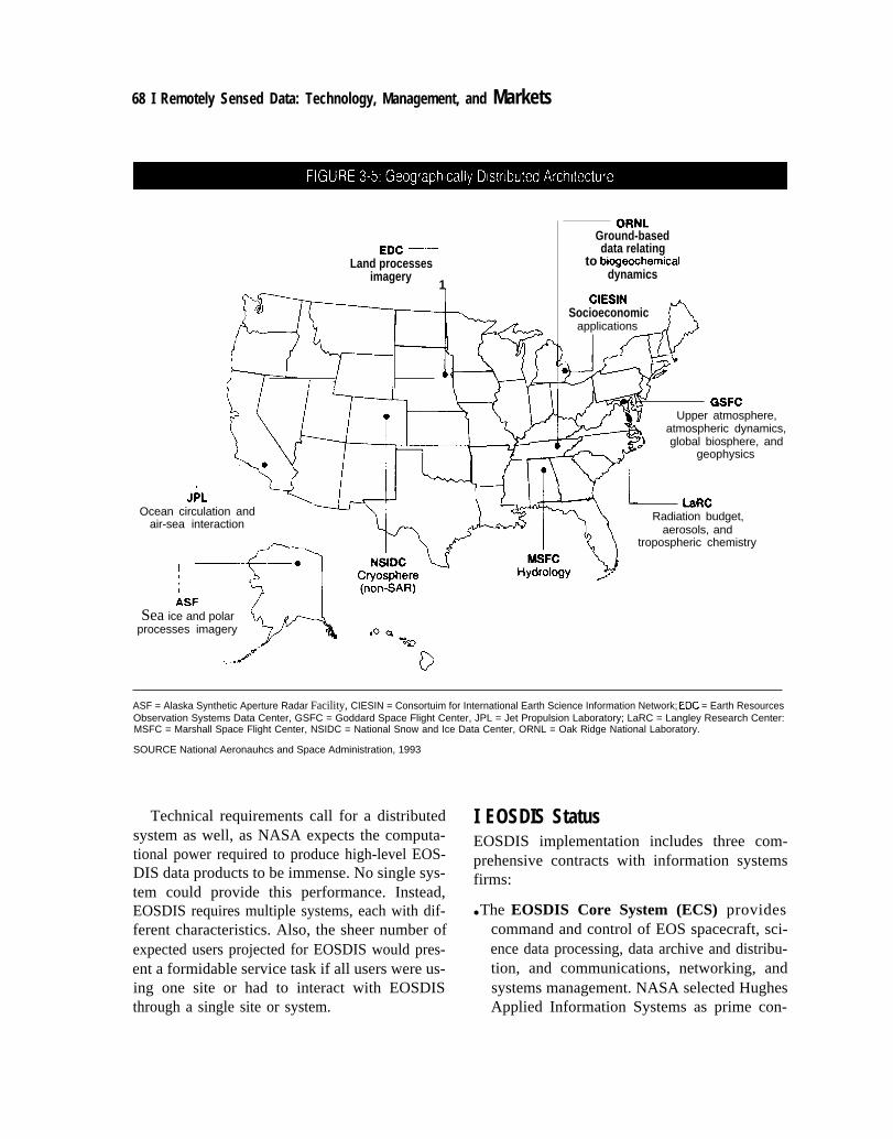
| Distributed ArchitectureNASA states it has implemented a “distributed ar-chitecture” for EOSDIS, rather than central proc-essing for all Earth observing data. Because ex-pertise in various Earth science disciplines isgeographically distributed across the country,NASA has chosen eight of the existing discipline-specific data centers as “Distributed Active Ar-chive Centers” (DAACS); they will serve as geo-graphically distributed “nodes” of the EOSDISsystem (figure 3-5). ]0
atively independent data centers requiring users tocontact each one individually in order to view datastored there. Each center set its own policies andmethods for distributing data. By contrast, whenEOSDIS is fully operational, users at any DAACsite will have complete access to all data sets any-where in EOSDIS, regardless of physical location.Box 3-2 discusses DAAC system architecture.
A truly distributed system approach reducesthe problems associated with failures at a centralor controlling site. NASA expects the specializa-tion and competition inherent in a distributed ar-chitecture to result in much better overall serviceto the EOSDIS user community, and avoid prob-lems inherent in centralized, “bureaucratic con-trol” of the system. ] 1
I ~ E~sD]s is wor~lng C] OSe]y with [he NOAA data centers, both tc~ broaden access to NOAA data through EOSDIS, ~d to acquire ~~pera-tlmal, rea]-time or near-real-time data required for some EOSDIS data products. The special agreements between NASA and NOAA designate
the NOAA data centers as ‘“Affiliated Data Centers” in EOSDIS. Affiliated Data Centers are not as closely linked to EOSDIS development as theDAACS and dt) not receive funding from NASA. However, officials of both NASA and NOAA expect to be able to access data easily from eachother’s systems.
I I An early description of the rationale behind distributed architecture can be found in Dozier and Ramapnyan, “Plmning for the EOS Data
and [nfom~ati(m System (EOSDIS ),” 1990.
68 I Remotely Sensed Data: Technology, Management, and Markets
EDC ‘—Land processes
imagery1
applications
4(/ I
GSFCUpper atmosphere,
atmospheric dynamics,global biosphere, and
geophysics
JPLOcean circulation and
LaRC
air-sea interactionRadiation budget,
aerosols, andtropospheric chemistry
~
ASFSea ice and polar
processes imagery.
,d’,. -**
ORNLGround-baseddata relating
to biogeochemicaldynamics
CIESINSocioeconomic n
ASF = Alaska Synthetic Aperture Radar Facility, CIESIN = Consortuim for International Earth Science Information Network; EDC = Earth ResourcesObservation Systems Data Center, GSFC = Goddard Space Flight Center, JPL = Jet Propulsion Laboratory; LaRC = Langley Research Center:MSFC = Marshall Space Flight Center, NSIDC = National Snow and Ice Data Center, ORNL = Oak Ridge National Laboratory.
SOURCE National Aeronauhcs and Space Administration, 1993
Technical requirements call for a distributedsystem as well, as NASA expects the computa-tional power required to produce high-level EOS-DIS data products to be immense. No single sys-tem could provide this performance. Instead,EOSDIS requires multiple systems, each with dif-ferent characteristics. Also, the sheer number ofexpected users projected for EOSDIS would pres-ent a formidable service task if all users were us-ing one site or had to interact with EOSDISthrough a single site or system.
I EOSDIS StatusEOSDIS implementation includes three com-prehensive contracts with information systemsfirms:
● The EOSDIS Core System (ECS) providescommand and control of EOS spacecraft, sci-ence data processing, data archive and distribu-tion, and communications, networking, andsystems management. NASA selected HughesApplied Information Systems as prime con-

Chapter 3 NASA’s Earth Observing System Data and Information System | 69
Three systems Will operate at each DAAC
1)
2)
3)
Product Generation System (PGS); the Product Generation System at each DAAC WIII convert raw data
signals into standard sets of Earth science data, using data processing software developed by the scien -
tific user community
Data Archiva/and Distribution System (DADS); the Data Archival and Dlstribution System at each DAAC
wiII serve as the archive and dlstribution mechanism for EOS and interdiscplinary data products, as well
as essential ancillary data such as radiometric and geometric calibrtions, metadata, command history,
algorithms documentation, and correlative data from EOS and non-EOS Sensors
information Management System (/MS) The Information Management System IS the user Interface for
EOSDIS The IMS at each DAAC will give users access to all data throughout EOSDIS, as well as help in
locating and ordering data, through convenient, easy user Interfaces for both novices and experts The
IMS will use simple search critera such as instrument name, product name, time of collection, and spatial
location, as well as cross-instrument and cross-disciplinary searches
SOURCE National Aeronautics and Space Administration , 1993
1 J
tractor on September 29, 1992; contract negoti-ations were completed March 30, 1993. Thecombined cost and fee has been set at $766 mil-lion for the contract period 1993 through2003.12The EOS Data and Operations System(EDOS) will capture data from EOS space-craft, provide systematic corrections process-ing, distribute preprocessed data to theDAACS, and archive these data. NASA has se-lected TRW for this contract; cost and fee areunder negotiation.The Independent Validation & Verification(IV&V) contract will provide for the testingand verification of the performance and capa-bilities of all elements of the EOS ground sys-tem and their integration with the EOS flightsystem. This contract will also provide for "ac -
ceptance testing” of all EOSDIS contractor de-liveries. NASA has selected Intermetrics Corp.for this contract, at a cost and fee of $64 mil-lion.NASA and the EOSDIS contractors will buildEOSDIS in a series of versions. The first is Ver-sion O, which is providing interoperabilityamong the 8 DAACS and connections with oth-er Earth science data systems. NASA expectsVersion O to be fully operational as an inte-grated “virtual” system in July 1994 (box 3-3).
The strategy and schedule for delivering subse-quent EOSDIS “versions” is undergoing major re-vision, because NASA and Hughes are reevaluatingoveral1 planning for EOSDIS .As a result of advicefrom the EOS Investigators Working Group in Oc-tober 1993, and the National Academy of Sciencesreport of January 1994,13 NASA and Hughes have
bids were much lower and rejected as unrealistic estimates. Subcontractors to Hughes are : Electronic Data Systems (new technology evalua-tion), Loral AeroSys (flight operations Applied Research Corp. (algorithm tookits) the Center f{~r Space and Advanced Techm)logy (re-search ), and NYMA (independent verification I iaistm).
Is ~a[lona] ReSearCh council, space s[u~les Board, Panel lo Re\’lew EOSDIS flan.~, F“imd Re/xm (Washingt(m, w: National Acadenly
Press, 1994).

70 I Remotely Sensed Data: Technology, Management, and Markets
Version O is a working prototype of EOSDIS with some operational elements. However, Version O will
not have all the functions, reliability, and performance of subsequent versions. Planning and preliminary
design of Version O began in the summer of 1990, and development of Version O as an integrated sys-
tem began in January 1991,
NASA has focused the bulk of Version O prototyping on achieving system interoperability among the
DAACS, NASA’s philosophy for Version O is to allow individual DAAC systems to develop at their own
rate, and focus on providing interconnections among those systems, Version O is improving user ac-
cess to the DAACS by providing an overall view of the data available from the various DAAC systems,
establishing common systemwide services, e.g., user assistance and support, problem resolution, and
request and tracking statistics, and providing a single point from which any user can search and order
data
■
●
■
■
■
■
●
■
from any archive. 1
NASA Climate Data System
NASA Ocean Data System
Cryospheric Data Management SystemAlaska Synthetic Aperture Radar Facility
Global Land Information System
NASA Pilot Land Data System
NASA Crystal Dynamics Data Information System
Trace Gas Dynamics Data Information System
NASA and the EOSDIS contractors plan to transfer knowledge and experience from Version O into
subsequent Versions of EOSDIS However, Version O IS not a true working prototype of EOSDIS in many
respects. Version O is a relatwely small effort, compared to subsequent versions of EOSDIS, Thus, Ver-
sion O projects cannot address some of the technically critical areas of EOSDIS, nor IS the effort sub-
stantial enough to allow users to assess some important EOSDIS functions. Nonetheless, the Version O
effort has already successfully achieved user involvement, Interoperablllty among heterogeneous and
distributed data systems, and a cooperative development environment that enables NASA to use DAAC
expertise and data system experience,
‘ Such mteroperabllty E Ilkely to be an expenswe task, since computer and network systems are mcreasmgly complex, usually
requmng specialists to enable appltcahons to operate properly
SOURCE Officeof Technology Assessment, 1994, and Judy Feldman, “Bulld[ngonVerslon O’, EOSDIS Progress Rewew, Dec 13-14,1993, Landover, MD,
Implemented a major shift in orientation, focusing of the details and results of this reorientation areon responsiveness to user needs and a more open, not yet clear, but the reaction from the Earth sci-distributed, and evolutionary architecture. Many ence community is generally positive. 14
IA~e fomr pIm was for version I to provide a fully functioning science data processing segment of EOSDIS (processing, archiving, and
distribution). This Version would be much more capable than Version O, appearing completely integrated to users. NASA and Hughes plannedits initial release for 1995, with a fully operational system in 1997.
Version 2 would have provided for full EOSDIS data system capacity and flight operations for the EOS-AM spacecraft launch in 1998. Itwould have been followed by Version 3, which would have supported data collection and operation of other EOS flights, in 2001.
Instead, Hughes plans 8 releases of the ECS, through 4 overlapping release cycles, beginning with the first full releases in September 1996.Hughes expects this “dual track” approach to improve incorporation of operational feedback as well as feedback from incremental develop-ment activities. “Release Schedules”, John Gainsborough, EOSDIS Progress Review, Dec. 13-14, 1993, Landover, MD.

Chapter 3 NASA’s Earth Observing System Data and Information System | 71
| Impact of EOS RestructuringThe overall EOS program has undergone majorrestructuring since its initial congressional ap-proval in 1990, resulting in significant reductionsin scope and capabilities. In the summer of 1991,the EOS External Engineering Review Commit-tee, organized at the request of the Office of Man-agement and Budget and the National SpaceCouncil, restructured the EOS program. The re-sult was a smaller more focused program of about$11 billion through fiscal year 2000 (down fromthe previous $17 billion estimate). The ExternalEngineering Review Committee focused on dis-tributing EOS instruments, and the reduced EOSinstrument requirements, onto a larger number ofsmaller spacecraft to provide increased budgetaryand technical resilience. The Restructuring Com-mittee did not examine EOSDIS, but the delay indeploying some EOS instruments allowed EOS-DIS to be smaller than originally planned, with areduced budget.
15 NASA Stated it made this ad-
justment in EOSDIS without altering the basic ar-chitecture or the evolutionary design of EOS-DIS. ]6
In the fall of 1992, the restructured EOS pro-gram was further reduced by an internal NASA re-view to fit within an $8 billion budget envelopethrough fiscal year 2000. Again, NASA reducedthe overall EOSDIS budget roughly commensu-rate to the overall program reduction. NASA re-duced the planned suite of data products availableat launch of EOS-AM 1 from 600 to approximate-
ly 160 data products. IT Other changes included
deferring the migration of existing data sets intoVersion O in cases where the data are already avail-able through an existing operational system, dele-tion of the HIRIS science computing facility, and amajor reduction in program reserves. ] 8
As a result of these changes, EOSDIS is smallerthan originally envisioned and program resourcesare substantially reduced. However, resilience inmeeting future challenges has also been reduced,although many goals regarding data delivery re-main unchanged. EOSDIS remains complex anddemanding, raising a number of technical and pro-grammatic challenges, discussed below.
EOSDIS TECHNOLOGY CHALLENGESEOSDIS will be only as capable as the informa-tion systems technology on which it relies. Over-all data rates and volumes will be unprecedented.EOS instruments will require very precise calibra-tion, and data will require extensive validation tobe useful. The DAACS will need to reprocess pre-viously acquired data periodically, to accommodateupdated processing algorithms. EOSDIS willhave many simultaneous users, many of whomwill require access to interactive databases. Dataanalysis and visualization 19 will be highly sophis-ticated and complex. Although EOSDIS facesthese and other technical challenges, there ap-pear to be no technical obstacles to an opera-tional EOSDIS that NASA could not overcomewith sufficient funding and infrastructure. In
15 The EOSDIS estlnlated budget dr{JpPd frt)nl $3.900 billi(m to $2.141 billi(m, a change of 45~0 compared tf~ an overall EOS pr(~gmm
budget change of 3 I %. U.S. C(mgrcss, General Accounting Office, NASA: Changes to the Scope, Schedule, and Estimated Cosl of the Earth
Obser]~ng System, NSIAD-92-223 (Gaithersburg, MD: U.S. General Accounting Office, July 1992), p. 18.
t h e16 N a t i o n a lEarth observing SYstem* Mar. 9, 1992v P.I 3.
I T NASA Eaflh Science and Applicati(ms Division, “Earth Observing System (EOS) Status,” briefing to OTA, Washington DC, Nov. 6,1992.
18 National Aeronautics and Space Administrati(m, “Adapting the Earth Observing System (o the Projected $8 Billion Budget: Recommen-dations from the EOS Investigators,” Washington DC, Oct{)ber 1992, p. 39. The H(mse Science, Space, and Technology Committee Report to
accompany the NASA FY 1994 and FY 1995 Authorizati(m Bill, Report 103-123, notes EOSDIS reserves were cut by S550 milli{~n, or 60 per-cent, in the rescoping (p. 46).
19 Uslng computer-generated Plc[ures t. represent data instead of a list of numbers, and viewing tinle sequences to track tem~)ml change.

72 I RemotelySensed Data: Technology, Management and Markets
other words, data processing and communicationcapacity and speeds have evolved to the point thata system approximating an EOSDIS in some re-spects, but with less capability, could conceivablybe built with existing hardware. Developing ahighly capable EOSDIS, however, will present achallenge to NASA.
Simply “keeping up with” rapidly advancingtechnology will bean important challenge. Rapidnew technology insertion will be essential for thesystem to retain its value to researchers. If usershave independent access to data processing sys-tems significantly more advanced than EOSDIS,many researchers would eventually use EOSDISsimply to download data into their own comput-ing systems. This would defeat one of the primarygoals of EOSDIS—interoperability among a vari-ety of researchers and disciplines. On the otherhand, reliance on emerging technologies that arenot field proven would threaten system operabil-ity if they were to fail in full-scale implementa-tion.
~ Data Storage and Access TechnologyThe data storage systems for EOSDIS will be ex-tremely demanding. The archives will last for atleast the lifetime of the EOS satellites,20 and willbe interactive with users, in contrast to the moretraditional (and simpler) view of archives as a re-pository in which to store data for occasionaluse.
21 In short, as a result of the high demands fordata storage that will be placed on EOSDIS, per-formance and cost of storage media may need tobe much improved over current technology.22
Data mass storage costs are falling rapidly, butthey remain a major expense for a system likeEOSDIS. Most industry experts expect no break-throughs in the cost of data storage in the next sev-eral years, although the development of opticalstorage systems should continue to bring storagecosts down. Perhaps what is more important isthat storage and access performance is not im-proving as rapidly as storage capacity. Searchingthe vast Earth science datasets for specific featureswill require major improvements in the ability toaccess specific data sets.
The advanced mass storage systems attemptedin recent years have experienced serious prob-lems.23 Since the EOSDIS program philosophy isto procure hardware as late as possible to take ad-vantage of falling cost and improved perfor-mance, EOSDIS may rely on advanced mass stor-age systems that have not yet proven commerciallyreliable. Maintaining a flexible system develop-ment strategy to accommodate rapid technologi-cal change successfully will be important.
NASA has not decided how much and whichkinds of EOSDIS data will be directly availableonline to users but expects to use a hierarchy ofdata storage, in which small, often-used data setsare rapidly accessible, and very large datasets thatare rarely used are stored offline. EOSDIS offlinearchives will be vast, and standards and mediaconsiderations (tape, cartridge, optical storagetechnologies) for offline archives should not beoverlooked. The offline media will need to be eas-ily serviced, and have reliable backups. Technolo-gy advancements and funds to archive and service
Zo NASA EOSDIS P]mning currently extends only through the 15-year EOS mission lifetime.
z] Seveml Wh ~ience &~5y5tems are already improving on this model. Forexarnple, the EROS Data Center, operated by the U.S. Geo-logical Survey and included in EOSDIS as a DAAC, operates a large active archive for Landsat and AVHRR data, featuring online search. Somesmaller data sets at NASA centers, such as the Coastal Zone Color Scanner System and the NASA Climate Data System, also allow these capa-bilities.
22 me EOSDIS pro~ct mmagement team at Goddard Space Flight Center has estimated that a roughly thousand-fold increase in NASA
Earth science data volume will occur during the 1990s. National Aeronautics and Space Administration, “Presentation to the EOSDIS Team on
Ground Infrastructure Interfaces, Formats, and Directions,” paper presented at IPD/EOSDIS seminar, Mar. 12, 1992.
23 U.S. Congress, General Accounting GftIce, Space Data: NASA’s Future Data Volumes Create Formidable Challenges, IMTEC-91 -24
(Gaithersburg , MD: General Accounting Office, April 1991).

Chapter 3 NASA’s Earth Observing System Data and Information System | 73
The EOSDIS network system consists of four networks:
1,
2
3.
4,
Ecom (dedicated network providing real-time, high reliability and secure communications between
ground and spacecraft)
ECS Internal Network (dedicated EOSDIS network providing communication among EOS Principal ln-
vestigators, DAACS, and the External Network)
External Network (NASA Science Internet) (shared network providing communications among EOSDIS
and users who are not Principal Investigators, including CIESIN and the Affiliated Data Centers)
Version O Network (dedicated network for prototyping)
Although more demanding than previous Earth remote sensing satellite communication systems,
NASA does not expect serious difficulty implementing the Ecom network. NASA expects more chal-
lenges Implementing the EOSDIS Internal Network, but the “External Network, ” which will essentially
connect EOSDIS with the outside world beyond NASA, will offer the most difficult technical obstacles
The External Network, using the services of NASA’s Science Internet (coordinated by Ames Re-
search Center), supports several protocols and is interoperable with the NSF Internet, This network con-
.sIsts of T1 transmission lines (1.5 million bits per second (Mbps)) connecting 27 regional networks and
over 100 lower capacity circuits to research sites (although the tail circuits have much lower band-
widths) The NASA Science Internet reaches approximately 2500 end users. In 1994, NASA plans to
upgrade the NASA Science Internet to T3 technology (45 Mbps). Eventually, NASA expects half of the
NASA Science Internet (NSI) users to be EOSDIS users,
NASA planned to employ the UNIX operating system, HDF format, and the communications-related
standards of the Consultive Committee on Standard Data Services where appropriate. However, a
more “open” system is now planned,
SOURCE National Aeronautics and Space Adminiarration, 1994
the tremendous amounts of EOSDIS data, often determined by network capacity. Fortunately, net-overlooked in the past, maybe critical to EOSDISlong-term success. Recent surveys show substan-tial increases in estimates of EOSDIS processingand storage/distribution requirements.24
| Data CommunicationNetworks perform the crucial tasks of linking re-searchers to EOSDIS and integrating the EOSDISuser community through cooperative research(box 3-4). The mode of delivery of data to EOS-DIS researchers and the uses of the system will be
work performance continues to increase as systemcosts decrease.
EOSDIS users are likely to request increasing-ly greater online access to increasing volumes ofdata. NASA has designed EOSDIS to deliverlarge data sets through EOSDIS networks, in con-trast to routine data delivery through physical me-dia (tapes, CD-ROMs, optical disks, etc.).25 Cur-rent input/output and networking technologiescannot support this increased on-line data de-mand, nor the expected data rates required for
24“CostiPerfonmmce,” Joe Guzek, EOSDIS Progress Review, Dec. 13-14, 1993, Landover, MD.
25 National Aeronautics and Space Administration, “Adapting the Earth Observing System to the Projected $8 Billion Budget: Recommen
dations from the EOS Investigators,’$ Washington DC, October 1992, p. 9. On the other hand, if a researcher acquires a large datasct through a
network, he or she still must store it on a physical medium.

74 | Remotely Sensed Data: Technology, Management, and Markets
browsing and visualization of EOSDIS data. Veryhigh data rate workstation network interfaces alsowill be required for doing research using EOS-DIS.26
External EOSDIS users will vary greatly intheir sophistication; most will connect to EOSDISthrough the future equivalent of today’s personalcomputer and modem. NASA does not plan toprovide a level of service to the larger globalchange community and other users equal to thatavailable to NASA Investigators. However,NASA plans to provide the maximum of servicesto users who do not possess highly sophisticatedworkstations. This will place a considerable bur-den on EOSDIS design. Because providing themaximum benefit from the public investmentin EOSDIS may require broad access, Con-gress may wish to examine the potential of pro-viding EOSDIS services to a broad communityof users. On the other hand, it is not feasible forEOSDIS to provide full service capabilities tocasual users.
The National Research and Education Network(NREN) is currently of great value to the EOSDISprogram in distributing data widely. However,NREN must be an operational system to be of usefor EOSDIS; development of NREN is in the earlystages, and the question of its status as an opera-tional system has not been decided. It is also unde-cided whether NREN will be free for researchers,or if the system will require tariffs similar to thenational telephone system (the EOSDIS programhas not budgeted the funds to pay for NREN ser-vice for Earth science researchers). Finally, accessto NREN would need to be widely distributed,serving the broader academic community outsidethe networks operated by the National ScienceFoundation, the Department of Energy, and
NASA. It is unclear whether NREN will achievesuch extensive distribution. For these reasons,EOSDIS planners are avoiding dependence onNREN.
DATA MANAGEMENT TECHNOLOGY(ORGANIZATION AND ACCESS)Advanced techniques for indexing data for storageand access must be developed by NASA, theEOSDIS contractors, and the computer industry.Current relational data management technology,developed for use in commercial applications, isimproving significantly in performance, and is ac-commodating some new types of data. However,relational databases have difficulty accommodat-ing searches of spatial data sets and many otherdata processing and display requirements of EOS-DIS. Relational data management software ismost appropriate for manipulating small recordsof highly similar text or numeric data. Earth sci-ence data records are enormous, temporal, highlyvaried, and contain many more dimensions (time,latitude, longitude, spectral value, etc.) than mostdata records. Current commercial relational data-base systems and data processing software cannotefficiently work with these diverse types of data(e.g., point, vector, raster, text) .27 Version O (box3-3) focuses on satellite data, but EOSDIS mustincorporate non-satellite datasets28 and their spe-cial requirements, complicating data manage-ment.
The interdisciplinary nature of global changeresearch requires the capability to view the samedata in different ways. It also requires common,and broader, access of data among different disci-plines. In order to give data maximum utility, theEOSDIS program may have to support basic re-
26 Note that access to EOSDIS capabilities will be quite limited without advanced equipment. For example, at present, using a typical 9,600
baud rmdem, a single typical browse image of approximately 1.4 Mbytes would require approximately an hour to transmit.
27 See ch. 2 for a discussion of different data types.28 Data acquired for ground-based facilities and from aircraft provide essential calibration for satellite data, and provide much essential data
impassible to acquire from orbit. See U.S. Congress, OffIce of Technology Assessment, OTA-l SC-538, The Furure of Remote .Yen.ring from
Space: Ci}i/Mn Satellife Sys/ems and App/ica(ions (Washington, DC: U.S. Government Printing Office, July 1993), ch.5 and app. B.
. —
Chapter 3 NASA’s Earth Observing System Data and Information System | 75
search into data management software tailored toscientific needs.
| Data Processing, Analysis, andAssimilation Technology Issues
Much data acquired by satellite instruments gounused as a result of the time needed to processthem on conventional computers, particularly tocompute images. The tasks of visualization andassimilation of EOSDIS data into climate modelsare critical steps in the transformation of data intoinform at ion.
The algorithms used by scientists to transformdigital remote sensing data into information willundergo revision as knowledge grows. Becausechanges in processing algorithms could leavesmall errors larger than any change in theglobal environment, rapid reprocessing ofyears of older data must be possible to main-tain a continuous record of comparable datafor research use. Given the high spectral and spa-tial resolution of EOS instruments, and massivedata volumes, this will be a formidable, continu-ous task.29 Updated algorithms, which can havemore than a million lines of code, must be trans-ferred from the scientists to the DAAC ProductGeneration System for execution. Transportingand integrating these complex algorithms to gen-erate “bug-free” products is a serious technicalchallenge.
Effective visualization technology will be animportant challenge for the program, requiringsignificant advances in data processing technol-ogies (e. g.. researchers can be expected to even-tually use virtual reality to enter into a dynamicmodel ).30
E O S D I S w i l l g e n e r a t e h i g h e r l e v e l d a t a s e t s b y
a s s i m i l a t i n g a p p l i c a b l e o b s e r v a t i o n s i n t o g l o b a l
c l i m a t e a n d o t h e r m o d e l s , w h i c h t h e n w i l l g e n e r -
2 0 I b i d . . p. 38.
a t e n e w d a t a s e t s b a s e d o n t h e s e m o d e l s . T h e s e
d a t a s e t s w i l l n e e d t o b e o f m u c h h i g h e r q u a l i t y
t h a n t h o s e c u r r e n t l y p r o d u c e d f o r n u m e r i c a l
w e a t h e r p r e d i c t i o n , a n d w i l l b e m u c h m o r e c o m -
p l e x , s i n c e t h e y w i l l r e q u i r e a s s i m i l a t i o n o f m a n y
m o r e t y p e s o f d a t a ( i n c l u d i n g n o n - E O S s p a c e -
c r a f t ; m e a s u r e m e n t s f r o m t h e g r o u n d , o c e a n , a n d
a i r ; a n d n o n - U . S . d a t a s o u r c e s ) . T h e c o m p u t a t i o n -
a l r e q u i r e m e n t s t o p r o d u c e t h e s e d a t a s e t s w i l l
e v e n t u a l ] y go f a r b e y o n d c u r r e n t p r a c t i c e i n E a r t h
s c i e n c e . M a s s s t o r a g e , n e t w o r k b a n d w i d t h , a n d
p r o c e s s i n g p o w e r o f c o m p u t e r s w i l l n e e d t o b e
g r e a t l y e x p a n d e d f o r u s e o f EOS d a t a i n f u t u r e
g l o b a l c l i m a t e models.31EOSDIS will p r o d u c e a s s i m i l a t e d d a t a s e t s o n
c o m p u t e r s d i s t r i b u t e d g e o g r a p h i c a l l y , w h i c h i n
s o m e c a s e s w i l l u s e d i f f e r e n t s y s t e m a r c h i t e c t u r e s .
C o m p u t e r l a n g u a g e s a n d o t h e r t e c h n o l o g i e s to a l -
l o w t h e s e h i g h - l e v e l a n a l y s e s o n m a s s i v e l y p a r a l -
l e l c o m p u t e r a r c h i t e c t u r e s a r e n o t y e t w e l l - d e v e l -
o p e d . S t a n d a r d s a r e o n l y j u s t e m e r g i n g i n
d i s t r i b u t e d s y s t e m s m a n a g e m e n t .
C o m p u t e r p r o c e s s i n g p o w e r a n d n e t w o r k p e r -
f o r m a n c e a r e i n c r e a s i n g r a p i d l y , w h i l e c o s t s a r e
d e c r e a s i n g . H o w e v e r , b a s e d o n e x p e r i e n c e w i t h
o t h e r s p a c e c r a f t p r o j e c t s , s c i e n t i s t s t y p i c a l l y u n -
d e r e s t i m a t e t h e c o m p u t e r r e s o u r c e s r e q u i r e d t o
p r o c e s s t h e i r a l g o r i t h m s . T h i s i s c o n s i d e r e d t h e
t o p r i s k i n t h e e n t i r e EOSDIS P r o d u c t G e n e r a t i o n
S y s t e m , a c c o r d i n g t o a r e c e n t r i s k a s s e s s m e n t .
3 2A l t h o u g h EOSDIS p r o c e s s i n g r e q u i r e m e n t s a p -
p e a r g r e a t n o w , t h e y c o u l d v e r y w e l l b e c o m e s e v -
e r a l t i m e s g r e a t e r w h e n t h e s y s t e m i s a c t u a l l y i m -
p l e m e n t e d . B o x 3 - 5 p r o v i d e s a s u m m a r y o f
t e c h n i c a l c h a l l e n g e s i n EOSDIS.
EOSDIS P R O G R A M C H A L L E N G E S
O v e r c o m i n g t e c h n i c a l o b s t a c l e s w i l l b e i m p o r t a n t
t o t h e s u c c e s s o f EOSDIS, b u t m a n a g e r i a l , insti-
w ]n lhls ~llanncr, the ~clentlst can v irlua]ly “’bect~me” a p a r t i c l e f l o w i n g t h r o u g h t h e model.
~ I Miilor rcan:l]lsls Progranls a r e now b e g i n n i n g a t s e v e r a l da[a c e n t e r s , i n c l u d i n g G(~dard.
32 Conlputer S c i e n c e s Corp.. Earth Obser\’ing S y s t e m Data and lnjimnotion System (EOSD1.7) P r o d u c t G e n e r a t i o n SYs[enr (PGS) R i s k
Ana/\\I{ and ,%!t[[~[f[[[m S[ra[ccq[cs ( F e b r u a r y 1 9 9 3 ) , p . 4 7 .

76 I Remotely Sensed Data: Technology, Management, and Markets
Data StorageDemands on storage media performance and reliability WiII be tremendous m EOSDIS, and data
storage system throughput is not keeping pace with improvements processing or communications.
Commercial data storage performance may not be successfully adaptable to EOSDIS needs Data stor-
age currently appears to be a “weak link” m EOSDIS.
Data CommunicationsDemand for online access to larger amounts of data IS increasing, as is the numbers of users, user
sosphistication, interagency and inteernational cooperation, data system distribution, and scientific coop-
erate work through networks. EOSDIS will not succeed If bandwidth and access are limited
Data Management
Effectively searching for data in EOSDIS could be difficult as a result of the quantity and variety of
data in the systems Efficiently classifying vast amounts and varieties of data wilI be challenging, requir-
ing new models of data management that are not yet well developed.
Data Processing, Analysis, and Assimilation
Processing demands wiII be much greater in EOSDIS than any previous system Software for use on
parallel and distributed systems IS difficult to write, and visualization technology iS not well developed
SOURCE Off Ice of Technology Assessment, 1994
tutional, and cultural challenges may be evengreater.
I The Role of EOSDIS in GCDISThe Global Change Data and Information System(GCDIS) is meant to allow routine access to allU.S. global change data (box 3-6). Some havecalled for a stronger NASA role in GCDIS. TheNational Research Council’s Panel to ReviewEOSDIS Plans, in its April 1992 Interim Reporfand its September 1992 letter report, expressesconcerns that EOSDIS may become a program● ’oriented solely to EOS,” rather than an integralpart of the GCDIS.33 The NRC Panel believesNASA has the responsibility for “establishingfirm and specific plans and budgets for the devel-
opment and operation of the GCDIS, in conjunc-tion with other agencies’’ 34. Thus, the panel de-sires a national directive to give NASA the leadagency role in the GCDIS, thereby transformingEOSDIS into a prototype for the GCDIS. TheHouse Committee on Science, Space, andTechnology largely agrees:
The National Aeronautics and Space Admin-istration, in coordination with other agenciesthat belong to the Committee on Earth and Envi-ronmental Sciences, shall establish the require-ments and architecture for, design, and developa Global Change Data and Information Systemthat shall serve as the system to process, archive,and distribute data generated by the GlobalChange Research Program.35
~~ ..N~[lt)n~] RC~e~rCh ct)Uncl] Pane] t. ReV@ EOsl>IS Plans: Interim Rep)fi,” Awl] 1992! P. I I.
‘~ [bid., p, 2.M u s ct)nve~s, HOU~e C[)mmlttee on Science, space, and Tectm)lt)gy, Nationa/ Aeronautics and Space Adn?inislration At~~~~ori@i~n. .
Act, FMca/ }’ears /994 and /995, H.R. 2200, June 1993, %c. 109.

Chapter 3 NASA’s Earth Observing System Data and Information System | 77
The GCDIS, as conceived by the Interagency Working Group on Data Management for Global
Change (IWGDMGC), would provide a single data system for the various federal agencies involved in
global change research GCDIS would use a combination of indivdual agency data system assets and
a shared Infrastructure to become the primary mechanism for the exchange of data and information
among USGCRP participants. GCDIS would include processes for Identifying and generating key inter-
agency global change data sets, coordination of data submission procedures for GCDIS centers, stan-
dard methods for decribing and documenting data, a common set of archive responsibilities, and uni-
form order validation, tracking, and billing among agencies Proponents expect GCDIS WIII make data
search and access among the various agency data sets much simpler and more effective
Interagency cooperation in GCDIS iS currently a collection of extensive, but voluntary, indivdual
agency efforts coordinated under the CEES IWGDMGC, GCDIS commonality and Interoperabilty would
be made by the agencies in concert. The GCDIS does not have a separately funded budget, but re-
source requirements for focused program activities are included in USGCRP planning. For GCDIS to be
successful, the effort will need to avoid becoming merely a “collector” of individual agency data and
Information system plans Ensuring interoperabillty among the data systems of the USGCRP agencies,
agreeing on standards for data among agencies so that researchers can easily exchange data, and
maintaing high levels of data service among the several agencies will be the most difficult and impor-
tant issues for GCDIS to resolve
SOURCE Office of Technology Assessment, 1994
NASA has agreed to seek funding to developthe techniques to allow interoperability amongagency systems, thus “enabling and not preclud-ing” extension of EOSDIS. All agencies, how-ever, would require substantial additional fundingfor GCDIS to be implemented as envisioned.
The objectives of the EOSDIS program are al-ready challenging, and NASA’s responsibilitiesfor GCDIS are an additional complexity in theprogram. However, because NASA is alreadyperforming many of the necessary tasks forGCDIS in its EOSDIS program, giving theagency responsibility for GCDIS would be amore efficient use of public funds than assign-ing GCDIS to another agency. Attempting toadd GCDIS requirements to EOSDIS after thelatter is built would prove far more costly thanplanning for them as it is developed.
| Alternative Definitions for DAACS?NOAA data will be critical for global change re-search. NOAA is already responsible for collect-ing and distributing operational and research datafor monitoring and predicting the behavior of theatmosphere and oceans. NOAA data centers con-tain the majority of U.S. Earth remote sensing andin situ environmental data, and NOAA makesthese data continuously available for its opera-tional data systems. The National Research Coun-cil panel convened to review EOSDIS plans rec-ommended including NOAA data centers as fullDAACS (they are currently “Affiliated Data Cen -ters’’).36 However, NOAA officials believe thecost of setting up DAAC, as currently defined, ismore than NOAA can afford. Making NOAA datacenters, as well as other essential sources of Earthscience data, interoperable with EOSDIS should

78 I Remotely Sensed Data: Technology, Management, and Markets
be a priority, whether or not they are consideredDAACS.37 The development of alternative defini-tions of DAACS that prevent disruption of qualityservice, yet give good data access at minimumadded cost, seems essential.
| Socioeconomic Data in EOSDISFor EOSDIS to be effective in meeting the long-term goals of the USGCRP NASA must transformEarth remote sensing data into information usefulfor nonspecialists (e.g., policy-makers, social sci-entists, resource managers, etc.). The systemshould also make potential users aware of, andable to use, available data and information. WhileEOSDIS and other Earth science data systemshave been designed primarily to facilitate physicalscience-based global change research, the Con-sortium for International Earth Science Informa-tion Network (CIESIN) was founded in 1989 toassist a broader community of users of globalchange information, with a focus on integratingEarth remote sensing and other global change datawith social science data.
CIESIN defines itself as an “international, non-profit consortium of academic, governmental,public, and private organizations that share amutual goal of understanding global change.”38
Because CIESIN is not housed within any gover-ment agency, the organization can be more flex-ible than an agency and can maintain greater insti-
tutional neutrality.39 This flexibility enablesCIESIN to work closely with the several gover-nment agencies concerned with global environ-mental change, as well as academia, private com-panies, and other nongovernmental organizations,encountering fewer bureaucratic impediments.
In its first few years, CIESIN activities focusedon assessing the needs and capabilities of usersand providers of global change information.While assessment activities continue, CIESIN hasbegun to design systems to meet those needs. CIE-SIN is providing “tools and expertise” for datamanagement, statistical analysis and modeling,visualization and imaging, and communicationsand collaboration.w
Although CIESIN intends to produce somenew socioeconomic data, and integrate a varietyof data from other sources, CIESIN’S strongestrole could be as an access point to data and in-formation from diverse sources worldwide. Theorganization would serve as a global “informationcooperative,” enabling interdisciplinary links be-tween the natural and human sciences in globalenvironmental change research.
CIESIN’S Socioeconomic Data and Applica-tions Center (SEDAC) is one of the nine data cen-ters in EOSDIS. As the data center responsible forproviding access and distribution of interdisci-plinary science data sets relating to the human di-mensions of global change, SEDAC will make
37 Becoming a DAAC nlay not me~ improved &ta services. Forexarnple, ofllcials of the important CDIAC archive (trace gas and climate
data), one of the three main climate change archives at Oak Ridge, do not want it to become a DAAC, and DOE does not want it to be part of theOak Ridge DAAC. The threat is a fundamental change in operations and possible compromise of current good service. ARM atmospheric radi-ation data also will not be included in the Oak Ridge DAAC.
38 me founding ~Jrgmizatlons of CIESIN were tie Environmental Research Institute of Michigan, Michigan State University, Saginaw
Valley State University, and the University of Michigan. New York’s Polytechnic University, Utah State University, and the University of Mary-
land at College Park were later included in Cl ESIN. CIESIN also works closely with the University of California at Santa Barbara.
39 A]though C]ESIN receives a majority of its funding from NASA (6I.7 percent in fiscal year 1993), CIESIN ako reCelVeS substantial
project funding from DOD (1 7.2 percent), EPA (1 6.3 percent), USDA (3.1 percent), and OSTP ( 1.7 percent) (fiscal year 1993 figures). Robert
Coullahan, Director Washington Operations, CIESIN, personal communication, 1993.
~ CIESIN is also involved in many t)~er proficts outside the EOSDIS SEDAC, including software applications, data cataloging, data
policy studies, the Global Change Research lnforrnation Office (GCRIO) supporting international data exchange, partnerships with federal
agencies including the EPA, DOD, and USDA, and international data networks. CIESIN also serves as a training and education center for adiverse audience of current and potential users, teaching users about its application technologies and information products through summerinstitutes and scientific fellowships.

Chapter 3 NASA’s Earth Observing System Data and Information System | 79
The Socioeconomic Data and Applications Center will provide eight general categories of data to its
users. The National Research Council has repeatedly identified the first four categories as the highest
priorities of the U S research program in the human dimensions of global environmental change; they
also are the expicit categories of emphasis for data collection and model development in the USGCRP,
The fifth category serves the economics element defined in the FY93 USGCRP, The final three catego-
ries serve dlsclpllne-specific studies in the social and health sciences that relate to the human causes
and human effects of global environmental change.
1. Land Use and Land Cover—land cover describes the land surface in generalized categories, whale land usedescribes the driving forces behind land cover
2 /ndustrla/Metabolism—the mass flows for key industrial materials, waste emissions, energy, and technicalforces that drive the evolution of industrial processes,
3 Agricultural Metabolisml—the effects of agriculture and changing agricultural practices.
4. Population Dynamucs—demographic data on population and attributes.
5. Economic Activity
6 Human Attitudes, Preferences, and behavior-the personal motivations, and thelr sources, among individu-als.
7. Social and Political Structures and Institions—the organization of human groups and the Influences of suchorganization on global environmental change
8 Human and Environmental Health—effects of global environmental change on the health of humans and thebroader environment
SOURCE Consortium for International Earth Science Information Network, 1993
physical science data available for use by social data centers. Unlike other data centers in EOSscientists, and vice versa. It is the task of CIESINand SEDAC to make EOSDIS data easily avail-able to the estimated 100,000 to 200,000 userswho are not physical scientists.
SEDAC will also serve as the designated Dataand Information System for the Human Dimen-sions of Global Environmental Change Programof the International Social Sciences Council. Inthis role, SEDAC will provide international ac-cess for social scientists, and other internationalusers, to all of NASA’s Mission to Planet Earthdata, as well as CIESIN’S socioeconomic data.
Data that serve the more particular research in-terests of social scientists are already collectedand archived by existing data centers, and SEDACwill serve as an information network linking these
DIS, SEDAC will not be a massive data archive,since most archiving of pertinent social sciencedata is already done elsewhere. SEDAC will,however, archive some unique CIESIN-produceddata sets. Box 3-7 describes the categories of datato be collected at SEDAC.
CIESIN ISSUESCIESIN has been vigorously debated by policy-makers. CIESIN detractors criticize the programfor high costs of facilities, too many programswith insufficient focus, excessive spending forlobbying efforts in Washington DC, inappropriateallocations of funding, and a lack of peer reviewfor funding.
41 CIESIN supporters refute these
~1 As ~ ~ongrc.~lona]l)” inltlated Progranl, CIESIN funding was not included in NASA budgets until the FY 1994 request. ln=di fundingfor CIESIN was inserted each year through c(mgressitmal “eam~arking” in the appropriations process.

80 I Remotely Sensed Data: Technology, Management, and Markets
claims or believe they have already been resolved,and maintain CIESIN is necessary to redress thelack of priority given to human dynamics researchin global change in the USGCRP and EOSDIS .42
Congress must decide whether CIESIN fund-ing is justified in comparison to alternative uses ofthe funding, whether CIESIN is indeed necessaryto the success of the USGCRP, and if CIESIN isusing resources appropriately. NASA plans to de-pend heavily on CIESIN for developing the use ofglobal change data beyond the scientific commu-nity. A USGCRP without CIESIN is possible;yet, many of the functions now provided byCIESIN would still need to be supplied by oth-er organizations.43 On the other hand, some crit-ics maintain that many of CIESIN’S activities du-plicate services provided by other agencies, andwill not provide them as effectively as agenciesthat have already provided such services for de-cades.
| Use of Outside Expertise in EOSDISMost observers agree EOSDIS would benefitfrom increased involvement by data centers out-side NASA and technologies developed outside
44 me adaptation of superi-the EOSDIS program.or technologies or methods used successfully inother systems could greatly enhance overall sys-tem capability. For example, recent demonstra-
tions of Version O have elicited criticisms that thesystem is too narrowly focused. Some data ex-perts argue EOSDIS is being developed as a sys-tem for “satellite researchers,” while the needs ofin situ researchers are not met. Increased consulta-tion with experts at other agencies presumablywould result in a more versatile system design.
For example, NOAA holds a majority of allcurrent data related to global change, and pursuessome applications likely to be required by EOS-DIS. The National Center for Atmospheric Re-search, with amass storage system of over 36 tera-bytes (noted by the NRC for its effectiveness),makes extensive use of supercomputers and largedata sets to model environmental phenomena suchas global warming and depletion of the ozone lay-er. The University of Wisconsin, with an archiveof about 130 terabytes, is the largest archive in theatmospheric sciences. The University Corporationfor Atmospheric Research, sponsored by NSF, hasdeveloped the nationwide, distributed, real-timeUnidata system to facilitate accessing, organiz-ing, storing, analyzing, and displaying Earth sci-ence data on-line for educational uses. DOD andthe intelligence community have invested heavilyin software to transform remotely sensed data intoinformation for national security purposes. In re-sponse to criticisms, officials at NASA andHughes have promised to increase their efforts toexamine non-NASA data systems.45
Q A recent audit from NASA’S offIce Of the InsWctor General (lG) criticizes CIESIN funding and management. The IG recommends redUC-ing NASA funding [o space-based data support only. CIESIN supporters contend NASA is obstructing the will of Congress. Space News, June20-26, 1994, p. 1.
43 See U.S. Congess, Offlce of Technology Assessment, OTA-BP-ISC- 122, Global Change Research and NASA’s Earth Obsen’ing $wem(Washington, D. C.: U.S. Government Printing OffIce, November 1993) for a discussion of the need for policy-related data and assessment of the
effects of global change.
44 Natl[)nal Re=Wch Council, The US Global c~n~e Research Program: An Analysis of the FY1991 Pk?tS Washington, DC: National
Academy Press, 1990), p. 76. Also, the 1991 EOS Engineering Review Committee, which was mainly preoccupied with restructuring the EOSspace hardware implementation strategy, expressed concerns that “EOSDIS makes no provision for bringing non-NASA Global Change Re-search projeets or other investigative teams involved in global change researeh into the system.” Earlier in the program GAO reports also criti-
cized EOSDIS planning for insut%cient use of existing database expertise at other federal agencies. “In designing and building its Version Oprototypes, NASA has not taken fill advantage of experience available at Earth science data and research centers other than the designatedDAACs...Previous expert panels, including an internal NASA committee as well as the National Research Council, have noted the value of thisexperience base and urged NASA to make use of it.” U.S. Congress, General Accounting OffIce, Ear~h Observing System: NASA’s EOSDISDevelopment Approach 1s Risky, IMTEC-92-24 (Gaithersburg, MD: General Accounting Office, February 1992), p. 21.
4s “EOSDIS Progress Review: Introduction,” D. Butler, J. Dalton, EOSDIS Progress Review, Dec. 13-141993, Landover, MD.

Chapter 3 NASA’s Earth Observing System Data and Information System | 81
The NRC Panel to Review EOSDIS Plans ad-vocated a much stronger computer science re-search program for EOSDIS. The U.S. computerscience community, Goddard’s own in-housecomputer science experts, and experts at NASA’sAmes research center have apparently had verylimited input into EOSDIS implementation and
46 ability of EOSDIS ‘0
operations decisions.exploit rapid advances of technology may dependon the consistent involvement of computer scien-tists both within and outside of NASA. NASA hasrecently devoted some of the EOSDIS budget tocomputer science and data handling technologydevelopment (approximately $20 million over thenext few years), and is now soliciting proposalsfor advanced computer technology work.47
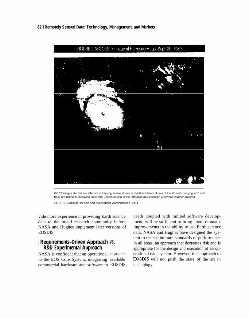
| Version O and PathfinderNASA, NOAA, and USGS have initiated devel-opment of “Pathfinder” data sets in EOSDIS Ver-sion O to increase the amount of data available toEarth science researchers in the near term. Path-finder datasets are large data sets collected over anumber of years by NOAA environmental opera-tional satellites, DOD DMSP satellites, and Land-sat. 48 They are potentially useful to researchersbecause they span enough years to allow detectionof ecological and climate trends. However, Path-finder datasets require careful reprocessing, sincethey have been collected from multiple instru-ments of varying calibration standards mountedon many satellites. Pathfinder datasets include:
m
■
●
8
■
■
Advanced Very High Resolution Radiometer(AVHRR) data sets held by NOAA,TIROS Operational Vertical Sounder (TOVS)data,GOES data (figure 3-6) held under NOAA con-tract by the University of Wisconsin,Special Sensor Microwave/Imagery (SSM/1)data acquired by NOAA from the Departmentof Defense,Scanning Multichannel Microwave Radiome-ter (SMMR) data recorded from the Nimbus-7satellite, andLandsat data in the USGS archive at the EROSData Center.49
NASA and Hughes have recently expanded theinfluence to be derived from Pathfinder data setsand Version O experience. NASA and Hughes ap-pear to be moving toward using Version O as atestbed for further EOSDIS development, insteadof replacing Version O with a different system forthe EOSDIS EOS Core System ECS (box 3-4).NASA and Hughes plan to reuse the incrementaldevelopment process, small development teams,“tirekickers,” 50 and other experience gained inVersion O development and integration in subse-quent versions of EOSDIS.
The work of NASA, NOAA, and the Depart-ment of Interior in developing the Pathfinder datasets is lauded by the scientific community. Con-gress may wish to encourage NASA to acceleratethe Pathfinder activity to enhance the near-termbenefits of EOSDIS. This action would also pro-
% “Likewise, the nation’s computer science community currently has very limited involvement in the Pr{J&ct, despite the fact that EOSDIS,to be successful, must implement the latest advances in scientific data management technology and, in some cases, stimulate the development ofnew technologies.” National Research Council Panel to Re\’iew EOSDISPlans Interim Report, April 1992, p. 16. The EOSDIS Advisory Panelalso noted in October, 1993, “Experts in computing technology, with credentials comparable to those of the most prominent EOS investigators,have not had the opportunity to contribute to the architecture and design of EOSDIS.”
47 Researchers in academic computer science &partmerl[S generally work with fairly small-scale interactive systems, and thus have little
experience with large data flows—with some exceptions. Most experience with handling large data sets still resides in NASA projects, somescience teams within NASA, and other agencies.
48 See U.S. Confless, Office Of Techn{)](~gy Assessment, The Future oj’Remote Sensingfiorn Space, OTA- lSC-558 (Washingt~~n ~: U.S.
Government Printing Office, July 1993) for a discussion of these programs.
49 Roughly go to w ~rcent Of Version O data are from NOAA satellites. Pathfinder could be considered art exchange of technology for data
between NOAA and NASA.
5~ Interdepaflmentai engineering experts charged with testing overall system capability.
82 I Remotely Sensed Data: Technology, Management, and Markets
GOES images like this are effective in tracking severe storms in real time Hlstorical data of the storms’ changing form andtrack are useful in Improving scientists' understanding of the formation and evolution of severe weather patterns
SOURCE National Oceanic and Atmospheric Administration, 1994
vide more experience in providing Earth sciencedata to the broad research community beforeNASA and Hughes implement later versions ofEOSDIS.
| Requirements-Driven ApproachR&D Experimental Approach
NASA is confident that an operationalto the EOS Core System, integratingcommercial hardware and software to
vs.
approachavailableEOSDIS
needs coupled with limited software develop-ment, will be sufficient to bring about dramaticimprovements in the ability to use Earth sciencedata. NASA and Hughes have designed the sys-tem to meet minimum standards of performancein all areas, an approach that decreases risk and isappropriate for the design and execution of an op-erational data system. However, this approach toEOSDIS will not push the state of the art intechnology.

Chapter 3 NASA’s Earth Observing System Data and Information System | 83
GAO and the NRC have criticized EOSDISplans for insufficient attention to advancedtechnology development,51 expressing concernthat the contractor’s near-term requirement to de-velop an operational system could detract from athorough prototyping program to support thelong-term needs of global change researchers.52
Efficiently working with large, complex, and het-erogeneous global change data sets may requirespecial advanced technology. Much of thistechnology will not be available commercially, ifscientific research is not considered a sufficientmarket .53
NASA does not usually sponsor the develop-ment of new technologies required for a flight pro-gram through the flight program budget itself, butrather uses other programs specifically estab-lished to sponsor flight and ground systems R&D.
NASA previously intended to sponsor EOSDIS-related computer science research and technologythrough its computer/data systems R&D pro-grams. so In response to external pressures, how-
ever, NASA has taken the unusual step of settingaside direct EOSDIS project funds to sponsorcomputer science research and advanced data sys-tems technology development for EOSDIS.NASA is soliciting proposals, through a Head-quarters Research Announcement, for technologydevelopment or adaptation for EOSDIS, andfunding will be used for research and developmentat DAACS, Earth science organizations, and uni-versity computer science departments. Unfortu-nately, these steps may reduce the overall budgetavailable for implementation and operations.
Congress has in the past had the opportunist y todirect NASA to strengthen the advanced technol-
s i As early ~~ 1990 tie NRC “oted that: “Acc(~rding t. NASA’S develt)pmen[ strategy, the EOSDIS C’orc SYSt~m ~tmtra~lt~r ~ l]] ~’ r~~V}nsl-
ble for mltiating and conducting pmtotyping efforts after the contract is awarded and full-scale devclt)pmcnt begins. pr(~t(~t~ ping is intended tobean ~mgoing aspect of the contractor’s work. However, we believe that devolving respmsibility ft~r prototyping” to the Core System ctmtract(wmay make it difficult for NASA to ensure that the full range of critical technological risk areas are addressed in a tlmel~ fashmn.” The follow mgtechnology” areas were recommended for pmtotyping by the NRC:
I ) data display & user interface,2) browsing capability,3) da(a fomlats & media,4) accessibility of data and information,5) cataloging,6) search and query capabilities,7) model and data interaction,8) data structures,9) data reduction algorithms, and
10) netw(wking.Nati(mal Research Council, The US G/oba/ Change Research Program: Arr Ana/ys/s oj’[he FY199/ P/an.! ( Washingt(m, DC Nati(mal Acad-
emy Press, I 990), p. 79.52 me EOSDIS AdvlsoV pine] n{)ted in @t(J~r 1993: “me system is being driven by detailed requmments, ~ ith Ilttle sense of [he (~ver-,-
archlng issues about information systems.” The Panel also noted that Hughes’ managers had “too little kmnvlcdge of the characteristics andc(xnputing sty Ies of Earth scientists.” GAO previously stated: “it is vital that NASA not allow the near-tern] tqxrational requirements to prw entit from building a system that can ultimately provide a “next generation” of capabilities beytmd what current Earth science datas} stems pr(~-vide. ” U.S. C(mgress, General Accounting Office, Ear(h Obsen’in~ S>’stetn: NASA’s EOSDIS Dc\’elopment Approach 1s Risk>, 1 MTEC-92-24
(Gaithersburg, MD General Accounting Office, February 1992), p. 33.
s~ However several (Jrganlzatlons outside NASA are pur.suing technology development that would enhance EOSDIS capabll ities. Sequoia
2000, a Digital Equipment Corp. project involving computer and Earth scientists at fi~e campuses in the Uni P ersity of Calif(~mia, is pursuing anumber of techmdogy development efforts, including working with very large data sets using advanced que~ st) Ies, searching ft)r large (~b-jects, and techniques for working with diverse types of data. The Mitre Ctrp. is also expl(wing advanced que~ capabilities and (~bject-(menteddata management systems. Visualization techniques are being pursued at a number of research organlzati(ms, Including the IBM Wats{m Re-search Center, JPL, the Mitre Corp., and the Xerox Palo Alto Research Center.
~~ Rt)bc~ ~lce, Director, Mission to planet Earth office, NASA/Goddard Space Flight Center, personal colllnlunicati(~n. JanuaD 1994.

84 I Remotely Sensed Data: Technology, Management, and Markets
ogy research component of the EOSDIS program.Congress may yet wish to expand the higherrisk technology development aspects of EOS-DIS within NASA. This approach would havethe potential to yield higher functionality of thesystem. Such a research effort would also havethe potential to produce more generic technolo-gies that might prove useful beyond meetingthe operational requirements of EOSDIS. Fi-nally, an expanded technology development effortwould enhance the oversight capability of NASAEOSDIS project staff.
On the other hand, successful and timely imple-mentation of EOSDIS could be jeopardized ifNASA and Hughes rely on custom-designed hard-ware and software, or new technologies withoutwidespread commercial support or commitment.Most scientists currently desire basic online func-tionality with a small set of critical services pres-ented in a way that matches how they work. Ad-vanced graphics interfaces or similar ‘*extras” maybe less important than simply having a system thatis consistent throughout, works correctly everytime, has a well-stocked archive of scientific datasets, performs quickly, and has a simple and inex-pensive procedure to acquire data rapidly.
| Long-Term ArchivesNASA has limited experience with operationalEarth remote sensing data systems. Although theEOSDIS budget has fared no worse than otherparts of the Mission to Planet Earth in recent pro-gram reductions, continuous operation and up-grading of an operational data system may provea challenge for an agency historically oriented to-ward high-profile engineering hardware develop-ment and an emphasis on human spaceflight.
Since it is not known which data will prove use-ful in the future, and in order for scientists to un-derstand the genesis of environmental changesthey discover in the future, it is important to pre-serve all data.55 Responsibility for long-term ar-chiving of EOS data, however, has not been de-cided, and planning has barely begun for datamaintenance after the 15-year life of EOS. NASAhas promised to have all EOS data preserved forpossible future use, and the pertinent Federalagencies are conducting negotiations concerningthe means and mechanisms of long-term preserva-tion of these data. The policy on archives will bean essential element in the long-term value ofEOSDIS.
EOSDIS SCIENTIFIC INVOLVEMENTNASA has sometimes conducted early missionplanning and system development phases of spacedata systems without actively involving research-ers and data consumers in the planning process.Insufficient scientific participation frequently hasresulted in improperly implemented data systemsand rejection of data systems by the scientificcommunity. EOSDIS poses a special challenge,because its large scope could result in the domina-tion of “system” concerns while science and ser-vice needs are overlooked.
Officials in the EOSDIS DAACS have alreadyindicated that early and continuous involvementof the science community is the most importantaspect of DAAC development. They also recog-nize that failure to involve scientists early in theplanning can lead to a DAAC receiving little useby the scientific community.56 To assist scientificinput into EOSDIS development, NASA has
55 For example, when the AVI+RR instmnlent was constructed, NOAA scientists were generally unaware of how imlx~rtant AVHRR ‘ata
would be in following changes in vegetation. Now, NOAA distributes data m changes in vegetation thrmghwt [he year as a standard dataprOduct.
56 Na[lona] Aeronautics and space AdnlinlS[rat](~n, NASA Goddard Space Flight Center, Earth Science Data and information Systems ~(JJ-
ect, “EOSDIS Version O (VO): Lessons Learned,” April 1993, p. 6. This document is tilled with references to the prime importance t~f a closeworking involvement between system development and the scientific community at the DAACS.

Chapter 3 NASA’s Earth Observing System Data and Information System | 85
The EOSDIS Advisory Panel of the NASA EOS Investigators” Working Group iS the primary mechanism
for obtaining user input in EOSDIS, with its 24 members drawn from the primarily academic community of
551 EOS Investigators Panel members have been on the procurement team for the ECS contract, and Pan-
el members also communicate to Industry independently The EOSDIS Advisory Panel examines the “int-
egrated picture’ of EOSDIS, reviewing and assisting in planning, proposals, and system testing This group
was Important in promoting the redirection of EOSDIS development toward a more open, evolutionary, and
distributed system after the September 1993 Systems Requirements Review.
DAAC User Working Groups also provide essential guidance to EOSDIS. These groups provide “grass
roots” input on science community requirements, data set needs and priorities, required functions and ser-
vices, assistance in setting DAAC priorities, review and comments on DMC and EOSDIS system efforts,
and assistance in the annual update of the EOSDIS science data plan Only half of the membership of
these groups are EOS Investigators
The DMC User Services Working Group includes User Support Off Ice staff at the DMCS and NOM
data centers, as well as members from the EOSDIS project at Goddard Space Flight Center This group is
responsible for improving access to exiting data, developing common user services at all DMCS, and
encouraging and gaining feedback from Version O use
Program scientists at NASA Headquarters take part in the MDIS Management Operations Working
Group, which provides an overall review of EOSDIS program structure and performance, Insight into the
larger outside Information systems world, and ties to the Earth Science and Applications Advvisory Sub-
committee
Day-to-day scientific operational input and data product support IS provided by the DAAC project sci-
entists on the staff of each DMC. At Goddard, the EOSDIS project has a project scientist on staff, as well
as a scientist n the role of Science Data and External Interface Manager
EOSDIS at the system level and the DMCS attempt to be receptive to science advice through lndividu-
al comments and experiences from all users
SOURCE National Aeronautics and Space AdministrationmvstratoP 1993
constructed an extensive system for providing sci - ited to advisory committees, while the DAAC sci-ence advice (box 3-8).57 entists have no direct input into basic design. de-
In spite of this system of science advice and velopment, and operations decisions. Also, someassertions about the importance of close involve- assert EOSDIS planning is conducted under al-ment with the science community, observers have most exclusive advice from NASA-affiliated sci-complained that the role of Earth scientists is lim- entists, to the exclusion of other users .5X
$7 L.[)nc ,Jf the first ac[lt l[lcs of E{>SDIS WaS to &fine nlcth(tis for increasing participati(m by the research c(mmlunlty in the dctjnltl~~n,
tes[lng, and rc-design of the jy SICIN...7IW succcss of EOSDIS hinges on the users’ being cn~ptwered I(J shape it to their needs—needs w hich w 111ewdvc w Ith prt)grcs~ In Earth scltmcc research and with experience gained in manipulating the data systems.” National Aeronautics and SpaceAdnlm[stra[l(m, LOWII.7: ff[).S [jof[i [irrd Ig[ortna[wn S>stern (Washington, DC, 1992), pp. 7, 23.
~~ .’~e Predolll inant Llscrs of EOSDIs ;lre ~x pected to be the thousands of Earth scientists wh[) are m~t afiil iated with ~h~ EOS prc~gram.
Howe\w-, NASA’s plannlng for the ~ysteru thuf far has relied largely tm input fr(~m the relati~ ely small number (>f researchers funded direc[ly b>NASA. NASA’$ gudcllncs and mechanisms for obtaining further user input in the future do not provide assurance that c/// segments of the user
conm~unlty W(III he adequatel} represented” LT. S. Congress, General Acc(mnlmg Office, Eard~ Ob.ser}irrg ,$~slerrl.” Broader /n\w/t’crr~err/ of IhcEO.\I~/S L’.~er (’ommun~l) /.$ ,$’ceded, IMTEC-92-40 (Gaithcrsburg. MD: General Accounting office, May 1992), p. 1.
86 I Remotely Sensed Data: Technology, Management, and Markets
Having individual investigators actually per-form data processing, validation, and intercompa-risons in EOSDIS development would provideimportant feedback on EOSDIS operations. Em-phasizing this approach would be more expen-sive, but has proven to be crucial in past data sys-tems such as the WETNET at MSFC.59 At thesame time, EOSDIS could be more effective ifEOSDIS officials look beyond the advice of cur-rent users and successfully anticipate the likelymodes of computer interaction of future users ofEOSDIS. Hughes has sent teams of scientists andengineers to many science user facilities to gainbetter insight into the needs of scientific users ofEOSDIS.
| Data Pricing: User Fees?Whether data centers will actually collect moneyfrom the research community for the use of EOS-DIS remains an open question. Current pricingpolicy for EOSDIS. and all U.S. global changedata, ensures that data will cost no more than the“marginal cost of reproduction.” At present, sev-eral EOSDIS DAACS distribute their data free tothe scientific community.60
User fees have the advantage of providing therecovery of a portion of the data system operationscosts, without seriously impeding data use ifprices are sufficiently low. User fees also provideaccountability, serving as a constraint against us-ers ordering vast amounts of data simply becausethey are free. They also encourage user involve-ment in the data system.
However, the costs of a billing system cansometimes outweigh the benefits. In some cases,especially for online data distribution, establish-ing a system to monitor payments, checks, pur-
chase orders, etc., may cost more than giving dataaway (especially for smaller data sets), and mayreduce overall use of the data. Many researchers(e.g., unfunded researchers doing exploratory re-search, graduate students, educators, some for-eign researchers) cannot raise sufficient funds topurchase large quantities of data, even at incre-mental costs.
Would EOSDIS be “flooded” with requests ifdata were free? EOSDIS could depend on com-mercial data distribution networks to limit datademand, similar to current use of the telephonenetwork. Users would be required to pay for thetime they spend on the network accessing andtransferring data, but no billing system would berequired at the DAACS. Network access wouldstill need to be relatively inexpensive, however,for EOSDIS data to have broad distribution. 61
Another alternative would be to institute the use ofresearch vouchers, allocating a limited number ofdata credits per researcher. Time and storage limi-tations alone might serve to discourage an indi-vidual undisciplined acquisition of large datasets.
This issue needs to be resolved relatively soonto facilitate the appropriate design of EOSDIS. Itis essential that whatever is decided, the datapolicy be consistent within the government, andsupported by appropriate funding.
| Equipment Requirements for EOSDISUsers
Use of EOSDIS will be determined in large part bythe equipment required to access the network.NASA will provide Science Computing Facilities(SCFS) for use by the 551 EOS primary investiga-tors, ranging from personal workstations to super-
S9 National Aeronautics ~d Space Administration, NASA Goddard Space Flight Center, Earth Science Data and Inf(Jm~ation SYsten~s ‘OJ-
ect, “EOSDIS Version O (VO): Lessons Learned,” April 1993.
60 AS nc)led in chapter 2, tie EROS Dam Center, with by far the largest remote sensing data archive of the DAACS, has a user fee sYst~nl in
operation. The Alaska SAR Facility also charges fordata. Goddard Space Ftight Center expects to have a charging mechanism in place by 1994.
The other DAACS do not currently charge for data, and do not plan to unless so directed by NASA Headquarters.
61 [t 15 highly ]Ikely hat fu~re ~omnlercla] data networks costs will becharged in terms of bandwid~, not bits, making EOSD]S data transfer
economical compared to other uses.
Chapter3 NASA’s Earth Observing System Data and Information System | 87
computers, for algorithm development. Besidesdirect NASA support, many other sources of re-search funding, both within and external toNASA, provide funding for computing equip-ment and communications to support the needs ofthe broader Earth science community. For thislarger community, NASA expects the minimumSCF required for full access to EOSDIS serviceswould be commensurate with what is currently af-fordable with a “typical research grant” (about$10,000 fiscal year 1993 dollars).62 EOSDISplans to make available software toolkits for useon these computers. 63 Furthermore, NASA and
Hughes have promised to design EOSDIS to pro-vide user access and as many services as possible.
However, under the present product generationsystem, scientists not directly involved with theprogram cannot easily contribute to the develop-ment and distribution of new algorithms. VersionO is criticized by some observers for requiringhighly specific equipment and software to be us-able. A need for special equipment, software, orformats could be a major liability, considering themany researchers expected to use the interagencyGCDIS.
Breadth of EOSDIS services, based on specialequipment requirements, could be one of the firstcasualties of any future program difficulties orbudget shortfalls. If Congress desires to main-tain the advantages of broad use of EOSDIS, itwill need to monitor this aspect of the programto ensure that highly specialized and advanced
computer hardware and software does not be-come a requirement for use of EOSDIS.
| Cost Savings in EOSDIS?Congress has provided EOSDIS with funding atthe level of agency requests thus far, with addi-tional funding added for CIESIN. However, thecontinued availability of such resources is likelyto be a central issue in the program in the future,given the strained budget context in NASA, thedeficit problem in the U.S. government, and theplanned increase of over 50 percent in EOSDISfunding for fiscal year 1995—from $188 millionto about $285 million. Also, cost overruns havebeen the rule, rather than the exception, in largedata systems. Figure 3-7 illustrates changes in to-tal EOSDIS funding between 1991 and 2000.
Some observers claim the sizing of EOSDIS isunrealistic, since it was not rescoped to reflect thenew reality of the smaller EOS program withsmaller data flows. The EOS satellites are nowabout the size of the current UARS, and thelaunches are staggered. A new, reduced set of re-quirements for EOSDIS, some argue, could cutthe costs of the program significantly.64
The EOS Investigator Working Group soundeda general caution concerning EOSDIS staffingcosts:
“From experience with other data systcms.
we caution that costs are only moderately sensi-tive directly to storage volumes and processingoperations; they are more sensitive to the work
6Z ~a[ional Aeronau[lc~ ~d Space Adnllnistmtit)n, Modeling, Data, and ]nfOrmatlOn Systenls briefing to OTA, ‘ebruary 1993”
6J It is unclear ~ hat dl fficultles nlay ~ encountered from government restrictions on distribution of software. Hardware distnbutl(m diffi-
culties were a major problem in the MSFC WETNET program. NASA ESDIS, “EOSDIS Version O: Lessons lxamed,” April 1993, p. 79.
64 An exalTlp]e is a recent ocean Wind scat[erome[er project at JpL, which was p]anned to cos[ $20 nlil]i(~n. A new design review reduced the
expected costs to $ I I million, apparently with little negative impact.
Some (~bscrvms argue that enough new inf(mmation has been learned about the production of data products m warrant re-evaluati(m of the
EOSDIS pr(tiuct generati(m system by DAACS and PIs to determine whether changes could bring more quality data products while sai ingresources. The present strategy is to plan each product in great detail. Top levels of NASA prepare and update detailed plans (to a~t)id delay t)fdata products to “fine tune” the algorithms, or a focus on only a small subset of the data). As an alternative, however, m(m conm)l could bepassed back to the investigators and project groups. An agreed set of goals and delivery schedules for primary products w(wld be required, butsec(mdary products c(mld be more creatively developed by investigators. This might give NASA many more g(wd products, although therewould be more failures as well. This approach w(mld promise de] ivenng more and better data products, lowering costs, and increasing pr(tiuc-tlwty and satisfaction of the scientists. NASA and Hughes moved toward this concepti(m at the EOSDIS Progress Review, December 1993.

88 I Remotely Sensed Data: Technology, Management, and Markets
SCFS
Pathfinder data
Version O prototyping
Other prototyping
Product generation systems development
Archive systems development
Data operations systems development
Communication systems development
Flight operation systems development
Verification and validation
Data system operations
Flight system operations
Program management
,
1-D 1 9 9 4
-2000
I “ ’ ’ ’ ’ ( ”
t1
1 I I 1 1 I I I I
o 10 20 30 40 50 60 70 80 90 100
Millions of dollars
SOURCE National Aeronautics and Space Adminstration Office of Technology Assessment, 1993
force needed for system engineering, algorithm tions, and the currently proposed staffing levelsintegration, etc.”65 seem high.”
The EOSDIS Advisory Panel noted in October EOSDIS plans require excellent data delivery at1 993: all times of the day; some costs could be saved if
“By far the greatest expense in EOSDIS is the this capability were reduced.66 If researchers cansum of the salaries for maintenance and opera- wait up to a week for most data products, the dif-
65 Nati(~na] Aeronautics and Space Administration, Adapting the Earth Observing System to the Projected$8Billion Budget: Recommenda-
tionsjiom (he EOS investigators, October 1992, p. 39. The EOSDIS Advisory Panel noted in Oct., 1993, that” ...the putative costs seem too
sensitive to the floating-point operations needed to create the EOS standard products, when the constraints are more likely to be the populationof users who can be served and the rate at which the system can deliver products to users,..”
66 If 8-hour shifts ~e substi~t~ for 24-hour shifts, DAAC operations costs are estimated to be reduced by 8.2% to I T.9V0 (depending on
“non prime time” operations levels, and assuming processing and electronic access/distribution of data during *’non prime time”). This is anestimated savings of $15.7 to $34.4 million through October 2002. “Cost/Wfommnce,” Joe Guzek, EOSDIS Progress Review, Dec. 13-14,1993, Landover, MD.

Chapter 3 NASA’s Earth Observing System Data and Information System | 89
ference in costs could also be expected to be sub-stantial.
However, underestimation of required datasystem personnel would also be a serious prob-lem. User services (establishing communicationsfor users, training researchers and computer ex-perts in the use of the system, solving communica-tion and network problems for users, providing in-formation on data product generation anddelivery, special requests for data, etc.) usuallyhave required more effort than initial estimates. InEOS, with a projected 100,000 to 200,000 users,the number of people dedicated to user servicescan be expected to be large.67
While many climate problems require globaldata for many years, there may be ways to acquiresamples from the data stream rather than store theentire data set in order to reduce the volume sharp-ly. These opportunities could make it easier to pur-sue the scientific search while reducing costs.
EOSDIS has ambitious plans for providingdata online. A few EOSDIS data streams will beneeded by NOAA for real-time weather forecast-ing, and NASA plans to deliver these data toNOAA rapidly. Some observers claim the rest ofthe EOSDIS data products do not need to be avail-able in real-time, as currently planned. Short de-lays in data transmission offline might result insignificant cost savings.
Observers have noted that to achieve good ser-vice at reduced cost, some competition is usuallynecessary. While this is difficult to achieve with-out some duplication, furthering efforts to providechoices to researchers might result in overall high-er efficiency, better service, and lower cost. Plac-ing the entire responsibility for meeting diverseuser needs through a single, pre-planned data andinformation system could be very difficult. EOS-DIS could become a very “brittle” system if EOS-DIS were “monolithic,” and the only means ofcommunication between researchers and NASAofficials. Examples of resilience - enhancing alter-
natives would include the use of the CIESIN net-work, direct broadcast of data, commercial high-volume/high-speed lines, and NREN.
As technology and economics change, the sys-tem must adapt to enable functions to migrate towhere they can most economically be performed(e.g., the shift from centralized mainframe com-puters in the 1970s to today’s distributed worksta-tions). NASA and Hughes plan to isolate func-tions where technology change is most likely tooccur, so these functions can easily be changed orreplaced as technology matures.68
Some observers point out that many of thefunctions in EOSDIS might well be provided bythe private sector. This view posits that it is inap-propriate and inefficient for government to planand build operational science networks in an era ofrapidly expanding technical capability. For exam-ple, special funding for networks of very highbandwidth would be redundant if sufficient band-width becomes widely available and inexpensivecommercially. As noted in chapter 2, computerprocessing speed, and storage capacity and access,largely funded by the commercial sector, havebeen increasing markedly in recent years.
As an alternative or supplement to EOSDIS,NASA could rely on direct-broadcast of data fromsatellites to ground stations at scientists’ researchinstitutions. Proponents of this approach claimcosts increase dramatically when government per-forms computing tasks, noting many researchersalready receive data directly over communica-tions links. Reliance on this strategy would, how-ever, hamper the fundamental goal of fosteringscientific interdisciplinary research. Such a planalso might increase costs, not decrease them, sinceeach user would require the ability to process rawdata signals to final products, a costly process formany types of data. Using a few well-controlledfacilities (DAACS) is advocated as a less expen-sive and more effective system.
67 “Members of most user communities wi]] continue to want to talk to knowledgeable user service personnel via telephone-specially as
the number of data products and their complexity increases...training is not a trivial matter, especially for a large number of data products withfrequent changes.” Pitt Theme, “Demographics”, EOSDIS Progress Review, Dec. 13- I 4, 1993, Landover, MD.
m “EOSDIS l%gress Review: 1ntroductim,” D. Butler, J. Daltm, EOSDIS Progress Review, Dec. 13-141993, Landover, MD.
90 I Remotely Sensed Data: Technology, Management, and Markets
There are other alternatives. As noted in chap-ter 2, many government data distribution pro-grams, including remote sensing data systems,have derived and distributed products with fairlymodest costs. While these programs do not achievethe broader goals of EOSDIS, they do provide lessexpensive models of data distribution.
| Commercial RelevanceNASA has planned and developed EOS as an op-erational scientific data system, relying onUSGCRP goals and scientific and technical con-siderations for program planning and execution.NASA has not designed EOS to stimulate theEarth remote sensing market, nor as a “test-bed”for advanced Earth remote sensing technologies,nor to contribute to the national goal of “globalcompetitiveness.” The two original EOS instru-ments with the most potential commercial rele-vance, HIRIS and SAR, were deleted from theprogram in the 1992 restructuring. EOS data aregenerally low-resolution, and land observationshave not been emphasized in the program, limit-ing the commercial value of EOS data.
Nonetheless, a strong potential may exist forcommercial value of some EOS data. While cur-rent EOSDIS plans to make all data available al-most immediately could destroy the commercialvalue of similar data from other sources, such asfrom the Sea Star Satellite (ch. 4), easy access toEOS data by the commercial sector could result invaluable enhancements (“value-added” products)that could satisfy various needs the governmentcannot meet.69 NASA and Hughes are conductingstudies of the potential commercial relevance ofEOSDIS data.
DATA FORMATS/STANDARDSThe issue of data formats for remote sensing hasbeen debated for several years, especially in
NASA. Until recently, NASA and Hughes hadsupported only high density format (HDF) forEOSDIS data storage and retrieval. However, thisimplied anew way to ingest data that very few sci-entists have used. Many scientists might desire tocontinue to obtain small datasets in a simplebinary or character format, such as ASCII.
Data formats should be easy to use. Formatsalso should not substantially increase data volumeor slow down the processing of large datasets. Fi-nally, formats must be capable of allowing dataprocessing on primary workstations and PCs. Theappropriateness of HDF by these criteria is de-bated in the science and computing communities.Designating a present format system as the stan-dard for future EOS data would doubtless causeproblems with using the data. Instead, NASA andHughes plan to provide translators within EOS-DIS so users can easily access data in different for-mats.
| Is EOSDIS “Distributed” and“Evolutionary”?
At the first EOSDIS ECS system requirements re-view in September 1993, Earth scientists ex-pressed concern that EOSDIS architecture ap-peared too centralized and inflexible toevolutionary change. The EOSDIS Advisory Pan-el of the EOS Investigators’ Working Group, inOctober 1993 concluded the system was not a dis-tributed system:
Instead it is a system of geographically dis-persed elements with tightly centralized man-agement [a central architecture forced to resideat several geographic locations] . . . Essential ele-ments of a distributed system-competitionamong elements, and differenttributed responsibility, power,are missing .70
The Panel also stated EOSDIStionary system:
approaches, dis-and resources—
was not an evolu-
69 F[)r example, ~ltal Science COT. is Cumen[]y attempting to develop a commercial market for value-added enhancements to data that
will be collected by its SeaWiFS ocean color sensor. See U.S. Congress, Office of Technology Assessment, The Furure ofRemote Sensingjiom
Space, op. cit., footnote 2, ch. 7.
To EOSDIS Advisory panel, EOS Investigators’ Working Group Payload Panel meeting, @t. 4-6, 1993.

Chapter3 NASA’s Earth Observing System Data and Information System 191
Instead its developers focus tightly on thenear future, use tools and standards that are al-ready obsolete, view “technology insertion” assynonymous with evolution, and have little vi-sion of the computing environment of this cen-tury and the early part of the next.71
The Panel noted the EOSDIS design had changedlittle since 1990, despite important technologicalachievements in the architecture of distributed in-formation systems since then.
In response, Hughes is conducting studies of al-ternative ECS architectures, with study teams se-lected from top universities in computer and Earthscience. 72 NASA is also funding the development
of prototypes and discipline-specific functions,and encouraging increased involvement in ECSdevelopment and funding for added functions andservices to meet the needs of specific science dis-ciplinescoc lpllnes.7~ The EOSDIS ECS system is now being
designed to accept alternative implementations atall levels, including new developments notcreated by NASA or Hughes, as well as test mar-keting new ideas, products, and methods.74
EOSDIS needs to maintain the flexibility todeal with different methods of data managementamong the DAACS, since different science com-munities will have different data managementneeds. The report of the NRC Panel to ReviewEOSDIS Plans Interim of September 1992 statedDAAC managers did not have well-defined au-thority or accountability in building EOSDIS, thatDAACS were not sufficiently involved in EOS-DIS implementation, and their primary role ap-peared to be simply to operate hardware and soft-
75 According toware at their sites after delivery.
the NRC Panel, ‘The centralized management ofthe design and implementation of EOSDIS func-tions at each DAAC is not conducive to active userinvolvement and responsiveness to changingtechnology.” 76
Decentralization also has its risks, however. Tobuild an integrated, interoperable system requiressufficient central authority to ensure interoperablesystem architecture and interfaces. As a projectserving multiple agencies, EOSDIS requiressmooth and efficient interpersonal communica-tions, as well as computer communications, in ahighly complex environment. Parochial interestsneed to be controlled to some degree. Completelyautonomous DAACS, each with its distinctivesystem architecture, data formats, and so on, wasone of the primary reasons for the development ofEOSDIS. While insufficient input from DAACmanagement would endanger system responsive-ness to scientists, excessive DAAC autonomymight endanger integration and interoperability ofEOSDIS.
Instead of increasing the authority of DAACSas a means of dealing with centralization, NASAmight arrange a system having a manager for eachcluster of major products for related disciplines.This manager would make agreements on how todevelop products that would be stored in theDAAC. Data distribution could be separated fromproduct generation, with the DAACS and advisorshaving most control over distribution while sci-ence experts have control over product genera-tion. This is similar to older NASA project man-agement philosophy in which a single managerhas control over the priorities and the level of ef-
7’ Ibid.
72 D. Butler, J. Dalton, “EOSDIS progress Review: lntrxduction,” EOSDIS Pn)gress Review, Dec. 13-141993, Larrdo\cr, MD.
73 Ibid.
74 Gal] McConaughY, ESDIS Prt)]ect, “The Evolving C(mtcxt t)f EOSDIS (Focus: Science Supp(mt). ” EOSDIS Progress Review, Dec.
13-14, 1993, Lan(h)ver, MD.
75 NASA ha5 ~.en crlllclLe~ for ~]]ow ing [he DAAC “1anager5 ]I([]e influ~nc~ ,)\er (he ~)~,ra[ion and main[~n~c~ of Ecs :M a ~hol~. no
financial c(mtrol over the I(mg-term strategy of the DA AC, and no resp(msibility to reallocate rcsourccs to ma~imize the prt)~ lsl(m of sen ices.
76 A re]lance on standard data pr(~ucts a]one ~ou]d ~ t(M) rlgld For exanlp]e, usCrS would have di fficu][y in au[t~nlfl[ic;l]l> c(mlbining data
from different sensors, altering products to meet new scientific needs, or revising algt~rithms to meet various purp(~ses. The DAACS curren[lyhave little control over the fomls in which they receive their data, the management and cv(~luti(m of the ECS, or budgets.

92 I Remotely Sensed Data: Technology, Management, and Markets
fort of each task, with less influence from NASAheadquarters and more authority from those in the“field,” along with freedom to cut across organiza-tional boundaries to accomplish tasks.
The level of autonomy at each DAAC couldhave a significant impact on the success of EOS-DOS. Congress may wish to consult with NASAmanagement, DAAC management, and informedmembers of the global change research communi-ty, to monitor the appropriate level of centraliza-tion in EOSDIS management.
I The New Future of EOSDIS: “UserDIS”and the “Earth Science Web”
The UserDIS is a vision of the future informationinfrastructure in which there will be a multiplicityof data sources and information integrators avail-able to scientists and other users of Earth scienceand global change data. EOSDIS would be one ofthe key providers of data services in this “EarthScience Web” of easily accessible pooled comput-ing and data resources.77
A Hughes study of this issue found: ‘*There aremany things which ECS could provide withoutleaving its mission envelope for GCDIS/User-DIS.”7 8 In response to ideas from the EOSDISAdvisory Group and the NRC Panel to ReviewEOSDIS plans, NASA and Hughes have recentlypromised to design EOSDIS ECS as part of a larg-er environment from which users can freely find,
invoke, and selectively combine services.79
While focusing on Earth science data and its users,other uses would not be excluded by the new EOS -DIS design architecture. The distinction betweenuser and provider would be elmininated, effective yusing the computer resources and expertise in thedistributed user community beyond EOSDIS. Re-sponsibility, power, and resources would be dis-persed throughout the Earth Science Web, withany provider having the ability to add a new ideato the Web. No restrictions would be placed on thenumber of providers, their locations, and the ser-vices and data they offer.80 Beyond the DAACS,the UserDIS would accommodate autonomousprovider sites dealing with researchers and re-search groups as individuals rather than relying onsponsoring “institutions’’.81
If EOSDIS is to evolve toward UserDIS, as ad-vocated by the NRC Panel to Review EOSDISPlans, specific EOSDIS goals should be limited,relying instead on the entrepreneurial spirit ofDAACS and other organizations. The Panel ex-pects the cost of communication and switching todrop dramatically in the 1990s, meaning a varietyof approaches to computing not previously envi-sioned would be made available by entrepreneur-ial companies and other organizations. The role ofEOSDIS would be to remain open, not excludingthe use of new developments or other users anduses of the system.
77 Gal] McConaughy, “me Evolving c(mtext of EOSDIS (Focus: SClenCe SUPPNI),” OP cit.
78 Mark Elkingttm, “GCDIS/UserDIS-Background and Issues,” EOSDIS Progress Review, Dec. 13-14, 1993, Landover, MD.
‘g Gail MCConaughy, ‘“~~ Evolving Context of EOSDIS (F(xus: Science, SUpp(M),” (Jp Cit.
~~ Mmk E]kington, ‘+ GCDls/userDls—BiiCkground and [sSues,” OP Cit.
81 Ibid.