nalanda–sriwijaya centre archaeology unit … report series tonle snguot: preliminary research...
TRANSCRIPT

A R C H A E O L O G YREPORT SERIES
Tonle Snguot: Preliminary Research Results from an
Angkorian Hospital Site
NALANDA–SRIWIJAYA CENTRE ARCHAEOLOGY UNIT
#8
D. KYLE LATINIS, EA DARITH, KÁROLY BELÉNYESY, AND HUNTER I. WATSON

Archaeology Unit
Nalanda–Sriwijaya Centre
ISEAS – Yusof Ishak Institute
30 Heng Mui Keng Terrace,
Singapore 119614 www.iseas.edu.sg/centres/nalanda-sriwijaya-centre
facebook.com/nalandasriwijayacentre
A
6870 0955
6778 1735
T
F W
F
E
Nalanda-Sriwijaya Centre Archaeology Unit Archaeology Report Series No. 8 (March 2018)ISSN (electronic): 2529-7295
The Nalanda–Sriwijaya Centre Archaeology Unit (NSC AU) Archaeology Report Series has been established to provide an avenue for publishing and disseminating archaeological and related research conducted or presented within the Centre. This also includes research conducted in partnership with the Centre as well as outside submissions from fields of enquiry relevant to the Centre's goals. The overall intent is to benefit communities of interest and augment ongoing and future research.
Citations of this publication should be made in the
following manner:
Latinis, D. K., Ea, D., Belényesy, K., and Watson, H. I. (2018).
“Tonle Snguot: Preliminary Research Results from an
Angkorian Hospital Site.” Nalanda-Sriwijaya Centre
Archaeology Unit Archaeology Report Series No. 8.
Cover image: Natalie Khoo
Editor : Foo Shu Tieng
Cover Art Template : Aaron Kao
Layout & Typesetting : Foo Shu Tieng
Editorial Committee:
Terence Chong Kwa Chong Guan
D. Kyle Latinis Lim Chen Sian
Andrea Acri Hélène Njoto
Foo Shu Tieng
For any submissions or inquiries, please refer to the
website or contact [email protected].
The NSC AU Archaeology Report Series is published
electronically by the Nalanda–Sriwijaya Centre of
ISEAS – Yusof Ishak Institute.
© Copyright is held by the author/s of each report.
ISEAS – Yusof Ishak Institute accepts no responsibility
for facts presented and views expressed. Responsibility
rests exclusively with the individual author or authors.
Authors have agreed that permission has been
obtained from appropriate sources to include any
content in the publication such as texts, images, maps,
tables, charts, graphs, illustrations, and photos that are
not exclusively owned or copyrighted by the authors.
Authors have also agreed that proper referencing,
acknowledgement and accreditation has been
exercised according to professional standards.
The NSC AU Archaeology Report Series cannot be
republished, reprinted, or reproduced in any format
without the permission of the paper’s author/s.

Latinis et al.: Tonle Snguot NSC AU Archaeology Report Series No. 8
1
CONTRIBUTORS
Dr. D. Kyle LATINIS was the Field School Director for the 2017 NSC Archaeological Field
School and is a Visiting Fellow at NSC. He currently researches the Historical Ecology of
Southeast Asia an approach combining ethnographic, historic, environmental and
archaeological data. Research also addresses internal and external socio-economic factors and
resource exploitation. Dr. Latinis oversees projects and Field training in Mainland Southeast
Asia, having over 25 years of experience in Southeast Asia and the Asia-Pacific. Dr Latinis
earned a PhD at the National University of Singapore (2008) and a PhD in Ecological
Anthropology at the University of Hawaii (1999).
Dr. EA Darith was the Field School Co-Director for the 2017 NSC Archaeological Field School
and is Deputy Director, Angkor International Center for Research and Documentation. He is
also Head of the Chair of the Angkor Ceramics Unit, APSARA Authority, and was a Visiting
Fellow at NSC (2014-2015). Dr Ea received his BA from Royal University of Fine Arts (1995),
His MA from Kyoto University (2000), and PhD from Osaka Ohtani University (2010). He has
coordinated a spectrum of diverse projects between APSARA Authority and numerous
international teams. His main research interests include Khmer stoneware ceramic industries
and kilns; having excavated more than 10 stoneware kilns throughout the Angkor region. He
has co-directed previous joint research and field-school projects where he has produced a
seminal paper on the Torp Chey kilns and provided seminars on current Cambodian
Archaeological research. He is currently working on a book on Angkor entitled Angkor Wat in
World Consciousness: A Khmer Perspective.
Dr. Károly BELÉNYESY was the Field School Senior Affiliate Advisor for the 2017 NSC
Archaeological Field School. He is an Archaeologist, Cultural Heritage Expert, and Team
Leader of the Archaeological Mission in Cambodia, Hungarian Southeast Asian Research
Institute; Budapest, Hungary. Dr Belényesy earned his MA in Archaeology and Museology
(1999) and PhD in Medieval History (2014) at Eötvös Loránd University, Budapest. From 2005,
Dr Belényesy has been a Reader at Corvinus University of Budapest, Faculty of Horticultural
Science. His specialties include medieval and post medieval urban archaeology, metallurgy, and
medieval rearms. His research also includes analyzing historical environments and landscapes.
He has directed Archaeology projects at Koh Ker to include LiDAR analysis.
Hunter I. WATSON is a PhD Candidate at the Department of Southeast Asian Studies,
National University of Singapore. He holds a BA in philosophy and religious studies from the
USA, and an MA in oriental epigraphy from Silpakorn University in Bangkok, Thailand. He
studies ancient inscriptions and languages, and especially Sanskrit, Pali, Thai, Khmer and Mon.
Currently he is researching the art and archaeology of Southeast Asia with a focus on ceramics
and religious iconography.

Latinis et al.: Tonle Snguot NSC AU Archaeology Report Series No. 8
2
Tonle Snguot: Preliminary Research Results
from an Angkorian Hospital Site
ABSTRACT
Tonle Snguot is an 11th/12th century CE hospital site at the northern gate of Angkor
Thom, Siem Reap, Cambodia. It was partially excavated by an international team from
the Nalanda-Sriwijaya Centre (NSC), APSARA Authority, and East Asia Summit (EAS)
training participants in 2017. This was part of an EAS research and training mission
supported by the Ministry of Foreign Affairs (MFA), Singapore, the NSC and the
ISEAS- Yusof Ishak Institute. Statuary and habitation remains were recovered. Cursory
analysis is provided throughout the report ranging from large-scale settlement
concerns to smaller- - -specific topics. The
following report is inte
theory-method focused while other sections provide descriptive results. The overall
intent was to explore and identify habitation sites related to the hospital compound.
conceived as complementary.
Keywords: Archaeology, Tonle Snguot, Cambodia, Angkor, Medical Industry, Ancient
Hospitals, Settlement Patterns

Latinis et al.: Tonle Snguot NSC AU Archaeology Report Series No. 8
3
CONTENTS
CONTRIBUTORS .................................................................................................................. 1
ABSTRACT ............................................................................................................................. 2
CONTENTS ............................................................................................................................ 3
LIST OF FIGURES .................................................................................................................. 5
LIST OF TABLES .................................................................................................................... 7
1: INTRODUCTION .............................................................................................................. 8
1.1 Background ................................................................................................................ 8
1.2: Settlement Area Dating, Urbanization, Abandonment, and Continuity
Models .................................................................................................................... 11
2: PROJECT PURPOSE ....................................................................................................... 16
2.1: General Concerns .................................................................................................. 16
2.2: Specific Goals .......................................................................................................... 18
3: SETTLEMENT HISTORY, LANDSCAPE, HOSPITALS AND THE TONLE
SNGUOT SITE .............................................................................................................. 19
3.1: Large-Scale Settlement, Landscape Modification, Ecological, Economic
and Social History ................................................................................................. 19
3.2: Surface Surveys and Hydrological Systems ........................................................ 25
3.3: Large Landscape Features in the General Area .................................................. 26
3.4: Hospital Site Components and Features ............................................................. 34
3.5: Tonle Snguot Name and Meaning ....................................................................... 38
3.6: Hospital Staff .......................................................................................................... 39
3.7: Tonle Snguot Site Dimensions ............................................................................. 40
3.8: Additional Features ............................................................................................... 41
3.9: Settlement and Dating Considerations (revisited) ............................................ 43
3.10: Hypothetical Temporal and Functional Sequence .......................................... 46
3.11: Additional Considerations Regarding Occupation and Dating .................... 48
Latinis et al.: Tonle Snguot NSC AU Archaeology Report Series No. 8
4
4: EXCAVATION RESULTS .............................................................................................. 49
4.1: Core and Test Excavation Synopsis ..................................................................... 49
4.2: Test Unit Finds ....................................................................................................... 52
4.3: Artifact Discussion ................................................................................................ 74
4.4: Further Considerations of the Statuary ............................................................... 82
4.5: Bas Reliefs ............................................................................................................... 84
5: INSCRIPTIONAL ANALYSIS ........................................................................................ 87
6: HOSPITALS, JAYAVARMAN VII AND NON-LOCAL INFLUENCE ................... 90
7: SUMMARY AND DISCUSSION ................................................................................... 98
8: CONCLUSION ............................................................................................................... 105
ACKNOWLEDGEMENTS................................................................................................ 107
REFERENCES ..................................................................................................................... 108
APPENDIX A: Wilson (2017) Soil Analysis Summary .................................................. 117
APPENDIX B: Background and Original Research Agenda (from 2017 Field
School Booklet) ........................................................................................................... 117
APPENDIX C: Field School Objective for East Asia Summit Participants and Staff
(from the 2017 Field School Booklet) ....................................................................... 122

Latinis et al.: Tonle Snguot NSC AU Archaeology Report Series No. 8
5
LIST OF FIGURES
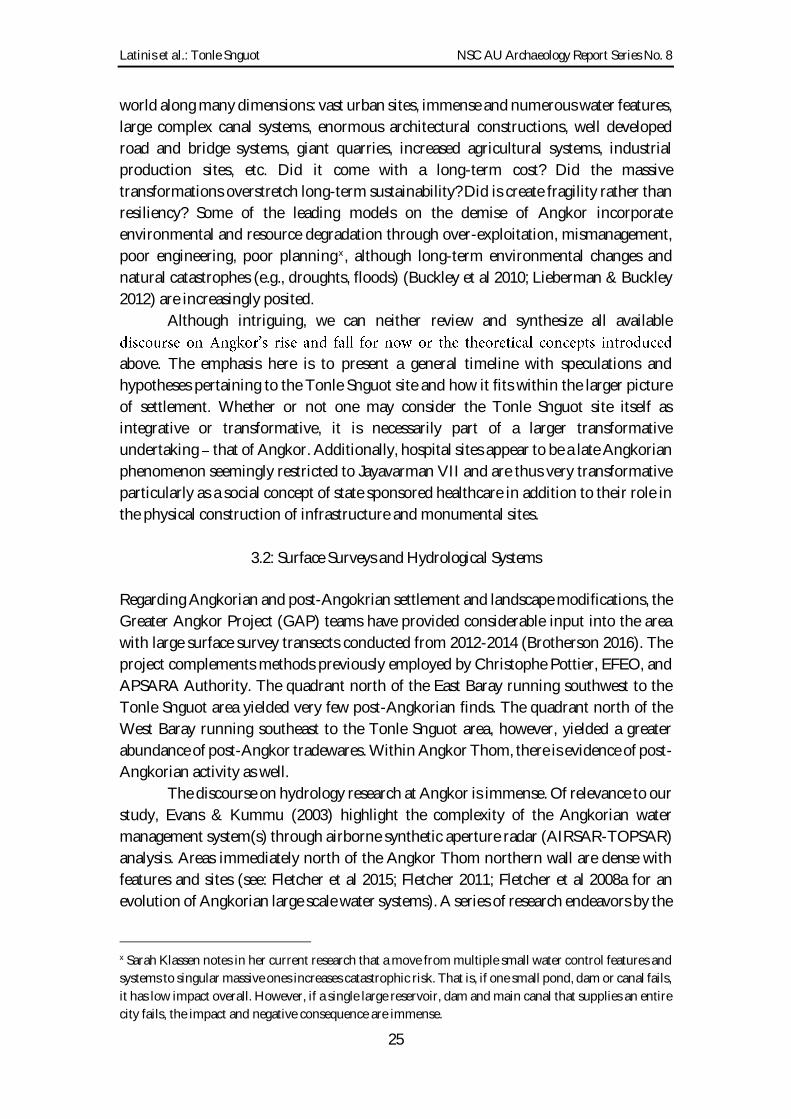
Figure 1: Location of Tonle Snguot (APSARA Map) ....................................................... 28
Figure 2: LIDAR image depicting Tonle Snguot and other major sites ......................... 29
Figure 3: Google Earth Image of Tonle Snguot highlighting the eastern reservoir
feature ............................................................................................................................. 29
Figure 4: Prasat Prei, Prasat Banteay Thom, Krol Romeas and other features ............. 29
Figure 5: East-West corridor of numerous large and transected rectilinear features .. 30
Figure 6: Features and plans for typical hospital sites (Prasat Ta Nup; from Im
2014) ............................................................................................................................... 36
Figure 7: Plan view of chapel and hospital complexes from Thailand (from Im
2014) ............................................................................................................................... 37
Figure 8: Plan view and site features for 30 comparable structures in Thailand ......... 38
Figure 9: LIDAR plan image of Tonle Snguot ................................................................... 41
Figure 10: Possible moated mound features to the west of Tonle Snguot (not
surveyed) ........................................................................................................................ 42
Figure 11: Plan image of Tonle Snguot depicting core and test unit locations (a);
possible grid patterns (b); structural and water features highlighted (c). .............. 43
Figure 12: Google Earth image depicting areas of current settlement and land use .... 44
Figure 13: Tonle Snguot Chapel (photo by Ea Darith) .................................................... 50
Figure 14: Tonle Snguot entryway (photo by Ea Darith)................................................. 50
Figure 15: Plan view depicting test units and main features ........................................... 52
Figure 16: Dvarapala statue in situ (photo by Ea Darith) ................................................ 54
Figure 17: Dvarapala head in situ (photo by Chan Wai Peng) ....................................... 54
Figure 18: Dvarapala statue at conservation storage area (photo by Chan Wai
Peng). .............................................................................................................................. 55
Figure 19: Dvarapala removal ceremony (photo by Ea Darith) ...................................... 56
Figure 20: Crystal (photo by Ea Darith) ............................................................................. 56
Figure 21: Arm fragment from broken statue (photo by Ea Darith) .............................. 57
Figure 22: Carved elephant (photo by Ea Darith) ............................................................. 57

Latinis et al.: Tonle Snguot NSC AU Archaeology Report Series No. 8
6
Figure 23: Feet and pedestal from broken statue (photo by Ea Darith) ......................... 58
Figure 24: Smoothed stone with grooves (photo by Ea Darith) ...................................... 58
Figure 25: Iron object (knife) (photo by Ea Darith) ......................................................... 59
Figure 26: Iron object (nail) (photo by Ea Darith) ........................................................... 59
Figure 27: Skeletal and teeth remains from Unit E02 (photos by Ea Darith)................ 60
Figure 28: Post-hole feature (photo by Ea Darith) ........................................................... 61
Figure 29: Buddha/Bodhisattva statuary in situ during excavation (Photo by Chan
Wai Peng) ....................................................................................................................... 62
Figure 30: Buddha/Bodhisattva statuary in situ during excavation (Photo by Chan
Wai Peng) ....................................................................................................................... 63
Figure 31: Buddha statuary in situ during excavation head sheltered by naga
(photo by Chan Wai Peng) .......................................................................................... 63
Figure 32: Buddha statuary after removal (photo by Ea Darith) .................................... 64
Figure 33: Buddha head backed by sheltering naga (photo by Ea Darith) .................... 64
Figure 34: Buddha head and torso backed by sheltering naga (photo by Ea Darith) ... 65
Figure 35: Buddha/Bodhisattva head (Suryavairocana or Candravairocana);
articulates with Figure 36 body (photo by Ea Darith) .............................................. 66
Figure 36: Buddha/Bodhisattva (Suryavairocana or Candravairocana) body and
pedestal; articulates with Figure 35 head (photo by Ea Darith). ............................. 67
Figure 37: Buddha legs, hands and pedestal (unknown if Bhaisajyaguru possible
object in hands is indeterminate) (photo by Ea Darith). ......................................... 68
Figure 38: Bhaisajyaguru (Medicine/Healing Buddha) legs, hands, pedestal (note:
fruit, jarlet of covered box in hands) (photo by Ea Darith) ..................................... 68
Figure 39: Ceremony for group blessings, protection and removal of statuary
(note: Buddhist statuary in background) (photo by Chan Wai Peng) ................... 69
Figure 40: Ceremony for group blessings, protection and removal of statuary
(note: Buddhist statuary in foreground) (photo by Chan Wai Peng) .................... 69
Figure 41: Unit W01 northwest view (photo by Sok Chanthida). ............................... 70
Figure 42: Unit W01 south view (photo by Sok Chanthida). ....................................... 70
Figure 43: Unit W01 east view (photo by Sok Chanthida) ........................................... 70

Latinis et al.: Tonle Snguot NSC AU Archaeology Report Series No. 8
7
Figure 44: Iron tool from Unit W02 (photo by Ea Darith). ............................................ 72
Figure 45: Unit W02 south view (photo by Sok Chanthida). ....................................... 72
Figure 46: Unit W02 southwest view (photo by Sok Chanthida). ............................... 73
Figure 47: Assorted ceramic remains (photo by Ea Darith) ............................................ 76
Figure 48: Assorted ceramic remains 2 (photo by Ea Darith) ......................................... 76
Figure 49: Khmer Angkorian brown-glazed (photo by Sok Chanthida) ....................... 77
Figure 50: Assorted stoneware (photo by Ea Darith) ....................................................... 78
Figure 51: Assorted green-glazed stoneware (photo by Ea Darith) ................................ 79
Figure 52: Green-glazed stoneware with iron firing stains (photo by Ea Darith) ........ 79
Figure 53: Chinese glazed ware Qingbai covered box and white ware sherds
(Dehua-?) (photo by Ea Darith) .................................................................................. 80
Figure 54: Chinese glazed ware blue and white (mid-late Ming ?) and Qingbai
covered box (photo by Ea Darith) ............................................................................... 80
Figure 55: Assorted Chinese glazed ware (photo by Ea Darith) ..................................... 81
Figure 56: Tonle Snguot chapel with pedestal/base and broken feet in background
(photo by Foo Shu Tieng) ............................................................................................ 84
Figure 57: Pedestal with broken feet on surface (photo by Foo Shu Tieng) .................. 84
Figure 58: Bas relief at the Bayon temple medical/hospital scene (photo by D.
Kyle Latinis) ................................................................................................................... 86
LIST OF TABLES
Table 1: Artifacts by mass from all material culture bearing units. ................................ 75
Table 2: Ceramic densities per unit. ................................................................................... 75

Latinis et al.: Tonle Snguot NSC AU Archaeology Report Series No. 8
8
1: INTRODUCTION
1.1 Background
Tonle Snguot is a late Angkorian hospital site associated with the reign of King
Jayavarman VII (1181-1218 CE). Archaeological research was conducted at Tonle
Snguot from 28 July to 07 August 2017 by the Nalanda Sriwijaya Centre (NSC) and
APSARA Authority as part of the NSC-EAS (East Asia Summit) Archaeological Field
School. Preliminary research results provide insights concerning hospital complexes
and ancient medical industries in Cambodia.
The Tonle Snguot site is located outside the northern gate at Angkor Thom,
Siem Reap, Cambodia (Figures 1-
most complex Angkorian capital cities. Research is intended to elucidate the nature of
the hospital compound as well as its relation to Angkor Thom, surrounding features,
planning, politics, and ancient state sponsored services particularly public health and
medical industries.
The interdisciplinary Field School includes research and training components
in archaeology, art history, anthropology and related fields. East Asia Summit (EAS)
young professionals and research staff are trained in a multi-tiered experiential learning
environment. The annual project is funded through the Singaporean Ministry of
Foreign Affairs (MFA) with additional support from the APSARA Authority.
Excavation and training teams were composed of staff from NSC, APSARA Authority,
and other contributing organizations (e.g., the Hungarian archaeology team;
Cambodian Development and Research Institute). Local community members,
volunteers, and visitors were also key contributors.
This report is divided into a brief summary of the overall purpose (Section 2)
followed by two primary overviews (Sections 3 and 4). The overviews in Sections 3 and
4 provide theory, models, methodologies, preliminary assessments,
interpretations/speculations, and discussion points in addition to primary data. Section
5 provides a discussion on inscriptions by Hunter I. Watson. Section 6 discusses non-
local influence related to hospitals, medicine and medical industries. Section 7 provides
a recap, discussion, and additional topical subsections.
The first overview in Section 3 examines potential settlement histories and
landscape transformations at the northern areas around Angkor Thom. The purpose is
to better understand how the Tonle Snguot site was possibly articulated within urban
planning and the larger urban system(s). We are interested in the big picture down to
or did they emerge separately? Were hospitals allocated to a specific number of
communities, neighborhoods, or people? For example, was one hospital dedicated to
village clusters (e.g., 5-10 proximate villages); 15 neighborhoods; or 10,000 people?
Were hospitals strategically located to support military and economic logistics? Was
the Tonle Snguot site built over pre-existing sites, residential neighborhoods,

Latinis et al.: Tonle Snguot NSC AU Archaeology Report Series No. 8
9
agricultural lands, or empty space? What was the duration of hospital site operations?
What, if anything, was subsequently built over or into the hospital compound after
abandonment?
We also hope to help disentangle aspects of potentially larger-scale
transformations through time and space. For example, can we visually distinguish
different periods of construction, settlement, land-use, water system engineering, etc.
many of which may be partially superimposed in LIDAR, satellite, aerial photographic,
topographic map imaging? Can this be determined by ground survey and feature
identification? Does a 10th or 11th century configuration exhibit sufficient distinctive
traits that can be recognized through extensive 13th century major landscape
modification? Currently, algorithms for LIDAR analysis supported with input from
GIS, ground surveys, subsurface testing and other factors are promising (e.g., the
Hungarian team led by Dr. Károly Belényesy working at Koh Ker have made significant
progress along these lines).
These goals, however, are not new to Angkorian archaeology. In fact, APSARA
Authority, the Greater Angkor Project (GAP), Ecole Fran
(EFEO), and many other international teams have made considerable progress and
contributions. By comparison, our inputs are small and limited. Nevertheless, it
remains an important step in revising models for understanding larger picture
questions. Furthermore, the archaeological efforts are important for Field School
training in addition to the research results.
Our principal methodologies are based on map, satellite, and LIDAR analysis
(Evans 2015) followed by core sampling and controlled excavations in specifically
targeted locations. First, we identified patterns, features, and known sites during the
map and remote sensing analysis. Details are provided in Section 3. Findings were
compared to excavation results and core samples. Excavation results are provided in
Section 4. LIDAR, map and satellite image analyses were subsequently revisited for
further comparative study. Ideally, a robust survey, mapping and ground-truthing
campaign would be included in the overall methodology. However, only a limited
amount of surface ground-truthing in the immediate Tonle Snguot area was possible
during our research campaign. This needs to be rectified in future undertakings.
Fortunately, the GAP and other teams previously surveyed large sections of proximate
areas (e.g., Brotherson 2016 provided an overview lecture for the Field School). The
GAP team also tested the canal at the eastern edge of Tonle Snguot site (Wilson 2017).
Their results provide critically important comparative data.
The analysis in Section 3 also examines hospital sites in general followed by site-
specific considerations at Tonle Snguot. In addition to testing for settlement and
activity within the hospital compound, the team planned to test the canal, road, and an
artificial reservoir to the east of Tonle Snguot as part of the original strategy. However,
only the hospital compound and canal were tested during the 2017 season. The canal
had been previously tested by a GAP team (Wilson 2017) resulting in: 1) evidence of
proximate habitation; 2) post-hole features suggesting a previous wooden bridge
spanning the canal; and 3) a valuable geo-morphology/geo-archaeology analysis of the
Latinis et al.: Tonle Snguot NSC AU Archaeology Report Series No. 8
10
area, particularly the canal. The canal was further tested during current undertakings
to gain more insights on the nature and dimensions of the bridge as part of Mr. Im
Section 3 ends with a review and additional considerations of the larger picture.
A basic hypothetical temporal-functional model is provided. The model provides a
baseline for testing related questions. It is not intended as a life-history of Tonle Snguot;
rather, what to think about when conducting archaeology in the area.
As stated, the second primary overview in Section 4 provides preliminary
excavation results. Section 4 is descriptive, provides site and artifact visual data
(numerous images), and is also infused with analytic and interpretative discussion
points rather than entirely consigned to a separate section. Archaeological finds and
their implications from each excavation unit are discussed in separate sub-sections.
Statuary, pottery, other artifacts, and bas reliefs are also given attention.
Regrettably, we do not provide a comprehensive art historical assessment of
statuary, architecture, reliefs, and related material culture in this report. This is reserved
for a separate analysis. We do encourage others to use the images and data presented
here for their own research pursuits. The project members will be happy to supply
further information or imagery upon request.
Several near-complete Angkorian statues were identified and recovered from
the onset of the Field School. This was unexpected not that statues would be unusual
at the site during the Angkorian period rather, it is surprising that statues still exist at
the site given a history of statuary removal from Cambodian sites; subsequent
transference to museums and private collections; and the rampant looting that has
occurred in Cambodia for decades with statuary being extremely high value targets.
close to their original location, but not likely their original position during its
operational period). Some statues were assuredly displaced and perhaps broken
inadvertently/naturally after the collapse and breakage of architectural features. Others
may have been intentionally moved in antiquity. Some fragments may have been moved
in modern times. Following the unexpected statuary discoveries, our field operations
were adjusted accordingly. This resulted in deviations from the original plan.
Finally, we have yet to analyze the recovered artifacts, ecofacts, their spatial
distributions, soil samples, the stratigraphy, and other possibilities in significant detail
(e.g., phyotliths, pollen, residues, material compositions). These analyses will likely be
conducted in 2018 or later pending funding and scheduling. Once completed, this

Latinis et al.: Tonle Snguot NSC AU Archaeology Report Series No. 8
11
report will be augmented and adjusted. However, preliminary conclusions can be
drawn which may be of immediate use to archaeologists, art historians, and historiansi.
1.2: Settlement Area Dating, Urbanization, Abandonment, and Continuity Models
Most known sites and features in the surrounding area of Tonle Snguot are late
-1218 CE). Tonle Snguot
is only a few hundred meters from Angkor Thom. Nevertheless, sites in the larger
spatial context (i.e., extending several kilometers from Tonle Snguot in any direction)
represent several Angkorian periods ranging from the 9th/10th 14th centuries CE.
For example, the East Baray dates to the 10th century CE. The western bank of
the East Baray is only 3.1 km from Tonle Snguot. Large labor crews would have worked
in the area during its construction. They may have lived there, extracted resources,
processed materials, etc. resulting in various temporary and permanent sites as well as
environmental impacts. The same is true of the numerous major constructions within
and outside of Angkor Thom. Finally, we must consider that there were undoubtedly
rural villages, farming communities, and agricultural systems in the larger area; each
with various histories. The latter are a consistently understudied aspect of Angkorian
research with the partial exception of water control systems. LIDAR has recently
illuminated settlement studies considerably (Evans 2016), but most concerns are related
to latter urbanization particularly the orthogonal patterns at Angkor Wat and Angkor
Thom and population estimates rather than discerning the process of urbanization.
Without speculating on all possibilities it is important to highlight that there is
over half a millennium of major undertakings and settlement changes in the larger area.
Thus, we need to carefully consider the possibility of multiple periods of use, activities,
and settlement at all sites (temporary or permanent; small or large; functionally and/or
symbolically similar or different). We need to avoid the bias of designating specific
periodization and function of a particular site based solely on a few visible and
prominent criteria (e.g., designating Tonle Snguot as only [emphasis added] consisting
of a late Angkorian hospital complex because of the presence of a Bayon period shrine
and associated architectural features). It may have multiple occupation and use periods.
It is difficult to determine with ground surveys and LIDAR scans. Archaeologists are
well aware of these pitfalls. Nevertheless, Cambodian archaeology and historical
i We also acknowledge that Tonle Snguot may not be the centrally important site or site type in the area.
It is easy to become site-centric and inflate the significance of a site vis-à-vis a larger system of sites,
features and settlement. For example, it is likely that the northern gate area at Angkor Thom was far
busier, important, and populated than currently imagined. The hospital itself may have been one of many
services, industries, activity areas, and settlements in the area. In fact, there are several hospital
compounds around Angkor Thom. Likewise, the preeminence of the royal palace and other sites certainly
in many ways. However, it cannot be discounted that Tonle Snguot
indeed was a critically important site such as a medical supply restaging area, or an important
component to a busy commercial and military gate because of its location and/or some yet unknown
designation to serve a more specialized function.

Latinis et al.: Tonle Snguot NSC AU Archaeology Report Series No. 8
12
research often continue to be plagued by essentializing site histories into
compartmentalized time segments and functional categories defined by temporally and
structurally diagnostic art and architectural styles and/or inscriptions associated with a
particular site.
Although a single function and constricted use period for a site may be true in
some cases, exploring the full potential archaeological history in the larger context is
warranted. The Phum Lovea site ( 2016, 2015) provides a solid
example of partially overlaid, truncated, proximate, and quite different sites that are
clustered in a single area which represent numerous periods ranging from Iron Age
cemeteries to Angkorian water control features. Likewise, sites such as Prei Khmeng
and Koh Ta Meas that yield Iron Age settlement assemblages and burials in the Angkor
capital region (often built into and over by pre-Angkorian and Angkorian features and
sites) also warrant closer attention needed for research on earlier settlement histories,
urbanization trajectories, and continuity models ( 2016, 2015; see
also contributions to Journal of Southeast Asian Studies 2016 47[3] with introduction
by Murphy & Stark 2016). Thus, we need to be cautious not to over-focus only on the
Angkorian temples and architecture for defining temporal and spatial categories to
address, for example, settlement and ecological impact questions. This is an
increasingly cliché statement among researchers working in the region, but one that
needs constant reminding.
As stated, Phum Lovea in particular merits a need to thoroughly examine
possibilities of much earlier sites and settlements occurring in Angk -
urban landscapes; including research considerations related to settlement continuity,
urbanization, and complex polity evolution mentioned above (
2015). Phum Lovea is located west of the West Baray and contains an Iron Age circular
settlement and cemetery site with moats and earthen embankments. The site is adjacent
2015:3). Test excavations, material remains, and topographic analysis (inclusive of
LIDAR) indicate various manifestations of continuity through Iron Age, Ankgorian,
post-Angkorian, and historic periods including alterations and compromises to the site
throughout its history ( 2016:480; also acknowle
We have attempted to be comprehensive with our approach and questions
regarding Tonle Snguot and the larger context. What are the diachronic natures of
settlement, urbanization and landscape transformations in the larger urban and peri-
urban area, particularly around northern Angkor Thom and Tonle Snguot? Also, what
are the long-term anthropogenic histories, changes, and impacts in larger-scale areas?
Pre-Angkorian, Angkorian and post-Angkorian sites and features are found from the
Kulen Mountains (Phnom Kulen) to the Tonle Sap in the greater Angkorian capital
area and its surroundings. Iron Age sites exist. It is speculated that sporadic Neolithic
sites exist as well. Agricultural field systems and landscape features exist many of
which have unknown antiquities and development/use histories.

Latinis et al.: Tonle Snguot NSC AU Archaeology Report Series No. 8
13
The point is that resource abundance due to diverse, predictable, and productive
ecosystems as well as settlement potential in the area (biological, topographic,
terrestrial, aquatic, environmental, spatial, geographic, etc.) was ideal for human
populations throughout most of the Holocene. In fact, the eventual surplus production
potential, geography/location, and other factors (e.g., water systems and waterways)
were some of the most crucial factors for ancient complex polity formation in the area.
Thus, questions related to historical continuity are critically important. This
was also emphasized by the authors in the recent Journal of Southeast Asian Studies
(2016; issue 47[3]). We know Angkor was already emergent and urbanizing by at least
the 9th century CE. The presence of pre-Angkorian (Chenla) material culture and sites
suggests urbanization processes occurring from at least the 7th-8th centuries CE. As
n (2015) emphasize, the roots probably extend to at least the Iron Age.
Nevertheless, at Tonle Snguot and the immediate surrounding area there are
presently no prominent archaeological indicators that predate the Angkorian period.
Thus, it is equally important to ask why earlier sites and features are not present at or
choice for settlement until massive urbanization measures were available and provided
the necessary incentives. Many hypothetical models can be devised and we will continue
to discuss several.
On the other hand, some of the pottery remains post-date the 14th century. This
accords with the GAP surveys and evidence for continued settlement and use of the
area in the centuries following the demise of Angkor (Brotherson 2016).
We also must consider questions of de-urbanization and associated settlement
pattern, socio-political, economic, and environmental shifts for centuries related to and
following the demise of Angkor. There are some post-Angkor settlement, some
indicators of connections to long-distance value chains, and some evidence of visitation
from travellers and pilgrims but nothing as intensive as the mid to late Angkor period.
De-urbanization is not frequently studied in depth, although collapse models
are prevalent. Processual or diachronic abandonment models addressing density
decline, settlement dispersal, and long-term economic, political and
environmental/ecological shifts have not been as abundantly considered as rapid
collapse models in the past (e.g., war, political fragmentation, rapid economic
decay/collapse, environmental catastrophe), although new paleoclimate data, for
example, offer severe environmental fluctuations such as long-term drought and floods
as prominent contributing factors (Buckley et at. 2010).
The distinctions we make between diachronic decline models and rapid collapse
models are not necessarily mutually exclusive and exact. They are merely arbitrary
points on multi-dimensional continuums. Our definition is relative. We define rapid
collapse models as comparatively synchronic, such as an event (e.g., invasion,
catastrophic natural disaster, hydraulic system failure) with a focus on major
contributing factors within a single generational time span, for example, as a temporal
division for major driving forces. Diachronic decline models necessitate multi-
generation time spans and long-term forces that are frequently less evident to historians
Latinis et al.: Tonle Snguot NSC AU Archaeology Report Series No. 8
14
(e.g., multi-generational forest resource degradation; sea level shifts affecting salt
supplies; global warming). However, diachronic decline models may be heavily
these punctuations, like major events, have varying
overall cumulative impacts. When both forces are in operation, they sometimes synch
in both very positive and very negative manners. It is important to recognize our
considerations of these varying forces.
Of importance for the discussion, however, is that the Tonle Snguot hospital site
construction, support, operations, and related activities are apparently restricted to the
reign of Jayavarman VII (1181-1218 CE). Although some support and operations may
have lingered with his immediate successors (e.g., Indravarman II; 1218-1243 CE), it
seems more
and therefore a presumed lack of continued support for the state medical industry by
his successors.
Thus, the hospital aspect of the urban socio-cultural and physical environment
may fit a more rapid emergence and decline model. At a slightly greater scale,
Jayavarman VII may have over-extended. There are arguments this assisted the decline
of Angkor (i.e., he spent all the money and resources). Most of his sites remain
unfinished.
culture of inward looking economic and socio-political conservatism whereas a culture
of extra-local and extra-regional active entrepreneurship never developed, lending
them to be readily outcompeted by neighboring polities beginning as early as the
13th/14th centuries and certainly by the 15th century onwards (Latinis 2017ii).
Returning to the major issues at hand, the greater urban, peri-urban and
hinterland settlement area at Angkor has a lengthier history as previously indicated.
The positive correlation unsurprisingly follows a pattern of increasing numbers of sites
and temporal spans of settlement with an increase in geographic scale and research
attention. However, the non-Angkorian long-
around the capital are only beginning to be the focus of increased attention (again, refer
to continuity models mentioned above).
As a final note of interest and change of pace (the relevance is clarified below),
B. P. Groslier (2006: 4) suggests that the Royal Palace (and whole city of Angkor Thom)
seems to have been wholly abandoned by 1430 based on archaeological evidence of
uppermost levels at the Palace, but that the rest of Angkor (e.g., Angkor Wat) was
readily accessible, known, and still used by at least the 16th century onwards according
to various documents and inscriptions albeit certainly not to the urban intensity and
area were,
Groslier 2006:16) unlike Angkor Thom which was covered in
dense jungle. Groslier continues to state (2006:16):
ii Latinis (2017) notes that both shipwreck data and terrestrial data have an abundance of Chinese, Thai
and Vietnamese pottery throughout Southeast Asia, but hardly any Khmer ware.

Latinis et al.: Tonle Snguot NSC AU Archaeology Report Series No. 8
15
It is difficult to see why only a part of Angkor, and one particular part, was
invaded by the Jungle. One can realistically suppose urban life under the last
Khmer kings was concentrated around Angkor Thom. It is in this part that we
can find the greatest number of constructions after the thirteenth century. This
therefore was the area which, more than any other, was sacked by the Siamese
in the fourteenth and fifteenth centuries. The horrors of was, the systematic
destruction of the water reservoirs and hydraulic works, led to the abandonment
of the area, whereas the open countryside to the south and west remained
inhabited and tilled by the Cambodians. When we speak of Angkor being
abandoned about 1432, we mean that Angkor Thom as the royal capital was
deserted, and not that the country was entirely depopulated.
This may relate to a pattern of palace and partial urban de-intensification of use and
abandonment of the area for at least a few generations following the demise of a
particular Prominent ruler. This is somewhat evident at the palace areas at Phnom
Kulen (Banteay site; Jayavarman II) and Koh Ker (Jayavarman IV). Perhaps there was
a strong social-symbolic, spiritual or psychological reason (e.g., ill fortune, ghosts,
dangerous forces, neak ta) why those particular areas would become taboo for
that particular area
within multi-generational memory. Additionally, there may have been a negative event,
set of conditions, or uneasy feeling associated with the place that became reinforced in
myths, legends and other beliefs. Hence, reuse or continued use may not manifest in
specific locales for long periods. Thus, the abandonment of Tonle Snguot (and other
Angkor Thom hospitals) may be related to the abandonment of Angkor Thom in
general. However, simultaneous hospital operations ceasing throughout the kingdom
at sites located far away would better reinforce the hypothesis that economic, physical
and human resource support ended as succeeding kings (and the state) may neither
have had the desire nor the means to continue support.

Latinis et al.: Tonle Snguot NSC AU Archaeology Report Series No. 8
16
2: PROJECT PURPOSE
2.1: General Concerns
The overarching purpose of the project is to further understand the nature of hospital
sites during the late Angkor period particularly related to Jayavarman VII.
Jayavarman VII was the tantric Mahayana Buddhist King who reigned in the late 12th
to early 13th centuries (1181-1218). Jayavarman VII is famed for the construction of
massive urban complexes, temples, roads, water control features, infrastructure, and
industry development. It remains difficult to discern if many industries were wholly or
partially state/elite sponsored, controlled, and maintained (Latinis & Ea 2017). The lack
of a cash economy, however, seems to support centralized control to a degree, but
archaeological evidence is lacking and there are examples of semi-decentralization,
federation, confederation and certainly internal conflict and competition at various
periods. The hospital sites, however, appear to be state sanctioned and supported.
Professional medical staff were appointed. Site complexes including shrines, statuary,
walls, libraries (and texts), ponds, entryways, bridges, roads, paths, and other features
were built. Other assets such as labor, land, and resources were provided. Special
medicines and ingredients were evidently redistributed from the Ki
(Sharrock 2017; pers. comm.).
It is difficult to determine if the emergence of state sponsored medical industries
and hospital construction could have been at least partially a response to public health
concerns at the time (e.g., disease and epidemics in an increasingly populated area;
Gundersen 2015); and/or, related to political, social, and economic maneuvering.
Hunter I. Watson (pers comm; 2017; see also Gundersen 2015) noted that outbreaks of
various diseases occurred in Thailand during similar periods. Perhaps Jayavarman VII
public health out of altruism; but it cannot be ignored that public healthcare support
would have enhanced charisma, popularity, and allegiance as well as productivity and
efficiency through a healthier workforce and military. It also cannot be ignored that
providing healthcare and welfare for his people, Jayavarman VII (a tantric Mahayana
Buddhist) gained merit for himself and the kingdom (special thanks is extended to
Hunter I. Watson for further elaborating this point during a recent seminar). It is
equally important to emphasize that state support of the medical industry provided
opportunities and jobs (e.g., construction workers to build hospital facilities,
maintenance crews, producers and suppliers of medical goods, medical professionals,
provided jobs and opportunities for a very extensive population both in the capital and
throughout the empire.
Inscriptions indicate Jayavarman VII ordered 102 hospitals to be built and
staffed throughout the kingdom (Ta Prom inscription see 1940, 1941; Finot
1915a; Say Fong inscription - see Finot 1903; Briggs 1951) (refer also to Dagens 1991).
Hospitals were to provide public welfare and medical treatment. This included physical,

Latinis et al.: Tonle Snguot NSC AU Archaeology Report Series No. 8
17
spiritual and mental health. Medicine and medical treatments were almost certainly
intertwined with religious and spiritual beliefs and practices. Importantly, the hospitals
and medical services were available to the general population elite, military, and
commoners alike possibly to include foreigners. However, it is unknown if patients
had to pay, were partially subsidized, or, were provided free services through donations,
state taxation, and good will.
The hospitals undoubtedly served military and economic goals as well: supply
chains, distribution, logistics, a healthy workforce, etc. The building of roads, other
supporting travel infrastructure (e.g., water reservoirs, rest houses, hospitals), and
urban complexes were related to settlement hubs and industry locations. That is,
hospitals, infrastructure, and various services industries, for example, were located in
population centers and industrial production locations (e.g., a hospital site is located
proximate to the Torp Chey kilns (Ea 2015); Banteay Chhmar contains several hospital
complexes; Phimai has a hospital structure including several hospitals on the road from
Angkor to Phimai; Preah Khan at Kampong Svay has a neighboring hospital site
(Hendrickson & Evans 2016); even the 10th century capital at Koh Ker contains a
12th/13th century hospital site). Besides hospitals and rest houses, many Angkorian kilns,
quarries, and metal processing sites are located proximate to road networks. Traders,
service communities, and agrarian support communities would have gravitated
towards these areas.
Thus, roads may have been planned in accordance with existing population
hubs and industries, and, may have also affected settlement shifts and industry
development such that they relocated or developed closer to road networks (refer to
point is that settlement shifts due to roads and other infrastructure may have resulted
in the subsequent planning and placement of hospitals in addition to hospitals being
placed in areas that were already populated, urbanized, or contained industries and
infrastructure. Both cases may be valid: 1) a road was built to an existing hub and
hospital placement was part of the design; 2) settlement and industry shifts occurred
when roads were built and hospitals were then placed in response to those shifts.
However, it is imperative to highlight that the spacing of hospitals and rest houses on
key roads were consistent, suggesting most were likely part of advanced composite
planning rather than the result of post hoc placements following settlement shifts that
were a response to infrastructure and road development. Further contemplations of this
did the chicken or egg come first; or did both come together
scope of this introduction, but these are important points to consider.
A spectrum of considerations have been introduced in the section above. Thus,
it should be clear that we are not only concerned with the Tonle Snguot site as a closed-
system and bounded physical phenomenon with a specific purpose, but the Tonle
Snguot site in the context of larger considerations along multiple dimensions (physical,
functional, social, symbolic, settlement, ecological, urban and infrastructural planning,
etc.) and vice versa.

Latinis et al.: Tonle Snguot NSC AU Archaeology Report Series No. 8
18
2.2: Specific Goals
Regarding the various physical components and features that comprised a hospital
compound, the chapels (temples/shrines), libraries, walls, entryways, gopura, formal
ponds, and other architectural and art historical elements are more well-documented
(Im 2014 who refers to Journal Muang Boran 2004; Finot 1903; 1940; Chhem
2004, 2005). This is primarily because of their visibility, durability (often made with
stone and laterite), and aesthetic value in addition to a past dominance of ancient art
and architectural discourse vis-à- arch history.
Surprisingly, there are few comparative and holistic studies on hospitals. And, what
about everything else, particularly the archaeology?
archaeological soil-core testing and stratigraphic excavations related to settlement and
site activities. The project aimed to address the nature of the following: a) site-complex
layout (spatial organization), function and symbolism inclusive of evidence for
organic structures; such as, wooden houses, dormitories, processing structures, and
bridges; specialized activity areas; gardens possibly medicinal gardens; water features;
etc.); b) the nature of specific site activities and site use; c) occupational and activity
sequence(s) including possibilities of multiple period evolving settlement and site
function; d) site ecology; and e) material culture. These aspects remain largely unknown
and under-tested. Only one other hospital site has been systematically excavated: Prasat
Tromoung lo & Chhem 2008). Prasat
Tromoung yielded evidence of habitation and domestic activities, wooden structures in
addition to the existing stone architecture, a necropolis, numerous pottery sherds and
other artifacts, and 12th-13th century dates.
Lastly, research at the Tonle Snguot site also provided a platform to train East
Asia Summit (EAS) participants and project staff through the Nalanda Sriwijaya
-Yusof Ishak Institute, Singapore) Archaeological Field School in
partnership with APSARA Authority, Cambodia.
Latinis et al.: Tonle Snguot NSC AU Archaeology Report Series No. 8
19
3: SETTLEMENT HISTORY, LANDSCAPE, HOSPITALS AND THE TONLE
SNGUOT SITE
The following section provides a preliminary discussion of larger-scale geographic and
temporal settlement, landscape, and ecological history among other phenomena. It is
chiefly concerned with assessments and speculations based on pre-excavation and post-
excavation background research and image analysis. We emphasize it is highly
speculative. The intention is to facilitate further considerations for future modeling and
testing at varying scales of analysis. We first considered large-scale geography, modified
landscapes, settlement and ecology among other issues. The following sections will
consistently narrow to smaller site-scale and finally specific test unit finds in Section 4.
he end.
3.1: Large-Scale Settlement, Landscape Modification, Ecological, Economic and Social
History
Before delving into a discussion of settlement, image, landscape, and topographic
analysis, it is important to emphasize that this report is preliminary and cursoryiii. The
contributions of numerous research projects over several decades from multiple
nations and institutions have provided a wealth of knowledge, new interpretations, and
innovative methodologies. Apologetically, these are impossible to summarize here.
These studies have enhanced several aspects of our own efforts. We hope our modest
contributions will assist others in building a more integrated, nuanced and larger
comprehension of ancient Angkor.
The Angkorian region including areas in and around the capital was settled by
Bronze an Iron Age communities in the first few millennia BCE to the early first
millennium CE. The Phum Lovea site located in the Angkor area is the one of the most
recently studied Iron Age examples ( 2016). Prei Khmeng and Koh
Ta Meas (Western Baray) also contain Iron Age sites with burials beneath pre-
Angkorian and Angkorian sites and features (Pottier 2006a, 2006b)(note: these sites are
iii Needed are detailed understandings and dedicated research efforts related to: hydrology; overall
regional settlement; modern and ancient agricultural field systems; modern and historic landscape and
infrastructure modifications; modern and historic settlement and land-use changes; datable architectural
and art historical features (there are many in the wider zone of analysis); results from previous
archaeological studies in neighboring areas; dedicated inscriptional/epigraphic analysis related to project
research questions; analysis of large project findings such as the Greater Angkor Project surveys (Fletcher
2011; Fletcher & Evans 2012; Fletcher et al 2008a, 2008b; Evans et al 2013); archival research and other
related endeavors. Eventually, that is our long-term goal. We would also like to include species-genera
analysis of the local ecology from micro to macro scales (i.e., biological as well as physical landscapes).
This is part of our research interests in historical ecology. There are methods and data available (e.g., bas
reliefs indicating numerous species of plants, animals and a variety of natural and artificial ecosystems;
faunal, botanical, pollen, and phytolith studies; e.g., Penny (2014); Penny et al. (2005, 2006, 2007); Castillo
(2016) who identified rice, pomelo and ginger at Angkor Wat). Similar analyses are proposed but are
contingent upon sample availability and funds.

Latinis et al.: Tonle Snguot NSC AU Archaeology Report Series No. 8
20
alternatively classified as protohistoric see Heng 2016 for a more detailed discussion).
There is a high possibility of Neolithic sites in the region, though few have been
identified and studied in detail.iv
Communities farmed rice, gardened, tree-cropped, fished, raised livestock,
hunted, exploited wild forest resources, developed specialized craft industries, and
traded. Over time, they developed increasingly larger settlements with increasingly
larger, more sophisticated, and more transformative landscape modifications and water
management systems. They buried their dead in cemeteries with grave goods. They
were integrated in local and long-distance value chains. The exotic material culture
ranged from distant regions in Southeast, South, and East Asia especially by the late
Iron Age/early Funan periods. India and China were heavy influencers culturally and
economically.
At a more regional and coarse-grained scale of analysis, there was a common
culture of practice, ecology, socio-cultural-economic value chains (exchange), and
communication (probably similar languages) across the riverine and floodplain region.v
by the late Bronze and early Iron Ages. Sites such as Laang Spean (Forrestier et al 2015)
indicate early Holocene to Neolithic settlement. Whether or not the seeds of a common
macro-culture were sewn in these periods remains unknown. On the other hand,
imagining a purely homogenized culture over a broad area is dangerous and we would
expect varying manifestations of meaningful diversity as well as continued
diversification. It may seem contradictory to suggest a common connected macro-
culture with a mosaic of diverse micro-cultures, but it can be argued as normative in
certain circumstances. Where was the medical culture at this time? This is hard to
imagine, but it was probably highly localized in practice (i.e., local practitioners), but
maybe more widespread in medicines and medical treatments.
Beginning with the Bronze Age and especially by the mature Iron Age the
situation was reflective of significantly increased interaction and more accentuated
wealth differentiation, increasing social hierarchies, differential status, specialized
production, long-distance exchange, and overall complexity (Higham 2016; refer also
to other examples in JSEAS 2016 47[3] special issue). The period was characterized by
more effective and efficient technology; surplus production; environmental
engineering; access to exotic goods and wealth/prestige items; ability to engage in
increased trade and larger value chains with greater variety of goods (staple products to
high value prestige items and symbols of power); and more complex management
structures. These aspects likely assisted emergent elites to incentivize, mobilize, and
iv The Laang Spean site has been thoroughly reexamined; See Forrestier et al 2015. v It is possible to include coastal settlements. There are relevant reasons why coastal settlements could be
included (e.g., obvious integration into long-distance socio-economic value chains) and equally relevant
reasons why they may have quite separate and distinct trajectories (e.g., they had strand/maritime
economies; possible seafaring and shipping capabilities; possibly more frequent interactions and stronger
connections with much more ethnically diverse peoples as would be expected in port-like areas and
among maritime traders interestingly, the latter can be argued to have parallels with inland groups and
ethnic hill tribes). These models will be explored elsewhere.

Latinis et al.: Tonle Snguot NSC AU Archaeology Report Series No. 8
21
manage workgroups for increasingly larger-scale projects.vi They could also consolidate
and centralize power. As far as medical practices, specialists may have travelled or been
sought after.
This trend consistently and at times dramatically and quickly increased in scale
and complexity through time and space. For example, a) the transition to the Iron Age
(ca. 500 BCE); b) incipient urbanization (ca. 1st century BCE 1st century CE); and c)
the mid-centuries CE changes that included shifts in mortuary practices (cessation of
burial practices), monument construction, statuary production, dramatic primary
settlement size increases, increased socio-political complexity, the introduction of
writing (inscriptions, texts), and differing forms and intensities of outside influence
(not ignoring reciprocal relations and local agency) may have been periods of highly
accelerated changes technological, socio-cultural, political, and economic among
other dimensions. However, we do not know the true extents to which communities
integrated, accommodated, transformed, impacted, managed, or mismanaged their
vi In other words, time and energy needed for food production decreased while surplus increased. Surplus
was capital. This could be converted to supporting larger projects and importing wealth. Jobs, wealth,
and prestige provided incentives. Better management and group effort also increased efficiency.
Opportunities to further develop industries and incentive-based communal projects became increasingly
available. The larger and more complex the projects, the more jobs and job variability occurred. This also
required more complex management hierarchies. Increasing complexity of differing levels of roles,
power, authority, and wealth were inevitable. This continued to very large scales. However, the efficiency
and manageability curve may have decreased (i.e., points of diminishing returns, even up to points of
critical inefficiency and failure). Moving from one threshold to the next was both steady and punctuated.
The Iron Age technology shift around 500 BCE; incipient urbanization around the first century CE;
emergence of major architectural and statuary constructions with shifts in belief systems, burial practices,
and political hierarchies around the late Funan period; shifts in the Chenla period and then again in the
changes in many sectors of society. Nevertheless,
gradual changes and expansion continuously occurred. Very few places/settlements were likely static or
frozen for long periods of time. These are certainly not a new considerations and models. Rather, they
are grounded in basic economic, ecological, socio-political and evolutionary principals at the core.
Additionally, the model is not intended to ignore phenomena such as slavery and why and when
slavery would occur (e.g., either more efficient labor; or, at the points of diminishing returns); or the need
for force, threat, displays of power and negative incentives; cult/religion that emphasize non-material
incentives, disincentives, reinforces the social and power order, and so forth. These notions can be readily
incorporated.
The model also accommodates local continuity in evolving social complexity as well as multiple
degrees and types of outside influence. This is not the venue for detailed discussion of these issues here.
Rather, we want to highlight some of the theoretical underpinnings in our modeling. State health care,
for example, might be one of the public incentives: providing services, jobs, spiritual and physical
incentives, and so forth.

Latinis et al.: Tonle Snguot NSC AU Archaeology Report Series No. 8
22
total resource environmentsvii, social orders, and networks from local to regional scales.
We also do not know the true diversity of communities that existed from rural
hinterland groups to emergent urban and possibly immigrant or diasporic
communities. [Were certain medicines, medical treatments and medical knowledge
being transshipped from highland areas to other settlements, for example?]
Nevertheless, we do know that most riverine and floodplain areas were more
densely settled from Thailand through the lower Mekong. This is in contrast to the
comparatively sparse Neolithic settlement evidence. Some Bronze and Iron Age
settlements included areas in what would later become Funan, pre-Angkorian and
Angkorian urban sites (Murphy & Stark 2016; 2016; Heng 2016; see
also Murphy 2016; and Rispoli et al 2013 for parallels in Thailand with proto-Dvaravati
and Dvaravati models).
By the Funan period from the 1st- 6th centuries CE viii urbanization, social
complexity and larger-scale landscape impacts had significantly evolved (refer to
examples in the JSEAS 2016 47[3] special issue). The Funan urban site at Angkor Borei
(likely the capital), for example, demonstrates early urbanization and continuity from
the Iron Age (e.g., Wat Kamnou; Phnom Borei) with large-scale landscape
transformations. [We know almost nothing about the Funanese medical industry, but
the potential is sufficiently high given the vast amount of diverse material culture and
sites available for further study.]
Angkor Borei has a 20 meter wide, six kilometer long, amorphic wall with
adjacent moats. The wall is mostly built of clay. Evidence of brick interiors occur in
some places, although these may be architectural features embedded in the wall. Some
areas contain evidence of settlement or activity areas on top of the wall as well. The wall,
moats and other attached features primarily serve to manage water. Though large, the
wall integrates with, rather than drastically redesigns, the local topography and ecology
Angkor Borei being an island during the wet seasons when the exterior landscape is
vii Regarding ecology, what were the impacts of forest clearance for agricultural expansion, construction,
fuel, and infrastructure expansion; introduction of exotic plant and animal species some possibly being
destructive invasives; domestication; agriculture; aquaculture; species-genera ratio transformations in
forest plots and other ecosystems; wholesale ecosystem transformations; over-exploitation and depletion;
etc.? It is also noted that numerous cumulative micro-transformations may have had larger regional
impacts. It is also important to emphasize that ecosystems are not necessarily naturally stable and static.
They constantly evolve with speciations, extinctions, introductions/invaders, changes (physically and
biologically), etc. including major and minor shifts; constant and punctuated. They have differing
resiliencies and fragilities, however. viii The 1st- 6th centuries CE is a timeframe used by most historians, but not necessarily as clearly
compartmentalized temporally in the archaeological record. Work at Angkor Borei clearly for example,
clearly extends the timeframe to the early centuries BCE to the pre-Angkorian onwards (Stark et al 1999)
the archaeological overlap and divisions among Iron Age and Funan practices and material culture are
quite different than the historical narratives imply.

Latinis et al.: Tonle Snguot NSC AU Archaeology Report Series No. 8
23
significantly flooded ix
-scale landscape
modifications represents continuity from the Metal Ages. The size and scale of the wall
and settlement, however, could be interpreted as intermediary (it is recognized that
metal age moated sites and Neolithic banteay kou [circular earthwork sites], for
example present problems and debate with this modeling: see below). There are also
several notable artificial canals in the Angkor Borei region some of which have direct
connections to the site. These could be classified as more transformative in nature. The
Oc Eo Funan site in Vietnam connected via canals to the Angkor Borei area some 90-
100 km away is also geometrically designed in a manner that appears more
transformative.
-à-
vis landscape, physical, biological, ecological, social, etc. modifications. Theoretically,
both are merely arbitrary points on a continuum and can occur simultaneously
depending on the scale and nature of analysis.
The integrative/accommodating approach operates with the existing
environment, topography, hydrology, and ecology (e.g., many of the circular moated
Bronze and Iron age sites in Thailand and Cambodia; see Boyd 2008; Evans et al 2016;
& Scott 2015; Scott &
& Bong 2001). That is, populations target desired areas for settlement and embellish
them physically, ecologically, and socially. Impacts are initially not as pronounced and
transformative at larger area scales of analysis (e.g., 10-50 km radius), but they may
desirable areas are frequently less available. It is possible these areas need enhanced
embellishments. Fortification and moating may occur for competitive and defensive
purposes as well as ecological-economic reasons (e.g., water storage in moats),
cumulatively becoming more transformative at larger area scales of analysis.
Alternatively, the transformative approach is defined by significantly reworking
landscapes at larger scales or entirely manufacturing new ones from an original master-
plan design as a high-input large-scale undertaking (e.g., the West and East Barays at
Angkor; the Rahal and massive dam at Koh Ker; Angkorian road networks and urban
complexes; Angkorian mines; massive forest clearance for new agricultural and
irrigation systems). Transformative approaches are defined as generally more artificial
and larger scale. However, it is noted that artificiality if properly designed and managed
ix This may also explain the deeply stratified cultural deposits compared to areas like Angkor or Sambor
Prei Kuk where non-flooded land may have been more readily available during the wet seasons allowing
settlement expansion rather than reuse of the same locations and density increase. Nevertheless, the
deposits tested at Angkor Borei were generally at Wat Kamnou and closer to the river front (Stark et al
1999) perhaps a much busier and densely inhabited area. Deposits further away from the river front,
current market area, and Wat Kamnou appear less deeply stratified. Incidentally, Phon Kaseka (2004)
excavated burial sites similar to those recovered from Wat Kamnou at a habitation and cemetery complex
at the base of neighboring Phnom Borei. Further settlement testing is warranted.

Latinis et al.: Tonle Snguot NSC AU Archaeology Report Series No. 8
24
does not necessarily indicate less diversity and increased fragility as is appropriately
argued for some areas. In some cases it can create desired stability and predictability.
These concepts need not be restricted to only topography and/or hydrology. It
is not necessarily the physical scale of earth and rock moved and reshaped. For example,
the species-genera communities and their ratios may be slightly altered in the
integrative model while entirely reworked in the transformative. An example of the
former would be the introduction of a few new plant or animal species to a forested
environment, or, the reduction of frequency of one or a few species and an increase in
frequencies of others. Examples of heavily transformed biological environments might
be the conversion of forest to grassland or rice paddies (note: this can also occur without
changing the actual topography or main water flow systems dramatically), replacement
of wild habitats and fauna with domesticated animals and their habitats such as
conversion of forests and swamps to grazing ranges, or desertification in extreme cases.
Additionally, diachronically cumulative accommodating efforts may eventually
become significantly transformative. For example, the expansion of a few simple
farming and irrigation efforts by small rice growing communities through forest
clearance and minor tapping of streams may have expanded over time resulting in
major hydrological changes and large-scale forest clearance with increased wood-fuel
consumption, agricultural expansion and intensification (also conversion of
ecologically diverse communities to less diverse monocropping systems). They may
have also continuously filled and expanded settlement and household mounds over
time in parallel with population/settlement size increases. These combined diachronic
efforts may have altered topography dramatically. In the case of mining, quarrying,
leveling, and excavation (e.g., water storage features, canals, moats, and soil mining for
mounds) a cumulative transformative effect was achieved. These concepts are actually
quite common to considerations of landscape modifications. And, population size and
density are factors to consider for obvious reasons. Nevertheless, it is important to
clearly define them here.
During the subsequent period ca. 7th-8th centuries CE, more formalized,
geometrically designed and symbolic centers with a boom in monumental architecture
and major landscape modifications emerged (e.g., Sambor Prei Kuk Isanapura). This
included a scalar shift in environmental and landscape transformations to suit urban
settlement needs. Large-scale topography and hydrology were increasingly redesigned
and manipulated, if not outright manufactured; rather than being
accommodated/integrated or less grandiosely re-worked at smaller scale segments.
That is, there was more wholesale landscape transformation an endeavor requiring
much more labor and management effort including more sophisticated design,
planning and engineering. Landscape integration and modification approaches did not
necessarily disappear or diminish, however. The transformative approach at larger
scales simply became more accentuated especially around urban centers. Cumulative
integrative approaches also evolved to be more transformative.
By the Angkorian period, the scale of environmental transformations and
impacts were massive. These transformations were among the largest in the ancient
Latinis et al.: Tonle Snguot NSC AU Archaeology Report Series No. 8
25
world along many dimensions: vast urban sites, immense and numerous water features,
large complex canal systems, enormous architectural constructions, well developed
road and bridge systems, giant quarries, increased agricultural systems, industrial
production sites, etc. Did it come with a long-term cost? Did the massive
transformations overstretch long-term sustainability? Did is create fragility rather than
resiliency? Some of the leading models on the demise of Angkor incorporate
environmental and resource degradation through over-exploitation, mismanagement,
poor engineering, poor planning x , although long-term environmental changes and
natural catastrophes (e.g., droughts, floods) (Buckley et al 2010; Lieberman & Buckley
2012) are increasingly posited.
Although intriguing, we can neither review and synthesize all available
above. The emphasis here is to present a general timeline with speculations and
hypotheses pertaining to the Tonle Snguot site and how it fits within the larger picture
of settlement. Whether or not one may consider the Tonle Snguot site itself as
integrative or transformative, it is necessarily part of a larger transformative
undertaking that of Angkor. Additionally, hospital sites appear to be a late Angkorian
phenomenon seemingly restricted to Jayavarman VII and are thus very transformative
particularly as a social concept of state sponsored healthcare in addition to their role in
the physical construction of infrastructure and monumental sites.
3.2: Surface Surveys and Hydrological Systems
Regarding Angkorian and post-Angokrian settlement and landscape modifications, the
Greater Angkor Project (GAP) teams have provided considerable input into the area
with large surface survey transects conducted from 2012-2014 (Brotherson 2016). The
project complements methods previously employed by Christophe Pottier, EFEO, and
APSARA Authority. The quadrant north of the East Baray running southwest to the
Tonle Snguot area yielded very few post-Angkorian finds. The quadrant north of the
West Baray running southeast to the Tonle Snguot area, however, yielded a greater
abundance of post-Angkor tradewares. Within Angkor Thom, there is evidence of post-
Angkorian activity as well.
The discourse on hydrology research at Angkor is immense. Of relevance to our
study, Evans & Kummu (2003) highlight the complexity of the Angkorian water
management system(s) through airborne synthetic aperture radar (AIRSAR-TOPSAR)
analysis. Areas immediately north of the Angkor Thom northern wall are dense with
features and sites (see: Fletcher et al 2015; Fletcher 2011; Fletcher et al 2008a for an
evolution of Angkorian large scale water systems). A series of research endeavors by the
x Sarah Klassen notes in her current research that a move from multiple small water control features and
systems to singular massive ones increases catastrophic risk. That is, if one small pond, dam or canal fails,
it has low impact overall. However, if a single large reservoir, dam and main canal that supplies an entire
city fails, the impact and negative consequence are immense.

Latinis et al.: Tonle Snguot NSC AU Archaeology Report Series No. 8
26
GAP teams and others have led to a more nuanced understanding of the water system
complexities and vulnerabilities. More recently, LIDAR imaging (Evans 2016) has
further revolutionized our visibility, comprehension, methodological approaches, and
research questions related to water systems and landscape features. LIDAR imaging has
been central to our examinations of the Tonle Snguot area and research planning.
Prior to and during recent fieldwork at Tonle Snguot, preliminary walk-through
surveys were conducted to assess the site compound and surrounding areas. We
identified relevant features, assessed topography, and checked for artifact surface
scatters. This was also useful for the coring and excavation unit planning. To be clear,
walk-throughs were not systematic transect surveys and were mostly restricted to areas
proximate to Tonle Snguot. They were opportunistic where less dense vegetative
ground-cover allowed better inspection.
3.3: Large Landscape Features in the General Area
The following paragraphs discuss ideas and speculations during preliminary map and
image analysis, walkthroughs, and cursory post-excavation considerations. LIDAR, in
particular, has allowed us to consider larger landscape modification issues and different
methodologies in a new light (Evans 2016; Evans 2010; Evans et al 2013), although
ground truthing surveys and subsurface testing still remain necessary complements.
Tonle Snguot is located outside the North Gate of Angkor Thom abutting the
eastern side of an ancient Angkorian north-south canal and road leading north to the
Great Northern Canal (Figures 1 - 3). The Tonle Snguot temple (chapel, gopura and
entryway) faces east towards a moderate sized defunct rectilinear artificial Angkorian
reservoir (trapeang or baray). The reservoir is on the opposite side of the canal and road
and is more likely an articulated hydrological feature with Preah Khan.
The reservoir measures approximately 800 m along the east-west axis and 400
m along north-south axis. A rectilinearly defined forested area to the north of the
reservoir may have been part of a specific conjoined landscape feature (or pair of
features) when it was constructed. It would then measure approximately 800 x 800 m.
Similar sized embanked square features can be seen around the Tonle Snguot area to
include a larger square embanked feature containing Tonle Snguot itself. The relation
of these sites and features (if any) to Tonle Snguot is unknown. Testing the canal, road
and reservoir were part of the initial project sampling plan although the team only
managed to test the Tonle Snguot site during operations.
The area to the south of this reservoir contains several sites and features as well
most notably the unique Krol Romeas site: a large circular laterite-walled enclosure
that is thought to have served as an elephant corral the interior laterite wall having
numerous sizeable grooves presumably for large tree-boll wooden pillars xi . Several
xi Of note, the ethnic Banong and Kue have a history for monopolizing elephant capture, training, use
and trade in the ethnographic and ethnohistoric record. It would be interesting to postulate a dedicated
ethnic community of elephant trainers and caretakers in the area.

Latinis et al.: Tonle Snguot NSC AU Archaeology Report Series No. 8
27
water containment/control features and other unknown types of features are also
clearly visible in the LIDAR images. Lastly, it is likely there exists remnant evidence for
ancient settlement and land use in the vicinity.
The area to the west of Tonle Snguot and just north of the Ankgor Thom wall
and moat contains village houses and house gardens for about 1.5 km. Sporadic
evidence of earlier settlement is present (e.g., ancient potsherds in surface scatters), but
there is currently insufficient evidence to claim settlement existed prior to the mid to
late Angkorian periods.
Prasat Prei is approximately 1.6 km due west of Tonle Snguot. Another major
site, Prasat Banteay Thom, is approximately 1.5 km north and slightly east of Prasat Prei
(Figure 4). Prasat Prei contains structures and layouts similar to a Jayavarman VII
hospital site (which may have been its function) perhaps servicing a different
community and/or providing different types of services and functions. It is larger, has
a formalized surrounding moat and enclosures, but otherwise contains the normative
components: chapel, pond, library, entryway, and an enclosing wall. The nature of a
large square reservoir (700 x 700 m) with a mound and foundation remnants in the
center (Kagn Chan Ta Ourn) and the rectangular reservoir abutting the south (between
Prasat Prei and Tonle Snguot) is unknown. It is possibly related to Prasat Prei a water
reservoir with a central island-temple. Both Prasat Prei and Prasat Banteay Thom sites
are stated to be late Angkorian, although Prasat Banteay Thom contains brick
architecture and is possibly reminiscent of earlier constructions.
Figure 4 highlights several of the large square, rectangular, and linear
topographic features that are easily identified in the LIDAR imaging. Other dykes
transect these features, some of which appear to intentionally subdivide or
compartmentalize larger features. Alternatively, some patterns may reflect previous
features being built over or modified in later periods. A somewhat orthogonal mound-
pond settlement pattern is evident, although it is ambiguous and far less structured than
what appears within Angkor Thom or Angkor Wat Angkor Wat having the most
clearly defined and ordered orthogonal urban settlement planning.
At a larger macro-scale (Figure 5), there appears to be various types of
integration among large contiguous landscape features, water features, and sites along
an east-west corridor (north of the Angkor Thom wall and moat). This may stretch
several kilometers in length. Preah Khan and the massive Jayatataka reservoir (which
houses the Neak Pean temple) fall within this belt all contemporaneous with Tonle
Snguot (Jayavarman VII period). [Incidentally, the Neak Pean is also associated with
healing qualities.]
As stated, many features and sites in the larger swath are known to date to the
late Angkor period mostly associated with Jayavarman VII (e.g., Angkor Thom, Neak
Pean, Preah Khan, Jayatataka, Prasat Prei, Prasat Banteay Thom). However, it is noted
that the massive East Baray located just south of the Jayatataka dates to the 10th century.
One would expect earlier settlements in the area; minimally for construction crews and
support services. But, how much earlier?
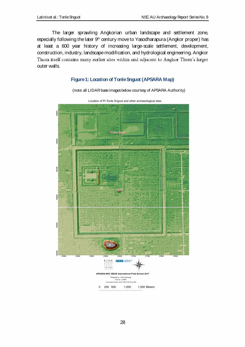
Latinis et al.: Tonle Snguot NSC AU Archaeology Report Series No. 8
28
The larger sprawling Angkorian urban landscape and settlement zone,
especially following the later 9th century move to Yasodharapura (Angkor proper) has
at least a 600 year history of increasing large-scale settlement, development,
construction, industry, landscape modification, and hydrological engineering. Angkor
outer walls.
Figure 1: Location of Tonle Snguot (APSARA Map)
(note: all LIDAR base images below courtesy of APSARA Authority)

Latinis et al.: Tonle Snguot NSC AU Archaeology Report Series No. 8
29
Figure 2: LIDAR image depicting Tonle Snguot and other major sites
Figure 3: Google Earth Image of Tonle Snguot highlighting the eastern reservoir
feature
Reservoir(nowricefields)
PreahKhan
TonleSnguout
AngkorThom
NorthGate

Latinis et al.: Tonle Snguot NSC AU Archaeology Report Series No. 8
30
Figure 4: Prasat Prei, Prasat Banteay Thom, Krol Romeas and other features
Figure 5: East-West corridor of numerous large and transected rectilinear features

Latinis et al.: Tonle Snguot NSC AU Archaeology Report Series No. 8
31
The lengthier history may include prehistoric and protohistoric sites, some of
which later became pre-Angkorian sites (e.g., Prei Khmeng). Other prehistoric and
protohistoric sites may have been absorbed while several were likely abandoned (Heng
2016) perhaps the inhabitants being drawn into urban emigration. Several earlier
settlements may have simply been outcompeted and subsequently abandoned. In turn,
Pre-Angkorian settlements may have followed a similar path during the Angkorian
periods. With the evidence thus far, however, it remains unclear. The northern swath
of settlement interest depicted in Figure 5 may simply represent expansion into
relatively uninhabited or marginally inhabited areas.
In summary, the repertoire of landscape features in the surrounding sectors at
the scale of several kilometers (larger than depicted in Figures 1-5) include roads,
canals, dykes, dams, reservoirs, ponds, trapeang, baray, terraces, mounds, structures,
agricultural field systems (wet-rice padi/paddy fields; dry agricultural systems; house
gardens; plantations; possible recreational and/or royal parks and gardens; etc.);
possible aquacultural systems (?); neighborhood grids; quarries; industrial production
areas (e.g., kilns, metal workshops); other forms of infrastructure; possible staging areas
for construction activities; possible markets; and many unknown features (e.g., the
maze/coil-like features south of Angkor visible in LIDAR imaging (Evans 2016; Evans
et al 2013). Not all of these types of features have been identified or necessarily occur in
the area surrounding Tonle Snguot, proximate sites, or the northern sections inside and
outside Angkor Thom, but the list elucidates a realm of possibilities for further research.
undertaken in the area for centuries or longer. The construction of the East Baray to the
development of Angkor Thom already represents three centuries. Large-scale landscape
modification, urbanization, and sophisticated water control engineering by the Khmer
people began at least in the Funan period (1st 6th centuries CE), and arguably had
incipient roots in the Bronze and Metal ages. The scale and sophistication increased
dramatically in the 7th-8th centuries (e.g., Sambor Prei Kuk), and then again in the 9th
century the dawn of Angkor with a range of early Angkorian capital constructions
and increased larger-scale urbanization ranging from Phnom Kulen to the Tonle Sap.
Evans et al (2013) break up various Angkorian periods to assess scalar shifts of
greater construction intensity, systematic planning, and more formal geometric design
imprinted on the landscape; particularly from the late 11th to 12th centuries and then
again by the late 12th to 13th centuries. However, by the time Angkor Thom was built
the rigid, formalized, redundant and orthogonal city block pattern witnessed at Angkor
Wat seems to have given way to more haphazard patterning. Evans et al note (2013:
12597-12598):
urban space. Linear elements such as roadways and canals begin to appear
within the moated precincts of temples and eventually form symmetrical

Latinis et al.: Tonle Snguot NSC AU Archaeology Report Series No. 8
32
into areas far beyond the space delimited by temple enclosures becomes well
established. With the construction of Angkor Thom in this period, we see
temple enclosure; however, it is once again clear that the rectilinear grid
encompasses both intramural and extramural areas, and transitions almost
seamlessly in extramural areas into the surrounding low-density urban
landscape. The organization of space within each of the city blocks has
undergone a significant transformation by the 13th century, however, as the
highly formalized spaces of the 11th to 12th centuries give way to a less rigid
pattern, with ponds and mounds showing a significant degree of variability in
ajectory that begins
with the essentially open cities of the 9th to 10th centuries, progresses through
a period of increasing urbanization and the formation of high-density nodes in
the 11th and 12th centuries, and culminates in the 12th to 13th centuries when
the high-density nodes in the central area of the settlement complex have
However, it is possible that the space in which Angkor Thom and surrounding
areas were used had slightly earlier and/or later settlement modifications resulting in
the less structured mound and pond orthogonal observed in the LIDAR images
compared to Angkor Wat. That is, it is possible that the neighborhoods at Angkor
Thom were resettled and repurposed multiple times. Residents may have settled there
for lengthier durations. The material cultural density and settlement duration at
Angkor Wat (Stark et al 2015) seem significantly less dense with briefer periods of use
respectively than seen at Angkor Thom or elsewhere (e.g., Koh Ker, Latinis 2016). It is
also plausible that Angkor Wat and Angkor Thom have different settlement and activity
natures along at least a few variables of analysis (e.g., settlement and activity nature,
duration and intensity). Stark et al (2015), for example, discuss periodic, intermittent
and/or rotating settlement patterns at Angkor Wat that may have left a quite unique
archaeological footprint at those particular sets of sites.
Without recourse to a lengthier discussion here, it is noted the Tonle Snguot
area for several kilometer
landscape features, particularly water features. This is not surprising given that the this
is the entry direction (north to south) of water systems (natural rivers and artificial
canals such as the Great North Canal) from Phnom Kulen, through agricultural lands,
into the Angkorian cities (also captured in many baray, trapeang, ponds, etc. at various
locations), and ultimately draining into the Tonle Sap lake. Angkor is well-known for

Latinis et al.: Tonle Snguot NSC AU Archaeology Report Series No. 8
33
its water engineering and large-scale hydraulic systems.xii Additionally, Tonle Snguot is
located near the gate of one of the largest Angorian urban complexes Angkor Thom.
It is reminded that we are not arguing that Tonle Snguot is the pivotal feature. Rather,
Tonle Snguot likely integrated into numerous features and may not have been in the
original Angkor Thom planning. The hospitals could have easily been added features
as supplements to original city design.
Meanwhile, debate continues around the function, symbolism, and overall
purpose of many features. Discerning particular time periods for each landscape feature
is also complicated and often ambiguous. Many are not well researched; some not
researched at all.
For example, the period of construction for the reservoir opposite Tonle Snguot
is unknown
proximate landscape features. As logic and parsimony would dictate, however, many
are likely contemporaneous with Angkor Thom, Preah Khan and Tonle Snguot (i.e.,
Bayon period - Jayavarman VII - late 12th/early 13th centuries CE). Additionally, we do
not know if the managers and engineers of these separate undertakings were all that
concerned about precise integration with the boundaries of proximate sites.
Notwithstanding, we suspect some of the features may be older dating to the middle
to early Angkorian periods with perhaps some pre-
settlement and land use. LIDAR and topographic analysis is ongoing in our Tonle
Snguot project (surface maps, satellite, LIDAR; and subsurface/geo-archaeological core
and site stratigraphy analysis). Once thoroughly assessed and [hopefully] backed with
robust ground truthing and subsurface testing, a better understanding will emergexiii.
To recap for emphasis: Tonle Snguot is built on an artificial mound. The site is
enclosed by and adjacent to several larger rectilinear and linear earthen and water
features (e.g., dykes, walls, terraces, berms, mounds, ponds, reservoirs, canals). A large
north-south canal separates Tonle Snguot, the road, and the reservoir to the east. The
reservoir is on the west side (back) of the Preah Khan temple (i.e., between Tonle Snguot
and Preah Khan) and more likely relates to Preah Khan.
The remnants of semi-orthogonal mound and pond settlement features exist
around Tonle Snguot. They are less formally organized than those witnessed at Angkor
Wat perhaps implicating less controlled settlement, less planning, and/or longer use
and reuse; possibly even less enforcement of property boundaries. This more haphazard
xii It is noted that since Funan and possibly pre-Funan times, the ancient Khmer have increasingly
mismanagement and poor engineering have ben factors in collapse models. xiii Regarding evidence of patterned features, termite mounds need consideration. Termite mound
patterning may relate to past wooden pillar supports used for organic structures such as buildings and
halls that are no longer preser
It is possible that the termite mounds are quite ancient, having concretized and preserved over time.
Wayne Johnson is highly thanked for providing these insights.

Latinis et al.: Tonle Snguot NSC AU Archaeology Report Series No. 8
34
appearance is more common throughout Angkor Thom within and outside of the site.
Natural processes is also a possibility worth testing.
Large water, earthen, and architectural features exist throughout the greater area
abutting the northern wall of Angkor Thom. This occurs along a lengthy east-west
corridor several kilometers long. The possible relationships, functions, symbolism, etc.
[if any] of all sites and features in this broader area remain unknown. Some may
represent different periods of construction, use, disuse/abandonment, and repurposing.
However, most appear to be late Angkorian and at least somewhat adherent to large-
scale planning. Field systems, however, may have been more organically emergent and
it likely that modern field system construction may obscure many ancient field systems
and features.
Different clusters of features may have articulated as various functional or
symbolic systems. They may have even been parts of assorted master-plans during
different periods perhaps some preexisting structures were articulated into the
planning by a successive engineer/architect working on different project during a later
period.
Other than the Eastern Baray and related features with known construction
dates, multiple time period construction is not clearly evident along the corridor in the
LIDAR analysis except for a few possible locations where superimposition or unusual
articulation of features may occur. Again, most pre-modern architecture sites and
associated landscape features appear to be Bayon period. If earlier sites and features are
represented, some may have been altered or augmented at later times (i.e., late Angkor,
post-Angkor, etc.).
Specifically for Tonle Snguot we know that the post holes in the canal indicate
previous analysis (2017). This supports arguments for a contemporaneous integrated
function of those particular features (bridge, canal, road); and/or, the hospital and
bridge may have been built after the canal and road.
Regarding hospital sites in general, the only relatively clear speculation at
present is that some of the hospitals (including Tonle Snguot) were intentionally placed
outside the cardinal gates at Angkor Thom probably as part of a master urban design,
or, were strategically emplaced shortly after when Jayavarman VII ordered the
construction of numerous hospitals. A similar pattern of four hospital sites at the four
cardinal midpoints/gates is replicated at Banteay Chhmar (Im 2014), for example. This
is discussed further in the following sections.
3.4: Hospital Site Components and Features
Most known hospital sites compounds are comprised of relatively standard
components (major site features) with fairly consistent spatial layouts (Im 2014)
(Figures 6-9). Typically, they contain central stone and laterite shrines (chapels);
libraries to the southeast; entrance gates, gopuras, and walkways to the east; enclosing
walls (some made of stone or lat
Latinis et al.: Tonle Snguot NSC AU Archaeology Report Series No. 8
35
formalized or buttressed with stone or laterite and architectural embellishments). Many
have larger square or rectangular ponds or water tanks to the northeast which are also
frequently more formally constructed. There is some confusion as to whether the more
are synonymous. Some sites may have both. This needs validation. Interestingly, Zhou
Daguan (Chou Ta Kuan) (Smithies 2001) notes that bathing practices were a frequent
medicinal cure. Indian Hospitals also had medicinal bathing areas (Bhattacharya
2017:29; Prematilleke 2017: 307; Prematilleke & Aluwihare 1995; Aluwihare 2017; see
also Chakravarti 1979). The pools may have functioned in similar manners.
Architectural features are often ornately carved. An inventory of prominent
architectural decorative elements, figures, and narratives as well as their spatial
arrangements is beyond the scope of this study but would prove interesting.
This generic standard pattern is not clear at Tonle Snguot. The Tonle Snguot
site contains a precariously cracked and collapsing central chapel, and highly degraded
entryway, the possible ruins of a gopura (?) or entry hall to the east, the possible ruins
of a library to the southeast, a semi formalized small pond to the immediate northeast,
and no readily discernable formal enclosing wallsxiv. The site is in a mature state of ruin,
continued degradation, attrition, and erosion. The central shrine requires numerous
wooden supports and buttressing to prevent further collapse.
It is presumed that hospitals had diagnosis and treatment areas, living quarters
(for staff, patients and families), and possibly medicinal gardens. They also may have
had dedicated land, agricultural fields, animal pens, plantations, houses, and house
garden plots associated with the compound or in nearby areas. We hope to conduct
pollen, phytolith and residue analysis from Tonle Snguot to assist with understanding
the local species-genera profiles and residue analysis to understand the nature of
processed or stored items in jars, pots and cooking/preparation vessels.
Treatment areas and living quarters were likely built of wood with possible stone
foundations, floorings, alignments, drainages and/or post supports. If built on piles,
formal floorings would not likely be present. Rather, compacted earth floors would be
expected with a pattern of post holes, post hole supports, refuse, hearths and
preparation areas. Roofs may have been thatch (e.g., grass or palm leaf), wood, or
bamboo. Some roofs may have been tiled. Roof tiles are common at the site. Other
structures may have been composed only from organic construction materials. Typical
Khmer wooden structures are built on raised earth mounds with the main structure
elevated on wooden posts/stilts/piles. The bases of wooden posts are generally
supported by stones and rubble to provide firm support and prevent sinking.
The size of hospital site compounds may range from approximately 5000-10,000
m2 (the Yeay Kom outer walled area is approximately 7000 m2); the chapel, library and
xiv An enclosing wall may exist as defined by the edge of the fields to the north and south as well as the
eastern embankment closer to the canal at edge of the site. The presence of walls was not tested or
thoroughly surveyed due to the density of the secondary growth during the fieldwork and limited
schedule. This also needs further testing and validation.

Latinis et al.: Tonle Snguot NSC AU Archaeology Report Series No. 8
36
gopura structural areas are smaller, ranging from approximately 500-1000 m2; and the
chapels themselves are around 20-30 m2. The size of hospital complexes inclusive of
habitation structures, activity areas, gardens and other features may be much larger
(e.g., 1-3 hectares); and presumably much larger if dedicated agricultural plots,
plantations, animal pens/corrals, and forest plots were included.
Figure 6: Features and plans for typical hospital sites (Prasat Ta Nup; from Im 2014)

Latinis et al.: Tonle Snguot NSC AU Archaeology Report Series No. 8
37
Figure 7: Plan view of chapel and hospital complexes from Thailand (from Im 2014)
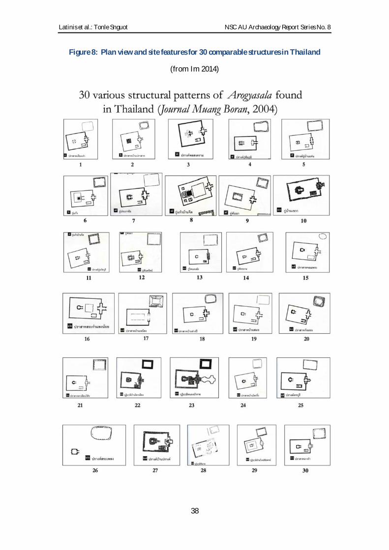
Latinis et al.: Tonle Snguot NSC AU Archaeology Report Series No. 8
38
Figure 8: Plan view and site features for 30 comparable structures in Thailand
(from Im 2014)

Latinis et al.: Tonle Snguot NSC AU Archaeology Report Series No. 8
39
3.5: Tonle Snguot Name and Meaning
Prasat Tonle Snguot (Tonle Snguot):
probably refers to the ancient artificial north-south canal [now dry] in front of the site
to the east. The original site name is unknown to our knowledge, but was likely listed
in an inscription at one point in time. Invocations, donations, assets, prominent people,
and staff would have been included. For example, the Say Fong inscription (Finot 1903;
Briggs 1951; Watson 2017) gives a detailed account of hospital staff (see below; also
from Im and Ea, pers. comm.; Watson 2017). Given the recovery of in situ statuary
during the recent campaign, it is possible an inscription still remains on site.
3.6: Hospital Staff
Beyond serving as spiritual, mental and physical healthcare facilities, the hospitals at
the gates may have served as rest stops and checkpoints also assuring healthy and sane
people entered the city. The Say Fong inscription yields information on how the
hospitals were staffed: 66 permanent staff to include: 2 doctors; 2 pharmacists
(apothecaries); 8 nurses; 6 doctor assistants; 14 guards; 4 rice makers; 4 cooks; 4
secretaries; 6 servants; 2 achar (religious specialists/priests who likely oversaw mental
and spiritual diagnoses and treatments among serving the normative spiritual and
religious needs of staff and visitors).
Briggs (1951: 233) calculated 101 staff from the Say Fong inscription (also
referring to Finot 1903) including an astronomer and two sacrificers. Briggs (1951:233)
from Say Fong, just below Vientiane in Laos, to the present southern boundary of
Cambodia, but only two are east of the meridian of Angkor, while all except one in
Most hospital sites have or had inscriptions. According to feedback from
Hunter I. Watson (pers. comm.; 2017), several hospital inscriptions have been
translated or at least have been discussed by Thai and other archaeologists.
Regrettably, we do not have access to all this information, but Watson (see Section 5)
has provided information on other sites that have different staff lists and numbers
perhaps related to community size, specific needs or amount of state support provided.
Watson indicates the preamble to the inscriptions are virtually identical. In fact, many
of them may have been manufactured in a single workshop or set of centralized
workshops possible located in the capital further lending creadance to a heavily state
supported and managed industry. They would have been augmented with additional
information after delivery. The list, positions and total number of staff and additional
information may vary considerably. Staff numbers and positions were apparently not
standardized.

Latinis et al.: Tonle Snguot NSC AU Archaeology Report Series No. 8
40
3.7: Tonle Snguot Site Dimensions
The total site dimensions for Tonle Snguot are not yet clear but estimated around 1-2
hectares maximum for the hospital compound and surrounding habitation, activity,
and possible garden areas. Whether or not the hospital had designated agricultural
fields (e.g., rice paddies) is unknown, but plausible many inscriptions at various
temples describe dedicated assets and donations, such as agricultural fields and staff.
The central elevated mound(s)/terrace(s) on which the Tonle Snguot chapel and
main area rests is much smaller. As a coarse estimate, the main Tonle Snguot area is
approximately 80 x 80 m to include the pond, library, temple, entryway and a few
additional proximate features. If the western habitation and stretch of ponds are
included, the site may measure at least 200 x 80 m. The maximum dimensions for the
temple platform/mound are approximately 20 x 20 m with the walkway terrace and
architecture extending east for another 20 m and approximately 5-10 m maximum
width. The collapse and erosion make it appear much wider. The collapsed and eroded
gopura or entry hall is expected to be wider than the walkway. Similarly, the scattered
and collapsed surface remains also likely exaggerate the original width. The dimensions
of these features were not mapped in detail during the field campaign. A GIS team was
scheduled to assist, but unfortunately were tasked for other projects at the time.
The mound filled with ruined debris to the southeast is most likely the remains
of the library structure (20 x 10 m; again, the actual size being amplified by collapse and
erosion). Approximately five readily discernable ponds exist on the northern side of the
compound. The ponds have approximately 20 m diameters. One is located to the
northeast the more formalized temple pond. The remaining ponds are located
northwest and west. Several more possible ponds are located in surrounding areas. The
mounds to the west are difficult to measure. They are not readily pronounced and dense
secondary growth precluded sufficient mapping. It is estimated they are approximately
20-30 m in diameter. LIDAR images reveal squared plots ranging from approximately
20 x 20 m to 30 x 30 m in size. They are made of low earthen berms surrounding both
mounds and ponds. It remains unknown if these are modern, historic or ancient
(Figures 9 11).

Latinis et al.: Tonle Snguot NSC AU Archaeology Report Series No. 8
41
Figure 9: LIDAR plan image of Tonle Snguot
3.8: Additional Features
Approximately 300-350 m east of the main shrine is a C-shaped (though
squared/rectilinear) depression possibly opening to the east; Figure 10). This appears
similar to various types of moat-mounds in which a small mound was augmented or
artificially raised with fill to house a structure or shrine surrounded by a small partially
enclosing moat. The fill for the mound was excavated from the perimeter which
subsequently formed the surrounding moat. This feature needs further inspection and
may be a component of a larger set of features articulating with the Tonle Snguot
compound. If it is a related feature, it would extend the total site-complex size to at least
three or four hectares. Another uniquely mounded feature is located between the chapel
and the aforementioned C-shaped feature. These features were not formally mapped or
tested during the 2017 campaign and deserve future attention. It is noted that there are
at least four or five modern structures (houses/buildings) in this area including the
noted features (Fig 10). Thus, they may be modern or historic.
Of interest, the immediate site area to the east of Tonle Snguot appears to be
gridded by the aforementioned small low berms resulting in several square-like
contiguous segments approximating lengths of 20 x 20 m to 30 x 30 m plots (Figures
11a-c). Some contain mounds while others contain ponds. These could be agricultural
plots, but not typical wet-rice fields. These may represent remnants of a settlement
system, such as gridded orthogonal neighborhoods typical of Angkor Wat and Angkor
Thom mentioned above. Gridded neighborhoods are now understood to be common
among many Angkorian urban sites. From the LIDAR analysis, there appear to be two
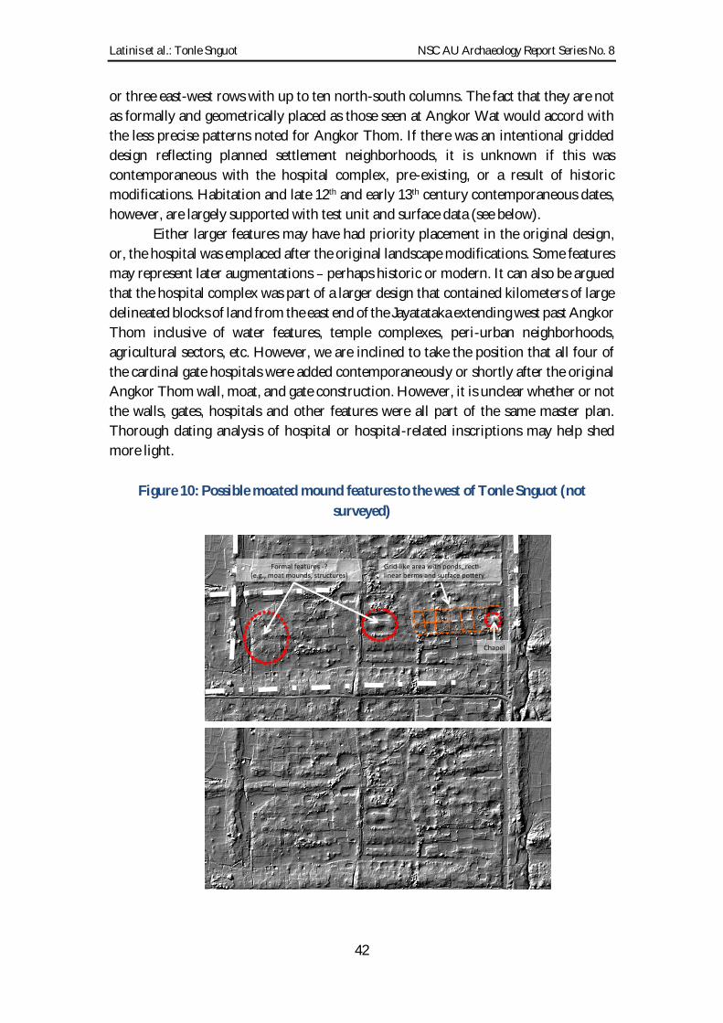
Latinis et al.: Tonle Snguot NSC AU Archaeology Report Series No. 8
42
or three east-west rows with up to ten north-south columns. The fact that they are not
as formally and geometrically placed as those seen at Angkor Wat would accord with
the less precise patterns noted for Angkor Thom. If there was an intentional gridded
design reflecting planned settlement neighborhoods, it is unknown if this was
contemporaneous with the hospital complex, pre-existing, or a result of historic
modifications. Habitation and late 12th and early 13th century contemporaneous dates,
however, are largely supported with test unit and surface data (see below).
Either larger features may have had priority placement in the original design,
or, the hospital was emplaced after the original landscape modifications. Some features
may represent later augmentations perhaps historic or modern. It can also be argued
that the hospital complex was part of a larger design that contained kilometers of large
delineated blocks of land from the east end of the Jayatataka extending west past Angkor
Thom inclusive of water features, temple complexes, peri-urban neighborhoods,
agricultural sectors, etc. However, we are inclined to take the position that all four of
the cardinal gate hospitals were added contemporaneously or shortly after the original
Angkor Thom wall, moat, and gate construction. However, it is unclear whether or not
the walls, gates, hospitals and other features were all part of the same master plan.
Thorough dating analysis of hospital or hospital-related inscriptions may help shed
more light.
Figure 10: Possible moated mound features to the west of Tonle Snguot (not
surveyed)
Grid-likeareawithponds,rec -linearbermsandsurfacepo ery
Chapel
Formalfeatures-?(e.g.,moatmounds,structures)

Latinis et al.: Tonle Snguot NSC AU Archaeology Report Series No. 8
43
Figure 11: Plan image of Tonle Snguot depicting core and test unit locations (a);
possible grid patterns (b); structural and water features highlighted (c).
3.9: Settlement and Dating Considerations (revisited)
The area around and inclusive of the Tonle Snguot site may have contained an earlier
and possibly much larger habitation site, village or activity area. That is, there may have
been a village-sized settlement prior to the construction of Angkor Thom and the
hospital; perhaps prior to the Angkorian period. This seems less likely given the data,
but it is possible.
a
b c

Latinis et al.: Tonle Snguot NSC AU Archaeology Report Series No. 8
44
During the topographic, satellite and LIDAR image analysis, a larger semi-
circular area (possibly of slightly higher elevation) can be diffusely delineated (Figure
12). The current vegetation and land use may produce a misleading picture, although it
cannot be wholesale rejected that the current vegetation and topographic patterns are
resultant from past settlement, slightly higher topography, and differing soils. If this is
the case, the visible pattern may represent 1/3-1/4 of a larger circular settlement site
east. Surface scatters of pottery remains, for example, are often low density but
consistently occur throughout the area. Additionally, a strip of the current village
and then adjacent to Tonle Snguot closer to the gate where it then penetrates into the
suggested area. The elevation, however, could have resulted from the construction of
the moat and other features. Antiquity of the current or historic settlement area is
unknown. Surface remains contain Angkorian to post-Angkorian artifacts, but nothing
discernibly earlier. The GAP surveys (Brotherson 2017) also indicate sparse 11th century
surface scatters, with larger frequencies of 12th-14th century datable tradewares. We do
not know if earlier sites and assemblages were recorded in the immediate area.
Figure 12: Google Earth image depicting areas of current settlement and land use
(Note: surface remains in the area contain Angkorian and Song-Yuan Dynasty pottery
sherds).

Latinis et al.: Tonle Snguot NSC AU Archaeology Report Series No. 8
45
If there were pre-Angkorian or earlier settlements, they may not have occurred
on the existing Tonle Snguot site itself. The mound(s) at Tonle Snguot were probably
built up with fill specifically for the hospital. There may be earlier sites nearby, but
current data from imaging is unable to reveal a possible earlier settlement pattern or
site especially without ground truthing and subsurface testing. None of the Tonle
Snguot test units were deeply excavated. Although it is possible that more deeply buried
cultural deposits lay beneath perhaps separated by the relatively sterile and seemingly
natural layers we encountered at basal levels it seems unlikely.
Thus, we must reiterate with emphasis that no pre-Angkorian or earlier
evidence was unearthed during excavations. The diagnostic glazed and unglazed
stoneware (local Khmer and exotic) could date between the 9th to 15th centuries CE; but
most probably date within the 12th-14th centuries consistent with a late Angkorian
occupation and use. Also, any earlier pottery may have been in circulation for quite
some time. Most of the earthenware is temporally non-diagnostic, although detailed
analysis of the ceramic assemblage is pending. There remains a chance that temporally
diagnostic earthenware sherds will be identified, some of which may assist answering
this question.
As stated, it is also emphasized that the 12th/13th century chapel mound and
immediately surrounding areas were artificially constructed (raised, built-up) using soil
and sand fill as evidenced by the geo-archaeological core testing. No earlier material
culture was noted in the deposits unlike some cases, such as Prei Khmeng and Koh
Ta Meas (Heng 2016; Pottier 2006a).
The Prei Khmeng site, albeit a pre-Angkorian site, for example, supplies a case
where metal age settlement and burial assemblages were excavated for fill to build a
moat and mound for the pre-Angkor temple. The assemblages and stratigraphy are
mirrored at the mid-point, with earlier Iron age remains in uppermost and lowermost
levels as a result of excavating surrounding mound surfaces and piling up fill to build
the mound. Heng (2016) also makes a strong argument for pre-Angkorian [and
Angkorian] urban sites and temple clusters having deeper histories of continuity. Tala
Borivat in Stung Treng and Angkor Borei (Wat Kamnou) in Takeo are noted examples
(Heng 2016). Nevertheless, a similar case is not evident at Tonle Snguot. In addition,
these sites generally have visible remains of earlier material culture at or nearby the sites
as surface scatters, road cuts, construction areas, erosion cutes, etc. This was not noted
at Tonle Snguot or surrounding areas. A scenario depicted in Figure 12 may be pure
wishful thinking.
The best dating methods we currently rely on are: a) art/architecture history
clearly within the late Angkor Bayon period; b) datable ceramics (exotic and local)
again, mostly late Angkor, Song-Yuan or later; and c) stratigraphic data which do not
indicate successive earlier occupations or activities at present.
Radiocarbon dates from the contemporaneous Prasat Tromoung site fall within
the 11th-15th centuries, but mainly cluster in the 12th/13th centuries range (Pottier &

Latinis et al.: Tonle Snguot NSC AU Archaeology Report Series No. 8
46
Chhem 2008). The material remains obtained from the east bank at Tonle Snguot (Unit
E02) may be secondary older habitation deposits from a nearby pre-existing settlement
that was mined for fill to build the dykes and road. However, the Khmer ceramics are
mostly mid to late Angkorian.
At a smaller temporal scale, one can hypothesize workers, craftsmen and service
communities living on or near the site during its construction; followed by hospital staff
and a different service community after it was operational. It is also possible that a larger
community organically developed near the Angkor Thom gate area, road, canal and
Tonle Snguot hospital complex perhaps parallel to the scenario just mentioned for the
Tonle Snguot hospital complex, but a much larger scale: construction workers for
Angkor Thom and other proximate sites, followed by settlers and service communities.
In our repertoire of plausibilities, this is not unwarranted. There would likely have been
lucrative social and economic benefits to the location providing services and products
for a busy funnel point. This might explain some of the artifact surface scatters in the
area. These would add complexity to the settlement pattern. In fact, one hypothesis may
be that the gates attracted larger settlements and thus may have required more medical
services and staff. Minimally, these notional models provide hypotheses worthy of
further exploration.
Current condition and use: Currently (Figures 13 and 14), the elevated portions
of the site are covered in trees and secondary growth. Architectural remains are spread
abundantly on the surface especially near the chapel, gopura and library. Historic
surface artifacts often consisting of 15th century and later local and exotic ceramic
shards occasionally occur, though not in any currently discernable pattern,
concentration, abundance.
The surrounding low areas are used for wet rice agriculture, gardens and grazing
by locals. It is not a priority tourist location, although occasional small groups or
individuals visit the site. The site is accessible by paths, with a nearby unpaved road.
Village houses are located nearby (see satellite images; Figure 12).
3.10: Hypothetical Temporal and Functional Sequence
Thus, a possible sequence of occupation and site use can be proposed for further testing.
The following sequence is not posited as the model that existed at Tonle Snguot; rather,
it is proposed as a consideration for future research design.
Pre- and Post-Angkor occupation and land use: No evidence thus far at Tonle
Snguot other than limited surface scatters of post-Angkor ceramics implicating
limited post-Angkor use. However, there are Iron Age, Funan, and pre-Angkor
(Chenla) sites in the Angkorian area. Sites such as Prei Khmeng, Koh Ta Meas
and Phum Lovea demonstrate continuity from the metal ages through pre-
Angkorian and Angkorian periods. Also, many sites, including Angkor Wat,
yield evidence of continued and/or periodic use through the post-Angkor,
historic and colonial periods.

Latinis et al.: Tonle Snguot NSC AU Archaeology Report Series No. 8
47
Phase I: Farmstead, household and/or village settlement, house gardens,
livestock and agricultural fields. Although there may be some evidence of earlier
occupation and activities in the surrounding areas (e.g., features, ceramics and
other remains), no current evidence clearly supports this at the Tonle Snguot
site.
Phase II: If earlier settlement existed, the site may have been truncated or
modified by large Angkorian landscape features associated with accelerated and
large-scale urban development (mostly earthen embankments, walls and dykes:
artificial water features ponds, lakes, canals). The evidence is unclear at
present from topography, surface survey, and LIDAR analysis. However,
lengthy earthen features transect the area and there are an abundance of water
features.
Phase III: Site repurposed as a hospital complex during the Angkor Thom
master-plan and construction efforts ca. late 12th early 13th centuries CE. Work
crews were on-site during construction followed by a settlement shift with
medical and support staff (also patients and visitors) when the hospital became
operational. However, there is no current evidence the site was repurposed
rather than simply built as an original undertaking. At present, we are unable to
discern differences in: a) original site construction activities, b) subsequent
hospital operations, and c) abandonment. We would expect differences but
limited sample size and limited ability for appropriate fine grain analysis at this
stage precludes any clear recognition.
Phase IV: Hospital complex abandoned after dissipation of Angkorian Empire
in 14th/15th centuries CE. There is no evidence of continued use, embellishments,
or alterations of the temple or temple complex features, etc. after the 13th/14th
centuries. The hospital complex was likely abandoned shortly after the demise
of Jayavarman VII rather than the complete dissipation of the Angkorian
Empire. Cessation of hospital operations and abandonment was probably
related to termination (or lack) of support and funding.
Phase V: Continued sporadic use for agricultural and proximate household or
small village settlement. Occasional local and exotic ceramic surface sherds in
the area indicate low-level post-Angkor presence and activity. Exotic sherds
(Thai, Chinese, Vietnamese, others) also indicate they were connected to larger
scale regional supply chains that imported exotic pottery and presumably other
commodities. This is not an uncommon pattern in Angkor and elsewhere i.e.,
low level settlement and activities continued into the historic and modern
periods possibly moderately fluctuating in density and intensity over the
centuries.
Current: The site continues to be minimally used for agricultural purposes by
local villagers who respect the sacred integrity of the temple (chapel) ruins,
architecture and artifacts. The site is marginally visited by tourists, although that
will likely change given recent discoveries. Additionally, the site does not appear
to have been looted further evidenced by our ability to recover near-complete
in situ statuary in shallow deposits. However, at least one local informant claims
that some exposed statuary had been removed/looted in the past.

Latinis et al.: Tonle Snguot NSC AU Archaeology Report Series No. 8
48
3.11: Additional Considerations Regarding Occupation and Dating
Some of the lower level structural remains at Tonle Snguot (e.g., quarried and shaped
laterite blocks; see below), artifacts and stratigraphy do not necessarily indicate earlier
occupation. Some of these may also represent unknown structures related to the
hospital complex (e.g., staff or patient quarters), perhaps even a workshop the western
units containing multiple iron artifacts/tools.
Occurrences of numerous stoneware roof tiles indicate the present of wooden
structures. Roof tiles are among the most numerous artifacts next to construction
materials for structures (laterite and sandstone in particular). These mostly appear to
be late Angkorian.
Post holes in the canal and banks indicate the presence of a bridge (likely built
or upgraded when the hospital was erected). The canal and bridge are late Angkorion.
Datable glazed and plain stoneware ceramics range from the 9th 15th centuries
CE (some may be later; i.e., post 15-th century). Though not particularly abundant,
most stoneware sherds are comprised of Khmer green-glazed and brown-glazed wares
as well as small amounts of Song-Yuan Dynasty Chinese wares (mostly celadon and
Qingbai; both common in Angkorian sites). Most are probably late Angorian.
The main temple area of the site was elevated by about four meters of fill (clayey
sand). The fill was obtained from excavating nearby ponds, canals, etc. There is a more
formalized main pond to the northeast of the temple that has laterite and sandstone
buttressing (probably late Angkorian). Several additional ponds are located to the south
many of which may have been ponds related to households possibly prior to the
repurposing of the site to a hospital complex, contemporaneous with hospital use,
and/or, after the hospital was abandoned. Several are a haphazardly placed consistent
with the less formalized pattern seen at Angkor Thom compared to the rigid grids at
Angkor Wat.
Surface and subsurface cultural deposits are mostly sand with some clay/loam
content. Sterile basal layers consist of more clayey lateritic soils. The depth of cultural
deposits to the west (behind the temple site) is about 1.0 meter. There are indications
of multiple layers but not necessarily multiple floors from different occupational
periods.

Latinis et al.: Tonle Snguot NSC AU Archaeology Report Series No. 8
49
4: EXCAVATION RESULTS
This section provides preliminary results from the 2017 excavations. The focus is
primarily on the test units and material remains. Sampling was specific and targeted: a)
stratigraphic test excavation units at mound edges to the west of the site to determine
the nature of habitation and site activities; b) test units along the canal (banks and
center) located to the east of the site to determine the nature of habitation, activities and
further information on ancient bridge design. Core samples assisted determination of
subsurface geomorphology and the extent of subsurface cultural deposits.
This site contains architectural structures of note (Figures 13 and 14). The
architectural remains, however, were not targeted for archaeological or art historical
assessment during this phase. The main temple (chapel) is precariously standing and
highly degraded. Other structures are highly degraded as well (e.g., gopura, library,
pond, walls, entryway).
Evidence of a formal walkway, halls, gopura, pillars and construction blocks are
clearly visible but collapsed, eroded, partially buried and highly degraded. Sandstone
and laterite are the most common visible materials. A considerable amount of the
sandstone architectural remains are highly decorated. The presumed library is possibly
the large southern mounded area with debris. It located in a normative library location.
However, a discernable library structure and library features are not clearly evident. The
pond to the northeast has evidence of more formalized construction and buttressing. It
was not mapped or studied in detail although two core samples were taken from the
pond. Fragments of construction material are scattered in a wide area around the site.
Some of the blocks contain ornate carvings characteristic of late Angkorian/Bayon
architecture and art. A few pedestal and statuary fragments are scattered throughout
the surface of the site as well.
Mounded areas and ponds extend several hundred meters to the west. Dense
secondary growth made it difficult to survey. The area around the chapel, however, had
less ground cover and more trees. The canal to the east was dry and fairly clear of
vegetation. The berm/road beyond was covered in trees and secondary growth. Further
east is the large reservoir. It contains rice fields. They were dry on our first walk-through
survey prior to initiating the Field School. The original plan was to retrieve core samples
and excavate test units for comparative purposes from the reservoir area, although this
was later scrapped due to the discovery of the statuary and time constraints.
4.1: Core and Test Excavation Synopsis
Testing began with 41 small cores spaced 5.0 m apart on linear axes (East [of the central
chapel] 21; West 20)(Figure 11). Results indicate approximately four meters of fill was
used to build up the mound near the chapel (i.e., temple to road surface). Erosion from
the mound and temple as well as collapse of structural remains had covered proximate
areas around the shrine and gateway/walkway. This buried statuary and masonry, but
did not significantly infill the canal or ponds. The bank of the canal is in a state of partial

Latinis et al.: Tonle Snguot NSC AU Archaeology Report Series No. 8
50
erosion. Almost all cores revealed cultural deposits. However, differentiating specific
habitation/household sites versus activity areas or other land use from the core data
remains speculative.
Figure 13: Tonle Snguot Chapel (photo by Ea Darith)
Figure 14: Tonle Snguot entryway (photo by Ea Darith)
(main temple/chapel in background; main pond in the depression to the far right)

Latinis et al.: Tonle Snguot NSC AU Archaeology Report Series No. 8
51
On the second day of operations, the team discovered a 1.9 m near-complete
sandstone dvarapala (guardian) statue dating to the 12th/ 13th centuries CE (Bayon
period) at the entryway of the temple complex upslope from the canal. This disrupted
normative operations. We had to spend substantial time conducting appropriate
ceremonies and removing the statue for protection. We subsequently discovered several
other statues (described in further detail below). Again, these were unexpected and
altered our research operations significantly.
Six test units of variable size were then excavated totaling 61.5m2 (E01, E02, E03,
E04, W01 and W02): testing an estimated 0.1% of the site at most. Recovered cultural
remains are described more thoroughly in the following subsection (Figure 13).
Sandy soils characterize the upper deposits until basal lateritic soils with more
clay content were encountered. The ponds, however, generally have more clay content
presumably to allow better retention of water. Incidentally, three additional larger
diameter auger cores were collected from pond locations for further soil and pollen
testing two from the formal northeast pond.
The eastern (E) units are at the entryway/walkway and gopura of the existing
sandstone chapel to the north-south canal. The canal and canal banks were tested to
further discern the nature of the bridge, sedimentation and geo-archaeology. Artifacts
and ecofacts were recovered as well.
Post-holes were identified in the canal and proximate banks indicating a bridge
structure made of wood. It is noted that this was previously tested during the GAP-
Greater Angkor Project 2003 [U. Sydney](report by Andrew Wilson 2017). We simply
found more post-hole evidence through further testing, but wanted to further define
-archaeology analysis is thorough. Our data
corroborates his sequence.
two distinct deposits. Occupying the western 2m of
the excavation area was a dark brown clayey sand with laterite inclusions [9].
This appeared to correspond with the bank of the canal. The remainder of the
excavation area was taken up by a brown sandy loam soil deposit with charcoal
the laterite block [10]. As excavation proceeded it became clear that these two
deposits we
The eastern units from the 2017 NSC-APSARA campaign revealed
approximately 1.0-1.5 m of cultural deposits. The units at the west side of the temple
likewise had approximately 1.0-1.5 m of cultural deposits. Most remains were recovered
in the upper 75-100 cm; the in situ statuary beginning just a few centimeters below
surface. Artifact, ecofact, stratigraphic and soil analyses are ongoing. Thus, it remains

Latinis et al.: Tonle Snguot NSC AU Archaeology Report Series No. 8
52
premature to indicate if there is more than one cultural deposit and if cultural deposits
in different locations are contemporaneous. Generally, 3-5 layers were identified in
most trenches with similar sandy soils, some charcoal flecking, and similar artifact
remains. At present, the stratigraphy and cultural content seem restricted to the
12th/13th centuries consistent with the architecture, art and epigraphic data, as well as
Pottier &
Figure 15: Plan view depicting test units and main features
4.2: Test Unit Finds
Unit E01: 5.0m X 5.0m; located on the east slope of canal. Five layers were noted.
Cultural material recovered included:
Large body and head of a sandstone Bayon period dvarapala (guardian) statue
(Figures 14-17). It is broken at the lower legs: measuring 190-200cm (without
feet) and approximately 58cm wide. Estimated total height would be
approximately 2.5 m depending on the pedestal height. It was laying on its back
face facing upwards emerging only a few centimeters below surface deposits.
were noted. The statue likely fell, broke, and may have been moved in antiquity.
Parts of the arms and legs are missing, but otherwise it is near-complete and in
good condition with intricate carved details. The nose is eroded, however. A
broken piece of leg was also recovered. The statue was removed following
ceremonies and subsequently taken to the museum and conservation area for
protection and further analysis along with all other statuary at the site (all
artifacts, ecofacts, and soil samples are now stored with APSARA Authority

Latinis et al.: Tonle Snguot NSC AU Archaeology Report Series No. 8
53
following the end of the 2017 campaign to be further studied during upcoming
post-excavation analysis).
A white oval crystal (1.0cm x 2.0cm) (Figure 18). The crystal is speculated to
have been used as a decoration for the dvarapala (guardian) statue.
A sandstone statue arm fragment not related to the dvarapala (guardian)
(Figure 19).
A small palm-sized (15cm x 10cm maximum) sandstone statue of a kneeling
elephant carved in the round (Figure 20).
A foot fragment of sandstone statuary with base (Figure 21).
A squared flat polished stone fragment (sandstone) with cut grooves
(approximately 15cm x 12cm x 5cm) (Figure 22).
Two highly oxidized iron tools (likely a short knife 15cm x 3cm and a nail 7cm
x 1.5cm) (Figures 23 and 24).
Numerous fragments of stoneware roof-tiles.
A small amount of Song-Yuan Dynasty Chinese ceramic sherds.
90g of faunal remains.

Latinis et al.: Tonle Snguot NSC AU Archaeology Report Series No. 8
54
Figure 16: Dvarapala statue in situ (photo by Ea Darith)
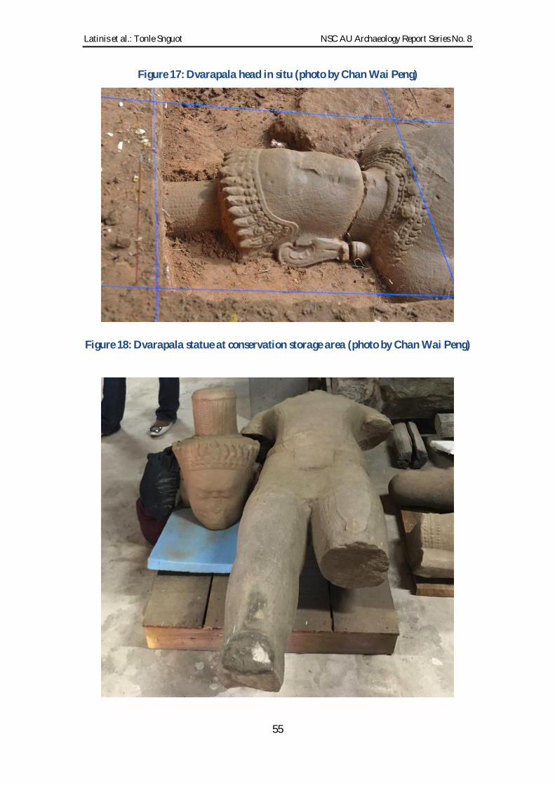
Latinis et al.: Tonle Snguot NSC AU Archaeology Report Series No. 8
55
Figure 17: Dvarapala head in situ (photo by Chan Wai Peng)
Figure 18: Dvarapala statue at conservation storage area (photo by Chan Wai Peng)

Latinis et al.: Tonle Snguot NSC AU Archaeology Report Series No. 8
56
Figure 19: Dvarapala removal ceremony (photo by Ea Darith)
Figure 20: Crystal (photo by Ea Darith)

Latinis et al.: Tonle Snguot NSC AU Archaeology Report Series No. 8
57
Figure 21: Arm fragment from broken statue (photo by Ea Darith)
Figure 22: Carved elephant (photo by Ea Darith)

Latinis et al.: Tonle Snguot NSC AU Archaeology Report Series No. 8
58
Figure 23: Feet and pedestal from broken statue (photo by Ea Darith)
Figure 24: Smoothed stone with grooves (photo by Ea Darith)

Latinis et al.: Tonle Snguot NSC AU Archaeology Report Series No. 8
59
Figure 25: Iron object (knife) (photo by Ea Darith)
Figure 26: Iron object (nail) (photo by Ea Darith)

Latinis et al.: Tonle Snguot NSC AU Archaeology Report Series No. 8
60
Unit E02: 6.0m x 2.0m; located on eastern bank of canal. Four layers were noted.
Cultural material recovered included:
Numerous faunal remains (fragmented; mostly food remains) (Figure 27), to
include a mammalian long bone and possible skull fragments, teeth (large
mammal - cow). There is a possibility that some human skeletal material may
be present the GAP teams having recovered a skull at the Thvea Dei Chhnang
site in 2006 (Johnson et al 2006). Faunal remains occurred in the soil deposits
used to build the dyke, suggesting people may had lived there before the dyke
was built.
Wood recovered near the faunal and skeletal remains.
Numerous Khmer ceramics sherds.
Sandstones fragments.
Laterite chips.
Figure 27: Skeletal and teeth remains from Unit E02 (photos by Ea Darith)

Latinis et al.: Tonle Snguot NSC AU Archaeology Report Series No. 8
61
Unit E03: 1.0m x 6.0m; located in the middle of canal. Three layers were identified.
A post hole 26cm in diameter and 70cm below surface was identified likely
Findings (Figure 28).
Figure 28: Post-hole feature (photo by Ea Darith)
Unit E04: 1.0m X 2.0m with 0.5 mx 1.0m southeastern extension. Two layers were
noted. Findings primarily consisted of statuary. There are six large statue pieces
representing five figures (Buddhas/Bodhisattvas): two lower body halves and bases;
three heads; and one complete body from neck to base. Only one head and body can be
articulated forming a complete statue (probably a Candravairocana or Suryvairocana).
All other pieces are from differing statues.
Two pieces of a sandstone Buddha statuary seated on a nagas from the knees to
the bases: One piece has a pointed foot under the naga body with a medicinal
fruit (myrobolan?; possibly Terminalia spp.), covered box or jarlet representing
a Bhaisajyaguru (Medicine Buddha). The other piece does not have a pointed
foot. These are presumably Bayon-period styles. Bases have tenons for insertion
into a larger pedestal.
Two pieces of a carved sandstone Buddhas seated on nagas. One piece extends
from the belly to naga head. The other piece is a head projecting outward with
broken naga heads sheltering the back of the head.
A seated Buddha resting on a lotus base. The head is broken off (two fragments),
but otherwise the statue is complete from head to base. The hands are slightly
extended in a praying-like position clasping a round elliptical object. The object
may be a fruit or jar. There is a circular carved portion at the top of the object
(i.e., the outward extended position just beyond the fingers) as if a protrusion,
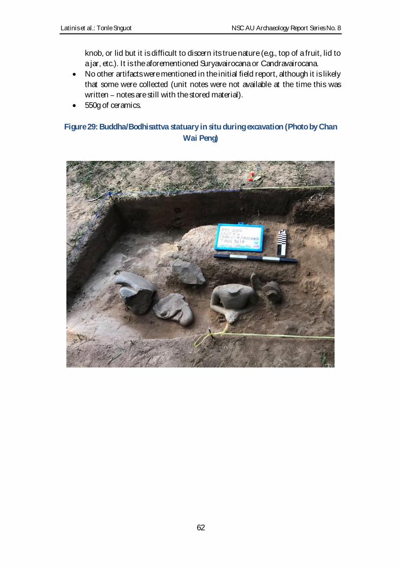
Latinis et al.: Tonle Snguot NSC AU Archaeology Report Series No. 8
62
knob, or lid but it is difficult to discern its true nature (e.g., top of a fruit, lid to
a jar, etc.). It is the aforementioned Suryavairocana or Candravairocana.
No other artifacts were mentioned in the initial field report, although it is likely
that some were collected (unit notes were not available at the time this was
written notes are still with the stored material).
550g of ceramics.
Figure 29: Buddha/Bodhisattva statuary in situ during excavation (Photo by Chan
Wai Peng)

Latinis et al.: Tonle Snguot NSC AU Archaeology Report Series No. 8
63
Figure 30: Buddha/Bodhisattva statuary in situ during excavation (Photo by Chan
Wai Peng)
Bhaisajyaguru Medicine Buddha on left holding a medicinal fruit, jarlet or covered box; Praying
Buddha/Bodhisattva [Candravairocana or Suryavairocana] on right holding object in hands)
Figure 31: Buddha statuary in situ during excavation head sheltered by naga
(photo by Chan Wai Peng)

Latinis et al.: Tonle Snguot NSC AU Archaeology Report Series No. 8
64
Figure 32: Buddha statuary after removal (photo by Ea Darith)
(left to right: Bhaisajyaguru legs, hands and pedestal; Buddha head and torso sheltered by naga; broken
head and body with base of Buddha/Bodhisattva holding object in hands
(Candravairocana/Suryavairocana); Head [upper] and lower body of possible Bhaisajyaguru Buddha
[undetermined])
Figure 33: Buddha head backed by sheltering naga (photo by Ea Darith)

Latinis et al.: Tonle Snguot NSC AU Archaeology Report Series No. 8
65
Figure 34: Buddha head and torso backed by sheltering naga (photo by Ea Darith)

Latinis et al.: Tonle Snguot NSC AU Archaeology Report Series No. 8
66
Figure 35: Buddha/Bodhisattva head (Suryavairocana or Candravairocana);
articulates with Figure 36 body (photo by Ea Darith)

Latinis et al.: Tonle Snguot NSC AU Archaeology Report Series No. 8
67
Figure 36: Buddha/Bodhisattva (Suryavairocana or Candravairocana) body and
pedestal; articulates with Figure 35 head (photo by Ea Darith)
(note: holding large round object such as pot or large fruit in hands )

Latinis et al.: Tonle Snguot NSC AU Archaeology Report Series No. 8
68
Figure 37: Buddha legs, hands and pedestal (unknown if Bhaisajyaguru possible
object in hands is indeterminate) (photo by Ea Darith).
Figure 38: Bhaisajyaguru (Medicine/Healing Buddha) legs, hands, pedestal (note:
fruit, jarlet of covered box in hands) (photo by Ea Darith)

Latinis et al.: Tonle Snguot NSC AU Archaeology Report Series No. 8
69
Figure 39: Ceremony for group blessings, protection and removal of statuary (note:
Buddhist statuary in background) (photo by Chan Wai Peng)
Figure 40: Ceremony for group blessings, protection and removal of statuary (note:
Buddhist statuary in foreground) (photo by Chan Wai Peng)

Latinis et al.: Tonle Snguot NSC AU Archaeology Report Series No. 8
70
Unit W01: 2.0m x 4.0m; located on the southeastern portion of an east-west mound to
the west of the chapel.
An ancient compacted floor was identified approximately 20cm below the
northwest corner extending to southeast corner.
Numerous Khmer and Song-Yuan Dynasty Chinese ceramics were identified.
Figure 41: Unit W01 northwest view (photo by Sok Chanthida).
Figure 42: Unit W01 south view (photo by Sok Chanthida).

Latinis et al.: Tonle Snguot NSC AU Archaeology Report Series No. 8
71
Figure 43: Unit W01 east view (photo by Sok Chanthida)
Unit W02: 2.0m x 4.0m; located 15m southwest of Unit W01 in a low mound.
A compacted ancient floor was identified approximately 40-50cm below
surface.
Four laterite blocks near the eastern wall were identified probably pillar/post
bases. Three measure 25cm, 30cm, and 50cm in length with thicknesses between
15-20cm. The larger sandstone block is 106cm by 24cm and 20cm thick.
A highly oxidized iron object was recovered possibly the head of an undefined
iron tool.
Khmer and Song-Yuan Dynasty Chinese ceramics were recovered.
There were no roof-tiles, possibly indicating that some house roofs were not
tiled (i.e., perhaps made of wood, bamboo, thatch and other organic perishable
material).

Latinis et al.: Tonle Snguot NSC AU Archaeology Report Series No. 8
72
Figure 44: Iron tool from Unit W02 (photo by Ea Darith)
Figure 45: Unit W02 south view (photo by Sok Chanthida)

Latinis et al.: Tonle Snguot NSC AU Archaeology Report Series No. 8
73
Figure 46: Unit W02 southwest view (photo by Sok Chanthida)
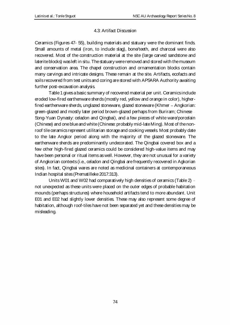
Latinis et al.: Tonle Snguot NSC AU Archaeology Report Series No. 8
74
4.3: Artifact Discussion
Ceramics (Figures 47- 55), building materials and statuary were the dominant finds.
Small amounts of metal (iron, to include slag), bone/teeth, and charcoal were also
recovered. Most of the construction material at the site (large carved sandstone and
laterite blocks) was left in situ. The statuary were removed and stored with the museum
and conservation area. The chapel construction and ornamentation blocks contain
many carvings and intricate designs. These remain at the site. Artifacts, ecofacts and
soils recovered from test units and coring are stored with APSARA Authority awaiting
further post-excavation analysis.
Table 1 gives a basic summary of recovered material per unit. Ceramics include
eroded low-fired earthenware sherds (mostly red, yellow and orange in color), higher-
fired earthenware sherds, unglazed stoneware, glazed stoneware (Khmer Angkorian:
green-glazed and mostly later period brown-glazed perhaps from Buriram; Chinese
Song-Yuan Dynasty: celadon and Qingbai), and a few pieces of white ware/porcelain
(Chinese) and one blue and white (Chinese: probably mid-late Ming). Most of the non-
roof tile ceramics represent utilitarian storage and cooking vessels. Most probably date
to the late Angkor period along with the majority of the glazed stoneware. The
earthenware sherds are predominantly undecorated. The Qingbai covered box and a
few other high-fired glazed ceramics could be considered high-value items and may
have been personal or ritual items as well. However, they are not unusual for a variety
of Angkorian contexts (i.e., celadon and Qingbai are frequently recovered in Agkorian
sites). In fact, Qingbai wares are noted as medicinal containers at contemporaneous
Indian hospital sites (Prematilleke 2017:313).
Units W01 and W02 had comparatively high densities of ceramics (Table 2)
not unexpected as these units were placed on the outer edges of probable habitation
mounds (perhaps structures) where household artifacts tend to more abundant. Unit
E01 and E02 had slightly lower densities. These may also represent some degree of
habitation, although roof-tiles have not been separated yet and these densities may be
misleading.

Latinis et al.: Tonle Snguot NSC AU Archaeology Report Series No. 8
75
Table 1: Artifacts by mass from all material culture bearing units
Grand total: 123,802g
* Sample masses have not yet been calculated
Table 2: Ceramic densities per unit

Latinis et al.: Tonle Snguot NSC AU Archaeology Report Series No. 8
76
Figure 47: Assorted ceramic remains (photo by Ea Darith)
Figure 48: Assorted ceramic remains 2 (photo by Ea Darith)

Latinis et al.: Tonle Snguot NSC AU Archaeology Report Series No. 8
77
Figure 49: Khmer Angkorian brown-glazed (photo by Sok Chanthida)

Latinis et al.: Tonle Snguot NSC AU Archaeology Report Series No. 8
78
Figure 50: Assorted stoneware (photo by Ea Darith)

Latinis et al.: Tonle Snguot NSC AU Archaeology Report Series No. 8
79
Figure 51: Assorted green-glazed stoneware (photo by Ea Darith)
Figure 52: Green-glazed stoneware with iron firing stains (photo by Ea Darith)

Latinis et al.: Tonle Snguot NSC AU Archaeology Report Series No. 8
80
Figure 53: Chinese glazed ware Qingbai covered box and white ware sherds
(Dehua-?) (photo by Ea Darith)
Figure 54: Chinese glazed ware blue and white (mid-late Ming ?) and Qingbai
covered box (photo by Ea Darith)

Latinis et al.: Tonle Snguot NSC AU Archaeology Report Series No. 8
81
Figure 55: Assorted Chinese glazed ware (photo by Ea Darith)
The iron tools may represent work/activity areas other than habitation (e.g.,
stoneworking; perhaps for work crews who may have built the architecture; medical
services; etc.), although no other data currently supports this interpretation.
Furthermore, data is too sparse for any definitive conclusions on multiple occupations
(e.g., earlier settlements and/or preliminary specialized work crews for temple
construction). If they are a knife, a point and other related items, these may be typical
household goods. Unit W01 yielded 210 g of iron including slag. Although this is not
necessarily abundant by all means, it represents a much greater density than other units.
Faunal remains were comparatively abundant in Unit E02 (near the canal) and
absent in the western W01 and W02 units. It is possible that most are food remains but
it remains unclear. They may have been secondarily deposited during the canal
construction as well.
It is unfortunate we do not have data for comparative artifact and ecofact
densities at Angkor Wat (Stark et al 2015) or Prasat Tromoung (Pottier & Chhem 2008).
Stark et al (2015) discuss low intensity and perhaps rotational, intermittent or periodic
habitation in mound sites at Angkor Wat. They mention a fairly simple stratigraphy
(three main layers) with radiocarbon dating placing most occupation during Angkor
perhaps some earlier work crew presence and later period sporadic use.
Artifact density appears fairly low in their description.
Densities at Tonle Snguot range between 0-2.7 kg/m3 depending on variable
calculations. Compared with habitation mounds at Koh Ker (approximate average of
7.5 kg/m3), this is fairly low. Occupation at Tonle Snguot, like Angkor Wat, may have
been restricted to Tonle

Latinis et al.: Tonle Snguot NSC AU Archaeology Report Series No. 8
82
Ker habitation likely was longer in duration (7th 14th centuries, but probably heaviest
in the 10th century when massive construction projects were underway and it served as
the Angkorian capital under Jayavarman IV). Soils are quite different (clay at Koh Ker;
sand at Angkor Wat and Tonle Snguot) which may be a factor affecting comparative
density or volumetric analysis. Nevertheless, the densities may reflect on the nature and
density of habitation as well as frequency and intensity of activities. Comparative
volumetric studies can be quite useful, especially with fine-grained artifact and ecofact
typologies. Nevertheless, this data is not often reported and adequate sample sizes for
Angkorian habitation/household sites are not readily available because only a few sites
of this nature have been tested.
4.4: Further Considerations of the Statuary
It is not surprising that statuary and ornate carvings were components of the chapel
and hospital complex. However, it is rather shocking that they still exist in situ given
the shallow depositional context (only a few dozen cm below the surface) vis-à-vis the
rampant looting that has occurred over the decades. These are extremely high value
items and frequently end up for sale on the black market. Therefore, there was a need
to recover and move the statuary to official Cambodian conservation and museum
facilities for protection, conservation and further study.
In addition to the dvarapala (guardian), the six large statuary fragments indicate
the presence of five Buddha effigies. All are broken, but appear in situ from ancient
deposition. Whether or not they were moved in antiquity remains unknown. Their
location along the entryway to the shrine at the southern side may have been intentional
for visitor access perhaps sheltered in a corridor. However, the lugged (tenoned) bases
indicate insertion into larger pedestals. The base housings were not identified in the
excavation units.
Pedestal fragments occur on nearby site surfaces and among the collapsed
architectural ruins. In fact, one pedestal with broken feet was thought to be the base of
the dvarapala (Figures 56 and 57). It was located several meters from where the
dvarapala was unearthed. Diameter measurements suggested otherwise. Whether this
indicates the pedestal or the dvarapala or other statues and parts were moved in
antiquity (post-depositionally) or even more recently is unknown, but highly likely.
One Buddha fragment is an exceptionally rare find in this context. It is a
Bhaisajyaguru the Medicine or Healing Buddha. The statue was broken in half just
below the stomach. The legs, hands, pedestal and base remain. The Buddha is seated
atop a coiled naga on a tenoned (lugged) pedestal for insertion into a larger separate
pedestal. Buddhas seated on coiled naga bodies with naga heads shielding the back and
head of the Buddha are common to Angkorian iconography especially Bayon period
given the Mahayana Buddhist state/royal religion of the time. The Bhaisajyaguru
Buddha is holding either a medicinal fruit or medicine jar (covered box) in his lap.
Although several Bhaisajyaguru statues were recovered at the Bayon-period Banteay
Kdei site, this is the first Bhaisajyaguru recovered from an actual hospital complex.
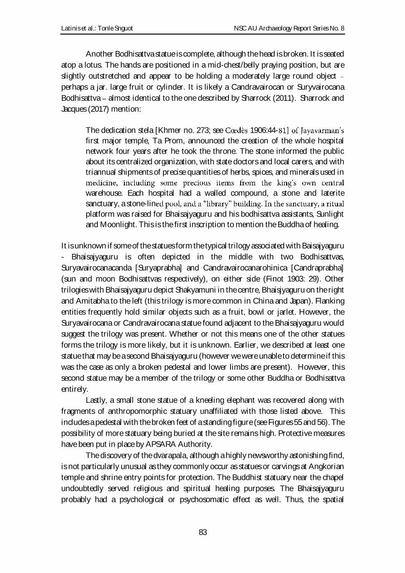
Latinis et al.: Tonle Snguot NSC AU Archaeology Report Series No. 8
83
Another Bodhisattva statue is complete, although the head is broken. It is seated
atop a lotus. The hands are positioned in a mid-chest/belly praying position, but are
slightly outstretched and appear to be holding a moderately large round object
perhaps a jar. large fruit or cylinder. It is likely a Candravairocan or Suryvairocana
Bodhisattva almost identical to the one described by Sharrock (2011). Sharrock and
Jacques (2017) mention:
The dedication stela [Khmer no. 273; see 1906:44-
first major temple, Ta Prom, announced the creation of the whole hospital
network four years after he took the throne. The stone informed the public
about its centralized organization, with state doctors and local carers, and with
triannual shipments of precise quantities of herbs, spices, and minerals used in
warehouse. Each hospital had a walled compound, a stone and laterite
sanctuary, a stone-lin
platform was raised for Bhaisajyaguru and his bodhisattva assistants, Sunlight
and Moonlight. This is the first inscription to mention the Buddha of healing.
It is unknown if some of the statues form the typical trilogy associated with Baisajyaguru
- Bhaisajyaguru is often depicted in the middle with two Bodhisattvas,
Suryavairocanacanda [Suryaprabha] and Candravairocanarohinica [Candraprabha]
(sun and moon Bodhisattvas respectively), on either side (Finot 1903: 29). Other
trilogies with Bhaisajyaguru depict Shakyamuni in the centre, Bhaisjyaguru on the right
and Amitabha to the left (this trilogy is more common in China and Japan). Flanking
entities frequently hold similar objects such as a fruit, bowl or jarlet. However, the
Suryavairocana or Candravairocana statue found adjacent to the Bhaisajyaguru would
suggest the trilogy was present. Whether or not this means one of the other statues
forms the trilogy is more likely, but it is unknown. Earlier, we described at least one
statue that may be a second Bhaisajyaguru (however we were unable to determine if this
was the case as only a broken pedestal and lower limbs are present). However, this
second statue may be a member of the trilogy or some other Buddha or Bodhisattva
entirely.
Lastly, a small stone statue of a kneeling elephant was recovered along with
fragments of anthropomorphic statuary unaffiliated with those listed above. This
includes a pedestal with the broken feet of a standing figure (see Figures 55 and 56). The
possibility of more statuary being buried at the site remains high. Protective measures
have been put in place by APSARA Authority.
The discovery of the dvarapala, although a highly newsworthy astonishing find,
is not particularly unusual as they commonly occur as statues or carvings at Angkorian
temple and shrine entry points for protection. The Buddhist statuary near the chapel
undoubtedly served religious and spiritual healing purposes. The Bhaisajyaguru
probably had a psychological or psychosomatic effect as well. Thus, the spatial
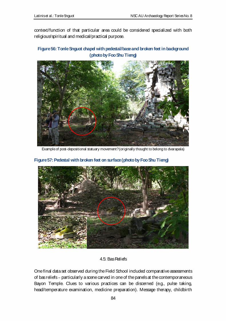
Latinis et al.: Tonle Snguot NSC AU Archaeology Report Series No. 8
84
context/function of that particular area could be considered specialized with both
religious/spiritual and medical/practical purpose.
Figure 56: Tonle Snguot chapel with pedestal/base and broken feet in background
(photo by Foo Shu Tieng)
Example of post-depositional statuary movement? (originally thought to belong to dvarapala)
Figure 57: Pedestal with broken feet on surface (photo by Foo Shu Tieng)
4.5: Bas Reliefs
One final data set observed during the Field School included comparative assessments
of bas reliefs particularly a scene carved in one of the panels at the contemporaneous
Bayon Temple. Clues to various practices can be discerned (e.g., pulse taking,
head/temperature examination, medicine preparation). Message therapy, childbirth

Latinis et al.: Tonle Snguot NSC AU Archaeology Report Series No. 8
85
assistance, and other practices are not evident, however. What we do not see may be
equally important, perhaps indicating that certain practices occurred at different
locations (
homes).
Structures, site furniture and a small variety of tools and containers are depicted,
but they may be fairly generic. Surgical tools, however, are known in Indian hospitals
of that period particularly the 12th century Polonnaruwu site (Aluwihare 2017). The
structures may represent buildings that have long disappeared. Pillared open structures
examination and treatment areas, practices, tools and other objects are depicted.
Further analysis may yield more specific clues. Fruit bearing palms and other trees are
depicted in upper sections, but these may be generic floral backdrops rather than
depictions of medical plants grown and used at the facilities. Staff, patients and
common people are depicted. One person appears to be writing (perhaps a
prescription), while others possibly prepping medicines or equipment/supplies in
boxes. It would be interesting to assess gender, age, ethnicity and any visual clues to
specific ailments or disorders. All faces are smiling. Thus it appears they must be
receiving/providing good treatment and the staff are enjoying their work.
Sharrock and Jacques (2017) describe a carved relief at Banteay Chhmar (while
:
ceremonial regalia, makes a symbolic offering in a temple in front of a pile of
having seen medicinal herb blessing ceremonies in Tibet today that involve
similar piles of sacks, it appears more likely that the Banteay Chhmar scene
presents a medicine blessi
Although we visited Banteay Chhmar for art history training, we did not focus on the
reliefs that would depict medical industry related information. Banteay Chhmar
certainly deserves further attention. Sharrock and Jacques (2017) make a strong
argument for its importance in the overall industry, especially the links to the Dangrek
Mountains a
that the site was tant

Latinis et al.: Tonle Snguot NSC AU Archaeology Report Series No. 8
86
Figure 58: Bas relief at the Bayon temple medical/hospital scene (photo by D. Kyle
Latinis)

Latinis et al.: Tonle Snguot NSC AU Archaeology Report Series No. 8
87
5: INSCRIPTIONAL ANALYSIS
Hunter I. Watson
Hospital Inscriptions: During the reign of Jayavarman VII numerous construction
projects were undertaken, including the rest houses and hospitals outside urban centers
and along the roads between them. Some information regarding the establishments of
Jayavarman VII has been gained from the study
reign there are multiple inscriptions which provide glimpses into this period; most
notable are the two large inscriptions found at Ta Prohm and Preah Khan, in the region
around Angkor. There are also numerous smaller inscriptions found scattered across a
wide region known collectively as the Hospital Inscriptions. The inscriptions from Ta
Prohm and Preah Khan share some similarities but are not wholly identical. Similar in
shape and size, both are four-sided stele nearly two meters tall and just over half a meter
wide on each side. Both are composed in Sanskrit and comprise of 72 lines on each side,
except the fourth side of the Ta Prohm stele, which has 74 lines. The first 18 stanzas are
identical on both, but afterwards
1941: 255).
was founded after the war. This was a reference to the great battle between the Khmers
and the Chams, supposedly in the year 1177 CE, also depicted on the carved murals of
the Bayon and Banteay Chhmar temples. This might also imply that Preah Khan temple,
258). The Ta Prohm inscrip
hospitals. The inscription states that there were 102 hospitals and lists the total budget
of items distributed among them (Ta Prohm stele, Side D, Lines 17-62 (Stanzas CXVII-
-69, 80-81). Ta Prohm was effectively the headquarters of all
The Preah Khan inscription mentions another type of structure built along the
s d'étape
-297), or lodges with fire. Finot later assigned these
(Finot 1925: 422), or houses of charity. In English these are often referred to as rest
houses. The Preah Khan inscription enumerates 121 of these structures and lists the
numbers constructed along the roads to various cities (Preah Khan stele, Side D, Lines
2-6 (Stanzas CXXII- -297). It seems there was both a rest
The Preah Khan inscription mentions the establishment of 430 divinities at
Preah Khan. Among the divinities enumerated are four statues in the rest house and
three in the hos -289). This corresponds precisely with
the record engraved on the Hospital Inscriptions, which all begin with an invocation to
three deities: Bhaiṣajyaguru Vaiḍ

Latinis et al.: Tonle Snguot NSC AU Archaeology Report Series No. 8
88
(Stanza I ṇḍarocis and
Candravairocana Rohiṇ
which are Bodhisattvas (Finot 1903: 19). The statues recovered in 2016 to the north of
Angkor Thom by the NSC field school are arguably examples of these deities. Chhem
stated that no description of these statues were given in the inscription and that none
of them had yet been found (Chhem 2005: 10). However, Lorrillard drew attention to
the fact that the Say Fong inscription was found together with a statue, photographed
in 1902, suggesting that it might represent one of the bodhisattvas (Lorrillard 2014 : 77,
79). In Thailand, a complete statue of the Buddha of Medicine was discovered at Ku
Kaew in Khon Kaen Province (Phiset et al 2000: 41).
Regarding the Hospital Inscriptions, several have been found at various
locations. Based on a preliminary review, it would appear that as many as 43 different
Hospital Inscriptions have been discovered (for a review of structures in Thailand
attributed to
and northeastern Thailand, as well as one in central Laos and one in southern Vietnam.
However, these numbers and locations need to be reconfirmed, a matter complicated
by the fact that some boundaries have shifted since information regarding these
inscriptions was published (in some cases many decades ago).
The first Hospital Inscription was discovered in Cambodia by Étienne
Aymonier. It was studied by Abel Bergaigne and published in 1882. The stone was
broken into several pieces, but was identified as relating to a hospital providing services
for people of every social class. The fragmentary inscription mentioned doctors and
medicine, as well as staff of different sorts, and made clear
or the king of Cambodia (Bergaigne 1882: 143). In the year 1900, Aymonier described
an inscription found in Cambodia which was not very legible. It was in fact another
Hospital Inscription, although at the time Aymonier had yet to make this connection
(Aymonier 1900: 378). In 1901, another publication of Aymonier (1901: 110, 116-117,
130-131, 191, 297)) included six more Hospital Inscriptions, but the similarities
between them had yet to be recognized.
An entire, unbroken inscription was discovered at Say Fong, along the Mekong
River in central Laos. This excellent specimen was featured in a number of articles in
1903 (Maspero 1903: 1-17; Finot 1903: 18-33; Pelliot 1903: 33-37; Barth 1903: 460-466).
By then the connection between the various inscriptions was realized, and it was noted
that the shape, size and style was remarkably similar between them (Maspero 1903: 4,
Finot 1903: 21-22; Barth 1903: 460). In a later publication, Finot (1915b: 1-135) further
analyzed textual differences between the inscriptions. The Say Fong inscription bears
the name of Jayavarman VII, as well as dates which correspond to 1182 and 1186 CE
(Barth 1903: 462). Finot transcribed and translated the inscription, explaining that the
content is divided into four sections. It begins with an invocation to the Buddha,
followed by a eulogy of Jayavarman VII, then a description of the various personnel and
supplies of the hospital, and ends with a final clause (Finot 1903: 19). The average
measurement of each side of the Say Fong inscription is 50 cm high by 20 cm wide; the

Latinis et al.: Tonle Snguot NSC AU Archaeology Report Series No. 8
89
first three sides bear 24 lines of writing each while the fourth side bears 26 lines (Finot
1903: 22).
Some of the Hospital Inscriptions found in northeastern Thailand are in
relatively good condition. Four of these were published in Thai in 1985 and again in
1986 (Kaeoklay 1985; Wiraprachak 1986). Although not all are exact replicas, they have
similar sizes and numbers of lines. In 2015, Sombat Mangmeesukhsiri (2015)
reanalyzed these inscriptions, comparing the one from Say Fong with one from Surin
Province, in Thailand, along the border with Cambodia. He explained that the
inscription from Surin is slightly shorter than the one from Say Fong, and stated that
out of 48 verses, 20 verses show slight differences, while the rest are the same. He further
explains that verses 1-3 are the invocation, verses 4-8 are the eulogy to Jayavarman VII,
and verses 9-12 described the misery of the Khmer people after facing a civil war and a
war with the Chams. Then verses 13-18 described the establishment of the hospitals by
Jayavarman VII for the benefit of his subjects. Verses 19-24 describe the various staff
who worked at the hospital and their responsibilities. The Say Fong inscription
reportedly had 98 people on the registry, while the hospital at Surin had only 50, an
indication that the community at Say Fong was much larger. Verses 25-36 described
the plants and some aquatic animals used in the production of various types of
medicines. Verses 37-46 mention other products used at the hospital, such as tin and
rice, as well as the religious personnel for performing rituals and an astrologer or
mathematician. The final part is Jayavarman VII's wish that his subjects would be well;
he compared himself to a beggar seeking happiness to all sentient beings, and stated
that he would give all of his possession, including his throne, for their benefit. The
inscription ends with Jayavarman VII's blessing for the hospital personnel, who he
hoped would achieve salvation and go to heaven (Mangmeesukhsiri 2015: 2-3).

Latinis et al.: Tonle Snguot NSC AU Archaeology Report Series No. 8
90
6: HOSPITALS, JAYAVARMAN VII AND NON-LOCAL INFLUENCE
The Tonle Snguot site and other hospital compounds, as with Jayavarman VII in
general, at first appear to break considerably from several normative Angkorian
historical and cultural trends. Most prominent among these changes were Jayavarman
massive construction efforts and infrastructural developments over broad territories
styles were quite unique in many regards, it can be argued that many basic elements of
engineering, architecture, symbolism, design and art as well as various overall trends
were actually quite consistent with Khmer traditions including the tradition of new
kings and subsequent eras defined by evolving stylistic variation among key elements
(e.g., lintels, pediments, statuary, and so forth) as well as general increases in magnitude
and abundance of architecture and major landscape features. That is, changes along
some dimensions were a dynamic norm of Khmer culturexv among the royalty, elite,
designers, architects, artisans, etc. Some types of changes were consistent or even
expected. Other factors remained very conservative. This is normative of any culture,
although the particular things (social or physical) that are expected to change, evolve,
or remain conservative vary from culture to culture; as well as the variance within each
category/phenomena.
It is also reminded that Jayavarman VII may not have been the only Buddhist
king (or king who strongly supported tantric Mahayana Buddhism) in ancient Khmer
history. However, his emphasis on tantric Mahayana Buddhism at that particular
600-
Mahidhara dynasty established Buddhism as the power behind the throne and in 1182
tantric from 600-
Importantly, what seems prominently different in the urban and infrastructural
spitals, rest houses,
and state supported medical industries. Although the size of the gates and walls around
Angkor Thomxvi, new art/architectural elements, and the sheer volume and scale of sites
were seemingly unique, these endeavors may not have actually been quite as unique as
the hospital and medical industry efforts. No other Khmer king appears to have
endorsed such a campaign.
Did Jayavarman VII or his advisors at some point spontaneously realize
versions, or, was this concept
partially influenced from non-local sources such as India or China?
xv Notwithstanding changes in technology and engineering which may have evolved for a variety of
different reasons. xvi Most Angkorian urban sites rarely had city walls, although walled compounds for shrines and temples
were common (Evens 2013). Evans also noted that the low density settlement occurred outside the walls
at Angkor Thom.

Latinis et al.: Tonle Snguot NSC AU Archaeology Report Series No. 8
91
Zysk (2000:44) noted
-38) further
describds the history of Buddhist medicine and hospitals in India from perhaps as early
as the 3rd century BCE ( in no way
proven ) and that the Nagarjunkoda inscription from the 3rd century CE clearly
in astery. Bhattacharya
(2017:32) also noted th century CE inscription from Duddavihara in Gujarat
states the use of medicines and remedies was for all those who are sick, not only for the
monks [
public medical attention for all classes was a concept in practice by that time.
Bhattacharya (2017:32) further discussed the records of Xuanzang (690 CE) noting,
highways of the towns and villages throughout India he [?] erected
hospices, provided with food and drink, and stationed there physicians, with
medicines for travelers and poor persons round about, to be given without any
nobles and householders of this country have
founded hospitals within the city, to which the poor of all countries, the
Although the inception of medical industries, hospitals, health related merit
making, and so forth are strongly associated with early Buddhism in South Asia, it was
not restricted to only Buddhist institutions, support, management and implementation
by later centuries. Zysk (2000:46) emphasized
Indian after 1200, these Hindu institutions seem to have assumed the responsibilities
(2017:33) also highlighted
Brahmanical religious institutions of Northern India during the early medieval period
[referring to King Sricandra c 925- that
adoption, [the] secular nature of Buddhist medicine begins to crystallize into orthodox
Wujastyk (2012) discussed hospitals in Bengal and Kashmir during the 12th
re to
-
seem to be hospitals in a recognizable and formal sense, rather than mere dormitories
upported
public medical industries, hospitals, and treatments were well established in South Asia
having transcended any exclusivity to Buddhism, although it did have a long Buddhist
history. South Asian connections and influence from the early centuries BCE to the
Angkorian era are quite clear in archaeological and other data sets (material culture,
writing, language, inscriptions, architecture, epic stories and characters, religions,
historic documents, etc.), although this does not imply we support earlier
Latinis et al.: Tonle Snguot NSC AU Archaeology Report Series No. 8
92
India stamped out on a blank slate of a socio-politically undeveloped Cambodia) that
have grown passé in the modern discourse. It would seem hard to imagine that various
Southeast Asian polities, especially Angkorian and pre-Angkorian, would be unaware
of South Asian medical institutions and practices for a long time. In fact, it may be a
more interesting question to ask why state/elite supported medical industries and
hospitals were only implemented by Jayavarman VII rather than earlier kings and
polities.
emphasis on tantric Mahayana Buddhism does not imply that all subjects converted
and that all non-Buddhist religious institutions were abolished. In fact, quite the
contrary. Though significant, how much of a societal change in the religious and belief
system sectors were there? In fact, Brahmanism (particularly Saivism) continued to
have significant representation and roles. It was the dominant formal large-scale belief
system since the Funan period although Buddhism had prominent representation and
was supported by many Khmer royalty xvii . Archaeological and historic evidence
indicated Buddhist influences existed since the Funan and early Chenla periods. For
example, Goonatilake (2003; also referring to Demiéville et al 1978) suggested that
Mandrasena and Sanghabhara, Funanese monks, couriered Buddhist texts to China in
the 5th and 6th centuries CE, -
415 CE) sent in 484 CE, an Indian Buddhist monk, Nagasena, a resident of Funan as
ambassador to the Court of the Chinese Emperor Wu-
[and] the same king sent another envoy to China in 503 CE with gifts including a coral
d that standing
Buddhas at the National Museum in Cambodia likely date to the early 7th century CE
and were recovered from the Funan heartland near Angkor Borei. Incidentally,
Suryavarman I [reigned 1006-1050 CE] was once thought to be a Buddhist King
although Vickery (1985:227) strongly put that idea to rest
above theories is now tenable, it is worth noting that the most recent research on
Suryavarman agrees that in fact he was no more Buddhist than other Angkor rulers of
associated wi
Additionally, traditional belief systems (e.g., ancestor worship, neak ta
placation, animism) undoubtedly continued to be infused throughout daily life and
periodic rituals as was the case throughout, from historic to modern times. Sharrock
(2013:13) noted
routinely establishing formal links with past neak ta when officials are installed in the
d to give several prominent modern
xvii Peter Sharrock argued that Tribhuvanadityavarman [reigned 1149-1177 CE] was a Buddhist King;
Jayavarman II [reigned 802-835 CE] had at least two Buddhist communities next to his Phnom Kulen
royal residence as evidenced by the Don Meas and Peam Kre sema stone sites (Latinis 2018), Jayavarman
V [reigned 968-1001 CE], and Udayadityavarman II [reigned 1050-1066 CE] and several other kings,
though generally Saivite, strongly supported Buddhism and integrated Buddhist practices.

Latinis et al.: Tonle Snguot NSC AU Archaeology Report Series No. 8
93
and historic examples of the power of neak ta and the associated belief system. Anyone
familiar with Cambodia can attest to the fact that neak ta beliefs are infused in folklore
and daily life practices at all levels including official, private sector, and religious
institutions. Importantly, neak ta are associated with good fortune and bad fortune
including good health, bad health, and recovery being causal factors in many cases.
The concept of a single exclusive religion or belief system seems to have never
existed in practice. Quite the contrary, multiple belief systems were not only tolerated
but often promoted, used, fused and reinvented. Religious syncretism in Cambodia
since ancient times is quite well known though not frequently well defined, analyzed
and explored in depth. Nevertheless, the shift to tantric Mahayana Buddhism with the
need to promote health, prosperity, well being, and merit making for the king, kingdom
and people at state expense [emphasis intended] represented a significant departure at
that particular time and set of social conditions.
Again, we stress that various forms of Buddhism were practiced in the region
and in Cambodia for centuries. However, was the form of tantric Mayahana Buddhism
characterized and practiced by Jayavarman VII comparatively unique? How purely
Mahayana and/or tantric was Jayvarman VII and did he and/or the practicing
populations make sharp distinctions (again, we emphasize that various researchers have
differing opinions)? Was this a result of distant or more local/regional influence,
and/or, completely localized and reinvented by Jayavarman VII? Were the massive
construction campaigns including the erection and staffing of public hospitals and
promotion of tantric medicine a personal innovation of Jayavarman VII, or, was there
an influential concept from neighboring or distant polities? As we shall continue to
argue, the idea of non-local direct or indirect influence from South Asia as well as active
borrowing by the Khmer (in cultural packages) are more plausible explanations.
was a purely unique injection by Jayavarman despite tantric medical practices
introduced to the ancient Khmer as early as the mid-7th century CE when Punyodaya,
an Indian monk [tantric master] visiting the Tang to translate Sanskrit texts was sent
on an imperial mission to Chenla to study medicinal herbs and share knowledge with
local masters (Sharrock 2013: 4; Lin 1935: 89, 86; see also Chhem 2005:8). Sharrock
(2013:5; also referring to Lin 1935) further noted,
when he arrived in the southern seas, the kings paid homage to him and built
impact that after he returned to China a Zhenla delegation of Buddhists arrived
in the Tang capital in 663 and pleaded for his return. The emperor permitted
his departure by decree and the Indian master spent the rest of his days in
Zhenla. However, his work to establish early tantric Buddhism in Zhenla
suffered a rapid reversal in the suppression usually attributed to Jayavarman

Latinis et al.: Tonle Snguot NSC AU Archaeology Report Series No. 8
94
By contrast, as evidenced by (Smithies 2001) statements about health,
medicine and medical practices in the late 13th century CE, the Chinese had very little
notable influence on the Angkorian medical world despite being well represented in
other economic and cultural areas for several centuries. In fact, as seen in the
Punyodaya example above, the Chinese (at least in the earlier Tang courts) seemed
more interested in learning about medicine from the Chenla Khmer rather than
imparting their [Chinese] knowledge and practices.
An important ecological and historical consideration is also relevant.
Cambodians would likely be far more familiar with South Asian plants, animals, spices,
products, etc. (i.e., medical ingredients common to India and Southeast Asia) than they
would Chinese. Furthermore, the late Angkorian medical experts likely knew the South
Asian writing systems, texts and experts that dealt with medical practices more
thoroughly having been exposed to these for centuries. It is reemphasized, however,
recognize active reciprocal influence and interaction Cambodia being part of an
equally important region of agency.
Thus, it is emphatically restated that the prolific hospital construction campaign
appears to be completely unique to Jayavarman VII in Cambodia, but may have some
forms of outside influence. Undoubtedly local medical practices (physical, mental,
spiritual) existed in Cambodia well before Jayavarman VII presumably since
prehistoric times but little is known about the possibility of state or royal supported
hospitals in previous Angkorian, pre-Angkorian/Chenla, or Funanese periods. If
hospitals and state medical industries did exist in Cambodia prior to Jayavarman VII,
researching the possibilities with Suryavarman I would be a good start especially
tantric medical practices. Suryavarman I promoted large-scale projects. In the early 11th
century CE (1012-?) ( 1968), Suryvarman I allied with the Chola Kingdom to
fight Tambralinga specifically requesting support from King Rajendra Chola (1014-
1044 CE), one of the most successful and powerful kings who had also expanded power
to the Ganges and Sri Lanka. Sriwijaya eventually joined Tambralinga with subsequent
defeat of both circa 1025 CE from a Chola invasion. This actually resulted in widening
trade and influence dominated by Tamil merchants for the next century.
The Chola at that time had a public state supported medical industry with
hospitals, including medical schools and hostels for students. Physicians and staff were
kalam of paddy per
medicines that were kept in the store of the hospital were also mentioned in that
& Goyal 2011:18-19; Jaggi 2000; Bhattacharya
2017:35). Bhattacharya (2017:35) more clearly elaborates on King Virajendra and the
inscription (placing the date at 1069 CE):
-Perumal at Tirumukkudal in the
Madhurantakam taluk (are

Latinis et al.: Tonle Snguot NSC AU Archaeology Report Series No. 8
95
hospital wherein were treated students living in the hostel, and temple servants
that were sick [Subrahmanya Ayaar 1931-32/1984: 220-250]
Asvatthama Bhattan) and a surgeon (Calliyakkiriyai Pannuva) becomes evident.
The hospital had fifteen beds. Twenty different types of medicines were stored
in the hospital. Some of the medicines were of animal origin, most were of
vegetable origin. One item seems to be mineral in nature [Subrahmanya Ayaar
1931-32/1984: 224].
was paid annually 90 kalam (old South Indian unit measuring weight, which
varied from area to area) of paddy of 8 kasu (equivalent to 30 grains) in addition
to a grant of land. Contrarily, the surgeon of the hospital received 30 kalam of
paddy. Two persons for fetching medicinal herbs were padi 60 kalam of paddy
and 2 kasu. A barber performed minor operations in addition to his professional
duties received 15 kalam of paddy [Subrahmanya Ayaar 1931-32/1984: 223-
224].
discussion are interesting
vis-à-vis Angkor. Angkor was cashless. Payments in paddy, land and other non-cash
items/benefits would likely have occurred as seems to be the case at Venkatesa-
Perumal.
The temple was erected by Raje Rajendra Deva
(Virarajendra Chola [reigned 1063-1070 following his two brothers]) who also
strengthened power over Sri Lanka. He built the temple at Thirumukkudal which
contains the hospital inscription listing staff, facilities and medicines, some of which
Vijaya Raghavan et al. (2014:202) suggest were also used to treat insanity and mental
Latinis et al.: Tonle Snguot NSC AU Archaeology Report Series No. 8
96
illnessesxviii. Again, did the multiple public hospital concepts evolve independently, have
origins further away, emerge rather abruptly, or steadily build to their more formalized
In summary, it is significant that Sri Lanka and India have a long history of
institutionally supported hospitals perhaps the oldest in the world beginning as early
as the first few centuries BCE. Institutionally supported Hindu and Buddhist hospitals
continued to develop through time in India including 12th century CE Buddhist
hospitals. This is highly relevant to considerations of influence on Cambodia and
Jayavarman VII. South Asian direct and/or indirect influence and interaction were
prominent since the early centuries BCE onwards, with periodic waves of more
intensive influence and interaction: commerce and trade in commodities; language,
writing, inscriptions, titles; epic narratives (e.g., Mahabarata, Ramayana), temple
construction, and most importantly for the discussion here, religious and medical
institutions. Medical and specific religious practices would have been intimately
entwined quite evident in the Angkorian hospitals, especially with their
chapels/shrines being central and prominent in overall hospital compound designs.
In contrast, Chinese medical influence seems somewhat surprisingly absent.
Though A few Chinese missions and travellers had been sent and received since the
Funan period, Chinese influence is far less prevalent in non-commercial/economic
spheres. By the 11th-13th centuries a prolific amount of Song-Yuan Dynasty ceramics are
consistently found in many Ankgorian sites (particularly celadon and Qingbai wares)
suggesting strong economic value-chain connections with China. Whether goods were
shipped directly and/or indirectly is not entirely clear, but transshipment through
various maritime routes, ports, and overland segments through intermediaries remains
xviii According to Vijaya Raghavan et al. (2014: 202), the temple inscription at Thirumukkudal was
probably the first of its kind to give the composition of a small hospital with 15 beds and its staff. The
hospital (named Veera Cholesvara) functioned in the Jananatha Mandapam in this temple. The hospital
staff were comprised of: A doctor, a surgeon, 2 male nurses who brought herbs and firewood, and
prepared medicines, 2 female nurses who administered doses of medicines, fed the patients, and attended
to the cooking, a barber, a washer man, a potter, and a gatekeeper. Provisions were made for a lamp to
be lit all night. Drugs were prepared in the form of medicated ghee (ghritham), medicated oil (thailam),
and medicated water (made by mixing cardamom and lemon). The oil was applied to the body or only
to the head and was thought to reduce the heat (anal) in one's body. Medicines were applied externally
(tuvalai), by fumigation (vatu pitita), the oral route (ullukku kottudal), by nasal application (nasiyam),
and through ocular application (kallikam). The various drugs mentioned as being in use were: Brahmyam
kadumburi, Vasa-haritaki, Dasamula-haritaki, Bhallataka-haritaki, Gandiram, Balakeranda tailam,
Panchaka tailam, Lasunaka eranda tailam, Uttama karnadi tailam, Bilvadi ghritham, Mandukara
vatakam, Travatti, Vimalat, Sunerri, Tamrathi, Vajrakalpam, Kalyana lavanam. The indications for the
use of these drugs were not mentioned in the epigraph, but can be found in the Ayurvedic text, Charaka
Samhita. Brahmi is a popular Ayurvedic and Siddha drug even today, used to improve memory and
intelligence. Kalyana lavanam is used to treat insanity in general, as well as epilepsy and stammering.
The list consists of drugs like yellow myrobalan (haritaki in Sanskrit, kadukkai in Tamil) and castor oil
which are popular purgatives (thought to reduce the excess bile, pittham, in one's body). They were used
since antiquity to treat mental illness in India and in other parts of the world. Dasamula-haritaki is used
to treat mental illness in general.

Latinis et al.: Tonle Snguot NSC AU Archaeology Report Series No. 8
97
the most likely scenario based on our current models. The influence of Chinese medical
industries including clinics, medical halls, hospitals complexes, medical practices,
medical practitioners, and various medicines (with possible exceptions such as
mercury) are absent and may have been excluded. Differing environments may account
for differences in availability and choices of medicinal plants, animals, and other
products, for example, but well-established local traditions in Cambodia by that time
may have precluded local demand for Chinese influence, products, and practices.
Interestingly, Zhou Daguan, the Chinese diplomat residing in Angkor during
the late 13th century, mentions (Smithies 2001: 51 Sickness and Leprosy; see also Zhou
1312?/2007; refer to Un
they are very different from those in China, and
statement is important for two reasons. First, it appears Chinese medical influence,
medicines, and practices were not prevalent in Cambodia. Second, there is no mention
of hospital use; rather, medicines were available in markets (i.e., public hospitals had
fallen into disuse). H
Again, there is neither descriptions of formal professional doctors and related staff nor
hospitals. H
from many of their common illnesses by going to plunge into water and repeatedly
hospital complexes (i.e., the pools may have served as healing pools). Lastly, Un
[in Zhou 1312?/2007]
Smithies refer to as leprosy, fo If indeed the referenced
illness noted by Zhou Daguan is dominated by ringworm cases rather than leprosy, this
may have significant implications on how we further interpret and explore the medical
industry and health conditions at that time, treatments of that particular illness (i.e.,
ringworm rather than leprosy), and the social relations of those afflicted by ringworm
among the h
percentage of leprosy. However, if it were ringworm, leprosy may not have been as
prevalent and the general population less fearful of interaction.

Latinis et al.: Tonle Snguot NSC AU Archaeology Report Series No. 8
98
7: SUMMARY AND DISCUSSION
Archaeological investigations were conducted at the 12th/13th century Tonle Snguot
hospital complex in 2017 as part of the NSC-APSARA Field School. The site is located
outside the northern gate of Angkor Thom. Tonle Snguot is a late Angkorian hospital
site associated with Jayavarman VII (1125-1218; he reigned as King from 1181-1218).
-
structures in ruins and a partially collapsed temple-shrine. It is clearly Buddhist and late
Angkorian-Khmer (Bayon period) in nature based on architecture and art historical
evidence. Archaeological testing included six excavation units (61.5 m2 total) and 44
core samples (41 small diameter; 3 large diameter).
The main purpose of the project was to determine the nature of subsurface
deposits, habitation/settlement, and site activities in addition to a greater
understanding of ancient medical industries in Cambodia. During the Angkorian
period, a state supported public hospital campaign appears to be unique to Jayavarman
-term existence of similar
institutions in South Asia.
Regarding the statuary discoveries (which received considerable media
attention), a two meter dvarapala sandstone statue was recovered near the entryway of
the site (east side). The lower legs and pedestal are broken and missing. The complete
statue would exceed 2.0 meters. An additional broken pedestal with human feet
belonging to an unknown standing figure was also recovered from the same unit. It
represents a smaller separate statue.
More importantly, six sandstone Buddha statue fragments were recovered in a
separate test unit. These include two heads, one head with torso, and three lower body
and pedestal fragments. The six large fragments represent five individual statues. All
were in situ and buried in shallow deposits (approximately 10-75 cmbs). The statue
fragments were buried naturally through erosion and re-deposition of soils and debris
from the chapel, entryway architecture, and artificial mound. Base pedestals with
tenons are included with two of the lower body fragments (a Bhaisajyaguru and
Surya/Candra Vairocana) indicating they would have been placed on a larger pedestal
or support structure. The Bhaisajyaguru and Candra/Suryavairocana statues may be
related to tantric/Mahayana Buddhist medical ideology and practice. Tantric medicine
has a long history in Cambodia dating to at least the Chenla period in the 7th century
situ from an Angkorian hospital site. Bhaisajyaguru statues have been excavated from
other sites (e.g., Banteay Kdei), but not hospitals per se.
It remains unknown if the statues are close to their original locations while the
hospital was active, or, were relocated in antiquity. Much of the central shrine and
proximate architectural features in the hospital compound are collapsed and scattered
throughout the area. This may account for some of the breakage and movement. As
stated, statuary fragments such as the aforementioned pedestal with feet were found
several meters away on the surface (i.e., not buried). Thus, some surface artifacts,

Latinis et al.: Tonle Snguot NSC AU Archaeology Report Series No. 8
99
missing statue parts, and other remains indicate some objects or their parts were
possibly moved in the past to include historic and modern times.
The cause of statuary breakage is unknown. Perhaps breakage occurred during
the post-abandonment collapse and degradation of architectural features. Although
there are post-Jayavarman VII incidents of vandalism to Buddhist representations in
architecture and art, there is no present evidence indicating intentional breakage or
disfigurement. It also seems very unlikely the statues were intentionally buried for
protection or discard. Fortunately, the site has eluded intensive looting. There is a high
probability that additional buried statues exist at the site.
Two pieces (a head and a body with attached base; approximately 50-60 cm tall)
can be articulated into a complete statue. It is a Suryavairocana or Candravairocana
(Sunlight or Moonlight Bodhisattva; Sharrock 2011; Sharrock & Jacques 2017; Sharrock
pers. comm.; see cover photo; refer also to Salguero 2017). This is very similar to the
statue described by Sharrock (2011; pers. comm.) from the Berlin Museum of Asian
Art. Likewise, the statue is seated on a lotus with hands extended near the chest
(virasana posture) holding a large round object probably a cylinder, jar, or fruit (see
Boisselier 1966:301; Sharrock 2011; and Chhem 2005). The cylinder/jar may represent
a vessel containing medicinal ingredients. It would be interesting if the cylinder were
related to the Chinese mercury jar, but it seems unlikely at this point given the shape
(more ovoid). Lastly, the base of the statue includes a tenon which means it was set into
a separate pedestal (possibly for multiple statues) which was not identified.
One lower body and pedestal fragment with a tenon base recovered in the same
unit represents a Bhaisjyaguru (Medicine/Healing Buddha) with both hands folded in
the lap. The hands are cupping a small spherical object; perhaps a medicinal fruit (e.g.,
myrobolan), jarlet, or covered box. Other objects such as a bowl, jewelry, flower (lotus),
miniature stupa are possibilities (Chhem 2005). The torso and head are missing.
Another lower body and base fragment with a tenon may also represent a Bhaisajyaguru
or other Bodhisattva. However, this particular piece is fragmented and difficult to
accurately interpret at this stage of analysis. Both are seated atop a coiled naga.
As mentioned, Bhaisajyaguru statues have been recovered at sites such as
Banteay Kdei. Bhaisajyaguru and Moonlight/Sunlight Bodhisattva statues are also
noted in other sites and collections (Sharrock 2011; Sharrock & Jacques 2017; see also
Woodward 2011). Sharrock (2011:7) discusses similar statuary described in situ by
Goloubew
representative of the Bhaisajyaguru) at the east chapel hospital located west of the Takeo
temple as also described by Goloubew (1937). However, the Tonle Snguot finds may be
the first confirmed in-situ archaeological discoveries at an Angkorian hospital site in
the capital. This may have further implications concerning the redistribution of medical
a redistribution facility as well; Sharrock pers. comm.).
Briggs (1951:233) in refe
[Sayfong; Say Fong] inscription (hereafter, Say Fong) implies that all hospitals were
dedicated to Bhaisajyaguru. Sharrock (2011, 2017; see also Chhem 2005) provides more

Latinis et al.: Tonle Snguot NSC AU Archaeology Report Series No. 8
100
comprehensive details. Bhaisajyaguru and Surya/Candra-Vairocana Bodhisattvas are
often depicted in trios. Thus, to discover two of the three adjacent to each other in an
archaeological context is quite rare and critically important.
Evidence of habitation and various activities were identified in the material
culture and deposits of several units particularly to the west of the main chapel. A
semi-orthogonal pattern of mounds and ponds was noted in the LIDAR analysis. The
archaeological remains and spatial distributions (as well as types and densities) at this
point are too to determine absolutely, but the mounds in this area were possible
households, specialized buildings, or activity/processing areas.
Two units west of the chapel were excavated at mound perimeters. They
contained floorings and domestic artifacts. Artifacts include ceramics, iron, and blocks
of sandstone and laterite. Some ceramics may have been specialized containers,
preparation vessels, and tools. The Song-Yuan covered boxes from China (Qing Bai
ware) may have been medicine containers. Interestingly, these are also found at Indian
hospital sites.
Nonetheless, most of the remains cursorily indicate domestic/habitation
activities. The laterite blocks may relate to past structures which may have supported
wooden houses/buildings. Additional, they may represent parts of floorings,
pavements, drainages and walkways. Specialized activity or processing areas have not
yet been identified from the test unit data other than the religious nature of units
yielding statuary.
More refined analysis of the iron tools and pottery from specific units will yield
further details. Radiographs (X-rays) or proper cleaning of the iron tools, for example,
may indicate they were specialized medical tools. However, at present we can only
speculate that two of the iron artifacts consisted of a possible blade and nail-like
implement. Grinding stones, balances, medicinal vessels/container, and specialized
medical tools (including surgical tools) have been documented at the ancient Buddhist
monastic Alahana Parivena hospital complex at Polonnaruva founded by
Parakramabahu in the 12th century (Aluwihare 2017; Prematilleke 2017). This may have
further implications for understanding medical tools and practices if South Asian
influence was a factor in late Angkorian medical industries.
Data indicate habitation and activity dating to the 12th/13th centuries and later
contemporaneous with the artistic styles, architecture, epigraphic references, and
overall construction and settlement nature of Tonle Snguot and surrounding areas
associated with Jayavarman VII (Bayon period). None of the excavation data robustly
indicate site settlement or other activities prior to the 12th century. Local Khmer
stoneware and exotic Song-Yuan Dynasty high-fired ceramics (mostly glazed) support
mid to late Angkorian period dates. This also accords with research results from the
& Chhem 2008).
Some evidence, such as post-Angkor exotic ceramics, may indicate lower
intensity site use after the 13th century. This is expected given the GAP and other project
results indicating the presence of 14th century and later exotic pottery in assemblages
Latinis et al.: Tonle Snguot NSC AU Archaeology Report Series No. 8
101
and surface scatters throughout Angkor (Brotherson 2016; see also Stark et al 2015 with
similar evidence at household sites within the Angkor Wat complex).
Evidence from the east bank of the canal may indicate earlier settlement
(pottery, bone, faunal remains). However, the material culture may consist of secondary
remains that were excavated in antiquity to build the embankments. Nevertheless, the
significantly predating the 12th/13th centuries).
Stratigraphic analysis of all test units do not indicate long-term or
multiple/successive period floorings, activities and use. Testing for deeply buried
cultural deposits separated by sterile layers was not conducted. The possibility of earlier
deposits needs further investigation. Also, if the site were repurposed, it may have
destroyed evidence of earlier occupation. On the other hand, if this were the case,
deposits such as is seen in Prei Khmeng, Koh Ta Meas and Lovea.
A bridge-support post-hole was identified in the canal. This further supports
site to the road on the opposite side of the canal. In fact, this was the most expected
result of test excavations in the area. However, we wanted to determine size and
consistency in order to better understand the bridge design.
Jayavarman VII orchestrated and supported a state-level holistic medical
industry (physical, mental and spiritual). Public hospital construction seems unique to
-term Buddhist and subsequently Hindu
practice of elite and monastic supported hospitals existed in South Asia.
Inscriptional data for Jayavarman VII indicate 102 hospitals were built along
major arteries and urban centers. Many of these have been archaeologically identified.
The inscriptional data from modern-day Thailand are more prolific, but there are few
translations in English (see Watson above).
It is stated that hospitals were available to all classes of people (perhaps also
including travelers and foreigners). Hospitals provided physical, mental and spiritual
healthcare. Again, this corresponds to the preexisting South Asian tradition Buddhist
and Hindu. Some hospitals were apparently more heavily staffed than others (Watson
2017). This may correlate with local community population sizes and needs, and/or,
may correlate to the frequency of use including travelers/non-residents (Watson 2017).
Hospital cons
ascendency as a [tantric] Mahayana Buddhist king. The differentiation between tantric
and Mahayana Buddhism at that time in ancient Cambodia is obscure. In fact,
Cambodian tantric or Mahayana practices may be quite unique. However, Buddhist
merit-making and related ideological concepts are significantly important. The king,
kingdom and followers would have gained substantial merit as well as physical and
economic benefits from the medical industry.
The fact that the undertakings followed a period of conflict and strife is also
important (i.e., post-war conditions following the Cham conflicts). Additionally,

Latinis et al.: Tonle Snguot NSC AU Archaeology Report Series No. 8
102
possible plagues or epidemics in the region may have been additional factors in the
prolific hospital and public healthcare campaign.
Hospitals were periodically provisioned with medical supplies and products
& Jacques 2017;
herbs, spices and
these included rare and exotic products, such as clove from eastern Indonesia. Mercury
is commonly mentioned as a medicinal ingredient and important for medical practices
in addition to processing gold. Unique Chinese mercury jars (cylindrical/conical small
mouthed jars) from the 13th-14th centuries are found at many contemporaneous sites in
Cambodia and throughout the region. However, these unique vessels were not
identified in the Tonle Sngout assemblage (although detailed ceramic analysis is
pending). As suggested earlier, it is possible that some of the objects held by statuary
(i.e., cylinders) may be related. Ultimately, the presence and use of exotic, rare, and
precious items that were redistributed by the King (i.e., state) have implications for
understanding long-distance value chains as well as redistributive state-level supply
chains and other socio-economic phenomena. The model of state created and
supported medical industries has implications for understanding other industries.
The placement of hospitals had strategic economic supply/value-chain, logistic,
and military advantages. They also ensured a healthier and more productive population
and may have also been a partial response to epidemics and health concerns in the
region. Some hospitals may have served as checkpoints in various urban hubs such as
Angkor Thom and Banteay Chhmar. The consistent spacing of hospitals along key
roads and around/within key urban hubs signify the concept was part of an
infrastructural master plan. Additionally, many of the inscriptions are systematically
consistent in their introductions/invocations, although staff listings and a few other
details vary. The inscriptions may have been produced in one locale with standard
inscriptional pre-inscribed to be augmented when shipped to their final destination
(again, possibly signifying a state organized, controlled and planned approach).
Hospital construction, maintenance, staffing, and related aspects to the medical
industries provided jobs. Additionally, the King (Mahayana and/or tantric Buddhist)
health and well-being of his people. Finally, hospitals and the architecture served as a
Khmer/Jayavarman VII symbol to the public, essentially making a statement of
beneficence, socio-political inclusion, territory, control, etc.
Again, it is reasonably assumed from archaeological, architectural, art historical
and epigraphic data that hospital construction, maintenance, and staffing were
hospital support and operations appear to have dwindled or ceased entirely.
There is a strong history of medical practices in South Asia with some of the
Ayurveda

Latinis et al.: Tonle Snguot NSC AU Archaeology Report Series No. 8
103
were responsible for the perpetual organization of health institutions for the well-being
of th-13th
centuries CE) in Bihar, India had significant influence in Southeast Asia. Nalanda
provided medical instruction and texts. Travellers such as Xuanzang (biographer Hwui-
Li; see also Sen 2006) visited Nalanda in the mid-7th century and noted students studied
Chikitsavidya (medicine) as well as urban planning (see Dutt (1962/1988) and Frazier
(2011) respectively). However, it is unknown if the urban planning included hospitals;
particularly the location, design, facilities, and services of hospital compounds. Yijing
(I Ching; I Tseng; originally Zhang Wenming), a Chinese Buddhist monk and scholar,
also studied at Nalanda and Sriwijaya (Swrivijaya; probably Palembang) in the 7th
century noting similarities, differences and influences between South and Southeast
Asia in several of the traditions (Takakusu 2005; Sen 2006).
It is quite possible that the continual evolution of South Asian medical
institutions directly and/or indirect
construction concepts and campaign. The 12th century Polonnaruva period medical
sites and history deserve greater comparative analysis. Furthermore, Prematilleke
onnaruva period, Parakramabahu
I [a Buddhist reformer and also known for massive unification, expansion,
construction, and renovation campaigns] played a major role in the sphere of health
service. In addition to his political leadership, Parakramabahu was a reputed medical
Lanka chronicle, Culavamsa, records that Cambodia and Sri Lanka had close political
and cultural contacts in the 12th Sri Lankan trade
rivalry with Cambodia] captured a Sinhalese princess sent to Cambodia by the Sri
Dharanindravarman II (who was probably a Buddhist) by sending a princess as a bride
(direct and indirect) of strong Cambodia-Sri Lankan connections and influence during
of influence and interaction probably reciprocal in cases over the centuries since the
late first millennium BCE (e.g., economic, political, religious, language/writing, epic
stories, titles, art, architecture, monument construction, etc.).
In contrast, Chinese medical influence seems surprisingly absent despite a
robust history (and industry) of TCM (traditional Chinese Medicine) for 2-3 millennia
in China. Though A few Chinese missions and travellers had been sent and received
since the Funan period (c. 1st-6th centuries CE), Chinese influence is far less prevalent
in non-commercial/economic spheres.
provided accommodation and health care to the long-distance traders, many of whom
medical industries may have economically [and socially] benefitted from foreign
visitors.

Latinis et al.: Tonle Snguot NSC AU Archaeology Report Series No. 8
104
By the 11th-13th centuries a prolific amount of Song-Yuan Dynasty ceramics are
consistently found in many Ankgorian sites (particularly celadon and Qingbai wares)
suggesting strong economic value-chain connections with China. Whether goods were
shipped direct and/or indirect is not entirely clear, but transshipment through various
maritime routes, ports, and overland segments through intermediaries remains the
most likely scenario based on our current models. The influence of Chinese medical
industries including clinics, medical halls, hospitals complexes, medical practices,
medical practitioners, and various medicines (with possible exceptions such as
mercury) are absent and may have been excluded. Differing environments may account
for differences in availability and choices of medicinal plants, animals, and other
products, for example, but well-established local traditions in Cambodia by that time
may have precluded local demand for Chinese influence, products, and practices.
Interestingly, Zhou Daguan, a Chinese diplomat residing in Angkor during the late 13th
century, mentions (Smithies 2001: 51
are sold in the markets, but they are very different from those in China, and I do not
Chinese medical influence, medicines, and practices were not prevalent in Cambodia.
Second, there is no mention of hospital use; rather, medicines were available in markets
(i.e., public hospitals had fallen into disuse). He continues to state in the same passage
country spontaneously recover from many of their common illnesses by going to
consistent formal pools found at hospital complexes (i.e., the pools may have served as
healing pools).
Most of the discussion points, theory, hypotheses, methodology, etc. are
provided in sections above. In summary, we are only beginning to truly understand the
ancient Angkorian medical institutions, industries and related cultural phenomena.
Much work remains. However, baselines for further study have been set. It is reminded
that the historic narratives (largely based on epigraphy) and archaeological narratives
are very different. They do not necessarily negate or support each other, however. That
is not the intent. Rather, they complement. The archaeological narrative resulting from
systematic investigations is small by comparison. We hope our contributions in this
working paper will lead to further research and understanding.
Latinis et al.: Tonle Snguot NSC AU Archaeology Report Series No. 8
105
8: CONCLUSION
Most discussion points have been provided throughout the report. The project began
with map, satellite and LIDAR analysis (light distance and ranging) in addition to
normative background archival research. The GAP and other large-scale efforts have
increased our understanding significantly. Their surveys, LIDAR and art/architectural
historical endeavors reveal a very complex history of large landscape modifications,
urban planning and water engineering in the area. Most sites and features around Tonle
Snguot are late Angkorian, however. Likewise Tonle Snguot is a late Angkorian hospital
architecture, stratigraphy and material culture likewise appear to be mostly late-
Angkorian.
Perhaps the site was part of a pre-existing village or agricultural community
nearby, successively repurposed as a hospital in the late 12th century with work crews
occupying the area during its construction followed by the hospital staff and service
communities. Donated land and other assets would have been included. The larger area
adjacent to the road, canal, gate, and hospital presented an ideal opportunity for
various service entrepreneurs. Finally, the hospital and surrounding area returned to its
current agricultural nature following site abandonment after the demise of Jayavarman
hospitals ceased. This makes sense if hospitals were reliant on state support to maintain
normative operations. Nevertheless, it remains unknown if the medical industries also
included private for-profit aspects, although the state decree for ordering hospitals to
be constructed throughout the region strongly indicates at least a significant amount of
state sponsorship and support for facilities, staff and supplies. Despite abandonment,
the temple compound itself essentially remained a sacred space as it does today. No
evidence currently supports the hypothetical history other than site occupation and use
during the late Angkor period and a return to an agrarian low-density proximate
community during the post-Angkor period. We provide our interpretations as
speculations to be tested through further fieldwork, analyses and interpretations.
The mounds to the west of the chapel are likely the remains of occupation and
deposits contained possible structural remains that may have supported a more formal
house or building. Other than the chapel, library, pond, gopura and the religious zone
defined by units where statuary was recovered, no specialized activity areas are readily
identifiable. Further analysis is pending and we may be able to refine our interpretations
later. Some evidence of low-level post-Angkorian settlement occurs in the area (e.g.,
low representation of post-Angkor pottery).
Units in the canal and canal banks re-confirmed a wooded bridge once existed
(similar post-hole and similar material remains were analyzed by Wilson 2017). The
material remains on either bank indicate domestic/habitation activities as well. It is
unknown if they may be secondary deposits from canal and road construction in the
late 12th century.

Latinis et al.: Tonle Snguot NSC AU Archaeology Report Series No. 8
106
Local and non-local pottery occur in most units. Earthenware, glazed stoneware
and some porcelain were identified. Most of the pottery consists of utilitarian jars,
containers and cooking pots typical of a domestic context. Some (e.g., covered boxes)
are less utilitarian in a sense and may be high-value prestige items, but perhaps were
used to store important personal items, medicines, etc.
Non-local pottery (almost entirely Chinese) as well as Khmer glazed ceramics
indicate that Tonle Snguot residents were connected to long-distance and medium-
distanced value chains. Some ceramics may be high-value items (e.g., Qingbai covered
boxes), but these are not uncommon at many Angkorian sites and no residential
economic or status differences were noted.
Iron tools and other fragments (including small pieces of slag) were recovered.
A knife, possible nail and the head of an undefined iron tool were the only ones that
provided plausible functional attributes to be identified. They are highly oxidized.
Faunal remains were recovered and likely represent food items. Some may have
occurred naturally. Others may have occurred from secondary deposition.
The statuary included a two meter near complete dvarapala uncovered at the
entrance of the site, and five Buddha images in six large pieces, one of which is complete.
These high-value finds are unexpected given the history of intensive looting in the area,
but probably normative of ancient hospital site architecture. At least one of the Buddhas
represents Bhaisajyaguru the Medicine/Healing Buddha. Although Bhaisajyaguru
have been recovered from sites such as Banteay Kdei, this is the first recovered in situ
from an Angkorian hospital. It accords with the medical function of the hospital
complex to include practical/applied, mental and spiritual holistic medical services.
We are looking forward to continued work and post-excavation analysis in the
coming months. It is our plan to seek additional funding for further research and
preservation at Tonle Snguot.
Latinis et al.: Tonle Snguot NSC AU Archaeology Report Series No. 8
107
ACKNOWLEDGEMENTS
We graciously acknowledge the Nalanda Sriwijaya Centre and APSARA National
Authority for a very productive partnership and very generous support. We especially
thank the Ministry of Foreign Affairs (MFA), Singapore for providing the bulk of funds
as part of an East Asia Summit initiative which supported an amazing crew of
international and local participants. By extension, we thank the ISEAS Yusof Ishak
Institute in Singapore for administrative support of the projects. We also thank all our
partner institutions in the Field School to include the Ministry of Culture and Fine Arts
(Cambodia); the Hungarian Southeast Asian Research Institute; Budapest; and the
Cambodia Development Research Institute. Most importantly, we thank the
communities at Tonle Snguot and the citizens of Cambodia for their unlimited
hospitality, assistance, interest and passion. They are the heart of our success.
We would especially like to thank many of the official visitors and supporters
personally: APSARA Director General HE Dr. Sum Map and colleagues, Dr. Hang
Peuv, Ms. Chao Sun Kerya (Reporter of APSARA), HE Seung Kong (Advisor to
APSARA), Mr. Long Kosal and staff members (Department Of Communication), Dr.
Ly Vanna (Director of the Department of Conservation of Monuments Inside Angkor
Park and Preventive Archaeology and staff members), Ms. Chhom Kunthea (Director
of Preah Norodom Shihanouk Angkor Museum and conservation staffs), the
Department Of Angkor Conservation Office, ITC, Foot Print International Field
School, and Angkor Tourist Association.
Among the media we would like to thank APSARA Media, Radio Free Asia,
Hang Meas TV, Bayon TV, Southeast Asia TV, Cambodia National TV, CNN, BBC,
Cambodia Daily, Fresh News, Le Monde newspaper, and the Straits Times.

Latinis et al.: Tonle Snguot NSC AU Archaeology Report Series No. 8
108
REFERENCES
NOTES
BEFEO: Bulletin de l'École française d'Extrême-Orient
IPPA Bulletin: Bulletin of the Indo-Pacific Prehistory Association (in March 2014, the
name was changed to the Journal of Pacific Archaeology)
PNAS: Proceedings of the National Academy of Sciences of the United States of America
Agrawal, D. P. and Goyal, P. (2011). Hospitals in Ancient India Gandar Jari Hai
V(1).
Aluwihare, A. (2017). Surgical instruments at the Alahana Parivena Hospital in
Polonaruwa . In S. Garg (ed.), Archaeology of Buddhism: Recent Discoveries in South
Asia (317-325). New Delhi: SAARC/Manohar.
Ang, C. (1986). Les Etres Surnaturels dan la Religion Populaire Khmere. Paris: Cedorik.
Aymonier, É. (1901). Le Cambodge II: Les Provinces Siamoises. Paris: Ernest Leroux.
Aymonier, É. (1900). Le Cambodge I: Le Royaume Actuel. Paris: Ernest Leroux.
Barth, A. (1903). Les doublets de la stèle de Say-fong BEFEO 3, 460-466.
Beal, S. (trans.). (1884). Si-Yu-Ki. Buddhist Records of the Western World (AD 629).
Vol. 1. London: Trubner and Co.
Bergaigne, A. (1882). Les inscriptions Sanscrites du Cambodge Journal Asiatique
7.20, 143.
Bhattacharya, J. (2017). The hospital transcends into hospital medicine: a brief
journey through ancient, medieval and colonial India Indian Journal of History of
Science 52.1, 28-53.
Boisselier, J. (1966). Asie du Sud-Est : Le Cambodge, Tome I. Paris : A et J. Picard et
Cie.
Boyd, W. E. (2008). Social change in Late Holocene mainland SE Asia: A response to
gradual climate change or a critical climatic event? Quaternary International 184.1,
13.
Briggs, L. P. (1951 Transactions of the American
Philosophical Society 41.1, 1-295.
Latinis et al.: Tonle Snguot NSC AU Archaeology Report Series No. 8
109
Brotherson, D. (2016). Trade Ceramics @ Angkor: settlement patterns and the
archaeology of decline . Lecture provided for the 2016 NSC Archaeology Field School,
Siem Reap, Cambodia.
Buckley, B., Anchukaitis, Penny, D., Fletcher, R., and Cook, E. (2010). Climate as a
contributing factor in the demise of Angkor, Cambodia PNAS 107.15, 6748 6752.
Castillo, C. (2016). Cited in, Household archaeology at Angkor Wat . Khmer Times,
July 7, 2016. See http://www.khmertimeskh.com/news/26973/household-archaeology-
at-angkor-wat/ (last accessed March 18, 2018).
with special references to the time of Jayavarman VII (AD 1181- The South
East Asian Review III.2, 39-52.
Chhem, K. R. (2005). Bhaisajyaguru and tantric medicine in Jayavarman VII
hospitals . Siksacakr 7, 8-18.
Chhem, R. K. (2004). medicine in 12th century Angkor . Wellcome History
27, 6-7.
(1968). The Indianized States of Southeast Asia (S. B. Cowing, trans.),
University of Hawaii Press.
, G. (1941). La stèle du Práh Kh n d'Angkor BEFEO 41, 255-302.
(1940). Les hopitaux de Jayavarman VII BEFEO 40:344-347.
La stèle de Ta-Prohm BEFEO 6, 44-86.
Dagens, B. (1991). Centralisme et architecture: les hopitaux de Jayavarman VII en
Thailande . Deuxieme Symposium franco-thai: Recentes recherches en archeologie en
Thailande, 9-11 decembre 1991. Bangkok: Universie de Silpakorn, 24-41.
Demiéville, P., Durt, H., and Seidel, A. (1978). Reperoire du Canon Bouddhique Sino-
Japanais. Edition de Taisho. Fascicule Annexe du Hobogirin, Edition Révisée et
Augmentée. L'Académie des Inscriptions et Belles-Lettres, Institut de
France: Tokyo.
Dowling, N. (2000). New light on early Cambodian Buddhism The Journal of the
Siam Society 88: 122-155.
Dutt, S. (1988). Buddhist Monks and Monesteries of India: Their History and
Contribution to Indian Culture. George Allen and Unwin Ltd., London. (Original
work published in 1962).

Latinis et al.: Tonle Snguot NSC AU Archaeology Report Series No. 8
110
Ea, Darith. (2015 Torp Chey: Analysis of an Angkorian Kiln and Ceramic Industry,
NSC AU Archaeology Report Series No. 1. See
https://www.iseas.edu.sg/images/pdf/AU1TorpChey.pdf (last accessed 21 March,
2018).
Evans, C., Chang, N
patterns of the first to ninth centuries CE in the Upper Mun River Valley, northeast
Journal of Southeast Asian Studies, 47.3, 438 467.
Evans, D. (2016). Airborne laser scanning as a method for exploring long-term socio-
ecological dynamics in Cambodia Journal of Archaeological Science 72, 1-12.
BEFEO 97/98, 91-150.
Evans, D., Fletcher, R., Pottier, C., Chevance, J. B., Tan, B. S.,, Im, S., Ea, D., Tin, T.,
Kim, S., Cromarty, C., De Greef, S., Hanus, K., Baty, P., Kurszinger, R., Shimoda, I.,
Uncovering archaeological landscapes at Angkor using
PNAS 110.31, 12595-12600.
Modelling Cultural and Natural Hydrology Using
. ICGRHWE conference, Three Gorges Dam, China,
September 16-19, 2003.
Finot, Louis. (1925). Dharmaçâlâs au Cambodge BEFEO 25, 417-422.
Finot, Louis. (1915a). BEFEO 15, 108-110.
Finot, Louis. (1915b). Notes d'épigraphie BEFEO 15, 1-135.
Finot, Louis. (1903). - BEFEO
3:18-83.
Fletcher, R. (2011). Low-density, agrarian-based urbanism. The comparative
archaeology of complex societies, in M. Smith (ed.), The Archaeology of Complex
Societies (285-320). New York: Cambridge University Press.
Issues of scale, non- Old Myths and
New Approaches: Interpreting Ancient Religious Sites in Southeast Asia (42-62).
Clayton, Melbourne, Australia: Monash University Publishing.
Fletcher, R., Evans, D., Pottier, C., and Chhay R. (2015). Angkor Wat: an
introduction Antiquity 89, 1388-1401.

Latinis et al.: Tonle Snguot NSC AU Archaeology Report Series No. 8
111
Fletcher, R., Penny, D., Evans, D., Pottier, C., Barbetti, M., Kummu, M., & Lustig, T.
(2008a). The water management network of Angkor, Cambodia Antiquity, 82.317,
658-670.
Fletcher, R., Pottier, P., Evans, D., and Kummu, M. (2008b). The development of the
water management system of Angkor: a provisional model IPPA Bulletin 28, 56-66.
Forrestier, H., Heng S., Puad, S., Celiberti, V., Frere, S., Seitoun, V., Mourer-Chauvire,
C., Mourer, R., Heng T., Billault, L. (2015). The Hoabinhian from Laang Spean Cave
in its stratigraphic, chronological, typo-technological and environmental context
(Cambodia, Battambang Province Journal of Archaeological Science: Reports 3, 194-
206.
Frazier, J. (ed.). (2011). The Continuum Companion to Hindu Studies. London:
Continuum.
Goloubew, V. (1937). Sur quelques images khmers de Vajradhara Journal of the
Indian Society of Oriental Art 5, 97-104.
Goonatilake, H. (2003). Sri Lanka-Cambodia relations with special reference to the
Period 14th-20th centuries Journal of the Royal Asiatic Society of Sri Lanka, New Series,
Volume XLVIII, Special Issue, 191-211.
Groslier, B. P. (2006). Angkor and Cambodia in the Sixteenth Century According to
Portuguese and Spanish Sources (M. Smithies, trans.). Bangkok: Orchid Press.
(Original work published in 1958).
Gundersen, L. G. (2015). A Reassessment of the Decline of the Khmer Empire
International Journal of Culture and History 1, 63-66.
Hazra, R C. (1944-1945). The Nandi-Purana Journal of Ganganath Jha Research
Institute 2, 305-320.
Hendrickson, M. and Evans, D. (2015). Reimagining the City of Fire and Iron: A
landscape archaeology of the Angkor-Period Industrial Complex of Preah Khan of
Kompong Svay, Cambodia (ca. 9th to 13th centuries A.D.) Journal of Field
Archaeology 40.6, 644-664.
Heng, P. (2016). Transition to the Pre-Angkorian Period (300-500 CE): Thala Borivat
and a regional perspective Journal of Southeast Asian Studies 47.3 (Oct.), 484-505.
Symposium on Banteay Chhmar 06 December 2014, SOAS, London.

Latinis et al.: Tonle Snguot NSC AU Archaeology Report Series No. 8
112
Jacques, C. (1968). Les edits des hopitaux de Jayavarman VII Etudes Cambodgiennes
13:14-17.
Jaggi, O.P. (2000). Hospitals in India. Medicine in India: Modern Period Series, Vol.
IX, Part 1. New Delhi: Oxford University Press, Project of History of Indian Science,
Philosophy and Culture.
Journal of Muang Boran. (2004). Referenced in Im, Sokrithy (2014).
Journal of Southeast Asian Studies, 47(3):468 483.
Kaeoklay, Cha-em [ชะเอม แกว้คลา้ย]. (1985). Inscriptions of King Jayavarman VII
[จารึกพระเจ้าชัยวรมันท่ี ๗]. Bangkok: National Library, Department of Arts.
Latinis, D. K. (2018). Regional Research and Training Contributions from the
Nalanda- Sriwijaya Centre: Results from Research Projects and Field Schools in
Cambodia , in N. Hidalgo Tan et al (eds.), Advancing Southeast Asian Archaeology
2016 (151-165). Bangkok, Thailand: SEAMEO SPAFA.
Latinis, D. K. (2017). Ceramic industries, value chains and economic models:
competing with the Khmer Binh Dinh Ancient Ceramics Vijaya Kingdom and Its
Relationship with Than Long Citadel Dai Viet (11th 1 15th Centuries) Conference,
Quy Nhon City, Binh Dinh Province, Vietnam 26-28 October 2017.
Latinis, D. K. and Ea, D. (2017). Archaeological Investigations and Excavation at
Tonle Sngout a Late Angkorian Hospital Complex (research proposal) . 23 January
2017, on file at ISEAS Yusof Ishak Institute and Nalanda Sriwijaya Centre,
Singapore; on file with APSARA Authority, Siem Reap, Cambodia.
Lieberman, V. and Buckley, B. (2012). The impact of climate on Southeast Asia, circa
950 1820: New findings Modern Asian Studies 46.5, 1049 1096.
Lin, L-k. (1935). Puayodaya (Na-Ti), un propagateur du tantrisme en Chine et au
-Tsang Journal Asiatique CCXXVII:83-97.
Lorrillard, M. (2014). La plaine de Vientiane au tournant du second millénaire
Données nouvelles sur l'expansion des espaces khmer et môn anciens au Laos (II)
BEFEO 100: 38-107.
Mangmeesukhsiri, S. (2015). -
China region. Presented at the seminar "Sanskrit Through Maritime route,
Delhi, India, February 26-17, 2015.
Maspero, G. (1903). Say-fong. une ville morte BEFEO 3, 1-17.

Latinis et al.: Tonle Snguot NSC AU Archaeology Report Series No. 8
113
Moore, E. (1988a). Notes on two types of moated settlements in Northeast Thailand
Journal of the Siam Society 76, 275-287.
Moore. E. (1988b). Moated sites in early north east Thailand (British Archaeological
Reports international series 400). Oxford: Hedges.
Murphy, S. (2016). The case for proto-Dvaravati: a review of the art historical and
archaeological evidence Journal of Southeast Asian Studies 47.3:366-392.
Murphy, S. A., and Stark, M. T. (2016). Introduction: Transitions from late prehistory
to early historic periods in mainland Southeast Asia, c. early to mid-first millennium
Journal of Southeast Asian Studies 47.3, 333-340.
O'Naghten, H. M. (2014). The Organisation of Space in Pre-modern Thailand under
Jayavarman VII in N. Revire and S. Murphy (eds.), Before Siam: Essays in Art and
Archaeology (397-419). Bangkok: River Books and The Siam Society.
D. J. W. (2014). Increasing complexity and the political economy model: a
consideration of Iron Age moated sites in Thailand. Journal of Anthropological
Archaeology 35, 298 309.
, D. J. W., and Scott, G. (2015). Moated sites of the Iron Age in the Mun River
, Archaeological Research in
Asia 3 (Jul.), 9-18.
pura of Cambodia? Sociopolitical transformation from Iron Age settlements to early
Journal of Southeast Asian Studies 47.3, 468-483.
D. J. W. and Shewan, L. (2015). A report on the 2011-2012 excavation of
Lovea: an Iron Age, moated settlement in Cambodia Archaeological Research in Asia
1-2 (Jan.-Apr.), 33-47.
Pelliot, P. (1903). Le Bhaisajyaguru BEFEO 3, 33-37.
Penny, D., Chevance, J. D., Tang, D., and De Greef, S. (2014). The Environmental
hnom Kulen) PLoS ONE
9(1):e84252:1-9.
14C dating to explore issues of occupation and demise at the medieval city of Angkor,
Nuclear Instruments and Methods in Physics Research Section B: Beam
Interactions with Materials and Atoms 259.1, 388 394.

Latinis et al.: Tonle Snguot NSC AU Archaeology Report Series No. 8
114
Penny, D., Pottier, C., Fletcher, R., and Barbetti, M. (2006). Vegetation and land-use
at Angkor, Cambodia: a dated pollen sequence from the Bakong temple moat
Antiquity 80.309, 599 614.
Penny, D., Pottier, C., Kummu, M., Fletcher, F., and Zoppi, Z. (2005). Hydrological
history of the West Baray, Angkor, revealed through palynological analysis of
sediments from the West Mebon BEFEO 92: 497 521.
Phon, K. (2004). Phnom Borei and its relationship to Angkor Borei. Report on File
with the Royal Academy of Cambodia and the Ministry of Culture and Fine Arts,
Cambodia.
Pottier, C. (2006a). Under the Western Baray waters
V. C. Piggott (eds.),
International Conference of the European Association of Southeast Asian Archaeologists
(298-309). Singapore: NUS Press.
Pottier, C. (2006b). Mission archéologique franco-khmère sur
territoire angkorien (MAFKATA): Rapport campagne 2006 -
MAE-EFEO.
Udaya 9, 169-182.
Prematilleke, L. (2017). The archaeology of Buddhist monastic hospitals n S. Garg
(ed.), Archaeology of Buddhism: Recent Discoveries in South Asia (305-216). New
Delhi: SAARC/Manohar.
Prematilleke, L. and Aluwihare, A. P. R. (1995). Ancient hospital systems of Sri
Lanka n Sri Nagabhinandnam: Dr. M.S. Nagaraja Rao Fetschrift Volume (767-781).
Bangalore.
Vijaya Raghavan, D., Tejus Murthy, A. G., and Somasundaram, O. (2014). Treatment
of the mentally ill in the Chola empire in 11th 12th centuries AD: a study of
epigraphs Indian Journal of Psychiatry 56.2, 202-204.
Rispoli, F., Ciarla, R., and Pigott, V. (2013). Establishing the prehistoric cultural
sequence for the Lopburi region, central Thailand Journal of World Prehistory 26,
101-171.
Salguero, C. P. (ed.). (2017). Buddhism and Medicine: An Anthology of Premodern
Sources. New York: Columbia University Press.

Latinis et al.: Tonle Snguot NSC AU Archaeology Report Series No. 8
115
Scott, G. , D. (2015). Rainfall and circular moated sites in north-east
Thailand Antiquity 89.347, 1125-1138.
Sen, T. (2006). The Travel Records of Chinese Pilgrams Faxian, Xuanzang, and
Yijing: Sources for Cross-Cultural Encounters Between Ancient China and Ancient
Education about Asia 11.3, 24-33.
Sharrock, P. (2013). The tantric rools of the Buddhist pantheon of Jayavarman VII
in M. Klokke and V. Degroot (eds.), Materializing South Eas : Selected
Papers from the 12th International Conference of the European Association of Southeast
Asian Archaeologists Vol. 2 (41-55). Singapore: NUS Press.
- Indo-
Asiatische Zeitscriuft 15, 31-40.
Sharrock, P., and Jacques, C. (2017). The grief of kings is the suffering of their
subjects: n C. P. Salguero
(ed.), Buddhism and Medicine: An Anthology of Premodern Sources (226-232). New
York: Columbia University Press.
Smithies, M. (ed./trans.). (2001). The Customs of Cambodia by Zhou Daguan (Chou
Ta-Kuan). Bangkok: The Siam Society Under Royal Patronage.
IPPA Bulletin 21.5, 85-98.
Stark, M. T., Evans, D., Rachna, C., Piphal, H., & Carter, A. (2015). Residential
Antiquity 89.348, 1439-1455.
Stark, M. T., Griffin, P. B., Chuch P., Ledgerwood, J., Dega, M., Mortland, C.,
Dowling, N., Bayman, J. M., Bong S., Tea V., Chhan C., and Latinis, K. (1999).
-1996 Archaeological Field Investigations at Angkor Borei,
Camb Asian Perspectives 38.1 (Spring), 7-36.
Epigraphia Indica XXI (220-250). Calcutta: Superintendent of Government Printing.
(Original work published in 1931-32).
Takakusu, J. (trans.). (2005). I-Tsing, A Record of the Buddhist Religion: As Practised in
India and the Malay Archipelago (A.D. 671-695). New Delhi: AES. (Original work
published in 1896 by Claredon Press)
Un, L. (2010). Review of: A Record of Cambodia: The Land and Its People. Translated
by Peter Harris, 2007, Silkworm Books, Chiang Mai, Thailand Bijdragen tot de Taal-,
Land- en Volkenkunde 166.1, 155-157.

Latinis et al.: Tonle Snguot NSC AU Archaeology Report Series No. 8
116
Vickery, M. (1985). The reign of Suryvarman I and Royal Factionalism at Angkor
Journal of Southeast Asian Studies 16.2, 226-244.
Watson, H. I. (2017). Hospital Inscriptions report on late Angkorian
hospital inscriptions, submitted to ISEAS Yusof Ishak Institute.
Wilson, A. (2017). Prasat Tomle Snguot excavations north canal interim report;
Greater Angkor Project Project Prasat Tomle Snguot excavation interim report
University of Sydney.
Wiraprachak, K. (ed.) (1986). [ก่องแกว้ วีระประจกัษ]์, Inscriptions in Thailand, Vol.4
[จารึกในประเทศไทย เล่ม 4]. Bangkok: National Library, Department of Arts.
Woodward, H. (2011). Cambodian images of Bhaisajyaguru n E. C. Bunker and D.
Latchford (eds.), Khmer Bronzes: New Interpretations of the Past (497-502). Chicago:
Art Media Resources.
Wujastyk, D. (2012). The nurses should be able to sing and play instruments: The
evidence for early hospitals in South Asia. See
http://univie.academia.edu/DominikWujastyk/Talks (last accessed March 19, 2018).
Zhou, D. (2007). A Record of Cambodia: The Land and Its People (P. Harris, trans.).
Chiang Mai, Thailand: Silkworm Books. (Original work published in ca. 1312).
Zysk, K. G. (2000). Asceticism and Healing in Ancient India: Medicine in the Buddhist
Monastery. Delhi: Motilal Banarsidass.

Latinis et al.: Tonle Snguot NSC AU Archaeology Report Series No. 8
117
APPENDIX A: Wilson (2017) Soil Analysis Summary
Latinis et al.: Tonle Snguot NSC AU Archaeology Report Series No. 8
118
APPENDIX B: Background and Original Research Agenda (from 2017 Field School
Booklet)
Ancient Hospitals and the Tonle Snguot Research Plan:
Jayavarman VII is famed for launching some of the largest and most numerous
construction projects of any Angkorian King. He reigned from 1181-1218. His projects
have the broadest geographic distribution in many ways defining the vast extent and
accomplishments of the Khmer empire by the early 13th century. Unlike many of his
Hindu predecessors, Jayavarman VII was a Buddhist king. Buddhist designs,
iconography and statuary are found in many of the monuments. Unfortunately, many
of the projects were not fully completed. Also, numerous temples, statuary and carvings
were vandalized during the ensuing Hindu resurgence period. Regretfully, several sites
have also witnessed intensive looting both historic and modern. Despite these
problems, there still remains immense opportunities for art historical and
archaeological research to increase our understanding of ancient Khmer civilization
and their connections to others.
famed Bayon temple is located at the center. In addition to constructing numerous
temples, Jayavarman VII supported the expansion of road networks, canals, reservoirs,
bridges, rest houses, services, the economy, etc.
Of importance for the NSC-APSARA Field School research, Jayavarman VII
also ordained the construction of 102 hospitals (Arogyashala). These were located
across the main transportation arteries and urban hubs. We know of the hospitals from
inscriptions, carved stone bas reliefs, and the archaeological remains of hospital sites
and chapels. Incidentally, one of our site tours and training areas will include roads,
bridges and sites leading to the famed Jayavarman VII period Banteay Chhmar temple
complex which also contains hospital sites and features.
The ancient Khmer hospital sites have similar layouts. Generally, there is a
gate/entrance, walled compound, walkway, pond, central shrine, and a library. The
central shrine or sanctuary is also referred to as a chapel. The chapel is thought to have
been used for praying, offerings, spiritual treatments, and housing sacred objects.
Library structures may have contained palm leaf books some of which may have been
medical texts.
Many of the structures in hospital compounds exhibit stone, laterite or brick
pavements, alignments and other embellishments. These are non-perishable, enduring,
inorganic materials. They can break, and some can slowly erode or dissolve, but they
can last thousands of years. Organic materials such as wood, bamboo and thatch are
perishable. They rot, burn and are eaten by insects. Thus, they quickly disappear over
time.
materials (stone, laterite, bricks), although wooden beams, ceilings and other organic
additions would have been included. The shrines likely contained religious statuary and

Latinis et al.: Tonle Snguot NSC AU Archaeology Report Series No. 8
119
other sacred objects. Many objects may have specifically functioned to assist with
spiritual and physical healing practices.
Other structures may have had stone, laterite or brick foundations, floorings,
alignments, or hard supports for wooden posts. However, walls and roofs were
predominantly made of wood and other perishable materials, unlike shrines and
temples. Khmer houses, storage structures, etc. were often raised above ground on
wooden piles/posts as they are today. Walls, floors and roofs were typically made of
organic material. Some roofs had ceramic roof tiles. Even the royal palaces were made
mostly of wood. Generally, structures for deities and ancestors were made almost
entirely of hard enduring materials (stone, laterite, brick), while structures for human
habitation were predominantly made of wood.
Different activities occurred in different areas of the site. Some spaces were
sacred; others more functional, practical and mundane. Some spaces and material
culture may have been related to vocational specialty, status, title or rank. Various
structures in the hospital compound may represent treatment areas, rest areas, and even
residential areas for doctors, nurses, other specialists, and servants. The Say Fong
inscription from Laos indicates each hospital should have 66 permanent staff to include:
2 doctors; 2 pharmacists (apothecaries); 8 nurses; 6 doctor assistants; 14 guards; 4 rice
makers; 4 cooks; 4 secretaries; 6 servants; 2 achars (religious specialists) and others.
Particular archaeological remains may indicate storage and preparation areas for
medicines a type of pharmacy perhaps. Other areas may have included kitchens,
medicinal plant gardens, isolation areas for the sick, specialized disposal areas, and so
forth - although this remains speculative at present. Additional features may have been
connected to the compound. For example, at the Tonle Snguot site, there is a north-
south road and canal at the eastern end of the compound. There may have been a bridge
crossing the canal linking to the hospital to the main road.
Tonle Snguot is the northern hospital at Angkor Thom. It is one of four
hospitals associated with four of the five main entry gates at the city of Angkor Thom.
The western hospital, Prasat Tromoung, was test excavated under the direction of
Christophe Pottier and Rethy Chhem in 2006. Besides adding to our structural and
spatial knowledge of hospital compounds, they recovered an abundance of artifacts
such as numerous jars many of which may have used for medicine preparation and
storage. Dr. Chhem researchers ancient Khmer medical traditions, noting that court
doctors were common since at least the 7th century. Historic records also mention a
Chinese Buddhist monk visiting Cambodia for two years in the 7th century to study
Khmer herbal medicines. Incidentally, our site visits and training incorporate a trip to
the 7th-8th century Champa (pre-Angkorian) capital city at Sambor Prei Kuk (also
known as Isanapura). This will assist with the overarching research theme revolving
around the evolution of ancient complex polities, urban dynamics, and multi-scalar
socio-economic networks (domestic and foreign; proximate and long-distance).
The Field School personnel will assist test excavations at several locations
within and outside of the hospital compound at Tonle Snguot. We will use mixed
methods for research and training. Controlled stratigraphic excavations will be

Latinis et al.: Tonle Snguot NSC AU Archaeology Report Series No. 8
120
conducted at locations thought to contain habitation and specialized activity remains.
Larger, structural excavations will be conducted at key locations to expose the true
extent and nature of partially buried stone and brick features. Test trenches placed to
the east of the chapel near the canal will help us explore the possibility of a bridge and
yield further details about the entryway to the east. Coring will allow soil samples to be
collected from a broad area. Surface highlight mapping will help us ground-truth
features noted in LiDAR imaging, identify exposed surface remains not detectable
through remote sensing, and create a detailed archaeological map.
Primary Research Questions:
● What are the types and spatial layouts of surface remains and features; what are
the implications?
● What is the nature of material remains (surface and subsurface), as well as
activities reflected in the material culture (surface and subsurface)?
● What do basic analyses of artifacts, ecofacts, soils, stratigraphy, and spatial
relations reveal?
● Do material remains, such as pottery types and faunal remains, reflect specialized
use or activities?
● Can we conduct residue analysis to further our understanding of pottery
contents; likewise, can we conduct pollen and phytolith analysis to understand
botanical representation in the hospital vicinity?
● Is there evidence of specialized activities performed at the site; particularly
activities related to the medical industry?
● Is there evidence of temporary, periodic, or permanent habitation; what kind of
habitation; how big; how long; how dense; how busy?
● Was the site occupied and used prior to and after the hospital period in the
12th/13th centuries?
● If so, did the nature of site function and settlement change or remain consistent?
● Do spatial distributions reflect different activity areas, sacred areas, living
quarters, etc.?
● What is the nature of subsurface structural remains?
● Are there additional features, such as a bridge connecting the site to the main
road (which may only be indicated through geoarchaeological, subsurface
remains such as post hole evidence, and stratigraphic analysis)?
● How do our research results at the hospital/chapel site relate to larger questions
of urbanisation, industries, economics, networks and social complexity?
These are only a few of the many questions we can ask. Some have obvious overlap and
mutual implications. The important point is to start with basic, relevant and answerable
questions. Our methodologies are designed to answer some of these questions as best
as possible within the limitations of our available toolkit of methods, budget and time
constraints. Methods begin with background research and continue with excavations,
post-excavation analysis, creation of meaningful typologies and databases, various

Latinis et al.: Tonle Snguot NSC AU Archaeology Report Series No. 8
121
forms of specialized analyses, statistical analysis, comparative analysis, and so forth. It
is important to remember that understanding research design is central to the
programme. This starts with asking relevant research questions (which can be formed
into hypotheses) and designing an appropriate methodology (how we answer those
questions).

Latinis et al.: Tonle Snguot NSC AU Archaeology Report Series No. 8
122
APPENDIX C: Field School Objective for East Asia Summit Participants and Staff
(from the 2017 Field School Booklet)
The Nalanda Sriwijaya Centre Archaeology Unit, ISEAS Yusof Ishak Institute:
Welcome Letter and Background:
Dear Participants, Collaborators, and Staff,
On behalf of the ISEAS Yusof Ishak Institute and the Nalanda Sriwijaya Centre
(NSC) I take pleasure in welcoming you as members of the 2017 NSC Field School. This
year, fourteen participants have been selected from the East Asia Summit (EAS)
countries. Cambodia and Singapore are the host countries for fieldwork, site visits, and
lectures. Funding for the project is provided by the Singapore Ministry of Foreign
Affairs.
In 2009, the Institute of Southeast Asian Studies (Singapore) established the NSC as a
nexus for cultural research and knowledge exchange. Among several interdisciplinary
initiatives focusing on Asia, the NSC created an archaeological field training
programme in line with EAS and Singapore support of the Nalanda University project.
The archaeology programme is designed to recruit international students to actively
engage in dynamic on-site lectures, enhance field skills, and conduct interdisciplinary
research in Southeast Asia. Experienced, high caliber, international instructors will
guide them through the process.
This programme is designed to contribute to an increased understanding of the ancient
and intimate links that have connected Asian countries; to emphasize the history of
intra-Asian interactions over the past 2,000 years; and create a community of EAS
scholars. Primary goals include: building networks; strengthening enduring
partnerships; sharing knowledge, skills and experience among participants; and
expanding the community of experts.
Field research and experiential learning will concentrate in Cambodia with hands-on
activities related to archaeology art/architecture history, history, ethnography, and
environmental studies. In 2015 and 2016 we excavated sites at the ancient city of Koh
Ker - the famed 10th century Angkorian capital associated with Jayavarman IV. This
year, we will excavate Tonle Snguot - a hospital/chapel site associated with Jayavarman
VII. It is located near the northern gate of the 12th/13th century Angkorian capital city
at Angkor Thom in Siem Reap. Tonle Snguot will be a key training and research area.
Additional site visits include Sambor Prei Kuk, Banteay Chhmar, and numerous sites
in the Angkor Park. Training and lectures will cover early civilization and cultural
dynamism in Southeast Asia including extra-regional influence and interaction.
Together with our host partner, APSARA National Authority, the fth session of the eld
school will be held in July and August 2017. The curriculum will include site visits,
lectures, eld work, and training. Training covers research design, basic survey and

Latinis et al.: Tonle Snguot NSC AU Archaeology Report Series No. 8
123
excavation skills, art/architecture history, analysis, and cultural resource management.
Research design and project management are critical components of the training.
Lectures will incorporate broad topics in archaeology, history, art/architectural history,
ethnography, economics, ecology, environmental studies, and cultural interaction.
The field school is intensive, high energy, and densely packed. Field conditions will
range considerably. You will be more closely linked to local life, stakeholder
communities, and each other. There is no comparable experience. We sincerely hope
you will enjoy the programme, the training, the instruction and most of all, the new
friends and partners you will make during our journey.
Yours Sincerely,
Dr D. Kyle Latinis,
Field School Director,
The Nalanda Sriwijaya Centre
Field School Objectives:
Our strategic objectives are to build enduring partnerships among the EAS community
of young professionals; enhance skills in critical thinking and research design; train
basic field methods in archaeology, anthropology, art history and related disciplines;
promote lateral learning and sharing of knowledge among participants and staff; and
provide research results to the communities of interest. The following list includes some
of our many objectives. We also intend to have fun while working hard. The following
list contains several of our special c objectives. Our field school schedule/itinerary also
lists specialized training sessions, lectures, etc.
Immerse international participants in lectures, site visits, on-site interactive
discussions, and on-site training sessions.
Enhance critical thinking skills; expand knowledge; and increase awareness.
Provide basic introductions to the multi-disciplinary nature of archaeology and
related fields.
Develop skills in: research design, methodology, implementation, management,
analysis, and reporting.
Mentorship and training in: multi-disciplinary research design, methodology,
analysis and cultural resource management.
Train basic survey, mapping, drawing, excavation, sampling, and artefact
analysis skills.
Enable participants to design and conduct expedient group/team projects;
present preliminary results.
Build enduring partnerships among EAS participants and host-country staff.
Promote lateral learning and knowledge sharing among participants and staff.
Strengthen regional cooperation and networks.
Introduce a variety of topics to include:

Latinis et al.: Tonle Snguot NSC AU Archaeology Report Series No. 8
124
o Current historic and archaeological knowledge
o Method and theory
o Cultural resource management and historic preservation (to include
mitigation/salvage)
o Art and architectural history
o Anthropology, ethnography, ethnohistory, ethnoarchaeology
o Traditional industries
o Historical ecology, environmental studies, environmental archaeology
o Landscape archaeology
o Remote sensing to include LiDAR, aerial photography, and satellite
imagery
o Structural and architectural archaeology
o Intercultural engagement and influence through space and time
o The nature of cultural and economic networks
o Multi-scalar social complexity related to the Funan, Chenla, Angkor,
and post-Angkor periods (i.e., the evolution of complex polities with
consideration of local and extra-local variables)
o Museums, Tourism, and related topics
List of members for Tonle Snguot project to be acknowledged in an interim report.
APSARA National Authority:
HE Dr. Sum Map, Director General
HE Dr. Tan Boun Suy (Deputy Director General): Institutional Senior Advisor
and Oversight Coordinator
HE Sok Sangvar (Deputy Director General), Senior Advisor in charge of
Tourism (TMP)
HE Hang Peou (Deputy Director General)
HE Chau Sun Kerya (Advisor)
Dr. Ea Darith: Field School Director and Principal Investigator
Dr. Ly Vanna: Senior Archaeologist and Advisor
Mr. Im Sokrithy: Senior Archaeologist and Advisor
Mr. Tann Sophal: Site lecturer
Mr. Khieu Chan: Site/Operations Managers
Mr. Chhay Rachna: Site/Operations Managers
Mr. Huon Yav: technical staff
Mr. Po Nimol: technical staff
Ms. Soeng Sreytouch: technical staff
Ms. Seang Sophany: technical staff
ITC/J7 Heritage Science Team (Institute of Technology, Cambodia) Staff:
Dr. Rethy Chhem (CDRI): Senior Advisor and Subject Matter Expert: ancient
Angkorian hospitals, medical practices, and services
Dr. Kri Nallis, Dean, Faculty of Geo-resources and Geotechnical Engineering

Latinis et al.: Tonle Snguot NSC AU Archaeology Report Series No. 8
125
Dr. Bun Kim Ngun, Vice Dean, Faculty of Geo-resources and Geotechnical
Engineering
Ms. Sio Srey Mean, Lecturer, Faculty of Geo-resources and Geotechnical
Engineering
Mr. Kang Sang Long, Lecturer, Faculty of Geo-resources and Geotechnical
Engineering
Dr. Yos Phanny, Lecturer and Researcher, Faculty of Geo-resources and
Geotechnical Engineering
Royal University of Fine Arts (RUFA, Department of Archaeology)
Ms. Seng Sonetra: Dean of faculty of archaeology