multiphase mitigation monitoring report ccrrp
TRANSCRIPT

Earth Tech Environmental, LLC “Land, water and the environment…protecting what’s important.”
Earth Tech Environmental, LLC 1455 Rail Head Boulevard Ste. 8, Naples, FL 34110 www.etenviron.com
MULTIPHASE MITIGATION MONITORING REPORT
COLLIER COUNTY RESOURCE RECOVERY BUSINESS PARK ACOE Permit No: SAJ-2011-00626(SP-KDS) FDEP Permit No: 11-0285328-002 USFWS Consultation Code: 2012-F-0324
SECTION 25, TOWNSHIP 49 SOUTH, RANGE 26 EAST COLLIER COUNTY, FLORIDA
PREPARED FOR:
FLORIDA DEPARTMENT OF ENVIRONMENTAL PROTECTION (FDEP) South District Office PO Box 2549 Fort Myers, FL 33902-2549
US ARMY CORPS OF ENGINEERS (ACOE) Jacksonville District, Special Projects & Enforcement Branch Fort Myers Field Office 1520 Royal Palm Square Blvd., Suite 310 Fort Myers, FL 33901
US FISH & WILDLIFE SERVICE (USFWS) South Florida Ecological Services Field Office 1339 20th Street Vero Beach, FL 32960
January 15, 2016

Earth Tech Environmental, LLC Land, water and the environment…protecting what’s important.”
Multiphase Mitigation Monitoring Report www.etenviron.com
PERMIT INFORMATION:
Collier County Resource Recovery Park (CCRRP) ACOE Permit No: SAJ-2011-00626(SP-KDS) FDEP Permit No: 11-0285328-002 USFWS Consultation Code: 2012-F-0324
Permittee/Authorized Entity: Collier County Solid Waste Management Department 3339 Tamiami Trail East, 3rd Floor Naples, FL 34112
INTRODUCTION:
The purpose of this December 2015 Multiphase Mitigation Monitoring Report is to meet the wetland monitoring requirements of Specific Condition 32 within the above referenced Florida Department of Environmental Protection (FDEP) permit and Special Condition 11 within the above referenced U.S. Army Corps of Engineers (ACOE) permit for the Collier County Resource Recovery Park (CCRRP). The CCRRP property is located north of the existing Collier County Landfill, east of the Golden Gate Canal, and west of Garland Road in Section 25, 49S, Range 26E.
Figure 1. Site Location Map
2
Earth Tech Environmental, LLC Land, water and the environment…protecting what’s important.”
Multiphase Mitigation Monitoring Report www.etenviron.com
The referenced permit requires the enhancement, preservation and long-term management of a ±167.18 acre preserve area in accordance with the Florida Department of Environmental Protection (FDEP) Environmental Resource Permit No. 11-0285328-002. Activities within the preserve are phased according to development phases. These phases are outlined in the attached August 7, 2014 FDEP Specific Condition Modification letter and are summarized below:
Mitigation Phase Construction Phase Wetland Impact Acreage
Wetland Onsite Enhancement Acreage
1 1 4.33 9.24 2 2 4.63 51.08 3 3,4,5 30.28 46.14
Totals 39.24 106.46
At this time impacts have only occurred within Construction Phase 1, however in an effort to stay ahead of its permit obligations, Collier County has begun enhancement activities in Mitigation Phases 1 & 2.
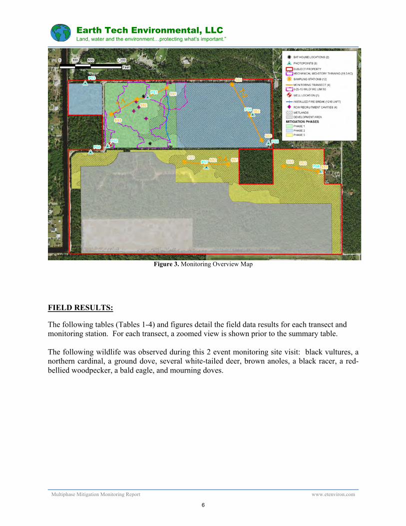
This multiphase monitoring summary provides results from the monitoring events completed on January 27, 2015 (phase 1) and December 16, 2015 (phase 2 & 3) within the phased mitigation\management areas. The Phase 1 Mitigation\Management area totals approximately 40 acres and is located roughly in the NW corner of the property. The Phase 2 Mitigation/Management area totals approximately 62 acres and is located in the northern portion of the preserve. The Phase 3 Mitigation/Management area totals approximately 65 acres and is located immediately north of the development envelope. See (Figure 2) for specific locations of each mitigation phase. The principal components of this summary include photographic documentation, preserve monitoring map with aerial, vegetation composition information, and wildlife observations. Please refer (Figure 3) for an overall map that depicts the monitoring\photo stations within the different mitigation phases within the preserve. (Figure 2) below shows the specific location of each mitigation phase.
3

Earth Tech Environmental, LLC Land, water and the environment…protecting what’s important.”
Multiphase Mitigation Monitoring Report www.etenviron.com
Figure 2. Mitigation Phase Location Map.
PROJECT HISTORY & DETAILS
The following is the approved work schedule for as outlined in the FDEP permit. The project has been subject to delays in permitting and construction and therefore the schedule of activities has been running approximately 6-9 months behind. The applicant has only recently (mid August 2015) begun initial site clearing within the Phase 1 impact area.
Due Date Activity Completion Date November 30, 2013 Baseline Monitoring report August 2014 December 2013 Initial Exotic Removal Feb. through Aug 2014 December 1, 2013 Record Conservation Easements August 12, 2014 January 15, 2014 Time Zero Monitoring Report September 8, 2014 December 2014 Maintenance Activity Dec. 2014 through Jan. 2015 January 15, 2015 First Annual Monitoring Report January 2015 December 2015 Maintenance Activity December 2015 January 15, 2016 Second Annual Monitoring Report Late January 2016 December 2016 Maintenance Activity January 15, 2017 Third Annual Monitoring Report December 2017 Maintenance Activity January 15, 2018 Fourth Annual Monitoring Report December 2018 Maintenance Activity January 15, 2019 Fifth Annual Monitoring Report
4

Earth Tech Environmental, LLC Land, water and the environment…protecting what’s important.”
Multiphase Mitigation Monitoring Report www.etenviron.com
WETLAND MONITORING METHODOLOGY
Approved Plan: The FDEP\ACOE approved plan is included in Appendix 4. This monitoring report covers the following events for the phased mitigation activities:
Phase 2 Baseline Monitoring (fieldwork conducted September 11, 2015) Phase 2 Time Zero Monitoring (fieldwork conducted December 16, 2015) Phase 3 Baseline Monitoring (fieldwork conducted December 16, 2015)
We expect to complete Phase 1 Second Annual Monitoring in late January 2016. Results of that monitoring event will be appended to this report.
Approved habitat management activities are outlined in the “Management Plan for Listed Species”, which is included in Appendix 5.
Hydrological: Water level data was downloaded from the digital In-Situ Rugged Troll 100 piezometer and In-Situ Baro Troll 100. The location of the well is shown in (Figure 3). A graph summarizing water levels over time is attached (February 2014 to December 2015). According to the graph, the groundwater was below the bottom of the well (~7.5’ NGVD) until approximately July 1, 2014. The highest point the water has reached in the well is approximately 2.5’ below ground and as of December 2015, the water in the well was just over 3.0’ below ground. It appears that the 2015 rainy season was longer in duration and had more consistent water levels. See Appendix 3 for the updated summary graph.
Photographic Documentation & Vegetation Composition: Photographs were taken at locations specified in the approved monitoring plan (PS1 through PS8). Phase 1 & 2 photo stations document the dramatic changes in the preserve as a result of exotic removal activities and wildlife habitat management. See Appendix 1. The vegetation composition of each station along the monitoring transect can be found in (Tables 1-4). Additional photographs taken at the monitoring stations and of mitigation activities throughout the property are included in Appendix 2, “Additional Photographic Documentation”.
5
Earth Tech Environmental, LLC Land, water and the environment…protecting what’s important.”
Multiphase Mitigation Monitoring Report www.etenviron.com
Figure 3. Monitoring Overview Map
FIELD RESULTS: The following tables (Tables 1-4) and figures detail the field data results for each transect and monitoring station. For each transect, a zoomed view is shown prior to the summary table. The following wildlife was observed during this 2 event monitoring site visit: black vultures, a northern cardinal, a ground dove, several white-tailed deer, brown anoles, a black racer, a red-bellied woodpecker, a bald eagle, and mourning doves.
6

Earth Tech Environmental, LLC Land, water and the environment…protecting what’s important.”
Multiphase Mitigation Monitoring Report www.etenviron.com
Figure 4. Transect #1 (T-1), Zoomed View
TRANSECT #1 (In Phase 1 Mitigation Area)
TRANSECT 1 (T-1)
SPECIES OBSERVED % COVER FOR EACH MONITORING EVENT
Scientific Name Common Name BL TZ 1st Annual
2nd Annual
3rd Annual
4th Annual
5th Annual
SS1 Canopy: Taxodim distichum Cypress 10 7 7 Sabal palmetto Cabbage Palm 10 4 3 Pinus elliotii Slash Pine 40 40 40 Acacia auriculiformis Ear Leaf Acacia 5 - - Mid: Myrsine guianensis Myrsine 8 8 8 Sabal palmetto Cabbage Palm 5 3 2 Acacia auriculiformis Ear Leaf Acacia 5 - - Serenoa repens Saw Palmetto 3 3 3
7

Earth Tech Environmental, LLC Land, water and the environment…protecting what’s important.”
Multiphase Mitigation Monitoring Report www.etenviron.com
Calicarpa americana Beautyberry - 2 1 Schinus terebinthifolia Brazilian pepper 2 - - Ground: Muscadine rotundifolia Grapevine 50 20 30 Cladium jamaicense Saw grass - 4 3 Andropogon virginicus Broomsedge - 2 - Piloblephis rigida Pennyroyal - 1 - Urena lobata Caesarweed 5 - - Toxicodendron radicans Poison Ivy 3 2 1 Smilax auriculata Earleaf greenbrier - - 1
SS2 Canopy: Taxodim distichum Cypress 10 8 8 Sabal palmetto Cabbage Palm 5 3 2 Pinus elliotii Slash Pine 40 35 35 Acacia auriculiformis Ear Leaf Acacia 4 - - Mid: Myrsine guianensis Myrsine 10 2 5 Sabal palmetto Cabbage Palm 10 2 1 Acacia auriculiformis Ear Leaf Acacia 3 1 - Serenoa repens Saw Palmetto 5 5 5 Schinus terebinthifolia Brazilian pepper 3 1 - Ground: Muscadine rotundifolia Grapevine 25 80 40 Urena lobata Caesarweed 5 - 1 Toxicodendron radicans Poison Ivy 3 2 2 Cladium jamaicense Saw grass 2 4 4 Calicarpa americana Beautyberry - - 2 Panicum hemitomon Maiden-cane - - 15
SS3 Canopy: Taxodim distichum Cypress 1 - -
Sabal palmetto Cabbage Palm 10 6 6
Pinus elliotii Slash Pine 30 30 30
Acacia auriculiformis Ear Leaf Acacia 4 - -
Mid: Myrsine guianensis Myrsine 15 15 5
Sabal palmetto Cabbage Palm 5 6 -
Acacia auriculiformis Ear Leaf Acacia 3 - -
Serenoa repens Saw Palmetto 15 15 20
Schinus terebinthifolia Brazilian pepper 2 - -
Ground: Muscadine rotundifolia Grapevine 15 3 1
Urena lobata Caesarweed 3 - -
8

Earth Tech Environmental, LLC Land, water and the environment…protecting what’s important.”
Multiphase Mitigation Monitoring Report www.etenviron.com
Calicarpa americana Beautyberry - - 2
Toxicodendron radicans Poison Ivy 3 2 1
Figure 5. Transect #2 (T-2), Zoomed View
TRANSECT #2 (In Phase 2 Mitigation Area)
TRANSECT 2 (T-2)
SPECIES OBSERVED % COVER FOR EACH MONITORING EVENT
Scientific Name Common Name BL TZ 1st Annual
2nd Annual
3rd Annual
4th Annual
5th Annual
SS1
Canopy: Taxodim distichum Cypress 10 10 Sabal palmetto Cabbage Palm 5 5 Pinus elliotii Slash Pine 60 60 Acacia auriculiformis Ear Leaf Acacia 15 - Mid:
9

Earth Tech Environmental, LLC Land, water and the environment…protecting what’s important.”
Multiphase Mitigation Monitoring Report www.etenviron.com
Myrsine guianensis Myrsine 4 4 Sabal palmetto Cabbage Palm 15 15 Ilex cassine Dahoon Holly 3 3 Calicarpa americana Beautyberry 10 - Ground: Muscadine rotundifolia Grapevine 50 10 Urena lobata Caesarweed 10 - Toxicodendron radicans Poison Ivy 3 3 Smilax auriculata Earleaf greenbrier 1 1
SS2
Canopy: Taxodim distichum Cypress 20 20 Ilex cassine Dahoon Holly 5 5 Pinus elliotii Slash Pine 55 55 Acacia auriculiformis Ear Leaf Acacia 10 - Mid: Myrsine guianensis Myrsine 35 35 Sabal palmetto Cabbage Palm 30 30 Calicarpa americana Beautyberry 8 8 Chrysobalanus icaco Coco Plum 1 1 Ground: Muscadine rotundifolia Grapevine 30 10 Urena lobata Caesarweed 3 -- Toxicodendron radicans Poison Ivy 2 2 Cladium jamaicense Saw grass - 1
Schinus terebinthifolia Brazilian pepper 8 0
Blechnum serrulatum Swamp Fern 2 2
Chiococca alba Snow Berry 1 1 SS3
Canopy:
Taxodim distichum Cypress 20 20
Ilex cassine Dahoon Holly 5 5
Pinus elliotii Slash Pine 50 50
Acacia auriculiformis Ear Leaf Acacia 10 -
Mid:
Myrsine guianensis Myrsine 3 3
Sabal palmetto Cabbage Palm 35 35
Serenoa repens Saw Palmetto 3 1
Schinus terebinthifolia Brazilian pepper 5 -
Ground:
Muscadine rotundifolia Grapevine 30 5
Urena lobata Caesarweed 15 -
Smilax auriculata Earleaf greenbrier 1 1
Toxicodendron radicans Poison Ivy 2 2
10

Earth Tech Environmental, LLC Land, water and the environment…protecting what’s important.”
Multiphase Mitigation Monitoring Report www.etenviron.com
Figure 6. Transect #3 (T-3), Zoomed View
TRANSECT #3 (In Phase 3 Mitigation Area)
TRANSECT 3 (T-3)
SPECIES OBSERVED % COVER FOR EACH MONITORING EVENT
Scientific Name Common Name BL TZ 1st Annual
2nd Annual
3rd Annual
4th Annual
5th Annual
SS1 Canopy: Taxodim distichum Cypress 20 Pinus elliotii Slash Pine 50 Acacia auriculiformis Ear Leaf Acacia 17 Sabal palmetto Cabbage Palm 10 Mid: Serenoa repens Saw Palmetto 4
11
Earth Tech Environmental, LLC Land, water and the environment…protecting what’s important.”
Multiphase Mitigation Monitoring Report www.etenviron.com
Myrsine guianensis Myrsine 5 Morella cerifera Wax Myrtle 1 Ground: Muscadine rotundifolia Grapevine 30 Cladium jamaicense Saw Grass 1 Acacia auriculiformis Ear Leaf Acacia 10
Urena lobata Caesarweed 4
Panicum hemitomon Maidencane 2
SS2
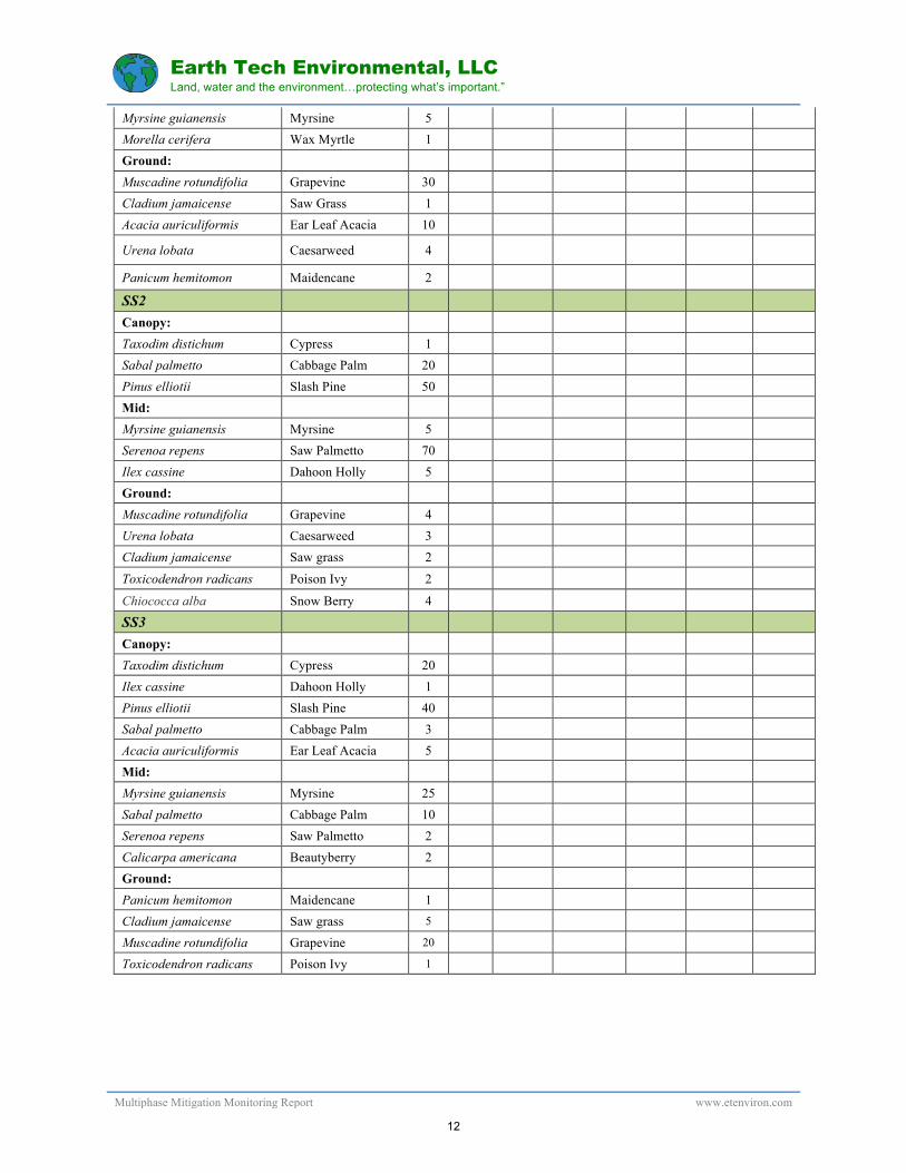
Canopy: Taxodim distichum Cypress 1 Sabal palmetto Cabbage Palm 20 Pinus elliotii Slash Pine 50 Mid: Myrsine guianensis Myrsine 5 Serenoa repens Saw Palmetto 70 Ilex cassine Dahoon Holly 5 Ground: Muscadine rotundifolia Grapevine 4 Urena lobata Caesarweed 3 Cladium jamaicense Saw grass 2
Toxicodendron radicans Poison Ivy 2
Chiococca alba Snow Berry 4
SS3
Canopy:
Taxodim distichum Cypress 20
Ilex cassine Dahoon Holly 1
Pinus elliotii Slash Pine 40
Sabal palmetto Cabbage Palm 3
Acacia auriculiformis Ear Leaf Acacia 5
Mid:
Myrsine guianensis Myrsine 25
Sabal palmetto Cabbage Palm 10
Serenoa repens Saw Palmetto 2
Calicarpa americana Beautyberry 2
Ground:
Panicum hemitomon Maidencane 1
Cladium jamaicense Saw grass 5
Muscadine rotundifolia Grapevine 20
Toxicodendron radicans Poison Ivy 1
12

Earth Tech Environmental, LLC Land, water and the environment…protecting what’s important.”
Multiphase Mitigation Monitoring Report www.etenviron.com
Figure 7. Transect #4 (T-4), Zoomed View
TRANSECT #4 (In Phase 3 Mitigation Area)
TRANSECT 4 (T-4)
SPECIES OBSERVED % COVER FOR EACH MONITORING EVENT
Scientific Name Common Name BL TZ 1st Annual
2nd Annual
3rd Annual
4th Annual
5th Annual
SS1
Canopy: Taxodim distichum Cypress 20 Pinus elliotii Slash Pine 50 Mid: Pinus elliotii Slash Pine 15 Taxodim distichum Cypress 15 Sideroxylon reclinatum Buckthorn 2 Ground: Muscadine rotundifolia Grapevine 30 Cladium jamaicense Saw grass 5 Melinis repens Natal grass 15
13

Earth Tech Environmental, LLC Land, water and the environment…protecting what’s important.”
Multiphase Mitigation Monitoring Report www.etenviron.com
Pteridium aquilinum Bracken fern 2
Spermacoce verticillata Shrubby buttonweed
5
Rhus copallinum Sumac 1
SS2
Canopy: Taxodim distichum Cypress 20 Sabal palmetto Cabbage Palm 5 Pinus elliotii Slash Pine 60 Mid: Myrsine guianensis Myrsine 10 Acacia auriculiformis Ear Leaf Acacia 3 Schinus terebinthifolia Brazilian pepper 5 Cupaniopsis anacardioides Carrotwood 1 Ground: Muscadine rotundifolia Grapevine 30 Urena lobata Caesarweed 5 Cladium jamaicense Saw grass 10
Blechnum serrulatum Swamp Fern 5
SS3
Canopy:
Taxodim distichum Cypress 20
Ilex cassine Dahoon Holly 2
Pinus elliotii Slash Pine 50
Sabal palmetto Cabbage Palm 2
Acacia auriculiformis Ear Leaf Acacia 2
Mid:
Myrsine guianensis Myrsine 20
Sabal palmetto Cabbage Palm 5
Ground:
Myrsine guianensis Myrsine 5
Urena lobata Caesarweed 4
Cladium jamaicense Saw grass 1
Muscadine rotundifolia Grapevine 15
Toxicodendron radicans Poison Ivy 1
DISCUSSION A large amount of onsite preserve management has taken place within the Phase 1 mitigation area. Onsite habitat management activities are intended to benefit a number of listed species, including Red Cockaded Woodpecker (RCW) (Picoides Borealis), Florida Bonneted Bat (Eumops floridanus), Big Cypress Fox Squirrel (Sciurus Niger Avicennia), Eastern Indigo Snake (Drymarchon Corais Couperi), and Gopher Tortoise (Gopherus Polyphemus).
14
Earth Tech Environmental, LLC Land, water and the environment…protecting what’s important.”
Multiphase Mitigation Monitoring Report www.etenviron.com
The following are updated discussions of what the onsite work for RCW management has been completed as of the date of this report (although most of these activities will benefit all the above listed species):
1. Removal of invasive, exotic vegetation. Removal of invasive vegetation throughout the Phase 1 mitigation area has been accomplished in several steps:
a. Extensive manual exotic removal around the perimeter of the 40 acre Phase 1 mitigation area: The perimeter of the 40 acre Phase 1 mitigation area contained dense stands of very large ear leaf acacia. This portion of the mitigation area has treated for re-sprouts during subsequent exotic maintenance events.
b. Extensive mechanical exotic removal within the FLUCCS 624 wetland in southwest corner of the 40 acre phase 1 mitigation area: This small wetland was heavily invaded with Brazilian pepper. Earth Tech has completed a maintenance event throughout this area to control re-sprouts in the newly opened up habitat. Beauty berry has recruited into this area nicely.
c. Herbicidal treatment of exotics within central portion of 40 acre phase 1 mitigation
area (~33 acres): Earth Tech has completed two herbicidal treatment maintenance events within the main portion of the 40 acre phase 1 mitigation area. Exotic vegetation re-sprouts were cut, removed, or killed in place throughout the preserve.
2. Develop and implement a controlled burn program within the preserve.
We’ve met with DOF regarding doing the controlled burn in the phase 1 mitigation area. We are planning to have the DOF as the lead in the controlled burn with assistance from local agencies if necessary. The burn has been delayed because the burn agreement proposed by DOF was required to be presented to the Collier County Board of County Commissioners for approval. We are awaiting their review and approval. The goal is to burn the portion of the phase 1 mitigation area that has been extensively managed by mid-story clearing sometime in the spring of 2016.
3. Installation of fire lines utilizing best management practices to minimize impacts to mature trees, habitat and wildlife populations. A firebreak has been cleared along the eastern limit of the phase 1 40 acre mitigation area. The purpose of the firebreak is to protect the mitigation area from wildfire and to allow controlled burns in the northern preserve in two 40 acre segments instead of a single large 80 acre block. The firebreak has now been raked down to the sand in order to provided optimal fire protection. The firebreak is scheduled to be maintained again later this spring, prior to the 2016 rainy season.
4. Control hardwoods, mid story vegetation, and excessive pines in the preserve through the use of mechanical or chemical methods or through the use of prescribed fire
15
Earth Tech Environmental, LLC Land, water and the environment…protecting what’s important.”
Multiphase Mitigation Monitoring Report www.etenviron.com
so that the density guidelines contained in Appendix 5 of the RCW Recovery Plan (USFWS 2003) are met. An exception to the recovery plan will be preservation of existing snag trees as potential roost sites for the bonneted bat.
The proposed RCW recruitment trees within the Phase 1 mitigation area were chosen and mid-story thinning & exotic removal was completed to make the habitat surrounding the 4 recruitment trees suitable for RCW. This included mechanical removal of nearly all mid-story vegetation such as cabbage palm, myrsine, saw palmetto, and any exotic vegetation such as ear leaf acacia & Brazilian pepper. Per the approved management plan, this work was supervised by an Earth Tech ecologist. Currently a total of 19.3 acres of habitat has been thinned mechanically. See attached “Management and Monitoring Map” for current limits of mechanical management areas. As of December 2015, grapevine and myrsine have re-sprouted within the mechanical thinning area. The myrsine is already 3 to 4 foot tall in many areas. Earth Tech is planning another mowing event within the RCW area to knock the myrsine back down and control the grapevine. This mowing event will take place in February 2016, hopefully in preparation for the first controlled burn.
5. Installing and maintaining artificial RCW cavities within the pine flatwoods, which are currently unoccupied nesting habitat. The preserve on the CCRRP is perfectly situated between the isolated RCW group on the Conservation Collier Nancy Payton preserve to the north and the City Gate mitigation parcel cluster (ROCCO) to the east. Establishing a new nesting group at this location will provide roosting and nesting cavities for fledglings from the RCW groups in the North Belle Meade which would otherwise have no place to roost within NBM.
During the summer of 2014, four (4) suitable slash pine trees were chosen in the north central portion of the mitigation area for installation of artificial RCW cavities. The trees were prepped and an artificial RCW cavity was installed in each. The trees were scraped, sap wells were created, and the tree locations were taken with a GPS capable of sub-meter accuracy. The locations of the cavity trees are shown on the attached Management & Monitoring map. In June of 2015, lightening struck one of the cavity trees and it has subsequently died. We anticipate choosing a new tree and installing a replacement artificial cavity in Spring 2016.
6. Monitoring and reporting of the status of the RCW recruitment cluster.
On 11/25/14, Monica Folk of Milliken Forestry monitored the status of the artificial RCW cluster on the property and made the following assessment, “The RRP potential RCW cluster and inserts were inspected. All 4 inserts are in excellent shape, but no RCW work was detected. The mulched area is growing back quickly and the grape vine is almost continuous and several feet high. A good hard freeze or mowing would be beneficial to knock it back. As soon as practical, a dormant season burn should be applied to the area to
16

Earth Tech Environmental, LLC Land, water and the environment…protecting what’s important.”
Multiphase Mitigation Monitoring Report www.etenviron.com
reduce fuel loads and control regrowth. If burning is not feasible in this current dormant season, a mowing treatment should be planned for next growing season.” As of Fall 2015, Monica Folk has not documented any RCW activity within the CCRRP cluster. She will conduct RCW monitoring again as part of the upcoming nesting season. 7. Install two bat houses within the preserve as potential roost locations for bats.
Two bat houses were installed within the Phase 1 mitigation area in July of 2015. See (Figure 3) for specific locations of the bat houses. Photographs of the bat houses have been included in Appendix 2, “Additional Photographic Documentation”.
1. ACOE Performance Standards & Summary:
ACOE Permit (SAJ-2011-00626) specifies the following performance standards in order to meet the objectives of the approved mitigation plan: a. At least 80 percent cover by appropriate wetland species (i.e., FAC or wetter).
The majority of the Phase 1 mitigation area is uplands. The portions of the Phase 1 mitigation area that are wetland do contain at least 80 percent cover of appropriate wetland species. Future phases of mitigation are primarily wetland. See Vegetation Composition Tables (Tables 1-4) for percentage breakdowns of cover by species. As can be seen from data taken at monitoring stations along the transects, the wetlands contain at least 80 cover of appropriate wetland species.
b. Cover of Category I and II invasive exotic plant species, pursuant to the most current
list established by the Florida Exotic Pest Plant Council at http://www.fleppc.org, and the nuisance species, dogfennel (Eupatorium capillifolium), Bermudagrass (Cynodon spp.), Bahiagrass (Paspalum notatum), and cattail (Typha spp.). shall total less than 5 percent. See the Vegetation Composition Tables (Tables 1-4) above for species compositions along the monitoring transects. Cover of Category I & II invasive exotic species was less than 5 percent along the monitoring transects and throughout the Phase 1 & 2 mitigation areas. Phase 3 was monitored for baseline conditions only.
Summary of Performance Standards As outlined above, the CCRRP Phase 1 & 2 mitigation areas currently meets the performance standards in the approved ACOE permit. Exotic and nuisance vegetation removal throughout the mitigation area was through and subsequent maintenance events have prevented any re-establishment. Wetland areas contain greater than 80% cover of appropriate wetland species.
17

Earth Tech Environmental, LLC Land, water and the environment…protecting what’s important.”
Multiphase Mitigation Monitoring Report www.etenviron.com
Future reports will include additional status updates on each of the activities listed above. Required timing of these activities was outlined in the “Management Plan for Listed Species”. As stated previously, we anticipate attempting the first burn of the Phase 1 mitigation area in Spring 2016.
18

Earth Tech Environmental, LLC Land, water and the environment…protecting what’s important.”
Multiphase Mitigation Monitoring Report www.etenviron.com
APPENDIX 1
PANORAMIC PHOTOGRAPHS OF PHOTO STATIONS
19

CCRRP:panoramicphotographs !"#$
PHASE1FIRSTANNUALMONITORING:PanoramicPhotographalongTransect#1,Photo-stationPS1takenonJanuary27,2015.
20

CCRRP:panoramicphotographs !"#$
PHASE1FIRSTANNUALMONITORING:PanoramicPhotographatPhoto-stationPS2takenonJanuary27,2015.
21

CCRRP:panoramicphotographs !"#$
PHASE2BASELINEMONITORING:PanoramicPhotographatPhoto-stationPS3takenonSeptember11,2015.
22

CCRRP:panoramicphotographs !"#$
PHASE2BASELINEMONITORING:PanoramicPhotographalongTransect#2,Photo-stationPS4takenonSeptember11,2015.
23

CCRRP:panoramicphotographs !"#$
PHASE2BASELINEMONITORING:PanoramicPhotographatPhoto-stationPS5takenonSeptember11,2015.
24

CCRRP:panoramicphotographs !"#$
PHASE2TIMEZEROMONITORING:PanoramicPhotographatPhoto-stationPS4takenonDecember16,2015.
25

CCRRP:panoramicphotographs !"#$
PHASE2TIMEZEROMONITORING:PanoramicPhotographalongTransect#2,Photo-stationPS4takenonDecember16,2015.
26

CCRRP:panoramicphotographs !"#$
PHASE2TIMEZEROMONITORING:PanoramicPhotographatPhoto-stationPS5takenonDecember16,2015.
27
CCRRP:panoramicphotographs !"#$
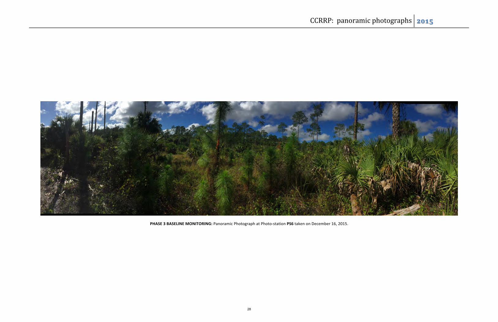
PHASE3BASELINEMONITORING:PanoramicPhotographatPhoto-stationPS6takenonDecember16,2015.
28

CCRRP:panoramicphotographs !"#$
PHASE3BASELINEMONITORING:PanoramicPhotographalongTransect#2,Photo-stationPS7takenonDecember16,2015.
29

CCRRP:panoramicphotographs !"#$
PHASE3BASELINETIMEZEROMONITORING:PanoramicPhotographatPhoto-stationPS8takenonDecember16,2015.
30

Earth Tech Environmental, LLC Land, water and the environment…protecting what’s important.”
Multiphase Mitigation Monitoring Report www.etenviron.com
APPENDIX 2
ADDITIONAL PHOTOGRAPHIC DOCUMENTATION
31

AdditionalPhotographicDocumentation !"#$CCRRBP–Phase2MitigationArea.ExoticRemovalProgress–October12,2015
NorthwestCornerofPhase2,lookingwest.Baseline. NorthwestCornerofPhase2,lookingwest.PostMechanicalClearingofEdge-earleaffringe.
32

AdditionalPhotographicDocumentation !"#$
SouthernlineofPhase2,lookingwest.Baseline. SouthernlineofPhase2,lookingwest.PostMechanicalClearingofEdge-earleaffringe,grindingBrazilianpepper.
33

AdditionalPhotographicDocumentation !"#$
SouthernlineofPhase2,lookingwest.Baseline. SouthernlineofPhase2,lookingwest.PostMechanicalClearingofEdge-earleaffringe,grindingBrazilianpepper.
34

AdditionalPhotographicDocumentation !"#$
VariousotherphotosofpostworkconditionsinPhase2.EarleaffringehasbeencutandstackedalongentireedgeofPhase2.Mechanicalgrinding\mulchingoflargeaBrazilianpepperareainnorthwestcornerofPhase2is
complete(above).
35

AdditionalPhotographicDocumentation !"#$
UpperLeft:DeadearleafacaciatreatedinplacewithintheinteriorofthePhase2mitigationarea.UpperRight:Ahandfernobservedduringthemostrecentmonitoringevent.LowerLeft:Aphotographofabathouseinstalled
inthePhase1mitigationarea.
36

AdditionalPhotographicDocumentation !"#$
UpperLeft:ThewesternlimitofthePhase2mitigationareaadjacenttothecanalafterextensiveexoticremoval.UpperRight:GirdledearleafacaciawithinthePhase2mitigationarea.LowerLeft:AportionofthePhase2
mitigationareaafterextensivemechanicalexoticremoval.
37

Earth Tech Environmental, LLC Land, water and the environment…protecting what’s important.”
Multiphase Mitigation Monitoring Report www.etenviron.com
APPENDIX 3
WATER LEVEL DATA SUMMARY GRAPH
38

Figure1:WaterLevelsatWellNo.1withinCollierCountyResourceRecoveryPark,February2014-December2015
7.00
8.00
9.00
10.00
11.00
12.00
13.00
WSEL-
NGVD
29
CCRRPWellNo.1WaterLevel NaturalGround 12.33
39

Earth Tech Environmental, LLC Land, water and the environment…protecting what’s important.”
Multiphase Mitigation Monitoring Report www.etenviron.com
APPENDIX 4
APPROVED WETLAND MONITORING PLAN (BOYLAN)
40

41
Earth Tech Environmental, LLC Land, water and the environment…protecting what’s important.”
Multiphase Mitigation Monitoring Report www.etenviron.com
APPENDIX 5
APPROVED MANAGEMENT PLAN FOR LISTED SPECIES
42
MANAGEMENT PLAN FOR LISTED SPECIES RED COCKADED WOODPECKER (Picoides borealis) FLORIDA BONNETED BAT (Eumops floridanus) BIG CYPRESS FOX SQUIRREL (Sciurus niger avicennia) EASTERN INDIGO SNAKE (Drymarchon corais couperi) GOPHER TORTOISE (Gopherus polyphemus) Project: COLLIER COUNTY RESOURCE RECOVERY PARK Location: Section 25, Township 49 South, Range 26 East
(26°10’27.35”N; 81°39’43.93”W) Prepared for:
U.S. FISH & WILDLIFE SERVICE (USFWS) South Florida Ecological Services Field Office 1339 20th Street Vero Beach, FL 32960 FLORIDA FISH & WILDLIFE CONSERVATION COMMISSION (FWC) Office of Conservation Planning Services 620 South Meridian Street Tallahassee, FL 32399
Date: November 26, 2012 Revised: December 18, 2012 Revised November 18, 2013 Prepared by:
5475 Golden Gate Parkway, Suite 5 West Naples, FL 34116 (239) 304-‐0030
11000 Metro Parkway Suite 4 Fort Myers, FL 33966 (239) 418-‐0671
43

COLLIER COUNTY RESOURCE RECOVERY PARK Management Plan for Listed Species
Page 2 of 26
INTRODUCTION This document provides a summary of onsite management activities proposed for implementation on the Collier County Resource Recovery Park site. Management activities will take place within the proposed preserve areas and will benefit a number of listed species, including Red Cockaded Woodpecker (Picoides Borealis), Big Cypress Fox Squirrel (Sciurus Niger Avicennia), Eastern Indigo Snake (Drymarchon Corais Couperi), And Gopher Tortoise (Gopherus Polyphemus).
PROJECT LOCATION The Collier County Resource Recovery Park site is located in portions of Section 25, Township 49 South, Range 26 East, Collier County, Florida. Specifically, it is situated north of the Collier County landfill, east of the Golden Gate Canal\Golden Gate Estates Unit 28, south of the Hideout golf course, and west of Garland Road. See Figure 1 below.
Figure 1. Site Location.
44

COLLIER COUNTY RESOURCE RECOVERY PARK Management Plan for Listed Species
Page 3 of 26
DESCRIPTION OF PROPOSED PROJECT The purpose of Resource Recovery Park is to construct a collection and transfer site adjacent to the existing landfill that will provide for resource recovery and recycling. Specifically, the solid waste recovery facility will include handling and/or processing of materials such as tires, glass, paper, plastics, storm debris, construction debris, and construction demolition debris. Processing of these materials will keep them in the recycle stream and prevent them from being buried within the landfill. The proposed project is being constructed because the existing landfill facilities will not meet the needs of the surrounding area in the next 25 years. Construction and operation of the proposed facility will extend the projected life span of the landfill operation to at least 50 years. Currently, existing materials collected in the County that qualify for recycling are shipped to Pembroke Pines for processing. Having this facility in Collier County will prevent the fiscal and environmental impacts of shipping these materials across the State.
EXISTING SITE CONDITIONS
The Resource Recovery Park Site has the following surrounding land uses:
West Golden Gate Canal
North Hideout Golf Course
South Undeveloped Lands, Collier County Landfill
East Garland Road, Low Density Residential
Vegetation Community Summary Table (Existing)
FLUCFCS Code Community Acreage 411 Pine Flatwoods 0.12± ac. 411E1 Pine Flatwoods (1-‐24% Exotics) 149.32± ac. 411E2 Pine Flatwoods (25-‐49% Exotics) 3.69± ac. 411E3 Pine Flatwoods (50-‐74% Exotics) 1.55± ac. 428 Cabbage Palm 3.03± ac. 428E1 Cabbage Palm (1-‐24% Exotics) 18.70± ac. 428H Cabbage Palm, Hydric 5.08± ac. 428HE1 Cabbage Palm, Hydric (1-‐24% Exotics) 6.16± ac. 435E1 Burned Pine Flatwoods (1-‐24% Exotics) 9.39± ac. 621E4 Cypress Wetlands (75-‐99% Exotics) 1.28± ac. 624E1 Cypress-‐Pine-‐Cabbage Palm (1-‐24% Exotics) 122.97± ac. 624E2 Cypress-‐Pine-‐Cabbage Palm (25-‐49% Exotics) 9.34± ac. 832H FPL Utility Easement, Hydric 0.87± ac. 833 Wellfield and Associated Roads 12.72± ac.
Total 344.22± ac.
(Figure 2) shows the current FLUCFCS breakdown on the property:
45

COLLIER COUNTY RESOURCE RECOVERY PARK Management Plan for Listed Species
Page 4 of 26
Figure 2. Existing Conditions FLUCSFCS mapping (Wetlands are hatched).
Based on the FLUCFCS system, the following is a description of each community currently present on the property:
411 Pine Flatwoods (1-‐24% Exotics) (0.12± acres) This upland habitat type occupies 0.12± acres of the property. Canopy vegetation is slash pine (Pinus elliottii). Sub-‐canopy includes minimal Brazilian pepper (Schinus terebinthifolius), Earleaf acacia (Acacia auriculiformis), cabbage palm (Sabal palmetto) and Guiana myrsine (Myrsine guianensis). Ground cover includes Brazilian pepper, saw palmetto (Serenoa repens), cabbage palm, saw grass (Cladium jamaicense), Bahia grass (Paspalum notatum), and Caesar weed (Urena lobata). 411E1 Pine Flatwoods (1-‐24% Exotics) (149.32± acres) This upland habitat type occupies 149.32± acres of the property. Canopy vegetation is slash pine (Pinus elliottii). Sub-‐canopy includes minimal Brazilian pepper (Schinus terebinthifolius), Earleaf acacia (Acacia auriculiformis), cabbage palm (Sabal palmetto) and Guiana myrsine (Myrsine guianensis). Ground cover includes Brazilian pepper, saw
46

COLLIER COUNTY RESOURCE RECOVERY PARK Management Plan for Listed Species
Page 5 of 26
palmetto (Serenoa repens), cabbage palm, saw grass (Cladium jamaicense), Bahia grass (Paspalum notatum), and Caesar weed (Urena lobata). 411E2 Pine Flatwoods (25-‐49% Exotics) (3.69± acres) This upland habitat type occupies 3.69± acres of the property. Canopy vegetation is slash pine. Sub-‐canopy and ground cover includes Brazilian pepper, Earleaf acacia, Guiana myrsine, and cabbage palm. Ground cover also includes Caesar weed, smilax (Smilax sp.), and grapevine (Vitis rotundifolia).
411E3 Pine Flatwoods (50-‐74% Exotics) (1.55± acres) This upland habitat type occupies 1.55± acres of the property. Canopy vegetation is slash pine. Sub-‐canopy includes Brazilian pepper, Earleaf acacia, and cabbage palm. Ground cover includes Brazilian pepper, Earleaf acacia saw palmetto, Caesar weed, and smilax. 428 Cabbage Palm (3.03± acres) This upland habitat type occupies 3.03± acres of the property. The canopy and sub-‐canopy contain cabbage palm. The ground cover includes wild coffee and beauty-‐berry. 428E1 Cabbage Palm (1-‐24% Exotics) (18.70± acres) This upland habitat type occupies 18.70± acres of the property. The canopy and sub-‐canopy contains cabbage palm, slash pine stags and some melaleuca (Melaleuca quinquenervia). The ground cover includes Brazilian pepper, smilax, Caesar weed and beauty-‐berry. 428H Cabbage Palm, Hydric (5.08± acres) This wetland habitat type occupies 5.08± acres of the property. This area was recently burned and the vegetation community has slightly changed, leaning to a more upland community. The canopy and sub-‐canopy contains cabbage palm, slash pine stags, Brazilian pepper, and some melaleuca (Melaleuca quinquenervia). The ground cover includes smilax, grapevine, Caesar weed, and beauty-‐berry. 428HE1 Hydric Cabbage Palm (6.16± acres) This wetland habitat type occupies 6.16± acres of the property. This area was recently burned and the vegetation community has slightly changed, leaning to a more upland community. The canopy and sub-‐canopy contains cabbage palm, slash pine stags, Brazilian pepper, and some melaleuca (Melaleuca quinquenervia). The ground cover includes smilax, grapevine, Caesar weed, and beauty-‐berry. 435E1 Burned Pine Flatwoods (1-‐24% Exotics) (9.39± acres) This upland habitat type occupies 9.39± acres of the property. Due to a recent burn, the canopy and understory are open. The canopy contains sparse slash pine, live oak, and cabbage palm. The sub-‐canopy contains some cabbage palm. The ground cover is sparse and includes Bahia grass, Caesar weed, Brazilian pepper, and cabbage palm.
47

COLLIER COUNTY RESOURCE RECOVERY PARK Management Plan for Listed Species
Page 6 of 26
621E4 Cypress Wetlands (75-‐99% Exotics) (1.28± acres) This wetland habitat type occupies 1.28± acres of the property. The canopy is dominated by cypress. The sub-‐canopy contains cypress, Brazilian pepper, swamp bay (Persea palustris), Earleaf acacia, dahoon holly (Ilex cassine), Guiana myrsine and wax myrtle (Myrica cerifera). The ground cover includes swamp fern (Blechnum serrulatum), Caesar weed, grapevine, and Earleaf acacia. This community does contain some transitional wetland vegetation, advantageous rooting, water line staining, and algal matting, as well as other signs in this community that would be classified as wetlands.
624E1 Cypress-‐Pine-‐Cabbage Palm (1-‐24% Exotics) (122.97± acres) This wetland habitat type occupies 122.97± acres of the property. The canopy contains slash pine, cypress, cabbage palm, and Earleaf acacia. The sub-‐canopy contains Brazilian pepper, small cypress, wax myrtle, coco plum, myrsine, cabbage palm, and melaleuca. The ground cover includes smilax, grape vine, saw grass, Caesar weed. This community does contain some transitional wetland vegetation, advantageous rooting, water line staining, and algal matting, as well as other signs in this community that would be classified as wetlands. 624E2 Cypress-‐Pine-‐Cabbage Palm (25-‐49% Exotics) (9.34± acres) This wetland habitat type occupies 9.34± acres of the property. The canopy contains slash pine, cypress, cabbage palm, and Earleaf acacia. The sub-‐canopy contains Brazilian pepper, small cypress, wax myrtle, coco plum, myrsine, cabbage palm, and melaleuca. The ground cover includes smilax, grape vine, saw grass, Caesar weed. This community does contain some transitional wetland vegetation, advantageous rooting, water line staining, and algal matting, as well as other signs in this community that would be classified as wetlands. 832H FPL Utility Easement, Hydric (0.87± acres) This area is occupied by Florida Power and Light electrical transmission lines and roadways. It accounts for 0.87± acres of the property. 833 Wellfield and Associated Roads (12.72± acres) This area is occupied by a large County well field and accounts for 12.72± acres of the property. It includes access roads, pump stations, and utilities.
48

COLLIER COUNTY RESOURCE RECOVERY PARK Management Plan for Listed Species
Page 7 of 26
PROPOSED SITE CONDITIONS AFTER DEVELOPMENT
Figure 3. Post Development Conditions FLUCSFCS mapping.
Vegetation Community Summary Table (Post Development)
FLUCFCS Code Community Existing Acreage Developed Preserved
411 Pine Flatwoods 0.12± Ac 0.12± Ac 0.00± Ac 411E1 Pine Flatwoods (1-‐24% Exotics) 149.32± Ac 84.53± Ac 64.79± Ac 411E2 Pine Flatwoods (25-‐49% Exotics) 3.69± Ac 1.83± Ac 1.86± Ac 411E3 Pine Flatwoods (50-‐74% Exotics) 1.55± Ac 0.00± Ac 1.55± Ac 428 Cabbage Palm 3.03± Ac 0.00± Ac 3.03± Ac 428E1 Cabbage Palm (1-‐24% Exotics) 18.70± Ac 18.70± Ac 0.00± Ac 428H Cabbage Palm, Hydric 5.08± Ac 0.00± Ac 5.08± Ac 428HE1 Cabbage Palm, Hydric (1-‐24% Exotics) 6.16± Ac 6.16± Ac 0.00± Ac 435E1 Burned Pine Flatwoods (1-‐24% Exotics) 9.39± Ac 9.39± Ac 0.00± Ac 621E4 Cypress Wetlands (75-‐99% Exotics) 1.28± Ac 0.00± Ac 1.28± Ac 624E1 Pine, Cypress, Cabbage Palm (1-‐24% Exotics) 122.97± Ac 29.64± Ac 93.33± Ac 624E2 Pine, Cypress, Cabbage Palm (25-‐49% Exotics) 9.34± Ac 4.34± Ac 5.00± Ac 832H FPL Easement, Hydric 0.87± Ac 0.00± Ac 0.87± Ac 833 Wellfield with Associated Roads 12.72± Ac 0.00± Ac 12.72± Ac
Totals 344.22± Ac 154.71± Ac 189.51± Ac
49

COLLIER COUNTY RESOURCE RECOVERY PARK Management Plan for Listed Species
Page 8 of 26
LAND PROTECTION A Conservation Easement will be placed over the preserved lands and granted to Florida Department of Environmental Protection with the U.S. Fish and Wildlife Service (FWS) included as a third party to the agreement. INITIAL MAINTENANCE AND MITIGATION ACTIVITIES Collier County will be responsible for 5 years following the initial exotic removal and site preparation activities, external fencing of the property, burn plans and prescribed burn activities, mowing, vegetative monitoring, and wildlife monitoring LONG-‐TERM MAINTENANCE Collier County will be responsible for long term management activities, with the assistance of Conservation Collier, FWC, or FWS to implement and manage prescribed burns, mowing, exotic removal and maintenance as needed. Annual costs will be estimated following the initial maintenance activities to set up an escrow account or similar financial mechanism to ensure that the costs of management the lands in perpetuity will be met. MANAGEMENT ACTIVITIES BY SPECIES The following section provides biology and proposed management activities for each affected species. Red Cockaded Woodpecker (RCW) Biology The RCW is listed as a Species of Special Concern (SSC) by the Florida Fish and Wildlife Conservation Commission (FWC) and as endangered by the U.S. Fish and Wildlife Service (USFWS) (Sullivan 2004, 35 Federal Register [FR] 16047). The RCW is 8.5 inches long with black and white horizontal stripes on its back and a large unbroken white cheek patch (Jackson 1994). It has a black cap and stripe on each side of the black cap. Adult males weigh about 1.6 ounces and may be distinguished from females by the presence of a small tuft of red feathers (cockade) on the sides of the head. Adult females weigh less than males averaging 1.48 ounces (City Gate HCP). RCWs forage on pine trees for insects, spiders, and other invertebrates. For foraging, they use a variety of pine species throughout their range. In this region of Florida, RCWs spend about 10% of their foraging time in cypress habitats and the
50

COLLIER COUNTY RESOURCE RECOVERY PARK Management Plan for Listed Species
Page 9 of 26
remainder on pines. Females forage more frequently on the bole (trunk), while males make greater use of the limbs, cones, and twigs. Thus, males forage higher in the tree compared to females. Both sexes forage primarily on trees greater than 15 years of age and 4 inches or larger in diameter. Larger and older pines are preferred foraging sites, although foraging may occur on younger pines (City Gate HCP). Project Region The occurrence of RCWs in the vicinity of County Road 951 was first evaluated by the FWC in the late 1980s and included about 27 occupied clusters. Since then that population has declined and now accounts for about 8% of the south Florida woodpecker groups extending from Avon Park to the Big Cypress National Preserve (BCNP) (Wood and Wenner 1983; DeLotelle 2004) (Figure 4). The population on the Picayune Strand State Forest (PSSF) has increased recently as a result of cavity augmentation and bird translocation (DeLotelle, Folk). (Figure 4) details the current RCW clusters within the BCNP, PSSF, and the North Belle Meade (NBM).
Figure 4. Existing RCW Cluster Locations in BCNP, PSSF, & NBM.
51

COLLIER COUNTY RESOURCE RECOVERY PARK Management Plan for Listed Species
Page 10 of 26
Past management practices in the Naples area using small, on-‐site preserves and limited management appear to have been a failure as indicated by the population declines observed in the 1990s, including the complete extirpation of groups west of Collier Boulevard. (City Gate HCP). Within the vicinity of the Collier County Resource Recovery Park (CCRRP), there are four (4) remaining active RCW clusters in the North Belle Meade (NBM). (Figure 5) shows the CCRRP’s location in relation to the clusters in the NBM. The Hideout cluster located approximately one mile north of the property has a roosting male RCW, but has produced no breeding activity. Three clusters, the Rocco cluster, the Hussey East, and Hussey West are breeding clusters that have produced fledglings in recent years. As part of a 2009 Incidental Take Permit, the final RCW located on the City Gate property to the west of the CCRRP was relocated to the PSSF.
Figure 5. Existing RCW Cluster Locations in Project Vicinity.
The CCRRP site and its vicinity have been extensively surveyed for cavity trees in an effort to locate additional breeding clusters in the NBM. No additional cavities have been observed on the subject property or its vicinity in annual surveys conducted by DeLotelle & Guthrie going back to 2003 and most recently by Wild Folk, Ecotone Environmental, and Boylan Environmental Consultants. All parties are confident that the property does not contain inactive or active RCW cavity trees.
52

COLLIER COUNTY RESOURCE RECOVERY PARK Management Plan for Listed Species
Page 11 of 26
Project Impacts The CCRRP property does contain approximately 164.06 acres of pine flatwoods, 132.31 acres of mixed pine and cypress or cypress communities that likely provide foraging habitat for RCW clusters located to the north and east of the site. Most of the potential foraging habitat on the property is of very low quality for RCW. Mid-‐story and groundcover are dense and severely overgrown with a mix of cabbage palm, pine saplings, myrsine, and various exotics such as Brazilian pepper and ear leaf acacia. Red Cockaded Woodpecker Management Activities For mitigation for impacts to low quality RCW foraging habitat, the applicant is proposing mitigation onsite. Approximately 166.53 acres of low quality foraging habitat will be preserved onsite (approximately 68.20 acres of pine flatwoods, 98.33 acres of mixed pine and cypress). The intent is to manage these habitats for RCW in order to transform them into quality foraging habitat and the pine flatwoods into potential nesting habitat. The following is a basic framework for what the onsite work for RCW management will include: See (Figure 6) for specific locations.
1. Removal of invasive, exotic vegetation. 2. Develop and implement a controlled burn program within the preserve. 3. Installation of fire lines utilizing best management practices to minimize impacts to
mature trees, habitat and wildlife populations. 4. Control hardwoods, mid story vegetation, and excessive pines in the preserve through
the use of mechanical or chemical methods or through the use of prescribed fire so that the density guidelines contained in Appendix 5 of the RCW Recovery Plan (USFWS 2003) are met. An exception to the recovery plan will be preservation of existing snag trees as potential roost sites for the bonneted bat.
5. Installing and maintaining artificial cavities within the pine flatwoods, which are currently unoccupied nesting habitat. The proposed preserve on the CCRRP is perfectly situated between the isolated RCW group on the Conservation Collier Nancy Payton preserve to the north and the City Gate mitigation parcel cluster (ROCCO) to the east. Establishing a new nesting group at this location would provide roosting and nesting cavities for fledglings from the RCW groups in the North Belle Meade which would otherwise have no place to roost within NBM (Monica Folk, personal communication).
6. Monitoring and reporting of the status of the recruitment cluster.
53

COLLIER COUNTY RESOURCE RECOVERY PARK Management Plan for Listed Species
Page 12 of 26
Figure 6. Management Activities Overview.
All of these activities will provide an immediate RCW net conservation benefit and will benefit all the other species outlined in this plan. The following is a more detailed description of each activity:
1. Removal of invasive, exotic vegetation.
The initial mitigation activities for the CCRRP Preserves will include the eradication of melaleuca and other exotic vegetation as identified by FLEPPC 2012. The limits of the preserve areas will be flagged in the field prior to exotic removal activities. Eradication methods will consist of mechanical removal, cutting and stump treatment of all woody exotic species, foliar treatment of all saplings and/or herbaceous exotics species, and/or hand pulling. All treated woody vegetation will either be stacked within the preserve, mulched in place, and/or removed from preserve. A technician that is licensed to apply herbicide in natural and aquatic areas by Florida Department of Agriculture and Consumer Services (FDACS) will supervise activities. All tree stumps that are cut and ground with the machinery will be treated with a U.S.
54

COLLIER COUNTY RESOURCE RECOVERY PARK Management Plan for Listed Species
Page 13 of 26
Environmental Protection Agency (EPA) approved herbicide and visual tracer dye. Any accumulated trash and refuse will be hand removed from preserve area. For areas requiring mechanical removal, a low ground pressure posi-‐track will be utilized to mechanically remove exotic vegetation to limit soil disturbance. A mulched layer will remain to limit exotic regrowth from exposed open areas. Mechanical eradication will be utilized in areas where exotic vegetation exceeds 50% coverage. Mechanical clearing limits will be flagged in the field. Areas mechanically cleared of exotics will be re-‐contoured to natural grade if necessary. Mechanical work will be conducted only during times of dry soil conditions to minimize ground disturbance. Mechanical clearing limits may vary as a result of soil conditions or other limiting factors. All areas to be mechanically cleared of exotic vegetation will follow the same pre-‐construction clearing procedures outlined above in order to protect potential fox squirrel nests. Removal of these invasive plant species will reduce existing fuel loads and thereby temperature of the initial prescribed fire, and make possible the restoration of the natural fire regime to these habitats and benefit a multitude of plant and animal species, particularly the RCW and the Florida panther, but also the white-‐tailed deer (Odocoileus virginianus), Big Cypress fox squirrel (Sciurus niger avicennia), gopher tortoise (Gopherus polyphemus), and other upland fauna.
2. Develop and implement a controlled burn program within the preserve.
With DOF assistance, a fire management plan will be created. If necessary it will be coordinated with other local qualified agencies for review and approval. Due to the existing County well field that surrounds the proposed prescribed burn area, extensive coordination with Collier County Public Utilities will be necessary. The plan must include the following elements: purpose and measurable objectives, description of the burn unit, map of the burn unit, weather factors, safety concerns, fuel conditions, season and time of day, smoke screening, publicity, legal requirements, firing plan, equipment and personnel, contingencies, control and mop-‐up, declaring the fire out and evaluation and monitoring.
3. Installation of fire lines utilizing best management practices to minimize impacts to mature trees, habitat and wildlife populations.
The perimeter of the proposed burn unit (as shown in Figure 6) is clearly delineated by the surrounding well easements. Fire lines may be necessary to break the proposed burn area into more manageable pieces or to protect pump areas and well equipment. Before clearing any vegetation, permits must be received from the Collier County Community Development and Environmental Services Department. A gopher tortoise and updated species survey will be done prior to any vegetation clearing or reduction. Fire lines will be installed utilizing best management practices to minimize impacts to mature trees, habitat and wildlife populations. Fire breaks will be disked or mulched
55

COLLIER COUNTY RESOURCE RECOVERY PARK Management Plan for Listed Species
Page 14 of 26
down to soil and will go around all mature pine trees; they will be a maximum of 8-‐10 feet wide.
4. Control hardwoods, mid story vegetation, and excessive pines in the preserve through the use of mechanical or chemical methods or through the use of prescribed fire so that the density guidelines contained in Appendix 5 of the RCW Recovery Plan (USFWS 2003) are met.
Reduce coverage of overgrown mid story vegetation, including pine saplings, cabbage palm, and excessively tall saw palmetto. Goals will be to mechanically or manually reduce cabbage palms to approximately 4 per acre and within 100 feet of potential cavity trees before any controlled burn. Saw palmetto greater than 3 feet in height or that surround potential cavity trees should be reduced before any controlled burn. Reduction may be accomplished by manual or mechanical means and may include thinning of diseased pine trees through logging. An exception to the recovery plan will be preservation of existing snag trees as potential roost sites for the bonneted bat.
5. Installing and maintaining artificial cavities within the pine flatwoods, which are currently unoccupied nesting habitat.
The proposed preserve on the CCRRP is perfectly situated between the isolated RCW group on the Conservation Collier Nancy Payton preserve to the north and the City Gate mitigation parcel cluster (ROCCO) to the east. Establishing a new nesting group at this location would provide roosting and nesting cavities for fledglings from the RCW groups in the North Belle Meade which would otherwise have no place to roost within NBM (Monica Folk, personal communication). A new recruitment cluster on the CCRRP property will be established in the area of pine flatwoods outlined in yellow on (Figure 6). Selection of specific trees and cavity installation would be completed by a contractor approved for artificial cavity installation. At least 4 artificial cavities will be installed in suitable slash pines within the preserve.
6. Monitoring and Reporting
Monitoring of the recruitment cluster will be conducted during the reproductive season (April-‐July), late summer (August-‐September) and mid-‐winter (January-‐February) for five years following cavity installation. The cluster will be resurveyed to determine the number and status (occupied, abandoned, and start-‐hole tree) of each cavity tree. Each cavity will be visually inspected to determine if RCWs are using it. Maintenance may be required on cavities that leak or contain debris from other species. A Treetop II Nest Peeper will be used to inspect cavities for leaks or use by other species at least once a year. All cavity trees will be marked with white paint, new identification numbers, and located by Global Positioning System for proper documentation. Any cavities that leak or have otherwise deteriorated will be replaced. Additional cleanup will be conducted around new replacement cavity trees as needed.
56

COLLIER COUNTY RESOURCE RECOVERY PARK Management Plan for Listed Species
Page 15 of 26
Annual Property Data Reports will be submitted to the RCW Recovery Coordinator at U.S. Fish and Wildlife Service for 5 years. These reports will include details on any habitat and land management activities, nesting activity, and proposed management activities for the following year.
Florida Bonneted Bat (Eumops floridanus) Biology (Excerpts taken from Federal Register, Vol. 78, No. 191 “Endangered and Threatened Wildlife and Plant; Endangered Species Status for the Florida Bonneted Bat.) The Florida Bonneted Bat was listed as endangered by the USFWS on November 1, 2013. The bonneted bat is a member of the Molossidae family and is the largest bat species in Florida. The name “bonneted” bat originates from their large broad ears that project forward over the eyes. Range Southern portion of Florida, except the Florida Keys. Habitat Habitat for the bonneted bat consists mainly of foraging areas and roosting sites. No active natural roosts have been identified or confirmed to date. Bonneted bats are closely associated with forested areas because of their tree-‐roosting habits. Evidence suggests that they do use tree cavities for roosting. They seem to be more closely associated with wet habitats such as wet prairies, cypress stands, and hydric pine flatwoods. Project Impacts The CCRRP property does contain approximately 164.06 acres of pine flatwoods, 132.31 acres of mixed pine and cypress or cypress communities that may provide foraging or roosting habitat for bonneted bats. Most of the potential foraging habitat on the property is likely of very low quality for bat due to its reduced hydrology and dense\overgrown nature. Mid-‐story and groundcover are dense and severely overgrown with a mix of cabbage palm, pine saplings, myrsine, and various exotics such as Brazilian pepper and ear leaf acacia. Florida Bonneted Bat Management Activities For mitigation for impacts to possible bonneted bat roosting and foraging habitat, the applicant is proposing mitigation onsite. Approximately 166.53 acres of (currently) low quality forested habitat will be preserved onsite (approximately 68.20 acres of pine flatwoods, 98.33 acres of mixed pine and cypress). The intent is to manage these habitats for RCW and bonneted bats in order to transform them into quality habitat for both species. The following is a basic framework for what the onsite management for bonneted bats will include:
57

COLLIER COUNTY RESOURCE RECOVERY PARK Management Plan for Listed Species
Page 16 of 26
Land management activities for the bonneted bat will match those being completed for RCW. See (Figure 6) for specific locations.
1. Removal of invasive, exotic vegetation. 2. Develop and implement a controlled burn program within the preserve. 3. Installation of fire lines utilizing best management practices to minimize impacts to
mature trees, habitat and wildlife populations. 4. Control hardwoods, mid story vegetation, and excessive pines in the preserve through
the use of mechanical or chemical methods or through the use of prescribed fire so that the density guidelines contained in Appendix 5 of the RCW Recovery Plan (USFWS 2003) are met. An exception to the recovery plan will be preservation of existing snag trees as potential roost sites for the bonneted bat.
5. Preserve existing snap trees located within the preserves in order to maintain potential roost sites for the bonneted bat.
6. Install two bat houses within the preserve as potential roost locations for bats. All of these activities will provide an immediate bonneted bat net conservation benefit and will benefit all the other species outlined in this plan. See the RCW sections for detailed descriptions of land management activities that will apply to both species. The following is a more detailed description of bonneted bat specific activities (#5, & #6):
5. Installing and maintaining at least two bat houses within the CCRRP preserve areas.
At least two bat houses will be installed within the CCRRP preserves. The applicant will consult with Fly by Night, Inc. (www.flybynightinc.org) regarding exact specifications and placement of the houses on the property. The bat houses will be maintained according accepted best management practices for bats as outlined by Fly by Night.
6. Monitoring and Reporting
Installed bat houses will be monitored annually for 5 years. Houses will be checked for activity and determinations will be made for any maintenance that might be necessary. Annual Property Data Reports will be submitted to the U.S. Fish and Wildlife Service for 5 years (in concert with RCW reporting). These reports will include details on any habitat and land management activities proposed management\maintenance activities for the following year.
Big Cypress Fox Squirrel (Sciurus niger avicennia) Biology The Big Cypress Fox Squirrel (Sciurus niger avicennia) is one of three fox squirrel sub-‐species found in Florida. It weighs approximately one to three pounds and averages 13 inches in body length (minus tail length). Their bushy tail can be up to 14 inches long. This size makes them noticeably larger than the more common gray squirrel. Fox squirrels are highly variable in color; from tan and reddish orange to black. Often the nose, front toes, and ear tips are white.
58

COLLIER COUNTY RESOURCE RECOVERY PARK Management Plan for Listed Species
Page 17 of 26
Range It generally ranges south of the Caloosahatchee River and is classified as Threatened by the Florida Fish and Wildlife Conservation Commission (FWC). Habitat Primary habitats for the big cypress fox squirrel are open pine flatwoods, cypress strands, broad-‐leaf evergreen hammocks, mangroves, and oak forest. More urban habitats may include golf courses and residential areas with native vegetation. Fox squirrels spend a significant amount of time on the ground foraging for pine seeds, cypress balls, and cabbage palm or palmetto berries, thus an open understory is critical. Optimal habitat for a fox squirrel has an open park-‐like quality. Life History Fox Squirrels are usually active during the day and build nests not only for breeding, but for resting or sleeping. Leaf or stripped bark nests may be found in pines, cypress, cabbage palms, and melaleuca. They may also nest in tree hollows and bromeliad clusters. Litters of approximately 2 to 4 young are produced each year. The young are weaned at about 2 to 3 months of age. Project Impacts No Big Cypress fox squirrels or signs of fox squirrels were observed on the subject property. The development area of the project will be cleared for construction so precautions will be taken in the event that fox squirrels are present on the property at that time. Big Cypress Fox Squirrel Management Activities The main focus of this management plan is to prevent incidental take of fox squirrel nests during construction activities and to maintain Big Cypress Fox Squirrel habitat within the preserves on the property after it is developed. This will be accomplished through a series of pre-‐construction precautionary activities and by preserving suitable habitat onsite and enhancing it through exotic removal. Pre-‐Construction Precautions: In order to prevent incidental take of fox squirrel nests during construction activities the following precautions will be taken: The limits of the preserves will be flagged or otherwise marked in the field prior to any construction activities. Immediately prior to any construction or clearing, the area slated for development will be re-‐surveyed for fox squirrel nests. If no nests are found, the clearing will be allowed to commence. If any nests are observed, buffers of 125 feet will maintained around each nest tree until the nests are found to be inactive or abandoned. In order to consider the
59

COLLIER COUNTY RESOURCE RECOVERY PARK Management Plan for Listed Species
Page 18 of 26
nest inactive or abandoned, it will be observed on 3 consecutive days during the morning or evening hours. If no squirrels or sign of activity are documented in the 3 days, FWC will be contacted and the tree containing the nest will be removed and the clearing of the area will commence. Preservation and Enhancement: The proposed preserve\enhancement areas are shown in Figure 6. Specific enhancement activities are outlined in the RCW Management Activities section above. Perpetual Management: Management activities will ensure that all preserve areas are maintained free of exotic plants in perpetuity. This is achieved by establishing a scheduled program to maintain the site free of exotic plants. The preserves will be evaluated on an annual or semi-‐annual basis for exotic vegetation. Exotics will be removed as necessary to ensure that exotic species will constitute no more than 0 percent of total cover.
Any future changes to the fox squirrel management activities outlined above will be submitted to the Florida Fish and Wildlife Conservation Commission (FWC) for approval prior to implementation.
Eastern Indigo Snake (Drymarchon Corais Couperi) Biology (Excerpt taken from City Gate HCP, 2009) The eastern indigo snake is listed as threatened by the FWC and as threatened by the USFWS (Sullivan 2004, 43 FR 4028). The eastern indigo snake is the longest North American snake, reaching 102 inches in length. The overall coloration is iridescent black, with a throat varying in color from red to white. Currently, only Georgia and Florida support eastern indigo snake populations, although there are historical records for Mississippi, Alabama, and southern South Carolina. Although, occurring in all 67 Florida counties, this snake is local in its distribution occurring only in suitable habitat areas (Moler 1992). This species may be found in a range of habitats (wetlands to uplands) and home ranges can be as large as 247 acres. It frequently uses the burrows of gopher tortoises as winter shelters although less so in central and south Florida. Breeding occurs from November to April with eggs (n = 5 -‐ 10) laid in May or June. Eastern indigo snakes feed on a variety of vertebrate species, including the eastern diamondback rattlesnake (Crotalus adamanteus). The decline of this species is the result of over collection for the pet trade and habitat degradation and fragmentation. No eastern indigo snakes were observed on the project site. Project Impacts No eastern indigo snakes have been observed on site, but they may occur in association with gopher tortoise burrows or in other habitats on the site. Indigo snakes are relatively secretive by nature and usually occur in low density; so their visibility is low. The surveys of likely habitat and for tortoises revealed no indigo snakes.
60

COLLIER COUNTY RESOURCE RECOVERY PARK Management Plan for Listed Species
Page 19 of 26
Eastern Indigo Snake Management Activities The CCRRP will follow the standard protection measures for the eastern indigo snake as outlined below. STANDARD PROTECTION MEASURES FOR THE EASTERN INDIGO SNAKE 1. An eastern indigo snake protection/education plan shall be developed by the applicant or requestor for all construction personnel to follow. The plan shall be provided to the Service for review and approval at least 30 days prior to any clearing activities. The educational materials for the plan may consist of a combination of posters, videos, pamphlets, and lectures (e.g., an observer trained to identify eastern indigo snakes could use the protection/education plan to instruct construction personnel before any clearing activities occur). Informational signs should be posted throughout the construction site and along any proposed access road to contain the following information:
a. a description of the eastern indigo snake, its habits, and protection under Federal Law; b. instructions not to injure, harm, harass or kill this species; c. directions to cease clearing activities and allow the eastern indigo snake sufficient time to move away from the site on its own before resuming clearing; and, d. telephone numbers of pertinent agencies to be contacted if a dead eastern indigo snake is encountered. The dead specimen should be thoroughly soaked in water and then frozen.
2. If not currently authorized through an Incidental Take Statement in association with a Biological Opinion, only individuals who have been either authorized by a section 10(a)(1)(A) permit issued by the Service, or by the State of Florida through the Florida Fish Wildlife Conservation Commission (FWC) for such activities, are permitted to come in contact with an eastern indigo snake. 3. An eastern indigo snake monitoring report must be submitted to the appropriate Florida Field Office within 60 days of the conclusion of clearing phases. The report should be submitted whether or not eastern indigo snakes are observed. The report should contain the following information:
a. any sightings of eastern indigo snakes and b. other obligations required by the Florida Fish and Wildlife Conservation Commission, as stipulated in the permit.
61
COLLIER COUNTY RESOURCE RECOVERY PARK Management Plan for Listed Species
Page 20 of 26
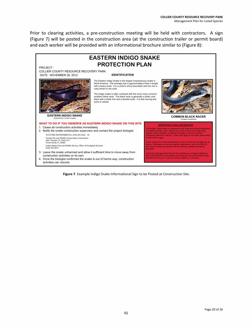
Prior to clearing activities, a pre-‐construction meeting will be held with contractors. A sign (Figure 7) will be posted in the construction area (at the construction trailer or permit board) and each worker will be provided with an informational brochure similar to (Figure 8):
Figure 7. Example Indigo Snake Informational Sign to be Posted at Construction Site.
EASTERN INDIGO SNAKEDrymarchon corais couperi
EASTERN INDIGO SNAKEPROTECTION PLAN
COMMON BLACK RACERColuber constrictor
The Eastern Indigo Snake is the largest nonpoisonous snake inNorth America. The average size is approximately 6 feet in length,with a heavy build. It is a uniform shiny blue-black with the chin a rusty brown to red color.
The Indigo snake is often confused with the much more commonsouthern black racer. The black racer is generally a duller colorblack with a white chin and a slender build. It is fast moving and quick to retreat.
IDENTIFICATION
PROJECT:�&2//,(5�&2817<�5(6285&(�5(&29(5<�3$5.�DATE: 129(0%(5 ��, ����
WHAT TO DO IF YOU OBSERVE AN EASTERN INDIGO SNAKE ON THIS SITE:1. Cease all construction activities immediately.2. Notify the onsite construction supervisor and contact the project biologist:
3. Leave the snake unharmed and allow it sufficient time to move away fromconstruction activities on its own.
4. Once the biologist confirmed the snake is out of harms way, constructionactivities can resume.
Florida Fish and Wildlife Conservation Commission3941 Tamiami Trl, Suite 3111Punta Gorda, FL 33950
United States Fish and Wildlife Service, Office of Ecological Services (239) 353-2873
(&2721(�(19,5210(17$/ (239) ��������� Or:
IMPORTANT LEGAL INFOMATIONThe Eastern Indigo Snake is protected by both State and Federal Regulations. It is illegal to harass, harm, pursue, hunt, shoot, wound, kill, molest, trap, capture, collect, transport, or attempt to engage in any such conduct (collectively defined as “taking”). These rules apply to the snake, parts thereofor their nests or eggs.
Under Chapter 39, Florida Administrative Code 39-4.002 the penalties are as follows: Punishable as a second degree misdemeanor, with up to $500.00fine and/or 60 days imprisonment for first offenses, additional penaltiesthereafter.
Under the Endangered Species Act the penalties are as follows: Maximumfine of $25,000.00 for civil penalties and maximum fine of $50,000/00 and/orimprisonment for up to 1 year for criminal violations, if convicted.
62

COLLIER COUNTY RESOURCE RECOVERY PARK Management Plan for Listed Species
Page 21 of 26
Figure 8. Example Indigo Snake Informational Brochure.
Ecotone Environmental, Inc.2223 Trade Center Way
Naples, FL 34109(239) 205-3222
www.ecotoneenv.com EASTERN INDIGOSNAKE
Contacts:
In case of a sighting of Eastern indigo snake during construction contact
one of the following:
Ecotone Environmental(239) 205.3222
Jeremy Sterk
U.S. Fish and Wildlife Service(239) 353-2873
Florida Fish andWildlife Conservation Commission
3941 Tamiami Trail, Suite 3111Punta Gorda, FL 33950
THE
The Eastern indigo snake (Drymarchon corais
couperi) is the longest snake in the United States.
It is sometimes mistaken for the Black Racer snake
which is more slender and faster moving than the
Eastern Indigo snake. In the past, the Eastern Indigo
snake has been collected as a pet due to its docile
nature. Its value as a pet and its ever disappearing
habitat have lead to the Eastern Indigo Snake being
added to the threated species list of the Florida Fish
and Wildlife Conservation Commission and the U.S. Fish
and Wildlife Services. The Eastern Indigo snake is also
protected under the Endangered Species Act of 1973.
There is a potential for this snake to be found
on-site.
Basic Facts
WŚLJƐŝĐĂů��ĞƐĐƌŝƉƟŽŶ͗ The Eastern indigo snake can
reach 6 to 8 feet in length. They are stocky and colored
a glossy blue-black with the chin a rusty brown to red
color.
,ĂďŝƚĂƚ͗ In the Southeast, it is found in pine
flatwoods, turkey oak and palmetto strands near
water. They also reside in gopher tortoises’burrows for
protection and warmth.
DĂƟŶŐ�,ĂďŝƚƐ͗ This species mates from November
to February with hatchlings appearing in late July
to October.
&ĞĞĚŝŶŐ�,ĂďŝƚƐ͗ The Eastern indigo snake immobilzes
its food with its jaw. It preys on frogs, small mammals,
birds, other snakes, and lizards.
The Eastern Indigo snake is not venomous.
See an Eastern Indigo Snake
If an Eastern indigo snake is sighted during
construction, the following measures shall be
taken:
Stop construction activity in the area
of the sighting immediately;
Notify the Ecotone Environmental biologist
named on the back of this brochure;
Allow the Eastern indigo snake
sufficient time to move away from the
site on its own before resuming
construction.
EASTERN INDIGO SNAKEDrymarchon corais couperi
The Eastern Indigo Snake is protected by both
State and Federal Regulations. It is illegal to
harass, harm, pursue, hunt, shoot, wound, kill,
molest, trap, capture, collect, transport, or
attempt to engage in any such conduct
(collectively defined as “taking”). These rules
apply to the snake, parts thereof
or their nests or eggs.
Under Chapter 39, Florida Administrative
Code 39-4.002 the penalties are as follows:
Punishable as a second degree misdemeanor,
with up to $500.00 fine and/or 60 days
imprisonment for first offenses, additional
penalties thereafter.
Under the Endangered Species Act the
penalties are as follows: Maximum fine of
$25,000.00 for civil penalties and maximum
fine of $50,000/00 and/or imprisonment for up to
1 year for criminal violations, if convicted.
The EasternIndigo Snake
What to do if you Legal Information for Contractors
COMMON BLACK RACERColuber constrictor
on this site
1)
2)
3)
63

COLLIER COUNTY RESOURCE RECOVERY PARK Management Plan for Listed Species
Page 22 of 26
Gopher Tortoise (Gopherus polyphemus) Biology (Excerpt taken from City Gate HCP, 2009) The gopher tortoise is listed as a species of special concern by the FWC (Sullivan 2004) and federally listed in Louisiana, Mississippi, and Alabama (52 FR 25376). This large terrestrial turtle can reach lengths up to 38 cm and is tan or brown in overall coloration. The gopher tortoise occurs throughout the southeastern coastal plain in appropriate habitat (Diemer 1992). The gopher tortoise is extant in all 67 counties of Florida; although, numbers are declining, especially in the southern peninsula where their distribution is limited and fragmented by unsuitable habitat and increasing urbanization. The tortoise occupies habitats with well-‐drained loose soil in which to excavate burrows, a low herbaceous ground cover for forage (e.g., fire-‐maintained), and open sunlit sites for placing nests. Typical habitats include sandhill, scrub, dry pine flatwoods, and disturbed habitats. The gopher tortoise digs extensive burrows, which provides refuge for 300 invertebrate and 60 vertebrate species. Gopher tortoises breed from mid-‐May to mid-‐June. One clutch, averaging six eggs, is produced annually and the incubation period varies from 80 to 110 days. Gopher tortoises are herbivores, which forage on a variety of grasses, legumes and fruits. Habitat destruction is the primary threat to the gopher tortoise; however, a respiratory disease has recently become an important threat, too. Project Impacts A species survey was originally conducted in January and February, 2012. The site contained approximately 10 active 11 inactive burrows and 4 abandoned burrows. Construction of the project’s main water management lake will require impacts to tortoise burrows. A permit to relocate impacted tortoises will be acquired which will allow any tortoises impacted within the development footprint to be relocated into the upland preserve area located in the northwest portion of the preserve. Gopher tortoises not impacted by development will remain. This area is proposed to be preserved, and will have active land management that will benefit the habitat of the tortoise. No construction activities will take place in this area. Gopher Tortoise Management Activities Pre-‐Construction Prior to relocation activities, management and enhancement activities as outlined in the RCW Management Activities section above will occur to prepare the recipient area for the tortoise. Once a relocation permit has been acquired, the property will be resurveyed for gopher tortoises no longer than 4 weeks prior to site clearing. The recipient area within the upland
64

COLLIER COUNTY RESOURCE RECOVERY PARK Management Plan for Listed Species
Page 23 of 26
preserve area will be staked. Installation of the temporary tortoise fencing will be installed prior to construction. Chicken wire will be installed and a portion of the fence will be trenched underground. The silt fence will be installed to the outside of the chicken wire. Following installation of the fencing, the area will be re-‐inspected by county staff, and then a vegetation permit for minor clearing to excavate the tortoises will be issued. Excavation and Relocation The physical relocation will be done by a qualified Gopher Tortoise Agent and will occur as follows: A flexible hose will be snaked down the burrow in order to track the direction of the burrow. A backhoe will carefully excavate soil material until just before reaching the burrow. Excavation will then occur manually to ensure no injury to the tortoise. All captured tortoises will be measured and their scutes will be notched according to the prearranged numbering system per the recipient site requirements, and then placed in crates and moved over to the gopher tortoise on-‐site recipient area. In addition, commensal species within burrows will also be safely relocated to the on-‐site preserve. If any Eastern indigo Snakes are encountered, they will be allowed to vacate the area prior to continuation of work. Note: “tortoises shall not be captured / relocated on days for which the overnight low temperature for that day and the two consecutive days thereafter is forecasted by the U.S. National Weather Service to be below 50°F. This 3-‐day window of milder overnight temperatures is to allow the relocated tortoises to settle into the recipient site”. Post-‐Construction When construction on-‐site is completed, the tortoise fence will be removed. On-‐site Gopher Tortoise Preserve Area Management 1. Exotic Vegetation Removal, Non-‐native Vegetation, and Nuisance or Invasive Plant Control The proposed preserve\enhancement areas are shown in Figure 6. Specific enhancement activities are outlined in the RCW Management Activities section above. 2. Maintenance: The tortoise preserve area will be walked and inspected at least once yearly for the presence of exotic vegetation. Every two years the preserve will be evaluated for manual trimming. Preserve trimming shall be conducted prior to the start of the rainy season; this will promote new growth of the recently trimmed material. Trimming will only occur as necessary to maintain the open space required for the gopher tortoises inhabiting the preserve area. The maintenance program will be conducted in perpetuity. Maintenance shall be the responsibility of the developer, or their successor. The tortoise preserve area shall be maintained in its natural state and must be kept free of refuse and debris.
65

COLLIER COUNTY RESOURCE RECOVERY PARK Management Plan for Listed Species
Page 24 of 26
PHASING OF MANAGEMENT ACTIVITIES The initial exotic removal and maintenance schedule, including burn and mowing activities, may be phased within the preserve to stagger burn and maintenance activities. (Figure 9). Phase 1 will include western half of areas north of the well field access road. These areas include the intensely managed RCW Management and Gopher tortoise recipient area. These mitigation activities will coincide with impacts to the phase 1 development area. Phase 2 will include the remaining wetlands on the eastern half of the preserve located north of the well field access road. These mitigation activities will coincide with impacts to the phase 2 development area. Phase 3 will include the upland and wetland areas south of the well field access road and adjacent to the development area. It is anticipated Phase 3 would be initiated following initial clearing of the remaining development boundary (phases 3, 4, & 5) for access purposes. TIMING AND SCHEDULING The following is a more detailed description of the timing each activity as it relates to the project construction:
1. Monitoring and Reporting
a.) Vegetative Monitoring -‐ Baseline monitoring will occur prior to the onset of any management activities. The Time-‐zero monitoring report for the management activities will be completed within 60 days of the completion of exotic removal. Annual reports will be submitted following the Time-‐zero for 5 years or until the goals of the mitigation activities have been met.
b.) Wildlife Monitoring – Prior to site clearing within the development area, a Gopher Tortoise Survey will be conducted over that phase of the development area. In addition, a Fox Squirrel nest survey will be conducted prior to clearing; to determine is any actively nesting Fox Squirrels are present within the clearing area. Finally, a survey will be conducted for cavities that might harbor bonneted bats.
c.) Semi-‐annual RCW Monitoring Surveys will be conducted in accordance with the FWS Protocol during both the breeding season (April 15-‐June 15) and the non-‐nesting season or fall (October 15-‐ December 15) following installation of the artificial cavities. Reports will be submitted following the completion of each Survey event.
2. Removal of invasive, exotic vegetation.
The initial mitigation activities for the CCRRP Preserves will include the eradication of melaleuca and other exotic vegetation as identified by FLEPPC 2012. This activity is anticipated to commence upon receipt of all development approvals and be phased
66

COLLIER COUNTY RESOURCE RECOVERY PARK Management Plan for Listed Species
Page 25 of 26
according to development impacts (see phasing outlined above). Maintenance events will occur at a minimum of twice a year after initial treatment, and continue for a minimum of five years. If vegetative monitoring data shows additional treatments are necessary, the maintenance and exotic removal schedule may be revised to increase the number of events until target species are controlled. After five years, if exotic removal activities are successful, the exotic removal would then be continued on an annual or as-‐needed basis.
3. Mid-‐Story Vegetation Thinning and Fuel Reduction
Reduce coverage of overgrown mid story vegetation, including pine saplings, cabbage palm, and excessively tall saw palmetto, may be accomplished by manual or mechanical means and may include thinning of diseased pine trees through logging. It is anticipated these activities would occur concurrent with the exotic removal, or shortly thereafter. Reduction of mid-‐story canopy coverage within the RCW Management Unit will occur prior to any controlled burn in order to reduce the fuel load, and to maintain the cover requirements and management goals. These activities will coincide with phase 1 development impacts.
4. Fire Lines and Mowing
Following the initial exotic removal treatment and thinning of overgrown mid-‐story, fire breaks will be installed where needed in accordance with an approved Fire Management Plan in accordance with Division of Forestry practices.
Mowing will occur in upland areas surrounding the development site, areas surrounding existing structures and wells, and when weather conditions prohibit the use of controlled burns.
5. Prescribed Fire
Controlled burns will only occur within the proposed burn management area, when conditions are appropriate. To mimic a natural fire regime, timing will likely occur during the late spring or summer (May – July) at intervals appropriate for each vegetative community. Estimated frequency of burn events will be two to five years.
6. Installing and maintaining artificial cavities \ bat houses
Following initial management activities within the phase 1 mitigation area, including exotic removal, mid-‐story thinning, and prescribed fire or mowing, the artificial cavities will be installed within the preserve.
67

COLLIER COUNTY RESOURCE RECOVERY PARK Management Plan for Listed Species
Page 26 of 26
Figure 9. Development Area Phasing Exhibit.
68