msc in surveying - pages - ucl · pdf filethe msc in surveying at ucl is a full-time...
TRANSCRIPT

UCL MSc in Surveying
MSc inSurveying
For entry in September 2012
Updated December 2011
CIVIL, ENVIRONMENTAL AND GEOMATIC ENGINEERING

UCL MSc in Surveying
i
Contents
1 Introduction ...................................................................... 1
2 Structure of the programme ................................................ 2
3 Aims and Strengths of the course ........................................ 3
4 University College London.................................................... 7
5 Research Environment......................................................... 8
6 Equipment and Facilities .....................................................11
7 Staff.................................................................................12
8 Programme review and accreditation....................................17
9 Entry Requirements ..........................................................17
10 Assessment.....................................................................18
11 Examples of individual MSc projects ...................................20
12 Careers and Student Profiles .............................................21
13 Final Remarks..................................................................28

UCL MSc in Surveying
1
1 Introduction
The MSc in Surveying at UCL is a full-time twelve-month programme, runby a department that is renowned throughout the world for its teaching ingeomatics, based in one of the world’s premier academic institutions.
The department first ran a surveying programme in 1949, with the firstgraduates of that course leaving in 1950. Since that time, hundreds ofstudents from around the world have followed them, and you will find ouralumni working on every continent.
The equipment that our students use has changed enormously since theearly years, and in most respects so have their careers. Once we trainedstudents in the delicate arts of survey observation and they went on tomap in detail parts of the world that were only sketchily known about.Now we build our programme around our outstanding research work inareas such as Global Navigation Satellite Systems, Terrestrial LaserScanning and GIS, and our graduates are just as likely to be working insatellite research, crime scene analysis or on a new railway tunnel asmapping deserts and forests.
However, our core aims for the course are in many ways fundamentallythe same: we are interested in producing graduates who understand theunderlying principles behind the equipment and methodology that theyare using, who can understand its limitations and evaluate its errors, whocan work in novel and challenging situations as their careers develop, andwho are capable of rising to the top of the profession.
This document gives a full description of the course for prospectivestudents and employers. It includes details of the aims and strengths ofthe course, the institution, the entry requirements, the facilities available,the research environment and individual projects, professionalaccreditation and profiles of the careers of some of our students.
I hope that you find the information that you’re looking for here. If youare interested in joining us then I look forward to hearing from you.
Dr Jonathan Iliffe, Senior Lecturer, Head of Geomatic and GeotechnicalEngineering, Course Director.

UCL MSc in Surveying
2
2 Structure of the programme
The overall length of the programme is 12 months, split into a first term fromSeptember to December, with the modules assessed in early January; a secondterm runs from January to late March, with assessment in late April/ early May.The final part is the individual project, running from May to September.
There are three sections to the course, each given equal weight: the first termtaught material; the second term taught material; and the individual project.Each of these is worth 60 credits.
The first term is organised into four 15 credit modules as:
Data Analysis GIS Principlesand Technology
Principles andPractice ofSurveying
Mapping Science
The second term is organised as:
Positioning Management/Group Project
Option 1 Option 2
The optional modules currently available are: Terrestrial Data Acquisition,Airborne Data Acquisition, Ocean and Coastal Zone Management, GeographicInformation System Design and Research Methods.
The individual project runs from mid-May to mid-September.
It is possible for students to graduate with a Postgraduate Diploma after followingthe taught part of the course but not doing the individual project. However, onlythe full programme, leading to an MSc, is recognised by the Royal Institution ofChartered Surveyors (RICS).

UCL MSc in Surveying
3
3 Aims and Strengths of the course
Overall aims
The UCL surveying programme aims to provide a broadly based education ingeomatics and surveying, combined with a strong practical element. It is afeature of the teaching in the department that we aim to move rapidly from atheoretical classroom-based exposition of a subject to its practicalimplementation. This practical element might take the form of using surveying orscanning equipment, or it might involve acquisition and processing of GPS data,or handling digital map data, or even using a pencil and paper to work out thefunctional link between an observational type and parameters to be derived byleast squares.
As the above implies, wecover a very broad range interms of instrumentation onthe course. We do cover dataacquisition types such assatellite and aerial imagery,and expect students to havean understanding of the useof this in mapping projects,but the main focus is onterrestrial survey equipment,global navigation satellitesystems such as GPS, andlaser scanning: students gainpractical hands-onexperience of all of these,and also gain a goodunderstanding of theirprinciples of operation, theirlimitations and error sources,the environmental factorsinfluencing their operation,and so on.
We also take a very broadview of the application areasthat students are likely to beusing this equipment in. For
example, a terrestrial laser scanner is something that can be used to surveyancient monuments, crime scenes, railway infrastructure, or film sets – we havegraduates working in all these areas, and also reflect this in the individualprojects.
Acquiring the data is only part of the story, however. We also make sure that ourstudents have a full understanding of issues such as coordinate referencesystems, and experience of using geographic information systems to manage anddisplay spatial data. We teach students about project management, and givethem experience of working in groups to deliver work under tight timeconstraints. Importantly, we also place a great deal of emphasis on data qualityissues, using mathematical techniques to ensure that data acquired is reliable andfit for purpose.

UCL MSc in Surveying
4
Strengths and specialisms
So to sum up: why come to UCL? What are the specialist areas that you get fromstudying here as opposed to anywhere else? We believe that these are:
Deep study of error theory, least squares analysis and quality control; In depth study of GNSS, geodesy, and coordinate reference systems; Practical hands-on use of the latest laser scanning equipment; Use of latest equipment on a range of survey fieldwork projects. Close collaboration of academic staff with industry. Opportunity to carry out an in-depth study into one particular topic as part
of the individual research project.
These particular strengths can best be illustrated with direct examples.
Study of error theory
Error theory and quality control are taught through the Data Analysis module, andfurther reinforced through applications in the Positioning and optional modules.For one of the practical assignments in the Data Analysis module the students aregiven a scenario of a rig being towed offshore from the yard where it wasconstructed, and its movement along a precisely defined path being monitored.Students are required to devise an observational scheme that meets certain pre-defined requirements for precision and reliability (expressed in terms of themarginally detectable errors being within a defined limit). This has to besimulated mathematically, with the students being responsible for the derivationof all the relevant equations and their implementation in Excel. Having devisedthe appropriate algorithms, they then refine the observational scheme to meetthe quality criteria with the minimum number of observations.
Working with the latest equipment
From the outset of the MSc programme, students gain hands-on experience ofthe latest equipment. In the Principles and Practice of Surveying module, havingreceived training in AutoCAD, students work in groups and use reflectorless totalstations and automatic levels to deliver topographic and detail surveys of an area

UCL MSc in Surveying
5
within the UCL vicinity, and set-out structural designs according to given criteria,within a realistic engineering survey workflow. Small-scale deformationmonitoring is also carried out in this module. In Positioning, students useintegrated GIS/GPS Leica Zeno mobile mapping devices, and our Leica 500 andLeica Viva GPS receivers. The Isle of Wight fieldtrip brings together variouspractical and computation elements. For example, one fieldtrip task is to set-out aroad curve and check the results using RTK GPS.
Collaboration with industry
We maintain good relations with colleagues in the Geomatics industry. As part ofthe Mapping Science module, we run an annual MSc Mapping Day with LeicaGeosystems. We also welcome a number of industry guest lecturers to ourmodules, and run visits to organisations such as the Ordnance Survey. A numberof our MSc projects are also run in collaboration with industry – including projectswith Arup, Plowman Craven, and Leica HDS. These close relationships are alsobeneficial for recruitment of our students to permanent positions on completion ofthe MSc.
Study of Global Navigation Satellite Systems
One example of student work involves calculating a position fix from GPS pseudo-ranges. Students are given five pseudo-ranges measured by a GPS receiver at thesite of Herstmonceux Castle in Sussex at the epoch 2001 9 14 13 45 0.00, as wellas the satellite positions in WGS84at the epoch of signaltransmission and the approximatelocation of the receiver. Thestudents are told to estimate theposition (in ECEF Cartesiancoordinates) of the receiver, andthe receiver clock offset, using allthe pseudo-ranges. They arealso instructed to assume that thestandard deviation of a pseudo-range measurement in metres isthe cosecant of the satelliteelevation angle. The studentshave to set up the appropriateobservation equations, carry out alinearisation and invert forupdated coordinates, usingseveral iterations. The studentsthen convert the answer tolatitude, longitude and height. Thequality of the position fix must beassessed (analysis of residuals,estimation of variance factor,scaling of covariance matrix) andthe GDOP, PDOP, HDOP and VDOPvalues are to be calculated fromthe variance-covariance matrix.

UCL MSc in Surveying
6
Specialising in laser scanning
Terrestrial laserscanning continues tosee rapid technologicaladvancement throughimprovements in dataquality, systemminiaturisation, theintegration with digitalimagery and ourcapability to processand understand vastquantities of 3D spatialdata. Widespreadadoption by thesurveying communitymakes anunderstanding andpractical ability to usethis technology an essential skill for the field surveyor. To address this need, thedepartment has significantly enhanced its laser scanning capabilities with acombination of leading edge research systems including two Arius3D close rangecolour scanners which are unique in the EU University sector and a metrologyclass Nikon K-Scan MMDx unit which incorporates not only an optically trackedscan head, but also a touch probe and a photogrammetric tracking system. Moreconventionally we have a Leica ScanStation 2 which, along with its industrystandard Cyclone software, forms our teaching backbone. A phase based FAROPhoton 120 system equipped with a Nikon D300s camera and FARO Scenesoftware is shared with the Bartlett school of Architecture and provides a uniqueopportunity for project work.
Individual MSc projects
Individual MSc projects form one third of the total credit value of the course, andare a means through which students can demonstrate a deep understanding ofthe subject. The aim of the project is to produce work that has a researchelement and is in principle of interest to a wider community than thoseimmediately involved. That is, the MSc project is something distinct from aroutine professional job and is intended to launch students to some extent intothe unknown: in several cases it has led to published papers. In most cases itfosters resourcefulness, as they are expected to act as the liaison point betweentheir academic supervisors and other bodies involved (such as industrialsponsors). In all cases it encourages students to think deeply about their chosenfield, to research widely in published literature, and to write clear and concisereports.
This is a significant part of the course – there is a separate section givingexamples of students’ individual projects.

UCL MSc in Surveying
7
4 University College London
In 2009 UCL climbed tofourth place in the annualTimes Higher Education -QS World UniversityRankings, confirming itsstanding as London’sglobal university. Themeteoric progression upthe tables in recent yearsreflects the outstandingquality of UCL’scommunity of academicsand students. Theuniversity is one of theforemost in the UK forresearch and innovation,and is dedicated toharnessing its exceptionalresearch for positive socialand economic benefit: nofewer than 21 Nobelprizewinners have comefrom the UCL community.
This community continuesto pursue the higheststandards of academicrigour and has earned
admiration in the higher education domain for its strategies to pool researchexpertise across a wide range of disciplines, to deliver the highest standards inteaching, and to attract the brightest students from all over the globe. Studentlife at UCL is rich and challenging; we provide the opportunities and leadership inteaching, research, entrepreneurship, volunteering and overseas study. 34% ofUCL students come from outside the UK, from approximately 140 countriesaround the world, and our research reaches the farthest corners of the globe;from the conservation of antiquities in Iraq to the transformation of engineeringresearch in Kazakhstan.
UCL was founded in 1826 as a secular alternative to the universities of Oxfordand Cambridge. Prior to this, the benefits of a university education in Englandwere restricted to men who were members of the Church of England. UCL wasfounded to challenge this discrimination, providing a radical alternative toOxbridge’s social exclusivity, religious restrictions and academic constraints, thusopening up English higher education for the first time to people of all beliefs andsocial backgrounds. Today, it remains fervently progressive and is one of theworld’s leading multidisciplinary universities, with a global reach and globalvision.

UCL MSc in Surveying
8
5 Research Environment
UCL is a research intensive university. In a department such as Civil,Environmental & Geomatic Engineering, the annual income from research isaround £5 million. Rather than being seen as a distraction from teachingstudents, the philosophy at UCL is that the whole learning experience is enrichedby contact with academic staff who are clearly at the forefront of their fields. Thisis true for staff involved in the MSc in Surveying as it is for all staff, and studentson the course come into contact with research into the latest developments in thefield.
To give a very brief flavour of this, some examples are given below of current orrecent projects in the department that are relevant to the surveying course.
GNSS positioning aboard vessels
A recent project led by Professor Paul Cross, and involving PhD student AlexParkin, and running from 2005 to 2009 has examined the future positioningrequirements of the IMO (resolution A.915) and tested the acquisition andprocessing of data in a marine environment against the IMO requirements.
A data collection exercise was held in Harwich Harbour, in collaboration withTrinity House, and saw THV Alert navigate into the harbour whilst GPS data wasacquired on board and at reference stations on shore. In addition, total stationsat shore based reference stations were used to track the vessel and provide atruth model.
The data acquired wasprocessed under differentscenarios and thepositioning performancewas analysed against theIMO requirements. Aprincipal finding was thatproviding integritythrough single-epochreal-time kinematicpositioning, required tomeet the strictest IMOrequirements, wasparticularly difficult.However, the workcarried out in this projecthas significantlyimproved the vital
ambiguity resolution success rate, and increased the maximum baseline lengthover which the highest requirements are met from 1 km to 66 km.
Example impact on MSc teaching: in 2009 Christopher Bubb did an MSc projecton “Characteristics and impacts of new GNSS signals”, exploring what theimpact of new developments in satellite positioning would be on the offshoreindustry.

UCL MSc in Surveying
9
SnakeGrid
The SnakeGrid coordinate system is a meansof projecting the curved surface of the Earthonto a flat plane (as with any mapprojection) but doing it in such a way thatthe distortion along a long gently curvingfeature such as a railway is minimised. It wasdeveloped at UCL, supported by NetworkRail, and first applied to the London toGlasgow West Coast Main Line. After thatinitial application the software was developedfurther and has been used to develop verylow distortion grids along all the major railroutes in the UK, and some overseas.
The advantage of this system is that as far asa surveyor or a design engineer is concerned,the Earth appears flat over the whole lengthof a very large project, and there is nodistortion between the design and the realityon the ground. The SnakeGrid software canbe used as a standalone system to convertbetween geographic and grid coordinates, orcan be incorporated into other programs –such as the SnakeGrid Transformer softwareused to handle Microstation files.
Example impact on MSc teaching: in 2009 Stephen Hudson did an MSc projecton “Performance Characteristics of SnakeGrid”, setting up a series ofsimulations to test the errors induced in various survey operations by differentconfigurations of the designed grids.
Laser scanning
Recent student projects in laser scanning are highly varied for example SandrineWhitmore undertook a critical analysis of English Heritage Metric SurveySpecifications for Cultural Heritage, in association with Norwich Cathedral usingtheir medieval cloisters as a case study. Given the civil engineering activity inLondon it is not surprising that engineering monitoring projects have generatedstudent project interest. Notable projects include working with Network Rail at theShard, where Chris Booth carried out scanning surveys to look at the feasibility ofmonitoring a column located deep within the structure whilst Thomas Kingexplored the potential of the technique for deep excavation with Skanska.Another project was carried out by Peter Costanzo who drew upon the resourcesof UCL’s Digital Manufacturing Centre and our close range scanning systems toassess the metric capability of small volume rapid prototyping technologies.These examples are drawn from a broad range of projects which extend fromsensor evaluation and modelling, through image and point cloud understanding toa diverse range of real world applications.

UCL MSc in Surveying
10

UCL MSc in Surveying
11
6 Equipment and Facilities
The Civil, Environmental & Geomatic Engineering Department at UCL has a suiteof dedicated surveying software including Leica GeoOffice, Cyclone, AutoCAD Civil3D, Clourworx and Starnet. In addition to this specialist software, students alsohave access to ArcGIS, ENVI, Hypack, Fledermaus, Cadcorp, and GeoDAS.Students are introduced to, and trained in this software throughout the teachingterms and utilise the suite in their individual research projects in the third term.
In July 2011, the department upgraded and enhanced its standard surveyequipment. We now have a suite of reflectorless Leica TS06 total stations, onerobotic imaging total station, static and RTK GNSS receivers (Leica 500 and Vivakit), a range of automatic levels and 10 new Leica Zeno handheld GIS/GPSdevices. We also have a ScanStation 2 and a FARO Photon 120 laser scanner, andon the close-range side we have a Nikon MMD and 2 Arius 3D colour scanners.We also have 2 Nikon D700 digital SLR cameras which are used forphotogrammetry.
The laser scanners have been used in MSc Surveying projects to monitordeformation on construction sites; the reflectorless total stations are often usedto validate control for a number of laser scanning and GPS projects, and theGNSS kit is frequently used to tie projects into national coordinate systems. Aswith the software, students are trained in the surveying kit in the first and secondterms before using the equipment when undertaking their projects in thesummer.

UCL MSc in Surveying
12
7 Staff
Jan Boehm
Jan Boehm has a background in Computer Science, for whichhe holds a Masters’ degree from the University ofMassachusetts, Dartmouth, USA, and a Diploma degree fromthe University of Stuttgart, Germany. He holds a doctoraldegree from the department of Aerospace Engineering andGeodesy at the University of Stuttgart. Since 2010 has been alecturer in Photogrammetry and 3D Imaging at UniversityCollege London. He actively participates in the InternationalSociety for Photogrammetry and Remote Sensing (ISPRS),where he regularly serves on organising and programmecommittees and as a reviewer for related journals. He is co-
chair of the ISPRS working group on Image-based and range-based 3D modelling.He serves on the VDI panel for optical metrology, where he works on the theVDI/VDE 2634 guidelines.
He has published more than 50 papers on the topics of close-rangephotogrammetry, three-dimensional point cloud processing and robotics. Hiscurrent research projects include creating building information models (BIM) frompoint clouds, detailed façade modelling from terrestrial and mobile laser scanningand developing a human measurement system from low cost natural userinterface sensors.
Jan contributes to the teaching on Mapping Science; Terrestrial Data Acquisition;Airborne Data Acquisition and Image Understanding.
Paul Groves
Paul Groves joined UCL in 2009 after 12 years at DERA andQinetiQ. He leads a programme of navigation and positioningresearch within UCL’s Space Geodesy and NavigationLaboratory. Paul specializes in the integration andmathematical modelling of all types of navigation system. He isinterested in all aspects of navigation and positioning, includingmulti-sensor integrated navigation, robust GNSS underchallenging reception conditions, and novel positioningtechniques. Current research projects include GNSS multipathmitigation, positioning using signals of opportunity, pedestrian
motion modelling for aiding indoor and outdoor positioning, novel GNSS-basedpositioning techniques for urban canyons and ultra-low-cost inertial sensorsintegrated with multi-antenna GNSS.
He is an author of about 40 technical publications, including the book Principles ofGNSS, Inertial and Multi-Sensor Integrated Navigation Systems. He holds aBA/MA and a DPhil in physics from the University of Oxford. He is a Fellow of theRoyal Institute of Navigation and an associate editor of both Navigation: Journalof the ION and IEEE Transactions on Aerospace and Electronic Systems.
Paul runs the Positioning module and contributes to the Data Analysis andMapping Science modules, and the Isle of Wight Field Course.

UCL MSc in Surveying
13
Muki Haklay
Muki Haklay is Professor of Geographic Information Science and the director ofUCL Extreme Citizen Science group. The group is dedicated to allowing anycommunity, regardless of their literacy, to use scientific methods and tools tocollect, analyse, interpret and use information about their area and activities. Hisresearch interests include Public access and use of Environmental Information;Human-Computer Interaction (HCI) and Usability Engineering aspects of GIS; andSocietal aspects of GIS use - in particular, participatory mapping and CitizenScience.
He contributes to the Mapping Science module.
Jonathan Iliffe
Jonathan Iliffe's expertise lies in the area of geodesy, andspecifically those issues that relate to coordinate referencesystems – national or local, on land or at sea. Current or veryrecent research projects include determining the heightcorrector surfaces for use in the British Isles (transformingGPS data to the local height system in each country), theUKHO-sponsored VORF project (transforming GPS data to thedifferent coordinate reference systems used on land and atsea) and the development of the SnakeGrid system (whichgives near-unity scale factor along very large linearengineering projects such as railways, highways andpipelines). He acts as a consultant on international land and
maritime boundary delimitations, and advises governments, survey andengineering companies, and railway organisations on the geodetic aspects oflarge infrastructure projects. He is the author with Roger Lott of Datums and MapProjections, a standard textbook for students and professionals around the world.In 2008 Jonathan Iliffe was awarded the Richard Carter Prize (GeospatialEngineer 2008) by the Institution of Civil Engineering Surveyors, for his work onSnakeGrid and projects such as OSGM02 and VORF.
Jonathan is the programme director for the Surveying and HydrographicSurveying courses and contributes to the teaching on Data Analysis; MappingScience; Principles and Practice of Surveying; Hydrographic Applications andOcean and Coastal Zone Management.
Richard Simons
Richard's main research interests lie in the field of CoastalEngineering, where he has made a major contribution to thestudy of wave-current interaction, providing an insight intofundamental fluid processes and related interactions with theseabed. Richard oversaw commissioning and management ofthe UK’s National Coastal Research Facility at Wallingford, andwas influential in the introduction of the UK coastal wavemonitoring programme WaveNet (now managed within the UKCoastal Monitoring & Forecasting Service). He has a particularinterest in marine aggregate dredging and supervised a recentproject using a new cellular automata model to predict the
long-term behaviour of the seabed and benthos after dredging. In the broader

UCL MSc in Surveying
14
field of coastal morphology, another project has applied novel statistical methodsto predict long-term morphological development of the seabed. In the field offluid-structure interaction, extensive tests are being performed to train andvalidate a neural network model of 3D wave effects around submergedbreakwaters, advanced 3D flow measurements are being made to assess thestability of scour protection for various levels of rock misalignment, and an EngDproject with HR Wallingford is investigating scour around complex foundationsrelevant to the marine renewables industry.
Richard contributes to the Ocean and Coastal Zone Management module.
Marek Ziebart
Space Geodesy - this is the science and engineering of usingsatellites in orbit around planets to measure dynamiccharacteristics, such as the gravity field, sea level and ice capvariations, as well as plate tectonics. In 2007, GPS Worldnamed him as one of the 50 Leaders to Watch for hiscontributions to the global navigation and positioning industry.He holds a PhD in Satellite Geodesy and Astrodynamics, and isa member of the NASA/CNES Ocean Surface TopographyScience Working Team. He is a contributor to news items anddocumentaries on BBC Radio 1, BBC Radio 4 (Todayprogramme), BBC Radio 5live, BBC News 24 and the World
Service. He has carried out numerous consultancies and research contracts,including for the UK Hydrographic Office, the European Space Agency, TritechRail, NASA, US Air Force, QinetiQ, and Ordnance Survey.The UCL Satellite Geodesy and Navigation Research Group has 12 members: 4academics, 3 PDRAs and 5 PhD students.
Marek contributes to the Positioning, Principles and Practice of Surveying, Oceanand Coastal Zone Management, and Hydrographic Applications modules.
Claire Ellul
Claire Ellul joined the department as a lecturer in Geographic Information Sciencein 2010, following a 10-year career as a GIS consultant in theUK, Europe and the Middle East. She is interested in technicaland data-related research in GIS, and specializes in spatialdatabases and software development. Current research themesinclude three-dimensional GIS, spatial data management, dataquality and metadata and she is conducting research into howto persuade non-GIS research teams to capture and use spatialmetadata, the use of GIS in Citizen Science and CommunityEngagement, teaching GIS principles to researchers from otherdisciplines.
Claire contributes to the Mapping Science module in Term 1, and runs theWeb and Mobile GIS module and contributes to the databases and spatialdatabases element Geographic Information System Design in Term 2.

UCL MSc in Surveying
15
Liz Jones
Liz Jones is a Teaching Fellow in Geomatics and a GeomaticSystems Manager. She joined the department after working asa surveyor in the 3D team of Plowman Craven, a UK surveycompany. Prior to this, she completed an MA in Egyptology(Liverpool) and an MSc in GIS (UCL).
Liz runs the Principles and Practice of Surveying module,teaches on the Terrestrial Data Acquisition and Positioningmodules and provides practical support on Ocean and CoastalZone Management and on the MSc projects.
In addition to this role, Liz is the GIS officer and surveyor for a number ofarchaeological projects, including the Gurob Harem Palace Project and theSaqqara Geophysical Survey Project. She also maintains the UCLGeomatics blogand is the Departmental Advisor to Women Students.
Dietmar Backes
Dietmar Backes is one of the department’s geomatics systemsmanagers, providing support for the use of equipment andsoftware in the department, particularly focusing on the Lidarand imagery side. He coordinates the Mapping Science module,which draws upon the expertise of several of the departmentalstaff, and contributes to Ocean and Coastal Zone Management.
Tao Cheng
Tao Cheng’s background is in spatial information science, from the acquisition,management and modelling to application of spatial data. She leads the GISPrinciples and Technology module and has supervised MSc projects such asCreating a Global Database of Submarine Landslides for Hazard Prediction.

UCL MSc in Surveying
16
Stuart Robson
Professor Stuart Robson heads the Photogrammetry, 3DImaging and Metrology Research Group. His personal researchfocus is in the traceable on-line dynamic 3D co-ordination andmonitoring of engineering, medical and cultural objects andstructures using photogrammetric image networks andsequences, vision metrology and laser scanning. Followingthese themes he has active research projects in theengineering sector with Network Rail, Airbus, NASA and NPLand in heritage with the British Museum, the Science Museum,Arius3D and the SME IET.
He has an on-going programme of continued photogrammetric softwaredevelopment with Prof. Mark Shortis of RMIT University with the VisionMeasurement Software (VMS) suite of photogrammetric software which is used bysome 30 international research institutions and universities for applications asdiverse as the underwater measurement of fish, the monitoring of engineering,aeronautic and spacecraft structures, and the monitoring of active lava flows.
Stuart has contributed to more than 120 publications including co-authoring amajor text book, ‘Close Range Photogrammetry: Principles, Techniques andApplications’. For the MSc Surveying programme he contributes to the module onPrinciples and Practice of Surveying and leads the Terrestrial and Aerial DataAcquisition modules.

UCL MSc in Surveying
17
8 Programme review and accreditation
In common with other geomatics MSc programmes in the department, the MSc inSurveying is recognised by the Royal Institution of Chartered Surveyors (RICS).This means that passing at MSc level affords an entry route into that institutionfor graduates of the programme. In order to gain this accreditation, details of thesyllabus are supplied to the RICS, and then on an annual basis furtherinformation is supplied on qualifications of entrants, destinations of graduates,and so on. There is also an annual “partnership” meeting between the RICS anduniversity representatives, with invited attendees from industry.
The programme, the department itself, and UCL more widely, are subject to ahierarchy of quality control procedures. These start at the level of the individualmodules, with a consideration of the marks awarded and any problemsencountered, and then work their way up through a consideration of theprogramme as a whole, the department, and finally UCL itself being subject toexternal review of its quality control apparatus.
Student feedback into these procedures takes several forms, includingquestionnaires and round table discussions, but as with any surveying course theexperience of working together on field courses means there are manyopportunities for students to comment on the programme.
Separately to all of this process there is a system of external examiners to ensurethat the academic standards of the degree match the national and internationalnorms. Thus, all exam papers are sent to the external examiner for review beforebeing signed off, they have access to all student work and review the marking,and they are present at the final examiners’ meeting at which degrees areawarded.
9 Entry Requirements
The minimum entry requirement for the MSc in Surveying is an upper secondclass honours degree in a cognate subject at undergraduate level (generally aBSc). Entrants should also have an appropriate level of background mathematicalknowledge.
Examples of cognate degrees would include geography, civil engineering,mathematics, marine sciences, physics, archaeology and geology. The essentialpoint is that before embarking on the MSc in Surveying students should alreadyhave followed a programme of study that prepares them for scientific analysis,report writing, the statistical analysis of data, and so on.
The UCL Registry has extensive knowledge and experience of overseasinstitutions and their marking schemes, and is able to provide an assessment forany applicant of how they compare against UK university standards.
Preparatory reading for entrants
For the appropriate level of mathematics, the advice given to students is that aBritish “A Level” in mathematics would certainly be sufficient preparation for thecourse. However, given that not all applicants are likely to have this, morespecific specifications are available about the level of background knowledge andthe subjects that should be revised before embarking on the course. Essentially,

UCL MSc in Surveying
18
these advise the students that they are expected to have a basic familiarity withalgebra (manipulation of equations, solution of simultaneous equations, quadraticequations, etc); geometry (properties of circles, concepts of angular measure);trigonometry (definitions and applications of basic functions, expansions ofcompound angles, application of sine and cosine rules for plane triangles);calculus (differential calculus including application to standard functions);matrices (definitions, simple algebraic functions such as addition, subtraction andmultiplication, inversion of small matrices). Students are advised to preparethemselves for the programme by studying these subjects as much as possiblebefore arrival; it is then possible to give a fairly rapid summary of these subjectsbefore immediately proceeding to apply them in practice. An example of acomprehensive mathematics text book to revise from would be:
“Engineering Mathematics” (paperback) by Stroud
Other text books are available if the above is not available locally. Another optionwould be:
“Maths for Map Makers” (paperback) by Arthur Allan
Average age of students on this MSc
It is worth pointing out that although the minimum age for enrolling on the MSc is21 (this being the effective minimum for a graduate of a British undergraduatedegree) in practice the average age is generally a bit older than this. Somegraduates have come to us either with a few years of general experience of work– for example in the IT industry – or have more specific experience of working insurveying and are coming back to university for further study of specialist areas.However, there are plenty of others who have come straight onto the coursewithout any previous experience.
10 Assessment
At the programme level, the minimum standards required are:
MSc Pass:
50% weighted course average in ALL taught modulesand
No more than 30 credit points at less than 50% (‘condoned fail’ gradesmay be granted between 40-49% at Board of Examiners’ discretion). Nomarks below 40% are allowed
and 50% (minimum) in Dissertation
MSc Merit
60% credit-weighted average over ALL modules (including Dissertation)and
65% (minimum) in Dissertationand
No marks below 50%, no condoned fails, no re-sits, and all marks arebased on first attempts.

UCL MSc in Surveying
19
MSc Distinction:
70% credit-weighted average over ALL modules (including dissertation)
and 70% (minimum) in Dissertation
and No marks below 50%, no condoned fails, no re-sits, and all marks are
based on first attempts
N.B The taught modules have a weight of 120 credit points. The Dissertation hasa weight of 60 credit points.
Individual modules may be assessed either by coursework or by an unseenwritten examination or by a combination of the two.
A summary of the method of assessment of each module, together with details ofthe nature of the examination (where assessed by a written exam) or of howmany pieces of coursework need to be submitted and what their credit value is(where assessed by coursework) is given in the table below.
Module Title Credit value Assessment
First Term
GIS Principles & Technology15 100% Coursework
Mapping Science15 100% Exam
Data Analysis 15 100% Coursework
Principles & Practice ofSurveying
1550% Exam and 50%Coursework
Second Term (Compulsory)
Positioning 1550% Exam and 50%Coursework
Management/Group Project 1550% Exam and 50%Coursework
Options
Ocean and Coastal ZoneManagement
15 60% Exam and 40%Coursework
Hydrographic Applications 1560% Exam and 40%Coursework
Airborne Data Analysis 15 100% Coursework
Geographic InformationSystem Design
15 100% Coursework
Research Methods 15 100% Coursework
Terrestrial Data Acquisition 15 100% Coursework
UCL MSc in Surveying
20
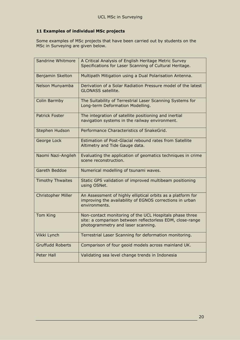
11 Examples of individual MSc projects
Some examples of MSc projects that have been carried out by students on theMSc in Surveying are given below.
Sandrine Whitmore A Critical Analysis of English Heritage Metric SurveySpecifications for Laser Scanning of Cultural Heritage.
Benjamin Skelton Multipath Mitigation using a Dual Polarisation Antenna.
Nelson Munyamba Derivation of a Solar Radiation Pressure model of the latestGLONASS satellite.
Colin Barmby The Suitability of Terrestrial Laser Scanning Systems forLong-term Deformation Modelling.
Patrick Foster The integration of satellite positioning and inertialnavigation systems in the railway environment.
Stephen Hudson Performance Characteristics of SnakeGrid.
George Lock Estimation of Post-Glacial rebound rates from SatelliteAltimetry and Tide Gauge data.
Naomi Nazi-Angileh Evaluating the application of geomatics techniques in crimescene reconstruction.
Gareth Beddoe Numerical modelling of tsunami waves.
Timothy Thwaites Static GPS validation of improved multibeam positioningusing OSNet.
Christopher Miller An Assessment of highly elliptical orbits as a platform forimproving the availability of EGNOS corrections in urbanenvironments.
Tom King Non-contact monitoring of the UCL Hospitals phase threesite: a comparison between reflectorless EDM, close-rangephotogrammetry and laser scanning.
Vikki Lynch Terrestrial Laser Scanning for deformation monitoring.
Gruffudd Roberts Comparison of four geoid models across mainland UK.
Peter Hall Validating sea level change trends in Indonesia

UCL MSc in Surveying
21
12 Careers and Student Profiles
In this section you can get an idea of the opportunities that are available upongraduating from the MSc in Surveying by looking at the career profiles of some ofour past students.
Below are just a few of our graduates from the last twenty years or so. You’ll seethat they are working in sectors that include private survey companies, research,rail companies, the construction industry, the oil and gas industry, satellite datacompanies, and so on. Others work for national mapping agencies, oruniversities, or have gone on to other careers that make use of the generic skillsthey have acquired on the course. You’ll also see that they are working not just inthe UK but all over the world, and so get an idea of the international reputation ofthe course.
Felice Napolitano (1992 – 1993)
I had a great time during my MSc in surveying during 92-93; it led me to a careerin survey and currently I am the Operations Director of a medium sized Land andBuilding Surveying business, MSA (Marshall Survey Associates Ltd).
We have about 18 staff and work mainly inLondon and the South East, with some of thebiggest firms dealing with survey in all its forms.We work with the likes of Zaha Hadid, KnightFrank, TilfenLand Land Securities, AmandaLevete Architects, Miller Hare, Ian RitchieArchitects, Westminster City Council amongstmany others and we run a RIBA accredited CPDabout Laser Scanning to introduce these newtechnologies to architects
We produce all types of survey coveringmeasured building plans, architecturalelevations, 3D models, Rights to Light surveys,View Verification Survey and utilise the latestequipment including an HDS6100 Laser scannerand a C10 laser scanner, Digital Levels, GPS,Total Stations and High accuracy Prism Sets.
The team works well together and all surveyors see their projects throughcovering both site work, cad work and office work. There is a good level ofcamaraderie and it is a pleasure to go to work where we continually push thelimits of what survey means.
Matt Levine (2001 – 2002)
I attended the UCL Masters in 2001-2002 having previously worked onconstruction projects in Latin America. I was seeking a qualification which wouldallow me to build a focussed career in the construction industry. The UCLMasters was one of the most challenging and rewarding years of my life and it setme up for the challenging projects that have followed.

UCL MSc in Surveying
22
Upon graduation I began working forthe Severn Partnership inShrewsbury, and I started work onthe railway within the first month. Iprogressed through the ranks gaininginvaluable experience eventuallybecoming Principal Surveyor. Thisrole then evolved into the current jobdescription of Project Manager; whichincludes tendering, planning allaspects of the project and liaison witha variety of clients.
I was fortunate to be involved at thestart of the Severn Partnership drive to develop laser scanning and have beenresponsible for the development and management of this area of our business.Numerous projects include Brighton Royal Sussex County Hospital, Sheffield to StPancras Line Speed Improvement – 70 miles of railway survey and 100 miles ofgeodetic control.
The Masters provides a solid foundation of the basic principles of surveying andbusiness management which form a platform upon which a successful career canbe built.
Gareth Beddoe (2007 – 2008)
I completed the MSc in Surveying in 2007-8 following a BA in Geography from theUniversity of Nottingham.
After finishing the course, I joined Jacobs Engineering UK asa Graduate Surveyor based on the Kent Highways Contract.My work involved producing high-order control and detailsurveys for major new highway designs. In 2010 Itransferred to a different team in Jacobs working as aSurveyor on a variety of Rail, Energy and Environmentprojects. Whilst in this team I became the lead RailSurveyor, managing all the Rail work which we completed.
I am currently seconded into the Rail Engineering team as aConstruction Manager working to support the Project
Managers in the successful running of projects. In addition I am currentlyawaiting my final RICS chartership interview.
The MSc in Surveying at UCL provided me with a great foundation in both thetechnical and professional skills required to work in the Engineering industry.
Stephen Hudson (2008 – 2009)
Following my degree, I began working for Plowman Craven Ltd, as part of theirmeasured building survey team. Typically, a measured building project willrequire detailed floorplans, elevations, and sections to be created. Capturing thenecessary data is done through a variety of methods and techniques, which areconstantly evolving as new developments within the industry are made.

UCL MSc in Surveying
23
It is the variety in the type of buildings surveyed thatensures there are always new challenges andobstacles that need to be overcome. Projects havevaried from a small two bedroom mews housethrough to a modern city centre shopping mall.Although much of the work is based in and aroundLondon, projects I have completed include a survey inEdinburgh, and also Jersey. Exposure to variousconcepts on the UCL course has ensured I have beenin a strong position to determine the most appropriateapproach and methods for successful outcomes. Thecourse has also given me a strong grounding in theprinciples behind many of the commercial surveysoftware packages I use on a regular basis.
Chris Miller (2006 – 2007)
Prior to studying the MSc Surveying course at UCL I was asite surveyor who would only be given a limited amount ofresponsibility and was battling against numerous othercandidates for promotion. The course gave me a fantasticknowledge base and made me stand out from the crowd. Inthe 4 years since completing the course I have been the leadsurveyor on the £200M DLR Capacity Enhancement Projectand the £700M Victoria Station Upgrade Project. I recentlytook up a new role with Plowman Craven as a projectmanager, overseeing a wide variety of survey work for abroad range of clients.
Rollo Rigby (2004 – 2005)
Having completed my MSc in 2005 I went to work for The Severn Partnership Ltdas a junior land surveyor. I spent the first 3 years travelling around the country
surveying railway lines from Somersetto the Scottish Highlands gainingexperience in everything from laserscanning tunnels to large scale GNSSsurvey control networks, installing afew hundred concrete PGM’s along theway!
In between railways I have laserscanned the Valhalla golf course inKentucky for the 2008 Ryder Cup(which we lost..), laser scanned aquarry on the Isle of Jersey forredevelopment, and carried out
numerous surveys of major accident scenes for government organisations.
I am now a project manager for the Severn Partnership with responsibilitiesranging from marketing, project tendering and in-house training through to linemanaging. Stand out projects along the way include managing a survey andaerial photo control network from Dublin to Cork, some 267km, and control

UCL MSc in Surveying
24
validation surveys for the Thameslink and Crossrail programmes. These projectshave required a sound understanding of Geodesy, Survey Grids, Datums and MapProjections, all of which I can thank the UCL MSc Surveying course for.
Sook Yee Loh (2006 – 2007)
In my part of the world, it’s not so common to find a woman who wants to do anMSc in Surveying. Looking back, I'm very glad I have chosen this off beaten trackbecause it has opened up many doors for me.
I joined the MSc in Surveying in 2006-2007 under thesponsorship of my previous employer, Singapore LandAuthority. I worked in Singapore Land Authority for 3years on GIS and cadastral surveying area before Istarted this course. Upon graduation, I took on abigger role in SLA developing the National SpatialData Infrastructure before I joined DigitalGlobe in themiddle of 2011 working as a Client Services Managerworking on projects in the South East Asia, Australiaand New Zealand.
The MSc in Surveying in UCL has a verycomprehensive and rigorous curriculum. Whilst it focuses on various surveyingtechnologies, it also covers a good breadth of related geomatic engineering topicssuch as GIS, Remote Sensing and Management, where I have the flexibility tochoose the electives that interest me the most.
There is a balanced mix of theories and practical sessions including projects,assignments and field work. It was an enriching experience interacting withcourse mates who came with diverse background and culture. The academic staffare very knowledgeable on the subject matter and they always give goodguidance.
I would highly encourage anyone who wants to build a strong foundation onGeomatic Engineering to take up this course. You will definitely learn a great dealand have an enjoyable time living in central London for a year!
Matthew Miles (1999 – 2000)
I completed the MSc in 2000. I have worked forthree different survey companies since then.Immediately after finishing the MSc I went to workfor Capital Surveys based near St Albans. The workload was quite varied from small topographicalsurveys to large river cross section surveys. Afterbeing with Capital for about five years I went to workin Vancouver Canada for a company calledMcElhanney. The work there was also quite varied. Iwas involved in some high profile jobs, I was incharge of the survey QC of the ski jump for the 2010winter Olympics, I was also involved in setting theprimary control and QC for the bobsleigh run. Duringmy time in Vancouver I worked for about 18 monthson an underground train line that was being built. Myrole involved setting primary control, setting out and

UCL MSc in Surveying
25
managing three other survey teams. With three years abroad under my belt Idecided to come back to the UK and have been working for the SevernPartnership since then. We work mainly on railways but also do a lot withscanning and 3d modelling.
The MSc course helped me immensely as it gave me the base knowledge that mycareer has been built on. Experience is very useful but I think you need theacademic background to fully understand what you are doing and make a goodcareer in surveying. On a personal note, the course was very good for me as Imet my wife whilst doing it.
Alex Parkins (2004 – 2005)
I found my MSc project, in which I analysed methods to improve GPS positioningon the railway, enjoyable and rewarding. So much so that immediately after thecompletion of my MSc, I started a PhD with the same supervisor. My PhD was
sponsored by the General Lighthouse Authorities,and I investigated different GPS positioningtechniques for the various phases of marinenavigation, as well as the potential benefit of theforthcoming European satellite positioning systemGalileo. After the completion of my PhD I moved toa post-doc position, also at UCL. In this role I amworking with scientists from several otheruniversities as part of the Centre for the Observationand Modelling of Earthquakes, Volcanoes andTectonics (COMET+). I am currently working withtwo PhD students to investigate the integration ofprecise GPS positioning and seismometry forearthquake and tsunami early warning.
Gruffudd Roberts (2008 – 2009)
I completed my MSc September 2009, and startedworking for an Engineering Surveyor’s in NorthWales later that month. It was a small firm but ithad a very good reputation in many differentindustries. Working there really opened my eyes tothe different aspects of design and installationengineering that survey techniques can be used as asolution for. The work was varied - one week I couldbe monitoring dams in North Wales and the next Icould have been erecting steel work at the OlympicStadiums in London or surveying pipelines on an OilRig.
After 18months I chose to gain additionalexperience in the Oil and Gas industry and moved toa company based in Aberdeen: the Surveying Icarry out now is mainly pipeline surveys offshore onOil and Gas platforms and some onshore work in Oil and Gas terminals.

UCL MSc in Surveying
26
Timothy Thwaites (2006 – 2007)
After graduating from UCL I returned home to Jamaica and began work as a landsurveyor in the private sector. I immediately started to realize the advantages ofthe strong theoretical and practical experience I received in the Surveying MSc.The understanding of the fundamental principles of spatial data and the methodsused to acquire it has allowed me to take on tasks at all levels of accuracy and in
a wide range of environments.Ranging from G.P.S. mapping forG.I.S. database population, surveyaccuracy GPS observations for controlsurveys, topographical and cadastralsurveys with total station, and near-shore hydrographic surveys, my skillset has afforded me the confidence totake on any data acquisition project.It has also allowed me to travel theCaribbean to work on a wide range ofprojects. The UCL Surveying MSc. hasset me a cut above the rest, andwould be recommended for anyone
who wants to gain a distinct advantage in the surveying world.
Anthony Sibthorpe (2000 – 2002)
I was the first ever student to complete a part-time MSc in Surveying at UCL,while working as a Senior Geomatics Officer with the Museum of LondonArchaeology Service (see picture), and graduating in 2002. I had such a greattime on the course that I stayed on to complete a PhD and post-doc, researchingthe art and science of producing highaccuracy satellite orbits. In 2008, largelybecause of networking opportunitiesafforded to me during my time at UCL, Istarted working as a Senior SystemsEngineer for NASA's Jet PropulsionLaboratory in Pasadena, California. I amnow part of a team responsible forproducing JPL's GPS-based orbitsolutions, both for the GPS constellationitself, and low Earth orbiting satellitesthat have GPS antennae. These solutionsare used by an international community of scientists for high-precision geodeticpurposes, such as monitoring global sea-level and plate boundary motion.
Nelson Munyamba (2008 – 2010)
I was one of the handful part-time students who completed a 2-year SurveyingMSc (1 year if studying full time) at UCL in 2010. I took out the course as astepping stone into acquiring a Survey Management role. The invaluable support Igot from staff and fellow students helped me to successfully complete the courseand to strike the balance between working as a Setting Out Engineer in Londonand being a Postgraduate student.

UCL MSc in Surveying
27
After finishing the course I got a role in the Middle East (Bahrain) with an Oil &Gas consultancy Company as a Junior Survey Manager. The company is aspecialist engineering consultancy focusing on 3D Laser Scanning, Process
Automation and MechanicalPiping within the oil/gas,petro-chemical and powerplant industries Gulf wide.Apart from office work, I amalso involved in 3D datacapture and data processingfrom time to time. Our currentmethods of data capture /acquisition include GPS RTK,Static and Mobile Scanning.Currently I am working on an80km pipeline project in Iraq,where Map Projection, Datumtransformation &Combined/Scale Factor are
common terms that remind me of my great time at UCL.
My Surveying knowledge base that I have widened by studying at UCL hasenabled me to confidently lead, supervise survey teams and to deal with theclient directly.
Faith Osagie (2004 – 2005)
I undertook the MSc course in 2004 - 2005. AfterwardsI went to work for a London based measured buildingsurveyors, where I undertook a variety of surveys andenrolled on the RICS APC scheme. I completed this andbecame a chartered surveyor in 2008. In April 2010 Ichanged jobs and commenced a role as a project co-ordinator at MSA. My job is to run and maintainprojects from inception to completion. The work isdiverse and interesting, creating 3D models andvisualisations, as well as more traditional 2D surveywork. The MSc in land surveying equipped me with agreat deal of knowledge integral to my role. It was tough, but is well respected inthe industry and a great building block to start or consolidate a career insurveying.
Barry Gleason (2003 – 2004)
I undertook the MSc Surveying course at UCL in2003-2004 after working for 10 years in thesurvey industry in Ireland. On finishing thecourse I took up a role as Senior EngineeringSurveyor with a UK based company on a multi-national construction project in China, travellingon to work in India, Germany, Romania andMexico. I returned to UK in 2007 to join a UKwide multi-disciplinary survey consultancy to setup a land survey department in their CentralLondon office.

UCL MSc in Surveying
28
In 2009 I joined Network Rail as the Survey Assurance Manager for theThameslink Programme involving a £3.5 billion railway investment project.
Hardly a day goes by when I don’t think of something that was taught on the MSccourse at UCL and I refuse to let go of my notes or handouts after nearly 10years. Without doubt the course at UCL changed my career direction, and my lifeexperiences. It has assisted greatly in my appreciation of the profession and itsimportance to the modern world at large. This is in no small part reflected bymany of the academics who taught me there, past and present, and students whostudied there, with many being leading figures in the Geomatics world today.
13 Final Remarks
The UCL MSc Surveying programme has been running for over sixty years andhas produced hundreds of well-trained graduates, who have gone on to havefulfilling careers and extraordinary experiences. You’ll find them all over the world– helping to construct roads and railways, running national survey offices,surveying the land, working in research and development or running their owncompany. Wherever they are, their UCL degree is respected and valued: this is astrue today as it’s always been, and we’re investing in the equipment andappointing the staff to make sure it stays that way into the future.
We have tried in this brochure to give as much information as is feasible aboutthe scope of the course, its particular strengths, the staff who contribute, and thefacilities available. If you do need to know more, then have a look at our web siteor do feel free to contact us.
Otherwise, if you are thinking of applying to do the course, or if you haveemployees that you are planning to send here for further training, or if you arelooking for well-trained graduates to join your organisation – then we lookforward to hearing from you.