ms heii needs(u) construction engineering
TRANSCRIPT
AD-A139 025 A STUDY 0F MX EN'VIRONMENTAL MANAGEMENT INFORMATION I/SYSTEM (MXEMIS) NEEDS(U) CONSTRUCTION ENGINEERINGRESEARCH LAB (ARMY CHAMPAION ILN WEBSTEN ET AL
UNCtASSIFIED DEC 83 CERL-RN N 69 FG52 NmS hEIi h
IIMoo 1250
Ill'I.25 1jj 4 111
MICROCOPY RESOLUTION TEST CHART
.ATIONAL BUREAU Or SANDARDS 1963 A
At"
US Army Corpsof Engineers TECHNICAL REPORT N-169
Construction Engineering December 1983
Research Laboratory
0
C A STUDY OF MX ENVIRONMENTAL MANAGEMENTINFORMATION SYSTEM (MXEMIS) NEEDS
byRonald WebsterRalph MitchellValorie Young
-J : 2 34
LA--. Approved for public release: distribution unlimited. A
03 19 o17
The contents of this report are not to be used for advertising, publication, orpromotional purposes. Citation of trade names does not constitute anofficial indorsement or approval of the use of such commercial products.The findings of this report are not to be construed as an official Departmentof the Army position, unless so designated by other authorized documents.
DESTROY THIS REPORT WHEN IT IS NO I ONGER NEEDED
DO NOT RETURN IT TO THE ORIGINA4 TOR
W - .
UNCLASSIFIEDSECURITY CLASSIFICATION OF THIS PAGE (W~hen Does Prntered)
READ INSTRUCTIONSREPORT DOCUMENTATION PAGE 'SjNO BEFORE COMPLETING FORMREPORT NUMBER 2.GOVT ACCESSI O .R~PETSCTLGNME
CERL TR-N-169 06jo1 -4. TITLE (ad Subtitle) 5. TYPE OF REPORT & PERIOD COVERED
A Study of MX Environmental Management Informa- FINALtion Systems (MMIS) Needs
6. PERFORMING ORG. REPORT NUMBER
7. AUTHOR(8) S. CONTRACT OR GRANT NUMBER(S)
Ronald WebsterRalph MitchellValorie Young
9. PERFORMING ORGANIZATION NAME AND ADDRESS 10. PROGRAM ELEMENT. PROJECT, TASK
U.S. Army Construction Engineering Research Lab. AREA A WORK UNIT NUMBERS
P.O. Box 4005Champaign, IL 61820
k r. CONTROLLING OFFICE NAME AND ADDRESS t2. REPORT DATE
December 198313. NUMBER OF PAGES
2714. MONITORING AGENCY NAME 6 AODRESS(if different from Controlling Oftice) 1S. SECURITY CLASS. (of this repot)
UNCLASSIFIED150. DECLASSIFICATION/DOWNGRADING
SCHEDULE
16. DISTRIBUTION STATEMENT (of this Report)
Approved for public release; distribution unlimited.
17. DISTRIBUTION STATEMENT (of the abotract en~tered In Block 20. It different from Report)
IS. SUPPLEMENTARY NOTES
Copies are available from National Technical Information ServiceSpringfield, VA 22161
III. KEY WORDS (Continue on reverse side II necesawy and identify by block number)
MXEMISenvironmental managementinformation systemsMX missile
121 AinTRACT (MSUeo revero shb N nieeem d idwaVf by block number)
;-This report identifies and provides information about various environmental manage-ment information systems (EMIS) and subsystems which may be used to analyze theenvironmental impacts of MX missile deployment. Three categories of EMIS were investi-gated: The Environmental Technical Information System and its related systems; otherenvironmental management systems; and geographic information systems. Informationin this report can also serve as a reference guide to the EMIS subsystems available.
AD, ~ 1 3 vno sIwae sOSL UNCLASSiFIED
SECUINTY CLASSIFICATION OF THIS PAGE (9ben Date Itnted)
FOREWORD
This study was conducted for the Corps of Engineers MX Proponent Agency(CEMXPA) upon request and direction of the CERL Commander and Director.
The research was conducted by the Environmental Division (EN), U.S. Army Con-struction Engineering Research Laboratory (CERL).
Dr. R. K. Jain is Chief of EN. COL Paul J. Theuer is Commander and Director ofCERL, and Dr. L. R. Shaffer is Technical Director.
!C
3
.. S'" :1 " \1
CONTENTS
DD FORM 1473 PageFOREWORD
INTRODUCTION .......................................... 7BackgroundObjective
2 EXISTING SYSTEMS/CLASSIFICATION ........................... 7
3 ETIS AND RELATED SYSTEMS ................................ 7The Environmental Impact Computer System (EICS)The Economic Impact Forecast System (EI FS)The Computer-Aided Environmental Legislative Data System (CELDS)The Clearing House Information System (CHIS)The Baseline Information System (BLIS)The Land Use Compendium (LUC)The Pollution Abatement Management System (PAMS)The Hazardous Materials Management System (HMMS)The Environmental Early Warning System (EEWS)The Soils Information Retrieval System (SIRS)The Pesticide Management System (PEST)The Tracker System (TRKR)The Management by Objective System (MBO)The Air Force Environmental Imipact Computer System (AFEICS)The Local Economic Consequences Study (LECS)The Interagency/Intergovernmental Coordination
of Environmental Planning (IICEP)The Department of Energy CELDS (DOE CELDS)The Environmental Protection Agency CELDS (EPA CELDS)The Civil Works CELDS (CW CELDS)European EIFS (EEIFS)Federal Republic of Germany CELDS (FRG CELDS)Socioeconomic Assessment and Impact Forecast System (SAIFS)The MX Management Information System (MX MIS)The Mobilization Early Warning System (MEWS)The Computer-Aided Environmental Baseline
Information System (CEBIS)
4 OTHER ENVIRONMENTAL MANAGEMENT INFORMATION SYSTEMS.... 18UPG RADEWESTLAWLEXISHazardous Material Information System (HMIS)GeoecologyWATSTORESensitive Wildlife Information System (SWIS)NEPSSDepartment of the Army Registry of the Environment (DARE)The EPA Permic Compliance System (EPA-PCS)Computer.Assistd Procedure for the Design and Evaluation
of Wastewater Treatment Systems (CAPDET)
4
CONTENTS (Cont'd)
PagP
Regional Industrial Multiplier System (RIMS)Bureau of Reclamation Economic Assessment Model (BREAM)
The Socioeconomic Assessment Model (SEAM)Onsite/Site II
STORETThe National Water Data Exchange (NAWDEX)
Chemical Substances Information Network (CSIN)
5 GEOGRAPHIC INFORMATION SYSTEMS ......................... 24
Environmental Systems Research Institute (ESRI)The Mapping Overlay and Statistical System (MOSS)OdysseyThe Resource Information and Analysis Program (RIA)The Illinois Resource Information System/Natural
Resource Information System (IRIS/NARIS)IntergraphicsFort Hood MIS (HOOD MIS)
6 EXISTING MX DATABASES .................................. 25
7 COORDINATION WITH MX FIELD AGENCIES ..................... 25
8 SUMMARY AND RECOMMENDATIONS .......................... 26
REFERENCES
DISTRIBUTION
I5
S' t
A STUDY OF MX ENVIRONMENTAL 2 EXISTING SYSTEMS CLASSIFICATIONMANAGEMENT INFORMATIONSYSTEM (MXEMIS) NEEDS
To evaluate the many computer systems applicableto MX needs, including ETIS and related systems,other environmental management systems, and geo-
INTRODUCTION graphic information systems, the classification schemeshown in Tables I and 2 may be used. Chapters 3.4, and 5 give a short description of each system.
BackgroundThe performance of military activities involves the
analysis of their environmental effects and compliance Rwith applicable regulatory and statutory requirements. 3 ETIS AND RELATED SYSTEMSIn meeting these analyses and documentation require-ments, the Department of Defense (DOD) has his-torically used a number of computer information ETIS was developed by CERL to support militarysystems. The MX missile project, now being developed needs for environmental planning and analysis: theby the Air Force, has certain unique requirements system has received broad support within DOD and a
because of its orientation controversy and its size. number of other Federal, State, and international
It seems reasonable to assume that attempts to develop organizations. While a few ETIS systems are operation-an MX-specific Environmental Management Inform- al, many others are in varying stages of development.atin System (EM ES)isoul asn a ee w of Most of the new efforts were the result of user support,ation System (EM IS) should be based on a review of an re o m d ti s i e tf ed h ou h he E I[ exitingenvironmental management systems, MX data and recommendations identified through the ETISexisting eUser Group (ETISUG) and represent actual needs ofwhich have already been collected, and the most cost- ETIS field users.effective approach to meeting identified MXEMISuneeds.
The following brief abstracts summarize the systemsrelated to ETIS and their functions.
The mission for military-specific R&D in the areas
of environmental protection and facility management The Environmental Impactis a mission of the U.S. Army Construction Engineering Computer System 2
Research Laboratory (CERL). To support military TnmputerSystemenvironmental planning, CERL has developed the The Environmental Impact Computer SystemEnvironmental Technical Information System (ETIS)' - (EICS) allows the user to determine both how ana computerized system which provides users with action affects various aspects of the environment andenvironmental data quickly and inexpensively-and how to address these effects.
a number of conceptual extensions. In addition, anumber of other systems have been developed by The system considers eight broad areas of militaryother agencies active in the area of environmental activities called functional areas: construction; missionprotection. changes; operation and maintenance' training; indus-trial; research, development, test, and evaluation;Objective procurement; and real estate. The "environment"
includes 13 broad categories called technical special-Tde io tie aties. These are ecology, health science, air quality,
provide information about the range of environmental surface water, groundwater, sociology, economics,moranalyinge theenvironment a os mpts w h m sse earth science, land use, noise, transporta!ion, aesthetics,for analyzing the environmental impacts of MX missile and energy and resource conservation. To make thedeployment. system more site-specific, the user is asked to inter-
actively answer a series of filter questions for eachtechnical specialty.
'R. D. Webster, ct al., Modifk-ation and Extensinn of theEnvironmental Technical Information System (ETIS) for theAir Force. Special Report N-81/ADA079441 (U.S. Army 1R. Baran and R. D. Webster, Interactire EnvironmentalConstruction Engineering Research Laboratory ICERLI, Impact Computer System (EICS) User Manual. Technical1979). Report N-80/ADA074890 (CERL, 1979).
7SPRIEVIOUS PA ,IS BLANK
.... VA
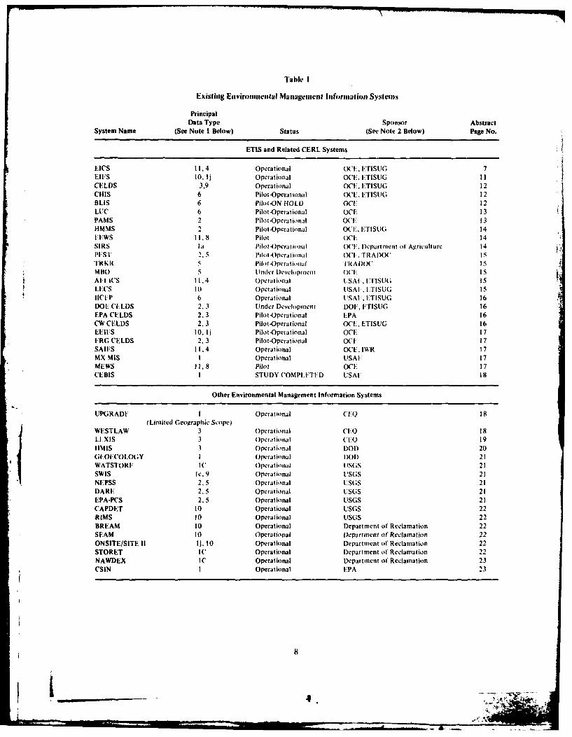
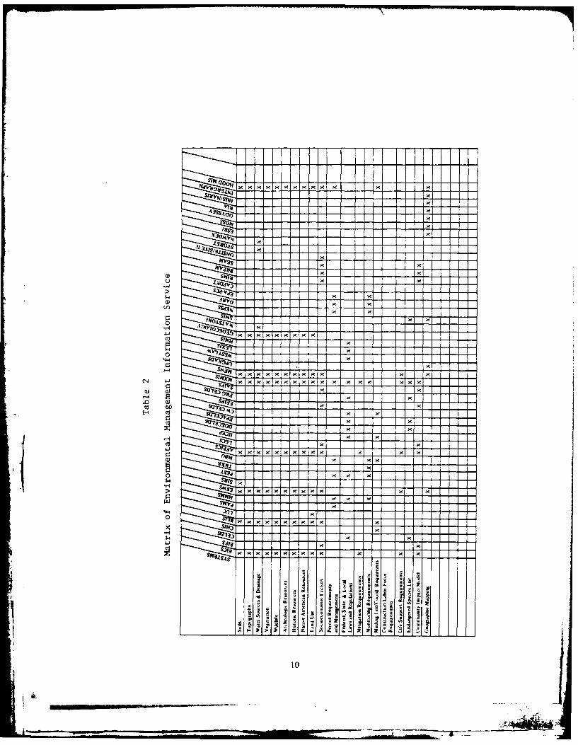
E xisting Entviromesntal Mlantagemewnt Informtion Systems~
PrincipalData Type Sponsor Abstract
System Name (See Note I Below) Status (See Note 2 Below) Page No.
ETIS and Related CERL Systems
EICS 11.A Operational (Xl F Er1 ISUG 7EIFS to, lj Operational OC F. 1:TISUG 11CELDS 3.9 Operational OCF. ETISUG 12CHIS 6 Pilot-Operational OCE. FTISUG 12BLIS 6 Pilot-ON HOLD (' 12LUC 6 Pilot -Operational OCE 13PAMS 2 Pilot -Opera tional OC F 13
-MS Pilot -Opera tional OCE. ETISUG 14FFWS II. 8 pilot (WE 14SIRS 1;1 Pilot 4)pera tiimal ('F. D~epart ment ol'Agriculture 14PE-ST 2.,5 Pilot-Operational 0(1>. rtAI)OC isTR K R 5 Pilo t -Ope ra t it t I a R A D)OC isMitt) 5 Unlder D~evelopmoent 0(1 I5
&All I WS H1,4 Operational 1JSAI. HLTSU(; Is
uFCS 10 Operational LISAI , FTISUG 15IICF1P 6 Operational IJSAI., ETISUG 16DOE CILDS 2.3 Under Development DO. FTISUG 16EPA CELDS 2,3 Pilot-Operational EPA 16CW CELDS 2, 3 Pilot -Operational OCL, ET1SUG 16EEII:S 10, lj Pilot -Operational OCE 17ERG CELDS 2. 3 Pilot -Opera tional OCE 17SAlES 11.4 Operational OCE, IWR 17MX MIS I Operational USAI- 17MEWS 1,.8 Hiot OCI: 17CEBIS I STUDY COMPLETED USAF 18
Other Environmental Management Information Systems
UPGRADE I Operational C'IAQ 18(Limited Geographic Scope?
WE 'STLAW 3 Operational CI.O 18LlxIs 3 Operational (:'Q 1911MIS 3 Operational DOD) 20(;l-OKCOL(Y I Operational DO 1) 21WATSTORE- IW Operational U SGS 21SWIS le. 9 Operational USGS 21NE ':PSS 2.5 Operational IUSGS 21DARE 2.5 Operational UJSGS 21EPA-PCs 2.5 Operational USGS 21CAPDET 10 Operational USGS 22RIMS 10 Operational USGS 22BREAM 10 Operational Department of Reclamation 22SEAM 10 Operational Departmnent or' Reclamation 22ONSITE/SITE 1I lj. 10 Operational Department of Reclamation 22STORET IC Operational Department of Reclamation 22NAWDEX IC Operational Depiartment o1 Reclamnation 23CSIN I Operational EPA 23
8
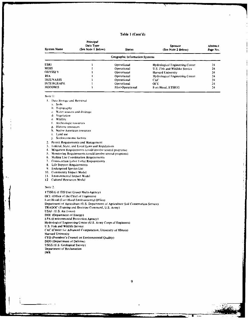
Table I (Cont'd)
PrincipalData Type Sponsor Abstract
System Name (See Note I Below) Status (See Note 2 Below) Page No.
Geographic Information Systems
ESRI I Operational Hydrological Engineering Center 24MOSS I Operational U.S. Fish and Wildlike Service 24ODYSSEY I Operational Harvard University 24RIA I Operational Hydrological Engineering Center 24IRIS/NARIS I Operational CAC 24INTERGRAPH I Operational OCE 24HOODMIS I Pilot-Operational Fort Hood, ETISUG 24
Note I:I. )ata Storage and Retrievala. Soilsb. lopographyc. Water sources and drainaged. Vegetatione. Wildlifet. Archcologic resourcesg. Historic resourcesh. Native American resourcesi. Land usej. Socioeconomic factors
2. Permit Requirements and Management3. federal. State. and Local Laws and Regulations4. Mitigation Requirements (could involve several programtsl5. Monitoring Requirements (could involve several programs)6. Mailing List Coordination Requirements7. Consit.ction Labor Force Requirements8. Life Support Requirements9. Endangered Species List
10. Community Impact ModelII. Environmental Impact Model12. Cultural Resources Model
Note 2:
FTISUG (I TIS User Group Multi-Agency)OCt (Office of the Chief of .ngincers)I FIort Hood (I ort Hood Environmental Office)Department of Agriculture (U.S. Department of Agriculture Soil Conservation Service)TRADOC (Training and Doctrine Command, U.S. Army)USAF (U.S. Air Force)DOF (Department of Energy)EPA (Environmental Protection Agency)Hydrological Engineering Center (U.S. Army Corps of Engineers)U.S. Fish and Wildlife ServiceCAC (Center (or Advanced Computation, University of Illinois)Harvard UniversityCEQ (President's Council on Environmental Quality)DOD (Department of Defense)USGS (U.S. Geological Survey)Department of ReclamationIWR
9
% .-,* -
Go~ --- -
At
xX
x -I
Cu I X
0 x
I I X-4 rl x x
o aa
ca~~ x I I
x~~ ~ ~ xrsx x* XI
2 & ~ ~ x
__ __ I x X
The functional areas are further broken down into business statistics, either by defined region or con-basic activities. These activities are then compared to stituent counties.the attributes in each technical specialty using a"need-to-consider" scale. The system indicates the b. The time series profile highlights historicalprobability of impact occurrelce, rather than the trends in income, employment, and population. Thesepotential magnitude of tht impact. Ramification and can also be displayed by occupation or category type.mitigation statements are keyed to the activity. Ramifi-cation remarks explain why the activities were scored c. The predictive model profile is broken into aas they were. Mitigation statements describe ways to number of submodels for construction, operation andlessen or avoid the impacts of that activity, maintenance, mission change, and training. Location
quotient techniques are used to estimate an action'sThe user has the option of obtaining output at impact on the region.
two levels. The review level contains attributes (en-vironmental characteristics) that give an overview of d. The Rational Threshold Value (RTV) profilethat technical specialty without the specificity that is a bracketing method to establish the significance ofthe detailed-level attributes provide. It should be used economic impact. Four areas of the regional economyprimarily to assist reviewers of completed documents are examined: change in business volume, change inand to help select the best alternative from numerous personal income. cha" • in total employment. andactions. The detailed level, which is generally used to change in populatio,. ie historic changes in each ofhelp prepare major Environmental Impact Statements these parameters z !xamined. The positive RTV(EIS.), contains all the atrributes of a technical special- equals the largest ye percent deviation fromty. Controversial attributes are presented at both the average growth ie historical record. The nega-levels. These are attributes that are controversial in tive RTV is a fi -'centage of the maximumnature i.e., historically they have caused some public historic negative t a; ,. Actions that result inconcern whether or not the actual impact is scientif- changes which fall w,,,n this bracket are not con-ically significant. sidered significant.
The Economic Impact Forecast System e. The detailed employment profile includes allThe Economic Impact Forecast System (EIFS)V is Standard Industrial Classification codes for the area.
an export base location quotient model designed to At the user's option, these can be retrieved at the one-.help the military planner determine if an action will two-, three-, or four-digit levels, which representhave a significant impact on the local economy. This increasingly detailed data.computerized system is a user-oriented, low-cost,systematic approach to socioeconomic impact analysis. f. The export employment profile provides theEIFS also has an economic model of analysis which four-digit location quotient derivations used in thepredicts community-level impacts on income, employ- predictive model.ment, population. schools, and public finance thatwould result from implementing the various alter- g. The census tract profiles provide county datanative actions. The system is based on county units, at the census tract level or at the minor civil divisionwith statistics available for every county in the nation. (town) level. These statistics deal with projections onSpecific counties are then aggregated to form the household, per capita, and total personal income:relevant economic region. group quarter counts, employment statistics- and other
detailed data. They cover more than 30.000 individualThis system contains many different subfeatures reporting units.
called profiles. Some of these are explained below.h. The BLS profiles present Bureau of Labor
a. The overview profile gives an overview of the Statistics (BLS) data on employment, unemployment.region, including population, governmental, and and labor participation on a monthly basis.
i. Several graphics profiles allow color graphics
'R. D. Webster. et At. The Economic Impact Forecast displays of multicounty maps, bar chart and pie chartS-stem Description and User Instructions. Technical Report distributions, and other display mechanisms associatedN-2/ADA029139 tCERL. 1976). with EIFS.
II
The Computer-Aided letter postal code. e.g.. *IL*' for Illinois.Environmental Legislative Data System -'US" for the Federal government.
The Computer-Aided Environmental LegislativeData System (('ELDS?4 is an up-to-date summary if *AGY adminislralive agency tile name andall Federal and State regulations related to tile environ- address of' the agency which promulgatesment. It was developed to respond to the need tor and enforces each regulation.rapid and easy access to relevant environmentalstandards. ('-LDS has been developed for use by non- BIB bibliographic reference the source of thelawyers to determine ettvirontmentlt standards which original text from which tIre regulatinomlight he important in regulating ali on-going activiiy was abstracted.or which should be considered in plai rring a tutreaction. Abstracts of tile regulations are written in a ABS abstract a concise, informative prescnta-straightforward. easy to understand, narrative style. tion of the regulation's details.These abstracts are not intended to replace tIre originaldocuments or to resolve complex legal problems. IBL table of numerical standards, if anir exist
for the regulation.Each CELDS record is subdivided into the following
12 categories of' information, called fields. Fields which *ATT environmental attributes. Records arecall be used to conduct a search are indicated by an indexed under relevant attributes wInchasterisk, are listed in the CELDS User Mantual.
*AC accession number, which identifies the *KEY keywords used to index each record. A
records as the' were originally entered list of the keywords (or thesaurus) mayinto the system, be obtained in the CELDS User Manual.
ITL title, a brief comprehensive title that The Clearing House Information Systemreflects tire scope of each regulation. The Clearing House Information System ((CI ISi)'
identifies State and local agencies with which plannersDAT tile date ofr enactment of the regulation. must coordinate environmental impact planning docii-
or the date of its rmost current amend- tienits as required by OMB Cir. A-)5. This systemriment or cItan|ge. Each time a regulation identir . these potential contacts based on theii ge -is amended, this date is changed. graphic uesignations (counties). Its reliance on coun t\
designations instead off State designa tions indicates aREF the referenced or official legal source of greater number of search terms and more differentia-
the regulation. t,,rn because there are More search terms. The usermerely supplies the county (or counties) of interest.
*MEC the major environmental category. Each and the local A-95 clearing houses are identified.record has been indexed under one ormore of the following environmental The Baseline Information Systemareas: Air Quality, Earth Science. The Baseline Information System (BLIS)" identitiesEcology. Health Science. Land Use, sources of information and consultation which may beNoise. Sociology. Solid Waste. Trans- used to prepare and develop environmental planningportation. and Water Quality. documents. This project is intended to supplement
EICS by identifying data sources keyed to each state*GPS geographical/political scope, tile political and searchable by environmental attribute (or attribute
areas in which tile regulation is applied.such as a State or the Federal govern-mient. States are identified by their two- 'J. van Weringm et t
,R W,'ebster and ti. (;rllin. Chearipighouse InjormationSyst'n I)escription and t sir Instructions. Technival ReportN-53/ADAt591 '6 (CIRL. 19781.
'I. van eringh. et at.. (wipitr.,fided i -nriraem',vial' B. ;riftin and R. Webster. Tie Baseline I fortnationIeyislative Data Svston (CtI).DSi Usier .taiua/. Technical System User's Manual, Technical Report N-72/AbAO69324Report N-56fADAt61126 (CI RI.. 19780 I(' RL. 1979).
12
desigiatiol). I'hell e cli.ics ale taken lii dcllt.'li es, 0. SiIlace Mininig RegualtllsSt ate agency l ists. Federal age ncy lists, and maniiy ohlisources. The system is designed to he a starting point 7. Agricultutal Lands Classificationfor obtaining consultation, assistance, or data whichcan be used to clarify, substantiate, and assess the 8. Forest Land Managementmagnitude of potential impacts identified by EICS.The system will enable the user to make inquiries and 9. Recreation Lands Managementreceive feedback. A list of addresses, phone numbers,and supplemental qualifying information will be 10. Differential Assessment Lawssupplied initially, based on keyword inputs by theuser (using EICS output to specify attributes). The 11. Historic/Archaeologic Sitesupdate of BLIS is supplemented by user-suggestedcontacts which are fed back directly to the machine 12. Critical Area Designationand stored in a directory accessible to maintenancepersonnel. This feedback mechanism provides a means 13. Water Resources Managementof updating and refining the system to meet user needsby allowing good contacts to be transferred from one 14. Air Qualityuser to tlhe rest of l)01) community.
15. Water QualityThe Land Use Compendium
The Land Use ('ompenditmL (LUC)8 identifies 16. Solid Waste ManagementFederal and State agencies having designated land useauthority. In keeping withI Point 2 of lthe Council on 17. Noise ControlEnvironmental Quality (CEQ) guidelines, LUC allowsfor efficient identification of agreements and 18. Power Plant Sitingresolution of conflicts between a given military pro-gram (or project) and other Federal, State, and local 19. Transportation Planningplans. policies, and programs. These agencies satisfytwo criteria: (I ) they control sorte aspect of land LUC identifies information by geographic desig-use, and (2) the uses of lands they control are related nation (state) and by category of interest (anotherto Department of the Army ()A) actions. Up to 19 keyword type of search).State agencies or points of contact are also includedwhich satisfy the following criteria: ( I ) they administer The Pollution Abatement Management Systema law or regulaton; 12) they are officially responsible, The Pollution Abatement Management Systemstatewide, for some area concerned with land use; (PAMS) 9 is designed to help pollution abatementor (3) they are responsible, statewide, for the study oif planners/engineers manage facility pollution problemsland use problems. and define alternative mitigation techniques to bring
about legal compliance.Areas of concern included withnin LUC are:
Ai PAMS' interactive computer-supported data-based1. Statewide Planning (Coordination) subsystems allow management of large quantities of
data in a form that is readily available, reliable, and2. Statewide Planning (A-95 Review) centrally located for effective and economic data
management. Examples include (I) National Pollutant3. Coastal Zone Management Discharge Elimination System (NPDES) permit man-
agement tool; (2) a computerized logic system for4, Wetlands Management helping choose from various water and air pollution
abatement technologies (the choice is based on5. Floodplain Management
'E. Smith and R. Webster, Concept Definition for theProblems Data Base Component of the Water Pollution A bate-
R. Lacey. ct at.. Compendium of'Administrators of/Land mete Subsystem of' the Pollution Abatement ManagementUse and Related Programs. Technical Report N-40 tRevised)/ System (PAMS/. Interim Report N-73/ADA072398 (CERL,ADA128413 (WERL. 1983). 1979).
13
4 ,- .
technical attributes (advantages/disadvantages. cost, The Environmental Early Warning Systemand DA site-specific considerations): (3) a cornpre- The Environmental Early Warning System (EEWS)l j
lensive environmental database to manage pesticides, allows Army headquarters level decision-makers and
hazardous materials, and related data; and (4) a environmental specialists to determine rapidly whethersystems approach to wastewater reuse applicability at proposed mission changes can be expected to result inDA installations, unacceptable environmental impacts at affected
installations. LEWS is designed to be used at theThe Hazardous Materials Management System earliest stages of action planning the "What if?"
The Ilazardous Materials Management System stage so that alternatives may be examined for
(IIMMS)" t was originally programmed to identify, possibly serious environmental consequences. Theeither by listing or definition. chenlica. sbstances factors considered are restricted to those which havesubject to ha/ardous waste regulations. A variety of actually resulted in delay or reconfiguration of Army
chemical infornm ation sources was searched to identify actions in tile past. Background information will besynonyms anid trade names of the listed hazaldous based on existing reports and data sources. Therefore,wastes, and the chemical, genetic, and trade names of' results may be expected to be of at least equivalent
compounds described by one or more of the detini- accuracy to present practices, but will be obtainedlions of hazardous waste. This database contained within a few minutes, without the necessity of10.505 compounds as of February i9N2 arid is still repetitive, individual inquiries to the installations.under development. Background information, which includes tabular data
and mapped factors. may also be retrieved for certain
The system has been expanded to provide regula- comparisons. All commands are in English. No com-tory and management information. Department of puter programming expertise is assumed.Transportation (DOT) regulations for hazardousmaterials have been provided in full. RCRA regulations The Soils Information Retrieval Systemfor generators, a list of substances excluded from The Soils Information Retrieval System (SIRS)' 2
regulation under R('RA. and the four legal definitions was developed as an outgrowth of erosion modelingof hazardous waste are also available. In addition. work done at (ERL for expanding the ETIS system.31 Technical Data Sheets for Managing Hazardous The Soil Conservation Service (SCS) of tile Depart-Waste, developed by IIQ TRADO('. are accessible ment of Agriculture has developed an enormousunder IIMMS. along with supplementary information database of soils-related information. Data from thison these 31 compounds taken from tile Coast Guard's source is required for erosion modeling. To obtainChenical I lazaids Responise In oritation System the needed data for all geographic areas of potential(CIIRIS). Army interest, ('ERL obtained a tape copy of the
entire SCS database. A retrieval program was writtenPlans for the systelm includc: completing the data. which displayed any of the data available on any soil
base of chemicals subect to RCRA regulation upon in a format interactively selected by the user. Thisdisposal: providing detailed information, including capability is useful not only to the Army, but alsosubstitution arid waste reduction guidelines, oil six to the Department of Agriculture, which can now
classes of hazardous waste produced in large volumes retrieve data in minutes which previously requiredby the Army: providing guidance ont delisting pro- weeks. Moreover, tle output format can be specifiedcedures and points of contact. providing software to by each user to exactly fulfill his/her needs. The datainteractively access and search the Defense Logistics are available for all soil series in the United StatesAgency's (DLA) Hazardous Materials Information (more than 12,000) and include all interpretationsSystem (HMIS) by chemical and trade name: and performed by the SCS.
creating a database of chemical names correlated withtrade names. Federal specifications, military specifi.cations, registry numbers, and formulations.
R. Lozar and tI, Balbach. The itironmental EarlrWarning S-mstem (EE'SJ Concept Description. TechnicalReport N-144/ADIA127356 (CURL, 1983).
''M. Messcngcr. et A.. Intractitev Hazardois Materials 2 NV I). G;ranl, Atn Interactire Soils In,lrttarion System
lnItornation S-stm' (IMIS). I)escription atd .ssessmecnt. (1scrs Manual. Technical Report N-163/ADAI33480 ((TRL.Technical Report N-170 ( CRL. 1983). 1983).
14
2' ,
The Pesticide Management System commands, MACOMs, IiQDA, and. finally, DOD. TheThe Pesticide Management System (PEST)1 3 helps automated MBO system greatly reduces the paper-
Army personnel who manage pest control by auto- work associated with the data collection and aggrega-mating certain reporting requirements in tile areas 1: lion process. Installations interactively input their data(I) types and quantities of pesticides applied (where to a central computer. The computer lacililates theand for what pests) and (2) exposures t) pesticides of review process associated with the MBO repo~rttspersonnel involved in actual application, preparation by allowing reviewers to instantly call up
any current or previously supplied data.In cooperation with the TRADOC environmental
office, CERL developed a design for an automated With MBO data available in a computer system, itpesticide accounting system. A database was created can be retrieved in any format or level of aggregationwhich contained information on pesticide applications desired. The information can be used for purposesat all TRADOC installations: type and amount of other than MBO report generation. Its availability is aagent applied, pest being controlled, time and site substantial aid to managing the Army's environmentalof application, and person applying the agent. A program.program was written to summarize and format thedi.,a, which was used in supervising the MACOM's The Air Force Environmentaloverall pest control program and preparing necessary Impact Computer Systemreports. The Air Force Environmental Impact Computer
System (AFEICS) is an offshoot of EICS which wasPEST has been well received at TRADOC and is developed to reflect Air Force, rather than Army,
being considered f(or Army-wide use. activities. AFEICS allows the user to delete unwantedactivities before receiving computer output. This
The Tracker System modification was made to meet specilic needs ratherThe Tracker System (TRKR) was developed to help than complete system redevelopment. This feature was
MACOM environmental personnel track and manage also later adapted in the Army system.Army Pollution Abatement Program (APAP) projects.APAP project data are entered into a database used by The Local Economic Consequences Studytwo user programs. The first routine validates the input The requirement for adequate assessment of socio-to the project file, flags late projects, and produces a economic impacts when preparing ElSs has becomefunding by media report. The fornat makes project increasingly important to military planners. To thissearching easy through simple. word-processing-type end, DOD guidelines and suggestions have encouragedcommands. Projects can be searched and retrieved by the use of a systematic approach and uniformity ofmedia type (e.g., water, air): funding type (e.g., MMCA, documentation when considering the socioeconomicOMA), project status (comp, preplan, LATE), project impacts of new military projects. This is due partly tonumber, and other criteria. The second routine the uniqueness of the DOD installations and theirproduces formatted listings of projects that can be effects on local economies, the geographic distributionprinted on a high-speed line printer. The listings are of those installations, and the complexity of problemsin a format suitable for inclusion in reports, or any associated with determining the economic and relatedother use where a paper copy is needed, social impacts associated with DOD actions. The
approach to be selected must be efficient, systematic,The Management by Objective System and capable of providing "first-cut" estimates of
CERL has developed a pilot, automated Environ- impact before case-specific studies are undertaken.mental Management by Objective (MBO) reportgeneration system for the Army Environmental Office. To address the need for a systematic, first-cutThe report begins with installations filling in inter- approach to socioeconomic impact assessment, DA,actively on the computer questionnaires about their with cooperation and substantial support from theprogress in achieving pollution abatement. The re- Department of the Air Force, developed EIFS, whichsponses are then aggregated through major subordinate provides information useful for calculating socio-
economic changes caused by DOD actions.
I M. Messenger, R. Webster, and T. Brown, Comparisonof Alternative Modes of Data Input to the Pesticide Inform- New and changing laws, guidelines, directives, andation Retrieval System. Technical Report N-137/A122045 executive orders have determined that a more detailed(CERL, 1982). methodology to assess large and controversial proposed
15
I
actions is "ceded. In response to this need, tihe Air The system's int - rma lit n allows the user to identif'yForce Engineering and Services ('enter (AFES() and the relevance of each agency in order to specify en-CERL developed a highly disaggregated socioeconomic vironmnetal planning issues, and lists the agency'smodel of analysis and used the procedure to analyze address, telephone number, point of contact, andAir Force installation realignments and closures. This function.model, called the Local Economic ConsequencesStudy (LECS) t4 methodology, provides more temporal The Department of Energy CELDSand geographical detail in the output results than The Department of Energy CELDS (DOE CELDS)EIFS. Substantial quantities of community-specific is a part of the operational CELDS component ofinput data and numerous hand calculations are neces- ETIS. DOE has used CELDS frequently, and some ofsary to use LECS. Much of the required input data is its personnel realized that the CELDS approach wouldalready stored in the EIFS database, and the iathe- be useful for storing and retrieving mining regulationsmatical calculations are a simple task for the mini- relevant to their work. As a result, DOE data havecomputer on which EIFS operates. Therefore, it was been entered and the CELDS thesaurus altered to meetboth logical and beneficial to integrate LECS into DOE needs.ETIS.
The Environmental Protection Agency CE LDSThe Interagency/intergovernmental ('ERL developed the pilot Environmental Protec-Coordination of Environmental Planning tion Agency (ELI)S (EPA CELDS) to respond to
Tile lnteragency/lntergovernmental Coordination of needs of the EPA's Office of Water Planning andEnvironmental Planning (IICEP)"s identities State Standards. Specifically, a system was needed in whichenvironmental planning agencies with which Air Force an individual body of water (river, lake, creek. etc.)planners must coordinate their actions. Agencies could be retrieved, along with its "'use" classificationlocated in all 50 states. Guam. and Puerto Rico are (i.e.. recreation, drinking water, navigation, etc.) andincluded. The listed agencies are from the following its water quality parameters (i.e.. pH, temperature.environmental categories: dissolved oxygen. etc.). Five states were selected for
inclusion in the pilot project: Texas, Iowa, Pennsyl-I General vania, Montana, and Arizona.
2. Air Resources The Civil Works CELDSThe Civil Works CELDS (CW CELDS)' 6 was devel-
3. Energy oped for OCE t) help Corps civil works planners
4. Hlealth and Safety comply with OMB Circular No. A-I 1.17 This circularrequires that any Federal agency:
5. Land UsePerforming water resources activities will submit
6. Natural Resources [as part of its annual budget request] ... acertification by the agency that each project
7. Noise in the planning or construction stage is in compliance with applicable environmental statutes.
8. SocioeconomicFifteen of the applicable statutes for environmental
9. Solid Waste protection and cultural heritage preservation are
10. Transportation referenced by the OMB directive and are listed in theWater Resources Council's "Principles and Standards
It. Water for Water and Related Land Resources PlanningLevel C" (Final Rule, 29 Sep 80. Federal Register.
"J. Hamilton and R. Webster. Local kconomc Conse-quences Study (I- ECS) Preliminarv' User Manual. InterimReport N-94/ADA088261 (CIRL. 1980). I.. Herrick and R. Webster. Clk' CELDS User Manual.
"R. Webster and D. Putnam. nteragencv/nergo''rn. Technical Report N-141/AI)Ai25974 (CFRL. 1983).mental Coordination of Enrironmental Planning (IICEP) "Pr'paration and Submission of* Budget Estimates. Cir-Svstems Considerations. Technical Report N-87/ADA085991 cular A-I I (Revised) (Office of Management and Budget,(CFRL. 1990). 25 May 1978).
16
& t.- . -
p 64398, Table 711.71-2). These laws are also cited CERL/IWR. This effort involves modifying EIFS toby ER 200-2-2."' provide additional analysis capabilities to Civil Works
users. The military orientation of EIFS requires modi-To conform with these requirements, Corps plan- fication to meet the needs of water resource planners.
ning, engineering, and construction personnel can use Efforts include the addition of statistical packages.CW-('ELDS for guidance to delermine which of the subcounty (tract and MCD) data analysis. and color-laws apply io a given project and whether the specified graphics displays.procedures have been followed. This system is a plan-ning tool for ascertaining whether a project is in a The MX Management Information Systemstate of noncompliance which must be rectified before The major databases for MX environmental planningthe work may proceed further. It can be userful early are maintained at AFRCE-MX Norton AFB. CA.in the planning stage by showing the course that a Although the data are gathered and analyzed by vari-project must follow to assure its timely compliance ous Air Force contractors, data transfers are beingwith the appropriate laws and thereby avoid errors made so that all information will be deposited withthat lead to procedural delays. the AFRCE-MX office.
This system is designed to take the user through a The MX Management Information System (MXMIS)series of queries concerning tasks mandated for Federal database falls into three categories, with overlap inagencies for each of the 15 statutes. Each query is also various subject areas. The categories are:reinforced by additional helpful information. The usercan obtain this help at three levels of detail: Level I I. The environmental impact analysis process.gives the legal citation for the question- Level II gives This is data gathered on human, cultural, natural,the full text of tile cited portion of the law or regula- and physical resources in support of the great basintions: and Level III gives an abstract of that text. FIS effort. The data include information on Utah,
Nevada, Texas, and New Mexico as well as some in-At the conclusion ofa session, the user will be given formation to support the silo basing mode in the
two options. The first will allow the user to see a Northern United States.graphic display of" the logic path used in the session.The second will allow this graphic display to he saved 2. Comprehensive siting and planning. Data existin a file for later use. at the 10.000-acre level of detail and were developed
for detailed site selection at four locations in Nevada.European EIFS Ultah. and New Mexico. The data were collected by
The need for demographic and economic data for extensive field work at Cannon AFB. NM: Coyoteinclusion in military planning in Europe led to the Springs. NV: Milford. UT: and Beryl. UT.development of a German version of FIFS calledEuropean EIFS (EEIFS). This system, which has 3. Geotechnical. Water and geology data exist fordata on Kreis (county) regions for the Federal 36 valleys within Nevada/Utah and parts of NewRepublic of Germany (FRG), contains both data and Mexico. The data for these valleys are fairly extensive.economic models for analyzing military activities, with most existing in hard.copy form. The data will be
available from the National Technical InformationFederal Republic of Germany CELDS Service (NTIS). There is also information available
Using the same criteria as for the stateside version (primarily hard copy) on legal, archaeological, Americanof CELDS, CERL developed a pilot system called Indian, historical, and community resource conserva-Federal Republic of Germany CELDS (FRG CELDS), tion requirements.which contains German regulations.
The Mobilization Early Warning SystemSocioeconomic Assessment and To increase internal planning responsiveness, theImpect Forecast System HQ Training and Doctrine Command (TRADOC)
The Socioeconomic Assessment and Impact Fore- Engineer asked CERL to develop a system to allowcast System (SAIFS) is being developed jointly by quick, flexible response to mobilization plans. A
modification of the Environmental Early WarningSystem (EEWS) was therefore prepared. EEWS already
'Pollcy and Procedures for Implementing NEPA, Engineer contained the capability to compare new installationRegulation (ER) 200-2-2 (Office of the Chief of Engineers, demands with installation assets to predict the environ-25 August 1980). mentally related consequences of such mismatches.
17
AL.. " .
The Mobilization Early Warning System (MEWS) uses A OTHER ENVIRONMENTALthe same general approach, but presents the match 4 MANAGEMENT INFORMATIONbetween demand and assets as the final result, rather SYSTEMSthan predicting environmental effects.
MEWS uses basic installation information, such as In addition to ETIS, several other systems have beenthe available square feet of billeting area and the developed for use by environmental planners. Thenumber and type of ranges; it then compares these sponsors for these systems are listed in Table I . Theassets with demands derived from the installation's following sections discuss some of these systems andmobilization tasking. The resulting surplus or short- their functions.fall in any category is then displayed for each weeklyincrement following "Mobilization Day" (M-Day). UPGRADETabular and graphic outputs are available, and outputs UPGRADE was designed primarily to support themay be configured for all common types of access development of the annual Council on Environmentaldevices. Tabular response to al altered demand or Quality (CEQ) report. It provides statistical andrevised supply of a facility may be examined within graphic capability for analyzing user-supplied data-minutes of the proposed change, and the element bases. Current efforts are to move the UPGRADEeither further restructured or permanently installed, software to a VAX mini-computer and expand theGraphic output is also immediately available, and is user community.especially useful for presenting the broad overview,or in preparing briefings where the response is eval- WESTLAWuated. Key variables under the control of TRADOC WESTLAW is a management information systemplanners include trainee loads, number, type and which provides access to several fides of legal inform-scheduling of any troop demands, and training course ation, including:length.
1. Supreme Court Report. Full text, includingThe Computer-Aided Environmental headnotes, of U.S. Supreme Court cases, from 1932 toBaseline Information System the present.
CERL and the Air Force are developing theComputer-Aided Environmental Baseline Information 2. Federal Reporter. Full text, including head-System (CEBIS),' 9 a system that will store and allow notes, of reported cases from the U.S. Courts ofanalysis of environmental information from sources Appeals, Court of Claims, Court of Customs andsuch as the TAB A-I. Environmental Narrative. Revised Patent Appeals, and Temporary Emergency Court ofTAB A-I formats provided by Stanford Research Appeals, from 1945 to the present.Institute (SRI) and the Air Force were used to developa pilot CEBIS system for use by AFESC in environ- 3. State Cases. Full text, including headnotes,mental planning and impact analysis. The pilot system of all reported cases for Minnesota (since 1945), Newdemonstrated use of CEBIS with TAB A-I data for Jersey (since 1948). California (since 1967), Louisiana
three selected bases. CERL analyzed the TAB and (since 1956), and Washington (since 1965). Headnotesidentified TAB elements regarding data usefulness, for all states are available from 1957 to 1966. Duringinterfacing, and sources. The programming was begun 1982, full text from 1967 to the present will be addedon the TAB structure, and interfaces were made with for the remaining states.ETIS and other database systems. Data from the threeAir Force installations were incorporated for the pilot 4. Military Justice Reporter. Decisions of the
study. with the addition of information update capa. U.S. Court of Military Appeals, and Courts of Militarybiity. The next phase of CEBIS development will Review for the Army, Navy, Air Force, and Coastinvolve: (I) full-scale implementation of CEBIS and Guard.identified refinements for all Air Force installations, and(2) the integration of CEBIS data into other ETIS 5. New Jersey Tax Court Reporter. Full text,systems. including headnotes, of the Tax Court of New Jersey
__________cases, from 1980 to the present.
"R. Webster and D. Putnam, Preliminarv AnalYsis of 6 as e piglit.
Computer-Aided Environmental Baseline Information System 6. WESTLAW Case Highlights. A weekly inform-(C.BIS). Phase I: System Requirement. Interim Report N-88/ ation ide of specially prepared summaries of the mostADB046908 (CERL. 1980). significant State and Federal cases around the country.
18
Ilk
7. Shepard's Citations. Provides citations to sub- 17, SEC Decisions since 1934, SEC Interpretivesequent histories of cases and to all other cases that Releases since 1933, and SEC No Action Letterscite a given case. since 1971.
8. Quick Opinion File. Provides pre-publication 16. Labor. Covers labor cases from the U.S.coverage of Federal court decisions from the 5th and Supreme Court since 1932, U.S. Courts of Appeals9th Circuit Courts. since 1945, U.S. District Courts since 1950, U.S.
Court of Claims since 1961. and relevant sections from9. West Bankruptcy Reporter. Full text, including the U.S. Code. Contains Titles 26, 29, 40, 42, and 45,
headnotes, of Federal bankruptcy cases since 1979; and CFR Titles 20, 28, 29. 30, and 42, National LaborU.S. Code Title II. CFR Title 28, and SEC Reorganiza- Relations Board (NLRB) decisions since 1972, andtion Reports. Occupational Safety and Health Review Commission
(OSHRC) Reports since 1971.10. West Key Number Digest topics (currently
covering Civil Rights, Drugs, and Narcotics). Public 17. Antitrust and Business Regulation. Covers
Contracts, Product Liability, and Securities Regula- antitrust and business regulation cases from the U.S.
tions are reported on the database from the earliest Supreme Court since 1932, U.S. Courts of Appeals
reported case to the present. Any case retrieved will since 1945, U.S. District Courts since 1950, U.S.
have a case citation. Court of Claims since 1961. relevant sections of theU.S. Code and CFR, and Federal Trade Commission
I1. U.S. Code. Full text of the United States Code, (FTC) Decisions since 1959.
Titles 1 through 50.18. Communications. Covers communications cases
12. Code of Federal Regulations. Full text of the from the U.S. Supreme Court since 1932, U.S. Courts
Code of Federal Regulations. Titles I through 50 were of Appeals since 1956, U.S. District Courts since 1950.
scheduled for completion during 1982. U.S. Court of Claims since 1961, relevant sectionsfrom the U.S. Code and CFR, and Federal Communi-
13. Federal Tax Files. Full text of the Internal cations Commission (FCC) decisions.
Revenue Code, Federal tax cases reported for the 19. Government Contracts. Covers governmentU.S. Supreme Court since 1932, the Court of Appeals contract cases from the U.S. Supreme Court sincesince 1954, the Court of Claims since 1954, the 1932, U.S. Courts of Appeals since 1945, U.S. Dis-District Courts since 1954, and the U.S. Tax CourtReports and Memorandum Decisions since 1954; c1961 relevant sections of the U.S. Code and CFRCode of Federal Regulations-Title 26, Federal tax 191 rlevantctonseof tecU .administrative materials, including revenue rulings,revenue procedures, delegation orders, executive 20. Insurance. Covers state insurance cases from theorders, and Treasury Department orders since 1954; 50 U.S. states. West Key Number Digest topics (cur-and Internal Revenue Service written determinations, rently covering civil rights, drugs and narcotics, publicincluding private letter rulings and National Office contracts, product liability, and securities regulation)Technical Advice memoranda since 1954. IRS news are reported in the database from the earliest reportedreleases and tax notes were to be added during 1982. case to the present. Any retired case will always have
a case citation.14. Forensic Services Directory. Contains the
names of thousands of scientific, medical, and tech- WESTLAW does not require any special hardwarenical experts available to serve as consultants to or terminals for searching.attorneys and as expert trial witnesses. Also liststranslators, testing laboratories, investigators, and other LEXISspecialists providing trial support services. LEXIS is a database system with a family of files
(called libraries) that contain the full text of courtIS. Securities. Covers securities cases from the U.S. decisions, statutes, regulations, and other legal mater-
Supreme Court since 1932, U.S. Courts of Appeals ials. These include:since 1945, U.S. District Courts since 1950, U.S.Court of Claims since 1961, relevant sections of the I. General Federal Library. Contains the currentU.S. Code, Titles 7 and I5, and CFR Titles 7, 12, and version of the U.S. Code, Federal Register (from July
19
i _ _ _ .. ,
-I " 1- --.
1980). and Code of Federal Regulations. Supreme 6. Communications Library, Contains communica-Court decisions from 1925. Courts of Appeals decisions iions case decisions from the Supreme Court sincefrom 1938, District Courts decisions from 1960, and 1936, from the Courts of Appeals since 1929, andCourt of Claims decisions from 1977. Also contains from tile District Courts since 1960. Also containsSupreme Court Briefings beginning with the fall term tie following volutnes of the Federal Commissionof 1979. Reports: Volume 39 (frequency allocations) since
1939: Volume 40 (sponsorship identification, equal2. Federal Patent. Trademark, and Copyright Law time. fairness doctrine, FM frequency allocations)
Library. Contains patent, trademark, ant copyright since 1941 Volume 41 (television matters) sincecase decisions from the Supreme Court since 1850. 1950: and Volume 42 (common carrier and safetythe Courts of Appeals since 1938, the District Courts and special radio services) since 1947.since 1960. and the Court of Claims since 1977. Alsocontains patent and trademark case decisions from the 7. Labor Library. Contains the National LaborU.S. Court of Customs and Patent Appeals since Relations Board Reports since 1972, and labor case1952. decisions from the Supreme Court since 1932, the
Courts ot Appeals since 1938, and tile District Courts3. Tax Library. Contains the current version ot the since 1947.
Internal Revenue Code, final, temporary, and proposedregulations. and the ('umulative Bulletin since 1954: 8. Bankruptcy Library. Contains bankruptcy caserulings under the 1954 Code and 1939 Code, the dacisions fron the Supreme Court since 1925. theInternal Revenue Manual. private rulings released to Courts of Appeals since 1938, and the District Courtsthe public by tile Internal Revenue Service (IRS) since 1960. Also covers Bankruptcy Judges' decisionssince 1977 and private rulings from 1954 to 1977 beginning in October 1979.released to the public and classified as "reference"by the IRS; tax case decisions from the Supreme Court 9. State Law Libraries. Contains court decisions,since 1913. from tile Courts of Appeals since 1938, primarily from State courts of last resort, intermediary
from the District Courts since 1960, and from the courts, and lower courts, for the 50 U.S. states and theCourt of ('laims since 1943: Tax Court opinions and District of' Columbia. Earliest information is frommemorandum decisions since 1942 Board of Tax 1821.Appeals opinions from the beginning (1924l) andpublic laws and house. Senate. and contleren,:e reports Hazardous Materials Information Systemfor the 1954 ('ode and amendments thereto. THie lazardous Materials Information System
IHMIS) was developed by the Defense Logistics4. Securities Library. Contains relevant sections of' Agency (OLA) in 1978,179 and is fully described in
Title 15 of the U.S. Code: securities case decisions "DOD Hazardous Materials Information Systemfrom the Supreme Court since 1933, the Courts of Procedures.' 2 which states:Appeals since 1933, and the )istrict courts since 1933:final and proposed rules and regulations promulgated The data system is intended to provide technicalunder the Securities Act and those issued by the informatio about the hazardous properties ofBoard of Governors of the Federal Reserve System: items that in some manner affect DOD personnelno-action letters since 1971. selected administrative by the unique aspects associated with hazardousdecisions and interpretative releases from the Securities items. The data in the system is intended asand Exchange Commission since 1933. and House. reference data to assist all levels of DOD manage-Senate. and conference reports associated with the ment to develop procedures for prevention of1933 and 1934 acts and amendments. mishaps, to apprise DOD personnel of hazards of
materials encountered in DOD workplaces, and5. Trade Regulation Library. Contains trade regula- to assist the development of environmentally
tion case decisions from the Supreme Court since acceptable disposal procedures.1890. from the Courts of Appeals since i8., andfrom the District ('ourts since 1950. Also contains The system will initially store data in two files:Administrative Law Judges' initial decisions since 1950 tile Safety Data ISD) file. and the Transportationand procedural orders since 1976. Federal Trade
Commission opinions since 1950, and consent and ' Dt0l Hazardous Materials Information System Pro.interlocutory orders since 1970. 'edores. DOI) 6050.5-M iDepartment of Dlefen.w. May 1979).
20
! iAA
Data (TD) general item identification, iten trans- rare, endangered, and legally protected animal speciesportation, and safety and health data files. Those using and subspecies in the United States and its territories.the data will generally be safety and health or transpor- The system was prepared in response to the increasingtation DOD personnel. concern for preservation of wddlife. Information for
the taxa is arranged by state or territory, and for eachGeoecology taxon. The recorded information includes: the degree
The Geoecology Database is a unique compilation of protection or welfare benefits accorded the taxonof computerized environmental data for research plan- under Federal and State or territorial law; its geo-ning for energy development requiring rapid access to graphic distribution, including a distribution mapdata at appropriate spatial and temporal scales. The that is plotted automatically when requested by theEnvironmental Sciences Division (ESD) at Oak Ridge user: the known behavioral characteristics and habitatNational Laboratory (ORNL), has developed an requirements that relate particularly to its adaptabilityintegrated database of diverse environmental resource to structural changes in its environment; its populationinformation from extant sources. Data are stored at structure and trends; and a list of information sourcethe county level of resolution for the contiguous documents (the reference bibliography).United States, with some data available tor subcountyunits within larger, more diverse eastern counties. NEPSSThe Geoecology Database contains selected data on The Navy has developed NEPSS. a computer systemterrain and soils, water resources, forestry, vegetation, that will help it comply with NPDES permits. Person-agriculture, land use, wildlife, air quality, climate. nel at Navy facilities enter Self Monitoring Report datanatural areas, and endangered species. Basic files on onto coding forms. These forms are periodically mailedhuman population are also included to complement to one of six Regional Computer Centers at which thethe environmental files. The Geoecology Database data is punched onto cards and entered by "'Remoteis currently fulfilling diverse ongoing research needs Job Entry" (RJE) to the main computer facility atwhile it is being expanded and updated as needs and Port Hueneme. The system generates Self Monitoringnew data are identified. Reports which are returned to the installations for the
responsible officer's signature. Summary reports ofWATSTORE various kinds are available at the regional centers via
The U.S. Geological Survey (USGS) investigates RJE to Port Hueneme. The system has recently beenthe occurrence, quantity, quality, distribution, and modified to accept "interactive" access and use. Inmovement of the nation's surface and underground addition, a transfer to minicomputer technology iswater resources. The investigations, conducted by the anticipated.Water Resources Division, include: systematic collec-tion. analysis, and interpretation of water data; inves- Department of the Armytigation of industrial, domestic, and agricultural water Registry of the Environmentrequirements: research and development to improve Department of the Army Registry of the Environ-study techniques and methodologies to better under- ment (DARE) is a system being developed by USGSstand hydrologic principles that form the scientific to help with the Development and Readiness Coin-basis of investigation; and publicatiun and other forms mand's (DARCOM) Installation Restoration and
of release to the public of results and data from these Pollution Abatement programs. The system consistsinvestigations. of installation contamination database information.
A large-scale computerized storage and retrieval These data support determination of contaminant
system stores and disseminates water data acquired migration based on site survey data, and an Environ-through USGS activities. The USGS Water Data mental Project Information System (EPIS) which
Storage ind Retrieval System (WATSTORE) was provides reports on the status of MCA pollution
implemented in November 1971. Besides its data abatement projects.processing, storage, and retrieval capabilities, WAT-STORE can provide computer-printed tables, The EPA Permit Compliance Systemcomputer-printed graphs, statistical analyses of data, The EPA has a family of computer systems whichand digital plots. store and manipulate environmental data. Currently,
the EPA Permit Compliance System (EPA-PCS) con-Sensitive Wildlife Information System tains information only on major emitters, while many
The Sensitive Wildlife Information System (SWIS) is DOD pollution sources are minor. Federal facilities cana user-accessed computerized information system for be culled from the overall database, but there is no
214i
mechanism to identify which of these are military- system of first order, second-order, third-order, etc..related. counties, depending on service sector dependencies.
This information could assist in the function of theComputer-Assisted Procedure for the Design and region of influence (ROI). Also, if coupled with anEvaluation of Wastewater Treatment Systems input-output (1-0) model ot'some type, BREAM could
The Computer-Assisted Procedure for the Design provide a mechanism to better estimate the effects ofand Evaluation of Wastewater Treatment Systems constructing large buildings for large projects.(CAPDET) is a computer-hased technique forestimating both capital and operating and maintenance The Socioeconomic Assessment Model(O&M) costs fOr a large number of wastewater treat- The Socioeconomic Assessment Model (SLAM).ment alternative processes. Tile cost estimating tech- administered by the Argonne National Laboratory,nique is unit-process-oriented, allowing the model user is very similar to BREAM. The concepts are closelyto synthesize alternative wastewater treatment plans, aligned with some modification in refinement. A
iod:",d version of the SEAM mdethodology is beingRegional Industrial Multiplier System incorporated into ElIFS-related work.
Researchers performing regional economic impactanalyses are often faced with impact alternatives in Onsite/Site IIwhich only one or a few of the local industrial sectors The Onsite/Site Ii systems allow the aggregation ofare directly affected by a proposed project or action, demographic statistics for any geographic area in theThe Regional Industrial Multiplier System (RIMS) can United States. Statistics are aggregated based on thecalculate input-output multipliers for any multicoun ty location of block population centroids. Summaryarea in the United States and for any four-digit level demographic statistics can then be displayed andStandard Industrial Classification (SIC) industrial used. Primary use of these systems is by marketingsector that an analyst desires. RIMS is not an economic firms and planning groups.model per se. but is basically a methodology forestimating regional, industry-specific output multi- STORETpliers which can be used to measure project impacts STORET is a national system that provides data onon output. Changes in income and employment in a lakes, streams, wells, reservoirs, rivers, and other water-region due to a project or action can be estimated ways from more than 200.000 unique collection pointsfrom the output changes. A version of the RIMS throughout the United States. STORET users includemethodology is available as an ELIS enhancement. Federal agencies. more than 40 states, river basin com-
misions, and regional and local agencies.Bureau of Reclamation Economic Assessment Model
The Bureau of" Reclamation Economic Assessment STORET analysis programs can help users monitorModel (BREAM) was developed and implemented by water quality trends, measure compliance with waterMountain West Research. Inc.. at Tempe, AZ, for the quality standards, trace pollutants, and file waterBureau of Reclamation. I.S. Department of the quality reports, budget requests, and managementInterior. It assesses and projects the regional economic basin plans. STORET files include:impacts caused by Bureau of" Reclamation constructionprojects. Like EIFS and LECS, BREAM is an economic Water Qualit. Filebase model, which means that a regional economy is Progress Report File. Public Law 92-500 requiresdivided into two sectors: the basic sector and the the submission of annual reports to EOA concerning allnonbasic sector. It assumes that tle basic sector's sources of pollution. Tile reports include informationactivity depends on factors that are external to the on the nature and extent of the sources. recommenda-region (e.g.. exports). On the other hand, the non- tions for pollution control, and costs of the controls.basic sector is assumed to depend on the basic sector This fie provides a format for compliance with thisfor its demand, requirement.
A significant conceptual improvement provided by Standards and Criteria File. STORET has severalBREAM involves the development of some measure of report programs that document the effects of waterintercounty dependence. This is done by measuring pollution abatement activities' relation to state andeach county's ability to satisfy its own service needs national criteria for specific water quality standardsand its necessary dependence on higher-level county and goals, especially in relation to 1983 goals of waterunits to account for deficits. This natually produces a quality established by Public Law 92-500.
22
Toxic Substances File. All toxic substances for DEX was established in 1976 to link collectors andwhich water quality analyses have been performed are users of water data. Information is available throughdefined within STORET. If a user wants to determine NAWDEX from the Water Data Source Directory andlevels of toxic substances (such as mercury, cadmium, the Master Water Data Index. The Water Data Sourcean toxaphene), the STORET Toxic Substances File Directory lists:contains formats to analyze the presence or absenceof these materials. 1. Organizations that collect water data
Basin Planning File. River basin planning is primar- 2. The geographic area in which an organizationily the responsibility of the states and is given by collects datacertain sections of Public Law 92-500. This file pro-vides a formal to display and analyze water quality 3. The type of water data collected and availabledata for an entire river basin or a section of that basin.
4. Sources where these data may be obtainedResearch File. This file provides many formats
in which researchers can display and analyze their The Master Water Data Index provides informationwater quality data. For example, a broad-ranging on:Great Lakes research program, coordinated at EPA'sGrosse Isle Laboratory, uses this STORET file. 1. Sites for which water data are available
The Waste Facilities Municipal 2. Location of these sitesWastes Inventor File
This file is in the repository for data on municipal 3. The organization collecting data at a sitewaste facilities in the United States, including thoseprivately owned. Data are maintained on the location. 4. The type of data collectedcapacity, and treatment process of each facility aswell as on several other related characteristics. 5. Period of time for which data are available
Biological Data Summaries and 6. Major parameters measuredFish Kill File
Whenever water pollution is responsible for killing 7. Frequency of measurements of these parametersfish. the state submits a report to EPA, indicating thelocation, the time, the type of water body, the pol- 8. Media of storage.lution involved, and the estimated type and number offish killed. These reports, dating back to 1960, are Chemical Substances Information Networkmaintained on this file, and summary reports can be The Chemical Substances Information Networkretrieved. (CSIN) was developed by the Interagency Toxic Sub-
stances Data Committee, formed jointly by the EPAAward Summaries Contract Awards File and the Council on Environmental Quality. It was
This file provides information dating back to 1952 developed to organize the many diverse computeron the thousands of award grants authorized by the resources pertaining to chemical substances.Federal Government to municipalities for constructionof sewage treatment plants. Data are maintained for The system is designed to make searching for andeach award grant and report forms allow users to trace retrieving chemical informdtion easier. It is not a data-the pattern and progress of these grants. base itself, but rather a network providing access to
other on-line databases. It operates as an intelligentEach of the previous files has analytical and graphic interface between the user and the databases contain-
programs that can process and display data in a variety ing chemical information. CSIN allows users to formatof forms for specific uses. search strategies on the CSIN computer and then run
these preformatted strategies against an existing data-The National Water Data Exchange base. The results of the search can then be stored in a
The National Water Data Exchange (NAWDEX) is file in the CSI computer for later manipulation. CSIN'san index of sources, but is not a source itself. NAW- utilities include:
23
NIMN_
1. Automatic system dial-up and log-in permits the display of data in three-dimensionalcolor.
2. Storage of data in the .SIN co1mputerThe Resource Information and Analysis Program
3. Scripts to help the novice user perform searches The Resource Information and Analysis (RIA)program performs selected geographic-type environ-
4. A text editor to manipulate data mental analysis by using a BASE DATA FILE that isa grid cell data bank. The BASE DATA FILE (that
5. Standard query lists for subjects contains the grid cell representation of all resource.land use, and other grid data needed to perfonn the
6. Translations to allow for the searching of multi- desired analysis) must have been previously createdpIe databases. and available for access by the RIA program. RIA
can perform four major types of analyses and generatetSIN has access [I Ilil Iollowing ctlipt ilel systems: conputer printer graphic displays or tabulations of
the anlysis resuhs.I. (lheiicals i (olllielce Ilil'fo :alioii Systell
((I(IS) The Illinois Resource Information System/
Natural Resource Information System2. Chemical Information System (('IS) The Illinois Resource information System/Natural
Resource Information System (IRIS/NARIS) contains3. National Library of Medicine databases geographical information developed to meet the needs
of a planning commission and to help with decision-4. Chemical Abstracts Services On-Line making. The smallest unit of resolution is a quarter-
quarter section. This system has been implemented5. Systems Development Corporation's Orbit for northeastern Illinois.
System.Intergraphics
The Intergraphics Company has developed a draft-ing quality information system for use in the DA
GEOGRAPHIC INFORMATION master planning process. Tile Intergraphics system isSYSTEMS oriented toward recent software and hardware
concepts.
Wili the ciii i ii teiest in geogiaphic database Fort Hood MISsystems. it is also desirahle to review this type of The Fort Ilood MIS is a pilot environmental mail-analysis and display systems for possible use In identi- agment information system currently under develop-fying MX environmental impacts. ment and evaluation. Digitized Landsat data are beitg
entered into a geographically referenced database.Environmental Systems Research Institute Powerful graphics routines have been developed which
The Environmental Systems Research Institute allow the user to display the databank's information(ESRI) program is a geographic information system rapidly and with great flexibility.which can use either polygon or grid cell format.It can update, display, and statistically analyze data. Three types of data are entered into the Fort Hood
MIS database: point, line, and areal. Point data includeThe Mapping Overlay and Statistical System features such as well sites, towers, and other structures
The Mapping Overlay and Statistical System with no significant area. Line data describe features(MOSS) was developed by the U.S. Fish and Wild- such as roads and pipelines. Areal data include vege-life Service. It is an interactive system and can plot tation, soil type, and other continuous surface coveredoverlays on a variety of plotters. It is primarily a items. All this information is useful in environmentalpolygon system. although it is grid cell compatible. planning.
Odyssey The data system allows multi-attribute searches ofOdyssey is a color graphics display program rather the database to display machine-oriented overlaying of
than a true geographic information system. This system criteria. This helps identify areas meeting multivariant
24
_______
t. 4
ciiteria. While tlie systetn sppolits both cthlr aid -y COORDINATING WITHblack-and-white graphics, the software has beeni de- 7 MX FIELD AGENCIESsigned to insure compatibility with 16-bit micro-processors. allowing stand-alone capability and elimin-ating phone problems unlike interactive graphics.
CERL's extensive coordination with MX fieldefforts has been ongoing over the past 3 years. Theseefforts have involved coordinating field data collection
6 EXISTING MX DATABASES efforts through CEMXPA, participating Corps ofEngineers districts, and AFESC. Many AFRCE-MXpersonnel have extensively used ETIS and related
In support of the MX project, a large -,mount of developments in the USAF environmental planningenvironmental and other planning data has been environment. CERL's involvement in MX-relatedgathered and is already in databases. The major MX activities and its participation in the development ofdatabases which could be used for environmental military environmental analysis systems indicateplanning are maintained by MX contractors: HDR, an awareness of MXEMIS data needs and systemEDAW, ERTEC. and HERCORP. requirements.
The IIDR database contains primarily data gathered In support of the MX Program, CERL's Environ-on natural resources in support of the Great Basin mental Division has completed nine tasks for the CorpsEIS effort. Data are included on Utah, Nevada, Texas, of Engineers MX Program Agency (CEMXPA) be-and New Mexico, with minor information to support tween April and September 1981:basing in northern U.S. area silos.
I. Coordinating of biological and archaeologicalThe EDAW database is comprehensive planning study techniques for uniform reporting
data at the "'footprint" level of detail. Data are beingdeveloped for detailed site selection in four locations 2. Review and evaluation of the proposed basein Nevada and Utah. The data were collected by comprehensive plan (BCP)extensive field work at the following sites:
Cannon AFB, NM, by EDAW 3. Design and performance of preliminary fieldCoyote Springs, NV, by EDAW studies in archaeology, biology, soils, geology, andMilford, UT, by EDAW hydrology in support of site development.Beryl. UT, by EDAW
4. Assistance in revision and environmental eval-The ERTEC databases are oriented toward geo- uation of transportation and utility corridors
technical data (water and geology), archaeologicaldata, biological data, and so forth, for the entireGreat Basin area. The geotechnical data are the main 5. Preliminary field evaluation of potential aggregatearea of emphasis, and most of the data are in hard- sources and associated enviromental consequencescopy form.
6. Review and evaluation of BCP deliverable onThe IIERCORP database includes information and hydrology, geology, soils and ranching
legal requirements, archaeological conservation require-ments, and community conservation requirements. It 7. Review and evaluation of the mitigation pro-is primarily hard copy. cedures proposed by the Air Force contractors
The MXMIS study led to the development of anoverall information management system (coexisting CE awith ETIS as an independent, separate database andsystem). Efforts are underway to complete such asystem with non-ETIS components based on a central 9. Supplied baseline information concerning candi-USAF computer in San Antonio, TX. date military installations for closely based spacing.
25
'l, _ - - " " "= 1 '...,..."...........
8SUMMARY ANDRECOMMENDATIONS deployment are on schedule. Therefore, the following
recommendations are made:
This report has identified and provided intormation I. Curteillt systems should be adapted to MXI:MISabout various environmental management systems needs, when possible, to allow use ,)lex isting sot lvk arewhich may be useful for analyzing the environmental and to avoid duplicate databases.impacts of MX missile deployment.
2. An MXEMIS should be impleniented as no asThe response ot tie NIXEMIS to management possible, since enough data for its development :mne
needs must be quick if current timetables for MX now available.
26
REFERENCES
Earai R., and R. D. Webster, Interactive Environ- Policy and Procedures for Implementing NPA. L[n-
mental Impact Conputer S'stem (H(S) User gineer Regulation (ER) 200-2-3 (Ofice of t[le
,Manual. Technic:a Repoi i N-80/AI)A074890 (L.S, Chief of Engineers, 25 August I 980).Army ('onstruction |igincering Research Lab-oratory ICERLI , 1979). Preparation and Submission of Budget Fstitnates.
Circular A-1 I (Revised) (Office of Management
DOD Hazardous Materials Injonnation System Pro- and Budget, 14 May 1978).cedures, DOD 0050.5-M (Department of Defense,May 1979). Smith, E.. and R. Webster, Concept Definition for the
Problems Data Base Component of the Water
Goran, W.D.. et al., Prelinminarl User Manual for the Pollution Abatement Subsystem of the Pollution
Pilot Soils Infiormation Retrieval System (SIRS). Abatement Management System (PAMS), Interim
Draft Technical Report (CERL). Report N-73/ADA072398 (CERL. 1979).
Griffin, B.. and R. Webster, The Baseline Inforination van Weringh, J., et al., Comnputer-Aided I-n:'ironmental
System User's Manual, Technical Report N- Legislative Data Svstein (CELDS) User Manual.
72/ADA069324 (CERL, 1979). Technical Report N-56/ADA061126 (CERL,1978).
Hamilton, J., and R. Webster, Local Economic Con-sequences Study (LECS) Preliminary User Manual, Webster, R., and B. Griffin, Clearinghouse In orm-
Interim Report N-94/ADA088261 (('ERL, 1980). ation System: Description and User Instructions,Technical Report N-53/ADA059176 (CERL,
Herrick, F., and R. Webster, CW C'ELDS User Manual, 1978).Technical Report N-141/ADAI25974 (CERL,1983). Webster, R., and D. Putnam, Preliminary Analy'sis of
Computer-Aided Environmental Baseline Inforn-
Lacey, R., et a)., Compendium of Administrators of ation System (CI'BIS), Phase 1: SVstem Require-
Land Use and Related Programs, Technical Report mnent, Interim Report N-88/ADB046908 (CERL,
N-40 (Revised)/ADA128413 (CERL, 1983). 1980).
Lozar, R., and 11. Balbach, The Environmental Early Webster, R., and D. Putnam, lnteragencv/Ilntcrgovcrn-
Warning Svstem (EEWS): Concept Description, mental Coordination of Environmental PlanningTechnical Report N-144/ADAI27356 (CERL, (IICEP}: Systems Considerations, Technical1983). Report N-87/ADA085991 (CERL, 1980).
Messenger, M., R. Webster, and R. Brown, Compari- Webster, R. D., et al., The Economic Imnpact Forecast
son of Alternative Modes oj Data Input to the System: Description and User Instructions, Tech-
Pesticide Information Retrieval System, Technical nical Report N-2/ADA029139 (CERL, 1976).Report N-137/Ai22045 (CERL, 1982).
Webster, R. D. et al., Modification and Extension of
Messenger, M., et al., Interactive Hazardous Materials the Environmental Technical Information SystemInformation System (HMIS): Description and (ETIS) fir the Air Force, Special Report N-81/Assessment. Technical Report N-170 (CERL, ADA079441 (CERL, 1979).1983).
27
CER, DISTRIBUTION
Chief of EngineersAT TN. Tech Monitor MWATTNI OAEN-AS ]-L (2) ATTN, mSi '-k 187J24
ATTN. OEN-A-('.P ATTN Facilities ingineerATTN. 0AEN-P litisimons AMC 80240
ATMT DAEN-CwE Waiter Reed AMC 20012ATIW: OADEN-CWMl-RATTN. OAEN-CI-RO INSO M - Ch. Insti. Div.
ATTN. DE-CkP ATTN, Facilities Engineer (3)
ATTN. DAEB-ECATTN. D 0A3-ECC
A TTN DAEN-ECE ATN DE (3)
ATTN, DAEN-ZCFATTN# DAEN-EC MTMC
ATTNt OAEN-D ATTN MTiC-SA 20315
ATTN. DAEN-RDC ATTN, Facilities Engineer (3)ATTN. D0EMPES pN)Ao , ATTN DRNAF 071160ATTN: DAEN-Z2
ATTN: DAEN-ZCE TARCOM. Fec. Div. 46090ATTON .DAE-ZCEATTN, DAEN- Z04 TRAOC
Ha. IADOC. ATTN: ATEN-DEN
FESA. ATTN. Library 22060 ATTN. DEM (19)AfltN, DET 111 79906 TSARCCM. ATTN: STSAS-F 63120
US Army Engineer DistrictsATTN. Library (41)
USACCUS Army Engineer Divisions ArTN. Facilities Engineer 12)ATTN. Library (14)
WESTCOMUS Army Europe ATTN. OEM
AEAEN-ODCS/Engr 09403 Fort Shafter 96858ISAE 09081 ATT: APEN- IMV Corps
A t E ( i) SHAPE 09055VII Corps ATrm: Survivability Section. COE-OPS2TpN r DEH (5) Infrastructure Branch. LANDA21st Iupport CommandArm: DEH (12) HO USEUCOM 09128
USA Bn in ATTN, ECJ 4/7-LOCATrm: DEN (15)U SASET AlAT E i 16i U.S. Army. Fort Belvor 2206J
Allied C (6)nd Europe (PE) ATTN: Canadian Liaison OfficerATTN: DEH 3) ATTN: Water Resources Support CenterATTN: Engr Studies renter
Sth USA. Korea (14) ATTN: Engr Topographic LabATTN: ATZA-OTE-SU
ROK/US Combined Forces Comand 96301 ATTN: ATZA-OTE-EM
ArM. EUSA-HHC-CFC/Engr ATTN: R & D Commend
USA Japan (USARJ) CRuEL. ATTN Library 03755
ATTN. AJEN-FE 96343ATTN: DEH-Honshu 96 t3 ET., ATT Library 22060ATTN. DE-Okne 9633)WES. ATrN, Library 39180
Rocky Ot. Area 00903 IC. XVI Airborne Corps and
Area Engineer. AEC-Area Office Ft. Bragg 28307Arnold Air Force Station, TN 37389 ATTN: AFZA-FE-EE
Western Area Office. CE Chanute AF9, IL 618968
Vandenberg AFO. CA 93437 334S CE/DE. Stop 27416th Engineer Command 60623 Norton AF8 CA 92409
ATTN: Facilities Engineer ATTN! AFRC-MX/OEE
i US Military Academy 1096 Tyndall AF, FL 32403
ATTN. Facilities Engineer AFESC/Engineering & Service Lab
ATTN, Dept of Geography &NAFECComputer Sc ienceNFEAI" DStER/ScAENcA ATTN, ROTSE Liaison Office (6)ATTN. Sr. Tech. FAC-O3T 22332
ATTN. Aset. CDR R&O. FAC-03 22332AIC. ATTN. DM0I-WE 02172
NCEL 93041USA AOM 61:9 ATTN. Library (Code LOBA)ATTN. OCIS-RI-IATrt DRSAR-IS Defene technical Info. Center 22314
ArTN, DOA (12)DARO - Oir., Inst., & Svcs.ATTM DEN (23) Engineering Societies Library
New York. NY 10017DLA ATTN, OLA-WI 22314National Guard Bureau 20310
FOASCOM Installation DivisionFORS Engineer, ATT: AFEN-DEilATTN. DEN (231 US Government Printing Office 22304
Receiving Section/Depository Copies (2)
US Army Ens. Hyglene AgencyATTN. NShS-E 21010
National Bureau of Standards 20760
,00
1/9/84
amma,
ENS Team Distribution
Chief of Lngneeri IaS Army Engineer Division Tinker AFB, OK 13145
Chief {)ALneeri Huntsville 35801 2854 ABG/DEEL
ATTN: OALN-ZCF-H ATTN: Chief. HNDED-CS
ATTN: AN-CF-0 AT N: rhief. HNDED-M
ATTN: DAEN-ECB-A Lower Mississippi Valley 39180ATTN: Chief, PO-R Tyndall AFB, FL 32403
US Army Engineer District Ohio River 45201 AFESC/PRT
New York 10007 ATTN: Chief, Engr Div
ATTN: Chief. NANEN-E Nqrth Central 60605 Building Research Advisory Board 20418
ATTN: Chief, Design Br. ATTN* Chief, Engr. Planning Br.
Pittsburgh 15222 Southwestern 75202 ept. of Transportatio
ATTN: Chief, Engr Div ATTN: Chief, SW)CO-0 Tallahassee. FL 32304
Philadelphia 19106 South Pacific 94111
ATTN: Chief. NAPEN-E ATTN: Laboratory Dept. of Transportation Library 20590
Baltimore 21203 Pacific Ocean 96858
ATTN: Chief, Engr Div ATTN: Chief, Engr Div Transportation Research Board 20418
Norfolk 23510 ATTN: Chief, POE-P
ATTN: Chief, NAOEN-R North Pacific 97208 Airports and Const. Services Dir.
Huntington 25721 ATTN: Laboratory Ottawa, Ontario, Caneda KIA 0N8
ATTN: Chief, ORHED-P ATTN: Chief, Engr Div National Defense Headquarters
Wilmington 28401 Ottwa, Ontario. Canada xIA OK2
ATTN: Chief. SAWEN-PP 5th US Army 78234ATN: Chief. SAWEN-PM ATTN: AKFB-LG-EATTN: Chief. SAWEN-PM
ATTN: Chief, SAWEN-E 6th US Army 94129Charleston 29402 ATTN-. ArCJ 97
ATTN: Chief, Engr Div ATTN: A2-8C-EN 97
Savannah 31402ATTN: Chief. SASAS-L 7th US Army 0407
jacKsonville 32232 ATTN: AETTM-HRD-EHD
ATTN: Env. Res. Br.Nashville 37202 USA ARRADCO4
ATTN: Chief, ORNED-P ATTN: DRDAR-LCA-OK
Memphis 38103ATTN: Chief, L MEO-PR West Point, NY 10996
Vicksburg 39180 ATTN: Dept of Mechanics
ATTN: Chief. Engr Div ATTN: Library
Louisville 40201ATTN: Chief, Engr Div Ft. elvoir, VA 22060
St. Paul 55101 ATTN: Learning Resources Center
ATTN: Chief. ED-ER ATT: ATSE-TO-TL (2)
Chicago 60604 ATTN: British Liaison Officer (5)
ATTN: Chief, NCCPD-ERATT : Chief. NCCPE-PES Ft. Clayton Canal Zone 34004
St. Louis 63101 ATN: DFAE
ATTN: Chief, ED-8 Ft. Leavenworth, KS 66027
Kansas City 64106ATN ZL-SATTN: Chief, Engr Div ATrN: ATZLCA-SA
ATTN: Chief, Engr Div Ft. Lee, VA 23801
Little Rock 72203 ATTN: DRXMC-D (2)
ATTN: Chief. Engr DivTulsa 74102 Ft. McPherson. GA 30330
ATTN: Chief, Engr Div ATTN: AFEN-CO
Fort Worth 76102ATTN: Chief. SWFED-PR Ft. Monroe, VA 23651
ATTN: Chief, SWFED-F ATTX: ATEN-AD (3)
Galveston 77550 ATTN: ATEi-FE-E
ATTN: Chief, SWGAS-LATTN: Chief, SwGCO-M Aberdeen Proving Ground, MD 21005
Albuquerque 87103 ATTN: AMXHE
ATTN: Chief, Engr Div ATTN: DAC-ARCE
Los Angeles 90053ATTN: Chief, SPLED-E Naval Facilities Engr comnd 22332
San Francisco 94105 TTN: Co4l 04
ATTN: Chief, Engr DivSacramento 95814 US Naval Oceanographic Office 39522
ATTN: Chief. SPKED-D ATTN: Library
Far East 96301ATTN: Chief, Engr Div Port Hueneme, CA 93043
Seattle 98124 ATTN: Morell Library
ATTN: Chief, NPSEN-PL-WCATTN: Chief. NPSEN-PL-ER Kirtland AFB. NM 87117
ATTN: Chief, NPSEN-PL-BP ATTN: DEP
Walla Walla 99362ATTN: Chief, Engr Div Little Rock AFB 72076
Alaska 99501 AT: 31410EE
ATIN: Chief, NPASA-R Patrick AFB, FL 32925
US Army Engineer Division ATT: XRQ
New England 02154ATTN: Laboratory AFRO2T
ATTN: Chief, NEDED-E NASH DC 20330
South Atlantic 30303
ATTN: Chief. SADEN-E
Wtbster;, onald D.A study of 4X Environmental Management Information System (MXFlIS) needs I
by RonaIJ Wbacer, Ralph Mitchell, Valorie Young. - Champaign, ILL : Construc-tion Engineering Research Laboratoty ; avallabLe from NTIS. 1983.
29 p. krechni'al report Construction Engineering Research IaboratoryN-o9)
1. MX kweapons ,vstem) - environmental aspects. 1. Mitchell, Ralph.Lt. oung, ValorLe 1'. LLI. ritja. IV. Series Technical report tConstruc-clon Engineering Research Laboratory) N-1b9.
k-t --

hi