mounterrain—proposed crosscutting project to provide high
TRANSCRIPT
GEWEX is a Core Project of WCRP on Global Energy and Water Exchanges
Vol. 24 No. 4, November 2014
Inside
• Commentary—Re-engaging with GEWEX and Tackling New Challenges (Page 2)
• IN MEMORIAM—Chia Chou (Page 2)
• New GEWEX Scientific Steering Group Members (Page 3)
• New Co-Chair for Global Land/Atmosphere System Study (GLASS) Panel (Page 3)
• GEWEX Scientists Win International Prize (Page 3)
• GEWEX Scientists New 2014 AGU Fellows (Page 3)
• Model Output From the GASS-YoTC Vertical Structure and Physical Processes Multi-Model Experiment (Page 4)
• GABLS4: An Intercomparison Case to Study the Stable Boundary Layer Over the Antarctic Plateau (Page 4)
• MOUNTerrain: GEWEX Mountainous Terrain Precipitation Project (Page 5)
• Land Processes, Forcings, and Feedbacks in Climate Change Simulations: The CMIP6 “LandMIPs”(Page 6)
• 13th Baseline Surface Radiation Network Scientific Review and Workshop (Page 11)
• Water and Climate Information for Tomorrow—1st Annual OzEWEX Workshop (Page 13)
• Monitoring the Sustainable Development of Water Using Earth Observations, Novel Data, and Data Integration (Page 14)
• GEWEX/WCRP Calendar (Page 16)
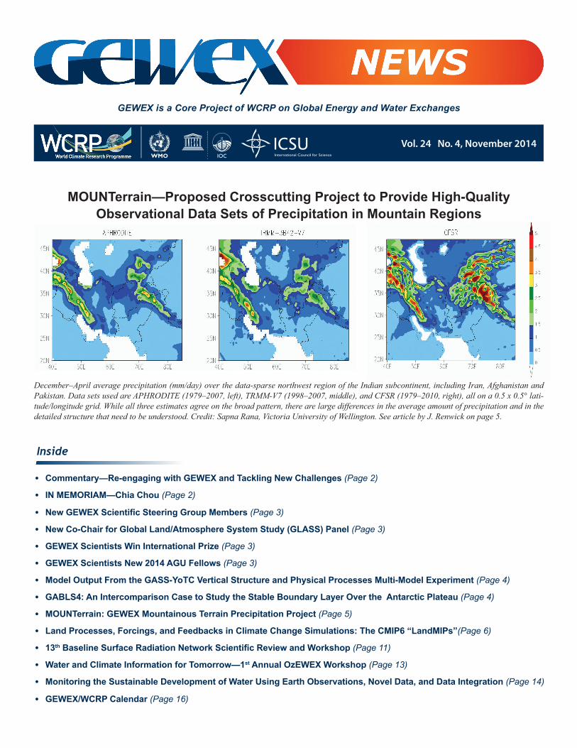
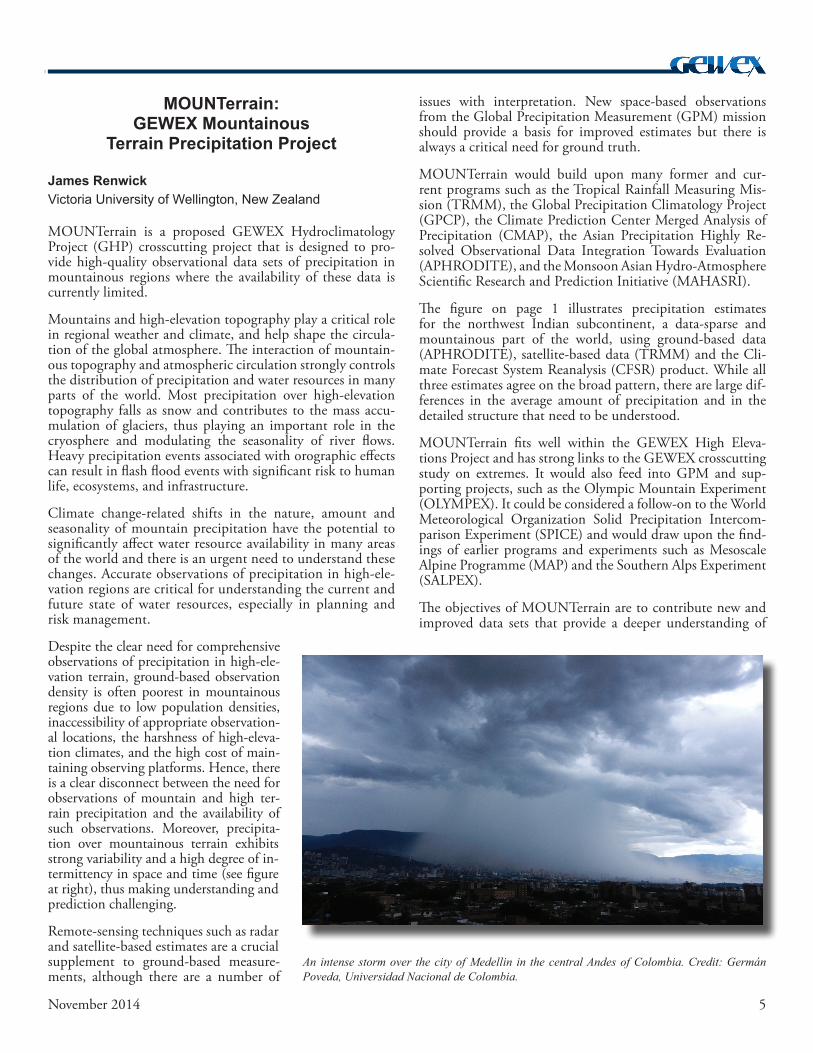
December–April average precipitation (mm/day) over the data-sparse northwest region of the Indian subcontinent, including Iran, Afghanistan and Pakistan. Data sets used are APHRODITE (1979–2007, left), TRMM-V7 (1998–2007, middle), and CFSR (1979–2010, right), all on a 0.5 x 0.5° lati-tude/longitude grid. While all three estimates agree on the broad pattern, there are large differences in the average amount of precipitation and in the detailed structure that need to be understood. Credit: Sapna Rana, Victoria University of Wellington. See article by J. Renwick on page 5.
MOUNTerrain—Proposed Crosscutting Project to Provide High-QualityObservational Data Sets of Precipitation in Mountain Regions
2 November 2014
Re-engaging with GEWEX and Tackling New Challenges
Graeme StephensCo-Chair, GEWEX Scientific Steering Group (SSG)
Commentary
Dr. Chia Chou, a Research Fellow at the Research Center for Envi-ronmental Changes (RCEC), Aca-demia Sinica in Taipei, Taiwan and a member of the GEWEX Scientific Steering Group, passed away on November 20, 2014, after a year-long battle with cancer. He was 49 years old and is survived by his wife Vivian.
Chia received his Ph.D. in At-mospheric Sciences from UCLA
in 1997 on tropical atmospheric modeling. He was a Post-graduate Researcher at UCLA until he returned to Taiwan in 2001 and became an Assistant Research Fellow at RCEC; he also held joint faculty appointments at the National Taiwan University and the National Central University. He is well known internationally for his contributions to understand-ing precipitation changes under global warming and other key mechanisms in tropical climate dynamics. He received the Ta-You Wu Commemorative Award from the National Science Council and the Outstanding Research Award of the National Science Council of Taiwan.
Chia had been an enthusiastic mentor to many young Tai-wanese scientists in climate research and has been active in the joint typhoon-climate research between Taiwan and Chi-na for the past 5–6 years. GEWEX has lost a very dear col-league and our community an outstanding, knowledgeable, and engaged scientist.
IN MEMORIAMChia Chou
Having accepted with pleasure the appointment as co-chair of the GEWEX SSG with Professor Sonia Isabelle Seneviratne (see Sonia’s article on page 6), I am glad to be once again en-gaging with the goals of WCRP and GEWEX. My associa-tion with both WCRP and GEWEX goes back to my being a founding member of the Working Group on Radiative Fluxes (WGRF) that served the WCRP Joint Scientific Committee (JSC) in the 1980s. After GEWEX became a WCRP project in 1990, the activities of the WGRF were transitioned into the GEWEX Radiation Panel (GRP), of which I served as Chair prior to 2002. The GRP subsequently transitioned in 2011 to the GEWEX Data and Assessments Panel (GDAP).
Sonia’s and my transition to co-chairs of the SSG has been greatly aided by the powerful legacy of past chairs. In particu-lar, I want to acknowledge Kevin Trenberth who ably steered GEWEX onto the path towards addressing the WCRP Grand Challenges for the next decade. At the recent Climate Sym-posium in Darmstadt, Germany, Professor Dame Julia Slingo succinctly put these challenges into two overarching science questions—Where is the heat going? and What is happening to the Earth’s fresh water? I see these questions as central to the GEWEX endeavor in general, and to both the Water Avail-ability and Extremes Grand Challenges that GEWEX is now leading.
In my return to the GEWEX family, I have begun to appreci-ate why GEWEX has so much traction, both at national and international levels. Water is fundamental to climate sciences, to society and all life, and there are still great challenges in understanding what will happen to the Earth’s fresh water in the future.
Our period of transition as new SSG co-chairs began gently but was soon intensified by our attendance at the JSC meeting in Heidelberg, Germany in early July, which was soon followed by the 7th International GEWEX Scientific Conference and panel meetings held in The Hague, The Netherlands. From my perspective, the GEWEX Conference was immensely suc-cessful and also incredibly valuable to both Sonia and myself in providing us with an extensive overview of GEWEX activi-ties. During the Conference, new initiatives were developed, some involving joint activities with CLIVAR such as the new joint GEWEX/CLIVAR Panel on Monsoons that is being co-chaired by Paul Dirmeyer.
New directions for the four GEWEX panels were also con-sidered, the implementation of the extremes grand challenge was further defined, and other crosscutting ad hoc activities emerged. As we look toward the near future, GEWEX will have the opportunity to shape the science at the very basic level, aligning activities to address important scientific issues, and exploiting opportunities that are presented.
One emerging opportunity is the formation of a US GEWEX Project Office through the auspices of the US Global Change Research Program. The USGCRP identifies the Water Avail-ability Grand Challenge as one of their highest priorities, thus making GEWEX even more central to the goals of US agen-cies. There are a number of developments that we expect will follow, such as an interest in promoting the GEWEX high resolution modeling initiative and the development of a new US regional hydrology project. These topics will be developed further in the December meeting of the GEWEX Hydrocli-matology Panel and will help shape the agenda for the water availability grand challenge.
3November 2014
Dr. Siegfried Schubert is a senior re-search scientist at the NASA Global Modeling and Assimilation Office at Goddard Space Flight Center in Greenbelt, Maryland, where he leads the group on sub-seasonal to decadal climate. His areas of interest are cli-mate variability and predictability, droughts, the hydrological cycle, extreme weather and climate events, and reanalysis.
Dr. Lisa Alexander is a senior lectur-er at the Climate Change Research Centre at the University of New South Wales in Sydney, Australia. Her areas of interest include climate variability and change, especially understanding changes in extreme events, climate observations and model evaluation.
Lisa Alexander
Siegfried D. Schubert
Dr. Peter J. Webster is a professor at the School of Earth and Atmo-spheric Sciences at Georgia Tech in Atlanta, Georgia. His research areas of interest include low fre-quency atmospheric and ocean dynamics, ocean-atmosphere in-teractions, and wave propagation through complex flows.
Peter J. Webster
Paul Poli
Drs. Eric F Wood and Justin Sheffield of Princeton University are one of two teams sharing the 6th Prince Sultan Bin Abdu-laziz International Prize for Creatvity. They received the prize for their development of a state-of-the-art system for accurate-ly monitoring, modeling, and forecasting drought on regional, continental and global scales.
Dr. Paul Poli is an investigator on the European Centre for Medium-Range Weather Forecasts Reanaly-sis Project (ERA) in Reading, UK. His areas of interest include global reanalyses, satellite observations, and data assimilation.
GEWEX Scientists Win International Prize
New Co-Chair for Global Land/Atmosphere System Study (GLASS) Panel
Dr. Michael Ek leads the Land-Hydrology Team at the U.S. Na-tional Centers for Environmental Prediction/Environmental Model-ing Center (NCEP/EMC) for the National Oceanic and Atmospheric Administration/National Weather Service. The Land-Hydrology Team is responsible for all aspects of land-hydrology in NCEP operational weather and seasonal climate mod-
els, including applications to drought. Prior to joining NCEP/EMC in 1999, Dr. Ek was at Oregon State University where he worked on land and atmospheric boundary-layer model de-velopment. Besides his involvement with GLASS, he serves as the NCEP representative to the WCRP Working Group on Numerical Experimentation, chairs the American Meteorolog-ical Society Committee on Hydrology, and is involved with the GEWEX Hydroclimatology Panel (GHP) and GEWEX Atmo-spheric Boundary Layer Study (GABLS). He is very interested in the role of local land-atmosphere coupling in the evolution of land-surface fluxes and boundary-layer development.
Dr. Ek replaces Joseph Santanello of NASA Goddard Space Flight Center. Dr. Santanello co-chaired the GLASS Panel from 2010-2014 and has been the project lead on the GLASS Lo-cal Land-Atmosphere Coupling (LoCo) Initiative since 2008, where he led the development of a methodology and experi-mental testbed (LIS-WRF) to evaluate local land-atmosphere coupling in models and observations.
New GEWEX Scientific Steering Group Members
GEWEX Scientists New 2014 AGU FellowsAna P. Barros, Pratt School of Engineering, Civil and En-•vironmental Engineering, Duke University, Durham, NCTaikan Oki, University of Tokyo, Tokyo, Japan•Hubert Savenije, Delft University of Technology, Delft, •The NetherlandsNeville Nichols, Monash University, Victoria, Australia•Gerald A. Meehl, Climate Change Research, National •Center for Atmospheric Research, Boulder, CODetlef Stammer, University of Hamburg, Hamburg, Ger-•many (CLIVAR SSG co-chair)
4 November 2014
GABLS4: An Intercomparison Case to Study the Stable Boundary Layer Over the
Antarctic Plateau
E. Bazile1, F. Couvreux1, P. Le Moigne1, C. Genthon2, A. A. M. Holtslag3, and G. Svensson4
1Météo-France, CNRM/GAME, Toulouse, France; 2Labora-toire de Glaciologie et Géophysique de l’Environnement, Grenoble, France; 3Wageningen University, The Nether-lands; 4Stockholm University, Stockholm, Sweden
Intercomparison studies by the GEWEX Atmospheric Boundary Layer Study (GABLS) focus on boundary-layer pa-rameterization schemes that are used by numerical weather prediction and climate models. In polar regions and under stable stratifications, models present large biases that are de-pendent on the parameterizations used for the surface and the boundary layer (Holtslag et al., 2013).
The fourth GABLS case is studying boundary layer-land sur-face intereactions over the Antarctic Plateau at the Dome C site, which was chosen for its in situ measurements, flat to-pography and the homogeneity of its surface. Boundary layer observations are retrieved from a 45-m tower with six levels of sensors measuring temperature, wind, humidity (Genthon et al., 2013), and turbulent fluxes. Radiative fluxes and the temperature in the snow pack are also available.
GABLS4 consists of three intercomparisons—Single Column Model (SCM), Large Eddy Simulation (LES) and land-snow model (LSM)—that are organized into two phases. Phase I is dedicated to LSMs and SCMs with an interactive surface (snow) scheme. In Phase II, the observed surface temperature is prescribed in the SCM and LES models. Results from LES, SCM, and LSM will be evaluated with the observations. In addition, results from LES with their variability (or uncer-tainties) and specific diagnostics will be also used to evaluate SCM results.
GABLS4 began in July 2014 and results from the first phase are expected at the end of 2014 (although it will still be pos-sible to send results after that date). A GABLS4 workshop is planned for May 2015 in Toulouse, France, with the Diurnal Land-Atmosphere Coupling Experiment (DICE) community (http://appconv.metoffice.com/dice/dice.html). For more infor-mation about GABLS4, see: http://www.cnrm.meteo.fr/aladin/meshtml/GABLS4/GABLS4.html.
References
Holtslag A. A. M., G. Svensson, P. Baas, S. Basu, B. Beare, A. C. M. Bel-jaars, F. C. Bosveld, J. Cuxart, J. Lindvall, T. Mauritsen, G. J. Steeneveld, M. Tjernström, and B. J. H. Van De Wiel, 2013. Diurnal cycles of tempera-ture and wind–Still a challenge for weather and climate models. Bull. Amer. Meteor. Soc. 94, pp. 1691–1706, doi:10.1175/BAMS-D-11-00187.1.
Genthon, C., D. Six, H. Gallee, P. Grigioni, and A. Pellegrini, 2013. Two years of atmospheric boundary layer observations on a 45-m tower at Dome C on the Antarctic Plateau. J. Geophys. Res. Atmospheres, doi:10.1002/jgrd.50128.
ANNOUNCEMENT
Model Output From the GASS-YoTC Vertical Structure and Physical Processes
Multi-Model Experiment is Available
Highly suitable for detailed, models-based, physical process studies of a wide range of
weather and climate phenomena.
Three experimental components available:1. Twenty-year simulations with 6-hourly, global
output from 27 GCMs. 2. Two-day hindcasts for two MJO events* with
time-step level output over the tropical warm pool region from 12 GCMs.
3. Same as (2) except for 20-day hindcasts and 3-hourly, global output from 13 GCMs.
All experiments provide extended physical process output, with vertical profiles of prognostic variables, all
tendency terms**, and a comprehensive set of addi-tional physical process and diagnostic outputs.
Data access through ESGF+CoG: https://earthsystemcog.org/projects/gass-yotc-mip/ (requires ESGF login and acceptance of CMIP5 license agreement)
Additional information regarding motivation, sponsors, experimental framework, contribut-ing models available at: http://yotc.ucar.edu/mjo/vertical-structure-and-diabatic-processes-mjo/
http://climate.ncas.ac.uk/pmwiki/MJO_Diabatic_Hindcast/
Project Support***WGNE MJO Task Force and GEWEX Global Atmospheric System Studies (GASS) Panel
Experiment Organizers and Contacts: Component (1): X. Jiang and D. Waliser (JPL/UCLA); [email protected]
Component (2): P. Xavier and J. Petch (UKMO); [email protected]
Component (3): N. Klingaman and S. Woolnough (NCAS); [email protected]
*10 Oct.–10 Nov. 2009 and 20 Dec. 2009–10 Jan. 2010 **For (1) and (3), tendency terms are ouput only for 50N–50S ***See additional acknowledgments on data access website
5November 2014
MOUNTerrain:GEWEX Mountainous
Terrain Precipitation Project
James RenwickVictoria University of Wellington, New Zealand
MOUNTerrain is a proposed GEWEX Hydroclimatology Project (GHP) crosscutting project that is designed to pro-vide high-quality observational data sets of precipitation in mountainous regions where the availability of these data is currently limited.
Mountains and high-elevation topography play a critical role in regional weather and climate, and help shape the circula-tion of the global atmosphere. The interaction of mountain-ous topography and atmospheric circulation strongly controls the distribution of precipitation and water resources in many parts of the world. Most precipitation over high-elevation topography falls as snow and contributes to the mass accu-mulation of glaciers, thus playing an important role in the cryosphere and modulating the seasonality of river flows. Heavy precipitation events associated with orographic effects can result in flash flood events with significant risk to human life, ecosystems, and infrastructure.
Climate change-related shifts in the nature, amount and seasonality of mountain precipitation have the potential to significantly affect water resource availability in many areas of the world and there is an urgent need to understand these changes. Accurate observations of precipitation in high-ele-vation regions are critical for understanding the current and future state of water resources, especially in planning and risk management.
Despite the clear need for comprehensive observations of precipitation in high-ele-vation terrain, ground-based observation density is often poorest in mountainous regions due to low population densities, inaccessibility of appropriate observation-al locations, the harshness of high-eleva-tion climates, and the high cost of main-taining observing platforms. Hence, there is a clear disconnect between the need for observations of mountain and high ter-rain precipitation and the availability of such observations. Moreover, precipita-tion over mountainous terrain exhibits strong variability and a high degree of in-termittency in space and time (see figure at right), thus making understanding and prediction challenging.
Remote-sensing techniques such as radar and satellite-based estimates are a crucial supplement to ground-based measure-ments, although there are a number of
issues with interpretation. New space-based observations from the Global Precipitation Measurement (GPM) mission should provide a basis for improved estimates but there is always a critical need for ground truth.
MOUNTerrain would build upon many former and cur-rent programs such as the Tropical Rainfall Measuring Mis-sion (TRMM), the Global Precipitation Climatology Project (GPCP), the Climate Prediction Center Merged Analysis of Precipitation (CMAP), the Asian Precipitation Highly Re-solved Observational Data Integration Towards Evaluation (APHRODITE), and the Monsoon Asian Hydro-Atmosphere Scientific Research and Prediction Initiative (MAHASRI).
The figure on page 1 illustrates precipitation estimates for the northwest Indian subcontinent, a data-sparse and mountainous part of the world, using ground-based data (APHRODITE), satellite-based data (TRMM) and the Cli-mate Forecast System Reanalysis (CFSR) product. While all three estimates agree on the broad pattern, there are large dif-ferences in the average amount of precipitation and in the detailed structure that need to be understood.
MOUNTerrain fits well within the GEWEX High Eleva-tions Project and has strong links to the GEWEX crosscutting study on extremes. It would also feed into GPM and sup-porting projects, such as the Olympic Mountain Experiment (OLYMPEX). It could be considered a follow-on to the World Meteorological Organization Solid Precipitation Intercom-parison Experiment (SPICE) and would draw upon the find-ings of earlier programs and experiments such as Mesoscale Alpine Programme (MAP)and the Southern Alps Experiment (SALPEX).
The objectives of MOUNTerrain are to contribute new and improved data sets that provide a deeper understanding of
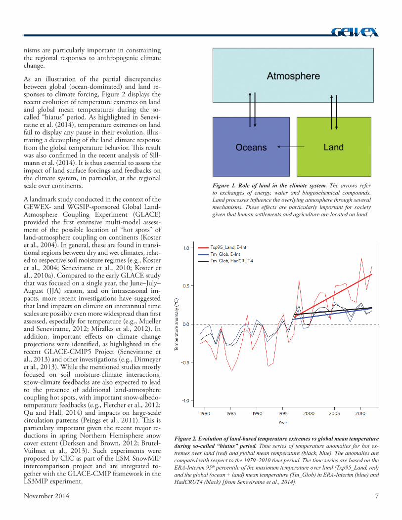
An intense storm over the city of Medellin in the central Andes of Colombia. Credit: Germán Poveda, Universidad Nacional de Colombia.

6 November 2014
Land Processes, Forcings, and Feedbacks in Climate Change Simulations:
The CMIP6 “LandMIPs”
In the context of the sixth phase of the Coupled Model In-tercomparison Project (CMIP6), two GEWEX-sponsored land-related Multimodel Intercomparison Projects (MIPs) are proposed: The Land Surface, Snow and Soil Moisture MIP (LS3MIP) and the Land Use MIP (LUMIP). These projects are referred to collectively as “LandMIPs,” and will allow a comprehensive investigation of the impacts of land processes, forcings and feedbacks on the climate system, including land-related systematic biases in Earth System Models (ESMs). In addition, some related simulations will be conducted within the Coupled Carbon Cycle Climate MIP (C4MIP) and Geo-engineering MIP (GeoMIP) experiments. These multimodel experiments together constitute an essential opportunity to integrate and exchange knowledge within the land-modeling research community, both within GEWEX—especially the GEWEX Global Land/Atmosphere System Study (GLASS) Panel—and in collaboration with other international research projects within the World Climate Research Programme (WCRP) and Future Earth [in particular, the Climate and Cryosphere (CliC) Project, the Climate and Ocean-Variabil-ity, Predictability, and Change (CLIVAR) Project, the Work-ing Group on Coupled Modelling (WGCM), the Working Group on Seasonal to Interannual Prediction (WGSIP), the Integrated Land-Ecosystem Atmosphere Processes Study (iLE-APS), and the Analysis, Integration and Modeling of the Earth System (AIMES) Project].
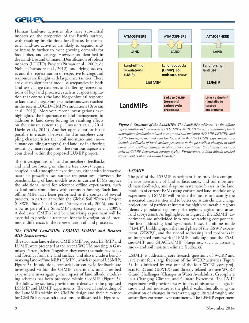
Role of Land Processes in the Climate SystemLand processes play an essential role in the climate system, as highlighted by numerous investigations in recent decades (e.g., Koster et al., 2004; Seneviratne et al., 2010; van den Hurk et al., 2011). Although oceans cover two-thirds of the Earth’s surface and play an important role on the global scale, the impacts of land processes on atmospheric conditions are substantial over continents. These effects are of direct rel-evance to human society given that humans live on continents and that land areas are used for the production of essential resources, including agriculture (Figure 1). The related mecha-
mountain precipitation processes, and to facilitate improve-ments in numerical weather prediction models, climate models, and hydrological models. The development of ob-servational data sets will be a central activity. In particular, MOUNTerrain will focus on a collation of existing digitized observational data for high-elevation precipitation, and data rescue of high-elevation precipitation records (including quality control). Undigitized meteorological station records and ski-field and alpine clubs records, global and regional re-analysis products, and climate model precipitation fields from CMIP5 and 6 would also be included.
Some of the key questions to be addressed are:
• How useful are (and how best to use) remotely sensed and gridded data sets, such as TRMM, GPCP, and reanalyses for characterizing high-elevation precipitation?
• How well are we measuring solid precipitation in moun-tain areas and how representative are available data sets?
• What are the statistics of high-elevation precipitation around the globe—means, extremes, seasonal cycle, spatial distribution, and trends at different space and time scales?
• What are the key processes involved in features of high-elevation precipitation?
• How well is high-elevation precipitation modeled, and what advances are needed to improve model performance?
• What are the effects of climate variability and climate change on the characteristics of high-elevation precipita-tion?
It is envisaged that MOUNTerrain will serve as a portal for precipitation data and analysis software and techniques. Mem-bers of the research community can contribute data and/or analysis software and methodologies via a GEWEX-hosted web portal to be set up in 2015. A series of intercomparison studies will be carried out to develop best-estimate gridded data sets of mountain precipitation. MOUNTerrain will also foster a series of model validation and sensitivity experiments focused on precipitation in high terrain. There may also be scope to develop proposals for Integrated Observing Periods in identified areas.
A start-up workshop for interested parties is being planned at the fall meeting of the American Geophysical Union in De-cember 2015, or earlier if possible. Information on the work-shop will be made available through the GEWEX web site (http://www.gewex.org) and networks. An initial review paper on the current state of knowledge is also planned. Interaction with the scientific community, especially early-career scientists and those from emerging economies, can come through a ded-icated Facebook page, Twitter feed, and a MOUNTerrain blog site, in addition to the web portal for data access.
For more information about MOUNTerrain, please contact James Renwick (e-mail: [email protected]).
Sonia I. Seneviratne1, Bart van den Hurk2, Dave Lawrence3, Gerhard Krinner4, George Hurtt5, Hyungjun Kim6, Chris Derksen7, Taikan Oki6, Aaron Boone8, Michael Ek9, Victor Brovkin10, Paul Dirmeyer11, Hervé Douville8, Pierre Friedlingstein12, Stefan Hagemann10, Randal Koster13, Nathalie de Noblet-Ducoudré14, and Andrew Pitman15
1ETH Zurich, Switzerland; 2KNMI, The Netherlands; 3NCAR, USA; 4CNRS/LGGE & U. Grenoble, France; 5U. Maryland, USA; 6U. Tokyo, Japan; 7Environment Canada; 8CNRM-GAME, Météo-France; 9NOAA/NCEP, USA; 10MPI for Me-teorology, Germany;11George Mason University, USA; 12U. Exeter, UK; 13NASA/GSFC, USA; 14LSCE/IPSL, France; 15UNSW & ARC CoECCS, Australia
7November 2014
nisms are particularly important in constraining the regional responses to anthropogenic climate change.
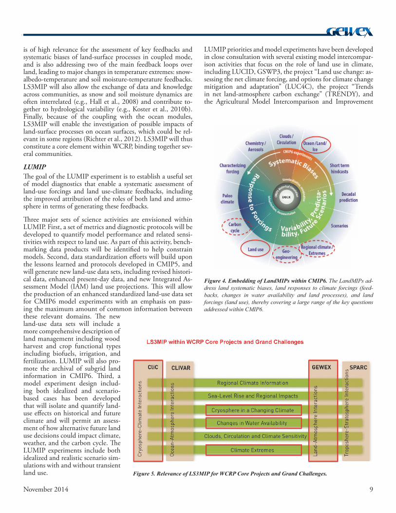
As an illustration of the partial discrepancies between global (ocean-dominated) and land re-sponses to climate forcing, Figure 2 displays the recent evolution of temperature extremes on land and global mean temperatures during the so-called “hiatus” period. As highlighted in Senevi-ratne et al. (2014), temperature extremes on land fail to display any pause in their evolution, illus-trating a decoupling of the land climate response from the global temperature behavior. This result was also confirmed in the recent analysis of Sill-mann et al. (2014). It is thus essential to assess the impact of land surface forcings and feedbacks on the climate system, in particular, at the regional scale over continents.
A landmark study conducted in the context of the GEWEX- and WGSIP-sponsored Global Land-Atmosphere Coupling Experiment (GLACE) provided the first extensive multi-model assess-ment of the possible location of “hot spots” of land-atmosphere coupling on continents (Koster et al., 2004). In general, these are found in transi-tional regions between dry and wet climates, relat-ed to respective soil moisture regimes (e.g., Koster et al., 2004; Seneviratne et al., 2010; Koster et al., 2010a). Compared to the early GLACE study that was focused on a single year, the June–July–August (JJA) season, and on intraseasonal im-pacts, more recent investigations have suggested that land impacts on climate on interannual time scales are possibly even more widespread than first assessed, especially for temperature (e.g., Mueller and Seneviratne, 2012; Miralles et al., 2012). In addition, important effects on climate change projections were identified, as highlighted in the recent GLACE-CMIP5 Project (Seneviratne et al., 2013) and other investigations (e.g., Dirmeyer et al., 2013). While the mentioned studies mostly focused on soil moisture-climate interactions, snow-climate feedbacks are also expected to lead to the presence of additional land-atmosphere coupling hot spots, with important snow-albedo-temperature feedbacks (e.g., Fletcher et al., 2012; Qu and Hall, 2014) and impacts on large-scale circulation patterns (Peings et al., 2011). This is particulary important given the recent major re-ductions in spring Northern Hemisphere snow cover extent (Derksen and Brown, 2012; Brutel-Vuilmet et al., 2013). Such experiments were proposed by CliC as part of the ESM-SnowMIP intercomparison project and are integrated to-gether with the GLACE-CMIP framework in the LS3MIP experiment.
Figure 1. Role of land in the climate system. The arrows refer to exchanges of energy, water and biogeochemical compounds. Land processes influence the overlying atmosphere through several mechanisms. These effects are particularly important for society given that human settlements and agriculture are located on land.
Figure 2. Evolution of land-based temperature extremes vs global mean temperature during so-called “hiatus” period. Time series of temperature anomalies for hot ex-tremes over land (red) and global mean temperature (black, blue). The anomalies are computed with respect to the 1979–2010 time period. The time series are based on the ERA-Interim 95th percentile of the maximum temperature over land (Txp95_Land, red) and the global (ocean + land) mean temperature (Tm_Glob) in ERA-Interim (blue) and HadCRUT4 (black) [from Seneviratne et al., 2014].
8 November 2014
Human land-use activities also have substantial impacts on the properties of the Earth’s surface, with resulting implications for climate. In the fu-ture, land-use activities are likely to expand and/or intensify further to meet growing demands for food, fiber, and energy. However, as identified in the Land-Use and Climate, IDentification of robust impacts (LUCID) Project (Pitman et al., 2009; de Noblet-Ducoudré et al., 2012), underlying process-es and the representation of respective forcings and responses are fraught with large uncertainties. These are due to significant model discrepancies in both land-use change data sets and differing representa-tions of key land processes, such as evapotranspira-tion that controls the land biogeophysical response to land use change. Similar conclusions were reached in the recent LUCID-CMIP5 simulations (Brovkin et al., 2013). Moreover, recent investigations have highlighted the importance of land management in addition to land cover forcing for resulting effects on the climate system (e.g., Luyssaert et al., 2014; Davin et al., 2014). Another open question is the possible interaction between land-atmosphere cou-pling characteristics (i.e., soil moisture- and snow-climate coupling strengths) and land use in affecting resulting climate responses. These various aspects are considered within the proposed LUMIP project.
The investigations of land-atmosphere feedbacks and land use forcing on climate (see above) require coupled land-atmosphere experiments, either with interactive ocean or prescribed sea surface temperatures. However, the benchmarking of land models used in current ESMs implies the additional need for reference offline experiments, such as land-only simulations with common forcing. Such land-offline MIPs have been performed in the context of several projects, in particular within the Global Soil Wetness Project (GSWP, Phase 1 and 2; see Dirmeyer et al., 2006), and for snow as part of the SnowMIP project (Essery et al., 2009). A dedicated CMIP6 land benchmarking experiment will be essential to provide a reference for the investigation of inter-model differences in the representation of land processes.
The CMIP6 LandMIPs: LS3MIP, LUMIP and Related MIP Experiments The two main land-related CMIP6 MIP projects, LS3MIP and LUMIP, were presented at the recent WGCM meeting in Gar-misch-Partenkirchen. Together, they cover the main feedbacks and forcings from the land surface, and also include a bench-marking land-offline MIP (“LMIP”, which is part of LS3MIP; Figure 3). In addition, terrestrial carbon-cycle feedbacks are investigated within the C4MIP experiment, and a testbed experiment investigating the impact of land albedo modify-ing schemes has been proposed within GeoMIP (Figure 3). The following sections provide more details on the proposed LS3MIP and LUMIP experiments. The overall embedding of the LandMIPs within the CMIP6 design and their relevance for CMIP6 key research questions are illustrated in Figure 4.
LS3MIPThe goal of the LS3MIP experiment is to provide a compre-hensive assessment of land surface, snow, and soil moisture-climate feedbacks, and diagnose systematic biases in the land modules of current ESMs using constrained land-module only experiments. LS3MIP will provide the means to quantify the associated uncertainties and to better constrain climate change projections, of particular interest for highly vulnerable regions (densely populated regions, polar regions, agricultural areas, land ecosystems). As highlighted in Figure 3, the LS3MIP ex-periments are subdivided into two overarching components, the first addressing land systematic biases in offline mode (“LMIP”, building upon the third phase of the GSWP experi-ment, GSWP3), and the second addressing land feedbacks in an integrated framework (“LFMIP,” building upon the ESM-snowMIP and GLACE-CMIP blueprints, such as assessing snow- and soil moisture-climate feedbacks).
LS3MIP is addressing core research questions of WCRP and is relevant for a large fraction of the WCRP activities (Figure 5). It is initiated by two out of the four WCRP core proj-ects (CliC and GEWEX) and directly related to three WCRP Grand Challenges (Changes in Water Availability; Cryosphere in a Changing Climate; and Climate Extremes). The LMIP experiment will provide best estimates of historical changes in snow and soil moisture at the global scale, thus allowing the evaluation of changes in freshwater, agricultural drought, and streamflow extremes over continents. The LFMIP experiment
Figure 3. Structure of the LandMIPs. The LandMIPs address: (1) the offline representation of land processes (LS3MIP/LMIP); (2) the representation of land-atmosphere feedbacks related to snow and soil moisture (LS3MIP/LFMIP); and (3) the forcing associated with land use. Note that the LUMIP experiments also include feedbacks of land-surface processes to the prescribed changes in land cover and resulting changes in atmospheric conditions. Substantial links also exist to C4MIP (terrestrial carbon cycle). Furthermore, a land albedo testbed experiment is planned within GeoMIP.
9November 2014
is of high relevance for the assessment of key feedbacks and systematic biases of land-surface processes in coupled mode, and is also addressing two of the main feedback loops over land, leading to major changes in temperature extremes: snow-albedo-temperature and soil moisture-temperature feedbacks. LS3MIP will also allow the exchange of data and knowledge across communities, as snow and soil moisture dynamics are often interrelated (e.g., Hall et al., 2008) and contribute to-gether to hydrological variability (e.g., Koster et al., 2010b). Finally, because of the coupling with the ocean modules, LS3MIP will enable the investigation of possible impacts of land-surface processes on ocean surfaces, which could be rel-evant in some regions (Richter et al., 2012). LS3MIP will thus constitute a core element within WCRP, binding together sev-eral communities.
LUMIPThe goal of the LUMIP experiment is to establish a useful set of model diagnostics that enable a systematic assessment of land-use forcings and land use-climate feedbacks, including the improved attribution of the roles of both land and atmo-sphere in terms of generating these feedbacks.
Three major sets of science activities are envisioned within LUMIP. First, a set of metrics and diagnostic protocols will be developed to quantify model performance and related sensi-tivities with respect to land use. As part of this activity, bench-marking data products will be identified to help constrain models. Second, data standardization efforts will build upon the lessons learned and protocols developed in CMIP5, and will generate new land-use data sets, including revised histori-cal data, enhanced present-day data, and new Integrated As-sessment Model (IAM) land use projections. This will allow the production of an enhanced standardized land-use data set for CMIP6 model experiments with an emphasis on pass-ing the maximum amount of common information between these relevant domains. The new land-use data sets will include a more comprehensive description of land management including wood harvest and crop functional types including biofuels, irrigation, and fertilization. LUMIP will also pro-mote the archival of subgrid land information in CMIP6. Third, a model experiment design includ-ing both idealized and scenario-based cases has been developed that will isolate and quantify land-use effects on historical and future climate and will permit an assess-ment of how alternative future land use decisions could impact climate, weather, and the carbon cycle. The LUMIP experiments include both idealized and realistic scenario sim-ulations with and without transient land use.
LUMIP priorities and model experiments have been developed in close consultation with several existing model intercompar-ison activities that focus on the role of land use in climate, including LUCID, GSWP3, the project “Land use change: as-sessing the net climate forcing, and options for climate change mitigation and adaptation” (LUC4C), the project “Trends in net land-atmosphere carbon exchange” (TRENDY), and the Agricultural Model Intercomparison and Improvement
Figure 4. Embedding of LandMIPs within CMIP6. The LandMIPs ad-dress land systematic biases, land responses to climate forcings (feed-backs, changes in water availability and land processes), and land forcings (land use), thereby covering a large range of the key questions addressed within CMIP6.
Figure 5. Relevance of LS3MIP for WCRP Core Projects and Grand Challenges.
10 November 2014
Project (AgMIP). Interactions with LS3MIP, particularly with the planned LMIP experiment, have also been exten-sively discussed. LUMIP is relevant for several WCRP Grand Challenges (e.g., those on regional climate information, water availability, and climate extremes) and it plays a strong role for the AIMES theme for collaboration on biospheric forcings and feedbacks.
Conclusions and OutlookImportant land-related multi-model experiments are currently planned as contributions to the CMIP6 modeling efforts, and will allow a comprehensive evaluation of the role of land pro-cesses, forcings and feedbacks for the climate systems. These experiments, which are collectively referred to as “LandMIPs,” will be conducted under the LS3MIP and LUMIP projects (with links to the C4MIP and GeoMIP projects), and will enable major advances in our understanding of underlying processes and a reduction of uncertainties and biases in pro-jections. The resulting insights will be particularly relevant in order to constrain simulations of changes in water availability, land extremes (heatwaves, droughts), regional climate, and biogeochemical cycles on land, thereby strongly contributing to GEWEX and WCRP aims in the coming years.
References
Brovkin, V., and Coauthors, 2013. Effect of anthropogenic land-use and land cover changes on climate and land carbon storage in CMIP5 projec-tions for the 21st Century. J. Clim., 26, 6859–6881.
Brutel-Vuilmet, C., M. Ménégoz, and G. Krinner, 2013. An analysis of present and future seasonal Northern Hemisphere land snow cover simu-lated by CMIP5 coupled climate models. The Cryosphere, 7, 67–80.
Davin, E. L., S. I. Seneviratne, P. Ciais, A. Olioso, and T. Wang, 2014. Preferential cooling of hot extremes from cropland albedo management. Proc. Natl. Acad. Sci. Published ahead of print June 23, 2014, doi:10.1073/pnas.1317323111.
de Noblet-Ducoudré, N., and Coauthors, 2012. Determining robust im-pacts of land-use-induced land cover changes on surface climate over North America and Eurasia: results from the first set of LUCID experiments. J. Clim., 25(9), 3261–3281.
Derksen, C., and R. Brown, 2012. Spring snow cover extent reductions in the 2008–2012 period exceeding climate model projections. Geophys. Res. Lett., 39, L19504, doi:10.1029/2012GL053387.
Dirmeyer, P. A., X. Gao, M. Zhao, Z. Guo, T. Oki, and N. Hanasaki, 2006. GSWP-2: Multimodel Analysis and Implications for Our Perception of the Land Surface. Bull. Amer. Meteor. Soc., 87, 1381–1397.
——, Y. Jin, B. Singh, and X. Yan, 2013. Trends in land-atmosphere inter-actions from CMIP5 simulations. J. Hydrometeor., 14, 829–849.
Essery, R., and Coauthors, 2009. SNOWMIP2. An evaluation of for-est snow process simulations. Bull. Amer. Meteor. Soc., 90, 1120–1135, doi:10.1175/2009BAMS2629.1.
Fletcher, C. G., H. Zhao, P. J. Kushner, and R. Fernandes, 2012. Using mod-els and satellite observations to evaluate the strength of snow albedo feedback. J. Geophys. Res. Atmospheres, 117, D11117, doi:10.1029/2012JD017724.
Hall, A., X. Qu, and J. D. Neeling, 2008. Improving predictions of sum-mer climate change in the United States. Geophys. Res. Lett., 35, L01702, doi:10.1029/2007GL032012.
van den Hurk, B., M. Best, P. Dirmeyer, A. Pitman, J. Polcher, and J. San-tanello, 2011. Acceleration of Land Surface Model Development over a De-cade of Glass. Bull. Amer. Meteor. Soc., 92, 1593–1600.
Hurtt, G. C., and Coauthors, 2011. Harmonization of land-use scenarios for the period 1500–2100: 600 years of global gridded annual land-use transitions, wood harvest, and resulting secondary lands. Climatic Change, doi:10.1007/s10584-011-0153-2.
Koster, R. D., and Coauthors, 2004. Regions of strong coupling between soil moisture and precipitation. Science, 305, 1138–1140.
——, and Coauthors, 2010a. Contribution of land surface initialization to subseasonal forecast skill: First results from a multi-model experiment. Geophys. Res. Lett., 37, L02402, doi:10.1029/2009GL041677.
——, S. P. P. Mahanama, B. Livneh, D. P. Lettenmaier, and R. H. Reichle, 2010b. Skill in streamflow forecasts derived from large-scale estimates of soil moisture and snow. Nature Geoscience, 3, 613–616.
Luyssaert, S., and Coauthors, 2014. Land management and land-cover change have impacts of similar magnitude on surface temperature. Nature Climate Change, published online, doi:10.1038/NCLIMATE2196.
Miralles, D. G., M. J. van den Berg, A. J. Teuling, and R. A. M. de Jeu, 2012. Soil moisture-temperature coupling: A multiscale observational anal-ysis. Geophys. Res. Lett., 39, L21707, doi:10.1029/2012GL053703.
Mueller, B., and S. I. Seneviratne, 2012. Hot days induced by precipitation deficits at the global scale. Proc. Natl Acad. Sci., 109 (31), 12398–12403.
Peings Y., H. Douville, R. Alkama, and B. Decharme, 2011. Snow contri-bution to springtime atmospheric predictability over the second half of the twentieth century. Climate Dyn., 37, 985–1004.
Pitman, A. J., and Coauthors, 2009. Uncertainties in climate responses to past land cover change: First results from the LUCID intercomparison study. Geophys. Res. Lett., 36(14), L14814, doi:10.1029/2009GL039076.
Richter, I., S. P. Xie, A. Wittenberg, and Y. Masumoto, 2012. Tropical At-lantic biases and their relation to surface wind stress and terrestrial precipita-tion. Clim. Dyn., 38, 985–1001, doi:10.1007/s00382-011-1038-9.
Qu, X., and A. Hall, 2014. On the persistent spread in snow-albedo feed-back. Clim. Dyn., 42, 69–81, doi:10.1007/s00382-013-1774-0.
Seneviratne, S. I., T. Corti, E. L. Davin, M. Hirschi, E. B. Jaeger, I. Lehner, B. Orlowsky, and A. J. Teuling, 2010. Investigating soil moisture–climate interactions in a changing climate: A review. Earth-Sci. Rev., 99, 125–161, doi:10.1016/j.earscirev.2010.02.004.
——, and Coauthors, 2013. Impact of soil moisture-climate feedbacks on CMIP5 projections: First results from the GLACE-CMIP5 experiment. Geophys. Res. Lett., 40, 2013GL057153, doi:10.1002/grl.50956.
——, M. Donat, B. Mueller, and L. V. Alexander, 2014. No pause in the increase of hot temperature extremes. Nature Climate Change, 4, 161–163.
Sillmann, J., M. G. Donat, J. C. Fyfe, and F. W. Zwiers, 2014. Observed and simulated temperature extremes during the recent warming hiatus. Environ. Res. Lett., 9, 064023.
11November 2014
13th Baseline Surface Radiation Network Scientific Review and Workshop
Bologna, Italy9–12 September 2014
Joseph MichalskyNOAA Earth System Research Laboratory, Boulder, Colo-rado, USA
Sixty-three scientists, station managers, and data users pre-sented 47 talks and 27 posters at the 13th BSRN Meeting held at the National Research Council’s Institute of Atmospheric Sciences and Climate (ISAC) in Bologna. The local hosts from ISAC were Christian Lanconelli and Vito Vitale, who were ably assisted by Angelo Lupi and Marco Mazzola. During the meeting, BSRN observations were reviewed, improvements in instrumentation and data reduction methods discussed, data management and quality control issues considered, and ways the data are used by the larger community were examined.
The GEWEX Data and Assessments Panel, formerly the GEWEX Radiation Panel, oversees and gives general guidance to BSRN. The project consists of volunteers operating stations that measure surface solar and infrared (IR) radiation. Most stations measure the surface radiation by making broadband solar and infrared downwelling and upwelling irradiances ac-cording to a set protocol and using first-class radiometers. Many stations also make ancillary measurements, such as aerosol optical depth, ultraviolet radiation, photosynthetically active radiation, and meteorological parameters.
A few stations began operating in 1992, and have accumu-lated over two decades of high-quality data. Currently, 49 stations are operational, nine are in the process of restarting their operations, there are five new candidates for network operation, and five have terminated their measurements. The World Radiation Monitoring Center of the Alfred Wegener Institute of Polar and Marine Research in Bremerhaven, Ger-many archives the data produced by the stations (http://www.bsrn.awi.de).
The meeting was opened by Dr. Cristina Sabbioni, the Di-rector of ISAC, who gave an overview of radiation research performed within ISAC, including activities at Arctic and Antarctic sites, stations in Italy focused on aerosol and cloud radiative forcing issues, and a program on solar energy re-search. Tim Oakley, the Implementation Manager for the World Meteorological Organization Global Climate Observ-ing System (GCOS) spoke on the efforts of GCOS to coor-dinate observations, records, and metadata that are useful for climate research. BSRN has been an official surface radiation network for GCOS since 2004. Nozomu Ohkawara reported on the 19th GCOS/WCRP Atmospheric Observation Panel for Climate Meeting held in April 2014 and noted that the main focus of GCOS now is to increase the number and spa-tial distribution of stations measuring surface radiation using BSRN standards.
In the next session, Alexander Makshtas gave a presentation on a new BSRN station in the Russian Arctic near 80°N, which began taking measurements in the late spring of 2014. Besides high-quality radiation measurements, the site makes several fundamental trace gas and atmospheric profile measurements. Next, Antonio Paz described three potential sites for BSRN stations in Costa Rica that need more instrumentation to com-plete the suite of radiometers necessary to become an active BSRN station. Katlego Ncongwane described plans to restart the long-dormant South African station at De Aar, and Enio Pereira gave an update on the four BSRN stations in Brazil. Ta-neil Uttal wrapped up the session with a talk on the coordinated effort to link radiation studies in the Arctic to the International Arctic Systems for Observing the Atmosphere (IASOA).
The afternoon session focused on studies using BSRN data. Using data from 19 BSRN stations to study atmospheric solar absorption, Maria Hakuba found that her results did not agree with those derived from satellite data, which may be related to the need for more BSRN sites in the tropics. Vasilii Kus-tov presented the solar record from four Arctic sites in Russia that began collecting measurements in the 1960s. Ben Liley described his efforts to rehabilitate solar data for New Zealand using the BSRN station at Lauder to guide his adjustments. Marion Maturilli showed that the atmosphere around the Ny-Alesund site has warmed, brightened and become more moisture-laden in the past 20 years. John Augustine used BSRN and Moderate Resolution Imaging Spectroradiometer (MODIS) data to derive surface, top-of-atmosphere, and at-mospheric radiative forcing from an isolated forest fire smoke plume. Boyan Petkov noted that ultraviolet radiation mea-surements in the interior of Antarctica appear to be affected most by solar zenith angle and total-column ozone, which is in contrast to the coastal site where variations are associated with changing aerosol and cloud conditions. Christian Lanconelli described snow albedo measurements for Antarctic and Arctic sites using an innovative method for obtaining spectral albedo with a rotating spectrometer that covers most of the solar spec-trum. Crystal Schaaf presented a method for validating satel-lite albedo products using BSRN data.
The Wednesday morning session covered radiometer improve-ments and evaluations. Julian Gröbner showed good agree-ment between two absolute infrared radiometers that have very different designs. However, the measurements disagree with the current World Infrared Standard Group of Pyrgeom-eters’ infrared standard, which reports lower values and has a dependence on column water vapor. Klaus Behrens compared four types of infrared radiometers to an absolute instrument, finding low values compared to the standard, except for the newer Kipp and Zonen CGR4 infrared radiometer. Jose Celso Thomaz described a method for obtaining the correct (non-thermopile) calibration constants in the derivation of infrared radiation from the Eppley Precision Infrared Radiometer and the Kipp and Zonen CGR4. Aron Habte compared 32 pyra-nometers measuring global horizontal irradiance (GHI) and 19 pyrheliometers measuring direct normal irradiance (DNI) from different manufacturers over a one-year period with some interesting findings for those using these instruments.

12 November 2014
Fred Denn concluded that the Multi-Filter Rotating Shadow-Band Radiometer can be calibrated for aerosol optical depth (AOD) at a non-optimal site (compared to Mauna Loa) with differences in AOD that are smaller than the uncertainties of the measurements.
Nicole Hyett demonstrated that with appropriate care, global and diffuse horizontal irradiance field measurements with un-certainties of around 2 percent could be obtained from their four BSRN sites. Laurent Vuilleumier reported on the accu-racy of sensors that are widely used in the solar energy industry and concluded that rotating shadowband radiometers and the shading mask instrument have GHI uncertainties on the order of 30 Wm–2 for all conditions and are two to three times this value for DNI. Ping Wang noted that measurements of actinic flux profiles made with a green light sensor that detected the enhancement and diminution of actinic flux above and below cloud layer, were generally in agreement with radiative flux cal-culations. Sylvio Mantelli described an approach for identify-ing cloud cover from a sky imager that can be used to validate satellite identifications of clear and cloudy skies. Julian Gröbner described progress on the development of a precision spectrora-diometer that measures direct and global spectral irradiance be-tween 300 and 1020 nm. Comparisons of AOD measurements with those taken from Cimel sunphotometers were within the measurement uncertainties of each instrument.
The Thursday sessions began with a presentation by V. Ramas-wamy who compared the Geophysical Fluid Dynamics Labo-ratory model to surface fluxes measured at BSRN sites and found differences caused by biases in predicted and observed clouds that could explain biases found in temperatures. Fur-ther, aerosols perturb the surface fluxes, affecting precipitation patterns (especially in south Asia). Martin Wild used BSRN data to demonstrate the usefulness of the data in constraining the radiation budget in the Coupled Model Intercomparison Project-Phase 5 models, which overestimate shortwave and underestimate longwave radiation at the surface. He also re-ported that decadal changes in shortwave and longwave radia-tion that have been detected in BSRN data are not reproduced in the Atmospheric Model Intercomparison Project models. Chuck Long described the climatology of the tropical western Pacific sites of Manus, Nauru, and Darwin, which have similar
cloud types, but differ in the frequency of each because of the influence of the El Niño Southern Oscillation and the Austra-lian monsoon. He also presented evidence for decadal increas-es in diffuse irradiance in clear skies, presumably caused by an undetected increase in light cirrus associated with air traffic. Taiping Zhang reported on the quality control of BSRN data used as benchmarks for satellite-derived global horizontal and global tilt irradiances.
Gert Koenig-Langlo reported on the status of the BSRN ar-chive, which now contains 650 years of data from 58 sites. He noted the important role that the station managers have in the quality control of their data and strongly recommended that they conduct visual inspections of their data before submitting it to the BSRN archive. He also reported on how the quality of the data from the Neumayer, Antarctica station has improved over the past 20 years. Jordi Badosa described new quality control procedures developed at the SIRTA Observatory near Paris. Wouter Knap reported on a new automated system for processing raw data for archive submission. Anatoly Tsvetkov discussed how the daily integrated irradiance from several BSRN and Global Atmosphere Watch sites can be quickly used to categorize solar climate. Jörgen Koenigs gave a talk on the application of the American Society for Testing and Materials (ASTM) standards to the Guide to the Expression of Uncertainty in Measurement (GUM) assigned to radiometer calibrations and measurements. Laurent Vuilleumier discussed how the Swiss BSRN measurements are now close to meeting the BSRN goals for global and diffuse irradiance.
The reports of the working groups (WG) were presented in the last session. The main task of the Uncertainties WG is to de-velop a report based on GUM for the uncertainties in BSRN measurements. The Broadband Solar WG is researching com-mercial instruments, especially pyranometers, as candidates for BSRN instruments. The Infrared WG is working on an improved worldwide standard for infrared measurements. The Oceanic WG is researching suitable platforms for ocean ob-servations. The Archive WG is looking for a successor to the current archive manager, who will retire in a few years. The Long-Term Data Sets WG is focused on improving quality control for BSRN data and is seeking new users outside the network for the 20-plus years’ data sets that have been ac-
quired. The Cold Climate WG is dealing with issues in keep-ing instruments ice free and the changing thermopile responses in low temperatures, and testing possible solutions to these prob-lems. Storm Peak Laboratory in Colorado was suggested as a test bed for comparing instruments bound for cold climates.
The meeting presentations and posters can be found at: http://bsrn.awi.de/meetings/2014.html.
Participants at the 13th BSRN Scientific Review and Workshop.
13November 2014
Water and Climate Information forTomorrow – 1st Annual OzEWEX Workshop
Around one hundred scientists, operational staff, information users and students took part in the first national workshop organized by the Australian Energy and Water Exchange Ini-tiative (OzEWEX), an Australian contribution to GEWEX. The Workshop was organized with generous support from the Commonwealth Scientific and Industrial Research Organiza-tion (CSIRO), the Bureau of Meteorology (BoM), the Aus-tralian Research Council Centre of Excellence for Climate System Science, The Australian National University, and the Modeling and Simulation Society of Australia and New Zea-land (MSSANZ).
The objective of the Workshop was to assess future water and climate information needs, and compare these to the current state and new developments in information services, observa-tion sources, scientific knowledge and model technology. The program included 40 oral presentations in two plenary ses-sions and six discussion sessions, each involving introductory presentations followed by facilitated debate, and a poster ses-sion on the first day.
Information Needs for TomorrowThe first day of the workshop was opened by Rob Vertessy, Director of Meteorology and CEO of BoM, who presented some of the major recent advances in the production and dis-semination of new information services by BoM and other agencies. He outlined the importance of new observations, science, information technology, and collaboration in driv-ing these. Warwick McDonald, the head of the CSIRO Water Resource Management Program, identified accessibility, time-liness, and usefulness as the most critical factors for develop-ing information, and interpreted research challenges through the lens of the international “Earth System Science for Global Sustainability” framework. Mike Makin, General Manager of Water Resource Planning in the Murray-Darling Basin Au-thority (MDBA), outlined the way in which the MDBA uses information in communicating with stakeholders, developing and implementing policy, managing compliance, and moni-toring outcomes. Michael Roderick, a professor at The Aus-tralian National University, challenged the now widespread but far too simplistic perception that climate will “make the wet wetter and the dry drier,” emphasizing the role OzEWEX could play in bringing together different environmental sci-ence disciplines to understand climate change impacts in a more sophisticated way.
Are we getting close to integrating climate and water infor-mation?Participants in this discussion session debated on whether land surface models (e.g., as used in weather and climate predic-tion) and hydrology models (e.g., as used in flood forecasting) could ever fully merge without compromising their end use. It was agreed that operational models need to find a balance between the intended application, scale of interest, and avail-able data. The importance of “physically realistic” models was debated when some target variables can only be interpreted as a relative index, as in the case of soil moisture, where differ-ences in scale prevent a direct interpretation in the field.
With ground networks in decline, can satellites meet our needs?There are areas of growth and decline across the ground ob-servation networks, and there appears to be some correlation with the capacity for remote sensing to provide observations. Participants agreed that there was scope for this to occur to some extent, but that it was important to be strategic when re-allocating resources between observational networks.
How well can we trust our models, and how can we be sure?The role of empirical models (e.g., data-mining) was discussed in defining a lower limit for model acceptance: if models can-not improve on this benchmark, they are not fully using the information available in the various observations. The com-pleteness of process representation was also discussed, as well as the potential that empirical models may produce an unde-sirable lack of consistency between variables. Models need to be considered as a means to an end, however, and one needs to consider the ultimate purpose to determine how narrow or broad an appropriate benchmark would be.
Creating an Environment for InnovationAndy Pitman, Professor at the University of New South Wales and Director of the Australian Research Council’s Centre of Excellence for Climate System Science, opened the second day of the workshop by acknowledging that organization, scale, collaboration, technical support, money, leadership, and a longer-term perspective are essential in creating an innovative environment. Prof. Pitman put forward that individual groups can no longer sustain a capability and that collaboration is im-perative. He proposed that the Australian community develop a water science strategy. Helen Owens, Assistant Secretary for Data Policy in the federal Department of Communication, expanded on the government’s open data agenda, which ad-dresses supply chain improvements, data quality, data delivery improvements, and an open and at-no-cost data policy. Brad Evans, Director of the Terrestrial Ecosystem Research Net-work Ecological Modeling and Scaling Infrastructure Facility (TERN e-MAST), provided an overview of the successes and challenges of TERN in managing data and researchers.
What new water and climate information should we be developing?In this session some future requirements were presented and discussed, including more and better information on: (i) natu-
28–29 October 2014Canberra, Australia
Albert van Dijk, Gab Abramowitz, Brad Evans, Juan Pablo Guerschman, Fiona Johnson, Tom Pagano, Luigi Renzullo, and Seth WestraOzEWEX Chair and Working Group Leaders
14 November 2014
ral hazards (e.g., floods, climate extremes and bushfires); (ii)surface and groundwater resources and their interactions, particularly in areas for potential development in Northern Australia; (iii) prediction of streamflow response during multi-year droughts; and (iv) water use by irrigated agriculture from remote sensing.
Is Australia’s data and model infrastructure ready for the future?The development of “hyper-resolution” models was presented as a driver of computational infrastructure and model de-velopment. The need for higher spatial resolution is clear in hydrological modeling, and is supported by increased access to high resolution remote sensing. In the context of climate modeling, it was questioned whether higher spatial resolution is useful if temporal resolution remains unchanged. New data products and developments were presented and included the new TERN e-Mast gridded 1-km interpolated meteorological data product for Australia; recent advances in BoM’s Austra-lian Water Resources Assessment (AWRA) modeling system, including the move towards open-source software; and BoM’s investment in high performance computing and associated aspiration to increase the resolutions of city, national and global weather forecasts to 1, 5, and 12-km by 2020.
Have we reached the limits of what can be forecast?The focus in this discussion session was split between flood forecasting and seasonal climate and streamflow forecasting. Discussion around flood forecasting ranged from operational challenges (e.g., getting river forecasts understood and used) to the research questions (e.g., how to demonstrate the efficacy of data assimilation in flood forecasting). Participants agreed that there is limited understanding about what our true hydrologic forecasting skill is, how this has changed over time, and if it has changed, whether it is due to models, data flow or rain-fall forecasts. An interesting insight from the session was that participants judged data quality and institutional challenges as the biggest impediments to better forecasts, yet they spent the majority of their time on model system development. Around seasonal forecasting, it was argued that there are still consider-able disagreements between different forecasting systems, and therefore we have not yet reached the limit of predictability. A presentation on seasonal streamflow forecasting demonstrated that data quality control is a major challenge; that translating research into an operation system takes much patience and communication; and that it is important to consider how fore-casts are used.
Poster SessionTwenty posters were presented. The MSSANZ student poster prize was awarded to Anna Ukkola of Macquarie University, for her poster entitled “Carbon dioxide-induced greening re-duces streamflow in water-stressed climates in Australia.” The full workshop summary report provides more detail on each of the discussion outcomes. It can be found, along with the submitted abstracts, presentations slides, and posters, via the workshop website at: http://www.ozewex.org/workshop.
Monitoring the Sustainable Development of Water Using Earth Observations,
Novel Data, and Data Integration
Richard Lawford1, Rifat Khondkar Hossain2, Sushel Unninayar3, and Douglas Cripe4
1Morgan State University (MSU)/NASA, West Virgina; 2World Health Organization, Geneva, Switzerland; 3NASA/MSU, West Virginia; 4Group on Earth Observations Secre-tariat, Geneva, Switzerland
The use of Earth observation data has improved our under-standing of the global water cycle, which has led to improve-ments in water resource planning and management and en-hanced supply security. Earth observation data from satellites, in situ networks, in addition to data from model outputs and in some cases data from public networks, can play a larger role in sustainable development. Recently, a 30-member Open Working Group (OWG) of the General Assembly prepared a proposal on Sustainable Development Goals (SDGs) (OWG, 2014), which the United Nations approved at its 68th session. That proposal referenced a specific, comprehensive goal for water, and in conjunction with this initiative, UN Water de-veloped a set of indicators related to water resources manage-ment (WRM) and wastewater and water quality management (WWQM) (UN Water, 2014). The monitoring requirements for these indicators created demands for robust, systematic, and standardized measurements of water resources, water quality, and wastewater. Global monitoring for SDGs is pri-marily focused on advocacy and must therefore be action oriented, measuring progress objectively for the global com-munity and providing guidance on global investments. This requires “timely and reliable quality data” gathered systemati-cally and in a cost effective manner. The GEWEX community is viewed as an essential partner that can provide research re-sults, understanding and innovations essential for strengthen-ing the contributions of Earth observations to monitoring the Water SDG, and its targets and indicators. Readers are invited to suggest creative applications of research, observations, and water cycle models that will assist in monitoring Water SDG indicators.
With support from the Swiss Agency for Development and Cooperation, a consortium comprised of the World Health Organization (WHO), the United Nations Human Settle-ments Programme (UN-Habitat), and the United Nations Environment Programme, formed seven task teams to explore requirements for these indicators. Under the Chairmanship of Dr. Rifat Hossain of WHO, the Earth Observation Task Team (EOTT) performed a preliminary assessment of the contribu-tions of Earth observations to monitoring the proposed Water SDG indicators.
The EOTT assessment found that most of the applications of Earth observations support the WRM indicators. However, some of the slowly varying Earth observation fields, such as

15November 2014
population density maps derived from remote sensing data (e.g., Landsat), could make a major contribution to inferring WWQM indicators by county, municipality, city, and coun-try, thereby allowing areas of greatest need to be identified. By combining Earth observations with hydrologic models it is possible to address the WRM indicators at similarly high data resolutions. Through the use of a Geographic Informa-tion System (GIS) platform, these data can be combined with socio-economic and survey data to enable the effective com-putation of complex indicators. As the following paragraphs indicate, Earth observations built on satellite systems and ex-isting or planned national in situ networks are well suited to meet the monitoring needs of the Water SDG.
Geospatial Consistency of DataUnder the UN Millennium Development Goals (MDGs), a series of targets to be achieved by 2015 have been identified. Each participating country has evaluated its progress toward specific targets by using internal data analysis without refer-ence to regional or global databases. The SDG evaluation process, which will apply to both developing and developed countries, will give rise to a need for common databases that are geospatially consistent to allow for intercomparisons of progress among countries. Earth observations can provide a reliable data source for developing and monitoring indicators because of their geospatial consistency, accessibility, and global coverage. Furthermore, many of these data sets are completely open, enabling all countries to access and analyze them.
Building on National Public Sector InvestmentThe WHO/UNICEF Joint Monitoring Programme (JMP) for water supply and sanitation has shown that data collected by agencies outside of the UN system can be effectively used to address program needs. In the case of JMP and other moni-toring programs, public-domain household survey data were used to augment and/or even replace time-consuming and ex-pensive data generation processes, such as house-to-house sur-veys. Replicating this experience with publicly funded Earth observations and novel data could lead to a cost-effective, high-quality monitoring program for the Water SDG with potential broad societal benefits.
Overcoming Data IssuesAs noted in the GEOSS Water Strategy Report (GEO IGWCO COP, 2014), transboundary basins pose special problems be-cause some nations do not share data across political boundar-ies, nor in some cases between agencies in the same nation. A commitment to indicators generated from Earth observation data facilitated by international standards would ensure that countries could collaborate, thereby making more efficient use of these data and data networks.
It is imperative that a wide variety of data sources (from re-motely sensed and in situ observations, and novel data, in-cluding citizen networks such as social media), as well as traditional household surveys, administrative records and regulatory frameworks, be integrated to obtain a complete picture of the development agenda’s societal benefits. Such a
seamless monitoring and analysis capability is essential for city planners, resource allocators, or politicians who are ready to commit to another round of development.
Expanding the Utility of Nontraditional Observations in a GIS FrameworkEarth observations have the potential to play a critical role in monitoring the indicators under a Water SDG by bringing these data together with socio-economic data. In the concep-tual approach shown in the figure below, Earth observation data is overlaid on a map showing the access of toilets con-nected to sewer networks (extracted from JMP database for 2010). Similar maps could also be produced for a range of health and well-being issues by combining Earth observations with data from a variety of sources. The combinations of data could provide warning services based on the knowledge of critical variables (such as 24-hour rainfall) and their interac-tions with infrastructure or vulnerable landscapes.
Traditional development indicators represent year-to-year changes, while Earth observation data are available at much higher frequencies. Furthermore, traditional development in-dicators are country-specific and often relate to human im-pacts without clear reference to events and causes, while Earth observation data can be used to pinpoint the location and tim-ing of nonsustainable events. Indicators involving geophysical, biogeophysical and socio-economic data can be integrated by a GIS. For example, a GIS system was used to develop a chol-era early warning system that led to interventions that have reduced health risks (See: http://www.who.int/globalchange/publications/atlas/report/en/).
Although there is a mismatch between the parameter types and scales of Earth observation data compared to the tradi-tional reporting on development goals, indicators could be re-designed to take full advantage of the capabilities of Earth ob-servations (see figure below). For example, the high temporal and spatial resolutions of these data could be extremely useful for enabling near-real-time analyses of trends, extreme events, and patterns of sustainability, and to identify changes in the physical environment and anthropogenic factors.
Conceptual model for hypothetical 24-hour heavy precipitation superim-posed on a global map showing toilets connected to sewer systems.
16 November 2014
GEWEX NEWSPublished by the International GEWEX Project Office
Peter J. van Oevelen, DirectorDawn P. Erlich, Editor
Shannon F. Macken, Assistant Editor
International GEWEX Project Office10015 Old Columbia Road, Suite E-250
Columbia, MD 21046, USA
Tel: 1-202-527-1827E-mail: [email protected]
Website: http://www.gewex.org
12–16 January 2015—SPARC SSG Meeting—Granada, Spain.
9–15 February 2015—CliC SSG Meeting—Boulder, Colorado, USA.
16–20 February 2015—GEWEX SSG-27 Meeting—Medellin, Colombia.
22–28 March 2015—Climate Sensitivity Workshop—College Park, Mary-land, USA.
23–27 March 2015—WGNE-30 Session—College Park, Maryland, USA.
8–10 April 2015—36th Meeting of the WCRP Joint Scientific Commit-tee—Geneva, Switzerland.
12–17 April 2015—EGU General Assembly—Vienna, Austria.
25–29 May 2015—World Water Congress XV—Edinburgh, Scotland.
14–19 June 2015—Chapman Conference on Evolution of the Asian Mon-soon and its Impact on Landscape, Environment and Society—Hong Kong.
22 June–2 July 2015—26th IUGG General Assembly 2015—Prague Con-gress Centre, Czech Republic.
7–11 July 2015—Our Common Future with Climate Change—UNES-CO, Paris, France.
23–28 August 2015—14th International Swiss Climate Summer School–Ex-treme Events and Climate—Ascona, Switzerland.
14–18 September 2015—SOLAS Open Science Conference, Paris, France.
5–9 October 2015—11th International Conference on Southern Hemi-sphere Meteorology and Oceanography—ESA-ESRIN, Frascati, Italy.
20–23 October 2015—Earth Observation for Water Cycle Science 2015— Santiago, Chile.
GEWEX/WCRP Calendar For the complete Calendar, see the GEWEX website:
http://www.gewex.org/
Development of a Framework for IntegrationAny monitoring framework that builds on Earth observa-tion capabilities will need to coordinate with organizations, such as the intergovernmental Group on Earth Observations (GEO), the international space agencies, the Committee on Earth Observation Satellites (CEOS), and the Global Ter-restrial Network for Hydrology (GTN-H), among others. In addition, climate-related indicators, characterizing variability and extremes in regional and local water availability and water quality, will also need to be taken into account and integrated with socio-economic and demographic information.
Observational and process model estimates also need to be combined in an integrated monitoring system that meets na-tional and international needs. Issues to be considered are: (i) obtaining information on spatial and temporal scales to cal-culate indicators for monitoring SDG targets; (ii) governing a monitoring system with multiple national and international stakeholders; (iii) clarifying nations’ roles and expectations as users and data providers; (iv) maximizing the use of capabili-ties for systematically generating global information; and (v) consistently benefitting from regional observational and ana-lytical capabilities where significant regional differences exist. A hierarchical approach is envisioned for some indicators—relatively low-resolution, freely available satellite data would be used for problem identification and large-scale estimates for the indicators, while high-resolution products can be utilized in key areas where detailed information on infrastructure (i.e., the location of treatment plants and industrial facilities) and site specific observations are important for detailed analysis.
SummaryEarth observations have a clear role to play for monitoring environmental variables in support of sustainable develop-ment. Two avenues for developing these capabilities are rec-ommended.
1. Within the current UN Water indicators framework, Earth observations can be used as a basis for a monitoring system and associated routines to support sustainable de-velopment. This would require that a number of partners supply data and information to both national and interna-tional focal points for the development of baseline condi-tions for the specific indicators, and to make compatible data routinely available over the next 15 years.
2. Data providers could supply a stream of information to be used to assess the roles of events and local processes in sustainable development in near real-time. This stream of data should take full advantage of Earth observations’ spa-tial and temporal characteristics to calculate a redesigned set of indicators aligned with the sustainable development agenda. The assessment of actions and their impacts would be carried out on regional to local scales on a weekly to daily basis, thereby allowing for focused, timely interven-tions. This data stream could also be helpful in expanding and planning new social and economic infrastructures and preserving natural and ecological resources and services un-der pressures arising from global environmental change.
References
GEO IGWCO COP, 2014. The GEOSS Water Strategy: From Observa-tions to Decisions. Printed by JAXA, Tokyo, Japan, 255 pp.
OWG, 2014. Open Working Group, final approved version of proposed Sustainable Development Goals, 19 July, 2014.
UN-Water, 2014. A Post-2015 Global Goal for Water: Synthesis of key find-ings and recommendations from UN-Water. 27 January 2014. See https://www.un.org//www.un.org/waterfor life decade/scarcity-shtml.