motivation: much of the deep ocean floor is uncharted by ships high spatial resolution gravity can...
TRANSCRIPT

•motivation:
much of the deep ocean floor is uncharted by ships
high spatial resolution gravity can reveal tectonic fabric, uncharted seamounts, and seafloor roughness
•objectives:
spatial resolution < 6 km (1/2 wavelength)
accuracy < 2 mGal
(* published in: The Leading Edge, August, 2013)
Towards 1 MilliGal Global Marine Gravity from CryoSat, Envisat, and Jason-1*
David Sandwell Emmanuel GarciaKhalid SoofiPaul Wessel
Walter H. F. Smith

•higher accuracy = improved range precision + improved coverage
•why retracking is essential for optimal gravity accuracy
•retracking improves range precision by 1.5 times and reduces “spectral hump”
•current gravity accuracy (V22.1 grid)
•some tectonic examples
Towards 1 MilliGal Global Marine Gravity from CryoSat, Envisat, and Jason-1

Geosat – descending (18 mo. old)

ERS-1 – descending (12 mo. old)

Envisat – descending (new)

CryoSat-2 – descending (34 mo. new)

Jason-1 – ascending (14 mo. new)

•higher accuracy = improved range precision + improved coverage
•why retracking is essential for optimal gravity accuracy
•retracking improves range precision by 1.5 times and reduces “spectral hump”
•current gravity accuracy (V22.1 grid)
•some tectonic examples
Towards 1 MilliGal Global Marine Gravity from CryoSat, Envisat, and Jason-1

1 Hz data has inadequate spatial resolution

2-pass retracking to improve range precision
1) retrack waveforms with standard 3-parameter model
2) smooth wave height and amplitude over 40-km
3) retrack waveforms with 2-parameter model
Note: this assumes wave height varies smoothly along track.
[Sandwell and Smith, GJI, 2005]

jason w.r.t. V22 - 3par
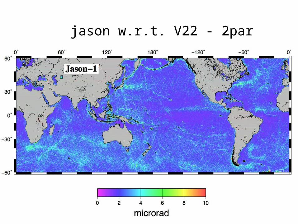
jason w.r.t. V22 - 2par
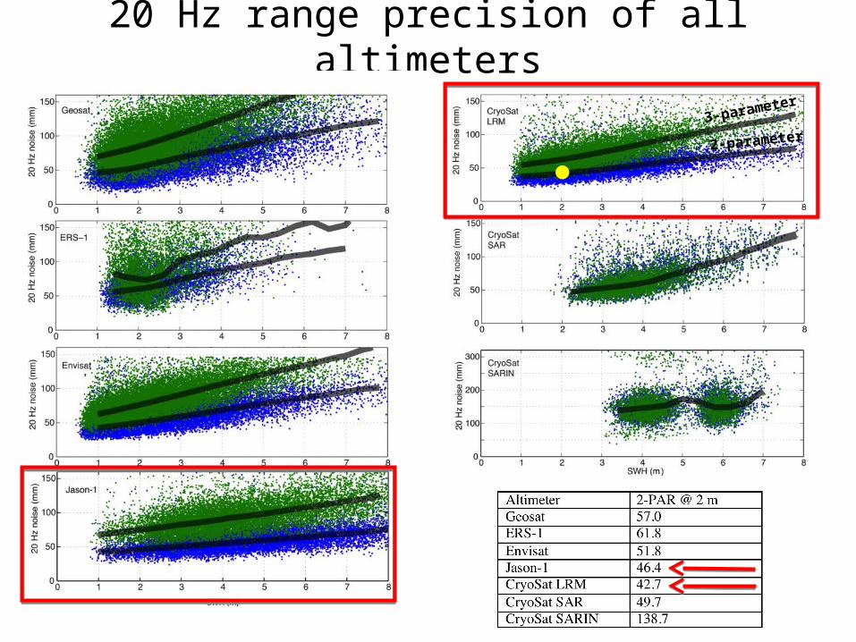
20 Hz range precision of all altimeters
3-parameter
2-parameter

2-pass retracking reduces “spectral hump”

•higher accuracy = improved range precision + improved coverage
•why retracking is essential for optimal gravity accuracy
•retracking improves range precision by 1.5 times and reduces “spectral hump”
•current gravity accuracy (V22.1 grid)
•some tectonic examples
Towards 1 MilliGal Global Marine Gravity from CryoSat, Envisat, and Jason-1
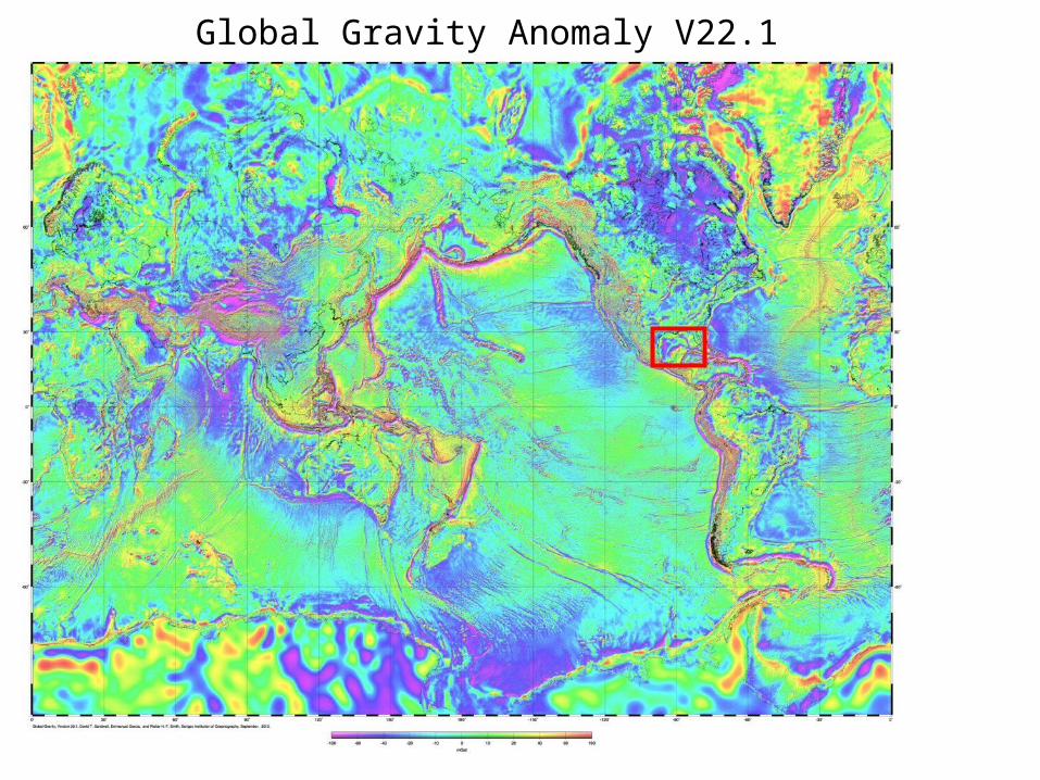
Global Gravity Anomaly V22.1

Gravity Anomaly V22.1 (10 mGal contours)

comparisons in the Gulf of Mexico
ship gravitysatellite gravitywith CryoSat LRM, Envisat and Jason-1
5 mGal contour interval
source: EDCON

GPS Navigated Gravity survey of Alaminos Canyon(Alan Herring, personal communication, Dec. 2011.)

spatial comparisons in the Gulf of Mexico
Noise contribution from the EDCON data is 0.51 mGal.
V18Geosat ERS-1
V22CryoSat-2Jason-1EnvisatGeosat ERS-1
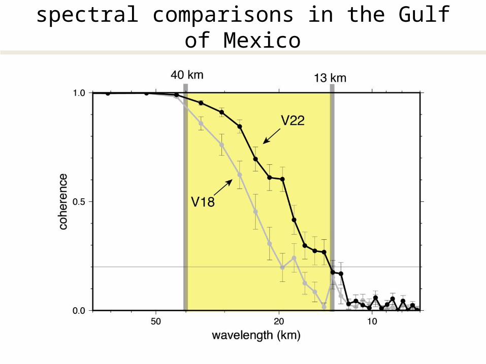
spectral comparisons in the Gulf of Mexico

along track slope difference in microradian (0.98 mGal)
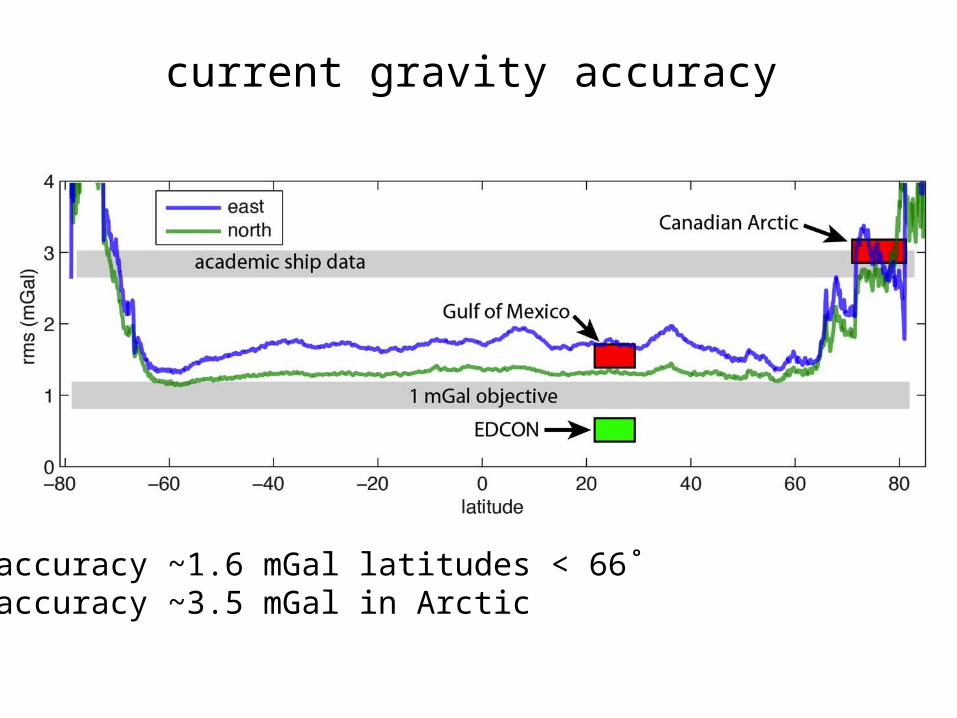
current gravity accuracy
accuracy ~1.6 mGal latitudes < 66˚accuracy ~3.5 mGal in Arctic

•higher accuracy = improved range precision + improved coverage
•why retracking is essential for optimal gravity accuracy
•retracking improves range precision by 1.5 times and reduces “spectral hump”
•current gravity accuracy (V22.1 grid)
•some tectonic examples
Towards 1 MilliGal Global Marine Gravity from CryoSat, Envisat, and Jason-1

vertical gravity gradient

oldV18
vertical gravity gradient

newV22
vertical gravity gradient

newV22
vertical gravity gradient

Conclusions
• “newer” altimeters have 1.4 times better range precision and 2 times better coverage.
• 2-pass waveform retracking provides 1.5 times range precision for all altimeters and reduces “spectral hump”.
• Marine gravity accuracy is currently 1.6 – 3.5 mGal with most improvement in the 13 – 40 km wavelength band.
• Most academic fleet ship gravity is less accurate than altimeter gravity.
• The new V22 gravity has less filtering but lower noise so subtle tectonic features are now apparent.
• We have not performed any long-wavelength corrections to the data so some corrections may improve areas of high mesoscale variability.


V22 – CryoSat-2, Jason-1, Envisat, ERS-1, GeosatV18 – ERS-1, Geosat
What is the contribution from each altimeter?Do we still need ERS-1 and Geosat?
actual gravity improvement
total improvement
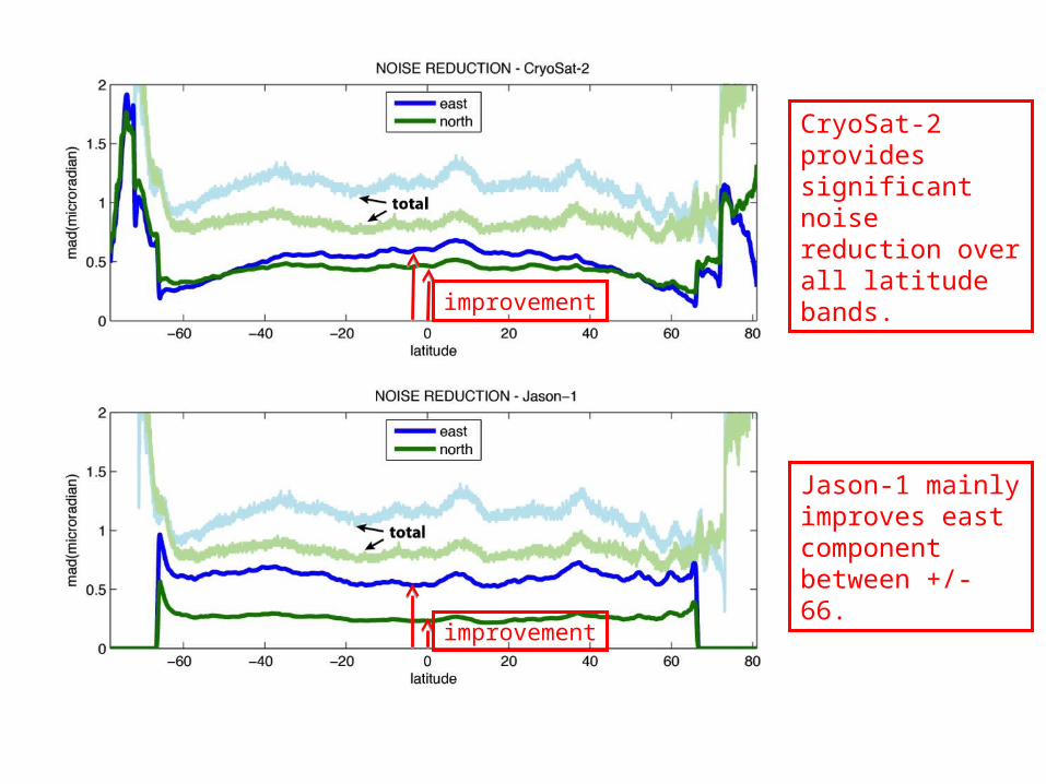
CryoSat-2 providessignificant noise reduction over all latitude bands.
Jason-1 mainly improves east component between +/- 66.
improvement
improvement

Envisat provides greatest noise reduction in Arctic and Antarctic.
Geosat improves east component at low latitudes and east component in 66-72 latitude band
improvement
improvement

First attempt at comparingall academic fleet ship gravity (1500 cruises) with V21.1 satellite gravity courtesy of Paul Wessel.
The median absolute deviation between academic fleet gravity and satellite gravity is 2.75 mGal.
Most academic fleet cruises are less accurate than the satellite gravity.