montana soil survey soil property and interpretation · web viewreports for hydric soils by...
TRANSCRIPT

Montana Soil Survey Soil Property and Interpretation Information
Reports for Hydric Soils by Survey Area and Soil Productivity Index for LESA by County are available at this site.
The reports listed below are available in the MicroSoft Access databases referred to in the Official Soil Survey Reference. Clicking on a report name will provide an example and brief explanation of the report contents.
A Glossary of Soil Survey Terms is provided for additional information.
Access Database Report Name
MANU - Legend by Symbol
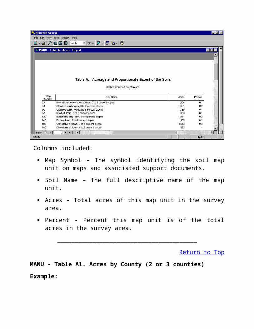
MANU - Table A. Acres
MANU - Table A1. Acres by County (2 or 3 counties)
MANU - Table AWM-1. Ag Waste Interp. w/fuzzy rating
MANU - Table AWM-2. Ag Waste Interp. w/fuzzy rating
MANU - Table B. Component Yields (1-3 crops)
MANU - Table B1. Mapunit Yields (1-3 crops)
MANU - Table B2. Component Non-Irr Yields (1-5 crops)
MT - Modeled Spring and Winter Wheat Yields
MT - Modeled Barley and Oat Yields
MANU - Table B3. Component Irrigated Yields (1-5 crops)
MANU - Table B4. Mapunit Irrigated Yields (1-5 crops)
MANU - Table B5. Mapunit Non-Irr Yields (1-5 crops)
MANU - Table C1. Range Production
MANU - Table C2. Range Production & Plants w/o Forest Understory
MANU - Table E1. Forest Productivity

MANU - Table ENG-1. Construction Materials w/fuzzy rating
MANU - Table ENG-2. Construction Materials w/fuzzy rating
MANU - Table ENG-3. Building Site Development w/fuzzy rating
MANU - Table ENG-4. Building Site Development w/fuzzy rating
MANU - Table ENG-5. Sanitary Facilities w/fuzzy rating
MANU - Table ENG-6. Sanitary Facilities w/fuzzy rating
MANU - Table FOR-1. Forestland Management w/fuzzy rating
MANU - Table FOR-2. Forestland Management w/fuzzy rating
MANU - Table FOR-3. Forestland Management w/fuzzy rating
MANU - Table FOR-4. Forestland Management w/fuzzy rating
MANU - Table FOR-5. Forestland Management w/fuzzy rating
MT Sprinkler Irr. And Fencing
MANU - Table H. Engineering Properties
MANU - Table J1a. Physical Properties (with Ksat)
MANU - Table J1b. Physical Properties (with permeability)
MANU - Table J2. Chemical Properties
MANU - Table K1. Water Features
MANU - Table K2. Soil Features
MANU - Table Q1. Classification w/taxadjuncts
MANU - Table REC-1. Recreation w/fuzzy rating
MANU - Table REC-2. Recreation w/fuzzy rating
MANU - Table U. Windbreak Plantings
MANU - Table Y. Prime Farmland
Component Legend
Hydric Soils List

Non-Technical Descriptions
Selected Soil Interpretations
Component Text
________________________________________
Return to Top
MANU - Legend by Symbol Report
Example:
Columns included:
Map Symbol – The symbol identifying the soil map unit on maps and associated support documents.
Soil Name – The full descriptive name of the map unit.
________________________________________
Return to Top
MANU - Table A. Acres
Example:

Columns included:
Map Symbol – The symbol identifying the soil map unit on maps and associated support documents.
Soil Name – The full descriptive name of the map unit.
Acres - Total acres of this map unit in the survey area.
Percent - Percent this map unit is of the total acres in the survey area.
________________________________________
Return to Top
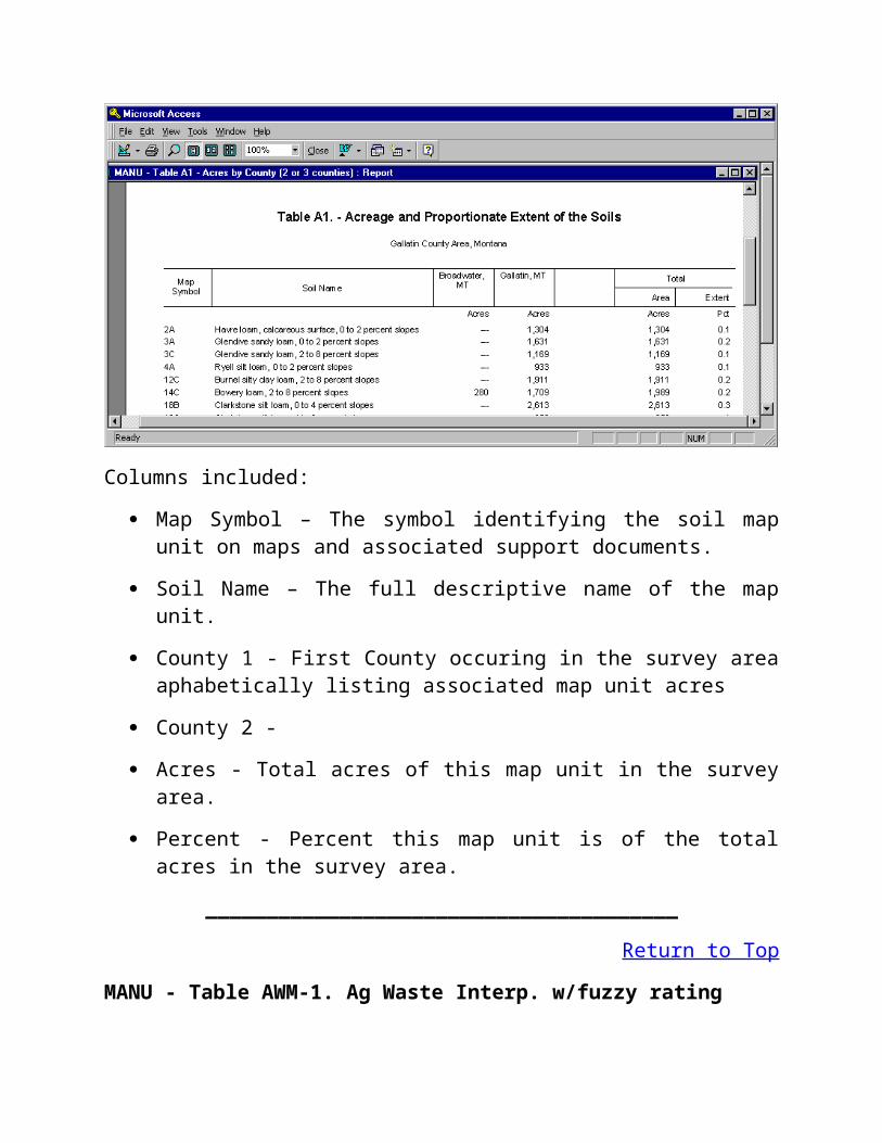
MANU - Table A1. Acres by County (2 or 3 counties)
Example:
Columns included:
Map Symbol – The symbol identifying the soil map unit on maps and associated support documents.
Soil Name – The full descriptive name of the map unit.
County 1 - First County occuring in the survey area aphabetically listing associated map unit acres
County 2 -
Acres - Total acres of this map unit in the survey area.
Percent - Percent this map unit is of the total acres in the survey area.
_______________________________________
Return to Top
MANU - Table AWM-1. Ag Waste Interp. w/fuzzy rating
Example:
Interpretations Included:
Application of Manure and Food Processing Waste
Application of Sewage Sludge
Disposal of Waste water by irrigation
Columns included:
Map Symbol – The symbol identifying the soil map unit on maps and associated support documents.
Soil Name – The name of the map unit component (soil, miscellaneous land type…)
Pct of Map Unit - Percent of the named map unit component within this map unit.
Interpretation name - Example: Application of Manure and Food Processing Waste.
Rating Class - Overall rating for component for interpretation, Limited, Somewhat Limited or Not limited.
Limiting Features - Listed below Rating Class where applicable, noting soil or site feature of concern.

Value - The relative value from 0 to 1 of the degree of limitation for the noted feature.
_______________________________________
Return to Top
MANU - Table AWM-2. Ag Waste Interp. w/fuzzy rating
Example:
Interpretations Included:
Overland Flow of Wastewater
Rapid infiltration of Wastewater
SlowRate Treatment of Wastewater
Columns included:
Map Symbol – The symbol identifying the soil map unit on maps and associated support documents.
Soil Name – The name of the map unit component (soil, miscellaneous land type…)

Pct of Map Unit - Percent of the named map unit component within this map unit.
Interpretation name - Example: Application of Manure and Food Processing Waste.
Rating Class - Overall rating for component for interpretation, Limited, Somewhat Limited or Not limited.
Limiting Features - Listed below Rating Class where applicable, noting soil or site feature of concern.
Value - The relative value from 0 to 1 of the degree of limitation for the noted feature.
_______________________________________
Return to Top
MANU - Table B. Component Yields (1-3 crops)
Example:
Crops Included:
User selects from list up to three crops found in select parameter box within Access Database
Columns included:

Map Symbol – The symbol identifying the soil map unit on maps and associated support documents.
Soil Name – The name of the map unit component (soil, miscellaneous land type…)
Land Capability - Land Capability Class and Subclass listed for both Irrigated and Non-Irrigated where applicable
Crop Name - Listed for each crop, up to three, selected in the parameter selection process
Yields - Both Non-irrigated and Irrigated yields are listed where applicable, yield units provided at the head of the listed yield potentials.
_______________________________________
Return to Top
MANU - Table B1. Mapunit Yields (1-3 crops)
Example:
Mapunit crop yield information is not provided for any Montana Soil Surveys!
_______________________________________
Return to Top
MANU - Table B2. Component Non-Irr Yields (1-5 crops)
Example:

Crops Included:
User selects from list up to five crops found in the select parameter box within Access Database
Columns included:
Map Symbol – The symbol identifying the soil map unit on maps and associated support documents.
Soil Name – The name of the map unit component (soil, miscellaneous land type…)
Land Capability - Non-Irrigated Land Capability Class and Subclass listed for map unit components
Crop Name - Listed for each crop, up to five, from the selection parameter box
Yields - Non-irrigated yields are listed with yield units provided at the head of the listed yields.
_______________________________________
Return to Top
MT - Modeled Spring and Winter Wheat Yields

Example:
Crops Included:
Spring Wheat Modeled Non-Irrigated Yields
Winter Wheat Modeled Non-Irrigated Yields
Columns included:
Map Symbol – The symbol identifying the soil map unit on maps and associated support documents.
Soil Name – The name of the map unit component (soil, miscellaneous land type…)
Pct of Map Unit - Percent of the named map unit component within this map unit.
Crop Name - For example, Winter Wheat.
Yields - Non-irrigated Modeled Small Grain Yield results are listed. The model utilized is based on Montana State University Agriculture Experiment Station Report 35. Yield Units are listed at the head of the Yield column of data. The Non-irrigated yields for these crops are only available in the modeled format.

_______________________________________
Return to Top
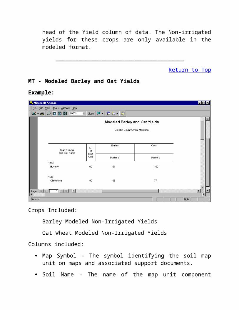
MT - Modeled Barley and Oat Yields
Example:
Crops Included:
Barley Modeled Non-Irrigated Yields
Oat Wheat Modeled Non-Irrigated Yields
Columns included:
Map Symbol – The symbol identifying the soil map unit on maps and associated support documents.
Soil Name – The name of the map unit component (soil, miscellaneous land type…)
Pct of Map Unit - Percent of the named map unit component within this map unit.
Crop Name - For example, Barley.

Yields - Non-irrigated Modeled Small Grain Yield results are listed. The model utilized is based on Montana State University Agriculture Experiment Station Report 35. Yield Units are listed at the head of the Yield column of data. The Non-irrigated yields for these crops are only available in the modeled format.
_______________________________________
Return to Top
MANU - Table B3. Component Irrigated Yields (1-5 crops)
Example:
Crops Included:
User selects from list up to five crops found in the select parameter box within Access Database
Columns included:
Map Symbol – The symbol identifying the soil map unit on maps and associated support documents.
Soil Name – The name of the map unit component (soil, miscellaneous land type…)
Land Capability - Irrigated Land Capability Class and Subclass listed
for map unit components
Crop Name - Listed for each crop, up to five, from the selection parameter box
Yields - Irrigated yields are listed with yield units provided at the head of the listed yields.
_______________________________________
Return to Top
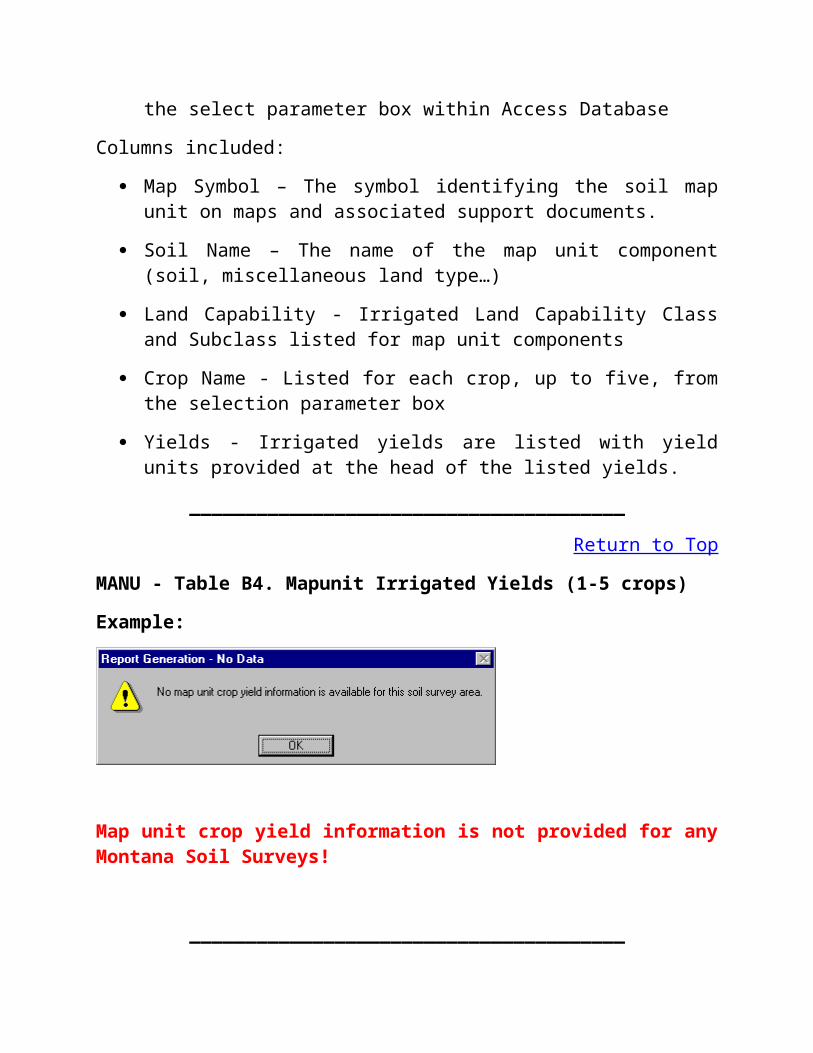
MANU - Table B4. Mapunit Irrigated Yields (1-5 crops)
Example:
Map unit crop yield information is not provided for any Montana Soil Surveys!
_______________________________________
Return to Top
MANU - Table B5. Mapunit Non-Irr Yields (1-5 crops)
Example:

Map unit crop yield information is not provided for any Montana Soil Surveys!
_______________________________________
Return to Top
MANU - Table C1. Range Production
Example:
Columns included:
Map Symbol – The symbol identifying the soil map unit on maps and associated support documents.
Soil Name – The name of the map unit component (soil, miscellaneous land type…)
Ecoligical Site - NRCS Rangeland Ecological Site Name.
Total Dry-Weight Production Estimate
Favorable Year - Production in lb/acre in year with above average precipitation/growing season.
Normal Year - Production in lb/acre in year with average precipitation/growing season.
Unfavorable Year - Production in lb/acre in year with below average precipitation/growing season.
_______________________________________
Return to Top
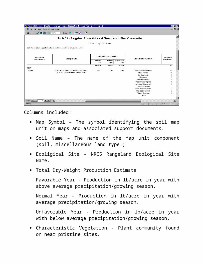
MANU - Table C2. Range Production & Plants w/o Forest Understory
Example:
Columns included:
Map Symbol – The symbol identifying the soil map unit on maps and associated support documents.
Soil Name – The name of the map unit component (soil, miscellaneous land type…)
Ecoligical Site - NRCS Rangeland Ecological Site Name.
Total Dry-Weight Production Estimate
Favorable Year - Production in lb/acre in year with above average precipitation/growing season.
Normal Year - Production in lb/acre in year with average precipitation/growing season.

Unfavorable Year - Production in lb/acre in year with below average precipitation/growing season.
Characteristic Vegetation - Plant community found on near pristine sites.
Rangeland Composition - Percent by weight of characteristic vegetation typically expected.
_______________________________________
Return to Top
MANU - Table E1. Forest Productivity
Example:
Columns included:
Map Symbol – The symbol identifying the soil map unit on maps and associated support documents.
Soil Name – The name of the map unit component (soil, miscellaneous land type…)
Common Trees - Common trees to this map unit.
Site Index - A productivity indicator used by the NRCS, based on

species/regional tables, tree age and height.
Volume of Wood Fiber - Annual increase in cubic feet per acre of volume for indicated species.
Trees to Manage - An indication if the common tree species listed is typically managed in this map unit.
_______________________________________
Return to Top
MANU - Table ENG-1. Construction Materials w/fuzzy rating
Example:
Interpretations Included:
Potential Source of Gravel
Potential Source of Sand
Columns included:
Map Symbol – The symbol identifying the soil map unit on maps and associated support documents.
Soil Name – The name of the map unit component (soil, miscellaneous land type…)
Pct of Map Unit - Percent of the named map unit component within this map unit.
Interpretation name - Example: Potential Source of Gravel.
Rating Class - Overall rating for component for interpretation ( Poor, Fair or Good).
Limiting Features - Listed below Rating Class where applicable, noting soil or site feature of concern.
Value - The relative value from 0 to 1 of the degree of Potential for the noted feature.
_______________________________________
Return to Top
MANU - Table ENG-2. Construction Materials w/fuzzy rating
Example:

Interpretations Included:
Potential Source of Reclamation Material
Potential Source of Roadfill
Potential Source of Topsoil
Columns included:
Map Symbol – The symbol identifying the soil map unit on maps and associated support documents.
Soil Name – The name of the map unit component (soil, miscellaneous land type…)
Pct of Map Unit - Percent of the named map unit component within this map unit.
Interpretation name - Example: Potential Source of Topsoil.
Rating Class - Overall rating for component for interpretation ( Poor, Fair or Good).
Limiting Features - Listed below Rating Class where applicable, noting soil or site feature of concern.
Value - The relative value from 0 to 1 of the degree of Potential for the noted feature.
_______________________________________
Return to Top
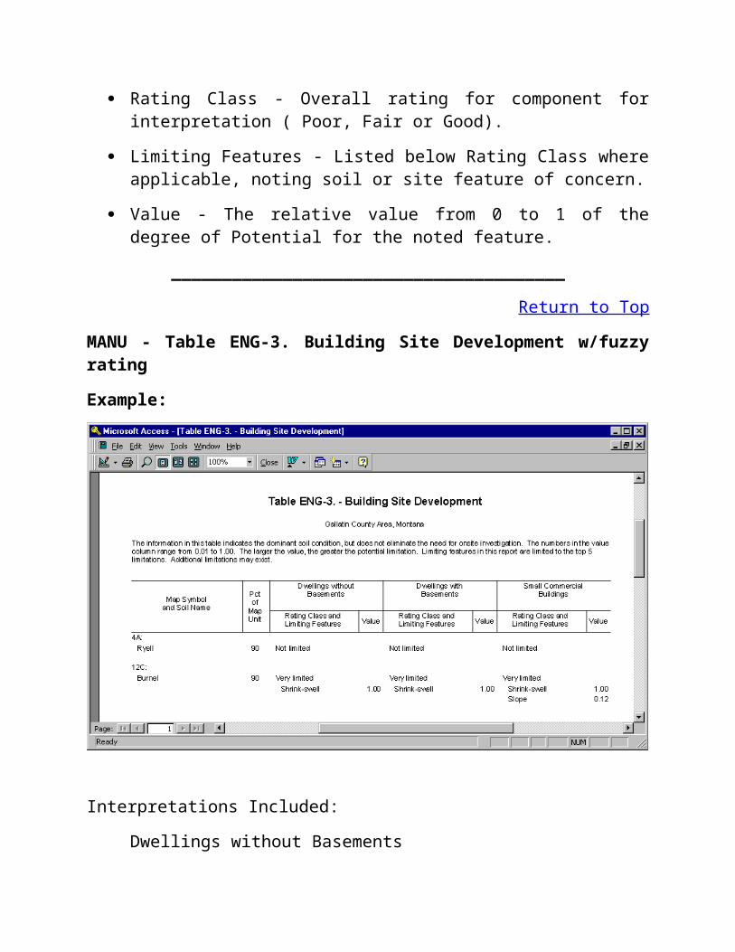
MANU - Table ENG-3. Building Site Development w/fuzzy rating
Example:

Interpretations Included:
Dwellings without Basements
Dwellings with Basements
Small Commercial Buildings
Columns included:
Map Symbol – The symbol identifying the soil map unit on maps and associated support documents.
Soil Name – The name of the map unit component (soil, miscellaneous land type…)
Pct of Map Unit - Percent of the named map unit component within this map unit.
Interpretation name - Example: Dwellings without Basements.
Rating Class - Overall rating for component for interpretation ( Not limited, Somewhat limted…).

Limiting Features - Listed below Rating Class where applicable, noting soil or site feature of concern.
Value - The relative value from 0 to 1 of the degree of Potential for the noted feature.
_______________________________________
Return to Top
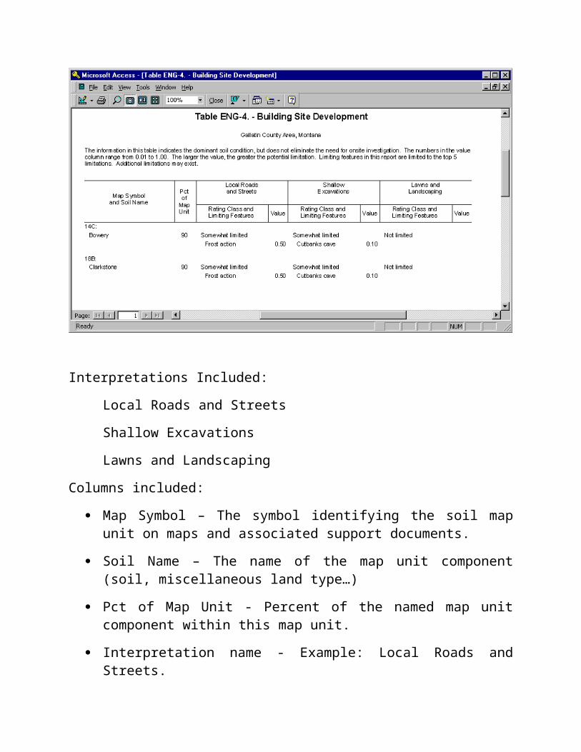
MANU - Table ENG-4. Building Site Development w/fuzzy rating
Example:
Interpretations Included:
Local Roads and Streets
Shallow Excavations
Lawns and Landscaping
Columns included:

Map Symbol – The symbol identifying the soil map unit on maps and associated support documents.
Soil Name – The name of the map unit component (soil, miscellaneous land type…)
Pct of Map Unit - Percent of the named map unit component within this map unit.
Interpretation name - Example: Local Roads and Streets.
Rating Class - Overall rating for component for interpretation (Not limited, somewhat limited…).
Limiting Features - Listed below Rating Class where applicable, noting soil or site feature of concern.
Value - The relative value from 0 to 1 of the degree of Potential for the noted feature.
_______________________________________
Return to Top
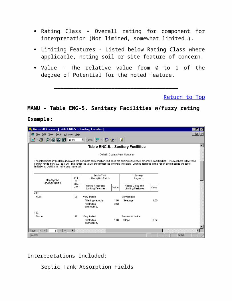
MANU - Table ENG-5. Sanitary Facilities w/fuzzy rating
Example:
Interpretations Included:
Septic Tank Absorption Fields
Sewage Lagoons
Columns included:
Map Symbol – The symbol identifying the soil map unit on maps and associated support documents.
Soil Name – The name of the map unit component (soil, miscellaneous land type…)
Pct of Map Unit - Percent of the named map unit component within this map unit.
Interpretation name - Example: Septic Tank Absorption Fields.
Rating Class - Overall rating for component for interpretation ( Not limited, somewhat limited… ).
Limiting Features - Listed below Rating Class where applicable,
noting soil or site feature of concern.
Value - The relative value from 0 to 1 of the degree of Potential for the noted feature.
_______________________________________
Return to Top
MANU - Table ENG-6. Sanitary Facilities w/fuzzy rating
Example:
Interpretations Included:
Trench Sanitary Landfill
Area Sanitary Landfill
Daily Cover for Landfill
Columns included:
Map Symbol – The symbol identifying the soil map unit on maps and associated support documents.
Soil Name – The name of the map unit component (soil, miscellaneous land type…)
Pct of Map Unit - Percent of the named map unit component within this map unit.
Interpretation name - Example: Daily Cover for Landfill.
Rating Class - Overall rating for component for interpretation ( Not limited, somewhat limited…).
Limiting Features - Listed below Rating Class where applicable, noting soil or site feature of concern.
Value - The relative value from 0 to 1 of the degree of Potential for the noted feature.
_______________________________________
Return to Top
MANU - Table FOR-1. Forestland Management w/fuzzy rating
Example:
Interpretations Included:
Limitations Affecting Construction of Haul Roads and Log Landings
Suitability for Log Landings
Soil Rutting Hazard
Columns included:
Map Symbol – The symbol identifying the soil map unit on maps and associated support documents.
Soil Name – The name of the map unit component (soil, miscellaneous land type…)
Pct of Map Unit - Percent of the named map unit component within this map unit.
Interpretation name - Example: Soil Rutting Hazard.
Rating Class - Overall rating for component for interpretation ( Slight,
Moderate, Severe, Poorly Suited, Well suited…).
Limiting Features - Listed below Rating Class where applicable, noting soil or site feature of concern.
Value - The relative value from 0 to 1 of the degree of Potential for the noted feature.
_______________________________________
Return to Top
MANU - Table FOR-2. Forestland Management w/fuzzy rating
Example:
Interpretations Included:
Hazard of Off-Road or Off-Trail Erosion
Hazard of Erosion on Roads and Trails
Suitability for Roads (Natural Surface)

Columns included:
Map Symbol – The symbol identifying the soil map unit on maps and associated support documents.
Soil Name – The name of the map unit component (soil, miscellaneous land type…)
Pct of Map Unit - Percent of the named map unit component within this map unit.
Interpretation name - Example: Hazard of Off Road or Off-Trail Erosion.
Rating Class - Overall rating for component for interpretation ( Slight, Moderate, Severe, Poorly Suited, Well suited…).
Limiting Features - Listed below Rating Class where applicable, noting soil or site feature of concern.
Value - The relative value from 0 to 1 of the degree of Potential for the noted feature.
_______________________________________
Return to Top
MANU - Table FOR-3. Forestland Management w/fuzzy rating
Example:

Interpretations Included:
Suitability for Hand Planting
Suitability for Mechanical Planting
Suitability for Use of Harvesting Equipment
Columns included:
Map Symbol – The symbol identifying the soil map unit on maps and associated support documents.
Soil Name – The name of the map unit component (soil, miscellaneous land type…)
Pct of Map Unit - Percent of the named map unit component within this map unit.
Interpretation name - Example: Suitability for Hand Planting.
Rating Class - Overall rating for component for interpretation ( Slight, Moderate, Severe, Poorly Suited, Well suited…).

Limiting Features - Listed below Rating Class where applicable, noting soil or site feature of concern.
Value - The relative value from 0 to 1 of the degree of Potential for the noted feature.
_______________________________________
Return to Top
MANU - Table FOR-4. Forestland Management w/fuzzy rating
Example:
Interpretations Included:
Suitability for Mechanical Site Preparation (Surface)
Suitability for Mechanical Site Preparation (Deep)
Columns included:
Map Symbol – The symbol identifying the soil map unit on maps and

associated support documents.
Soil Name – The name of the map unit component (soil, miscellaneous land type…)
Pct of Map Unit - Percent of the named map unit component within this map unit.
Interpretation name - Example: Suitability for Mechanical Site Preparation (Surface).
Rating Class - Overall rating for component for interpretation (Poorly Suited, Well suited…).
Limiting Features - Listed below Rating Class where applicable, noting soil or site feature of concern.
Value - The relative value from 0 to 1 of the degree of Potential for the noted feature.
_______________________________________
Return to Top
MANU - Table FOR-5. Forestland Management w/fuzzy rating
Example:

Interpretations Included:
Potential for Damage to Soil by Fire
Potential for Seedling Mortality
Columns included:
Map Symbol – The symbol identifying the soil map unit on maps and associated support documents.
Soil Name – The name of the map unit component (soil, miscellaneous land type…)
Pct of Map Unit - Percent of the named map unit component within this map unit.
Interpretation name - Example: Potential for Damage to Soil by Fire.
Rating Class - Overall rating for component for interpretation (Low, Medium, High, Not Rated).
Limiting Features - Listed below Rating Class where applicable, noting soil or site feature of concern.
Value - The relative value from 0 to 1 of the degree of Potential for the noted feature.
_______________________________________
Return to Top
MT Sprinkler Irr. And Fencing
Example:
Interpretations Included:
Sprinkler Irrigation
Fence Post Installation
Columns included:

Map Symbol – The symbol identifying the soil map unit on maps and associated support documents.
Soil Name – The name of the map unit component (soil, miscellaneous land type…)
Pct of Map Unit - Percent of the named map unit component within this map unit.
Interpretation name - Example: Fence Post Installation.
Rating Class - Overall rating for component for interpretation (Very limited, limited, Not limited…).
Limiting Features - Listed below Rating Class where applicable, noting soil or site feature of concern.
Value - The relative value from 0 to 1 of the degree of Potential for the noted feature.
_______________________________________
Return to Top
MANU - Table H. Engineering Properties
Example:

Columns included:
Map Symbol – The symbol identifying the soil map unit on maps and associated support documents.
Soil Name – The name of the map unit component (soil, miscellaneous land type…)
Depth - Soil Horizon/Layer Depths.
USDA Texture - Horizon textures using the USDA texture classification system
Unified Classification - Horizon texture using the Unified system
AASHTO Classification - Horizon texture(s) using the AASHTO system
>10 inches (fragments) - Percent of rock fragments greater than 10 inches in smallest dimension.
3-10 inches (fragments) - Percent of rock fragments greater than 3 and less than 10 inches in smallest dimension.
Percent passing sieve # 4 - percent of less than 3 inch material more than 5 mm.
Percent passing sieve # 10 - percent of less than 3 inch material more than 2 mm.
Percent passing sieve # 40 - percent of less than 3 inch material more than 0.42 mm.
Percent passing sieve # 200 - percent of less than 3 inch material more than 0.074 mm.
Liquid Limit - % moisture content at which a soil from a liquid to a plastic state.
Plasticity Index - The numerical difference between the liquid limit and the plastic limit.
_______________________________________
Return to Top

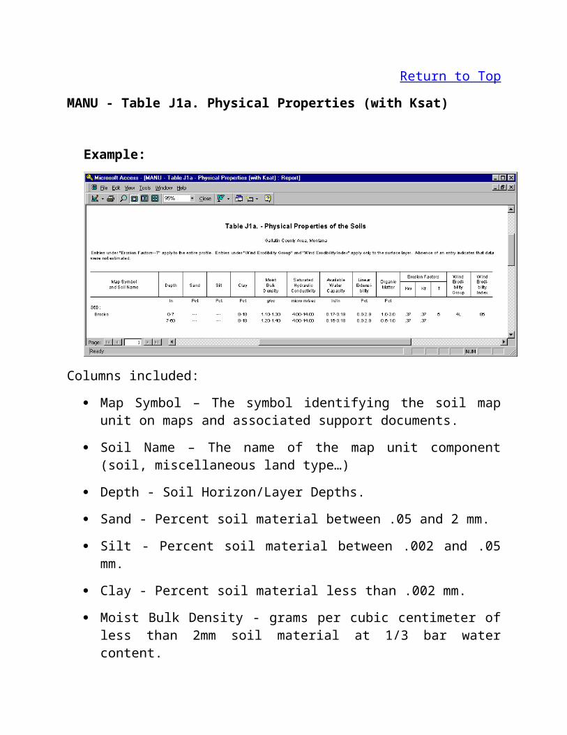
MANU - Table J1a. Physical Properties (with Ksat)
Example:
Columns included:
Map Symbol – The symbol identifying the soil map unit on maps and associated support documents.
Soil Name – The name of the map unit component (soil, miscellaneous land type…)
Depth - Soil Horizon/Layer Depths.
Sand - Percent soil material between .05 and 2 mm.
Silt - Percent soil material between .002 and .05 mm.
Clay - Percent soil material less than .002 mm.
Moist Bulk Density - grams per cubic centimeter of less than 2mm soil material at 1/3 bar water content.
Saturated Hydraulic Conductivity - The quality of a soils for downward movement of water measured in micro meters per second under saturated conditions.
Available Water Capacity - The capacity of soil to hold water available for most plants in inches per inch.

Linear Extensibily - Percent change in volume from 1/3 bar saturation to oven dry state.
Organic Matter - Percent of the soil of organic matter by weight.
Kw erosion factor - a whole soil erosion equation value based on soil texture, organic matter etc…
Kf erosion factor - A fragment free, less than 2mm erosion equation value based on soil texture, organic matter etc…
T factor - A value used in soil loss equations, relating to tons of allowable soil loss.
Wind Erodibility Group - A grouping of soils by susceptibility to wind erosion used in the Wind Erosion Equation
Wind Erodibility Index - The values used in defining Wind Erodibiliy groups based on percent by weight of aggregates greater than 0.84 mm.
_______________________________________
Return to Top
MANU - Table J1b. Physical Properties (with permeability)
Example:
Columns included:
Map Symbol – The symbol identifying the soil map unit on maps and

associated support documents.
Soil Name – The name of the map unit component (soil, miscellaneous land type…)
Depth - Soil Horizon/Layer Depths.
Sand - Percent soil material between .05 and 2 mm.
Silt - Percent soil material between .002 and .05 mm.
Clay - Percent soil material less than .002 mm.
Moist Bulk Density - grams per cubic centimeter of less than 2mm soil material at 1/3 bar water content.
Permeability - The quality of a soils for downward movement of water measured in inches per hour.
Available Water Capacity - The capacity of soil to hold water available for most plants in inches per inch.
Linear Extensibily - Percent change in volume from 1/3 bar saturation to oven dry state.
Organic Matter - Percent of the soil of organic matter by weight.
Kw erosion factor - a whole soil erosion equation value based on soil texture, organic matter etc…
Kf erosion factor - A fragment free, less than 2mm erosion equation value based on soil texture, organic matter etc…
T factor - A value used in soil loss equations, relating to tons of allowable soil loss.
Wind Erodibility Group - A grouping of soils by susceptibility to wind erosion used in the Wind Erosion Equation
Wind Erodibility Index - The values used in defining Wind Erodibiliy groups based on percent by weight of aggregates greater than 0.84 mm.
_______________________________________
Return to Top

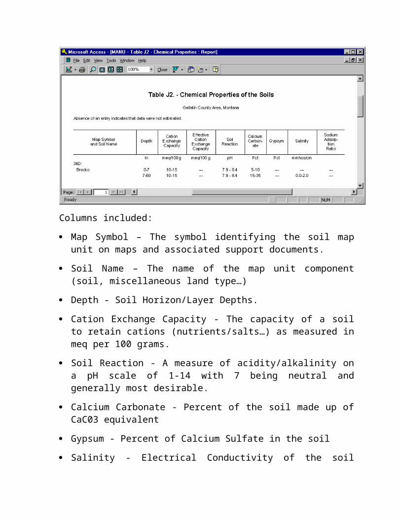
MANU - Table J2. Chemical Properties
Example:
Columns included:
Map Symbol – The symbol identifying the soil map unit on maps and associated support documents.
Soil Name – The name of the map unit component (soil, miscellaneous land type…)
Depth - Soil Horizon/Layer Depths.
Cation Exchange Capacity - The capacity of a soil to retain cations (nutrients/salts…) as measured in meq per 100 grams.
Soil Reaction - A measure of acidity/alkalinity on a pH scale of 1-14 with 7 being neutral and generally most desirable.
Calcium Carbonate - Percent of the soil made up of CaC03 equivalent
Gypsum - Percent of Calcium Sulfate in the soil
Salinity - Electrical Conductivity of the soil measured in mmhos/centimeter.
Sodium Adsorption Ration - The ratio of Sodium to other salts on the exchange capacity of the soil.
_______________________________________
Return to Top
MANU - Table K1. Water Features
Example:
Columns included:
Map Symbol – The symbol identifying the soil map unit on maps and associated support documents.
Soil Name – The name of the map unit component (soil, miscellaneous land type…)
Hydrologic Group - A letter A through D indicating a relative ability of a soil to produce runoff.
Month - The month(s) a water feature is estimated to be present.
Water Table Upper Limit - The upper range of the upper limit, in feet, the water table is estimated to exist in stated month.
Water Table Lower Limit - The lower range the bottom limit, in feet, the water table is estimated to exist in stated month.
Ponding Surface Depth - Water depth on the soil surface in feet.

Ponding Duration - V. Brief < 2 days, Brief is 2-7 days, Long is 7 to 30 days, Very long is more than 30 days.
Ponding Fequency - Rare is 0-5 percent chance, Occasional is 5 to 50 percent chance, Frequent is more than 50 percent chance.
Flooding Duration - Ex. Brief - .1 to 4 hours, Very Brief - 4 to 48 hours, Brief - 2 to 7 days, Long - 7 to 30 days, Very Long - more than 30 days.
Flooding Frequency - None - less than 1 in 500 years, Very Rare - 1 in 500 to less than 1 in 100 years, Rare - 1 to 5 percent chance per year, Occasional - 5 to 50 percent chance per year, Frequent - more than 50 percent chance per year, but not in all months, Very Frequent - more than 50 percent chance in all months of the year.
_______________________________________
Return to Top
MANU - Table K2. Soil Features
Example:
Columns included:
Map Symbol – The symbol identifying the soil map unit on maps and associated support documents.
Soil Name – The name of the map unit component (soil,

miscellaneous land type…)
Restrictive Layer Kind - Lists kind of soil restriction, Ex: Bedrock (paralithic).
Restrictive Layer Depth to Top - Depth in inches to first contact from soil surface.
Restrictive Layer Thickness - Thickness in inches of the restriction.
Restrictive Layer Hardness - Relative hardness of the restriction.
Subsidence Initial - Amount of settling directly following drainage of the soil (within 3 years).
Subsidence total - The depth to the water table or organic thickness, whichever is shallower.
Potential for frost Action - A relative term describing soil movement resulting from freezing and thawing.
Risk of Corrosion (Uncoated Steel) - The relative speed at which steel corrodes in the soil.
Risk of Corrosion (Concrete) - The relative speed at which concrete breaks down within the soil.
_______________________________________
Return to Top
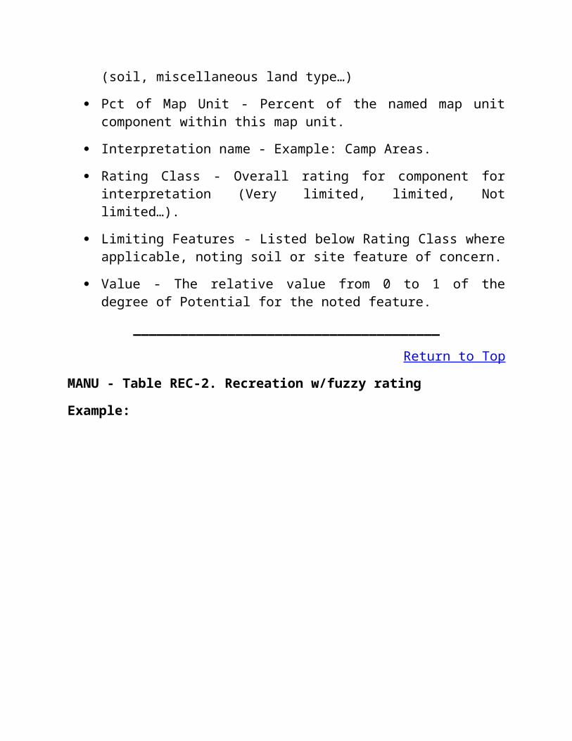
MANU - Table Q1. Classification w/taxadjuncts
Example:

Columns included:
Soil Name – The name of the map unit component (soil, miscellaneous land type…) Only soil components are classified in this report.
Family or Higher Taxonomic Classification - Classification of the soil component according to Agriculture Handbook 436, Soil Taxonomy.
_______________________________________
Return to Top
MANU - Table REC-1. Recreation w/fuzzy rating
Example:
Interpretations Included:
Camp Areas
Picnic Areas
Playgrounds
Columns included:
Map Symbol – The symbol identifying the soil map unit on maps and associated support documents.
Soil Name – The name of the map unit component (soil, miscellaneous land type…)
Pct of Map Unit - Percent of the named map unit component within this map unit.
Interpretation name - Example: Camp Areas.
Rating Class - Overall rating for component for interpretation (Very limited, limited, Not limited…).
Limiting Features - Listed below Rating Class where applicable, noting soil or site feature of concern.

Value - The relative value from 0 to 1 of the degree of Potential for the noted feature.
_______________________________________
Return to Top
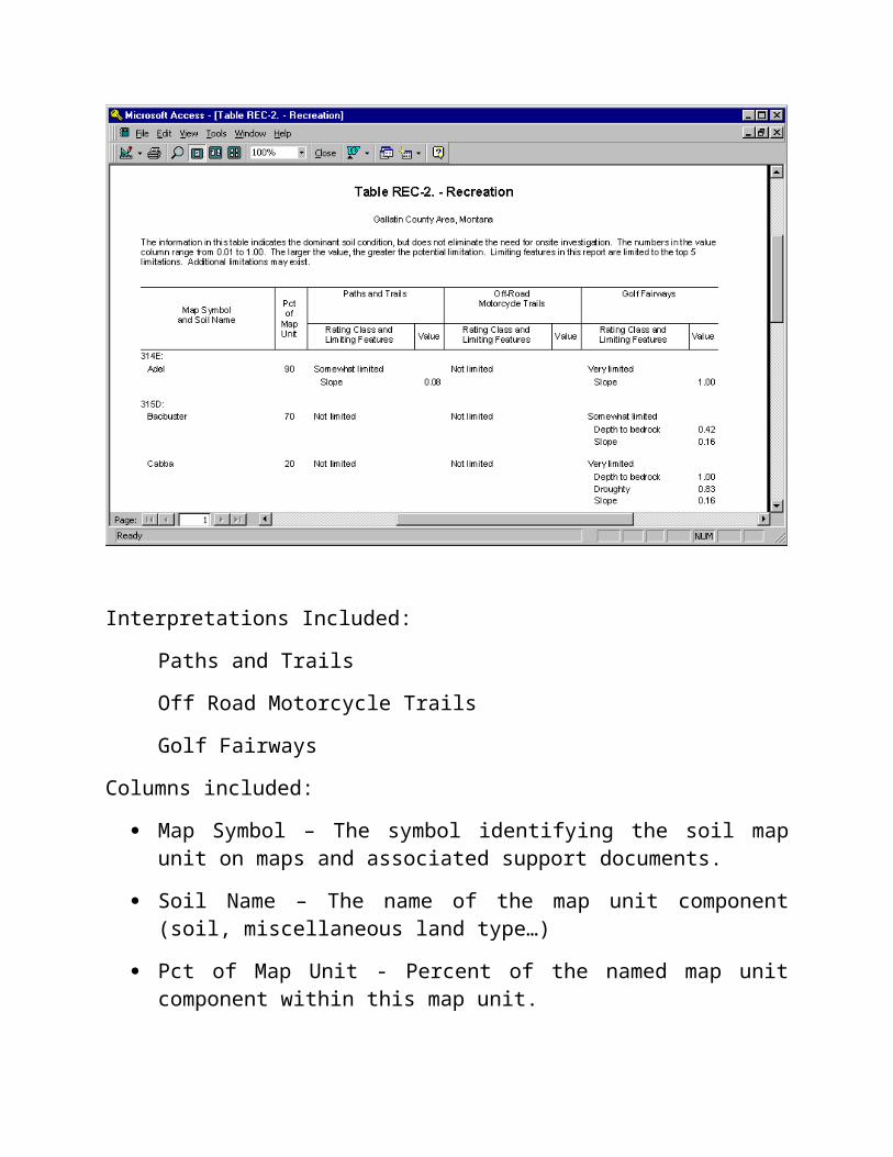
MANU - Table REC-2. Recreation w/fuzzy rating
Example:
Interpretations Included:
Paths and Trails
Off Road Motorcycle Trails
Golf Fairways
Columns included:
Map Symbol – The symbol identifying the soil map unit on maps and associated support documents.
Soil Name – The name of the map unit component (soil, miscellaneous land type…)
Pct of Map Unit - Percent of the named map unit component within this map unit.
Interpretation name - Example: Paths and Trails.
Rating Class - Overall rating for component for interpretation (Very limited, limited, Not limited…).
Limiting Features - Listed below Rating Class where applicable, noting soil or site feature of concern.
Value - The relative value from 0 to 1 of the degree of Potential for the noted feature.
_______________________________________
Return to Top
MANU - Table U. Windbreak Plantings
Example:
Note: Windbreaks are usually planned with use of a windbreak suitability

group. This assignment by map unit component is available at the NRCS Field Office responsible for the survey area in question.
Columns included:
Map Symbol – The symbol identifying the soil map unit on maps and associated support documents.
Soil Name – The name of the map unit component (soil, miscellaneous land type…)
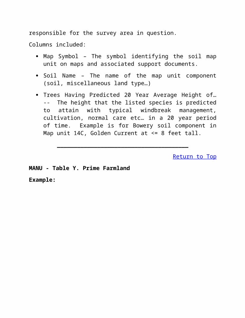
Trees Having Predicted 20 Year Average Height of… -- The height that the listed species is predicted to attain with typical windbreak management, cultivation, normal care etc… in a 20 year period of time. Example is for Bowery soil component in Map unit 14C, Golden Current at <= 8 feet tall.
_______________________________________
Return to Top
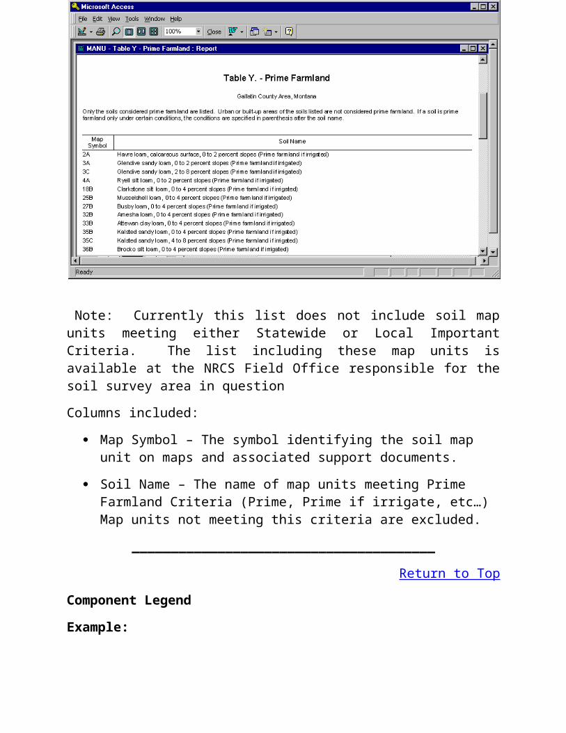
MANU - Table Y. Prime Farmland
Example:
Note: Currently this list does not include soil map units meeting either Statewide or Local Important Criteria. The list including these map units is available at the NRCS Field Office responsible for the soil survey area in question
Columns included:
Map Symbol – The symbol identifying the soil map unit on maps and associated support documents.
Soil Name – The name of map units meeting Prime Farmland Criteria (Prime, Prime if irrigate, etc…) Map units not meeting this criteria are excluded.
_______________________________________
Return to Top
Component Legend
Example:

Columns included:
Map Unit Symbol – The symbol identifying the soil map unit on maps and associated support documents.
Map Unit Name – The name of map unit, generally indicating type, slope and other information relevant to the map unit concept.
% Composition - Relates to the individual components within the map unit. This is the representative value for composition. The balance of the composition up to 100 percent are minor components not included currently in this dataset.
Component - A soil or misscelaneous land type identified to consistently exist in this map unit.
Component kind - Lists the type of map unit component (series, taxajunct, series family, miscellaneous area, and Taxon above family. This is closely related to the Soil Taxonomy Classification System.
Slope Low - The bottom end of the slope range for the stated component.
Slope RV - The representative value of the slope range for the stated component. It does not have to be the average. It is generally determined by the sample data distribution.
Slope High - The upper end of the slope range for the stated component.
_______________________________________
Return to Top
Hydric Soils List
The Hydric Soils lists by Soil Survey Area are provided at this link. The report available in the Access database does not contain map units with only hyrdic inclusions and therefore is not complete.
_______________________________________
Return to Top
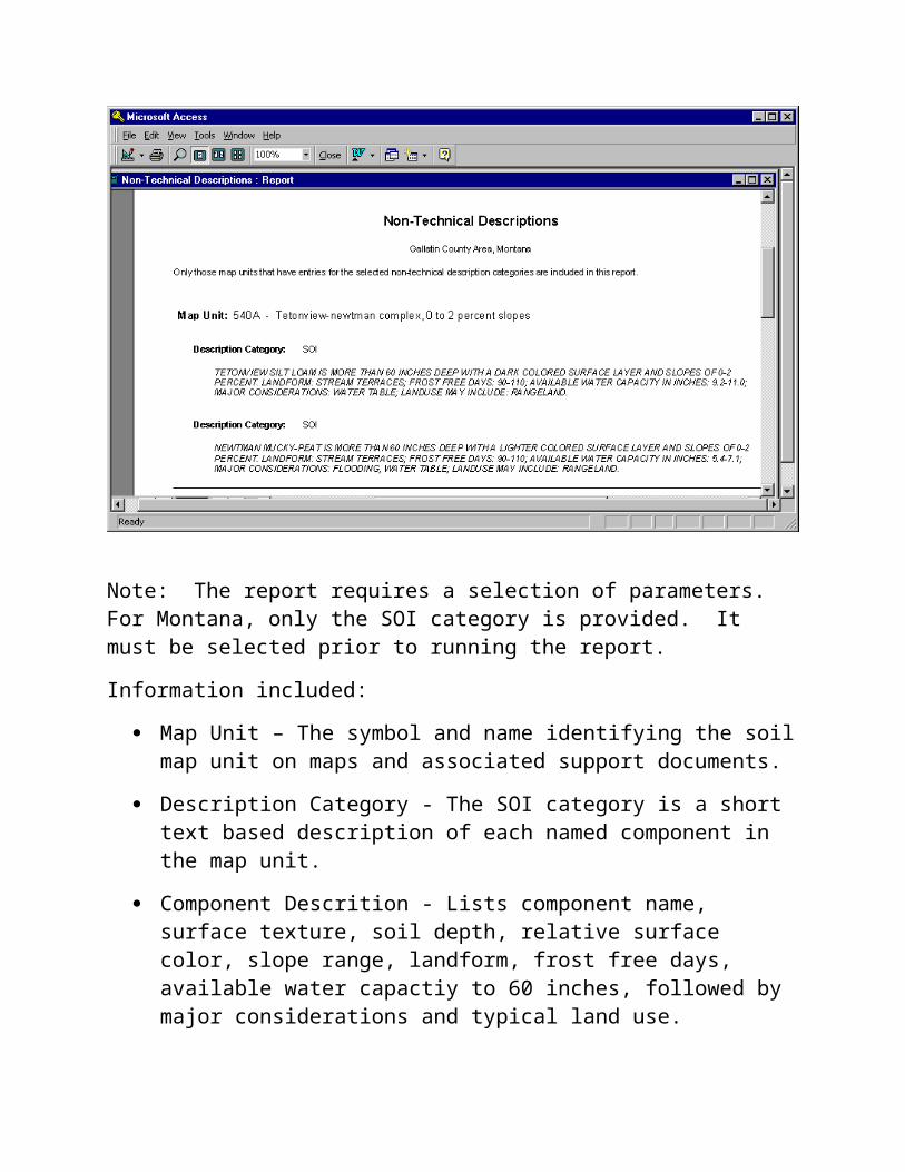
Non-Technical Descriptions
Example:
Note: The report requires a selection of parameters. For Montana, only the SOI category is provided. It must be selected prior to running the report.
Information included:
Map Unit – The symbol and name identifying the soil map unit on maps and associated support documents.
Description Category - The SOI category is a short text based description of each named component in the map unit.
Component Descrition - Lists component name, surface texture, soil depth, relative surface color, slope range, landform, frost free days, available water capactiy to 60 inches, followed by major considerations and typical land use.
_______________________________________
Return to Top
Selected Soil Interpretations
Example:

Interpretations Included:
Those selected by you using the SELECTION PARAMETERS. You will also be prompted to name the column headers for each interpretation and also name the report. Report name chosen here is "Test Sample". The interpretations chosen for this example for unit 537A were:
Dwellings with Basements
Septic Tank Absorption Fields
Potential Fire Damage Hazard
Columns included:
Map Symbol – The symbol identifying the soil map unit on maps and associated support documents.
Soil Name – The name of the map unit component (soil, miscellaneous land type…)
Pct of Map Unit - Percent of the named map unit component within this map unit.
Interpretation name - Example: What ever is selected by the User, this sample includes Dwellings with Basements...
Rating Class - Overall rating for component for interpretation (Very limited, limited, Not limited…).
Limiting Features - Listed below Rating Class where applicable, noting soil or site feature of concern.
Value - The relative value from 0 to 1 of the degree of Potential for the noted feature.
_______________________________________
Return to Top
Mapunit Text
Example:
Note : Map unit text report will print any map unit text notes that were included in the download when the Access database was created. The note type is chosen with a SELECTION PARAMETER. Only map units containing the selected text note are included in the report. The only category existing for this selected map unit is Nontechnical description/SOI.
Information included:
Map Unit – The symbol and name identifying the soil map unit on maps and associated support documents.
Text Kind/Category - The name of the text kind with the category after a /. Example as listed : Nontechnical description/SOI.
Text Note - The content of the text note is displayed below the Text Kind/Category title.
_______________________________________
Return to Top
Component Text
Example:
Note : Component text report will print any component text notes that were included in the download when the Access database was created. The

note type is chosen with a SELECTION PARAMETER. Only components containing the selected text note are included in the report.
Information included:
Component – The name identifying the soil component followed by the (percent composition) within the map unit.
Text Kind/Category - The name of the text kind with the category after a /. Example as listed : Miscellaneous Notes/Vegetation.
Text Note - The content of the text note is displayed below the Text Kind/Category title.
_______________________________________
Return to TopGlossary of Common Soil Survey Terms
Ablation till. Loose, permeable till deposited during the final downwasting of glacial ice. Lenses of crudely sorted sand and gravel are common.
Aeration, soil. The exchange of air in soil with air from the atmosphere. The air in a well-aerated soil is similar to that in the atmosphere; the air in a poorly aerated soil is considerably higher in carbon dioxide and lower in oxygen.
Aggregate, soil. Many fine particles held in a single mass or cluster. Natural soil aggregates, such as granules, blocks, or prisms, are called peds. Clods are aggregates produced by tillage or logging.
Alluvial fan. A body of alluvium, with overflow of water and debris flow deposits, whose surface forms a segment of a cone that radiates downslope from the point where the stream emerges from a narrow valley onto a less sloping surface. Source uplands range in relief and areal extent from mountains to gullied terrains on hillslopes.
Alluvium. Material, such as sand, silt, or clay, deposited on land by streams.
Animal-unit-month (AUM). The amount of forage required by one mature cow of approximately 1,000 pounds weight, with or without a calf, for 1 month.
Area reclaim (in tables). An area difficult to reclaim after the removal of soil for construction and other uses. Revegetation and erosion control are extremely difficult.
Argillite. Weakly metamorphosed mudstone or shale.
Association, soil. A group of soils or miscellaneous areas geographically associated in a characteristic repeating pattern and defined and delineated as a single map unit.
Available water capacity (available moisture capacity). The capacity of soils to hold water available for use by most plants. It is commonly defined as the difference between the amount of soil water at field moisture capacity and the amount at wilting point. It is commonly expressed as inches of water per inch of soil. The capacity, in inches, in a 60-inch profile or to a limiting layer is expressed as:
Very low...................0 to 3.75Low........................3.75 to 5.0Moderate.................5.0 to 7.5High..................more than 7.5
Avalanche chute. The track or path formed by an avalanche.Backslope. The geomorphic component that forms the steepest inclined
surface and principal element of many hillslopes. Backslopes in profile are commonly steep and linear and descend to a footslope. In terms of gradational process, backslopes are erosional forms produced mainly by mass wasting and running water.
Badland. Steep or very steep, commonly nonstony, barren land dissected by many intermittent drainage channels. Badland is most common in semiarid and arid regions where streams are entrenched in soft geologic material. Local relief generally ranges from 25 to 500 feet. Runoff potential is very high, and geologic erosion is active.
Basal area. The area of a cross section of a tree, generally referring to the section at breast height and measured outside the bark. It is a measure of stand density, commonly expressed in square feet.
Basal till. Compact glacial till deposited beneath the ice.Base saturation. The degree to which material having cation-exchange
properties is saturated with exchangeable bases (sum of Ca, Mg, Na, and K), expressed as a percentage of the total cation-exchange capacity.
Bedding planes. Fine strata, less than 5 millimeter thick, in unconsolidated alluvial, eolian, lacustrine, or marine sediment.
Bedrock. The solid rock that underlies the soil and other unconsolidated material or that is exposed at the surface.
Bedrock-floored plain. An extensive nearly level to gently rolling or moderately sloping area that is underlain by hard bedrock and has a slope of 0 to 8 percent.
Bench terrace. A raised, level or nearly level strip of earth constructed on or nearly on a contour, supported by a barrier of rocks or similar material, and designed to make the soil suitable for tillage and to prevent accelerated erosion.
Blowout. A shallow depression from which all or most of the soil material has been removed by the wind. A blowout has a flat or irregular floor formed by a resistant layer or by an accumulation of pebbles or cobbles. In some blowouts, the water table is exposed.
Board foot. A unit of measure of the wood in lumber, logs, or trees. The amount of wood in a board 1 foot wide, 1 foot long, and 1 inch thick before finishing.
Bottomland. The normal flood plain of a stream, subject to flooding.Boulders. Rock fragments larger than 2 feet (60 cm) in diameter.Bouldery. Refers to a soil with .01 to 0.1 percent of the surface covered
with boulders.Bouldery soil material. Soil that is 15 to 35 percent, by volume, rock
fragments that are dominated by fragments larger than 24 inches (60 cm) in diameter.
Breaks. The steep or very steep broken land at the border of an upland summit that is dissected by ravines.
Breast height. An average height of 4.5 feet above the ground surface. The point on a tree where diameter measurements are ordinarily taken.
Brush management. Use of mechanical, chemical, or biological methods to reduce or eliminate competition from woody vegetation and thus to allow understory grasses and forbs to recover or to make conditions favorable for reseeding. Brush management increases forage production and thus reduces the hazard of erosion. It can improve the habitat for some species of wildlife.
Cable yarding. A method of moving felled trees to a nearby central area for transport to a processing facility. Most cable yarding systems involve use of a drum, a pole, and wire cables in an arrangement similar to that of a rod and reel used for fishing. To reduce friction and soil disturbance, a felled tree generally is reeled in while one end is lifted or the entire log is suspended.
Calcareous soil. A soil containing enough calcium carbonate (commonly combined with magnesium carbonate) to effervesce visibly when treated with cold, dilute hydrochloric acid.
Caliche. A more or less cemented deposit of calcium carbonate in soils of warm-temperate, subhumid to arid areas. Caliche occurs as soft, thin

layers in the soil or as hard, thick beds just beneath the solum, or it is exposed at the surface by erosion.
California bearing ratio (CBR). The load-supporting capacity of a soil as compared to that of standard crushed limestone, expressed as a ratio. First standardized in California. A soil having a CBR of 16 supports 16 percent of the load that would be supported by standard crushed limestone, per unit area, with the same degree of distortion.
Canopy. The leafy crown of trees or shrubs. (See Crown.)Capillary water. Water held as a film around soil particles and in tiny
spaces between particles. Surface tension is the adhesive force that holds capillary water in the soil.
Cation. An ion carrying a positive charge of electricity. The common soil cations are calcium, potassium, magnesium, sodium, and hydrogen.
Cation-exchange capacity. The total amount of exchangeable cations that can be held by the soil, expressed in terms of milliequivalents per 100 grams of soil at neutrality (pH 7.0) or at some other stated pH value. The term, as applied to soils, is synonymous with base-exchange capacity but is more precise in meaning.
Channeled. Refers to a drainage area in which natural meandering or repeated branching and convergence of a streambed have created deeply incised cuts, either active or abandoned, in alluvial material.
Channery soil. A soil that is, by volume, more than 15 percent thin, flat fragments of sandstone, shale, slate, limestone, or schist as much as 6 inches along the longest axis. A single piece is called a channer.
Chemical treatment. Control of unwanted vegetation by use of chemicals.Chiseling. Tillage with an implement having one or more soil-penetrating
points that shatter or loosen hard, compacted layers to a depth below normal plow depth. A form of emergency tillage to control soil blowing.
Cirque. A semicircular, concave, bowl-like area that has steep faces primarily resulting from erosive activity of a mountain glacier.
Clay. As a soil separate, the mineral soil particles less than 0.002 millimeter in diameter. As a soil textural class, soil material that is 40 percent or more clay, less than 45 percent sand, and less than 40 percent silt.
Clayey soil. Silty clay, sandy clay, or clay.Clay film. A thin coating of oriented clay on the surface of a soil aggregate
or lining pores or root channels. Synonyms: clay coating, clay skin.Claypan. A slowly permeable soil horizon that contains much more clay
than the horizons above it. A claypan is commonly hard when dry and plastic or stiff when wet.
Clearcut. A method of forest harvesting that removes the entire stand of trees in one cutting. Reproduction is achieved artificially or by natural seeding from the adjacent stands.
Climax plant community. The stabilized plant community on a particular site. The plant cover reproduces itself and does not change so long as the environment remains the same.
Closed depression. A low area completely surrounded by higher ground and having no natural outlet.
Coarse textured soil. Sand or loamy sand.Cobble (or cobblestone). A rounded or partly rounded fragment of rock 3
to 10 inches (7.6 to 25 cm) in diameter.Cobbly soil material. Material that is 15 to 35 percent, by volume, rounded
or partially rounded rock fragments 3 to 10 inches (7.6 to 25 cm) in diameter. Very cobbly soil material is 35 to 60 percent cobbles, and extremely cobbly soil material is more than 60 percent cobbles.
Codominant trees. Trees whose crowns form the general level of the forest canopy and that receive full light from above but comparatively little from the sides.
Colluvium. Soil material, rock fragments, or both, moved by creep, slide, or local wash and deposited at the base of steep slopes.
Commercial forest. Forest land capable of producing 20 cubic feet or more per acre per year at the culmination of mean annual increment.
Complex slope. Irregular or variable slope. Planning or establishing terraces, diversions, and other water-control structures on a complex slope is difficult.
Complex, soil. A map unit of two or more kinds of soil or miscellaneous areas in such an intricate pattern or so small in area that it is not practical to map them separately at the selected scale of mapping. The pattern and proportion of the soils or miscellaneous areas are somewhat similar in all areas.
Compressible (in tables). Excessive decrease in volume of soft soil under load.
Concretions. Grains, pellets, or nodules of various sizes, shapes, and colors consisting of concentrated compounds or cemented soil grains. The composition of most concretions is unlike that of the surrounding soil. Calcium carbonate and iron oxide are common compounds in concretions.

Conglomerate. A coarse-grained, clastic rock composed of rounded to subangular rock fragments more than 2 millimeter in diameter. It commonly has a matrix of sand and finer material. Conglomerate is the consolidated equivalent of gravel.
Conservation cropping system. Growing crops in combination with needed cultural and management practices. In a good conservation cropping system, the soil-improving crops and practices more than offset the soil-depleting crops and practices.Cropping systems are needed on all tilled soils. Soil-improving practices in a conservation cropping system include the use of rotations that contain grasses and legumes and the return of crop residue to the soil. Other practices include the use of green manure crops of grasses and legumes, proper tillage, adequate fertilization, and weed and pest control.
Conservation tillage. Any tillage and planting system in which a cover of crop residue is maintained on at least 30 percent of the soil surface after planting in order to reduce the hazard of water erosion. In areas where soil blowing is the primary concern, a system that maintains a cover of at least 1,000 pounds of flat residue of small grain or the equivalent during the critical erosion period.
Consistence, soil. Refers to the degree of cohesion and adhesion of soil material and its resistance to deformation when ruptured. Consistence includes resistance of soil material to rupture and to penetration; plasticity, toughness, and stickiness of puddled soil material; and the manner in which the soil material behaves when subject to compression. Terms describing consistence are defined in the “Soil Survey Manual.”
Consolidated sandstone. Sandstone that disperses within a few hours when fragments are placed in water. The fragments are extremely hard or very hard when dry, are not easily crushed, and cannot be textured by the usual field method.
Consolidated shale. Shale that disperses within a few hours when fragments are placed in water. The fragments are extremely hard or very hard when dry and are not easily crushed.
Contour stripcropping (or contour farming). Growing crops in strips that follow the contour. Strips of grass or close-growing crops are alternated with strips of clean-tilled crops or summer fallow.
Control section. The part of the soil on which classification is based. The thickness varies among different kinds of soil, but, for many, it is that part of the soil profile between depths of 10 inches and 40 or 80 inches.
Coprogenous earth (sedimentary peat). Fecal material deposited in water by aquatic organisms.

Corrosion. Soil-induced electrochemical or chemical action that dissolves or weakens concrete or uncoated steel.
Cover crop. A close-growing crop grown primarily to improve and protect the soil between periods of regular crop production, or a crop grown between trees and vines in orchards and vineyards.
Cropping system. Growing crops according to a planned system of rotation and management practices.
Crop residue management. Returning crop residue to the soil, which helps to maintain soil structure, organic matter content, and fertility and helps to control erosion.
Cross-slope farming. Deliberately conducting farming operations on sloping farmland in such a way that tillage is across the general slope.
Crown. The upper part of a tree or shrub, including the living branches and their foliage.
Culmination of mean annual increment (CMAI). The average annual increase per acre in the volume of a stand. Computed by dividing the total volume of the stand by its age. As the stand increases in age, the mean annual increment continues to increase until mortality begins to reduce the rate of increase. The point where the stand reaches its maximum annual rate of growth is called culmination of mean annual increment.
Cutbanks cave (in tables). The walls of excavations tend to cave in or slough.
Decreasers. The most heavily grazed climax range plants. Because they are the most palatable, they are the first to be destroyed by overgrazing.
Deep soil. A soil that is 40 to 60 inches deep over bedrock or to other material that restricts the penetration of plant roots.
Deferred grazing. Postponing grazing or resting grazing land for a prescribed period.
Dense layer (in tables). A very firm, massive layer that has a bulk density of more than 1.8 grams per cubic centimeter. Such a layer affects the ease of digging and can affect filling and compacting.
Depth to rock (in tables). Bedrock is too near the surface for the specified use.
Dip slope. A slope of the land surface, roughly determined by and approximately conforming with the dip of underlying bedded rock.
Diversion (or diversion terrace). A ridge of earth, generally a terrace, built to protect downslope areas by diverting runoff from its natural course.
Divided-slope farming. A form of field stripcropping in which crops are grown in a systematic arrangement of two strips, or bands, across the slope to reduce the hazard of water erosion. One strip is in a close-growing crop that provides protection from erosion, and the other strip is in a crop that provides less protection from erosion. This practice is used where slopes are not long enough to permit the use of a full stripcropping pattern.
Dominant trees. Trees whose crowns form the general level of the forest canopy and that receive full light from above and from the sides.
Drainage class (natural). Refers to the frequency and duration of periods of saturation or partial saturation during soil formation, as opposed to altered drainage, which is commonly the result of artificial drainage or irrigation but may be caused by the sudden deepening of channels or the blocking of drainage outlets. Seven classes of natural soil drainage are recognized:Excessively drained.—These soils have very high and high hydraulic conductivity and a low water-holding capacity. They are not suited to crop production unless irrigated.Somewhat excessively drained.—These soils have high hydraulic conductivity and a low water-holding capacity. Without irrigation, only a narrow range of crops can be grown, and yields are low.Well drained.—These soils have an intermediate water-holding capacity. They retain optimum amounts of moisture, but they are not wet close enough to the surface or long enough during the growing season to adversely affect yields.Moderately well drained.—These soils are wet close enough to the surface or long enough that planting or harvesting operations or yields of some field crops are adversely affected unless a drainage system is installed. Moderately well-drained soils commonly have a layer with low hydraulic conductivity, a wet layer relatively high in the profile, additions of water by seepage, or some combination of these.Somewhat poorly drained.—These soils are wet close enough to the surface or long enough that planting or harvesting operations or crop growth is markedly restricted unless a drainage system is installed. Somewhat poorly drained soils commonly have a layer with low hydraulic conductivity, a wet layer high in the profile, additions of water through seepage, or a combination of these.Poorly drained.—These soils commonly are so wet, at or near the surface, during a considerable part of the year that field crops cannot be grown under natural conditions. Poorly drained conditions are caused by

a saturated zone, a layer with low hydraulic conductivity, seepage, or a combination of these.Very poorly drained.—These soils are wet to the surface most of the time. The wetness prevents the growth of important crops (except rice) unless a drainage system is installed.
Drainage, surface. Runoff, or surface flow of water, from an area.Drainageway. An area of ground at a lower elevation than the surrounding
ground and in which water collects and is drained to a closed depression or lake or to a drainageway at a lower elevation. A drainageway may or may not have distinctly incised channels at its upper reaches or throughout its course.
Drumlin. A low, smooth, elongated oval hill, mound, or ridge of compact glacial till. The longer axis is parallel to the path of the glacier and commonly has a blunt nose pointing in the direction from which the ice approached.
Duff. A term used to identify a generally firm organic layer on the surface of mineral soils. It consists of fallen plant material that is in the process of decomposition and includes everything from the litter on the surface to underlying pure humus.
Dune. A mound, ridge, or hill of loose, windblown granular material (generally sand), either bare or covered with vegetation.
Ecological site. An area where climate, soil, and relief are sufficiently uniform to produce a distinct natural plant community. An ecological site is the product of all the environmental factors responsible for its development. It is typified by an association of species that differ from those on other ecological sites in kind and/or proportion of species or in total production.
Eluviation. The movement of material in true solution or colloidal suspension from one place to another within the soil. Soil horizons that have lost material through eluviation are eluvial; those that have received material are illuvial.
Endosaturation. A type of saturation of the soil in which all horizons between the upper boundary of saturation and a depth of 2 m are saturated.
Eolian soil material. Earthy parent material accumulated through wind action; commonly refers to sandy material in dunes or to loess in blankets on the surface.

Episaturation. A type of saturation indicating a perched water table in a soil in which saturated layers are underlain by one of more unsaturated layers within 2 meters of the surface.
Ephemeral stream. A stream, or reach of a stream, that flows only in direct response to precipitation. It receives no long-continued supply from melting snow or other source, and its channel is above the water table at all times.
Erosion. The wearing away of the land surface by water, wind, ice, or other geologic agents and by such processes as gravitational creep.Erosion (geologic). Caused by geologic processes acting over long geologic periods and resulting in the wearing away of mountains and the building up of landscape features, such as flood plains and coastal plains. Synonym: natural erosion.Erosion (accelerated). Much more rapid than geologic erosion, mainly as a result of human or animal activities or of a catastrophe in nature, for example, fire, that exposes the surface.
Erosion pavement. A layer of gravel or stones that remains on the surface after fine particles are removed by sheet or rill erosion.
Escarpment. A relatively continuous and steep slope or cliff breaking the general continuity of more gently sloping land surfaces and resulting from erosion or faulting. The term is more often applied to cliffs resulting from differential erosion.
Esker. A long, narrow, sinuous, steep-sided ridge composed of irregularly stratified sand and gravel that were deposited by a subsurface stream flowing between ice walls or through ice tunnels of a retreating glacier and that were left behind when the ice melted. Eskers range from less than a mile to more than 100 miles in length and from 10 to 100 feet in height.
Even aged. Refers to a stand of trees in which only small differences in age occur between individual trees. A range of 20 years is allowed.
Excess fines (in tables). Excess silt and clay in the soil. The soil does not provide a source of gravel or sand for construction purposes.
Excess lime (in tables). Excess carbonates in the soil that restrict the growth of some plants.
Excess salts (in tables). Excess water-soluble salts in the soil that restrict the growth of most plants.
Excess sodium (in tables). Excess exchangeable sodium in the soil. The resulting poor physical properties restrict the growth of plants.

Excess sulfur (in tables). Excessive amount of sulfur in the soil. The sulfur causes extreme acidity if the soil is drained, and the growth of most plants is restricted.
Extrusive rock. Igneous rock derived from deep-seated molten matter (magma) emplaced on the earth’s surface.
Fallow. Cropland left idle in order to restore productivity through accumulation of moisture. Summer fallow is common in regions of limited rainfall where cereal grain is grown. The soil is tilled for at least one growing season for weed control and decomposition of plant residue.
Fast intake (in tables). The rapid movement of water into the soil.Fertility, soil. The quality that enables a soil to provide plant nutrients, in
adequate amounts and in proper balance, for the growth of specified plants when light, moisture, temperature, tilth, and other growth factors are favorable.
Fibric soil material (peat). The least decomposed of all organic soil material. Peat contains a large amount of well-preserved fiber that is readily identifiable according to botanical origin. Peat has the lowest bulk density and the highest water content at saturation of all organic soil material.
Field moisture capacity. The moisture content of a soil, expressed as a percentage of the ovendry weight, after the gravitational, or free, water has drained away; the field moisture content 2 or 3 days after a soaking rain; also called normal field capacity, normal moisture capacity, or capillary capacity.
Fine textured soil. Sandy clay, silty clay, or clay.Firebreak. An area cleared of flammable material to stop or help control
creeping or running fires. A firebreak also serves as a line from which to work and to facilitate the movement of firefighters and equipment. Designated roads also serve as firebreaks.
First bottom. The normal flood plain of a stream, subject to frequent or occasional flooding.
Flaggy soil material. Material that is, by volume, 15 to 35 percent flagstones. Very flaggy soil material is 35 to 60 percent flagstones, and extremely flaggy soil material is more than 60 percent flagstones.
Flagstone. A thin fragment of sandstone, limestone, slate, shale, or (rarely) schist 6 to 15 inches (15 to 38 cm) long.
Flood plain. A nearly level alluvial plain that borders a stream and is subject to inundation under flood stage conditions unless protected

artificially. It is usually a constructional landform built of sediment deposited during overflow and lateral migration of the stream.
Fluvial. Of or pertaining to rivers; produced by river action, as a fluvial plain.
Foothills. A region of relatively low, rounded hills at the base of a mountain range.
Footslope. The geomorphic component that forms the inner, gently inclined surface at the base of a hillslope. The surface profile is dominantly concave. In terms of gradational processes, a footslope is a transitional zone between an upslope site of erosion (backslope) and a downslope site of deposition (toeslope).
Forb. Any herbaceous plant not a grass or a sedge.Forest cover. All trees and other woody plants (underbrush) covering the
ground in a forest.Forest type. A stand of trees similar in composition and development
because of given physical and biological factors by which it may be differentiated from other stands.
Fragile (in tables). A soil that is easily damaged by use or disturbance.Fragipan. A loamy, brittle subsurface horizon low in porosity and content of
organic matter and low or moderate in clay but high in silt or very fine sand. A fragipan appears cemented and restricts roots. When dry, it is hard or very hard and has a higher bulk density than the horizon or horizons above. When moist, it tends to rupture suddenly under pressure rather than to deform slowly.
Frost action (in tables). Freezing and thawing of soil moisture. Frost action can damage roads, buildings and other structures, and plant roots.
Genesis, soil. The mode of origin of the soil. Refers especially to the processes or soil-forming factors responsible for the formation of the solum, or true soil, from the unconsolidated parent material.
Giant ripple mark. The undulating surface sculpture produced in noncoherent granular materials by currents of water and by the agitation of water in wave action during the draining of large glacial lakes, such as Glacial Lake Missoula.
Glacial drift (geology). Pulverized and other rock material transported by glacial ice and then deposited. Also, the sorted and unsorted material deposited by streams flowing from glaciers.
Glacial outwash (geology). Gravel, sand, and silt, commonly stratified, deposited by glacial meltwater.
Glacial till (geology). Unsorted, nonstratified glacial drift consisting of clay, silt, sand, and boulders transported and deposited by glacial ice.

Glaciated uplands. Land areas that were previously covered by continental or alpine glaciers and that are at a higher elevation than the flood plain.
Glaciofluvial deposits (geology). Material moved by glaciers and subsequently sorted and deposited by streams flowing from the melting ice. The deposits are stratified and occur as kames, eskers, deltas, and outwash plains.
Glaciolacustrine deposits. Material ranging from fine clay to sand derived from glaciers and deposited in glacial lakes mainly by glacial meltwater. Many deposits are interbedded or laminated.
Gleyed soil. Soil that formed under poor drainage, resulting in the reduction of iron and other elements in the profile and in gray colors and mottles.
Grassed waterway. A natural or constructed waterway, typically broad and shallow, seeded to grass as protection against erosion. Conducts surface water away from cropland.
Gravel. Rounded or angular fragments of rock as much as 3 inches (2 mm to 7.6 cm) in diameter. An individual piece is a pebble.
Gravelly soil material. Soil that is 15 to 35 percent, by volume, rounded or angular rock fragment up to 3 inches (7.6 cm) in diameter. Very gravelly soil is 35 to 60 percent gravel, and extremely gravelly soil is more than 60 percent gravel by volume.
Grazeable forest land. Land capable of sustaining livestock grazing by producing forage of sufficient quantity during one or more stages of secondary forest succession.
Green manure crop (agronomy). A soil-improving crop grown to be plowed under in an early stage of maturity or soon after maturity.
Ground water (geology). Water filling all the unblocked pores of the material below the water table.
Gully. A miniature valley with steep sides cut by running water and through which water ordinarily runs only after rainfall. The distinction between a gully and a rill is one of depth. A gully generally is an obstacle to farm machinery and is too deep to be obliterated by ordinary tillage; a rill is of lesser depth and can be smoothed over by ordinary tillage. A gullied map unit is one that has numerous gullies.
Gypsum. A mineral consisting of hydrous calcium sulfate.Habitat type. An aggregation of all land areas capable of producing similar
climax plant communities.Hard bedrock. Bedrock that cannot be excavated except by blasting or by
the use of special equipment that is not commonly used in construction.

Hardpan. A hardened or cemented soil horizon, or layer. The soil material is sandy, loamy, or clayey and is cemented by iron oxide, silica, calcium carbonate, or other substance.
Head out. To form a flower head.Heavy metal. Inorganic substances that are solid at ordinary temperatures
and are not soluble in water. They form oxides and hydroxides that are basic. Examples are copper, iron, cadmium, zinc, manganese, lead, and arsenic.
Hemic soil material (mucky peat). Organic soil material intermediate in degree of decomposition between the less decomposed fibric material and the more decomposed sapric material.
High-residue crops. Such crops as small grain and corn used for grain. If properly managed, residue from these crops can be used to control erosion until the next crop in the rotation is established. These crops return large amounts of organic matter to the soil.
Hill. A natural elevation of the land surface, rising as much as 1,000 feet above surrounding lowlands, commonly of limited summit area and having a well-defined outline; hillsides generally have slopes of more than 8 percent. The distinction between a hill and a mountain is arbitrary and is dependent on local usage.
Horizon, soil. A layer of soil, approximately parallel to the surface, having distinct characteristics produced by soil-forming processes. In the identification of soil horizons, an uppercase letter represents the major horizons. Numbers or lowercase letters that follow represent subdivisions of the major horizons. The major horizons of mineral soil are as follows:O horizon.—An organic layer of fresh and decaying plant residue.A horizon.—The mineral horizon at or near the surface in which an accumulation of humified organic matter is mixed with the mineral material. Also, a plowed surface horizon, most of which was originally part of a B horizon.E horizon.—The mineral horizon in which the main feature is loss of silicate clay, iron, aluminum, or some combination of these.B horizon.—The mineral horizon below an A or E horizon. The B horizon is in part a layer of transition from the overlying A to the underlying C horizon. The B horizon also has distinctive characteristics, such as (1) accumulation of clay, sesquioxides, humus, or a combination of these; (2) prismatic or blocky structure; (3) redder or browner colors than those in the A horizon; or (4) a combination of these.

C horizon.—The mineral horizon or layer, excluding indurated bedrock, that is little affected by soil-forming processes and does not have the properties typical of the overlying soil material. The material of a C horizon may be either like or unlike that in which the solum formed. If the material is known to differ from that in the solum, the number 2 precedes the letter C.Cr horizon.—Sedimentary beds of consolidated sandstone and semiconsolidated and consolidated shale. Generally, roots can penetrate this horizon only along fracture planes.R layer.—Hard, consolidated bedrock beneath the soil. The bedrock commonly underlies a C horizon but can be directly below an A or a B horizon.
Humus. The well-decomposed, more or less stable part of the organic matter in mineral soils.
Hydrologic soil groups. Refers to soils grouped according to their runoff-producing characteristics. The chief consideration is the inherent capacity of soil bare of vegetation to permit infiltration. The slope and the kind of plant cover are not considered but are separate factors in predicting runoff. Soils are assigned to four groups. In group A are soils having a high infiltration rate when thoroughly wet and having a low runoff potential. They are mainly deep, well drained, and sandy or gravelly. In group D, at the other extreme, are soils having a very slow infiltration rate and thus a high runoff potential. They have a claypan or clay layer at or near the surface, have a permanent high water table, or are shallow over nearly impervious bedrock or other material. A soil is assigned to two hydrologic groups if part of the acreage is artificially drained and part is undrained.
Igneous rock. Rock formed by solidification from a molten or partially molten state. Major varieties include plutonic and volcanic rock. Examples are andesite, basalt, and granite.
Illuviation. The movement of soil material from one horizon to another in the soil profile. Generally, material is removed from an upper horizon and deposited in a lower horizon.
Impervious soil. A soil through which water, air, or roots penetrate slowly or not at all. No soil is absolutely impervious to air and water all the time.
Increasers. Species in the climax vegetation that increase in amount as the more desirable plants are reduced by close grazing. Increasers commonly are the shorter plants and are less palatable to livestock.
Infiltration. The downward entry of water into the immediate surface of soil or other material, as contrasted with percolation, which is movement of water through soil layers or material.
Infiltration capacity. The maximum rate at which water can infiltrate into a soil under a given set of conditions.
Infiltration rate. The rate at which water penetrates the surface of the soil at any given instant, usually expressed in inches per hour. The rate can be limited by the infiltration capacity of the soil or the rate at which water is applied at the surface.
Intake rate. The average rate of water entering the soil under irrigation. Most soils have a fast initial rate; the rate decreases with application time. Therefore, intake rate for design purposes is not a constant but is a variable depending on the net irrigation application. The rate of water intake, in inches per hour, is expressed as follows:
Less than 0.2............very low0.2 to 0.4...........................low0.4 to 0.75......moderately low0.75 to 1.25.............moderate1.25 to 1.75...moderately high1.75 to 2.5.......................highMore than 2.5..........very high
Intermittent stream. A stream, or reach of a stream, that flows for prolonged periods only when it receives ground water discharge or long, continued contributions from melting snow or other surface and shallow subsurface sources.
Invaders. On range, plants that encroach into an area and grow after the climax vegetation has been reduced by grazing. Generally, plants invade following disturbance of the surface.
Irrigation. Application of water to soils to assist in production of crops. Methods of irrigation are:Basin.—Water is applied rapidly to nearly level plains surrounded by levees or dikes.Border.—Water is applied at the upper end of a strip in which the lateral flow of water is controlled by small earth ridges called border dikes, or borders.Controlled flooding.—Water is released at intervals from closely spaced field ditches and distributed uniformly over the field.

Corrugation.—Water is applied to small, closely spaced furrows or ditches in fields of close-growing crops or in orchards so that it flows in only one direction.Drip (or trickle).—Water is applied slowly and under low pressure to the surface of the soil or into the soil through such applicators as emitters, porous tubing, or perforated pipe.Furrow.—Water is applied in small ditches made by cultivation implements. Furrows are used for tree and row crops.Sprinkler.—Water is sprayed over the soil surface through pipes or nozzles from a pressure system.Subirrigation.—Water is applied in open ditches or tile lines until the water table is raised enough to wet the soil.Wild flooding.—Water, released at high points, is allowed to flow onto an area without controlled distribution.
Kame. A moundlike hill of glacial drift, composed chiefly of stratified sand and gravel.
Kame terrace. A terracelike ridge consisting of stratified sand and gravel that were deposited by a meltwater stream flowing between a melting glacier and a higher valley wall or lateral moraine and that remained after the disappearance of the ice. It is commonly pitted with kettles and has an irregular ice-contact slope.
Lacustrine deposit (geology). Material deposited in lake water and exposed when the water level is lowered or the elevation of the land is raised.
Lake plain. A surface marking the floor of an extinct lake, filled in by well-sorted, stratified sediments.
Landslide. The rapid downhill movement of a mass of soil and loose rock, generally when wet or saturated. The speed and distance of movement, as well as the amount of soil and rock material, vary greatly.
Large stones (in tables). Rock fragments 3 inches (7.6 cm) or more across. Large stones adversely affect the specified use of the soil.
Lateral moraine. A ridgelike moraine carried on and deposited at the side margin of a valley glacier. It is composed chiefly of rock fragments derived from the valley walls by glacial abrasion and plucking or by mass wasting.
Leaching. The removal of soluble material from soil or other material by percolating water.
Liquid limit. The moisture content at which the soil passes from a plastic to a liquid state.

Loam. Soil material that is 7 to 27 percent clay particles, 28 to 50 percent silt particles, and less than 52 percent sand particles.
Loamy soil. Coarse sandy loam, sandy loam, fine sandy loam, very fine sandy loam, loam, silt loam, silt, clay loam, sandy clay loam, or silty clay loam.
Loess. Fine grained material, dominantly of silt-sized particles, deposited by the wind.
Low-residue crops. Crops such as corn used for silage, peas, beans, and potatoes. Residue from these crops is not adequate to control erosion until the next crop in the rotation is established. These crops return little organic matter to the soil.
Low strength. The soil is not strong enough to support loads.Marl. An earthy, unconsolidated deposit consisting chiefly of calcium
carbonate mixed with clay in approximately equal amounts.Mean annual increment (MAI). The average annual increase in volume of
a tree during its entire life.Mechanical treatment. Use of mechanical equipment for seeding, brush
management, and other management practices.Medium textured soil. Very fine sandy loam, loam, silt loam, or silt.Merchantable trees. Trees that are of sufficient size to be economically
processed into wood products.Metamorphic rock. Rock of any origin altered in mineralogical
composition, chemical composition, or structure by heat, pressure, and movement. Nearly all such rocks are crystalline.
Microhigh. An area that is 2 to 12 inches higher than the adjacent microlow.
Microlow. An area that is 2 to 12 inches lower than the adjacent microhigh.Mineral soil. Soil that is mainly mineral material and low in organic
material. Its bulk density is more than that of organic soil.Minimum tillage. Only the tillage essential to crop production and
prevention of soil damage.Miscellaneous area. An area that has little or no natural soil and supports
little or no vegetation.Miscellaneous water. A sewage lagoon, an industrial waste pit, a fish
hatchery, or a similar water area.Moderately coarse textured soil. Coarse sandy loam, sandy loam, or fine
sandy loam.Moderately deep soil. A soil that is 20 to 40 inches deep over bedrock or
to other material that restricts the penetration of plant roots.
Moderately fine textured soil. Clay loam, sandy clay loam, or silty clay loam.
Moraine. An accumulation of glacial drift in a topographic landform of its own, resulting chiefly from the direct action of glacial ice. Some types are lateral, recessional, and terminal.
Morphology, soil. The physical makeup of the soil, including the texture, structure, porosity, consistence, color, and other physical, mineral, and biological properties of the various horizons, and the thickness and arrangement of those horizons in the soil profile.
Mottling, soil. Areas of color that differ from the matrix color. These colors are commonly attributes retained from the geologic parent material. (See Redoximorphic features for indications of poor aeration and impeded drainage.)
Mountain. A natural elevation of the land surface, rising more than 1,000 feet above surrounding lowlands, commonly of limited summit area and generally having steep sides (slopes greater than 25 percent) and considerable bare-rock surfaces. A mountain can occur as a single, isolated mass or in a group forming a chain or range. Mountains are primarily formed by deep-seated earth movements or volcanic action and secondarily by differential erosion.
Muck. Dark, finely divided, well-decomposed organic soil material. (See Sapric soil material.)
Mudstone. Sedimentary rock formed by induration of silt and clay in approximately equal amounts.
Munsell notation. A designation of color by degrees of three simple variables—hue, value, and chroma. For example, a notation of 10YR 6/4 is a color with hue of 10YR, value of 6, and chromaof 4.
Naturalized pasture. Forest land that is used primarily for the production of forage for grazing by livestock rather than for the production of wood products. Overstory trees are removed or managed to promote the native and introduced understory vegetation occurring on the site. This vegetation is managed for its forage value through the use of grazing management principles.
Neutral soil. A soil having a pH value between 6.6 and 7.3. (See Reaction, soil.)
Nutrient, plant. Any element taken in by a plant essential to its growth. Plant nutrients are mainly nitrogen, phosphorus, potassium, calcium, magnesium, sulfur, iron, manganese, copper, boron, and zinc obtained

from soil and carbon, hydrogen, and oxygen obtained from air and water.
Observed rooting depth. Depth to which roots have been observed to penetrate.
Organic matter. Plant and animal residue in the soil in various stages of decomposition.
Outwash plain. An extensive area of glaciofluvial material that was deposited by meltwater streams.
Overstory. The trees in a forest that form the upper crown cover.Oxbow. The horseshoe-shaped channel of a former meander, remaining
after the stream formed a cutoff across a narrow meander neck.Pan. A compact, dense layer in a soil that impedes the movement of water
and the growth of roots. For example, hardpan, fragipan, claypan, plowpan, and traffic pan.
Parent material. The unconsolidated organic and mineral material in which soil forms.
Peat. Unconsolidated material, largely undecomposed organic matter, that has accumulated under excess moisture. (See Fibric soil material.)
Ped. An individual natural soil aggregate, such as a granule, a prism, or a block.
Pedon. The smallest volume that can be called “a soil.” A pedon is three dimensional and large enough to permit study of all horizons. Its area ranges from about 10 to 100 square feet (1 to 10 square m), depending on the variability of the soil.
Percolation. The downward movement of water through the soil.Percs slowly (in tables). The slow movement of water through the soil,
adversely affecting the specified use.Permeability. The quality of the soil that enables water to move downward
through the profile. Permeability is measured as the number of inches per hour that water moves downward through the saturated soil.
Terms describing permeability are:Very slow..less than 0.06 inchSlow...............0.06 to 0.2 inchModerately slow0.2 to 0.6 inchModerate......0.6 to 2.0 inchesModerately rapid2.0 to 6.0 inchesRapid............6.0 to 20 inchesVery rapidmore than 20 inches

Phase, soil. A subdivision of a soil series based on features that affect its use and management, such as slope, stoniness, and thickness.
pH value. A numerical designation of acidity and alkalinity in soil. (See Reaction, soil.)
Piping (in tables). Formation of subsurface tunnels or pipelike cavities by water moving through the soil.
Plasticity index. The numerical difference between the liquid limit and the plastic limit. The range of moisture content within which the soil remains plastic.
Plastic limit. The moisture content at which a soil changes from semisolid to plastic.
Playa. The generally dry and nearly level lake plain that occupies the lowest parts of closed depressional areas, such as those on intermontane basin floors. Temporary flooding occurs primarily in response to precipitation and runoff.
Plowpan. A compacted layer formed in the soil directly below the plowed layer.
Ponding. Standing water on soils in closed depressions. The water can be removed only by percolation or evapotranspiration.
Poor filter (in tables). Because of rapid permeability or an impermeable layer near the surface, the soil may not adequately filter effluent from a waste disposal system.
Poorly graded. Refers to a coarse-grained soil or soil material consisting mainly of particles of nearly the same size. Because there is little difference in size of the particles, density can be increased only slightly by compaction.
Poor outlets (in tables). Refers to areas where surface or subsurface drainage outlets are difficult or expensive to install.
Potential natural community (PNC). The biotic community that would become established on an ecological site if all successional sequences were completed without interferences by man under the present environmental conditions. Natural disturbances are inherent in its development. The PNC may include acclimatized or naturalized nonnative species.
Potential rooting depth (effective rooting depth). Depth to which roots could penetrate if the content of moisture in the soil were adequate. The soil has no properties restricting the penetration of roots to this depth.

Prescribed burning. The application of fire to land under such conditions of weather, soil moisture, and time of day as presumably will result in the intensity of heat and spread required to accomplish specific forest management, wildlife, grazing, or fire hazard reduction purposes.
Productivity, soil. The capability of a soil for producing a specified plant or sequence of plants under specific management.
Profile, soil. A vertical section of the soil extending through all its horizons and into the parent material.
Proper grazing use. Grazing at an intensity that maintains enough cover to protect the soil and maintain or improve the quantity and quality of the desirable vegetation. This practice increases the vigor and reproduction capacity of the key plants and promotes the accumulation of litter and mulch necessary to conserve soil and water.
Quartzite, metamorphic. Rock consisting mainly of quartz that formed through recrystallization of quartz-rich sandstone or chert.
Quartzite, sedimentary. Very hard but unmetamorphosed sandstone consisting chiefly of quartz grains.
Range condition. The present composition of the plant community on a range site in relation to the potential natural plant community for that site. (See Similarity index.)
Range site. See Ecological site.Rangeland. Land on which the historic climax plant community is
predominantly grasses, grasslike plants, forbs, or shrubs. It includes lands revegetated naturally or artificially when routine management of that vegetation is accomplished mainly through manipulation of grazing. Rangelands include natural grasslands, savannas, shrublands, most deserts, tundra, alpine communities, coastal marshes, and wet meadows.
Reaction, soil. A measure of acidity or alkalinity of a soil, expressed in pH values. A soil that tests to pH 7.0 is described as precisely neutral in reaction because it is neither acid nor alkaline. The degrees of acidity or alkalinity, expressed as pH values, are:
Ultra acid............less than 3.5Extremely acid.........3.5 to 4.4Very strongly acid....4.5 to 5.0Strongly acid...........5.1 to 5.5Moderately acid.......5.6 to 6.0Slightly acid.............6.1 to 6.5

Neutral.....................6.6 to 7.3Slightly alkaline.......7.4 to 7.8Moderately alkaline. 7.9 to 8.4Strongly alkaline......8.5 to 9.0Very strongly alkaline9.1 and higher
Recessional moraine. A moraine formed during a temporary but significant halt in the retreat of a glacier.
Red beds. Sedimentary strata mainly red in color and composed largely of sandstone and shale.
Redoximorphic concentrations. Nodules, concretions, soft masses, pore linings, and other features resulting from the accumulation of iron or manganese oxide. An indication of chemical reduction and oxidation resulting from saturation.
Redoximorphic depletions. Low-chroma zones from which iron and manganese oxide or a combination of iron and manganese oxide and clay have been removed. These zones are indications of the chemical reduction of iron resulting from saturation.
Redoximorphic features. Redoximorphic concentrations, redoximorphic depletions, reduced matrices, a positive reaction to alpha, alpha-dipyridyl, and other features indicating the chemical reduction and oxidation of iron and manganese compounds resulting from saturation.
Reduced matrix. A soil matrix that has low chroma in situ because of chemically reduced iron (Fe II). The chemical reduction results from nearly continuous wetness. The matrix undergoes a change in hue or chroma within 30 minutes after exposure to air as the iron is oxidized (Fe III). A type of redoximorphic feature.
Regeneration. The new growth of a natural plant community, developing from seed.
Regolith. The unconsolidated mantle of weathered rock and soil material on the earth’s surface; the loose earth material above the solid rock.
Relict stream terrace. One of a series of platforms in or adjacent to a stream valley that formed prior to the current stream system.
Relief. The elevations or inequalities of a land surface, considered collectively.
Residuum (residual soil material). Unconsolidated, weathered or partly weathered mineral material that accumulated as consolidated rock disintegrated in place.
Rill. A steep-sided channel resulting from accelerated erosion. A rill is generally a few inches deep and not wide enough to be an obstacle to farm machinery.
Riser. The relatively short, steeply sloping area below a terrace tread that grades to a lower terrace tread or base level.
Riverwash. Unstable areas of sandy, silty, clayey, or gravelly sediments. These areas are flooded, washed, and reworked by rivers so frequently that they support little or no vegetation.
Road cut. A sloping surface produced by mechanical means during road construction. It is commonly on the uphill side of the road.
Rock fragments. Rock or mineral fragments having a diameter of 2 millimeter or more; for example, pebbles, cobbles, stones, and boulders.
Rock outcrop. Exposures of bare bedrock other than lava flows and rock-lined pits.
Rooting depth (in tables). Shallow root zone. The soil is shallow over a layer that greatly restricts roots.
Root zone. The part of the soil that can be penetrated by plant roots.Rubble land. Areas that have more than 90 percent of the surface covered
by stones or boulders. Voids contain no soil material and virtually no vegetation other than lichens. The areas commonly are at the base of mountain slopes, but some are on mountain slopes as deposits of cobbles, stones, and boulders left by Pleistocene glaciation or by periglacial phenomena.
Runoff. The precipitation discharged into stream channels from an area. The water that flows off the surface of the land without sinking into the soil is called surface runoff. Water that enters the soil before reaching surface streams is called ground water runoff or seepage flow from ground water.
Saline soil. A soil containing soluble salts in an amount that impairs the growth of plants. A saline soil does not contain excess exchangeable sodium.
Salinity. The electrical conductivity of a saline soil. It is expressed, in millimhos per centimeter, as follows:
Nonsaline......................0 to 4Slightly saline................4 to 8Moderately saline........8 to 16Strongly saline...more than 16
Salty water (in tables). Water that is too salty for consumption by livestock.

Sand. As a soil separate, individual rock or mineral fragments from 0.05 to 2.0 millimeters in diameter. Most sand grains consist of quartz. As a soil textural class, a soil that is 85 percent or more sand and not more than 10 percent clay.
Sandstone. Sedimentary rock containing dominantly sand-sized particles.Sandy soil. Sand or loamy sand.Sapric soil material (muck). The most highly decomposed of all organic
soil material. Muck has the least amount of plant fiber, the highest bulk density, and the lowest water content at saturation of all organic soil material.
Sawlogs. Logs of suitable size and quality for the production of lumber.Scarification. The act of abrading, scratching, loosening, crushing, or
modifying the surface to increase water absorption or to provide a more tillable soil.
Scribner’s log rule. A method of estimating the number of board feet that can be cut from a log of a given diameter and length.
Sedimentary plain. An extensive nearly level to gently rolling or moderately sloping area that is underlain by sedimentary bedrock and that has a slope of 0 to 8 percent.
Sedimentary rock. Rock made up of particles deposited from suspension in water. The chief kinds of sedimentary rock are conglomerate, formed from gravel; sandstone, formed from sand; shale, formed from clay; and limestone, formed from soft masses of calcium carbonate. There are many intermediate types. Some wind-deposited sand is consolidated into sandstone.
Sedimentary uplands. Land areas of bedrock formed from water- or wind-deposited sediments. They are higher on the landscape than the flood plain.
Seepage (in tables). The movement of water through soil. Seepage adversely affects the specified use.
Semiconsolidated sedimentary beds. Soft geologic sediments that disperse when fragments are placed in water. The fragments are hard or very hard when dry. Determining the texture by the usual field method is difficult.
Sequum. A sequence consisting of an illuvial horizon and the overlying eluvial horizon. (See Eluviation.)
Series, soil. A group of soils that have profiles that are almost alike, except for differences in texture of the surface layer or of the underlying material. All the soils of a series have horizons that are similar in composition, thickness, and arrangement.

Shale. Sedimentary rock formed by the hardening of a clay deposit.Shallow soil. A soil that is 10 to 20 inches deep over bedrock or to other
material that restricts the penetration of plant roots.Sheet erosion. The removal of a fairly uniform layer of soil material from
the land surface by the action of rainfall and surface runoff.Shelterwood system. A forest management system requiring the removal
of a stand in a series of cuts so that regeneration occurs under a partial canopy. After regeneration, a final cut removes the shelterwood and allows the stand to develop in the open as an even-aged stand. The system is well suited to sites where shelter is needed for regeneration, and it can aid regeneration of the more intolerant tree species in a stand.
Shoulder slope. The uppermost inclined surface at the top of a hillside. It is the transitional zone from the backslope to the summit of a hill or mountain. The surface is dominantly convex in profile and erosional in origin.
Shrink-swell (in tables). The shrinking of soil when dry and the swelling when wet. Shrinking and swelling can damage roads, dams, building foundations, and other structures. It can also damage plant roots.
Silica. A combination of silicon and oxygen. The mineral form is called quartz.
Silt. As a soil separate, individual mineral particles that range in diameter from the upper limit of clay (0.002 mm) to the lower limit of very fine sand (0.05 mm). As a soil textural class, soil that is 80 percent or more silt and less than 12 percent clay.
Siltstone. Sedimentary rock made up of dominantly silt-sized particles.Similar soils. Soils that share limits of diagnostic criteria, behave and
perform in a similar manner, and have similar conservation needs or management requirements for the major land uses in the survey area.
Similarity index. A similarity index is the percentage of a specific vegetation state plant community that is presently on the site.
Sinkhole. A depression in the landscape where limestone has been dissolved.
Site class. A grouping of site indexes into five to seven production capability levels. Each level can be represented by a site curve.
Site curve (50-year). A set of related curves on a graph that shows the average height of dominant or dominant and codominant trees for the range of ages on soils that differ in productivity. Each level is represented by a curve. The basis of the curves is the height of dominant or dominant and codominant trees that are 50 years old or are 50 years old at breast height.

Site curve (100-year). A set of related curves on a graph that shows the average height of dominant or dominant and codominant trees for a range of ages on soils that differ in productivity. Each level is represented by a curve. The basis of the curves is the height of dominant or dominant and codominant trees that are 100 years old or are 100 years old at breast height.
Site index. A designation of the quality of a forest site based on the height of the dominant stand at an arbitrarily chosen age. For example, if the average height attained by dominant or dominant and codominant trees in a fully stocked stand at the age of 50 years is 75 feet, the site index is 75.
Skid trails. Pathways along which logs are dragged to a common site for loading onto a logging truck.
Slash. The branches, bark, treetops, reject logs, and broken or uprooted trees left on the ground after logging.
Slickens. Accumulations of fine textured material, such as material separated in placer-mine and ore-mill operations. Slickens from ore mills commonly consist of freshly ground rock that has undergone chemical treatment during the milling process.
Slickensides. Polished and grooved surfaces produced by one mass sliding past another. In soils, slickensides may occur at the bases of slip surfaces on the steeper slopes; on faces of blocks, prisms, and columns; and in swelling clayey soils, where there is marked change in moisture content.
Slickspot. A small area of soil having a puddled, crusted, or smooth surface and an excess of exchangeable sodium. The soil generally is loamy or clayey, is slippery when wet, and is low in productivity.
Slippage (in tables). Soil mass susceptible to movement downslope when loaded, excavated, or wet.
Slope. The inclination of the land surface from the horizontal. Percentage of slope is the vertical distance divided by horizontal distance, then multiplied by 100. Thus, a slope of 20 percent is a drop of 20 feet in 100 feet of horizontal distance. In this survey the following slope classes are recognized:
Nearly level.......0 to 2 percentGently sloping...2 to 4 percentModerately sloping4 to 8 percentStrongly sloping8 to 15 percentModerately steep15 to 25 percent

Steep............25 to 45 percentVery steepmore than 45 percent
Slope (in tables). Slope is great enough that special practices are required to ensure satisfactory performance of the soil for a specific use.
Slow intake (in tables). The slow movement of water into the soil.Slow refill (in tables). The slow filling of ponds, resulting from restricted
permeability in the soil.Small stones (in tables). Rock fragments less than 3 inches (7.6 cm) in
diameter. Small stones adversely affect the specified use of the soil.Sodic (alkali) soil. A soil having so high a degree of alkalinity (pH 8.5 or
higher) or so high a percentage of exchangeable sodium (15 percent or more of the total exchangeable bases), or both, that plant growth is restricted.
Sodicity. The degree to which a soil is affected by exchangeable sodium. Sodicity is expressed as a sodium adsorption ratio (SAR) of a saturation extract, or the ratio of Na+ to Ca++ + Mg++. The degrees of sodicity and their respective ratios are:
Slight................less than 13:1Moderate....................13-30:1Strong............more than 30:1
Soft bedrock. Bedrock that can be excavated with trenching machines, backhoes, small rippers, and other equipment commonly used in construction.
Soil. A natural, three-dimensional body at the earth’s surface. It is capable of supporting plants and has properties resulting from the integrated effect of climate and living matter acting on earthy parent material, as conditioned by relief over periods of time.
Soil separates. Mineral particles less than 2 millimeters in equivalent diameter and ranging between specified size limits. The names and sizes, in millimeters, of separates recognized in the United States are as follows:
Very coarse sand....2.0 to 1.0Coarse sand............1.0 to 0.5Medium sand.........0.5 to 0.25Fine sand............0.25 to 0.10Very fine sand.....0.10 to 0.05Silt.....................0.05 to 0.002Clay................less than 0.002

Solum. The upper part of a soil profile, above the C horizon, in which the processes of soil formation are active. The solum in soil consists of the A, E, and B horizons. Generally, the characteristics of the material in these horizons are unlike those of the underlying material. The living roots and plant and animal activities are largely confined to the solum.
Species. A single, distinct kind of plant or animal having certain distinguishing characteristics.
Stone line. A concentration of coarse fragments in a soil. Generally, it is indicative of an old weathered surface. In a cross section, the line may be one fragment or more thick. It generally overlies material that weathered in place and is overlain by recent sediment of variable thickness.
Stones. Rock fragments 10 to 24 inches (25 to 60 cm) in diameter if rounded or 15 to 24 inches (38 to 60 cm) in length if flat.
Stony. Refers to a soil containing stones in numbers that interfere with tillage, or stones cover .01 to 0.1 percent of the surface. Very stony means that 0.1 to 3.0 percent of the surface is covered with stones. Extremely stony means that 3 to 15 percent of the surface is covered with stones.
Stony soil material. Soil that is 15 to 35 percent, by volume, rock fragments that are dominated by fragments 10 to 24 inches (25 to 60 cm) in diameter.
Strath terrace. A surface cut formed by the erosion of hard or semiconsolidated bedrock and thinly mantled with stream deposits.
Stream channel. The hollow bed where a natural stream of surface water flows or may flow; the deepest or central part of the bed, formed by the main current and covered more or less continuously by water.
Stream terrace. One of a series of platforms in a stream valley, flanking and more or less parallel to the stream channel. It originally formed near the level of the stream and is the dissected remnants of an abandoned flood plain, streambed, or valley floor that were produced during a former stage of erosion or deposition.
Stripcropping. Growing crops in a systematic arrangement of strips or bands that provide vegetative barriers to soil blowing and water erosion.
Structure, soil. The arrangement of primary soil particles into compound particles or aggregates. The principal forms of soil structure are: platy (laminated), prismatic (vertical axis of aggregates longer than horizontal), columnar (prisms with rounded tops), blocky (angular or subangular), and granular. Structureless soils are either single grain

(each grain by itself, as in dune sand) or massive (the particles adhering without any regular cleavage, as in many hardpans).
Stubble mulch. Stubble or other crop residue left on the soil or partly worked into the soil. It protects the soil from wind erosion and water erosion after harvest, during preparation of a seedbed for the next crop, and during the early growing period of the new crop.
Subsoil. Technically, the B horizon; roughly, the part of the solum below plow depth.
Subsoiling. Tilling a soil below normal plow depth, ordinarily to shatter or loosen a layer that is restrictive to roots.
Substratum. The part of the soil below the solum.Subsurface layer. Technically, the E horizon. Generally refers to a
leached horizon lighter in color and lower in content of organic matter than the overlying surface layer.
Summer fallow. The tillage of uncropped land during the summer to control weeds and allow storage of moisture in the soil for the growth of a later crop. A practice common in semiarid regions, where annual precipitation is not enough to produce a crop every year. Summer fallow is frequently practiced before planting winter grain.
Summit. A general term for the top, or highest level, of an upland feature, such as a hill or mountain. It commonly refers to a higher area that has a gentle slope and is flanked by steeper slopes.
Surface layer. The soil ordinarily moved in tillage, or its equivalent in uncultivated soil, ranging in depth from 4 to 10 inches (10 to 25 cm). Frequently designated as the “plow layer,” or the “Ap horizon.”
Tailwater. The water directly downstream of a structure.Talus. Rock fragments of any size or shape, commonly coarse and
angular, derived from and lying at the base of a cliff or very steep rock slope. The accumulated mass of such loose, broken rock formed chiefly by falling, rolling, or sliding.
Taxadjuncts. Soils that cannot be classified in a series recognized in the classification system. Such soils are named for a series they strongly resemble and are designated as taxadjuncts to that series because they differ in ways too small to be of consequence in interpreting their use and behavior.
Terminal moraine. A belt of thick glacial drift that generally marks the termination of important glacial advances. It commonly is a massive arcuate ridge or complex of ridges underlain by till and other types of drift.

Terrace. An embankment, or ridge, constructed across sloping soils on the contour or at a slight angle to the contour. The terrace intercepts surface runoff so that water soaks into the soil or flows slowly to a prepared outlet. A terrace in a field is generally built so that the field can be farmed. A terrace intended mainly for drainage has a deep channel that is maintained in permanent sod.
Terrace (geologic). An old alluvial plain, ordinarily flat or undulating, bordering a river, a lake, or the sea.
Terracette. Small, irregular step-like forms on steep hillslopes, especially in pasture, formed by creep or erosion of surficial materials that may or may not be induced by trampling of livestock such as sheep or cattle.
Texture, soil. The relative proportions of sand, silt, and clay particles in a mass of soil. The basic textural classes, in order of increasing proportion of fine particles, are sand, loamy sand, sandy loam, loam, silt loam, silt, sandy clay loam, clay loam, silty clay loam, sandy clay, silty clay, and clay. The sand, loamy sand, and sandy loam classes may be further divided by specifying “coarse,” “fine,” or “very fine.”
Thin layer (in tables). A layer of otherwise suitable soil material that is too thin for the specified use.
Till plain. An extensive, nearly level to gently rolling or moderately sloping area that is underlain by or consists of till and that has a slope of 0 to 8 percent.
Tilth, soil. The physical condition of the soil as related to tillage, seedbed preparation, seedling emergence, and root penetration.
Toeslope. The outermost inclined surface at the base of a hill. Toeslopes are commonly gentle and linear in profile.
Too arid (in tables). The soil is dry most of the time, and vegetation is difficult to establish.
Topsoil. The upper part of the soil, which is the most favorable material for plant growth. It is ordinarily rich in organic matter and is used to topdress roadbanks, lawns, and land affected by mining.
Toxicity (in tables). Excessive amount of toxic substances, such as sodium or sulfur, that severely hinder establishment of vegetation or severely restrict plant growth.
Trace elements. Chemical elements, for example, zinc, cobalt, manganese, copper, and iron, in soils in extremely small amounts. They are essential to plant growth.
Trafficability. The degree to which a soil is capable of supporting vehicular traffic across a wide range in soil moisture conditions.
Tread. The relatively flat terrace surface that was cut or built by stream or wave action.
Tuff. A compacted deposit that is 50 percent or more volcanic ash and dust.
Understory. Any plants in a forest community that grow to a height of less than 5 feet.
Unstable fill (in tables). Risk of caving or sloughing on banks of fill material.
Upland (geology). Land at a higher elevation, in general, than the alluvial plain or stream terrace; land above the lowlands along streams.
Valley. An elongated depressional area primarily developed by stream action.
Valley fill. In glaciated regions, material deposited in stream valleys by glacial meltwater. In nonglaciated regions, alluvium deposited by heavily loaded streams.
Variegation. Refers to patterns of contrasting colors assumed to be inherited from the parent material rather than to be the result of poor drainage.
Varve. A sedimentary layer or a lamina or sequence of laminae deposited in a body of still water within a year. Specifically, a thin pair of graded glaciolacustrine layers seasonally deposited, usually by meltwater streams, in a glacial lake or other body of still water in front of a glacier.
Very deep soil. A soil that is more than 60 inches deep over bedrock or to other material that restricts the penetration of plant roots.
Very shallow soil. A soil that is less than 10 inches deep over bedrock or to other material that restricts the penetration of plant roots.
Water bars. Smooth, shallow ditches or depressional areas that are excavated at an angle across a sloping road. They are used to reduce the downward velocity of water and divert it off and away from the road surface. Water bars can easily be driven over if constructed properly.
Water-spreading. Diverting runoff from natural channels by means of a system of dams, dikes, or ditches and spreading it over relatively flat surfaces.

Weathering. All physical and chemical changes produced in rocks or other deposits at or near the earth’s surface by atmospheric agents. These changes result in disintegration and decomposition of the material.
Well graded. Refers to soil material consisting of coarse-grained particles that are well distributed over wide range in size or diameter. Such soil normally can be easily increased in density and bearing properties by compaction. Contrasts with poorly graded soil.
Wilting point (or permanent wilting point). The moisture content of soil, on an ovendry basis, at which a plant (specifically a sunflower) wilts so much that it does not recover when placed in a humid, dark chamber.
Windthrow. The action of uprooting and tipping over trees by the wind.