minimum flows and levels candidate ite selection and
TRANSCRIPT

SPECIAL PUBLICATION SJ2006-SP16
MINIMUM FLOWS AND LEVELS CANDIDATE SITE SELECTION AND PRIORITIZATION
PROCESSES FOR EAST-CENTRAL FLORIDA


Minimum Flows and Levels CandidateSite Selection and Prioritization
Processes for East-Central Florida
PREPARED FOR
St. Johns River Water Management District
PREPARED BY
BILL DUNN, PH.D., CH2M HILL
RON WYCOFF, P.E., WATER SUPPLY SOLUTIONS
BOB EPTING, PH. D., ST. JOHNS RIVER WATER MANAGEMENT DISTRICT
SONNY HALL, PH. D., ST. JOHNS RIVER WATER MANAGEMENT DISTRICT
SEPTEMBER 2006


Contents
Minimum Flows and Levels Candidate Site Selection and Prioritization Processes
ii
CONTENTS
INTRODUCTION................................ ................................................................... 1
BACKGROUND .................................................................................................... 1PROJECT PURPOSE AND APPROACH ...................................................................... 3
PURPOSE ............................................................................................. 3APPROACH ............................................................................................. 4
MFL CANDIDATE SITE SELECTION PROCESS............................................... 7
PHASE I – IDENTIFICATION, ATTRIBUTION, AND SCREENING ................................ 7PHASE II – RATING, RANKING, AND SELECTION .................................................. 7
RESULTS AND DISCUSSION............................................................................... 9
PHASE 1--IDENTIFICATION, ATTRIBUTION, AND SCREEN ING ................................. 9STEP 1--IDENTIFY TOTAL POPULATION OF POTENTIAL CANDIDATE
SITES ........................................................................................ 9STEP 2—IDENTIFY DESIRED MFL SITE ATTRIBUTES ............................... 9
STEP 3—IDENTIFY ATTRIBUTABLE POPULATION OF CANDIDATESITES ....................................................................................... 11
STEP 4—IDENTIFY MINIMUM MFL S ITE ATTRIBUTES (SCREENINGCRITERIA)................................ .................................................11
STEPS 5 & 6—APPLY SCREENING CRITERIA TO GENERATE SHORTLIST OF CANDIDATE MFL S ITES................................ ................11
PHASE 2—SCORING RANKING AND SELECTION ...................................................14STEP 7—DEVELOP M ULTI-ATTRIBUTE APPROACH FOR SCORING
AND RANKING CANDIDATE SITES ..............................................14STEP 8—APPLY EVALUATION CRITERIA .................................................14STEP 9—DEVELOP FINAL CANDIDATE SITE RANKING .............................19STEP 10—FIELD VERIFICATION AND FINAL SITE SELECTION ...................20
RECOMMENDED MFLS PRIORITY WATER BODY LIST FOR EAST-CENTRAL FLORIDA ...........................................................................................21
REFERENCES ......................................................................................................23

Contents
Minimum Flows and Levels Candidate Site Selection and Prioritization Processes
iii
APPENDICES
Appendix A – Inventory of Potential Candidate MFL Sites
Appendix B – Inventory of CUP Monitoring Sites in ECF
Appendix C – Development of Site Attributes
Appendix D – Attribute Scores for Candidate MFL Sites
EXHIBITS
EXHIBIT 1. SUMMARY OF NETWORK DESIGN APP ROACHES FORMFL SITE SELECTION IN EAST -CENTRAL FLORIDA................................ ........ 5
EXHIBIT 2. MFL SITE SELECTION. ECF LAKES AND WETLANDSPROCESS OVERVIEW ........................................................................................... 8
EXHIBIT 3. DESIRED ATTRIBUTES FOR ECF MFL SITE SELECTION .............10
EXHIBIT 4. MINIMUM ATTRIBUTES (SCREENING CRITERIA) FORECF MFL SITE SELECTION ..................................................................................12
EXHIBIT 5. DESIRED ATTRIBUTES SCORING FOR ECF MFL SITESELECTION ...........................................................................................................13
EXHIBIT 6. MFL SITE SELECTION. ECF ATTRIBUTE WEIGHTING FORMULTI-ATTRIBUTE ANALYSIS ..........................................................................14
EXHIBIT 7. ECF LAKES AND WETLANDS MFL SITE SELECTION:UNWEIGHTED SCORES ....................................................................................... 16
EXHIBIT 8. ECF LAKES AND WETLANDS MFL SITE SELECTION:RANKING BY UNWEIGHTED SCORES ............................................................... 17
EXHIBIT 9. ECF LAKES AND WETLANDS MFL SITE SELECTION:SITE RANKING WITH WEIGHTED CRITERIA SCORES .....................................18
EXHIBIT 10. LOCATION OF PRIORITY MFL SITES AND OTHERHIGHLY RANKED CANDIDATE MFL SITES IN EAST-CENTRALFLORIDA ................................................................................................ ...............22

Introduction
Minimum Flows and Levels Candidate Site Selection and Prioritization Processes
1
INTRODUCTION
BACKGROUND
The St. Johns River Water Management District (SJRWMD) isengaged in a districtwide effort to develop minimum flowsand levels (MFLs) to protect priority surface water bodiesincluding lakes, streams, wetlands, and springs fromsignificant harm caused by water withdrawals. MFLsprovide an effective tool to assist in making sound watermanagement decisions that prevent significant adverseimpacts or harm to the water resources or the regionalecology. The basis for establishing and implementing MFLsis provided in the Florida Water Resources Act (Chapter 373,Florida Statutes [F.S.]), the State Comprehensive Plan (Section187.201(8)(b), F.S.), the Water Resources ImplementationRule (Chapter 62-40, Florida Administrative Code [F.A.C.], andthe Minimum Flows and Levels Administrative Rule(Chapter 40C-8, F.A.C.). These documents explicitly includeprovisions for the establishment of MFLs, the protection ofnonconsumptive uses, and the conservation of naturalsystems. MFLs are adopted by rule by SJRWMD’s GoverningBoard and implemented through its Water Supply Planning,Consumptive Use Permitting, and Environmental ResourcePermitting programs.
Florida’s water management districts (WMDs) are eachmandated to annually develop an MFLs Priority WaterBody List and Schedule. These documents identify waterbodies for which MFLs are scheduled to be adopted by ruleand those that will receive voluntary scientific peer reviewduring a three- to five-year planning horizon (Section373.042(2), F.S.).
SJRWMD’s MFLs prioritization process has evolved sincethe mid 1980s. The prioritization process between 1985 and1993 was designed to meet legislative mandates (i.e.,373.415(3), F.S., Wekiva River Basin water courses andaquifer) or to address lakes that had experienced any of thefollowing:
Consistently low water levels

Introduction
Minimum Flows and Levels Candidate Site Selection and Prioritization Processes
2
Citizen complaint regarding low water level
Large quantity of withdrawal and/or number ofconsumptive use permits from a surface water body
Availability of surface and ground water hydrologicmodels
This prioritization approach was superseded in Fiscal Year1995 as the result of a settlement agreement in the case ofConcerned Citizens of Putnam County for ResponsiveGovernment, Inc., and Citizens for Water, Inc. vs. SJRWMD(Circuit Court Case No. 91-6617-CA). This settlementagreement resulted in the prioritization of a list of lakesand springs identified in the agreement.
The 1997 Florida Legislature formalized the statewideMFLs prioritization process and identified the followingprioritization criteria to determine whether an aquaticresource should be included on the MFLs Priority WaterBody List and Schedule (Section 373.042(2), F.S.).
Importance of waters to the state or region
Existence of or potential for significant harm to thewater resources or ecology of the state or region
Area is currently experiencing or is expected toexperience adverse impacts as a result of surface orground water withdrawals
The 2002 Florida Legislature adopted legislation requiringWMDs to prioritize all first and second magnitude springsby January 1, 2003 (Subsection (2) of Section 373.042, FS).This requirement resulted in the addition of several springsto the MFLs Priority List and Schedule.
MFLs have served as important constraints in SJRWMD’swater supply planning process. Based on the application ofconstraints and ground water modeling results, SJRWMD’swater supply assessments have identified priority waterresource caution areas where unacceptable impacts to waterresources and related natural systems are expected to occurif projected water uses are implemented through the 20-year planning horizons. SJRWMD desires to focusappropriate attention in the MFLs site selection and

Introduction
Minimum Flows and Levels Candidate Site Selection and Prioritization Processes
3
prioritization process on identified priority water resourcecaution areas, because they represent areas addressed bythe statutory criteria for including water bodies on theMFLs Priority Water Body List and Schedule.
PROJECT PURPOSE AND APPROACH
SJRWMD desires to develop an MFL priority water bodylist for the east-central Florida area and to expeditedevelopment and implementation of MFLs in the area,because that area is rapidly approaching its limit ofsustainable groundwater availability. The East-CentralFlorida Site Selection and Prioritization Project, which isthe subject of this document, has been prepared to fulfillthis desire. The East-Central Florida MFL Site Selection andPrioritization Project was performed by a work groupconsisting of the following SJRWMD staff and consultants:
Ron Wycoff, P.E., Water Supply Solutions – projectmanager
Barbara Vergara, P.G.
Bob Epting, Ph.D.
Sonny Hall, Ph.D.
Price Robison, P.E.
Bill Osburn, P.G.
Patrick Burger, P.E.
Bill Dunn, Ph.D., CH2M HILL
PURPOSE
Following is the project purpose as developed by the workgroup.
Identification of water bodies needed to provide an efficient andadequate MFL monitoring network within east-central Florida.The selected water bodies will be incorporated into the SJRWMDMFL priority list and schedule.

Introduction
Minimum Flows and Levels Candidate Site Selection and Prioritization Processes
4
APPROACH
Based on the prioritization criteria provided in Section373.042, F.S., SJRWMD staff has found that within prioritywater resource caution areas (PWRCA), as described inSJRWMD’s regional water supply plans, a large number ofwater bodies can potentially be considered for inclusion onthe MFLs priority water body list and schedule. The ECF areais currently identified as a PWRCA. For purposes of thisproject the work group defined ECF as those portions ofOrange, Lake, Seminole, and Osceola counties within theboundaries of the East-Central Florida RegionalGroundwater Flow Model. SJRWMD’s experience indicatesthat the large set of potential MFLs sites in an area like ECFcan be prioritized by one of the following three methods:
Select all water bodies in an area
Ad hoc response to stakeholders
Structured decision process
Each of these methods has advantages and disadvantages(Exhibit 1). The work group quickly determined that atechnically defensible, structured decision approach wouldbe most consistent with the project purpose, because it willidentify that subset of sensitive water bodies that are bothreasonably representative of the water bodies in the area,and that can reasonably be used for MFL purposes.

Introduction
Minimum Flows and Levels Candidate Site Selection and Prioritization Processes
5
Exhibit 1. Summary of Network Design Approaches for MFL Site Selection in East-central Florida
Approach Advantages Disadvantages
1) Select all waterbodies
Site selection process is simple and straightforward; little up front analysis required
Approach is very costly, very timeconsuming, and thus is an inefficientuse of resources
Process will be difficult to manageand implement
Does not specifically identifyregionally representative water bodies
Does not specifically prioritizesensitive water bodies
2) Ad hoc Responseto Stakeholders
Site selection process is simple and straightforward; little up front analysis required
Approach is reactive to demands ofstakeholder groups
Does not follow a technicallydefensible, structured decisionprocess
Process will be difficult to manageand implement
Does not specifically identifyregionally representative water bodies
Does not specifically prioritizesensitive water bodies
3) StructuredDecision Process
Follows a technically defensible,structured decision process
Screening and ranking criteriadeveloped by expert panel
Identifies a subset of water bodies thatmeet the needs of the MFL program
Limits the number of sites
Allows flexibility to deal with changes infuture hydrologic conditions
Provides an efficient use of resources
Prioritizes sites for implementation
Requires time upfront to setobjectives, develop technical criteria,summarize characteristics of waterbodies
A structured decision process was used to develop aranking system to screen, rank, and compare potential MFLlakes and wetlands, hereinafter referred to as sites, basedon measurable criteria. In this effort the population ofpotential MFL sites were compared and ranked usingscreening and evaluation criteria developed by the workgroup. The decision analysis uses a method calledmultiattribute utility analysis (MUA). MUA, as applied to

Introduction
Minimum Flows and Levels Candidate Site Selection and Prioritization Processes
6
this project, proceeded through a series of defined steps, asfollows:
Identify and specify goals and objectivesDevelop evaluation criteria and performance measures
to assess project performance of each site against thecriterion
Assign weights to the evaluative criteria to reflect thework group’s assessment of relative importance
Apply the decision system to yield a ranked list of sites
The site selection decision process and the results ofapplying the process are discussed in the followingsections.
The work group met at SJRWMD headquarters forworkshops on five occasions: March 13, April 11, May 10,June 16, and July 6, 2006. Site verification visits to topranked sites took place on July 13 and 14, 2006..Projectbriefings were provided for Hal Wilkening and Al Canepaon August 14, 2006, and for Kirby Green on August 29,2006.

MFL Candidate Site Selection Process
Minimum Flows and Levels Candidate Site Selection and Prioritization Processes
7
MFL CANDIDATE SITE SELECTIONPROCESS
An MFL site selection process was developed by the workgroup (Exhibit 2). The process can be divided into twomajor phases and 10 steps or outputs as follows:
PHASE I – IDENTIFICATION, ATTRIBUTION, AND SCREENING
1. Identify total population of potential candidate sites
2. Identify desired site attributes
3. Identify attributable population of potential candidate sites
4. Identify minimum site attributes (screening criteria)
5. Apply screening criteria to attributable candidate sites
6. Produce candidate site short list
PHASE II – RATING, RANKING, AND SELECTION
7. Develop multi-attribute methodology for ranking shortlisted candidate sites
8. Apply multi-attribute methodology to short listed candidatesites
9. Develop final candidate site ranking
10. Perform site verification and final MFL site selection
The work group moved through the two-phased selectionprocess from March through August 2006, meeting fivetimes during this time period. Between workshops somemembers of the work group were assigned specific tasks.

MFL Candidate Site Selection Process
Minimum Flows and Levels Candidate Site Selection and Prioritization Processes
8
Exhibit 2. MFL Site Selection. ECF Lakes and Wetlands Process Overview
Phase I – Identification, Attribution and Screening
Phase II – Rating, Ranking and Selection
4) - Identify Minimum Site Attributes (Screening Criteria)
6) - Candidate Site Short List
o Meets all minimumscreening criteria
8) - Apply Multi-attribute methodology to short listedcandidate sites
o Site Score =∑attribute score x attribute weight
1) - Identify Total Population of Potential Candidate Sites
o Sentinel monitoring network candidate sites
o CUP monitoring sites
o MFL priority sites
o Adopted MFL sites
o ECF constraints sites
o Natural wetlands community monitoringsites
2) - Identify Desired Site Attributes
o Located within projected 2013 SASdecline
o Vegetative harm projected
o High risk of impact
7) - Develop Multi-attribute Methodology for Ranking Short Listed CandidateSites
o Attribute scoring (common scale)
5) - Apply Screening Criteria toAttributable Candidate Sites
o All screening criteria areapplied concurrently
9) - Develop FinalCandidate SiteRanking
3) - Identify Attributable Population ofPotential Candidate Sites
o Potential sites with knowndesired attributes
10) - Final MFL Site Selection
o Spatial analysis
o Field verification

Results and Discussion
Minimum Flows and Levels Candidate Site Selection and Prioritization Processes
9
RESULTS AND DISCUSSIONPHASE 1--IDENTIFICATION, ATTRIBUTION, AND SCREENING
STEP 1--IDENTIFY TOTAL POPULATION OF POTENTIAL CANDIDATE SITES
The work group developed an inventory of sources to bereviewed for possible inclusion in the population ofpotential candidate MFL sites. The inventory included thefollowing sources:
Sentinel monitoring network candidate sitesCUP monitoring sitesMFL priority sitesAdopted MFL sitesECF constraints sitesNatural wetlands community monitoring sitesERP monitoring sitesUSGS monitoring sitesCounty monitoring sites
Bob Epting, SJRWMD staff member, led the effort to reviewthe data sources and compile a spreadsheet. Once compiledthe population of potential candidate sites included over 400lake and wetland sites in ECF scattered across Lake, Orange,Seminole, and Osceola counties. The majority of sites in theinventory are from the sentinel monitoring network(Appendix A) and the CUP monitoring sites (Appendix B).
STEP 2—IDENTIFY DESIRED MFL SITE ATTRIBUTES
Over the course of discussions in several workshops thework group developed five major MFL site attributes(Exhibit 3) to be considered in the site selection process asfollows:
Located within areas with projected 2013 surficialaquifer decline
Located within areas projected to experience harm towetlands or lakes
Located in a landscape position with a high risk of impact
Acceptable site characteristics
Available hydrologic data

Results and Discussion
Minimum Flows and Levels Candidate Site Selection and Prioritization Processes
10
Exhibit 3. Desired Attributes for ECF MFL Site Selection1) Located within areas with projected 2013 surficial aquifer system (SAS)
decline
a. Best > 1.2 ft. SAS drawdownb. Acceptable -- 0.35 to 1.2 ft. SAS drawdown
2) Vegetation Harm to lakes or wetlands (Kinser, et. al., 2005)
a. Best – High or medium likelihood of vegetative harm to lakes andwetlands
b. Acceptable – Low likelihood of vegetative harm
3) High risk of impact
a. Best – Isolated hydrologic system located along a major landscape ridgeb. Acceptable – Other isolated or closed basins
4) Acceptable site characteristics (from ECF database)
a. Access
i. Best – E - Excellent—open to publicii. Good – Es - Public easement
iii. Acceptable – P - Possible easement
b. Site Quality
i. Best – E - Excellentii. Good – VG – Very good
iii. Acceptable – G or O – Good or OK
5) Available hydrologic data (continuous record)
a. Duration
i. Best > 10 yearsii. Good 5 to 10 years
iii. Acceptable >2 and <5
b. Frequency
i. Best – dailyii. Good – weekly
iii. Acceptable – monthly
c. Quality
i. Best - surveyed elevation datum, with data entered into qualityassured electronic database, using SJRWMD or USGS protocol
ii. Acceptable – surveyed elevation datum with quality assurancereview

Results and Discussion
Minimum Flows and Levels Candidate Site Selection and Prioritization Processes
11
The first three attributes relate to the sensitivity of thecandidate lake or wetland site to potential impacts fromgroundwater withdrawal. A major objective of this projectis to identify sites likely to be impacted by Floridan aquiferwater level declines such that if the MFLs are met, thereshould be a reasonable expectation that regional waterresources, not just the sites themselves, are protected fromsignificant harm.
The final two attributes deal with the practical issuesrelated to development of MFLs. Sites must be accessiblefor monitoring and some existing or background waterlevel data must exist.
Exhibit 4 provides a description of desirable site attributesand lists a range of conditions from acceptable to the bestcondition for each of the five key attributes. Appendix Ccontains more detailed discussion as to how each of theattributes and their characteristics were developed.
STEP 3—IDENTIFY ATTRIBUTABLE POPULATION OF CANDIDATE SITES
Where possible values were assigned for each of the fiveattributes (Exhibit 4) for the total population of potentialcandidate lake and wetland sites. Adequate backgroundinformation was lacking for some sites, so not all attributescould be assigned values. Three hundred and seventy two(372) of the sites in the inventory could be fully attributed;these sites were then screened in Step 4.
STEP 4—IDENTIFY MINIMUM MFL SITE ATTRIBUTES (SCREENING CRITERIA)
Minimum acceptable site attributes (Exhibit 5) weredeveloped by the work group based on the desired siteattributes and provide the minimum acceptable conditionsfor each criterion to be used for candidate site screening.
STEPS 5 & 6—APPLY SCREENING CRITERIA TO GENERATE SHORT LIST OF
CANDIDATE MFL SITES
Application of the screening criteria eliminated a largenumber of the 372 attributed sites yielding a list of 125 sitesthat could be scored and ranked for the evaluative criteria.

Results and Discussion
Minimum Flows and Levels Candidate Site Selection and Prioritization Processes
12
Exhibit 4. Minimum Attributes (Screening Criteria) For ECF MFL Site SelectionTo be considered as a candidate MFL site all of the following minimum criteria must bemet.
1) Located within areas with projected 2015 surficial aquifer system (SAS)decline
a. SAS 1995 to 2015 drawdown increase must be 0.35 ft. or greater
2) Vegetation Harm to lakes or wetlands (Kinser, et. al., 2005)
a. No screening criteria
3) High risk of impact
a. No screening criteria
4) Acceptable site characteristics (from ECF database)
a. ECF database access rating must be P or better and site quality ratingmust be O or better
5) Available hydrologic (water level) data (continuous record)
a. Must have at least 2 years of monthly or more frequent water level data
b. Level measurements must be referenced to a surveyed datum

Results and Discussion
Minimum Flows and Levels Candidate Site Selection and Prioritization Processes
13
Exhibit 5. Desired Attributes Scoring for ECF MFL Site Selection
Attribute Metric Attribute Score
> 1.2 ft. SAS drawdown 101) Located within areas withprojected 2013 surficialaquifer system (SAS)decline
0.35 to 1.2 ft. SASdrawdown 5
medium or high lake andwetland harm 10
medium or high lake orwetland harm 5
2) Vegetative/lake harm
Low likelihood of harm 0
Isolated/flow-through
Isolated 5
flow through 0
Elevation
Ridge 5
Intermediate 3
3) High risk of impact
Low 1
Total attribute score isequal to the sum of theIsolated/flow throughand Elevation Scores
Access
open to public 5
public easement 4
possible easement 1
Site Quality
Excellent 5
Very good 3
4) Acceptable sitecharacteristics
Good or OK 1
Total attribute score isequal to the sum of theAccess and Site QualityScores
Duration*
> 10 years 5
5 to 10 years 3
> 2 and < 5 years 1
Frequency*
daily 3
weekly 2
monthly 1
Quality*
Best 2
5) Available hydrologic data
Acceptable 1
Total attribute score isequal to the sum of theDuration, Frequencyand Quality Scores
* Due to limited available information the data frequency and data quality attributes were notconsidered in the final candidate site scoring.

Results and Discussion
Minimum Flows and Levels Candidate Site Selection and Prioritization Processes
14
PHASE 2—SCORING RANKING AND SELECTION
STEP 7—DEVELOP MULTI-ATTRIBUTE APPROACH FOR SCORING AND RANKINGCANDIDATE SITES
A key step in multiattribute utility analysis is for an expertpanel to assign relative weights to the attributes used forscoring and ranking. In this case the expert panel was thework group. In a workshop six members of the workgroupassigned weights to each criterion to reflect its relativeimportance on a scale of 0 to 100. Each individual assignedweights, and then the initial results were discussed. Asubsequent round of weighting allowed for changes to bemade. Exhibit 6 provides the results of the second and finalround of attribute weighting. Based on the assignedweights the most important criterion was Hydrologic Datawith an importance score of 92.5, while the remaining fourcriteria received weights between 65 and 82.
Exhibit 6. MFL Site Selection. ECF Attribute Weighting for Multi-attributeAnalysis
Attribute Weights (100 = highest importance)WeightingParticipant
SASDecline
Vegetation/Lake Harm Impact Risk
SiteCharacteristics
HydrologicData
Ron Wycoff 40 80 40 50 100
Barbara Vergara 40 100 40 80 100
Bob Epting 80 70 100 90 85
Bill Dunn 80 100 80 70 70
Price Robison 70 50 80 100 100
Sonny Hall 80 80 80 100 100
Average 65.0 80.0 70.0 81.7 92.5
Final Weight(0 to 1 scale) 0.650 0.800 0.700 0.817 0.925
Site Score = ∑attribute score x relative weight
STEP 8—APPLY EVALUATION CRITERIA
Criteria scores were assigned to each of the 125 lake orwetland sites in the candidate list. Scoring was done byBob Epting and criteria weights (Exhibit 5) were applied tothe raw scores in the spreadsheet (Appendix D). Results ofthe scoring and ranking are best viewed graphically;stacked bar charts provide a good visual summary of theoverall score for each site and the component scores for the

Results and Discussion
Minimum Flows and Levels Candidate Site Selection and Prioritization Processes
15
individual criteria (Exhibits 7, 8, and 9). This reviewrevealed that there was little difference between the overallsite ranking for the weighted versus unweighted attributescores (Exhibits 8 and 9). This outcome is due to the factthat highest scoring sites (i.e., score above 20 for theunweighted, above 15 for the weighted) generally had highindividual attribute scores for all 5 attributes.

Results and Discussion
Minimum Flows and Levels Candidate Site Selection and Prioritization Processes
16
Exhibit 7. ECF Lakes and Wetlands MFL Site Selection: Unweighted Scores
05
101520253035404550
1 2 2 3 4 5 7 8 10 11 12 13 14 17 19 20 22 23 24 33 34 35 36 37 41 42 43 44 45 46 47 48 50 51 53 54 57 61 63 64 65 67 68 69 70 71 76 78 83 85 92 93 97 98 991
061
121
171
191
371
521
601
611
902
102
172
192
202
222
272
282
292
322
502
512
522
542
632
642
662
722
752
782
822
912
953
003
013
023
033
053
063
073
103
153
193
203
213
223
253
303
458
211
32
Site Number
Sit
eS
core
SAS DECLINE VEG/LAKE HARM IMPACT RISKSITE CHAR HYDRO POR

Results and Discussion
Minimum Flows and Levels Candidate Site Selection and Prioritization Processes
17
Exhibit 8. ECF Lakes and Wetlands MFL Site Selection: Ranking by Unweighted Scores
05
101520253035404550
42
93
12
310
43
53
306
71
137
41 7
22 8
44
251 1
51
161
275
34
35
36
210
278
295
99
302 5
217
319
320
330
345 2
48
252
23
65
76
112
119
282 3
45
46
47
68
97
222
263
264
303 2
54
70
152
160
219
301
132 4
13
50
291
17
69
14
20
24
63
64
85
92
98
272
300
67
190
254
83
117
220
322
10
11
315
37
106
266
33
227
228
229
232
307
321
305
325
19
821
61
250
78
57
Site Number
Sit
eS
core
SAS DECLINE VEG/LAKE HARM IMPACT RISKSITE CHAR HYDRO POR

Results and Discussion
Minimum Flows and Levels Candidate Site Selection and Prioritization Processes
18
Exhibit 9. ECF Lakes and Wetlands MFL Site Selection: Site Ranking with Weighted Criteria Scores
0.00
5.00
10.00
15.00
20.00
25.00
30.00
35.00
40.00
42
93
12
310
43
53
306
71
137
41 7
22 8
44
251 1
51
161
275
34
35
36
210
278
295
99
302 5
217
319
320
330
345 2
48
252
23
65
76
112
119
282 3
45
46
47
68
97
222
263
264
303 2
54
70
152
160
219
301
132
1 4
13
50
291
17
69
14
20
24
63
64
85
92
98
272
300
67
190
254
83
117
220
322
10
11
315
37
106
266
33
227
228
229
232
307
321
305
325
19
821
61
250
78
57
Site Number
Sit
eS
core
SAS DECLINE VEG/LAKE HARM IMPACT RISK SITE CHAR HYDRO POR

Results and Discussion
Minimum Flows and Levels Candidate Site Selection and Prioritization Processes
19
The weighted rank scores were reviewed and discussed bythe work group in a workshop on July 6, 2006. This reviewrevealed that there was little difference between the overallsite ranking for the weighted versus unweighted attributescores (Exhibits 8 and 9). This outcome is due to the factthat highest scoring sites (i.e., score above 20 for theunweighted, above 15 for the weighted) generally had highindividual attribute scores for all 5 attributes.
STEP 9—DEVELOP FINAL CANDIDATE SITE RANKING
The work group evaluated the spatial distribution of theseapproximately 60 highest ranked sites by marking each oneon a map showing the location of all 125 sites. Themapping effort showed that sites were grouped in severalsubregions as follows:
Northern Seminole County (19 sites)Southern Seminole County (23 sites)Western Orange County (17 sites)Johns Lake area (3 sites)Leesburg area (2 sites)
For each of these clusters we identified at least two of thehighest scoring sites as the priority sites that would bevisited to confirm selection. The priority lakes are asfollows:
Northern Seminole County—Lake Hodge (12) andIsland Lake (53)
Southern Seminole County—Sylvan Lake (34) andCrystal Lake (42)
Western Orange County—Mt Plymouth Lake (137), LakePrevatt (71), Long Lake (275), Lake Hiawassee (310), andLake Bessie (93)
Johns Lake area—Lake Avalon and Johns Lake
Leesburg area--Lake Saunders (330) and Lake Dyches(345).
The work group agreed that as a follow up the 13 prioritylakes should be visited and evaluated by some work groupmembers and other knowledgeable SJRWMD staff, andbased on that evaluation either the site would remain on

Results and Discussion
Minimum Flows and Levels Candidate Site Selection and Prioritization Processes
20
the list of recommended sites or would be dropped if it wasfound to be wanting in some aspect. The work groupfurther agreed that if a site were dropped from the list ofrecommended sites, then other highly ranked sites in thesame subregion would be evaluated until an acceptablereplacement site was identified.
STEP 10—FIELD VERIFICATION AND FINAL SITE SELECTION
Field inspection of the selected sites in each subregionalong with a number of other highly ranked sites took placeon July 13 and 14, 2006. The site inspection team included:Bill Dunn, Bob Epting, Bob Fewster, Marc Minno, andTravis Richardson. The objective of the inspections was toverify the high scores and rank of each site, assuring thatthe site characteristics were accurately captured in the sitedatabase and that assigned criterion scores were correct.
The consensus of the field inspection team is that theselected sites are good candidate sites for setting MFLs inECF. The team recommended only one change to the list –the substitution of Crooked Lake for Long Lake in thewestern Orange County subregion. The recommended listof MFL sites includes at least two sites for each subregionalong with a supplemental list of other highly ranked sitesthat could be substituted as needed should one of therecommended sites prove to be infeasible to implement.

Recommended MFLs Priority Water Body List For East-Central Florida
Minimum Flows and Levels Candidate Site Selection and Prioritization Processes
21
RECOMMENDED MFLS PRIORITY WATERBODY LIST FOR EAST-CENTRAL FLORIDA
Over the course of 5 months from March through August2006 the MFL Site Selection Work Group developed andapplied a structured decision process for selection of asubset of sensitive lake and wetland sites in ECF that canserve as the region’s priority MFL water bodies.
The work group recommends a list of 13 lakes as thepriority MFL water bodies for ECF. The 13 sites arearrayed across five subregions within ECF (Exhibit 10). Therecommended list, which includes other highly ranked siteswithin several of the subregions, is as follows:
Northern Seminole County
- Recommended: Crystal Lake, Sylvan Lake
- Other high scoring lakes: Bingham, Mary, Liberty,Emma, Dawson, Marietta, Pearl, and Markham
Southern Seminole County
- Recommended: Lake Hodge, Island Lake, and LakeSearcy
- Other high scoring lakes: Crystal Bowl, Seminary,Sybelia, and Adelaide
Western Orange County
- Recommended: Mount Plymouth Lake, Lake Prevatt,Lake Hiawassee, and Crooked Lake
- Other high scoring lakes: Sherwood, Bessie, McKoy,Trout, Long, Horseshoe, Lucy, Alpharetta, and Anne
Johns Lake area
- Recommended: Lake Avalon and Johns Lake
- Other high scoring lakes: Ingram, Flat, and Black
Leesburg area
- Recommended: Lake Dyches and Lake Saunders

Recommended MFLs Priority Water Body List For East-Central Florida
Minimum Flows and Levels Candidate Site Selection and Prioritization Processes
22
Exhibit 10. Location of Priority MFL Sites and other highly ranked candidate MFLsites in East-central Florida

References
Minimum Flows and Levels Candidate Site Selection and Prioritization Processes
23
REFERENCESKinser, P., Minno, M., and Brown, S., Dennizman. J.Estimating the likelihood of harm to lakes fromgroundwater withdrawals in the St. Johns River WaterManagement District for the year 2025. St. Johns RiverWater Management District. Professional Paper SJ2006 PP1.Palatka, Fla.

Appendix AInventory of Potential Candidate MFL Sites

Appendix A
Minimum Flows and Levels Candidate Site Selection and Prioritization Processes
A-1
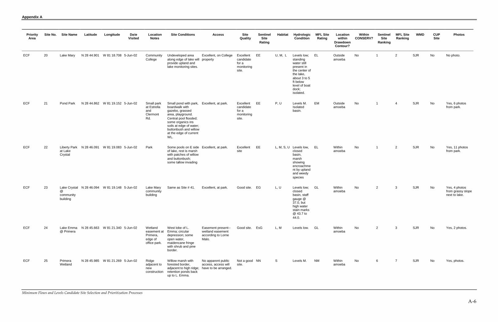
ECF ADAPTIVE MANAGEMENT DATABASEKEY TO COLUMNSNOTE: All cells should contain information unless otherwise noted here
Column Name Key to Descriptors, Comments
A Priority Area Name or acronym of priority area - ECF is the only area currently investigated
B Site No. All sites are numbered - there should be no empty cells
C Site Name Lake or marsh or other name identifier.
D Latitude NA - not collected
E Longitude NA - not collected
F Date Visted Empty cell indicates that the site was not visited - should be associated withNo in photos column
G Location notes Collected during site visit
H Site Conditions Information provided by site visit
I Access E -- Excellent - Open to the public - no restrictions
Es -- Public easement present (Pers. Comm Lorne Malo) but not "open topublic"
P -- Possible Easement (based on site visit)
N -- No Public Acess (based on site visit)
J Site Quality Rated through site visit and if site is used for CUP monitoring
E-- Excellent
V -- Very good
G - Good
O -- OK
M -- Marginal
N -- Not Good
CUP - In use as a CUP site - see Column CUP for Permit No. and Permitee
K Site Rating Two letters, referring to Access and Site Quality information, in that order.Information is drawn from Columns G and H. Exception is CUP entry
L Habitat L - lake; P - Pond; M-Marsh; S-Swamp; U - Upland
M Hydrology Isolated
Closed Basin (indicates multiple linked lakes)
Outflow present
Flow Through (inflow and outflow)
N Drawdown Coutour Yes / No
O In CONSERV Yes / No / Nearby Nearby indicates that it is very near the border ofCONSERV
P WMD SJR or SF - Indicates in which Water Management District the Lake Resides
Q CUP Yes/ No, CUP Permit No. Indicates that the site is a monitoring site for CUPPermit Compliance
R Photos Yes / No, Comments. Should list the number of photos and may provide otherinformation

Appendix A
Minimum Flows and Levels Candidate Site Selection and Prioritization Processes
A-2
Bay swamp at Red Bug Lake 1
Boardwalk at Red Bug Lake 1
Boat Ramp @ Lake Baldwin 1
Canal Inflow to Queens Mirror 1
Crooked Lake 4
Lake Baldwin 2
Lake Berry 1
Lake Florence 5
Lake Herrick 4
Lake Jeanie 1
Lake Jeanie Stormwater Pond 1
Lake Johio 2
Lake Julia 3
Lake Lucy 6
Lake Mizell 5
Lake North of Lake Hiawasee 8
Lake Virginia 2
Long Lake 13
Lost Lake 3
Mead Gardens 4
Metro West 5
Middle Triplet 2
North end of last headwater for Triplet 2
North Triplet 2
Park at Lake Baldwin 1
Pass between middle and North Triplet 1
Queens Mirror 2
Red Bug Lake 6
Red Bug Lake
Sherwood 12
Sherwood
Spring Lake 6
Turkey Lake 2
Weir Outflow of North of West Headwater Wetland for Triplet 2
West Headwater Wetland for Triplet 10
Winter Garden Area - OUC Site 6478 Wetland AM sites off Daniels Rd. 1

Appendix A
Minimum Flows and Levels Candidate Site Selection and Prioritization Processes
A-3
PriorityArea
Site No. Site Name Latitude Longitude DateVisited
LocationNotes
Site Conditions Access SiteQuality
SentinelSite
Rating
Habitat HydrologicCondition
MFL SiteRating
Locationwithin
DrawdownContour?
WithinCONSERV?
SentinelSite
Ranking
MFL SiteRanking
WMD CUPSite
Photos
ECF 1 LakeOrienta atLakeOrienta Park
N 28 39.118 W 81 22.867 4-Jun-02 In park atedge oflake,AltamonteSprings.
Small public park onBrinkley Avenueacross from FireStation 14. Most ofthe shoreline isdeveloped but not all.There may be enoughremnant vegetation toset some historiclevels. Features—boardwalk, parkinglot, 2 stormwaterponds, grassedareas.
Excellent, publicproperty at LakeOrienta Park, accessis good to the edge ofthe lake and to uplandgrassed areas.
Good site. EG L, U Levels M.Basinisolated.
GM Withinamoeba
No 2 4 SJR No Yes, from severallocations in park.
ECF 2 Marsh pondconnectedto LakeAdelaide
N 28 40.291 W 81 22.382 4-Jun-02 GPS inparking lotat edge ofmarsh
Marsh connected toL. Adelaide lying tosouthwest. Dominantspecies includewillow, cattail andsmartweed.
Possible easement--access from parkinglot, or maybe fromstormwater facility. Nopublic land.
Good siteif accesscan bearranged.
PG M, P Levels M;closed basin(Adelaide,Marion andFlorida).
GM Withinamoeba
No 4 4 SJR No Yes, fromapartmentcomplex (Villa delMar) lookingacross to hospital
ECF 3 Lake Marion N 28 40.731 W 81 21.992 4-Jun-02 Small stripof landbetweencurve inroad(Oakhurstand LakeAve.)
Dry basin with someresidual pools;houses surroundmost of the lake.
No apparent publicaccess. We did notfind a drainageeasement, but thatshould be checkedagain.
Good siteif accesscan bearranged.
NG L Levels M;closed basin(Adelaide,Marion andFlorida).
GM Withinamoeba
No 5 4 SJR No Yes, pan of 9 to10 shots
ECF 4 Lake Florida N 28 40.295 W 81 21.833 4-Jun-02 Drainageeasementon FloridaBlvd.
Connects to Adelaide. Possible easement--Access via drainageeasement. Small areabetween the road andthe edge of the lakecould be used.
Good siteif accesscan bearranged.
PG L Levels M;closed basin(Adelaide,Marion andFlorida).
GM Withinamoeba
No 4 4 SJR No Yes pan of 6.
ECF 5 LakeAdelaide
N 28 40.244 W 81 21.970 4-Jun-02 Swamp atnorth end offof Tropic HillSt.
Tallow on edge w/ redmaple, buttonbush,mixed shrub andemergent marshspecies. OUCMonitoring Site#3338.
No apparent publicaccess. We did notfind a drainageeasement, but thatshould be checkedagain. Access fromback of buildings onthe south side. Alsomay be access fromadjacent roads (FernPark Blvd. and OxfordRd.)
Good siteif accesscan bearranged.
CUP L Levels M;closed basin(Adelaide,Marion andFlorida).
GM Withinamoeba
No 7 4 SJR Permit#3159
Yes 3 photos

Appendix A
Minimum Flows and Levels Candidate Site Selection and Prioritization Processes
A-4
PriorityArea
Site No. Site Name Latitude Longitude DateVisited
LocationNotes
Site Conditions Access SiteQuality
SentinelSite
Rating
Habitat HydrologicCondition
MFL SiteRating
Locationwithin
DrawdownContour?
WithinCONSERV?
SentinelSite
Ranking
MFL SiteRanking
WMD CUPSite
Photos
ECF 6 LibraryWetland
N 28 39.731 W 81 20.108 4-Jun-02 Parking lotof centrallibrarySeminoleCounty.
Forested (hardwood)wetland.
Possible easement--Assume that libraryproperty extends intothe wetland. Areabetween the edge ofthe parking lot andthe wetland could beused.
Good siteif accesscan bearranged.
PG S Levels M. GM Edge ofamoeba
No 4 4 SJR No Yes, series of 6photos fromparking lot.
ECF 7 TripletLakes Parkat SecretLake Parkoff TripletLake Dr.
N 28 40.394 W 81 19.560 4-Jun-02 Park at theconnectionpointbetweenNorth andMiddleTripletLakes
Lakes with fringingwetlands.UnnumberedMonitoring Site.
Excellent, publicaccess to both lakesystems as well asthe canal connectionthe two.
Excellentsite.
CUP L, S,M,and U
Levels M.Flowthoughlake system,connects toGee Creekand then Lk.Jesup.
EM Edge ofamoeba
No 7 4 SJR Permit#3159
Yes, 3 photosfrom parking lot.
ECF 9 Clear Lakeoff Lake Dr.
N 28 40.224 W 81 17.676 4-Jun-02 Countyproperty onClear LakeDr.
Pool remaining in thelower portion, rest isbroomsedge withmixed grasses andsedges. About 75 ftof oak forest betweenroad and edge oflake/marsh. OUCMonitoring Site#3363.
OUC's list; Goodaccess, apparentlythe oak forest edge iscounty property. Thisshould be confirmed..This lake is on OUC'slist.
Excellent,on OUC'slist.
CUP L, M, andU
Levels low,3-4 feetbelow thehigh watermarks.
EL Withinamoeba
No 7 2 SJR Permit#3159
Yes, 6 photoswith pan of 5.
ECF 10 Lake Tony N 28 40.269 W 81 17.312 4-Jun-02 Near ClearLake. Cul-de-sac dusac onSweetwaterLane.
Only part of shorelineis developed.Forested border onpart of the E side..May be conservationarea next to SevilleChase.
No apparent publicaccess.
Marginalsite.
NM L Levels M.Closedbasin.
MM Withinamoeba
No 6 6 SJR No No photo.
ECF 11 Lake Tony N 28 40.263 W 81 17.313 4-Jun-02 Bird Roadalong Eside.
No apparent publicaccess.
Marginalsite.
NM L, S Levels M.Closedbasin.
MM Withinamoeba
No 6 6 SJR No No photo.
ECF 12 Lake HodgePark
N 28 41.400 W 81 19.253 4-Jun-02 Parkadjacent tothe lake.
Grassed areaadjacent to lake withgazebo. Residualpools of water in thelake basin, willowfringe in few places.
Excellent, accessfrom City park. Staffgauge at boardwalk.
Excellentsite
EE L, U, M Levels low,several feetbelow thehigh watermarks;isolated.
EL Edge ofamoeba
No 1 2 SJR No Yes, 9 photos ofplayground andpark and lake.
ECF 13 Myrtle Lake N 28 43.385 W 81 21.760 5-Jun-02 Twin LakeDr., at edgeof cul-de-sac du sac.
Dry bed; maidencane,sedges, dogfennel,buttonbush, willow; nostanding water;woodstorks and greategrets.
Possible easement--No direct publicaccess, but check oneasements. Mapshows park at thesouth end, but we didnot find it.
Good site;Lorneconsidersthis a goodsite formonitoring.
PG L, M Levels verylow, nostandingwater.Isolatedbasin
GVL Withinamoeba
No 4 2 SJR No Yes, pan of shotsN to S.

Appendix A
Minimum Flows and Levels Candidate Site Selection and Prioritization Processes
A-5
PriorityArea
Site No. Site Name Latitude Longitude DateVisited
LocationNotes
Site Conditions Access SiteQuality
SentinelSite
Rating
Habitat HydrologicCondition
MFL SiteRating
Locationwithin
DrawdownContour?
WithinCONSERV?
SentinelSite
Ranking
MFL SiteRanking
WMD CUPSite
Photos
ECF 14 GreenwoodLake Park
N 28 43.980 W 81 20.947 5-Jun-02 Upland siteat countypark
Upland park area. Excellent, countypark.
Not a goodsite.
EN U Upland site NU Withinamoeba
No 5 7 SJR No Yes, 1 photo fromthe road.
ECF 15 Big TreePark
N 28 43.228 W 81 19.905 5-Jun-02 Big TreePark andSpringHammockReserve.
Large forestedwetland area withSoldier Creek runningthrough on the W sideof L. Jesup.
Excellent, large publ icland holdings in thearea.
Good sitewithoutflow.
EG S, U Levels M toH; outflowwetlandsystemdraining toJesup.
GMH Edge ofamoeba
No 2 4 SJR No Yes, 6 photos atBig Tree Park.
ECF 16 SpringHammockPreserve
N 28 43.232 W 81 19.580 5-Jun-02 Big TreePark andSpringHammockReserve.
Large forestedwetland area withSoldier Creek runningthrough on the W sideof L. Jesup.
Excellent, large publicland holdings in thearea.
Good sitewithoutflow.
EG S, U Levels M toH; outflowwetlandsystemdraining toJesup.
GMH Outsideamoeba
No 2 4 SJR No No photo.
ECF 17 LakeBingham
N 28 44.284 W 81 18.617 5-Jun-02 South ofcommunitycollege,Lake roadon southside withsidewalkalong theedge of thelake.
Hypericum prairie upto the edge and downto the pool; waterlilies edge the pool,;central part of thebasin with standingwater.
No apparent publicaccess; access wouldhave to be arranged,but sidewalk runsalong the edge of thelake.
Good site. NG M, L Levels low,isolated,staff gauge.
GL Outsideamoeba
No 5 3 SJR No Yes, pan of 5photos fromsidewalk.
ECF 18 Lake Lee N 28 44.571 W 81 18.791 5-Jun-02 Pond to NWof L.Bingham,WoldunnSubd. On Eside.
Small lake (pond) insubdivision; residualstanding water, rest isgraminoid prairie;partial forestedborder, butresidentialdevelopment isongoing.
Possible easement--Stormwater pond insubd. abuts the pondon Woldunn Circle.
Good siteif accesscan bearranged.
PG P, M Levels low;standingwater stillpresent inthe center ofthe pond,about 3 to 5ft belowlevel of boatdock;isolated.
GL Outsideamoeba
No 4 3 SJR No Yes, 3 photos.
ECF 19 Lake Mary N 28 44.809 W 81 19.010 5-Jun-02 Drainageeasementon ClermontRd. SEcorner oflake.
North section of lake,broad section of thelittoral zone isexposed white sand.
Possible easement--drainage easement.
Good siteif accesscan bearranged.
PG L, M Levels low;standingwater stillpresent inthe center ofthe pond,about 3 to 5ft belowlevel of boatdock;isolated.
GL Outsideamoeba
No 4 3 SJR No Yes, 4 photosfrom shoreline.
Appendix A
Minimum Flows and Levels Candidate Site Selection and Prioritization Processes
A-6
PriorityArea
Site No. Site Name Latitude Longitude DateVisited
LocationNotes
Site Conditions Access SiteQuality
SentinelSite
Rating
Habitat HydrologicCondition
MFL SiteRating
Locationwithin
DrawdownContour?
WithinCONSERV?
SentinelSite
Ranking
MFL SiteRanking
WMD CUPSite
Photos
ECF 20 Lake Mary N 28 44.901 W 81 18.708 5-Jun-02 CommunityCollege
Undeveloped areaalong edge of lake willprovide upland andlake monitoring sites.
Excellent, on Collegeproperty
Excellentcandidatefor amonitoringsite.
EE U, M, L Levels low;standingwater stillpresent inthe center ofthe lake,about 3 to 5ft belowlevel of boatdock;isolated.
EL Outsideamoeba
No 1 2 SJR No No photo.
ECF 21 Pond Park N 28 44.862 W 81 19.152 5-Jun-02 Small parkat EstrellaandClermontRd.
Small pond with park,boardwalk withgazebo, grassedarea, playground.Central pool flooded;some organics inssoils at edge of water;buttonbush and willowat the edge of currentWL.
Excellent, at park. Excellentcandidatefor amonitoringsite.
EE P, U Levels M.Isolatedbasin.
EM Outsideamoeba
No 1 4 SJR No Yes, 6 photosfrom park.
ECF 22 Liberty Parkat LakeCrystal
N 28 46.091 W 81 19.083 5-Jun-02 Park Some pools on E sideof lake, rest is marshwith patches of willowand buttonbush;some tallow invading
Excellent, at park. Excellentsite
EE L, M, S, U Levels low,closedbasin,marshshowingencroachment by uplandand weedyspecies
EL Withinamoeba
No 1 2 SJR No Yes, 11 photosfrom park.
ECF 23 Lake Crystal@communitybuilding
N 28 46.094 W 81 19.148 5-Jun-02 Lake Marycommunitybuilding
Same as Site # 41. Excellent, at park. Good site. EG L, U Levels low;closedbasin, staffgauge @37.0, buthigh waterstain marks@ 43.7 to44.0.
GL Withinamoeba
No 2 3 SJR No Yes, 4 photosfrom grassy slopenext to lake.
ECF 24 Lake Emma@ Primera
N 28 45.663 W 81 21.340 5-Jun-02 Wetlandeasement atPrimera,edge ofoffice park.
West lobe of L.Emma; circulardepression; someopen water,maidencane fringewith shrub and pineborder.
Easement present--wetland easementaccording to LorneMalo.
Good site. EsG L, M Levels low. GL Withinamoeba
No 2 3 SJR No Yes, 2 photos.
ECF 25 PrimeraWetland
N 28 45.985 W 81 21.269 5-Jun-02 Ridgeadjacent tonewconstruction
Willow marsh withforested border,adjacent to high ridge;retention ponds backup to L. Emma.
No apparent publicaccess, access willhave to be arranged.
Not a goodsite.
NN S Levels M. NM Withinamoeba
No 6 7 SJR No Yes, photos.

Appendix A
Minimum Flows and Levels Candidate Site Selection and Prioritization Processes
A-7
PriorityArea
Site No. Site Name Latitude Longitude DateVisited
LocationNotes
Site Conditions Access SiteQuality
SentinelSite
Rating
Habitat HydrologicCondition
MFL SiteRating
Locationwithin
DrawdownContour?
WithinCONSERV?
SentinelSite
Ranking
MFL SiteRanking
WMD CUPSite
Photos
ECF 26 AlaquaWetland @Legacy HillsCourt
N 28 45.513 W 81 23.540 5-Jun-02 Cul-de-sacdu sac areaon LegacyHills Court
forested wetlandcypress mixedhardwoods, withwillow and buttonbushon interior, somestanding waterpresent withduckweed cover (seephotos)
No apparent publicaccess, access willhave to be arranged.
OK site ifaccesscan bearranged.
NO S Levels M.Alteredhydrology--Lorne Malosaid that 10years agothe wetlandhad a closedcanopy, nowcanopyopen withdead trees.
OM Edge ofamoeba
No 6 5 SJR No Yes, 2 photos.
ECF 27 AlaquaWetland @AshtonOaks
N 28 45.354 W 81 23.500 5-Jun-02 AshtonOaks cul dusac.
Slough with golf carttrail, near the tee forhole #3.
No apparent publicaccess, access willhave to be arranged.
OK site ifaccesscan bearranged.
NO S Levels M. OM Edge ofamoeba
No 6 5 SJR No Yes, 2 photos.
ECF 28 AlaquaWetland @SterlingRidge Courtand AlaquaLakes Blvd.
N 28 45.354 W 81 23.646 5-Jun-02 SterlingRidge Ct. &AlaquaLakes Blvd.
Small cypress mixedhardwood wetland.
No apparent publicaccess, access willhave to be arranged.
OK site ifaccesscan bearranged.
NO S Levels M. OM Edge ofamoeba
No 6 5 SJR No No photo.
ECF 29 AlaquaWetland @SterlingRidge Courtcul du sac
N 28 45.186 W 81 23.706 5-Jun-02 SterlingRidge Ct.cul du sac atS end.
Small cypress mixedhardwood wetland.
No apparent publicaccess, access willhave to be arranged.
OK site ifaccesscan bearranged.
NO S Levels M. OM Outsideamoeba
No 6 5 SJR No No photo.
ECF 30 AlaquaWetland @Park GroveCourt andAlaquaLakes Blvd.
N 28 45.299 W 81 23.535 5-Jun-02 Park GroveCt. & AlaquaLakes Blvd.
Small cypress mixedhardwood wetland.
No apparent publicaccess, access willhave to be arranged.
OK site ifaccesscan bearranged.
NO S Levels M. OM Edge ofamoeba
No 6 5 SJR No No photo.
ECF 31 AlaquaWetland @New GateLoop andSnowfieldsRun
N 28 45.873 W 81 23.330 5-Jun-02 New GateLoop &SnowfieldsRun.
Powerline crossing;mixed hardwoodforested wetland withorganic soils.
Possible easement--Access would have tobe arranged, but likelycan be arranged viathe R.O.W.
Good site. PG S Levels M. GM Edge ofamoeba
No 4 4 SJR No Yes, 3 photos.
ECF 32 Lake NearSylvan
N 28 45.829 W 81 23.308 5-Jun-02 MarkhamWoodsRoad.
Unnamed small lakeconnected to Sylvan;natural vegetationalong borders.
No apparent publicaccess, access willhave to be arranged.
OK site ifaccesscan bearranged.
NO L Levels L toM. Isolated,small lake.
OML Edge ofamoeba
No 6 5 SJR No Yes, 2 photos.
ECF 33 LakeMarkham
N 28 48.018 W 81 23.871 5-Jun-02 L. MarkhamPreservesubdiv.
Subdivision underdevelopment, soeventually theshoreline will bealtered;
Easement --Publicaccess is not good,but Lorne Malo saysthat there might belakefront conservationeasement.
Good siteif accesscan bearranged.
EsG L Levels low,water levels4 to 5 ftbelow highwatermarks.
GL Outsideamoeba
No 2 3 SJR No Yes, 3 photos.

Appendix A
Minimum Flows and Levels Candidate Site Selection and Prioritization Processes
A-8
PriorityArea
Site No. Site Name Latitude Longitude DateVisited
LocationNotes
Site Conditions Access SiteQuality
SentinelSite
Rating
Habitat HydrologicCondition
MFL SiteRating
Locationwithin
DrawdownContour?
WithinCONSERV?
SentinelSite
Ranking
MFL SiteRanking
WMD CUPSite
Photos
ECF 34 Sylvan LakePark--parking lot
N 28 48.066 W 81 23.152 5-Jun-02 Lake SylvanPark
Upland area atparking lot and playground.
Excellent, at park.Also other smallisolated wetlands inthe park.
Excellentsite!
EE M, L, U Levels low,closedbasin,organic soilsin marsh stillsaturated.
EL Edge ofamoeba
No 1 2 SJR No No photo.
ECF 35 Sylvan LakePark--marsh
N 28 48.048 W 81 23.062 5-Jun-02 Lake SylvanPark
Boardwalk throughmarsh with organicsoils, water stillpresent in low spots.
Excellent, at park.Also other smallisolated wetlands inthe park.
Excellentsite!
EE M, L, U Levels low,closedbasin,organic soilsin marsh stillsaturated.
EL Edge ofamoeba
No 1 2 SJR No Yes, 5 photos.
ECF 36 Sylvan LakePark--edgeof lake
N 28 48.040 W 81 23.026 5-Jun-02 Lake SylvanPark
Boardwalk at edge oflake with water lilyzone with fringingsawgrass; organicsoils still saturated.
Excellent, at park.Also other smallisolated wetlands inthe park.
Excellentsite!
EE L, M, U Levels low,closedbasin,organic soilsin marsh stillsaturated.
EL Edge ofamoeba
No 1 2 SJR No Yes, 4 photos.
ECF 37 YankeeLake
N 28 49.053 W 81 23.742 5-Jun-02 SeminoleCountyspraysite.
Lake at edege ofspray field
Excellent, this iscounty property.
Marginalsite,hydrologyis affectedby thereclaimedwaterapplications.
EM L, U Levels M toH; levelshigher thanother lakesin the area.Lake levelsareinfluencedbyapplicationson thesprayfield.
MMH Outsideamoeba
No 5 6 SJR No Yes, 3 photos.
ECF 38 WetlandWest OfYankeeLake
N 28 49.195 W 81 24.017 5-Jun-02 Immediatelywest ofSeminoleCountyspraysite.
Marsh to west ofentrance road to thespray site.
Excellent, appears tobe public land.
Good site,thoughhydrologymay beinfluencedby spraysite.
EG M, U Water levelsnotdetermined.Assume M.
GM Outsideamoeba
No 2 4 SJR No Yes, 2 photosfrom road.
ECF 39 LowerWekivaSawgrassMarsh
N 28 49.492 W 81 24.150 5-Jun-02 NW ofcountyspraysiite inLowerWekiva R.Preserve.
Sawgrass marsh tothe W and NW of theNW corner of thecounty property.
Excellent, public land. Excellentsite.
EE M, U Water levelsnotdetermined.Assume M.
EM Outsideamoeba
No 1 4 SJR No No photo.
ECF 40 Ross Lake N 28 48.537 W 81 23.852 5-Jun-02 Ross LakeShoresSubd.
South of countyreclamation facility,some residual poolswith water lilies,organic soils startingto fissure
Possible easement--May be drainageeasement on theedge of lake, justbefore the cul du sac,confirm this.
Good siteif accesscan bearranged.
PG L, M, U Levels verylow.
GVL Outsideamoeba
No 4 2 SJR No Yes, 5 photosfrom edge ofmarsh.

Appendix A
Minimum Flows and Levels Candidate Site Selection and Prioritization Processes
A-9
PriorityArea
Site No. Site Name Latitude Longitude DateVisited
LocationNotes
Site Conditions Access SiteQuality
SentinelSite
Rating
Habitat HydrologicCondition
MFL SiteRating
Locationwithin
DrawdownContour?
WithinCONSERV?
SentinelSite
Ranking
MFL SiteRanking
WMD CUPSite
Photos
ECF 41 CrystalLake@CommunityBuilding
N 28 45.713 W 81 19.418 5-Jun-02 AtCommunityBldg.
Same as Site # 23.Upland area extendsdown to lake
Excellent, city ownedproperty.
Excellentsite
EE U, L Levels low,closedbasin, staffgauge @37.0, buthigh waterstain marks@ 43.7 to44.0.
EL Withinamoeba
No 1 2 SJR No Yes, 4 photosfrom grassy slopenext to lake.
ECF 42 CrystalLake@Wesley Park
N 28 45.597 W 81 19.995 5-Jun-02 Wesley Park Parking and picnicareas, grassed areasloping down to lake;staff gauge; sandhillcranes.
Excellent, city ownedproperty.
Excellentsite
EE U, L Levels low,closedbasin, staffgauge @37.0, buthigh waterstain marks@ 43.7 to44.0.
EL Withinamoeba
No 1 2 SJR No Yes, series of 12photos.
ECF 43 LakeConcord@AnniversaryPark
N 28 40.355 W 81 20.175 6-Jun-02 AnniversaryPark inCasselberry.
S. end of lakeConcord inCasselberry; grassedarea extends to edgeof lake;
Excellent, city ownedproperty.
Good site. EG U,L Levels M,within 3 ft oftop of boatdocks.Check ifdrainagewell ispresent.
GM Edge ofamoeba
No 2 4 SJR No Yes, 5 photosfrom park andedge of lake.
PriorityArea
Site No. Site Name Latitude Longitude Date Visited LocationNotes
Site Conditions Access SiteQuality
SentinelSite Rating
Habitat HydrologicCondition
MFL SiteRating
LocationwithinDrawdownContour?
WithinCONSERV?
SentinelSiteRanking
MFL SiteRanking
WMD CUPSite
Photos
ECF 44 QuailPond@AnniversaryPark
N 28 40.292 W 81 20.114 6-Jun-02 AnniversaryPark inCasselberry.
Pond south of L.Concord inCasselberry; grassedarea extends to edgeof lake;
Excellent, city ownedproperty.
Good site. EG U,L Levels H,within 1.5 ftof highwater markson boatdocks.
GH Edge ofamoeba
No 2 4 SJR No Yes, 3 photosfrom grassedslope adjacent topond.
ECF 45 LakeWildmere
N 28 41.875 W 81 20.100 6-Jun-02 Casselberryarea, southof CR434.
Two connected lakes,Wildemere andEvergreen.
Possible easement--access via DOTeasement on edge ofL. Evergreen alongCR 434.
OK site ifaccesscan bearranged.
PO L Levels M toH,connectedto theTriplet/GeeCreeksystem.
OMH Withinamoeba
No 5 5 SJR No Yes, 5 photosfrom E side ofDOT ROW.

Appendix A
Minimum Flows and Levels Candidate Site Selection and Prioritization Processes
A-10
PriorityArea
Site No. Site Name Latitude Longitude DateVisited
LocationNotes
Site Conditions Access SiteQuality
SentinelSite
Rating
Habitat HydrologicCondition
MFL SiteRating
Locationwithin
DrawdownContour?
WithinCONSERV?
SentinelSite
Ranking
MFL SiteRanking
WMD CUPSite
Photos
ECF 46 LakeYvonne(Quintuplet)
N 28 40.171 W 81 18.897 6-Jun-02 N. ofQuintupletDrive,Casselberry.
L. Yvonne, the largestof the Qunitupletlakes, swamp andmarsh complexbordering the part ofthe lake. Bayswampon south side showsexcessive oxidation oforganic soil (seephotos).
Possible easement--Drainage easementfrom the road to thelake, passes througha bayhead beforereaching the lake.
Good siteif accesscan bearranged.
PG S, M, L Levels verylow, site withalteredhydrology,oxidizedorganic soilsin thebayhead.Treesfalling, soilsreceding,rootsexposed.
GVL Edge ofamoeba
No 4 2 SJR No Yes, 6 photosfrom bayswampand edge of lake.
ECF 47 Crystal Bowl N 28 39.897 W 81 18.772 6-Jun-02 Casselberryarea, to E ofWinter ParkDrive.
Difficult to see thelake, surrounded bysingle familyresidences.
Possible Easement--Drainage easementnear intersection ofCrystal Bowl withGuinevere.
OK site ifaccesscan bearranged.
PO L Levels M. OM Withinamoeba
No 5 5 SJR No No photo.
ECF 48 Crystal BowlPark
N 28 39.723 W 81 18.801 6-Jun-02 Casselberryarea, to E ofWinter ParkDrive.
Small park area onCrystal Bowl Circle,with open stand oflong leaf pine, turkeyoak and olive oak.
Excellent, city ownedupland property.
Good siteif uplandwell clustercould bepaired withstaff gaugeand wellon thelake.
EU U Upland site. GU Withinamoeba
No 3 7 SJR No Yes, 3 photosfrom road.
ECF 49 Dew DropPark
N 28 39.756 W 81 18.560 6-Jun-02 Casselberryarea, E ofCrystalBowl.
Good size park areabordering the lake; noshoreline littoralvegetation on thisisolated lake.
Excellent, city ownedproperty.
Excellentsite
EE U, L Levels M,within 2 ft ofwater stainmarks;isolated.
EM Withinamoeba
No 1 4 SJR No Yes, 6 photosfrom park at edgeof lake.
ECF 50 LakeKathryn
N 28 40.995 W 81 19.979 6-Jun-02 SE corner ofintersectionof Seminola& 17/92.
Unpaved parking areaat edge of lake, checkto see if it is a publicaccess.
No apparent publicaccess, access willhave to be arranged.
Marginalsite.
NM L Notdetermined.
MN Edge ofamoeba
No 6 6 SJR No No photo.
ECF 51 Lake Searcy@SandalwoodPark
N 28 42.357 W 81 21.502 6-Jun-02 E. of RangeLine Rd, N.end ofLongwood.
Small park inSandalwood subd.;powerline ROWcrosses back end ofpark; thicket of redmaple, willow andbay, assume thicketextends down to thelake, but lake is notvisible from the park.
No apparent publicaccess; access notclear, needs followup. Lake andbordering wetlandmay be accessiblefrom the park or thepowerline ROW..
OK site ifaccesscan bearranged.
NO U, L, S Levels M. OM Withinamoeba
No 6 5 SJR No Yes, 3 photosfrom SandalwoodPark.

Appendix A
Minimum Flows and Levels Candidate Site Selection and Prioritization Processes
A-11
PriorityArea
Site No. Site Name Latitude Longitude DateVisited
LocationNotes
Site Conditions Access SiteQuality
SentinelSite
Rating
Habitat HydrologicCondition
MFL SiteRating
Locationwithin
DrawdownContour?
WithinCONSERV?
SentinelSite
Ranking
MFL SiteRanking
WMD CUPSite
Photos
ECF 52 Range LineRoadWetland
N 28 42.106 W 81 21.738 6-Jun-02 Wetland onW. side ofRange LineRd, N. of CR434.
Emergent marsh withpocket of shrub andbay thicket; sandhillcranes.
No apparent publicaccess; wetlandadjacent to the road,so access might bevia the ROW forRange Line Rd.
Good siteif accesscan bearranged.
NG M, P Levels low,no standingwatervisible;water markson willow at2 ft abovesoil surface;wetlandreceivesstormwaterinflows.
GL Withinamoeba
No 5 3 SJR No Yes, pan of 6photos from road.
ECF 53 Island Lake N 28 41.733 W 81 21.659 6-Jun-02 Largewetland
Large wet prairiesystem withinterspersed treeislands'Rhynchospora andEleocharis; bayheadisland; peat soils inprairie saturated butnot flooded.
Possible easement--No clear publicaccess, howeverparking areas androads border thewetland, sostormwater facilitiesmay provide access.
Excellentsite ifaccesscan bearranged.
PE M, S Levels L toM, peat soilsin the prairiesaturatedbut notflooded.
EML Withinamoeba
No 3 3 SJR No Yes, 5 photosfrom NE edge.
ECF 54 Island Lakeat borrow pit
N 28 41.721 W 81 21.605 6-Jun-02 Borrow pit atnorth centralend ofwetland, atedge ofparking lot.
Borrow pit at northcentral end ofwetland, at edge ofparking lot.
No apparent publicaccess, access willhave to be arranged.
Good sitein wetland.
NG P, M Levels L toM.
GML Withinamoeba
No 5 4 SJR No Yes, 2 photosfrom N end.
ECF 55 Lake DotPark
N 28 44.997 W 81 17.190 6-Jun-02 Lake DotPark, E. of17/92, S. ofLk. MaryBlvd.
Small circular lakewith grassed area in aresidentialneighborhood; littlehabitat value.
Excellent, city ownedproperty.
Marginalsite, lowhabitatvalue.
EM L Levels H.Stormwaterinlets fromsurroundingneighborhood.
MH Outsideamoeba
No 5 6 SJR No Yes, 4 photosfrom grassedarea next to lake.
ECF 56 ChaseGrovesSwamp,Sanfordarea.
N 28 47.156 W 81 17.999 6-Jun-02 At SWcorner of SR46A and CR417,W.Sanford.
Large forestedwetland, headwatertype; Magnolia, Acer,Nyssa; organic soils,18+ inches deep atedge near road; alsounderstory ofbuttonbush, royalfern, cinnamon fern,pickerelweed andduck-potato.
Possible easement--Lorne Malo says thatthere may be aconservationeasement formitigation; or accessvia DOT ROW.
Excellentsite ifaccesscan beworkedout.
PE S Levels L toM, organicsoilssaturated,but nostandingwater
EML Edge ofamoeba
No 3 3 SJR No Yes, 4 photosfrom roadsideedge of swamp.
ECF 57 LakesDeforestand Belaire,Sanfordarea.
N 28 46.863 W 81 18.556 6-Jun-02 CanalconnectingBelaire andDeforest.
Most of shorelinedeveloped.
Possible drainageeasement, swale inbackyards catcheswater before popoffinto lake.
Good siteif accesscan bearranged.
PG L, M Levels L toM, 3 to 4below watermarks onboat docks.
GML Edge ofamoeba
No 4 4 SJR No Yes, 5 photos.

Appendix A
Minimum Flows and Levels Candidate Site Selection and Prioritization Processes
A-12
PriorityArea
Site No. Site Name Latitude Longitude DateVisited
LocationNotes
Site Conditions Access SiteQuality
SentinelSite
Rating
Habitat HydrologicCondition
MFL SiteRating
Locationwithin
DrawdownContour?
WithinCONSERV?
SentinelSite
Ranking
MFL SiteRanking
WMD CUPSite
Photos
ECF 58 Golden Lake@ SanfordAirport
N 28 46.166 W 81 14.352 6-Jun-02 South sideof Sanfordairport.
Lake at south end ofSanford airportproperty.
Possible easement--lake looks to be onairport property, so itmay be accessible.
OK site. PO L Level M OM Outsideamoeba
No 5 5 SJR No No photo.
ECF 59 Wetland atNorth LakeJesup
N 28 45.599 W 81 12.795 6-Jun-02 North LakeJesupConservation Area, E. ofCameronAve. S. ofSR 46
Some isolated,forested wetlands onproperty.
Excellent, SJRWMDproperty.
Excellentsite,SJRWMDproperty.Otherwetlandsmay bepresent.
EE S, U Levels M. EM Outsideamoeba
No 1 4 SJR No Yes, 2 photosfrom roadside.
ECF 60 Red RootMarsh atGeneva
N 28 44.941 W 81 07.947 6-Jun-02 E. side ofSR 46, W. ofSong BirdTrail; NW ofGeneva.
Small, redroot marshnext to SR 46.Isolated.
No apparent publicaccess, access willhave to be arranged.
OK site ifsmallisolatedwetland isneeded.
NO M Levels L toM; nostandingwaterpresent.
OML Outsideamoeba
No 6 5 SJR No No photo.
ECF 61 LakeGeneva
N 28 44.725 W 81 06.646 6-Jun-02 L. GenevaRd. & CulverWay
North lobe of the lake;water lily marsh;uplands are sand pinescrub.
No apparent publicaccess, access willhave to be arranged.
Good siteif accesscan bearranged.
NG L, M, U Levels low. GL Outsideamoeba
No 5 3 SJR No Yes, 2 photos.
ECF 62 Harts Lake N 28 45.118 W 81 06.847 6-Jun-02 N. of L.Geneva onHart Rd.
Large lot residencesborder part of lake; farside (W.) shoreline isundeveloped.
No apparent publicaccess, access willhave to be arranged.
Good siteif accesscan bearranged.
NG L, M, U Levels L toM, standingwaterpresent 4 to5 belowwater markson boatdock.
GML Outsideamoeba
No 5 4 SJR No Yes, 3 photosfrom roadside.
ECF 63 Flatwoodspond at LkProctorWildernessArea
N 28 43.638 W 81 06.040 6-Jun-02 Lake ProctorWildernessArea,Geneva.
Isolated wetland onWhite Trail. Smallflatwoods depression,marsh with red-rootand maidencane; withdogfennel cover, fromseedbank.
Excellent, countypark.
Excellentsite,countyparkproperty.Otherwetlandsarepresent ontheproperty.
EE M, U Levels low,no standingwater;dogfennelcover fromseedbank.
EL Outsideamoeba
No 1 2 SJR No No photo.

Appendix A
Minimum Flows and Levels Candidate Site Selection and Prioritization Processes
A-13
PriorityArea
Site No. Site Name Latitude Longitude DateVisited
LocationNotes
Site Conditions Access SiteQuality
SentinelSite
Rating
Habitat HydrologicCondition
MFL SiteRating
Locationwithin
DrawdownContour?
WithinCONSERV?
SentinelSite
Ranking
MFL SiteRanking
WMD CUPSite
Photos
ECF 64 Lake Proctormarsh
N 28 43.741 W 81 06.123 6-Jun-02 Lake Proctorin LPWA,Geneva.
Levels L, residualpools in lowest areas,remaining areas areemergent marsh andprairie with scatteredshrub thicket;maidencaneSacciolepis, red-root,water lily andspadderdock.
Excellent, countypark.
Excellentsite,countyparkproperty.Otherwetlandsarepresent ontheproperty.
EE M, L, U Levels low,residualpools inlowestareas,remainingareas areemergentmarsh andprairie.Monitor wellnearentrance topark.
EL Outsideamoeba
No 1 2 SJR No Yes, 1 photo.
ECF 65 GenevaWildernessArea--
N 28 42.396 W 81 07.570 6-Jun-02 GWA,CountyPark.
Isolated flatwoodspond; water lilies andstanding water incenter of pond;maidencane andmixed emergentsupslope; dogfenneland broomsedge upto the pine edge.
Excellent, countypark.
Excellentsite,countyparkproperty.Otherwetlandsarepresent ontheproperty.
EE P, M, U Levels low,residualpools inlowestareas,remainingareas areemergentmarsh andprairie, levelbelow staffgauge, butestimatelevel at 22.5ft, watermarks at23.5, pineedge at 24to 25 ft.
EL Outsideamoeba
No 1 2 SJR No Yes, pan of 6photos.
ECF 66 Little/BigEcon--wetland
N 28 41.234 W 81 06.920 6-Jun-02 Isolateddepressionalwetland atentrancearea atSnowhill Rd.
Lorne says that thiswetland is include inthe state wetlanddelineation manual.Other wetlands are onthe property.
Excellent, SJRWMDproperty.
Excellentsite,SJRWMDproperty.Otherwetlandsmay bepresent.
EE M, P Levels L toM; nostandingwaterpresent.
EML Outsideamoeba
No 1 3 SJR No Yes, 3 photos atentrance area.
ECF 67 Lake MillsPark
N 28 37.956 W 81 07.304 6-Jun-02 Lake MillsPark,Chuluota.
Forested uplandareas, cypress borderto lake, and largeblackwater lake.
Excellent, countypark.
Excellentsite,countyparkproperty.Largeuplandarea.Other maywetlandsarepresent ontheproperty.
EE U, L, S Levels M toH, 2 ft belowthe highwater lineson borderingcypresstrees. Lakehas inflow(L. Pickett)and outflow(Mills Creek)
EMH Outsideamoeba
No 1 4 SJR No Yes, 9 photos.

Appendix A
Minimum Flows and Levels Candidate Site Selection and Prioritization Processes
A-14
PriorityArea
Site No. Site Name Latitude Longitude DateVisited
LocationNotes
Site Conditions Access SiteQuality
SentinelSite
Rating
Habitat HydrologicCondition
MFL SiteRating
Locationwithin
DrawdownContour?
WithinCONSERV?
SentinelSite
Ranking
MFL SiteRanking
WMD CUPSite
Photos
ECF 68 Mirror Lake N 28 40.080 W 81 26.293 13-Jun-02 Apartmentsnext to CR436.
Boardwalk withresidual wetlandtrees. Water levels L,houses along most ofthe shoreline.
Possible easement--Lorne Malo says thatthere may be aconservationeasement; this shouldbe confirmed.
Good siteif accesscan bearranged.
PG L Levels low,4 + ft belowwater markson dock,lichen linealso visibleon some ofthe fringingtrees. Hasan outflowthat appearsto connectto LittleEcon.
GL Withinamoeba
No 4 3 SJR No Yes, 3 photos.
ECF 69 Bear Lakes N 28 38.563 W 81 26.677 13-Jun-02 Bear LakeWoodsSubd.; E. ofUS 441, andS. CR 436(SemoranBlvd.)
Three lakes (Bear,Little, and Cub),drainage easement insubd., Jessica Dr.Extends down to lake,wide flat retentionbasin, about 200 ftwide; anotherstormwater basin,across street to S.
Possible easement--Drainage easementsat stormwaterfacilities, confirm.
Good siteif accesscan bearranged.
PG L Levels M toH in all threelakes, watermarks ondock at 1 ftabovecurrentlevel. Lakesconnectedtogether andtheneventually tothe LittleWekiva R.
GMH Withinamoeba
No 4 4 SJR No Yes, 3 photos.
ECF 70 Border Lake N 28 40.186 W 81 27.710 13-Jun-02 Next toSprint officebuilding on436
open water with fringeof willow andelderberry.
Possible easement--Retention areaadjacent to lake atoffice parking lot;there may bedrainage easement.
Marginalsite.
PM L Levels low.L. Maloestimatedthat currentlevel 4 + ftbelow highwater mark.
ML Withinamoeba
No 6 6 SJR No Yes, 3 photos.

Appendix A
Minimum Flows and Levels Candidate Site Selection and Prioritization Processes
A-15
PriorityArea
Site No. Site Name Latitude Longitude DateVisited
LocationNotes
Site Conditions Access SiteQuality
SentinelSite
Rating
Habitat HydrologicCondition
MFL SiteRating
Locationwithin
DrawdownContour?
WithinCONSERV?
SentinelSite
Ranking
MFL SiteRanking
WMD CUPSite
Photos
ECF 71 Lake Prevatt N 28 42.535 W 81 29.296 13-Jun-02 WekivaSpringsState Park,N. of WelchRd.
Basin nearly dry, nostanding water,herbaceous emergentmarsh; uplands havelive oak edge andgrade uphill intosandhill. It is likelythat there are otherwetland and aquaticsites in the park thatmay be suitable foruse as monitoringsites.
Excellent, State Park. Excellentsite, statepark.Uplandandwetlandareasavailablele.
EE L,U, M Levels verylow ( belowthe min.infreq.Low???), nostandingwaterpresent,peat in deepisdesiccated,cracked;blocks ofpeat havebeenreflectedand moved(seephotos).There issmalltributaryinflow, andan outflow tothe north,CarpenterBranch.
EVL Outsideamoeba
No 1 1 SJR No Yes, 9 photos.
ECF 72 Sand LakePond
N 28 43.320 W 81 28.291 13-Jun-02 WekivaSpringsState Park,N. of WelchRd.
Small blackwaterpond in park; waterlevels H. It is likelythat there are otherwetland and aquaticsites in the park thatmay be suitable foruse as monitoringsites.
Excellent, State Park. Excellentsite, statepark.Uplandandwetlandareasavailablele.
EE L, U Levels H,within 0.5 ftof top ofbank.
EH Outsideamoeba
No 1 4 SJR No Yes, 11 photos.
ECF 73 Lake Caroni(Caronia)
N 28 42.143 W 81 29.607 13-Jun-02 WekivaWoodssubd., S. ofLk. Prevatt.
Cul du sac largeretention basinextends to edge oflake basin. Basin dry,seedbank responseseen in the waves ofdogfennel.
Possible easement--Drainage easementsat the stormwaterfacilities, confirm.
Excellentsite ifaccesscan bearranged.
PE L, M Levels verylow, nostandingwater, likePrevatt.Rust stainson chain-linkfence atsame levelas the toe ofslope ofretentionarea berm.On topomap it lookslike lakemay connectto McCoy athigh stage,and outflowto Prevatt.
EVL Edge ofamoeba
No 3 1 SJR No Yes, 9 photos.
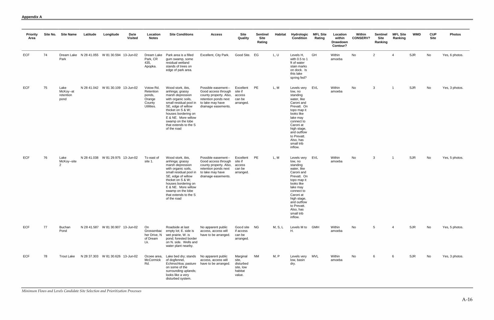
Appendix A
Minimum Flows and Levels Candidate Site Selection and Prioritization Processes
A-16
PriorityArea
Site No. Site Name Latitude Longitude DateVisited
LocationNotes
Site Conditions Access SiteQuality
SentinelSite
Rating
Habitat HydrologicCondition
MFL SiteRating
Locationwithin
DrawdownContour?
WithinCONSERV?
SentinelSite
Ranking
MFL SiteRanking
WMD CUPSite
Photos
ECF 74 Dream LakePark
N 28 41.055 W 81 30.594 13-Jun-02 Dream LakePark, CR435,Apopka.
Park area is a filledgum swamp, someresidual wetlandstands of trees onedge of park area.
Excellent, City Park. Good Site. EG L, U Levels H,with 0.5 to 1ft of waterstain markson dock. Isthis lakespring fed?
GH Withinamoeba
No 2 4 SJR No Yes, 6 photos.
ECF 75 LakeMcKoy--atretentionpond
N 28 41.042 W 81 30.109 13-Jun-02 Votow Rd.Retentionponds,OrangeCountyUtilities.
Wood stork, ibis,anhinga; grassymarsh depressionwith organic soils,small residual pool inSE, edge of willowthicket on S & W;houses bordering onE & NE. More willowswamp on the lobethat extends to the Sof the road
Possible easement--Good access throughcounty property. Also,retention ponds nextto lake may havedrainage easements.
Excellentsite ifaccesscan bearranged.
PE L, M Levels verylow, nostandingwater, likeCaroni andPrevatt. Ontopo map itlooks likelake mayconnect toCaroni athigh stage,and outflowto Prevatt.Also, hassmall tribinflow.
EVL Withinamoeba
No 3 1 SJR No Yes, 3 photos.
ECF 76 LakeMcKoy--site2
N 28 41.038 W 81 29.975 13-Jun-02 To east ofsite 1.
Wood stork, ibis,anhinga; grassymarsh depressionwith organic soils,small residual pool inSE, edge of willowthicket on S & W;houses bordering onE & NE. More willowswamp on the lobethat extends to the Sof the road
Possible easement--Good access throughcounty property. Also,retention ponds nextto lake may havedrainage easements.
Excellentsite ifaccesscan bearranged.
PE L, M Levels verylow, nostandingwater, likeCaroni andPrevatt. Ontopo map itlooks likelake mayconnect toCaroni athigh stage,and outflowto Prevatt.Also, hassmall tribinflow.
EVL Withinamoeba
No 3 1 SJR No Yes, 5 photos.
ECF 77 BuchanPond
N 28 41.587 W 81 30.907 13-Jun-02 OnGrossenbacher Drive, Nof DreamLk.
Roadside at lastempty lot; E. side iswet prairie, W. ispond; forested borderon N. side. Wells andwater plant nearby.
No apparent publicaccess, access willhave to be arranged.
Good siteif accesscan bearranged.
NG M, S, L Levels M toH.
GMH Withinamoeba
No 5 4 SJR No Yes, 5 photos.
ECF 78 Trout Lake N 28 37.303 W 81 30.626 13-Jun-02 Ocoee area,McCormickRd.
Lake bed dry; standsof dogfennel,Echinochloa; pastureon some of thesurrounding uplands;looks like a verydisturbed system.
No apparent publicaccess, access willhave to be arranged.
Marginalsite,disturbedsite, lowhabitatvalue.
NM M, P Levels verylow, basindry.
MVL Withinamoeba
No 6 6 SJR No Yes, 3 photos.

Appendix A
Minimum Flows and Levels Candidate Site Selection and Prioritization Processes
A-17
PriorityArea
Site No. Site Name Latitude Longitude DateVisited
LocationNotes
Site Conditions Access SiteQuality
SentinelSite
Rating
Habitat HydrologicCondition
MFL SiteRating
Locationwithin
DrawdownContour?
WithinCONSERV?
SentinelSite
Ranking
MFL SiteRanking
WMD CUPSite
Photos
ECF 79 Prairie Lake@ retentionpond
N 28 35.574 W 81 30.793 13-Jun-02 Ocoee off ofClark Rd.Prairie Lakeoff Clark Rd.
Retention pondsbetween Clark Rd.and lake; staff gaugeat edge of retentionpond; shallow areashave standing deadstalks of previousyear's dogfennel,deeper area havecover of grasses andsedges, no standingwater visible; housesline the NE and SE,land on the W isbeing cleared fordevelopment. OUCmonitoring site #4871.
Possible easement--Access from retentionponds, check fordrainage easement.
Good siteif accesscan bearranged.
CUP M, L Levels verylow, basindry.
GVL Withinamoeba
No 7 2 SJR Permit#3159
Yes, 8 photos.
ECF 80 LakeSydney(LakeMeadows)
N 28 35.486 W 81 31.123 13-Jun-02 S. section ofMeadow Lk.,W. of ClarkeRd., Ocoee.
City land to NE ofWWTP; adjacent tofiring range; opencleared area next towillow thicket; somestanding waterpresent in thicket upto edge of the fillarea. Topo showsnorth end of basinhas been excavated.
Excellent accessfrom City property.
OK, butsiteexcavated.
EO S, L Levels M. OM Withinamoeba
No 4 5 SJR No Yes, 5 photos.
ECF 81 Lake Tiny--site 1
N 28 35.298 W 81 28.074 14-Jun-02 Indian HillRd., nearHorseshoe
Dry basin except for apond area that maybe excavated.
No apparent publicaccess, access willhave to be arranged.
Marginalsite.
NM M, P Levels low,dry basinexcept for apond areathat may beexcavated.
ML Withinamoeba
No 6 6 SJR No Yes, 2 photos.
ECF 82 Lake Tiny--site 2
N 28 35.343 W 81 28.075 14-Jun-02 OCU liftstation.
Dry basin except for apond area that maybe excavated.
Possible easement--access via OCUeasement.
Marginalsite.
PM M, P Levels low,dry basinexcept for apond areathat may beexcavated.
ML Withinamoeba
No 6 6 SJR No Yes, 2 photos.
ECF 83 HorseshoeLake
N 28 35.821 W 81 28.116 14-Jun-02 Powers Rd.@ NewDestinyMinistry.
Grassed areaadjacent to lake; staffgauge; basin dry,muck in deep areas;Lorne Malo says thatthere was water in thebasin in January butlimited to where themuck zones are. Thislake is on OUC's list.
No apparent publicaccess, access willhave to be arranged.
Good siteif accesscan bearranged.
NG M, L Levels low;dry basin,muckexposed.
GL Withinamoeba
No 5 3 SJR No Yes, 5 photos.

Appendix A
Minimum Flows and Levels Candidate Site Selection and Prioritization Processes
A-18
PriorityArea
Site No. Site Name Latitude Longitude DateVisited
LocationNotes
Site Conditions Access SiteQuality
SentinelSite
Rating
Habitat HydrologicCondition
MFL SiteRating
Locationwithin
DrawdownContour?
WithinCONSERV?
SentinelSite
Ranking
MFL SiteRanking
WMD CUPSite
Photos
ECF 84 Bayhead @GordonBarnett Park
N 28 35.820 W 81 28.081 14-Jun-02 GordonBarnettPark, PineHills area, E.of CR 341,and N. ofSR 50.
Remnant, isolatedbayhead in park.
Excellent, countypark.
Good Site. EG S, U Levels M. GM Withinamoeba
No 2 4 SJR No Yes, 3 photos.
ECF 85 Lawne Lake@ GordonBarnett Park
N 28 33.823 W 81 26.506 14-Jun-02 GordonBarnettPark, PineHills area, E.of CR 341,and N. ofSR 50.
Parking area next tolake; shoreline fencedfor bulrush plantings;shoreline in park isundeveloped andcontains forestedwetland of willow andmixed hardwoods.
Excellent, countypark.
Good Site,but flowthroughsystem.
EG L, S, U Levels M toH, water upto the willowthicket onedge; lakehas canalinflowcomingthrough thepark. Lakeis flowthrough,eventuallyconnectedto the LittleWekiva R.
GMH Edge ofamoeba
No 2 4 SJR No Yes, 5 photos.
ECF 86 ArundelRoadSinkholePond
N 28 33.354 W 81 27.687 14-Jun-02 Arundel Rd. Sinkhole pondadjacent to baseballfield, access throughwhat appears to be adrainage easement;deep area with coverof hyacinths, restlooks like old field.
Possible easement--Drainage easementneeds to beconfirmed.
Marginalsite,disturbedsite, lowhabitatvalue.
PM P Levels M;receivesstormwaterinflows; alsomay beused forresidentialirrigation.
MM Withinamoeba
No 6 6 SJR No Yes, 6 photos.
ECF 87 LakePamela atValencia CC
N 28 31.227 W 81 27.816 14-Jun-02 ValenciaCC, W. ofKirkman Rd(CR535).
Small lake; someparts of the shorelineare undeveloped withmarsh, shrub andswamp border.
Excellent, through theCC.
Good Site.Uplandareas andotherwetlandsare oncampus.
EG L, U Levels M toH.
GMH Edge ofamoeba
No 2 4 SF No Yes, 4 photos.
ECF 88 Pond atValencia CC
N 28 31.495 W 81 28.039 14-Jun-02 ValenciaCC.
Pond at edge ofcampus next to largeretention pond, but avery disturbed site;circular depression,water pooled in lowareas, stormwaterinflows.
Excellent, through theCC.
Not a goodsite.
EN P, M Levels low.Verydisturbedsite; circulardepression,waterpooled inlow areas,stormwaterinflows.
NL Edge ofamoeba
No 5 7 SF No Yes, 2 photos.
ECF 89 Pine/Oak atValencia CC
N 28 31.491 W 81 27.746 14-Jun-02 ValenciaCC.
Transitional forestarea, only marginallya wetland
Excellent, through theCC.
Not a goodsite.
EN S Disturbedsite.
ND Edge ofamoeba
No 5 7 SF No No photo.

Appendix A
Minimum Flows and Levels Candidate Site Selection and Prioritization Processes
A-19
PriorityArea
Site No. Site Name Latitude Longitude DateVisited
LocationNotes
Site Conditions Access SiteQuality
SentinelSite
Rating
Habitat HydrologicCondition
MFL SiteRating
Locationwithin
DrawdownContour?
WithinCONSERV?
SentinelSite
Ranking
MFL SiteRanking
WMD CUPSite
Photos
ECF 90 Lake Cone& MarshPark--Shadow BayPond
N 28 29.417 W 81 28.922 14-Jun-02 Lake Coneand MarshPark, CR435.
Shadow pond--pineforest surrounds half,water tank offproperty on W. side,water levels M to H.Park also has goodupland area of xericforest, sand pinescrub.
Excellent, area is inpark.
Good Site. EG P, U Levels H;within 1 to1.5 ft of theelevation ofpines.
GH Edge ofamoeba
No 2 4 SF No Yes, 5 photos.
PriorityArea
Site No. Site Name Latitude Longitude Date Visited LocationNotes
Site Conditions Access SiteQuality
SentinelSite Rating
Habitat HydrologicCondition
MFL SiteRating
LocationwithinDrawdownContour?
WithinCONSERV?
SentinelSiteRanking
MFL SiteRanking
WMD CUPSite
Photos
ECF 91 Lake Cone& MarshPark--Pond2
N 28 29.550 W 81 28.791 14-Jun-02 Lake Coneand MarshPark
Pond 2 (WoodlandPond)--sand pineuplands surround,road nearly borderson N. side; grassyborder to the pond;wood ducks andGBH., water levels Mto H. Park also hasgood upland area ofxeric forest, sand pinescrub.
Excellent, area is inpark.
Good Site. EG P, U Levels M toH; up toedge ofgrassedarea.
GMH Edge ofamoeba
No 2 4 SF No Yes, 5 photos.
ECF 92 Lake Downat boat ramp
N 28 29.630 W 81 31.217 14-Jun-02 WindemereRd. (CR439).
Lake in the Butlerchain.
Possible easementaccess to lakeassuming that boatramp is public,confirm this.
Good site,flows intoReedyCreekSystem.
EG L Levels M;connectedto LakeButler andthenultimately tothe ReedyCreekSystem.
GM Withinamoeba
No 2 4 SF No No photo.
ECF 93 Lake Bessieat Park
N 28 29.503 W 81 31.830 14-Jun-02 Boat ramp. Small lake near LakesDown and Butler.
Excellent at City boatramp.
Excellentsite
EE L, U Levels M toH; appearsto isolated,notconnectedinto theButler chain.
EMH Withinamoeba
No 1 4 SF No Yes, 6 photos.
ECF 94 Camp Down(OUC) onLake Down
N 28 30.366 W 81 32.228 14-Jun-02 OUC'sCamp Down
W. side of lake on N.end of Windemere.
Possible access:would have to bearranged with OUC.
Good site,flows intoReedyCreekSystem.
PG L, U Levels M;connectedto LakeButler andthenultimately tothe ReedyCreekSystem.
GM Withinamoeba
No 4 4 SF No No photo.

Appendix A
Minimum Flows and Levels Candidate Site Selection and Prioritization Processes
A-20
PriorityArea
Site No. Site Name Latitude Longitude DateVisited
LocationNotes
Site Conditions Access SiteQuality
SentinelSite
Rating
Habitat HydrologicCondition
MFL SiteRating
Locationwithin
DrawdownContour?
WithinCONSERV?
SentinelSite
Ranking
MFL SiteRanking
WMD CUPSite
Photos
ECF 95 LakeCrescent --Butler BayRecreationCenter
N 28 30.354 W 81 33.099 14-Jun-02 Private Rec.center.
Lake W. of lake down,appears to also beconnected into theButler chain.
No apparent publicaccess, access willhave to be arranged.
Good site,flows intoReedyCreekSystem.
NG L Levels M;connectedto LakeButler andthenultimately tothe ReedyCreekSystem.
GM Withinamoeba
No 5 4 SF No No photo.
ECF 96 Lake Roper@ Cemetery
N 28 30.093 W 81 35.060 14-Jun-02 WinterGarden
Site not visited, driveby.
Excellent accessthrough cemetery.
Good Site. EG L Levels M. GM Withinamoeba
No 2 4 SF No No photo.
ECF 97 Tibet ButlerPreserve--CypressDome
N 28 26.805 W 81 32.283 14-Jun-02 Tibet Butler Isolated cypressdome, signs of muckfire. Intact uplands.
Excellent, countypark.
Excellentsite. Checkto see ifotherisolatedwetlandsare on theproperty.
EE S, U Levels low. EL Outsideamoeba
No 1 2 SF No Yes, 2 photos.
ECF 98 Tibet ButlerPreserve--lakesidemarsh
N 28 26.882 W 81 32.125 14-Jun-02 Tibet Butler Cypress swamp andemergent marshfringing the lake,along trail andboardwalk; peat soilsin the marsh atgazebo, soils dry withsurface cracks; watermarks on boardwalkpilings at 1.5 ft abovesoil surface.
Excellent, countypark.
Good site,but lake isconnectedto theButlerchain andthe ReedyCreeksystem.
EG S, M, L, U Levels low. GL Outsideamoeba
No 2 3 SF No Yes, 6 photos.
ECF 99 Lake Starke--park atmunicipalcomplex
N 28 34.262 W 81 32.507 20-Jun-02 Ocoeemunicipalcomplex.
Park at edge of lake;need to check fordrainage wells; 2/3 ofshoreline lined withhouses; park hasgrassed areas alongshoreline
Excellent, city park. Excellentsite, butcheck ondrainagewells
EE L, U Levels M,check ondrainagewells.
EM Withinamoeba
No 1 4 SJR No Yes, 6 photos.
ECF 100 LakeOlympia--retentionpond 1
N 28 34.227 W 81 31.293 20-Jun-02 Lk. OlympiaClub subd.
Stormwater ponddischarge to lake;levels much lowerthan Lk. Starke, sandbottom exposed
Possible easement--Access would bethrough drainageeasement, check toconfirm.
OK site ifaccesscan bearranged.
PO L Levels low;water markson docksare 4 to 5 ft.abovecurrentlevel.
OL Withinamoeba
No 5 4 SJR No Yes, 3 photos.
ECF 101 LakeOlympia--retentionpond 2
N 28 34.003 W 81 31.201 20-Jun-02 Lk. OlympiaClub subd.
Stormwater ponddischarge to lake; hascement paved roadadjacent to it thatcome near the edgeof the lake (seephotos).
Possible easement--Access would bethrough drainageeasement, check toconfirm.
OK site ifaccesscan bearranged.
PO L Levels low;water markson docksare 4 to 5 ft.abovecurrentlevel.
OL Withinamoeba
No 5 4 SJR No Yes, 3 photos.

Appendix A
Minimum Flows and Levels Candidate Site Selection and Prioritization Processes
A-21
PriorityArea
Site No. Site Name Latitude Longitude DateVisited
LocationNotes
Site Conditions Access SiteQuality
SentinelSite
Rating
Habitat HydrologicCondition
MFL SiteRating
Locationwithin
DrawdownContour?
WithinCONSERV?
SentinelSite
Ranking
MFL SiteRanking
WMD CUPSite
Photos
ECF 102 LakeOlympia--private park
N 28 34.341 W 81 31.421 20-Jun-02 Lk. OlympiaClub subd.
Private(neighborhood) park@ Hercules Court &Hawthorne Cove,playground, grassedareas, pond,boardwalk and dock.
No apparent publicaccess, access willhave to be arranged.
Good siteif accesscan bearranged.
NG L Levels low;water markson docksare 4 to 5 ft.abovecurrentlevel.
GL Withinamoeba
No 5 3 SJR No Yes, 2 photos.
ECF 103 SinkholeSouth ofOlympia
N 28 23.773 W 81 31.242 20-Jun-02 Sinkholepond alongWhite Rd.
Site was also visitedin January 2002.
No apparent publicaccess, access wouldhave to be arranged;but roadway isimmediately adjacentto sinkhole.
OK site ifisolatedsite in thearea isneeded.
NO L Levels L toM. Nostandingwater, watermarks ontelephonepoles (seephotos) at 3ft.
OML Withinamoeba
No 6 5 SJR No Yes, 3 photos.
ECF 104 LakeOlympia--retentionpond 3
N 28 34.053 W 81 31.527 20-Jun-02 Pond on W.side of lake,alongCoastalCircle.
Retention pond andsinkhole pondadjacent to lake.
No apparent publicaccess, access willhave to be arranged.
OK site ifaccesscan bearranged.
NO L Levels low;water markson docksare 4 to 5 ft.abovecurrentlevel.
OL Withinamoeba
No 6 4 SJR No Yes, 1 photo.
ECF 105 LakeOlympia--retentionpond 4
N 28 34.178 W 81 31.753 20-Jun-02 Retentionponds insubd.
Other retention pondsin subd.
No apparent publicaccess, access willhave to be arranged.
OK site ifaccesscan bearranged.
NO L Levels low;water markson docksare 4 to 5 ft.abovecurrentlevel.
OL Withinamoeba
No 6 4 SJR No No photo.
ECF 106 Lake Starke--retentionpondeasement
N 28 34.059 W 81 32.013 20-Jun-02 AdmiralPoint subd.
Small park and boatramp with adjacentpair of retentionponds near lake; highwater connection toLk. Olympia.
Possible easementfor mitigationplantings on edge ofponds may provideaccess.
Good siteif accesscan bearranged,but SiteNo. 101 isbetter.
PG L Levels M,check ondrainagewells.
GM Withinamoeba
No 4 4 SJR No Yes, 9 photos.
ECF 107 Lake PrairieVista
N 28 33.776 W 81 32.064 20-Jun-02 White Rd. Canal connection toLk. Starke; privatepark at SE cornerbetween road andlake.
No apparent publicaccess; access wouldhave to be arranged,park is private.
Marginalsite, site101 isbetter.
NM L Levels low;water markson docksare 4 to 5 ft.abovecurrentlevel.
ML Withinamoeba
No 6 6 SJR No No photo.

Appendix A
Minimum Flows and Levels Candidate Site Selection and Prioritization Processes
A-22
PriorityArea
Site No. Site Name Latitude Longitude DateVisited
LocationNotes
Site Conditions Access SiteQuality
SentinelSite
Rating
Habitat HydrologicCondition
MFL SiteRating
Locationwithin
DrawdownContour?
WithinCONSERV?
SentinelSite
Ranking
MFL SiteRanking
WMD CUPSite
Photos
ECF 108 Spring Lake@ Ocoeeretentionpond # 22
N 28 34.716 W 81 31.178 20-Jun-02 Lake to W.of Clarke Rdand N. ofCR438,Ocoee.Parking lot withsidewalk tolake.
City of Ocoee'sretention pond # 22adjacent to parkingarea and lake.
No apparent publicaccess, access willhave to be arranged.Site # 109 is betterlocation.
OK site ifaccesscan bearranged.
NO L Levels Mwithin 3 ft ofwatermarks.
OM Withinamoeba
No 6 5 SJR No Yes, 1 photo.
ECF 109 Spring Lake@ SilverGlen Park
N 28 34.788 W 81 31.211 20-Jun-02 Park inSilver Glensubd. S.side of lake,Ocoee.
Lorne says that thissite is on WinterGarden's monitoringlist. Half of shorelineof lake isundeveloped; parkhas width of about100 m; some areas ofintact littoralvegetation on e4dgesof park.
Excellent, city park. Excellentsite, Citypark.
EE U, L Levels Mwithin 3 ft ofwatermarks.
EM Withinamoeba
No 1 4 SJR No Yes, 4 photos.
ECF 110 Lake Johio--gazebo
N 28 34.665 W 81 30.812 20-Jun-02 Willows onthe Lakesubd.
This lake is on OUC'slist #5293).Commons area/ parkadjacent to the lakewith boardwalk andgazebo. In Januarywe had visited acommons area nextto the Lk. In anothersubdv.
OUC will have toarrange access.
CUP sitefor OUC.
CUP L Levels M toH, within 1 ftof waterstain markson gazebopiers, butthese arerelativelynew….somarks mayreflect longtermaverage.
CMH Withinamoeba
No 7 4 SJR No Yes, 7 photos.
ECF 111 Lake Johio--playground
N 28 34.537 W 81 30.749 20-Jun-02 Willows onthe Lakesubd.
This lake is on OUC'slist #5293).Commons area/ parkadjacent to the lakewith boardwalk andgazebo. In Januarywe had visited acommons area nextto the Lk. In anothersubdv.
OUC will have toarrange access.
CUP sitefor OUC.
CUP U, L Levels M toH, within 1 ftof waterstain markson gazebopiers, butthese arerelativelynew….somarks mayreflect longtermaverage.
CMH Withinamoeba
No 7 4 SJR No Yes, 1 photo.
ECF 112 Lake Lucy-- N 28 34.331 W 81 29.785 6/20/2002 Lk. Lucy Site visited in January Possible easement-- Excellent PE L, M Levels very EVL Within No 3 1 SJR No Yes, 2 photos. 6

Appendix A
Minimum Flows and Levels Candidate Site Selection and Prioritization Processes
A-23
PriorityArea
Site No. Site Name Latitude Longitude DateVisited
LocationNotes
Site Conditions Access SiteQuality
SentinelSite
Rating
Habitat HydrologicCondition
MFL SiteRating
Locationwithin
DrawdownContour?
WithinCONSERV?
SentinelSite
Ranking
MFL SiteRanking
WMD CUPSite
Photos
retentionswale atmonitor well
1/10/2002 Drive on S.side.
also. Monitor well ongrassed retentionswale between roadand lake. Lake basindry, as it was inJanuary; no standingwater, scattered lineso dead trees???Site has the look ofan old field.
Access would have tobe arranged, but weassume that can bedone through adrainage easementfor the swale.
site,anotherdry basinin theCrookedLk area.
low, likeother lakesin theCrooked Lk.area.
amoeba additional photostaken on 1/10/02.
PriorityArea
Site No. Site Name Latitude Longitude Date Visited LocationNotes
Site Conditions Access SiteQuality
SentinelSite Rating
Habitat HydrologicCondition
MFL SiteRating
LocationwithinDrawdownContour?
WithinCONSERV?
SentinelSiteRanking
MFL SiteRanking
WMD CUPSite
Photos
6/20/2002ECF 113 LakeFlorence
N 28 34.258 W 81 30.120
1/10/2002
Lk. Florenceblvd. on N.side. LakeFlorence offLakeFlorenceRd.
Site visited inJanuary. Lorne saysthat there may bedrainage wells on W.side; lake and marshin several connectedbasins. Room forupland wells betweenthe pond and road.OUC Monitoring Site#3159.
No apparent publicaccess; access wouldhave to be arranged,but physically accessis easy from the road.
Good siteif accesscan bearranged.
CUP L, M Levels low,like otherlakes in theCrooked Lk.Area butsomestandingwater left inthe deeperareas, sonot as dryas Lucy;water inlargest basinis about 6 ft.below watermark ondock.
GL Withinamoeba
No 7 3 SJR Permit#3159
Yes, 1 photo.Plus 5 morephotos taken on1/10/02.
ECF 114 LakeStanley--Retentionpond # 17 &11
N 28 34.987 W 81 30.132 20-Jun-02 Parksidesubd. LakeStanley offCedar BluffLn.
Lake is on OUC'smonitoring list; RP #11 adjacent to lake;golf holes along theedge of water on farside, very odd. Waterremains in centerarea; portions of theshoreline modified byhomeowners. OUCMonitoring Site#5293.
OUC will have toarrange access.
Good site. CUP L, M Levels low. GL Withinamoeba
No 7 3 SJR Permit#3159
Yes, 4 photos.
ECF 115 SinkholePond
N 28 33.480 W 81 30.594 20-Jun-02 Sinkholepond.
Sinkhole pond. Possible easement--Retention areaadjacent to lake mayhave drainageeasement.
Good site--Lorneconsidersthis a goodsite.
PG P Levels low. GL Withinamoeba
No 4 3 SJR No No photo.

Appendix A
Minimum Flows and Levels Candidate Site Selection and Prioritization Processes
A-24
PriorityArea
Site No. Site Name Latitude Longitude DateVisited
LocationNotes
Site Conditions Access SiteQuality
SentinelSite
Rating
Habitat HydrologicCondition
MFL SiteRating
Locationwithin
DrawdownContour?
WithinCONSERV?
SentinelSite
Ranking
MFL SiteRanking
WMD CUPSite
Photos
ECF 116 Peach Lake@ RussellPark
N 28 35.068 W 81 31.794 20-Jun-02 Park in TwinLakes subd.
Upland grassed areaswith clumps of liveoaks, sloping down towater.
Possible easementaccess neighborhoodthrough park.
Good siteif accesscan bearranged.
PG U, L Levels M,about 3 ftbelow highwatermarks.
GM Withinamoeba
No 4 4 SJR No No photo.
ECF 117 Lake Alden N 28 42.009 W 81 32.081 20-Jun-02 ErrolEstatesarea, N. ofApopka.
The Courtyards subd.& golf course;clubhouse overlooksthe N. end of lake.
No apparent publicaccess, access willhave to be arranged.
Good siteif accesscan bearranged.
NG L Levels L toM.
GML Withinamoeba
No 5 4 SJR No No photo.
ECF 118 Wolf Lake(complex)
N 28 43.663 W 81 32.058 20-Jun-02 Adjacent toPonkan Rd,N. OfApopka.
Water in center basin,at high water timesthe basins would beinterconnected.
No apparent publicaccess, access willhave to be arranged.
Good siteif accesscan bearranged.
NG L, M Levels L toM.
GML Withinamoeba
No 5 4 SJR No No photo.
ECF 119 Lake Anne@ retentionpond
N 28 41.380 W 81 32.791 20-Jun-02 Adjacent toUS 441 inApopka.
Retention pondbehind PlymouthWoodshed restaurant,shoreline disturbed.
Possible easement--Retention areaadjacent to lake mayhave drainageeasement.
Marginalsite, okaysite forwaterlevels only.
PM L Levels low,water stains5 ft abovecurrentlevel.
ML Withinamoeba
No 6 6 SJR No No photo.
ECF 120 Lake Moxie@ retentionpond
N 28 34.912 W 81 32.054 20-Jun-02 N. of StarkeLk. InOcoee,retentionpond nearJuarez St.
Sidewalk access topond back of pond,backing up to lake;park area at edge oflake below the pond;park extends down tothe lake.
Possible easementaccess neighborhoodthrough park.
Good siteif accesscan bearranged.
PG L, U Levels L toM.
GML Withinamoeba
No 4 4 SJR No Yes, 3 photos.
ECF 121 Lake Pearl@ ErrolEstates
N 28 41.432 W 81 32.180 20-Jun-02 S. end ofErrolEstates
Small, circular pondat S entrance to ErrolEstates; waterremains in center,rest of the depressionis grassed; pondreceives stormwaterinflows.
No apparent publicaccess; access wouldhave to be arranged,but physically accessis easy from the road.
Marginalsite,disturbedsite, lowhabitatvalue.
NM P Levels low. ML Withinamoeba
No 6 6 SJR No Yes, 3 photos.
ECF 122 MarshallLake onLake DoeBlvd.--RP
N 28 40.809 W 81 32.048 20-Jun-02 Doe LakeBlvd.,Apopka.
Retention pond atedge of lake, pavedroad on one side thataround to back forgood access
Possible easement--Retention areaadjacent to lake mayhave drainageeasement.
Good siteif accesscan bearranged.
PG P, M Levels low.Upper partof a seriesofconnectedlake andpond basinsthateventuallyflow to LakeApopka.
GL Withinamoeba
No 4 3 SJR No Yes, 3 photos.

Appendix A
Minimum Flows and Levels Candidate Site Selection and Prioritization Processes
A-25
PriorityArea
Site No. Site Name Latitude Longitude DateVisited
LocationNotes
Site Conditions Access SiteQuality
SentinelSite
Rating
Habitat HydrologicCondition
MFL SiteRating
Locationwithin
DrawdownContour?
WithinCONSERV?
SentinelSite
Ranking
MFL SiteRanking
WMD CUPSite
Photos
ECF 123 Lower LakeDoe--Retentionpond @pumpstation # 35
N 28 40.595 W 81 32.233 20-Jun-02 Doe LakeBlvd.,Apopka.
Retention pond atPump Station # 35;No standing waterlooks like an old field,may be connected toLk. Marshall at highwater; connected toUpper Doe at highwater.
Possible easement--Retention areaadjacent to lake mayhave drainageeasement.
Good siteif accesscan bearranged.
PG P, M Levels verylow, lookslike old field;part of aseries ofconnectedlake andpond basinsthateventuallyflow to LakeApopka.
GVL Withinamoeba
No 4 2 SJR No Yes, 3 photos.
ECF 124 Upper LakeDoe--Retentionpond on culde sac
N 28 40.668 W 81 32.342 20-Jun-02 Doe LakeBlvd.,Apopka.
Retention pond at endof cul du sac; Upperand Lower lakesconnected at highwater by marsh; mostof shoreline isundeveloped butconstruction isongoing in area.
Possible easement--Retention areaadjacent to lake mayhave drainageeasement.
Good siteif accesscan bearranged.
PG P, M Levels verylow, lookslike old field;part of aseries ofconnectedlake andpond basinsthateventuallyflow to LakeApopka.
GVL Withinamoeba
No 4 2 SJR No Yes, 2 photos.
ECF 125 Lake--CountryLandingSubd.--retentionpond on culde sac
N 28 40.870 W 81 32.091 20-Jun-02 CountryLandingBlvd.,CountryLandingSubd. InApopka.
Retention pond andpark on small lake insubd. To NW of Lk.Marshall; small parkat end of cul du sac;standing water, somepatches of willow andshrubs, littoralemergents; someresidences havelawns extending toedge of lake.
Possible easement--Retention areaadjacent to lake mayhave drainageeasement. Also, parkprovides access, butit is likely owned by aneighborhood grouplike a homeownersassociation.
OK site ifaccesscan bearranged.
PO P, M Levels M toH.
OMH Withinamoeba
No 5 5 SJR No Yes, 5 photos.
ECF 126 Lake Fuller--marsh andlake
N 28 39.738 W 81 31.573 20-Jun-02 OcoeeApopka Rd(CR 437),Apopka.
Lake adjacent to CR437, retention pondsbetween road andlake; open water withfringing littoral marsh.
Possible easement--FDOT retention areaadjacent to lake mayhave drainageeasement.
Good siteif accesscan bearranged.
PG L, M Levels M.Lakeconnects tosamedrainagesystem asMarshalland DoeLakes,eventuallyflowing toApopka.
GM Withinamoeba
No 4 4 SJR No Yes, 2 photos.

Appendix A
Minimum Flows and Levels Candidate Site Selection and Prioritization Processes
A-26
PriorityArea
Site No. Site Name Latitude Longitude DateVisited
LocationNotes
Site Conditions Access SiteQuality
SentinelSite
Rating
Habitat HydrologicCondition
MFL SiteRating
Locationwithin
DrawdownContour?
WithinCONSERV?
SentinelSite
Ranking
MFL SiteRanking
WMD CUPSite
Photos
ECF 127 LakeHeiniger
N 28 40.940 W 81 32.775 21-Jun-02 Orange Ave(CR 437),NW ofApopka.
Edge of lake isadjacent to road, pipeunder road connectsto Sheppard Lake tothe E.; most ofshoreline isundeveloped.
No apparent publicaccess; access wouldhave to be arranged,but physically accessis easy from the road.
Not a goodsite.
NN P Levels M,connectedtoSheppard.
NM Withinamoeba
No 6 7 SJR No Yes, 1 photo.
ECF 128 LakeSheppard--YMCACampWewa
N 28 40.925 W 81 32.732 21-Jun-02 Orange Ave(CR 437),NW ofApopka.
Immediately E. of Lk.Heiniger on YMCACamp Wewa, wecould not get accessto lake.
No apparent publicaccess; access wouldhave to be arrangedthrough YMCA.
Marginalsite, didnotinspect.
NM L Levels M;connectedto Heiniger.
MM Withinamoeba
No 6 6 SJR No No photo.
ECF 129 Clear WaterLake
N 28 40.421 W 81 32.917 21-Jun-02 Orange Ave(CR 437),NW ofApopka.
S. of Heinigert andSheppard; lakeimmediately adjacentto road; mottledducks; looks to be allprivate propertysurrounding the lake;isolated.
No apparent publicaccess; access wouldhave to be arranged,but physically accessis easy from the road.
Good siteif accesscan bearranged.
NG L Levels low;5+ ft belowhigh waterlevel;standingwater stillpresent inthe basin.
GL Withinamoeba
No 5 3 SJR No Yes, 2 photos.
ECF 130 Mud Lake--YMCACampWewa
N 28 40.723 W 81 32.831 21-Jun-02 Orange Ave(CR 437),NW ofApopka.
Backs up on CampWewa; small pond,basin is dry, nostanding water, lookslike old field.
No apparent publicaccess; access wouldhave to be arrangedthrough YMCA.
OK site ifaccesscan bearranged.
NO P, M Levels verylow, dry, nostandingwater.
OVL Withinamoeba
No 6 3 SJR No Yes, 1 photo.
ECF 131 LakeStandish(OUC's list)
N 28 42.151 W 81 32.851 21-Jun-02 PlymouthLandingsubd.,Plymouth.
On OCU's monitoringlist; no standing watervisible; limiteddevelopment; mosaicof shrubs andemergent marsh;retention pond next togreenhouses.
OUC site; Possibleeasement--Retentionarea adjacent to lakemay have drainageeasement.
Good siteif accesscan bearranged,OUC CUPsite.
CUP P, M Levels verylow, dry, nostandingwater.
GVL Withinamoeba
No 7 2 SJR No Yes, 3 photos.
ECF 132 Apopka--NWRecreationArea
N 28 43.822 W 81 32.669 21-Jun-02 N. ofPonkan Rd.
Uplands area to northof lakes along PonkanRd. (Wolf Merril,etc.).Wolf
Excellent, City ownedproperty.
Good sitein upland.
EG U Upland. GU Withinamoeba
No 2 7 SJR No Yes, 3 photos.
ECF 133 Fox Lake--retentionpond RockSpringsRidge Subd.
N 28 44.491 W 81 30.722 21-Jun-02 RockSpringsRidgeSubd.;corner ofRock RidgeBlvd. AndColumbiaCourt.
Small lake next toretention pond insubd.;no standingwater, looks likeshallow emergentmarsh with scatteredwillows, shrubs,redroot is common,also some blackberry.
Possible easement--Retention areaadjacent to lake mayhave drainageeasement.
OK site ifaccesscan bearranged.
PO P, M Levels low,no standingwater.
OL Edge ofamoeba
No 5 4 SJR No Yes, 4 photos.

Appendix A
Minimum Flows and Levels Candidate Site Selection and Prioritization Processes
A-27
PriorityArea
Site No. Site Name Latitude Longitude DateVisited
LocationNotes
Site Conditions Access SiteQuality
SentinelSite
Rating
Habitat HydrologicCondition
MFL SiteRating
Locationwithin
DrawdownContour?
WithinCONSERV?
SentinelSite
Ranking
MFL SiteRanking
WMD CUPSite
Photos
ECF 134 BaptistCamp Pond
N 28 45.841 W 81 30.381 21-Jun-02 Pond W.side ofBaptistCamp Rd.
Flatwoods pondsurrounded by oakand pine; center isbuttonbush, Rhexia,and Panicum; upperedges have sandcordgrass, Vacciniummyrsinites, withpersimmonencroaching. Asecond isolated pondwith intact forestborder, may becounty owned; trailaccess off of road;another lobe issawgrasss andwillow, buttonbush;organic matter insurface horizon;remnant fernhummocks...oxidized??? Gopher tortoiseburrows and signs offire.
Possible publicownership--Some ofthe area may becounty owned land,this needs to beconfirmed.
Good siteif accesscan bearranged.
PG P, M, U Levels low,no standingwater.
GL Outsideamoeba
No 4 3 SJR No Yes, 6 photos.
ECF 135 Lake Lerla@ drainageeasement
N 28 46.131 W 81 31.251 21-Jun-02 Lake LerlaDrive.
Drainage easement toretention pond thatspills into the lakebasin; vegetation isugly mess of willows,many of which aredead; rest looks likeold field thicket;center is Panicummarsh withelderberry, willow andblackberry; upper 4 to10 inches of soil isorganic; looks a lotlike Lk. Prevatt.
Possible easement--Via the drainageeasement andretention pond.
Good siteif accesscan bearranged.
PG P, M, U Levels verylow, nostandingwater,organic soilsexposed.Lorne saysthatresidentshadcomplaintsabout lowwater levelsin 1998.
GVL Outsideamoeba
No 4 2 SJR No Yes, 3 photos.
ECF 136 Neighborhood Lakes--RP in OakSpringsMHP
N 28 42.217 W 81 31.712 21-Jun-02 Oak SpringsMobileHome Park.
Drainage easement atHillsborough Dr.;Mowed marsh systemon edge of MHP;tallow thickets, drymarsh withPanicum/dogfennelflats; some OM insurface horizon; lookslike Lk. Lerla.
Possible easement --several drainageeasements alongHillsborough.
Good siteif accesscan bearranged.
PG P, M, U Levels verylow, nostandingwater,organic soilsexposed.
GVL Withinamoeba
No 4 2 SJR No Yes, 4 photos.
ECF 137 Mt PlymouthLake Park
N 28 48.509 W 81 31.372 21-Jun-02 E.side oflake on W.end ofSandwichPlace.
Undeveloped arealabeled as park instreet atlas; dirt roadends at edge of lake;dry marsh/prairie; novisible standing water.
Possible publicownership--Access isgood if land is actuallyin public ownership;confirm this.
Excellentsite ifaccesscan bearranged.
EE P, M, U Levels verylow, nostandingwater,organic soilsexposed.
EVL Outsideamoeba
No 1 1 SJR No Yes, 5 photos.

Appendix A
Minimum Flows and Levels Candidate Site Selection and Prioritization Processes
A-28
PriorityArea
Site No. Site Name Latitude Longitude DateVisited
LocationNotes
Site Conditions Access SiteQuality
SentinelSite
Rating
Habitat HydrologicCondition
MFL SiteRating
Locationwithin
DrawdownContour?
WithinCONSERV?
SentinelSite
Ranking
MFL SiteRanking
WMD CUPSite
Photos
ECF 138 SeminoleStateForest--flatwoodspond
N 28 48.833 W 81 30.604 21-Jun-02 Seminole St.Forest.
Depressions withwillow, Panicum,elderberry,broomsedge, anddogfennel; dry, nostanding water.
Excellent, stateowned land.
Excellentsite
EE P, M, U Levels low,no standingwater.
EL Outsideamoeba
No 1 2 SJR No Yes, 1 photo forthe group offlatwoods ponds,Sites 138 to 143.
ECF 139 SeminoleStateForest--flatwoodspond
N 28 48.869 W 81 30.707 21-Jun-02 Seminole St.Forest.
Depressions withwillow, Panicum,elderberry,broomsedge, anddogfennel; dry, nostanding water.
Excellent, stateowned land.
Excellentsite
EE P, M, U Levels low,no standingwater.
EL Outsideamoeba
No 1 2 SJR No Yes, 1 photo forthe group offlatwoods ponds,Sites 138 to 143.
ECF 140 SeminoleStateForest--flatwoodspond
N 28 48.959 W 81 30.753 21-Jun-02 Seminole St.Forest.
Depressions withwillow, Panicum,elderberry,broomsedge, anddogfennel; dry, nostanding water.
Excellent, stateowned land.
Excellentsite
EE P, M, U Levels low,no standingwater.
EL Outsideamoeba
No 1 2 SJR No Yes, 1 photo forthe group offlatwoods ponds,Sites 138 to 143.
ECF 141 SeminoleStateForest--flatwoodspond
N 28 49.085 W 81 30.800 21-Jun-02 Seminole St.Forest.
Depressions withwillow, Panicum,elderberry,broomsedge, anddogfennel; dry, nostanding water.
Excellent, stateowned land.
Excellentsite
EE P, M, U Levels low,no standingwater.
EL Outsideamoeba
No 1 2 SJR No Yes, 1 photo forthe group offlatwoods ponds,Sites 138 to 143.
ECF 142 SeminoleStateForest--flatwoodspond
N 28 49.288 W 81 30.733 21-Jun-02 Seminole St.Forest.
Depressions withwillow, Panicum,elderberry,broomsedge, anddogfennel; dry, nostanding water.
Excellent, stateowned land.
Excellentsite
EE P, M, U Levels low,no standingwater.
EL Outsideamoeba
No 1 2 SJR No Yes, 1 photo forthe group offlatwoods ponds,Sites 138 to 143.
ECF 143 SeminoleStateForest--flatwoodspond
N 28 49.432 W 81 30.738 21-Jun-02 Seminole St.Forest.
Depressions withwillow, Panicum,elderberry,broomsedge, anddogfennel; dry, nostanding water.
Excellent, stateowned land.
Excellentsite
EE P, M, U Levels low,no standingwater.
EL Outsideamoeba
No 1 2 SJR No Yes, 1 photo forthe group offlatwoods ponds,Sites 138 to 143.
ECF 144 SeminoleStateForest--Swamp
N 28 48.936 W 81 29.946 21-Jun-02 SR 46 atSeminoleSF.
Headwater maple andmixed hardwoodswamp adjacent toSR 46; groundcoverof ferns (royal fern,chain fern, nettedchain fern); gaslineROW on S. side ofwetland preventsoverflow to S.; nostanding water, largertrees on hummocks.
Excellent, stateowned land.
Excellentsite
EE S, U Levels low,no standingwater.Headwaterswamp forsmalltributary thateventuallyflows northto Seminolecreek.
EL Outsideamoeba
No 1 2 SJR No Yes, 4 photos.

Appendix A
Minimum Flows and Levels Candidate Site Selection and Prioritization Processes
A-29
PriorityArea
Site No. Site Name Latitude Longitude DateVisited
LocationNotes
Site Conditions Access SiteQuality
SentinelSite
Rating
Habitat HydrologicCondition
MFL SiteRating
Locationwithin
DrawdownContour?
WithinCONSERV?
SentinelSite
Ranking
MFL SiteRanking
WMD CUPSite
Photos
ECF 145 RockSprings RunState Park--ponds
N 28 48.473 W 81 27.393 21-Jun-02 Parkentrancearea.
Wetland depressionon W. side ofentrance road;spadefoot toads; dogfennel/old field cover;part of a complex ofwetlands that areconnected at highwater.
Excellent, stateowned land.
Excellentsite andotherwetlandsare foundwithin thepark.
EE P, M, U Levels low,no standingwatervisible.
EL Outsideamoeba
No 1 2 SJR No Yes, 2 photos.
ECF 146 RockSprings RunState Park--ponds
N 28 48.126 W 81 27.396 21-Jun-02 Parkentrancearea.
Wetland depressionon W. side ofentrance road;spadefoot toads; dogfennel/old field cover;part of a complex ofwetlands that areconnected at highwater.
Excellent, stateowned land.
Excellentsite andotherwetlandsare foundwithin thepark.
EE P, M, U Levels low,no standingwatervisible.
EL Outsideamoeba
No 1 2 SJR No Yes, 2 photos.
ECF 147 RockSprings RunSP--bayhead
N 28 47.558 W 81 27.023 21-Jun-02 Off of mainentranceroad.
Bayhead split by theroad just south of themarsh complex (site146)
Excellent, stateowned land.
Excellentsite andotherwetlandsare foundwithin thepark.
EE S, U Levels low,standingwater limitedto the lowestareas.
EL Outsideamoeba
No 1 2 SJR No No photo.
ECF 148 SeminoleSpringHeadwaterSwamp
N 28 50.551 W 81 31.739 21-Jun-02 Adjacent toSR 46.
Forested wetland thatis headwater toSeminole Spring; redmaple and mixedhardwood canopy.Hydrologically thesystem has periodicoutflow.
Possible publicownership--area listedas a potentialacquisition.
Good siteif accesscan bearranged.
EG S, U Levels low,standingwater limitedto the lowestareas.
GL Outsideamoeba
No 2 3 SJR No Yes, 4 photos.
ECF 149 Lake Norrisarea--EbersoleRoadWetland
N 28 55.435 W 81 32.069 21-Jun-02 EbersoleRd. due Wof Bay Lk.
Small isolatedwetland adjacent toroad; willow, maple,elderberry; powerlinecrosses wetland.
No apparent publicaccess--access wouldhave to be arranged,but physical access iseasy form the road.
OK site ifaccesscan bearranged.
NO S Levels M.Isolatedbasin.
OM Outsideamoeba
No 6 5 SJR No No photo.
ECF 150 Lk Norrisarea--BayLake
N 28 55.569 W 81 31.563 21-Jun-02 EbersoleRd.
North and E shoresundeveloped withintact littoral marshand forested border.
No apparent publicaccess--access wouldhave to be arranged,but physical access iseasy form the road.
Good siteif accesscan bearranged.
NG L, M Levels M,lichen lines1.5 to 2 ftabovecurrentlevel. Lakehas anoutflow toBlackwaterCreeksystem.
GM Outsideamoeba
No 5 4 SJR No Yes, 5 photos.

Appendix A
Minimum Flows and Levels Candidate Site Selection and Prioritization Processes
A-30
PriorityArea
Site No. Site Name Latitude Longitude DateVisited
LocationNotes
Site Conditions Access SiteQuality
SentinelSite
Rating
Habitat HydrologicCondition
MFL SiteRating
Locationwithin
DrawdownContour?
WithinCONSERV?
SentinelSite
Ranking
MFL SiteRanking
WMD CUPSite
Photos
ECF 151 Lake NorrisConservation Area--bayhead
N 28 54.222 W 81 32.575 21-Jun-02 Lake NorrisRd.
Bayhead swamp,headwater wetlandthat appears to havean outflow thatmerges with thatcoming out of Lk.Norris.
Excellent, stateowned land.
Excellentsite
EE S, U Levels M,swampappears tohavedischarge totheBlackwaterCreeksystem.
EM Outsideamoeba
No 1 4 SJR No No photo.
ECF 152 Dixie Lake@ LakeLouisa St.Park
N 28 26.459 W 81 44.099 29-Aug-02 Parking lotadjacent tolake.
Cypress forest borderto lake, blackwater.Some early browningto leaves of cypress.
Excellent, state park,access from any side.
Excellentsite, buthas inflowandoutflow.
EE L, M, S, U Levels M,lake hasartificialpopoff to LkLouisa.Waterextendedback in thefringingswamp;lichen lineson cypressabout 2+ ftabovecurrentlevel. Also,observedwaterflowing intoDixiethroughwetlandstrand to S.
EM Outsideamoeba
Not directly,butCONSERVirrigatedgroves areon the Eside of US27, within0.5 miles.
1 4 SJR No Yes, 4 photos.
ECF 153 Wetlandnear DixieLake @Lake LouisaSt. Park
N 28 26.659 W 81 44.155 29-Aug-02 Parking lotadjacent tolake.
Small depressionwetland due N ofDixie. Cypress andwillow fringe withwillow-shrub andemergent marshcenter. Standingwater is present.
Excellent, state park,access from any side.
Good site. EG S, U Level M toH. At highwaterwetland hasoutflow to LkLouisa.Level 1 ftbelow lichenline ontrees.
GMH Outsideamoeba
Not directly,butCONSERVirrigatedgroves areon the Eside of US27, within0.5 miles.
2 4 SJR No Yes, 2 photos.

Appendix A
Minimum Flows and Levels Candidate Site Selection and Prioritization Processes
A-31
PriorityArea
Site No. Site Name Latitude Longitude DateVisited
LocationNotes
Site Conditions Access SiteQuality
SentinelSite
Rating
Habitat HydrologicCondition
MFL SiteRating
Locationwithin
DrawdownContour?
WithinCONSERV?
SentinelSite
Ranking
MFL SiteRanking
WMD CUPSite
Photos
ECF 154 HammondLake @Lake LouisaSt. Park
N 28 26.001 W 81 43.519 29-Aug-02 S of Dixie,campgroundunderconstructionadjacent tolake.
open water areasfringed by emergentmarsh and cypress.
Excellent, state park,access from any side.
Excellentsite, hashigh wateroutflow onW side,.
EE L, S, U Levels M,appear to belower thanLk Dixie;does notappear tohave aninflow, butlooks like itmay have ahigh waterpopoff.Roadcrossing atpresumedpopofflacked aculvert.
EM Outsideamoeba
Not directly,butCONSERVirrigatedgroves areon the Eside of US27, within0.5 miles.
1 4 SJR No Yes, 2 photos.
ECF 155 Wetlandsouth ofHammondL. @ LakeLouisa St.Park
N 28 25.396 W 81 43.651 29-Aug-02 S ofHammond.
Pond and marshcomplex, part ofwhich may beenexcavated to createpond.
Excellent, state park. Good site,part ofcomplex ofwetlandsthat drainto Lk.Louisa.
EG P, M, S,U
Levels H,within 0.25 ftof lichenlines,outflow maybe blocked.
GH Outsideamoeba
Not directly,butCONSERVirrigatedgroves areon the Eside of US27, within0.5 miles.
2 4 SJR No Yes, 1 photo.
ECF 156 Marsh/pond@ LakeLouisa St.Park
N 28 25.381 W 81 44.020 29-Aug-02 S ofHammond.
Marsh/pond complex. Excellent, state park. Excellentsite smallmarsh/pond.
EE P, M, U Levels M. EM Outsideamoeba
Not directly,butCONSERVirrigatedgroves areon the Eside of US27, within0.5 miles.
1 4 SJR No Yes, 1 photo.
ECF 157 Marsh/pond@ LakeLouisa St.Park
N 28 25.286 W 81 44.007 29-Aug-02 S ofHammond.
Marsh/pond complex. Excellent, state park. Excellentsite smallmarsh/pond.
EE P, M, U Levels M. EM Outsideamoeba
Not directly,butCONSERVirrigatedgroves areon the Eside of US27, within0.5 miles.
1 4 SJR No Yes, 1 photo.
ECF 158 Marsh/pond@ LakeLouisa St.Park
N 28 25.205 W 81 43.934 29-Aug-02 S ofHammond.
Marsh/pond complex. Excellent, state park. Excellentsite smallmarsh/pond.
EE P, M, U Levels M. EM Outsideamoeba
Not directly,butCONSERVirrigatedgroves areon the Eside of US27, within0.5 miles.
1 4 SJR No Yes, 1 photo.

Appendix A
Minimum Flows and Levels Candidate Site Selection and Prioritization Processes
A-32
PriorityArea
Site No. Site Name Latitude Longitude DateVisited
LocationNotes
Site Conditions Access SiteQuality
SentinelSite
Rating
Habitat HydrologicCondition
MFL SiteRating
Locationwithin
DrawdownContour?
WithinCONSERV?
SentinelSite
Ranking
MFL SiteRanking
WMD CUPSite
Photos
ECF 159 Depressionnorth ofDixie Lake@ LakeLouisa St.Park
N 28 26.650 W 81 43.849 29-Aug-02 N of Dixie Marsh/pond complex. Excellent, state park. Excellentsite smallmarsh/pond.
EE P, M, U Levels M. EM Outsideamoeba
Not directly,butCONSERVirrigatedgroves areon the Eside of US27, within0.5 miles.
1 4 SJR No No photo.
ECF 160 Depression@ entranceto LakeLouisa St.Park
N 28 27.177 W 81 43.388 29-Aug-02 Adjacent toUS 27.
Circular depressionadjacent to US 27.Emergent marshfringing.
Excellent, state park. Excellentsite
EE P, M, U Levels M, uptoemergentson edge;isolated.
EM Outsideamoeba
Not directly,butCONSERVirrigatedgroves areon the Eside of US27, within0.25 miles.
1 4 SJR No Yes, 1 photo.
ECF 161 Tripledepressionon US 27 @Lake LouisaSt. Park
N 28 26.737 W 81 43.282 29-Aug-02 Adjacent toUS 27.
Small lake withmultiple depressionsadjacent to US 27.Emergent marshfringing.
Excellent, state park. Excellentsite
EE P, M, U Levels M, uptoemergentson edge;isolated.
EM Outsideamoeba
Not directly,butCONSERVirrigatedgroves areon the Eside of US27, within0.25 miles.
1 4 SJR No Yes, 3 photos.
ECF 162 Trout Lakeon US 27 Eof L. Louisa
N 28 26.894 W 81 43.146 29-Aug-02 US 27across (E) ofLk LouisaSP.
See other entry forTrout Lake.
No apparent publicaccess, access wi llhave to be arranged.
Good siteif accesscan bearranged.
NG L Levels M, uptoemergentson edge.Isolated.
GM Outsideamoeba
SurroundedbyCONSERVII groves.
5 4 SJR No Yes, 3 photos.
ECF 163 Marsh eastof LakeLouisa &US 27
N 28 27.820 W 81 42.910 29-Aug-02 US 27across (E) ofLk LouisaSP.
Water lilies and mixedemergents.
No apparent publicaccess, access willhave to be arranged.
OK site. NO M Levels M. OM Outsideamoeba
SurroundedbyCONSERVII groves.
6 5 SJR No No photo.
ECF 164 Grassy Lake@ QuailValley
N 28 35.474 W 81 44.479 29-Aug-02 Quail ValleySubd.
Standing water stillpresent in low areas,but rest of basin isemergent marsh andHypericum fasc.
Possible easement--Access via drainageeasements--Lornesays this should beeasy to work out.
Good siteif accesscan bearranged.
PG L, M Levels low,standingwater only inthe fewdepressions.
GL Withinamoeba
No 4 3 SJR No Yes, 3 photos.
ECF 165 Lake east ofL. Apshawa
N 28 36.097 W 81 46.030 29-Aug-02 Minneola,Oak ValleySubdivision.East of E.ApshawaRd.
Unnamed lake basin,on the Clermont'sCUP list, just E of LkApshewa. Dry basinwith dog fennel andmaidencane edgebelow the live oakline.
Clemont's CUP list;Possible easement--Access via drainageeasements.
Good site. CUP L Levels verylow. Dry, nostandingwater.
GVL Edge ofamoeba
No 7 2 SJR App#2478
Yes, 2 photos.

Appendix A
Minimum Flows and Levels Candidate Site Selection and Prioritization Processes
A-33
PriorityArea
Site No. Site Name Latitude Longitude DateVisited
LocationNotes
Site Conditions Access SiteQuality
SentinelSite
Rating
Habitat HydrologicCondition
MFL SiteRating
Locationwithin
DrawdownContour?
WithinCONSERV?
SentinelSite
Ranking
MFL SiteRanking
WMD CUPSite
Photos
ECF 166 Marsh SEof Apshawa
N 28 35.654 W 81 45.954 29-Aug-02 Near (SE) ofApshewa
Sinkhole depressionmarsh, no standingwater.
Possible easement--Access via powerlinetransmission ROW.
OK site. PO P Levels verylow; dry, nostandingwater.
OVL Withinamoeba
No 5 3 SJR No Yes, 1 photo.
ECF 167 Clear Lakeon ClearLake Dr.
N 28 36.152 W 81 47.279 29-Aug-02 West ofApshewa.
On Clear Lake Drive,west of Lk Apshewa.Emergent fringe,mostly cattail.
No apparent publicaccess, may be aproblem.
Good siteif accesscan bearranged.
NG L, M Levels M(see photos)
GM Withinamoeba
No 5 4 SJR No Yes, pan of 3photos.
ECF 168 Marsh onLibby Rd.No. 3
N 28 37.751 W 81 46.640 29-Aug-02 Libby Road East end of road nextto AmericanHoltzkraft, Inc. Somestanding waterpresent, but looksmore like a marshthan a pond. Cattailand mixed emegents,dog fennel border,and mowed grass onupland edge.
No apparent publicaccess, access willhave to be arranged.
OK site. NO P, M Levels L toM. Topomap show acanalconnectiontoSchoolhouse Lk.
OM Withinamoeba
No 6 5 SJR No Yes, 3 photos.
ECF 169 Water lilypond
N 28 37.867 W 81 46.642 29-Aug-02 Libby Road Water lily pond. No apparent publicaccess, access willhave to be arranged.
Marginalsite.
NM P Levels M. MM Withinamoeba
No 6 6 SJR No No photo.
ECF 170 DeaconLake on S.Libby Rd.
N 28 37.120 W 81 47.601 29-Aug-02 South LibbyRd.
Central pool with widelittoral border ofgraminoids, shorelinemostly undeveloped.
No apparent publicaccess, privateproperty, butaccessible from road.
Good siteif accesscan bearranged.
NG L, M Levels M, 3to 4 ft belowpines onedge.
GM Withinamoeba
No 5 4 SJR No Yes, pan of 3photos.
ECF 171 Long Lakeon S. LibbyRd.
N 28 36.695 W 81 47.575 29-Aug-02 End ofSouth LibbyRd.,GrovelandFL
Good site if accesscan be worked.Cattail and dogfennelborder to smallelongate water body,surrounding land isgrove and abandonedgrove converted topasture
No apparent publicaccess; good site ifaccess can beworked. Wetlandedge is within 200 ftof road.
Good siteif accesscan bearranged.
NG L, M Levels M,cattail edgeis wet.
GM Edge ofamoeba
No 5 4 SJR No Yes, single.
ECF 172 SchoolHouse Lake& Marsh
N 28 36.950 W 81 47.504 29-Aug-02 Libby Road Lake and marshcomplex with series ofinterconnectedmarshes and ponds.Uplands are mix ofpatches of oak forestand pasture.
No apparent publicaccess; excellent siteif access can beworked.
Excellentsite
NE L, M Levels low.No standingwater visiblefrom road.
EL Withinamoeba
No 4 2 SJR No Yes, two photos.
ECF 173 Sam's Lake N 28 36.869 W 81 48.149 29-Aug-02 West LibbyRd.
Immediately SW ofDeacon Lk. Adjacentto road, surroundinguplands were grovesbut are not going intoexpensive housing.
No apparent publicaccess; access fromroadside, but mayrequire easement.
Good siteif accesscan bearranged.
NG P, M Levels M,littoral edgeis wet.Isolatedbasin.
GM Withinamoeba
No 5 4 SJR No Yes, pan of 3photos.

Appendix A
Minimum Flows and Levels Candidate Site Selection and Prioritization Processes
A-34
PriorityArea
Site No. Site Name Latitude Longitude DateVisited
LocationNotes
Site Conditions Access SiteQuality
SentinelSite
Rating
Habitat HydrologicCondition
MFL SiteRating
Locationwithin
DrawdownContour?
WithinCONSERV?
SentinelSite
Ranking
MFL SiteRanking
WMD CUPSite
Photos
ECF 174 Sinkholepond onLibby Rd.No. 3
N 28 37.394 W 81 48.102 29-Aug-02 Libby RoadN0. 3
Due N of Sam's Lake,adjacent to road.Steeply inclinedsinkhole basin.
No apparent publicaccess; good site ifaccess can beworked. Wetlandedge is within 200 ftof road.
Good siteif accesscan bearranged.
NG P Levels M. GM Withinamoeba
No 5 4 SJR No Yes, 1 photo.
ECF 175 Marsh/pondon S.O'Brien
N 28 37.526 W 81 48.851 29-Aug-02 N of LibbyRd No. 3
Central pool withmixed emergents onedge.
No apparent publicaccess; access fromroadside, but mayrequire easement.
Good siteif accesscan bearranged.
NG P Levels L toM, 2 to 3belowwetlandedge.
GML Withinamoeba
No 5 4 SJR No Yes, 2 photos.
ECF 176 IndianHouse Lake
N 28 37.660 W 81 49.438 29-Aug-02 Along SR19.
Great site--Two lakebasins separated bySR 19. Large CircuitCity shippingwarehouse on N sideoff of SR 19. Eastlake has forestedborder, some pools,andHypericum/Rhynchospora marshes.
Possible easement--Excellent site, accessfrom road, alsostormwater facilityadjacent to lake at thewarehouse.
Excellentsite
PE P, M, L Levels L toM, 2 to 3belowwetlandedge.
EML Withinamoeba
No 3 3 SJR No Yes.
ECF 177 IndianHouse Lake@ culvertbetweenlakes
N 28 37.502 W 81 49.471 29-Aug-02 SR 19 Great site--Two lakebasins separated bySR 19. Large CircuitCity shippingwarehouse on N sideoff of SR 19. Eastlake has forestedborder, some pools,andHypericum/Rhynchospora marshes.
Possible easement;access from roadside,but may requireeasement.
Excellentsite
PE P, M, L Levels L toM; boxculvertconnectingtwosections.
EML Withinamoeba
No 3 3 SJR No Yes.
ECF 178 L. Desire onLake EmmaRd.
N 28 36.729 W 81 50.552 29-Aug-02 Lake EmmaRd.
Isolated lake, lobe atSW adjacent to road.Intact shorelinevegetation in someplaces.
No apparent publicaccess; access fromroadside, but mayrequire easement.Stormwater inflowthrough box culvert.
Good siteif accesscan bearranged.
NG L, M Levels M toH, 1 ft belowwater markson dock.
GMH Edge ofamoeba
No 5 4 SJR No Yes, pan of 4photos.
ECF 179 Small lakeadjacent toSR 19
N 28 36.623 W 81 49.949 29-Aug-02 East side ofSR 19
Small lake just S ofLake Emma Rd.
No apparent publicaccess; good site--access from roadside,but private property,so will requireeasement.
Good siteif accesscan bearranged.
NG P Levels M. GM Withinamoeba
No 5 4 SJR No Yes, 2 photos.
ECF 180 Small lakeadjacent toSR 19
N 28 36.022 W 81 50.362 29-Aug-02 East side ofSR 19
Small lake E of LakeLucy.
No apparent publicaccess; good site--access from roadside,but private property,so will requireeasement.
Good siteif accesscan bearranged.
NG P Levels M. GM Edge ofamoeba
No 5 4 SJR No Yes, 2 photos.

Appendix A
Minimum Flows and Levels Candidate Site Selection and Prioritization Processes
A-35
PriorityArea
Site No. Site Name Latitude Longitude DateVisited
LocationNotes
Site Conditions Access SiteQuality
SentinelSite
Rating
Habitat HydrologicCondition
MFL SiteRating
Locationwithin
DrawdownContour?
WithinCONSERV?
SentinelSite
Ranking
MFL SiteRanking
WMD CUPSite
Photos
ECF 181 Trout Lake@ SR 19 &455
N 28 40.250 W 81 46.750 29-Aug-02 At junctionof SR 19 &CR 455.
Good site if accesscan be worked. SJRmaps show publicland adjacent,however it wasprivate property.
No apparent publicaccess; good site ifaccess can beworked. Resolve thepublic land issue.Otherwise, accessfrom roadside, butmay requireeasement.
Good siteif accesscan bearranged.
NG L Levels M,water marks@ + 1.5 to 2ft. belowhigh watermarks.
GM Withinamoeba
No 5 4 SJR No Yes, 1 photo.
ECF 182 MontgomeryL. W ofBuckhill Rd.
N 28 36.176 W 81 45.878 29-Aug-02 West ofBuckhill Rd.
Group ofinterconnectedbasins, theeasternmost isadjacent to BuckhillRd.
No apparent publicaccess; access fromroadside in east, butmay requireeasement.
Good siteif accesscan bearranged.
NG P, M, L Levels M,this basinconnects onNW to otherparts oflake. Lakeitselfappears toflow intoLittleEvergladesand thenPalatlakaha.
GM Withinamoeba
No 5 4 SJR No No photo.
ECF 183 HorseshoeLake
N 28 38.690 W 81 45.611 29-Aug-02 East of LkMontgomery
Closed basin ofseveral pools withinterconnectedmarshes. Nostanding water.
No apparent publicaccess, access willhave to be arranged.
Good siteif accesscan bearranged.
CUP P, M, L Levels verylow. Basindry, nostandingwater.
GVL Withinamoeba
No 7 2 SJR Permit#3159
No photo.
ECF 184 Wilma LakeE ofClermont
N 28 32.424 W 81 43.723 30-Aug-02 SR50&US27
East side of ClermontSE corner ofintersection, shrubthicket with talldogfennel, littlestanding water.
Possible easement--Lift station adjacent toedge of East basin(station #E4-13410,phone 394-5588).
Good siteif accesscan bearranged.
PG P, M, L Levels verylow, littlestandingwater.
GVL Withinamoeba
No 4 2 SJR Yes, 2 photos.
ECF 185 L. Felter Eside of US27
N 28 31.033 W 81 43.571 30-Aug-02 East side ofUS 27 nearClermont.
Site is on Clermont'smonitoring list.
Clermont's monitoringlist.
CUP CityofClermont
CUP M, L Levels M. CM Edge ofamoeba
No 7 4 SJR App#2478
Yes, pan of 3photos.
ECF 186 Lost L. N ofFelter
N 28 31.984 W 81 42.974 08/30/2002 GreaterPines subd.Off ofHancockRd.
Some open water incenter with agraminoid fringe.
Possible easement--May be access viaany of severalstormwater facilitiesadjacent to lake.
Good siteif accesscan bearranged.
PG M, L Levels M. GM Withinamoeba
Yes 4 4 SJR Yes, pan of 4photos.
ECF 187 Lake N ofTrout Lake
N 28 27.803 W 81 42.885 30-Aug-02 Unnamedlake N. ofTrout, nearClermont,east ofBradshawRd.
Site is on Clermont'smonitoring list.Surrounded by grovesthat are irrigated byCONSERV.
Clermont's monitoringlist.
CUP sitefor City ofClermont.
CUP L Levels L toM. Pump atN end oflake, so itmay beused forgroveirrigation.
CML Outsideamoeba
Yes 7 3 SJR App#2478
Yes, pan of 3photos.

Appendix A
Minimum Flows and Levels Candidate Site Selection and Prioritization Processes
A-36
PriorityArea
Site No. Site Name Latitude Longitude DateVisited
LocationNotes
Site Conditions Access SiteQuality
SentinelSite
Rating
Habitat HydrologicCondition
MFL SiteRating
Locationwithin
DrawdownContour?
WithinCONSERV?
SentinelSite
Ranking
MFL SiteRanking
WMD CUPSite
Photos
ECF 188 Shell PondRd.Wetlands
N 28 28.308 W 81 42.583 30-Aug-02 Shell PondRoad, E.side of US27, nearClermont.
Several small marshdepressionsinterconnected by wetprairie, but overallsystem looks to beisolated; single arewith standing waterand water lilies.
No apparent publicaccess, access willhave to be arranged.
Good siteif accesscan bearranged.
NG M, L Levels verylow., littlestandingwater.
GVL Outsideamoeba
Yes 5 2 SJR No Yes, pan of 3photos.
ECF 189 Island Lakeon ShellPond Rd.
N 28 26.898 W 81 41.407 30-Aug-02 Shell PondRoad, E.side of US27, nearClermont.
Severalinterconnectedbasins; upland islandin middle; marshmosaic between thebasins, basins havestanding water.
No apparent publicaccess, access willhave to be arranged.
Good siteif accesscan bearranged.
NG L, M, U Levels L toM; 4 ft.below highwater line.Some of theadjacentgroves areirrigated withCONSERV.
GML Outsideamoeba
Yes. 5 4 SJR No Yes, pan of 4photos.
ECF 190 Keene Lakeon W side ofUS 27
N 28 25.179 W 81 42.399 30-Aug-02 West side ofUS 27, S. ofLk.Hammond.
Lake area has somepatches ofspadderdock, littoralfringe is mostly cattail;groves border the W.side.
No apparent publicaccess; access mayhave to be arranged,but physical access iseasy from side ofroad. GIS maps showpublic land adjacentto lake, but this is notapparent.
Good site,outflowconnectedto otherlakes.
NG L Levels M ;up to thelittoral fringeof cattail.
GM Outsideamoeba
No, butnearby.
5 4 SJR No Yes, pan of 2photos.
ECF 191 Square Lakeon E side ofUS 27
N 28 25.388 W 81 42.336 30-Aug-02 East side ofUS 27, N. ofFrank JerrellRd.
West end is a floodedredroot marsh.
No apparent publicaccess; privateproperty; access willhave to be arranged,but physical access iseasy from side ofroad.
Good site,outflowconnectedto otherlakes.
NG M, P Levels H,connectedto Keene viachannel,and drainstoSawgrass.
GH Outsideamoeba
No, butnearby.
5 4 SJR No Yes, 3 photos.
ECF 192 BoggyMarshponds inHilocheeWMA
N 28 24.413 W 81 41.976 30-Aug-02 West side ofUS 27.
Series of ponds withconnecting marshesand stands of pinesinterspersed; connectto Boggy Marsh, andultimately to Lk.Louisa.
Excellent access viapublic land.
Excellentsite.
EE M, L, P, U Levels M. EM Outsideamoeba
No, butnearby.
1 4 SJR No Yes, pan of 2photos.
ECF 193 BoggyMarsh @culvert onBoggyMarsh Rd.
N 28 23.861 W 81 42.254 30-Aug-02 BoggyMarsh Rd.;W. of US 27.
Large forestedwetland with flow tonorth into Lk. Louisa.
Excellent access viapublic land.
Good site,flowthroughwetland.
EG S, U Levels M toH due torecentrainfall.SJRWMDhas setlevels inBoggyMarsh.
GMH Outsideamoeba
No, butnearby.
2 4 SJR No Yes, 1 photo.

Appendix A
Minimum Flows and Levels Candidate Site Selection and Prioritization Processes
A-37
PriorityArea
Site No. Site Name Latitude Longitude DateVisited
LocationNotes
Site Conditions Access SiteQuality
SentinelSite
Rating
Habitat HydrologicCondition
MFL SiteRating
Locationwithin
DrawdownContour?
WithinCONSERV?
SentinelSite
Ranking
MFL SiteRanking
WMD CUPSite
Photos
ECF 194 Pond @ AllSeasonsMH Park
N 28 22.009 W 81 41.248 30-Aug-02 All SeasonsMobileHome Park.
Isolated pond; mix ofopen water , cattailand mixedemergents.
No apparent publicaccess; privateproperty; access willhave to be arranged,but physical access iseasy from side ofroad.
Marginalsite, bettersites in thearea.
NM P, M Levels M. MM Outsideamoeba
No, butnearby.
6 6 SJR No Yes, pan of 3photos.
ECF 195 Pond @BoggyMarsh Rd. &SR 474
N 28 22.924 W 81 42.304 30-Aug-02 Pond at NEcorner ofintersection.
Isolated pondadjacent to BoggyMarsh slough; openwater in center,graminoid marshedge.
No apparent publicaccess; privateproperty; access willhave to be arranged,but physical access iseasy from side ofroad.
Marginalsite, bettersites in thearea.
NM P, M Levels M toH; veryheavy rainsthe previousevening,levels nearlyup to thepalmettoline.
MMH Outsideamoeba
No, butnearby.
6 6 SJR No Yes, 1 photo.
ECF 196 Peat Lakesin HilocheeWMA
N 28 21.388 W 81 43.958 30-Aug-02 HilocheeWildlifeManagement Area.
Lorne thinks that peatmay have beenexcavated out of thelakes; open waterareas with fringingbay and mixedhardwoods.
Excellent access viapublic land.
Excellentsite.
EE P, S Levels M tohigh; ditchoutflow on Eside, butLorne saysthis is to beblocked aspart of therestorationeffort.
EMH Outsideamoeba
No, butnearby.
1 4 SJR No Yes, 1 photo.
ECF 197 Pond SW ofPeat Lakes
N 28 21.220 W 81 44.451 30-Aug-02 HilocheeWildlifeManagement Area.
Isolated pond nearPeat Lake.
Excellent access viapublic land.
Excellentsite.
EE P Levels M EM Outsideamoeba
No, butnearby.
1 4 SJR No No photo.
ECF 198 Pond NW ofPeat Lakes
N 28 21.810 W 81 44.524 30-Aug-02 HilocheeWildlifeManagement Area.
Isolated pond nearPeat Lake.
Excellent access viapublic land.
Excellentsite.
EE P Levels M EM Outsideamoeba
No, butnearby.
1 4 SJR No No photo.
ECF 199 Pond NW ofPeat Lakes
N 28 21.727 W 81 44.332 30-Aug-02 HilocheeWildlifeManagement Area.
Isolated pond nearPeat Lake.
Excellent access viapublic land.
Excellentsite.
EE P Levels M EM Outsideamoeba
No, butnearby.
1 4 SJR No No photo.
ECF 200 Cypressdome S ofPeat Lakes
N 28 20.971 W 81 43.768 30-Aug-02 HilocheeWildlifeManagement Area.
Isolated cypressdome; cypress andblackgum canopy;groundcover ofcinnamon fern; firescars on trunks oftrees.
Excellent access viapublic land.
Excellentsite.
EE S Levels H,heavy rainsthe previousevening,standingwaterextends intoadjacentpasture.
EH Outsideamoeba
No, butnearby.
1 4 SJR No Yes, 2 photos.
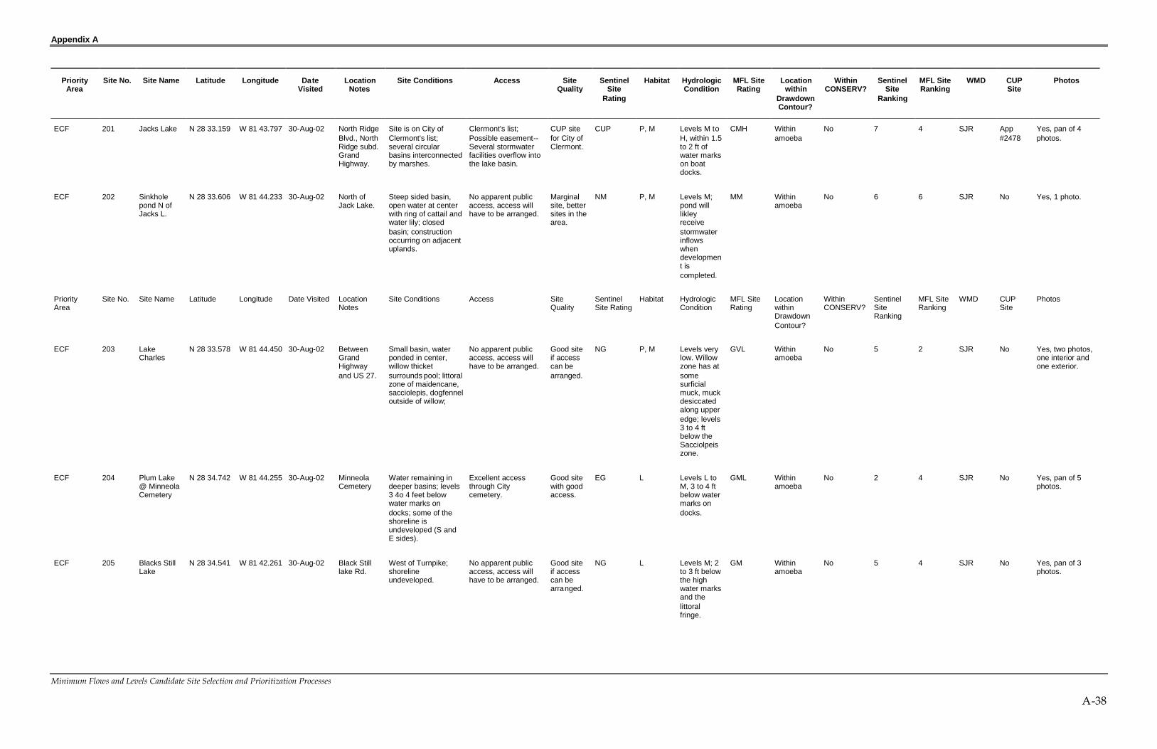
Appendix A
Minimum Flows and Levels Candidate Site Selection and Prioritization Processes
A-38
PriorityArea
Site No. Site Name Latitude Longitude DateVisited
LocationNotes
Site Conditions Access SiteQuality
SentinelSite
Rating
Habitat HydrologicCondition
MFL SiteRating
Locationwithin
DrawdownContour?
WithinCONSERV?
SentinelSite
Ranking
MFL SiteRanking
WMD CUPSite
Photos
ECF 201 Jacks Lake N 28 33.159 W 81 43.797 30-Aug-02 North RidgeBlvd., NorthRidge subd.GrandHighway.
Site is on City ofClermont's list;several circularbasins interconnectedby marshes.
Clermont's list;Possible easement--Several stormwaterfacilities overflow intothe lake basin.
CUP sitefor City ofClermont.
CUP P, M Levels M toH, within 1.5to 2 ft ofwater markson boatdocks.
CMH Withinamoeba
No 7 4 SJR App#2478
Yes, pan of 4photos.
ECF 202 Sinkholepond N ofJacks L.
N 28 33.606 W 81 44.233 30-Aug-02 North ofJack Lake.
Steep sided basin,open water at centerwith ring of cattail andwater lily; closedbasin; constructionoccurring on adjacentuplands.
No apparent publicaccess, access willhave to be arranged.
Marginalsite, bettersites in thearea.
NM P, M Levels M;pond willlikleyreceivestormwaterinflowswhendevelopment iscompleted.
MM Withinamoeba
No 6 6 SJR No Yes, 1 photo.
PriorityArea
Site No. Site Name Latitude Longitude Date Visited LocationNotes
Site Conditions Access SiteQuality
SentinelSite Rating
Habitat HydrologicCondition
MFL SiteRating
LocationwithinDrawdownContour?
WithinCONSERV?
SentinelSiteRanking
MFL SiteRanking
WMD CUPSite
Photos
ECF 203 LakeCharles
N 28 33.578 W 81 44.450 30-Aug-02 BetweenGrandHighwayand US 27.
Small basin, waterponded in center,willow thicketsurrounds pool; littoralzone of maidencane,sacciolepis, dogfenneloutside of willow;
No apparent publicaccess, access willhave to be arranged.
Good siteif accesscan bearranged.
NG P, M Levels verylow. Willowzone has atsomesurficialmuck, muckdesiccatedalong upperedge; levels3 to 4 ftbelow theSacciolpeiszone.
GVL Withinamoeba
No 5 2 SJR No Yes, two photos,one interior andone exterior.
ECF 204 Plum Lake@ MinneolaCemetery
N 28 34.742 W 81 44.255 30-Aug-02 MinneolaCemetery
Water remaining indeeper basins; levels3 4o 4 feet belowwater marks ondocks; some of theshoreline isundeveloped (S andE sides).
Excellent accessthrough Citycemetery.
Good sitewith goodaccess.
EG L Levels L toM, 3 to 4 ftbelow watermarks ondocks.
GML Withinamoeba
No 2 4 SJR No Yes, pan of 5photos.
ECF 205 Blacks StillLake
N 28 34.541 W 81 42.261 30-Aug-02 Black Stilllake Rd.
West of Turnpike;shorelineundeveloped.
No apparent publicaccess, access willhave to be arranged.
Good siteif accesscan bearranged.
NG L Levels M; 2to 3 ft belowthe highwater marksand thelittoralfringe.
GM Withinamoeba
No 5 4 SJR No Yes, pan of 3photos.

Appendix A
Minimum Flows and Levels Candidate Site Selection and Prioritization Processes
A-39
PriorityArea
Site No. Site Name Latitude Longitude DateVisited
LocationNotes
Site Conditions Access SiteQuality
SentinelSite
Rating
Habitat HydrologicCondition
MFL SiteRating
Locationwithin
DrawdownContour?
WithinCONSERV?
SentinelSite
Ranking
MFL SiteRanking
WMD CUPSite
Photos
ECF 206 Camp Lake N 28 36.353 W 81 43.676 30-Aug-02 On westside ofTurnpike;NE ofGrasssyLake.
Steep sided lakebasin visible fromTurnpike; basin hasbeen receding forseveral years, nostanding waterpresent; stands ofcattail and mixedemergents.
Clemont's list??Noapparent publicaccess, access willhave to be arranged.
CUP CityofClermont,excellentsite.
CUP P, M Levels verylow. Lakehas beendisappearing for severalyears,visible fromTurnpike.
CVL Withinamoeba
No 7 2 SJR App#2478
Yes, 6 photos.
ECF 207 UnnamedClermontLake
N 28 29.155 W 81 42.863 4-Nov-02 Adjacent toUS 27.
House on hill onopposite side; willowBaccharis, Myruicaborder then ring ofcattail and then openwater in center;planted pines onadjacent hillsides;some exotics on theedge (Sapium andMelaleuca).
No apparent publicaccess, access willhave to be arranged.
Good site,but accesswouldhave to bearranged.
NG P, M Levels M,water up toedge of theshrubborder.
GM Withinamoeba
No 5 4 SJR No Yes, pan of 3photos.
ECF 208 Johns Lake@ boatramp
N 28 32.614 W 81 39.579 4-Nov-02 Lake Blvd.Off of SSR50.
Large lake, boat rampoff of SR 50 on LakeBlvd.
Excellent--Publicaccess at boat ramp.
Good site. EG L, M Levels M.Lake hashigh waterconnectionto Apopkaviaexcavatedcanal, andreceivesinflow fromBlack Lake.
GM Edge ofamoeba
No 2 4 SJR No Yes, 2 photos.
ECF 209 ChannelconnectingBlack &Johns Lakes
N 28 31.774 W 81 36.539 4-Nov-02 CR 545. Channel connectingJohns and BlackLakes; 3 72 inchculverts under theroad.
No apparent publicaccess, access willhave to be arranged.
Marginalsite, bettersites in thearea.
NM Ditch. Levels M toH.
MMH Edge ofamoeba
No 6 6 SJR No Yes, 3 photos.
ECF 210 Black Lake N 28 31.783 W 81 36.453 4-Nov-02 See other entry forBlack Lake, # 212.
No apparent publicaccess, access willhave to be arranged.
Good site. NG Levels M. GM Edge ofamoeba
No, butnearby.
5 4 SJR No No photo.
ECF 211 Johns Lake@ Lake Co.WaterAuthorityPreserve
N 28 31.699 W 81 39.684 4-Nov-02 Lake Co.WaterAuthorityPreserve.
Preserve on S. side oflake;
Excellent accessthrough public lands.
Excellentsite.
EE L, M, U Levels L toM. Lakehas highwaterconnectionto Apopkaviaexcavatedcanal, andreceivesinflow fromBlack Lake.
EML Edge ofamoeba
No, butnearby.
1 3 SJR No Yes, pan of 7photos.

Appendix A
Minimum Flows and Levels Candidate Site Selection and Prioritization Processes
A-40
PriorityArea
Site No. Site Name Latitude Longitude DateVisited
LocationNotes
Site Conditions Access SiteQuality
SentinelSite
Rating
Habitat HydrologicCondition
MFL SiteRating
Locationwithin
DrawdownContour?
WithinCONSERV?
SentinelSite
Ranking
MFL SiteRanking
WMD CUPSite
Photos
ECF 212 Black Lake@StoneybrookWest
N 28 31.325 W 81 36.090 4-Nov-02 Stoneybrook Westsubdivisionon SW sideof BlackLake.
Community recreationarea and stormwaterfacilities border lake;boardwalk andgazebo extend intolake; blackwater lake;development ongoingaround the lake.
Possible easement--Access would have tobe arranged, butstormwater facilityand communityrecreation areas areimmediately adjacentto lake.
Good site,but accesswouldhave to bearranged.
PG L Levels L toM; lichenlines oncypress are3 to 4 ftabovecurrentstage; Blacklakeconnects toJohns Lake.
GML Edge ofamoeba
No, butnearby.
4 4 SJR No Yes, pan of 7photos.
ECF 213 StoneybrookWetland 1
N 28 31.114 W 81 36.981 4-Nov-02 Stoneybrook Westsubdivisionon SW sideof BlackLake.
Small forestedwetland, isolated;stormwater pondadjacent.
Easement --LorneMalo says that thereis access viaeasement.
OK site. EsO S Levels L toM.
OML Edge ofamoeba
No, butnearby.
4 5 SJR No Yes, 3 photos.
ECF 214 StoneybrookWetland 2
N 28 30.923 W 81 37.099 4-Nov-02 Stoneybrook Westsubdivisionon SW sideof BlackLake.
Small shrubby marshalong golf cart path,isolated; stormwaterpond adjacent.
Easement --LorneMalo says that thereis access viaeasement.
OK site. EsO S Levels L toM.
OML Edge ofamoeba
No, butnearby.
4 5 SJR No Yes, 1 photo.
ECF 215 StoneybrookWetland 3
N 28 31.146 W 81 36.898 4-Nov-02 Stoneybrook Westsubdivisionon SW sideof BlackLake.
Small shrubby marsh,very large retentionpond bordering Eside; pickerelweed incenter.
Easement --LorneMalo says that thereis access viaeasement.
OK site. EsO S Levels L toM; LorneMalo saidthat thiswetland hasapiezometerin it.
OML Edge ofamoeba
No, butnearby.
4 5 SJR No Yes, 3 photos.
ECF 216 StoneybrookWetland4(Bayhead)
N 28 30.763 W 81 36.697 4-Nov-02 Stoneybrook Westsubdivisionon SW sideof BlackLake.
Bayhead withstormwater pondsbordering; muck soils,white and red bayscommon.
Easement --LorneMalo says that thereis access viaeasement.
OK site. EsO S Levels L toM. Mayreceiveinflows fromotherwetlandsandstormwater;may havepopoffdischarge toSE to LakeYarbo.
OML Edge ofamoeba
No, butnearby.
4 5 SJR No Yes, 3 photos.

Appendix A
Minimum Flows and Levels Candidate Site Selection and Prioritization Processes
A-41
PriorityArea
Site No. Site Name Latitude Longitude DateVisited
LocationNotes
Site Conditions Access SiteQuality
SentinelSite
Rating
Habitat HydrologicCondition
MFL SiteRating
Locationwithin
DrawdownContour?
WithinCONSERV?
SentinelSite
Ranking
MFL SiteRanking
WMD CUPSite
Photos
ECF 217 Lake Avalon N 28 30.784 W 81 38.237 4-Nov-02 South centerpart of lake,accessedfromSanctuaryLane off ofAvalon Rd.(CR 545).
South side of lake inthe middle of the"horseshoe"; waterlevels very low; lakebasin is a series ofpools with slightlyhigher marsh areas inbetween.
No apparent publicaccess; from adjacentgroves, access wouldhave to be workedout.
Excellentsite ifaccesscan bearranged.
NE L, P, M Levels low,muckexposed issome pools;upper edgeofHypericumis 4 to5 ftabovecurrentlevel.Adjacentgrovesirrigated withCONSERVwater.
EL Edge ofamoeba
Yes,irrigatedgrovesadjacent topart of lake.
4 2 SJR App#2478
Yes, pan of 5photos.
ECF 218 SinkholePond 1 @Avalon Rd.
N 28 30.456 W 81 37.910 4-Nov-02 North side ofAvalon Rdwest ofturnoff forSanctuaryLane.
Sinkhole pond,surrounded by roadand groves (activeand abandoned);open water in centerwith willow/emergentedge.
No apparent publicaccess; from adjacentgroves, access wouldhave to be workedout.
OK site. NO P Levels M. OM Edge ofamoeba
No, butnearby.
6 5 SJR No Yes, 2 photos.
ECF 219 L. Avalon--Secret Vista
N 28 30.436 W 81 38.675 4-Nov-02 Groves offof AvalonRd.
Adjacent to irrigatedgroves off of AvalonRd. Water levels verylow. Basin is a seriesof pools with slightlyhigher marsh areas inbetween.
No apparent publicaccess; from adjacentgroves, access wouldhave to be workedout.
Excellentsite ifaccesscan bearranged.
NE P, M, L Levels low,muckexposed issome pools;upper edgeofHypericumis 4 to5 ftabovecurrentlevel.Adjacentgrovesirrigated withCONSERVwater.
EL Edge ofamoeba
Yes,irrigatedgrovesadjacent topart of lake.
4 2 SJR No Yes, pan of 4photos.
ECF 220 Flat Lake N 28 29.582 W 81 40.274 4-Nov-02 Roadside SJR benchmark atroadside. Mosaic ofopen water, floatingwater lily,maidencane, wetprairie, cattail withborder of willow andshrub. Most of thesurround land isundeveloped.
No apparent publicaccess; from edge ofroad.
Excellentsite.
NE P, M, L Levels low,like Avalon,4 to 5 ftbelowuplandedge.
EL Outsideamoeba
Yes,irrigatedgrovesadjacent topart of lake.
4 2 SJR No Yes, pan of 5photos.
ECF 221 SinkholePond 2 @Avalon Rd.
N 28 28.145 W 81 38.408 4-Nov-02 E side ofAvalon Rd.
Near CONSERVpump station 1 S 2.Adjacent to LkIngram.
No apparent publicaccess; access fromroad, but easementneeded.
Good siteif accesscan bearranged.
NG P Level L toM. Isolatedbasin.
GML Outsideamoeba
Yes,irrigatedgrovessurround.
5 4 SJR No Yes, pan of 4photos.

Appendix A
Minimum Flows and Levels Candidate Site Selection and Prioritization Processes
A-42
PriorityArea
Site No. Site Name Latitude Longitude DateVisited
LocationNotes
Site Conditions Access SiteQuality
SentinelSite
Rating
Habitat HydrologicCondition
MFL SiteRating
Locationwithin
DrawdownContour?
WithinCONSERV?
SentinelSite
Ranking
MFL SiteRanking
WMD CUPSite
Photos
ECF 222 SawgrassLake @Cook Rd.
N 28 26.178 W 81 41.224 5-Nov-02 Cook Roadon N side.
Sonny Hall has setlevels for this lake.Floating mats ofhyacinth rim openwater on the northside. Irrigated groveson the hill on N side.
No apparent publicaccess; from CookRoad. Easementmay be needed. Howdid Sonny Hall getaccess.
Good site,MFL hasbeen set.
NG P, M, L Levels Hnearly up tothe l ive oakand pine lineon S side;water markon fenceposts 1 ftabovecurrentlevel; butthat wouldput oaksand pinesunder water.Water levelwithin 2 ft ofthe rootcrown ofthe lowestCitrus
GH Outsideamoeba
Yes,irrigatedgroves onhill on Nside.
5 4 SJR No Yes, series of 12shots
CF 223 WetlandDepressionNW LakeNeedham
N 28 26.954 W 81 40.016 5-Nov-02 NW of LkNeedham
Adjacent toCONSERV II pumpstation 4-T-10, just Nof road. Water incenter, fringe ofmaidencane,Echinochloa walteri,and dog fennel.
No apparent publicaccess.
Good siteif accesscan bearranged.
NG P, M Levels M toH. Isolatedbasin.
GMH Outsideamoeba
Yes,surroundinggroves havecontract withCONSERVII
5 4 SJR No Yes, singlephoto.
ECF 224 LakeNeedham
N 28 26.920 W 81 39.436 5-Nov-02 Unpavedroad on Nside of thelake.
CONSERV overflowstructure on edge oflake (see photos);RCID propertyadjacent to lake.
Easement --land oneast side owned byReedy CreekImprovement District.Also, looks to be aCONSERV easementassociated withoverflow structures.
Good siteif accesscan bearranged.
EsG L, M Levels H.Staff gage@ 104.75;levels within1 ft of edgeof live oaksand within1.5 ft of topof road.Levels maybe affectedbyCONSERVoverflows.
GH Outsideamoeba
Yes,irrigatedgrovesadjacent tolake. Also,emergencyoverflowstructure atnorth side oflake.
2 4 SJR&SF No Yes, series of 9shots
ECF 225 Lake Ingram N 28 27.761 W 81 38.427 5-Nov-02 Viewed fromAvalon Rd(CR545)
Some open water(60%) with somefringing emergents(maidencane,Spartina bakerii,Andropogon gerardii,and Hypericumfasciculatum).Groves on ridges onS side.
No apparent publicaccess; access fromthe road, easementwould have to bearranged.
Good siteif accesscan bearranged.
NG L, M Levels L toM, waterlevels downseveral feetbelow highwater mark.Culvert (24")under roadconnectingto section oflake lying tothe east.
GML Outsideamoeba
Yes,irrigatedgrovesadjacent tolake.
5 4 SF No Yes, from CR545, pan of 4photos.

Appendix A
Minimum Flows and Levels Candidate Site Selection and Prioritization Processes
A-43
PriorityArea
Site No. Site Name Latitude Longitude DateVisited
LocationNotes
Site Conditions Access SiteQuality
SentinelSite
Rating
Habitat HydrologicCondition
MFL SiteRating
Locationwithin
DrawdownContour?
WithinCONSERV?
SentinelSite
Ranking
MFL SiteRanking
WMD CUPSite
Photos
ECF 226 Wetland @Avalon &Old YMCA
N 28 26.283 W 81 38.194 5-Nov-02 Wetland onE side ofAvalon Rd(CR545)
May have beenexcavated, standingwater in center, fringeof grasses andsedges.
No apparent publicaccess; access fromthe road, easementwould have to bearranged.
Good siteif accesscan bearranged.
NG L, M Levels H,staff gage at3.44 ft.Water stainson trees @+ 1 ft. MayreceiveCONSERVoverflow.
GH Outsideamoeba
Manholeand pipemay be anoverflow;site is just Sof RIBS andOrangeCountyNational.
5 4 SF No Yes, 1 photo.
ECF 227 Hickory NutLake @YMCA Rd.
N 28 26.265 W 81 38.748 5-Nov-02 Lake issouth of OldYMCA Rd.
Talked to an olderman and his wife,long time residents ofthe area. He said thatwater levels in thelake have come up 7ft since July 2002!!
No apparent publicaccess; access fromthe road, easementwould have to bearranged.
Good siteif accesscan bearranged.
NG L, M Levels H,within 20inches of thetop of theboat docksthat we cansee throughbinoculars.
GH Outsideamoeba
Yes,irrigatedgroves andOCNGCnearby.
5 4 SF No Yes, from road apan of 3 photos.
ECF 228 Hickory NutLake @Avalon Rd.1
N 28 25.291 W 81 38.152 5-Nov-02 Viewed fromAvalon Rd(CR545)
Talked to an olderman and his wife,long time residents ofthe area. He said thatwater levels in thelake have come up 7ft since July 2002!!
No apparent publicaccess; access fromthe road, easementwould have to bearranged.
Good siteif accesscan bearranged.
NG L, M Levels H,within 20inches of thetop of theboat docksthat we cansee throughbinoculars.
GH Outsideamoeba
Yes,irrigatedgroves andOCNGCnearby.
5 4 SF No Yes, from road apan of 3 photos.
ECF 229 Hickory NutLake @Avalon Rd.2
N 28 24.867 W 81 38.172 5-Nov-02 Viewed fromAvalon Rd(CR545)
Talked to an olderman and his wife,long time residents ofthe area. He said thatwater levels in thelake have come up 7ft since July 2002!!
No apparent publicaccess; access fromthe road, easementwould have to bearranged.
Good siteif accesscan bearranged.
NG L, M Levels H,within 20inches of thetop of theboat docksthat we cansee throughbinoculars.
GH Outsideamoeba
Yes,irrigatedgroves andOCNGCnearby.
5 4 SF No Yes, from road apan of 3 photos.
ECF 230 Lake @OrangeCountyNational 1
N 28 26.768 W 81 36.774 5-Nov-02 Viewed fromroad.
Lake and wetlandcomplex extends tothe SE. Lake may beused as source ofirrigation water asevidenced bywithdrawal pipe.Irrigated groves onslope to W.
Excellent, on Countyproperty.
Good siteif accesscan bearranged.
EG L, M Levels M toH.
GMH Outsideamoeba
Yes,irrigatedgroves andOCNGCnearby.
2 4 SF No No photo.
ECF 231 Lake @OrangeCountyNational 2
N 28 26.694 W 81 36.938 5-Nov-02 Viewed fromroad.
Small lake. Excellent, on Countyproperty.
Good siteif accesscan bearranged.
EG L, M Levels M toH.
GMH Outsideamoeba
Yes,irrigatedgroves andOCNGCnearby.
2 4 SF No Yes, from road apan of 4 photos.

Appendix A
Minimum Flows and Levels Candidate Site Selection and Prioritization Processes
A-44
PriorityArea
Site No. Site Name Latitude Longitude DateVisited
LocationNotes
Site Conditions Access SiteQuality
SentinelSite
Rating
Habitat HydrologicCondition
MFL SiteRating
Locationwithin
DrawdownContour?
WithinCONSERV?
SentinelSite
Ranking
MFL SiteRanking
WMD CUPSite
Photos
ECF 232 LakeHancock
N 28 27.147 W 81 36.733 5-Nov-02 Viewed fromroad.
Lake that is part ofthe Reedy Creekdrainage.
No apparent publicaccess; access fromthe road, easementwould have to bearranged.
Good siteif accesscan bearranged.
NG L, M Levels M toH. Appearsto be anupper part ofthe ReedyCreekdrainage.Water levelsnot as highas otherlakes in thearea, butstain lineson new boatdocks areonly + 1 ftabovewater. Highwater popoffthru culvertat SE end oflake, noevidence ofrecent flow.
GMH Outsideamoeba
Yes,irrigatedgrovesadjacent tolake.
5 4 SF No Yes, from road, 2photos.
ECF 233 PondsSouth ofLakeSawyer
N 28 27.462 W 81 34.194 5-Nov-02 Viewed fromroad.
Pond surrounded byimproved pasture inan area generallybeing developed intoresidentialsubdivisions.
Possible public--Public land shown onmaps for area to theeast, area is anabandoned grove.Also USGSmonitoring stationnext to road at NWedge.
Good siteif accesscan bearranged.
PG P Levels M toH.
GMH Withinamoeba
No, butnearby.
4 4 SF No Yes, from road, 2photos.
ECF 234 East Pond@ Chase/LkSawyer Rd
N 28 27.758 W 81 33.667 5-Nov-02 Viewed fromeast side ofroad (WinterGardenVineland,CR 535).
Pond with opencenter, fringinggraminoids, somecattail, and border ofprimrose willow andBaccharis.
No apparent publicaccess; access fromthe road, easementwould have to bearranged.
Good siteif accesscan bearranged.
NG P Levels M toH.
GMH Withinamoeba
No, butnearby.
5 4 SF No Yes, from road apan of 4 photos.
ECF 235 West Pond@ Chase/LkSawyer Rd
N 28 27.732 W 81 33.722 5-Nov-02 Viewed fromwest side ofroad (WinterGardenVineland,CR 535).
Pond with water liliesat center, emergentsaround the fringe;adjacent to golfcourse
No apparent publicaccess; access fromthe road, easementwould have to bearranged.
Good siteif accesscan bearranged.
NG P Levels M toH.
GMH Withinamoeba
No, butnearby.
5 4 SF No Yes, from road, 2photos.
ECF 236 Pond NorthofWindemerePrep
N 28 28.671 W 81 34.390 5-Nov-02 Viewed fromroad.
Pond may have hadits south edgeexcavated. Groves onN & S.
No apparent publicaccess; access fromthe road, easementwould have to bearranged.
Good siteif accesscan bearranged.
NG P Water levelH.
GH Withinamoeba
No 5 4 SF No Yes, 2 photos.

Appendix A
Minimum Flows and Levels Candidate Site Selection and Prioritization Processes
A-45
PriorityArea
Site No. Site Name Latitude Longitude DateVisited
LocationNotes
Site Conditions Access SiteQuality
SentinelSite
Rating
Habitat HydrologicCondition
MFL SiteRating
Locationwithin
DrawdownContour?
WithinCONSERV?
SentinelSite
Ranking
MFL SiteRanking
WMD CUPSite
Photos
ECF 237 Lakes Davis& Estes (Wof Butler) 1
N 28 28.938 W 81 34.168 5-Nov-02 Viewed fromroads insubdivisions.
Upscale subdivisionsborder lake.
No apparent publicaccess; access fromthe road, easementwould have to bearranged.
Good siteif accesscan bearranged.
NG L Levels M toH; Davislooks to beisolated.
GMH Withinamoeba
No 5 4 SF No Yes, 3 photos.
ECF 238 Lakes Davis& Estes (Wof Butler) 2
N 28 29.200 W 81 34.106 5-Nov-02 Viewed fromroads insubdivisions.
Upscale subdivisionsborder lake.
No apparent publicaccess; access fromthe road, easementwould have to bearranged.
Good siteif accesscan bearranged.
NG L Levels M toH; Davislooks to beisolated.
GMH Withinamoeba
No 5 4 SF No Yes, 3 photos.
ECF 239 Pond westof Little LakeSawyer
N 28 28.313 W 81 34.969 5-Nov-02 Viewed fromside ofWinterGardenVineland,CR 535.
Large water lily pondwith patches of willowand sawgrass; ringneck ducks present;S&E sides notdeveloped.
No apparent publicaccess; access fromthe road, easementwould have to bearranged.
Good siteif accesscan bearranged.
NG L, M Levels M toH. Basinisolated.
GMH Withinamoeba
No 5 4 SF No Yes, 3 photos.
ECF 240 Pond @CawoodEstates
N 28 28.671 W 81 34.390 5-Nov-02 Viewed fromedge ofretentionpond.
Isolated pond withborder of emergentmacrophytes.
Possible easement--Access may bepossible fromretention pond,however the wetlandis 50 yards from theretention pond.
Good siteif accesscan bearranged.
PG L, M Levels M toH.
GMH Withinamoeba
No 4 4 SF No Yes, 2 photos.
ECF 241 Serene &Big SandLakes
N 28 26.475 W 81 29.846 5-Nov-02 Viewed fromroads in newsubdivision.
Entered from theEsplanade south offof Sand Lake Road
Possible easement--Access from facilities--OCU pump station #3931, stormwaterfacilities next to lake.
Good siteif accesscan bearranged.
PG L, M Levels M toH.
GMH Outsideamoeba
No 4 4 SF No No photos,raining.
ECF 242 Bay Lakes@ Dr.Phillips
N 28 26.794 W 81 30.376 5-Nov-02 Bay Lakesat Granada,east of CR435, southof GranadaBlvd.
Two small lakes in asubd. With a parkarea in between.Good site, the parkwill allow upland wellsand access to bothlakes.
Possible easement--Neighborhood park,but not public.
Good siteif accesscan bearranged.
PG L, M Levels M toH.
GMH Outsideamoeba
No 4 4 SF No Yes, series of 5photos.
ECF 243 LakeCrowell
N 28 25.102 W 81 29.749 5-Nov-02 DiamondCove andEmeraldForestSubd.
Lake with fringingcypress. Most ofshoreline abuts singlefamily residences.
Possible easement;access from pathalong edge ofstormwater facilitiesthat lead to boardwalkat the edge of thelake.
Good siteif accesscan bearranged.
PG L, M Levels H. GH Outsideamoeba
No 4 4 SF No Yes, series of 9photos.

Appendix A
Minimum Flows and Levels Candidate Site Selection and Prioritization Processes
A-46
PriorityArea
Site No. Site Name Latitude Longitude DateVisited
LocationNotes
Site Conditions Access SiteQuality
SentinelSite
Rating
Habitat HydrologicCondition
MFL SiteRating
Locationwithin
DrawdownContour?
WithinCONSERV?
SentinelSite
Ranking
MFL SiteRanking
WMD CUPSite
Photos
ECF 244 Lake Charity N 28 37.917 W 81 22.752 6-Nov-02 Stormwaterpond behindnursinghome in CR414.
SJR staff areconcerned that levelsare low in this lake,but get higher throughother lakes as oneheads toward the E.
Possible easement--From retention pondbehind nursing home.
Good siteif accesscan bearranged.
PG L, M Levels low,well belowboat dockswhich areleft high anddry; level 5 ftbelow waterlines on thedocks.
GL Withinamoeba
No 4 3 SJR No Yes, 3 photos.
ECF 245 Lake Love N 28 38.092 W 81 23.063 6-Nov-02 West of L.Charity.
Small circular lake. No apparent publicaccess; access wouldhave to be arranged,from off of WymoreRoad.
Good siteif accesscan bearranged.
NG L, M Level M toH; 1 ft belowwatermarks.
GMH Edge ofamoeba
No 5 4 SJR No Yes, singlephoto.
ECF 246 Wood Lake N 28 38.511 W 81 23.114 6-Nov-02 Wood LakeDrive.
Very small lake to Nof Lake Love.Surrounded byhouses.
No apparent publicaccess; accessdifficult, look fordrainage easement.
Good siteif accesscan bearranged.
NG L, M Level M toH; 1 ft belowwatermarks.
GMH Withinamoeba
No 5 4 SJR No Yes, singlephoto, shotbetween houses.
ECF 247 Lake Hope N 28 38.421 W 81 22.354 6-Nov-02 Lake HopeDrive.
Lake surrounded byhouses, not muchvisibility
No apparent publicaccess; accessdifficult, look fordrainage easement.
Good siteif accesscan bearranged.
NG L, M Levels L toM, not aslow asCharity.Watermakes 3-4 fthigher thancurrentlevel.
GML Withinamoeba
No 5 4 SJR No No photo.
ECF 248 StonewoodLake
N 28 38.629 W 81 22.449 6-Nov-02 South sideof Oranole,N of LakeHope
Small circular urbanlake. Aerators,stormwater inflows.City of Altamonte(phone 660-4400) liftstation #9 across thestreet from lake.
Possible easement--Access from roadwould have to bearranged. Drainageeasement likely forthe stormwater inflowsystem.
Good siteif accesscan bearranged.
PG L, M Levels H,lichen lineson fringingcypressabout 0.5 ftbelowcurrentlevel. Staffgage atstormwaterinlet @ 4.3ft.
GH Withinamoeba
No 4 4 SJR No Yes, pan of 2photos.
ECF 249 Lake Faith 1 N 28 38.424 W 81 21.933 6-Nov-02 Intersectionof LakeShore DriveandMaitlandAve.
Stormwater retentionpond adjacent to lake,NE edge of lake.Another pond to southalong Maitland Ave.
Possible easement--Good access fromretention ponds ifeasements can beworked out.
Good siteif accesscan bearranged.
PG L, M Levels M, 2ft belowwater markson boatdocks.
GM Withinamoeba
No 4 4 SJR No Yes, pan of 3photos.
ECF 250 Lake Faith 2 N 28 28.221 W 81 22.018 6-Nov-02 Lake FaithCondos onS side.
Drainage easement atcondo complex.
No apparent publicaccess; good accessfrom drainageeasement down toedge of lake (seephotos)
Good siteif accesscan bearranged.
NG L, M Levels M, 2ft belowwater markson boatdocks.
GM Withinamoeba
No 5 4 SJR No Yes, pan of 3photos.
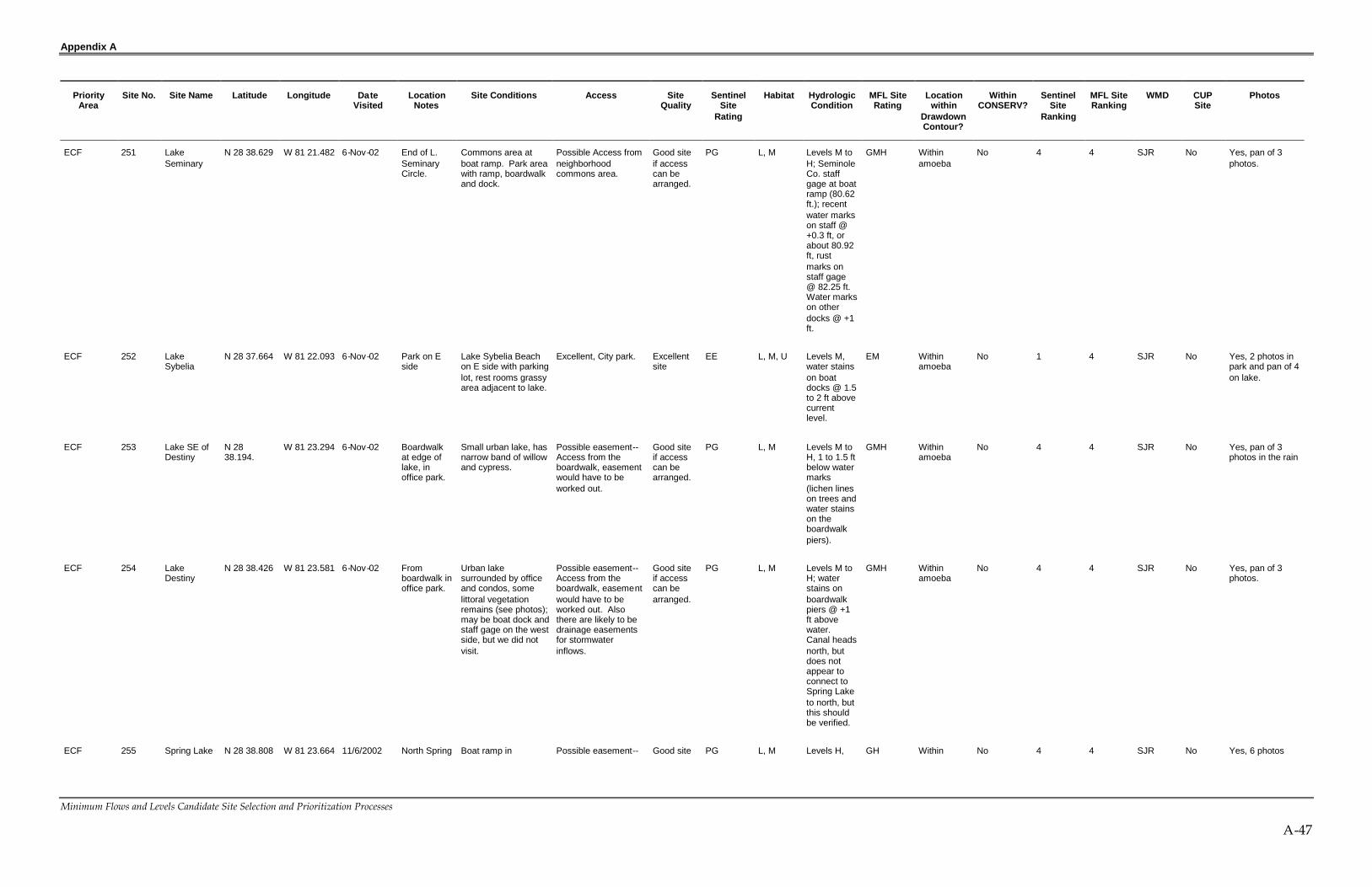
Appendix A
Minimum Flows and Levels Candidate Site Selection and Prioritization Processes
A-47
PriorityArea
Site No. Site Name Latitude Longitude DateVisited
LocationNotes
Site Conditions Access SiteQuality
SentinelSite
Rating
Habitat HydrologicCondition
MFL SiteRating
Locationwithin
DrawdownContour?
WithinCONSERV?
SentinelSite
Ranking
MFL SiteRanking
WMD CUPSite
Photos
ECF 251 LakeSeminary
N 28 38.629 W 81 21.482 6-Nov-02 End of L.SeminaryCircle.
Commons area atboat ramp. Park areawith ramp, boardwalkand dock.
Possible Access fromneighborhoodcommons area.
Good siteif accesscan bearranged.
PG L, M Levels M toH; SeminoleCo. staffgage at boatramp (80.62ft.); recentwater markson staff @+0.3 ft, orabout 80.92ft, rustmarks onstaff gage@ 82.25 ft.Water markson otherdocks @ +1ft.
GMH Withinamoeba
No 4 4 SJR No Yes, pan of 3photos.
ECF 252 LakeSybelia
N 28 37.664 W 81 22.093 6-Nov-02 Park on Eside
Lake Sybelia Beachon E side with parkinglot, rest rooms grassyarea adjacent to lake.
Excellent, City park. Excellentsite
EE L, M, U Levels M,water stainson boatdocks @ 1.5to 2 ft abovecurrentlevel.
EM Withinamoeba
No 1 4 SJR No Yes, 2 photos inpark and pan of 4on lake.
ECF 253 Lake SE ofDestiny
N 2838.194.
W 81 23.294 6-Nov-02 Boardwalkat edge oflake, inoffice park.
Small urban lake, hasnarrow band of willowand cypress.
Possible easement--Access from theboardwalk, easementwould have to beworked out.
Good siteif accesscan bearranged.
PG L, M Levels M toH, 1 to 1.5 ftbelow watermarks(lichen lineson trees andwater stainson theboardwalkpiers).
GMH Withinamoeba
No 4 4 SJR No Yes, pan of 3photos in the rain
ECF 254 LakeDestiny
N 28 38.426 W 81 23.581 6-Nov-02 Fromboardwalk inoffice park.
Urban lakesurrounded by officeand condos, somelittoral vegetationremains (see photos);may be boat dock andstaff gage on the westside, but we did notvisit.
Possible easement--Access from theboardwalk, easementwould have to beworked out. Alsothere are likely to bedrainage easementsfor stormwaterinflows.
Good siteif accesscan bearranged.
PG L, M Levels M toH; waterstains onboardwalkpiers @ +1ft abovewater.Canal headsnorth, butdoes notappear toconnect toSpring Laketo north, butthis shouldbe verified.
GMH Withinamoeba
No 4 4 SJR No Yes, pan of 3photos.
ECF 255 Spring Lake N 28 38.808 W 81 23.664 11/6/2002 North Spring Boat ramp in Possible easement-- Good site PG L, M Levels H, GH Within No 4 4 SJR No Yes, 6 photos

Appendix A
Minimum Flows and Levels Candidate Site Selection and Prioritization Processes
A-48
PriorityArea
Site No. Site Name Latitude Longitude DateVisited
LocationNotes
Site Conditions Access SiteQuality
SentinelSite
Rating
Habitat HydrologicCondition
MFL SiteRating
Locationwithin
DrawdownContour?
WithinCONSERV?
SentinelSite
Ranking
MFL SiteRanking
WMD CUPSite
Photos
1/8/2002 Lake Rd insubdivision.
subdivision, just westof intersection withSpring Lake HillsDrive, near the top ofcanal from LakeDestiny.
Access is good fromboat ramp, but this iscommons property forthe subdivision, so anaccess easementwould have to beworked out.
if accesscan bearranged.
lake hasoutflow toLittle WekivaRiversystem;levels within0.5 ft ofwater stainson boatdocks.
amoeba taken.
ECF 256 Prairie andPearl Lakes@connector
N 28 39.529 W 81 20.832 6-Nov-02 Connectingcanal onGladwinAve.
Lakes connected bycanal thru subdivision
No apparent publicaccess; water levelscan be monitored inthe canal. Access isnot good to the lakesthemselves.
Good siteif accesscan bearranged.
NG L Levels H,within + 1 ftof stainmarks onthe boxculvert.
GH Withinamoeba
No 5 4 SJR No Yes, pan of 3photos. 6additional photostaken.
ECF 257 Lake NW ofLake of theWoods
N 28 38.883 W 81 21.225 6-Nov-02 Navel Driveoff ofO'Brien.
Unnamed small laketo NW of Lake of theWoods. Willow andtaro edge. Talked toresident who said thatwater levels havecome up about 4 ftsince summer.
No apparent publicaccess; access isfrom end of road, buteasements wouldhave to be workedout.
Good siteif accesscan bearranged.
NG L Levels Hwithin .5 to 1ft of watermarks ontrees.
GH Withinamoeba
No 5 4 SJR No Yes, singlephoto.
ECF 258 Lake of theWoods
N 28 38.556 W 81 20.976 6-Nov-02 Cul du sacon Spartan.
Undeveloped lot oncul du sac, may be adrainage easement.Also, boat ramp atend of SummerwoodTrace
Possible easement--Boat ramp is private.Drainage easementsmay be an option.Stormwater facility onsouth end at outflow.
Good siteif accesscan bearranged.
PG L, M Levels Hwithin .5 ft to1 ft of highwatermarks, andwithin 1-2 ftof top ofmost boatdocks.Outflowchannel atsouth end;weir withstop logs,waterflowing overstructure(seephotos).
GH Withinamoeba
No 4 4 SJR No Yes, severalphotos at outflow.

Appendix A
Minimum Flows and Levels Candidate Site Selection and Prioritization Processes
A-49
PriorityArea
Site No. Site Name Latitude Longitude DateVisited
LocationNotes
Site Conditions Access SiteQuality
SentinelSite
Rating
Habitat HydrologicCondition
MFL SiteRating
Locationwithin
DrawdownContour?
WithinCONSERV?
SentinelSite
Ranking
MFL SiteRanking
WMD CUPSite
Photos
ECF 259 Lake of theWoods @outflow weir
N 28 38.398 W 81 20.879 6-Nov-02 South end oflake.
Surface water outflowpoint at south end oflake. Weir structureadjacent to road;water flowing at timeof visit (see photos).
No apparent publicaccess.
Good siteif accesscan bearranged.
NG L, M Levels Hwithin .5 ft to1 ft of highwatermarks, andwithin 1-2 ftof top ofmost boatdocks.Outflowchannel atsouth end;weir withstop logs,waterflowing overstructure(seephotos).
GH Withinamoeba
No 5 4 SJR No Yes, severalphotos at outflow.
ECF 260 Blue Lake N 28 39.493 W 81 28.012 6-Nov-02 East of US441, GreenAcres Rd.
Most of the lake isbordered byresidential.
Possible easement--Access from road atretention pond withdrop inlet next toroad.
Good siteif accesscan bearranged.
PG L Levels Hwithin 0.5 ftof watermarks onboat docks.
GH Withinamoeba
No 4 4 SJR No Yes, singlephoto.
ECF 261 LakePiedmont
N 28 39.493 W 81 28.012 6-Nov-02 North ofBlue LakeonCrispwoodCourt off ofPiedmontLake Blvd.
Some littoralvegetation left onshoreline on otherside of lake.
Possible easement--Access from retentionpond at end of cul dusac.
Good siteif accesscan bearranged.
PG L, M Levels Hwithin 0.5 ftof watermarks.
GH Withinamoeba
No 4 4 SJR No Yes, pan of 3photos.
ECF 262 LakeMcDadenear L.Piedmont
N 28 39.770 W 81 28.027 6-Nov-02 Adjacent toL. Piedmont
Playground borderinglake.
Possible easement--Playground andretention pond.
Good siteif accesscan bearranged.
PG L Levels H,likePiedmont
GH Withinamoeba
No 4 4 SJR No Yes, singlephoto.
ECF 263 Maggiore &Minore nearZellwood
N 28 44.097 W 81 36.392 6-Nov-02 Zellwoodarea E of441.
Lake MaggioreEstates subdivision.East shoreline isundeveloped.
Easement --Goodaccess at school (seebelow)
Excellentsite.
EsE L, M, U Levels M toH, within+1.5 ft ofwatermarks; mayhaveoverflow toApopkamarshes.
EMH Edge ofamoeba
No 1 4 SJR No Yes, one.
ECF 264 Maggiore @ZellwoodElementary
N 28 44.200 W 81 36.138 6-Nov-02 Zellwoodarea E of441.
Edge of lake atZellwood ElementarySchool at E corner oflake at point where itpinches off to Lk.Minore.
Easement --Good sitewith good access atschool.
Excellentsite.
EsE L, M, U Levels M toH;connectionto Minore,and maypop off toApopkamarshes.
EMH Edge ofamoeba
No 1 4 SJR No Yes, pan of 3photos.

Appendix A
Minimum Flows and Levels Candidate Site Selection and Prioritization Processes
A-50
PriorityArea
Site No. Site Name Latitude Longitude DateVisited
LocationNotes
Site Conditions Access SiteQuality
SentinelSite
Rating
Habitat HydrologicCondition
MFL SiteRating
Locationwithin
DrawdownContour?
WithinCONSERV?
SentinelSite
Ranking
MFL SiteRanking
WMD CUPSite
Photos
ECF 265 Loch Levannear Mt.Dora
N 28 49.920 W 81 38.333 6-Nov-02 Mt Doraarea.
Good site--LochLevan subdivision.
Easement --Good site--Conservationeasement for dredgeand fill violation willallow access,according to LorneMalo. Also, boatramp and boardwalkin commons area.
Good siteif accesscan bearranged.
EsG L, M, U Levels H. GH Outsideamoeba
No 2 4 SJR No Yes, from photosconservationarea and boatramp &boardwalk.
ECF 266 LakeJoanna nearMt Dora
N 28 50.914 W 81 38.508 6-Nov-02 Park PlaceSubdivision
Good site. Possible easementaccess--Good site--boat ramp atParkwood Ave & ParkPlace Blvd.
Good siteif accesscan bearranged.
PG L, M, U Levels Hwithin 0.5 ftof stainmarks.
GH Outsideamoeba
No 4 4 SJR No Yes, pan of 4-5photos.
ECF 267 LakeSwataranear Mt.Dora
N 28 51.846 W 81 38.533 6-Nov-02 LakeSwataraDrive, E sideof lake.
Good site--Maturefringing cypress, verysteep slope down tolake in subdivision;lake may be used forirrigation.
Possib le Easement--Good site--Access viadrainage easement insubdivision.
Good siteif accesscan bearranged.
PG L, M, U Levels H. GH Outsideamoeba
No 4 4 SJR No Yes, photosofdrainageeasement,fringing cypressand pan of lake.
ECF 268 Lake Lincolnnorth (N) ofL. Joanna
N 28 51.829 W 81 38.092 6-Nov-02 HighlandLane on Wside.
Good site--Dry lakebasin, has severalsinkholes in it, nowater present. Steepslope on west side,forested ridge on N,E, and S.
No apparent publicaccess; accessthrough subdivision,may be other points.
Good siteif accesscan bearranged.
NG L, M, U Levels verylow, NOWATER.
GVL Outsideamoeba
No 5 2 SJR No Yes, pan of 4photos.
ECF 269 LakeEldoradonear Eustis
N 28 53.101 W 81 37.890 6-Nov-02 SR 44 A &WestEldoradoDrive
Good site. No apparent publicaccess; access bestfrom SR 44A on westside. Undevelopedland betweenroadside and edge oflake (see photos).
Good siteif accesscan bearranged.
NG L, M, U Levels L toM, watermarks 3 fthigher thancurrentlevel.
GML Outsideamoeba
No 5 4 SJR No Yes, 3 photos,but daylightfading.
ECF 270 LakeDalhousienear Eustis
N 28 54.155 W 81 37.065 6-Nov-02 Lk.DalhousiePark
Great site--LkDalhousie Park on Eside of lake. Parkingarea and boat ramp.
Excellent, accessfrom park.
Excellentsite.
EE L, M, U Levels M, 2ft belowwater stains.
EM Outsideamoeba
No 1 4 SJR No Yes, photos ofpark area andlake.
ECF 271 Lake BurnsE of Umatilla
N 28 54.950 W 81 38.521 6-Nov-02 East ofUmatilla
Adjacent to road. No apparent publicaccess.
Good siteif accesscan bearranged.
NG L, M, U Levels M,about 2 ftbelow highwater mark.
GM Outsideamoeba
No 5 4 SJR No Yes, two photos,but light fading atend of day

Appendix A
Minimum Flows and Levels Candidate Site Selection and Prioritization Processes
A-51
PriorityArea
Site No. Site Name Latitude Longitude DateVisited
LocationNotes
Site Conditions Access SiteQuality
SentinelSite
Rating
Habitat HydrologicCondition
MFL SiteRating
Locationwithin
DrawdownContour?
WithinCONSERV?
SentinelSite
Ranking
MFL SiteRanking
WMD CUPSite
Photos
ECF 272 LakeUmatilla @GuerrantPark
N 28 55.058 W 81 39.986 6-Nov-02 GuerrantPark inUmatilla
City park on S side ofLake Umatilla hasboat ramp, picnicarea, parking areasand fishing pier.Upland, wetland andaquatic habitatpresent.
Excellent site-accessfrom park.
Excellentsite.
EE L, M, U Levels M toH.
EMH Outsideamoeba
No 1 4 SJR No Yes, 8 photostaken.
ECF 273 YarboroughConservation Easement
N 28 41.374 W 81 6.605 6-Jun-02 Across roadfrom LittleBig Econ.
Large cypress strand. No apparent publicaccess, access willhave to be arranged.
Good siteif accesscan bearranged.
NG S Levels M. GM Outsideamoeba
No 5 4 SJR No No photo.
ECF 274 Wetland offDaniels Rd.
N 28 32.286 W 81 34.972 1/10/2002 Wetland offDaniels Rd.
OUC Monitoring Site#6478
OUC Monitoring Site. Excellentsite
CUP S Levels verylow.
CVL Withinamoeba
No 7 2 SJR Permit#3159
Yes, 1 phototaken.
ECF 275 Long Lakeoff GrovelineDr. near.
N 28 36.964 W 81 28.448 1/7/2002 Near.Clarcona,FL
OUC Monitoring Site#4272
OUC Monitoring Site. Excellentsite
CUP L, M Levels verylow.
CVL Withinamoeba
No 7 2 SJR Permit#3159
Yes, 13 photostaken.
ECF 276 Prairie Lakeeast of N.HiawasseeRd.
N 28 35.858 W 81 28.115 Not visited East side ofN.HiawasseeRd., dueeast ofCrookedLake.
OUC Monitoring Site#4883
OUC Monitoring Site. Excellentsite
CUP L, M Not visited,conditionsneed to bedetermined.
CNV Withinamoeba
No 7 3 SJR Permit#3159
Yes.
ECF 277 Lake Genieoff CoralCove Dr.
N 28 35.374 W 81 29.436 1/10/2002 Immediatelysouth of SWcorner ofCrookedLake.
OUC Monitoring Site#5036. Small lakewith residual pool ofwater; stormwaterpond on one edge insubdivision; housesborder 1/3 ofshoreline; scatteredwillows on upperedge, dense stands ofdogfennel lie belowthe willow.
OUC Monitoring Site. Excellentsite
CUP L Levels L,surficialaccumulation of muckexposed atedge of theremainingpool.
CL Withinamoeba
No 7 2 SJR Permit#3159
Yes, 2 photostaken.
ECF 278 LakeSherwoodoff SR 50
N 28 33.155 W 81 29.881 1/8/2002 LakeSherwoodoff SR 50
OUC Monitoring Site#5824
OUC Monitoring Site. Excellentsite
CUP L, M Levels verylow.
CVL Withinamoeba
No 7 2 SJR Permit#3159
Yes, 12 photostaken.
ECF 279 Unnamedlake west ofL.Hiawassee
N 28 31.825 W 81 29.495 Not visited Unnamedlake west ofL.Hiawassee
OUC Monitoring Site#6714
OUC Monitoring Site. Excellentsite
CUP Notvisited
Not visited,conditionsneed to bedetermined.
CNV Withinamoeba
No 7 3 SJR Permit#3159
No photo, site notvisited.
ECF 280 UnnamedLake offBerks Ct.
N 28 32.034 W 81 28.336 Not visited UnnamedLake offBerks Ct.
OUC unnumberedmonitoring site
OUC Monitoring Site. Excellentsite
CUP Notvisited
Not visited,conditionsneed to bedetermined.
CNV Withinamoeba
No 7 3 SJR Permit#3159
No photo, site notvisited.

Appendix A
Minimum Flows and Levels Candidate Site Selection and Prioritization Processes
A-52
PriorityArea
Site No. Site Name Latitude Longitude DateVisited
LocationNotes
Site Conditions Access SiteQuality
SentinelSite
Rating
Habitat HydrologicCondition
MFL SiteRating
Locationwithin
DrawdownContour?
WithinCONSERV?
SentinelSite
Ranking
MFL SiteRanking
WMD CUPSite
Photos
ECF 281 Wetlands atMeadBotanicalGardens
N 28 35.116 W 81 21.329 1/9/2002 Forestedwetland longboardwalk.
OUC Monitoring Site#5143
OUC Monitoring Site. Excellentsite
CUP S, U Levels M toH.
CMH Outsideamoeba
No 7 4 SJR Permit#3159
Yes
ECF 282 Lake Berryoff BalmoralRd.
N 28 35.128 W 81 19.783 1/9/2002 BalmoralRoad inWindsongsubdivision.
OUC Monitoring Site#5070; edge of lakeat gazebo insubdivision;undevelopedshoreline on oppositeside of lake still hasintact live oak border
OUC Monitoring Site. Excellentsite
CUP L Levels M;lakeconnectedto LakeVirginia;muck soils1-2 ft thickpresent atedge of lakeat gazebo;levels about3 ft belowwatermarks, and5 to 6 feetbelow themature liveoak line.
CM Outsideamoeba
No 7 4 SJR Permit#3159
Yes, 1 photo.
ECF 283 Lake SpieroffGlenridgeWay
N 28 34.725 W 81 19.892 1/9/2002 Edge ofNavalTrainingCenterproperty,across formWaterbridgesubdivision
Unnumberedmonitoring site; lakeat edge of NavalTraining Centerproperty; willowthicket at north end oflake.
OUC Monitoring Site. Excellentsite
CUP L Levels M toH; top ofhummocksand lichenlines at 1 to1.5 ft abovecurrentlevels; muckin upper 1.5feet ofhorizon inthe willowthicket, soilssaturated.
CMH Outsideamoeba
No 7 4 SJR Permit#3159
No photo, site notvisited.

Appendix A
Minimum Flows and Levels Candidate Site Selection and Prioritization Processes
A-53
PriorityArea
Site No. Site Name Latitude Longitude DateVisited
LocationNotes
Site Conditions Access SiteQuality
SentinelSite
Rating
Habitat HydrologicCondition
MFL SiteRating
Locationwithin
DrawdownContour?
WithinCONSERV?
SentinelSite
Ranking
MFL SiteRanking
WMD CUPSite
Photos
ECF 284 Red BugLake at RedBug LakePark off RedBug LakeRd.
N 28 38.989 W 81 17.487 1/9/2002 SeminoleCounty park.
OUC Monitoring Site#3710. Park on thesouth side of lake withrecreation areas,grassed open areasand boardwalk atedge of lake; someresidual hardwoodand bay forestremain; some patchesof cattail present;water lilies in SEportion of lake; abouthalf of lake isbordered by forestedwetland.
OUC Monitoring Site. Excellentsite
CUP L, S, U Levels M toH, lichenline onMagnolia @1.8 abovecurrentlevel; staffgauge atboardwalkreads 67.52ft; soils inbayheadedge have8-12 inchesof muck,saturated tosurface;upper edgeof bay trees@ 3.3 feetabovecurrentlevel.
CMH Edge ofamoeba
No 7 4 SJR Permit#3159
Yes, 6 photostaken.
ECF 285 ForestedWetland,Clermont
N 28 33.159 W 81 41.088 Not visited Site notvisited
City of Clermont Clermont MonitoringSite.
Excellentsite
CUP Notvisited
Not visited,conditionsneed to bedetermined.
CNV Withinamoeba
No 7 3 SJR App #2478
No photo, site notvisited.
ECF 286 ForestedWetland,Monteverde
N 28 35.312 W 81 41.478 Not visited Site notvisited
City of Clermont Clermont MonitoringSite.
Excellentsite
CUP Notvisited
Not visited,conditionsneed to bedetermined.
CNV Withinamoeba
No 7 3 SJR App #2478
No photo, site notvisited.
ECF 287 Wetland atSiplin Rd.and EllerbeeRd
N 28 31.946 W 81 35.948 Not visited Site notvisited
City of Winter GardenMonitoring Site #1
Winter GardenMonitoring Site.
Excellentsite
CUP Notvisited
Not visited,conditionsneed to bedetermined.
CNV Withinamoeba
No 7 3 SJR App#3368
No photo, site notvisited.
ECF 288 Wetland offWinterGarden -VinelandRd.
N 28 32.533 W 81 35.201 Not visited Site notvisited
City of Winter GardenMonitoring Site #4
Winter GardenMonitoring Site.
Excellentsite
CUP Notvisited
Not visited,conditionsneed to bedetermined.
CNV Withinamoeba
No 7 3 SJR App#3368
No photo, site notvisited.
ECF 289 Unnamedborrow lake,WinterGarden
N 28 33.477 W 81 35.793 Not visited Site notvisited
City of Winter GardenMonitoring Site #16
Winter GardenMonitoring Site.
Excellentsite
CUP Notvisited
Not visited,conditionsneed to bedetermined.
CNV Withinamoeba
No 7 3 SJR App#3368
No photo, site notvisited.
ECF 290 Wetland offBeulah Rd.,WinterGarden
N 28 32.618 W 81 34.196 Not visited Site notvisited
City of Winter GardenMonitoring Site #34
Winter GardenMonitoring Site.
Excellentsite
CUP Notvisited
Not visited,conditionsneed to bedetermined.
CNV Withinamoeba
No 7 3 SJR App#3368
No photo, site notvisited.

Appendix A
Minimum Flows and Levels Candidate Site Selection and Prioritization Processes
A-54
PriorityArea
Site No. Site Name Latitude Longitude DateVisited
LocationNotes
Site Conditions Access SiteQuality
SentinelSite
Rating
Habitat HydrologicCondition
MFL SiteRating
Locationwithin
DrawdownContour?
WithinCONSERV?
SentinelSite
Ranking
MFL SiteRanking
WMD CUPSite
Photos
ECF 291 Lake BeulahoffWindermereRd.
N 28 32.060 W 81 33.725 Not visited Site notvisited
City of Winter GardenMonitoring Site #35
Winter GardenMonitoring Site.
Excellentsite
CUP Notvisited
Not visited,conditionsneed to bedetermined.
CNV Withinamoeba
No 7 3 SJR App#3368
No photo, site notvisited.
ECF 292 Wetland offWestOrange Trail
N 28 34.803 W 81 33.999 Not visited Site notvisited
City of Winter GardenMonitoring Site #38
Winter GardenMonitoring Site.
Excellentsite
CUP Notvisited
Not visited,conditionsneed to bedetermined.
CNV Edge ofamoeba
No 7 3 SJR App#3368
No photo, site notvisited.
ECF 293 Wetland offOcoee-Apopka Rd.
N 28.34.866 W 31 33.023 Not visited Site notvisited
City of Winter GardenMonitoring Site #43
Winter GardenMonitoring Site.
Excellentsite
CUP Notvisited
Not visited,conditionsneed to bedetermined.
CNV Withinamoeba
No 7 3 SJR App#3368
No photo, site notvisited.
ECF 294 Wetland offKennowayCt., Ocoee
N 28 31.998 W 81 33.123 Not visited Site notvisited
City of Winter GardenMonitoring Site #51
Winter GardenMonitoring Site.
Excellentsite
CUP Notvisited
Not visited,conditionsneed to bedetermined.
CNV Withinamoeba
No 7 3 SJR App#3368
No photo, site notvisited.
ECF 295 CrookedLake
N 28 35.462 W 81 28.856 1/7/2002 East ofOcoee onNorthHiawasseeRd.
Orange CountyUtilities MonitoringSite
Orange CountyUtilities MonitoringSite
Excellentsite
CUP L, M, U Levels verylow.
CVL Withinamoeba
No 7 2 SJR No Yes, 4 photostaken.
ECF 297 Lake Herr ick N 28 32.801 W 81 28.981 1/8/2002 Immediatelysouth of E-WExpressway,and north ofLakeHiawassee.
Orange CountyUtilities MonitoringSite
Orange CountyUtilities MonitoringSite
Excellentsite
CUP L, M, U Levels verylow.
CVL Withinamoeba
No 7 2 SJR No Yes, 4 photostaken.
ECF 298 Boat rampat LakeBaldwin atpark (FleetPark orBicentennialPark)
N 28 34.560 W 81 19.545 1/9/2002 Park on NWside of lake,formerNavalTrainingCenterproperty.
Park area with openunderstory, grassedareas, boat ramp.Some intact forestededge remains; mostshoreline isundeveloped;
Excellent, city park. Excellentsite
EE L, U Levels M toH; within 1.5to 2 feet ofwater stains;staff gaugeat rampreads 91.0ft.; waxmyrtlethicket atedge ofwater is onmuck soilsabout 2 ftthick; liveoak edge isabout 3.5 ftabovecurrentlevel.
EMH Outsideamoeba
No 1 4 SJR No Yes, 1 photo.

Appendix A
Minimum Flows and Levels Candidate Site Selection and Prioritization Processes
A-55
PriorityArea
Site No. Site Name Latitude Longitude DateVisited
LocationNotes
Site Conditions Access SiteQuality
SentinelSite
Rating
Habitat HydrologicCondition
MFL SiteRating
Locationwithin
DrawdownContour?
WithinCONSERV?
SentinelSite
Ranking
MFL SiteRanking
WMD CUPSite
Photos
ECF 299 Lake Julia N 28 38.026 W 81 28.810 1/10/2002 West side ofLakevilleRd., NW ofLong L.
Adjacent to OCU'swestern wellfield,some water remainsin lowest depressions,but levels 20 + ft.below the live oakline.
No apparent publicaccess, bur physicallyaccess would be easyfrom roadside.
Good site. NG L Levels L GL Outsideamoeba
No 5 3 SJR No Yes, 3 photostaken.
ECF 300 Lake Mizell N 28 35.961 W 81 20.342 1/9/2002 Immediatelynortheast of,andconnectedto L.Virginia,Winter Park.
Vacant lot inWindsongsubdivision; fringingcypress present,lowermost trees inwater upper ones insaturated soil.
No apparent publicaccess, bur physicallyaccess would be easyfrom roadside.
Good site. NG L Levels M;fringingcypress instandingwater orsaturatedmuck(surficial);historicallevels mayhave beenhigher--compactedlayer ofmuck liesabove thecypressfringe toelevation 2.5to 3 ft abovecurrentwater level.
GM Outsideamoeba
No 5 4 SJR No Yes, 5 photostaken.
ECF 301 LakeVirginia
N 28 35.222 W 81 20.956 1/9/2002 At RollinsCollege,Winter Park.
Urban lakesurrounded by collegecampus, residences,and condos, somelittoral vegetationremains (see photos).
Excellent, RollinsCampus
Good site,but part ofchain oflakes
EG L Levels M. GM Outsideamoeba
No 2 4 SJR No Yes, 2 photostaken.
ECF 302 Lost Lake N 28 40.281 W 81 19.322 1/9/2002 Adjacent toMiddleTriplet.
Small lake adjacent toTriplet lakes.
Park and seniorcenter adjacent tolake.
Good site. EG L Levels M GM Edge ofamoeba
No 2 4 SJR No Yes, 3 photostaken.

Appendix A
Minimum Flows and Levels Candidate Site Selection and Prioritization Processes
A-56
PriorityArea
Site No. Site Name Latitude Longitude DateVisited
LocationNotes
Site Conditions Access SiteQuality
SentinelSite
Rating
Habitat HydrologicCondition
MFL SiteRating
Locationwithin
DrawdownContour?
WithinCONSERV?
SentinelSite
Ranking
MFL SiteRanking
WMD CUPSite
Photos
ECF 303 QueensMirror
N 28 39.790 W 81 19.600 1/9/2002 Connectedto LowerTriplet.
Small lake in theupper part of theTriplet chain;residences bordermuch of the lake.
Possible easement,may be drainageeasement for inflowand outflow channels.
Good site. PG L, U Levels M,within 1.5 to2 ft of waterstains ondocks andlichen lineson trees;inflow fromheadwaterswamp viacanal, lakealso hasoutflow toLowerTriplet.Historicallevels mayhave beenhigher,residualmuck soilsinbayswampadjacent toinflow canalat elevationsof 3 ft abovecurrentlevel.
GM Withinamoeba
No 4 4 SJR No Yes, 2 photostaken.
ECF 304 Turkey Lake N 28 29.91 W 81 28.44 1/8/2002 TurkeyLakes Park.
County park on westside of lake, someportions of east sidebordered byapartments and/orcondos; someresidual cypressborder still present onparts of the lake.
Excellent, countypark.
Good site,hasdownstreamdischarge
EG L, U Levels M. GM Outsideamoeba
No 2 4 SF No Yes, 2 photostaken.
ECF 305 LakeAlpharetta
N 28 37.366 W 81 29.331 1/10/2002 North ofCrooked L.and west ofLong L.
Dry basin, looks likean old field.
No apparent publicaccess, bur physicallyaccess would be easyfrom roadside.
Good site. NG M Levels verylow.
GVL Withinamoeba
No 5 2 SJR No No photo taken.
ECF 306 MiddleTriplet
N 28 40.176 W 81 19.764 1/9/2002 Casselberry Park at outflow area,50% of shoreline isundeveloped, flowthrough system;emergent fringe ofmostly cattail is instanding water, lowerend of forested fringeis in standing water,but upper edge issaturated soil.
Excellent, countypark.
Good site,but hasflowthroughsystem
EG L, U Levels M,flow throughsystem.
GM Edge ofamoeba
No 2 4 SJR No Yes, 2 photos.

Appendix A
Minimum Flows and Levels Candidate Site Selection and Prioritization Processes
A-57
PriorityArea
Site No. Site Name Latitude Longitude DateVisited
LocationNotes
Site Conditions Access SiteQuality
SentinelSite
Rating
Habitat HydrologicCondition
MFL SiteRating
Locationwithin
DrawdownContour?
WithinCONSERV?
SentinelSite
Ranking
MFL SiteRanking
WMD CUPSite
Photos
ECF 307 LakeSusannahsouth of L.Baldwin
N 28 33.645 W 81 19.216 1/9/2002 On oldTrainingCenterproperty.
Lake on NavalTraining site property,to south of lakeBaldwin; areaundergoing rapiddevelopment tocommercial andresidential property.
No apparent publicaccess, bur physicallyaccess would be easyfrom roadside.
Good site. NG L Levels M. GM Outsideamoeba
No 5 4 SJR No Yes, 1 photo.
ECF 308 Oak Lake N 28 38.396 W 81 28.871 Not visited CUPmonitoringsite
OCU monitoring site#4.
OCU CUP monitoringsite
CUPmonitoringsite
CUP Notvisited
Not visited,conditionsneed to bedetermined.
CNV Withinamoeba
No 7 3 SJR OCU No, site notvisited.
ECF 309 UnnamedPond
N 28 37.910 W 81 29.572 Not visited CUPmonitoringsite
OCU monitoring site#5.
OCU CUP monitoringsite
CUPmonitoringsite
CUP Notvisited
Not visited,conditionsneed to bedetermined.
CNV Withinamoeba
No 7 3 SJR OCU No, site notvisited.
ECF 310 LakeHiawassee
N 28 31.980 W 81 28.816 Not visited CUPmonitoringsite
OCU monitoring site#8.
OCU CUP monitoringsite
CUPmonitoringsite
CUP Notvisited
Not visited,conditionsneed to bedetermined.
CNV Withinamoeba
No 7 3 SJR OCU No, site notvisited.
ECF 311 Lake Barbett N 28 32.623 W 81 27.843 Not visited CUPmonitoringsite
OCU monitoring site#9.
Seminole CountyCUP monitoring site
CUPmonitoringsite
CUP Notvisited
Not visited,conditionsneed to bedetermined.
CNV Withinamoeba
No 7 3 SJR OCU No, site notvisited.
ECF 312 UnnamedWetland
N 28 48.835 W 81 22.393 Not visited CUPmonitoringsite
Seminole Countymonitoring Site A
Seminole CountyCUP monitoring site
CUPmonitoringsite
CUP Notvisited
Not visited,conditionsneed to bedetermined.
CNV Edge ofamoeba
No 7 3 SJR SeminoleCounty
No, site notvisited.
ECF 313 MiddlemassLake
N 28 47.666 W 81 22.944 Not visited CUPmonitoringsite
Seminole Countymonitoring Site C
Seminole CountyCUP monitoring site
CUPmonitoringsite
CUP Notvisited
Not visited,conditionsneed to bedetermined.
CNV Withinamoeba
No 7 3 SJR SeminoleCounty
No, site notvisited.
ECF 314 UnnamedWetland
N 28 47.812 W 81 22.131 Not visited CUPmonitoringsite
Seminole Countymonitoring Site D
Seminole CountyCUP monitoring site
CUPmonitoringsite
CUP Notvisited
Not visited,conditionsneed to bedetermined.
CNV Withinamoeba
No 7 3 SJR SeminoleCounty
No, site notvisited.
ECF 315 Pearl Lake N 28 47.705 W 81 22.065 Not visited CUPmonitoringsite
Seminole Countymonitoring Site E
Seminole CountyCUP monitoring site
CUPmonitoringsite
CUP Notvisited
Not visited,conditionsneed to bedetermined.
CNV Withinamoeba
No 7 3 SJR SeminoleCounty
No, site notvisited.
ECF 316 UnnamedWetland
N 28 47.604 W 81 21.747 Not visited CUPmonitoringsite
Seminole Countymonitoring Site F
Seminole CountyCUP monitoring site
CUPmonitoringsite
CUP Notvisited
Not visited,conditionsneed to bedetermined.
CNV Withinamoeba
No 7 3 SJR SeminoleCounty
No, site notvisited.

Appendix A
Minimum Flows and Levels Candidate Site Selection and Prioritization Processes
A-58
PriorityArea
Site No. Site Name Latitude Longitude DateVisited
LocationNotes
Site Conditions Access SiteQuality
SentinelSite
Rating
Habitat HydrologicCondition
MFL SiteRating
Locationwithin
DrawdownContour?
WithinCONSERV?
SentinelSite
Ranking
MFL SiteRanking
WMD CUPSite
Photos
ECF 317 Lake Irish N 28 47.298 W 81 22.633 Not visited CUPmonitoringsite
Seminole Countymonitoring Site G
Seminole CountyCUP monitoring site
CUPmonitoringsite
CUP Notvisited
Not visited,conditionsneed to bedetermined.
CNV Withinamoeba
No 7 3 SJR SeminoleCounty
No, site notvisited.
ECF 318 UnnamedWetland
N 28 47.082 W 81 21.841 Not visited CUPmonitoringsite
Seminole Countymonitoring Site H
Seminole CountyCUP monitoring site
CUPmonitoringsite
CUP Notvisited
Not visited,conditionsneed to bedetermined.
CNV Withinamoeba
No 7 3 SJR SeminoleCounty
No, site notvisited.
ECF 319 LakeMarietta
N 28 46.613 W 81 22.275 Not visited CUPmonitoringsite
Seminole Countymonitoring Site I
Seminole CountyCUP monitoring site
CUPmonitoringsite
CUP Notvisited
Not visited,conditionsneed to bedetermined.
CNV Withinamoeba
No 7 3 SJR SeminoleCounty
No, site notvisited.
PriorityArea
Site No. Site Name Latitude Longitude Date Visited LocationNotes
Site Conditions Access SiteQuality
SentinelSite Rating
Habitat HydrologicCondition
MFL SiteRating
LocationwithinDrawdownContour?
WithinCONSERV?
SentinelSiteRanking
MFL SiteRanking
WMD CUPSite
Photos
ECF 320 Island Lake N 28 46.490 W 81 22.283 Not visited CUPmonitoringsite
Seminole Countymonitoring Site J
Seminole CountyCUP monitoring site
CUPmonitoringsite
CUP Notvisited
Not visited,conditionsneed to bedetermined.
CNV Withinamoeba
No 7 3 SJR SeminoleCounty
No, site notvisited.
ECF 321 BananaLake
N 28 46.629 W 81 21.808 Not visited CUPmonitoringsite
Seminole Countymonitoring Site K
Seminole CountyCUP monitoring site
CUPmonitoringsite
CUP Notvisited
Not visited,conditionsneed to bedetermined.
CNV Withinamoeba
No 7 3 SJR SeminoleCounty
No, site notvisited.
ECF 322 Twin Lakes N 28 47.340 W 81 20.007 Not visited CUPmonitoringsite
Seminole Countymonitoring Site L
Seminole CountyCUP monitoring site
CUPmonitoringsite
CUP Notvisited
Not visited,conditionsneed to bedetermined.
CNV Edge ofamoeba
No 7 3 SJR SeminoleCounty
No, site notvisited.
ECF 323 UnnamedWetland
N 28 47.413 W 81 18.768 Not visited CUPmonitoringsite
Seminole Countymonitoring Site M
Seminole CountyCUP monitoring site
CUPmonitoringsite
CUP Notvisited
Not visited,conditionsneed to bedetermined.
CNV Edge ofamoeba
No 7 3 SJR SeminoleCounty
No, site notvisited.
ECF 324 UnnamedLake
N 28 46.477 W 81 20.577 Not visited CUPmonitoringsite
Seminole Countymonitoring Site N
Seminole CountyCUP monitoring site
CUPmonitoringsite
CUP Notvisited
Not visited,conditionsneed to bedetermined.
CNV Withinamoeba
No 7 3 SJR SeminoleCounty
No, site notvisited.
ECF 325 DawsonLake
N 28 46.505 W 81 20.356 Not visited CUPmonitoringsite
Seminole Countymonitoring Site O
Seminole CountyCUP monitoring site
CUPmonitoringsite
CUP Notvisited
Not visited,conditionsneed to bedetermined.
CNV Withinamoeba
No 7 3 SJR SeminoleCounty
No, site notvisited.
ECF 326 Lake Como N 28 46.738 W 81 20.094 Not visited CUPmonitoringsite
Seminole Countymonitoring Site P
Seminole CountyCUP monitoring site
CUPmonitoringsite
CUP Notvisited
Not visited,conditionsneed to bedetermined.
CNV Withinamoeba
No 7 3 SJR SeminoleCounty
No, site notvisited.

Appendix A
Minimum Flows and Levels Candidate Site Selection and Prioritization Processes
A-59
PriorityArea
Site No. Site Name Latitude Longitude DateVisited
LocationNotes
Site Conditions Access SiteQuality
SentinelSite
Rating
Habitat HydrologicCondition
MFL SiteRating
Locationwithin
DrawdownContour?
WithinCONSERV?
SentinelSite
Ranking
MFL SiteRanking
WMD CUPSite
Photos
ECF 327 Lake Wilkins N 28 42.199 W 81 34.289 Not visited CUPmonitoringsite
OCU monitoring site#1.
OCU CUP monitoringsite
CUPmonitoringsite
CUP Notvisited
Not visited,conditionsneed to bedetermined.
CNV Edge ofamoeba
No 7 3 SJR No No, site notvisited.
ECF 329 LakeGertrude @SylvanShores Park
N 28 48.794 W 81 39.735 4/29/2003 SylvanShores ParkonMorningsideRd.
Park with grassedareas, sidewalkadjacent to lake;shrub thicket andemergent fringedownslope form parkarea; much of the restof the shoreline isbordered by houses,outflow at south end.
Excellent, city park. Excellentsite
EE L, M Levels M toH within 1.5ft of highwatermarks;outflow"weir" atsouth endallows forhigh wateroutflow; staffgauge reads70.43 ft.
EMH Outsideamoeba
No 1 4 SJR No Yes, 12 photostaken.
ECF 330 LakeSaunders
N 28 48.974 W 81 42.004 4/29/2003 Mt. Dora,LakeSaundersPointsubdivision.
Subdivision underconstruction aroundNW lobe of lake;open water body withlittoral fringe ofemergents, waterlilies in deeper areas.
No apparent publicaccess, bur physicallyaccess would be easyfrom future boatramp.
Good site. NG L, M Levels M, 1to 2 ft belowtheupland/wetland edge.
GM Outsideamoeba
No 5 4 SJR No Yes, 5 photostaken.
ECF 331 Trout Lake@ NatureCenter
N 28 52.121 W 81 40.928 4/29/2003 NatureCenter on Nend of lake.
Nature Center withboardwalk throughforested area north oflake; pine oak forest,then cypress mixedhardwoods, alsoshrub swamp andemergent marsh;gazebo located at endof boardwalk on lake.
Excellent, countynature center.
Excellentsite
EE L, S, U Levels H,within 0.75 ftof stain linesonboardwalkpiers; lakehas outflowtosouthwest,but it mayonly be ahighwateroverflow,confirm this.
EH Outsideamoeba
No 1 4 SJR No Yes, 7 photostaken.
ECF 332 Lake Mary@ UmatillaCemetery
N 28 55.548 W 81 40.742 4/29/2003 Umatilla, citycemetery onW side oflake.
Cemetery plot areaextends down to theshrub/littoral edge ofsmall lake; portions ofshorelineundeveloped.
Excellent, citycemetery.
Excellentsite
EE L, U Levels H,within 1.0 ftof watermarks.
EH Outsideamoeba
No 1 4 SJR No Yes, 3 photostaken.

Appendix A
Minimum Flows and Levels Candidate Site Selection and Prioritization Processes
A-60
PriorityArea
Site No. Site Name Latitude Longitude DateVisited
LocationNotes
Site Conditions Access SiteQuality
SentinelSite
Rating
Habitat HydrologicCondition
MFL SiteRating
Locationwithin
DrawdownContour?
WithinCONSERV?
SentinelSite
Ranking
MFL SiteRanking
WMD CUPSite
Photos
ECF 333 Clear LakeRecreationArea, OcalaNF
N 28 58.684 W 81 33.251 4/29/2003 OcalaNationalForest.
Campground, roadsand trails in a pineforest adjacent tolake; boat launcharea, easy access,open water area,water lilies scattered,graminoid andHypericumfasciculatum edge.
Excellent, recreationarea in NationalForest.
Excellentsite
EE L, M, U Levels M toH, within 1.0to 1.5 ft ofwatermarks; staffgaugepresent,reading was2.28 ft.
EMH Outsideamoeba
No 1 4 SJR No Yes, 8 photostaken.
ECF 334 Big BassLakeRecreationArea, OcalaNF
N 28 59.185 W 81 46.989 4/29/2003 OcalaNationalForest.
Dry basin, looks likean old field, somemuck in the surficialsoil horizon almost upto upland edge.
Excellent, recreationarea in NationalForest.
Excellentsite
EE L,M, U Levels low,about 4 feetbelow highwatermarks;areas lookslike an oldfield ratherthan a lake.
EL Outsideamoeba
No 1 2 SJR No Yes, 4 photostaken.
ECF 335 Sinkholepond @ BigBass LakeRecreationArea
N 28 59.141 W 81 47.116 4/29/2003 OcalaNationalForest.
Sinkhole pond nearentrance to recreationarea; residual waterlily pond in center;remain basin is quitedry.
Excellent, recreationarea in NationalForest.
Excellentsite
EE P, U Levels L toM., about 3to 3.5 ftbelow highwatermarks.
EML Outsideamoeba
No 1 3 SJR No Yes, 3 photostaken.
ECF 336 NicotoonLake, OcalaNF
N 28 59.369 W 81 42.700 4/29/2003 OcalaNationalForest.
Series of connectedpond/lake basins.
Excellent, recreationarea in NationalForest.
Excellentsite
EE L, M, U Levels L toM
EML Outsideamoeba
No 1 3 SJR No No photo taken.
ECF 338 Lake 1 @RoyalHighlandsSubdiv.
N 28 39.834 W 81 51.297 4/30/2003 RoyalHighlandssubdivision,off of US 27.
Lakes in residentialsubdivision used foraesthetics andstormwater watermanagement;stormwater retentionponds discharge intolake, ponds treatedwith copper sulfate.
Possible easement,may be drainageeasement forstormwater facilities.
Good site. PG L Levels M. GM Outsideamoeba
No 4 4 SJR No Yes, 8 photostaken.
ECF 339 Lake 2 @RoyalHighlandsSubdiv.
N 28 39.564 W 81 51.459 4/30/2003 RoyalHighlandssubdivision,off of US 27.
Lakes in residentialsubdivision used foraesthetics andstormwater watermanagement;stormwater retentionponds discharge intolake, ponds treatedwith copper sulfate.
Possible easement,may be drainageeasement forstormwater facilities.
Good site. PG L Levels M. GM Outsideamoeba
No 4 4 SJR No Yes, 3 photostaken.
ECF 340 Pond/marshat RoyalHighlands
N 28 39.998 W 81 51.905 4/30/2003 RoyalHighlandssubdivision,off of US 27.
Wetland adjacent toclubhouse area.
Possible easement,may be drainageeasement forstormwater facilities.
Good site. PG L Levels M. GM Outsideamoeba
No 4 4 SJR No No photos taken.

Appendix A
Minimum Flows and Levels Candidate Site Selection and Prioritization Processes
A-61
PriorityArea
Site No. Site Name Latitude Longitude DateVisited
LocationNotes
Site Conditions Access SiteQuality
SentinelSite
Rating
Habitat HydrologicCondition
MFL SiteRating
Locationwithin
DrawdownContour?
WithinCONSERV?
SentinelSite
Ranking
MFL SiteRanking
WMD CUPSite
Photos
ECF 341 FDOTWetlandmitigationsite @Turnpike
N 28 40.724 W 81 51.374 4/30/2003 Adjacent toFloridaTurnpike
Mitigation wetland(marsh) with sometree and shrubplantings.
Excellent, FDOTmitigation site.
Excellentsite
EE M, U Levels L toM, risingafterdrought.
EML Outsideamoeba
No 1 3 SJR No Yes, 3 photostaken.
ECF 343 GreenhouseLake
N 28 43.445 W 81 51.909 4/30/2003 County parkon formerUF/IFASproperty.
Small lake with mixedopen water andmarsh; shorelinemostly undeveloped;grassed slope downto water at theabandonedgreenhouse complex(UF/IFAS). Parcel isnow part of Countypark.
Excellent, county parkland.
Excellentsite
EE L, M, U Levels H,within 0.75 ftof stainlines; lakehas outflowto southwestto anothersmall lake,but basinmay beclosed.
EH Outsideamoeba
No 1 4 SJR No Yes,2 photostaken.
ECF 344 FountainLake Park
N 28 51.513 W 81 54.998 4/30/2003 FruitlandPark
Park and recreationarea on the S side oflake provide easyaccess; open waterwith narrow littoralfringe; residencessurrounding northside, lots are largeand houses are setback.
Excellent, city parkland.
Excellentsite
EE L, U Levels M,about 2 ftbelow highwatermarks.
EM Outsideamoeba
No 1 4 SJR No Yes, 4 photostaken.
ECF 345 LakeDyches,Leesburg
N 28 48.502 W 81 54.209 4/30/2003 SW sectionin City ofLeesberg.
Multi-lobed lake basinsurrounded byresidentialdevelopment.
No apparent publicaccess, bur physicallyaccess would be easyfrom roadside.
Good site. NG L Levels M. GM Outsideamoeba
No 5 4 SJR No Yes, 3 photostaken.
ECF 346 Wet prairiein Legacy atLeesburgsubdiv.
N 28 44.650 W 81 51.761 4/30/2003 Subdivision,off of US 27,south ofLeesberg.
Multi-lobed graminoidwet prairie basin 50 %surrounded by newresidentialdevelopment.
No apparent publicaccess, bur physicallyaccess would be easyfrom roadside.
Good site. NG M Levels M. GM Outsideamoeba
No 5 4 SJR No Yes, 5 photostaken.
ECF 347 Wetland inHighlandLakessubdiv.
N 28 44.031 W 81 51.834 4/30/2003 Subdivision,off of US 27,south ofLeesberg.
Large wetland nearentrance, hasconservationeasement formitigation area thatlies adjacent toparking lot and groveof live oaks with anopen, park-likeunderstory.
Possible easement,there is aconservationeasement on thewetland that mayallow access.
Excellentsite
PE M, U Levels M toH.
EMH Outsideamoeba
No 3 4 SJR No Yes, 5 photostaken.
ECF 348 Wetlands atPlantation atLeesburgsubdiv.
N 28 42.946 W 81 52.475 4/30/2003 Subdivision,off of US 27,south ofLeesberg.
Small wetland/pondsurrounded bymoderate densityresidential.
Possible easement,may be drainageeasement forstormwater facilities.
Good site. PG M, U Levels M. GM Outsideamoeba
No 4 4 SJR No Yes, 4 photostaken.

Appendix A
Minimum Flows and Levels Candidate Site Selection and Prioritization Processes
A-62
PriorityArea
Site No. Site Name Latitude Longitude DateVisited
LocationNotes
Site Conditions Access SiteQuality
SentinelSite
Rating
Habitat HydrologicCondition
MFL SiteRating
Locationwithin
DrawdownContour?
WithinCONSERV?
SentinelSite
Ranking
MFL SiteRanking
WMD CUPSite
Photos
PriorityArea Site No. Site Name Latitude Longitude Date Visited
LocationNotes Site Conditions Access
SiteQuality
SentinelSite Rating Habitat
HydrologicCondition
MFL SiteRating
LocationwithinDrawdownContour?
WithinCONSERV?
SentinelSiteRanking
MFL SiteRanking WMD
CUPSite Photos
ECF 349 Twin Lakesat PumpkinCenter
N 28 43.122 W 81 49.768 4/30/2003 West ofHowey inthe Hills
Pair of small lakes inPumpkin Center area,west of Howey in Hills
No apparent publicaccess, bur physicallyaccess would be easyfrom roadside.
Good site. NG L, M Levels L toM.
GML Outsideamoeba
No 5 4 SJR No Yes, 3 photostaken.
ECF 350 LakeMargaretta
N 28 44.478 W 81 50.286 4/30/2003 West ofHowey inthe Hills
Small lake in PumpkinCenter area, west ofHowey in Hills
No apparent publicaccess, bur physicallyaccess would be easyfrom roadside.
Good site. NG L Levels M. GM Outsideamoeba
No 5 4 SJR No Yes, 3 photostaken.
ECF 351 Lake Illinois,Howey inHills
N 28 43.024 W 81 46.729 4/30/2003 Howey inthe Hills
Mostly a mix of marshand shrub thicket.Basin is surroundedby city governmentcomplex, industrialand residential areas.
Excellent, city landborders lake.
Excellentsite
EE L, M, U Levels H,within 1 ft ofhigh watermarks.
EH Outsideamoeba
No 1 4 SJR No Yes, 3 photostaken.
ECF 328 A CardinalCove LakePark
N 28 51.332 W 81 39.735 4/29/2003 City ofEustis parksandrecreationarea.
Park area withboardwalk throughlake and marsh,adjacent areas haverecreation facilities.
Excellent, city park. Excellentsite
EE L, M, U Levels M toH, within+1.5 ft ofwatermarks.
EMH Outsideamoeba
No 1 4 SJR No Yes, 10 photostaken.
ECF 328 B Carver Parkat CardinalCove Lake
N 28 51.409 W 81 39.689 4/29/2003 City ofEustis parksandrecreationarea.
Park area withboardwalk throughlake and marsh,adjacent areas haverecreation facilities.
Excellent, city park. Excellentsite
EE L, M, U Levels M toH, within+1.5 ft ofwatermarks.
EMH Outsideamoeba
No 1 4 SJR No Yes, 3 photostaken.
ECF 337 A Ponds 1& 2at LakeCountyCorrectionalInstitution
N 28 37.464 W 81 45.845 4/30/2003 CountyCorrectional,off of US 27,south ofLake RidgeWinery.
Ponds to south ofentrance road atcorrectional facility,adjacent areas mostcleared grassy , andopen.
Excellent, countycorrectionalinstitution.
Excellentsite
EE P, U Levels M. EM Outsideamoeba
No 1 4 SJR No Yes, 9 photostaken.
ECF 337 B Lake atLake CountyCorrectionalInstitution
N 28 37.325 W 81 45.649 4/30/2003 CountyCorrectional,off of US 27,south ofLake RidgeWinery.
Lake and marshcomplex lyingbetween thecorrectional facilityand US 27.
Excellent, countycorrectionalinstitution.
Excellentsite
EE L, M, U Levels M. EM Outsideamoeba
No 1 4 SJR No Yes, 5 photostaken.
ECF 342 A Pond atLake CountyPark site
N 28 43.742 W 81 52.457 4/30/2003 County parkon formerUF/IFASproperty.
Pond in pasture area,but uplands will berestored by County.
Excellent, county parkland.
Excellentsite
EE P, U Levels H,within 1 ft ofhigh watermarks.
EH Outsideamoeba
No 1 4 SJR No Yes, 5 photostaken.

Appendix A
Minimum Flows and Levels Candidate Site Selection and Prioritization Processes
A-63
PriorityArea
Site No. Site Name Latitude Longitude DateVisited
LocationNotes
Site Conditions Access SiteQuality
SentinelSite
Rating
Habitat HydrologicCondition
MFL SiteRating
Locationwithin
DrawdownContour?
WithinCONSERV?
SentinelSite
Ranking
MFL SiteRanking
WMD CUPSite
Photos
ECF 342 B Marsh atLake CountyPark site
N 28 43.730 W 81 52.582 4/30/2003 County parkon formerUF/IFASproperty.
Marsh/Pond inpasture area, butuplands will berestored by County.
Excellent, county parkland.
Excellentsite
EE P, U Levels H,within 1 ft ofhigh watermarks.
EH Outsideamoeba
No 1 4 SJR No No photos taken.
ECF 342 C Marsh andpond atLake CountyPark site
N 28 43.912 W 81 52.340 4/30/2003 County parkon formerUF/IFASproperty.
Marsh/Pond inpasture area, butuplands will berestored by County.
Excellent, county parkland.
Excellentsite
EE M, U Levels M,about 2 ftbelow highwatermarks.
EM Outsideamoeba
No 1 4 SJR No Yes, 3 photostaken.

Appendix BInventory of CUP Monitoring Sites in ECF

Appendix B
Minimum Flows and Levels Candidate Site Selection and Prioritization Processes
B-1
GRS No Permit Name Condition Mon Loc Mon Type Mon Freq Habitat WellDiameter
WellDepth
ScreenTop
ScreenBottom
WellBottom
WellElevation
Data Col Rainfall Active
2-095-3317 OCU Eastern andWestern Service Areas
44 Lake Wilkins - west of thePlymouth wellfield Sec 36, T20S,R 27E
PZ, SG WK Wetland 2 22.5 56.5 46 68.5 Manual PlymouthWellfield
Yes
2-095-3317 OCU Eastern andWestern Service Areas
44 Lake Standish PZ, SG WK 2 14.1 59.9 49.4 63.5 Manual Yes
2-095-3317 OCU Eastern andWestern Service Areas
44 Crooked Lake PZ, SG WK 2 26.1 48.9 38.4 64.5 Manual Yes
2-095-3317 OCU Eastern andWestern Service Areas
44 Oak Lake - immeadiatelynortheast of the WesternRegional wellfield
PZ, SG WK 2 25 105.9 95.4 120.4 Manual Yes
2-095-3317 OCU Eastern andWestern Service Areas
44 unnamed pond - immeadiatelysouthwest of the WesternRegional wellfield
PZ WK 2 25 49 38.5 63.5 Manual Yes
2-095-3317 OCU Eastern andWestern Service Areas
44 Lake Lucy - south of theWestern Regional wellfield andnorth of the Oak Meadowwellfield
PZ, SG WK 2 30 51.3 40.8 70.8 Manual Yes
2-095-3317 OCU Eastern andWestern Service Areas
44 Lake Herrick - immediately northof the Oak Meadow wellfield
PZ, SG WK 2 25 51.8 41.3 66.3 Manual Yes
2-095-3317 OCU Eastern andWestern Service Areas
44 Lake Hiawassee PZ, SG WK 2 24.5 61 50.3 75 Manual Yes
2-095-3354 Orange County Landfill 20 Max Hall Park VG, SG, PZ 2YR Wetland Manual NA Yes
2-069-2478 City of Clermont 28 Jack's Lake (Sec 20, T 22 S, R26 E), Clermont, Lake County
PZ WK Automatic Yes Yes
2-069-2478 City of Clermont 28 Lake Felter (Sec 32 & 33, T. 22S, R 26 E; Sec 4 & 5, T 23 S, R26 E), Clermont, Lake County
PZ WK Automatic Yes Yes
2-069-2478 City of Clermont 28 Unnamed Lake (Sec 21 & 28, T23 S, R 26 E) north of TroutLake and east of Bradshaw Rd,Clermont
PZ WK Automatic Yes Yes
2-069-2478 City of Clermont 28 Unnamed Lake (Sec 1, T 22 S,R 25 E) east of E. Apshawa Rd.,Minneola, Lake County
PZ WK Automatic Yes Yes
2-069-2478 City of Clermont 28 Forested Wetland (Sec 10 & 11,T 22 S, R 26 E), Montverde,Lake County
PZ WK Automatic Yes Yes
2-069-2478 City of Clermont 28 Forested wetland ( Sec 22, 23 &26, T 22 S, R 26 E), Clermont,Lake County
PZ WK Automatic Yes Yes
2-069-2482 City of Fruitland Park 23 Mirror Lake SG WK Manual NA

Appendix B
Minimum Flows and Levels Candidate Site Selection and Prioritization Processes
B-2
GRS No Permit Name Condition Mon Loc Mon Type Mon Freq Habitat WellDiameter
WellDepth
ScreenTop
ScreenBottom
WellBottom
WellElevation
Data Col Rainfall Active
2-069-2718 Plantation at Leesburg 22 Sawgrass Lake SG WK Manual NA
2-069-2718 Plantation at Leesburg 21 PZ-1, SG-1 PZ, SG MO Manual NA
2-069-2718 Plantation at Leesburg 21 PZ-3, SG-3 PZ, SG MO Manual NA
2-069-2718 Plantation at Leesburg 21 PZ-2, SG-2 PZ, SG MO Manual NA
2-069-2849 Clermont West SandMine
19 Staff Gauge in perimeter ditch SG MO Manual NA
2-069-2849 Clermont West SandMine
18 Staff Gauge in Mine Pit SG MO Manual NA
2-069-5736 Tarmac America 20 MW-4 MW MO Manual NA
2-069-5736 Tarmac America 20 MW-5 MW MO Manual NA
2-069-5736 Tarmac America 20 MW-6 MW MO Manual NA
2-069-5736 Tarmac America 21 Staff gauge in NE wetland SG MO Manual NA
2-069-5736 Tarmac America 21 Staff gauge in NW wetland SG MO Manual NA
2-069-66769
Cherry Lake GolfCourse at the Summit
14 Cherry Lake SG WK Manual NA
2-117-8230 Seminole CountyNorthwest Service Area
38a Unnamed wetland north of SR46, Sanford (Sec 24 &25, T 19S,R 29 E)
PZ, SG WK Automatic Yes
2-117-8230 Seminole CountyNorthwest Service Area
38b Sylvan Lake at Sylvan LakeCounty Park (Sec 26, T 19 S, R29 E)
PZ, SG WK Automatic Yes
2-117-8230 Seminole CountyNorthwest Service Area
38c Middlemass Lake, Sanford (Sec35, T 19 S, R 29 E)
PZ, SG WK Automatic Yes
2-117-8230 Seminole CountyNorthwest Service Area
38d Unnamed wetland north ofMarkham Rd, Sanford ( Sec 36,T 19 S, R 29 E)
PZ, SG WK Automatic Yes
2-117-8230 Seminole CountyNorthwest Service Area
38e Pearl Lake, Sanford (Sec 36, T19 S, R 29 E)
PZ, SG WK Automatic Yes
2-117-8230 Seminole CountyNorthwest Service Area
38f Unnamed wetland east of theMarkham Rd. and Orange Blvd.intersection,Heathrow(S31,T19S, R30E)
PZ, SG WK Automatic Yes
2-117-8230 Seminole CountyNorthwest Service Area
38g Lake Irish, Heathrow (Sec 35, T19 S, R 29 E)
PZ, SG WK Automatic Yes
2-117-8230 Seminole CountyNorthwest Service Area
38h Unnamed wetland sw of theHeathrow Blvd. and BannanaLake Rd interesection (36-19-29&1-20-29)
PZ, SG WK Automatic Yes

Appendix B
Minimum Flows and Levels Candidate Site Selection and Prioritization Processes
B-3
GRS No Permit Name Condition Mon Loc Mon Type Mon Freq Habitat WellDiameter
WellDepth
ScreenTop
ScreenBottom
WellBottom
WellElevation
Data Col Rainfall Active
2-117-8230 Seminole CountyNorthwest Service Area
38i Lake Marietta, Heahtrow (Sec1&2, T 20 S, R 29 E)
PZ, SG WK Automatic Yes
2-117-8230 Seminole CountyNorthwest Service Area
38j Island Lake, Heathrow (Sec 1, T20 S, R 29 E)
PZ, SG WK Automatic Yes
2-117-8230 Seminole CountyNorthwest Service Area
38k Banana Lake, Heathrow (Sec 1,T 20 S, R 29 E)
PZ, SG WK Automatic Yes
2-117-8230 Seminole CountyNorthwest Service Area
38l Twin Lakes (east portion) (Sec39, T 19 S, R 30 E)
PZ, SG WK Automatic Yes
2-117-8230 Seminole CountyNorthwest Service Area
38m Unnamed wetlands, west ofMonterey Oaks subdivision,Sanford (Sec 39, T 19 S, R 30E)
PZ, SG WK Automatic Yes
2-117-8230 Seminole CountyNorthwest Service Area
38n Unnamed lake, encircled byPickfair Ter, Lake Mary (Sec 5, T20 S, R 30 E)
PZ, SG WK Automatic Yes
2-117-8230 Seminole CountyNorthwest Service Area
38o Dawson Lake, Lake Mary (Sec5, T 20 S, R 30 E)
PZ, SG WK Automatic Yes
2-117-8230 Seminole CountyNorthwest Service Area
38p Lake Como, Lake Mary (Sec 37,T 20 S, R 30 E)
PZ, SG WK Automatic Yes
2-117-8230 Seminole CountyNorthwest Service Area
38q Crystal Lake (west portion) (Sec8 & 9, T 20 S, R 30 E)
PZ, SG WK Automatic Yes
2-127-8528 City of Holly HIll 34 Forested wetland approx 200feet west of Production Well 17(GRS# 16369)
PZ WK Wetland Manual NA
2-127-8747 New Smyrna BeachWellfield
24a P-1 PZ WK Wetland
2-127-8747 New Smyrna BeachWellfield
24a P-2 PZ WK Wetland
2-127-8747 New Smyrna BeachWellfield
24a P-3 PZ WK Wetland
2-127-8747 New Smyrna BeachWellfield
24a P-4 PZ WK Wetland
2-127-8747 New Smyrna BeachWellfield
24a P-9 PZ WK Wetland
2-127-8747 New Smyrna BeachWellfield
24a P-10 PZ WK Wetland
2-127-8747 New Smyrna BeachWellfield
24a P-11 PZ WK Wetland
2-127-8747 New Smyrna BeachWellfield
24a P-13 PZ WK Wetland

Appendix B
Minimum Flows and Levels Candidate Site Selection and Prioritization Processes
B-4
GRS No Permit Name Condition Mon Loc Mon Type Mon Freq Habitat WellDiameter
WellDepth
ScreenTop
ScreenBottom
WellBottom
WellElevation
Data Col Rainfall Active
2-127-8747 New Smyrna BeachWellfield
24b G-1 PZ WK Wetland
2-127-8747 New Smyrna BeachWellfield
24b G-2 PZ WK Wetland
2-127-8747 New Smyrna BeachWellfield
24b G-3 PZ WK Wetland
2-127-8747 New Smyrna BeachWellfield
24b G-4 PZ WK Wetland
2-127-8747 New Smyrna BeachWellfield
24c U-1 PZ MO Upland
2-127-8747 New Smyrna BeachWellfield
24c U-2 PZ MO Upland
2-127-8747 New Smyrna BeachWellfield
24c U-3 PZ MO Upland
2-127-8747 New Smyrna BeachWellfield
24c U-4 PZ MO Upland
2-127-8747 New Smyrna BeachWellfield
24d P-16 PZ WK Wetland
2-127-9157 City of Edgewater 22 Borrow Pit Piezometer - P2 PZ Cont
2-127-9157 City of Edgewater 22 Borrow Pit Staff Gauge SG DY/HR
2-127-9157 City of Edgewater 28 Alan R. Thoma Water Plant RainGuage
RG DY
2-127-9157 City of Edgewater 29 Alan R. Thomas Water Plantshallow aquifer well No. T3
PZ WK
2-127-9157 City of Edgewater 29 Western Wellfield shallowaquifer well
PZ WK Wetland
2-127-9157 City of Edgewater 29 Off-site wetland shallow aquiferwell
PZ WK Wetland
2-095-3317 OCU Eastern andWestern Service Areas
44 Lake Barbett - east of the OakMeadow wellfield within OrangeCounty's Orlo Vista Park
PZ WK 2 20.5 98.2 87.7 108.2 Manual
2-127-50590
Halifax Plantation 47 Ribbon Lake/Stormwater pond SG WK
2-009-10647
City of Titusville 20 Parkway Wetland PZ, SG WK
2-009-10647
City of Titusville 29 AII-S1 PZ MO Wetland Yes

Appendix B
Minimum Flows and Levels Candidate Site Selection and Prioritization Processes
B-5
GRS No Permit Name Condition Mon Loc Mon Type Mon Freq Habitat WellDiameter
WellDepth
ScreenTop
ScreenBottom
WellBottom
WellElevation
Data Col Rainfall Active
2-009-10647
City of Titusville 29 AII-S2 PZ MO Yes
2-009-10647
City of Titusville 29 AII-S3 PZ MO Upland Yes
2-009-10647
City of Titusville 29 AII-S4 SG MO Wetland Yes
2-009-10647
City of Titusville 29 AII-S5 SG MO Wetland Yes
2-009-10647
City of Titusville 29 AIII-S1 PZ MO Upland Yes
2-009-10647
City of Titusville 29 AIII-S2 PZ MO Upland Yes
2-009-10647
City of Titusville 29 AIII-S3 PZ MO Upland Yes
2-009-10647
City of Titusville 29 AIII-S4 PZ MO Upland Yes
2-009-10647
City of Titusville 29 AIII-S5 PZ MO Upland Yes
2-095-3159 Orlando UtilitiesCommision
a Unknown #, Orange Co Sec 21,27 &28, T 23S, R 27E, LakeHancock
PZ DY
2-095-3159 Orlando UtilitiesCommision
b #9126, Orange Co. Sec 22, T24S, R 28 E, Little Lake Bryan
PZ DY
2-095-3159 Orlando UtilitiesCommision
c #8738, Orange Co. Sec 10, T24S, R 28E, Lake Crowell fromDiamond Cove ConservationArea
PZ DY
2-095-3159 Orlando UtilitiesCommision
d #8422, Orange Co Sec32, T23S,R28E, SFWMD mon wells incypress dome located in Tibet-Butler Nat Pres
PZ DY
2-095-3159 Orlando UtilitiesCommision
e #8438, Orange Co Sec33 T23S,R29E, Bay head located inSouth Park Cir, in SouthparkOffice Center
PZ DY
2-095-3159 Orlando UtilitiesCommision
f #7488, Orange Co. Sec 1 & 12,T 23 S, R 28E, Lake Cyrstal NEof Robert Trent Jones Dr.,Orlando
PZ DY
2-095-3159 Orlando UtilitiesCommision
g #6601, Orange Co., Sec 36, T22 S, R 28E, Unnamed lake offBerks Ct., Orlando
PZ DY

Appendix B
Minimum Flows and Levels Candidate Site Selection and Prioritization Processes
B-6
GRS No Permit Name Condition Mon Loc Mon Type Mon Freq Habitat WellDiameter
WellDepth
ScreenTop
ScreenBottom
WellBottom
WellElevation
Data Col Rainfall Active
2-095-3159 Orlando UtilitiesCommision
h #6714, Orange Co., Sec 34 &35, T 22 S., R 28 E, UnnamedLake off Cassia Ct.
PZ DY
2-095-3159 Orlando UtilitiesCommision
i #5824. Orange Co, Sec 22 & 27,T 22 S, R 28 E, Lake Sherwoodoff SR 50, Orlando
PZ DY
2-095-3159 Orlando UtilitiesCommision
j #5485, Orange Co., Sec 15, T22 S, R 28E, Lake Florence offLake Florence Rd., Orlando
PZ DY
2-095-3159 Orlando UtilitiesCommision
k #4871, Orange Co., Sec3,4,9&10, T 22 S, R 28 E, PrairieLake off Clarke Rd., Ocoee
PZ DY
2-095-3159 Orlando UtilitiesCommision
l #5036, Orange Co., Sec 11, T22 S, R 28 E, Lake Genie offCoral Cove Dr., Orlando
PZ DY
2-095-3159 Orlando UtilitiesCommision
m #4883, Orando Co., Sec 1 & 12,T 22 S, R 28 E, Horseshoe Lakeoff Powers Rd., Orlando
PZ DY
2-095-3159 Orlando UtilitiesCommision
n #4272, Orange Co., Sec 36, T21 S, R 28E, Long Lake offGroveline Dr., Orlando
PZ DY
2-095-3159 Orlando UtilitiesCommision
o #5297, Orange Co., Sec 16 &17,T 22 S, R 30 E, Lake Spier offGlenridge Way, Winter Park
PZ DY
2-095-3159 Orlando UtilitiesCommision
p #5070, Orange Co., Sec 8 & 17,T 22 S, R 30 E, Lake Berry offBalmoral Dr., Winter Park
PZ DY
2-095-3159 Orlando UtilitiesCommision
q #3137, Seminole Co., Sec 21, T21 S, R 29 E, Lake Marion offOld Grove Ln., Longwood
PZ DY
2-095-3159 Orlando UtilitiesCommision
r #2774 Seminole CoS1T21SR29E & S6T21SR30E,Island Lk S of Shoppes at IslandLake Shop. Cnt, Longwood
PZ DY
2-095-3159 Orlando UtilitiesCommision
s #2787, Seminole Co, S 37, T 21S, R 30 E, Lake Hodge at LakeHodge Park off Osceola Tr.Casselberry
PZ DY
2-095-3159 Orlando UtilitiesCommision
t #3343, Seminole Co., Sec 8, T21 S, R 30 E, Quail Pond offMelody Ln., Casselberry
PZ DY

Appendix B
Minimum Flows and Levels Candidate Site Selection and Prioritization Processes
B-7
GRS No Permit Name Condition Mon Loc Mon Type Mon Freq Habitat WellDiameter
WellDepth
ScreenTop
ScreenBottom
WellBottom
WellElevation
Data Col Rainfall Active
2-095-3159 Orlando UtilitiesCommision
u #3363, Seminole Co., Sec 38, T21 S, R 30 E, Clear Lake offLake Dr., Casselberry
PZ DY
2-095-3159 Orlando UtilitiesCommision
v #3710, Seminole Co., S23,T21S, R30E, Red Bug Lake atRed Bug Lake Park, off R.B.L.Rd, Casselberry
PZ DY
2-095-3159 Orlando UtilitiesCommision
y #5583, Orange Co, Sec 21, T 22S, R 32 E, Cypress Dome inCypress Lakes developement
PZ DY
2-095-3159 Orlando UtilitiesCommision
x #4502, Seminole Co, Sec 31, T21 S, R 31 E, Little Lake Georgia
PZ DY
2-095-3159 Orlando UtilitiesCommision
w #3832, Seminole Co., Sec 23, T21 S, R 31 E, Lake Gem inCanterberry Retreat off SR 434,Oveido
PZ DY
2-127-8932 City of Ormond Beach R1 PZ Yes
2-127-8932 City of Ormond Beach R2 Yes
2-127-8932 City of Ormond Beach R3 Yes
2-127-8932 City of Ormond Beach R4 Yes
2-127-50157
Volusia County 79a Wetland #2 east portion ofGoose Lake (Sec 24, T 18 S, R30 E)
PZ 2 25 -15 -10 PL
2-127-50157
Volusia County 79b Wetland # 8, S of Saxon Blvd,West of Broward Ave, adj toSonnys Barbecue
PZ 2 25 -15 -25 PL
2-127-50157
Volusia County 79c Wetland #5, Trout Lake, (Sec24, T. 18 S., R. 30 E.)
PZ 2 23 -13 -23 PL
2-127-50157
Volusia County 79d Wetland #10, James Pond inGlen Abbey (Sec 26, T. 18 S., R30 E.)
PZ 2 17 -7 -17 PL
2-127-50157
Volusia County 79e Wetland #12, Unnamed pond inthe I-4 median (Sec 25, T. 18 S.,R 30 E.)
PZ 2 22 -12 -22 PL
2-127-50157
Volusia County 79f Wetland #14, Lake Gleason atLake Gleason Park (Sec 25, T.18 S., R. 30 E.)
PZ 2 13 -3 -13 PL
2-127-50157
Volusia County 79g Wetland #17, Unnamed PondSE of the SummerhavenDr./Enterprise Rd intersection(Sec26, Twn18, Rge30)
PZ 2 15 -5 -15 PL

Appendix B
Minimum Flows and Levels Candidate Site Selection and Prioritization Processes
B-8
GRS No Permit Name Condition Mon Loc Mon Type Mon Freq Habitat WellDiameter
WellDepth
ScreenTop
ScreenBottom
WellBottom
WellElevation
Data Col Rainfall Active
2-127-50157
Volusia County 79h Wetland #18, Unnamed pond inGlen Abbey (Sec 22, T. 18 S., R.30 E.)
PZ 2 6 -1 -6 PL
2-127-50157
Volusia County 79i Wetland # 23, NW of cul-de-sacon Pine Valley Ct. in the GlenAbbey Subdivision
PZ 2 15 -5 -15 PL
2-009-50245
City of Cocoa Beach 27 Well 38 PZ WK Wetland Yes
2-009-50245
City of Cocoa Beach 27 Well 44 PZ WK Wetland Yes
2-009-50245
City of Cocoa Beach 27 Well 5T PZ WK Wetland Yes
2-009-50245
City of Cocoa Beach 27 Well 9T PZ WK Wetland Yes
2-009-50245
City of Cocoa Beach 27 Well 10T PZ WK Wetland Yes
2-009-50245
City of Cocoa Beach 27 Well 11T PZ WK Wetland Yes
2-009-50245
City of Cocoa Beach 27 Well 12T-1 PZ WK Wetland Yes
2-009-50245
City of Cocoa Beach 27 Well 12T-2 PZ WK Wetland Yes
2-009-50245
City of Cocoa Beach 27 Well 13T PZ WK Wetland Yes
2-009-50245
City of Cocoa Beach 27 Well 14T PZ WK Wetland Yes
2-009-50245
City of Cocoa Beach 27 Well 15T PZ WK Wetland Yes
2-009-50245
City of Cocoa Beach 27 Well 16T PZ WK Wetland Yes
2-127-8595 City of Port Orange 23 R-1 PZ WK Wetland
2-127-8595 City of Port Orange 23 R-2 PZ WK Wetland
2-127-8595 City of Port Orange 23 CR-10 PZ WK Wetland
2-127-8595 City of Port Orange 23 CR-11W PZ WK Wetland
2-127-8595 City of Port Orange 23 CR-17 PZ WK Wetland
2-127-8595 City of Port Orange 23 CR-19 PZ WK Wetland
2-127-8595 City of Port Orange 23 CR-7 PZ WK Upland

Appendix B
Minimum Flows and Levels Candidate Site Selection and Prioritization Processes
B-9
GRS No Permit Name Condition Mon Loc Mon Type Mon Freq Habitat WellDiameter
WellDepth
ScreenTop
ScreenBottom
WellBottom
WellElevation
Data Col Rainfall Active
2-127-8595 City of Port Orange 23 CR-9 PZ WK Upland
2-127-8595 City of Port Orange 23 CR-12 PZ WK Upland
2-127-8595 City of Port Orange 23 CR-13 PZ WK Upland
2-127-8595 City of Port Orange 23 CR-14 PZ WK Upland
2-127-8595 City of Port Orange 23 CR-15 PZ WK Upland
2-127-8595 City of Port Orange 23 MS-1 PZ WK Wetland
2-127-8595 City of Port Orange 23 MS-2 PZ WK Wetland
2-127-8595 City of Port Orange 23 MS-3 PZ WK Wetland
2-127-8834 City of Daytona Beach 24a Tiger Bay Canal by the VolusiaCo. Tomoka CorrectionalInstitution (Sec 1, T 16S, R31E)
PZ DY Wetland
2-127-8834 City of Daytona Beach 24b Bennett Swamp tributary atIndian lake Rd. crossing, TigerBay State Forest( S25, T15S,R31E)
PZ DY Wetland
2-127-8834 City of Daytona Beach 24c Indian Lake, Tiger Bay StateForest (Sec 26, T 15S, R 31E)
PZ DY Wetland
2-127-8834 City of Daytona Beach 24d Coon Pond, Tiger Bay StateForest (Sec 26, T15S, R31E)
PZ DY Wetland
2-127-8834 City of Daytona Beach 24e Scoggins Lake, Tiger Bay StateForest (Sec 23, T15S, R31E)
PZ DY Wetland
2-127-8834 City of Daytona Beach 24f Thayer Canal at LPGA Blvd. (Sec 29, T15S, R32E)
PZ DY Wetland
2-127-8834 City of Daytona Beach 24g Bennett Swamp tributary on thenorth side of Tiger Bay StateForest ( Sec 25, T15S, R 31E)
PZ DY Wetland
2-127-8834 City of Daytona Beach 24h Bennett Swamp off roadopposite well 20, Tiger Bay StateForest (Sec 25, T15S, R31E)_
PZ DY Wetland
2-127-8834 City of Daytona Beach 24i Bennett Swamp off roadcrossing(south side)east ofScoggins Lake,Tiger Bay StateForest (24, 15, 31)
PZ DY Wetland
2-127-8834 City of Daytona Beach 24j Forested wetland off Bear IslandRd., Tiger Bay State Forest (Sec26, T15S, R31E)
PZ DY Wetland

Appendix B
Minimum Flows and Levels Candidate Site Selection and Prioritization Processes
B-10
GRS No Permit Name Condition Mon Loc Mon Type Mon Freq Habitat WellDiameter
WellDepth
ScreenTop
ScreenBottom
WellBottom
WellElevation
Data Col Rainfall Active
2-127-8834 City of Daytona Beach 24k Forested wetland on the westside of the Brennan WaterTreatment Plant, east of LPGABlvd(29,15,32)
PZ DY Wetland
2-127-8834 City of Daytona Beach 24l Forested wetland on the westside of LPGA Blvd, Tiger BayState Forest (Sec 32, T15S, R32E)
PZ DY Wetland
2-127-8834 City of Daytona Beach 24m Forested wetland on the northside of Old Deland Rd., TigerBay State Forest (Sec 5, T16S,R32E)
PZ DY Wetland
2-127-8834 City of Daytona Beach 24n Forested wetland on the southside of Old Deland Rd., north ofS.R. 92 (Sec 6, T16S, R32E)
PZ DY Wetland
2-127-8834 City of Daytona Beach 24o Forested wetland east of RedJohn Dr, south of Vol. Co. LawEnf. Pris. Del area (Sec1, T16S,R31E)
PZ DY Wetland
2-127-8834 City of Daytona Beach 24p Forested wetland off thenortheast intersection of IndianLake Rd, and Olson Dr (Sec 1,T16S,R31E)
PZ DY Wetland
2-127-8834 City of Daytona Beach 24q Forested wetland off the eastend Olson Dr. (Sec 6, T16S,R32E)
PZ DY Wetland
2-127-8834 City of Daytona Beach 24r Forested wetland between S.R.92 and I-4, City of DaytonaBeach property (Sec 18, T16S,R32E)
PZ DY Wetland
2-001-11339
Gainesville RegionalUtilities
Wetland B PZ WK Wetland 162.058
2-001-11339
Gainesville RegionalUtilities
Wetland C PZ WK Wetland 169.772
2-001-11339
Gainesville RegionalUtilities
Wetland D PZ WK Wetland 170.29
2-001-11339
Gainesville RegionalUtilities
Wetland E PZ WK Wetland 174.83
2-001-11339
Gainesville RegionalUtilities
Wetland F PZ WK Wetland 2 10.5 166.5
2-001-11339
Gainesville RegionalUtilities
Wetland A PZ WK Wetland 156.108

Appendix B
Minimum Flows and Levels Candidate Site Selection and Prioritization Processes
B-11
GRS No Permit Name Condition Mon Loc Mon Type Mon Freq Habitat WellDiameter
WellDepth
ScreenTop
ScreenBottom
WellBottom
WellElevation
Data Col Rainfall Active
2-001-11339
Gainesville RegionalUtilities
Wetland G SG WK Wetland 165.98
2-069-2581 Marian Gardens 19a Red Maple Swamp, Locatedsouth of SR 50 (sec 17 & 18, T22 S, R 24 E)
PZ WK Wetland Yes
2-069-2581 Marian Gardens 19e Big Prairie (Sec 5 & 6, T 22 S, R24 E)
PZ WK Wetland Yes
2-069-2581 Marian Gardens 19d Shallow Marsh, located north ofGano Field (Sec 5, T 22 S, R 24E)
PZ WK Wetland Yes
2-069-2581 Marian Gardens 19c Wet Prairie, located north of SR50, south of main drainage canal( Sec 8, T 22 S, R 24 E)
PZ WK Wetland Yes
2-069-2581 Marian Gardens 19b Shallow Marsh, located south ofSR 50 (Sec 18, T 22 S, R 24 E)
PZ WK Wetland Yes
2-127-8932 City of Ormond Beach RC1 PZ WK Upland
2-127-8932 City of Ormond Beach RC2 PZ WK Upland
2-127-8932 City of Ormond Beach RC3 PZ WK Upland
2-127-8932 City of Ormond Beach R5 - Cypress Dome near P54 PZ WK Wetland
2-127-8932 City of Ormond Beach R6 - Chain Fern Marsh near P55 PZ WK Wetland
2-127-8932 City of Ormond Beach R7 - Bayhead Near P56 PZ WK Wetland
2-069-2387 474 Sand Mine 22 T1 - DEP monitoring location PZ MO Wetland Rain Gaugeat start ofTransect
2-069-2387 474 Sand Mine 22 T2 - DEP Monitoring Location PZ MO Wetland Rain Gaugeat start ofTransect
2-069-2387 474 Sand Mine 22 T3 - DEP Monitoring Location PZ MO Wetland Rain Gaugeat start ofTransect
2-069-2387 474 Sand Mine 22 Staff Gauge - DEP MonitoringLocation
SG MO Wetland
2-069-2387 474 Sand Mine 22 T4 - DEP Monitoring Location PZ MO Wetland Rain Gaugeat start ofTransect
2-069-2796 City of Groveland 22a Forested wetland next to BigBear Lake, Bisected by EmpireChurch Rd (Sec 25, T 22 S, R24 E)
PZ WK Wetland

Appendix B
Minimum Flows and Levels Candidate Site Selection and Prioritization Processes
B-12
GRS No Permit Name Condition Mon Loc Mon Type Mon Freq Habitat WellDiameter
WellDepth
ScreenTop
ScreenBottom
WellBottom
WellElevation
Data Col Rainfall Active
2-069-2796 City of Groveland 22b Staff Gauge on Big Bear Lake(Sec 25, T. 22 S., R 24 E)
SG WK Wetland
2-069-2796 City of Groveland 22c Lake Audrey (Sec 24, T 22 S, R24 E)
PZ WK Wetland
2-069-2796 City of Groveland 22d Stewart Lake Swamp (Sec 30, T22 S, R 25 E)
PZ WK Wetland
2-069-2796 City of Groveland 22e Palatlakaha River Swamp (Sec18, T 22 S, R 25 E)
PZ WK Wetland
2-069-2886 City of Minneola 22a Unnamed Marsh OV-1, (Sec 1,Twn 22 S) Rge 25 E)
PZ WK Wetland
2-069-2886 City of Minneola 22b Grassey Lake (Sec 6 & 7, Twn22 S, Rge 26 E)
PZ WK Wetland
2-069-2886 City of Minneola 22c Plum Lake (Sec 8 & 17, Twn 22S, Rge 26 E)
PZ WK Wetland
2-069-50279
Village CenterCommunity Dev. District
41 LSU-PZ-1 Wetland #1 PZ MO Wetland Yes
2-069-50279
Village CenterCommunity Dev. District
41 LSU-PZ-2 Wetland # 2 PZ MO Wetland Yes
2-069-50279
Village CenterCommunity Dev. District
41 LSU-PZ-3 Wetland # 3 PZ MO Wetland Yes
2-069-50279
Village CenterCommunity Dev. District
41 LSU-PZ-4 Hollow Hole Lake PZ MO Wetland Yes
2-069-50279
Village CenterCommunity Dev. District
41 LSU-PZ-OS-1 Lady Lake atBerchfield Road
PZ MO Yes
2-069-50279
Village CenterCommunity Dev. District
41 LSU-PZ-5 Wetland M-1 PZ MO Yes
2-069-50279
Village CenterCommunity Dev. District
41 LSU-PZ-OS-2 Crystal Lake inFruitland Park
PZ MO Yes
2-095-3368 City of Winter Garden 38 BRA #1 Forested Wetland offSiplin Rd, (Sec 2, 27 & 34, T 22S, R 27 E)
PZ WK Wetland
2-095-3368 City of Winter Garden 38 BRA#4, Marsh located at SWquadrant of Daniels Rd. and SR50 ( Sec 26, T 22 S, R 27 E)
PZ WK Wetland
2-095-3368 City of Winter Garden 38 BRA#16 Unnamed borrow lake,located in SE quadrant of W.Plant St and CR 545 (Sec 22, T22 S, R 27E)
PZ WK Wetland
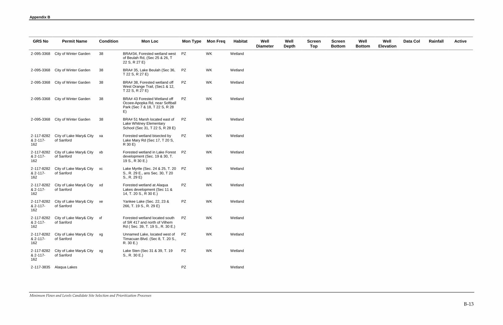
Appendix B
Minimum Flows and Levels Candidate Site Selection and Prioritization Processes
B-13
GRS No Permit Name Condition Mon Loc Mon Type Mon Freq Habitat WellDiameter
WellDepth
ScreenTop
ScreenBottom
WellBottom
WellElevation
Data Col Rainfall Active
2-095-3368 City of Winter Garden 38 BRA#34, Forested wetland westof Beulah Rd, (Sec 25 & 26, T22 S, R 27 E)
PZ WK Wetland
2-095-3368 City of Winter Garden 38 BRA# 35, Lake Beulah (Sec 36,T 22 S, R 27 E)
PZ WK Wetland
2-095-3368 City of Winter Garden 38 BRA# 38, Forested wetland offWest Orange Trail, (Sec1 & 12,T 22 S, R 27 E)
PZ WK Wetland
2-095-3368 City of Winter Garden 38 BRA# 43 Forested Wetland offOcoee-Apopka Rd, near SoftballPark (Sec 7 & 18, T 22 S, R 28E)
PZ WK Wetland
2-095-3368 City of Winter Garden 38 BRA# 51 Marsh located east ofLake Whitney ElementarySchool (Sec 31, T 22 S, R 28 E)
PZ WK Wetland
2-117-8282& 2-117-162
City of Lake Mary& Cityof Sanford
xa Forested wetland bisected byLake Mary Rd (Sec 17, T 20 S,R 30 E)
PZ WK Wetland
2-117-8282& 2-117-162
City of Lake Mary& Cityof Sanford
xb Forested wetland in Lake Forestdevelopment (Sec. 19 & 30, T.19 S., R 30 E.)
PZ WK Wetland
2-117-8282& 2-117-162
City of Lake Mary& Cityof Sanford
xc Lake Myrtle (Sec. 24 & 25, T. 20S., R. 29 E., ans Sec. 30, T 20S., R. 29 E)
PZ WK Wetland
2-117-8282& 2-117-162
City of Lake Mary& Cityof Sanford
xd Forested wetland at AlaquaLakes development (Sec 11 &14, T. 20 S., R 30 E.)
PZ WK Wetland
2-117-8282& 2-117-162
City of Lake Mary& Cityof Sanford
xe Yankee Lake (Sec. 22, 23 &266, T. 19 S., R. 29 E)
PZ WK Wetland
2-117-8282& 2-117-162
City of Lake Mary& Cityof Sanford
xf Forested wetland located southof SR 417 and north of VilhemRd ( Sec. 39, T. 19 S., R. 30 E.)
PZ WK Wetland
2-117-8282& 2-117-162
City of Lake Mary& Cityof Sanford
xg Unnamed Lake, located west ofTimacuan Blvd. (Sec 8, T. 20 S.,R. 30 E.)
PZ WK Wetland
2-117-8282& 2-117-162
City of Lake Mary& Cityof Sanford
xg Lake Sten (Sec 31 & 39, T. 19S., R. 30 E.)
PZ WK Wetland
2-117-3835 Alaqua Lakes PZ Wetland

Appendix B
Minimum Flows and Levels Candidate Site Selection and Prioritization Processes
B-14
GRS No Permit Name Condition Mon Loc Mon Type Mon Freq Habitat WellDiameter
WellDepth
ScreenTop
ScreenBottom
WellBottom
WellElevation
Data Col Rainfall Active
2-009-10647
City of Titusville ya A4-1 Cypress dome, locatedeast of RR (Sec. 5, T. 19 S., R.34 E.)
PZ WK Wetland No
2-009-10647
City of Titusville yb A4-2 Shallow Marsh, East of RR(Sec 5, T. 20 S., R. 34 E.)
PZ WK Wetland No
2-009-10647
City of Titusville yc A4-3 Cypress strand (Sec 4 & 5,T. 20 S., R. 34 E.)
PZ WK Wetland No
2-009-10647
City of Titusville yd A4-4 Cypress/cabbage palmdome (Sec. 5, T. 20 S., R. 34 E.)
PZ WK Wetland No
2-009-10647
City of Titusville ye A4-5 Cypress strand (Sec 4, T.20 S., R. 34 E.)
PZ WK Wetland No
2-009-10647
City of Titusville yf A4-6 Cypress dome ( Sec 4 & 5,T. 20 S., R. 34 E.)
PZ WK Wetland No
2-009-10647
City of Titusville yg A4-7 Cypress dome (Sec 5., T.20 S., R. 34 E.)
PZ WK Wetland No
2-009-10647
City of Titusville yh A4-8 Cypress dome (Sec. 6, T.20 S., R. 34 E.)
PZ WK Wetland No
2-009-10647
City of Titusville yi A4-9 Cypress dome/ShallowMarsh (Sec 5 & 8, T. 20 S., R.34 E.)
PZ WK Wetland No
2-009-10647
City of Titusville yj A4-10 Cypress strand (Sec 9, T.20 S., R. 34 E)
PZ WK Wetland No
2-009-10647
City of Titusville yk A4-11 Cypress dome (Sec. 41,T. 20 S., R. 43 E.)
PZ WK Wetland No
2-009-10647
City of Titusville yl A4-12 Cypress strand (Sec. 41,T. 20 S., R. 43 E)
PZ WK Wetland No
2-009-10647
City of Titusville ym A4-C1 Shallow Marsh (Sec. 31,T. 19 S., R. 34 E)
PZ WK Wetland No
2-009-10647
City of Titusville yn A4-C2 Cypress dome (Sec 6, T.20 S., R. 34 E.)
PZ WK Wetland No
2-127-8693 Hagstrom/Weston 25 Bowman Lake SG WK Wetland
2-001-1672 Meadowbrook GolfCourse at Gainesville
25 South Basin
2-001-1672 Meadowbrook GolfCourse at Gainesville
25 West Basin
2-009-202 Palm Bay Utilities 38 Staff Gauge 21-1 SG WK Wetland
2-009-202 Palm Bay Utilities 38 Monitor Well 29A-1 PZ WK Wetland
2-009-202 Palm Bay Utilities 38 Monitor Well 29A-2 PZ WK Wetland
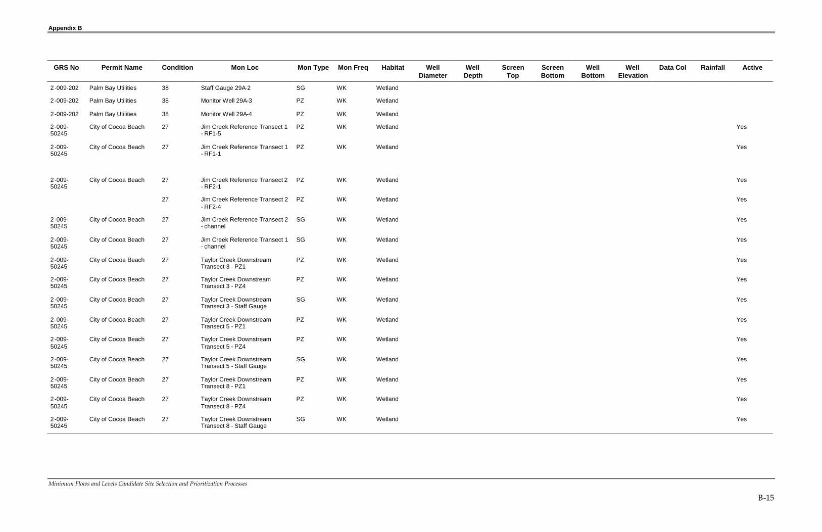
Appendix B
Minimum Flows and Levels Candidate Site Selection and Prioritization Processes
B-15
GRS No Permit Name Condition Mon Loc Mon Type Mon Freq Habitat WellDiameter
WellDepth
ScreenTop
ScreenBottom
WellBottom
WellElevation
Data Col Rainfall Active
2-009-202 Palm Bay Utilities 38 Staff Gauge 29A-2 SG WK Wetland
2-009-202 Palm Bay Utilities 38 Monitor Well 29A-3 PZ WK Wetland
2-009-202 Palm Bay Utilities 38 Monitor Well 29A-4 PZ WK Wetland
2-009-50245
City of Cocoa Beach 27 Jim Creek Reference Transect 1- RF1-5
PZ WK Wetland Yes
2-009-50245
City of Cocoa Beach 27 Jim Creek Reference Transect 1- RF1-1
PZ WK Wetland Yes
2-009-50245
City of Cocoa Beach 27 Jim Creek Reference Transect 2- RF2-1
PZ WK Wetland Yes
27 Jim Creek Reference Transect 2- RF2-4
PZ WK Wetland Yes
2-009-50245
City of Cocoa Beach 27 Jim Creek Reference Transect 2- channel
SG WK Wetland Yes
2-009-50245
City of Cocoa Beach 27 Jim Creek Reference Transect 1- channel
SG WK Wetland Yes
2-009-50245
City of Cocoa Beach 27 Taylor Creek DownstreamTransect 3 - PZ1
PZ WK Wetland Yes
2-009-50245
City of Cocoa Beach 27 Taylor Creek DownstreamTransect 3 - PZ4
PZ WK Wetland Yes
2-009-50245
City of Cocoa Beach 27 Taylor Creek DownstreamTransect 3 - Staff Gauge
SG WK Wetland Yes
2-009-50245
City of Cocoa Beach 27 Taylor Creek DownstreamTransect 5 - PZ1
PZ WK Wetland Yes
2-009-50245
City of Cocoa Beach 27 Taylor Creek DownstreamTransect 5 - PZ4
PZ WK Wetland Yes
2-009-50245
City of Cocoa Beach 27 Taylor Creek DownstreamTransect 5 - Staff Gauge
SG WK Wetland Yes
2-009-50245
City of Cocoa Beach 27 Taylor Creek DownstreamTransect 8 - PZ1
PZ WK Wetland Yes
2-009-50245
City of Cocoa Beach 27 Taylor Creek DownstreamTransect 8 - PZ4
PZ WK Wetland Yes
2-009-50245
City of Cocoa Beach 27 Taylor Creek DownstreamTransect 8 - Staff Gauge
SG WK Wetland Yes

Appendix CDevelopment of Site Attributes
Appendix C
Minimum Flows and Levels Candidate Site Selection and Prioritization Processes
C-1
IDENTIFICATION OF AREAS WITHPROJECTED SURFICIAL AQUIFER WATERLEVEL DECLINESThe site selection process begins with identification of areas with projected surficialaquifer water level declines through 2013, the date by which the South Florida, St.Johns River, and Southwest Florida water management districts have concludedthat water use is likely to reach the sustainable limits of the Floridan aquifer in thecentral Florida area (Figure 1). This conclusion is discussed in the document titledRecommended Action Plan for the Central Florida Coordination Area, September18, 2006.
IDENTIFICATION OF AREAS WITH THE HIGHEST RISK OFUNACCEPTABLE IMPACTS OR HARM TO WETLANDS AND LAKES
The projected surficial aquifer water level declines developed in Step 1.are usedas critical input to SJRWMD’s models that predict the likelihood of harm towetlands and lakes. These models were developed for use in SJRWMD’s WaterSupply Planning Program (Kinser et al. 1995, 2003) (Kinser et al. 2005). Throughuse of these models wetland and lake areas with the highest risk of unacceptableimpacts or harm are identified (Figures 2 and 3).
PROJECTED IMPACTS TO WETLANDS
SJRWMD’s process for assessing impacts to wetlands is described in Kinser andMinno (1995) and Kinser et al. (2003). The relative likelihood of harm to wetlandvegetation due to projected 2013 groundwater withdrawals was assessed using ageographic information system (GIS) model. The GIS model integrated soilpermeability, sensitivity of wetlands to dewatering, and projected declines in thewater levels of the surficial aquifer system (SAS) to predict the likelihood of harmto wetland plant communities. The wetland constraints for the 2013 assessmentwere updated to reflect the wetlands criteria in the Water 2020 ConstraintsHandbook (SJRWMD et al. 2005). The wetland impact constraints are as follows:
Lower likelihood of harm (<0.35 ft SAS drawdown)
Moderate likelihood of harm (>0.35 to <1.2 ft SAS drawdown)
Higher likelihood of harm (>1.2 ft SAS drawdown)
The likelihood of unacceptable impacts to native vegetation related to projectedgroundwater withdrawals varied throughout SJRWMD (Figure 2). The likelihoodof unacceptable impacts is lower in most of the northern and extreme southernportions of SJRWMD, including all of Alachua, Baker, Duval, Clay, St. Johns,

Appendix C
Minimum Flows and Levels Candidate Site Selection and Prioritization Processes
C-2
Indian River, Nassau, Okeechobee, and Putnam counties. Most of the remainderof SJRWMD was identified as exemplifying moderate-to-higher likelihood ofharm to wetland vegetation. Exceptions were lowlands associated with coastallagoons and the valleys of the St. Johns and Ocklawaha rivers. The areas showingthe highest likelihood of wetland impacts occurred along major landscape ridgesthroughout SJRWMD. These include the Atlantic Coastal Ridge in Volusia andFlagler counties and northern Brevard County, the Crescent City and DeLandridges in northwestern and central Volusia counties, the Groveland Karst andLake Wales Ridge regions of central and south Lake County, the Apopka Uplandsand the Orlando Promontory of western Orange County, and the Casselberry-Oviedo-Geneva-Chuluota Hills region of west-central Seminole County.
PROJECTED IMPACTS TO LAKES
SJRWMD assessed the relative likelihood of harm to lakes due to projectedchanges in groundwater withdrawals (1995-2013) using a GIS model developedby Kinser et al. (2005). Six GIS data layers, each influencing or expressinggroundwater-surface water interactions, were chosen as input to the model.These data layers include:
Thickness of the upper confining unit separating the surficial and Floridanaquifer systems
Head difference between surficial and Floridan aquifer systems
Soil permeability
Wetlands
Topographic curvature
Topographic deviation
These GIS layers were overlaid to identify regions susceptible to harm due toprojected 2013 groundwater withdrawals. The output is a map representing therelative likelihood of harm to lakes produced by overlaying the lake susceptibilityand modeled surficial aquifer drawdown layers. Susceptible areas are thoseidentified as having a surficial drawdown >0.5 ft. This value is based on the lakesconstraint established in the Water 2020 Constraints Handbook (CH2M HILL 2005).The regional patterns of likelihood of harm to lakes was very similar to thatobserved for likelihood of harm to wetland vegetation (Figure 3).
IDENTIFY SITES WITH HIGH PROBABILITY OF REFLECTINGREGIONAL IMPACTS
Among wetlands and lakes, some are more sensitive to drawdown than others.The process design is intended to ensure representation of the most drawdown-

Appendix C
Minimum Flows and Levels Candidate Site Selection and Prioritization Processes
C-3
sensitive wetlands and lakes. A special priority is places on isolated wetlands notassociated with lakes, because they have been largely ignored in the MFLsprocess to date and their small size makes them especially sensitive todrawdown. The process of assessing the extent to which a water body is likely toreflect the impacts of regional groundwater withdrawals was developed based onthe general consensus of SJRWMD environmental scientists with experience in theassessment process for wetland impacts.
The principle design factors in the wetland site selection process were:
Water body size
Water body depth
Water body landscape position
Additional landscape factors to consider in candidate site selection include:
Basin size and slope
Soil permeability
Karst geology
Surrounding landcover
These and other factors determine the hydrogeomorphic setting and character ofthe wetland. For example, an herbaceous or cypress depression can have eithermineral or organic soils. The hydrologic characteristics of smaller wetlands maybe determined by subsurface fractures or sinkholes. Bayheads occur mid-slopealong a break in a confining layer, at the bottom of a slope where the water tablereaches the surface, or in hydric flatwoods where the soils saturate to the surface.Consideration of the confounding effects of landscape alteration is necessary;ditching, roads, and other land use factors can alter wetland hydrology.
SUITABILITY OF WATER BODY FOR APPLICATION OF AVAILABLE MFL METHODS
A desirable MFL site must have soil characteristics for which an evaluationmethod exists. MFLs evaluation and threshold criteria are well-developed forwater bodies with histosol soils. These methods are based on a large body of soilsresearch and have been subjected to intensive peer review. Additionally,SJRWMD is in the advanced stages of developing soils criteria and a methodologyfor setting MFLs on sandhill lakes. The identification of soil indicators ofcharacteristic hydrology is published (Richardson et al. 2005). The methodologyhas been site tested and a set of benchmark sites are being established.Separately, the criteria for setting MFLs for sandhill lakes are in review (Jones,
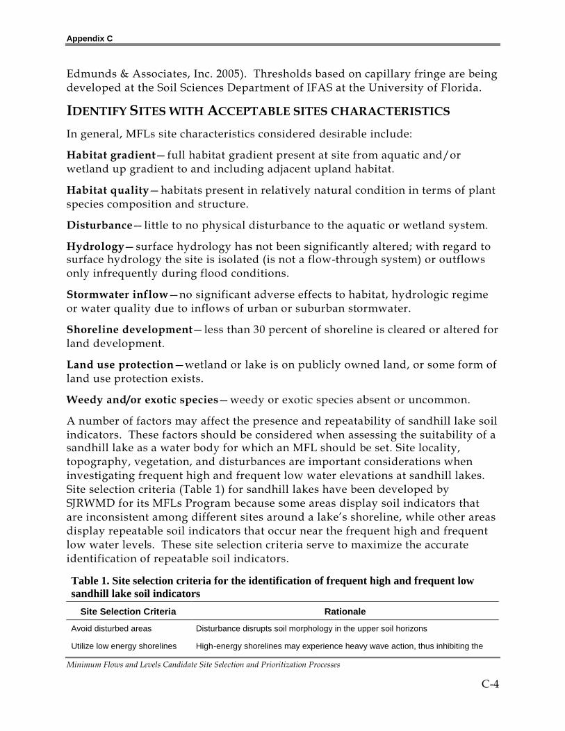
Appendix C
Minimum Flows and Levels Candidate Site Selection and Prioritization Processes
C-4
Edmunds & Associates, Inc. 2005). Thresholds based on capillary fringe are beingdeveloped at the Soil Sciences Department of IFAS at the University of Florida.
IDENTIFY SITES WITH ACCEPTABLE SITES CHARACTERISTICS
In general, MFLs site characteristics considered desirable include:
Habitat gradient—full habitat gradient present at site from aquatic and/orwetland up gradient to and including adjacent upland habitat.
Habitat quality—habitats present in relatively natural condition in terms of plantspecies composition and structure.
Disturbance—little to no physical disturbance to the aquatic or wetland system.
Hydrology—surface hydrology has not been significantly altered; with regard tosurface hydrology the site is isolated (is not a flow-through system) or outflowsonly infrequently during flood conditions.
Stormwater inflow—no significant adverse effects to habitat, hydrologic regimeor water quality due to inflows of urban or suburban stormwater.
Shoreline development—less than 30 percent of shoreline is cleared or altered forland development.
Land use protection—wetland or lake is on publicly owned land, or some form ofland use protection exists.
Weedy and/or exotic species—weedy or exotic species absent or uncommon.
A number of factors may affect the presence and repeatability of sandhill lake soilindicators. These factors should be considered when assessing the suitability of asandhill lake as a water body for which an MFL should be set. Site locality,topography, vegetation, and disturbances are important considerations wheninvestigating frequent high and frequent low water elevations at sandhill lakes.Site selection criteria (Table 1) for sandhill lakes have been developed bySJRWMD for its MFLs Program because some areas display soil indicators thatare inconsistent among different sites around a lake’s shoreline, while other areasdisplay repeatable soil indicators that occur near the frequent high and frequentlow water levels. These site selection criteria serve to maximize the accurateidentification of repeatable soil indicators.
Table 1. Site selection criteria for the identification of frequent high and frequent lowsandhill lake soil indicators
Site Selection Criteria Rationale
Avoid disturbed areas Disturbance disrupts soil morphology in the upper soil horizons
Utilize low energy shorelines High-energy shorelines may experience heavy wave action, thus inhibiting the

Appendix C
Minimum Flows and Levels Candidate Site Selection and Prioritization Processes
C-5
formation of sandhill lake soil indicators
Utilize short slope lengths(steep slopes)
Short slope lengths tend to display the greatest changes in soil morphology overshort distances, thereby providing the best opportunity to accurately identifysandhill lake soil indicators
Avoid seepage slopes Seepage slopes experience wetter conditions than provided by lake inundationalone, likely resulting in dissimilar soil morphology or misidentification of sandhilllake soil indicators
Avoid pine-dominated uplandcommunities
Pine-dominated upland communities tend to be less common on sandhill lakesand produce more biomass of disparate chemistry, resulting in different soilmorphology than that observed in hardwood-dominated upland communities
Avoid areas with more than afew inches of organic soil
Areas that develop organic soil on sandhill lakes are likely influenced byseepage, which may result in dissimilar soil morphology or misidentification ofsandhill lake soil indicators
SITE ACCESSIBILITY
A candidate MFL site must be physically accessible in order to assess thesuitability of the site and to perform the work necessary to establish MFLs.Access requires the permission of the owner or its agent.
IDENTIFICATION OF WATER BODIES FOR WHICH A LONG PERIOD OFHIGH QUALITY HYDROLOGIC DATA IS AVAILABLE
Water bodies identified as a result of Step 3 are further evaluated to identifythose for which a long period of high quality hydrologic data is available. Thisdata is necessary for the establishment and implementation of MFLs. This stepresults in a list of candidate sites, all of which satisfy the site selection criteria.SJRWMD anticipates that these sites or a subset of these sites will be added tofuture MFLs Priority Water Body Lists and Schedules to satisfy the requirementsof Section 373.042(2), F.S.
The primary criterion for assessing the value of the hydrologic data is the lengthof the period of record. The longer the period of record, the more likely it is torepresent the natural range of variation of surface water levels and, in particular,include more extreme events of high and low stages.
Several secondary valuation criteria important to assessing data quality are:
Data frequency
Data continuity
Data quality assurance

Appendix C
Minimum Flows and Levels Candidate Site Selection and Prioritization Processes
C-6
DATA FREQUENCY
The frequency of observation may be daily, weekly, monthly, or less frequent.More frequent observations are preferred, however, weekly observations aresatisfactory and monthly observations are adequate when the period of record issufficient.
DATA CONTINUITY
Continuity of water level observations is very important to the application of thedata. Gaps and irregular observations in the period of record require datainterpolation and affect hydrologic model calibration. An added drawbackassociated with data gaps is the absence of data during more extreme climaticconditions. For example, gaps often occur during extreme dry conditions, aswater levels fall below the range of staff gauges. Much less often, water levelscan rise above the range of gauges during periods of high rainfall, and maximumwater levels are not recorded.
DATA QUALITY ASSURANCE
Quality Assurance (QA) of hydrologic data is also a very important valuationcriterion. Important QA considerations include:
Existence of a surveyed (to a registered monument) elevation for the staff gauge
Existence of surveyed elevation data from routine re-surveys to ensure stability ofthe topographic datum over time
Documentation of a chain of custody associated with the data
Existence of data in a computerized database

Appendix C
Minimum Flows and Levels Candidate Site Selection and Prioritization Processes
C-7

Appendix C
Minimum Flows and Levels Candidate Site Selection and Prioritization Processes
C-8

Appendix C
Minimum Flows and Levels Candidate Site Selection and Prioritization Processes
C-9

Appendix C
Minimum Flows and Levels Candidate Site Selection and Prioritization Processes
C-10
REFERENCESJones, Edmunds & Associates, Inc. 2005 (draft). Sandhill lakesminimum flows and levels: Values, functions, criteria, andthresholds for establishing and supporting minimum levels.Jones, Edmunds & Associates, Inc. Gainesville, Fla.
Kinser, P., and M. Minno. 1995. Estimating the likelihood ofharm to native vegetation from groundwater withdrawals, St.Johns River Water Management District. Technical PublicationSJ95-8. St. Johns River Water Management District. Palatka, Fla.
Kinser, P., M. Minno, P. Burger, and S. Brown. 2003 (draft).Modification of modeling criteria for application in the 2025 likelihoodof harm assessment. St. Johns River Water Management District,Palatka, Fla.
Kinser, P., Minno, M., and Brown, S., Dennizman. J. 2005 (draft).Estimating the likelihood of harm to lakes form groundwaterwithdrawals in the St. Johns River Water Management District forthe year 2025. St. Johns River Water Management District.Professional Paper. Palatka, Fla.
Richardson, T.C., D.S. Segal, G.W. Hurt, G.B. Hall, R.J. Epting,and B.L. Skulnick. 2005. Methodology to predict frequent highand frequent low water levels in Florida sandhill lakes using soilmorphology. Version 1.0. St. Johns River Water ManagementDistrict. Palatka, Fla.
South Florida, St. Johns, Southwest Florida water managementdistricts. 2006. Recommended Action Plan for the Central FloridaCoordination Area. St. Johns River Water Management District.Palatka, Fla.
St. Johns River Water Management District and CH2M HILL.2005. Water 2020 Constraints Handbook. Special Publication SJ 2005-SP8. St. Johns River Water Management District. Palatka, Fla.
St. Johns River Water Management District. 2006. Water SupplyAssessment, 2003. Technical Publication SJ2006-1. St. Johns RiverWater Management District. Palatka, Fla.

Appendix DAttribute Scores for Candidate MFL Sites

Appendix D
Minimum Flows and Levels Candidate Site Selection and Prioritization Processes
D-1
Site Site Name Latitude Longitude SourceSas
DeclineVeg/Lake
HarmImpact
Risk Site CharHydro
Por1 Lake Orienta at Lake N 28 39.118 W 81 22.867 SM 10 0 8 6 6
2 Hammond Lake @ Lake L N 28 26.001 W 81 43.519 SJR 5 0 5 10 0
2 Marsh pond connected N 28 40.291 W 81 22.382 SM 10 0 8 2 4
3 Lake Marion N 28 40.731 W 81 21.992 SM 10 0 8 1 2
4 Lake Florida N 28 40.295 W 81 21.833 SM 5 0 8 2 4
5 Lake Adelaide N 28 40.244 W 81 21.970 SM 5 0 8 8 4
7 Triplet Lakes Park at N 28 40.394 W 81 19.560 SM 5 10 3 8 6
8 Triplet Lakes Swamp N 28 39.564 W 81 19.389 SM 10 10 3 8 0
10 Lake Tony N 28 40.269 W 81 17.312 SM 5 0 3 0 6
11 Lake Tony N 28 40.263 W 81 17.313 SM 5 0 3 0 6
12 Lake Hodge Park N 28 41.400 W 81 19.253 SM 10 10 3 10 6
13 Myrtle Lake N 28 43.385 W 81 21.760 SM 10 0 1 2 6
14 Greenwood Lake Park N 28 43.980 W 81 20.947 SM 5 0 1 5 6
17 Lake Bingham N 28 44.284 W 81 18.617 SM 5 0 6 1 6
19 Lake Mary N 28 44.809 W 81 19.010 SM 0 0 1 4 4
20 Lake Mary N 28 44.901 W 81 18.708 SM 0 0 3 10 4
22 Liberty Park at Lake N 28 46.091 W 81 19.083 SM 0 10 6 10 6
23 Lake Crystal @ commun N 28 46.094 W 81 19.148 SM 0 0 6 10 6
24 Lake Emma @ Primera N 28 45.663 W 81 21.340 SJR 0 10 1 5 1
33 Lake Markham N 28 48.018 W 81 23.871 SM 0 0 1 5 6
34 Sylvan Lake Park--par N 28 48.066 W 81 23.152 SJR 5 0 6 10 6
35 Sylvan Lake Park--mar N 28 48.048 W 81 23.062 SJR 5 0 6 10 6
36 Sylvan Lake Park--edg N 28 48.040 W 81 23.026 SJR 5 0 6 10 6
37 Yankee Lake N 28 49.053 W 81 23.742 SM 5 0 1 5 2
41 Crystal Lake@ Communi N 28 45.713 W 81 19.418 SJR 10 0 6 10 7
42 Crystal Lake@ Wesley N 28 45.597 W 81 19.995 SJR 10 10 6 10 7
43 Lake Concord@ Anniver N 28 40.355 W 81 20.175 SM 10 10 3 6 6
44 Quail Pond@ Anniversa N 28 40.292 W 81 20.114 SM 10 10 3 6 2

Appendix D
Minimum Flows and Levels Candidate Site Selection and Prioritization Processes
D-2
Site Site Name Latitude Longitude SourceSas
DeclineVeg/Lake
HarmImpact
Risk Site CharHydro
Por45 Lake Wildmere N 28 41.875 W 81 20.100 SM 10 0 3 2 6
46 Lake Yvonne (Quintupl N 28 40.171 W 81 18.897 SM 10 0 3 2 6
47 Crystal Bowl N 28 39.897 W 81 18.772 SM 10 0 3 2 6
48 Crystal Bowl Park N 28 39.723 W 81 18.801 SM 10 0 3 5 6
50 Lake Kathryn N 28 40.995 W 81 19.979 SM 10 0 3 0 6
51 Lake Searcy @ Sandalw N 28 42.357 W 81 21.502 SM 10 10 3 1 6
53 Island Lake N 28 41.733 W 81 21.659 SM 10 10 3 6 6
54 Island Lake at borrow N 28 41.721 W 81 21.605 SM 10 0 3 1 6
57 Lakes Deforest and Be N 28 46.863 W 81 18.556 SJR 0 0 1 2 0
61 Lake Geneva N 28 44.725 W 81 06.646 SM 0 0 1 1 4
63 Flatwoods pond at Lk N 28 43.638 W 81 06.040 SM 0 0 1 10 6
64 Lake Proctor marsh N 28 43.741 W 81 06.123 SM 0 0 1 10 6
65 Geneva Wilderness Are N 28 42.396 W 81 07.570 SJR 5 0 1 10 6
67 Lake Mills Park N 28 37.956 W 81 07.304 SJR 5 0 1 10 0
68 Mirror Lake N 28 40.080 W 81 26.293 SM 0 10 3 2 6
69 Bear Lakes N 28 38.563 W 81 26.677 SM 5 0 5 2 6
70 Border Lake N 28 40.186 W 81 27.710 OR 10 0 3 1 6
71 Lake Prevatt N 28 42.535 W 81 29.296 SJR 5 10 3 10 6
76 Lake McKoy--site 2 N 28 41.038 W 81 29.975 SJR 10 0 3 6 3
78 Trout Lake N 28 37.303 W 81 30.626 SJR 0 0 3 0 2
83 Horseshoe Lake N 28 35.821 W 81 28.116 OR 5 0 3 1 6
85 Lawne Lake @ Gordon B N 28 33.823 W 81 26.506 OR 0 0 5 6 6
92 Lake Down at boat ram N 28 29.630 W 81 31.217 OR 0 0 5 6 6
93 Lake Bessie at Park N 28 29.503 W 81 31.830 OR 5 10 10 10 6
97 Tibet Butler Preserve N 28 26.805 W 81 32.283 OR 0 0 5 10 6
98 Tibet Butler Preserve N 28 26.882 W 81 32.125 OR 0 0 5 6 6
99 Lake Starke--park at N 28 34.262 W 81 32.507 SJR 5 0 5 10 6
106 Lake Starke--retentio N 28 34.059 W 81 32.013 SJR 0 0 5 2 6

Appendix D
Minimum Flows and Levels Candidate Site Selection and Prioritization Processes
D-3
Site Site Name Latitude Longitude SourceSas
DeclineVeg/Lake
HarmImpact
Risk Site CharHydro
Por112 Lake Lucy--retention N 28 34.331 W 81 29.785 SJR 10 0 3 6 3
117 Lake Alden N 28 42.009 W 81 32.081 OR 5 0 3 1 6
119 Lake Anne @ retention N 28 41.380 W 81 32.791 OR 10 0 5 1 6
137 Mt Plymouth Lake Park N 28 48.509 W 81 31.372 SJR 5 10 3 10 6
152 Dixie Lake @ Lake Lou N 28 26.459 W 81 44.099 SJR 5 0 5 10 0
160 Depression @ entrance N 28 27.177 W 81 43.388 SJR 5 0 5 10 0
161 Triple depression on N 28 26.737 W 81 43.282 SJR 5 10 5 10 0
190 Keene Lake on W side N 28 25.179 W 81 42.399 SJR 5 0 5 1 5
210 Black Lake N 28 31.783 W 81 36.453 OR 5 10 5 1 6
217 Lake Avalon N 28 30.784 W 81 38.237 SJR 10 0 5 5 5
219 L. Avalon--Secret Vis N 28 30.436 W 81 38.675 SJR 5 0 5 5 5
220 Flat Lake N 28 29.582 W 81 40.274 SJR 0 0 5 5 5
222 Sawgrass Lake @ Cook N 28 26.178 W 81 41.224 SJR 5 10 5 1 0
227 Hickory Nut Lake @ YM N 28 26.265 W 81 38.748 OR 0 0 5 1 6
228 Hickory Nut Lake @ Av N 28 25.291 W 81 38.152 OR 0 0 5 1 6
229 Hickory Nut Lake @ Av N 28 24.867 W 81 38.172 OR 0 0 5 1 6
232 Lake Hancock N 28 27.147 W 81 36.733 OR 0 0 5 1 6
250 Lake Faith 2 N 28 28.221 W 81 22.018 SJR 0 0 5 1 0
251 Lake Seminary N 28 38.629 W 81 21.482 SM 10 10 3 2 6
252 Lake Sybelia N 28 37.664 W 81 22.093 OR 5 0 3 10 6
254 Lake Destiny N 28 38.426 W 81 23.581 SM 5 0 5 2 4
263 Maggiore & Minore nea N 28 44.097 W 81 36.392 SJR 5 0 3 9 4
264 Maggiore @ Zellwood E N 28 44.200 W 81 36.138 SJR 5 0 3 9 4
266 Lake Joanna near Mt D N 28 50.914 W 81 38.508 SJR 0 0 5 2 6
272 Lake Umatilla @ Guerr N 28 55.058 W 81 39.986 LK 0 0 3 10 4
275 Long Lake off Groveli N 28 36.964 W 81 28.448 OR 10 0 5 8 6
278 Lake Sherwood off SR N 28 33.155 W 81 29.881 OR 0 10 3 8 6
282 Lake Berry off Balmor N 28 35.128 W 81 19.783 OR 5 0 3 8 6

Appendix D
Minimum Flows and Levels Candidate Site Selection and Prioritization Processes
D-4
Site Site Name Latitude Longitude SourceSas
DeclineVeg/Lake
HarmImpact
Risk Site CharHydro
Por291 Lake Beulah off Winde N 28 32.060 W 81 33.725 OR 0 0 5 8 6
295 Crooked Lake N 28 35.462 W 81 28.856 OR 10 0 3 8 6
300 Lake Mizell N 28 35.961 W 81 20.342 OR 5 0 5 1 6
301 Lake Virginia N 28 35.222 W 81 20.956 OR 5 0 3 6 6
302 Lost Lake N 28 40.281 W 81 19.322 SM 5 10 3 6 2
303 Queens Mirror N 28 39.790 W 81 19.600 SM 10 0 3 2 6
305 Lake Alpharetta N 28 37.366 W 81 29.331 OR 0 0 3 1 6
306 Middle Triplet N 28 40.176 W 81 19.764 SM 10 10 3 6 6
307 Lake Susannah south o N 28 33.645 W 81 19.216 OR 0 0 5 1 6
310 Lake Hiawassee N 28 31.980 W 81 28.816 SJR 10 10 3 8 5
315 Pearl Lake N 28 47.705 W 81 22.065 SM 5 0 1 8 0
319 Lake Marietta N 28 46.613 W 81 22.275 SM 0 10 1 8 6
320 Island Lake N 28 46.490 W 81 22.283 SM 0 10 1 8 6
321 Banana Lake N 28 46.629 W 81 21.808 SJR 0 0 3 8 0
322 Twin Lakes N 28 47.340 W 81 20.007 SM 0 0 1 8 6
325 Dawson Lake N 28 46.505 W 81 20.356 SM 0 0 1 8 1
330 Lake Saunders N 28 48.974 W 81 42.004 SJR 5 10 3 1 6
345 Lake Dyches, Leesburg N 28 48.502 W 81 54.209 LK 5 10 3 1 6
821 Island Lake N 28 46.605 W 81 22.417 SM 0 0 1 2 6
1321 Lake Irma N 28 35.697 W 81 15.705 SJR 10 0 3 1 6