mike urban+ migration guide · 1 introduction mike urban+ is the new and future modelling platform...
TRANSCRIPT

MIKE 2020
MIKE URBAN+
Guide to existing MIKE URBAN Users
Migration

mike urban plus migration guide.docx © DHI A/S
DHI A/S
Agern Allé 5
DK-2970 Hørsholm
Denmark
+45 4516 9200 Telephone
+45 4516 9333 Support
+45 4516 9292 Telefax
www.mikepoweredbydhi.com
Company Registration No.: DK36466871

MIKE 2020
PLEASE NOTE
COPYRIGHT This document refers to proprietary computer software, which is
protected by copyright. All rights are reserved. Copying or other
reproduction of this manual or the related programmes is
prohibited without prior written consent of DHI A/S (hereinafter
referred to as “DHI”). For details please refer to your ‘DHI
Software Licence Agreement’.
LIMITED LIABILITY The liability of DHI is limited as specified in your DHI Software Li-
cense Agreement:
In no event shall DHI or its representatives (agents and suppliers)
be liable for any damages whatsoever including, without
limitation, special, indirect, incidental or consequential damages
or damages for loss of business profits or savings, business
interruption, loss of business information or other pecuniary loss
arising in connection with the Agreement, e.g. out of Licensee's
use of or the inability to use the Software, even if DHI has been
advised of the possibility of such damages.
This limitation shall apply to claims of personal injury to the extent
permitted by law. Some jurisdictions do not allow the exclusion or
limitation of liability for consequential, special, indirect, incidental
damages and, accordingly, some portions of these limitations
may not apply.
Notwithstanding the above, DHI's total liability (whether in
contract, tort, including negligence, or otherwise) under or in
connection with the Agreement shall in aggregate during the term
not exceed the lesser of EUR 10,000 or the fees paid by Licensee
under the Agreement during the 12 months' period previous to the
event giving rise to a claim.
Licensee acknowledge that the liability limitations and exclusions
set out in the Agreement reflect the allocation of risk negotiated
and agreed by the parties and that DHI would not enter into the
Agreement without these limitations and exclusions on its liability.
These limitations and exclusions will apply notwithstanding any
failure of essential purpose of any limited remedy.

MIKE URBAN+
Guide to existing MIKE URBAN Users - © DHI A/S

i
CONTENTS
1 Introduction .................................................................................................................. 1
2 Release and License Information ................................................................................. 1 2.1 Releases ........................................................................................................................................ 1
3 Getting Started with MIKE URBAN+ ............................................................................. 3 3.1 Open MIKE URBAN+ model and explore MIKE URBAN+ GUI ........................................................ 3 3.2 Project Info: provides a general information on the project contents ................................................ 6 3.2.1 Find about editors functionality ....................................................................................................... 6 3.2.2 Editor Functionality ......................................................................................................................... 8 3.3 Project info ..................................................................................................................................... 9 3.4 Boundary conditions ..................................................................................................................... 10 3.4.1 Boundary Conditions Editor .......................................................................................................... 10 3.5 Result specification ...................................................................................................................... 15 3.5.1 Result Files .................................................................................................................................. 15 3.5.2 Network summary ........................................................................................................................ 18 3.6 Simulation setup........................................................................................................................... 20 3.6.1 ‘Identification’ box and function buttons ........................................................................................ 20 3.6.2 ‘General’ TAB............................................................................................................................... 21 3.6.3 Module TABS ............................................................................................................................... 21 3.6.4 ‘Results’ TAB ............................................................................................................................... 22 3.7 Results......................................................................................................................................... 23 3.7.1 Loading result files ....................................................................................................................... 23 3.7.2 Results in the map ....................................................................................................................... 25 3.7.3 Results TS Plot & table ................................................................................................................ 26 3.7.4 Results in Long profile .................................................................................................................. 28 3.7.5 Results in Bar-chart ...................................................................................................................... 28 3.7.6 Results: LTS reports..................................................................................................................... 28
4 Import MIKE URBAN model to MIKE URBAN+ ........................................................... 29 4.1 Modules Overview ........................................................................................................................ 29 4.2 Prerequisites ................................................................................................................................ 29 4.3 File | New ..................................................................................................................................... 29 4.3.1 Module Selection.......................................................................................................................... 30 4.3.2 Coordinate System ....................................................................................................................... 31 4.3.3 General settings | Modules ........................................................................................................... 32 4.4 File | Import .................................................................................................................................. 32 4.5 Status after import ........................................................................................................................ 33 4.6 MIKE URBAN+ unsupported features in first release .................................................................... 35

MIKE URBAN+
ii Guide to existing MIKE URBAN Users - © DHI A/S

1 Introduction
MIKE URBAN+ is the new and future modelling platform for modelling all urban water
systems. It is introduced as a full featured urban modelling package for modelling Water
Distribution and Collection System. MIKE URBAN+ is the successor of the current MIKE
URBAN.
The MIKE 2020 Release will include both MIKE URBAN+ and MIKE URBAN. MIKE
URBAN 2020 will be the last release of MIKE URBAN.
The current document targets existing MIKE URBAN users with the aim of informing
about the current contents and features of MIKE URBAN+ as well as outlining the main
steps involved in migrating from MIKE URBAN to MIKE URBAN+.
2 Release and License Information
MIKE URBAN+ is our primary urban software product for sale with the MIKE URBAN+
Release 2019 and forward.
MIKE URBAN will be included with MIKE URBAN+ until the last release of MIKE URBAN
2020. New purchases of MIKE URBAN+ model licenses will include access to both MIKE
URBAN+ and MIKE URBAN. The MIKE URBAN+ and MIKE URBAN can coexist on the
PC and run simultaneously.
MIKE URBAN+ comes in two versions:
• MIKE URBAN+
• MIKE URBAN+ ArcGIS
The difference between the two version is that the MIKE URBAN+ ArcGIS includes
license for ArcGIS Pro, ArcGIS and one seat for ArcGIS Online as well as installation files
for ArcGIS Pro.
In both MIKE URBAN+ and MIKE URBAN+ ArcGIS, there is an ArcGIS integration option
by which integration with ArcGIS Pro is possible. This integration requires a license for
ArcGIS Pro.
Existing users of MIKE URBAN with a valid Service and Maintenance
Agreement (SMA) will get access to MIKE URBAN+ ArcGIS version without additional
fees.
2.1 Releases
MIKE URBAN+ will be released in two parts:
• the first release in May 2019, MIKE URBAN+ 2019 includes for water distribution and
collection systems
• the second release in November 2019, MIKE URBAN+ 2020 includes:
o 2D Overland flood modelling
o Culvert Structures

MIKE URBAN+
Guide to existing MIKE URBAN Users - © DHI A/S
o Sediment Transport
o Import of existing MIKE URBAN Scenarios
o Enhanced LTS functionality
o Improved result presentation workflow

3 Getting Started with MIKE URBAN+
This chapter provides a quick introduction to MIKE URBAN+. MIKE URBAN+ supports
both Collection System and Water Distribution modelling.
Examples files for both Collection System and Water Distribution is provided with the
installation in both SI and US units.
In the following illustration of a Collection System model, Sirius is used as an example.
3.1 Open MIKE URBAN+ model and explore MIKE URBAN+ GUI
1. Start MIKE URBAN+
Figure 3.1 Start screen
2. Open the model Sirius.mupp
a. File/Open
Figure 3.2 File | New

MIKE URBAN+
Guide to existing MIKE URBAN Users - © DHI A/S
b. Browse to the MIKE URBAN+ project file Sirius.mupp and click “Open”
Figure 3.3 Browse for MIKE URBAN+ project file, *.mupp
c. Review the application window
Figure 3.4 Overview application window
MAP: map view of the model with default symbology

Figure 3.5 Map and toolbar window
The map is per default ‘docked’, but can be ‘floated’ (right ‘click’ + Float).
The map is brought to the front by clicking on the ‘Map’ tab)
Setup: One of three ‘Table of contents’:
• Setup: Access to model setup editors
• Layers and Symbols: Configuring map symbols
• Results: Result presentation
Context-sensitive contents – only editors associated with currently active
modules are shown (controlled by ‘Modules’ editor)

MIKE URBAN+
Guide to existing MIKE URBAN Users - © DHI A/S
Figure 3.6 Modules selection
Logical workflow sequence, entries organised in modules and groups
Data validation:
Green: all OK
Red: Some data is incomplete or incorrect
3.2 Project Info: provides a general information on the project contents
Figure 3.7 Project information
3.2.1 Find about editors functionality
General features
A click on any group entry folds/unfolds a group.
A click on any low-level entry opens an editor and per default docks it as a tabbed document.
‘Docked’ editors are displayed one at a time. Any editor can be brought to the front by clicking
on its tab.
When ‘Floated’, editors are displayed in a stack, with the active editor on top.
MIKE URBAN+ GUI with ‘floating’ editors:

Figure 3.8 Dialogs floating
MIKE URBAN+ GUI with all editors ‘docked’. Only the active ‘Catchment Connections’ editor is
visible:
Figure 3.9 Dialogs docked

MIKE URBAN+
Guide to existing MIKE URBAN Users - © DHI A/S
3.2.2 Editor Functionality
Error validation
Figure 3.10 On-the-fly data validation
Filtering
Figure 3.11 Catchment Connections
Other functions

Figure 3.12 Grid functions (1)
Figure 3.13 Grind functions (2)
3.3 Project info
Provides some basic information about project contents.
Figure 3.14 Project Info

MIKE URBAN+
Guide to existing MIKE URBAN Users - © DHI A/S
3.4 Boundary conditions
Figure 3.15 Boundary Conditions
3.4.1 Boundary Conditions Editor
‘Identification’ box
BC ‘passport’: Identifier (name), Type, Activity
Serves all types of BC.

Figure 3.16 Boundary Conditions

MIKE URBAN+
Guide to existing MIKE URBAN Users - © DHI A/S
‘Spatial extent’ TAB
Linking of the actual BC with the model
• All – entire model
• List (selection): reference to a sub-set of model elements, defined in a ‘selection manager’
(in MU Classic: ‘*.mus’ file)
• Individual: reference to individual model element
• Geo-coded: applies for load points associated with individual model elements
• Data source location: applies for meteorological stations ( e.g. rain gauges)
• Grid-distributed weights: applies for rainfall supplied as RADAR grid data
‘Temporal variation’ TAB
Figure 3.17 Temporal Variations
Provides information about quantities and temporal variation
• Constant
• Cyclic
• Time series
‘Limited interval’ TAB
Per default, a BC applies during entire simulation period. Activating ‘Limited interval’ restricts the
BCs activity for the specified time interval only

Figure 3.18 Limited interval
Scaling factor ‘TAB’
‘Scaling factor’ other than ‘1’ scales the specified BC quantity up or down.
Figure 3.19 Scaling factor
‘Distribute weights’ TAB
Contains user-specified or automatically computed ‘weighting factors’, i.e. contributions of
RADAR grid cells to each catchment in the model. Note that the sum of weights for each
catchment must be one. Data validation automatically controls that the data are correct.

MIKE URBAN+
Guide to existing MIKE URBAN Users - © DHI A/S
Figure 3.20 Distributed Weights
‘Description’ TAB
Contains user-specified description of the actual BC. Good as a reminder!
Figure 3.21 Boundary Conditions - Description

3.5 Result specification
3.5.1 Result Files
Figure 3.22 Result files
‘Identification’ box
Figure 3.23 Identification box
Contains basic information about the result file:
• ID: ResultFileID is a part of the unique result file name, which is created as:
SimulationID+ScenarioID+ResultFileID+format extension
• Model Type: Makes a distinction between ‘Catchments’ model and ‘Network’ model. This
distinction controls possible contents types and formats.
• Content type: Each of the above model types can generate various contents. Result file
may contain just one type of contents (keeps various types of results in separate files), or
the contents may be mixed (puts various types or results in one result files)
• Format: various types or results may be saved in various formats: res1d and dfs0
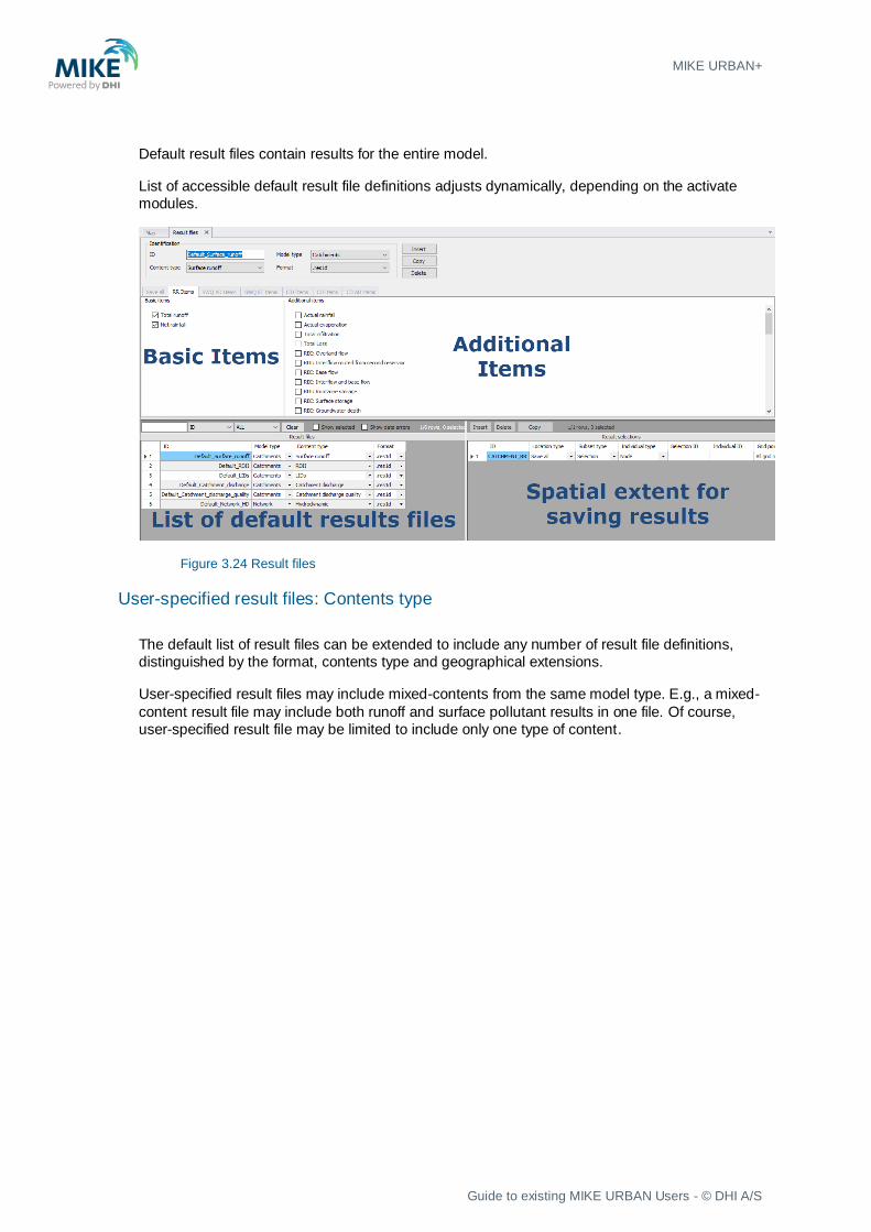
Default result files
For each model type, MIKE URBAN+ database contains several definitions for default result file
contents for each type of simulation.
Simulation results are distinguished as ‘basic items’ and ‘additional items’
Default content may be user-modified to include or exclude specific result items.
MIKE URBAN+
Guide to existing MIKE URBAN Users - © DHI A/S
Default result files contain results for the entire model.
List of accessible default result file definitions adjusts dynamically, depending on the activate
modules.
Figure 3.24 Result files
User-specified result files: Contents type
The default list of result files can be extended to include any number of result file definitions,
distinguished by the format, contents type and geographical extensions.
User-specified result files may include mixed-contents from the same model type. E.g., a mixed-
content result file may include both runoff and surface pollutant results in one file. Of course,
user-specified result file may be limited to include only one type of content.

Figure 3.25 Additional Results
Various result items are accessible through currently active TABS. The TABs activity depends
on the selected model type, contents type and active modules.
User- specified result file: Location
All specified results will be saved only as the specified locations

MIKE URBAN+
Guide to existing MIKE URBAN Users - © DHI A/S
Figure 3.26 Result files location
Saving result may be specified at:
• Save All: saves the wanted results at all model elements
• Save subset: saves the wanted results for model elements included in the chosen
selection
• Save individual: saves the wanted results for the specified individual model element
• Save within polygon: saves the wanted results for the model elements located within a
polygon drawn on the map
‘Location’ for one result file may be defined by any number of location definitions. Overlapping
location definitions are ignored (the results are saved only once).
3.5.2 Network summary
Any number of summary contents can be specified and associated with network model
simulations

Figure 3.27 Network summary
MIKE URBAN+
Guide to existing MIKE URBAN Users - © DHI A/S
3.6 Simulation setup
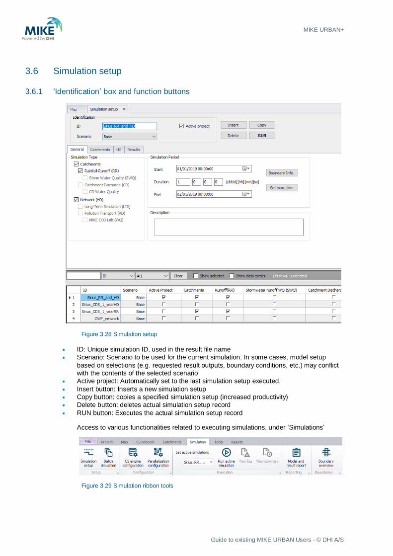
3.6.1 ‘Identification’ box and function buttons
Figure 3.28 Simulation setup
• ID: Unique simulation ID, used in the result file name
• Scenario: Scenario to be used for the current simulation. In some cases, model setup
based on selections (e.g. requested result outputs, boundary conditions, etc.) may conflict
with the contents of the selected scenario
• Active project: Automatically set to the last simulation setup executed.
• Insert button: Inserts a new simulation setup
• Copy button: copies a specified simulation setup (increased productivity)
• Delete button: deletes actual simulation setup record
• RUN button: Executes the actual simulation setup record
Access to various functionalities related to executing simulations, under ‘Simulations’
Figure 3.29 Simulation ribbon tools

3.6.2 ‘General’ TAB
Figure 3.30 Simulation setup
• Simulation Type: Choice of modules to be included in the simulation. Accessible modules
depend on module activation, model setup data and module dependency
• Simulation Period: start and end time for the simulation, limited by the active boundary
conditions (note some exceptions!)
• Description: user-specified reminder information about the actual simulation
• Boundary Info: provides overview of the extent of the active boundary conditions
• Set max. time: sets the maximum extent of the simulation (the earliest possible start time
and the latest possible end time), based on active boundary conditions
3.6.3 Module TABS
• Catchments TAB: Contains data for any catchment simulation (runoff, SQW, catchment
discharge)
• HD TAB: Contains data for network hydraulics simulation setup
• AD and WQ: Contains pollution transport and WQ – specific data for network simulation
setup
• LTS: Contains LTS-specific simulation setup data

MIKE URBAN+
Guide to existing MIKE URBAN Users - © DHI A/S
Figure 3.31 Simulation setup
3.6.4 ‘Results’ TAB
Figure 3.32 Results specifications
• Output folder: Default (= Project folder) or user-specified location
• Summary: reference to a network summary definition
• Result files: List of selected result files. Initially, the output list include default result files for
all modules included in the simulation. This list can be modified by deleting the unwanted
result files and including user-specified result files.
3.7 Results
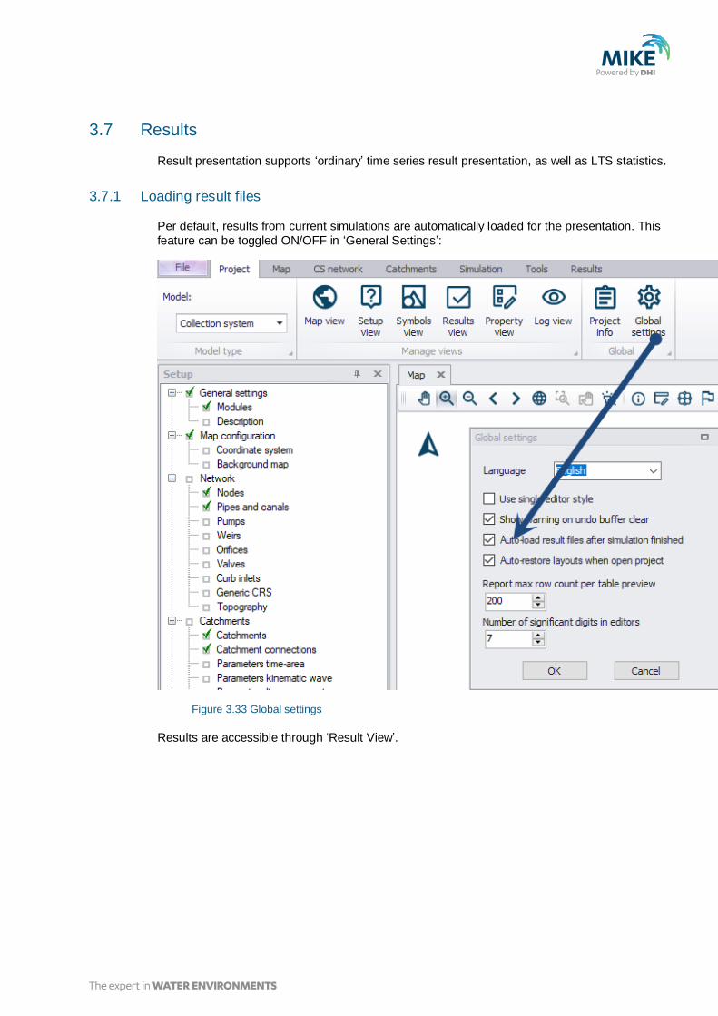
Result presentation supports ‘ordinary’ time series result presentation, as well as LTS statistics.
3.7.1 Loading result files
Per default, results from current simulations are automatically loaded for the presentation. This
feature can be toggled ON/OFF in ‘General Settings’:
Figure 3.33 Global settings
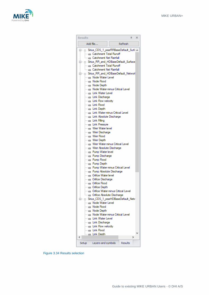
Results are accessible through ‘Result View’.
MIKE URBAN+
Guide to existing MIKE URBAN Users - © DHI A/S
Figure 3.34 Results selection
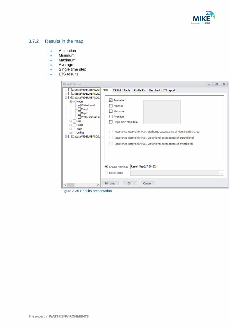
3.7.2 Results in the map
• Animation
• Minimum
• Maximum
• Average
• Single time step
• LTS results
Figure 3.35 Results presentation

MIKE URBAN+
Guide to existing MIKE URBAN Users - © DHI A/S
3.7.3 Results TS Plot & table
Figure 3.36 Time series plot

Figure 3.37 Tabular results

MIKE URBAN+
Guide to existing MIKE URBAN Users - © DHI A/S
3.7.4 Results in Long profile
Figure 3.38 Longitudinal profile and results
3.7.5 Results in Bar-chart
Used for LTS chronological results (annual and monthly statistics)
3.7.6 Results: LTS reports
Used for reporting LTS statistics results in tabular form.
4 Import MIKE URBAN model to MIKE URBAN+
A step-by-step description is provided on how to import existing models into MIKE
URBAN+.
The first step is to open MIKE URBAN+ and then follow the steps described in the
following.
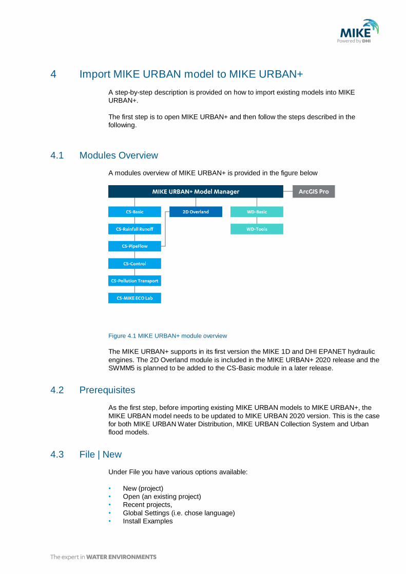
4.1 Modules Overview
A modules overview of MIKE URBAN+ is provided in the figure below
Figure 4.1 MIKE URBAN+ module overview
The MIKE URBAN+ supports in its first version the MIKE 1D and DHI EPANET hydraulic
engines. The 2D Overland module is included in the MIKE URBAN+ 2020 release and the
SWMM5 is planned to be added to the CS-Basic module in a later release.
4.2 Prerequisites
As the first step, before importing existing MIKE URBAN models to MIKE URBAN+, the
MIKE URBAN model needs to be updated to MIKE URBAN 2020 version. This is the case
for both MIKE URBAN Water Distribution, MIKE URBAN Collection System and Urban
flood models.
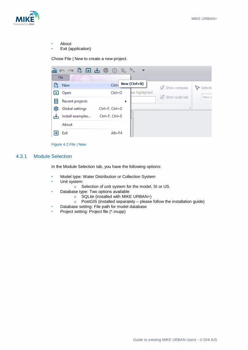
4.3 File | New
Under File you have various options available:
• New (project)
• Open (an existing project)
• Recent projects,
• Global Settings (i.e. chose language)
• Install Examples
MIKE URBAN+
Guide to existing MIKE URBAN Users - © DHI A/S
• About
• Exit (application)
Chose File | New to create a new project.
Figure 4.2 File | New
4.3.1 Module Selection
In the Module Selection tab, you have the following options:
• Model type: Water Distribution or Collection System
• Unit system:
o Selection of unit system for the model, SI or US.
• Database type: Two options available
o SQLite (installed with MIKE URBAN+)
o PostGIS (installed separately – please follow the installation guide)
• Database setting: File path for model database
• Project setting: Project file (*.mupp)
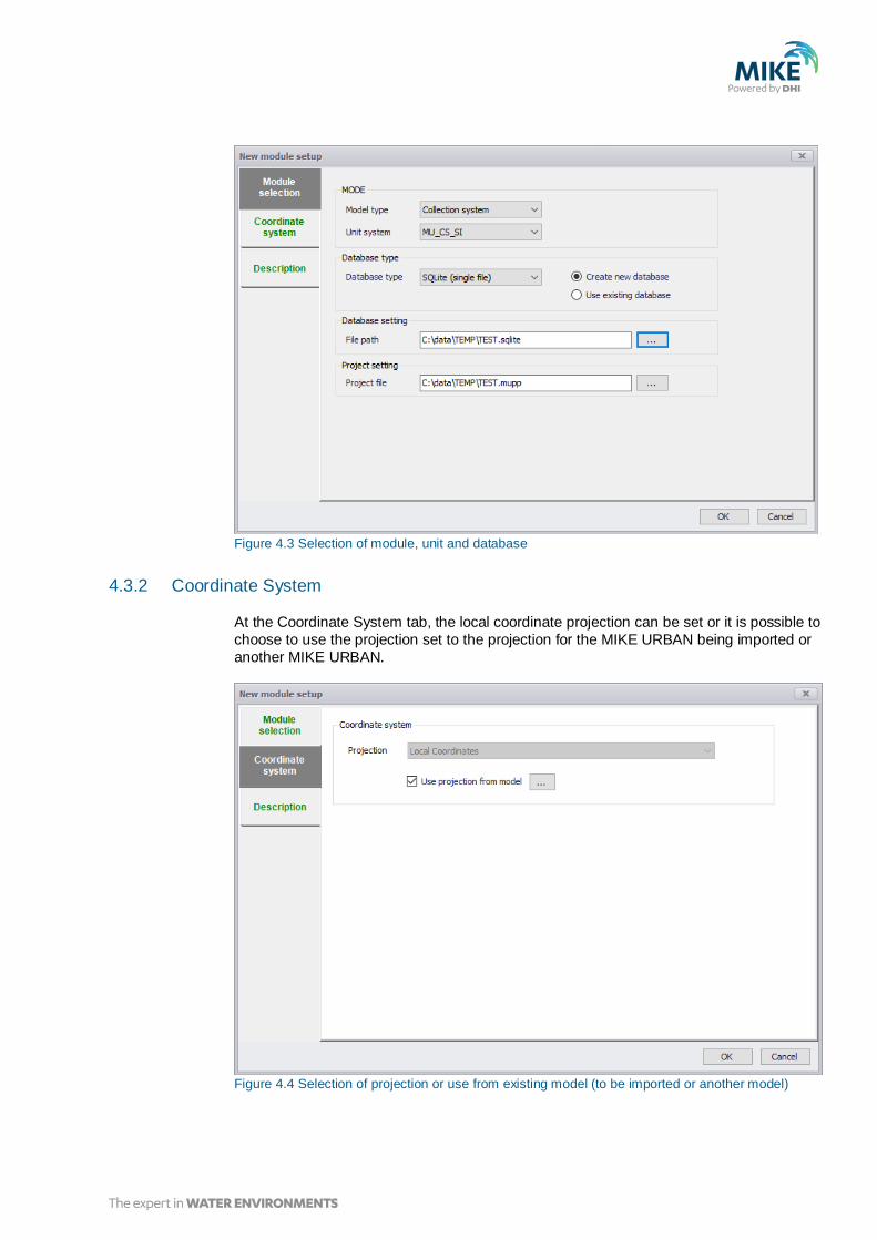
Figure 4.3 Selection of module, unit and database
4.3.2 Coordinate System
At the Coordinate System tab, the local coordinate projection can be set or it is possible to
choose to use the projection set to the projection for the MIKE URBAN being imported or
another MIKE URBAN.
Figure 4.4 Selection of projection or use from existing model (to be imported or another model)

MIKE URBAN+
Guide to existing MIKE URBAN Users - © DHI A/S
4.3.3 General settings | Modules
In the General settings, Modules, the different modules available for Collection System or
Water Distribution can be activated for the model to get the complete overview of the data
groups available.
Figure 4.5 Modules selection for the project. Can be toggled on/off any time
4.4 File | Import
The File | Import provides a quick access to import existing models:
Figure 4.6 Fast import options of existing models
• Import MU Classic model (mdb) requires that MIKE URBAN is installed.
• Import MU Classic model (gdb) does not require that MIKE URBAN is installed.
• Import EPANET model just import
These imports have been developed to make it is easy for users to import existing MIKE
URBAN models. If customised imports are required, then the general Import and export
found under Tools tab can be used.
When clicking on i.e. ‘Import MU Classic model (mdb)’, the dialog below appears for
selecting the MIKE URBAN.

Figure 4.7 Browser for selecting MIKE URBAN+ model
The import process starts after clicking Open.
After import of the MIKE URBAN model, then it could look like this.
Figure 4.8 Imported MIKE URBAN model to MIKE URBAN+
At the right side in the setup tree, data has been grouped and instant data validation is
performed. If there are any errors in the data, a red cross will appear. If there are no
errors in the data, a green check mark or no marker will be displayed.
4.5 Status after import
All features in Water Distribution except from Water Hammer is supported in MIKE
URBAN+, so all models that run in MIKE URBAN 2019 or EPANET 2.0 should be
imported into MIKE URBAN+ without data errors and ready to run.

MIKE URBAN+
Guide to existing MIKE URBAN Users - © DHI A/S
For Collection System and 2D Urban Flood models, it is expected that most running MIKE
URBAN 2019 models based on either MOUSE or MIKE 1D will be running in MIKE
URBAN+ MIKE 1D with the exception of models including features listed in 4.6.
Collection System models based on MIKE URBAN SWMM5 cannot be imported in MIKE
URBAN+ yet.

4.6 MIKE URBAN+ unsupported features in first release
In Table 4.1, the features which are not supported in MIKE URBAN+ are listed.
Table 4.1 Overview of features have limited support in MIKE URBAN+
Feature Status
SWMM5 Not supported - Expected in later release.
Water Hammer Not supported in MIKE URBAN+.
MOUSE UWC (User Written
Control)
If MOUSE UWC has been applied, this cannot
be transferred to MIKE 1D. Those UWC
controls needs to be recoded into MIKE SDK.
The MIKE 1D is in general much more open for
user control than MOUSE.
MOUSE Storage Nodes Not supported in MIKE URBAN+.
Special feature: MOUSE PCS Not supported in MIKE 1D. Expected to be
developed later.
Special feature: Pump Emergency
Storage (.adp file)
Not supported in MIKE 1D. Expected to be
developed later.
MIKE 1D – RTC Imports existing models using RTC. However,
if some Actions have been reused, then they
have to be added manually as individual
Actions. This is an improvement of how
Actions are handled in the model with unique
ids, but it is impossible to update the model
automatically.
MIKE 1D - SWQ SWQ is brand new with a new concept for
flexible definitions of different land uses etc.
Models having used the previous concepts in
SRQ and SWQ needs to be converted
manually. The data amount that needs to be
converted is limited.


B-1