midterm review report
TRANSCRIPT
Midterm review Report
Hotspot Mainport Schiphol
KfC 65/2012
2
Authors:
Sonja Döpp (Knowledge for Climate) editor
Peter van den Brink, coordinator Hotspot Mainport Schiphol (Amsterdam Airport Schiphol),
with the cooperation of the project leaders Oscar Hartogensis (WUR), Albert Jacobs, Carine Homan and
Jan Sondij (KNMI)
August 2012
Copyright © 2012
National Research Programme Knowledge for Climate/Nationaal Onderszoekprogramma Kennis voor
Klimaat (KvK) All rights reserved. Nothing in this publication may be copied, stored in automated
databases or published without prior written consent of the National Research Programme Knowledge
for Climate / Nationaal Onderzoeksprogramma Kennis voor Klimaat. Pursuant to Article 15a of the Dutch
Law on authorship, sections of this publication may be quoted on the understanding that a clear
reference is made to this publication.
Liability
The National Research Programme Knowledge for Climate and the authors of this publication have
exercised due caution in preparing this publication. However, it cannot be excluded that this publication
may contain errors or is incomplete. Any use of the content of this publication is for the own
responsibility of the user. The Foundation Knowledge for Climate (Stichting Kennis voor Klimaat), its
organisation members, the authors of this publication and their organisations may not be held liable for
any damages resulting from the use of this publication.

3
Contents
1 Introduction .......................................................................................................................................... 4
1.1 Mainport Schiphol and climate change ........................................................................................ 4
1.2 Impact of climate change on airport operations .......................................................................... 5
1.3 Objectives Hotspot Mainport Schiphol ......................................................................................... 7
2 Research approach................................................................................................................................ 8
2.1 Hotspot and coordination ............................................................................................................. 8
2.2 Projects ......................................................................................................................................... 8
3 Results ................................................................................................................................................. 10
3.1 Critical weather parameters Schiphol in current and future climate ......................................... 10
3.2 Weather and climate modeling – determining local weather conditions (IMPACT) .................. 10
3.2.1 Results (phase 1) ................................................................................................................. 13
3.2.2 Outlook (phase 2) ................................................................................................................ 16
3.3 Wind and Visibility monitoring system (WindVisions) ................................................................ 17
3.3.1 Results (phase 1) ................................................................................................................. 18
3.3.2 Outlook (phase 2) ................................................................................................................ 19
4 Conclusions and outlook ..................................................................................................................... 20

4
1 Introduction
The focus of Knowledge for Climate (KfC) research in Hotspot Schiphol Mainport is to optimize the
contribution of meteorological services to a sustainable operation and reliable operation of Schiphol
airport. Three research projects have been carried out in the first tranche of the Knowledge for Climate
programme on climate change and local critical weather conditions at Mainport Schiphol. Two projects
(IMPACT and WindVisions) will be continued in the second tranche of the programme, in the Knowledge
for Climate consortium High-Quality Climate Projections (Theme 6). This report presents a summary of
the main results of the first tranche projects, and an outlook on the expected end results of the second
tranche research at the end of the programme in 2014.
Figure 1 Aerial view of Schiphol Mainport in Amsterdam the Netherlands
1.1 Mainport Schiphol and climate change Schiphol Mainport and its network of international connections are of vital importance for the Dutch
economy. Schiphol is a primary hub for Air France – KLM in the region, resulting in a strong economic
position for the Netherlands in Europe and in many employment opportunities. The airport and the
surrounding area are vulnerable to changes in our climate. The airport is situated 4–6 m below sea level
in the Haarlemmermeer, one of the most complex and vulnerable urban areas of the world. An
accelerated sea level rise together with continuous land subsidence and periods of intense precipitation
and drought, forces Schiphol to investigate which adaptations are necessary to make the airport and the
whole Schiphol region “Climate Proof”.
Climate proofing Schiphol and to contribute to a sustainable airport operation, now and in the future,
requires knowledge on various issues that may be affected by climate change: 1) On regional issues such
as land-use, infrastructure, housing, flight safety, noise, air pollution and water management, and 2) On
the local weather conditions at the airport which have a direct influence not only on the airport
operation but also on the capacity, which is of vital importance for the position of Schiphol and is a
limiting factor for a possible future expansion of the airport.

5
As a so called Hotspot, Schiphol is one of the focus areas in the Knowledge for Climate (KfC) research
programme. At the onset of the KfC programme in 2009, a regional approach was explored in Hotspot
Schiphol Region. A first quick-scan was performed (HSRS01) in order to define the most important
consequences of climate change for the region. Based on the results regional actors such as the Province
of Noord-Holland and water boards felt no urgency to participate in this part of the KfC programme in
addition to their existing activities and investments related to climate change adaptation. Therefore it
was decided to continue as Hotspot Mainport Schiphol (HSMS) and to focus on the impact of climate
change on Schiphol airport, in particular on the impact of climate change on the operational system of
the airport due to the effects of future weather conditions.
1.2 Impact of climate change on airport operations Adverse weather highly impacts safety and efficiency in aviation. Recent studies showed that in about
20% of aviation related accidents involving aircraft and in about 80% of airspace delays, the weather was
a cause or contributing factor [FAA, 2010; Eurocontrol, 2007]. Due to its location near the sea, the
weather at Schiphol airport is often adverse and subject to sudden changes. Critical weather conditions,
like fog, low clouds, stormy winds, severe thunderstorms and heavy precipitation, lead to a loss in the
available airport capacity, and if not foreseen in time, to additional delays, diversions and holdings,
resulting in increasing costs. For example, at Schiphol airport the number of arrivals and departures
reduces by a factor of at least 1.5 when visibility is less than 550 m or when cloud ceiling is less than 200
ft. To increase safety and guarantee operational efficiency during flight and platform operations at the
airport, accurate and reliable information on critical weather parameters and their changes on local
scales are needed.
In addition (and related) to ensure Schiphol’s operational reliability, accurate measurements and climate
and weather models are crucial for optimization of the usage of runways. With this information,
Schiphol is able to prevent as much as possible that climate change will lead to restrictions in air traffic
due to exceeding noise standards. The longer preferred runways can be used (preferred from the
viewpoint of less noise for local residents) the better for the (immediate) environment of Schiphol
airport. In that way, accurate weather data and predictions enable Schiphol to reduce nuisance.
The impact of climate change on Schiphol airport is determined by the effect that the future weather
has on the airport operation. Given the current and anticipated climate change (e.g., KNMI, 2008), the
sensitivity to local weather is expected to increase, as extreme weather events are expected to occur
more frequently and with increased intensity. The main problem is that it is not well know at present
how climate change affects the critical weather conditions at the airport. Existing climate models do not
provide enough spatial differentiation to describe the effect that climate change has on the local
weather, and changes in weather extremes are highly uncertain. Shortcomings are due to a coarse
resolution of the model, a poor physical description of the land-atmosphere interaction, and the limited
predictability of local events.
6
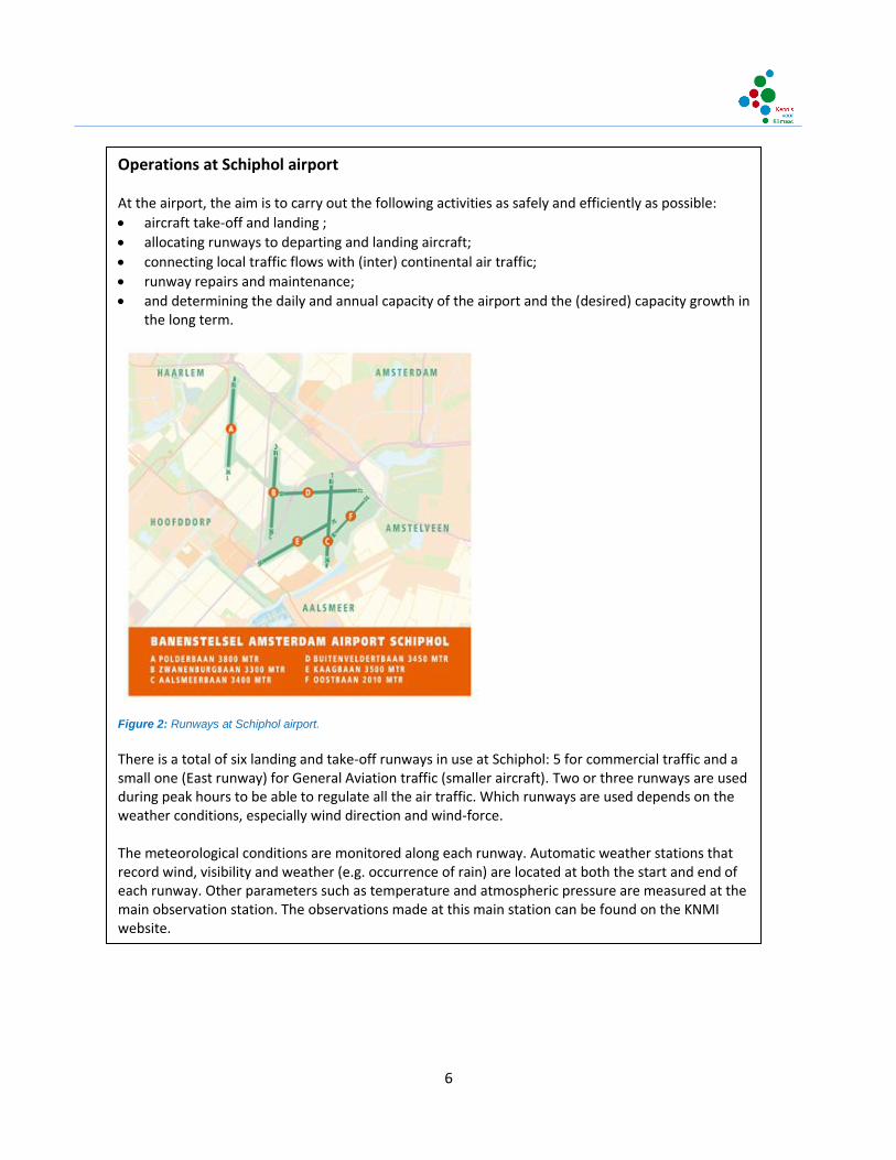
Operations at Schiphol airport At the airport, the aim is to carry out the following activities as safely and efficiently as possible:
aircraft take-off and landing ;
allocating runways to departing and landing aircraft;
connecting local traffic flows with (inter) continental air traffic;
runway repairs and maintenance;
and determining the daily and annual capacity of the airport and the (desired) capacity growth in the long term.
Figure 2: Runways at Schiphol airport. There is a total of six landing and take-off runways in use at Schiphol: 5 for commercial traffic and a small one (East runway) for General Aviation traffic (smaller aircraft). Two or three runways are used during peak hours to be able to regulate all the air traffic. Which runways are used depends on the weather conditions, especially wind direction and wind-force. The meteorological conditions are monitored along each runway. Automatic weather stations that record wind, visibility and weather (e.g. occurrence of rain) are located at both the start and end of each runway. Other parameters such as temperature and atmospheric pressure are measured at the main observation station. The observations made at this main station can be found on the KNMI website.

7
1.3 Objectives Hotspot Mainport Schiphol To guarantee a safe and sustainable operation of the airport in a future climate, it is required to identify
and quantify changes in the frequency and intensity at which critical weather conditions at the airport
will occur with sufficient accuracy. The focus of Knowledge for Climate research in Hotspot Schiphol
Mainport is to optimize the contribution of meteorological services to a sustainable operation and
reliable operation of Schiphol airport.
The objectives of the Hotspot Schiphol Mainport are:
1. To develop a Wind and Visibility Monitoring System for critical weather conditions in the changing climate at the airport (Project “WindVisions”)
2. To provide tailored information about the current local climate at the airport and the perceived changes in climate in the past decennia (Project “Climatology and Climate Scenario’s Mainport Schiphol”)
3. To provide and demonstrate new innovative model tools that can be used to compute with sufficient accuracy the effect that climate change has on the local critical weather conditions at the airport (Project “Impact”)
8
2 Research approach
2.1 Hotspot and coordination Hotspot Schiphol Mainport is coordinated by Amsterdam Airport Schiphol (AAS). The stakeholder
organization represented in the hotspot is Air Traffic Control the Netherlands (LVNL). Resources for co-
financing from LVNL come from the Knowledge Development Centre Mainport Schiphol (KDC)1.
Representatives of KDC and KLM Airlines are involved in some of the research activities in Hotspot
Mainport Schiphol as well. All stakeholders have a strong interest in learning how climate change affects
the critical weather conditions at the airport. Furthermore, they expect that the HSMS projects will
contribute to the development of model tools that can be used to provide improved and more detailed
weather forecasts for the airport. Their own adaptation and operational decision strategies highly
depend on that.
Hotspot coordinator Peter van den Brink of Amsterdam Airport Schiphol (AAS) is the main contact
person for stakeholders, project leaders and the Knowledge for Climate programme office. The
technical contact persons and members of the research consortia are Jan-Otto Haanstra and Hans van
Grootel, both working for Amsterdam Airport Schiphol (AAS).
The three knowledge institutes carrying out the research projects in HSMS are the Royal Netherlands
Meteorological Institute (KNMI), Delft University of Technology (TU Delft) and Wageningen University
and Research Centre (WUR). KNMI scientists are involved due to their experience in operational weather
forecasting and weather and climate research. Scientists from the universities of Wageningen and Delft
are involved due to their expertise on scintillometers and Sodar, as well on local weather processes and
modeling, and their interest to use the newly developed HARMONIE model in HSMS03 for general
research and for specific research focusing on Schiphol airport.
2.2 Projects After the exploratory study ‘Climate scan Schiphol region’ (HSRS01)2 in 2009 it was decided to focus
further research in the hotspot on the impact of climate change on the operational system of Schiphol
airport. Regional partners decided to continue their work on climate adaptation outside the Knowledge
for Climate programme, only stakeholders directly related to Mainport Schiphol were involved in the
hotspot. As a consequence, no regional adaptation strategies will be developed like in the other KfC
1 The foundation Knowledge & Development Centre (KDC) sets itself the task to find valuable and innovative solutions for the
sustainable development of the Mainport Schiphol. In the KDC the Dutch aviation partners KLM, Amsterdam Airport Schiphol and Air Traffic Control the Netherlands (LVNL) work together with universities and other research institutes to innovate the Schiphol operation. The KDC work programme is guided by the Knowledge and Innovation Agenda for Aviation, which has been developed in cooperation with the Dutch government. More information: www.kdc-mainport.nl 2 http://knowledgeforclimate.climateresearchnetherlands.nl/hotspots/schiphol-mainport/HSRS01
9
hotspots and research was and will only be carried out in the first and second tranche of the
programme.
Three projects were carried out in the 1e tranche (2009-2012) of Knowledge for Climate, all related to
climate change and critical weather conditions at Schiphol airport:
HSMS01 WindVisions: an airport Wind and Visibility Monitoring System for critical weather conditions in a changing climate
HSMS02 Climatology and climate scenarios Mainport Schiphol
HSMS03 The impact of climate change on the critical weather conditions at Schiphol airport
(IMPACT)
The projects WindVisions (HSMS01) and IMPACT (HSMS03) were too comprehensive to be completed in
the 1st tranche of KfC. Therefore, the execution of these projects was divided in two phases. The second
phase will be executed in the 2e tranche of KfC by the consortium ‘High-quality climate projections’
(Theme 6).
WindVisions (HSMS01) is organized as a four year PhD-project, and research in the second phase will be
executed by the same consortium as in first phase. Research activities in the second phase of IMPACT
(HSMS03) are organized in several work packages of the Theme 6 consortium.
10
3 Results
This chapter presents the main results of the completed project HSMS02 and the first phase research of
IMPACT (HSMS03) and WindVisions (HSMS01).
3.1 Critical weather parameters Schiphol in current and future climate
HSMS02: Climatology and climate scenarios Mainport Schiphol
Projectleader: Carine Homan (KNMI)
Stakeholders: Amsterdam Airport Schiphol (AAS), Air Traffic Control the Netherlands (LVNL)
Duration: 1 April 2009 – 1 September 2012
The goal of this project was to provide specifically relevant information that is fundamental for the
activities at Schiphol: information on the current local climate at Schiphol, the changes observed over
the past decades, and future climatic changes. The variables that are of importance to Schiphol, i.e.
wind, mist and visibility, precipitation, temperature and the upper air characteristics were also studied.
Especially climate information for the coming five to ten years is important for Schiphol in connection
with the airport’s capacity planning. Hence in this study it was decided to look at two time horizons:
around the year 2010 (1996-2025) and around the year 2050 (2036-2065).
Various sub-projects were carried out, an overview, including the sub-reports and supplementary
information, can be found on the project website of KNMI3 of KfC4.
Below is a summary of the main results / conclusions per variable:
Wind
- The only period of wind measurements taken at Schiphol which are suitable for calculating the
frequencies of the occurrence of crosswinds and tail winds for the individual runways is 1971-1995.
- Consecutive years of wind variations cause differences in crosswind and tail wind frequencies,
which are approximately five times greater than the changes in the period between 1971 and 1995
and over the next ten years caused by the trend in wind speed as a result of the increased regional
severity.
- The results of various numeric global climate models failed to show an unequivocal picture of what
will happen in terms of wind speed: a slight decrease, slight increase, and no change, were all seen
in these models.
3www.knmi.nl/samenw/kbs 4http://kennisvoorklimaat.klimaatonderzoeknederland.nl/hotspots/schipholmainport/HSMS02
11
Mist and visibility
- The frequency of poor visibility conditions (at Schiphol and elsewhere in the Netherlands) has
decreased. This decrease was on average 2% per year for the various threshold values over the
entire period 1955-2010.
- It would seem that there was a break in the trend at the end of the 1980s which is partly explained
by an improvement in the quality of the atmosphere. Data from before the 1980s are no longer
representative for the current situation, particularly because of the changed trend.
- The difference in mist susceptibility between the years before and after the end of the 1980s is
mainly evident in the winter months (December – February) and in the autumn months (September
and October) in the morning, just after sunrise.
- The measurements taken on the Polderbaan runway (poorer visibility) and the Kaagbaan runway
(better visibility) are more striking from a spatial point of view. All these measurements relate to the
time period 2004-2010, too short a period to be able to speak of a climatic difference.
- The frequency of degrees of cloud in the categories ‘broken’ and ‘overcast’ would not seem to be
part of a trend. However, a transition from manual and automatic observations around 2002 must
be taken into account. This is reflected in the frequency of the ceiling below the critical limits.
Between 1951 and 2002 this has clearly decreased for the 1000, 300 and 200-foot limits.
- Future changes in visibility strongly depend on how the atmospheric quality progresses and possibly
also local development of the Schiphol terrain. It is therefore difficult to make a quantitative
statement about future developments.
Precipitation
- Precipitation occurs on 241 days of the year. The intensity in the summer months is often higher
than in the winter. In a changed climate the expectation is that extreme precipitation intensity will
increase.
- For the amount of rainfall in the precipitation statistics for De Bilt, periods of rainfall longer than 24
hours must be increased by 8% to obtain a good overview of the amount of rainfall at Schiphol.
There are no great regional differences seen in the Netherlands regarding periods of rainfall shorter
than 24 hours. The amount of precipitation could rise more in coastal areas than inland in the
future.
- Snow falls on an average of 25 days a year, hail on 22 days and ice forming occurs on average 7 days
a year. Nevertheless, the year-to-year variance is very big. In the future, hail will probably occur
more frequently.
Temperature
- The increase in average annual temperature in the Netherlands around 2050 is expected to be
between 0.8 and 2.2°C compared with the period 1981-2010.
- The average number of days per year that the minimum temperature drops below freezing point
will decrease around 2010 by about 2 (G) to 8 (W+) in comparison with the normal period 1981-
2010. This will be 12 to 16 around 2050.

12
- The number of days the maximum temperature rises above 25°C increased around 2010 by 1-5 days,
and will increase around 2050 by 6-22 days compared with the period 1981-2010.
- Minimum temperatures around 2010 and around 2050 are lower in the G+ scenario than in the W
scenario. The change in circulation therefore has less of an effect on the minimum temperature than
the difference of 1°C in global warming between the G and W scenarios.
- Days with low wind chill figures will definitely decrease around 2050. For instance, the average
number of days on which the wind chill is below zero for at least one hour will drop from 117 days
(1971-2000) to 63 (W+) -92 (G) days around 2050.
Upper air characteristics
- As a rule, the wind in the whole of the Netherlands generally comes from the west or south-west in
all seasons. In the spring and summer wind speed is lower than in the autumn and winter (the
‘storm season’). Wind speeds are increasing in the upper regions and the wind direction veers in
accordance with height.
- The vertical profiles for De Bilt show an average decrease in temperature in the upper regions in the
summer of +17°C (+/- 7°C) on the earth’s surface to -55°C (+/- 9°C) on the 200 hPa level (approx. 12
km). The decrease during the winter months is +4°C (+/- 6°C) near the earth’s surface to -61°C (+/-
10°C)near 200 hPa.
- The relative humidity near the earth’s surface in the summer is approximately 75% around midnight
with a variance of about 10% during the daytime. In the winter, the relative humidity is on average
approximately 84% with little daily variation. The relative humidity drops down to approximately
45% at 600-700 hPa (3-4 km) and increases at the tropopause.
- Spatial differences in the Amsterdam FIR in the vertical profiles for wind speed, temperature and
humidity show a gradient from north/northwest to south/southeast with the lowest temperatures,
lower levels of relative humidity and higher wind speeds in the north/northwest.
- The average monthly height of the tropopause is approximately 239 hPa, varying between 250 hPa
in April to 215 hPa in September. The standard deviation lies between 34 and 45 hPa.
- Most inversions occur at night and during the winter months. The inversion intensity is in most cases
no more than 2°C.
This project has contributed to an overview of Schiphol’s present and future climatology and therefore
makes it possible for the airport to better respond to the current circumstances and any possible
changes in the future and thus reinforces its status as a mainport. The project has also been able to
answer the questions that arose during the project itself among the direct partners and other
stakeholders.

13
3.2 Weather and climate modeling – determining local weather conditions
(IMPACT)
HSMS03: The impact of climate change on the critical weather conditions at Schiphol airport (Impact)
Projectleader (phase 1): Albert Jacobs (KNMI)
Stakeholders: Amsterdam Airport Schiphol (AAS), Air Traffic Control the Netherlands (LVNL), KDC
Duration: 1 October 2009 – 31 May 2012 (phase 1)
The main objectives of the IMPACT (HSMS03) project are:
1. To demonstrate the potential of the next generation weather and climate model HARMONIE to
provide an improved and more detailed short term weather prediction for Schiphol airport (up to 24
– 48 hours)
2. To demonstrate how HARMONIE can be used to compute the effect of climate change on local
critical weather conditions at Schiphol airport (use as downscaling tool)
Furthermore, knowledge from this project will be used to improve the quality of present and future
weather forecasts.
First, the ability of HARMONIE to determine local high‐resolution weather forecasts for Schiphol airport
was demonstrated by selected case studies, in particular for those meteorological circumstances that
may hinder aircraft operations. The selected cases mainly represent the weather parameters which
were identified in the Inventory with the main stakeholders at the airport, Amsterdam Airport Schiphol
(AAS), the Air Traffic Control the Netherlands (NVNL) and KLM airlines.
Next, it was demonstrated how certain extreme weather events would evolve in case of changing
climatological circumstances. The potential of the HARMONIE model to provide high resolution weather
forecasts for Schiphol airport was assessed in the project for several cases in our current and past
climate. For this purpose, the model output is validated against the coarse‐resolution (10 – 20 km)
hydrostatic HiRLAM model, which is the current operational weather prediction model for Schiphol
airport, and against local airport observations.
3.2.1 Results (phase 1) According to the Impact Inventory5, the following weather parameters, and sudden changes in these,
are most critical for Schiphol operation:
1. Wind direction, wind intensity, wind shear, wind fluctuations (gusts)
2. Surface visibility (VIS/RVR) and low clouds (Ceiling): see table 2.1
3. Precipitation intensity and type (snow, hail, rain, freezing rain)
5 Jacobs, Albert, Nico Maat, Jitze van der Meulen & Hans Roozekrans, 2011. Een inventarisatie van kritieke
weerparameters die de operatie op luchthaven Schiphol beïnvloeden (in Dutch). Kennis voor Klimaat rapport, Impact (HSMS03).
14
4. Specific weather conditions such as thunderstorms, lightning, up‐ and downdrafts
5. Surface and upper‐air temperature
The selected cases mainly represent the weather parameters wind, surface visibility, low clouds and
precipitation. To be able to anticipate future weather, for some of the weather cases it was also studied
how they would evolve for changes in the sea surface temperature, which is one of the most important
climatological factors that is subject to change in a future climate. The most important results of the
weather case studies, in relation to the weather parameters that are critical for Schiphol operation are:
Strong winds
Unlike HiRLAM, the non‐hydrostatic model HARMONIE explicitly resolves vertical convective motions. As
a result, extreme wind events such as downbursts (e.g. at July 14th, 2010: wind speeds up to 100 km/h,
gusts up to 140 km/h) are more realistically captured by the model than with HiRLAM. Also the higher
spatial resolution of HARMONIE (1 – 2 km versus 10 km in HiRLAM) results in a more detailed picture of
the wind. In general, HARMONIE can represent small regions with very high wind speed, which are
mostly absent in HiRLAM. Finally, if we compare the current operational model HiRLAM with
HARMONIE, we also see that in cases where HiRLAM performs well, such as large synoptic scale storms
(order 1000 km), HARMONIE gives similar results, but at a higher resolution and with more detail.
Fog
Compared to HiRLAM, HARMONIE seems better capable to predict the dynamical structure of fog fields
and of extremes in cloud water at the lowest model levels. Nevertheless, case studies of radiation fog
events have revealed that HARMONIE, among other models, has difficulties in forecasting the precise
onset and development of the fog layer. A high vertical resolution in the lowest few hundred meters of
the model appears to be of great importance. A lower vertical resolution leads in general to a delay in
the onset. However, this conclusion should be drawn with care as the number of cases that have been
studied is small and in some of the cases we have seen that not all important model parameters
improve with an increase in the vertical resolution of the model.
Low clouds
Despite that in general also low clouds are better captured within HARMONIE, stratocumulus clouds are
often underpredicted by the model due to their relative shallowness (they are only a few hundreds of
meters thick). The coarse vertical model resolution makes that these clouds may only be present in the
model at 1 or 2 model layers. This makes its representation much more sensitive to small errors. For
example, errors of the order of 0.1 °C in temperature may already make the difference between a clear
atmosphere and one that is filled with low clouds. Therefore, as with the prediction of fog, also the
prediction of the formation of low clouds will likely benefit from a finer vertical model resolution.
To verify this hypothesis, a similar experiment was performed with a very high-resolution (order 10 m)
large‐eddy simulation (LES) model. It was shown that such a model is well capable to predict the
15
stratocumulus cloud layer. Due to its fine resolution, these LES models, however, are computationally
too expensive for operational use.
Intense precipitation
Several case studies have shown that HARMONIE predicts well heavy precipitation and the general
shape of rainfall patterns. Rainfall intensity and the timing of precipitation, however, seem to be highly
sensitive to the size of the computational model domain. For smaller model domains the onset of the
precipitation is often too early and the intensity is too low. To be able to run the high‐resolution model
HARMONIE with confidence, producing reliable results but at the same time keep the computational
load within acceptable limits, a domain size of 400x400 grid‐points, using the standard horizontal
resolution of 2.5x2.5 km, is recommended. This is necessary for the development of convective
structures by the model, such as storms and squall lines. This domain size ensures that HARMONIE does
not only add smaller scale information to HiRLAM, but can really employ the benefits of a
non‐hydrostatic model to yield a state‐of‐the‐art prediction.
The impact of climate change
1. Increased sea surface temperature and rainfall
For a few case studies HARMONIE has been applied to study the effect of increased sea surface
temperature on rainfall amounts and winds. It was found that this effect was most easily noticed for
weather systems that approach from the west, i.e. overseas, and that have enough time to exert its
influence. The main effect for weather systems approaching from the sea seems to be that convection
close to the coast is triggered more easily, rainfall patterns change and coastal rainfall amounts and
winds are more intense.
2. The urban heat island effect
HARMONIE has also been applied to study the urban heat island effect of Rotterdam. An urban heat
island is a metropolitan area that is significantly warmer than its surrounding rural areas. HARMONIE is
able to model this effect by using a town energy budget module. This module calculates the effect of the
built up environment and landscape heterogeneity on local weather conditions, such as e.g. the 2m
temperature. It appears that the results of high‐resolution models such as HARMONIE are very sensitive
to the land‐use classification data that is used by the model. This will also be of importance for the
modeling of other local weather phenomena that are affected by the heterogeneity of the surface, such
as e.g. convective rainfall.
3. Monthly precipitation amounts in summer
HARMONIE has been evaluated for its skill to predict monthly precipitation amounts during the summer.
To this purpose the August 2006 period was evaluated. In this period a record amount of precipitation
was observed, particularly near the coast where amounts exceeded 300% of the climatological mean.
For this study HARMONIE has been applied in two different modes:

16
a) Hindcast mode in which consecutive daily weather forecasts are made that start each day from the
ECMWF analysis, and b) Climate mode in which the model is initialized only once at July 31 running
continuously until the end of August. Both models use the same boundary conditions, in this case the
ECMWF analysis. The hindcast results are indicative for what we can expect from HARMONIE when used
as an operational weather prediction model. The climate mode runs are indicative of how HARMONIE
would perform as a regional climate model, in this case fed with perfect boundary conditions.
The results show that both the climate and hindcast simulations predict the qualitative picture of more
precipitation in the coastal regions that inland in agreement with the observations. Both model
simulations, however, overpredict the monthly precipitation by around 15%. The inland precipitation is
overestimated and the peak value of the hindcast run near the coast is much too high. Further research
has revealed that the most likely reason for the higher precipitation amounts in HARMONIE is a much
too high surface evaporation caused by too high soil moisture values in the model.
It is believed that the higher amount of rainfall, as observed in August 2006, is caused by higher sea
surface temperatures (SST). To investigate the role of the SST on enhanced precipitation, two additional
climate runs were made with increased (+2K) and decreased (‐2K) SST. It appears that changing the SST
has a strong influence on the monthly precipitation and that the most significant differences occur in the
coastal zone. Higher SST’s indicate a greater amount of rainfall in the coastal area, but inland more than
100 km from the coast the SST has no effect.
Finally, a few new verification methods have been studied, which we believe are more suited to
demonstrate the skill of high resolution models such as HARMONIE, especially for precipitation
forecasts. The new methods try to circumvent the ‘double penalty’ problem that conventional
verification methods suffer from, for example: a shower is forecasted where it is not observed, raising a
‘false alarm’, and the observed shower is not forecasted, counting as a ‘miss’. The application of these
methods for HARMONIE will be further investigated in the 2nd tranche of the KfC programme.
3.2.2 Outlook (phase 2) Knowledge from the Impact case studies will be used to further adapt and improve the HARMONIE
model. The implementation of these improvements, i.e. harvesting of the results of Impact, is foreseen
in the follow‐up phase of Impact in the 2nd tranche KfC programme.
The implementation of an advanced verification package (MET) is well under way. This is an important
step towards an objective evaluation of the performance of HARMONIE with respect to critical weather
parameters, such as verification, precipitation and wind (gusts). During Impact 2nd tranche we hope to
gain insight in the dominant processes that determine the behaviour of these critical weather
parameters, with special emphasis on Schiphol Mainport. This includes the study of how certain key
parameters in relevant physical packages affect the characteristics of these weather parameters, for
example in terms of intensity, distribution of precipitation amounts, or timing. A beginning has been
made with this, but further evaluation is required to substantiate the results. It is also foreseen that the
17
use of extra data sources will positively contribute to a better performance of HARMONIE. For example,
the use of ModeS data in HARMONIE is currently subject of such an evaluation in order to conclude that
inclusion of this data source in the forecasting process leads to an improvement in predictability for
critical weather parameters.
More information about IMPACT, including reports and other documentation can be found on the
KNMI6 or KvK7 websites.
3.3 Wind and Visibility monitoring system (WindVisions)
HSMS01: WindVisions: an airport Wind and Visibility Monitoring System for critical weather conditions in
a changing climate
Projectleader: Oscar Hartogensis (Wageningen University)
Stakeholders: Amsterdam Airport Schiphol (AAS), Air Traffic Control the Netherlands (LVNL), KDC
Duration: 1 October 2009 – 15 July 2012 (phase 1)
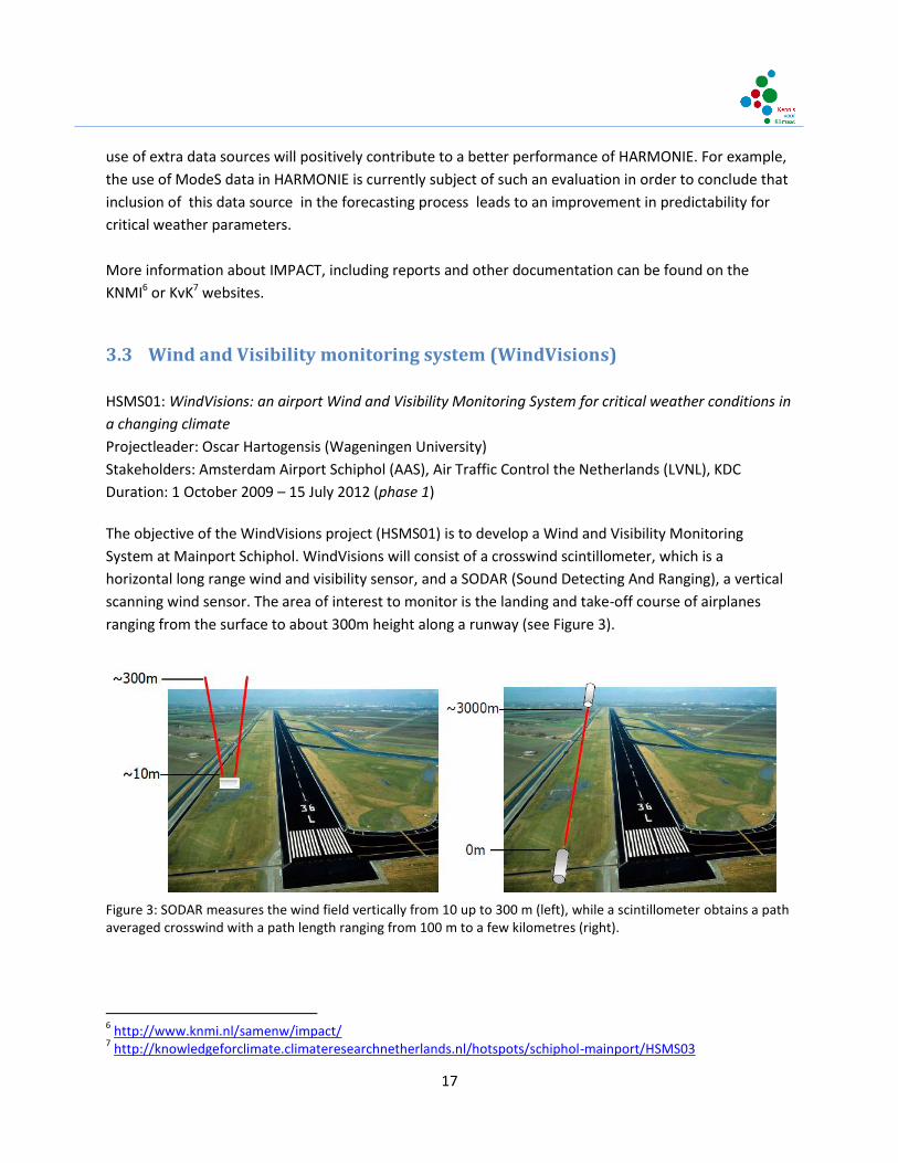
The objective of the WindVisions project (HSMS01) is to develop a Wind and Visibility Monitoring
System at Mainport Schiphol. WindVisions will consist of a crosswind scintillometer, which is a
horizontal long range wind and visibility sensor, and a SODAR (Sound Detecting And Ranging), a vertical
scanning wind sensor. The area of interest to monitor is the landing and take-off course of airplanes
ranging from the surface to about 300m height along a runway (see Figure 3).
Figure 3: SODAR measures the wind field vertically from 10 up to 300 m (left), while a scintillometer obtains a path averaged crosswind with a path length ranging from 100 m to a few kilometres (right).
6 http://www.knmi.nl/samenw/impact/
7 http://knowledgeforclimate.climateresearchnetherlands.nl/hotspots/schiphol-mainport/HSMS03
18
As the project focus on wind and visibility data that support the landing phase of aircraft, the
scintillometer and SODAR types are chosen reflect that objective. In the vertical a mini-SODAR is used
that gives information on averaged wind speed with a high vertical resolution of 5m up to a height of
~250m. Along the runway the scintillometer provides a path averaged cross-wind and visibility at a
height of choice ranging between 2 to 20m. The scintillometer should not be seen as a replacement of
traditional instrumentation already used at airports, but rather as a complimentary path averaged
measure of the cross-wind.
This study is organized as a four year PhD-project, divided over two phases following in the Knowledge
for Climate Program. Phase 1 of WindVisions is characterized by the technical development and testing
of the system, that mainly took place at Wageningen University and the KNMI observatory in Cabauw.
Phase 2 of WindVisions will be geared towards the operational implementation of the system at
Schiphol Airport.
3.3.1 Results (phase 1) The main results from WindVisions Phase 1 are the development and testing of innovative cross-wind
algorithms for a single aperture scintillometer (SA-LAS) and testing of SFAS64 mini-SODAR of Scintec AG
at the KNMI meteorological observatory of Cabauw.
Regarding the cross-wind scintillometer work, we obtained the crosswind from a single aperture
scintillometer (SA-LAS) signal using three different algorithms, which are based on scintillation spectra
without a calibration in the field. These algorithm are; the corner frequency (CF), maximum frequency
(MF) and cumulative spectrum (CS). All three algorithms obtained similar results for the crosswind
compared with a sonic anemometer. However, we conclude that the CS algorithm is best qualified to
obtain crosswinds. First, because it is the algorithm with the best fit and lowest scatter with the sonic
anemometer. Second, the results of the wavelet spectra also indicated that this method is best suited to
obtain the crosswind over 1 second. The results of this study have been submitted the Journal of
Atmospheric and Ocean technology.
Regarding the SODAR work, the experiment at Cabauw revealed that the SODAR wind field
measurements are comparable to that of the tower measurements. However, some measurements
height (80 m) have a better agreement with the tower than other levels. In general the horizontal wind
speed seems to be overestimated at greater heights (140 and 200 m, with regression off-sets of 1 and
1.5). The wind direction compared very well to that of the tower. However, some scatter occurred in the
wind direction measured by the SODAR for low wind speed. For the application for WindVisions this will
not cause a problem, since the low wind speeds do not introduce a safety risk for aircrafts landing or
taking off. In all the SFAS64 SODAR performs well enough to proceed with this instrument as part of
WindVisions.

19
3.3.2 Outlook (phase 2) Phase 2 of WindVisions is geared towards the operational implementation of the system at Schiphol
Airport. The system will then also be embedded in a total package of wind and visibility measurements
and forecasts from HARMONIE, a non-hydrostatic meteorological forecast model with a spatial
resolution of around 2 km model. The application of HARMONIE at Schiphol is developed as part of the
accompanying KfC project IMPACT (HSMS03). The measurements provided by WindVisions and the
gained insight on the performance of HARMONIE with respect to the critical weather parameters
precipitation and wind is of direct use for hotspot Schiphol Mainport. It should help in their decision
process to make optimally use of runway capacity. Also the evaluation of present-day and future severe
events may provide guidelines for Schiphol Mainport of how to respond to a future climate.
Looking towards the future, given the vulnerability of Schiphol to climate change, building up a
consistent long-term dataset monitoring the behavior of wind and its extremes will be vitally important
in assessing the effects of climate change, and will provide societal benefits in the capacity-efficient
management of the airport and protection of its economic benefits. The application of sound
propagation should not be overlooked since at many airports flight capacity is limited by noise
abatement orders and the WindVisions data could play an important role in assessing noise reduction
interventions.
The WindVisions datasets will provide an important resource in planning future developments and
operation schedules for Schiphol, which have both national and international benefits, economic and
environmental (e.g. reduction in CO2 emissions by more efficient runway alignment with the prevailing
wind). Ultimately these future plans will have associated multi-billion Euro costs and therefore it is
essential that these long-term investments are made with the benefit of the high quality data that
WindVisions will provide.
Military applications are also important – both for runway operations and also for toxic plume
monitoring and modeling.
In general, this work has in potential a much broader application than airports and transportation, for
example in crop irrigation evaporation measurement and monitoring wind speed and air pollution in
urban areas. Scintillometers are now commonly used throughout the world, particularly in China, and
these techniques will be applicable to them.
20
4 Conclusions and outlook
The development of Schiphol as a mainport hinges on the quality of its function as a hub, in particular
for its homecarrier AF-KLM. This requires a regularity of operation and a growth in capacity of Schiphol
that matches the connectivity that is essential to hub-and-spokes operations of the airlines. Due to its
special location this connectivity is challenged by the uncertainty in weather conditions and the
interplay of weather and noise-abatement procedures in effect at the airport. In a changing climate,
which is not just a projection for the future but a process happening right now, weather extremes are
more likely to occur. Such extremes are less predictable, at least with current methods, and thus have a
negative effect on the uncertainty of the weather, the regularity of operations and ultimately the
connectivity of the airport.
To assess the current and future change in climate and its consequences on airport operations tools are
required that are able to model extreme and operationally relevant weather condition in sufficient
detail. These statistical, experimental and model tools were developed in phase 1 of the HMS project
and were validated through field studies and case studies. This validation also indicates that these tools
can be used to monitor and predict operationally relevant weather conditions, thus contributing to the
quality of operations. In phase 2 these tools will be further evaluated in an operational context to
establish their worth for operations, to monitor the ongoing change in climate to support airport
utilization planning and to improve the detail in operational forecasts. Furthermore the model tools will
be used to downscale future projections of the climate and study the change in forecast uncertainty as
input to adaptation strategies of airport operations and collaborative decision making.
The application of these tools is not limited to the location of Schiphol or the specific problems of
aerometeorology and airport operations in the current and future climate. The downscaling and
tailoring of the assessment of the current change in climate and of the projection of the future change in
climate, the modeling of extreme weather and the evaluation of forecast uncertainty are relevant to all
hotspots and knowledge areas of the Knowledge for Climate program. As the development of HMS is
continued within theme 6 of KfC 'High-Quality Climate Projections' there will be a natural spin-off to the
whole program. In addition the link that has been established in this project, through operations,
between present and future weather and the airport's development strategy can be a model for other
areas with complex interactions between weather, climate and socio-economic development.
Knowledge and tools that are being developed in both projects are not only useful for the airport, but
are relevant in research on climate modeling and research in other societal sectors as well:
Determination of critical weather conditions and the impact of climate change: this knowledge
is also relevant for other commercial airports, major seaports and military airports
The prediction of critical weather conditions is highly relevant for road and rail traffic, and
weather alert systems

21
Knowledge about down-scaling of climate models, about the ‘translation’ of large-scale climate
models and regional climate models to local weather and climate models, is useful in many
situations