messaging mesoscale snowbands and expressing uncertainty during winter weather
TRANSCRIPT

Maintaining Situational Awareness and
Communicating Uncertainty Associated
with Banded Snowfall
Matthew A. Dux*
Philip N. Schumacher*
Ray Wolf+
* National Weather Service – Sioux Falls, SD
+ National Weather Service – Quad Cities, IA/IL
October 21, 2015, National Weather Association

October 27, 2016 Comments or Questions: @matthewdux
Mesoscale Heavy Snow Bands
Meteorological Challenges:
- High Snowfall Gradients
- Significant Snowfall Rates
- Rapid and Unpredictable Development
- Model Ingredient Variance
NAM – 24 Hour Forecast
Actual Snowfall

October 27, 2016 Comments or Questions: @matthewdux
Mesoscale Heavy Snow Bands
Impact Challenges
- Rapid Development of Impact
- Significant Impact to Infrastructure
- Less Planning Time by Partners
- Lack of Situational Awareness
Messaging Challenges
- Raising Awareness of Threat
- Educating on the Impact
- Prompting Action

October 27, 2016 Comments or Questions: @matthewdux
How Do We Lower the “Surprise” Factor?
Blizzard – January 2015
Light Snow
&
50 mph winds
…Turns into This

October 27, 2016 Comments or Questions: @matthewdux
Our Science Has Moved Forward
Ensemble Forecasting
New Smart Tools
High-Resolution Modeling
Can We Effectively
Communicate:
Potential Risk
Uncertainty
Actual Impact
October 27, 2016 Comments or Questions: @matthewdux
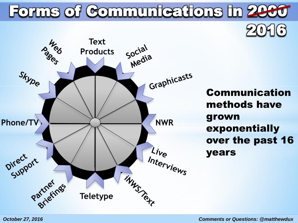
Forms of Communications in 2000
Communication
methods have
grown
exponentially
over the past 16
years
2016
NWR
Text
Products
Phone/TV
Teletype

October 27, 2016 Comments or Questions: @matthewdux
Creating a New Communication Concept
Prediction and Forecast of Heavy Mesoscale Banded Snow
Can Be Similar to That of Summer-Time Convection
Similarities:
- Conceptually Modeled Days in Advance
- Highly Depend on Mesoscale Details
- Rapidly Evolve as Event Approaches
- Share a Localized High-Impact Potential
Why Not Model the Forecast and Messaging
Process in Similar Fashions?

October 27, 2016 Comments or Questions: @matthewdux
Proposed Communication Model
12 to 24+ Hours Ahead12 to 36+ Hours Ahead
- Focus on Potential
- Highlight Broad Area
- Preparedness Info (plant the seed)
Outlook Stage
6 to 12 Hours Ahead- Highlight Potentials
- Trend Towards Certainty
- Have Talking Points
Alert Stage
0 to 6 Hours Ahead- Prompt Action
- Mesoscale Projections
- Message IS Certain
Watch
Stage
Event Ongoing- Provide Warnings
- Continual Information
- “Now-Cast” Theme
- Show Impacts
Warning
Stage
Increased
Accuracy
&
Certainty
General
Specific
Post Event Stage
After Event-Summarize Info (partners)
-Talking Points (staff)
October 27, 2016 Comments or Questions: @matthewdux
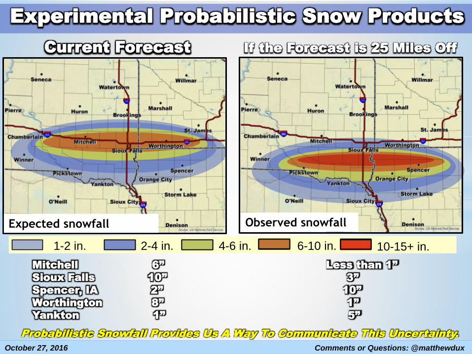
Experimental Probabilistic Snow Products
1-2 in. 2-4 in. 4-6 in.
Expected snowfall
6-10 in. 10-15+ in.
Observed snowfall
Mitchell 6” Less than 1”
Sioux Falls 10” 3”
Spencer, IA 2” 10”
Worthington 8” 1”
Yankton 1” 5”
Probabilistic Snowfall Provides Us A Way To Communicate This Uncertainty.
Current Forecast If the Forecast is 25 Miles Off
October 27, 2016 Comments or Questions: @matthewdux
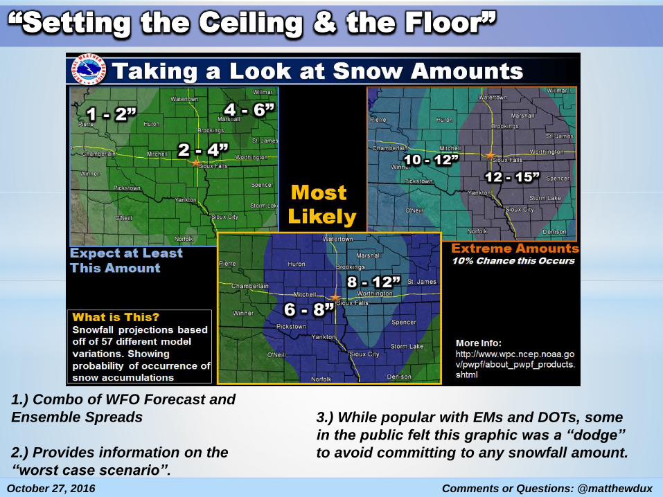
“Setting the Ceiling & the Floor”
3.) While popular with EMs and DOTs, some
in the public felt this graphic was a “dodge”
to avoid committing to any snowfall amount.
1.) Combo of WFO Forecast and
Ensemble Spreads
2.) Provides information on the
“worst case scenario”.

October 27, 2016 Comments or Questions: @matthewdux
“Focus on the Baseline & Leave Room”
Uses similar and risk
levels to words already
associated with severe
weather.
Can focus more on
critical snowfall
thresholds.
Sets a floor for snowfall
rather than a ceiling.
We believe this may
reduce hype as well by
avoiding talk of
extreme snowfall
amounts.Graphics created from Probability of Exceedance grids using
the SAC Grid Image Maker. WFO SLC provided the code.

October 27, 2016 Comments or Questions: @matthewdux
Example Case
Typical Mid-Winter Snow
Event for Northern Plains
Expectations of
Widespread Light Snow
3” or Less
Arrival of Snow Late
Afternoon/Evening
Models Showing Signs of
Banded Precipitation36 Hour Snow Forecast
Timeline: 36 Hours in Advance

October 27, 2016 Comments or Questions: @matthewdux
Outlook Stage Timeline: 12 to 36 Hours Prior
Forecast Awareness
- Be Aware of Model
Trends
- Address Concerns in
the AFD
- WWA in Effect?
Event Messaging
- Focus on Potential
- Highlight Broad Area
- Address Uncertainty
Slight
Slight

October 27, 2016 Comments or Questions: @matthewdux
Outlook Stage Timeline: 12 to 36 Hours Prior

October 27, 2016 Comments or Questions: @matthewdux
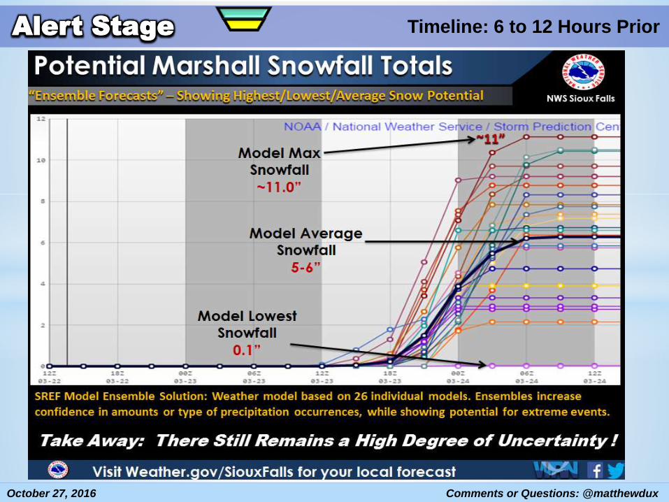
Alert Stage Timeline: 6 to 12 Hours Prior
Forecast Awareness- In Depth Examination
of Environment
- Use Probabilities to
Inspect Heavy Snow
Potential
- Change in Headlines
Needed?
- Adjust Staffing?
Event Messaging- Narrow Down Risk of
Heavy Snow Area
- Begin to Stress
Potential Impacts
- Address Uncertainty
Slight
Slight
Slight

October 27, 2016 Comments or Questions: @matthewdux
Alert Stage Timeline: 6 to 12 Hours Prior
Messaging Plan
- Future Radars
- Impact Potentials
-Event Timing
Other Thoughts:- Invite Media In
- Dedicated
Communicator?
- Skype Interviews
- 30 Sec Updates

October 27, 2016 Comments or Questions: @matthewdux
Alert Stage Timeline: 6 to 12 Hours Prior
October 27, 2016 Comments or Questions: @matthewdux
Alert Stage Timeline: 6 to 12 Hours Prior
October 27, 2016 Comments or Questions: @matthewdux
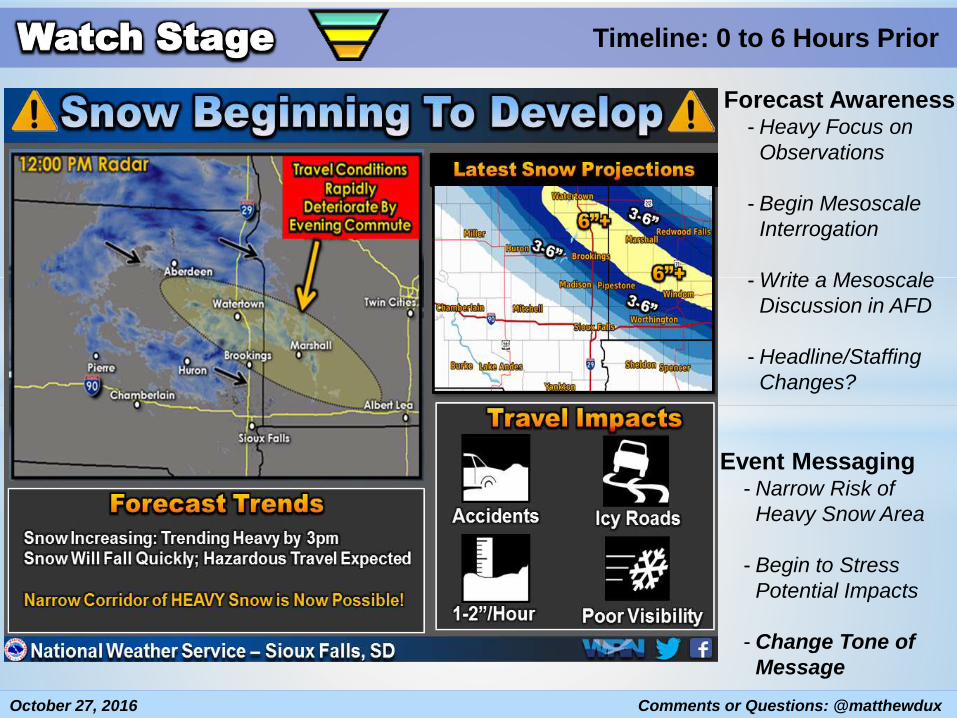
Watch Stage Timeline: 0 to 6 Hours Prior
Forecast Awareness- Heavy Focus on
Observations
- Begin Mesoscale
Interrogation
- Write a Mesoscale
Discussion in AFD
- Headline/Staffing
Changes?
Event Messaging- Narrow Risk of
Heavy Snow Area
- Begin to Stress
Potential Impacts
- Change Tone of
Message

October 27, 2016 Comments or Questions: @matthewdux
Watch Stage Timeline: 0 to 6 Hours Prior
Messaging Plan
- Hazard Education
- Prompt Action Plans
- Show Potential
Other Thoughts:- Change Tone of
Message
- Communicator in
Place
- WWOP Active?

October 27, 2016 Comments or Questions: @matthewdux
Warning Stage Timeline: Event Ongoing
Forecast Awareness
- Focusing on Incoming
Information
- Gather Reports
- Continual Weather
Watch and Forecast
Adjustments
- Warning Already
Issued
- Staffing Adjusted
Strong Emphasis on
Social Media and
Communications

October 27, 2016 Comments or Questions: @matthewdux
Warning Stage Timeline: Event Ongoing
What Types of Messages:
- Live Traffic Cameras
- 30 Second Human Video Updates
- Animated Radar GIFS to Show Motion
- Showing Impacts/Snow Data
Event Messaging
- Heavy Focus on Impacts
- Continual Flow of Information
- Express Certainty in the Message
- Provide Outlooks into the Night
October 27, 2016 Comments or Questions: @matthewdux
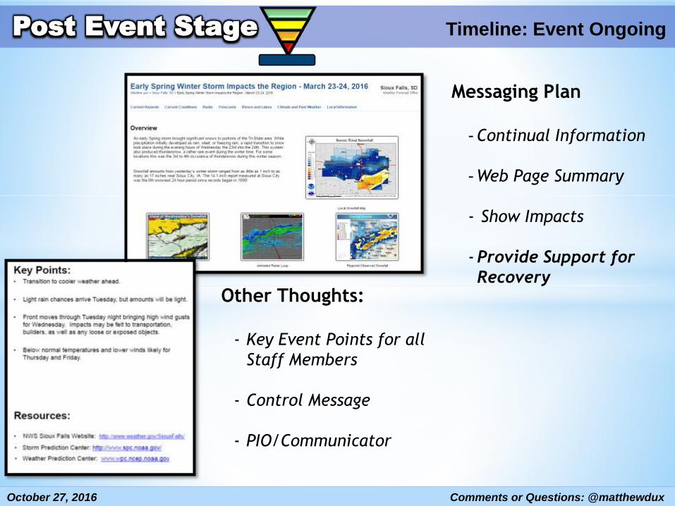
Post Event Stage Timeline: Event Ongoing
Messaging Plan
- Continual Information
- Web Page Summary
- Show Impacts
-Provide Support for
RecoveryOther Thoughts:
- Key Event Points for all
Staff Members
- Control Message
- PIO/Communicator

October 27, 2016 Comments or Questions: @matthewdux
What Tools Have Helped Us…
A Robust Set of Graphics Templates
Specialized Communications Training For
All Staff Members
-expressing probabilities
-briefing on impacts
Keep the Key Messages Visible
To All Staff Members
October 27, 2016 Comments or Questions: @matthewdux
What Are Our Limitations?
Various skillset levels in graphics and
communications
Lack of time or human resources available
Forecaster-to-forecaster and event-to-
event inconsistency

October 27, 2016 Comments or Questions: @matthewdux
Important Questions for the Future
How Do We Advertise the Worst Case Snow Scenario? Can We?
How Do You Message Extreme Events Without Leading to “Forecast Hype”?
Does “One-Size-Fits-All” Messaging Work? Does Message Need to Vary by
User (Public/Schools/Emergency Management/DOT)?
Contact: [email protected]
@MatthewDux