merrylands centre controls - cumberland council · public domain 513 3.1. roads and ... •...
TRANSCRIPT

Merrylands Centre ControlsHolroyd DevelopmentControl Plan 2013
MPart
Contents
Introduction 5081. Aims & Objectives 5092. Urban Design Strategies 5103. Public Domain 513
3.1. Roads and circulation 5133.2. Pedestrian and Bicycle Network 5153.3. Landscaping and Open Space 5173.4. Indicative Street Sections 519
4. Building Envelope 5324.1. Site amalgamation and minimum frontage 5324.2. Building and Ceiling Height 5354.3. Street setbacks, road widening and street frontage heights 5364.4. Building Depth and length 5414.5. Setbacks and Separation 5424.6. Active frontages, Street Address and Building Use 5444.7. Landscaping and Open Space 547
5. Block by Block Controls Neil Street Precinct 5495.1. Block 1 5495.2. Block 2 5525.3. Block 3 5555.4. Block 4 5585.5. Block 5 5615.6. Block 6 564
6. Movement 5676.1. Rear laneways and private accessways 5676.2. Pedestrian access 5686.3. Vehicle access 5696.4. Parking 569
7. Design and Building Amenity 5707.1. Laneway and Arcade Design 5707.2. Managing External Noise and Vibration 5707.3. Awnings 5717.4. Adaptable Housing 5727.5. Corner buildings 572
8. Environmental 5738.1. Flood and Stormwater Management 573
9. General 5778.1. Public art 5778.2. Interim development 578
Part MPartPart
Merrylands Centre
Holroyd Development Control Plan August 2013

508 Holroyd Development Control Plan August 2013
IntroductionLand covered by this Part This Part applies to all development within the Merrylands Centre, including land within the Neil Street Precinct as shown in Figure 1.
Relationship to other parts of Holroyd Development Control Plan 2013.This Part of Holroyd DCP 2013 shall be read in conjunction with all other Parts of Holroyd DCP 2013 which contains objectives and development controls that relate to development in this Part.
Part A - General Controls
Part B - Residential Controls
Part C - Commerical, Shop Top Housing and Mixed Use Development Controls
Part E - Public Participation
Part F - Advertising and Signage Controls
Part G - Places of Public Worship Controls
Part H - Heritage and Conservation Controls
Part I - Child Care Centre Controls
Definitions
McFARLANE ST
MERRYLANDS RD
PITT
ST
MEM
ORI
AL A
V
MIL
LER
ST
NEIL ST
GLADSTONE ST
TERM
INAL
PL
RAILWAY TER
0 100m
Figure 1
Part MMerrylands Centre

509 Holroyd Development Control Plan August 2013
1. Aims & Objectives
Aims of the plan• Renew and revitalise the Merrylands Centre.• Provide increased growth capacity with Merrylands.• Provide greater housing sustainability.• Promote steady local economic growth over the next 20 years.
Objectives• Strengthen the economic and employment role of Merrylands.• Provide for an active and vibrant centre.• Ensure buildings are designed to maximise appropriate amenity outcomes for the centre.• Ensure development design promotes the principles of ecologically sustainable
development.• Create a centre for a diverse community.• Promote public transport use, cycling and walking and reduce reliance on private car
travel.• Improve pedestrian and vehicular traffic movement within the centre.• Achieve urban design strategies that acknowledge the role of Merrylands within Holroyd
and the subregion.• Maintain and create clear linkages within the centre and with adjoining residential
precincts.
Part MMerrylands Centre
510 Holroyd Development Control Plan August 2013
2. Urban Design Strategies
In order to achieve the objectives for the redevelopment of the Merrylands Centre, the following urban design strategies have been established. These have been implemented through development controls in this plan. The success of the centre plan is reliant on the achievement of these strategies.
Strengthen the economic and employment role of Merrylands.
• Create an active centre for opportunities to live, work and play.• Facilitate the development of commercial, office and retail development at grade, with
commercial and/or ancillary residential development above;• Facilitate the growth of retail, and commercial development within the Town Centre, with
ancillary residential development;• Become a destination through additional retail, commercial and entertainment uses.• Ensuring interim development does not hinder or detract from the attainment of commercial
or mixed use development in the town centre.
Provide for an active and vibrant centre
• Ensure buildings address the street and the public domain by providing a consistent built edge and street frontage height.
• Facilitate of mixed use development with retail and commercial at grade and first floor, residential or commercial development above.
• Maintain Merrylands Road as the main street within the precinct.• Improve the landscaping and public domain spaces along McFarlane Street.• Create an active town centre where walking is encouraged by requiring future development to
activate the street with quality design and provide for at grade pedestrian connectivity.• Enable McFarlane Street to become an ‘eat street’ restaurant space.• Requiring development to activate the street and enhance at grade pedestrian connectivity
Ensure buildings are designed to maximise appropriate amenity outcomes for the centre.
• Provide setbacks and separation on upper storeys to lessen overshadowing impacts.• Provide height transition from the lower scale residential buildings to the higher scale buildings
on Merrylands Road and McFarlane Street in order to lessen overshadowing impacts.• Maintain the amenity of the Centre by maximising solar access to the street.• Require appropriate building setbacks and separation to allow for solar access and privacy.• Require the design of buildings to implement ‘safer by design’ principles.• Create a centre where pedestrians can feel safe during the day and night.• Provide public open space and landscaping for amenity and passive recreation opportunities.
Part MMerrylands Centre

511 Holroyd Development Control Plan August 2013
Ensure development design promotes the principles of ecologically sustainable development
• Respond to the opportunities and constraints of the site; the hierarchy and proposed uses of streets and laneways; flood hazard and the need for high quality public spaces and public and private amenity.
• Ensure that redevelopment within the Centre does not increase the impact of flood inundation on property or person (or both), within or beyond the Centre’s boundaries.
• Provide an overland flow path across which reduces flood levels while also serving as a pedestrian thoroughfare and focus for shopfronts and activity.
• Minimise the impacts of development on the environment.
Create a centre for a diverse community
• Facilitate the provision of a variety of dwelling sizes within the residential component of buildings.• Promote a variety of uses within the centre.• Provide public spaces for the community to meet and congregate.
Promote public transport use, cycling and walking and reduce reliance on private car travel
• Create a safe, pedestrian friendly environment through the activation of streets and public places• Create clear linkages within the centre and to adjoining residential precincts.• Contribute to a mix of residential, business, commercial and entertainment uses in the centre to
maximise public transport use.• Improve pedestrian connectivity through providing designated pedestrian linkages;
Improve pedestrian and vehicular traffic movement within the centre
• Restrict egress and ingress of vehicular traffic onto Merrylands Road from private properties.• Facilitate the creation of laneways and rear private access ways for key sites within the centre.• Provide new roads and infrastructure to improve accessibility and circulation in the Neil Street Precinct.
Achieve urban design that acknowledge the role of Merrylands within Holroyd the subregion
• Provide a transition in building heights through increasing height when approaching from the west and north east to enable the built form to signal the presence of the town centre.
• Maintain the amenity of surrounding lower scale development.• Comply with site requirements to enable better amenity outcomes for taller buildings.• Development responds to site opportunities and constraints and the need for high quality public spaces.• Facilitate the location of civic and public uses within the centre.• Provide appropriate public open spaces within the core of the centre and with the Neil Street Precinct.• Deliver quality designed buildings that reflect the role of the centre.
Part MMerrylands Centre
512 Holroyd Development Control Plan August 2013
Maintain and create clear linkages within the centre and with adjoining residential precincts
• Provide clear vehicular and pedestrian linkages with Neil Street Precinct, Holroyd Gardens and surrounding residential areas.
• Maintain and enhance a primary north-south pedestrian corridor from Memorial Avenue to Neil Street.
• Provide suitable crossings and infrastructure for pedestrians and cyclists.• Create of pedestrian linkages that provide connections within the centre.
Part MMerrylands Centre

513 Holroyd Development Control Plan August 2013
3. Public Domain3.1. Roads and circulation
A number of new intersections, roads, laneways and accessways are proposed under this plan, as indicated in the tables below and in Figure 2. Road widening along Merrylands Road will be required to enable a greater footpath area for street tree planting and pedestrian movement. Points where vehicular entry is not permitted are also identified. Indicative street sections are provided in Section 3.4.
Urban design strategies achieved:
• Create clear linkages within the centre and to adjoining residential precincts.
• Improve pedestrian connectivity through providing designated pedestrian linkages.
• Restrict egress and ingress of vehicular traffic onto Merrylands Road from private properties.
• Facilitate the creation of laneways and rear private access ways for key sites within the centre.
• Provide new roads and infrastructure to improve accessibility and circulation in the Neil Street Precinct.
• Provide clear vehicular and pedestrian linkages with Neil Street Precinct, Holroyd Gardens and surrounding residential areas.
• Create of pedestrian linkages that provide connections within the centre.
• Maintain Merrylands Road as the main street within the precinct.
• Create a safe, pedestrian friendly environment through the activation of streets and public place.
Table 1- New Roads, laneways. accessways in Merrylands Centre
New Roads
Extension of Sheffield Street
Extension of Gladstone Street
New Road 1- between Terminal Place and Sheffield Street Extension
New Road 2- between Dressler Court and New Road 1
Signalised intersections
Neil Street and New Road 1
Gladstone Street and Pitt Street
Laneways (public)
Extension of Main Lane
Laneway 1- between Merrylands Road and McFarlane Street
Laneway 2- between Memorial Avenue and Addlestone Road
Accessways (public or private)
Accessway 1- between Military Road and Miller Street
Accessway 2- between Addlestone Road and Burford Street
Accessway 3- between Neil Street and Sheffield Street
Part MMerrylands Centre

514 Holroyd Development Control Plan August 2013
New
Roa
ds
New
Acc
essw
ay
Prop
osed
Lan
eway
Exis
ting
Lane
way
s
Vehi
cula
r Ent
ry a
nd L
oadi
ng B
ays
Vehi
cle
Entr
y Po
ints
Not
Per
mitt
ed
0.5m
Roa
d W
iden
ing
KEY
- RO
AD
S A
ND
CIRC
ULA
TIO
N
McF
ARLA
NE
ST
MER
RYLA
ND
S RD
PITT ST
MEMORIAL AV
MILLER ST
NEI
L ST
GLA
DST
ON
E ST
TERMINAL PL
RAILWAY TER
010
0m
Figu
re 2
Part MMerrylands Centre

515 Holroyd Development Control Plan August 2013
3.2. Pedestrian and Bicycle NetworkFigure 3 includes footpaths, required new pedestrian access and crossings and bicycle access.
Pedestrian accessways create linkages to key locations in the centre. The proposed cycleway links to Holroyd Gardens, which is part of the regional cycle network.
Urban design strategies achieved:
• Create an active town centre where walking is encouraged by requiring future development to activate the street with quality design and provide for at grade pedestrian connectivity.
• Create a safe, pedestrian friendly environment through the activation of streets and public places
• Create clear linkages within the centre and to adjoining residential precincts.
• Improve pedestrian connectivity through providing designated pedestrian linkages;
• Provide clear vehicular and pedestrian linkages with Neil Street Precinct, Holroyd Gardens and surrounding residential areas.
• Provide suitable crossings and infrastructure for pedestrians and cyclists.
• Create of pedestrian linkages that provide connections within the centre.
Part MMerrylands Centre

516 Holroyd Development Control Plan August 2013
Foot
path
s
Pede
stria
n Ac
cess
+ A
rcad
es
Bicy
cle
Acce
ss
Pede
stria
n Cr
ossi
ngs
KEY
- PED
ESTR
IAN
ACC
ESS
+
BICY
CLE
NET
WO
RK
McF
ARLA
NE
ST
MER
RYLA
ND
S RD
PITT ST
MEMORIAL AV
MILLER ST
NEI
L ST
GLA
DST
ON
E ST
TERMINAL PL
RAILWAY TER
010
0m
Figu
re 3
Part MMerrylands Centre

517 Holroyd Development Control Plan August 2013
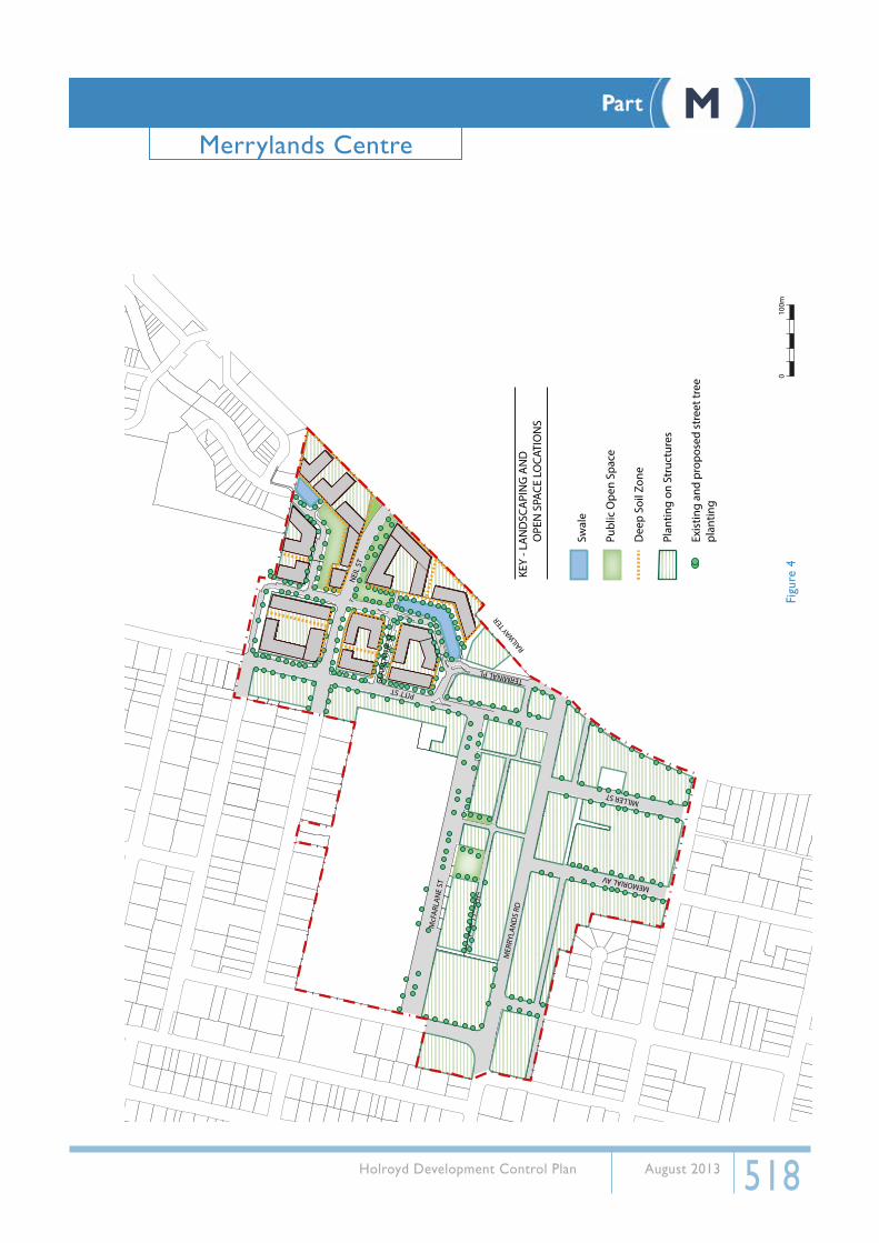
3.3. Landscaping and Open SpaceThe Centre proposes public and private open spaces, including deep soil zones, swales and planting on structures. Parks in Neil Street are located adjacent to roads to provide overland flow paths and to increase the visibility and safety. They also provide connectivity within the precinct. A town square between Merrylands Road and McFarlane Street is to provide focus for the city.
Opportunity to provide deep soil zones within the centre is limited therefore opportunities for planting on structures (i.e roof gardens) is promoted.
Trees planting will be important to the centre in providing streetscape character and providing amenity. Figure 4 indicates locations for open spaces and landscaping, including indicative locations for existing and proposed street tree planting.
Urban design strategies achieved:
• Create an active centre for opportunities to live, work and play.
• Improve the landscaping and public domain spaces along McFarlane Street.
• Provide public open space and landscaping for amenity and passive recreation opportunities.
• Respond to the opportunities and constraints of the site; the hierarchy and proposed uses of streets and laneways; flood hazard and the need for high quality public spaces and public and private amenity.
• Ensure that redevelopment within the Centre does not increase the impact of flood inundation on property or person (or both), within or beyond the Centre’s boundaries.
• Provide an overland flow path across which reduces flood levels while also serving as a pedestrian thoroughfare and focus for shopfronts and activity.
• Minimise the impacts of development on the environment.
• Provide public spaces for the community to meet and congregate.
• Provide appropriate public open spaces within the core of the centre and with the Neil Street Precinct.
Part MMerrylands Centre
518 Holroyd Development Control Plan August 2013
Swal
e
Publ
ic O
pen
Spac
e
Dee
p So
il Zo
ne
Plan
ting
on S
truc
ture
s
Exis
ting
and
prop
osed
str
eet t
ree
plan
ting
KEY
- LA
ND
SCA
PIN
G A
ND
OPE
N S
PACE
LO
CATI
ON
S
McF
ARLA
NE
ST
MER
RYLA
ND
S RD
PITT ST
MEMORIAL AV
MILLER ST
NEI
L ST
GLA
DST
ON
E ST
TERMINAL PL
RAILWAY TER
010
0mFi
gure
4
Part MMerrylands Centre

519 Holroyd Development Control Plan August 2013
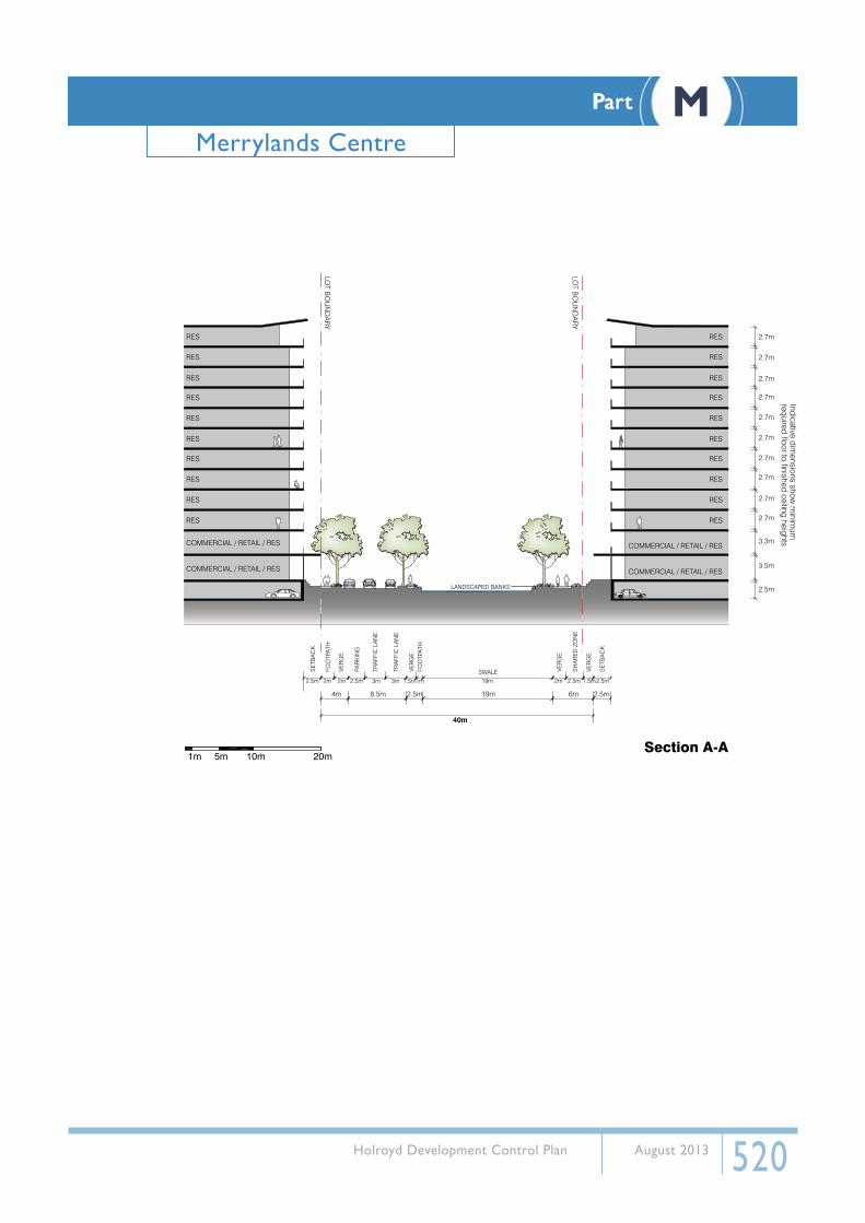
3.4. Indicative Street SectionsThe key map below shows a number of street sections within the centre. Indicative street sections have been provided on the following pages to indicate carriageway, footpath, verge widths and setbacks.
A
A
BB
LL
E
EC
CJ
J
FF
D
H
HD
GG
II
KK
McF
AR
LAN
E S
T
ME
RR
YLA
ND
S R
D
PITT ST
MEMORIAL AV
MILLER ST
NE
IL S
T
GLA
DS
TON
E S
T
TERMINAL PL
RAILW
AY T
ER
010
0m
Part MMerrylands Centre
520 Holroyd Development Control Plan August 2013
SWALE
LANDSCAPED BANKS
2m 2.5m 2.5m
2.5m6m19m2.5m8.5m
40m
19m1m1.5m3m3m2m
4m
2m 2.5m2.5m 1.5m
SE
TBA
CK
FOO
TPAT
H
VER
GE
VER
GE
VER
GE
VER
GE
SE
TBA
CK
SH
AR
ED
ZO
NE
FOO
TPAT
H
PAR
KIN
G
TRA
FFIC
LA
NE
TRA
FFIC
LA
NE
2.7m
2.7m
2.7m
2.7m
2.7m
2.7m
2.7m
2.7m
2.7m
2.7m
3.3m
3.5m
2.5m
Indicative dimensions show
minim
um
required floor to finished ceiling heights
COMMERCIAL / RETAIL / RES
COMMERCIAL / RETAIL / RES
COMMERCIAL / RETAIL / RES
COMMERCIAL / RETAIL / RES
RES
RES
RES
RES
RES
RES
RES
RES
RES
RES
RES
RES
RES
RES
RES
RES
RES
RES
RES
RES
LOT B
OU
ND
AR
Y
LOT B
OU
ND
AR
Y
1m 5m 10m 20mSection A-A
Part MMerrylands Centre

521 Holroyd Development Control Plan August 2013
LOT B
OU
ND
AR
Y
LOT B
OU
ND
AR
Y
2.5m 4m 2.5m 2.5m15.5m
40m
12m 6m
2m 2m 3m 3m 3m 3m 1.5m
CHILDREN’S PARK
2m 2.5m 1.5m1m
RES
RES
RES
RES
RES
RES
RES
RES
RES
RETAIL
COMMERCIAL
RES
RES
RES
RES
RES
RES
RES 2.7m
2.7m
2.7m
2.7m
2.7m
2.7m
2.7m
3.3m
3.5m
2.5m
Indicative dimensions show
minim
um
required floor to finished ceiling heights
SE
TBA
CK
FOO
TPAT
H
VER
GE
TRA
FFIC
LA
NE
TRA
FFIC
LA
NE
TRA
FFIC
LA
NE
TRA
FFIC
LA
NE
VER
GE
FOO
TPAT
H
VER
GE
SH
AR
ED
ZO
NE
VER
GE
SE
TBA
CK
1m 5m 10m 20mSection B-B
Part MMerrylands Centre

522 Holroyd Development Control Plan August 2013
LOT B
OU
ND
AR
Y
LOT B
OU
ND
AR
Y
2.5m 4.5m 11m 4.5m 2.5m
20m
2.5m 2.5m 2.5m 2.5m 2.5m 2.5m2m 3m 3m 2m
SE
TBA
CK
SE
TBA
CK
FOO
TPAT
H
FOO
TPAT
H
VER
GE
VER
GE
PAR
KIN
G
PAR
KIN
G
TRA
FFIC
LA
NE
TRA
FFIC
LA
NE
RETAIL
COMMERCIAL
2.7m
2.7m
2.7m
2.7m
2.7m
3.3m
3.5m
2.5m
Indicative dimensions show
minim
um
required floor to finished ceiling heightsRETAIL
COMMERCIAL
RES
RES
RES
RES
RES
RES
RES
RES
RES
RES
1m 5m 10m 20mSection C-C
Part MMerrylands Centre

523 Holroyd Development Control Plan August 2013
LOT B
OU
ND
AR
Y
LOT B
OU
ND
AR
Y
11m 4.5m 12m2.5m2.5m
30m floodway
3m 2m 12m3m2.5m 2.5m 2.5m2.5m2.5m
2.5m2.5m
SE
TBA
CK
SE
TBA
CK
FOO
TPAT
H
PAR
KIN
G
PAR
KIN
G
SH
AR
ED
ZO
NE
VER
GE
PARKTRA
FFIC
LA
NE
TRA
FFIC
LA
NE
RETAIL
COMMERCIAL
2.7m
2.7m
2.7m
2.7m
2.7m
2.7m
3.3m
3.5m
2.5m
Indicative dimensions show
minim
um
required floor to finished ceiling heights
RETAIL
COMMERCIAL
RES
RES
RES
RES
RES
RES
RES
RES
RES
RES
RES
1m 5m 10m 20mSection D-D
Part MMerrylands Centre

524 Holroyd Development Control Plan August 2013
1m 5m 10m 20m
LOT B
OU
ND
AR
Y
LOT B
OU
ND
AR
Y
2.5m
34.5m
2.5m
3m 8.5m 3m 19m
3m 3m 3m 2.5m 2.5m 19m
1m2.5m
1m 2.5m
SE
TBA
CK
FOO
TPAT
H
TRA
FFIC
LA
NE
TRA
FFIC
LA
NE
PAR
KIN
G
SH
OU
LDE
R
SE
TBA
CK
SWALE
LANDSCAPED BANKS
RETAIL
COMMERCIAL
2.7m
2.7m
2.7m
2.7m
2.7m
2.7m
3.3m
3.5m
2.5m
Indicative dimensions show
minim
um
required floor to finished ceiling heights
RETAIL
COMMERCIAL
RES
RES
RES
RES
RES
RES
RES
RES
RES
RES
RES
Section E-E
Part MMerrylands Centre

525 Holroyd Development Control Plan August 2013
RETAIL
HOLROYDGARDENS
COMMERCIAL
2.7m
2.7m
2.7m
2.7m
2.7m
3.3m
3.5m
2.5m
Indicative dimensions show
minim
um
required floor to finished ceiling heights
RES
RES
RES
RES
RES
LOT B
OU
ND
AR
Y
4.4m 11m 4.5m 2.5m
20m
2m 2.5m 2.5m 3m 3m 2.5m 2.5m 2.5m2m
SE
TBA
CK
SE
TBA
CK
PAR
KIN
G
TRA
FFIC
LA
NE
TRA
FFIC
LA
NE
PAR
KIN
G
SE
TBA
CK
SE
TBA
CK
SE
TBA
CK
1m 5m 10m 20mSection F-F
Part MMerrylands Centre

526 Holroyd Development Control Plan August 2013
Indicative dimensions show
minim
um
required floor to finished ceiling heights
2.7m
2.7m
2.7m
2.7m
2.7m
2.7m
2.7m
2.7m
2.7m
2.7m
3.3m
3.5m
2.5m
2.5m 4m 15m 4m 2.5m
2.5m 2.5m2m 2m2m 2m
SE
TBA
CK
FOO
TPAT
H
VER
GE
CARRIAGEWAY
ROAD RESERVATION
FOO
TPAT
H
VER
GE
SE
TBA
CK
23m
RETAIL
COMMERCIAL
RES
RES
RES
RES
RES
RES
RETAIL
COMMERCIAL
RES
RES
RES
RES
RES
RES
RES
RES
RES
RES
1m 5m 10m 20m
LOT B
OU
ND
AR
Y
LOT B
OU
ND
AR
Y
Section G-G
Part MMerrylands Centre

527 Holroyd Development Control Plan August 2013
Indicative dimensions show
minim
um
required floor to finished ceiling heights
2.7m
2.7m
2.7m
2.7m
2.7m
2.7m
2.7m
3.3m
3.5m
2.5m
2.5m 15m 2.5m
2.5m 2m 2m 2m 2m (min 7m) 2.5m
SE
TBA
CK
VAR
IES
FOO
TPAT
H
VER
GE
FOO
TPAT
H
VER
GE
VARIES
CARRIAGEWAY
ROAD RESERVATION 23M
SE
TBA
CK
RETAIL
COMMERCIAL
RES
RES
RES
RES
RES
RES
RETAIL
COMMERCIAL
RES
RES
RES
RES
RES
RESLO
T BO
UN
DA
RY
LOT B
OU
ND
AR
Y
1m 5m 10m 20mSection H-H
Part MMerrylands Centre

528 Holroyd Development Control Plan August 2013
LOT B
OU
ND
AR
Y
LOT B
OU
ND
AR
Y
RETAIL
COMMERCIAL
RES
RES
RES
RES
RES
RES
RETAIL
COMMERCIAL
RES
RES
RES
RES
RES
RES
RES RES
Indicative dimensions show
minim
um
required floor to finished ceiling heights
2.7m
2.7m
2.7m
2.7m
2.7m
2.7m
2.7m
3.3m
3.5m
2.5m
2.5m2.5m 5.5m 4m 5.5m 2.5m
2.5m 3m 3m 2.5m
2.5m
SE
TBA
CK
FOO
TPAT
H
PAR
KIN
G
TRA
FFIC
LA
NE
MEDIAN TRA
FFIC
LA
NE
PAR
KIN
G
FOO
TPAT
H
SE
TBA
CK
20m
1m 5m 10m 20mSection I-I
Part MMerrylands Centre

529 Holroyd Development Control Plan August 2013
LOT B
OU
ND
AR
Y
LOT B
OU
ND
AR
Y
RETAILRETAIL
COMMERCIALCOMMERCIAL
RES
RES
RES
RES
RES
RES
RES
RES
RES
RES
Indicative dimensions show
minim
um
required floor to finished ceiling heights
2.7m
2.7m
2.7m
2.7m
2.7m
3.3m
3.5m
2.5m
2.5m 3.6m 12.8m 3.6m 2.5m
SE
TBA
CK
FOO
TPAT
H
FOO
TPAT
H
SE
TBA
CK
20m
1m 5m 10m 20mSection J-J
Part MMerrylands Centre
530 Holroyd Development Control Plan August 2013
RETAIL
Section K-K
2.7m
2.7m
2.7m
2.7m
2.7m
2.7m
2.7m
2.7m
2.7m
2.7m
2.7m
2.7m
2.7m
3.3m
3.3m
3.5m
2.5m
Indicative dimensions show
minim
um
required floor to finished ceiling heights
COMMERCIAL
COMMERCIAL
RES
RES
RES
RES
RES
RES
RES
RES
RES
RES
RES
RES
RES
RETAIL
COMMERCIAL
East-West Laneway
COMMERCIAL
RES
RES
RES
RES
RES
RES
RES
RES
RES
RES
RES
RES
RES
RES
RES
RES
RES
8m
CARRIAGEWAY
1m 5m 10m 20m
Part MMerrylands Centre
531 Holroyd Development Control Plan August 2013
Section L-LNorth-South Laneway
4m 1m1m1.5m 1.5m
CA
RR
IAG
EW
AY
FOO
TPAT
H
FOO
TPAT
H
FOO
TPAT
H D
ININ
G
FOO
TPAT
H D
ININ
G
1m 5m 10m 20m
2.7m
2.7m
2.7m
2.7m
2.7m
2.7m
2.7m
2.7m
2.7m
2.7m
2.7m
2.7m
2.7m
2.7m
3.3m
3.3m
3.5m
2.5m
Indicative dimensions show
minim
um
required floor to finished ceiling heights
COMMERCIAL
COMMERCIAL
RES
RES
RES
RES
RES
RES
RES
RES
RES
RES
RES
RES
RES
RES
RES
RES
RES
RETAIL RETAIL
COMMERCIAL
COMMERCIAL
RES
RES
RES
RES
RES
RES
RES
RES
RES
RES
RES
RES
RES
RES
RES
RES
RES
2.7m
2.7m
2.7m
Part MMerrylands Centre

532 Holroyd Development Control Plan August 2013
4. Building Envelope4.1. Site amalgamation and minimum frontage
In order for taller buildings to achieve suitable building amenity outcomes and to ensure building sites can accommodate appropriate vehicular access and carparking facilities, a suitable minimum site frontage needs to be obtained for all developments.
In some instances specific site amalgamations will be required, this may be where the provision of a laneway is required, where vehicular entry points are required in a certain location or where a specific building footprint is required due to flood conditions.
ObjectivesO1. Ensure the achievement of laneways and private accessways in order to require development
fronting Merrylands Road to have rear vehicular access.
O2. Ensure vehicular access can be obtained from secondary streets and laneways.
O3. Ensure sites are sufficient in frontage in order to provide adequate vehicular access and basement carparking.
O4. Ensure site dimensions allow for the achievement of appropriate building setbacks and separation.
O5. For new development not to reduce the reasonable development opportunity of adjoining lots.
Development Controls
C1. Amalgamation of lots in accordance with Figure 5 is required for redevelopment.
C2. Where amalgamation is not required by this plan, the minimum site width for redevelopment is 20m
C3. The minimum site width achieved shall determine the height of buildings (in storeys) in accordance with the table below. Site width shall be measured at the primary frontage.
Site width (m) Permitted Height (storeys)
20m Maximum 3 storeys
26m Maximum 8 storeys
32m Maximum 20 storeys
C4. Sites must not be left such that they are physically unable to reasonably develop a three storey building in accordance with the controls in Sections 4 and 5 of this Part.
C5. Development must not prevent the provision of laneways, accessways or vehicular access locations is prevented, or cannot be achieved in accordance with this plan.
C6. Where required amalgamations cannot be achieved:
a) Applicants are to negotiate with all affected property owners prior to the lodgement of a development application, in an attempt to achieve the preferred development outcome.
b) In instances where amalgamation cannot be achieve (because a landowner chooses not
Part MMerrylands Centre
533 Holroyd Development Control Plan August 2013
to take-up a reasonable offer) the following information must be submitted with any development application:
• two (2) written valuations indicating the value of the remaining sites that were to be developed in conjunction with the applicants properties. These are to be undertaken by two independent Valuers registered with the Australian Institute of Valuers, and
• evidence that a reasonable offer has been made to the owner(s) of the affected sites to purchase and valuation reports.
C7. Where amalgamation (as required) is not achieved the applicants must show that the remaining sites, which are not included in the consolidation will still be able to achieve the development outcome prescribed in this DCP (i.e. minimum site frontage of 20m). This includes achieving the required vehicular access, basement parking and built form.
Note:
• Potential value can include, (but is not limited to) the land locked site developed jointly with adjoining properties, or on its own, under Holroyd LEP 2013 and this plan.
• A reasonable offer shall be a fair market value, and include for all expenses that would be incurred by the owner in the sale of the land locked site.
Part MMerrylands Centre

534 Holroyd Development Control Plan August 2013
Site
Am
alga
mat
ion
KE
Y -
SIT
E A
MA
LGA
MA
TIO
N
McF
AR
LAN
E S
T
ME
RR
YLA
ND
S R
D
PITT ST
MEMORIAL AV
MILLER ST
NE
IL S
T
GLA
DS
TON
E S
T
TERMINAL PL
RAILW
AY T
ER
010
0mFi
gure
5
Part MMerrylands Centre
535 Holroyd Development Control Plan August 2013
4.2. Building and Ceiling HeightBuilt form scale is important in establishing the role and character of a centre. It can provide visual cues to signal the presence of the town centre and also provide legibility within the centre itself. The built form of Merrylands centre will reflect its role as a town centre, whilst having regard for surrounding lower density development.
The built form scale established for Merrylands provides a height transition, from lower scale when approaching from the west, north-east and surrounding lower scale residential buildings to towers in the core of the centre. The scale has been specifically developed to ensure that an appropriate level of daylight access is achievable for dwellings within and immediately outside of the centre and that the scale of building reflects its proximity to the core of the centre.
ObjectivesO1. Achieve appropriate management of overshadowing, access to sunlight and privacy
O2. Deliver a built form that provides a height transition, from lower scale on the edges of the centre to higher scale in the core of the centre.
O3. Ensure the scale of the built form provides for a legible centre.
O4. Provide appropriate transition in building heights from public spaces.
Development ControlsC1. Maximum permitted building height in storeys* shall be in accordance with the table below.
Permitted Height (storeys)
Height (m) storeys
10 1
12.5 2
14 3
17 4
20 5
23 6
26 7
29 8
32 9
38 11
41 12
50 15
53 16
65 20
C3. Each storey shall have the following minimum floor to ceiling heights:
• Ground floor- 3.5m• First floor (regardless of use)- 3.3m• All other floors- 2.7m
C4. Development in the centre shall establish a consistent building height transition, from the edges
Part MMerrylands Centre
536 Holroyd Development Control Plan August 2013
of the centre, to the core of the centre.
C5. Ensure the achievement of daylight access to public open spaces in accordance with Section 7.4.
* Building heights set under Holroyd LEP 2013 accommodate flood management measures, such as floor level heights.
4.3. Street setbacks, road widening and street frontage heights
The street setback and frontage height of buildings establishes different character areas and spaces, through the definition of streets. Consistent street alignment provides continuity of street facades and enhances the character of the area. Street frontage height determines the scale of buildings on the street and reflects the role of the centre and the intended experiences for pedestrians.
The street setbacks in Merrylands reflect the retail and commercial uses within the core, civic streets and the transition to lower scale residential areas. Street frontage heights provide a human scale to the centre, to optimize pedestrian experience and allow for the achievement of sunlight access.
Objectives
O1. Provide street edges that reinforce and reflect the various uses and characters within the centre.
O2. Ensure the location of shop fronts are adjacent to pedestrian activity.
O3. Create a pleasant environment and amenity for residents and visitors through the provision of street trees and wider footpaths on Merrylands Road.
O4. Encourage the establishment of active laneway uses through street setbacks.
O5. Enhance the character of the centre through consistent and continuous street facades.
O6. Ensure building heights at street level are at a human scale.
O7. Ensure the pedestrian environment is pleasant and inviting through access to sunlight, appropriate scale and massing of buildings and wind mitigation.
Development ControlsC1. Street setbacks in accordance with Figure 6 are required for redevelopment.
C2. 0.5m road widening is required for both sides of Merrylands Road in accordance with Figure 2.
C3. On Pitt Street a 0.65m road widening is required for 185 Pitt Street, to enable the cycle path connection.
C4. A 3m x 3m splay corner is required at the south-western corner of the Neil Street/Pitt Street intersection.
C5. On Neil Street, road widening is required at 185 Pitt Street, to require the footpath dimensions to match existing to the east of the site.
C6. Street wall height of buildings (podium) shall be 3 storeys, with a minimum height of 11m and maximum height of 14m.
Part MMerrylands Centre

537 Holroyd Development Control Plan August 2013
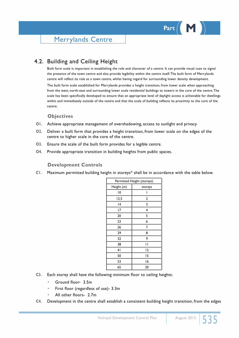
C7. Upper level (above street wall)street frontage setbacks for Merrylands Road, McFarlane Street and Pitt Street will be based on storey height, in accordance with the table below and Figure 7:
Storeys Street frontage setback (m)
4-8 4
9-12 5
13-20 6
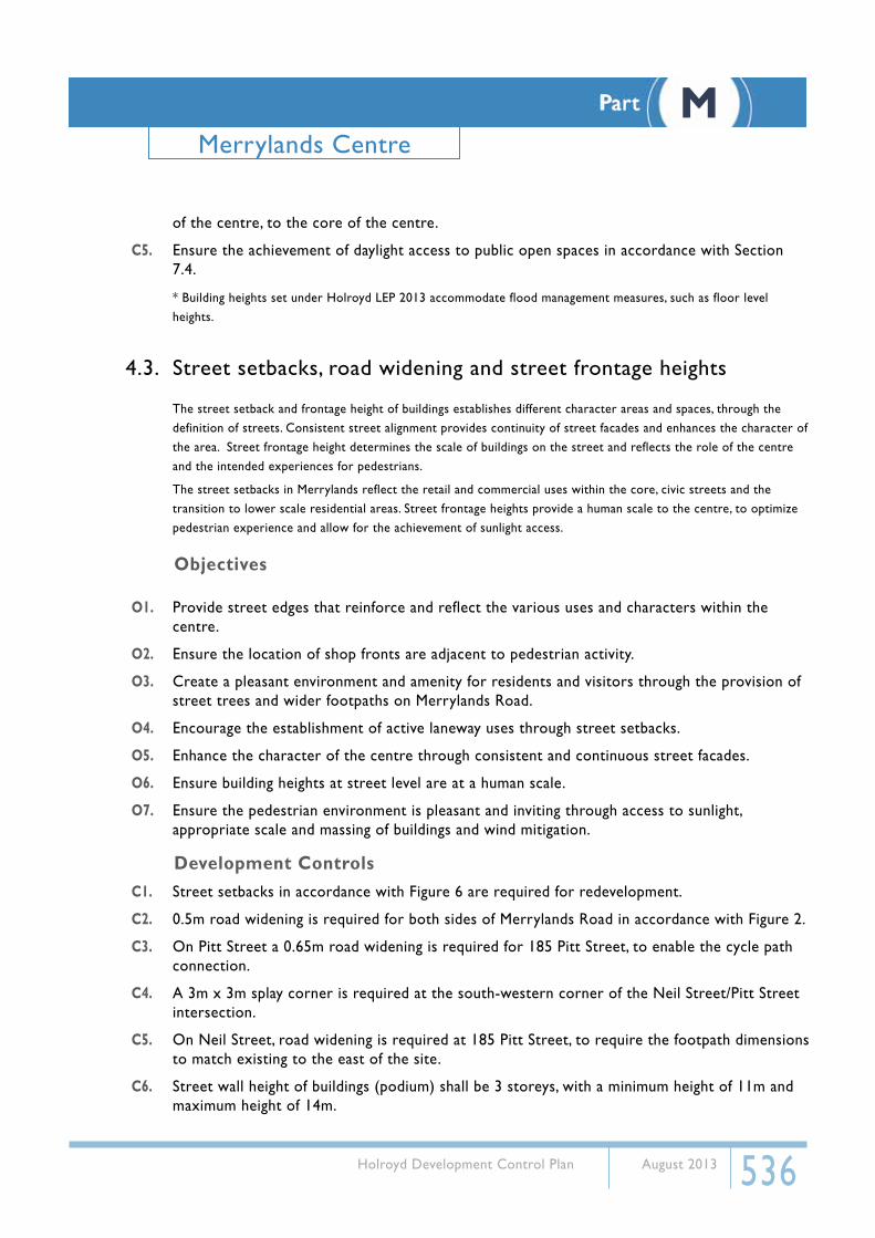
C8. Upper level street frontage setbacks for Memorial Avenue shall be in accordance with Figure 8
C9. Minor projections into the street setback will be accepted for sites where 0m setback is required, in accordance with the table below:
Permitted projection Permitted length of projection
Awnings 3.0m
Awnings (laneways) Maximum 1.5m
Balconies (above 3rd storey) 600mm
Note: Awning requirements are provided in Section 7.3
Part MMerrylands Centre

538 Holroyd Development Control Plan August 2013
0m 1.5m
4m 2.5m
3m 7.5m
11-1
4 m
etre
s (3
Sto
reys
)
Spec
ial e
mph
asis
on
corn
er
KEY
- STR
EET
SETB
ACKS
AN
D
ST
REET
FRO
NTA
GE
Podi
um S
tree
t Set
back
Stre
et W
all H
eigh
t
Build
ing
Stre
et S
etba
ck
McF
ARLA
NE
ST
MER
RYLA
ND
S RD
PITT ST
MEMORIAL AV
MILLER ST
NEI
L ST
GLA
DST
ON
E ST
TERMINAL PL
RAILWAY TER
010
0mFi
gure
6
Part MMerrylands Centre
539 Holroyd Development Control Plan August 2013
LOT B
OU
ND
AR
Y
LOT B
OU
ND
AR
Y
1m 5m 10m 20m
1
2
3
4
5
6
7
8
9
10
11
12
13
14
15
16
17
18
19
20
1
2
3
4
5
6
7
8
9
10
11
12
13
14
15
16
17
18
19
20
6m
5m
4m
3m Max
3m Max
3 Storey Street Wall HeightMin 11m, Max 14m
Main Street
6m
5m
4m
Figure 7
Part MMerrylands Centre
540 Holroyd Development Control Plan August 2013
16
1
2
3
4
5
6
7
8
9
10
11
12
13
15
14
3m Max
4m
8m
9m
3m Max
4m
8m
9m
Figure 8
Part MMerrylands Centre
541 Holroyd Development Control Plan August 2013
4.4. Building Depth and length
Building depths directly impact the residential amenity for dwelling occupants. Achieving adequate building depths can ensure access to natural ventilation and sunlight, which provides amenity and energy savings. Limiting building depth and length also reduces the bulk of a building, which provides benefits to the public domain of sunlight access and streetscape amenity.
Building depth is related to building use and different site conditions such as size, orientation and density which may require different design solutions.
Building depth will be calculated as Building plan (glass line to glass line) + articulation zone (including balconies).
ObjectivesO1. Promote sustainable building design and development and reduce reliance on artificial heating,
cooling and lighting.
O2. Ensure that adequate cross ventilation and sunlight access is achieved in residential apartments within the high density centre.
O3. Provide for viable and functional commercial spaces.
O4. Consider the amenity of future residents and workers through building design.
O5. Provide sunlight access and streetscape amenity to the public domain.
Development ControlsC1. There is no maximum building depth requirement for floors used as commercial premises.
C2. The maximum permissible building plan depth for residential accommodation is 18m.
C3. The maximum permissible building envelope depth for residential accommodation is 22m.
C4. Residential apartments on the 2nd and 3rd storey levels are limited in depth to 8m from the glassline and 11m from the outer edge of the building envelope.
C5. Where office premises are proposed, all points on an office floor should be no more than 15m from a source of daylight.
C6. The maximum horizontal length of any building above the podium shall not exceed 50m.
C7. All residential and mixed use developments shall be, or substantially contain, dual aspect apartments.
Note:
• Bui.lding depth controls for Neil Street Precinct are location in Section 5 of this part.
• Development applications shall provide detailed supporting documentation demonstrating how the building depth, bulk, scale, length and the achievement of adequate natural ventilation and sunlight is respondent to site conditions.
Part MMerrylands Centre

542 Holroyd Development Control Plan August 2013
4.5. Setbacks and Separation
Building setbacks and separation is significant in establishing and maintaining residential and pedestrian amenity within and outside of the centre. Sunlight access, privacy and airflow to both buildings and public spaces can only be achieved through the adequate separation of buildings.
Sufficient building separation can reduce the appearance of building bulk and allows for the definition of public space, including laneways, open space and landscaping. Providing spaces between buildings also contributes in creating legibility within the centre.
Setbacks and separation proposed for Merrylands responds to the future role of the centre, in order to provide a balance between the future density of the centre and the amenity for residents and pedestrians.
ObjectivesO1. Ensure residents within buildings and adjoining buildings have adequate access to sunlight,
airflow and visual and acoustic privacy.
O2. Provide visual legibility and a pleasant public domain through breaks in the built form.
O3. Mitigate the impacts of wind within the centre.
O4. Create a consistent streetscape character.
Development Controls
C1. Where the street setback is 0m, a continuous built edge shall be provided up to the 3rd storey, regardless of use.
C2. Where a laneway or accessway is required the minimum rear setback shall be 8m, unless shown otherwise.
C3. Setbacks to secondary streets (above podium) to the property line shall be provided as below:
Storeys Setback (m)
4-8 3m
9-20 6m
C4. 0m side setback to Terminal place and or Milne Lane will be accepted for properties 266 Pitt Street and 135-137 Merrylands Road.
C5. Minimum setbacks to side boundaries shall be provided in accordance with the table below:
Building uses Storeys Side setbacks
Non habitable rooms and commercial with no windows
1-3 storeys 0 metres
4-8 storeys 3 metres
9-20 storeys 6 metres
Habitable rooms/balconies
4 storeys 6 metres
5-8 storeys 9 metres
9-20 storeys 12 metres
Part MMerrylands Centre

543 Holroyd Development Control Plan August 2013
Habitable rooms/balconies and non habitable rooms
4 storeys 4.5 metres
5-8 storeys 6.5 metres
9-20 storeys 9 metres
C6. Minimum rear setbacks to buildings with a common boundary to a business zone.
Building use Storeys Rear Setback
Ground floor 0-3 storeys 0 metres
Non habitable rooms (including commercial)4-8 storeys 3 metres
9-20 storeys 6 metres
Habitable rooms/balconies
4 storeys 6 metres
5-8 storeys 9 metres
9-20 storeys 12 metres
Habitable rooms/balconies and non habitable rooms
4 storeys 4.5 metres
5-8 storeys 6.5 metres
9-20 storeys 9 metres
Where rear laneway or accessway is required 8 metres
C7. Minimum rear setbacks to a common boundary with a residential zone.
Building use Storeys Rear Setback
Non habitable rooms (including commercial) 0-8 storeys 6 metres
9-12 9 metres
13-20 storeys 12 metres
Habitable rooms/balconies 4 storeys 6 metres
5-8 storeys 9 metres
9-20 storeys 12 metres
Habitable rooms/balconies and non habitable rooms Up to 4 storeys 4.5 metres
5-8 storeys 6.5 metres
9-20 storeys 9 metres
Where a rear laneway or accessway is required 8 metres
C8. Minimum separation between upper levels (above podium) on one site.
Building uses Storeys Side Separation
Non habitable rooms (including commercial)4-8 storeys 6 metres
9-20 storeys 12 metres
Habitable rooms/balconies
4 storeys 12 metres
5-8 storeys 18 metres
9-20 storeys 24 metres
Habitable rooms/balconies and non habitable rooms
4 storeys 9 metres
5-8 storeys 12 metres
9-20 storeys 18 metres
Part MMerrylands Centre

544 Holroyd Development Control Plan August 2013
4.6. Active frontages, Street Address and Building Use
Building frontages that contribute positively to the public domain through activity and design not only encourage pedestrian activity, which can bring vitality and vibrancy to a centre, but also provides pedestrians with amenity and a safer environment.
Entrances to buildings define the private and public domain and need to be legible and free of barriers. Frontages should also enable accessibility for the entire community.
ObjectivesO1. Provide for a vibrant, pedestrian focused centre through the orientation and design of ground floor
entries and shop fronts.
O2. Require activation of the street through the reinforcement of activities along the main streets and some laneways.
O3. Maintain the established character of fine grain frontages at ground level.
O4. Provide well designed building facades and entrances.
O5. Contribute to a safe environment for pedestrians and residents through both passive and active surveillance.
O6. Ensure the accessibility of the centre for the entire community.
Development Controls
Active FrontagesC1. Provide Active frontages at street level, orientating onto streets,laneways and public places, as
identified on Figure 9.
C2. Active frontages consist of the following:
i) Shopfrontii) Food and Drink premises such as Restaurant or Caféiii) Entrance to public buildings or commercial building foyersiv) Customer service areas and receptions (where visible from the street)
C3. At least 70% of street level frontages shall be transparent glazing. Blank or solid walls and the use of dark or obscured glass on active frontages are prohibited.
C4. Restaurants, cafes and the like are to consider providing openable shop fronts.
C5. Active frontages located on Merrylands Road (to Addlestone Street) and McFarlane Street should aim to provide at least 10-14 separate tenancy entries per 100m.
C6. Large developments shall provide multiple entrances.
C7. Solid roller shutters or the like that obscure windows and entrances are not permitted. Security grilles which are fixed internally to the shop front, fully retractable and are at least 50% transparent when closed, are acceptable.
C8. The ground floor level of active frontages shall be at the same level as the footpath, unless otherwise required by this plan.
Part MMerrylands Centre

545 Holroyd Development Control Plan August 2013
C9. The location of fire escapes, service doors, plant equipment and the like are to be minimised on active streets.
Street AddressC10. Street address in the form of entries, lobbies and/or habitable rooms with clear glazing are
required at ground level, in accordance with Figure 9.
C11. Direct pedestrian access off the primary street front shall be provided.
C12. Direct ‘front door’ access to residential units is encouraged.
C13. Open space should be oriented to overlook pedestrian access points.
C14. Blank walls or dark or obscured glass is not permitted.
Building UseC15. Retail and commercial uses are to be located on at the ground floor level for all development
within the B4 zone.
C16. Residential development is not permitted to be located at the ground floor level of any development within the B4 zone.
C17. Commercial office space or other suitable non residential uses must be provided at the first floor level of development for the entire premises street frontage.
Note: Block by block controls in Section 5 indicate required building uses within the Neil Street precinct.
Part MMerrylands Centre

546 Holroyd Development Control Plan August 2013
Activ
e St
reet
Fro
ntag
e Re
quire
d
Stre
et A
ddre
ss
Out
door
Din
ing
Enco
urag
ed
Mai
n St
reet
Ret
ail W
ith
Inte
rmitt
ent O
utdo
or D
inin
g
KEY
- AC
TIVE
FRO
NTA
GES
AN
D S
TREE
T A
DD
RESS
McF
ARLA
NE
ST
MER
RYLA
ND
S RD
PITT ST
MEMORIAL AV
MILLER ST
NEI
L ST
GLA
DST
ON
E ST
TERMINAL PL
RAILWAY TER
010
0mFi
gure
9
Part MMerrylands Centre

547 Holroyd Development Control Plan August 2013
4.7. Landscaping and Open SpaceLandscaping should build on a site’s existing natural and cultural features to contribute to a developments positive relationship to its context and site. Landscape design should optimize usability, privacy, social opportunity, equitable access and respect for neighbours’ amenity. It plays a significant role in improving the amenity of open space and the visual quality for residents and visitors to the centre.
Together, landscape and buildings operate as an integrated and sustainable system, resulting in greater aesthetic quality and amenity for occupants and the adjoining public domain. As such, it should not be generated by left over spaces resulting from building siting and location.
ObjectivesO1. Enhance the amenity and liveability for residents, workers and visitors to the centre through
integrated landscape design, improvements to the public domain and the provision of passive and recreational opportunities.
O2. Provide a pleasant and enhanced streetscape character and amenity through the retention and/or planting of trees.
O3. Provide for pleasant and safe public open spaces through designing for accessibility and surveillance.
O4. Assist the management of the water table, stormwater and water quality through maximising site infiltration through deep soil and permeable surfaces.
O5. Require communal open space that is assessable, functional and attractive and provides for passive recreation and landscaping.
O6. Enhance liveability for residents by requiring every dwelling to have access to a private, useable and functional private open space directly adjacent to living areas and providing an extension of the living spaces.
O7. Provide balconies and terraces of sufficient size and proportion, which are functional and allow for outdoor living and planter opportunities.
O8. Require balconies and terraces to be integrated into the overall architectural form of the building and to contribute to the articulation and modulation of the building façade.
O9. Contribute to the safety and liveliness of the street by allowing for casual overlooking and address.
O10. Ensure private and communal open space areas are adequately landscaped and able to accommodate a range of plant species.
O11. Provide appropriate soil conditions, drainage and irrigation measures that encourage plant growth.
Development ControlsNote: For general landscaping and open space development controls, refer to Part C of this DCP.
Public Open SpaceC1. Public open spaces for passive recreation and for overland flow paths shall be provide as
identified in Figure 4.
Part MMerrylands Centre
548 Holroyd Development Control Plan August 2013
Streetscape planting and public domain worksC2. Streetscape planting shall be provided in accordance with Figure 4.
C3. Planting and public domain works shall be in accordance with Council’s Landscape Masterplan.
Deep Soil zonesC4. Deep soil zones shall be provided in accordance with Figure 4.
C5. Where there is limited capacity for water infiltration, stormwater treatment measures are to be integrated with the design of the buildings.
Part MMerrylands Centre

549 Holroyd Development Control Plan August 2013
5. Block by Block Controls Neil Street Precinct5.1. Block 1
Block 1 is currently bound by Holroyd Gardens on the north, Neil Street on the south, and Pitt Street on the west. Pitt Street is a significant street in the road hierarchy as an important connector between Parramatta and Merrylands. Block 1 benefits from its close proximity to Holroyd Gardens, which provides recreational opportunities and attractive views into the park. Commercial development within the mixed use precinct is to have active street frontages.
The proposed plan for the block shows the introduction of two new roads. New Road 1 (north) has been introduced on the eastern boundary, and Sheffield Street has been extended on the northern boundary of the block. These two new roads provide access to the block, provide
for the overland flow path, and also create an address to any future development on the block. They also help in increasing the developable area on the site. Sheffield Street extension will provide the park (Holroyd Gardens) with an address, and will thereby increase its useability.
There will be a southern gate to the park off Sheffield Street extension, which will open it up more to the public, and will also make the park feel more a part of the
town centre than it is currently. Street tree planting on New Road 1 (north) helps emphasise the view corridor from the Merrylands transit interchange into the park (Holroyd Gardens). Developments fronting Sheffield Street Extension will promote passive surveillance of the park and will thus aid in improving its security.
A building height of 6 storeys is allowed on the block. A building height of 7 storeys is allowed on the corner of Neil and Pitt Streets. This has been allowed in order to emphasise this important Junction, as well as to reflect this important entry point into the Merrylands town centre from the north. The top two floors of buildings along Pitt Street (except for buildings on the corner of Pitt and Neil Streets) have been set back, in order to maintain a four-storey streetwall height. The buildings along Pitt Street have been set back 3m from the street, in keeping with the ‘green’ nature of Holroyd Gardens. This setback area will be landscaped, and will have tree planting. This also helps to give a distinction in the character of Pitt Street as one moves from the Neil Street Precinct, towards the heart of the town centre (ie Merrylands Road).
The building adjacent to Pitt Street should enable an active street frontage through the provision of ground floor commercial use. A maximum building depth of 25m is allowed for retail/commercial floors (max 23m glassline
to glassline. Residential building depths are maximum 18m (15m glassline to glassline) and 22m (18m glassline to glassline). See section drawings and written controls for details.
On-street parking has been provided on both sides of Sheffield Street Extension, which is an added attraction for people to use the park. On-street parking has also been provided on New Road 1 (north) . On-site parking for future development is envisaged to be provided in basement/sub-basement floors, and/or at ground level (screened from the street by a skin of either residential or commercial/retail uses on the street frontage). This is explained in the section drawing provided.
Landscaping is to be provided on top of basement car parks. These will act as communal open spaces for the developments. Deep soil zones are to be provided, as indicated in the building envelope plan. Car parking areas must not extend into deep soil zones.
Part MMerrylands Centre

550 Holroyd Development Control Plan August 2013
Building Height
In general • Max 7 storeys
On the corner of Pitt and Neil Streets • max 8 storeys to a maximum extent of 18 metres from the corner in each direction
Building Use:
B4 zone
Ground and first floor• commercial / retail
Second floor and above• commercial/ retail or residential
R4 zone All floors residential
Building Depth:
Commercial / retail on ground and first floors • max 25m (max 23m glass line to glass line)
Commercial / retail on second floor and above • max 18m (max 15m glass line to glass line)
Residential on second floor and above • max 28m (max 15m glass line to glass line)
Setback:
Street setback
Pitt Street• min 3m
Neil Street and New Road 1 (north)• min 2.5m
Rear setback
For lots fronting Pitt Street• min 6m
For lots fronting New Road 1 (North)• 0m
Deep Soil Zone + Open Space
• Development is to comply with all open spaces, deep soil zones and planting on structures indicated in the building envelope plan and the section
• Development is to comply with all open spaces, deep soil zones and planting on structures indicated in the building envelope plan and the section
Part MMerrylands Centre
551 Holroyd Development Control Plan August 2013
PLANTING ON STRUCTUREMAX 15m
GLASS TO GLASS LINE
IND
ICATIVE
DIM
EN
SIO
NS
SH
OW
MIN
IMU
M
RE
QU
IRE
D FLO
OR
TO FIN
ISH
ED
CE
ILING
HE
IGH
TS
MAX 18m BUILDING DEPTH
MAX 15m GLASS TO GLASS LINE
PITT STREET NEW STREET 1
LOT
BO
UN
DA
RY
LOT
BO
UN
DA
RY
LOT
BO
UN
DA
RY
MAX 18m BUILDING DEPTH
MAX 30m COMMERCIAL BUILDING DEPTH
6m
DE
EP
SO
IL
ZON
E
3.6m
FOO
TPAT
H
3m 4m
SE
TBA
CK
2.5m
2.5m
3.5m
2.7m
2.7m
2.7m
2.7m
2.7m
2.7m
2.5m
3.5m
3.3m
3.3m
2.7m
2.7m
2.7m
2.7m
2.5m
SE
TBA
CK
2m
VER
GE
FOO
TPAT
H
TOW
ER
SE
TBA
CK
New Road 2
7
7
8
71
3A
APitt
Stre
et
Neil Street
Sheffield Street Extension
New
Roa
d 1
(nor
th)
Holroyd Gardens 2 storeys
1 storey
3 storeys
4 storeys
5 storeys
6 storeys
7 storeys
8 storeys
envelope if amalgamation/land swap occurspossible location of breakin building
swale
N 0 50
All dimensions in metres.
can be built overafter 2 levels
public open space
deep soil zone
planting on structure
9 storeys
12 storeys
16 storeys
residential
retail/commercial
parking
Pitt Street
Neil Street
She�eld Street Extension
New Road 1
Part MMerrylands Centre

552 Holroyd Development Control Plan August 2013
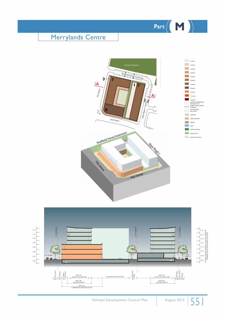
5.2. Block 2Block 2 is currently bound by Neil Street on the north, Gladstone Street on the south, and Pitt Street on the west. Pitt Street is an important connector road between Parramatta and Merrylands, and hence, is high on the hierarchy of roads. The proximity of Block 2 to the town centre and the transit interchange provides it with high a high level of amenity. Commercial development within the mixed use precinct is to have active street frontages.
The proposed plan for the block shows the introduction of a new road, New Road 1 (south), on the eastern boundary of the block, with a public park adjacent to the road. This new road and park area:
• provides access to the block
• provides an address to any future development on the block
• helps in increasing the developable area on the site
• helps to emphasise the view corridor from the Merrylands transit interchange into the park (Holroyd Gardens)
• contributes to flood management within the precinct
• provides a public park which improves the amenity of the area.
A building height of 6 storeys is allowed on the block. A building height of 7 storeys is allowed on the corner of Neil and Pitt Streets. This has been allowed in order to emphasise this important Junction, as well as to reflect this important entry point into the Merrylands town centre from the north. The top two floors of buildings along Pitt Street (except for buildings on the corner of Pitt and Neil Streets) have been set back, in order to maintain a four-storey streetwall height. The buildings along Pitt Street have been set back 3m from the street, in keeping with the green nature of Holroyd Gardens.
This setback area will be landscaped, and will have tree planting. This also helps to give a distinction in character of Pitt Street as one moves from the Neil Street Precinct towards the heart of the town centre (ie Merrylands Road).
A maximum building depth of 25m is allowed for retail/commercial floors (max 23m glassline to glassline. Residential building depths are maximum 22m (18m glassline to glassline). See section drawings and written controls for details.
On-street parking has been provided on both sides of Gladstone Street. On-site parking for future development is envisaged to be provided in basement/sub-basement floors, and/or at ground level (screened from the street by a skin of either residential or commercial/retail uses on the street frontage). This is better explained in the accompanying section.
A contamination pit may affect part of this block. Investigation is needed to determine the exact extent of the building envelopes.
Landscaping is to be provided on top of basement car parks. These will act as communal open spaces for the developments. Deep soil zones are to be provided, as indicated in the building envelope plan. Car parking areas must not extend into deep soil zones.
Part MMerrylands Centre

553 Holroyd Development Control Plan August 2013
Building Height
In general • max 9 storeys
On the corner of Pitt and Neil Streets • max 12 storeys
Building Use
B4 Zone
Ground and first floor• commercial/retail
Second floor and above• commercial/retail or residential
Along Neil Street, New Road 1 (south) and Gladstone Street
All floors residential
Building Depth
Commercial/retail on ground and first floors • max 25m (max 23m glass line to glass line)
Commercial/retail on second floor and above • Max 22m (max 18m glass line to glass line)
Residential on second floor and above • Max 22 (max 18m glass line to glass line)
Road Widening
208-212 Pitt Street
7m x 7m splay corner
2.94m road widening to Pitt Street
2.44m road widening to Neil Street
214-220 Pitt Street
• 0.9m road widening to Pitt Street
• splay corner at intersection of Pitt/Gladstone Street shall be adjusted to incorporate road widening.
Setback
Street setback
Pitt Street• min 3m
Neil Street, New Road 1 (South) and Gladstone Street• min 2.5m
Neil Street, New Road 1 (south) and Gladstone Street Min 2.5m
Rear setbackFor lots fronting Pitt Street
• 0m
For lots fronting New Road 1 (South)• min 6m
Landscaping
Deep Soil Zone + Open Space• Development is to comply with all open spaces, deep
soil zones and planting on structures indicated in the building envelope plan and the sections.
Part MMerrylands Centre

554 Holroyd Development Control Plan August 2013
MAX 30m COMMERCIAL BUILDING DEPTH
6m
DE
EP
SO
IL
ZON
E
PLANTING ON STRUCTUREMAX 15m
GLASS TO GLASS LINE
IND
ICATIVE
DIM
EN
SIO
NS
SH
OW
MIN
IMU
M
RE
QU
IRE
D FLO
OR
TO FIN
ISH
ED
CE
ILING
HE
IGH
TS
MAX 18m BUILDING DEPTH
MAX 15m GLASS TO GLASS LINE
PITT STREET NEW STREET 1
LOT
BO
UN
DA
RY
LOT
BO
UN
DA
RY
LOT
BO
UN
DA
RY
MAX 18m BUILDING DEPTH
3.6m
FOO
TPAT
H
3m 4m
SE
TBA
CK
2.5m
2.5m
3.5m
2.7m
2.7m
2.7m
2.7m
2.7m
2.7m
2.7m
2.7m
2.5m
3.5m
3.3m
3.3m
2.7m
2.7m
2.7m
2.7m
2.7m
2.7m
2.7m
2.7m
2.7m
2.5m
SE
TBA
CK
2m
VER
GE
FOO
TPAT
H
TOW
ER
SE
TBA
CK
Neil Street
par
k
Gladstone Street
Pitt
Stre
et
New
Roa
d 1
(sou
th)
12
9
3
A
A
Neil Street
Pitt Street
New Road 1
Gladstone Street
2 storeys
1 storey
3 storeys
4 storeys
5 storeys
6 storeys
7 storeys
8 storeys
envelope if amalgamation/land swap occurspossible location of breakin building
swale
N 0 50
All dimensions in metres.
can be built overafter 2 levels
public open space
deep soil zone
planting on structure
9 storeys
12 storeys
16 storeys
residential
retail/commercial
parking
Part MMerrylands Centre

555 Holroyd Development Control Plan August 2013
5.3. Block 3Block 3 is currently bound by Gladstone Street on the north, Terminal Place on the south, and Pitt Street on the west. Pitt Street is an important connector road between Parramatta and Merrylands. Block 3 is well located close to both the town centre and the transit interchange. The part of this block within the mixed use precinct is required to provide ground floor commercial uses with active frontages.
The proposed plan for the block shows the introduction of a new road, New Road 1 (south), on the eastern boundary of the block. This new road:
• provides access to the block.
• provides an address to any future development on the block.
• helps in increasing the developable area on the site.
• helps to emphasise the view corridor from the Merrylands transit interchange into the park (Holroyd Gardens)
• contributes to flood management within the precinct.
A maximum building height of 6 stories is allowed on the block. The top two floors of buildings along Pitt Street have been set back, in order to maintain a four-storey streetwall height. The buildings along Pitt Street have been set back 3m from the street, in keeping with the ‘green’ nature of Holroyd Gardens. This setback area will be landscaped, and will have tree planting in it. This also helps to give a distinction in the character of Pitt Street as one moves from the Neil Street Precinct towards the heart of the town centre (ie Merrylands Road).
On Pitt Street, a maximum building depth of 25m (23m glassline to glassline) is allowed for retail/commercial floors (ground and first floor), 22m (18m glassline to glassline) for residential floors and for the commercial / mixed use second floor. (See section drawings and written controls for details of allowable building depths).
Building depths on Gladstone Street and the northern portion of New Road South are constrained by the shallowness of the block and the need for adequate building separation for sun access, privacy and open space for building users. These building depths are limited to 18 metres (max 15m glassline to glassline).
On-street parking has been provided on both sides of Gladstone Street, and on the western side of New Road 1 (south). On-site parking for future development is envisaged to be provided in basement/sub-basement floors, and/or at ground level (screened from the street by a skin of either residential or commercial/retail uses on the street frontage). This is better explained in the cross sections provided.
Landscaping is to be provided on top of basement/sub-basement car parks. These will act as communal open spaces for the developments. Deep soil zones are to be provided, as indicated in the building envelope plan.
Part MMerrylands Centre

556 Holroyd Development Control Plan August 2013
Building Height
Along Pitt Street • max 16 storeys
Gladstone Street/Terminal Place • max 9-12 storeys
Building Use
Along Pitt Street
Ground and first floor• commercial/retail/residential
Second floor and above• commercial/retail or residential
Along New Road 1 (south) and Gladstone Street
Ground and first floor• commerical/retail/residential
All floors above first floor• residential
Building Depth
Commercial/retail on ground and first floors
• max 25m (max 23m glass line to glass line)
• Consideration may be given to a larger ground floor plate, where compliance with flood controls can be demonstrated.
Commercial/retail and residential on all floors above first floor
• max 22m (max 18m glass line to glass line)
Setback
Street setback
Pitt Street• min 3m
Terminal Place, New Road 1 (south) and Gladstone Street• min 2.5m
Rear setback Comply with Separation controls.
Landscaping
Deep Soil Zone + Open SpaceDevelopment is to comply with all open spaces, deep soil zones and planting on structures indicated in the building envelope plan and the sections
Other Controls
• Any building along New Road 1(south) is to follow the bend of the road (as shown in the building envelope plan) in order to reinforce the spatial quality of the road and also in order to directionally orient pedestrians and vehicles
• Any building along New Road 1(south) is to follow the bend of the road (as shown in the building envelope plan) in order to reinforce the spatial quality of the road and also in order to directionally orient pedestrians and vehicles
Part MMerrylands Centre

557 Holroyd Development Control Plan August 2013
MAX 25m COMMERCIAL BUILDING DEPTH
IND
ICATIVE
DIM
EN
SIO
NS
SH
OW
MIN
IMU
M
RE
QU
IRE
D FLO
OR
TO FIN
ISH
ED
CE
ILING
HE
IGH
TS
2.5m
3.5m
2.7m
2.7m
2.7m
2.7m
2.7m
2.7m
2.7m
2.7m
PLANTING ON STRUCTUREMAX 15m
GLASS TO GLASS LINE
IND
ICAT
IVE
DIM
EN
SIO
NS
SH
OW
MIN
IMU
M
RE
QU
IRE
D F
LOO
R T
O F
INIS
HE
D C
EIL
ING
HE
IGH
TS
MAX 18m BUILDING DEPTH
MAX 15m GLASS TO GLASS LINE
PITT STREETNEW
STREET 1
LOT B
OU
ND
AR
Y
LOT B
OU
ND
AR
Y
MAX 18m BUILDING DEPTH
3.6m
FOO
TPAT
H
3m 4m
SE
TBA
CK
2.5m
2.5m
3.5m
3.3m
3.3m
2.7m
2.7m
2.7m
2.7m
2.7m
2.7m
2.7m
2.7m
2.7m
2.7m
2.7m
2.7m
2.7m
2.5m
SE
TBA
CK
2m
VER
GE
FOO
TPAT
H
TOW
ER
SE
TBA
CK
6m
SE
TBA
CK
New Road 1
Terminal Place
Gladstone StreetPitt S
treetN
ew R
oad
1 (s
outh
)
child
ren'
s par
k
6
Gladstone Street
1639
12
A
A
Terminal Place
Pitt
Stre
et
2 storeys
1 storey
3 storeys
4 storeys
5 storeys
6 storeys
7 storeys
8 storeys
envelope if amalgamation/land swap occurspossible location of breakin building
swale
N 0 50
All dimensions in metres.
can be built overafter 2 levels
public open space
deep soil zone
planting on structure
9 storeys
12 storeys
16 storeys
residential
retail/commercial
parking
Part MMerrylands Centre
558 Holroyd Development Control Plan August 2013
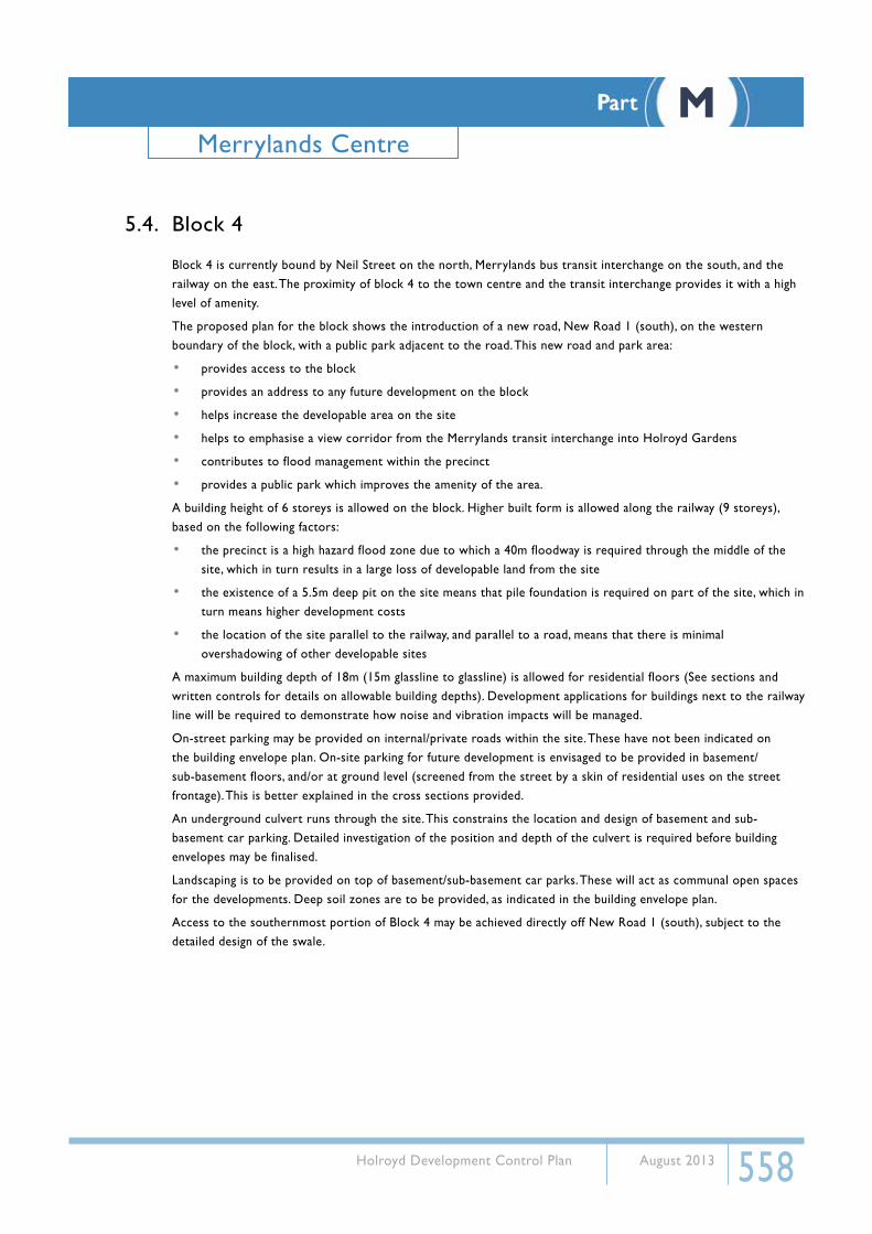
5.4. Block 4
Block 4 is currently bound by Neil Street on the north, Merrylands bus transit interchange on the south, and the railway on the east. The proximity of block 4 to the town centre and the transit interchange provides it with a high level of amenity.
The proposed plan for the block shows the introduction of a new road, New Road 1 (south), on the western boundary of the block, with a public park adjacent to the road. This new road and park area:
• provides access to the block
• provides an address to any future development on the block
• helps increase the developable area on the site
• helps to emphasise a view corridor from the Merrylands transit interchange into Holroyd Gardens
• contributes to flood management within the precinct
• provides a public park which improves the amenity of the area.
A building height of 6 storeys is allowed on the block. Higher built form is allowed along the railway (9 storeys), based on the following factors:
• the precinct is a high hazard flood zone due to which a 40m floodway is required through the middle of the site, which in turn results in a large loss of developable land from the site
• the existence of a 5.5m deep pit on the site means that pile foundation is required on part of the site, which in turn means higher development costs
• the location of the site parallel to the railway, and parallel to a road, means that there is minimal overshadowing of other developable sites
A maximum building depth of 18m (15m glassline to glassline) is allowed for residential floors (See sections and written controls for details on allowable building depths). Development applications for buildings next to the railway line will be required to demonstrate how noise and vibration impacts will be managed.
On-street parking may be provided on internal/private roads within the site. These have not been indicated on the building envelope plan. On-site parking for future development is envisaged to be provided in basement/sub-basement floors, and/or at ground level (screened from the street by a skin of residential uses on the street frontage). This is better explained in the cross sections provided.
An underground culvert runs through the site. This constrains the location and design of basement and sub-basement car parking. Detailed investigation of the position and depth of the culvert is required before building envelopes may be finalised.
Landscaping is to be provided on top of basement/sub-basement car parks. These will act as communal open spaces for the developments. Deep soil zones are to be provided, as indicated in the building envelope plan.
Access to the southernmost portion of Block 4 may be achieved directly off New Road 1 (south), subject to the detailed design of the swale.
Part MMerrylands Centre

559 Holroyd Development Control Plan August 2013
Building Height
Parts of buildings along railway • max 12 storeys
Other buildings • max 9 storeys
Building Use
Ground and first floor • commercial/retail/residential
All floors above first floor • residential
Building Depth
All buildings • max 18m (max 15m glassline to glassline)
Setback
Street setbackShared zone east of New Road 1 (South)
• min 2.5m
Side setback
From Merrylands Transit Interchange• min 3m
All other lots• Comply with masterplan
Rear setback
From the railway• min 6m
For all other lots• Comply with minimum separation controls
Landscaping
Deep Soil Zone + Open SpaceDevelopment is to comply with all open spaces, deep soil zones and planting on structures indicated in the building en-velope plan and the sections
Other Controls
Any building along New Road 1(south) is to follow the bend of the road (as shown in the building envelope plan) in order to reinforce the spatial quality of the road and also in order to directionally orient pedestrians and vehicles
Part MMerrylands Centre

560 Holroyd Development Control Plan August 2013
MINIMUM 9MSEPARATION
(if break in building)
PLANTING ON STRUCTUREMAX 15m
GLASS TO GLASS LINE
IND
ICATIVE
DIM
EN
SIO
NS
SH
OW
MIN
IMU
M
RE
QU
IRE
D FLO
OR
TO FIN
ISH
ED
CE
ILING
HE
IGH
TS
MAX 18m BUILDING DEPTH
MAX 15m GLASS TO GLASS LINE
NEW ROAD 1(SOUTH)
RAILWAYLINE
LOT B
OU
ND
AR
Y
LOT B
OU
ND
AR
Y
MAX 18m BUILDING DEPTH
15.5m2.5m
CHILDRENS PARK
2.5m
SE
TBA
CK
SH
AR
ED
ZO
NE
VER
GE
FOO
TPAT
H
VER
GE
VER
GE
4m
2.5m
3.5m
2.7m
2.7m
2.7m
2.7m
2.7m
2.7m
2.7m
2.7m
2.7m
2.7m
2.7m
SE
TBA
CK
New Road 1
RailwayNeil Stre
et
New
Roa
d 1
(sou
th) Neil Street
swal
e
park
Railway
line
9
12
9
12
A
A
2 storeys
1 storey
3 storeys
4 storeys
5 storeys
6 storeys
7 storeys
8 storeys
envelope if amalgamation/land swap occurspossible location of breakin building
swale
N 0 50
All dimensions in metres.
can be built overafter 2 levels
public open space
deep soil zone
planting on structure
9 storeys
12 storeys
16 storeys
residential
retail/commercial
parking
Part MMerrylands Centre

561 Holroyd Development Control Plan August 2013
5.5. Block 5
Block 5 is currently bound by the old brickworks site on the north, Neil St on the south, and the railway on the east. No.1 Neil Street (Millmaster site) is listed as a site of potential archaeological significance. On this site are located mill buildings and silos which are the only remnants of the industrial past of Merrylands. The proximity of Block 5 to the town centre, transport, and the park (Holroyd Gardens), provides it with a high level of amenity.
The proposed plan for the block shows the introduction of two new roads, New Road 1 (north), on the western boundary of the block, with a public park adjacent to the road, and New Road 2, on the northern boundary of the site. These new roads and park area:
• provide access to the block
• provide an address to any future development on the block
• help in increasing the developable area on the site
• Increases connectivity between the Merrylands transit interchange and the park (Holroyd Gardens)
• provides a public park which improves the amenity of the area.
A building height of 6-8 storeys is allowed on the block. 8 storeys is allowed along the railway line due to the following factors:
• the precinct is a high hazard flood zone due to which a 40m floodway is required through the middle of the site, which in turn results in a large loss of developable land from the site which has to be compensated to some extent by a slightly higher built form
• the location of the site parallel/adjacent to the railway means that there is minimal overshadowing of other neighbouring developable sites
A maximum building depth of 18m (15m glassline to glassline) is allowed for residential floors (See section drawings and written controls for details on allowable building depths).
Development applications for buildings next to the railway line will be required to demonstrate how noise and vibration impacts will be managed. Buildings in this block adjacent to the railway line are required to be oriented perpendicular to, not parallel with, the railway line to minimise the area of building, and hence the number of apartments, impacted by railway noise and vibration.
On-street parking has been provided on New Road 2 and New Road 1 (north). On street parking may also be provided on internal/private streets. These have not been indicated on the building envelope plan. On-site parking for future development is envisaged to be provided in basement/sub-basement floors, and/or at ground level (screened from the street by a skin of residential uses on the street frontage). This is better explained in the cross sections provided.
Landscaping is to be provided on top of basement/sub-basement car parks. These will act as communal open spaces for the developments. Deep soil zones are to be provided, as indicated in the building envelope plan. Future development on this block is to take maximum advantage of its view and close proximity to the park (Holroyd Gardens).
Building envelopes will be required to accommodate a 19m wide riparian corridor to ensure the retention of A’Becketts Creek. A portion of the creek is shown within the swale / park area and the location of the Creek is indicated on the plan diagram.
Part MMerrylands Centre
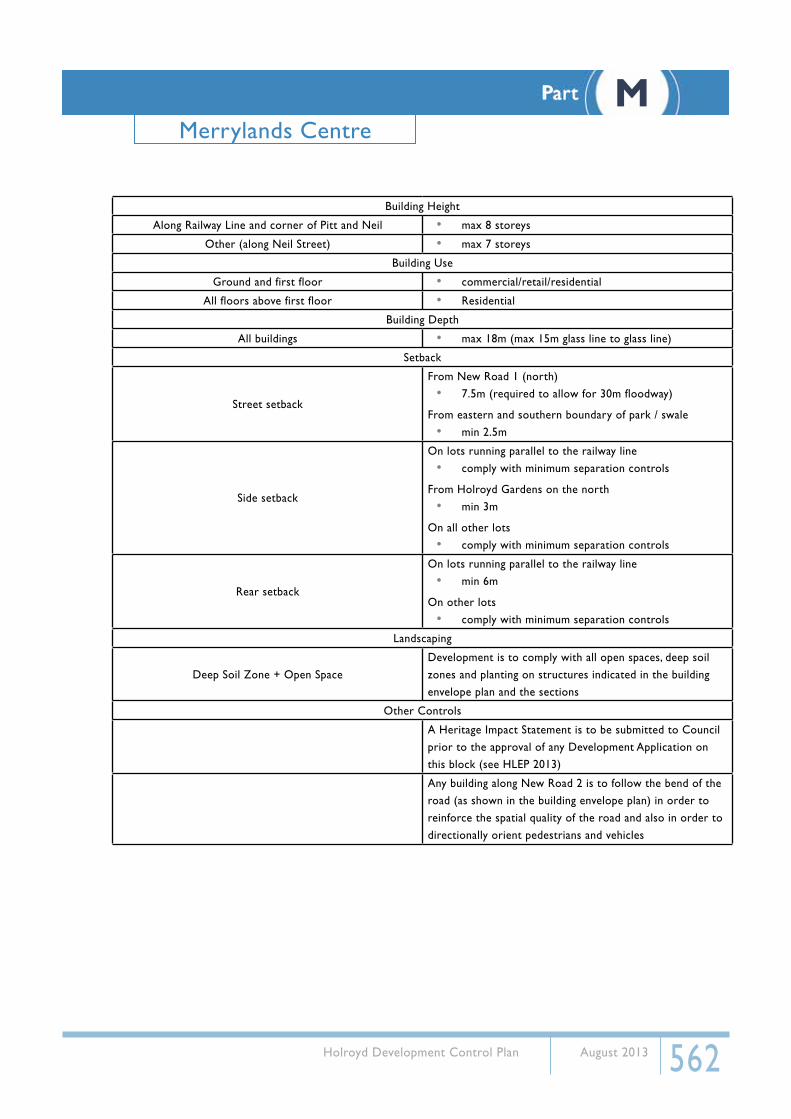
562 Holroyd Development Control Plan August 2013
Building Height
Along Railway Line and corner of Pitt and Neil • max 8 storeys
Other (along Neil Street) • max 7 storeys
Building Use
Ground and first floor • commercial/retail/residential
All floors above first floor • Residential
Building Depth
All buildings • max 18m (max 15m glass line to glass line)
Setback
Street setback
From New Road 1 (north)• 7.5m (required to allow for 30m floodway)
From eastern and southern boundary of park / swale• min 2.5m
Side setback
On lots running parallel to the railway line• comply with minimum separation controls
From Holroyd Gardens on the north• min 3m
On all other lots• comply with minimum separation controls
Rear setback
On lots running parallel to the railway line• min 6m
On other lots• comply with minimum separation controls
Landscaping
Deep Soil Zone + Open SpaceDevelopment is to comply with all open spaces, deep soil zones and planting on structures indicated in the building envelope plan and the sections
Other Controls
A Heritage Impact Statement is to be submitted to Council prior to the approval of any Development Application on this block (see HLEP 2013)
Any building along New Road 2 is to follow the bend of the road (as shown in the building envelope plan) in order to reinforce the spatial quality of the road and also in order to directionally orient pedestrians and vehicles
Part MMerrylands Centre

563 Holroyd Development Control Plan August 2013
IND
ICATIVE
DIM
EN
SIO
NS
SH
OW
MIN
IMU
M
RE
QU
IRE
D FLO
OR
TO FIN
ISH
ED
CE
ILING
HE
IGH
TS
BUILDING SEPARATION
9m
BUILDING SEPARATION
9m
MAX 15m GLASS TO GLASS LINE
MAX 18m BUILDING DEPTH
MAX 15m GLASS TO GLASS LINE
LOT B
OU
ND
AR
Y
MAX 18m BUILDING DEPTH
2.5m
3.5m
2.7m
2.7m
2.7m
2.7m
2.7m
2.7m
2.7m
Railway
New Road
1
Neil Street
New Road 2
ion
Dre
ssle
r Cou
rt
loca
tion
of
A'Be
cket
ts C
reek
Railway
line
Neil Street
New
Roa
d 1
(nor
th)
New Road 2
park
87 8 8
8
B
B
2 storeys
1 storey
3 storeys
4 storeys
5 storeys
6 storeys
7 storeys
8 storeys
envelope if amalgamation/land swap occurspossible location of breakin building
swale
N 0 50
All dimensions in metres.
can be built overafter 2 levels
public open space
deep soil zone
planting on structure
9 storeys
12 storeys
16 storeys
residential
retail/commercial
parking
Part MMerrylands Centre

564 Holroyd Development Control Plan August 2013
5.6. Block 6Block 6 is currently bound by the old brickworks site and Holroyd Gardens on the north, and Neil Street on the south. The proximity of block 6 to the town centre, transport, and the park (Holroyd Gardens), provides it with a high level of amenity.
The proposed plan for the block shows the introduction of two new roads, New Road 1 (north), on the eastern boundary of the block, and New Road 2, on the southern boundary of the site. These new roads:
• provide access to the block
• provide an address to any future development on the block
• help in increasing the developable area on the site
• increases connectivity between the Merrylands transit interchange/Merrylands town centre and the park (Holroyd Gardens).
A maximum building height of 6 storeys is allowed on the block. A maximum building depth of 18m (15m glassline to glassline) is allowed for residential floors (See section drawings and written controls for details on allowable building depths).
On-street parking has been provided on New Road 2 and New Road 1 (north). On-site parking for future development is envisaged to be provided in basement/sub-basement floors, and/or at ground level (screened from the street by a skin of residential uses on the street frontage).
Landscaping is to be provided on top of basement/sub-basement car parks. These will act as communal open spaces for the developments. Deep soil zones are to be provided, as indicated in the building envelope plan. Future development on this block is to take advantage of its view and close proximity to the park (Holroyd Gardens).
A contamination pit may affect part of this block. Investigation is needed to determine the exact extent of the building envelopes and car parks. On-grade car parking may be provided where contamination pit has been capped.
Part MMerrylands Centre

565 Holroyd Development Control Plan August 2013
Building Height
On all lots • max 7 storeys
Building Use
Ground and first floor • commercial/retail/residential
All floors above first floor • Residential
Building Depth
All buildings • max 18m (max 15m glass line to glass line)
Setback
Street setback• New Road 1, New Road 2
min 2.5m
Side setback • comply with minimum separation controls
Rear setback
For lots fronting New Road 2• min 3m
• comply with minimum separation controls
Landscaping
Deep Soil Zone + Open Space• Development is to comply with all open spaces, deep soil
zones and planting on structures indicated in the building envelope plan and the sections
Other Controls
• Any building along New Road 2 is to follow the bend of the road (as shown in the building envelope plan) in order to reinforce the spatial quality of the road and also in order to directionally orient pedestrians and vehicles
Part MMerrylands Centre
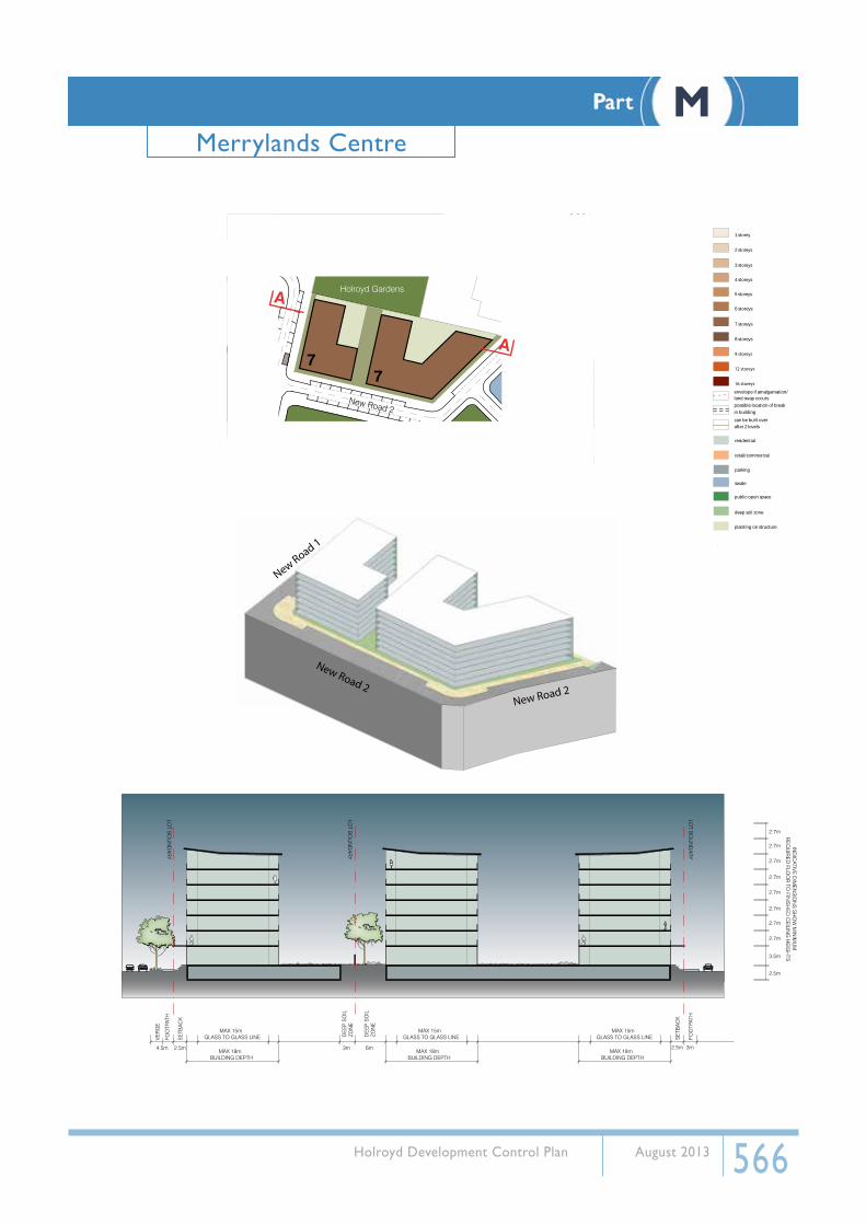
566 Holroyd Development Control Plan August 2013
DE
EP
SO
ILZO
NE
DE
EP
SO
ILZO
NE
3m 6m4.5m
MAX 15m GLASS TO GLASS LINE
MAX 18m BUILDING DEPTH
MAX 15m GLASS TO GLASS LINE
LOT B
OU
ND
AR
Y
LOT B
OU
ND
AR
Y
LOT B
OU
ND
AR
Y
MAX 18m BUILDING DEPTH
2.5m
3.5m
2.7m
2.7m
2.7m
2.7m
2.7m
2.7m
2.7m
2.7m
MAX 15m GLASS TO GLASS LINE
MAX 18m BUILDING DEPTH
2.5m
SE
TBA
CK
FOO
TPAT
H
VER
GE
2.5m 3m
SE
TBA
CK
FOO
TPAT
H
IND
ICATIVE
DIM
EN
SIO
NS
SH
OW
MIN
IMU
M
RE
QU
IRE
D FLO
OR
TO FIN
ISH
ED
CE
ILING
HE
IGH
TS
New Road 2
New Road 1
New Road 2
Dre
ssle
r Cou
rt
park
New Road 2
Holroyd Gardens
77
A
A
2 storeys
1 storey
3 storeys
4 storeys
5 storeys
6 storeys
7 storeys
8 storeys
envelope if amalgamation/land swap occurspossible location of breakin building
swale
N 0 50
All dimensions in metres.
can be built overafter 2 levels
public open space
deep soil zone
planting on structure
9 storeys
12 storeys
16 storeys
residential
retail/commercial
parking
Part MMerrylands Centre
567 Holroyd Development Control Plan August 2013
6. Movement6.1. Rear laneways and private accessways
Good vehicular circulation in the centre is important for pedestrians and residents. Vehicular crossings over footpaths not only can restrict vehicle and pedestrian movement, it can be dangerous within a town centre environment. Enabling access to developments through a secondary street or accessway will improve movement in the centre whilst making it a safer place.
The addition of laneways can also add to the vibrancy of the centre, providing opportunities for retail uses at grade.
ObjectivesO1. Make vehicular access to buildings more compatible with pedestrian movements and the public
domain.
O2. Require buildings fronting primary roads to gain vehicular access from the rear of the property.
O3. Enable the maintenance of continuous retail frontages.
Development ControlsNote: For general rear laneway and private accessway development controls, refer to Part C of this DCP.
C1. Rear laneways and private accessways are to be provided in accordance with Figure 2.
C2. Where buildings front Merrylands Road, McFarlane Road or Pitt Street, vehicular access must be provided from the rear via laneways or private accessways, as indicated in Figure 2. No vehicle entrances are permitted from primary roads, as indicated in Figure 2.
C3. Where other buildings have access to existing laneways, vehicular access must be provided from the laneway.
Part MMerrylands Centre

568 Holroyd Development Control Plan August 2013
6.2. Pedestrian access
Pedestrian accessibility is critical to establishing a vibrant and safe centre. Designing for pedestrians within the centre focuses on delivering high quality, safe and pleasant walking environments, which is person centred, rather than vehicular centred. Pedestrian access should be equitable, barrier free where all people who live, work and visit can enjoy the public domain and access communal use areas and apartments.
ObjectivesO1. Ensure access to workspaces, retail areas, apartments and to the public domain is direct and
efficient for the entire community, regardless of age, physical condition or mobility restriction.
O2. Require development to be well connected to the street and contributes to the accessibility of the public domain.
O3. Provide an environment which is permeable for pedestrians.
O4. Create a safe environment for all pedestrians.
Development ControlsNote: For general pedestrian access development controls, refer to Part C of this DCP.
C1. Pedestrian site through links shall be provided in accordance with Figures 2 and 3.
C2. Required pedestrian access identified at 246 Pitt Street, between Terminal Place and Pitt Street, is for an overland flow path and shall be a minimum of 15m wide and 4m high. This may be designed as an arcade.
Part MMerrylands Centre

569 Holroyd Development Control Plan August 2013
6.3. Vehicle access
The location, type and design of vehicular access points for a development can have impacts on the streetscape, building design and function of the centre. It is important that vehicular access is located to ensure the maintenance of a safe pedestrian environment, viability and vitality of the centre.
ObjectivesO1. Minimise the impact of vehicle access on streetscape amenity, pedestrian safety and circulation within
the centre.
O2. Enable active frontages.
O3. Differentiate between primary and secondary roads and their uses.
O4. Integrate vehicular access and service areas into building design and streetscape character.
Development ControlsNote: For general vehicle access development controls, refer to Part C of this DCP.
C1. Driveways shall be provided from laneways (existing or proposed), private accessways and secondary streets (as indicated in Figure 2)
C2. Vehicular access in the Neil Street precinct shall comply with Figure 2.
6.4. ParkingOn- site parking includes both underground (basement), surface (on grade) and above ground, and can include parking stations.
It is important that carparking does not visually dominate the streetscape or impact on stormwater management. Carparking that is well designed and located should make efficient use of the site, reduce its visual impact and enables the maintenance of active frontages.
ObjectivesO1. Minimise car dependency for commuting and recreational transport use and to promote alternative
means of transport such as public transport, bicycling and walking.
O2. Maintain a positive streetscape character by designing and treating carparking to reduce its visual impact.
O3. Ensure parking does not impact on the character and function of active frontages.
Development ControlsNote: For general parking development controls, refer to Part A and Part C of this DCP.
C1. On-site parking is to be accommodated underground wherever possible.
C2. On street parking within Neil Street shall be provided as indicated Section 5.
Part MMerrylands Centre

570 Holroyd Development Control Plan August 2013
7. Design and Building Amenity7.1. Laneway and Arcade Design
Site links in the form of laneways and arcades provide permeability within the centre for pedestrians and vehicular traffic which enhances movement, safety and streetscape vibrancy and functionality. It is important that the design of these links consider the safety and security of pedestrians and how they may contribute to the vibrancy of the centre.
ObjectivesO1. Ensure the design of laneways and arcades provides for pedestrian safety and amenity.
O2. Assist in creating a vibrant centre through active frontages.
O3. Promote permeability in the redevelopment of large sites.
Development ControlsNote: For general laneway and arcade design development controls, refer to Part C of this DCP.
LanewayC1. Laneways identified in Figure 9 shall have active ground floor frontages.
Arcades C2. Arcades shall be provided in accordance with Figure 3.
7.2. Managing External Noise and VibrationBuildings in close proximity to the railways need to consider the impact of external noise and vibration on development proposals.
ObjectivesO1. Ensure consent is not grant to development on land affected by external noise, if, in the
opinion of Council, will be affected by noise and vibration, unless the development will incorporate attenuation measure to the satisfaction of Council.
Development ControlsC1. Development proposals within 60m of the south western railway line and/or adjacent to Neil
Street or Pitt Street must provide a report, to be submitted with the development application, demonstrating that the development will comply with the following criteria.
C2. The following Australian Standards are to be complied with:
i) AS 1055-1997 Acoustics - Description and Measurement of Environmental Noise.ii) AS 1259-1990 Acoustics – Sound Level Meters Part 2 Integrating – Averaging.iii) AS 1633-1985 Acoustics - Glossary of Terms and Related Symbols.iv) AS 2107-2000 Acoustics - Recommended Design Sound Levels and Reverberation
Times for Building Interiors.
Part MMerrylands Centre

571 Holroyd Development Control Plan August 2013
C3. The report shall be prepared by an acoustic consultant having the technical eligibility criteria required for membership of the Association of Australian Acoustical Consultants (AAAC) and/or grade membership of the Australian Acoustical Society (MAAS).
C4. Prior to the issues of an Occupation Certificate, a noise compliance report shall be submitted to the Principal Certifying Authority (PCA) confirming that the building/s comply with the noise criteria following. The report shall be prepared by an acoustic consultant, other than the consultant responsible for the preliminary/design report, having the technical eligibility criteria required for membership of the Association of Australian Acoustical Consultants (AAAC) and/or grad membership of the Australian Acoustical Society (MAAS).
C5. Acoustic reports prepared under this Plan must be prepared in accordance with the specified methodology provided in the Appendix.
C6. Floor vibration levels in habitable rooms should comply with the criteria in British Standard BS6472: 1992 Evaluation of Human Exposure to Vibration in Buildings (1 Hz to 80 Hz). This is the vibration standard recommended by the Department of Infrastructure Planning and Natural Resources (DIPNR) and the Department of Environment and Conservation (DEC). It is similar to AS2670.2 – 1990 but includes additional guidance in relation to intermittent vibration such as that emitted by trains.
7.3. Awnings
The provision of awnings within a centre increases the usability of amenity of the footpath, encouraging active environments through greater pedestrian movement and activity. Awnings like building entries, provide a public presence and interface with the public domain contributing to the identity of an environment.
ObjectivesO1. Ensure the amenity of pedestrians through weather protection.
O2. Maintain a consistent streetscape and provide visual interest through a continuous awning theme.
O3. Locate awnings to provide for the safety and security of pedestrians.
O4. Enable the provision of street tree planting and furniture location.
Development ControlsC1.
C2. Continuous awnings are required to be provided to all active street frontages (except laneways).
C3. Awnings on Merrylands road shall be 2.5m deep.
C4. Awnings are permitted on laneways where active frontages are required and shall be retractable and only used in hours of operation.
Part MMerrylands Centre
572 Holroyd Development Control Plan August 2013
7.4. Adaptable Housing
ObjectivesO1. Ensure the design of apartments meet the broadest range of occupants needs possible.
O2. Promote buildings that can accommodate whole or partial changes of use.
O3. Provide a diversity of apartments types, which cater for different household requirements now and in the future.
O4. To maintain equitable access to new housing by cultural and socio-economic groups.
Development ControlsC1. Provide a total of 20% of dwellings as adaptable housing by ensuring that:
i) a minimum of 10% of all apartments within a development comply with AS4299- 1995 Adaptable House Class A.
ii) a minimum of 10% of all apartments within a development comply with AS4299- 1995 Adaptable House Class C.
7.5. Corner buildings
Corner site buildings play an important role within a town centre in providing legibility, reinforcing the road layout and can assist in creating a visually interesting streetscape.
ObjectivesO1. Promote a strong and legible streetscape character by ensuring corner sites are visually
significant elements.
O2. Require buildings at visually significant locations are well designed and respond to the different characteristics of the streets the address.
O3. Reinforce and clarify spatial relationships and street hierarchy in the centre and accentuate the topography.
Development ControlsC1. Generally, Corner building shall be designed to:
i) Articulate street corners by massing and building articulation,ii) to add variety and interest to the street,iii) Present each frontage of a corner building as a main street frontage,iv) reflect the architecture, hierarchy and characteristics of the streets they address, andv) align and reflect the corner conditions.
C2. Corners identified in Figure 6 shall be emphasised through architectural design and materials.
Part MMerrylands Centre
573 Holroyd Development Control Plan August 2013
8. Environmental8.1. Flood and Stormwater Management
Much of the Merrylands centre is affected by the 1 in 100 year flood. The location, requirements and layouts of roads, infrastructure, open space and buildings within the Neil Street Precinct have been specifically designed in response to the site constraints in order to manage the impact of flooding.
Some roads within the centre are the overland flow paths and development along those streets will need to be designed to be flood compatible.
Merrylands centre was built along one of the major watercourses that drains towards A’Beckett Creek and much of the centre is subject to flooding. It is important that the design of development incorporates measures to manage the impact of development to natural waterways
ObjectivesO1. Ensure appropriate flood management and protection of overland flow paths.
O2. Require buildings within the flood affected areas are designed to ensure minimal damage in the event of a flood.
O3. Balance the need for active frontages and flood mitigation from flood proofing and design.
O4. Ensure that redevelopment of the site can occur.
O5. Minimise stormwater run off.
O6. Control the quality and quantity of stormwater, and to reduce impacts on adjoining properties.
O7. Minimise the impacts of development and associated infrastructure on the health and amenity of natural waterways.
O8. Preserve existing topographic and natural features, including watercourses, creeks and wetlands.
Development ControlsNote: existing and post development flood contours are shown in Figures 10 and 11.
Commercial and RetailC1. On street frontages to Merrylands Road, McFarlane Street and Pitt Street where it is not
practical or desirable to achieve floor levels 500mm above the 100-year ARI floor levels, alternative flood management measures (such as flood proofing) must be undertaken.
Neil Street PrecinctC2. Management of the redevelopment of the Neil Street Precinct must be undertaken in a whole-
of-site approach. Site amalgamation and resubdivision under this DCP is required to manage redirection of the floodway.
C3. Building footprints are to be placed to allow best movement of flood waters (eg. 30m separation between buildings on the southern end of New Road (1) north)
C4. Provide a 40m floodway through Neil Street Precinct, comprising roads, parks, swales and a natural creek system.
Stormwater
Part MMerrylands Centre
574 Holroyd Development Control Plan August 2013
C5. The peak/volume impact of stormwater on infrastructure is to be reduced by detaining/
retarding it on site. Design solutions may include:
i) minimising impervious areas by using pervious or open pavement materialsii) retaining runoff from roofs and balconies in water features as part of landscape
design or for reuse or activities such as toilet flushing, car washing and garden watering
iii) landscape design incorporating appropriate vegetationiv) minimising formal drainage systems (pipes) with vegetated flowpaths (grass swales),v) infiltration or biofiltration trenches and subsoil collection systems in saline areasvi) water pollution control ponds or constructed wetlands on larger developmentsvii) Developments shall optimise the amount of deep soil zones within the site, in
accordance with Figure 4.C6. Stormwater quality shall be maintained through the use of the following
i) Litter or gross pollutant traps to capture leaves, sediment and litter should be used,ii) sediment filters, traps or basins for hard surfaces,iii) treatment of stormwater collected in sediment traps on soils containing dispersive
clays.C7. Where sites are next to the rail corridor, adequately dispose of or manage drainage from the
development such that it is not distributed into the rail corridor unless prior approval has been obtained from the State Rail Authority.
Part MMerrylands Centre

575 Holroyd Development Control Plan August 2013
Figu
re 1
0
Part MMerrylands Centre

576 Holroyd Development Control Plan August 2013
Figu
re 1
1
Part MMerrylands Centre

577 Holroyd Development Control Plan August 2013
9. General8.1. Public art
Objectives
O1. Provide art works which are integrated into broader development and planning of Merrylands Centre.
O2. Avoid stand alone public art projects that fail to address the locality and its culture.
Development ControlsC1. Public Art is encouraged to be provided within the centre, in accordance with Council’s Public
Art Policy 2012-2015.
C2. Public Art provided shall develop the cultural identity of the community and reflect the culture of the community.
C3. Artworks shall be integrated into the design of buildings and the landscape.
C4. Within the Neil Street Precinct, the following thematic areas are to be considered in the public art/design:
• Industrial heritage of the locality including the grain mills, brick works and railway,• A’Becketts Creek and the natural environment.
Part MMerrylands Centre
578 Holroyd Development Control Plan August 2013
8.2. Interim developmentThrough the process of implementing this plan it is expected that development applications associated with existing uses will continue to be received. Acceptable design outcomes of the application for minor development, must comply with the vision and objectives of the DCP.
ObjectivesO1. Enable ongoing development works in the centre that are associated with existing uses,
without compromising the implementation of the longer term vision and objectives as outline in this DCP.
O2. Permit a reasonable amount of interim development while maintaining the viability of implementing this plan as an attractive future option.
O3. Ensure any development works provides a positive design outcomes that contributes to the urban character of the centre.
Development ControlsC1. All minor development associated with existing buildings including but not limited to alteration
and additions, change of use, outdoor dining, subdivision and signage must not restrict or prohibit an adjoining landowner from developing their site in accordance with this DCP.
C2. Development is to ensure activation of the streetscape and high urban design outcomes.
C3. Alterations and additions must not exceed 60m2 of additional floor space on to or associated with an existing building. Only 1 application for this addition, per lot, is permissible, as from the date of adoption of this DCP.
Part MMerrylands Centre