medical office building project draft environmental impact ... · 3-6 (d) proposed parking...
TRANSCRIPT
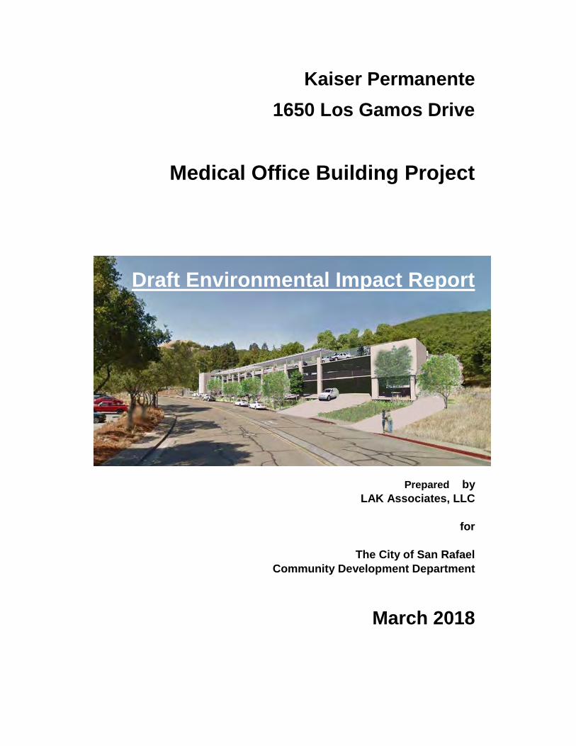
Kaiser Permanente
1650 Los Gamos Drive
Medical Office Building Project
Draft Environmental Impact Report
Prepared by
LAK Associates, LLC
for
The City of San Rafael
Community Development Department
March 2018

This page intentionally left blank
Kaiser Permanente
1650 Los Gamos Drive Medical Office Building Project i March 2018
Draft EIR
TABLE OF CONTENTS
Kaiser Permanente - 1650 Los Gamos Drive Medical Office Building Project
Draft Environmental Impact Report
Page List of Acronyms and Abbreviations vii 1. Introduction 1-1 1.1 Overview 1-1 1.2 Property Description 1-1 1.3 Use of this EIR 1-2 1.4 EIR Scoping 1-2 1.5 Organization of the EIR 1-4 2. Summary 2-1 2.1 Project Overview 2-1 2.2 Areas of Controversy and Scoping Comments 2-2 2.3 Alternatives 2-3 2.4 Environmental Impacts and Mitigation Measures 2-3 3. Project Description 3-1 3.1 Project Location and Surroundings 3-1 3.2 Existing Site Conditions 3-6 3.3 Proposed Project 3-7 3.4 Project Entitlements and Approvals 3-27 4. Environmental Setting, Impacts and Mitigation Measures 4.0-1 4.0.1 Determination of Significance 4.0-1 4.0.2 Issues Addressed in the Draft EIR 4.0-1 4.1 Land Use, Plans, and Policies 4.1-1 4.1.1 Setting 4.1-1 4.1.2 Regulatory Setting 4.1-3 4.1.3 Impacts and Mitigation Measures 4.1-6 4.1.4 Plan and Policy Conflicts Impacts and Mitigations 4.1-6 4.1.5 Cumulative Land Use Impacts 4.1-8 4.2 Aesthetics 4.2-1 4.2.1 Setting 4.2-1 4.2.2 Regulatory Setting 4.2-10 4.2.3 Impacts and Mitigation Measures 4.2-12 4.2.5 Visual Character Impacts and Mitigations 4.2-14 4.2.6 Light and Glare Impacts and Mitigations 4.2-16 4.2.7 Aesthetic Cumulative Impacts 4.2-18 4.3 Air Quality 4.3-1 4.3.1 Setting 4.3-1
Table of Contents
Kaiser Permanente
1650 Los Gamos Drive Medical Office Building Project ii March 2018
Draft EIR
4.3.2 Regulatory Setting 4.3-8 4.3.3 Impacts and Mitigation Measures 4.3-11 4.3.4 Criteria Pollutants Impacts and Mitigation 4.3-13 4.3.5 Air Quality Standards Impacts and Mitigation 4.3-17 4.3.6 Sensitive Receptors Impacts and Mitigation 4.3-18 4.3.7 Cumulative Air Quality Impacts 4.3-23 4.4 Greenhouse Gases and Climate Change 4.4-1 4.4.1 Setting 4.4-1 4.4.2 Regulatory Setting 4.4-2 4.4.3 Impacts and Mitigation Measures 4.4-11 4.4.4 Greenhouse Gas Emissions Impacts and Mitigations 4.4-12 4.4.5 Applicable Plan or Policy Impacts and Mitigations 4.4.-13 4.4.6 Cumulative GHG Impacts 4.4.-15 4.5 Noise 4.5-1 4.5.1 Setting 4.5-1 4.5.2 Existing Noise Environment 4.5-6 4.5.3 Regulatory Background 4.5-12 4.5.4 Impacts and Mitigation Measures 4.5-19 4.5.5 Noise Levels in Excess of Standards 4.5-20 4.5.6 Exposure to Excessive Groundborne Vibration due to Construction 4.5-27 4.5.7 Permanent Noise Level Increase 4.5-28 4.5.8 Temporary Construction Noise 4.5-29 4.5.9 Cumulative Noise Increase Impacts 4.5-33 4.6 Transportation and Circulation 4.6-1 4.6.1 Setting 4.6-1 4.6.2 Regulatory Setting 4.6-11 4.6.3 Impact Analysis 4.6-16 4.6.4 Traffic Conditions 4.6-26 4.6.5 Vehicle Miles Traveled Analysis 4.6-32 4.6.6 Existing Plus Project Impacts and Mitigations 4.6-36 4.6.7 Baseline Plus Project Impacts and Mitigations 4.6-46 4.6.8 Cumulative Conditions Impacts and Mitigations 4.6-57 5. Alternatives 5-1 5.1 CEQA Requirements 5-1 5.2 Factors Considered in Selection of Alternatives 5-1 5.3 Alternatives Considered but Not Analyzed Further in the EIR 5-3 5.4 Alternatives Selected for Consideration 5-5 5.5 Alternative 1: No Project / No Medical Office Uses 5-7 5.6 Alternative 2: Reduced Medical Office Use 5-9 5.7 Alternative 3: Alternate Parking Structure Location 5-13 5.8 Alternative 4: Applicant-Implemented Traffic Improvements 5-15 5.9 Environmentally Superior Alternative 5-18 6. Impact Overview 6-1 6.1 Significant and Unavoidable Impacts 6-1 6.2 Significant Irreversible Environmental Changes 6-2 6.3 Cumulative Impact 6-3 6.4 Growth Inducement 6-3
Table of Contents
Kaiser Permanente
1650 Los Gamos Drive Medical Office Building Project iii March 2018
Draft EIR
6.5 Effects Found not to be Significant 6-4 7. Report Preparation and References 7-1 7.1 Lead Agency 7-1 7.2 Other Agencies/Persons Consulted 7-1 7.3 Environmental Consultant 7-1 7.4 References 7-3
Appendices
A. Notice of Preparation and EIR Scoping Comments A-1 B. 1650 Los Gamos Drive Initial Study B-1 C. Air Quality and Greenhouse Gases Emissions Assessment, Illingworth & Rodkin, 2018 C-1 D. Noise Impact Assessment, Illingworth & Rodkin, 2018 D-1 E. 1650 Los Gamos Drive Final Traffic Impact Analysis, Fehr & Peers, 2018 E-1
List of Figures
3-1 Site Location Map 3-2 3-2 Aerial of Project Site and Surroundings 3-4 3-3 Existing Parking Supply 3-8 3-4 Proposed Site Plan 3-9 3-5 Proposed Lot Coverage 3-10 3-6 (a) Proposed Parking Structure – West Elevation 3-14 3-6 (b) Proposed Parking Structure – North Elevation 3-14 3-6 (c) Proposed Parking Structure – East Elevation 3-15 3-6 (d) Proposed Parking Structure – South Elevation 3-15 3-7 Proposed Parking Structure – Exterior Rendering and Site Section 3-16 3-8 Proposed Parking Structure - Photo Simulation 3-17 3-9 Proposed Landscaping Plan 3-21 3-10 Tree Inventory and Proposed Removal 3-22 3-11 Demolition Plan 3-24 3-12 Grading and Utilities Plan 3-25 4.1-1 Project Area Aerial 4.1-2 4.2-1 View Locations of Project Site 4.2-3 4.2-2a Looking North from south entrance to 1650 Los Gamos Drive 4.2-4 4.2-2b Looking South from Lucas Valley Rd/Los Gamos Drive 4.2-4 4.2-2c Looking South from proposed parking structure entrance 4.2-5 4.2-2d Looking west from Lucas Valley Rd/Los Gamos Drive 4.2-5 4.2-3a Looking northwest along Lucas Valley Rd 4.2-6 4.2-3b Looking southeast on Lucas Valley Rd towards Highway 101 4.2-6 4.2-3c Looking south from Lucas Valley Road towards project site 4.2-7 4.2-3d Looking west to the hills above the project site 4.2-7 4.2-4a Looking west across Los Gamos Drive toward surface parking 4.2-8 4.2-4b Looking east from end of Salvatore Way 4.2-8 4.2-4c Looking northeast from rear yards of homes on Salvatore Way 4.2-9 4.2-4d Looking north from rear yards of homes on Salvatore Way 4.2-9 4.2-6 Proposed Solar Arrays 4.2-15 4.3-1 Project Construction Site and Locations of Off-Site Sensitive Receptors and
Maximum TAC and PM2.5 Impacts 4.3-20 4.5-1 Noise Measurement Locations 4.5-8 4.5-2 Daily Trend in Noise Levels at LT-1 March 8, 2017 4.5-9
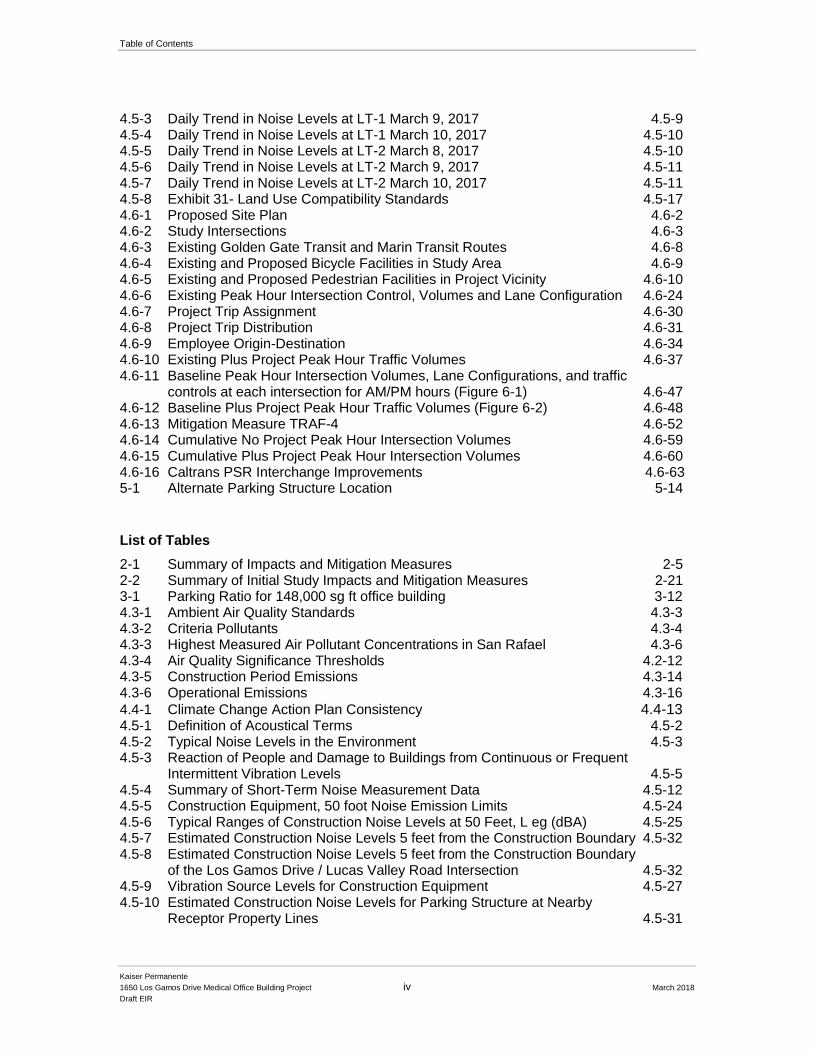
Table of Contents
Kaiser Permanente
1650 Los Gamos Drive Medical Office Building Project iv March 2018
Draft EIR
4.5-3 Daily Trend in Noise Levels at LT-1 March 9, 2017 4.5-9 4.5-4 Daily Trend in Noise Levels at LT-1 March 10, 2017 4.5-10 4.5-5 Daily Trend in Noise Levels at LT-2 March 8, 2017 4.5-10 4.5-6 Daily Trend in Noise Levels at LT-2 March 9, 2017 4.5-11 4.5-7 Daily Trend in Noise Levels at LT-2 March 10, 2017 4.5-11 4.5-8 Exhibit 31- Land Use Compatibility Standards 4.5-17 4.6-1 Proposed Site Plan 4.6-2 4.6-2 Study Intersections 4.6-3 4.6-3 Existing Golden Gate Transit and Marin Transit Routes 4.6-8 4.6-4 Existing and Proposed Bicycle Facilities in Study Area 4.6-9 4.6-5 Existing and Proposed Pedestrian Facilities in Project Vicinity 4.6-10 4.6-6 Existing Peak Hour Intersection Control, Volumes and Lane Configuration 4.6-24 4.6-7 Project Trip Assignment 4.6-30 4.6-8 Project Trip Distribution 4.6-31 4.6-9 Employee Origin-Destination 4.6-34 4.6-10 Existing Plus Project Peak Hour Traffic Volumes 4.6-37 4.6-11 Baseline Peak Hour Intersection Volumes, Lane Configurations, and traffic
controls at each intersection for AM/PM hours (Figure 6-1) 4.6-47 4.6-12 Baseline Plus Project Peak Hour Traffic Volumes (Figure 6-2) 4.6-48 4.6-13 Mitigation Measure TRAF-4 4.6-52 4.6-14 Cumulative No Project Peak Hour Intersection Volumes 4.6-59 4.6-15 Cumulative Plus Project Peak Hour Intersection Volumes 4.6-60 4.6-16 Caltrans PSR Interchange Improvements 4.6-63 5-1 Alternate Parking Structure Location 5-14
List of Tables
2-1 Summary of Impacts and Mitigation Measures 2-5 2-2 Summary of Initial Study Impacts and Mitigation Measures 2-21 3-1 Parking Ratio for 148,000 sg ft office building 3-12 4.3-1 Ambient Air Quality Standards 4.3-3 4.3-2 Criteria Pollutants 4.3-4 4.3-3 Highest Measured Air Pollutant Concentrations in San Rafael 4.3-6 4.3-4 Air Quality Significance Thresholds 4.2-12 4.3-5 Construction Period Emissions 4.3-14 4.3-6 Operational Emissions 4.3-16
4.4-1 Climate Change Action Plan Consistency 4.4-13 4.5-1 Definition of Acoustical Terms 4.5-2 4.5-2 Typical Noise Levels in the Environment 4.5-3 4.5-3 Reaction of People and Damage to Buildings from Continuous or Frequent
Intermittent Vibration Levels 4.5-5 4.5-4 Summary of Short-Term Noise Measurement Data 4.5-12 4.5-5 Construction Equipment, 50 foot Noise Emission Limits 4.5-24 4.5-6 Typical Ranges of Construction Noise Levels at 50 Feet, L eg (dBA) 4.5-25 4.5-7 Estimated Construction Noise Levels 5 feet from the Construction Boundary 4.5-32 4.5-8 Estimated Construction Noise Levels 5 feet from the Construction Boundary of the Los Gamos Drive / Lucas Valley Road Intersection 4.5-32 4.5-9 Vibration Source Levels for Construction Equipment 4.5-27 4.5-10 Estimated Construction Noise Levels for Parking Structure at Nearby
Receptor Property Lines 4.5-31
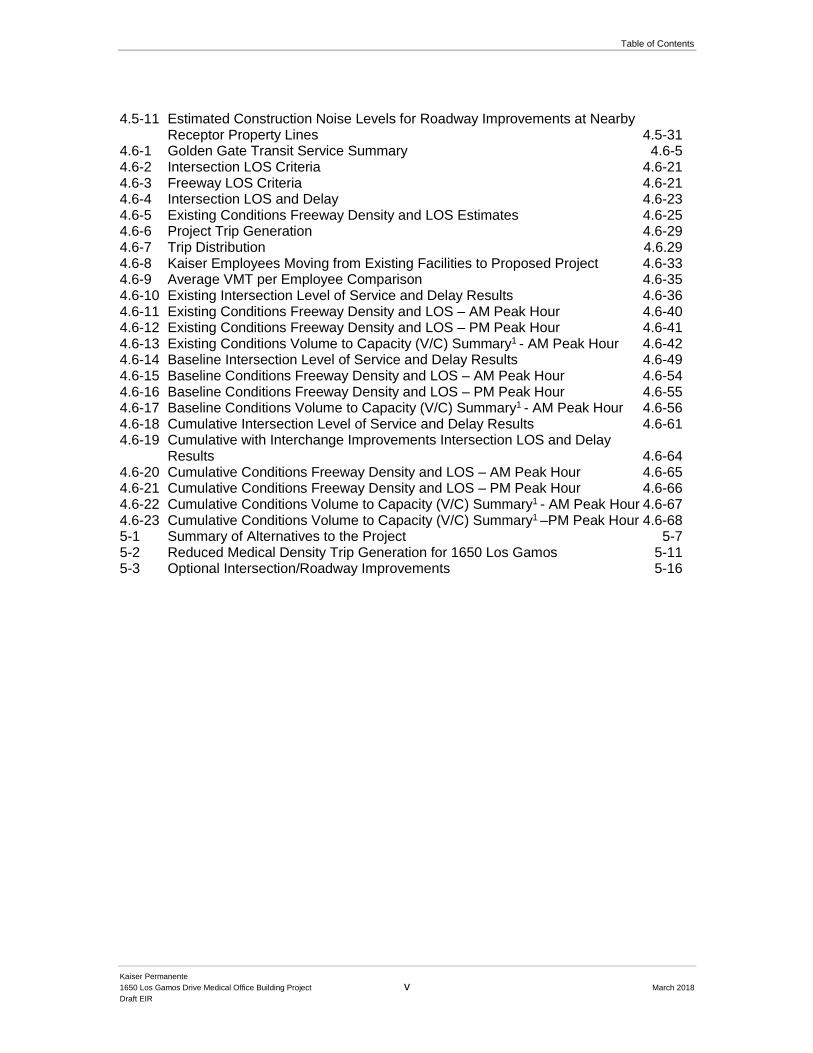
Table of Contents
Kaiser Permanente
1650 Los Gamos Drive Medical Office Building Project v March 2018
Draft EIR
4.5-11 Estimated Construction Noise Levels for Roadway Improvements at Nearby Receptor Property Lines 4.5-31
4.6-1 Golden Gate Transit Service Summary 4.6-5 4.6-2 Intersection LOS Criteria 4.6-21 4.6-3 Freeway LOS Criteria 4.6-21 4.6-4 Intersection LOS and Delay 4.6-23 4.6-5 Existing Conditions Freeway Density and LOS Estimates 4.6-25 4.6-6 Project Trip Generation 4.6-29 4.6-7 Trip Distribution 4.6.29 4.6-8 Kaiser Employees Moving from Existing Facilities to Proposed Project 4.6-33 4.6-9 Average VMT per Employee Comparison 4.6-35 4.6-10 Existing Intersection Level of Service and Delay Results 4.6-36 4.6-11 Existing Conditions Freeway Density and LOS – AM Peak Hour 4.6-40 4.6-12 Existing Conditions Freeway Density and LOS – PM Peak Hour 4.6-41 4.6-13 Existing Conditions Volume to Capacity (V/C) Summary1 - AM Peak Hour 4.6-42 4.6-14 Baseline Intersection Level of Service and Delay Results 4.6-49 4.6-15 Baseline Conditions Freeway Density and LOS – AM Peak Hour 4.6-54 4.6-16 Baseline Conditions Freeway Density and LOS – PM Peak Hour 4.6-55 4.6-17 Baseline Conditions Volume to Capacity (V/C) Summary1 - AM Peak Hour 4.6-56 4.6-18 Cumulative Intersection Level of Service and Delay Results 4.6-61 4.6-19 Cumulative with Interchange Improvements Intersection LOS and Delay
Results 4.6-64 4.6-20 Cumulative Conditions Freeway Density and LOS – AM Peak Hour 4.6-65 4.6-21 Cumulative Conditions Freeway Density and LOS – PM Peak Hour 4.6-66 4.6-22 Cumulative Conditions Volume to Capacity (V/C) Summary1 - AM Peak Hour 4.6-67 4.6-23 Cumulative Conditions Volume to Capacity (V/C) Summary1 –PM Peak Hour 4.6-68 5-1 Summary of Alternatives to the Project 5-7 5-2 Reduced Medical Density Trip Generation for 1650 Los Gamos 5-11 5-3 Optional Intersection/Roadway Improvements 5-16
Table of Contents
Kaiser Permanente
1650 Los Gamos Drive Medical Office Building Project vi March 2018
Draft EIR
This page intentionally left blank
Kaiser Permanente
1650 Los Gamos Drive Medical Office Building Project vii March 2018
Draft EIR
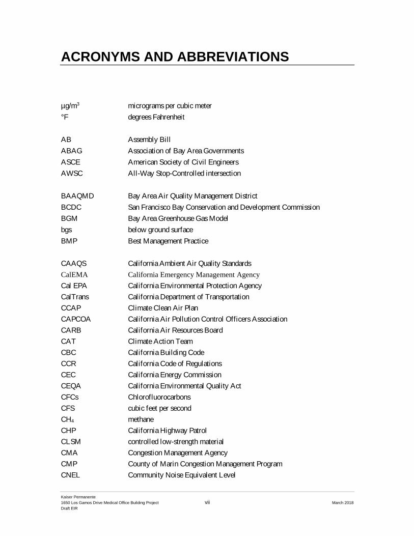
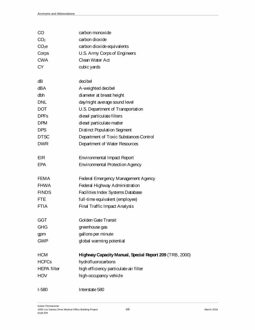
ACRONYMS AND ABBREVIATIONS
µg/m3 micrograms per cubic meter
°F degrees Fahrenheit
AB Assembly Bill
ABAG Association of Bay Area Governments
ASCE American Society of Civil Engineers
AWSC All-Way Stop-Controlled intersection
BAAQMD Bay Area Air Quality Management District
BCDC San Francisco Bay Conservation and Development Commission
BGM Bay Area Greenhouse Gas Model
bgs below ground surface
BMP Best Management Practice
CAAQS California Ambient Air Quality Standards
CalEMA California Emergency Management Agency
Cal EPA California Environmental Protection Agency
CalTrans California Department of Transportation
CCAP Climate Clean Air Plan
CAPCOA California Air Pollution Control Officers Association
CARB California Air Resources Board
CAT Climate Action Team
CBC California Building Code
CCR California Code of Regulations
CEC California Energy Commission
CEQA California Environmental Quality Act
CFCs Chlorofluorocarbons
CFS cubic feet per second
CH4 methane
CHP California Highway Patrol
CLSM controlled low-strength material
CMA Congestion Management Agency
CMP County of Marin Congestion Management Program
CNEL Community Noise Equivalent Level
Acronyms and Abbreviations
Kaiser Permanente
1650 Los Gamos Drive Medical Office Building Project viii March 2018
Draft EIR
CO carbon monoxide
CO2 carbon dioxide
CO2e carbon dioxide equivalents
Corps U.S. Army Corps of Engineers
CWA Clean Water Act
CY cubic yards
dB decibel
dBA A-weighted decibel
dbh diameter at breast height
DNL day/night average sound level
DOT U.S. Department of Transportation
DPFs diesel particulate filters
DPM diesel particulate matter
DPS Distinct Population Segment
DTSC Department of Toxic Substances Control
DWR Department of Water Resources
EIR Environmental Impact Report
EPA Environmental Protection Agency
FEMA Federal Emergency Management Agency
FHWA Federal Highway Administration
FINDS Facilities Index Systems Database
FTE full-time equivalent (employee)
FTIA Final Traffic Impact Analysis
GGT Golden Gate Transit
GHG greenhouse gas
gpm gallons per minute
GWP global warming potential
HCM Highway Capacity Manual, Special Report 209 (TRB, 2000)
HCFCs hydrofluorocarbons
HEPA filter high efficiency particulate air filter
HOV high-occupancy vehicle
I-580 Interstate 580
Acronyms and Abbreviations
Kaiser Permanente
1650 Los Gamos Drive Medical Office Building Project ix March 2018
Draft EIR
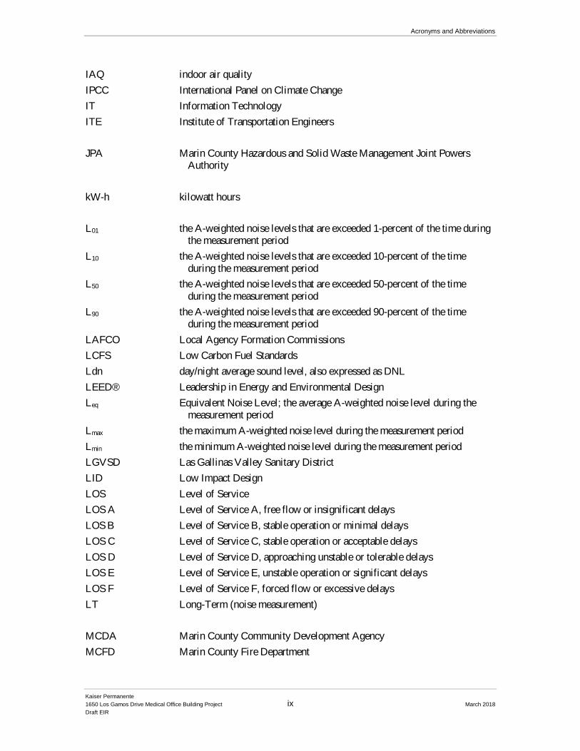
IAQ indoor air quality
IPCC International Panel on Climate Change
IT Information Technology
ITE Institute of Transportation Engineers
JPA Marin County Hazardous and Solid Waste Management Joint Powers Authority
kW-h kilowatt hours
L01 the A-weighted noise levels that are exceeded 1-percent of the time during the measurement period
L10 the A-weighted noise levels that are exceeded 10-percent of the time during the measurement period
L50 the A-weighted noise levels that are exceeded 50-percent of the time during the measurement period
L90 the A-weighted noise levels that are exceeded 90-percent of the time during the measurement period
LAFCO Local Agency Formation Commissions
LCFS Low Carbon Fuel Standards
Ldn day/night average sound level, also expressed as DNL
LEED® Leadership in Energy and Environmental Design
Leq Equivalent Noise Level; the average A-weighted noise level during the measurement period
Lmax the maximum A-weighted noise level during the measurement period
Lmin the minimum A-weighted noise level during the measurement period
LGVSD Las Gallinas Valley Sanitary District
LID Low Impact Design
LOS Level of Service
LOS A Level of Service A, free flow or insignificant delays
LOS B Level of Service B, stable operation or minimal delays
LOS C Level of Service C, stable operation or acceptable delays
LOS D Level of Service D, approaching unstable or tolerable delays
LOS E Level of Service E, unstable operation or significant delays
LOS F Level of Service F, forced flow or excessive delays
LT Long-Term (noise measurement)
MCDA Marin County Community Development Agency
MCFD Marin County Fire Department
Acronyms and Abbreviations
Kaiser Permanente
1650 Los Gamos Drive Medical Office Building Project x March 2018
Draft EIR
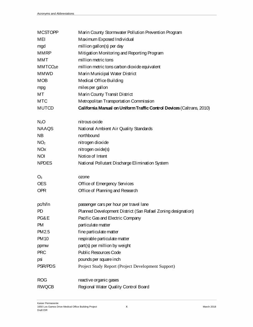
MCSTOPP Marin County Stormwater Pollution Prevention Program
MEI Maximum Exposed Individual
mgd million gallon(s) per day
MMRP Mitigation Monitoring and Reporting Program
MMT million metric tons
MMTCO2e million metric tons carbon dioxide equivalent
MMWD Marin Municipal Water District
MOB Medical Office Building
mpg miles per gallon
MT Marin County Transit District
MTC Metropolitan Transportation Commission
MUTCD California Manual on Uniform Traffic Control Devices (Caltrans, 2010)
N2O nitrous oxide
NAAQS National Ambient Air Quality Standards
NB northbound
NO2 nitrogen dioxide
NOx nitrogen oxide(s)
NOI Notice of Intent
NPDES National Pollutant Discharge Elimination System
O3 ozone
OES Office of Emergency Services
OPR Office of Planning and Research
pc/h/ln passenger cars per hour per travel lane
PD Planned Development District (San Rafael Zoning designation)
PG&E Pacific Gas and Electric Company
PM particulate matter
PM2.5 fine particulate matter
PM10 respirable particulate matter
ppmw part(s) per million by weight
PRC Public Resources Code
psi pounds per square inch
PSR/PDS Project Study Report (Project Development Support)
ROG reactive organic gases
RWQCB Regional Water Quality Control Board
Acronyms and Abbreviations
Kaiser Permanente
1650 Los Gamos Drive Medical Office Building Project xi March 2018
Draft EIR
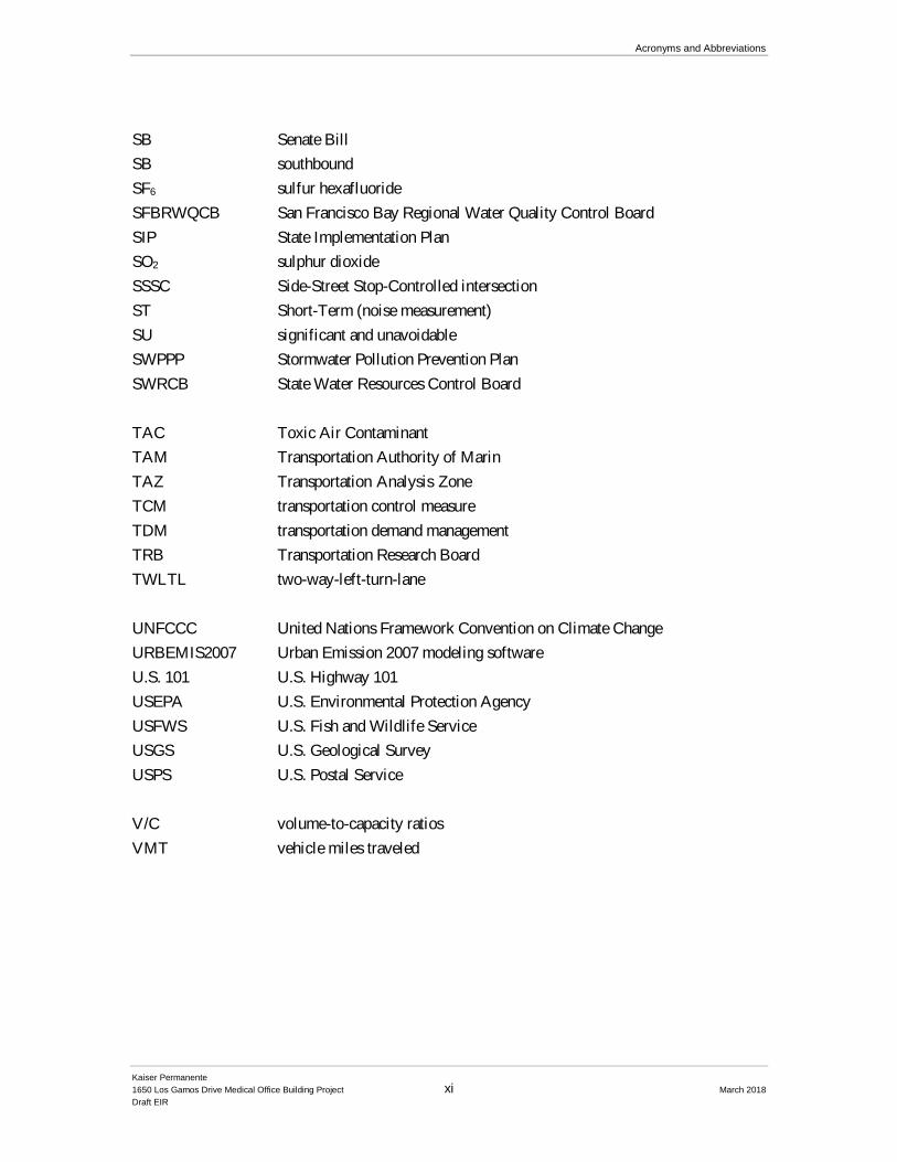
SB Senate Bill
SB southbound
SF6 sulfur hexafluoride
SFBRWQCB San Francisco Bay Regional Water Quality Control Board
SIP State Implementation Plan
SO2 sulphur dioxide
SSSC Side-Street Stop-Controlled intersection
ST Short-Term (noise measurement)
SU significant and unavoidable
SWPPP Stormwater Pollution Prevention Plan
SWRCB State Water Resources Control Board
TAC Toxic Air Contaminant
TAM Transportation Authority of Marin
TAZ Transportation Analysis Zone
TCM transportation control measure
TDM transportation demand management
TRB Transportation Research Board
TWLTL two-way-left-turn-lane
UNFCCC United Nations Framework Convention on Climate Change
URBEMIS2007 Urban Emission 2007 modeling software
U.S. 101 U.S. Highway 101
USEPA U.S. Environmental Protection Agency
USFWS U.S. Fish and Wildlife Service
USGS U.S. Geological Survey
USPS U.S. Postal Service
V/C volume-to-capacity ratios
VMT vehicle miles traveled
Acronyms and Abbreviations
Kaiser Permanente
1650 Los Gamos Drive Medical Office Building Project xii March 2018
Draft EIR
This page intentionally left blank
Kaiser Permanente
1650 Los Gamos Drive Medical Office Building Project 1-1 March 2018
Draft EIR
CHAPTER 1
Introduction
1.1 Overview
In compliance with the California Environmental Quality Act of 1970 (CEQA), as amended, the
City of San Rafael Community Development Department has prepared this Draft Environmental
Impact Report (DEIR) for the Kaiser Permanente 1650 Los Gamos Drive Medical Office
Building (“proposed Project” or “Project”), located at 1650 Los Gamos San Rafael Marin
County, California, APNs: 165-220-12 and 165-220-13.
The City of San Rafael is the Lead Agency primarily responsible for preparing this DEIR
(pursuant to State and local guidelines for implementing CEQA) and has determined that the
Project is subject to CEQA (Public Resources Code Section 21000, et seq. and Section 15080, et
seq.) and the State CEQA Guidelines (California Code of Regulations) promulgated thereunder.
1.2 Property Description
The subject property is approximately 11.1-acres in size and located in north San Rafael. The
eastern 4.09-acre (178,373 square feet) portion of the subject property is previously developed
with an existing approximately 148,000 square foot office building and associated surface
parking. Across Los Gamos Drive, to the west, is an additional 7.02-acre (305,947 square feet)
parcel developed with an approximately 80,000 square foot terraced surface parking lot and
landscaping.
The Project site is located in the North San Rafael Commercial Center district just west of
Highway 101 and south of the intersection of Lucas Valley Road and Los Gamos Drive. The
existing building is surrounded by several existing surface parking lots, and a Marin County-
owned building to the south, at 1600 Los Gamos Drive. The Project site is located in a mixed-use
office/commercial area and is separated from the nearest residential neighborhood by an open
space hillside to the west (the closest residential structure is approximately 215 feet west and
uphill from the southwest corner of the existing surface parking lot).
The Project site includes three corresponding parcels, two of which are owned by Kaiser
Permanente and the third (1600 Los Gamos Drive), which is owned by Marin County, as
described more fully below:
• An existing building at 1650 Los Gamos Drive (Assessor Parcel Number’s
[APN] 165-220-13), includes a three-story, approximately 148,000 square foot
office building and associated surface parking on approximately 4.09 acres.
1. Introduction
Kaiser Permanente
1650 Los Gamos Drive Medical Office Building Project 1-2 March 2018
Draft EIR
• An approximately 7.02-acre parcel located to the west of 1650 Los Gamos Drive,
on the west side of Los Gamos Drive (APN 165‐220‐12). The parcel currently
consists of a surface parking lot and vegetative hillside, and abuts an
undeveloped hillside slope, with a single‐family subdivision above. There is also
an existing sanitary sewer line running through the parcel.
• The surface parking site at 1600 Los Gamos Drive (APN: 165-220-11), a portion
of which Kaiser Permanente holds a parking easement to allow the use of 42
parking spaces for 1650 Los Gamos Drive.
Together, these parcels comprise the “Project site.”
1.3 Use of this EIR
Pursuant to CEQA, this EIR is a public information document prepared for use by governmental
agencies and the public to identify and evaluate potential environmental consequences of the
Project, to evaluate and recommend mitigation measures that would substantially lessen or
eliminate significant environmental adverse impacts, and to examine a range of feasible
alternatives to the Project. The information contained in this EIR is subject to review and
consideration by the City of San Rafael, and any other responsible agency, prior to its decision to
approve, reject or modify the Project. This EIR is a Project EIR pursuant to CEQA Guidelines
15161, which covers all actions of the Project, including planning, construction and operation of
the Project.
1.4 EIR Scoping
The City of San Rafael, as Lead Agency, elected to prepare an Initial Study Checklist to reduce
the scope and focus of the EIR, as permitted by CEQA Guidelines §15063(c)(3) and 15126. As
such, several areas of environmental factors have been determined to have less than significant
impacts or less than significant impacts with mitigation incorporation. The environmental factors
that were determined to be less than significant include:
Agriculture, Biological Resources, Cultural Resources, Geology /Soils, Hazards & Hazardous Materials, Hydrology / Water Quality, Mineral Resources, Population / Housing, Public Services, Recreation, Tribal Cultural Resources, and Utilities / Service Systems
On June 9, 2017, the City of San Rafael circulated an Initial Study and Notice of Preparation
(NOP) for 30 calendar days that included a list of environmental effects that could result from the
proposed Project. The NOP was published and distributed to governmental agencies,
organizations, and persons interested in the Project. The City of San Rafael sent the NOP to
agencies with statutory responsibilities in connection with the Project and requested their input on
the scope and content of the environmental information that should be addressed in the EIR. The
City of San Rafael held a Public Scoping Meeting on June 27, 2017 to accept comments
1. Introduction
Kaiser Permanente
1650 Los Gamos Drive Medical Office Building Project 1-3 March 2018
Draft EIR
regarding the scope of the EIR in response to the NOP. The NOP review period ended on July 10,
2017. The NOP, the written comments received in response to the NOP (including those received
after the 30-day comment period), and the Initial Study are included as Appendix A and B to this
DEIR.
On June 27, 2017 the Planning, Commission conducted a Scoping Session Public Hearing.
Members of the public and Planning Commission were invited to comment on the potential
environmental impacts of the Project that should be examined in the EIR. Based on commentary
from Commissioner Belletto and comments received from the public regarding views of the
proposed parking structure’s solar infrastructure, environmental issues related to Aesthetics are
also be included as part of the EIR discussion.
The City of San Rafael has prepared this EIR to analyze the potential environmental effects of the
Project under CEQA and addresses the environmental topics identified in the Initial Study and
NOP and comments received on the NOP. Therefore, in accordance with CEQA, this EIR is
limited to the effects on the environment that are specific to this Project. The following
environmental topics are addressed in this EIR:
1. Land Use
2. Aesthetics
3. Air Quality
4. Greenhouse Gas Emissions
5. Noise
6. Transportation and Circulation
1.4.1 Public Review
This DEIR is available for public review and comment for the period identified on the notice
accompanying this document (45 calendar days). During the public review and comment period,
written comments on the DEIR may be submitted to the City of San Rafael at the address
indicated on the notice or to:
Mr. Sean Kennings, Contract Planner
Mailing address: City of San Rafael Community Development Department
1400 5th Street, 3rd floor
City of San Rafael, CA 94901
Email address: [email protected]
Verbal comments may be stated at the public hearing on the DEIR, which will be held on April
24, 2018. A notice regarding the public hearing will be mailed to all neighboring properties
within 300 feet of the Project site as well as relevant public agencies and interested parties and
stakeholders.
1. Introduction
Kaiser Permanente
1650 Los Gamos Drive Medical Office Building Project 1-4 March 2018
Draft EIR
Following the public review and comment period for the DEIR, the City of San Rafael will
prepare responses that address all substantive written and verbal comments on the DEIR’s
environmental analyses and that are received within the specified review period. The responses
and any other revisions to the DEIR will be prepared as a Responses to Comments document
(commonly referred to as the Final EIR or FEIR). The DEIR and its appendices, together with the
Responses to Comments document actually constitute the Final EIR for the Project.
Prior to approval of the Project and a Mitigation Monitoring and Reporting Program for all
mitigation measures identified in the FEIR, the City of San Rafael must review and certify the
FEIR.
1.4.2 Project Review and Approval
The City of San Rafael must ultimately certify that it has reviewed and considered the
information in the EIR and that the EIR has been completed in conformity with the requirements
of CEQA. This determination must be made before any decision can be made regarding the
proposed Project. This EIR identifies significant effects that would result from the proposed
Project. Therefore, pursuant to CEQA Guidelines Section 15091, no public agency shall approve
or carry out a project for which an EIR has been certified which identifies one of more significant
effects of the project, unless the public agency makes one or more of the following findings:
1. Changes or alterations have been required in, or incorporated into, the project which avoid or
substantially lessen the significant environmental effect as identified in the FEIR.
2. Such changes or alterations are within the responsibility and jurisdiction of another public
agency and not the agency making the finding. Such changes have been adopted by such
other agency or can and should be adopted by such agency.
3. Specified economic, legal, social, technological, or other considerations, including
provisions of employment opportunities for highly trained workers, make infeasible the
mitigation measures or project alternatives identified in the FEIR.
The City of San Rafael will prepare the appropriate findings prior to taking action on the Project.
1.5 Organization of the EIR
Following this Chapter 1, Introduction, this EIR is organized as follows:
Chapter 2, Summary, contains a brief summary of the Project and is an easy reference to the
analysis presented in the DEIR. It is prepared for use as a stand-alone summary of the EIR. A
Summary of Impacts, Mitigation Measures, and Residual Impacts table is provided at the end of
Chapter 2 as a reader-friendly reference to each of the environmental impacts, proposed
1. Introduction
Kaiser Permanente
1650 Los Gamos Drive Medical Office Building Project 1-5 March 2018
Draft EIR
mitigation measures and residual environmental impacts after mitigation is implemented.
Chapter 2 also summarizes the analysis of potential alternatives to the Project.
Chapter 3, Project Description, describes in detail the Project and surroundings, the background
of the Project; Project objectives, and Project characteristics (including phasing and construction
activities). Chapter 3 also identifies other agencies that must consider or approve aspects of the
Project.
Chapter 4, Environmental Setting, Impacts and Mitigation Measures, discusses for each
environmental topic the environmental setting (existing physical conditions and regulatory
framework), significance criteria, the potential environmental impacts of the Project and
cumulative conditions, mitigation measures that, in most cases, would reduce or eliminate
significant impacts. The preface of Chapter 4 outlines the scope of the analysis, organization, the
methods and nomenclature for determining significance used in the EIR, as well as the baseline
and cumulative analysis approach applied.
Chapter 5, Alternatives, evaluates a reasonable range of alternatives to the Project and identifies
an environmentally superior alternative.
Chapter 6, Impact Overview, summarizes the potentially significant and unavoidable impacts
and cumulative impacts that could result from the Project, as they are identified throughout
Chapter 4. Chapter 6 also describes the Project’s potential for inducing growth, as well as the
Project’s significant, irreversible effects and less-than-significant effects.
Chapter 7, Report Preparation, identifies the authors of the EIR, including CEQA and other
consultants to the City of San Rafael, who provided technical resources for the Project description
and EIR analysis. All reference documents used to prepare the EIR analyses are listed in this
chapter.
Appendices to the EIR are provided at the end of the document and include the NOP and scoping
comments received, as well as certain technical background detail supporting certain analyses
presented throughout the document. The appendices to the DEIR are available for review by the
public at The City of San Rafael offices (address indicated on the notice provided at the front of
this document).

1. Introduction
Kaiser Permanente
1650 Los Gamos Drive Medical Office Building Project 1-6 March 2018
Draft EIR
This page intentionally left blank
Kaiser Permanente
1650 Los Gamos Drive Medical Office Building Project 2-1 March 2018
Draft EIR
CHAPTER 2
Summary
This DEIR has been prepared to evaluate the environmental impacts of the proposed Kaiser
Permanente Medical Office Building Project at 1650 Los Gamos Drive, San Rafael, CA. This
section briefly describes the Project and also summarizes the Project-specific impacts and
mitigation measures identified in the DEIR (Table 2-1). Project-specific impacts and mitigation
measures identified in the Initial Study are included in Table 2-2. Alternatives to the Project that
have been considered are also summarized.
2.1 Project Overview
Kaiser Permanente is proposing a project with three components:
• The addition of medical office as an allowable use in the Planned Development (PD)
Zoning District for an existing, approximately 148,000-gross square foot office building
located at 1650 Los Gamos Drive in San Rafael, to be utilized as a medical office building
(MOB).
• The construction of an up to 476-space, three-level plus upper ramp, parking structure
on the existing surface parking lot located to the west of 1650 Los Gamos Drive that
will primarily serve Kaiser Permanente employees working at the MOB.
• Continued use of the existing 42 parking spaces located adjacent to 1650 Los Gamos
Drive, on the 1600 Los Gamos Drive property. Kaiser Permanente has legal access to
the use of those parking spaces through an easement and is not proposing any changes
to the parking spaces.
Both 1650 and 1600 Los Gamos Drive were originally constructed pursuant to a single Planned
Development (PD) District, which permits 1650 Los Gamos Drive to be constructed with up to
150,000 square feet of general or administrative office uses and 1600 Los Gamos Drive to be
constructed with up to 340,000 square feet of general or administrative office uses or a computer
center.
Discretionary approvals or permits needed to construct the Project will include: 1) an amendment
to the existing PD District for the site to allow medical office uses in addition to the existing office
uses, and to separate the PD District from 1600 Los Gamos Drive. As discussed above, the Project
would convert the entire office building into approximately 148,000 square feet of medical office
space. Two existing tenants are anticipated to remain (as interim uses) during the remainder of their
leases.
2. Summary
Kaiser Permanente
1650 Los Gamos Drive Medical Office Building Project 2-2 March 2018 Draft EIR
At full buildout, the MOB would contain approximately 70 provider offices anticipated to provide
the following services:
Member Services, Health Education, Internal Medicine, Pediatrics, OB/GYN,
Endocrinology, Rheumatology, Dermatology, Eye Services, Physical Therapy, Imaging,
Pharmacy, and Laboratory (the composition of services may be subject to change by the
time the MOB is operational).
There would be approximately 315 employees working at 1650 Los Gamos Drive at full buildout.
Many of these employees, about 78%, or 245, would be relocated from existing Kaiser Permanente
facilities in Marin County. Approximately 70%, or 170, of these relocated Marin employees would
be relocated from the existing Kaiser Permanente Medical Center at 99 Monticello Road, San
Rafael.
The Project will not increase the footprint, height or massing of the existing building. The medical
office uses will be contained within the existing building and no substantial exterior changes are
proposed to the MOB. The only proposed exterior changes to the existing building at 1650 Los
Gamos Drive are minor improvements to the landscaping and new signage to identify the facility
and provide a brand identity.
For purposes of the environmental review, the Project was assumed to have up to 150,000 square
feet of medical office space, which is the maximum amount allowed for development under the
existing zoning.
While not proposed as part of the Project, the potential environmental impacts of off-site roadway
improvements resulting from Project mitigation measures are also analyized as part of this DEIR.
2.2 Areas of Controversy and Scoping Comments
Areas of Potential Controversy
The comments on the NOP and at the Project scoping meeting focused on the following topics:
• Increased traffic.
• Visual impacts of a larger proposed parking structure.
• Construction noise and air quality impacts.
• Pedestrian and bicycle connections and safety.
Impacts and Mitigation Measures
Under CEQA, a significant effect on the environment is defined as a substantial or potentially
substantial adverse change in any of the physical conditions within the area affected by a project,
including effects on land, air, water, minerals, flora, fauna, ambient noise, and objects of historic
or aesthetic significance. The criteria of significance used to determine whether or not effects are
2. Summary
Kaiser Permanente
1650 Los Gamos Drive Medical Office Building Project 2-3 March 2018
Draft EIR
significant are included in the "Impacts and Mitigation Measures" section for each topic discussion
in this DEIR.
This DEIR identifies significant and unavoidable Project-level impacts associated with the
mitigation requirement to signalize and improve the intersections at Los Gamos Drive and Lucas
Valley Road as well as mitigations to improve the intersection at Las Gallinas Drive and Lucas
Valley Road. All other identified impacts can be mitigated to a less than significant level with the
implementation of the recommended mitigation measures. This DEIR also addresses less than
significant impacts for which mitigation measures are not needed.
Prior to approval of the Project, written findings regarding each of the identified environmental
impacts must be prepared. Also, a monitoring program for each mitigation measure must be
adopted. This monitoring program will be prepared as part of the FEIR for this Project.
2.3 Alternatives
Four potential alternatives to the proposed Project are evaluated in Chapter 5, Alternatives. They
are:
• Alternative 1: No Project/No Medical Office Uses
• Alternative 2: Reduced Medical Office Use
• Alternative 3: Alternate Parking Structure Location
• Alternative 4: Applicant-Implemented Traffic Improvements
The environmental impacts of each alternative are compared. The ability of each alternative to meet
Project objectives is also evaluated. Alternatives 1 and 2 do not meet the primary objectives of
Kaiser Permanente. Alternative 4 is the identified Environmentally-Superior alternative.
2.4 Environmental Impacts and Mitigation Measures
Table 2-1 summarizes project impacts and mitigation measures. The table identifies the level of
impact both before and after mitigation. Proposed mitigation measures identified in the Initial
Study are included in Table 2-2 and are referenced accordingly. The Initial Study is included as
Appendix B to this DEIR.
2. Summary
Kaiser Permanente
1650 Los Gamos Drive Medical Office Building Project 2-4 March 2018 Draft EIR
This page intentionally left blank
2. Summary
Kaiser Permanente
1650 Los Gamos Drive Medical Office Building Project 2-5 March 2018
Draft EIR
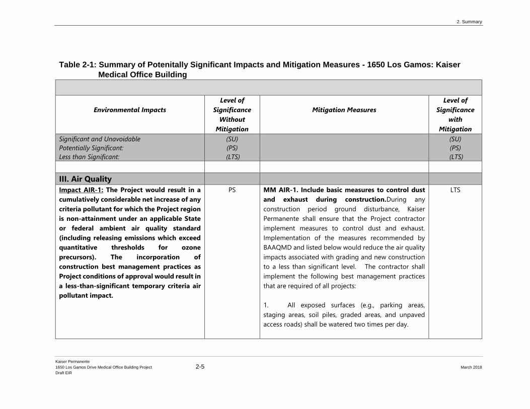
Table 2-1: Summary of Potenitally Significant Impacts and Mitigation Measures - 1650 Los Gamos: Kaiser
Medical Office Building
Environmental Impacts
Level of
Significance
Without
Mitigation
Mitigation Measures
Level of
Significance
with
Mitigation
Significant and Unavoidable
Potentially Significant:
Less than Significant:
(SU)
(PS)
(LTS)
(SU)
(PS)
(LTS)
III. Air Quality
Impact AIR-1: The Project would result in a
cumulatively considerable net increase of any
criteria pollutant for which the Project region
is non-attainment under an applicable State
or federal ambient air quality standard
(including releasing emissions which exceed
quantitative thresholds for ozone
precursors). The incorporation of
construction best management practices as
Project conditions of approval would result in
a less-than-significant temporary criteria air
pollutant impact.
PS MM AIR-1. Include basic measures to control dust
and exhaust during construction.During any
construction period ground disturbance, Kaiser
Permanente shall ensure that the Project contractor
implement measures to control dust and exhaust.
Implementation of the measures recommended by
BAAQMD and listed below would reduce the air quality
impacts associated with grading and new construction
to a less than significant level. The contractor shall
implement the following best management practices
that are required of all projects:
1. All exposed surfaces (e.g., parking areas,
staging areas, soil piles, graded areas, and unpaved
access roads) shall be watered two times per day.
LTS
2. Summary
Kaiser Permanente
1650 Los Gamos Drive Medical Office Building Project 2-6 March 2018
Draft EIR
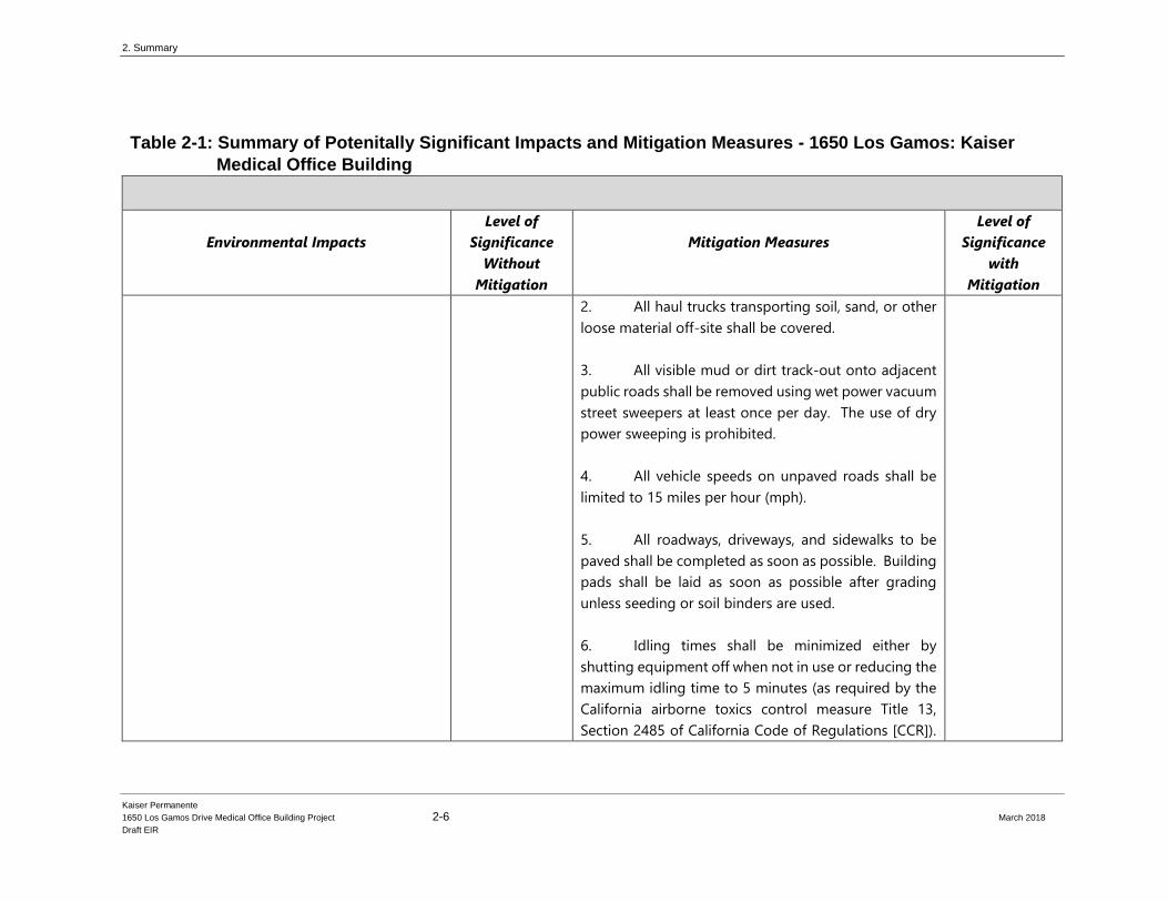
Table 2-1: Summary of Potenitally Significant Impacts and Mitigation Measures - 1650 Los Gamos: Kaiser
Medical Office Building
Environmental Impacts
Level of
Significance
Without
Mitigation
Mitigation Measures
Level of
Significance
with
Mitigation
2. All haul trucks transporting soil, sand, or other
loose material off-site shall be covered.
3. All visible mud or dirt track-out onto adjacent
public roads shall be removed using wet power vacuum
street sweepers at least once per day. The use of dry
power sweeping is prohibited.
4. All vehicle speeds on unpaved roads shall be
limited to 15 miles per hour (mph).
5. All roadways, driveways, and sidewalks to be
paved shall be completed as soon as possible. Building
pads shall be laid as soon as possible after grading
unless seeding or soil binders are used.
6. Idling times shall be minimized either by
shutting equipment off when not in use or reducing the
maximum idling time to 5 minutes (as required by the
California airborne toxics control measure Title 13,
Section 2485 of California Code of Regulations [CCR]).
2. Summary
Kaiser Permanente
1650 Los Gamos Drive Medical Office Building Project 2-7 March 2018
Draft EIR
Table 2-1: Summary of Potenitally Significant Impacts and Mitigation Measures - 1650 Los Gamos: Kaiser
Medical Office Building
Environmental Impacts
Level of
Significance
Without
Mitigation
Mitigation Measures
Level of
Significance
with
Mitigation
Clear signage shall be provided for construction
workers at all access points.
7. All construction equipment shall be maintained
and properly tuned in accordance with manufacturer’s
specifications. All equipment shall be checked by a
certified mechanic and determined to be running in
proper condition prior to operation.
8. Post a publicly visible sign with the telephone
number and person to contact at the Lead Agency
regarding dust complaints. This person shall respond
and take corrective action within 48 hours. The Air
District’s phone number shall also be visible to ensure
compliance with applicable regulations.
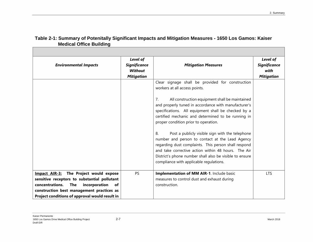
Impact AIR-3: The Project would expose
sensitive receptors to substantial pollutant
concentrations. The incorporation of
construction best management practices as
Project conditions of approval would result in
PS Implementation of MM AIR-1. Include basic
measures to control dust and exhaust during
construction.
LTS
2. Summary
Kaiser Permanente
1650 Los Gamos Drive Medical Office Building Project 2-8 March 2018
Draft EIR
Table 2-1: Summary of Potenitally Significant Impacts and Mitigation Measures - 1650 Los Gamos: Kaiser
Medical Office Building
Environmental Impacts
Level of
Significance
Without
Mitigation
Mitigation Measures
Level of
Significance
with
Mitigation
a less than significant temporary impact to
sensitive receptors.
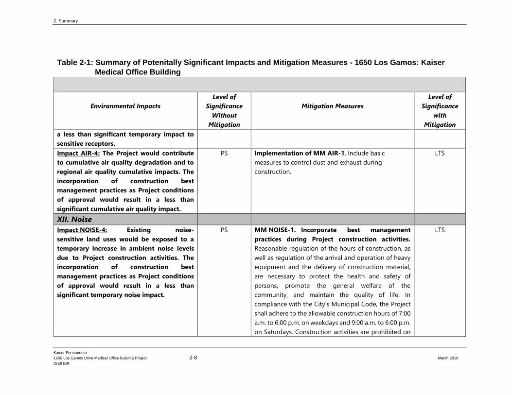
Impact AIR-4: The Project would contribute
to cumulative air quality degradation and to
regional air quality cumulative impacts. The
incorporation of construction best
management practices as Project conditions
of approval would result in a less than
significant cumulative air quality impact.
PS Implementation of MM AIR-1. Include basic
measures to control dust and exhaust during
construction.
LTS
XII. Noise
Impact NOISE-4: Existing noise-
sensitive land uses would be exposed to a
temporary increase in ambient noise levels
due to Project construction activities. The
incorporation of construction best
management practices as Project conditions
of approval would result in a less than
significant temporary noise impact.
PS MM NOISE-1. Incorporate best management
practices during Project construction activities.
Reasonable regulation of the hours of construction, as
well as regulation of the arrival and operation of heavy
equipment and the delivery of construction material,
are necessary to protect the health and safety of
persons, promote the general welfare of the
community, and maintain the quality of life. In
compliance with the City’s Municipal Code, the Project
shall adhere to the allowable construction hours of 7:00
a.m. to 6:00 p.m. on weekdays and 9:00 a.m. to 6:00 p.m.
on Saturdays. Construction activities are prohibited on
LTS
2. Summary
Kaiser Permanente
1650 Los Gamos Drive Medical Office Building Project 2-9 March 2018
Draft EIR
Table 2-1: Summary of Potenitally Significant Impacts and Mitigation Measures - 1650 Los Gamos: Kaiser
Medical Office Building
Environmental Impacts
Level of
Significance
Without
Mitigation
Mitigation Measures
Level of
Significance
with
Mitigation
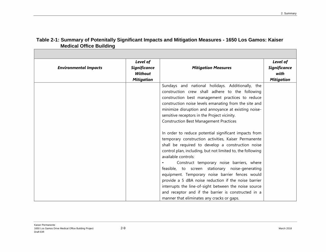
Sundays and national holidays. Additionally, the
construction crew shall adhere to the following
construction best management practices to reduce
construction noise levels emanating from the site and
minimize disruption and annoyance at existing noise-
sensitive receptors in the Project vicinity.
Construction Best Management Practices
In order to reduce potential significant impacts from
temporary construction activities, Kaiser Permanente
shall be required to develop a construction noise
control plan, including, but not limited to, the following
available controls:
• Construct temporary noise barriers, where
feasible, to screen stationary noise-generating
equipment. Temporary noise barrier fences would
provide a 5 dBA noise reduction if the noise barrier
interrupts the line-of-sight between the noise source
and receptor and if the barrier is constructed in a
manner that eliminates any cracks or gaps.
2. Summary
Kaiser Permanente
1650 Los Gamos Drive Medical Office Building Project 2-10 March 2018
Draft EIR
Table 2-1: Summary of Potenitally Significant Impacts and Mitigation Measures - 1650 Los Gamos: Kaiser
Medical Office Building
Environmental Impacts
Level of
Significance
Without
Mitigation
Mitigation Measures
Level of
Significance
with
Mitigation
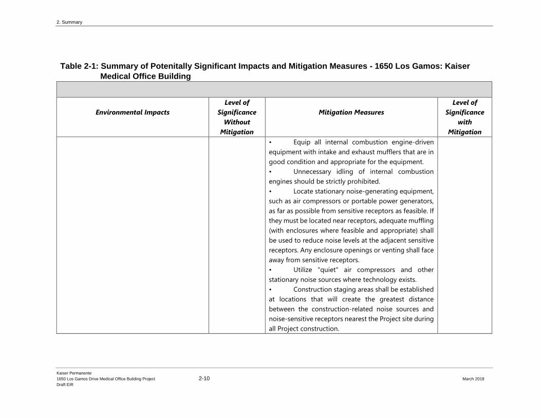
• Equip all internal combustion engine-driven
equipment with intake and exhaust mufflers that are in
good condition and appropriate for the equipment.
• Unnecessary idling of internal combustion
engines should be strictly prohibited.
• Locate stationary noise-generating equipment,
such as air compressors or portable power generators,
as far as possible from sensitive receptors as feasible. If
they must be located near receptors, adequate muffling
(with enclosures where feasible and appropriate) shall
be used to reduce noise levels at the adjacent sensitive
receptors. Any enclosure openings or venting shall face
away from sensitive receptors.
• Utilize "quiet" air compressors and other
stationary noise sources where technology exists.
• Construction staging areas shall be established
at locations that will create the greatest distance
between the construction-related noise sources and
noise-sensitive receptors nearest the Project site during
all Project construction.

2. Summary
Kaiser Permanente
1650 Los Gamos Drive Medical Office Building Project 2-11 March 2018
Draft EIR
Table 2-1: Summary of Potenitally Significant Impacts and Mitigation Measures - 1650 Los Gamos: Kaiser
Medical Office Building
Environmental Impacts
Level of
Significance
Without
Mitigation
Mitigation Measures
Level of
Significance
with
Mitigation
• Locate material stockpiles, as well as
maintenance/equipment staging and parking areas, as
far as feasible from residential receptors.
• Route construction-related traffic along major
roadways and as far as feasible from sensitive receptors.
• Control noise from construction workers’
radios to a point where they are not audible at existing
residences bordering the Project site.
• The contractor shall prepare a detailed
construction schedule for major noise-generating
construction activities. The construction plan shall
identify a procedure for coordination with adjacent
residential land uses so that construction activities can
be scheduled to minimize noise disturbance.
• Designate a "disturbance coordinator" who
would be responsible for responding to any complaints
about construction noise. The disturbance coordinator
will determine the cause of the noise complaint (e.g.,
bad muffler, etc.) and will require that reasonable
measures be implemented to correct the problem.
Conspicuously post a telephone number for the
disturbance coordinator at the construction site and
2. Summary
Kaiser Permanente
1650 Los Gamos Drive Medical Office Building Project 2-12 March 2018
Draft EIR
Table 2-1: Summary of Potenitally Significant Impacts and Mitigation Measures - 1650 Los Gamos: Kaiser
Medical Office Building
Environmental Impacts
Level of
Significance
Without
Mitigation
Mitigation Measures
Level of
Significance
with
Mitigation
include in it the notice sent to neighbors regarding the
construction schedule.
The implementation of the reasonable and feasible
controls outlined above would reduce construction
noise levels emanating from the site by 5 to 10 dBA in
order to minimize disruption. With the implementation
of these controls, as well as the Municipal Code limits
on allowable construction hours, and considering that
construction is temporary, the impact would be
reduced to a less-than-significant level.
XVI. Traffic and Circulation Impact TRAF-1: Implementation of
the Project would increase traffic volumes on
area roadways and affect levels of service at
the local intersections and freeways under
Existing plus Project Conditions.
PS MM TRAF-1. Signalize Lucas Valley Road / Los
Gamos Drive. In coordination with the City of San
Rafael, the County of Marin Department of Public
Works, and Caltrans, Kaiser Permanente shall pay the
fair share cost to signalize the Lucas Valley Road / Los
Gamos Drive intersection to mitigate poor operating
conditions. Signalizing the intersection is consistent
with improvements identified in the San Rafael General
Plan 2020. Due to its close proximity to the US-101
SU

2. Summary
Kaiser Permanente
1650 Los Gamos Drive Medical Office Building Project 2-13 March 2018
Draft EIR
Table 2-1: Summary of Potenitally Significant Impacts and Mitigation Measures - 1650 Los Gamos: Kaiser
Medical Office Building
Environmental Impacts
Level of
Significance
Without
Mitigation
Mitigation Measures
Level of
Significance
with
Mitigation
Ramp terminal intersections, the new signal should
include traffic signal interconnect and be coordinated
with the adjacent interchange signals. Additionally,
interagency coordination will be required during
design, construction and maintenance of the new
signal. Therefore, a memorandum of understanding
(MOU) will be required between the City of San Rafael
and the County of Marin to document the management
and maintenance of the new signal, since the US
101/Lucas Valley interchange signals and the new Lucas
Valley Road / Los Gamos Drive signal would need to be
operated and maintained by one or multiple agencies.
Signalizing the intersection would mitigate the project
impact to a less than significant impact. However,
implementation of the mitigation measure requires the
intersection improvements to be fully funded and
constructed. Therefore, until and unless the MOU and
fair-share contributions are finalized, and the design
and construction of the intersection is permitted and
approved, the Project will result in a significant and
unavoidable impact.
2. Summary
Kaiser Permanente
1650 Los Gamos Drive Medical Office Building Project 2-14 March 2018
Draft EIR
Table 2-1: Summary of Potenitally Significant Impacts and Mitigation Measures - 1650 Los Gamos: Kaiser
Medical Office Building
Environmental Impacts
Level of
Significance
Without
Mitigation
Mitigation Measures
Level of
Significance
with
Mitigation
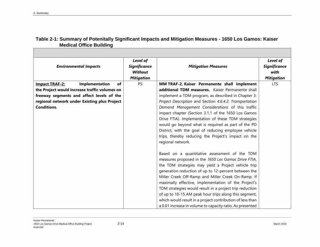
Impact TRAF-2: Implementation of
the Project would increase traffic volumes on
freeway segments and affect levels of the
regional network under Existing plus Project
Conditions.
PS MM TRAF-2. Kaiser Permanente shall implement
additional TDM measures. Kaiser Permanente shall
implement a TDM program, as described in Chapter 3:
Project Description and Section 4.6.4.2: Transportation
Demand Management Considerations of this traffic
impact chapter (Section 3.1.1 of the 1650 Los Gamos
Drive FTIA). Implementation of these TDM strategies
would go beyond what is required as part of the PD
District, with the goal of reducing employee vehicle
trips, thereby reducing the Project’s impact on the
regional network.
Based on a quantitative assessment of the TDM
measures proposed in the 1650 Los Gamos Drive FTIA,
the TDM strategies may yield a Project vehicle trip
generation reduction of up to 12-percent between the
Miller Creek Off-Ramp and Miller Creek On-Ramp. If
maximally effective, implementation of the Project’s
TDM strategies would result in a project trip reduction
of up to 10-15 AM peak hour trips along this segment,
which would result in a project contribution of less than
a 0.01 increase in volume to capacity ratio. As presented
LTS
2. Summary
Kaiser Permanente
1650 Los Gamos Drive Medical Office Building Project 2-15 March 2018
Draft EIR
Table 2-1: Summary of Potenitally Significant Impacts and Mitigation Measures - 1650 Los Gamos: Kaiser
Medical Office Building
Environmental Impacts
Level of
Significance
Without
Mitigation
Mitigation Measures
Level of
Significance
with
Mitigation
in the 1650 Los Gamos Drive FTIA, implementation of
the Project’s TDM measures will achieve this reduction,
however, Kaiser will annually quantitatively analyze and
monitor employee vehicle trip generation data via
comprehensive employee surveys and make
adjustments to its TDM measures as needed to achieve
the stated reduction.
As described in the 4.6.4.2: Transportation Demand
Management Considerations and the Fehr & Peers 1650
Los Gamos Drive FTIA, Kaiser Permanente shall conduct
an annual employee survey and prepare a monitoring
report that evaluates the effectiveness of the Project’s
TDM Plan. The TDM program will be submitted to the
City of San Rafael for comment and review. Kaiser
Permanente will coordinate with the City of San Rafael,
as necessary. The annual survey shall demonstrate how
the TDM measures reduce the Project’s impact to peak-
hour volume to capacity ratio for the Miller Creek On
and Off Ramp.
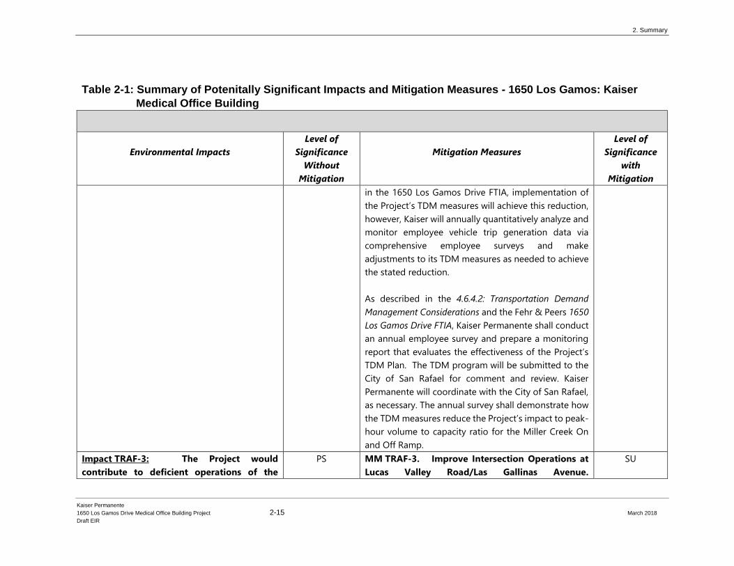
Impact TRAF-3: The Project would
contribute to deficient operations of the
PS MM TRAF-3. Improve Intersection Operations at
Lucas Valley Road/Las Gallinas Avenue.
SU
2. Summary
Kaiser Permanente
1650 Los Gamos Drive Medical Office Building Project 2-16 March 2018
Draft EIR
Table 2-1: Summary of Potenitally Significant Impacts and Mitigation Measures - 1650 Los Gamos: Kaiser
Medical Office Building
Environmental Impacts
Level of
Significance
Without
Mitigation
Mitigation Measures
Level of
Significance
with
Mitigation
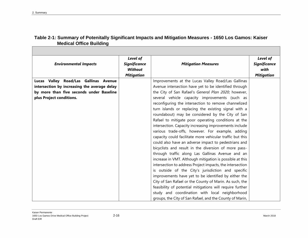
Lucas Valley Road/Las Gallinas Avenue
intersection by increasing the average delay
by more than five seconds under Baseline
plus Project conditions.
Improvements at the Lucas Valley Road/Las Gallinas
Avenue intersection have yet to be identified through
the City of San Rafael’s General Plan 2020; however,
several vehicle capacity improvements (such as
reconfiguring the intersection to remove channelized
turn islands or replacing the existing signal with a
roundabout) may be considered by the City of San
Rafael to mitigate poor operating conditions at the
intersection. Capacity increasing improvements include
various trade-offs, however. For example, adding
capacity could facilitate more vehicular traffic but this
could also have an adverse impact to pedestrians and
bicyclists and result in the diversion of more pass-
through traffic along Las Gallinas Avenue and an
increase in VMT. Although mitigation is possible at this
intersection to address Project impacts, the intersection
is outside of the City’s jurisdiction and specific
improvements have yet to be identified by either the
City of San Rafael or the County of Marin. As such, the
feasibility of potential mitigations will require further
study and coordination with local neighborhood
groups, the City of San Rafael, and the County of Marin,

2. Summary
Kaiser Permanente
1650 Los Gamos Drive Medical Office Building Project 2-17 March 2018
Draft EIR
Table 2-1: Summary of Potenitally Significant Impacts and Mitigation Measures - 1650 Los Gamos: Kaiser
Medical Office Building
Environmental Impacts
Level of
Significance
Without
Mitigation
Mitigation Measures
Level of
Significance
with
Mitigation
who operates and maintains the existing traffic signal.
Since the City cannot legally implement mitigation
measures outside of its jurisdiction, this potential
mitigation is infeasible from both a legal and public
policy standpoint. Ultimately, the City of San Rafael, in
coordination with the County of Marin, would be
responsible for implementing improvements, of which
Kaiser Permanente would pay its fair share; however, as
discussed above, since the intersection is not part of a
traffic fee program and intersection improvements
have yet to be identified, the Project would result in a
significant and unavoidable.
Impact TRAF-4: The proposed Project
would contribute to deficient operations of
the Lucas Valley Road/Las Gamos Drive
intersection by increasing the average delay
by more than five seconds under Baseline
plus Project conditions.
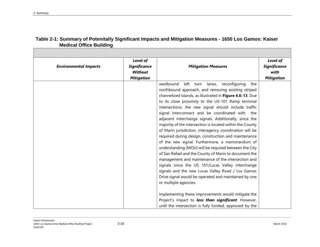
PS MM TRAF-4. Signalize and Reconfigure the Lucas
Valley Road/Los Gamos Drive Intersection. In
coordination with the City of San Rafael Department of
Public Works, the County of Marin Department of
Public Works, and Caltrans, Kaiser Permanente shall pay
a fair share contribution to the reconfiguring and
signalization of the Lucas Valley Road/Los Gamos Drive
Intersection. The San Rafael General Plan 2020 (Exhibit
21 #2 ) identifies improvements at this intersection,
including signalizing the intersection, adding dual
SU
2. Summary
Kaiser Permanente
1650 Los Gamos Drive Medical Office Building Project 2-18 March 2018
Draft EIR
Table 2-1: Summary of Potenitally Significant Impacts and Mitigation Measures - 1650 Los Gamos: Kaiser
Medical Office Building
Environmental Impacts
Level of
Significance
Without
Mitigation
Mitigation Measures
Level of
Significance
with
Mitigation
westbound left turn lanes, reconfiguring the
northbound approach, and removing existing striped
channelized islands, as illustrated in Figure 4.6-13. Due
to its close proximity to the US-101 Ramp terminal
intersections, the new signal should include traffic
signal interconnect and be coordinated with the
adjacent interchange signals. Additionally, since the
majority of the intersection is located within the County
of Marin jurisdiction, interagency coordination will be
required during design, construction and maintenance
of the new signal. Furthermore, a memorandum of
understanding (MOU) will be required between the City
of San Rafael and the County of Marin to document the
management and maintenance of the intersection and
signals since the US 101/Lucas Valley interchange
signals and the new Lucas Valley Road / Los Gamos
Drive signal would be operated and maintained by one
or multiple agencies.
Implementing these improvements would mitigate the
Project’s impact to less than significant. However,
until the intersection is fully funded, approved by the
2. Summary
Kaiser Permanente
1650 Los Gamos Drive Medical Office Building Project 2-19 March 2018
Draft EIR
Table 2-1: Summary of Potenitally Significant Impacts and Mitigation Measures - 1650 Los Gamos: Kaiser
Medical Office Building
Environmental Impacts
Level of
Significance
Without
Mitigation
Mitigation Measures
Level of
Significance
with
Mitigation
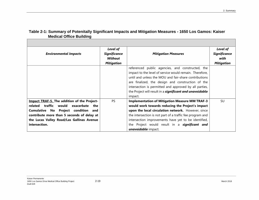
referenced public agencies, and constructed, the
impact to the level of service would remain. Therefore,
until and unless the MOU and fair-share contributions
are finalized, the design and construction of the
intersection is permitted and approved by all parties,
the Project will result in a significant and unavoidable
impact.
Impact TRAF-5. The addition of the Project-
related traffic would exacerbate the
Cumulative No Project condition and
contribute more than 5 seconds of delay at
the Lucas Valley Road/Las Gallinas Avenue
intersection.
PS Implementation of Mitigation Measure MM TRAF-3
would work towards reducing the Project’s impact
upon the local circulation network. However, since
the intersection is not part of a traffic fee program and
intersection improvements have yet to be identified,
the Project would result in a significant and
unavoidable impact.
SU
2. Summary
Kaiser Permanente
1650 Los Gamos Drive Medical Office Building Project 2-20 March 2018
Draft EIR
This page intentionally left blank
2. Summary
Kaiser Permanente
1650 Los Gamos Drive Medical Office Building Project 2-21 March 2018
Draft EIR
Table 2-2: Summary of Impacts and Mitigation Measures - 1650 Los Gamos: Kaiser Medical Office Building
Initial Study
Environmental Impacts
Level of
Significance
Without
Mitigation
Mitigation Measures
Level of
Significance
with
Mitigation
Significant and Unavoidable
Potentially Significant:
Less Than Significant Without Mitigation:
Less than Significant:
(SU)
(PS)
(LTSWM)
(LTS)
(SU)
(PS)
(LTSWM)
(LTS)
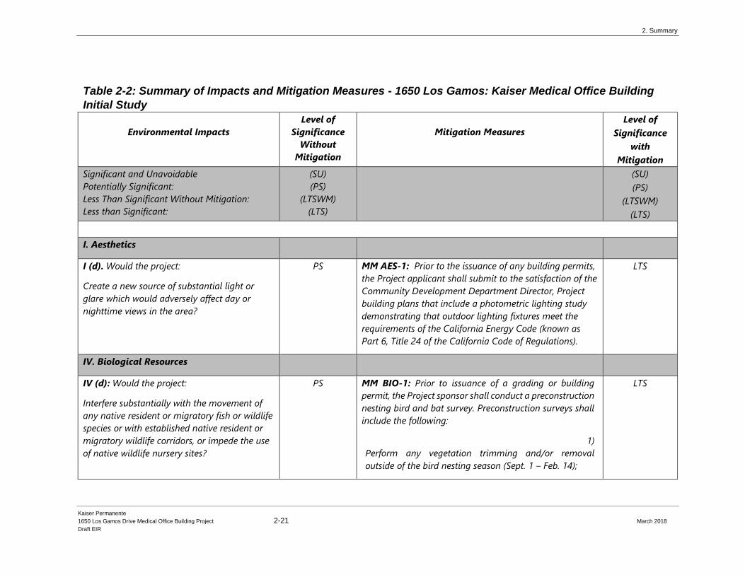
I. Aesthetics
I (d). Would the project:
Create a new source of substantial light or
glare which would adversely affect day or
nighttime views in the area?
PS MM AES-1: Prior to the issuance of any building permits,
the Project applicant shall submit to the satisfaction of the
Community Development Department Director, Project
building plans that include a photometric lighting study
demonstrating that outdoor lighting fixtures meet the
requirements of the California Energy Code (known as
Part 6, Title 24 of the California Code of Regulations).
LTS
IV. Biological Resources
IV (d): Would the project:
Interfere substantially with the movement of
any native resident or migratory fish or wildlife
species or with established native resident or
migratory wildlife corridors, or impede the use
of native wildlife nursery sites?
PS MM BIO-1: Prior to issuance of a grading or building
permit, the Project sponsor shall conduct a preconstruction
nesting bird and bat survey. Preconstruction surveys shall
include the following:
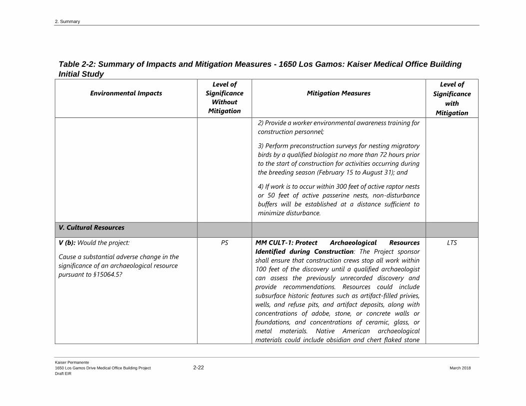
1)
Perform any vegetation trimming and/or removal
outside of the bird nesting season (Sept. 1 – Feb. 14);
LTS
2. Summary
Kaiser Permanente
1650 Los Gamos Drive Medical Office Building Project 2-22 March 2018
Draft EIR
Table 2-2: Summary of Impacts and Mitigation Measures - 1650 Los Gamos: Kaiser Medical Office Building
Initial Study
Environmental Impacts
Level of
Significance
Without
Mitigation
Mitigation Measures
Level of
Significance
with
Mitigation
2) Provide a worker environmental awareness training for
construction personnel;
3) Perform preconstruction surveys for nesting migratory
birds by a qualified biologist no more than 72 hours prior
to the start of construction for activities occurring during
the breeding season (February 15 to August 31); and
4) If work is to occur within 300 feet of active raptor nests
or 50 feet of active passerine nests, non-disturbance
buffers will be established at a distance sufficient to
minimize disturbance.
V. Cultural Resources
V (b): Would the project:
Cause a substantial adverse change in the
significance of an archaeological resource
pursuant to §15064.5?
PS MM CULT-1: Protect Archaeological Resources
Identified during Construction: The Project sponsor
shall ensure that construction crews stop all work within
100 feet of the discovery until a qualified archaeologist
can assess the previously unrecorded discovery and
provide recommendations. Resources could include
subsurface historic features such as artifact-filled privies,
wells, and refuse pits, and artifact deposits, along with
concentrations of adobe, stone, or concrete walls or
foundations, and concentrations of ceramic, glass, or
metal materials. Native American archaeological
materials could include obsidian and chert flaked stone
LTS

2. Summary
Kaiser Permanente
1650 Los Gamos Drive Medical Office Building Project 2-23 March 2018
Draft EIR
Table 2-2: Summary of Impacts and Mitigation Measures - 1650 Los Gamos: Kaiser Medical Office Building
Initial Study
Environmental Impacts
Level of
Significance
Without
Mitigation
Mitigation Measures
Level of
Significance
with
Mitigation
tools (such as projectile and dart points), midden
(culturally derived darkened soil containing heat-affected
rock, artifacts, animal bones, and/or shellfish remains),
and/or groundstone implements (such as mortars and
pestles).
V (d): Would the project:
Disturb any human remains, including those
interred outside of dedicated cemeteries?
PS MM CULT-2: Protect Human Remains Identified
During Construction: The Project proponent shall treat
any human remains and associated or unassociated
funerary objects discovered during soil-disturbing
activities according to applicable State laws. Such
treatment includes work stoppage and immediate
notification of the Marin County Coroner and qualified
archaeologist, and in the event that the Coroner’s
determination that the human remains are Native
American, notification of NAHC according to the
requirements in PRC Section 5097.98. NAHC would
appoint a Most Likely Descendant (MLD). A qualified
archaeologist, Project proponent, County of Marin, and
MLD shall make all reasonable efforts to develop an
agreement for the treatment, with appropriate dignity, of
any human remains and associated or unassociated
funerary objects (CEQA Guidelines Section 15064.5[d]).
The agreement would take into consideration the
appropriate excavation, removal, recordation, analysis,
custodianship, and final disposition of the human remains
LTS
2. Summary
Kaiser Permanente
1650 Los Gamos Drive Medical Office Building Project 2-24 March 2018
Draft EIR
Table 2-2: Summary of Impacts and Mitigation Measures - 1650 Los Gamos: Kaiser Medical Office Building
Initial Study
Environmental Impacts
Level of
Significance
Without
Mitigation
Mitigation Measures
Level of
Significance
with
Mitigation
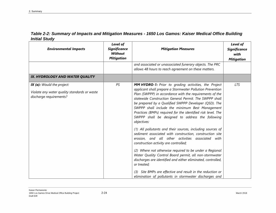
and associated or unassociated funerary objects. The PRC
allows 48 hours to reach agreement on these matters.
IX. HYDROLOGY AND WATER QUALITY
IX (a): Would the project:
Violate any water quality standards or waste
discharge requirements?
PS MM HYDRO-1: Prior to grading activities, the Project
applicant shall prepare a Stormwater Pollution Prevention
Plan (SWPPP) in accordance with the requirements of the
statewide Construction General Permit. The SWPPP shall
be prepared by a Qualified SWPPP Developer (QSD). The
SWPPP shall include the minimum Best Management
Practices (BMPs) required for the identified risk level. The
SWPPP shall be designed to address the following
objectives:
(1) All pollutants and their sources, including sources of
sediment associated with construction, construction site
erosion, and all other activities associated with
construction activity are controlled;
(2) Where not otherwise required to be under a Regional
Water Quality Control Board permit, all non‐stormwater
discharges are identified and either eliminated, controlled,
or treated;
(3) Site BMPs are effective and result in the reduction or
elimination of pollutants in stormwater discharges and
LTS
2. Summary
Kaiser Permanente
1650 Los Gamos Drive Medical Office Building Project 2-25 March 2018
Draft EIR
Table 2-2: Summary of Impacts and Mitigation Measures - 1650 Los Gamos: Kaiser Medical Office Building
Initial Study
Environmental Impacts
Level of
Significance
Without
Mitigation
Mitigation Measures
Level of
Significance
with
Mitigation
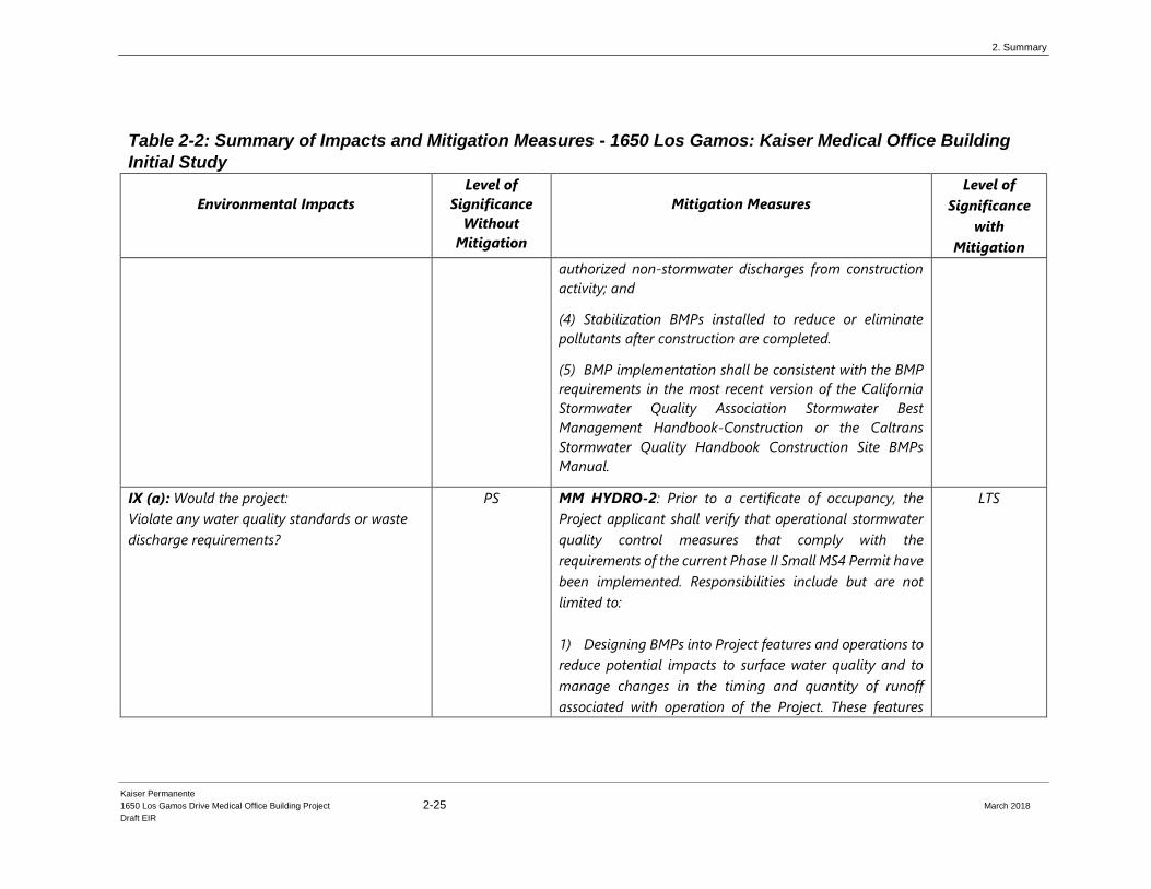
authorized non‐stormwater discharges from construction
activity; and
(4) Stabilization BMPs installed to reduce or eliminate
pollutants after construction are completed.
(5) BMP implementation shall be consistent with the BMP
requirements in the most recent version of the California
Stormwater Quality Association Stormwater Best
Management Handbook‐Construction or the Caltrans
Stormwater Quality Handbook Construction Site BMPs
Manual.
IX (a): Would the project:
Violate any water quality standards or waste
discharge requirements?
PS MM HYDRO-2: Prior to a certificate of occupancy, the
Project applicant shall verify that operational stormwater
quality control measures that comply with the
requirements of the current Phase II Small MS4 Permit have
been implemented. Responsibilities include but are not
limited to:
1) Designing BMPs into Project features and operations to
reduce potential impacts to surface water quality and to
manage changes in the timing and quantity of runoff
associated with operation of the Project. These features
LTS
2. Summary
Kaiser Permanente
1650 Los Gamos Drive Medical Office Building Project 2-26 March 2018
Draft EIR
Table 2-2: Summary of Impacts and Mitigation Measures - 1650 Los Gamos: Kaiser Medical Office Building
Initial Study
Environmental Impacts
Level of
Significance
Without
Mitigation
Mitigation Measures
Level of
Significance
with
Mitigation
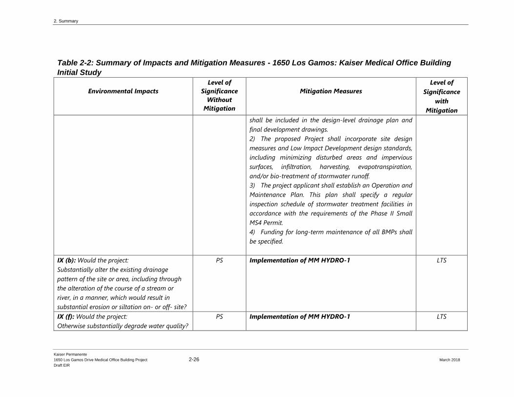
shall be included in the design‐level drainage plan and
final development drawings.
2) The proposed Project shall incorporate site design
measures and Low Impact Development design standards,
including minimizing disturbed areas and impervious
surfaces, infiltration, harvesting, evapotranspiration,
and/or bio‐treatment of stormwater runoff.
3) The project applicant shall establish an Operation and
Maintenance Plan. This plan shall specify a regular
inspection schedule of stormwater treatment facilities in
accordance with the requirements of the Phase II Small
MS4 Permit.
4) Funding for long‐term maintenance of all BMPs shall
be specified.
IX (b): Would the project:
Substantially alter the existing drainage
pattern of the site or area, including through
the alteration of the course of a stream or
river, in a manner, which would result in
substantial erosion or siltation on- or off- site?
PS Implementation of MM HYDRO-1 LTS
IX (f): Would the project:
Otherwise substantially degrade water quality?
PS Implementation of MM HYDRO-1
LTS
2. Summary
Kaiser Permanente
1650 Los Gamos Drive Medical Office Building Project 2-27 March 2018
Draft EIR
Table 2-2: Summary of Impacts and Mitigation Measures - 1650 Los Gamos: Kaiser Medical Office Building
Initial Study
Environmental Impacts
Level of
Significance
Without
Mitigation
Mitigation Measures
Level of
Significance
with
Mitigation
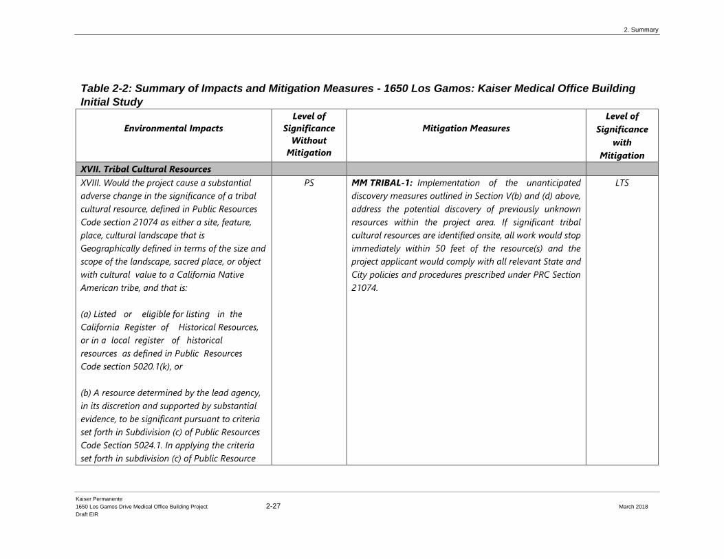
XVII. Tribal Cultural Resources
XVIII. Would the project cause a substantial
adverse change in the significance of a tribal
cultural resource, defined in Public Resources
Code section 21074 as either a site, feature,
place, cultural landscape that is
Geographically defined in terms of the size and
scope of the landscape, sacred place, or object
with cultural value to a California Native
American tribe, and that is:
(a) Listed or eligible for listing in the
California Register of Historical Resources,
or in a local register of historical
resources as defined in Public Resources
Code section 5020.1(k), or
(b) A resource determined by the lead agency,
in its discretion and supported by substantial
evidence, to be significant pursuant to criteria
set forth in Subdivision (c) of Public Resources
Code Section 5024.1. In applying the criteria
set forth in subdivision (c) of Public Resource
PS MM TRIBAL-1: Implementation of the unanticipated
discovery measures outlined in Section V(b) and (d) above,
address the potential discovery of previously unknown
resources within the project area. If significant tribal
cultural resources are identified onsite, all work would stop
immediately within 50 feet of the resource(s) and the
project applicant would comply with all relevant State and
City policies and procedures prescribed under PRC Section
21074.
LTS
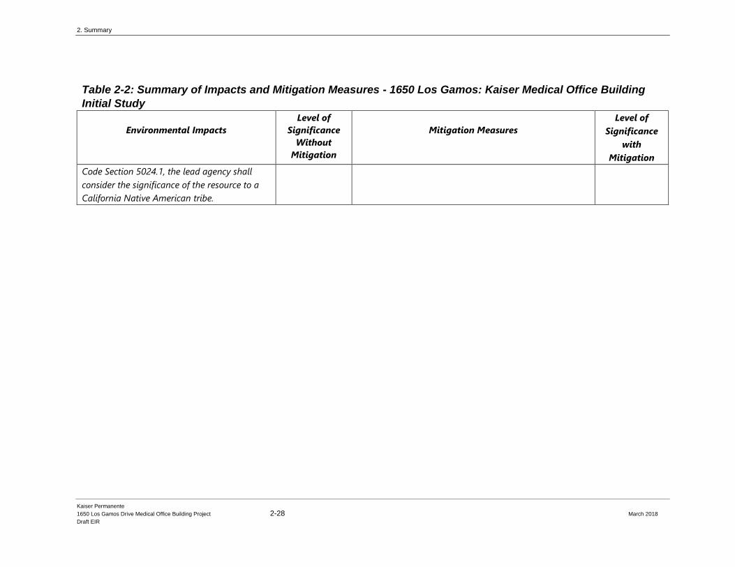
2. Summary
Kaiser Permanente
1650 Los Gamos Drive Medical Office Building Project 2-28 March 2018
Draft EIR
Table 2-2: Summary of Impacts and Mitigation Measures - 1650 Los Gamos: Kaiser Medical Office Building
Initial Study
Environmental Impacts
Level of
Significance
Without
Mitigation
Mitigation Measures
Level of
Significance
with
Mitigation
Code Section 5024.1, the lead agency shall
consider the significance of the resource to a
California Native American tribe.
Kaiser Permanente
1650 Los Gamos Drive Medical Office Building Project 3-1 March 2018
Draft EIR
CHAPTER 3 Project Description
This chapter describes the Kaiser Permanente Medical Office Building (“proposed Project” or
“Project”) proposed by Kaiser Permanente. Topics discussed in this chapter include Project
objectives, geographic setting and location of the Project site, Project characteristics relevant to
the environmental analysis, State of California regulatory context for the Project, and permits and
approvals required for the Project. The design of the parking structure that is analyzed in this
DEIR has been modified slightly since the Initial Study to reflect comments received from the
Design Review Board and community, though the revised design did not change the original
Initial Study conclusions. The exterior design of the parking structure may change as a result of
the on-going Design Review Board process, but the overall massing is anticipated to stay the
same.
3.1 Project Location and Surroundings
3.1.1 Project Location
The Project site is located at 1650 Los Gamos San Rafael, Marin County, California, APNs: 165-
220-12 and 165-220-13. The subject property is approximately 11.1 acres in size located in north
San Rafael and consists of two separate parcels divided by Los Gamos Drive. The 4.09-acre
(178,373 square feet) southeastern parcel is already developed with an existing three-story,
approximately 148,000 square foot office building and associated surface parking. Across Los
Gamos Drive, to the west, is a 7.02-acre (305,947 square feet) parcel developed with an
approximately 80,000 square foot terraced surface parking lot and landscaping. The remainder of
this parcel is characterized by oak woodland. (see Figure 3-1, Project Location Map.)
The Project site is located west of Highway 101 and south of Lucas Valley Road. The existing
building is surrounded by several existing surface parking lots, with a Marin County-owned
building to the south, at 1600 Los Gamos Drive. The Project site is located in a mixed-use
office/commercial area and is separated from the nearest residential neighborhood by an open
space hillside the closest residential structure is approximately 215 feet west and uphill from the
southwest corner of the existing surface parking lot.
The Project site includes three corresponding parcels, two of which are owned by Kaiser
Permanente and a third owned by the County of Marin:
• An existing building at 1650 Los Gamos Drive (Assessor Parcel Number’s [APN]
165-220-13), includes a three-story, approximately 148,000 square foot office building
and associated surface parking on approximately 4.09-acres.
• An approximately 7.02 -acre parcel located to the west of 1650 Los Gamos Drive, on

3. Project Description
Kaiser Permanente
1650 Los Gamos Drive Medical Office Building Project 3-2 March 2018
Draft EIR
San Rafael
Tiburon
SAN PABLO BAY
101
Project Site
San Francisco
Oakland
Richmond
Novato
PACIFIC OCEAN
580
Fairfax
Project Site
Larkspur
Corte Madera
San Anselmo
Figure 3.1: Project Location Map
3. Project Description
Kaiser Permanente
1650 Los Gamos Drive Medical Office Building Project 3-3 March 2018
Draft EIR
the west side of Los Gamos Drive (APN 165-220-12). The parcel currently consists of a
surface parking lot and vegetative hillside, and abuts an undeveloped hillside slope,
with a single-family subdivision above. There is also an existing sanitary sewer line
running through the parcel.
• The surface parking site at 1600 Los Gamos Drive (APN 165-220-11), a portion of
which Kaiser holds a parking easement to allow the use of 42 parking spaces for 1650
Los Gamos Drive.
Together, these parcels are the “Project” site.
The Project site and surrounding areas is shown in Figure 3-2, Aerial of Project Site and
Surroundings.
3.1.2 Existing General Plan and Zoning Designations
The City of San Rafael General Plan 2020 Land Use designation for the Project site is “O –
Office.” The City of San Rafael Zoning designation for the Project site is Planned Development
(PD 1590). PD 1590 allows for general and administrative office uses and a computer center.
The area west of Los Gamos Drive is limited to parking uses only. PD 1590 encompasses
approximately 33 acres which also includes the existing building at 1600 Los Gamos Drive and
associated surface parking lots. Currently, both the 1600 and 1650 Los Gamos Drive buildings
constitute 490,000 square feet of office space with 1,296 total parking spaces and are referred to
jointly as the “Marin Commons.”
3.1.3 Background and Existing Ownership
Kaiser Permanente owns the two parcels at 1650 Los Gamos Drive and is one of the nation’s
leading health care providers and not-for-profit health plans providing integrated managed care
with a focus on prevention. The Project site is located within the Kaiser Permanente San Rafael
Medical Center Service Area that serves approximately 137,000 members in Marin and Southern
Sonoma Counties.
The San Rafael Medical Center main campus is located at 99 Montecillo Road with a 116- bed
hospital, emergency department, and on-site medical office buildings. The facility has functioned
in its current configuration since 1977 with over half the buildings between 40 to 55 years old. At
the same time, medicine has changed over the last 50 years, including the need for larger physical
space to accommodate medical technology such as MRIs and CT scanners that were not part of
the original campus design.
In addition to the main campus, other Kaiser Permanente facilities in the San Rafael Service Area
are located at: downtown San Rafael; Smith Ranch Road in San Rafael; Petaluma; Novato; and
Mill Valley. Kaiser Permanente members in Petaluma and the Town of Sonoma receive most of
their care at the Petaluma Medical Offices.
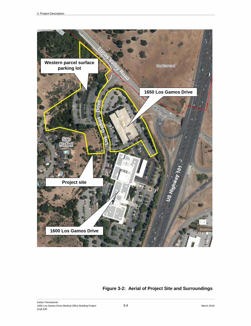
3. Project Description
Kaiser Permanente
1650 Los Gamos Drive Medical Office Building Project 3-4 March 2018
Draft EIR
1600 Los Gamos Drive
1650 Los Gamos Drive
Project site
Western parcel surface
parking lot
Figure 3-2: Aerial of Project Site and Surroundings
3. Project Description
Kaiser Permanente
1650 Los Gamos Drive Medical Office Building Project 3-5 March 2018
Draft EIR
Available space on the main Kaiser Permanente campus at 99 Montecillo Road is constrained
with limited ability to enhance existing services or renovate clinical areas. To better serve the
needs of the Kaiser Permanente members, as well as to make the existing medical center less
crowded, Kaiser Permanente purchased 1650 Los Gamos Drive in the summer of 2015 for use as
a new Medical Office Building (MOB). The Project proposes to add medical office uses as a
permitted use (along with general office) within the existing internally renovated 1650 Los
Gamos Drive office building.
3.1.4 Surrounding Uses
The Project site is set within the larger context of north central Marin County, a suburban area
dominated by low to medium density residential development, shopping centers, and smaller
commercial districts that include retail and/or office development. Parks and open space areas exist
throughout the area, with the largest being regional open space preserves of Lucas Valley and
Terra Linda about 1.5 miles west and southwest of the Project site, and McInnis Park, a local
Marin County park of 72 acres approximately one mile east of the Project site. The local terrain is
variable with large expanses of level topography interspersed with many low-lying hillsides. Mt.
Tamalpais (elevation of 2,574 feet above mean sea level) forms the dominant visual feature from
many locations in this portion of Marin County along the US Highway 101 corridor.
The existing 1650 Los Gamos Drive office building is located within a level area that is
surrounded by surface parking areas on four sides. Los Gamos Drive borders the building site to
the west with vegetated hillsides further west. On the west side of Los Gamos Drive is the
existing surface parking lot that also serves 1650 Los Gamos Drive, and is characterized with
small terraces stepping up the site towards the west. The nearest residence in the Mont
Marin/San Rafael Park neighborhood is located approximately 215 feet west and above the
proposed parking structure. Los Gamos Drive, which divides the two parcels of the Project site, includes curbside parking
and landscaped pedestrian sidewalks areas in the vicinity of the Project site. Mature street trees
include live oak, ash, and sycamore that provide effective screening of the existing office
building and surface parking area for north and southbound motorists on Los Gamos Drive.
Immediately adjacent and east of the Project site is US Highway 101, a major eight lane
north/south freeway. To the east of US 101 is the North San Rafael Commercial District which is
characterized with low one and two-story office, commercial and light industrial buildings. To
the north of the Project site is Lucas Valley Road, a major east-west arterial road connecting
central Marin County with west Marin County. To the north of Lucas Valley Road is the
undeveloped open spaces of the Oakview Master Plan property located in the boundaries of
Marin County. Immediately south of the Project site is 1600 Los Gamos Drive, a three-story
office building and surface parking lot currently occupied by the Marin County Sherriff’s Office.
The YMCA Club is located farther south of the site, near the end of Los Gamos Drive. Los
Gamos Drive terminates at a parking lot for 1400 Los Gamos Drive, a two-story office building.
There is no vehicle access beyond this parking area, however, emergency and bicycle access are
allowed through to a southern portion of Los Gamos Drive that becomes Los Gamos Road.
3. Project Description
Kaiser Permanente
1650 Los Gamos Drive Medical Office Building Project 3-6 March 2018
Draft EIR
3.2 Existing Site Conditions
3.2.1 Existing Development
The existing three-story building at 1650 Los Gamos Drive was opened in 1981 and the Project
site consists of two fee title parcels and an adjacent access and parking easement area, as
described above. Although substantial portions of the building have historically been occupied,
approximately 7% of the building is currently leased to two office tenants, Tequila Partida
(beverages) and 10,000 Degrees (a non-profit organization that assists low-income students to
attend college), and the remaining of the building is vacant. Tequila Partida will be relocated to a
space on the first floor (the same level where 10,000 Degrees is already located), and both
businesses will continue to occupy space in the building per the terms of their existing leases,
including potential renewal options. These two existing uses are allowed under the existing
zoning and as part of the Project will be replaced with medical office uses at the end of their lease
term.
The 1650 Los Gamos Drive building and the larger adjacent building at 1600 Los Gamos Drive
are within the same PD District known as the “Marin Commons” development. The 1600 Los
Gamos Drive building is currently owned by County of Marin and includes the Marin County
Office of Emergency Services and Sheriff’s Department, the Marin County Department of Public
Works Real Estate, and the Bright Horizons private preschool/day care and the private Fusion
Academy school.
Existing Access and Circulation
Vehicular access to the existing office building is provided from Los Gamos Drive. There are
three existing driveways on the east side of Los Gamos Drive that provide primary access to the
existing building. The surface parking lot on the west side of Los Gamos Drive has two existing
access driveways at both the north and south ends of the lot.
Pedestrians access the Project site from the sidewalks on both sides of Los Gamos Drive,
connecting to sidewalks along Lucas Valley Road, as well as informal walkways and paths to the
bus pad/stop at the Highway 101 ramp interchange to the east of the Project site. Bicyclists access
the Project site from the existing Class II bike lane on Lucas Valley Road.
3.2.2 Existing Parking
The 1650 Los Gamos Drive property currently includes two surface parking lots on either side of
Los Gamos Drive. There are currently a total of 455 existing parking spaces allocated to the
Project site consisting of:
• 204 spaces surrounding the building at 1650 Los Gamos Drive
• 209 spaces on the existing surface parking lot on the west side of Los Gamos Drive
3. Project Description
Kaiser Permanente
1650 Los Gamos Drive Medical Office Building Project 3-7 March 2018
Draft EIR
• 42 spaces located on the adjacent 1600 Los Gamos Drive property, (legally
allocated to 1650 Los Gamos Drive through an easement)
The overall Project Site currently provides approximately 3 parking spaces to 1,000 square feet of
office space (a parking ratio of 3:1,000), consistent with the City’s municipal code provisions in
place at the time the building was originally constructed. To meet current City parking
requirements, Kaiser Permanente is required to provide additional parking, as discussed below.
Figure 3-3, Parking Supply Site Plan, depicts all the parking spaces as currently allotted to the
Project site.
3.2.3 Existing Landscaping and Vegetation
The Project site includes mature parking-lot landscaping and natural vegetation, including oak
woodland consisting of coast live and valley oaks, and grasslands typical of Marin County. The
surface parking lot area on the western parcel includes mature landscape trees planted throughout
the various terraces, including southern magnolias, Chinese pistache, ash, redwoods, and other
varietals. Several large redwood trees border the west and south edge of the western parcel
surface parking lot.
3.3 Proposed Project
3.3.1 Project Description
This section describes the major building development components of the proposed Project,
including the conversion of the existing office building for use as a medical office building
(MOB) and the development of the proposed parking structure. No modifications are proposed
for the exterior of the existing office building, with the exception of new minor exterior finishes,
including paint schemes consistent with the Kaiser Permanente brand and landscaping upgrades.
Solar panels may be added to the surface parking surrounding the medical office building in the
future. Internal improvements would include remodeling existing spaces to accommodate the
required medical office uses. In conjunction with the renovation to the office building, the Project
includes the construction of a new three-level, plus upper ramp, parking structure on the parcel
west of Los Gamos Drive. Buildout of the proposed parking structure is illustrated in Figure 3-
4, Proposed Site Plan, and Figure 3-5, Proposed Lot Coverage.
Other relevant Project components, such as proposed landscaping and utility improvements
required to accommodate the proposed building development, are discussed below.
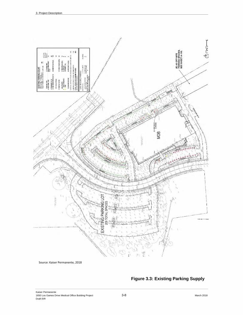
3. Project Description
Kaiser Permanente
1650 Los Gamos Drive Medical Office Building Project 3-8 March 2018
Draft EIR
Figure 3.3: Existing Parking Supply
Source: Kaiser Permanente, 2018
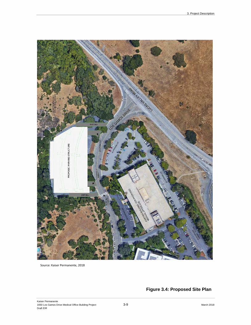
3. Project Description
Kaiser Permanente
1650 Los Gamos Drive Medical Office Building Project 3-9 March 2018
Draft EIR
Figure 3.4: Proposed Site Plan
Source: Kaiser Permanente, 2018
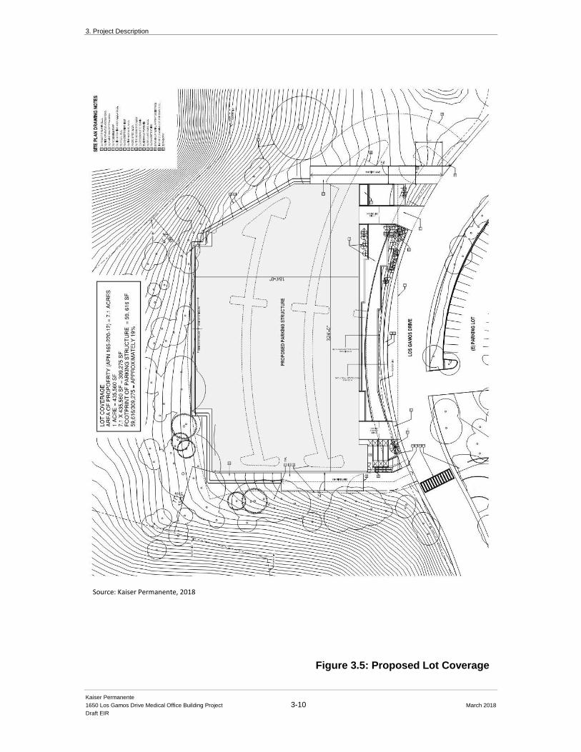
3. Project Description
Kaiser Permanente
1650 Los Gamos Drive Medical Office Building Project 3-10 March 2018
Draft EIR
Figure 3.5: Proposed Lot Coverage
Source: Kaiser Permanente, 2018
3. Project Description
Kaiser Permanente
1650 Los Gamos Drive Medical Office Building Project 3-11 March 2018
Draft EIR
3.3.2 Project Objectives
The proposed Project will provide Kaiser Permanente with a central, modernized facility,
supplemental to and supportive of existing facilities, large enough to house the necessary medical
services for the central Marin County member base. As such, the following are the primary
Project objectives as outlined by Kaiser Permanente:
1. Provide high quality, affordable health care in a new, approximately 150,000 square foot
centralized outpatient facility for Kaiser Permanente members and the greater Marin
County area by reusing an existing building and surface parking lot area in a practical
and cost-effective manner.
2. Immediately supplement and support existing Kaiser Permanente medical offices and
support services in the North Bay region in one consolidated location, allowing for the
ability to:
i. right-size spaces to decompress existing services and providers,
ii. modernize clinical areas of the existing Kaiser Permanente San Rafael
Medical Center, and
iii. provide enhanced medical services for local residents at a conveniently
located facility.
3. Facilitate the logical, orderly development of an infill site in order to achieve a
beneficial set of end uses at a site with good freeway access and proximity to public
transportation.
4. Positively contribute to the local economy through new capital investment.
5. Design the new MOB in a manner so as to meet the evolving and varied health care
demands of Kaiser Permanente members and the residents of San Rafael within the
framework of Kaiser Permanente resources and changing health care industry practices.
6. Provide an environment that is easy to negotiate and access for pedestrians,
bicyclists, and vehicles, including persons with disabilities. Create pedestrian circulation
that is clear and safe.
7. Implement a MOB and parking structure that are aesthetically compatible with
surrounding development and do not unduly impact existing views.
3.3.3 Parking Structure
The existing building is served by 455 existing parking spaces, which, as stated earlier, met prior
City of San Rafael requirements in place at the time the building was originally constructed. The
current City municipal code requires a parking ratio of 4.4 spaces per 1,000 square feet of
development for medical uses, a shortfall of approximately 203 parking spaces once the entire
building is converted to medical office. As a result, Kaiser Permanente needs to provide at least
203 additional parking spaces (or 651 spaces total) to meet the City’s minimum requirements. In
addition, based on its experience, Kaiser Permanente’s preferred parking ratio is 5:1,000 (or about
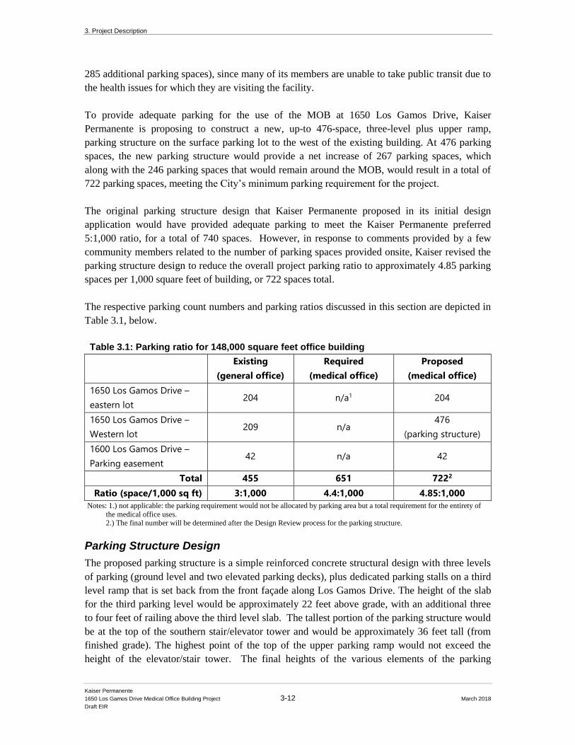
3. Project Description
Kaiser Permanente
1650 Los Gamos Drive Medical Office Building Project 3-12 March 2018
Draft EIR
285 additional parking spaces), since many of its members are unable to take public transit due to
the health issues for which they are visiting the facility.
To provide adequate parking for the use of the MOB at 1650 Los Gamos Drive, Kaiser
Permanente is proposing to construct a new, up-to 476-space, three-level plus upper ramp,
parking structure on the surface parking lot to the west of the existing building. At 476 parking
spaces, the new parking structure would provide a net increase of 267 parking spaces, which
along with the 246 parking spaces that would remain around the MOB, would result in a total of
722 parking spaces, meeting the City’s minimum parking requirement for the project.
The original parking structure design that Kaiser Permanente proposed in its initial design
application would have provided adequate parking to meet the Kaiser Permanente preferred
5:1,000 ratio, for a total of 740 spaces. However, in response to comments provided by a few
community members related to the number of parking spaces provided onsite, Kaiser revised the
parking structure design to reduce the overall project parking ratio to approximately 4.85 parking
spaces per 1,000 square feet of building, or 722 spaces total.
The respective parking count numbers and parking ratios discussed in this section are depicted in
Table 3.1, below.
Table 3.1: Parking ratio for 148,000 square feet office building
Existing
(general office)
Required
(medical office)
Proposed
(medical office)
1650 Los Gamos Drive –
eastern lot 204 n/a1 204
1650 Los Gamos Drive –
Western lot 209 n/a
476
(parking structure)
1600 Los Gamos Drive –
Parking easement 42 n/a 42
Total 455 651 7222
Ratio (space/1,000 sq ft) 3:1,000 4.4:1,000 4.85:1,000
Notes: 1.) not applicable: the parking requirement would not be allocated by parking area but a total requirement for the entirety of
the medical office uses. 2.) The final number will be determined after the Design Review process for the parking structure.
Parking Structure Design
The proposed parking structure is a simple reinforced concrete structural design with three levels
of parking (ground level and two elevated parking decks), plus dedicated parking stalls on a third
level ramp that is set back from the front façade along Los Gamos Drive. The height of the slab
for the third parking level would be approximately 22 feet above grade, with an additional three
to four feet of railing above the third level slab. The tallest portion of the parking structure would
be at the top of the southern stair/elevator tower and would be approximately 36 feet tall (from
finished grade). The highest point of the top of the upper parking ramp would not exceed the
height of the elevator/stair tower. The final heights of the various elements of the parking

3. Project Description
Kaiser Permanente
1650 Los Gamos Drive Medical Office Building Project 3-13 March 2018
Draft EIR
structure may change slightly through the design review process, but the parking structure will
not exceed the maximum height allowed of 36 feet.
As proposed, the parking structure would not exceed 476 parking spaces, but at a minimum,
would provide enough spaces to meet the City required parking shortfall of 203 parking spaces.
The parking structure will have an enclosed elevator and stair element at the southeast corner
adjacent to the existing cross walk and vehicular entry. The elevator/stair element will be clad in
a material that will provide texture meant to be compatible with the concrete structure. Use of the
same cladding at the upper portion of the northeast corner is intended to define the vehicular
entry/exit and wraps the stairs at this end to relate to the elevator/stair element at the opposite end.
The design shown in this DEIR may change slightly as the project moves through the City’s
Design Review Board process, but it is anticipated that changes would be related to the skin of
the structure versus the overall massing. The parking structure will be fully sprinklered and
outfitted with fire extinguishers/cabinets per current codes and ordinances. Fire access will also
be provided by fire lanes on both the north and south side of the parking structure, and from Los
Gamos Drive. The parking structure will have LED lighting throughout and will be fully
accessible per ADA requirements. Figures 3-6 (a) through (d) below depict the new parking
structure plan and sections. Figure 3-7 depicts the exterior rendering and the site section. Figure
3-8 depicts the proposed parking structure in a photo simulation with before and after views from
Los Gamos Drive. The top level of the proposed parking structure is designed to accommodate a
shade structure that could support photovoltaic arrays and serve to partially screen the parking
deck. Based on initial studies, it is anticipated that the parking structure panels would provide
most of the power necessary for the parking structure. Situated along either side of the drive
aisles, the shade structures will be approximately 18 feet wide by 200 feet long. Panels will be
oriented to maximize efficiency while mitigating the potential for glare to adjacent hillside
properties. The shade structure would be constructed of light gauge steel framing and will feature
a non-reflective coating on top.
3.3.4 Site Access and Circulation
Vehicular Access
Vehicular access to the new MOB would be provided from Los Gamos Drive. The three existing
driveways on the east side of Los Gamos Drive will continue to provide primary access to the
existing building. The north entrance would provide access to the surface parking lot to the north
of the existing building, as well as provide access to the rear (east) entrance to the lower floor.
The middle driveway access would serve as the main MOB access for patient drop-off and pick-
up. Vehicles would continue south in front of the MOB and exit onto Los Gamos Drive at the
southern driveway. There are 27 parking spaces located in the access loop, including 27 regular
angled spaces for short-term and visitor serving and five Americans with Disabilities Act (ADA)
accessible spaces to remain. Seven accessible spaces would also be located at the rear/eastern
entrance to the MOB. The southern driveway access would also include access for deliveries and
other non-patient vehicles needed to serve the Project.
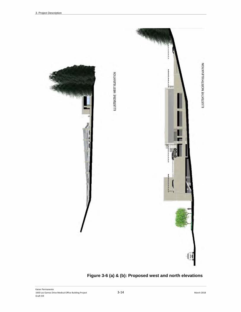
3. Project Description
Kaiser Permanente
1650 Los Gamos Drive Medical Office Building Project 3-14 March 2018
Draft EIR
Figure 3-6 (a) & (b): Proposed west and north elevations
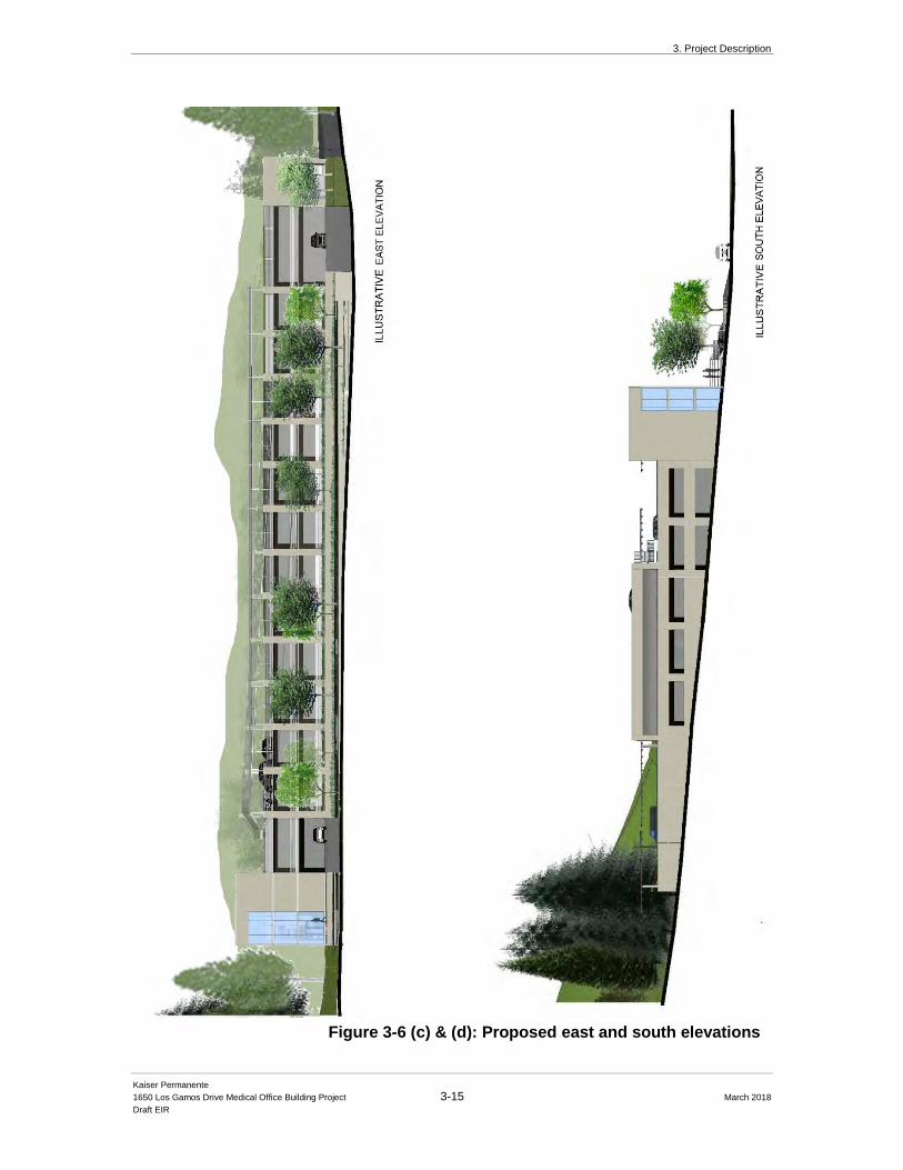
3. Project Description
Kaiser Permanente
1650 Los Gamos Drive Medical Office Building Project 3-15 March 2018
Draft EIR
Figure 3-6 (c) & (d): Proposed east and south elevations
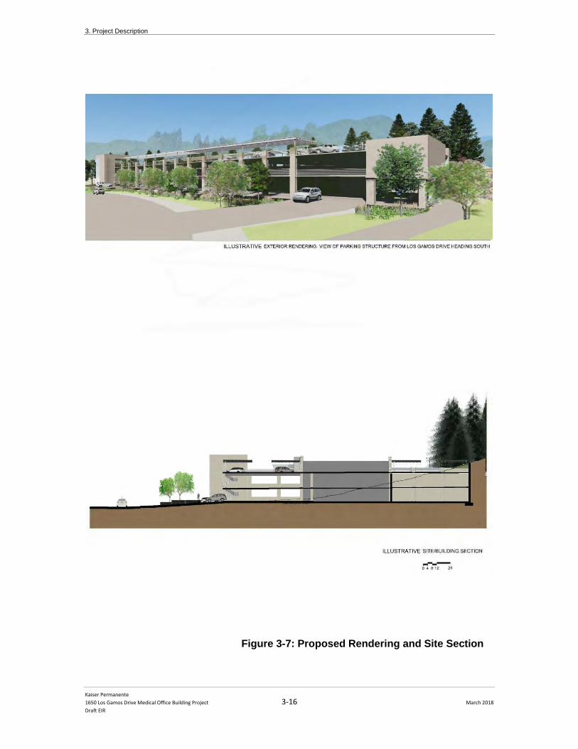
3. Project Description
Kaiser Permanente
1650 Los Gamos Drive Medical Office Building Project 3-16 March 2018
Draft EIR
Figure 3-7: Proposed Rendering and Site Section
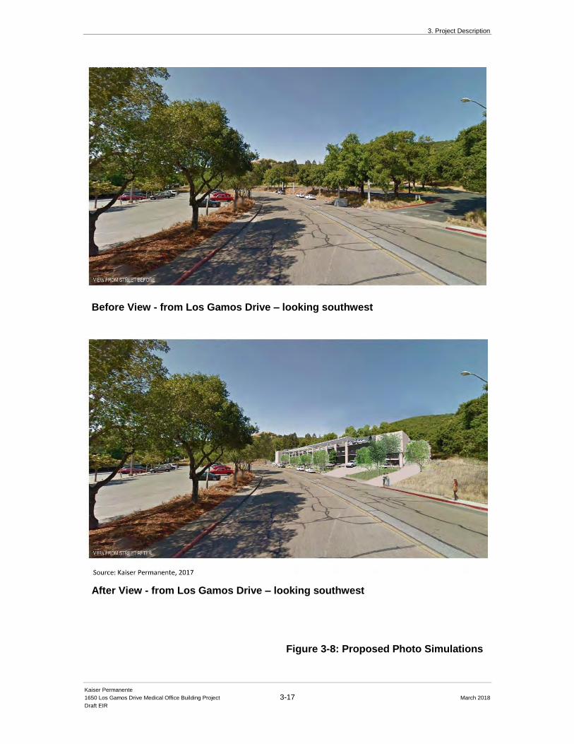
3. Project Description
Kaiser Permanente
1650 Los Gamos Drive Medical Office Building Project 3-17 March 2018
Draft EIR
Figure 3-8: Proposed Photo Simulations
Before View - from Los Gamos Drive – looking southwest
After View - from Los Gamos Drive – looking southwest
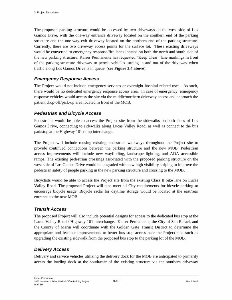
3. Project Description
Kaiser Permanente
1650 Los Gamos Drive Medical Office Building Project 3-18 March 2018
Draft EIR
The proposed parking structure would be accessed by two driveways on the west side of Los
Gamos Drive, with the one-way entrance driveway located on the southern end of the parking
structure and the one-way exit driveway located on the northern end of the parking structure.
Currently, there are two driveway access points for the surface lot. These existing driveways
would be converted to emergency response/fire lanes located on both the north and south side of
the new parking structure. Kaiser Permanente has requested “Keep Clear” lane markings in front
of the parking structure driveway to permit vehicles turning in and out of the driveway when
traffic along Los Gamos Drive is in queue. (see Figure 3.4 above).
Emergency Response Access
The Project would not include emergency services or overnight hospital related uses. As such,
there would be no dedicated emergency response access area. In case of emergency, emergency
response vehicles would access the site via the middle/northern driveway access and approach the
patient drop-off/pick-up area located in front of the MOB.
Pedestrian and Bicycle Access
Pedestrians would be able to access the Project site from the sidewalks on both sides of Los
Gamos Drive, connecting to sidewalks along Lucas Valley Road, as well as connect to the bus
pad/stop at the Highway 101 ramp interchange.
The Project will include reusing existing pedestrian walkways throughout the Project site to
provide continued connections between the parking structure and the new MOB. Pedestrian
access improvements will include new wayfinding, landscape lighting, and ADA accessible
ramps. The existing pedestrian crossings associated with the proposed parking structure on the
west side of Los Gamos Drive would be upgraded with new high visibility striping to improve the
pedestrian safety of people parking in the new parking structure and crossing to the MOB.
Bicyclists would be able to access the Project site from the existing Class II bike lane on Lucas
Valley Road. The proposed Project will also meet all City requirements for bicycle parking to
encourage bicycle usage. Bicycle racks for daytime storage would be located at the east/rear
entrance to the new MOB.
Transit Access
The proposed Project will also include potential designs for access to the dedicated bus stop at the
Lucas Valley Road / Highway 101 interchange. Kaiser Permanente, the City of San Rafael, and
the County of Marin will coordinate with the Golden Gate Transit District to determine the
appropriate and feasible improvements to better bus stop access near the Project site, such as
upgrading the existing sidewalk from the proposed bus stop to the parking lot of the MOB.
Delivery Access
Delivery and service vehicles utilizing the delivery dock for the MOB are anticipated to primarily
access the loading dock at the south/rear of the existing structure via the southern driveway
3. Project Description
Kaiser Permanente
1650 Los Gamos Drive Medical Office Building Project 3-19 March 2018
Draft EIR
access. Kaiser will work with its suppliers to ensure delivery vehicles operate in a safe manner to
avoid conflict with pedestrian, bicycle and other vehicular traffic on the site.
Transportation Demand Management Program
The San Rafael Medical Center operates an existing transportation demand management program
(San Rafael Kaiser Permanente TDM) to increase the use of alternative modes of transportation
by employees. Currently, the San Rafael Kaiser Permanente TDM includes the Kaiser
Permanente facilities at: 99 Montecillo Road, 820 Las Gallinas, 111 Smith Ranch Road, 100
Smith Ranch Road, 7200 Redwood Blvd., 1033 3rd Street, 3900 Lakeville Hwy, and 97 San
Marin Drive. The 1650 Los Gamos Drive MOB would be included into the existing program.
The San Rafael Kaiser Permanente TDM includes the following services for Kaiser Permanente
employees working at the facilities listed above:
• A TDM manager who is responsible for but not limited to: developing
and disseminating transportation information, aiding employees in the
selection of transportation options, and communicating available transit
alternatives
• An on-line transit information center, as part of the internal website that
provides information on San Rafael Kaiser Permanente TDM, that
describes current public transit, vanpools, carpools and shuttle services
serving the area
• A carpool and vanpool matching program
• Commuter subsidy for bicycle, transit or car/vanpool use (current
subsidy is $60/month)
• Pre-tax commuter spending accounts
• Guaranteed Ride Home program
• Designated bicycle parking on-site
• Local Kaiser Shuttle: Shuttle employees to and from SMART Station
and other Kaiser facilities in the City of San Rafael
The MOB will also provide on-site bicycle parking, as well as dedicated parking for
carpool/vanpools and electric charging stations for electric vehicles, to comply with San Rafael
regulatory requirements. The Project’s proposed TDM program is discussed in further detail in
Chapter 4.6: Transportation and Circulation.
3.3.5 Landscape Concept
The proposed parking structure is to be located within the footprint of an existing surface parking
lot to reduce disturbance to undeveloped portions of the project site and preserve as many non-
ornamental trees as possible. As such, the majority of trees proposed for removal are the non-
native, ornamental trees located within the boundaries of the existing western parcel surface
parking lot. The parking structure has been designed expressly to retain as many of the larger
3. Project Description
Kaiser Permanente
1650 Los Gamos Drive Medical Office Building Project 3-20 March 2018
Draft EIR
trees around the perimeter of the existing parking lot by keeping construction and grading outside
the trees’ critical root zones. However, due to the topography of the site and desire to also reduce
the overall height of the parking structure to minimize its visual impact by sinking it into the
hillside, several trees are anticipated to be removed as part of the excavation process and new
trees will be planted around the perimeter of the parking structure. The existing and proposed
perimeter trees will provide screening of the new parking structure and provide habitat for local
species. The design also integrates terraced planter walls that collect and treat stormwater in
native planting beds. The terraces help transition the grade change from street level to the parking
structure. The proposed landscape design concept for the project is depicted in Figure 3-9,
Landscape Concept Plan.
The landscape design is intended to reinforce the character of the surrounding natural
environment while complementing the existing buildings and programs. The Project site is
situated below a prominent woodland hill and within viewsheds that also encompass open area
buffers to residential neighborhoods to the west of the Project site. The existing hillside located
on the west and north side of the proposed parking structure will be maintained and supplemented
with native oak trees and grasses to reinforce an oak woodland vegetation mix, while providing a
visual and acoustic buffer to adjacent uses. The project site contains over 300 existing trees,
including native oaks and redwoods, and other landscape varietals. As part of the Project
evaluation, Urban Forestry Associates (UFA) conducted a tree survey in 2016 and identified 274
trees within the total Project site that could potentially be impacted by proposed improvements.
Of the 274 trees surveyed by UFA, 61 have significance, due to size, and unique character in this
locale. Overall, a total of approximately 63 trees are proposed to be removed and 34 new trees
would be planted around the perimeter of the parking structure as replacement for development of
the Project. The landscape concept plan indicates an additional 19 trees could be impacted due to
their location, resulting in canopy reduction or root zone impacts. Figure 3-10: Tree Inventory
and Proposed Removal depicts trees proposed for removal and trees to remain and protected
during construction. (See the 1650 Los Gamos Initial Study – Appendix B, for a discussion of
tree removal and plantings to occur with the project).
3.3.7 Signage
The proposed Project would include an updated signage program consistent with Kaiser
Permanente’s branding and color scheme. The existing PD has an approved signage program for
the Marin Commons development that would be modified to include specific wayfinding and
informational signage consistent with the Kaiser Permanente theme.
3.3.8 Lighting Concept
The proposed Project would include a lighting program that provides a variety of lighting types.
New and enhanced lighting will include parking lot light poles in parking lots, as well as bollards
and other lighting along other pedestrian paths of travel. Mounted lighting on buildings and
landscape walls would be cast downwards and compliant with City of San Rafael requirements
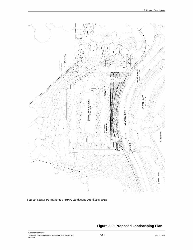
3. Project Description
Kaiser Permanente
1650 Los Gamos Drive Medical Office Building Project 3-21 March 2018
Draft EIR
Figure 3-9: Proposed Landscaping Plan
Source: Kaiser Permanente / RHAA Landscape Architects 2018
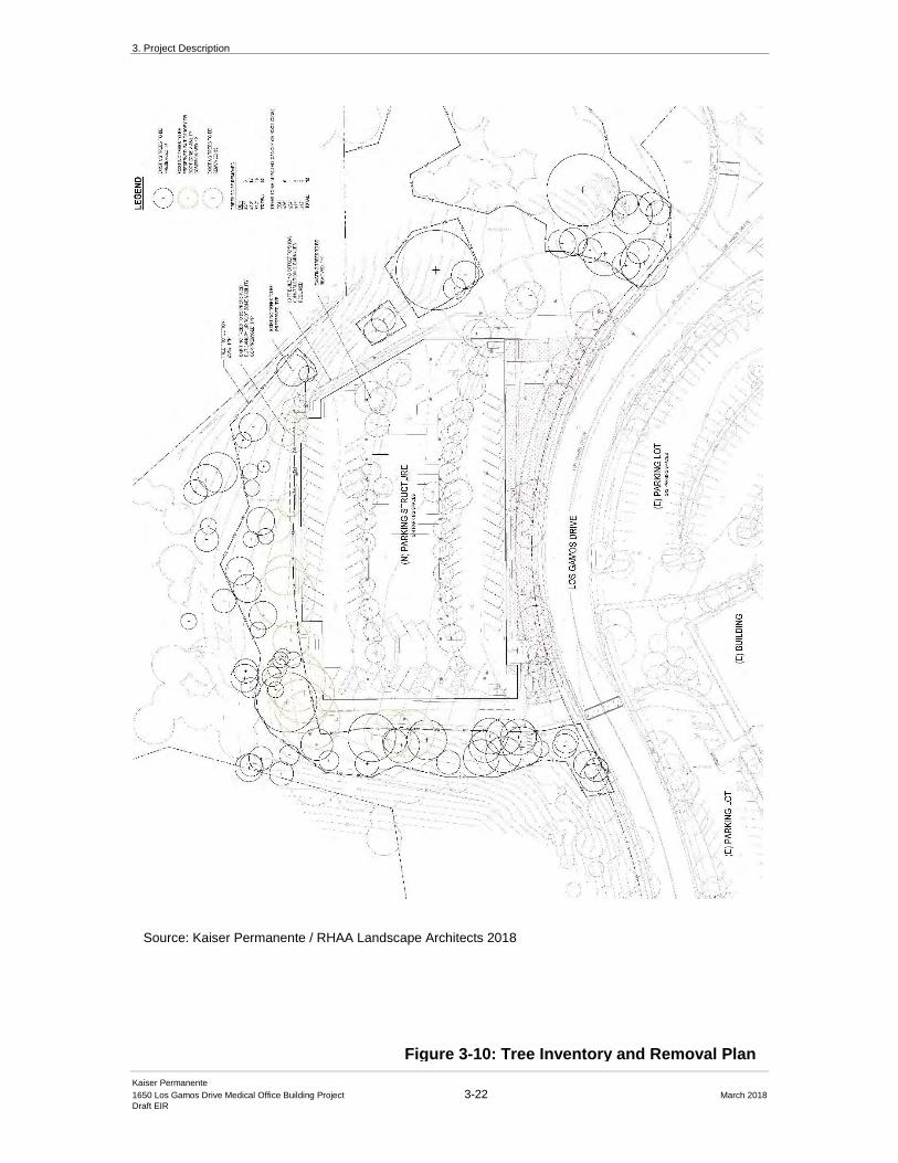
3. Project Description
Kaiser Permanente
1650 Los Gamos Drive Medical Office Building Project 3-22 March 2018
Draft EIR
Figure 3-10: Tree Inventory and Removal Plan
Source: Kaiser Permanente / RHAA Landscape Architects 2018

3. Project Description
Kaiser Permanente
1650 Los Gamos Drive Medical Office Building Project 3-23 March 2018
Draft EIR
for nighttime lighting. Parking lot pole lights would remain unchanged on the parcel surrounding
the existing office building structure. Several existing street pole lights will remain along Los
Gamos Drive.
3.3.9 Grading and Utilities
Excavation Volumes and Off-Haul of Soil
Excavation will be carried out with the goal of minimizing the impact to the existing trees. The
proposed Project site is partly in cut and fill, but mostly cut. The parking structure will have a
concrete retaining wall system integrated with the overall structural system. Retaining walls with
be primarily on the south, west and north sides. The stormwater retention/planter area on the east
side utilizes concrete retainage. Cuts of approximately up to 25 feet in depth may be required for
the new construction. Approximately 30,000 cubic yards (CY) of excavation and off-haul is
preliminarily estimated to be required for development of the proposed parking structure; all of
the excavated materials is anticipated to be hauled offsite to an appropriate disposal site based on
the test results of the soil.
Utilities
A 6-inch public sanitary sewer main, operated and maintained by the Las Gallinas Valley Sanitary
District (LGVSD), runs in a 10-foot easement through the site of the proposed parking structure.
Upon completion and approval of the realigned sanitary sewer facilities, the existing line will be
rerouted to the north of the proposed parking structure and connected to the Los Gamos right-of-
way north of the existing connection per LGVSD standards. (see Figure 3-11: Demolition
Plan).
Storm Drainage and Stormwater Control Concept
All areas of the Project site to be modified or disturbed would be required to incorporate
stormwater quality Best Management Practices (BMPs). The proposed storm drainage scheme for
the Project site includes directing all stormwater runoff from new or modified impervious areas of
the parking structure Project site to landscape-based stormwater filtration areas. The proposed
stormwater management facilities incorporate stormwater quality features such as stormwater
infiltration swales, surface bioswales, and infiltration planters, reducing sources of polluted
stormwater runoff from impervious surfaces. These features will be constructed within the
terraced planter walls along the east side of the parking structure to capture and treat runoff from
the uppermost level of the structure in compliance with C3 requirements. The work around the
MOB and the offsite roadway mitigation measure improvements are not anticipated to trigger any
stormwater requirements, but will comply with the Construction General Permit Order No. 2009-
0009-DWQ, the Caltrans MS4 Program Order No. 2012-0011-DWQ, and the Phase II Small MS4
Permit Order No. 2013-0001-DWQ. (see Figure 3-12: Grading and Utility Plan)
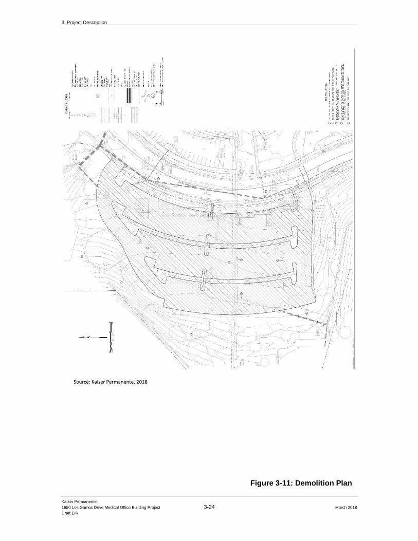
3. Project Description
Kaiser Permanente
1650 Los Gamos Drive Medical Office Building Project 3-24 March 2018
Draft EIR
Figure 3-11: Demolition Plan
Source: Kaiser Permanente, 2018

3. Project Description
Kaiser Permanente
1650 Los Gamos Drive Medical Office Building Project 3-25 March 2018
Draft EIR
Figure 3-12: Grading and Utilities Plan
Source: Kaiser Permanente, 2018
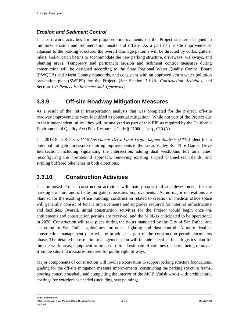
3. Project Description
Kaiser Permanente
1650 Los Gamos Drive Medical Office Building Project 3-26 March 2018
Draft EIR
Erosion and Sediment Control
The earthwork activities for the proposed improvements on the Project site are designed to
minimize erosion and sedimentation onsite and offsite. As a part of the site improvements,
adjacent to the parking structure, the overall drainage patterns will be directed by curbs, gutters,
inlets, and/or catch basins to accommodate the new parking structure, driveways, walkways, and
planting areas. Temporary and permanent erosion and sediment control measures during
construction will be designed according to the State Regional Water Quality Control Board
(RWQCB) and Marin County Standards, and consistent with an approved storm water pollution
prevention plan (SWPPP) for the Project. (See Section 3.3.10: Construction Activities, and
Section 3.4: Project Entitlements and Approvals).
3.3.9 Off-site Roadway Mitigation Measures
As a result of the initial transportation analysis that was completed for the project, off-site
roadway improvements were identified as potential mitigation. While not part of the Project due
to their independent utility, they will be analyzed as part of this EIR as required by the California
Environmental Quality Act (Pub. Resources Code § 21000 et seq., CEQA).
The 2018 Fehr & Peers 1650 Los Gamos Drive Final Traffic Impact Analysis (FTIA) identified a
potential mitigation measure requiring improvements to the Lucas Valley Road/Los Gamos Drive
Intersection, including signalizing the intersection, adding dual westbound left turn lanes,
reconfiguring the northbound approach, removing existing striped channelized islands, and
striping buffered bike lanes in both directions.
3.3.10 Construction Activities
The proposed Project construction activities will mainly consist of site development for the
parking structure and off-site mitigation measures improvements. As no major renovations are
planned for the existing office building, construction related to creation of medical office space
will generally consist of tenant improvements and upgrades required for internal infrastructure
and facilities. Overall, initial construction activities for the Project would begin once the
entitlements and construction permits are received, and the MOB is anticipated to be operational
in 2020. Construction will take place during the hours mandated by the City of San Rafael and
according to San Rafael guidelines for noise, lighting and dust control. A more detailed
construction management plan will be provided as part of the construction permit documents
phase. The detailed construction management plan will include specifics for a logistics plan for
the site work areas, equipment to be used, refined estimate of volumes of debris being removed
from the site, and measures required for public right of ways.
Major components of construction will involve excavation to support parking structure foundations,
grading for the off-site mitigation measure improvements, constructing the parking structure frame,
pouring concrete/asphalt, and completing the interior of the MOB (finish work) with architectural
coatings for exteriors as needed (including new painting).
3. Project Description
Kaiser Permanente
1650 Los Gamos Drive Medical Office Building Project 3-27 March 2018
Draft EIR
Construction Vehicles and Trips
Most of the heavy traffic during construction will be during excavation and off haul days during
the placement of concrete for the parking structure and laying of the roadway for the off-site
mitigation measure improvements. This traffic will most likely be comprised of 10-wheel dump
trucks and concrete trucks, plus delivery trucks for equipment and supplies. During the
excavation and off haul of the excavated material the 10-wheel dump truck traffic would be fairly
continuous and regular. Truck trips will also occur during the off haul of demolition debris from
the site, but in substantially smaller numbers and not during periods that would overlap with the
truck trips associated with construction and excavation.
A detailed construction management plan, including a 24-hour construction hotline, will be
provided as part of the construction permit documents, including logistics plan for the site,
equipment being used, volumes of debris being removed from the site, and impacts to public right
of ways.
3.4 Project Entitlements and Approvals
3.4.1 Lead Agency
The City of San Rafael
The City of San Rafael is the Lead Agency primarily responsible for preparing this DEIR (CEQA
Guidelines § 15051). This DEIR is intended to provide CEQA clearance for all required
discretionary actions for the proposed Project. The City of San Rafael will make decisions on the
following discretionary actions (and other considerations and approvals) that have been
identified, without limitation, at the time this DEIR was prepared:
• Certification of the FEIR
• Approval of the Mitigation Monitoring and Reporting Plan (MMRP)
• Project Approval, including project entitlements
3.4.2 Required Project Approvals and Permits
The applicant proposes the renovation and conversion of an existing three-story office building to
medical office uses and construction of a new three level, with upper ramp open-air parking
structure at the northwest portion of the 11.1-acre Project site. Applications have been submitted
for a Rezoning to revise the Planned Development (PD) zoning, an Environmental and Design
Review Permit to allow the construction of the parking structure and associated site
improvements, a Use Permit to allow medical office uses, and a Sign Program for new building
and site signage. The Project would require additional approvals and permits from local, State and
federal agencies. The Project would require the following zoning entitlements and land use
approvals by the City of San Rafael:
3. Project Description
Kaiser Permanente
1650 Los Gamos Drive Medical Office Building Project 3-28 March 2018
Draft EIR
• Environmental and Design Review (ED17-001) - The Project requires an
Environmental and Design Review Permit because it is proposing a new three-level
parking structure, with upper ramp. The Project is subject to the review criteria for
Environmental and Design Review Permits pursuant to San Rafael Municipal Code
Section 14.25.050, which provide guidelines for all aspects of project design,
including site design, architecture, materials and colors, walls, fences and screening,
exterior lighting, signs and landscape design.
• Use Permit (UP17-005) - The Project includes a request for approval of a use permit
to allow medical office, pursuant to Section 14.07.020 of the San Rafael Municipal
Code.
• PD Rezoning (ZC17-001) – The Project includes a request for PD amendment
(defined as a zoning change under the City’s Municipal Code) to allow medical
office uses in the PD ordinance, pursuant to Section 14.07.150 of the San Rafael
Municipal Code. This action will create a new PD ordinance specific to 1650 Los
Gamos Drive property and remove the Project site from the current PD 1590 that also
includes the 1600 Los Gamos Drive building.
• Sign Program (SP17-002) - The Project includes a request for approval of a signage
master plan for the site.
Existing PD and Amendment Consistency
As part of the Project permit approval process, the City of San Rafael will process an amendment
to the existing PD 1590 district to create a clean version that separates 1600 Los Gamos Drive
from 1650 Los Gamos Drive. This will ensure that prior references to 1650 Los Gamos Drive in
the newly created PD district are separate and apart from the uses and standards attributed to the
PD specific to the 1600 Los Gamos Drive property. This action will remove reference to 1650
Los Gamos Drive in PD 1590, and like the zoning change for the proposed Project, would
therefore create a new PD for the 1600 Los Gamos Drive parcel.
Finally, the Project will require permits from the City of San Rafael to allow construction,
including an Improvement Plan, Encroachment Permit, Grading Permit, and Building Permits for
the parking structure and MOB renovations.
3.4.3 Inter-Agency Coordination
As discussed above in Section 3.3.8: Off-site Roadway Mitigation Measures above, the proposed
Project will require an off-site improvement to the intersection at Lucas Valley Road and Los
Gamos Drive. This intersection is located within both County of Marin and City of San Rafael
jurisdictions. The California Department of Transportation (Caltrans) owns and maintains the US
Highway 101 interchange and signals at Lucas Valley Road adjacent to the Project site and would
also require coordination for modifications or improvements to their infrastructure. As such, any
3. Project Description
Kaiser Permanente
1650 Los Gamos Drive Medical Office Building Project 3-29 March 2018
Draft EIR
potential intersection improvements would require inter-agency coordination and review and
approval of necessary permits. Therefore, while the Project will require specific project
approvals and permits from the City of San Rafael outlined in Section 3.4.2: Required Project Approvals and Permits above, it is still yet to be determined what approvals and permits may be
required from the County of Marin, Caltrans, or other potential permitting agencies.
3.4.4 Responsible and Trustee Agencies
“Responsible Agencies” include “all local and state public agencies other than the lead agency
that have discretionary approval power over the Project (CEQA Guidelines § 15381). A “trustee
agency” is a “state agency having jurisdiction by law over resources affected by the Project that
are held in trust for the people of the State of California” (CEQA Guidelines § 15386). It is not
anticipated that any federal agencies will have permit authority over aspects of the Project. These
agencies may also consider this EIR in their review and decision-making processes. A list of
these other agencies and their jurisdictional permits and approvals include, but are not limited to,
the following:
County of Marin
Marin County is a Responsible Agency pursuant to CEQA because it has the authority to grant
other discretionary approvals required before the City of San Rafael can implement the proposed
Project. (CEQA Guidelines § 15381). A portion of the Project site is located in unincorporated
Marin County. The County will make decisions on the following actions (and other
considerations and approvals) that have been identified at the time this EIR was prepared:
• Any work in the Lucas Valley Road Right of Way (County Public Works)
California Department of Transportation (Caltrans)
Caltrans is a Responsible Agency pursuant to CEQA because it has the authority to grant other
discretionary approvals required before the City of San Rafael can implement the proposed
Project. (CEQA Guidelines § 15381). The Project site is located in unincorporated Marin County.
Caltrans will make decisions on the following actions (and other considerations and approvals)
that have been identified at the time this EIR was prepared:
• Any work in the Lucas Valley Road / Highway 101 Right of Way (Caltrans)
San Francisco Bay Regional Water Quality Control Board (RWQCB)
The RWQCB administers the NPDES, authorized by the federal Clean Water Act, as well as
State water laws to protect water quality. The Project will require compliance with NPDES
through preparation and approval of a Stormwater Pollution Prevention Plan, which encompasses
Standard Urban Stormwater Mitigation Plan requirements and a Stormwater Mitigation Plan. The
Project will require Section 401 Water Quality Certification. The Project will also require
RWQCB acceptance of a Notice of Intent (NOI) to obtain coverage under the General
3. Project Description
Kaiser Permanente
1650 Los Gamos Drive Medical Office Building Project 3-30 March 2018
Draft EIR
Construction Activity Storm Water Permit (General Construction Permit), and Notice of
Termination after construction is complete.
Bay Area Air Quality Management District (BAAQMD)
The BAAQMD has jurisdiction over regional air quality issues, including the operation of
stationary equipment, such as emergency generators, that emit air pollutants. The BAAQMD
could require a new or revised Authority to Construct and Permission to Operate (PTO) permits.
The BAAQMD typically reissues PTOs annually.
Other Local Utility and Service System Providers
The Project will involve new and modified utility systems and potentially expanded services that
will require review and/or approval by local agencies that include, but are not limited to, the
following:
• Marin Municipal Water District (MMWD);
• Las Gallinas Valley Sanitation District (LGVSD);
• Pacific Gas and Electric (PG&E);
• AT&T
Kaiser Permanente
1650 Los Gamos Drive Medical Office Building Project 4.0-1 March 2018
Draft EIR
CHAPTER 4.0
Environmental Setting, Impacts and Mitigation Measures
This chapter contains an analysis of the potentially significant environmental topics that were
either identified in the Kaiser Permanente 1650 Los Gamos Drive Medical Office Building
Project Initial Study or identified in comments received to the NOP.
4.0.1 Determination of Significance
Under CEQA, a significant effect is defined as a substantial, or potentially substantial, adverse
change in the environment (Public Resources Code 21608). The CEQA Guidelines direct that this
determination be based on scientific and factual data. Each impact and mitigation measure section
is prefaced by a summary of the criteria for significance. These criteria have been developed
using the CEQA Guidelines and applicable City policies, as well as the San Rafael General Plan 2020 (General Plan).
4.0.2 Issues Addressed in the Draft EIR
This section addresses Project -related impacts within the following six topic categories:
• Land Use and Planning
• Aesthetics
• Air Quality
• Greenhouse Gas Emissions
• Noise
• Transportation and Circulation
This EIR is prepared pursuant to CEQA § 21080. Each of the six topic sections in this EIR
presents information in three parts, as described below.
Environmental Setting / Existing Conditions
This section briefly describes elements of the Project setting relevant to a discussion of impacts in
the topic category. Existing conditions are the onsite conditions and regional environmental
conditions in existence at the time of publication of the Notice of Preparation (NOP) and Initial
Study (IS), pursuant to CEQA Guidelines § 15125.
4. Environmental Setting, Impacts and Mitigation Measures
Kaiser Permanente
1650 Los Gamos Drive Medical Office Building Project 4.0-2 March 2018
Draft EIR
Regulatory Framework
This section describes applicable federal, state, regional, and local regulations relevant to the
topic category.
Environmental Impacts and Mitigation Measures
This subsection identifies potential impacts that would potentially result to the existing physical
environment should the Project be approved, based on the identified significance criteria.
Potentially significant impacts are numbered sequentially within each section and summarized in
bolded text. For each impact, the summary is followed by text that describes the impact in more
detail. Mitigation measures that can reduce such impacts follow the detailed discussion with a
number that corresponds to the number of the impact. Impacts are also categorized by type of
impact, as follows: Less than Significant, Potentially Significant, and Significant and
Unavoidable. The following notations are provided after each identified potential significant
impact. These notations indicate the level of impact before and after mitigation incorporation.
NI: No Impact
LTS: Less than Significant
LTSWM: Less Than Significant with Mitigation Incorporation
PS: Potentially Significant
SU: Significant and Unavoidable
Pursuant to CEQA Guidelines § 15002, 15021, and 15126.4, mitigation measures are required (as
feasible) when significant impacts are identified. Unless, otherwise noted, all mitigation
measures contained herein are proposed by the lead agency.
4. Environmental Setting, Impacts, and Mitigation Measures
1. Land Use, Plans, and Policies
Kaiser Permanente
1650 Los Gamos Drive Medical Office Building Project 4.1-1 March 2018
Draft EIR
4.1 Land Use, Plans, and Policies
This section addresses Project conflicts with adopted goals and policies of the City of San Rafael
General Plan 2020 intended to eliminate or reduce an environmental impact. The analysis in this
chapter utilizes the City of San Rafael General Plan 2020 and the City of San Rafael Municipal
Code. This section also describes the applicable plans and policies that guide development in the
Project area and evaluates the Project’s consistency with these plans and policies and other existing
land use regulations. The evaluation of potentially significant impacts or conflicts with applicable
plans and policies are identified.
4.1.1 Setting
4.1.1.1 Regional Setting
San Rafael is located in Marin County in the northwestern San Francisco Bay Area. Marin County
contains eleven incorporated cities, of which San Rafael is the county seat. The nearest
incorporated cities to San Rafael and the Project site are San Anselmo, approximately two-and-
a-half miles to the southwest; Ross, approximately three-and-a-half miles to the south; and the
city of Novato approximately five miles to the northwest. The Cities of Larkspur and Corte
Madera are also nearby, located approximately four and four-and-a-half miles to the south,
respectively.
The City of San Francisco is located approximately 18 miles to the south, across the Golden Gate
Bridge, and the City of Richmond is located approximately 12 miles to the east, across the
Richmond Bridge.
4.1.1.2 Site Setting
The subject property is approximately 11.1 acres in size located in north San Rafael. The subject
property consists of two separate parcels bisected by Los Gamos Drive. APN 165-220-13 is a
178,373-square foot parcel previously developed with an existing approximately 148,000 square
foot office building and associated surface parking. Across Los Gamos to the west is APN 165-
220-12, a 305,947-square foot parcel developed with an approximately 80,000 square foot terraced
surface parking lot and landscaping. The remainder of this parcel is characterized by undisturbed
oak woodland and grassland areas. The proposed Project also includes the continued use of 42
existing parking spaces located adjacent to 1650 Los Gamos Drive, on the neighboring 1600 Los
Gamos Drive property. Kaiser Permanente has legal access to the use of those parking spaces
through an easement and is not proposing any changes to the parking spaces. Together, the two
parcels and the surface parking on 1600 Los Gamos Drive are referred to as the “Project site.” An
aerial photo identifying the Project site’s surrounding land uses is provided in Figure 4-1.
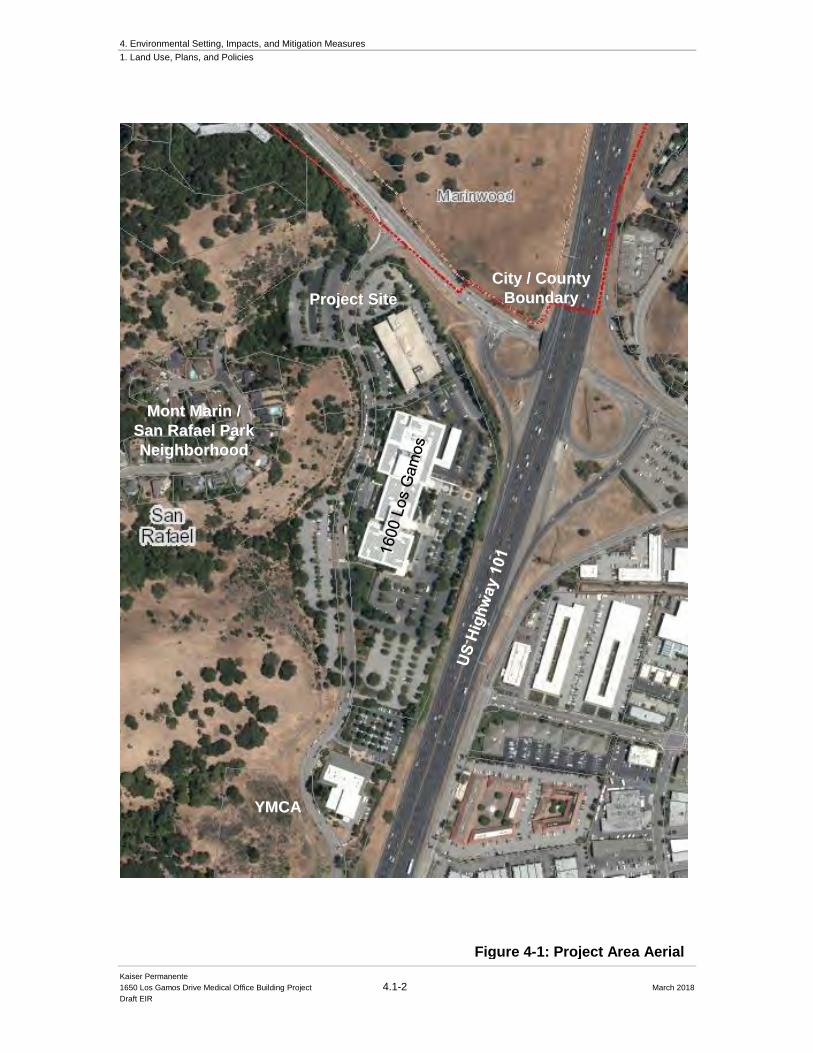
4. Environmental Setting, Impacts, and Mitigation Measures
1. Land Use, Plans, and Policies
Kaiser Permanente
1650 Los Gamos Drive Medical Office Building Project 4.1-2 March 2018
Draft EIR
Figure 4-1: Project Area Aerial
Project Site
YMCA
Mont Marin /
San Rafael Park
Neighborhood
City / County
Boundary
4. Environmental Setting, Impacts, and Mitigation Measures
1. Land Use, Plans, and Policies
Kaiser Permanente
1650 Los Gamos Drive Medical Office Building Project 4.1-3 March 2018
Draft EIR
Surrounding Uses
Immediately adjacent to and east of the Project site is US Highway 101, a major eight lane
north/south freeway. To the east of US Highway 101 is the North San Rafael Commercial District,
which is characterized with low one and two-story office, commercial and light industrial buildings.
To the north of the Project site is Lucas Valley Road, a major east-west arterial road connecting
central Marin County with west Marin County. Further north of Lucas Valley Road is the
undeveloped open spaces of the Oakview Master Plan property located in the jurisdiction of Marin
County. West of the Project site is the Mont San Rafael residential subdivision. This residential
neighborhood also includes areas of undeveloped open space buffers adjacent to the Project site.
The nearest residential structure is approximately 215 feet west and uphill from the southwest
corner of the existing surface parking lot on the western parcel. South of the Project site is 1600
Los Gamos Drive, a 340,000-square foot office building which is owned by Marin County and
includes the County of Marin Office of Emergency Services. Further south of 1600 Los Gamos
Drive is the YMCA.
4.1.2 Regulatory Setting
4.1.2.1 City of San Rafael
San Rafael General Plan 2020
The General Plan 2020 is organized into four sections, which address the various General Plan 2020 Elements: Our Use of Our Land (Land Use, Housing, Neighborhoods, and Community
Design); Our Foundation (Economic Vitality, Circulation, Infrastructure, Governance, and
Sustainability); Our Quality of Life (Culture and the Arts, Parks and Recreation, Safety, and Noise);
and Our Natural Resources (Open Space, Conservation, and Air and Water Quality).
The Neighborhoods Element of the General Plan 2020 addresses neighborhood-specific issues,
while Citywide concerns relating to traffic, and parking, design, and air quality and noise impacts
are addressed elsewhere in the General Plan 2020 in the appropriate element. The Neighborhoods
Element contains the vision for the North San Rafael Commercial Center, which focuses on the
design and identity of the North San Rafael Town Center located in the Northgate commercial area.
However, the policies included in this area of San Rafael are also aimed at maintaining a high
quality of design for the Project site.
Aside from the Land Use Element policies, there are other applicable policies contained in the
Safety, Noise, and Air and Water Quality Elements of the General Plan 2020 that are adopted for
the purpose of avoiding or mitigating an environmental effect (references to exhibits in the
following section pertain to the numbering organization contained in the General Plan 2020).
The General Plan land use designation for the Project site is Office (O). Overall land use goals and
policies applicable to the proposed Project are as follows:
4. Environmental Setting, Impacts, and Mitigation Measures
1. Land Use, Plans, and Policies
Kaiser Permanente
1650 Los Gamos Drive Medical Office Building Project 4.1-4 March 2018
Draft EIR
Land Use Element
LU-2. Development Timing.
For health, safety and general welfare reasons, new development should only occur when
adequate infrastructure is available consistent with the following findings:
a. Project-related traffic will not cause the level of service established in the
Circulation Element to be exceeded;
b. Any circulation improvements needed to maintain the level of service standard
established in the Circulation Element have been programmed and funding has
been committed;
c. Environmental review of needed circulation improvement projects has been
completed;
d. The time frame for completion of the needed circulation improvements will not
cause the level of service in the Circulation Element to be exceeded, or the findings
set forth in Policy C-5 have been made
LU-9. Intensity of Nonresidential Development.
Commercial and industrial areas have been assigned floor area ratios (FARs) to identify
appropriate intensities (see Exhibits 4, 5 and 6). Maximum allowable FARs are not
guaranteed, particularly in environmentally sensitive areas. Intensity of commercial and
industrial development on any site shall respond to the following factors: site resources and
constraints, traffic and access, potentially hazardous conditions, adequacy of infrastructure,
and City design policies.
LU-12. Building Heights.
Citywide height limits in San Rafael are described in Exhibits 7 and 8. For Downtown
height limits see Exhibit 9:
LU-14. Land Use Compatibility.
Design new development in mixed residential and commercial areas to minimize potential
nuisance effects and to enhance their surroundings.
Neighborhood Element
NH-136. Design Excellence. Assure quality of design by supporting policies that encourage harmonious and aesthetically pleasing design for new and existing development. NH-162. Kaiser Permanente Medical Center. Retain uses at the Kaiser Permanente Medical Center and seek ways to improve traffic and parking.
Sustainability Element
SU-2. Promote Alternative Transportation. Decrease miles traveled in single-occupant vehicles. SU-6. Resource Efficiency in Site Development. Encourage site planning and development practices that reduce energy demand, support transportation alternatives and incorporate resource and energy-efficient infrastructure.
4. Environmental Setting, Impacts, and Mitigation Measures
1. Land Use, Plans, and Policies
Kaiser Permanente
1650 Los Gamos Drive Medical Office Building Project 4.1-5 March 2018
Draft EIR
San Rafael Development Code and Zoning
Zoning designation for this site is a Planned Development (PD) District (PD 1590). The PD
was created in 1979 as PD 1350 and subsequently amended in 1990 as PD 1590. Title 14 of the
City’s zoning code (Chapter 14.07.10) states that the specific purposes of a PD district are to:
a) Promote and encourage cluster development on large sites to avoid sensitive areas of
property;
b) Encourage innovative design on large sites by allowing flexibility in
property development standards;
c) Encourage the establishment of open areas in land development;
d) Encourage the assembly of properties that might otherwise be developed in unrelated
increments to the detriment of surrounding neighborhoods;
e) Establish a procedure for the development of large lots of land in order to reduce or
eliminate the rigidity, delays and conflicts that otherwise would result from
application of zoning standards and procedures designed primarily for small lots;
f) Accommodate various types of large-scale, complex, mixed-use,
phased developments; and
g) Enable affected governmental bodies to receive information and provide an integrated
response to both the immediate and long-range impacts of such proposed development
(Or1625 § 1 (part), 1992).
The current PD District designation for the Project site allows for two office buildings totaling
490,000 square feet, a 340,000 square foot office/computer center at 1600 Los Gamos Drive, and
a 150,000 square foot office building at 1650 Los Gamos Drive. The allowable uses as described
in the PD 1590 Exhibit A are general office and computer office/center. The PD district also
specifically cites a requirement for 1,296 parking spaces for both buildings, which, as mentioned
previously, was based on former City parking requirements at that time. The current proposal for
medical office uses in the existing 1650 Los Gamos Drive office building requires amendments
to the PD District and Master Use Permit for the site.
4. Environmental Setting, Impacts, and Mitigation Measures
1. Land Use, Plans, and Policies
Kaiser Permanente
1650 Los Gamos Drive Medical Office Building Project 4.1-6 March 2018
Draft EIR
4.1.3 Impacts and Mitigation Measures
4.1.3.1 Significance Criteria
Utilizing criteria from Appendix G of the State CEQA Guidelines, the project would have a
significant impact on land use, plans, and policies if it would:
a) Physically divide an established community;
b) Conflict with any applicable land use plan, policy, or regulation of an agency with jurisdiction over the project (including, but not limited to the general plan, specific plan, local coastal program, or zoning ordinance) adopted for the purpose of avoiding or mitigating an environmental effect; or
c) Conflict with any applicable habitat conservation plan or natural community conservation plan.
In the context of land use and relevant planning, significant impacts occur when a conflict with any
applicable land use plan, policy, or regulation of an agency with jurisdiction over the Project results
in an adverse physical environmental impact. In relation to the second significance standard stated
above, it should be noted that although the Project requires a PD rezone to allow medical office
uses, it does not necessarily mean it would result in a significant environmental effect.
4.1.3.2 Approach to Analysis
The Project was evaluated for its compatibility with the applicable plans and policies identified
above in the Regulatory Setting section in order to determine the potential for significant
environmental impacts. The Project site and the Project’s proposed uses were evaluated in terms of
their compatibility with existing land uses surrounding and in close proximity to the Project site.
This section addresses the potential impacts to the land use-related plans and policies identified
above in 4.1.3 Regulatory Setting above. Each environmental topic section in this Chapter 4 also
identifies the plans and policies that apply to the specific environmental topic addressed, and
identifies any conflicts with those applicable plans and policies.
4.1.4 Plan and Policy Conflicts Impacts and Mitigations
Impact LU-1: The Project would not conflict with any applicable land use plan, goal,
policy, or regulation, including zoning, adopted for the purpose of avoiding or mitigating an
environmental effect. (Less than Significant)
As described above, the General Plan 2020 Land Use designation for the Project site is Office
(O). This designation is intended to provide for specialized commercial environments and to
promote appropriately located business and building intensities that generate revenue for the City
while maintaining acceptable traffic operating standards. The San Rafael zoning designation for
the Project site is PD District (PD 1590).
4. Environmental Setting, Impacts, and Mitigation Measures
1. Land Use, Plans, and Policies
Kaiser Permanente
1650 Los Gamos Drive Medical Office Building Project 4.1-7 March 2018
Draft EIR
The proposal for medical office uses requires an amendment to the PD District and Master Use
Permit for the 1650 Los Gamos Drive. Medical office uses are typical and allowed in Office (O)
General Plan designations and the proposed MOB use and parking structure are consistent with the
land use designation established by the City of San Rafael General Plan 2020. However, as
explained above, medical office use is not consistent with the current PD District and Master Use
Permit established for the Project site. Therefore, as part of the Project, Kaiser Permanente has
submitted an application for development of the MOB, including applications for amendments to
the PD District and Master Use Permit to establish appropriate standards and regulations for the
new medical office uses.
The Project also requires a rezoning and amendment to the current PD District in order to separate
the proposed Project and uses from the existing PD boundaries, which also includes 1600 Los
Gamos Drive and the County Emergency Operations headquarters. A new PD designation would
be created for the 1650 Los Gamos Project. The 1600 Los Gamos building, owned and operated
by Marin County, would remain within the existing PD1590 designation, but the existing PD
District would be amended to remove text and references to the uses at 1650 Los Gamos Drive. As
a result, two separate PD Districts will be created for 1650 Los Gamos Drive and 1600 Los Gamos
Drive.
The revisions to the PD District and Master Use Permit will be evaluated through the City’s
planning process. The merits of the proposed revisions will be reviewed and acted upon by the San
Rafael City Council following the review and recommendation of the Planning Commission and
Design Review Board.
The Project would result in a community benefit because the proposed MOB would provide needed
medical office facilities for residents in the City of San Rafael, as well as residents throughout the
County. The relocation of specific medical office services from the main Kaiser Permanente
Medical Center in Terra Linda to the Project site would also potentially reduce traffic related
impacts to areas within San Rafael, notably residential and commercial areas. Furthermore, the
Project proposes colors and materials that are harmonious with the existing development on the site
as well as the surrounding hills in the background. Lastly, given the reuse of the existing on-site
building and developing a parking structure within existing footprints on-site, the proposed
development would not significantly impact any threatened, endangered or special status species
in the surrounding area. Therefore, impacts to this category would be less than significant.
Mitigation: None required
4. Environmental Setting, Impacts, and Mitigation Measures
1. Land Use, Plans, and Policies
Kaiser Permanente
1650 Los Gamos Drive Medical Office Building Project 4.1-8 March 2018
Draft EIR
4.1.5 Cumulative Land Use Impacts
Impact LU-2: The Project, combined with past, present, and reasonably foreseeable
projects in the area, would not result in a cumulative land use impact regarding land use,
plans and policies. (Less than Significant)
Geographic Context
The cumulative geographic context of the Project for land use and planning consideration consists of
North San Rafael and Marin County since cumulative effects must be considered in relationship to
policies or regulations that apply within the region and countywide.
Impacts
As discussed in the impact analysis above, the Project would not result in significant impacts due to
creating a conflict with surrounding land uses, physically dividing an existing community, or
converting open space. Like past and present projects, including the Project, reasonably foreseeable
future projects are anticipated to locate in areas considered suitable by area land use plans and zoning,
as all applicable ordinances and regulations intended for the purpose of ensuring land use compatibility
and avoiding nuisance effects of incompatible uses. The Project vicinity is well developed, and the
nature of cumulative development anticipated, including proposed infrastructure projects (see
Chapter 4.6: Transportation and Circulation) would not divide the existing community. Therefore,
no cumulative land use impact is identified to which the Project could contribute. The impact is
less than significant.
Mitigation: None required
4. Environmental Setting, Impacts, and Mitigation Measures
2. Aesthetics
Kaiser Permanente
1650 Los Gamos Drive Medical Office Building Project 4.2-1 March 2018
Draft EIR
4.2 Aesthetics
This section describes existing conditions visible in the vicinity of the Project site and documents
visibility of the Project site from various key public viewing locations such as roadways and public
open space areas. Applicable regulations and policies that pertain to scenic vistas, scenic resources,
and the visual character of the area are briefly addressed. This section also discusses the visible
changes that would occur at the Project site from the proposed new construction and identifies
potential impacts and appropriate mitigation measures when necessary. Visual simulations are
presented to provide “before” and “after” views of the Project from key public viewing locations.
4.2.1 Setting
4.2.1.1 Regional Setting
The Project site is set within the larger context of north central Marin County, a suburban area
dominated by low to medium density residential development, shopping centers, and smaller
commercial districts that include retail and/or office development. Parks and open space areas exist
throughout the area, with the largest being regional open space preserves of Lucas Valley and Terra
Linda about 1.5 miles west and southwest of the Project site, and McInnis Park, a local Marin
County park of 72 acres approximately one mile east of the Project site. The local terrain is variable
with large expanses of level topography interspersed with many low-lying hillsides. Views from
roadways that may be limited by hillsides in one area open up to long-distance vistas when the
terrain becomes more level. Mt. Tamalpais (elevation of 2,574 feet above mean sea level) forms
the dominant visual feature from many locations in this portion of Marin County along the US
Highway 101 corridor.
4.2.1.2 Local Setting / Visual Character Overview
The existing 1650 Los Gamos Drive office building is located within a level area that is surrounded
by surface parking areas on four sides. Los Gamos Drive borders the building site to the west with
vegetated hillsides further west. The existing surface parking lot, on the western portion of the
Project site, on the west side of Los Gamos Drive includes small terraces stepping up the site
towards the west. Vegetated hillsides on the western parcel’s northwest, west, and southwestern
edges screen the proposed parking structure from the view of most of the residences that are located
approximately 215 feet above and to the west in the Mont Marin / San Rafael Park neighborhood.
View locations of the Project site are shown in Figure 4.2-1.
Los Gamos Drive, which divides the two parcels of the Project site, includes curbside parking and
landscaped pedestrian sidewalks areas in the vicinity of the Project site. Mature street trees include
live oak, ash, and sycamore that provide screening of the existing office building and surface
parking area for north and southbound motorists on Los Gamos Drive. Surface parking landscaping
trees on the Project site also screen some of the on-site development from view, as shown in Figure
4. Environmental Setting, Impacts, and Mitigation Measures
2. Aesthetics
Kaiser Permanente
1650 Los Gamos Drive Medical Office Building Project 4.2-2 March 2018
Draft EIR
4.2-2(a). Immediately adjacent and east of the Project site is US Highway 101, a major eight lane
north/south freeway. To the east of US 101 is the North San Rafael Commercial District which is
characterized with low one and two-story office, commercial and light industrial buildings. To the
north of the Project site is Lucas Valley Road, a major east-west arterial road connecting central
Marin County with west Marin County. To the north of Lucas Valley Road is the undeveloped
open space of the Oakview Master Plan property located in the boundaries of Marin County.
Immediately south of 1650 Los Gamos Drive is the three-story 1600 Los Gamos Drive office
building and associated surface parking. The YMCA Club is located farther south of the site, near
the end of Los Gamos Drive. Los Gamos Drive terminates at a parking lot for 1400 Los Gamos
Drive, a two-story office building. There is no vehicle access beyond this parking area, however,
emergency and bicycle access is allowed through to a southern portion of Los Gamos Drive that
becomes Los Gamos Road.
4.2.1.3 Views to and Across the Project Site from
Surrounding Areas
Views of the Project site are primarily available from Lucas Valley Road and Los Gamos Drive are
shown in Figures 4.2-2(a) and 4.2-2(b), and from the pedestrian pathways and surface parking lots
located south of the Project site in Figure 4.2-2(c) and (d). As seen in Figure 4.2-2(a), the view
of the Project site and the existing office building is largely screened by intervening trees. The on-
site parking lot is the foreground of this view.
Views to the Project site from Lucas Valley Road, about 300 feet to the north, are shown in Figures
4.2-3(a) and (b), which would require a vehicle passenger to turn and look about 60 to 90 degrees
to the south from the direction of travel. From the corner of Lucas Valley Road and Los Gamos
Drive, a view to the Project site is shown in Figure 4.2-3(c). From this view, the office building
and surface parking lots are partially screened from view by intervening tree cover. The hillsides
west of the Project site form the backdrop to the existing buildings and prevent the existing
buildings from visually breaking the ridgeline views, see Figure 4.2-3(d).
The Mont Marin / San Rafael Park residential area is located at higher elevations in the vicinity of
the Project site, and is located approximately 215 feet west and southwest of the surface parking
lot. Views west are through wooded vegetation that frames the view towards the parking lot on the
western parcel and the tree cover along Los Gamos Drive see Figure 4.2-4(a). In this view corridor,
tree cover forms the predominant image in the foreground, midground, and background of the
image.
From Salvador Way, one looks northeast to a view corridor that takes in tree-covered hillsides in
both the foreground and the background in Figure 4.2-4(b). US Highway 101 cannot be seen from
Salvador Way; however, it is a dominant view from the back yards of the homes on the east side
of Salvador Way as shown in Figure 4.2-4(c). The buildings of the Marin Commons
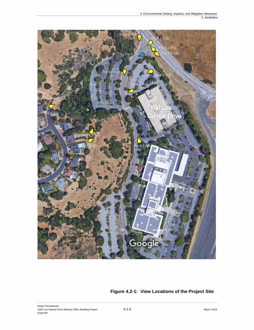
4. Environmental Setting, Impacts, and Mitigation Measures
2. Aesthetics
Kaiser Permanente
1650 Los Gamos Drive Medical Office Building Project 4.2-3 March 2018
Draft EIR
Fig 4.2-2(d)
Fig 4.2-2(b)
Fig 4.2-3(d)
Fig 4.2-2(c)
Fig 4.2-2(a)
Fig 4.2-4(b)
Fig 4.2-4(c)
Fig 4.2-3(a)
Fig 4.2-3(b)
Fig 4.2-4(a)
Fig 4.2-4(d)
Fig 4.2-6
Figure 4.2-1: View Locations of the Project Site
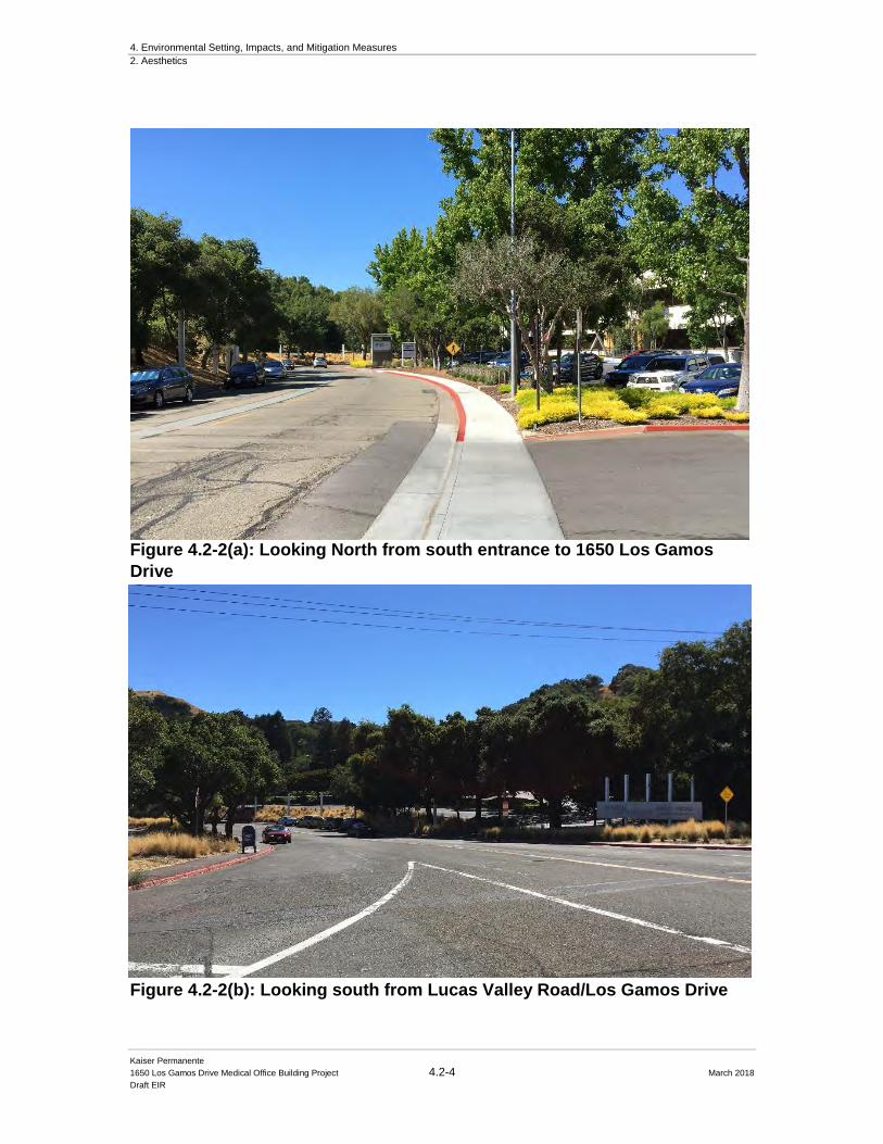
4. Environmental Setting, Impacts, and Mitigation Measures
2. Aesthetics
Kaiser Permanente
1650 Los Gamos Drive Medical Office Building Project 4.2-4 March 2018
Draft EIR
Figure 4.2-2(a): Looking North from south entrance to 1650 Los Gamos
Drive
Figure 4.2-2(b): Looking south from Lucas Valley Road/Los Gamos Drive

4. Environmental Setting, Impacts, and Mitigation Measures
2. Aesthetics
Kaiser Permanente
1650 Los Gamos Drive Medical Office Building Project 4.2-5 March 2018
Draft EIR
Figure 4.2-2(c): Looking south from proposed parking structure entrance
Figure 4.2-2(d): Looking west from Lucas Valley Road/Los Gamos Drive
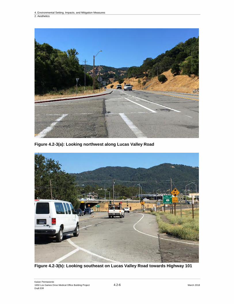
4. Environmental Setting, Impacts, and Mitigation Measures
2. Aesthetics
Kaiser Permanente
1650 Los Gamos Drive Medical Office Building Project 4.2-6 March 2018
Draft EIR
Figure 4.2-3(a): Looking northwest along Lucas Valley Road
Figure 4.2-3(b): Looking southeast on Lucas Valley Road towards Highway 101
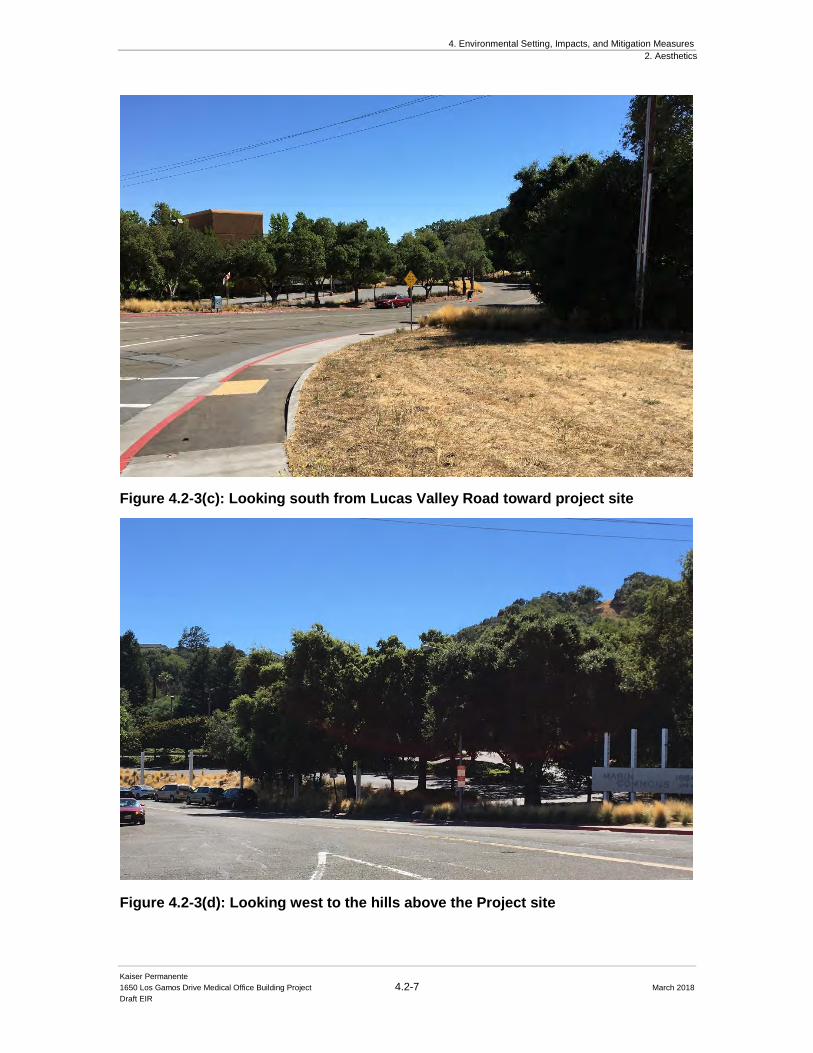
4. Environmental Setting, Impacts, and Mitigation Measures
2. Aesthetics
Kaiser Permanente
1650 Los Gamos Drive Medical Office Building Project 4.2-7 March 2018
Draft EIR
Figure 4.2-3(c): Looking south from Lucas Valley Road toward project site
Figure 4.2-3(d): Looking west to the hills above the Project site
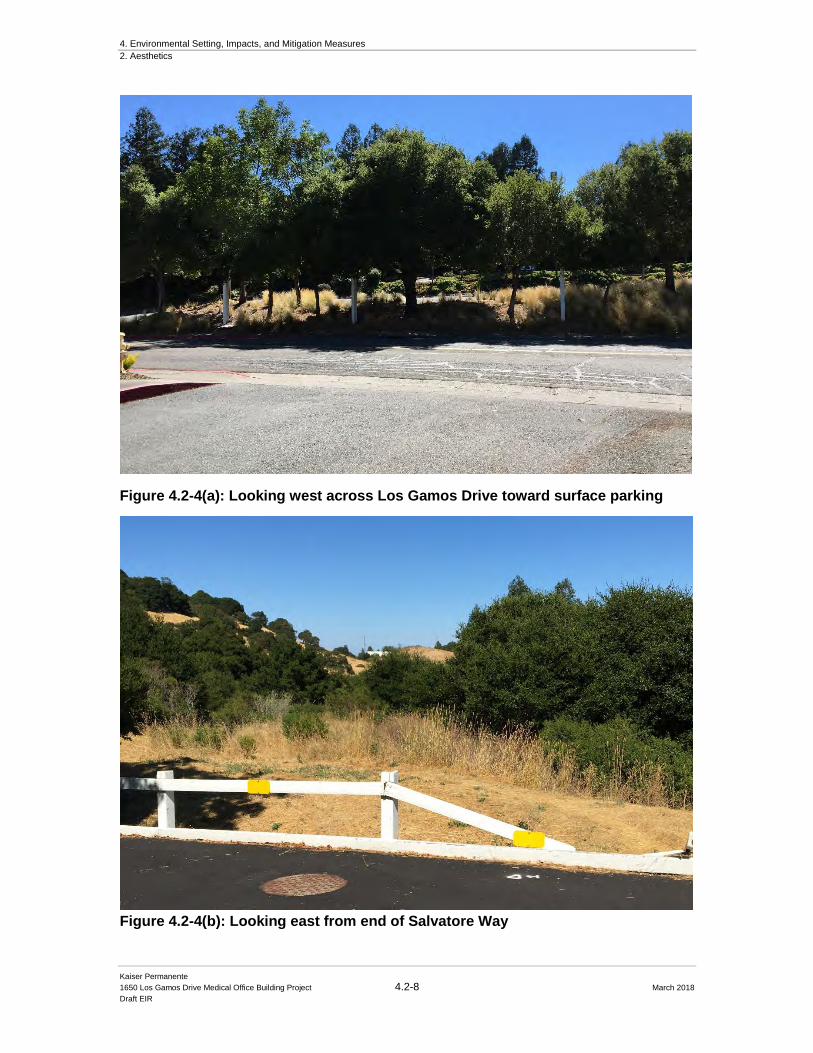
4. Environmental Setting, Impacts, and Mitigation Measures
2. Aesthetics
Kaiser Permanente
1650 Los Gamos Drive Medical Office Building Project 4.2-8 March 2018
Draft EIR
Figure 4.2-4(a): Looking west across Los Gamos Drive toward surface parking
Figure 4.2-4(b): Looking east from end of Salvatore Way
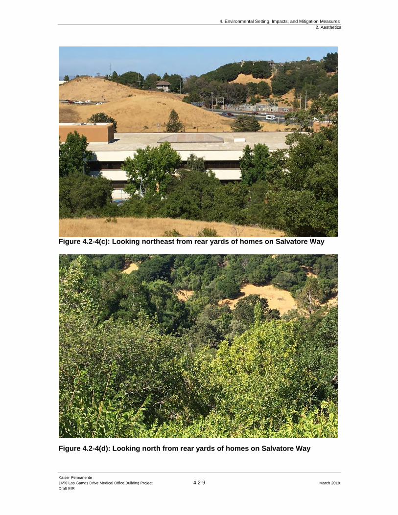
4. Environmental Setting, Impacts, and Mitigation Measures
2. Aesthetics
Kaiser Permanente
1650 Los Gamos Drive Medical Office Building Project 4.2-9 March 2018
Draft EIR
Figure 4.2-4(c): Looking northeast from rear yards of homes on Salvatore Way
Figure 4.2-4(d): Looking north from rear yards of homes on Salvatore Way
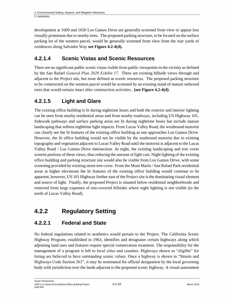
4. Environmental Setting, Impacts, and Mitigation Measures
2. Aesthetics
Kaiser Permanente
1650 Los Gamos Drive Medical Office Building Project 4.2-10 March 2018
Draft EIR
development at 1600 and 1650 Los Gamos Drive are generally screened from view or appear less
visually prominent due to nearby trees. The proposed parking structure, to be located on the surface
parking lot of the western parcel, would be generally screened from view from the rear yards of
residences along Salvador Way see Figure 4.2-4(d).
4.2.1.4 Scenic Vistas and Scenic Resources
There are no significant public scenic vistas visible from public viewpoints in the vicinity as defined
by the San Rafael General Plan 2020 Exhibit 17. There are existing hillside views through and
adjacent to the Project site, but none defined as scenic resources. The proposed parking structure
to be constructed on the western parcel would be screened by an existing stand of mature redwood
trees that would remain intact after construction activities. (see Figure 4.2-4(d).
4.2.1.5 Light and Glare
The existing office building is lit during nighttime hours and both the exterior and interior lighting
can be seen from nearby residential areas and from nearby roadways, including US Highway 101.
Sidewalk pathways and surface parking areas are lit during nighttime hours but include mature
landscaping that softens nighttime light impacts. From Lucas Valley Road, the westbound motorist
can clearly see the lit features of the existing office building as one approaches Los Gamos Drive.
However, the lit office building would not be visible by the eastbound motorist due to existing
topography and vegetation adjacent to Lucas Valley Road until the motorist is adjacent to the Lucas
Valley Road / Los Gamos Drive intersection. At night, the existing landscaping and tree cover
screens portions of these views, thus reducing the amount of light cast. Night lighting of the existing
office building and parking structure site would also be visible from Los Gamos Drive, with some
screening provided by existing street tree cover. From the Mont Marin / San Rafael Park residential
areas at higher elevations the lit features of the existing office building would continue to be
apparent, however, US 101 Highway further east of the Project site is the dominating visual element
and source of light. Finally, the proposed Project is situated below residential neighborhoods and
removed from large expanses of tree-covered hillsides where night lighting is not visible (to the
north of Lucas Valley Road).
4.2.2 Regulatory Setting
4.2.2.1 Federal and State
No federal regulations related to aesthetics would pertain to the Project. The California Scenic
Highway Program, established in 1963, identifies and designates certain highways along which
adjoining land uses and features require special conservation treatment. The responsibility for the
management of a program is left to local cities and counties. Highways shown as “eligible” for
listing are believed to have outstanding scenic values. Once a highway is shown in “Streets and
Highways Code Section 263”, it may be nominated for official designation by the local governing
body with jurisdiction over the lands adjacent to the proposed scenic highway. A visual assessment
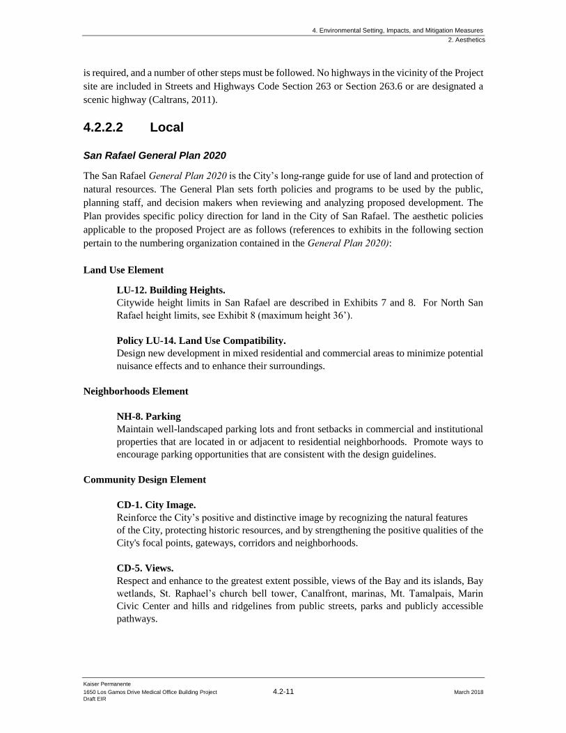
4. Environmental Setting, Impacts, and Mitigation Measures
2. Aesthetics
Kaiser Permanente
1650 Los Gamos Drive Medical Office Building Project 4.2-11 March 2018
Draft EIR
is required, and a number of other steps must be followed. No highways in the vicinity of the Project
site are included in Streets and Highways Code Section 263 or Section 263.6 or are designated a
scenic highway (Caltrans, 2011).
4.2.2.2 Local San Rafael General Plan 2020
The San Rafael General Plan 2020 is the City’s long-range guide for use of land and protection of
natural resources. The General Plan sets forth policies and programs to be used by the public,
planning staff, and decision makers when reviewing and analyzing proposed development. The
Plan provides specific policy direction for land in the City of San Rafael. The aesthetic policies
applicable to the proposed Project are as follows (references to exhibits in the following section
pertain to the numbering organization contained in the General Plan 2020):
Land Use Element
LU-12. Building Heights.
Citywide height limits in San Rafael are described in Exhibits 7 and 8. For North San
Rafael height limits, see Exhibit 8 (maximum height 36’).
Policy LU-14. Land Use Compatibility.
Design new development in mixed residential and commercial areas to minimize potential
nuisance effects and to enhance their surroundings.
Neighborhoods Element
NH-8. Parking
Maintain well-landscaped parking lots and front setbacks in commercial and institutional
properties that are located in or adjacent to residential neighborhoods. Promote ways to
encourage parking opportunities that are consistent with the design guidelines.
Community Design Element
CD-1. City Image.
Reinforce the City’s positive and distinctive image by recognizing the natural features
of the City, protecting historic resources, and by strengthening the positive qualities of the
City's focal points, gateways, corridors and neighborhoods.
CD-5. Views.
Respect and enhance to the greatest extent possible, views of the Bay and its islands, Bay
wetlands, St. Raphael’s church bell tower, Canalfront, marinas, Mt. Tamalpais, Marin
Civic Center and hills and ridgelines from public streets, parks and publicly accessible
pathways.
4. Environmental Setting, Impacts, and Mitigation Measures
2. Aesthetics
Kaiser Permanente
1650 Los Gamos Drive Medical Office Building Project 4.2-12 March 2018
Draft EIR
CD-6. Hillsides and Bay.
Protect the visual identity of the hillsides and Bay by controlling development within
hillside areas, providing setbacks from the Bay, and providing public access along the Bay
edge.
CD-6a. Hillside Design Guidelines. Continue to implement hillside design
guidelines through the design review process. Update the guidelines as needed.
CD-6b. Wetland Setbacks. Continue to implement the wetland setbacks
addressed in Policy CON-4 and in the zoning ordinance.
CD-6c. Public Access Opportunities. Continue to evaluate public access
opportunities through the development review process.
San Rafael Municipal Code and Zoning
The San Rafael Municipal Code is one of the primary tools to carry out the goals, objectives, and
policies of the Marin Countywide Plan and applicable community and specific plans, and is
intended to maintain consistency with the San Rafael General Plan 2020 policies. The San Rafael
Municipal Code designates zoning districts applicable to all lands under the jurisdiction of San
Rafael. The City Municipal Code Section 15.25.040 Environmental and Design Review Permits
and Section 14.07.010 Planned Development District are applicable to the Project site. The PD
development standards are specific to the District for which they are established.
4.2.3 Impacts and Mitigation Measures
4.2.3.1 Significance Criteria
Utilizing Appendix G of the CEQA Guidelines, the Project would have a significant impact on
aesthetics if it would:
a) Have a substantial adverse effect on a scenic vista;
b) Substantially damage scenic resources, including but not limited to, trees, rock
outcroppings, hillsides, and historic buildings within a state scenic highway;
c) Substantially degrade the existing visual character of the project site or quality of the site
and its surroundings; or
d) Create a new source of substantial light and glare which would adversely affect day or
nighttime views in the area.
4. Environmental Setting, Impacts, and Mitigation Measures
2. Aesthetics
Kaiser Permanente
1650 Los Gamos Drive Medical Office Building Project 4.2-13 March 2018
Draft EIR
4.2.3.2 Impacts Not Further Evaluated
As discussed in Chapter 1, an Initial Study was prepared to identify potentially significant impacts
as a result of the Project. Several topic areas of environmental concern were considered to have no
impact or a less than significant impact, including the following topic areas concerning aesthetics:
● Would the project have a substantial adverse effect on a scenic vista?
● Would the project substantially damage scenic resources, including, but not limited to,
trees, rock outcroppings, and historic buildings within a state scenic highway?
No scenic vistas have been identified in the General Plan at or in the immediate vicinity of this site.
Furthermore, there are no state scenic highways within the Project area. The 1650 Los Gamos
Drive MOB would be considered an urban infill development project located in the North San
Rafael Commercial Center area and is generally consistent with existing zoning standards and
General Plan land use designations. As an infill project, there are no potential scenic resources in
the Project site that would be affected by the Project. These impact categories, listed in the
significance criteria above as an impact topic to consider in a CEQA evaluation, are therefore not
further examined as part of the DEIR.
4.2.3.3 Approach to Analysis
Aesthetics analysis relies on a subjective evaluation by the analyst. Therefore, tools are used here
to illustrate how the Project may likely appear after it is constructed within the context of the visual
setting of the Project site and surroundings. The main aesthetic related component of the proposed
Project would be the construction of the new parking structure on the western parcel. The proposed
parking structure will be a simple reinforced concrete structural design with three levels of parking
(ground level and two elevated parking decks), plus a park-able ramp on the third level that is set
back from the front façade along Los Gamos Drive. The height to the slab of the third parking level
would be approximately 22 feet above grade, with an additional three to four feet of railing above
the third level slab. The tallest portion of the parking structure would be at the top of the southern
stair/elevator tower and would be approximately 36 feet tall (from finished grade). The highest
point of the top of the upper parking ramp would not exceed the height of the elevator/stair tower.
The final heights of the various elements of the parking structure may change slightly through the
design review process, but the parking structure will not exceed the maximum height allowed of
36 feet. There are significant mature redwood trees that would remain to provide screening for the
proposed parking structure.
Kaiser Permanente supplied photographic visual simulations to support the impact analysis
discussion in the Initial Study. The resulting evaluation determined that no impacts would occur
as a result of the proposed Project. However, comments received during the public comment period
and at the June 27, 2017 scoping hearing at the City of San Rafael Planning Commission,
determined a desire for further analysis of the potential visual impacts related to the addition of
potential photovoltaic (PV) solar panels and private views. In response, Kaiser Permanente has
supplied a simulation depicting the potential for photovoltaic arrays so that they could be included
4. Environmental Setting, Impacts, and Mitigation Measures
2. Aesthetics
Kaiser Permanente
1650 Los Gamos Drive Medical Office Building Project 4.2-14 March 2018
Draft EIR
as part of this environmental analysis but has not formally proposed them as part of the Project.
Although comments were submitted regarding private views, the City of San Rafael does not have
any policies or regulations relating to the protection of private views, nor are private views
protected under CEQA. The resulting evaluation that follows takes these considerations into
account. The following drawings also reflect changes to the overall massing of the proposed
parking structure that resulted from the first Design Review Board meeting. The actual skin of the
parking structure may be modified going forward to reflect additional comments from the Design
Review Board, but the overall massing is not anticipated to change significantly from what is
analyzed in this DEIR.
A visual simulation of the potential PV solar installation on the parking structure was prepared
based on digital models of the proposed structure, site improvement and topography. See Figure
4.2-6 (as compared to Figure 3-9 in Chapter 3, Project Description). The revised simulation depicts
the proposed conditions as seen from the Los Gamos Drive viewpoint (shown in blue on Figure
4.2-1).
Based on the descriptions in Section 4.2.1: Setting above, the approach to this analysis relies on
local and state policies for defining the potential existing “scenic vista(s)”, “scenic resources” and
“visual character” that could be “substantially” and adversely affected or degraded by the Project.
These are described in the impact analysis.
4.2.5 Visual Character Impacts and Mitigations
Impact AES-1: The Project would not substantially degrade the existing visual
character or quality of the site and its surroundings. (Less than Significant)
Based on the detailed description of the Project site surroundings in Section 4.2.1.2: Local Setting
above, the most significant local visual character areas visible from public viewpoints in the vicinity
include the resources that include (1) the views across the Project site to open areas above and
beyond the Project site, and (2) views of distant hillsides and ridgelines to the north, south and east
of the Project site. There are no established scenic vistas adjacent to the Project site as identified
in the General Plan.
The Project would add a new structure within the existing Project site. The proposed parking
structure would be compatible in height and bulk to existing buildings, as well as the range of
existing colors and exterior materials. Existing landscaping along Los Gamos Drive and along the
rear of the western parcel would provide significant screening from public views above the Project
site. The overall site is contained by the existing topography that includes wooded hillsides on three
sides of the site. As described in Section 4.2.3.2: Impacts Not Further Evaluated above, no
significant visual resources would be disturbed as a result of the Project.
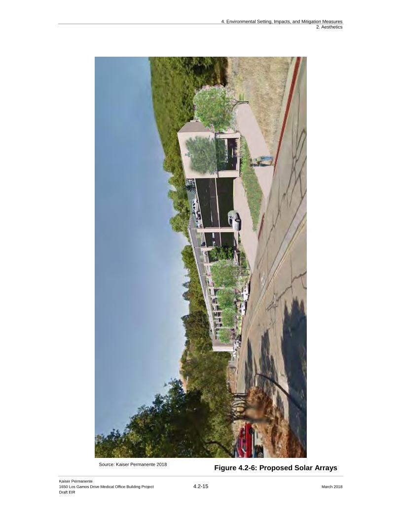
4. Environmental Setting, Impacts, and Mitigation Measures
2. Aesthetics
Kaiser Permanente
1650 Los Gamos Drive Medical Office Building Project 4.2-15 March 2018
Draft EIR
Figure 4.2-6: Proposed Solar Arrays Source: Kaiser Permanente 2018
4. Environmental Setting, Impacts, and Mitigation Measures
2. Aesthetics
Kaiser Permanente
1650 Los Gamos Drive Medical Office Building Project 4.2-16 March 2018
Draft EIR
While detailed exterior building materials have not been specified, the new parking structure is
proposed to be finished primarily with concrete elements, as described above in Section 4.2.4.2: Approach to Analysis. Further, the new parking structure is proposed to be simple, yet
complementary to the existing office building across Los Gamos Drive. As also discussed in the
Approach to Analysis section, the potential trellises with a photovoltaic (PV) solar installation may
be incorporated along the central aisles of the top parking level pending Kaiser Permanente’s final
determination for incorporation into the Project. As seen in Figure 4.2-6, the trellis/PV system
would be a parking structure appurtenance that would not adversely affect the visual character of
the Project site or its surroundings. Finally, the preservation of the mature redwood trees that line
the edge of the existing surface parking lot would provide significant visual screening to residents
and the public above the Project site. As depicted in Figure 4.2-4(d), the parking structure would
remain virtually hidden by existing vegetation.
Overall, the nature of the Project would not degrade the existing visual character of the Project site
or its surroundings, change the visual quality of the region, or eliminate significant visual resources.
The impact is less than significant.
Mitigation: None required
4.2.6 Light and Glare Impacts and Mitigations Impact AES-2: The Project would not create a significant increase in light and glare
that would adversely affect nighttime views in the area. (Less than Significant)
As a general office building, lighting currently occurs during the entire night, including existing
surface parking lot lighting. The new parking structure could increase light generated from the
Project site during nighttime hours. The parking structure would be located where a lighted surface
parking lot currently exists.
Those most potentially affected by the increase in light from the new parking structure would be
the uphill residents to the west along Salvador Way. From these locations, the upper deck of the
proposed parking structure would not be visible. Lighting fixtures inside the parking structure
would be ceiling mounted and would not cast direct glare, however, upper level light standards
would increase the overall light intensity of the site and increase the lit environment. Rooftop
parking lighting would be provided for safety and to meet code requirements; it would be pole
mounted lighting that is shielded and cast downwards. After the proposed landscaping matures, the
garage side openings would be partially screened from view which would reduce overall lighting
visibility. The potential PV system that may be incorporated on the top level of the parking
structures, pending funding, would have panels with standard low-glare glass with anti-reflective
coatings – much like standard commercial building windows. The potential panels would be sited
and angled to minimize potential glare to nearby residences. (see Figure 4.2-6)
4. Environmental Setting, Impacts, and Mitigation Measures
2. Aesthetics
Kaiser Permanente
1650 Los Gamos Drive Medical Office Building Project 4.2-17 March 2018
Draft EIR
Lighting associated with the MOB would also be visible to uphill residents but would be similar to
lighting currently visible from the existing office building. Although the existing office building is
largely vacant, historical use patterns for the subject property is consistent with office building
nighttime usage. The new MOB use may increase nighttime patterns, but as indicated in Section
4.2.1.5: Light and Glare above, existing views towards the subject property are minimal from
public vantage points. Existing mature vegetation provides further screening of the existing office
building. Furthermore, the dominant light emitting feature in the Project area is US Highway 101
immediately east of the subject property. Light emitted associated with vehicle headlights and
taillights would outshine any light emissions from security lighting or internal light emissions for
the proposed MOB. All new exterior lighting would be shielded and cast downwards to minimize
glare and excess light pollution. In conclusion, the Project would not create a significant increase
in light and glare which could adversely affect nighttime views in the area or cause potential
“spillage” of lighting that may affect nearby residents. The impact is less than significant.
Mitigation: None required
Private Views
Although the City of San Rafael does not have any policies or regulations relating to the protection
of private views, nor are private views protected under CEQA, for discussion purposes the City has
evaluated impacts to private views as part of this DEIR. The primary private view that is applicable
to this Project is the easterly view towards McInnis Park and the hillside and ridgelines and potential
bay views behind the park from the residential neighborhood to the west (Mont Marin / San Rafael
Park). Although two photo simulations were prepared to illustrate the Project’s impacts on public
views (see Exhibits 1 and 2, Initial Study, Appendix B) the Initial Study did not take into account
the potential for solar arrays on the proposed Project, private views, or the additional partial ramp
on the top level. As part of this DEIR, a third photo simulation was prepared to demonstrate what
solar arrays may look like on the parking structure. Views from an area near the backyard of private
residences between 56 and 52 Salvador Way are shown in Figure 4.2-4(c) and 4.2-4(d) above.1
In regard to these views, the proposed Project would not block the view of the hills to the east and
would not break or silhouette any of the hillside or ridgelines that are to the north or east.
Additionally, the proposed parking structure materials, which are generally concrete and muted
colors, would not significantly alter existing views of the natural setting that surround the parking
structure and minimize the visibility of the structure. Furthermore, the building would be situated
within an area of the site where existing trees would screen much of the view of the proposed
parking structure. The impact is considered less than significant.
Mitigation: None required
1 These photos were taken from the open space parcel adjacent to the private rear yards of the residences along
Salvatore Way.

4. Environmental Setting, Impacts, and Mitigation Measures
2. Aesthetics
Kaiser Permanente
1650 Los Gamos Drive Medical Office Building Project 4.2-18 March 2018
Draft EIR
4.2.7 Aesthetic Cumulative Impacts Impact AES-3: The Project, combined with past, present and other reasonably
foreseeable future development in the area, would not cause cumulative aesthetics impacts.
(Less than Significant)
Geographic Setting
The geographic setting for the consideration of cumulative aesthetic impacts is the vicinity within
one-quarter mile of the Project site as this area is generally within the important viewsheds that
take in site. Past development at the Project site and the vicinity has greatly altered the visual quality
of the area, placing new buildings and roadways in an area that was once dominated by grass-
covered hills and woodlands. There are no proposed projects within the viewshed of the Kaiser
MOB property at 1650 Los Gamos Drive. The nearest reasonably foreseeable project relevant to
the aesthetics analysis, is The Oaks project located to the north of Lucas Valley Road. This
development, a senior-assisted residential project, would be located over a small ridge and would
be unseen by properties above or adjacent to the subject property.
Impacts
Like past projects, current and future projects, including the proposed Project, are subject to Design
Review to ensure high-quality and compatible design with each project’s setting, and as required,
cumulative projects would also be subject to CEQA to address potential adverse visual impacts.
Adherence to the City of San Rafael Design Guidelines, other mitigation measures recommended
in this DEIR, as well as those that may be identified for other cumulative development, in addition
to Design Review Board recommendations for all cumulative projects, would ensure that the visual
effects of the Project and other nearby projects would be less than significant.
Therefore, a cumulative visual impact related to scenic vistas, overall visual quality, scenic
resources, and light and glare would not occur. The impact would be less than significant.
Mitigation: None required

4. Environmental Setting, Impacts, and Mitigation Measures
3. Air Quality
Kaiser Permanente
1650 Los Gamos Drive Medical Office Building Project 4.3-1 March 2018
Draft EIR
4.3 Air Quality
This section incorporates the setting information and analyses included in the 2018 Illingworth
and Rodkin Kaiser Medical Office Building Air Quality and Greenhouse Gas Emissions Assessment conducted for the Project. This section describes existing air quality conditions in the
vicinity of the Project site and presents applicable regulations that pertain to air quality. This
section also discusses the air quality impacts that could result from construction and operation of
the proposed Project and identifies appropriate mitigation measures when necessary.
4.3.1 Setting
4.3.1.1 Existing Air Quality Conditions
The ambient air quality in a given area depends on the quantities of pollutants emitted within the
area, transport of pollutants to and from surrounding areas, local and regional meteorological
conditions, as well as the surrounding topography of the air basin. Air quality is described by the
concentration of various pollutants in the atmosphere or the emissions of a pollutant or
contaminant. Units of concentration are generally expressed in parts per million (ppm) or
micrograms per cubic meter (µg/m3). Emissions are typically expressed as grams per mile,
pounds per day, or tons per year.
The proposed Project is located in Marin County, which is part of the nine county San Francisco
Bay Air Basin. Air quality in the region is affected by natural factors such as proximity to the Bay
and ocean, topography, and meteorology, as well as proximity to sources of air pollution. The
Bay Area is characterized by its Mediterranean type climate with warm dry summers and cool
wet winters.
The air pollution potential in Marin County is quite low due to the proximity to the San Francisco
Bay and Pacific Ocean. The almost constant influence of marine air and lack of nearby or upwind
air pollution sources results in low air pollution levels. Air pollutant levels can build up locally in
Marin County under stable atmosphere conditions, since vertical and horizontal dispersion of air
pollutants can be limited. However, the lack of upwind sources reduces the air pollution potential
during these conditions.
4.3.1.2 National and State Ambient Air Quality Standards
As required by the Federal Clean Air Act, National Ambient Air Quality Standards (NAAQS) have
been established for six major air pollutants: carbon monoxide (CO), nitrogen dioxide (NO2), ozone
(O3), particulate matter, including respirable particulate matter (PM10) and fine particulate matter
(PM2.5), sulfur dioxide (SO2), and lead. Pursuant to the California Clean Air Act, the State of
California has established the California Ambient Air Quality Standards (CAAQS). Both State and
federal standards are summarized in Table 4.3-1. The “primary” standards have been established to
protect the public health. The “secondary” standards are intended to protect the nation’s welfare and
4. Environmental Setting, Impacts, and Mitigation Measures
3. Air Quality
Kaiser Permanente
1650 Los Gamos Drive Medical Office Building Project 4.3-2 March 2018
Draft EIR
account for air pollutant effects on soil, water, visibility, materials, vegetation, and other aspects of
the general welfare. While the NAAQS have lower standards for NO2 and SO2, they can be
exceeded a certain number of times per year where the CAAQS are not to be exceeded. As a
result, CAAQS are generally the same or more stringent than NAAQS. Thus, CAAQS are used as
the comparative standard in this analysis.
Efforts to reduce air pollution began in the Bay Area started in 1955 with the formation of the Bay
Area Air Pollution Control District, now known as the BAAQMD. State and national ambient air
quality standards cover a wide variety of pollutants; however, only a few of these pollutants are
problems in the Bay Area either due to the strength of the emission or the climate of the region. The
BAAQMD has for many years operated a multi-pollutant monitoring site in San Rafael, allowing
analysis of trends in air quality. Problem air pollutants in Marin County and the Bay Area include
ozone, particulate matter (PM2.5and PM10), and toxic air contaminants (TACs).
4.3.1.3 Criteria Air Pollutants and Effects
Air quality studies generally focus on five pollutants that are most commonly measured and
regulated: CO, O3, NO2, SO2, and suspended particulate matter, i.e., PM10 and PM2.5. These
pollutants are listed in Table 4.3-2 along with the health effects associated with each pollutant. In
Marin County, ozone and particulate matter are the pollutants of greatest concern, as measured air
pollutant levels exceed these concentrations at times.
Ozone
High ozone levels are caused by the cumulative emissions of reactive organic gases (ROG) and
nitrogen oxides (NOX). These precursor pollutants react under certain meteorological conditions
to form high ozone levels. Controlling the emissions of these precursor pollutants is the focus of
the Bay Area’s attempts to reduce ozone levels. The highest ozone levels in the Bay Area occur
in the eastern and southern inland valleys that are downwind of air pollutant sources. High
ozone levels aggravate respiratory and cardiovascular diseases, reduced lung function, and
increase coughing and chest discomfort.
Particulate Matter
Particulate matter is another problematic air pollutant of the Bay Area. Particulate matter is
assessed and measured in terms of respirable particulate matter or particles that have a diameter
of 10 micrometers or less (PM10) and fine particulate matter where particles have a diameter of
2.5 micrometers or less (PM2.5). Elevated concentrations of PM10 and PM2.5 are the result of both
region-wide (or cumulative) emissions and localized emissions. High particulate matter levels
aggravate respiratory and cardiovascular diseases, reduce lung function, increase mortality (e.g.,
lung cancer), and result in reduced lung function growth in children. The greatest quantity of
PM10 emissions associated with motor vehicle uses is generated by re-suspended road dust.
Reductions in motor vehicle miles traveled, rather than changes to motor vehicle technology, are
necessary to reduce PM10 emissions. Wood burning in fireplaces and stoves is another significant
source of particulate matter, primarily PM2.5.
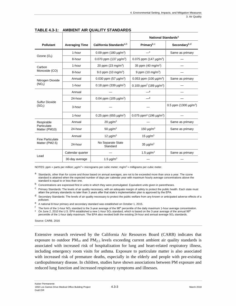
4. Environmental Setting, Impacts, and Mitigation Measures
3. Air Quality
Kaiser Permanente
1650 Los Gamos Drive Medical Office Building Project 4.3-3 March 2018
Draft EIR
TABLE 4.3-1: AMBIENT AIR QUALITY STANDARDS
Pollutant Averaging Time California Standardsa,b
National Standardsa
Primaryb,c Secondaryb,d
Ozone (O3) 1-hour 0.09 ppm (180 µg/m3) —e Same as primary
8-hour 0.070 ppm (137 µg/m3) 0.075 ppm (147 µg/m3) —
Carbon Monoxide (CO)
1-hour 20 ppm (23 mg/m3) 35 ppm (40 mg/m3) —
8-hour 9.0 ppm (10 mg/m3) 9 ppm (10 mg/m3) —
Nitrogen Dioxide (NO2)
Annual 0.030 ppm (57 µg/m3) 0.053 ppm (100 µg/m3) Same as primary
1-hour 0.18 ppm (339 µg/m3) 0.100 ppmf (189 µg/m3) —
Sulfur Dioxide (SO2)
Annual — —g —
24-hour 0.04 ppm (105 µg/m3) —g —
3-hour — — 0.5 ppm (1300 µg/m3)
1-hour 0.25 ppm (655 µg/m3) 0.075 ppmg (196 µg/m3) —
Respirable Particulate Matter (PM10)
Annual 20 µg/m3 — Same as primary
24-hour 50 µg/m3 150 µg/m3 Same as primary
Fine Particulate Matter (PM2.5)
Annual 12 µg/m3 15 µg/m3
24-hour No Separate State
Standard 35 µg/m3
Lead Calendar quarter — 1.5 µg/m3 Same as primary
30-day average 1.5 µg/m3 — —
NOTES: ppm = parts per million; µg/m3 = micrograms per cubic meter; mg/m3 = milligrams per cubic meter. a Standards, other than for ozone and those based on annual averages, are not to be exceeded more than once a year. The ozone
standard is attained when the expected number of days per calendar year with maximum hourly average concentrations above the standard is equal to or less than one.
b Concentrations are expressed first in units in which they were promulgated. Equivalent units given in parentheses. c Primary Standards: The levels of air quality necessary, with an adequate margin of safety to protect the public health. Each state must
attain the primary standards no later than 3 years after that state’s implementation plan is approved by the EPA. d Secondary Standards: The levels of air quality necessary to protect the public welfare from any known or anticipated adverse effects of a
pollutant. e A national 8-hour primary and secondary standard was established on October 1, 2015. f The form of the 1-hour NO2 standard is the 3-year average of the 98th percentile of the daily maximum 1-hour average concentration. g On June 2, 2010 the U.S. EPA established a new 1-hour SO2 standard, which is based on the 3-year average of the annual 99th
percentile of the 1-hour daily maximum. The EPA also revoked both the existing 24-hour and annual average SO2 standards. Source: CARB, 2016
Extensive research reviewed by the California Air Resources Board (CARB) indicates that
exposure to outdoor PM10 and PM2.5 levels exceeding current ambient air quality standards is
associated with increased risk of hospitalization for lung and heart-related respiratory illness,
including emergency room visits for asthma. Exposure to particulate matter is also associated
with increased risk of premature deaths, especially in the elderly and people with pre-existing
cardiopulmonary disease. In children, studies have shown associations between PM exposure and
reduced lung function and increased respiratory symptoms and illnesses.
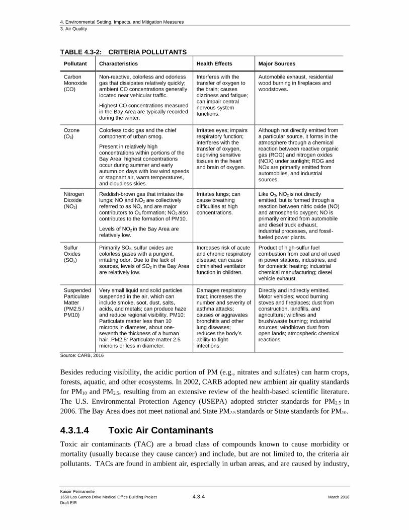
4. Environmental Setting, Impacts, and Mitigation Measures
3. Air Quality
Kaiser Permanente
1650 Los Gamos Drive Medical Office Building Project 4.3-4 March 2018
Draft EIR
TABLE 4.3-2: CRITERIA POLLUTANTS
Pollutant Characteristics Health Effects Major Sources
Carbon Monoxide (CO)
Non-reactive, colorless and odorless gas that dissipates relatively quickly; ambient CO concentrations generally located near vehicular traffic.
Highest CO concentrations measured in the Bay Area are typically recorded during the winter.
Interferes with the transfer of oxygen to the brain; causes dizziness and fatigue; can impair central nervous system functions.
Automobile exhaust, residential wood burning in fireplaces and woodstoves.
Ozone (O3)
Colorless toxic gas and the chief component of urban smog.
Present in relatively high concentrations within portions of the Bay Area; highest concentrations occur during summer and early autumn on days with low wind speeds or stagnant air, warm temperatures, and cloudless skies.
Irritates eyes; impairs respiratory function; interferes with the transfer of oxygen, depriving sensitive tissues in the heart and brain of oxygen.
Although not directly emitted from a particular source, it forms in the atmosphere through a chemical reaction between reactive organic gas (ROG) and nitrogen oxides (NOX) under sunlight; ROG and NOx are primarily emitted from automobiles, and industrial sources.
Nitrogen Dioxide (NO2)
Reddish-brown gas that irritates the lungs; NO and NO2 are collectively referred to as NOx and are major contributors to O3 formation; NO2 also contributes to the formation of PM10.
Levels of NO2 in the Bay Area are relatively low.
Irritates lungs; can cause breathing difficulties at high concentrations.
Like O3, NO2 is not directly emitted, but is formed through a reaction between nitric oxide (NO) and atmospheric oxygen; NO is primarily emitted from automobile and diesel truck exhaust, industrial processes, and fossil-fueled power plants.
Sulfur Oxides (SOx)
Primarily SO2, sulfur oxides are colorless gases with a pungent, irritating odor. Due to the lack of sources, levels of SO2 in the Bay Area are relatively low.
Increases risk of acute and chronic respiratory disease; can cause diminished ventilator function in children.
Product of high-sulfur fuel combustion from coal and oil used in power stations, industries, and for domestic heating; industrial chemical manufacturing; diesel vehicle exhaust.
Suspended Particulate Matter (PM2.5 / PM10)
Very small liquid and solid particles suspended in the air, which can include smoke, soot, dust, salts, acids, and metals; can produce haze and reduce regional visibility. PM10: Particulate matter less than 10 microns in diameter, about one-seventh the thickness of a human hair. PM2.5: Particulate matter 2.5 microns or less in diameter.
Damages respiratory tract; increases the number and severity of asthma attacks; causes or aggravates bronchitis and other lung diseases; reduces the body’s ability to fight infections.
Directly and indirectly emitted. Motor vehicles; wood burning stoves and fireplaces; dust from construction, landfills, and agriculture; wildfires and brush/waste burning; industrial sources; windblown dust from open lands; atmospheric chemical reactions.
Source: CARB, 2016
Besides reducing visibility, the acidic portion of PM (e.g., nitrates and sulfates) can harm crops,
forests, aquatic, and other ecosystems. In 2002, CARB adopted new ambient air quality standards
for PM10 and PM2.5, resulting from an extensive review of the health-based scientific literature.
The U.S. Environmental Protection Agency (USEPA) adopted stricter standards for PM2.5 in
2006. The Bay Area does not meet national and State PM2.5 standards or State standards for PM10.
4.3.1.4 Toxic Air Contaminants
Toxic air contaminants (TAC) are a broad class of compounds known to cause morbidity or
mortality (usually because they cause cancer) and include, but are not limited to, the criteria air
pollutants. TACs are found in ambient air, especially in urban areas, and are caused by industry,
4. Environmental Setting, Impacts, and Mitigation Measures
3. Air Quality
Kaiser Permanente
1650 Los Gamos Drive Medical Office Building Project 4.3-5 March 2018
Draft EIR
agriculture, fuel combustion, and commercial operations (e.g., dry cleaners). TACs are typically
found in low concentrations, even near their source (e.g., diesel particulate matter [DPM] near a
freeway). Because chronic exposure can result in adverse health effects, TACs are regulated at
the regional, State, and federal level.
Diesel exhaust is the predominant TAC in urban air and is estimated to represent about three-
quarters of the cancer risk from TACs (based on the Bay Area average). According to the
California Air Resources Board (CARB), diesel exhaust is a complex mixture of gases, vapors,
and fine particles. This complexity makes the evaluation of health effects of diesel exhaust a
complex scientific issue. Some of the chemicals in diesel exhaust, such as benzene and
formaldehyde, have been previously identified as TACs by the CARB, and are listed as
carcinogens either under the State's Proposition 65 or under the Federal Hazardous Air Pollutants
programs. USEPA has adopted low-sulfur diesel fuel standards that will reduce DPM
substantially; these standards went into effect in late 2006. Other common TACs in urban
environments include benzene present in gasoline vapors and vehicle exhaust, and 1,3 butadiene
in vehicle exhaust.
In cooler weather, smoke from residential wood combustion can be a source of TACs. Localized
high TAC concentrations can result when cold stagnant air traps smoke near the ground and, with
no wind, the pollution can persist for many hours. This occurs in sheltered valleys during the
winter. Wood smoke also contains a significant amount of PM10 and PM2.5. Wood smoke is an
irritant and is implicated in worsening asthma and other chronic lung problems.
4.3.1.5 Air Pollution Potential
The significance of a pollutant concentration is determined by comparing the concentration to an
appropriate ambient air quality standard. The standards represent the allowable pollutant
concentrations designed to ensure that the public health and welfare are protected, while
including a reasonable margin of safety to protect the more sensitive individuals in the
population. The San Francisco Bay Area is considered to be one of the cleanest metropolitan
areas in the country with respect to air quality.
The air pollution potential in Marin County is low due to the proximity to the San Francisco Bay
and Pacific Ocean. The constant influence of marine air and lack of nearby or upwind air pollution
sources results in low air pollution levels. Air pollutant levels can build up under stable atmosphere
conditions, since vertical and horizontal dispersion of air pollutants is limited. Due to the
surrounding terrain and location of the Project site, neutral or stable conditions would be typical
during night and early mornings.
BAAQMD monitors air pollutant levels continuously throughout the Bay Area. The San Rafael
station is the closest to the Project site and the only station in Marin County. This station is about
two miles from the Project site. Over the five-year period of 2012 to 2016, PM10 levels measured in
San Rafael have exceeded CAAQS on zero to one sample day per year. Since PM10 is sampled once
every six days, standards are exceeded on an estimated zero to six days annually. PM2.5 monitoring
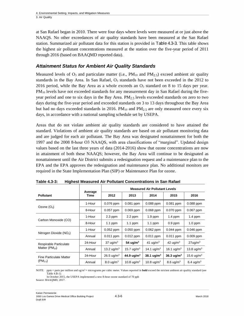
4. Environmental Setting, Impacts, and Mitigation Measures
3. Air Quality
Kaiser Permanente
1650 Los Gamos Drive Medical Office Building Project 4.3-6 March 2018
Draft EIR
at San Rafael began in 2010. There were four days where levels were measured at or just above the
NAAQS. No other exceedances of air quality standards have been measured at the San Rafael
station. Summarized air pollutant data for this station is provided in Table 4.3-3. This table shows
the highest air pollutant concentrations measured at the station over the five-year period of 2011
through 2016 (based on BAAQMD reported data).
Attainment Status for Ambient Air Quality Standards
Measured levels of O3 and particulate matter (i.e., PM10 and PM2.5) exceed ambient air quality
standards in the Bay Area. In San Rafael, O3 standards have not been exceeded in the 2012 to
2016 period, while the Bay Area as a whole exceeds an O3 standard on 8 to 15 days per year.
PM10 levels have not exceeded standards for any measurement day in San Rafael during the five-
year period and one to six days in the Bay Area. PM2.5 levels exceeded standards on zero to two
days during the five-year period and exceeded standards on 3 to 13 days throughout the Bay Area
but had no days exceeded standards in 2016. PM10 and PM2.5 are only measured once every six
days, in accordance with a national sampling schedule set by USEPA.
Areas that do not violate ambient air quality standards are considered to have attained the
standard. Violations of ambient air quality standards are based on air pollutant monitoring data
and are judged for each air pollutant. The Bay Area was designated nonattainment for both the
1997 and the 2008 8-hour O3 NAAQS, with area classifications of “marginal”. Updated design
values based on the last three years of data (2014-2016) show that ozone concentrations are now
in attainment of both these NAAQS; however, the Bay Area will continue to be designated as
nonattainment until the Air District submits a redesignation request and a maintenance plan to the
EPA and the EPA approves the redesignation and maintenance plan. No additional monitors are
required in the State Implementation Plan (SIP) or Maintenance Plan for ozone.
Table 4.3-3: Highest Measured Air Pollutant Concentrations in San Rafael
Pollutant Average
Time
Measured Air Pollutant Levels
2012 2013 2014 2015 2016
Ozone (O3) 1-Hour 0.076 ppm 0.081 ppm 0.088 ppm 0.081 ppm 0.088 ppm
8-Hour 0.057 ppm 0.069 ppm 0.068 ppm 0.070 ppm 0.067 ppm
Carbon Monoxide (CO) 1-Hour 2.3 ppm 2.2 ppm 1.9 ppm 1.4 ppm 1.4 ppm
8-Hour 1.1 ppm 1.1 ppm 1.1 ppm 0.9 ppm 1.0 ppm
Nitrogen Dioxide (NO2) 1-Hour 0.052 ppm 0.050 ppm 0.062 ppm 0.044 ppm 0.046 ppm
Annual 0.011 ppm 0.012 ppm 0.011 ppm 0.011 ppm 0.009 ppm
Respirable Particulate Matter (PM10)
24-Hour 37 ug/m3 54 ug/m3 41 ug/m3 42 ug/m3 27ug/m3
Annual 13.2 ug/m3 15.7 ug/m3 14.1 ug/m3 16.1 ug/m3 13.8 ug/m3
Fine Particulate Matter (PM2.5)
24-Hour 26.5 ug/m3 44.9 ug/m3 38.1 ug/m3 36.3 ug/m3 15.6 ug/m3
Annual 8.0 ug/m3 10.8 ug/m3 10.8 ug/m3 8.6 ug/m3 6.4 ug/m3
NOTE: ppm = parts per million and ug/m3 = micrograms per cubic meter. Values reported in bold exceed the strictest ambient air quality standard (see
Table 4.B-1).
In October 2015, the USEPA implemented a new 8-hour ozone standard of 70 ppb
Source: BAAQMD, 2017.

4. Environmental Setting, Impacts, and Mitigation Measures
3. Air Quality
Kaiser Permanente
1650 Los Gamos Drive Medical Office Building Project 4.3-7 March 2018
Draft EIR
Under the federal Clean Air Act, the USEPA has designated the region as marginally non-
attainment for the eight-hour O3 standard. USEPA has proposed revisions to the O3 eight-hour
NAAQS rule; however, the Office of Information and Regulatory Affairs (OIRA) recently
returned the draft rule to USEPA for reconsideration (OIRA, 2011).
The Bay Area does attain the annual NAAQS for PM2.5. USEPA designated the Bay Area Air
Basin as “nonattainment” for the 2006 24-hour PM2.5 standard, as monitoring data indicate levels
slightly above the standard. Most PM2.5 nonattainment areas have until 2015 to attain the
standards, with some extensions to 2020 if necessary.
The Bay Area has met the CO NAAQS for over a decade and is classified as attainment by the
USEPA. The USEPA grades the region as attainment or unclassified for all other air pollutants,
which include PM10, NO2, SO2, and lead. An unclassified designation means that there is not
enough data to designate an area as “nonattainment,” but the area likely is in attainment of the
standard. There have not been any recorded violations of these standards.
At the state level, the region is considered serious non-attainment for ground level O3, because
monitoring stations in the region exceeds the one-hour and eight-hour CAAQS. The BAAQMD is
required to adopt plans on a triennial basis that show progress towards meeting the State O3
standard (see Air Quality Plans, discussed below). The region is also designated non-attainment
for PM10 and PM2.5 by the State. Although the region is designated nonattainment for PM2.5 under
the CAAQS, monitoring data indicate that the standard is met. Note that the CAAQS only address
annual concentrations of PM2.5. Most monitoring stations in the region exceed the annual and 24-
hour PM10 CAAQS. The area is considered attainment or unclassified for all other pollutants
regulated under the CAAQS.
Sensitive Receptors
There are groups of people more affected by air pollution than others. CARB has identified the
following persons who are most likely to be affected by air pollution: children under 16, the
elderly over 65, athletes, and people with cardiovascular and chronic respiratory diseases. These
groups are classified as sensitive receptors. Locations that may contain a high concentration of
these sensitive population groups include residential areas, hospitals, daycare facilities, elder care
facilities, elementary schools, and parks. For cancer risk assessments, children are the most
sensitive receptors, since they are more susceptible to cancer causing TACs. Residential
locations are assumed to include infants and small children. The closest sensitive receptors to the
Project site are residences approximately 215 feet to the west and southwest of the proposed
parking structure. Additional sensitive receptors include children in the Bright Horizons
school/daycare facilities at the 1600 Los Gamos Drive office building, located approximately 700
feet to the south of the proposed parking structure.
4. Environmental Setting, Impacts, and Mitigation Measures
3. Air Quality
Kaiser Permanente
1650 Los Gamos Drive Medical Office Building Project 4.3-8 March 2018
Draft EIR
4.3.2 Regulatory Setting
4.3.2.1 Federal Regulations
The United States Environmental Protection Agency (USEPA) sets nationwide emission
standards for mobile sources, which include on-road (highway) motor vehicles such trucks, buses,
and automobiles, and non-road (off-road) vehicles and equipment used in construction,
agricultural, industrial, and mining activities (such as bulldozers and loaders). The USEPA also
sets nationwide fuel standards. California also has the ability to set motor vehicle emission
standards and standards for fuel used in California, as long as they are the same or more stringent
than the Federal standards.
In the past decade the USEPA has established a number of emission standards for on- and non-
road heavy-duty diesel engines used in trucks and other equipment. This was done in part
because diesel engines are a significant source of nitrogen oxides, or NOX, and particulate matter
(PM10 and PM2.5) and because the USEPA has identified diesel particulate matter as a probable
carcinogen. Implementation of the heavy-duty diesel on-road vehicle standards and the non-road
diesel engine standards are estimated to reduce PM and NOX emissions from diesel engines up to
95 percent in 2030 when the heavy-duty vehicle fleet is completely replaced with newer heavy-
duty vehicles that comply with these emission standards.1
In concert with the diesel engine emission standards, the USEPA has also substantially reduced
the amount of sulfur allowed in diesel fuels. The sulfur contained in diesel fuel is a significant
contributor to the formation of particulate matter in diesel-fueled engine exhaust. The new
standards reduced the amount of sulfur allowed by 97 percent for highway diesel fuel (from 500
parts per million by weight [ppmw] to 15 ppmw), and by 99 percent for off-highway diesel fuel
(from about 3,000 ppmw to 15 ppmw). The low sulfur highway fuel (15 ppmw sulfur), also
called ultra-low sulfur diesel (ULSD) is currently required for use by all vehicles in the U.S.
All of the above Federal diesel engine and diesel fuel requirements have been adopted by
California, in some cases with modifications making the requirements more stringent or the
implementation dates sooner.
4.3.2.2 State Regulations
To address the issue of diesel emissions in the state, CARB developed the Risk Reduction Plan to
Reduce Particulate Matter Emissions from Diesel-Fueled Engines and Vehicles.2 In addition to
requiring more stringent emission standards for new on-road and off-road mobile sources and
1 USEPA, 2000. Regulatory Announcement, Heavy-Duty Engine and Vehicle Standards and Highway Diesel Fuel Sulfur Control
Requirements. EPA420-F-00-057. December 2000.
2 California Air Resources Board. Risk Reduction Plan to Reduce Particulate Matter Emissions from Diesel-Fueled Engines and Vehicles. October 2000.
4. Environmental Setting, Impacts, and Mitigation Measures
3. Air Quality
Kaiser Permanente
1650 Los Gamos Drive Medical Office Building Project 4.3-9 March 2018
Draft EIR
stationary diesel-fueled engines to reduce particulate matter emissions by 90 percent, a significant
component of the plan involves application of emission control strategies to existing diesel
vehicles and equipment. Many of the measures of the Diesel Risk Reduction Plan have been
approved and adopted, including the Federal on-road and non-road diesel engine emission
standards for new engines, as well as adoption of regulations for low sulfur fuel in California.
CARB has adopted and implemented a number of regulations for stationary and mobile sources to
reduce emissions of Diesel Particulate Matter (DPM). Several of these regulatory programs
affect medium and heavy-duty diesel trucks that represent the bulk of DPM emissions from
California highways. CARB regulations require on-road diesel trucks to be retrofitted with
particulate matter controls or replaced to meet 2010 or later engine standards that have much
lower DPM and PM2.5 emissions. This regulation will substantially reduce these emissions
between 2013 and 2023. While new trucks and buses will meet strict federal standards, this
measure is intended to accelerate the rate at which the fleet either turns over so there are more
cleaner vehicles on the road, or i s retrofitted to meet similar standards. With this regulation,
older, more polluting trucks would be removed from the roads sooner.
CARB has also adopted and implemented regulations to reduce DPM and NOX emissions from
in-use (existing) and new off-road heavy-duty diesel vehicles (e.g., loaders, tractors, bulldozers,
backhoes, off-highway trucks, etc.). The regulations apply to diesel-powered off-road vehicles
with engines 25 horsepower (hp) or greater. The regulations are intended to reduce particulate
matter and NOX exhaust emissions by requiring owners to turn over their fleet (replace older
equipment with newer equipment) or retrofit existing equipment in order to achieve specified
fleet-averaged emission rates. Implementation of this regulation, in conjunction with stringent
Federal off-road equipment engine emission limits for new vehicles, will significantly reduce
emissions of DPM and NOX.
4.3.2.3 BAAQMD Regulations
BAAQMD has jurisdiction over an approximately 5,600-square mile area, commonly referred to
as the San Francisco Bay Area (Bay Area). The District’s boundary encompasses the nine San
Francisco Bay Area counties, including Alameda County, Contra Costa County, Marin County,
San Francisco County, San Mateo County, Santa Clara County, Napa County, southwestern
Solano County and southern Sonoma County.
BAAQMD is the lead agency in developing plans to address attainment and maintenance of the
National Ambient Air Quality Standards and California Ambient Air Quality Standards. The
District also has permit authority over most types of stationary equipment utilized for the
proposed Project. The BAAQMD is responsible for permitting and inspection of stationary
sources; enforcement of regulations, including setting fees, levying fines, and enforcement
actions; and ensuring that public nuisances are minimized.
4. Environmental Setting, Impacts, and Mitigation Measures
3. Air Quality
Kaiser Permanente
1650 Los Gamos Drive Medical Office Building Project 4.3-10 March 2018
Draft EIR
The BAAQMD CEQA Air Quality Guidelines3 were prepared to assist in the evaluation of air
quality impacts of projects and plans proposed within the Bay Area. The guidelines provide
recommended procedures for evaluating potential air impacts during the environmental review
process consistent with CEQA requirements including thresholds of significance, mitigation
measures, and background air quality information. They also include assessment methodologies
for air toxics, odors, and greenhouse gas emissions. In June 2010, the BAAQMD’s Board of
Directors adopted CEQA thresholds of significance and an update of their CEQA Guidelines. In
May 2011, the updated BAAQMD CEQA Air Quality Guidelines were amended to include a risk
and hazards threshold for new receptors and modify procedures for assessing impacts related to
risk and hazard impacts.
BAAQMD adopts and enforces rules to reduce particulate matter emissions and develops public
outreach programs to educate the public to reduce PM10 and PM2.5 emissions (e.g., Spare the Air
Program). California Senate Bill 656 (SB 656) requires further action by CARB and air districts
to reduce public exposure to PM10 and PM2.5. Efforts identified by BAAQMD in response to
SB656 are primarily targeting reductions in wood smoke emissions and adoption of new rules to
further reduce NOx and particulate matter from internal combustion engines and reduce
particulate matter from commercial charbroiling activities. The Bay Area experiences the highest
PM10 and PM2.5 concentrations in winter when wood smoke and ammonium nitrate contributions
to particulate matter are highest. BAAQMD rules restrict operation of any indoor or outdoor
fireplace, fire pit, wood or pellet stove, masonry heater, or fireplace insert on specific days during
the winter when air quality conditions are forecasted to exceed the NAAQS for PM2.5. When
meteorological conditions are conducive to high levels of O3 or PM2.5, BAAQMD declares a
Spare the Air day. Uncontrolled wood burning is prohibited in winter during Spare the Air days.
The rule also limits excess visible emissions from wood burning devices and requires clean
burning technology for wood burning devices sold (or resold) or installed in the Bay Area. NOx
emissions contribute to ammonium nitrate formation that resides in the atmosphere as particulate
matter, so a reduction in NOx emissions reduces wintertime PM2.5 levels.
4.3.2.4 Local
City of San Rafael General Plan
The Air and Water Quality Elements of the San Rafael General Plan 2020 contain the following
goal, policies, and implementation programs relevant to the air quality impacts of the proposed
Project:
AW-1. State and Federal Standards.
Continue to comply and strive to exceed state and federal standards for air quality for the
benefit of the Bay Area.
3 Bay Area Air Quality Management District, 2017. CEQA Air Quality Guidelines. May.
4. Environmental Setting, Impacts, and Mitigation Measures
3. Air Quality
Kaiser Permanente
1650 Los Gamos Drive Medical Office Building Project 4.3-11 March 2018
Draft EIR
AW-2. Land Use Compatibility.
To ensure excellent air quality, promote land use compatibility for new development by
using buffering techniques such as landscaping, setbacks, and screening in areas where
different land uses abut one another.
AW-3. Air Quality Planning with Other Processes.
Integrate air quality considerations with the land use and transportation processes by
mitigating air quality impacts through land use design measures, such as encouraging
project design that will foster walking and biking.
AW-4. Particulate Matter Pollution Reduction.
Promote the reduction of particulate matter pollution from roads, parking lots,
construction sites, agricultural lands and other activities.
AW-5. Circulation Alternatives.
Promote circulation alternatives that reduce air pollution.
4.3.3 Impacts and Mitigation Measures
4.3.3.1 Significance Criteria
Utilizing Appendix G of the CEQA Guidelines, the Project would have a significant impact on air
quality if it would:
a) Conflict with or obstruct implementation of the applicable air quality plan;
b) Violate any air quality standard or contribute substantially to an existing or projected air quality violation;
c) Result in a cumulatively considerable net increase of any nonattainment pollutant for which the project region is non-attainment under an applicable federal or State ambient air quality standard (including releasing emissions which exceed quantitative thresholds for ozone precursors);
d) Expose sensitive receptors to substantial pollutant concentrations; or
e) Create objectionable odors affecting a substantial number of people.
4.3.3.2 Approach to Analysis
The following impact analysis focuses on potential impacts of the Project related to air quality.
The analysis presented in this report uses the methodologies provided in the BAAQMD’s CEQA Air Quality Guidelines (herein referred to as the BAAQMD Guidelines) (BAAQMD, 2017).
Emission estimates for the Project presented in this section were prepared by Illingworth and
Rodkin, Inc. (2018). For details of data, calculations, and assumptions used to determine project-
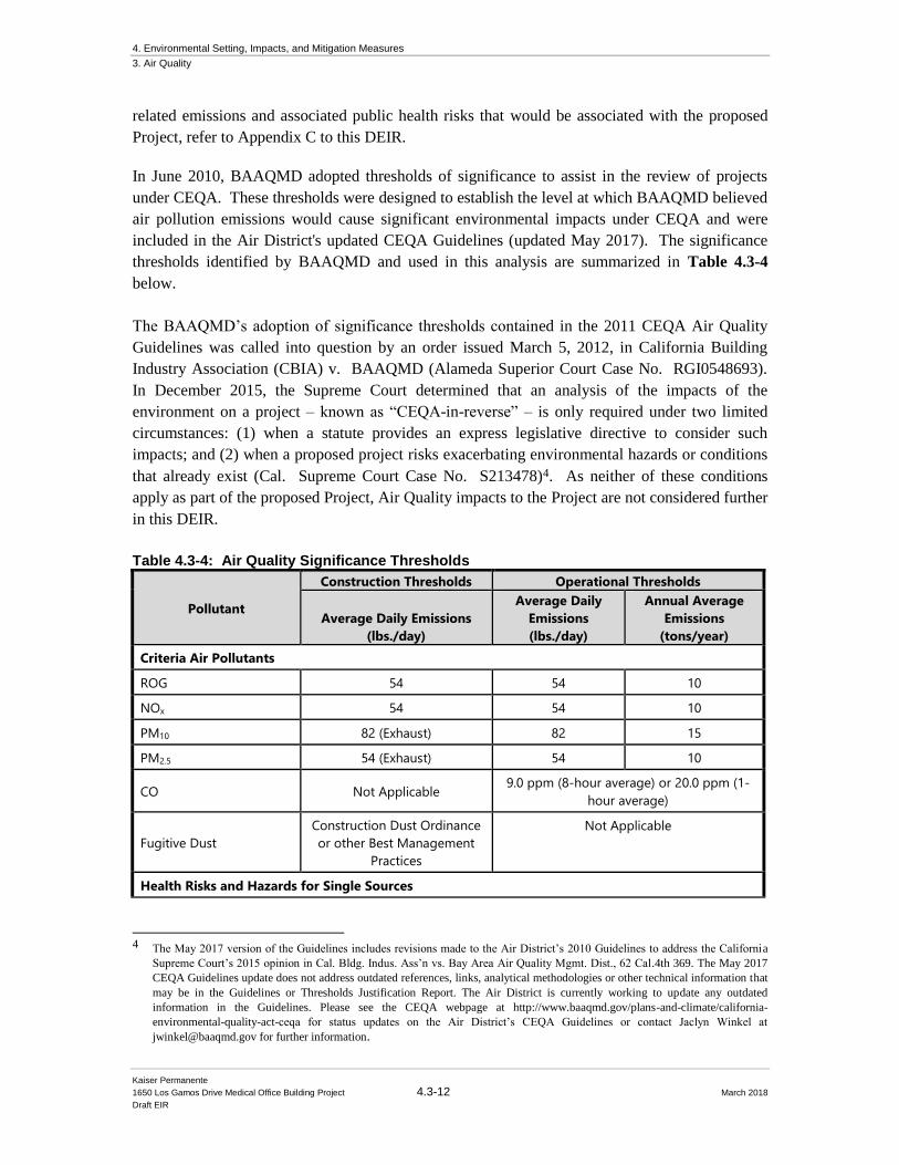
4. Environmental Setting, Impacts, and Mitigation Measures
3. Air Quality
Kaiser Permanente
1650 Los Gamos Drive Medical Office Building Project 4.3-12 March 2018
Draft EIR
related emissions and associated public health risks that would be associated with the proposed
Project, refer to Appendix C to this DEIR.
In June 2010, BAAQMD adopted thresholds of significance to assist in the review of projects
under CEQA. These thresholds were designed to establish the level at which BAAQMD believed
air pollution emissions would cause significant environmental impacts under CEQA and were
included in the Air District's updated CEQA Guidelines (updated May 2017). The significance
thresholds identified by BAAQMD and used in this analysis are summarized in Table 4.3-4
below.
The BAAQMD’s adoption of significance thresholds contained in the 2011 CEQA Air Quality
Guidelines was called into question by an order issued March 5, 2012, in California Building
Industry Association (CBIA) v. BAAQMD (Alameda Superior Court Case No. RGI0548693).
In December 2015, the Supreme Court determined that an analysis of the impacts of the
environment on a project – known as “CEQA-in-reverse” – is only required under two limited
circumstances: (1) when a statute provides an express legislative directive to consider such
impacts; and (2) when a proposed project risks exacerbating environmental hazards or conditions
that already exist (Cal. Supreme Court Case No. S213478)4. As neither of these conditions
apply as part of the proposed Project, Air Quality impacts to the Project are not considered further
in this DEIR.
Table 4.3-4: Air Quality Significance Thresholds
Pollutant
Construction Thresholds Operational Thresholds
Average Daily Emissions
(lbs./day)
Average Daily
Emissions
(lbs./day)
Annual Average
Emissions
(tons/year)
Criteria Air Pollutants
ROG 54 54 10
NOx 54 54 10
PM10 82 (Exhaust) 82 15
PM2.5 54 (Exhaust) 54 10
CO Not Applicable 9.0 ppm (8-hour average) or 20.0 ppm (1-
hour average)
Fugitive Dust
Construction Dust Ordinance
or other Best Management
Practices
Not Applicable
Health Risks and Hazards for Single Sources
4 The May 2017 version of the Guidelines includes revisions made to the Air District’s 2010 Guidelines to address the California
Supreme Court’s 2015 opinion in Cal. Bldg. Indus. Ass’n vs. Bay Area Air Quality Mgmt. Dist., 62 Cal.4th 369. The May 2017
CEQA Guidelines update does not address outdated references, links, analytical methodologies or other technical information that
may be in the Guidelines or Thresholds Justification Report. The Air District is currently working to update any outdated
information in the Guidelines. Please see the CEQA webpage at http://www.baaqmd.gov/plans-and-climate/california-
environmental-quality-act-ceqa for status updates on the Air District’s CEQA Guidelines or contact Jaclyn Winkel at
[email protected] for further information.

4. Environmental Setting, Impacts, and Mitigation Measures
3. Air Quality
Kaiser Permanente
1650 Los Gamos Drive Medical Office Building Project 4.3-13 March 2018
Draft EIR
Excess Cancer Risk >10 per one million
Hazard Index >1.0
Incremental annual PM2.5 >0.3 µg/m3
Health Risks and Hazards for Combined Sources (Cumulative from all sources within 1,000 foot
zone of influence)
Excess Cancer Risk >100 per one million
Hazard Index >10.0
Annual Average PM2.5 >0.8 µg/m3
Greenhouse Gas Emissions
GHG Annual Emissions
Compliance with a Qualified GHG Reduction Strategy
OR
1,100 metric tons or 4.6 metric tons per capita
Note: ROG = reactive organic gases, NOx = nitrogen oxides, PM10 = course particulate matter or particulates with an
aerodynamic diameter of 10 micrometers (µm) or less, PM2.5 = fine particulate matter or particulates with an
aerodynamic diameter of 2.5µm or less; and GHG = greenhouse gas.
Source: Illingworth & Rodkin 2018
4.3.4 Criteria Pollutants Impacts and Mitigation Impact AIR-1: The Project would result in a cumulatively considerable net increase
of any criteria pollutant for which the Project region is non-attainment under an applicable
State or federal ambient air quality standard (including releasing emissions which exceed
quantitative thresholds for ozone precursors). The incorporation of construction best
management practices as Project conditions of approval would result in a less-than-
significant temporary criteria air pollutant impact. (Less than Significant with Mitigation
Incorporation)
The Bay Area is considered a non-attainment area for ground-level ozone and PM2.5 under both
the Federal Clean Air Act (CAA) and the California Clean Air Act. The area is also considered
non-attainment for PM10 under the California Clean Air Act, but not the federal act. The area has
attained both State and federal ambient air quality standards for carbon monoxide. As part of an
effort to attain and maintain ambient air quality standards for ozone and PM10, the BAAQMD has
established thresholds of significance for these air pollutants and their precursors. These
thresholds are for ozone precursor pollutants (ROG and NOX), PM10, and PM2.5 and apply to both
construction period and operational period impacts.
The California Emissions Estimator Model (CalEEMod) Version 2016.3.2 was used to estimate
emissions from construction and operation of the site assuming full build out of the Project. The
Project land use types and size, and anticipated construction schedule were input to CalEEMod5.
5 The CalEEMod emissions calculations can be found in Appendix C of the 2018 Illingworth & Rodkin Air Quality and Greenhouse
Gases Emissions Report (see Appendix C to this DEIR for the full Illingworth & Rodkin report).
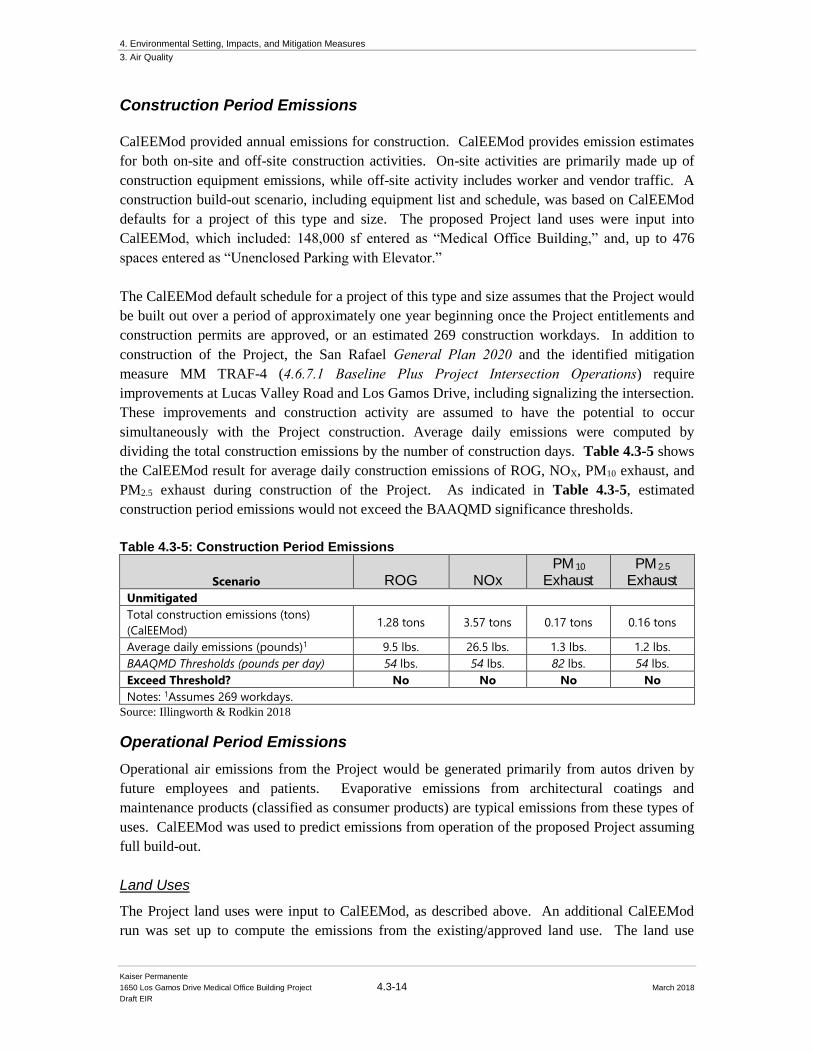
4. Environmental Setting, Impacts, and Mitigation Measures
3. Air Quality
Kaiser Permanente
1650 Los Gamos Drive Medical Office Building Project 4.3-14 March 2018
Draft EIR
Construction Period Emissions
CalEEMod provided annual emissions for construction. CalEEMod provides emission estimates
for both on-site and off-site construction activities. On-site activities are primarily made up of
construction equipment emissions, while off-site activity includes worker and vendor traffic. A
construction build-out scenario, including equipment list and schedule, was based on CalEEMod
defaults for a project of this type and size. The proposed Project land uses were input into
CalEEMod, which included: 148,000 sf entered as “Medical Office Building,” and, up to 476
spaces entered as “Unenclosed Parking with Elevator.”
The CalEEMod default schedule for a project of this type and size assumes that the Project would
be built out over a period of approximately one year beginning once the Project entitlements and
construction permits are approved, or an estimated 269 construction workdays. In addition to
construction of the Project, the San Rafael General Plan 2020 and the identified mitigation
measure MM TRAF-4 (4.6.7.1 Baseline Plus Project Intersection Operations) require
improvements at Lucas Valley Road and Los Gamos Drive, including signalizing the intersection.
These improvements and construction activity are assumed to have the potential to occur
simultaneously with the Project construction. Average daily emissions were computed by
dividing the total construction emissions by the number of construction days. Table 4.3-5 shows
the CalEEMod result for average daily construction emissions of ROG, NOX, PM10 exhaust, and
PM2.5 exhaust during construction of the Project. As indicated in Table 4.3-5, estimated
construction period emissions would not exceed the BAAQMD significance thresholds.
Table 4.3-5: Construction Period Emissions
Scenario ROG NOx PM10
Exhaust PM2.5
Exhaust Unmitigated
Total construction emissions (tons)
(CalEEMod) 1.28 tons 3.57 tons 0.17 tons 0.16 tons
Average daily emissions (pounds)1 9.5 lbs. 26.5 lbs. 1.3 lbs. 1.2 lbs.
BAAQMD Thresholds (pounds per day) 54 lbs. 54 lbs. 82 lbs. 54 lbs.
Exceed Threshold? No No No No
Notes: 1Assumes 269 workdays.
Source: Illingworth & Rodkin 2018
Operational Period Emissions
Operational air emissions from the Project would be generated primarily from autos driven by
future employees and patients. Evaporative emissions from architectural coatings and
maintenance products (classified as consumer products) are typical emissions from these types of
uses. CalEEMod was used to predict emissions from operation of the proposed Project assuming
full build-out.
Land Uses
The Project land uses were input to CalEEMod, as described above. An additional CalEEMod
run was set up to compute the emissions from the existing/approved land use. The land use
4. Environmental Setting, Impacts, and Mitigation Measures
3. Air Quality
Kaiser Permanente
1650 Los Gamos Drive Medical Office Building Project 4.3-15 March 2018
Draft EIR
entered was 148,000 sf as “General Office.”
Model Year
Emissions associated with vehicle travel depend on the year of analysis because emission control
technology requirements are phased-in over time. Therefore, the earlier the year analyzed in the
model, the higher the emission rates utilized by CalEEMod. The earliest full year the buildout
Project could possibly be constructed and begin operating would be 2020. Emissions associated
with build-out later than 2020 would be lower.
Trip Generation Rates
CalEEMod allows the user to enter specific vehicle trip generation rates. However, the trip
generation rates from the 2018 Fehr & Peers 1650 Los Gamos Drive FTIA report (36.13 trips per
1,000 sf for the Project and 11.03 trips per 1,000 sf for the existing/approved use) are the same as
the default trip rates in CalEEMod and were, therefore, not modified. The default trip lengths and
trip types specified by CalEEMod were used. Although the Project would shift some employees
from other nearby Kaiser facilities to the proposed Project, a trip reduction credit was
conservatively not taken for purposes of this analysis.
Energy
CalEEMod defaults for energy use were used, which are assumed to include the latest 2016 Title
24 Building Standards.
Project Generator
The only source of stationary air pollutants identified with build-out of the project is assumed to
be an emergency back-up generator. The Project proposes use of a 600 kW (approximately 880
hp) generator. It is assumed for this assessment that the generator would be driven by a diesel-
fueled engine.
The emergency back-up generator would be used for backup power in emergency conditions.
The generator would be operated for testing and maintenance purposes, with a maximum of 50
hours each per year of non-emergency operation under normal conditions allowed by BAAQMD.
During testing periods, the engine would typically be run for less than one hour. The engine
would be required to meet CARB and EPA emission standards and consume commercially
available California low-sulfur diesel fuel. The generator emissions were modeled using
CalEEMod.
Other Inputs
Default model assumptions for emissions associated with solid waste generation and
water/wastewater use were applied to the Project.
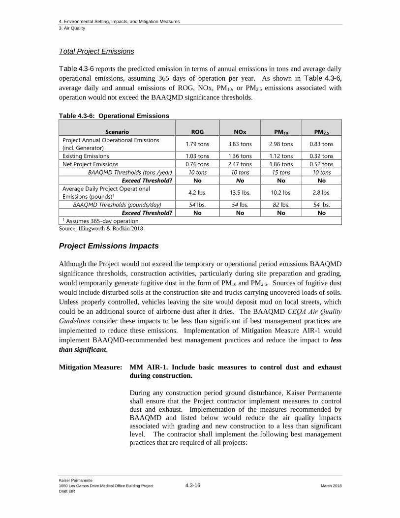
4. Environmental Setting, Impacts, and Mitigation Measures
3. Air Quality
Kaiser Permanente
1650 Los Gamos Drive Medical Office Building Project 4.3-16 March 2018
Draft EIR
Total Project Emissions
Table 4.3-6 reports the predicted emission in terms of annual emissions in tons and average daily
operational emissions, assuming 365 days of operation per year. As shown in Table 4.3-6,
average daily and annual emissions of ROG, NOx, PM10, or PM2.5 emissions associated with
operation would not exceed the BAAQMD significance thresholds.
Table 4.3-6: Operational Emissions
Scenario ROG NOx PM10 PM2.5
Project Annual Operational Emissions
(incl. Generator) 1.79 tons 3.83 tons 2.98 tons 0.83 tons
Existing Emissions 1.03 tons 1.36 tons 1.12 tons 0.32 tons
Net Project Emissions 0.76 tons 2.47 tons 1.86 tons 0.52 tons
BAAQMD Thresholds (tons /year) 10 tons 10 tons 15 tons 10 tons
Exceed Threshold? No No No No
Average Daily Project Operational
Emissions (pounds)1 4.2 lbs. 13.5 lbs. 10.2 lbs. 2.8 lbs.
BAAQMD Thresholds (pounds/day) 54 lbs. 54 lbs. 82 lbs. 54 lbs.
Exceed Threshold? No No No No 1 Assumes 365-day operation
Source: Illingworth & Rodkin 2018
Project Emissions Impacts
Although the Project would not exceed the temporary or operational period emissions BAAQMD
significance thresholds, construction activities, particularly during site preparation and grading,
would temporarily generate fugitive dust in the form of PM10 and PM2.5. Sources of fugitive dust
would include disturbed soils at the construction site and trucks carrying uncovered loads of soils.
Unless properly controlled, vehicles leaving the site would deposit mud on local streets, which
could be an additional source of airborne dust after it dries. The BAAQMD CEQA Air Quality Guidelines consider these impacts to be less than significant if best management practices are
implemented to reduce these emissions. Implementation of Mitigation Measure AIR-1 would
implement BAAQMD-recommended best management practices and reduce the impact to less
than significant.
Mitigation Measure: MM AIR-1. Include basic measures to control dust and exhaust
during construction.
During any construction period ground disturbance, Kaiser Permanente
shall ensure that the Project contractor implement measures to control
dust and exhaust. Implementation of the measures recommended by
BAAQMD and listed below would reduce the air quality impacts
associated with grading and new construction to a less than significant
level. The contractor shall implement the following best management
practices that are required of all projects:
4. Environmental Setting, Impacts, and Mitigation Measures
3. Air Quality
Kaiser Permanente
1650 Los Gamos Drive Medical Office Building Project 4.3-17 March 2018
Draft EIR
1. All exposed surfaces (e.g., parking areas, staging areas, soil piles,
graded areas, and unpaved access roads) shall be watered two times
per day.
2. All haul trucks transporting soil, sand, or other loose material off-site
shall be covered.
3. All visible mud or dirt track-out onto adjacent public roads shall be
removed using wet power vacuum street sweepers at least once per
day. The use of dry power sweeping is prohibited.
4. All vehicle speeds on unpaved roads shall be limited to 15 miles per
hour (mph).
5. All roadways, driveways, and sidewalks to be paved shall be
completed as soon as possible. Building pads shall be laid as soon as
possible after grading unless seeding or soil binders are used.
6. Idling times shall be minimized either by shutting equipment off
when not in use or reducing the maximum idling time to 5 minutes
(as required by the California airborne toxics control measure Title
13, Section 2485 of California Code of Regulations [CCR]). Clear
signage shall be provided for construction workers at all access
points.
7. All construction equipment shall be maintained and properly tuned in
accordance with manufacturer’s specifications. All equipment shall
be checked by a certified mechanic and determined to be running in
proper condition prior to operation.
8. Post a publicly visible sign with the telephone number and person to
contact at the Lead Agency regarding dust complaints. This person
shall respond and take corrective action within 48 hours. The Air
District’s phone number shall also be visible to ensure compliance
with applicable regulations.
4.3.5 Air Quality Standards Impacts and Mitigation Impact AIR-2: The Project would not violate any air quality standard or contribute
substantially to an existing or projected air quality violation. (Less than Significant)
As discussed under Impact AIR-1, the Project would have emissions less than the BAAQMD
screening size for evaluating impacts related to ozone and particulate matter. Therefore, the
Project would not contribute substantially to existing or projected violations of those standards.
Carbon monoxide emissions from traffic generated by the Project would be the pollutant of
greatest concern at the local level. Congested intersections with a large volume of traffic have the
greatest potential to cause high-localized concentrations of carbon monoxide. Air pollutant
4. Environmental Setting, Impacts, and Mitigation Measures
3. Air Quality
Kaiser Permanente
1650 Los Gamos Drive Medical Office Building Project 4.3-18 March 2018
Draft EIR
monitoring data indicate that carbon monoxide levels have been at healthy levels (i.e., below
State and federal standards) in the Bay Area since the early 1990s. As a result, the region has
been designated as attainment for the standard. “Attainment” status for a pollutant means that the
Air District meets the standard set by the USEPA (federal) or California EPA (state). The highest
measured level over any 8-hour averaging period during the last 3 years in the Bay Area is less
than 3.0 parts per million (ppm), compared to the ambient air quality standard of 9.0 ppm.
Intersections affected by the Project would have traffic volumes less than the BAAQMD
screening criteria and, thus, would not cause a violation of an ambient air quality standard or have
a considerable contribution to cumulative violations of these standards.6 Therefore, the impact
would be considered less than significant.
Mitigation: None Required.
4.3.6 Sensitive Receptors Impacts and Mitigation
Impact AIR-3: The Project would expose sensitive receptors to substantial pollutant
concentrations. The incorporation of construction best management practices as Project
conditions of approval would result in a less than significant temporary impact to sensitive
receptors. (Less than Significant with Mitigation Incorporation)
Project impacts related to increased community risk can occur either by introducing a new
sensitive receptor, such as a residential use, in proximity to an existing source of TACs or by
introducing a new source of TACs with the potential to adversely affect existing sensitive
receptors in the Project vicinity. The BAAQMD recommends using a 1,000-foot screening radius
around a Project site for purposes of identifying community health risk from siting a new
sensitive receptor or a new source of TACs. It is anticipated that the Project could include an
emergency back-up generator that is powered by diesel fuel. This generator would only be
operated for testing and emergency purposes. The Project would not introduce new sensitive
receptors to the area. There are thresholds that address both the impact of single and cumulative
TAC sources upon projects that include new sensitive receptors (see Table 4.3-1). Construction
activity would generate dust and equipment exhaust on a temporary basis that could affect nearby
sensitive receptors. Attachment 1 in the Illingworth & Rodkin Air Quality and Greenhouse Gas Emissions report (see Appendix C to this DEIR) provides the detailed construction risk modeling
methodology and parameters.
Operational Community Risk Impacts - Project Generator
As previously described, the Project could include a 600 kW emergency generator. The generator
would be operated for testing and maintenance purposes, with a maximum of 50 hours per year of
6 For a land-use project type, the BAAQMD CEQA Air Quality Guidelines state that a proposed project would result in a less than
significant impact to localized carbon monoxide concentrations if the project would not increase traffic at affected intersections with
more than 44,000 vehicles per hour.
4. Environmental Setting, Impacts, and Mitigation Measures
3. Air Quality
Kaiser Permanente
1650 Los Gamos Drive Medical Office Building Project 4.3-19 March 2018
Draft EIR
non-emergency operation under normal conditions. During testing periods the engine would
typically be run for less than one hour under light engine loads. The engines would be required to
meet USEPA emission standards and consume commercially available California low sulfur
diesel fuel. The emissions from the operation of the generator were calculated based on the
manufacturer’s full load emission factors (see Attachment 2 in the Illingworth & Rodkin Air Quality and Greenhouse Gas Emissions report for Emission Data Sheet – Appendix C to this
DEIR) and assuming each generator would operate for 50 hours.
Risk and PM2.5 concentrations from a diesel generator of this size and average daily emissions
were then calculated based on BAAQMD’s Risk and Hazards Emissions Screening Calculator (Beta Version) and Distance Adjustment Multiplier Tool for Diesel Internal Combustion Engines.
Results indicate that the Project generator would result in an excess cancer risk of 0.1 per
million,7 PM2.5 concentration of <0.01μg/m3 and HI of <0.01 at the nearest sensitive receptor
(residence to the west), all of which would be below BAAQMD thresholds of significance, both
on-site affecting Project users and at nearby sensitive receptors. Therefore, this impact would be
considered less than significant. Attachment 2 of the Illingworth & Rodkin Air Quality and Greenhouse Gas Emissions (see Appendix C to this DEIR) report includes emission factors and
risk modeling calculations for the Project emergency back-up generator.
Project Construction Activity
Construction equipment and associated heavy-duty truck traffic generates diesel exhaust, which is
a known TAC. These exhaust air pollutant emissions would not be considered to contribute
substantially to existing or projected air quality violations. Construction exhaust emissions may
still pose community risks for sensitive receptors such as nearby residents. The primary
community risk impact issues associated with construction emissions are cancer risk and
exposure to PM2.5. Diesel exhaust poses both a potential health and nuisance impact to nearby
receptors. A community risk assessment of the Project construction activities was conducted that
evaluated potential health effects of sensitive receptors at these nearby residences from
construction emissions of DPM and PM2.5.8 The closest sensitive receptors to the Project site are
residences approximately 215 feet to the west and southwest of the proposed parking structure.
Additional sensitive receptors include children in the school/daycare facilities at the 1600 Los
Gamos Drive office building, located approximately 700 feet to the south of the proposed parking
structure (see Figure 4.3-1). Emissions and dispersion modeling was conducted to predict the
off-site DPM concentrations resulting from Project construction, so that lifetime cancer risks and
non-cancer health effects could be evaluated. In addition to construction of the Project, the San
Rafael General Plan 2020 and the identified mitigation measure MM TRAF-4 (4.6.7.1 Baseline Plus Project Intersection Operations) require improvements at Lucas Valley Road and Los
Gamos Drive, including signalizing the intersection. While these improvements and construction
7 Includes adjustment factor of 1.3744 to account for latest OEHHA methodology per correspondence with Alison
Kirk, BAAQMD, November 23, 2015. 8 DPM is identified by California as a toxic air contaminant due to the potential to cause cancer.
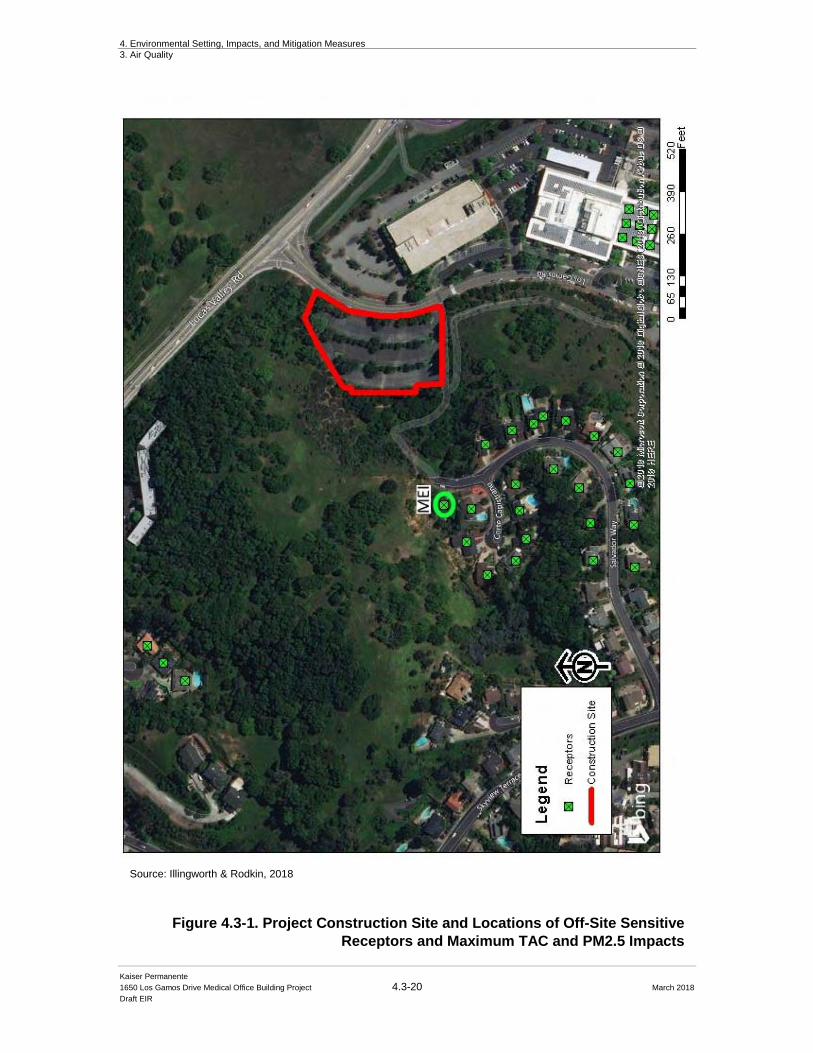
4. Environmental Setting, Impacts, and Mitigation Measures
3. Air Quality
Kaiser Permanente
1650 Los Gamos Drive Medical Office Building Project 4.3-20 March 2018
Draft EIR
Figure 4.3-1. Project Construction Site and Locations of Off-Site Sensitive
Receptors and Maximum TAC and PM2.5 Impacts
Source: Illingworth & Rodkin, 2018

4. Environmental Setting, Impacts, and Mitigation Measures
3. Air Quality
Kaiser Permanente
1650 Los Gamos Drive Medical Office Building Project 4.3-21 March 2018
Draft EIR
activity have the potential to occur simultaneously with the Project construction, the majority of
the intersection improvements would be 1,000 feet or greater from the project construction
maximum exposed individual (MEI), which is beyond BAAQMD’s screening distance for
potentially significant community risk impacts. Therefore, the contribution to construction
community risk from the intersection improvements would be negligible.
On-Site Construction TAC Emissions
Construction period emissions were computed using CalEEMod along with projected
construction activity, as described above. The CalEEMod model provided total annual PM10
exhaust emissions (assumed to be DPM) for the off-road construction equipment used for
construction of the Project and for the exhaust emissions from on-road vehicles (vendor trucks
and worker vehicles) of 0.1631 tons (326 pounds) over the construction period. A trip length of
one-half mile was used to represent vehicle travel while at or near the construction site. For
modeling purposes, it was assumed that these emissions from on-road vehicles would occur at the
construction site. Fugitive dust PM2.5 emissions were also computed and included in this
analysis. The model predicts emissions of 0.0128 tons (26 pounds) of fugitive PM2.5 over the
construction period.
Dispersion Modeling
The U.S.EPA ISCST3 dispersion model was used to predict concentrations of DPM and PM2.5
concentrations at sensitive receptors (residences) in the vicinity of the Project construction area.
The ISCST3 dispersion model is a BAAQMD-recommended model for use in modeling analysis
of these types of emission activities for CEQA projects.9 The ISCST3 modeling utilized two area
sources to represent the on-site construction emissions, one for exhaust emissions and one for
fugitive dust emissions. To represent the construction equipment exhaust emissions, an emission
release height of 6 meters (19.7 feet) was used for the area source. The elevated source height
reflects the height of the equipment exhaust pipes plus an additional distance for the height of the
exhaust plume above the exhaust pipes to account for plume rise of the exhaust gases. For
modeling fugitive PM2.5 emissions, a near-ground level release height of 2 meters (6.6 feet) was
used for the area source. Emissions from the construction equipment and on-road vehicle travel
were distributed throughout the modeled area sources. Construction emissions were modeled as
occurring daily between 7 a.m. to 4 p.m., when the majority of construction activity would occur.
The modeling used a 5-year meteorological data set (2001 – 2005) from the Sonoma Baylands
prepared for use with the AERMOD model by the BAAQMD. Annual DPM and PM2.5
concentrations from construction activities during the 2018 - 2019 period were calculated using
the model. DPM and PM2.5 concentrations were calculated at nearby sensitive receptor locations.
Receptor heights of 1.5 meters (4.9 feet) were used to represent the breathing heights of
residents in first floor levels of nearby residences. The maximum-modeled cancer risk and
annual PM2.5 concentrations, which includes both the DPM and fugitive PM2.5 concentrations,
9 Bay Area Air Quality Management District (BAAQMD), 2012, Recommended Methods for Screening and Modeling Local Risks
and Hazards, Version 3.0. May.
4. Environmental Setting, Impacts, and Mitigation Measures
3. Air Quality
Kaiser Permanente
1650 Los Gamos Drive Medical Office Building Project 4.3-22 March 2018
Draft EIR
occurred at a residence the west of the Project site, as shown in Figure 4.3-1. Using the maximum
annual modeled DPM concentrations, the maximum increased cancer risks were calculated.
Attachment 3 in the Illingworth & Rodkin Air Quality and Greenhouse Gas Emissions (see
Appendix C to this DEIR) report includes the emission calculations used for the construction area
source modeling and the cancer risk calculations.
Cancer Risks
Results of this assessment indicate that the maximum excess residential cancer risks would be 4.1
in one million for an infant exposure and 0.1 in one million for an adult exposure. Excess cancer
risk at the Bright Horizons daycare would be 2.1 in one million. The maximum excess cancer
risk would not be greater than the BAAQMD significance threshold of 10 in one million.
Predicted Annual PM2.5 Concentration
The maximum-modeled annual PM2.5 concentration, which is based on combined exhaust and
fugitive dust emissions, was 0.03 μg/m3. The maximum annual PM2.5 concentration at the MEI
receptor location would not exceed the BAAQMD significance threshold of 0.3 μg/m3.
Non-Cancer Hazards
The maximum modeled annual residential DPM concentration (i.e., from construction exhaust)
was 0.0249 μg/m3. The maximum computed HI based on this DPM concentration is 0.01, which
is much lower than the BAAQMD significance criterion of a HI greater than 1.0.
Impacts
Construction activities, particularly during site preparation and grading would temporarily
generate fugitive dust in the form of respirable particulate matter (PM10) and PM2.5. Sources of
fugitive dust would include disturbed soils at the construction site and trucks carrying uncovered
loads of soils. Unless properly controlled, vehicles leaving the site would deposit mud on local
streets, which could be an additional source of airborne dust after it dries. The BAAQMD CEQA Air Quality Guidelines consider these impacts to be less than significant if best management
practices are employed to reduce these emissions. Therefore, implementation of mitigation
measure MM AIR-1 would implement BAAQMD required best management practices and
reduce the impact to less than significant levels.
Mitigation: Implementation of MM AIR-1.
4. Environmental Setting, Impacts, and Mitigation Measures
3. Air Quality
Kaiser Permanente
1650 Los Gamos Drive Medical Office Building Project 4.3-23 March 2018
Draft EIR
4.3.7 Cumulative Air Quality Impacts
Impact AIR-4: The Project would contribute to cumulative air quality degradation
and to regional air quality cumulative impacts. The incorporation of construction best
management practices as Project conditions of approval would result in a less than
significant cumulative air quality impact. (Less than Significant with Mitigation
Incorporation)
Geographic Context
All past, present and reasonably foreseeable future development within the air basin contributes to
regional emissions of criteria pollutants, thus basin-wide projections of emissions is factored into
assessing the cumulative effect. For cumulative sources of TACs, all existing sources within 1,000
feet of sensitive receptors affected by TAC emissions from the proposed Project are considered,
in combination with the Project-generated TACs.
Impacts
Based on BAAQMD guidance, if a Project would result in an increase in ROG, NOx, PM10, or
PM2.5 of more than its respective average daily mass thresholds, then it would also be considered
to contribute considerably to a significant cumulative impact. Short-term construction activities
associated with the Project will result in emissions that will be mitigated to less than significant
levels with implementation of mitigation measure MM AIR-1 and long-term operations of the
Project would result in emissions that will be less than significant. Therefore, mass emissions that
will be associated with the Project will not be cumulatively considerable when combined with
cumulative development in the regional air basin. As indicated above, all existing sources within
1,000 feet of sensitive receptors affected by TAC emissions from the proposed Project are
considered, in combination with the Project-generated TACs. Cumulative impacts associated with
criteria pollutants will be less than significant with implementation of mitigation measure MM
AIR-1. No further mitigation is required.
Mitigation: Implementation of MM AIR-1.
4. Environmental Setting, Impacts, and Mitigation Measures
3. Air Quality
Kaiser Permanente
1650 Los Gamos Drive Medical Office Building Project 4.3-24 March 2018
Draft EIR
This page intentionally left blank
4. Environmental Setting, Impacts, and Mitigation Measures
4. Greenhouse Gases and Climate Change
Kaiser Permanente
1650 Los Gamos Drive Medical Office Building Project 4.4-1 March 2018
Draft EIR
4.4 Greenhouse Gases and Climate Change
This section incorporates the setting information and analyses included in the 2018 Illingworth and
Rodkin Kaiser Medical Office Building Air Quality and Greenhouse Gas Emissions Assessment conducted for the Project. This section summarizes key Federal, State, and City statutes,
regulations, and policies that would apply to the proposed Project. Global climate change resulting
from greenhouse gas (GHG) emissions is an emerging environmental concern being raised and
discussed at the international, national, and statewide level. At each level, agencies are considering
strategies to control emissions of gases that contribute to global climate change. This analysis was
conducted following guidance provided by the Bay Area Air Quality Management District
(BAAQMD, 2017). This analysis also evaluates the Project consistent with CEQA Guidelines
§15183.5 and 15064(h)(3), which allow for tiering and streamlining at the project level when a
project meets the criteria of the programmatic analysis of GHG emissions (a climate action plan).
4.4.1 Setting
Global temperatures are affected by naturally occurring and anthropogenic-generated (generated
by humankind) atmospheric gases, such as water vapor, carbon dioxide (CO2), methane (CH4), and
nitrous oxide (N2O) (IPCC, 2014). Gases that trap heat in the atmosphere are called GHGs. Solar
radiation enters the Earth’s atmosphere from space, and a portion of the radiation is absorbed at the
surface. The Earth emits this radiation back toward space as infrared radiation. GHGs, which are
mostly transparent to incoming solar radiation, are effective in absorbing infrared radiation and
redirecting some of this back to the Earth’s surface. As a result, this radiation that otherwise would
have escaped back into space is now retained, resulting in a warming of the atmosphere. This is
known as the greenhouse effect. The greenhouse effect maintains a habitable climate. Emissions of
GHGs from human activities, such as electricity production, motor vehicle use, and agriculture are
elevating the concentration of GHGs in the atmosphere, and are reported to have led to a trend of
unnatural warming of the Earth’s natural climate, known as global warming or climate change.
Other than water vapor, the GHGs contributing to global warming include the following gases:
● CO2 (carbon dioxide) is primarily a byproduct of fuel combustion;
● N2O (nitrous oxide) is a byproduct of fuel combustion and also associated with
agricultural operations such as fertilization of crops;
● CH4 (methane) is commonly created by off-gassing from agricultural practices (e.g.
livestock), wastewater treatment, and landfill operations;
● Chlorofluorocarbons (CFCs) that were widely used as refrigerants, propellants, and
cleaning solvents, but their production has been mostly reduced by international treaty;
● Hydrofluorocarbons (HCFCs) are now used as a substitute for CFCs in refrigeration
and cooling; and
● Perfluorocarbons and sulfur hexafluoride (SF6) emissions are commonly created by
industries such as aluminum production and semiconductor manufacturing.
4. Environmental Setting, Impacts, and Mitigation Measures
4. Greenhouse Gases and Climate Change
Kaiser Permanente
1650 Los Gamos Drive Medical Office Building Project 4.4-2 March 2018
Draft EIR
Gases in the atmosphere can contribute to the greenhouse effect both directly and indirectly. Direct
effects occur when the gas itself absorbs outgoing radiation. Indirect effects occur when gases cause
chemical reactions that produce other GHGs or prolong the existence of other GHGs. The Global
Warming Potential (GWP) concept is used to compare the ability of each GHG to trap heat in the
atmosphere relative to CO2, which is the most abundant GHG. CO2 has a potential of 1, expressed
as CO2e. Other GHGs, such as CH4 and N2O are commonly found in the atmosphere but at much
lower concentrations. However, the GWP for methane is 21, while N2O has a GWP of 310. Other
trace gases, such as CFCs and HCFCs, which are halocarbons that contain chlorine, have much
greater GWPs. Fortunately, these gases are found at much lower concentrations and many are being
phased out as a result of global efforts to reduce destruction of stratospheric ozone. In the United
States, CO2 emissions account for about 83 percent of the CO2e emissions, followed by CH4 at
about 10 percent, and N2O at about 5 percent (USEPA, 2011).
The IPCC predicts a temperature increase of between 2 and 11.5 degrees Fahrenheit (ºF) (1.1 and
6.4 degrees Celsius) by the end of the 21st Century under six different scenarios of emissions and
CO2 equivalent (CO2e) concentrations (IPCC, 2007). Sea levels are predicted to rise by 7 to
23 inches (0.18 to 0.59 meters) during this time, with an additional 3.9 to 7.8 inches possible
depending upon the rate of polar ice sheet melting from increased warming. The IPCC states that
the increase in hurricane and tropical cyclone strength since 1970 can likely be attributed to human-
generated GHGs.
4.4.2 Regulatory Setting
Global climate change resulting from GHG emissions is an emerging environmental concern being
raised and discussed at the international, national, state, and local level. At each level, agencies are
considering strategies to reduce emissions of gases that contribute to global warming.
4.4.2.1 Federal
The U.S. Environmental Protection Agency (USEPA) is the federal agency responsible for
implementing the Clean Air Act (CAA). The U.S. Supreme Court ruled on April 2, 2007, that CO2
is an air pollutant as defined under the CAA, and that USEPA has the authority to regulate
emissions of GHGs. In response to the mounting issue of climate change, USEPA has taken actions
to regulate, monitor, and potentially reduce GHG emissions. Actions include a national program to
reduce GHG emissions and improve fuel economy for all new cars and trucks sold in the United
States. However, there are no federal plans, policies, regulations, or laws related to GHGs that are
directly applicable to the Project.
The United States participates in the United Nations Framework Convention on Climate Change
(UNFCCC). At this time, there are no federal regulations or policies pertaining to GHG emissions
from proposed actions like the proposed Project. As part of the commitments to UNFCCC, the US
EPA has developed an inventory of anthropogenic emissions by sources and removals by sinks of
all greenhouse gases. This inventory is periodically updated with the latest update being April 2016.
4. Environmental Setting, Impacts, and Mitigation Measures
4. Greenhouse Gases and Climate Change
Kaiser Permanente
1650 Los Gamos Drive Medical Office Building Project 4.4-3 March 2018
Draft EIR
The USEPA reports that total U.S. emissions have risen by 7.4 percent from 1990 to 2014 to 6,870
million metric tons of CO2e (MMTCO2e) per year, while emissions increased by 1.0 percent from
2013 to 2014. In 2014, relatively cool winter conditions led to an increase in fuels for the residential
and commercial sectors for heating. Additionally, transportation emissions increased as a result of
a small increase in vehicle miles traveled (VMT) and fuel use across on-road transportation modes.
There also was an increase in industrial production across multiple sectors resulting in slight
increases in industrial sector emissions. Lastly, since 1990, U.S. emissions have increased at an
average annual rate of 0.3 percent. (USEPA, 2016).
4.4.2.2 State of California
The State of California is concerned about GHG emissions and their effect on global climate
change. The State recognizes that “there appears to be a close relationship between the
concentration of GHGs in the atmosphere and global temperatures” and that “the evidence for
climate change is overwhelming.” The effects of climate change on California, in terms of how it
would affect the ecosystem and economy, remain uncertain. The State has many areas of concern
regarding climate change with respect to global warming. According to the 2006 Climate Action
Team Report, the following climate change effects and conditions can be expected in California
over the course of the next century:
• A diminishing Sierra snowpack declining by 70 percent to 90 percent, effecting the
state’s water supply;
• Increasing temperatures from 8 to 10.4 degrees Fahrenheit (°F) under the higher
emission scenarios, leading to a 25 to 35 percent increase in the number of days
ozone pollution standards are exceeded in most urban areas;
• Coastal erosion along the length of California and seawater intrusion into the
Sacramento River Delta from a 4- to 33-inch rise in sea level. This would exacerbate
flooding in already vulnerable regions;
• Increased vulnerability of forests due to pest infestation and increased temperatures;
• Increased challenges for the state’s important agricultural industry from water
shortages, increasing temperatures, and saltwater intrusion into the Delta; and
• Increased electricity demand, particularly in the hot summer months.
Executive Order S-3-05
In 2005, the Governor of California signed Executive Order S-3-05, which established GHG
emission reduction targets to reduce emissions to 2000 levels by 2010, to reduce emissions to 1990
levels by 2020, and to reduce emissions to 80 percent below 1990 levels by 2050. The Secretary of
the California Environmental Protection Agency (Secretary) was designated to coordinate
oversight of the efforts made to meet the targets with the Business, Transportation and Housing
Agency, the Department of Food and Agriculture, the Resources Agency, the Air Resources Board,
the Energy Commission, and the Public Utilities Commission. The Secretary reports to the
Governor and State Legislature biannually on the impacts to California from global warming,
including impacts to water supply, public health, agriculture, the coastline, and forestry. The most
4. Environmental Setting, Impacts, and Mitigation Measures
4. Greenhouse Gases and Climate Change
Kaiser Permanente
1650 Los Gamos Drive Medical Office Building Project 4.4-4 March 2018
Draft EIR
recent report, Safeguarding California: Reducing Climate Risk was approved in July 2014 (Natural
Resource Agency 2014).
Executive Order B-30-15
On April 29, 2015, California Governor Jerry Brown announced E.O. B-30-15, which establishes
a California GHG reduction target of 40 percent below 1990 levels by 2030. California is on track
to meet or exceed the current target of reducing GHG emissions to 1990 levels by 2020, as
established in the California Global Warming Solutions Act of 2006 (AB 32). California's new
emission reduction target of 40 percent below 1990 levels by 2030 will make it possible to reach
the ultimate goal of reducing emissions 80 percent under 1990 levels by 2050. This is in line with
the scientifically established levels needed in the U.S. to limit global warming below 2 degrees
Celsius - the warming threshold at which scientists say there will likely be major climate disruptions
such as super droughts and rising sea levels.
Assembly Bill 32, California Global Warming Solutions Act of 2006
AB 32, the Global Warming Solutions Act of 2006, codifies the State’s GHG emissions target by
directing CARB to reduce the State’s global warming emissions to 1990 levels by 2020. AB 32
was signed and passed into law by Governor Schwarzenegger on September 27, 2006. Since that
time, the CARB, CEC, California Public Utilities Commission (CPUC), and Building Standards
Commission have all been developing regulations that will help meet the goals of AB 32 and
Executive Order S-3-05. The statute requires the CARB to track emissions through mandatory
reporting, determine the 1990 emission levels, set annual emissions limits that will result in meeting
the 2020 target, and design and implement regulations and other feasible and cost-effective
measures to ensure that statewide GHG emissions will be reduced to 1990 levels by 2020. In
December 2007, the ARB approved the 2020 emissions limit at 427 MMT CO2e. The
Intergovernmental Panel on Climate Change (IPCC), which assesses scientific, technical, and
socioeconomic information relevant to the understanding of climate change, has since revised the
global warming potential of certain GHGs. Therefore, CARB recalculated the 2020 emissions limit
as 431 MMT CO2e. Projected business-as-usual emissions for 2020 are 509 MMT CO2e. A
reduction of 78 MMT CO2e is needed to meet the goal (ARB 2014).
Climate Change Scoping Plan
In December 2008, pursuant to AB 32, the CARB adopted the Climate Change Scoping Plan
(Scoping Plan), which outlined measures to attain the 2020 GHG emissions limit. The Scoping
Plan estimated that implementation of identified measures would result in a reduction of 105.3
MMT CO2e from various sectors including transportation, energy, forestry, and high global
warming potential gas sectors (originally reported as 174 MMT CO2e, but updated to 105.3 MMT
CO2e in the Status of Scoping Plan Recommended Measures [CARB 2012]). This is 24 percent
more than is needed to meet the 2020 mandate. In May 2014, CARB approved the First Update to
the Climate Change Scoping Plan (Updated Scoping Plan) which describes the progress made to
meet the near-term (2020) objectives of AB 32 and defines California’s climate change priorities
4. Environmental Setting, Impacts, and Mitigation Measures
4. Greenhouse Gases and Climate Change
Kaiser Permanente
1650 Los Gamos Drive Medical Office Building Project 4.4-5 March 2018
Draft EIR
and activities for the next several years (CARB 2014). The Updated Scoping Plan also updated the
2020 emissions limit and business-as-usual emissions for 2020. The 2020 limit is now 431 MMT
CO2e and the business-as-usual forecast is 509 MMT CO2e. Finally, the Updated Scoping Plan
provides recommendations for establishing a mid-term emissions limit that aligns with the long-
term (2050) goals of Executive Order S-3-05. The recommendations cover the energy,
transportation, agriculture, water, waste management, natural and working lands, short-lived
climate pollutants, green building, and cap-and-trade sectors. The initial Scoping Plan
recommended that local governments achieve a 15-percent reduction below 2005 levels by 2020,
which aligns with the State’s goal of not exceeding 1990 emissions levels by 2020. However, the
Updated Scoping Plan does not contain a recommended reduction level or percent for local
government’s municipal operations. CARB adopted the updated Scoping Plan in November 2017.
California Building Code, Title 24
The Energy Efficiency Standards for Residential and Nonresidential Buildings were established in
1978 in response to a legislative mandate to reduce California's energy consumption. The standards
are updated periodically to allow consideration and possible incorporation of new energy efficiency
technologies and methods. Title 24 of the CCR includes requirements for the structural, plumbing,
electrical, and mechanical systems of buildings, and for fire and life safety, energy conservation,
green design, and accessibility in and about buildings. Two sections of Title 24 – Part 6, the
California Energy Code, and Part 11, the California Green Building Standards Code or CalGreen
Code – contain standards that address GHG emissions related to construction. The California Green
Building Standards Code, or CalGreen, became a mandatory code beginning January 1, 2011. The
code takes a holistic approach to green building by including minimum requirements in the areas
of planning and design, energy efficiency, water efficiency and conservation, material conservation
and resource efficiency, and environmental quality. The CalGreen code has minimum mandatory
standards and two additional tiers of voluntary measures intended to achieve greater levels of
efficiency that result in lower levels of GHG emissions. Local governments must enforce the
minimum standards and can choose to adopt either Tier 1 or Tier 2 standards to achieve greater
positive environmental impacts. The current 2016 Title 24 standards became effective January 1,
2017.
Senate Bill 375, California's Regional Transportation and Land Use Planning Efforts (2008)
California enacted legislation (SB 375) to expand the efforts of AB 32 by controlling indirect GHG
emissions caused by urban sprawl. SB 375 provides incentives for local governments and
applicants to implement new conscientiously planned growth patterns. This includes incentives for
creating attractive, walkable, and sustainable communities and revitalizing existing communities.
The legislation also allows applicants to bypass certain environmental reviews under CEQA if they
build projects consistent with the new sustainable community strategies. Development of more
alternative transportation options that would reduce vehicle trips and miles traveled, along with
traffic congestion, would be encouraged. SB 375 enhances CARB’s ability to reach the AB 32
goals by directing the agency in developing regional GHG emission reduction targets to be
4. Environmental Setting, Impacts, and Mitigation Measures
4. Greenhouse Gases and Climate Change
Kaiser Permanente
1650 Los Gamos Drive Medical Office Building Project 4.4-6 March 2018
Draft EIR
achieved from the transportation sector for 2020 and 2035. CARB works with the metropolitan
planning organizations (e.g. Association of Bay Area Governments [ABAG] and Metropolitan
Transportation Commission [MTC]) to align their regional transportation, housing, and land use
plans to reduce vehicle miles traveled and demonstrate the region's ability to attain its GHG
reduction targets. Plan Bay Area, adopted in 2013, is the first Bay Area Regional Transportation
Plan (RTP) to incorporate the state-mandated Sustainable Communities Strategy (SCS). As a
cooperative effort between MTC and ABAG, Plan Bay Area establishes performance targets for
meeting the SCS Bay Area goals of a 7 percent per capita reduction in GHG emissions by 2020
and a 15 percent per capita reduction by 2035.
Executive Order S-13-08 (2008)
This Executive Order directed California agencies to assess and reduce the vulnerability of future
development projects to impacts associated with sea-level rise.
Tiering and Streamlining the Analysis of Greenhouse Gas Emissions (CEQA Guidelines Section 15183.5)
CEQA allows a lead agency to comply with project-level review requirements pursuant to the
CEQA Guidelines Section 15183.5 which specify that project-level review requirements of GHG
emissions can “tier off” a programmatic analysis of GHG emissions, provided that the
programmatic analysis (climate action plan) includes the following:
• Quantify GHG emissions, both existing and projected over a specified time period,
resulting from activities within a defined geographic area.
• Establish a level, based on substantial evidence, below which the contribution to GHG
emissions from activities covered by the plan would not be cumulatively considerable.
• Identify and analyze the GHG emissions resulting from specific actions or categories of
actions anticipated within the geographic area.
• Specify measures or a group of measures, including performance standards that substantial
evidence demonstrates, if implemented on a project-by-project basis, would collectively
achieve the specified emissions level.
• Monitor the plan’s progress.
• Adopt the GHG reduction strategy in a public process following environmental review.
SB 350 Renewable Portfolio Standards
In September 2015, the California Legislature passed SB 350, which increases the states
Renewables Portfolio Standard (RPS) for content of electrical generation from the 33 percent target
for 2020 to a 50 percent renewables target by 2030.

4. Environmental Setting, Impacts, and Mitigation Measures
4. Greenhouse Gases and Climate Change
Kaiser Permanente
1650 Los Gamos Drive Medical Office Building Project 4.4-7 March 2018
Draft EIR
Statewide GHG Emissions Inventory
The California Greenhouse Gas Emission Inventory – 2017 Edition (released June 6, 2017)
indicates that total California emissions in 2015 were 440.4 MMT of CO2e1. Approximately 37
percent of these emissions were associated with transportation (i.e., all sectors), followed by the
Industrial sector at 21 percent and the Electric Power sector at 19 percent. The statewide inventory
was estimated to have peaked in 2004. The current 2015 inventory is estimated to represent an
overall decrease of 10 percent from 2004 levels.
4.4.2.3 Regional and Local
Bay Area Air Quality Management District (BAAQMD)
The Bay Area Air Quality Management District (BAAQMD) publishes CEQA Guidelines to assist
local jurisdictions and lead agencies in complying with the requirements of CEQA regarding
potentially adverse impacts to air quality. These CEQA Guidelines were updated in June 2010 to
include new thresholds of significance (2010 Thresholds) adopted by the BAAQMD Governing
Board. The BAAQMD’s Guidelines were further updated in May 2017 to address the California
Supreme Court’s 2015 opinion in California Building Industry Association vs. Bay Area Air Quality Management District, 62 Cal.4th 369. The 2010 GHG thresholds of significance contain
the following operational thresholds:
● Compliance with a Qualified GHG Reduction Strategy; or
● 1,100 metric tons (MT) of CO2e per year; or
● 4.6 MT CO2e per service population (residents plus employees) per year.
The BAAQMD does not currently have an adopted threshold of significance for construction GHG
emissions and currently recommends that lead agencies quantify GHG emissions resulting from
new development and apply all feasible mitigation measures to lessen the potentially significant
adverse impacts. The BAAQMD Guidelines state that the BAAQMD encourages local
governments to adopt a Qualified GHG Reduction Strategy that is consistent with AB 32 goals. If
a project is consistent with an adopted Qualified GHG Reduction Strategy that meets the standards
laid out below, it can be presumed that the project will not have significant GHG emission impacts.
This approach is consistent with the State CEQA Guidelines, Section 15183.5. The standard plan
elements of a GHG reduction strategy identified by the BAAQMD should:
A. Quantify greenhouse gas emissions, both existing and projected over a specified time
period, resulting from activities within a defined geographic area;
B. Establish a level, based on substantial evidence, below which the contribution to
greenhouse gas emissions from activities covered by the plan would not be cumulatively
considerable;
1 See https://www.arb.ca.gov/cc/inventory/pubs/reports/2000_2015/ghg_inventory_trends_00-15.pdf accessed June 8,
2017
4. Environmental Setting, Impacts, and Mitigation Measures
4. Greenhouse Gases and Climate Change
Kaiser Permanente
1650 Los Gamos Drive Medical Office Building Project 4.4-8 March 2018
Draft EIR
C. Identify and analyze the greenhouse gas emissions resulting from specific actions or
categories of actions anticipated within the geographic area;
D. Specify measures or a group of measures, including performance standards, that substantial
evidence demonstrates, if implemented on a project-by-project basis, would collectively
achieve the specified emissions level;
E. Establish a mechanism to monitor the plan’s progress toward achieving the level and to
require amendment if the plan is not achieving specified levels;
F. Be adopted in a public process following environmental review
As provided by BAAQMD (BAAQMD 2010, BAAQMD 20172), justification and substantial
evidence supporting thresholds are defined further:
“BAAQMD’s approach to developing a Threshold of Significance for GHG emissions is to
identify the emissions level for which a project would not be expected to substantially conflict
with existing California legislation adopted to reduce statewide GHG emissions needed to
move us towards climate stabilization. If a project would generate GHG emissions above the
threshold level, it would be considered to contribute substantially to a cumulative impact, and
would be considered significant. If mitigation can be applied to lessen the emissions such that
the project meets its share of emission reductions needed to address the cumulative impact, the
project would normally be considered less than significant.”
4.4.2.4 Local
City of San Rafael General Plan
The Sustainability and Air and Water Quality Elements of the San Rafael General Plan 2020 contain the following goal, policies, and implementation programs relevant to the GHG impacts of the proposed Project:
SU-1. Land Use.
Implement General Plan land use policies to increase residential and commercial densities
within walking distance of high frequency transit centers and corridors.
SU-2. Promote Alternative Transportation.
Decrease miles traveled in single-occupant vehicles.
SU-3. Alternative Fuel and Fuel Efficient Vehicles.
Promote the use of alternative fuel and fuel efficient vehicles.
SU-6. New and Existing Trees.
Plant new and retain existing trees to maximize energy conservation and carbon
sequestration benefits.
2 BAAQMD, California Environmental Quality Act Air Quality Guidelines, May 2017
4. Environmental Setting, Impacts, and Mitigation Measures
4. Greenhouse Gases and Climate Change
Kaiser Permanente
1650 Los Gamos Drive Medical Office Building Project 4.4-9 March 2018
Draft EIR
SU-9. Zero Waste.
Reduce material consumption and waste generation, increase resource re-use and
composting of organic waste, and recycle to significantly reduce and ultimately eliminate
landfill disposal.
SU-11. Environmentally Beneficial Economy.
Support environmentally beneficial businesses and job creation.
AW-1. State and Federal Standards.
Continue to comply and strive to exceed state and federal standards for air quality for the
benefit of the Bay Area.
AW-2. Land Use Compatibility.
To ensure excellent air quality, promote land use compatibility for new development by
using buffering techniques such as landscaping, setbacks, and screening in areas where
different land uses abut one another.
AW-3. Air Quality Planning with Other Processes.
Integrate air quality considerations with the land use and transportation processes by
mitigating air quality impacts through land use design measures, such as encouraging
project design that will foster walking and biking.
AW-4. Particulate Matter Pollution Reduction.
Promote the reduction of particulate matter pollution from roads, parking lots, construction
sites, agricultural lands and other activities.
AW-5. Circulation Alternatives.
Promote circulation alternatives that reduce air pollution.
City of San Rafael Climate Change Action Plan (CCAP)
The City of San Rafael adopted a Climate Change Action Plan (CCAP) in 2009 with the intent to
comply with state and federal regulations on reducing GHG emissions, such as California’s AB 32
and SB 375 legislation. San Rafael’s community-wide GHG emissions in 2005 amounted to
524,148 tons of CO2e (equivalent carbon dioxide units, including nitrous oxides and methane); of
that, 61 percent was associated with transportation, 17 percent from commercial buildings, 17
percent from residential buildings, and 5 percent from waste. A 15% reduction from this level
would actually constitute a 30% reduction by 2020, since the community’s GHG emissions are
projected to continue to grow 21% over that time period if unchecked. Implementation of the
programs recommended in the CCAP, together with others already underway, would meet the
state’s AB32 goal for local government actions by achieving a 15% reduction in San Rafael’s GHG
emissions. The San Rafael CCAP targets a total reduction of 25% by 2020, to be achieved as actions
at other levels of government, technological improvements and local educational efforts continue
to spur residents and businesses to reduce their carbon footprints. The City will have to periodically
update the Plan to achieve both this 2020 goal and the ambitious 2050 goal.
4. Environmental Setting, Impacts, and Mitigation Measures
4. Greenhouse Gases and Climate Change
Kaiser Permanente
1650 Los Gamos Drive Medical Office Building Project 4.4-10 March 2018
Draft EIR
On July 18, 2011, San Rafael adopted its Greenhouse Gas Emissions Reduction Strategy as
Appendix E of the CCAP (Resolution No.13212). Concurrently, a an Addendum to the General
Plan 2020 EIR was prepared and a General Plan Amendment was adopted to include the General
Plan 2020 Sustainability Element policies. These amendments were adopted in response to SB97
and changes by the BAAQMD in 2010 to update its CEQA Air Quality Guidelines for the Bay
Area; requiring that projects address new state climate change and GHG reduction requirements
(consistent with AB32 goals). The GHG Emissions Reduction Strategy includes the following:
• An updated GHG emissions inventory. The initial inventory prepared for the CCAP
using the ICLEI modeling program has been updated using more current
methodologies for calculating vehicle miles traveled (VMT) and associated emissions.
Methane emissions associated with waste disposal were updated using the California
Air Resources Board (CARB) Landfill Emission Tool. Stationary sources of emissions
have been included in the inventory update per the BAAQMD guidelines and
thresholds. The strategy discloses that community-wide GHG emissions in 2005 were
412,804 metric tons of CO2 equivalents (MTCO2e), with 43% of this amount
attributed to transportation. This emission estimate is considered the “baseline” for
future reduction goals.
• GHG emission projections through year 2035 (consistent with target date set by Senate
Bill 375). The projections rely on ABAG projections of housing, population, and
employment growth within the City by 2020 (per Senate Bill 32) and 2035 (per Senate
Bill 375), as well as Metropolitan Transportation Commission’s (MTC) county-
specific growth estimates of VTM for Marin County. Based on projected growth,
annual emission forecasts under “business as usual” conditions (no application of GHG
reduction measures) are estimated at 494,824 MTCO2e by 2035 (19.87% increase).
• Identification of reduction targets. SB 32 and the adopted CCAP target a 25% reduction
in 2005 baseline GHG emissions by 2020. For San Rafael, the annual emission
reduction target is 385,282 MTCOe for 2020 and 380,765 MTCO2 by 2035.
• Application of reduction measures from CCAP. The strategy quantifies numerous
reduction measures from CCAP programs such as: implementing transit-oriented
development; participation in Marin Clean Energy; SMART rail service; increased
transit service; implementing transportation demand management; promoting
alternative and fuel efficient vehicles; promoting zero waste; implementation of Green
Building codes; and promoting affordable housing.
• Providing a GHG Emission Reduction Summary. Based on application of the reduction
measures and projected growth, estimated annual emissions can be reduced by 56,858
MTCO2e by 2020 and 78,382 MTCO2e by 2035

4. Environmental Setting, Impacts, and Mitigation Measures
4. Greenhouse Gases and Climate Change
Kaiser Permanente
1650 Los Gamos Drive Medical Office Building Project 4.4-11 March 2018
Draft EIR
The GHG Emissions Reduction Strategy includes revisions to the baseline community-wide GHG
inventory to comply with BAAQMD guidance. As part of these revisions, the methodology for
calculating VMT and associated emissions on state highways, like US Highway 101 and Interstate
580 which pass through San Rafael, was updated. Methane emissions associated with waste
disposal were updated using the California Air Resources Board (CARB) Landfill Emissions Tool
to determine the methane emissions that will be released over the next hundred years from the
decomposition of waste that was disposed of by San Rafael residents and businesses in 2005.
The 2011 San Rafael CCAP update was integrated into the General Plan 2020 pursuant to the
General Plan 2020 EIR Addendum - General Plan Amendment No. 2 (Resolution No. 13211), to
include the GHG Emission Reduction Strategy to meet the requirements of the BAAQMD criteria
for a qualified document as defined by the CEQA Air Quality Guidelines.
4.4.3 Impacts and Mitigation Measures
4.4.3.1 Significance Criteria
Utilizing criteria from Appendix G of the State CEQA Guidelines, the Project will have a
significant impact if it would:
a) Generate greenhouse gas emissions, either directly or indirectly, that may have a significant
impact on the environment; or
b) Conflict with an applicable plan, policy or regulation adopted for the purpose of reducing the
emissions of greenhouse gases.
4.4.3.2 Approach to Analysis
The Project will result in a significant impact if it conflicts with any applicable City of San Rafael General Plan 2020 goals, policies, and programs, or City of San Rafael ordinances adopted to
increase building energy efficiency or to reduce GHG emissions. One purpose of the City’s CCAP
(and Qualified GHG Emissions Reduction Strategy) is to streamline the environmental review
process regarding a proposed project’s impact on GHG emissions within the City. Pursuant to
CEQA Guidelines Section 15183.5, a project’s environmental document may tier off the existing
programmatic CCAP to meet CEQA evaluation requirements for GHG emissions at the project
level. The City’s CCAP was evaluated, pursuant to CEQA, in the General Plan 2020 EIR Addendum General Plan Amendment No. 2 in 2011. This DEIR analyzes the Project’s increment
of change over this prior CEQA and the City’s established CEQA GHG baseline of analysis.
Compliance with the CCAP assures that the General Plan 2020 Sustainability Element policies
will be addressed, and that a development project will satisfy regional air quality and GHG
reduction requirements enforced by the BAAQMD.
4. Environmental Setting, Impacts, and Mitigation Measures
4. Greenhouse Gases and Climate Change
Kaiser Permanente
1650 Los Gamos Drive Medical Office Building Project 4.4-12 March 2018
Draft EIR
In order to meet the City’s GHG reduction targets, new construction projects must be determined
to be consistent with the GHG Emissions Reduction Strategy. A checklist has been developed to
be used in reviewing new development applications to ensure that GHG reduction measures are
incorporated into project design and operation. Project compliance with the measures in the
checklist would exempt an individual, quantitative study of GHG emissions for an individual
development project. Development projects that are unable to meet the standards in the checklist,
or projects that propose an amendment to the San Rafael General Plan 2020 (e.g., a change in land
use that results in changes to the projections used in the strategy) would require an individual,
quantitative GHG emissions assessment. Here, since the Project conforms to the current General Plan 2020, and thus the 2011 CCAP, it is appropriate to qualitatively evaluate the significance of
GHG impacts by assessing the Project’s consistency with relevant CCAP measures and actions.
4.4.4 Greenhouse Gas Emissions Impacts and
Mitigations
Impact GHG-1: The Project will not generate greenhouse gas emissions, either directly
or indirectly, that may have a significant impact on the environment. (Less than Significant).
GHG emissions associated with development of the proposed Project would occur over the short-
term from construction activities, consisting primarily of emissions from equipment exhaust and
worker and vendor trips. There would also be long-term operational emissions associated with
vehicular traffic within the Project vicinity, energy and water usage, and solid waste disposal.
Emissions for the proposed Project are discussed below and were analyzed using the methodology
recommended in the BAAQMD CEQA Air Quality Guidelines.
Consistency with Adopted CCAP
As discussed in the CCAP discussion above, projects that show consistency with CCAP forecasts
and implement applicable strategies included in a CCAP are considered to have less than significant
GHG emissions. The 2011 CCAP update included the Qualified GHG Emissions Reduction
Strategy, which was integrated into the General Plan 2020. The Project is consistent with the
General Plan 2020 and therefore, would be consistent with the applicable CCAP measures if it
meets the standards included in the Qualified GHG Emissions Reduction Strategy. As shown in
Table 4.4-1, the Project is consistent with the standards, and as result, the Project GHG emissions
would be less than significant.
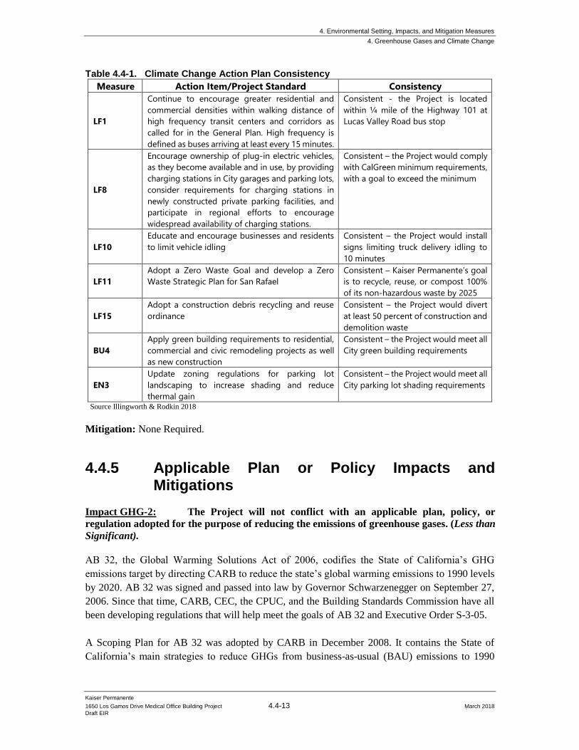
4. Environmental Setting, Impacts, and Mitigation Measures
4. Greenhouse Gases and Climate Change
Kaiser Permanente
1650 Los Gamos Drive Medical Office Building Project 4.4-13 March 2018
Draft EIR
Table 4.4-1. Climate Change Action Plan Consistency
Measure Action Item/Project Standard Consistency
LF1
Continue to encourage greater residential and
commercial densities within walking distance of
high frequency transit centers and corridors as
called for in the General Plan. High frequency is
defined as buses arriving at least every 15 minutes.
Consistent - the Project is located
within ¼ mile of the Highway 101 at
Lucas Valley Road bus stop
LF8
Encourage ownership of plug-in electric vehicles,
as they become available and in use, by providing
charging stations in City garages and parking lots,
consider requirements for charging stations in
newly constructed private parking facilities, and
participate in regional efforts to encourage
widespread availability of charging stations.
Consistent – the Project would comply
with CalGreen minimum requirements,
with a goal to exceed the minimum
LF10
Educate and encourage businesses and residents
to limit vehicle idling
Consistent – the Project would install
signs limiting truck delivery idling to
10 minutes
LF11
Adopt a Zero Waste Goal and develop a Zero
Waste Strategic Plan for San Rafael
Consistent – Kaiser Permanente’s goal
is to recycle, reuse, or compost 100%
of its non-hazardous waste by 2025
LF15
Adopt a construction debris recycling and reuse
ordinance
Consistent – the Project would divert
at least 50 percent of construction and
demolition waste
BU4
Apply green building requirements to residential,
commercial and civic remodeling projects as well
as new construction
Consistent – the Project would meet all
City green building requirements
EN3
Update zoning regulations for parking lot
landscaping to increase shading and reduce
thermal gain
Consistent – the Project would meet all
City parking lot shading requirements
Source Illingworth & Rodkin 2018
Mitigation: None Required.
4.4.5 Applicable Plan or Policy Impacts and Mitigations
Impact GHG-2: The Project will not conflict with an applicable plan, policy, or
regulation adopted for the purpose of reducing the emissions of greenhouse gases. (Less than
Significant).
AB 32, the Global Warming Solutions Act of 2006, codifies the State of California’s GHG
emissions target by directing CARB to reduce the state’s global warming emissions to 1990 levels
by 2020. AB 32 was signed and passed into law by Governor Schwarzenegger on September 27,
2006. Since that time, CARB, CEC, the CPUC, and the Building Standards Commission have all
been developing regulations that will help meet the goals of AB 32 and Executive Order S-3-05.
A Scoping Plan for AB 32 was adopted by CARB in December 2008. It contains the State of
California’s main strategies to reduce GHGs from business-as-usual (BAU) emissions to 1990
4. Environmental Setting, Impacts, and Mitigation Measures
4. Greenhouse Gases and Climate Change
Kaiser Permanente
1650 Los Gamos Drive Medical Office Building Project 4.4-14 March 2018
Draft EIR
levels. BAU is the projected emissions in 2020, including increases in emissions caused by growth,
without any GHG reduction measures. The Scoping Plan has a range of GHG reduction actions,
including direct regulations, alternative compliance mechanisms, monetary and non-monetary
incentives, voluntary actions, and market-based mechanisms such as a cap-and-trade system. It
required CARB and other state agencies to develop and adopt regulations and other initiatives
reducing GHGs by 2012.
As directed by AB 32, CARB has also approved a statewide GHG emissions limit. On December
6, 2007, CARB staff resolved an amount of 427 MMT of CO2e as the total statewide GHG 1990
emissions level and 2020 emissions limit. The limit is a cumulative statewide limit, not a sector- or
facility-specific limit. CARB updated the future 2020 BAU annual emissions forecast, in light of
the economic downturn, to 545 MMT of CO2e. Two GHG emissions reduction measures currently
enacted that were not previously included in the 2008 Scoping Plan baseline inventory were
included, further reducing the baseline inventory to 507 MMT of CO2e. Thus, an estimated
reduction of 80 MMT of CO2e is necessary to reduce statewide emissions to meet the AB 32 target
by 2020.
SB 32 was passed in 2016, which codified a 2030 GHG emissions reduction target of 40 percent
below 1990 levels. CARB recently published a second update to the Scoping Plan to reflect the
2030 target set by Executive Order B-30-15 and codified by SB 32. The second Scoping Plan
Update was published in November 2017 as directed by SB 32 companion legislation AB 197. The
mid-term 2030 target is considered critical by CARB on the path to obtaining an even deeper GHG
emissions target of 80 percent below 1990 levels by 2050, as directed in Executive Order S-3-05.
The Scoping Plan outlines the suite of policy measures, regulations, planning efforts, and
investments in clean technologies and infrastructure, providing a blueprint to continue driving
down GHG emissions and obtain the statewide goals.
The proposed Project would not conflict or otherwise interfere with the statewide GHG reduction
measures identified in CARB’s Scoping Plan. The Project would comply with requirements of the
Green Building Code and the CCAP. For example, the parking structure and tenant improvements
of the medical office building will be constructed in conformance with CALGreen and the Title 24
Building Code. Therefore, the impact is considered less than significant, and no mitigation is
required.
Mitigation: None Required.
4. Environmental Setting, Impacts, and Mitigation Measures
4. Greenhouse Gases and Climate Change
Kaiser Permanente
1650 Los Gamos Drive Medical Office Building Project 4.4-15 March 2018
Draft EIR
4.4.6 Cumulative GHG Impacts
Impact GHG-3: The Project would not result in a cumulatively considerable
contribution to a significant cumulative impact related to greenhouse gas emissions. (Less
than Significant)
Greenhouse gas impacts are cumulative in nature. The Project’s cumulative contribution to GHG
impacts is addressed in Impact GHG-1. As identified in Impact GHG-1, the Project would not
exceed the BAAQMD’s recommended threshold of significance for GHG emissions and is
consistent with the adopted City of San Rafael CCAP, which serves as a Qualified Greenhouse Gas
Reduction Strategy. No further analysis is required, and no mitigation is required.
Mitigation: None Required.
4. Environmental Setting, Impacts, and Mitigation Measures
4. Greenhouse Gases and Climate Change
Kaiser Permanente
1650 Los Gamos Drive Medical Office Building Project 4.4-16 March 2018
Draft EIR
This page intentionally left blank
4. Environmental Setting, Impacts, and Mitigation Measures
5. Noise
Kaiser Permanente
1650 Los Gamos Drive Medical Office Building Project 4.5-1 March 2018
Draft EIR
4.5 Noise
This section incorporates the setting information and analyses included in the Kaiser Medical Office Building Project Noise and Vibration Assessment (Illingworth and Rodkin, Inc., 2018) conducted
for the Project. The setting section presents the fundamentals of environmental noise, provides a
discussion of policies and standards applicable to the Project, and presents the results of ambient
noise measurements made at the site to document baseline noise conditions at adjacent noise-
sensitive residential receivers in the site vicinity. The impacts and mitigation measures section of
the Project summarizes future noise levels resulting from the construction and operation of the
project and provides an evaluation of potential significance of Project impacts. Where appropriate,
mitigation measures are recommended to reduce noise impacts resulting from the Project to a less
than significant level.
4.5.1 Setting
4.5.1.1 Fundamentals of Environmental Noise
Noise may be defined as unwanted sound. Noise is usually objectionable because it is disturbing
or annoying. The objectionable nature of sound could be caused by its pitch or its loudness. Pitch
is the height or depth of a tone or sound, depending on the relative rapidity (frequency) of the
vibrations by which it is produced. Higher pitched signals sound louder to humans than sounds
with a lower pitch. Loudness is intensity of sound waves combined with the reception
characteristics of the ear. Intensity may be compared with the height of an ocean wave in that it is
a measure of the amplitude of the sound wave.
In addition to the concepts of pitch and loudness, there are several noise measurement scales which
are used to describe noise in a particular location. A decibel (dB) is a unit of measurement which
indicates the relative amplitude of a sound. The zero on the decibel scale is based on the lowest
sound level that the healthy, unimpaired human ear can detect. Sound levels in decibels are
calculated on a logarithmic basis. An increase of 10 decibels represents a ten-fold increase in
acoustic energy, while 20 decibels is 100 times more intense, 30 decibels is 1,000 times more
intense, etc. There is a relationship between the subjective noisiness or loudness of a sound and its
intensity. Each 10 decibel increase in sound level is perceived as approximately a doubling of
loudness over a fairly wide range of intensities. Technical terms are defined in Table 4.5-1.
There are several methods of characterizing sound. The most common in California is the A-weighted sound level (dBA). This scale gives greater weight to the frequencies of sound to which
the human ear is most sensitive. Representative outdoor and indoor noise levels in units of dBA are
shown in Table 4.5-2. Because sound levels can vary markedly over a short period of time, a
method for describing either the average character of the sound or the statistical behavior of the
variations must be utilized. Most commonly, environmental sounds are described in terms of an
average level that has the same acoustical energy as the summation of all the time-varying events.
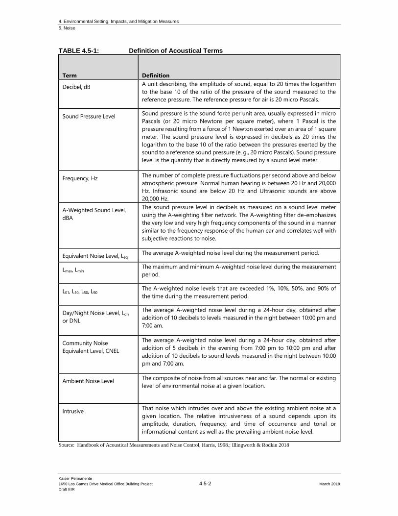
4. Environmental Setting, Impacts, and Mitigation Measures
5. Noise
Kaiser Permanente
1650 Los Gamos Drive Medical Office Building Project 4.5-2 March 2018
Draft EIR
TABLE 4.5-1: Definition of Acoustical Terms
Term Definition
Decibel, dB A unit describing, the amplitude of sound, equal to 20 times the logarithm
to the base 10 of the ratio of the pressure of the sound measured to the
reference pressure. The reference pressure for air is 20 micro Pascals.
Sound Pressure Level Sound pressure is the sound force per unit area, usually expressed in micro
Pascals (or 20 micro Newtons per square meter), where 1 Pascal is the
pressure resulting from a force of 1 Newton exerted over an area of 1 square
meter. The sound pressure level is expressed in decibels as 20 times the
logarithm to the base 10 of the ratio between the pressures exerted by the
sound to a reference sound pressure (e. g., 20 micro Pascals). Sound pressure
level is the quantity that is directly measured by a sound level meter.
Frequency, Hz The number of complete pressure fluctuations per second above and below
atmospheric pressure. Normal human hearing is between 20 Hz and 20,000
Hz. Infrasonic sound are below 20 Hz and Ultrasonic sounds are above
20,000 Hz.
A-Weighted Sound Level,
dBA
The sound pressure level in decibels as measured on a sound level meter
using the A-weighting filter network. The A-weighting filter de-emphasizes
the very low and very high frequency components of the sound in a manner
similar to the frequency response of the human ear and correlates well with
subjective reactions to noise.
Equivalent Noise Level, Leq The average A-weighted noise level during the measurement period.
Lmax, Lmin The maximum and minimum A-weighted noise level during the measurement
period.
L01, L10, L50, L90 The A-weighted noise levels that are exceeded 1%, 10%, 50%, and 90% of
the time during the measurement period.
Day/Night Noise Level, Ldn
or DNL
The average A-weighted noise level during a 24-hour day, obtained after
addition of 10 decibels to levels measured in the night between 10:00 pm and
7:00 am.
Community Noise
Equivalent Level, CNEL
The average A-weighted noise level during a 24-hour day, obtained after
addition of 5 decibels in the evening from 7:00 pm to 10:00 pm and after
addition of 10 decibels to sound levels measured in the night between 10:00
pm and 7:00 am.
Ambient Noise Level The composite of noise from all sources near and far. The normal or existing
level of environmental noise at a given location.
Intrusive That noise which intrudes over and above the existing ambient noise at a
given location. The relative intrusiveness of a sound depends upon its
amplitude, duration, frequency, and time of occurrence and tonal or
informational content as well as the prevailing ambient noise level.
Source: Handbook of Acoustical Measurements and Noise Control, Harris, 1998.; Illingworth & Rodkin 2018
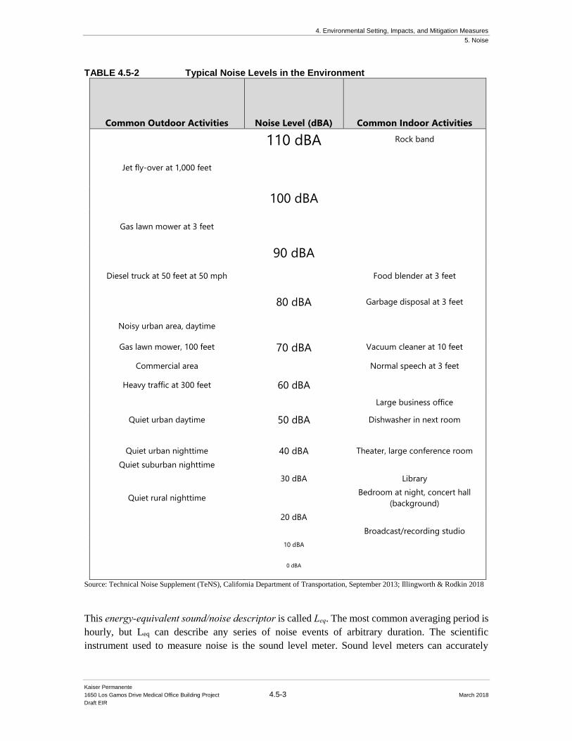
4. Environmental Setting, Impacts, and Mitigation Measures
5. Noise
Kaiser Permanente
1650 Los Gamos Drive Medical Office Building Project 4.5-3 March 2018
Draft EIR
TABLE 4.5-2 Typical Noise Levels in the Environment
Common Outdoor Activities
Noise Level (dBA)
Common Indoor Activities
110 dBA Rock band
Jet fly-over at 1,000 feet
100 dBA
Gas lawn mower at 3 feet
90 dBA
Diesel truck at 50 feet at 50 mph Food blender at 3 feet
80 dBA Garbage disposal at 3 feet
Noisy urban area, daytime
Gas lawn mower, 100 feet 70 dBA Vacuum cleaner at 10 feet
Commercial area Normal speech at 3 feet
Heavy traffic at 300 feet 60 dBA
Large business office
Quiet urban daytime 50 dBA Dishwasher in next room
Quiet urban nighttime 40 dBA Theater, large conference room
Quiet suburban nighttime
30 dBA Library
Quiet rural nighttime Bedroom at night, concert hall
(background)
20 dBA
Broadcast/recording studio
10 dBA
0 dBA
Source: Technical Noise Supplement (TeNS), California Department of Transportation, September 2013; Illingworth & Rodkin 2018
This energy-equivalent sound/noise descriptor is called Leq. The most common averaging period is
hourly, but Leq can describe any series of noise events of arbitrary duration. The scientific
instrument used to measure noise is the sound level meter. Sound level meters can accurately
4. Environmental Setting, Impacts, and Mitigation Measures
5. Noise
Kaiser Permanente
1650 Los Gamos Drive Medical Office Building Project 4.5-4 March 2018
Draft EIR
measure environmental noise levels to within about plus or minus 1 dBA. Various computer models
are used to predict environmental noise levels from sources, such as roadways and airports. The
accuracy of the predicted models depends upon the distance the receptor is from the noise source.
Close to the noise source, the models are accurate to within about plus or minus 1 to 2 dBA.
Since the sensitivity to noise increases during the evening and at night -- because excessive noise
interferes with the ability to sleep -- 24-hour descriptors have been developed that incorporate
artificial noise penalties added to quiet-time noise events. The Community Noise Equivalent Level (CNEL) is a measure of the cumulative noise exposure in a community, with a 5-dB penalty added
to evening (7:00 pm - 10:00 pm) and a 10-dB addition to nocturnal (10:00 pm - 7:00 am) noise
levels. The Day/Night Average Sound Level (DNL or Ldn) is essentially the same as CNEL, with
the exception that the evening time period is dropped and all occurrences during this three-hour
period are grouped into the daytime period.
4.5.1.2 Effects of Noise
Sleep and Speech Interference
The thresholds for speech interference indoors are about 45 dBA if the noise is steady and above
55 dBA if the noise is fluctuating. Outdoors the thresholds are about 15 dBA higher. Steady noises
of sufficient intensity (above 35 dBA) and fluctuating noise levels above about 45 dBA have been
shown to affect sleep. Interior residential standards for multi-family dwellings are set by the State
of California at 45 dBA CNEL. Typically, the highest steady traffic noise level during the daytime
is about equal to the CNEL and nighttime levels are 10 dBA lower. The standard is designed for
sleep and speech protection and most jurisdictions apply the same criterion for all residential uses.
Typical structural attenuation is 12-17 dBA with open windows. With closed windows in good
condition, the noise attenuation factor is around 20 dBA for an older structure and 25 dBA for a
newer dwelling. Sleep and speech interference is therefore possible when exterior noise levels are
about 57-62 dBA CNEL with open windows and 65-70 dBA CNEL if the windows are closed.
Levels of 55-60 dBA are common along collector streets and secondary arterials, while 65-70 dBA
is a typical value for a primary/major arterial. Levels of 75-80 dBA are normal noise levels at the
first row of development outside a freeway right-of-way. In order to achieve an acceptable interior
noise environment, bedrooms facing secondary roadways need to be able to have their windows
closed; those facing major roadways and freeways typically need special glass windows.
Annoyance
Attitude surveys are used for measuring the annoyance felt in a community for noises intruding
into homes or affecting outdoor activity areas. In these surveys, it was determined that the causes
for annoyance include interference with speech, radio and television, house vibrations, and
interference with sleep and rest. The CNEL as a measure of noise has been found to provide a valid
correlation of noise level and the percentage of people annoyed. People have been asked to judge
the annoyance caused by aircraft noise and ground transportation noise. There continues to be
disagreement about the relative annoyance of these different sources. When measuring the
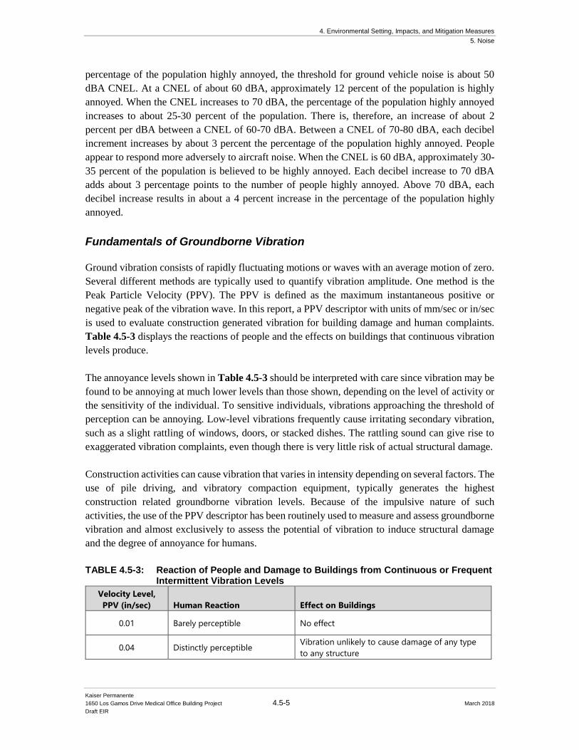
4. Environmental Setting, Impacts, and Mitigation Measures
5. Noise
Kaiser Permanente
1650 Los Gamos Drive Medical Office Building Project 4.5-5 March 2018
Draft EIR
percentage of the population highly annoyed, the threshold for ground vehicle noise is about 50
dBA CNEL. At a CNEL of about 60 dBA, approximately 12 percent of the population is highly
annoyed. When the CNEL increases to 70 dBA, the percentage of the population highly annoyed
increases to about 25-30 percent of the population. There is, therefore, an increase of about 2
percent per dBA between a CNEL of 60-70 dBA. Between a CNEL of 70-80 dBA, each decibel
increment increases by about 3 percent the percentage of the population highly annoyed. People
appear to respond more adversely to aircraft noise. When the CNEL is 60 dBA, approximately 30-
35 percent of the population is believed to be highly annoyed. Each decibel increase to 70 dBA
adds about 3 percentage points to the number of people highly annoyed. Above 70 dBA, each
decibel increase results in about a 4 percent increase in the percentage of the population highly
annoyed.
Fundamentals of Groundborne Vibration
Ground vibration consists of rapidly fluctuating motions or waves with an average motion of zero.
Several different methods are typically used to quantify vibration amplitude. One method is the
Peak Particle Velocity (PPV). The PPV is defined as the maximum instantaneous positive or
negative peak of the vibration wave. In this report, a PPV descriptor with units of mm/sec or in/sec
is used to evaluate construction generated vibration for building damage and human complaints.
Table 4.5-3 displays the reactions of people and the effects on buildings that continuous vibration
levels produce.
The annoyance levels shown in Table 4.5-3 should be interpreted with care since vibration may be
found to be annoying at much lower levels than those shown, depending on the level of activity or
the sensitivity of the individual. To sensitive individuals, vibrations approaching the threshold of
perception can be annoying. Low-level vibrations frequently cause irritating secondary vibration,
such as a slight rattling of windows, doors, or stacked dishes. The rattling sound can give rise to
exaggerated vibration complaints, even though there is very little risk of actual structural damage.
Construction activities can cause vibration that varies in intensity depending on several factors. The
use of pile driving, and vibratory compaction equipment, typically generates the highest
construction related groundborne vibration levels. Because of the impulsive nature of such
activities, the use of the PPV descriptor has been routinely used to measure and assess groundborne
vibration and almost exclusively to assess the potential of vibration to induce structural damage
and the degree of annoyance for humans.
TABLE 4.5-3: Reaction of People and Damage to Buildings from Continuous or Frequent Intermittent Vibration Levels
Velocity Level,
PPV (in/sec) Human Reaction Effect on Buildings
0.01 Barely perceptible No effect
0.04 Distinctly perceptible Vibration unlikely to cause damage of any type
to any structure
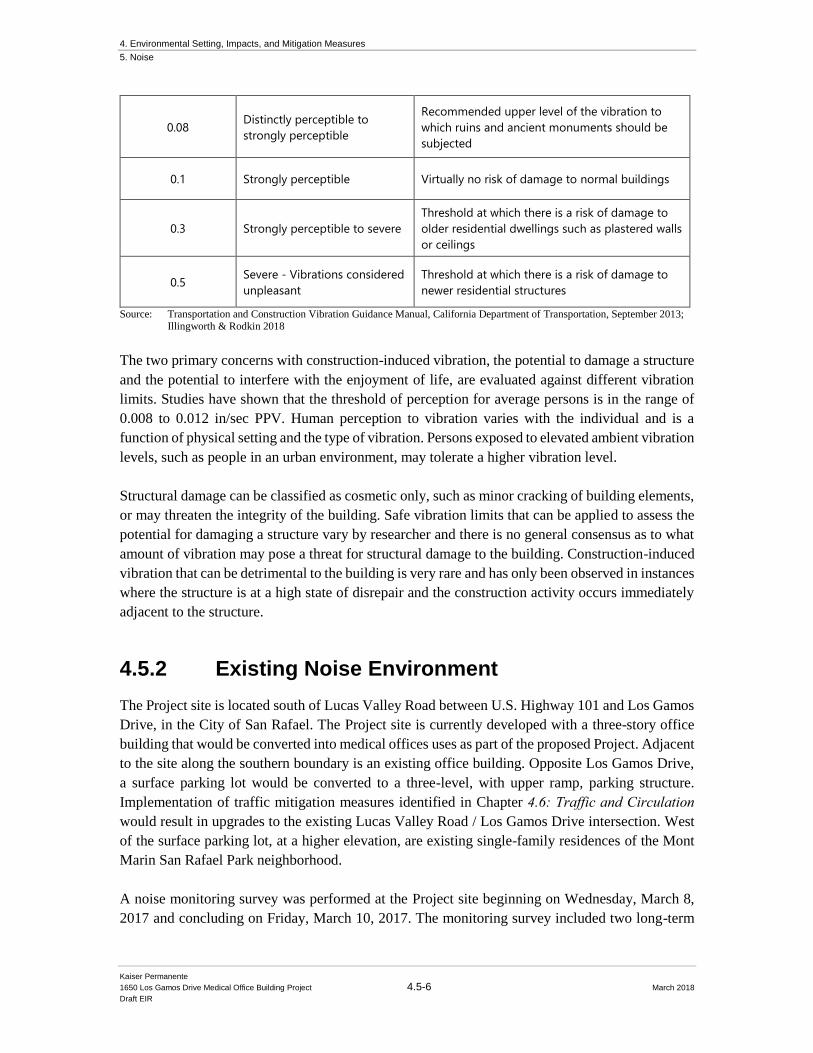
4. Environmental Setting, Impacts, and Mitigation Measures
5. Noise
Kaiser Permanente
1650 Los Gamos Drive Medical Office Building Project 4.5-6 March 2018
Draft EIR
0.08 Distinctly perceptible to
strongly perceptible
Recommended upper level of the vibration to
which ruins and ancient monuments should be
subjected
0.1 Strongly perceptible Virtually no risk of damage to normal buildings
0.3 Strongly perceptible to severe
Threshold at which there is a risk of damage to
older residential dwellings such as plastered walls
or ceilings
0.5 Severe - Vibrations considered
unpleasant
Threshold at which there is a risk of damage to
newer residential structures
Source: Transportation and Construction Vibration Guidance Manual, California Department of Transportation, September 2013; Illingworth & Rodkin 2018
The two primary concerns with construction-induced vibration, the potential to damage a structure
and the potential to interfere with the enjoyment of life, are evaluated against different vibration
limits. Studies have shown that the threshold of perception for average persons is in the range of
0.008 to 0.012 in/sec PPV. Human perception to vibration varies with the individual and is a
function of physical setting and the type of vibration. Persons exposed to elevated ambient vibration
levels, such as people in an urban environment, may tolerate a higher vibration level.
Structural damage can be classified as cosmetic only, such as minor cracking of building elements,
or may threaten the integrity of the building. Safe vibration limits that can be applied to assess the
potential for damaging a structure vary by researcher and there is no general consensus as to what
amount of vibration may pose a threat for structural damage to the building. Construction-induced
vibration that can be detrimental to the building is very rare and has only been observed in instances
where the structure is at a high state of disrepair and the construction activity occurs immediately
adjacent to the structure.
4.5.2 Existing Noise Environment
The Project site is located south of Lucas Valley Road between U.S. Highway 101 and Los Gamos
Drive, in the City of San Rafael. The Project site is currently developed with a three-story office
building that would be converted into medical offices uses as part of the proposed Project. Adjacent
to the site along the southern boundary is an existing office building. Opposite Los Gamos Drive,
a surface parking lot would be converted to a three-level, with upper ramp, parking structure.
Implementation of traffic mitigation measures identified in Chapter 4.6: Traffic and Circulation would result in upgrades to the existing Lucas Valley Road / Los Gamos Drive intersection. West
of the surface parking lot, at a higher elevation, are existing single-family residences of the Mont
Marin San Rafael Park neighborhood.
A noise monitoring survey was performed at the Project site beginning on Wednesday, March 8,
2017 and concluding on Friday, March 10, 2017. The monitoring survey included two long-term
4. Environmental Setting, Impacts, and Mitigation Measures
5. Noise
Kaiser Permanente
1650 Los Gamos Drive Medical Office Building Project 4.5-7 March 2018
Draft EIR
and four short-term noise measurements, as shown in Figure 4.5-1. The noise environment at the
site and in the Project vicinity is dominated by traffic noise along U.S. Highway 101. The
surrounding local roadways (Lucas Valley Road and Los Gamos Drive) would also affect the noise
environment, as would aircraft flyovers associated with the San Rafael Airport.
Long-term noise measurement LT-1 was made from the Project site’s existing parking lot. LT-1
had direct line-of-sight to U.S. Highway 101, with a setback from the centerline of the nearest
through travel lane of approximately 295 feet. LT-1 represented the existing noise environment at
the Project site. Hourly average noise levels at this location typically ranged from 59 to 67 dBA Leq
during the day and from 54 to 66 dBA Leq at night. The day-night average noise level measured on
Thursday, March 9, 2017 was 68 dBA Ldn. The daily trend in noise levels measured at LT-1 is
shown in Figures 4.5-2 through 4.5-4.
Long-term noise measurement LT-2 was made across the roadway from 59 Salvador Way in a tree.
LT-2 was approximately 20 feet from the centerline of Salvador Way. LT-2 represented the existing
noise environment of the nearest residential land uses surrounding the Project site. Hourly average
noise levels at this location typically ranged from 43 to 54 dBA Leq during the day and from 35 to
49 dBA Leq at night. The day-night average noise level measured on Thursday, March 9, 2017 was
56 dBA Ldn. The daily trend in noise levels measured at LT-2 is shown in Figures 4.5-5 through
4.5-7.
Short-term measurements were made on Friday March 10, 2017 in ten-minute intervals between
11:30 a.m. and 12:40 p.m. ST-1 was made approximately 30 feet from the northeast corner of the
existing office building and approximately 50 feet from the chilling unit. Noise from the chilling
unit is audible when traffic along U.S. Highway 101 slows down, with levels of about 49 dBA at
50 feet. The ten-minute average noise level measured at ST-1 was 59 dBA Leq(10), and the estimated
day-night average noise level was 61 dBA Ldn. ST-2 was made approximately 30 feet from the
northwest corner of the existing office building. The ten-minute average noise level measured at
ST-2 was 55 dBA Leq(10), and the estimated day-night average noise level was 58 dBA Ldn. ST-3
was made at the front of the existing office building, approximately 40 feet from the centerline of
Los Gamos Drive. Noise levels from ST-3 were affected by vehicle pass-bys along Los Gamos
Drive, which typically reached levels of 60 to 65 dBA. The ten-minute average noise level
measured at ST-3 was 58 dBA Leq(10), and the estimated day-night average noise level was 61 dBA
Ldn. ST-4 was made in front of 40 Salvador Way. ST-4 was approximately 20 feet from the
centerline of Salvador Way. The ten-minute average noise level measured at ST-4 was 42 dBA
Leq(10), and the estimated day-night average noise level was 52 dBA Ldn. Table 4.5-4 summarizes
the results of the short-term noise measurements.
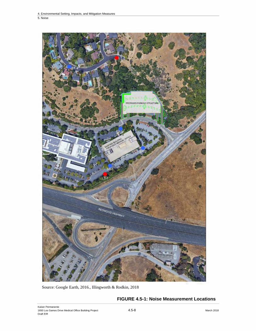
4. Environmental Setting, Impacts, and Mitigation Measures
5. Noise
Kaiser Permanente
1650 Los Gamos Drive Medical Office Building Project 4.5-8 March 2018
Draft EIR
Source: Google Earth, 2016., Illingworth & Rodkin, 2018
FIGURE 4.5-1: Noise Measurement Locations
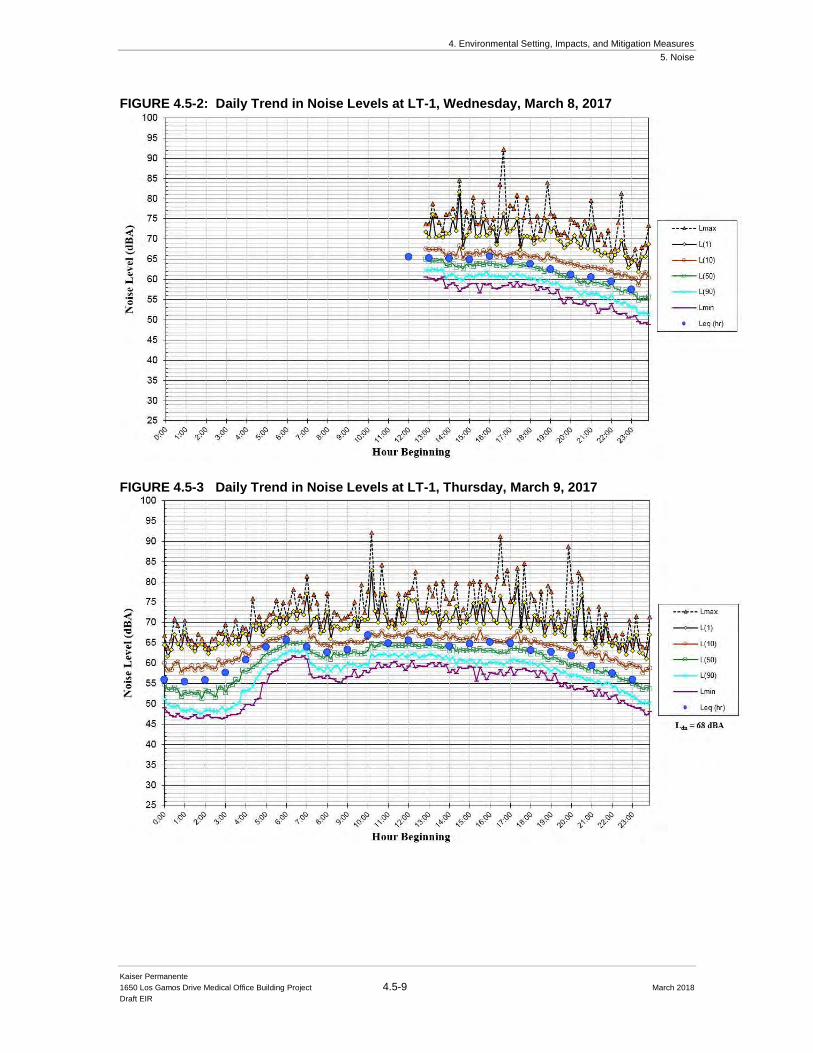
4. Environmental Setting, Impacts, and Mitigation Measures
5. Noise
Kaiser Permanente
1650 Los Gamos Drive Medical Office Building Project 4.5-9 March 2018
Draft EIR
FIGURE 4.5-2: Daily Trend in Noise Levels at LT-1, Wednesday, March 8, 2017
FIGURE 4.5-3 Daily Trend in Noise Levels at LT-1, Thursday, March 9, 2017
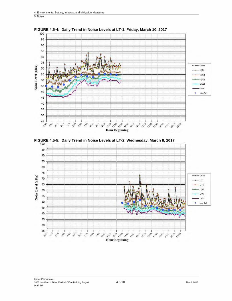
4. Environmental Setting, Impacts, and Mitigation Measures
5. Noise
Kaiser Permanente
1650 Los Gamos Drive Medical Office Building Project 4.5-10 March 2018
Draft EIR
FIGURE 4.5-4: Daily Trend in Noise Levels at LT-1, Friday, March 10, 2017
FIGURE 4.5-5: Daily Trend in Noise Levels at LT-2, Wednesday, March 8, 2017

4. Environmental Setting, Impacts, and Mitigation Measures
5. Noise
Kaiser Permanente
1650 Los Gamos Drive Medical Office Building Project 4.5-11 March 2018
Draft EIR
FIGURE 4.5-6: Daily Trend in Noise Levels at LT-2, Thursday, March 9, 2017
FIGURE 4.5-7 Daily Trend in Noise Levels at LT-2, Friday, March 10, 2017
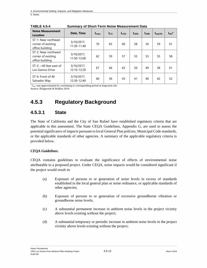
4. Environmental Setting, Impacts, and Mitigation Measures
5. Noise
Kaiser Permanente
1650 Los Gamos Drive Medical Office Building Project 4.5-12 March 2018
Draft EIR
TABLE 4.5-4 Summary of Short-Term Noise Measurement Data
Noise Measurement
Location Date, Time Lmax L(1) L(10) L(50) L(90) Leq(10) Ldn
a
ST-1: Near northeast
corner of existing
office building
3/10/2017,
11:30-11:40 70 65 60 58 56 59 61
ST-2: Near northwest
corner of existing
office building
3/10/2017,
11:50-12:00 62 59 57 55 53 55 58
ST-3: ~40 feet east of
Los Gamos Drive
3/10/2017,
12:10-12:20 67 66 63 56 49 58 61
ST-4: Front of 40
Salvador Way
3/10/2017,
12:30-12:40 60 56 43 41 40 42 52
a Ldn was approximated by correlating to corresponding period at long-term site
Source: Illingworth & Rodkin 2018
4.5.3 Regulatory Background
4.5.3.1 State
The State of California and the City of San Rafael have established regulatory criteria that are
applicable in this assessment. The State CEQA Guidelines, Appendix G, are used to assess the
potential significance of impacts pursuant to local General Plan policies, Municipal Code standards,
or the applicable standards of other agencies. A summary of the applicable regulatory criteria is
provided below.
CEQA Guidelines.
CEQA contains guidelines to evaluate the significance of effects of environmental noise
attributable to a proposed project. Under CEQA, noise impacts would be considered significant if
the project would result in:
(a) Exposure of persons to or generation of noise levels in excess of standards
established in the local general plan or noise ordinance, or applicable standards of
other agencies;
(b) Exposure of persons to or generation of excessive groundborne vibration or
groundborne noise levels;
(c) A substantial permanent increase in ambient noise levels in the project vicinity
above levels existing without the project;
(d) A substantial temporary or periodic increase in ambient noise levels in the project
vicinity above levels existing without the project;

4. Environmental Setting, Impacts, and Mitigation Measures
5. Noise
Kaiser Permanente
1650 Los Gamos Drive Medical Office Building Project 4.5-13 March 2018
Draft EIR
(e) For a project located within an airport land use plan or where such a plan has not
been adopted within two miles of a public airport or public use airport, if the project
would expose people residing or working in the project area to excessive noise
levels;
(f) For a project within the vicinity of a private airstrip, if the project would expose
people residing or working in the project area to excessive noise levels.
Pursuant to recent court decisions, the impacts of site constraints such as exposure of the proposed
Project to excessive levels of noise and vibration are not included in the Impacts and Mitigation
Section of this report. Checklist item (a), regarding the compatibility of the project with noise levels
at the site, is discussed in the General Plan Consistency section of the report. Checklist items (a)
through (d) are applicable in the assessment of potential impacts resulting from the proposed Project
at off-site receptors.
CEQA does not define what noise level increase would be considered substantial. Typically, an
increase in the Ldn noise level resulting from the Project at noise sensitive land uses of 3 dBA or
greater would be considered a significant impact when projected noise levels would exceed those
considered acceptable for the affected land use. An increase of 5 dBA Ldn or greater would be
considered a significant impact when projected noise levels would remain within those considered
acceptable for the affected land use.
4.5.3.2 Local
City of San Rafael General Plan 2020. The Noise Element of San Rafael’s General Plan 2020 is
intended to reduce noise impacts and improve the quality of life of the residents. To accomplish
this intent, the Noise Element contains goals and policies (references to exhibits in the following
section pertain to the numbering organization contained in the General Plan 2020). The goals and
policies that apply to the proposed Project are as follows:
Goal 29: It is the goal of San Rafael to have acceptable noise levels. Excessive noise is a concern
for many residents of San Rafael. These concerns can be managed with proper mitigation or through
the implementation of the noise ordinance. The City of San Rafael recognizes the issue of noise
and has standards to protect people from excessive, unnecessary and unreasonable noises from any
and all sources in the community.
N-1. Noise Impacts on New Development.
Protect people in new development from excessive noise by applying noise standards in
land use decisions. Apply the Land Use Compatibility Standards (see Exhibit 31) to the
siting of new uses in existing noise environments. These standards identify the
acceptability of a project based on noise exposure. If a project exceeds the standards in
Exhibit 31, an acoustical analysis shall be required to identify noise impacts and potential
noise mitigations. Mitigation should include the research and use of state-of-the-art abating
materials and technology.
4. Environmental Setting, Impacts, and Mitigation Measures
5. Noise
Kaiser Permanente
1650 Los Gamos Drive Medical Office Building Project 4.5-14 March 2018
Draft EIR
N-1a. Acoustical Studies. Require acoustical studies for all new residential
projects within the projected Ldn 60 dB noise contours (see Exhibit 31) so that noise
mitigation measures can be incorporated into project design. Acoustical studies
shall identify noise sources and contain a discussion of the existing and future noise
exposure and the mitigation measures that may be used to achieve the appropriate
outdoor and indoor noise standards.
N-3. Planning and Design of New Development.
Encourage new development to be planned and designed to minimize noise impacts from
outside noise sources.
N-3a. Noise Mitigation. Require, where appropriate, the following mitigation
measures to minimize noise impacts on proposed development projects:
1. Site planning. Proper site planning is the first mitigation measure that should
be investigated to reduce noise impacts. By taking advantage of the natural
shape and terrain of the site, it often is possible to arrange the buildings and
other uses in a manner that will reduce and possibly eliminate noise impacts.
Specific site planning techniques include:
a. Increasing the distance between the noise source and the receiver;
b. Placing non-noise sensitive land uses such as parking lots,
maintenance facilities, and utility areas between the source and the
receiver;
c. Using non-noise sensitive structures such as garages to shield noise-
sensitive areas; and
d. Orienting buildings to shield outdoor spaces from a noise source.
2. Architectural layout of buildings. In many cases, noise reduction can be
attained by careful layout of noise-sensitive spaces. Bedrooms, for example,
should be placed away from freeways. Quiet outdoor spaces can be provided
next to a noisy highway by creating a U-shaped development, which faces
away from the highway.
3. Noise barriers. Absorptive types of noise barriers or walls should be used to
reduce noise levels from ground transportation noise sources and industrial
sources. A barrier must interrupt the line of sight between the noise source and
the receiver in order to reduce noise level both outdoors and indoors. A barrier
should provide at least Ldn 5 dB of noise reduction to achieve a noticeable
change in noise levels.
4. Construction modifications. If site planning, architectural layout, noise
barriers, or a combination of these measures does not achieve the required
4. Environmental Setting, Impacts, and Mitigation Measures
5. Noise
Kaiser Permanente
1650 Los Gamos Drive Medical Office Building Project 4.5-15 March 2018
Draft EIR
noise reduction, then mitigation should be facilitated through construction
modification to walls, roofs, ceilings, doors, windows.
5. Alternatives to sound walls. Encourage new development to identify
alternatives to the use of sound walls to ease noise impacts.
N-4. Noise from New Nonresidential Development.
Design nonresidential development to minimize noise impacts on neighboring uses.
a. Performance Standards for Uses Affecting Residential Districts. New
nonresidential development shall not increase noise levels in a residential district by
more than Ldn 3 dB, or create noise impacts that would increase noise levels to more
than Ldn 60 dB at the property line of the noise receiving use, whichever is the more
restrictive standard.
b. Performance Standards for Uses Affecting Nonresidential and Mixed-Use
Districts. New nonresidential projects shall not increase noise levels in a
nonresidential or mixed-use district by more than Ldn 5 dB, or create noise impacts that
would increase noise levels to more than Ldn 65 dB (Office, Retail) or Ldn 70 dB
(Industrial), at the property line of the noise receiving use, whichever is the more
restrictive standard.
c. Waiver. These standards may be waived if, as determined by an acoustical study, there
are mitigating circumstances (such as higher existing noise levels), and no uses would
be adversely affected.
N-4a. Require Acoustical Study. Identify through an acoustical study noise
mitigation measures to be designed and built into new nonresidential and mixed-
use development, and encourage absorptive types of mitigation measures between
noise sources and residential districts.
N-5. Traffic Noise from New Development.
Minimize noise impacts of increased off-site traffic caused by new development. Where
the exterior Ldn is 65 dB or greater at a residential building or outdoor use area and a plan,
program, or project increases traffic noise levels by more than Ldn 3 dB, reasonable noise
mitigation measures shall be included in the plan, program or project.
N-5a. Traffic Noise Studies. Require acoustical studies to evaluate potential off-
site noise impacts resulting from traffic generated by new development.
N-6. Traffic Noise.
Attempt to minimize traffic noise through land use policies, law enforcement, and street
improvements.
4. Environmental Setting, Impacts, and Mitigation Measures
5. Noise
Kaiser Permanente
1650 Los Gamos Drive Medical Office Building Project 4.5-16 March 2018
Draft EIR
N-6a. Enforce Speed Limits. Enforce speed limits on roads generating numerous
noise complaints.
N-6b. Mixed-Use. Develop land use districts to allow housing close to offices and
services to reduce the amount of traffic from local trips.
N-6c. Coordination with Local and State Agencies. Coordinate with CalTrans,
Marin Countywide Planning Agency, Congestion Management Agency and other
agencies to achieve noise reduction along Pt. San Pedro Road, Highways 101 and
580, and the Sonoma Marin Area Rail Transit corridor.
N-6d. Vehicle Code. Enforce the California Vehicle Code regarding noisy
vehicles.
N-6e. Street Improvements. Pursue feasible cost-effective new street paving
technologies to minimize traffic noise.
N-6f. Widening of US 101 and 580. Encourage Caltrans to mitigate highway
noise impacts as a part of the US 101 widening project. Review and comment, as
necessary, on any proposed sound walls in San Rafael. Encourage Caltrans to use
noise mitigation measures other than walls if they can be shown to be effective.
These measures may include alternative pavement types and sound-absorptive
treatments on existing and future noise barriers.
N-8a. Future Transitway Mitigation Measures. A detailed noise assessment and
appropriate mitigation measures should be prepared for any rail project on the
Sonoma Marin Area Rail Transit right-of-way. The analysis should address the
City’s noise standards and the Federal Transit Administrations (FTA) guidelines.
N-9. Nuisance Noise.
Minimize impacts from noise levels that exceed community sound levels.
N-9a. Enforce and Update the Noise Ordinance. Enforce and update, as
necessary, the City's Noise Ordinance that addresses common noise nuisances
including amplified music, outdoor mechanical equipment and construction
activities.
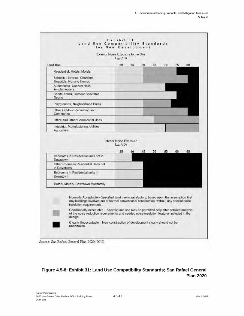
4. Environmental Setting, Impacts, and Mitigation Measures
5. Noise
Kaiser Permanente
1650 Los Gamos Drive Medical Office Building Project 4.5-17 March 2018
Draft EIR
Figure 4.5-8: Exhibit 31: Land Use Compatibility Standards; San Rafael General
Plan 2020
4. Environmental Setting, Impacts, and Mitigation Measures
5. Noise
Kaiser Permanente
1650 Los Gamos Drive Medical Office Building 4.5-18 March 2018
Draft EIR
N-10b. Mitigation for Construction Activity Noise. Through environmental
review, identify mitigation measures to minimize the exposure of neighboring
properties to excessive noise levels from construction-related activity.
N-10c. Noise Specifications. Include noise specifications in requests for
equipment information and bids for new City equipment and consider this
information as part of evaluation of the bids.
City of San Rafael Municipal Code. Chapter 8.13, Noise, in the City’s Municipal Code seeks
to protect the peace, health, safety, and general welfare of the citizens of San Rafael from
excessive, unnecessary, and unreasonable noises from any and all sources in the community.
Section 8.13.040 provides General Noise Limits.
Chapter 8.13.050 Standard exceptions to general noise limits. The following standard
exceptions to the provisions of Section 8.13.040 shall be allowed as of right, to the extent and
during the hours specified. A summary of the standard exceptions provided in this section is set
forth in Table 5 below.
A. Construction. Except as otherwise provided in subsection B of this section, or by the planning
commission or city council as part of the development review for the project, on any
construction project on property within the city, construction, alteration, demolition,
maintenance of construction equipment, deliveries of materials or equipment, or repair
activities otherwise allowed under applicable law shall be allowed between the hours of seven
a.m. (7:00 a.m.) and six p.m. (6:00 p.m.), Monday through Friday, and nine a.m. (9:00 a.m.)
and six p.m. (6:00 p.m.) on Saturdays, provided that the noise level at any point outside of the
property plane of the project shall not exceed ninety (90) dBA. All such activities shall be
precluded on Sundays and holidays. Violation of the foregoing may subject the permittee to
suspension of work by the chief building official for up to two (2) days per violation.
Noise level at any point outside the construction property plane shall not exceed ninety (90)
dBA.
Violation of the construction hours and noise limits may be enforced as either an infraction or
a misdemeanor punishable by fines or jail time or both, or by an administrative citation with a
fine, or by a civil action with a monetary penalty, injunction and/or other remedies, as provided
in Chapter 1.42 of this code. In addition, the chief building official may issue a stop work order
requiring suspension of work for up to two (2) days per violation.
C. Refuse Collection. Refuse collection activities shall be permitted as specified in this section,
provided they do not produce a noise level in excess of ninety-five (95) dBA measured at a
distance of twenty-five feet (25’) from the activity:
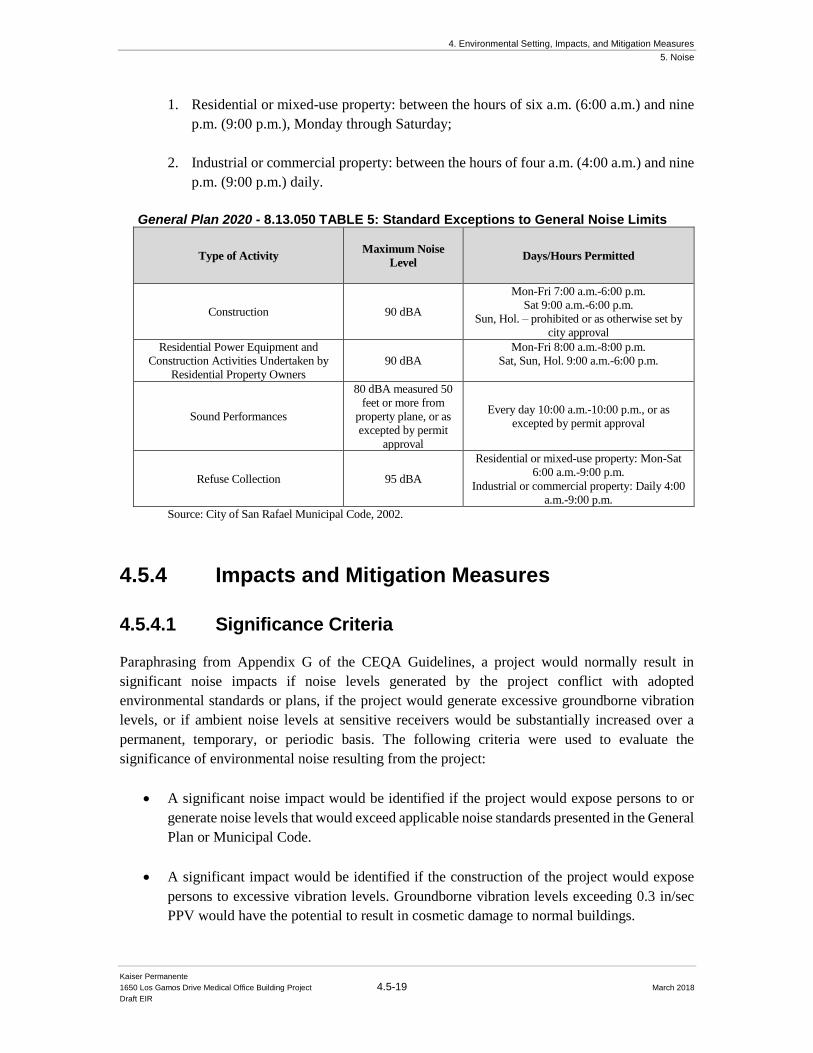
4. Environmental Setting, Impacts, and Mitigation Measures
5. Noise
Kaiser Permanente
1650 Los Gamos Drive Medical Office Building Project 4.5-19 March 2018
Draft EIR
1. Residential or mixed-use property: between the hours of six a.m. (6:00 a.m.) and nine
p.m. (9:00 p.m.), Monday through Saturday;
2. Industrial or commercial property: between the hours of four a.m. (4:00 a.m.) and nine
p.m. (9:00 p.m.) daily.
General Plan 2020 - 8.13.050 TABLE 5: Standard Exceptions to General Noise Limits
Type of Activity Maximum Noise
Level Days/Hours Permitted
Construction 90 dBA
Mon-Fri 7:00 a.m.-6:00 p.m.
Sat 9:00 a.m.-6:00 p.m.
Sun, Hol. – prohibited or as otherwise set by
city approval
Residential Power Equipment and
Construction Activities Undertaken by
Residential Property Owners
90 dBA
Mon-Fri 8:00 a.m.-8:00 p.m.
Sat, Sun, Hol. 9:00 a.m.-6:00 p.m.
Sound Performances
80 dBA measured 50
feet or more from
property plane, or as
excepted by permit
approval
Every day 10:00 a.m.-10:00 p.m., or as
excepted by permit approval
Refuse Collection 95 dBA
Residential or mixed-use property: Mon-Sat
6:00 a.m.-9:00 p.m.
Industrial or commercial property: Daily 4:00
a.m.-9:00 p.m.
Source: City of San Rafael Municipal Code, 2002.
4.5.4 Impacts and Mitigation Measures
4.5.4.1 Significance Criteria Paraphrasing from Appendix G of the CEQA Guidelines, a project would normally result in
significant noise impacts if noise levels generated by the project conflict with adopted
environmental standards or plans, if the project would generate excessive groundborne vibration
levels, or if ambient noise levels at sensitive receivers would be substantially increased over a
permanent, temporary, or periodic basis. The following criteria were used to evaluate the
significance of environmental noise resulting from the project:
• A significant noise impact would be identified if the project would expose persons to or
generate noise levels that would exceed applicable noise standards presented in the General
Plan or Municipal Code.
• A significant impact would be identified if the construction of the project would expose
persons to excessive vibration levels. Groundborne vibration levels exceeding 0.3 in/sec
PPV would have the potential to result in cosmetic damage to normal buildings.
4. Environmental Setting, Impacts, and Mitigation Measures
5. Noise
Kaiser Permanente
1650 Los Gamos Drive Medical Office Building Project 4.5-20 March 2018
Draft EIR
• A significant impact would be identified if traffic generated by the project or project
improvements/operations would substantially increase noise levels at sensitive receivers in
the vicinity. A substantial increase would occur if: a) the noise level increase is 5 dBA Ldn
or greater, with a future noise level of less than the “normally acceptable” standard, or b)
the noise level increase is 3 dBA Ldn or greater, with a future noise level equal to or greater
than the “normally acceptable” standard.
• A significant noise impact would be identified if construction-related noise would
temporarily increase ambient noise levels at sensitive receptors. Hourly average noise
levels exceeding 60 dBA Leq, and the ambient by at least 5 dBA Leq, for a period of more
than one year would constitute a significant temporary noise increase at adjacent residential
land uses.
4.5.5 Noise Levels in Excess of Standards
Impact NOISE-1: The Project would not produce noise levels that would exceed the
City’s established noise thresholds or increase the existing ambient noise environment. (Less
than Significant)
Mechanical Equipment Noise
Chapter 8.13.040 of the City’s Municipal Code limits mechanical equipment noise, as measured at
residential property lines, to 50 dBA during daytime hours and to 40 dBA during nighttime hours
for constant noise-generating equipment and to 60 dBA during daytime hours and to 50 dBA during
nighttime hours for intermittent noise-generating equipment. While the Municipal Code does not
define daytime and nighttime hours, it is assumed that daytime hours are 7:00 a.m. to 10:00 p.m.
and nighttime hours are 10:00 p.m. to 7:00 a.m., consistent with the Ldn acoustical descriptor used
by the City in the General Plan. Additionally, Policy N-4 of the City’s General Plan states that new
nonresidential developments shall not increase noise levels in a residential district by more than 3
dBA Ldn, or create noise impacts that would increase noise levels to more than 60 dBA Ldn at the
property line of the noise receiving use, whichever is more restrictive. Since the existing day-night
average noise level at the residential land uses is 56 dBA Ldn, the more restrictive criteria would be
the 3 dBA Ldn increase.
Further, mechanical equipment noise shall not exceed 55 dBA when measured at any commercial
property line for constant noise-generating equipment and shall not exceed 65 dBA for intermittent
noise-generating equipment.
While the structure and equipment associated with the existing office building would not change
under proposed Project conditions, the parking structure will require mechanical equipment, such
as elevators. As proposed in the site plan, the electrical room/elevator control room would be
located on the interior of the first floor, and the elevator tower is located at the southeastern corner
of the structure. A detailed noise analysis or operational environment was not included as part of
4. Environmental Setting, Impacts, and Mitigation Measures
5. Noise
Kaiser Permanente
1650 Los Gamos Drive Medical Office Building Project 4.5-21 March 2018
Draft EIR
the Project application. Illingworth & Rodkin prepared the analysis based on typical noise levels
expected from parking garages/structures.
Typical noise levels from electrical equipment rooms would be 50 to 60 dBA Leq at 10 feet. The
walls of the electrical equipment room would provide 5 to 10 dBA reduction, and the exterior walls
of the parking structure would provide an additional 5 to 10 dBA reduction. Typical elevators have
levels of about 46 to 47 dBA at a distance of 10 feet when the doors open, while reaching levels of
52 to 53 dBA at 10 feet during movement between floors.
The nearest residential property boundary, 56 Salvador Way in the Mont Marin/San Rafael Park
neighborhood, is approximately 150 feet to southwest of the proposed parking structure rear façade.
The nearest residential structure is located approximately 215 feet southwest of the proposed
parking structure rear façade. Residential properties are approximately 50 feet higher in elevation
than the proposed parking structure ground floor pad elevation. This distance, and elevation
difference, coupled with structure wall assemblies would provide some shielding from potential
noise sources. At 150 feet and assuming shielding from the intervening wall assemblies and
elevation of the receptor, the expected noise due to electrical room equipment would be less than
40 dBA Leq, which would meet both the daytime and nighttime thresholds established in the City’s
Municipal Code for residential land uses. Although existing mature trees would remain post
construction, these residences could potentially have direct line-of-sight to the third floor of the
elevator tower (the third floor includes a ramp that would not exceed the elevator tower’s height).).
The distance from the nearest residential property line to the elevator tower would be approximately
320 feet. The difference in elevations from the residence to the third-floor elevator doors would
provide some shielding from potential noise sources. Thus, assuming some shielding, the elevator
noise at the nearest residential property, at a distance of 320 feet, and would be less than 30 dBA,
which would meet the City’s Municipal Code thresholds.
The ambient hourly average noise levels at the residential land uses, which is represented by the
data collected at LT-2, range from 43 to 54 dBA Leq during daytime hours and from 35 to 49 dBA
Leq during nighttime hours. The mechanical equipment noise generated by the proposed Project
would fall within or below the existing hourly average noise levels at the nearby residences during
daytime and nighttime hours. If the mechanical equipment associated with the proposed parking
structure ran continuously for a 24-hour period, the day-night average noise level at the residential
property line would be less than 50 dBA Ldn, which would be below the existing day-night average
of 56 dBA Ldn. Therefore, mechanical equipment noise would have a less-than-significant impact
on the residential land uses located to the west of the Project site.
While the proposed Kaiser MOB would be the closest commercial building to the proposed parking
structure, this would be considered one Project site. Therefore, the nearest off-site commercial
property would be the existing office building to the south, at 1600 Los Gamos Drive. The property
line of this off-site office building is approximately 325 feet from the nearest parking structure
façade. At this distance and assuming shielding from the intervening wall assemblies, the noise
4. Environmental Setting, Impacts, and Mitigation Measures
5. Noise
Kaiser Permanente
1650 Los Gamos Drive Medical Office Building Project 4.5-22 March 2018
Draft EIR
levels generated by equipment in the electrical room would be less than 40 dBA Leq. This would
meet the City’s threshold for commercial properties.
The elevator tower would be approximately 325 feet to the nearest commercial property line, and
since the first-floor of the elevator would be the closest access, the wall assemblies of the parking
structure would provide 5 to 10 dBA of shielding. At 325 feet and assuming partial shielding from
the wall assemblies, elevator noise would be at or below 30 dBA at the nearest commercial property
line. This would also meet the City’s thresholds.
Since all new mechanical equipment associated with the proposed Project would be below the
City’s thresholds during daytime and nighttime hours and would not increase the day-night average
noise level at the residential land uses, the impact is considered less-than-significant.
Parking Structure Noise
Intermittent noise from the parking structure must meet the intermittent noise thresholds established
in the City’s Municipal Code. Additionally, the parking structure noise cannot increase the ambient
noise levels at existing residential land uses by more than 3 dBA Ldn.
Regular office hours at the 1650 Los Gamos MOB are estimated to be from 7:00 a.m. until 7:00
p.m.; however, after hour clinic hours is estimated to be available until 12:00 a.m. The 242 surface
parking spaces currently available around the existing building would remain as part of the
proposed Project. Additionally, the parking structure shall provide up to 476 spaces, for a total of
718 spaces on both parcels. The existing surface parking lot in the location of the proposed parking
structure has approximately 213 spaces. With the proposed Project, the available parking could
increase up to 263 spaces.
The surrounding land uses are currently exposed to the parking lot noise and will continue to be
exposed to the parking lot noise surrounding the existing office building. The three-level, with
upper ramp parking structure would move the parking lot noise approximately 25 feet closer to the
residences located on the hill to the west due to the height of the parking structure; however, these
noise-sensitive receptors would be shielded from parking lot noise located on the first and second
floors. The third level would have approximately 150 spaces, and the upper ramp would include
an additional 40 spaces. Sensitive receptors in nearby residences would be directly exposed to
parking lot noise for 190 spaces, which would be fewer vehicles than the existing surface lot. Due
to the shielding that the parking structure would provide, the existing office building to the south
of the Project site would be exposed to less parking lot noise than under existing conditions with
the surface lot.
Noise associated with parking lot usage would include vehicular circulation, loud engines, car
alarms, squealing tires, door slams, and human voices. The maximum sound (Lmax) of a passing car
at 15 mph typically ranges from 40 to 50 dBA Lmax at 200 feet. The noise generated during an
engine start is similar. Door slams create lower noise levels. The hourly average noise level
4. Environmental Setting, Impacts, and Mitigation Measures
5. Noise
Kaiser Permanente
1650 Los Gamos Drive Medical Office Building Project 4.5-23 March 2018
Draft EIR
resulting from all of these noise-generating activities in a busy parking lot, without taking shielding
into account, could range from 35 to 40 dBA Leq at a distance of 200 feet from the parking area.
As stated above, the nearest residential property line would be approximately 150 feet from the
nearest parking structure façade. At this distance, and taking into account the elevation difference
between the third level and upper ramp of the parking structure and residential property, hourly
average noise levels due to parking lot noise would range from 37 to 42 dBA Leq. This would meet
the daytime and nighttime intermittent noise thresholds established in the Municipal Code. During
daytime hours, parking lot activity on the third- level and upper ramp of the structure may be fairly
constant, which possibly makes it subject to comparison with the constant daytime threshold of 50
dBA. However, the third level and upper ramp of the parking structure is expected to be sparsely
used during nighttime hours due to minimal medical office usage during these hours. It is most
likely that the surface parking spaces surrounding the medical office building would be used during
the nighttime hours, and if the parking structure is used during these hours, the first-level parking
spaces would be the likely locations for any activity. The third level and upper ramp is unlikely to
be used, and therefore, the constant nighttime threshold would not be appropriate for the assessment
of nighttime parking lot noise at the proposed parking structure.
In addition to the Municipal Code standards, parking lot noise at the property line of the nearest
residence is assessed against the existing day-night average noise level of 56 dBA Ldn (measured
at LT-2). Assuming the maximum hourly average noise level of 42 dBA Leq occurred continuously
through a 24-hour period, the measured day-night average noise level would be 49 dBA Ldn, which
is less than the existing ambient measurement. Therefore, the parking structure would not increase
the ambient environment at the nearest residential property line by 3 dBA Ldn. This is a less-than-
significant impact.
The nearest façade of the parking structure would be approximately 325 feet from the property line
of the nearest off-site commercial building. At this distance, hourly average parking lot noise would
be at or below 36 dBA Leq. This would meet the City’s 65 dBA threshold. This would be a less
than significant impact.
Noise from Refuse Collection
The City of San Rafael requires that refuse collection at commercial properties be limited to the
hours of 4:00 a.m. to 9:00 p.m. daily. Additionally, refuse collection shall not exceed 95 dBA at a
distance of 25 feet from the collection activities.
The proposed MOB would require refuse collection, which may be of greater quantity than the
existing office building; however, it is unlikely that the proposed Project would require more
frequent trash pickups than the existing land use. Therefore, the proposed Project is not expected
to change the existing noise environment due to refuse collection activities and would be
compatible with the City’s noise limits. This is considered a less than significant impact.
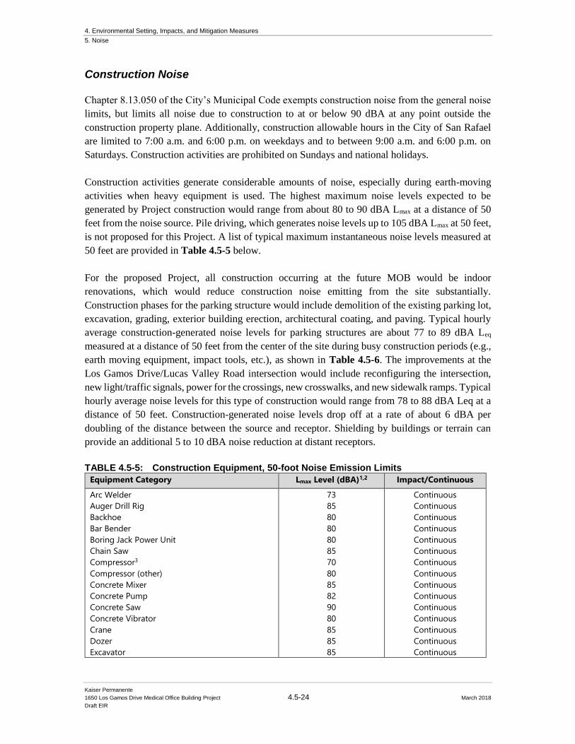
4. Environmental Setting, Impacts, and Mitigation Measures
5. Noise
Kaiser Permanente
1650 Los Gamos Drive Medical Office Building Project 4.5-24 March 2018
Draft EIR
Construction Noise
Chapter 8.13.050 of the City’s Municipal Code exempts construction noise from the general noise
limits, but limits all noise due to construction to at or below 90 dBA at any point outside the
construction property plane. Additionally, construction allowable hours in the City of San Rafael
are limited to 7:00 a.m. and 6:00 p.m. on weekdays and to between 9:00 a.m. and 6:00 p.m. on
Saturdays. Construction activities are prohibited on Sundays and national holidays.
Construction activities generate considerable amounts of noise, especially during earth-moving
activities when heavy equipment is used. The highest maximum noise levels expected to be
generated by Project construction would range from about 80 to 90 dBA Lmax at a distance of 50
feet from the noise source. Pile driving, which generates noise levels up to 105 dBA Lmax at 50 feet,
is not proposed for this Project. A list of typical maximum instantaneous noise levels measured at
50 feet are provided in Table 4.5-5 below.
For the proposed Project, all construction occurring at the future MOB would be indoor
renovations, which would reduce construction noise emitting from the site substantially.
Construction phases for the parking structure would include demolition of the existing parking lot,
excavation, grading, exterior building erection, architectural coating, and paving. Typical hourly
average construction-generated noise levels for parking structures are about 77 to 89 dBA Leq
measured at a distance of 50 feet from the center of the site during busy construction periods (e.g.,
earth moving equipment, impact tools, etc.), as shown in Table 4.5-6. The improvements at the
Los Gamos Drive/Lucas Valley Road intersection would include reconfiguring the intersection,
new light/traffic signals, power for the crossings, new crosswalks, and new sidewalk ramps. Typical
hourly average noise levels for this type of construction would range from 78 to 88 dBA Leq at a
distance of 50 feet. Construction-generated noise levels drop off at a rate of about 6 dBA per
doubling of the distance between the source and receptor. Shielding by buildings or terrain can
provide an additional 5 to 10 dBA noise reduction at distant receptors.
TABLE 4.5-5: Construction Equipment, 50-foot Noise Emission Limits
Equipment Category Lmax Level (dBA)1,2 Impact/Continuous
Arc Welder
Auger Drill Rig
Backhoe
Bar Bender
Boring Jack Power Unit
Chain Saw
Compressor3
Compressor (other)
Concrete Mixer
Concrete Pump
Concrete Saw
Concrete Vibrator
Crane
Dozer
Excavator
73
85
80
80
80
85
70
80
85
82
90
80
85
85
85
Continuous
Continuous
Continuous
Continuous
Continuous
Continuous
Continuous
Continuous
Continuous
Continuous
Continuous
Continuous
Continuous
Continuous
Continuous
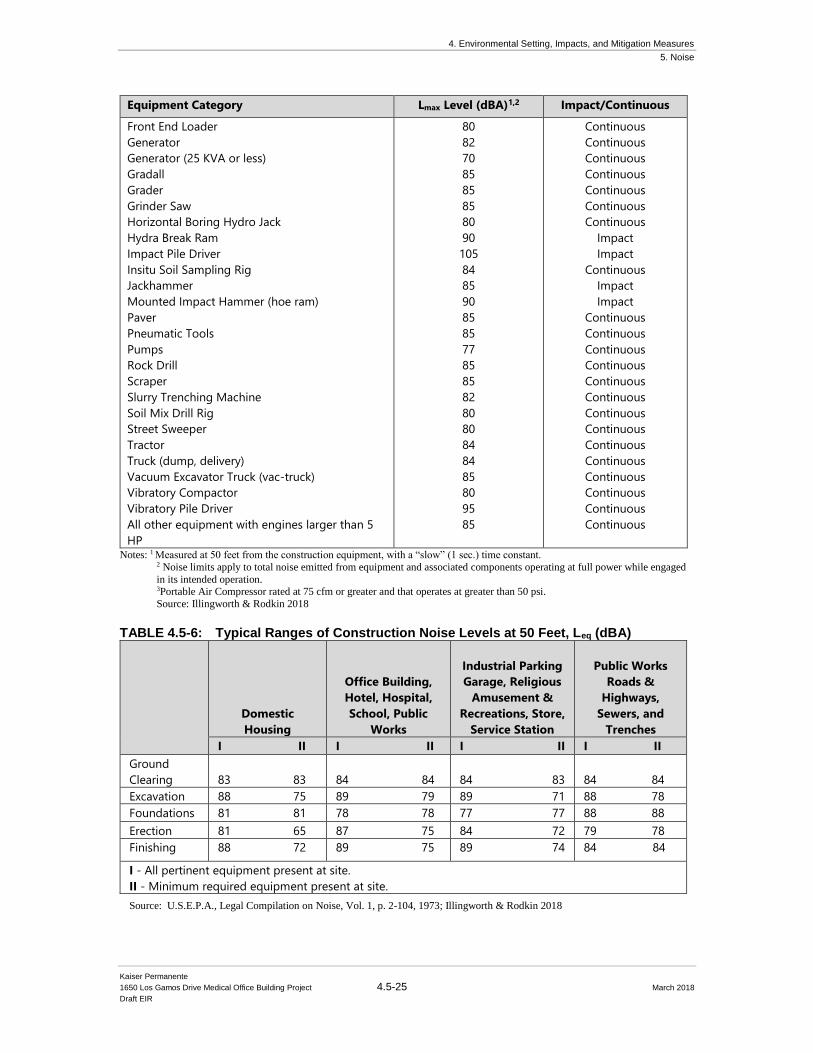
4. Environmental Setting, Impacts, and Mitigation Measures
5. Noise
Kaiser Permanente
1650 Los Gamos Drive Medical Office Building Project 4.5-25 March 2018
Draft EIR
Equipment Category Lmax Level (dBA)1,2 Impact/Continuous
Front End Loader
Generator
Generator (25 KVA or less)
Gradall
Grader
Grinder Saw
Horizontal Boring Hydro Jack
Hydra Break Ram
Impact Pile Driver
Insitu Soil Sampling Rig
Jackhammer
Mounted Impact Hammer (hoe ram)
Paver
Pneumatic Tools
Pumps
Rock Drill
Scraper
Slurry Trenching Machine
Soil Mix Drill Rig
Street Sweeper
Tractor
Truck (dump, delivery)
Vacuum Excavator Truck (vac-truck)
Vibratory Compactor
Vibratory Pile Driver
All other equipment with engines larger than 5
HP
80
82
70
85
85
85
80
90
105
84
85
90
85
85
77
85
85
82
80
80
84
84
85
80
95
85
Continuous
Continuous
Continuous
Continuous
Continuous
Continuous
Continuous
Impact
Impact
Continuous
Impact
Impact
Continuous
Continuous
Continuous
Continuous
Continuous
Continuous
Continuous
Continuous
Continuous
Continuous
Continuous
Continuous
Continuous
Continuous
Notes: 1 Measured at 50 feet from the construction equipment, with a “slow” (1 sec.) time constant.
2 Noise limits apply to total noise emitted from equipment and associated components operating at full power while engaged
in its intended operation. 3Portable Air Compressor rated at 75 cfm or greater and that operates at greater than 50 psi.
Source: Illingworth & Rodkin 2018
TABLE 4.5-6: Typical Ranges of Construction Noise Levels at 50 Feet, Leq (dBA)
Domestic
Housing
Office Building,
Hotel, Hospital,
School, Public
Works
Industrial Parking
Garage, Religious
Amusement &
Recreations, Store,
Service Station
Public Works
Roads &
Highways,
Sewers, and
Trenches
I II I II I II I II
Ground
Clearing
83 83
84 84
84 83
84 84
Excavation 88 75 89 79 89 71 88 78
Foundations 81 81 78 78 77 77 88 88
Erection 81 65 87 75 84 72 79 78
Finishing 88 72 89 75 89 74 84 84
I - All pertinent equipment present at site.
II - Minimum required equipment present at site.
Source: U.S.E.P.A., Legal Compilation on Noise, Vol. 1, p. 2-104, 1973; Illingworth & Rodkin 2018
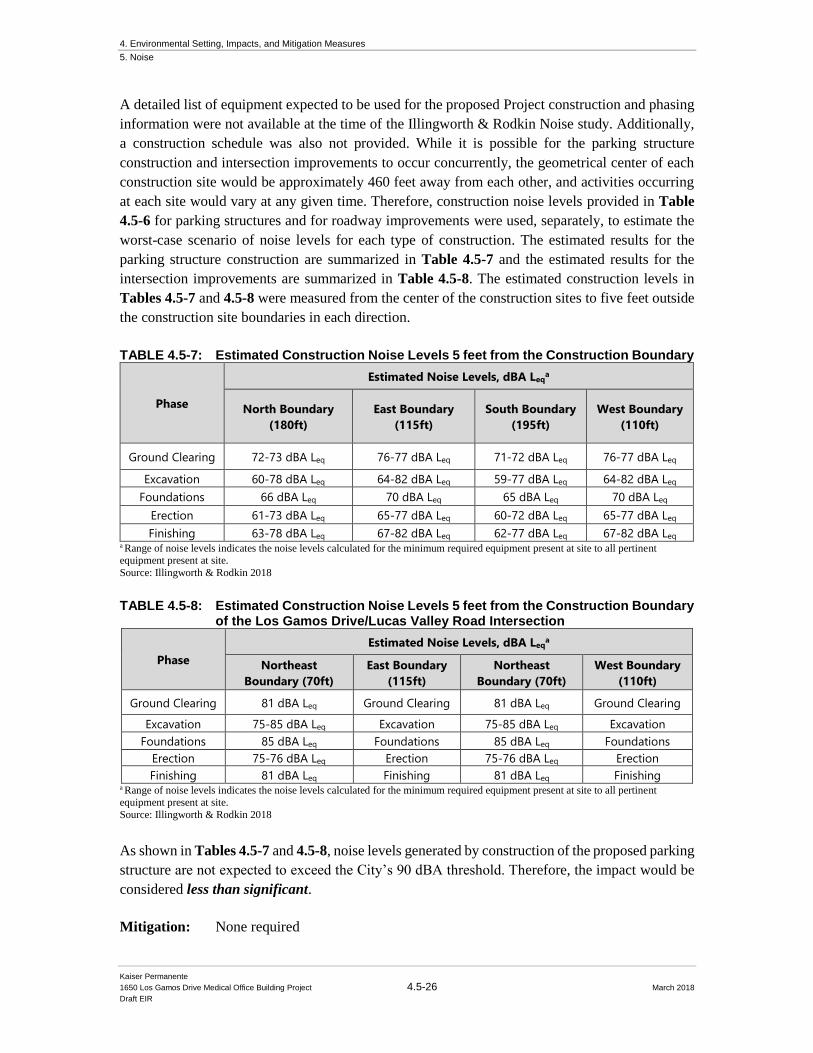
4. Environmental Setting, Impacts, and Mitigation Measures
5. Noise
Kaiser Permanente
1650 Los Gamos Drive Medical Office Building Project 4.5-26 March 2018
Draft EIR
A detailed list of equipment expected to be used for the proposed Project construction and phasing
information were not available at the time of the Illingworth & Rodkin Noise study. Additionally,
a construction schedule was also not provided. While it is possible for the parking structure
construction and intersection improvements to occur concurrently, the geometrical center of each
construction site would be approximately 460 feet away from each other, and activities occurring
at each site would vary at any given time. Therefore, construction noise levels provided in Table
4.5-6 for parking structures and for roadway improvements were used, separately, to estimate the
worst-case scenario of noise levels for each type of construction. The estimated results for the
parking structure construction are summarized in Table 4.5-7 and the estimated results for the
intersection improvements are summarized in Table 4.5-8. The estimated construction levels in
Tables 4.5-7 and 4.5-8 were measured from the center of the construction sites to five feet outside
the construction site boundaries in each direction.
TABLE 4.5-7: Estimated Construction Noise Levels 5 feet from the Construction Boundary
Phase
Estimated Noise Levels, dBA Leqa
North Boundary
(180ft)
East Boundary
(115ft)
South Boundary
(195ft)
West Boundary
(110ft)
Ground Clearing 72-73 dBA Leq 76-77 dBA Leq 71-72 dBA Leq 76-77 dBA Leq
Excavation 60-78 dBA Leq 64-82 dBA Leq 59-77 dBA Leq 64-82 dBA Leq
Foundations 66 dBA Leq 70 dBA Leq 65 dBA Leq 70 dBA Leq
Erection 61-73 dBA Leq 65-77 dBA Leq 60-72 dBA Leq 65-77 dBA Leq
Finishing 63-78 dBA Leq 67-82 dBA Leq 62-77 dBA Leq 67-82 dBA Leq a Range of noise levels indicates the noise levels calculated for the minimum required equipment present at site to all pertinent equipment present at site.
Source: Illingworth & Rodkin 2018
TABLE 4.5-8: Estimated Construction Noise Levels 5 feet from the Construction Boundary of the Los Gamos Drive/Lucas Valley Road Intersection
Phase
Estimated Noise Levels, dBA Leqa
Northeast
Boundary (70ft)
East Boundary
(115ft)
Northeast
Boundary (70ft)
West Boundary
(110ft)
Ground Clearing 81 dBA Leq Ground Clearing 81 dBA Leq Ground Clearing
Excavation 75-85 dBA Leq Excavation 75-85 dBA Leq Excavation
Foundations 85 dBA Leq Foundations 85 dBA Leq Foundations
Erection 75-76 dBA Leq Erection 75-76 dBA Leq Erection
Finishing 81 dBA Leq Finishing 81 dBA Leq Finishing a Range of noise levels indicates the noise levels calculated for the minimum required equipment present at site to all pertinent
equipment present at site.
Source: Illingworth & Rodkin 2018
As shown in Tables 4.5-7 and 4.5-8, noise levels generated by construction of the proposed parking
structure are not expected to exceed the City’s 90 dBA threshold. Therefore, the impact would be
considered less than significant.
Mitigation: None required
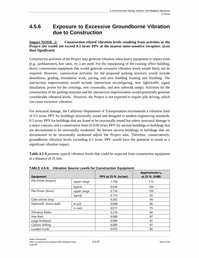
4. Environmental Setting, Impacts, and Mitigation Measures
5. Noise
Kaiser Permanente
1650 Los Gamos Drive Medical Office Building Project 4.5-27 March 2018
Draft EIR
4.5.6 Exposure to Excessive Groundborne Vibration due to Construction
Impact NOISE -2: Construction-related vibration levels resulting from activities at the
Project site would not exceed 0.3 in/sec PPV at the nearest noise-sensitive receptors. (Less
than Significant)
Construction activities of the Project may generate vibration when heavy equipment or impact tools
(e.g., jackhammers, hoe rams, etc.) are used. For the repurposing of the existing office building,
heavy construction equipment that would generate excessive vibration levels would likely not be
required. However, construction activities for the proposed parking structure would include
demolition, grading, foundation work, paving, and new building framing and finishing. The
intersection improvements would include intersection reconfiguring, new light/traffic signal
installation, power for the crossings, new crosswalks, and new sidewalk ramps. Activities for the
construction of the parking structure and the intersection improvements would potentially generate
considerable vibration levels. However, the Project is not expected to require pile driving, which
can cause excessive vibration.
For structural damage, the California Department of Transportation recommends a vibration limit
of 0.5 in/sec PPV for buildings structurally sound and designed to modern engineering standards,
0.3 in/sec PPV for buildings that are found to be structurally sound but where structural damage is
a major concern, and a conservative limit of 0.08 in/sec PPV for ancient buildings or buildings that
are documented to be structurally weakened. No known ancient buildings or buildings that are
documented to be structurally weakened adjoin the Project area. Therefore, conservatively,
groundborne vibration levels exceeding 0.3 in/sec PPV would have the potential to result in a
significant vibration impact.
Table 4.5-9 presents typical vibration levels that could be expected from construction equipment
at a distance of 25 feet.
TABLE 4.5-9: Vibration Source Levels for Construction Equipment
Equipment PPV at 25 ft. (in/sec)
Approximate Lv
at 25 ft. (VdB)
Pile Driver (Impact) upper range 1.158 112
typical 0.644 104
Pile Driver (Sonic) upper range 0.734 105
typical 0.170 93
Clam shovel drop 0.202 94
Hydromill (slurry wall) in soil 0.008 66
in rock 0.017 75
Vibratory Roller 0.210 94
Hoe Ram 0.089 87
Large bulldozer 0.089 87
Caisson drilling 0.089 87
Loaded trucks 0.076 86
4. Environmental Setting, Impacts, and Mitigation Measures
5. Noise
Kaiser Permanente
1650 Los Gamos Drive Medical Office Building Project 4.5-28 March 2018
Draft EIR
Jackhammer 0.035 79
Small bulldozer 0.003 58 Source: Transit Noise and Vibration Impact Assessment, United States Department of Transportation, Office of Planning and
Environment, Federal Transit Administration, May 2006.;
Illingworth & Rodkin 2018
Project construction activities, such as drilling, the use of jackhammers, rock drills and other high-
power or vibratory tools, and rolling stock equipment (tracked vehicles, compactors, etc.), may
generate substantial vibration in the immediate vicinity. Jackhammers typically generate vibration
levels of 0.035 in/sec PPV, and drilling typically generates vibration levels of 0.09 in/sec PPV at a
distance of 25 feet. Vibration levels would vary depending on soil conditions, construction
methods, and equipment used.
The nearest residential structure located to the west of the Project site and at a higher elevation,
would be approximately 215 feet from the parking structure construction site boundary. At this
distance, vibration levels would be up to 0.02 in/sec PPV, which would not exceed the 0.3 in/sec
PPV threshold. The distance from the nearest residential structure to the boundary of the
intersection improvements construction zone would be approximately 690 feet, and at this distance,
vibration levels would be at or below 0.01 in/sec PPV. The nearest off-site commercial building
would be approximately 325 feet south of the parking structure and approximately 615 feet from
the intersection. Vibration levels experienced at this building due to construction of the parking
structure would be up to 0.01 in/sec PPV and due to intersection improvements would be up to 0.01
in/sec PPV. The on-site proposed MOB would be approximately 115 feet east of the parking
structure construction site and approximately 200 feet from the boundary of the intersection
improvements. At these distances, vibration levels would be up to 0.04 in/sec PPV and up to 0.02
in/sec PPV, respectively. Construction of the Project would not generate vibration levels of 0.3
in/sec PPV or more at existing noise-sensitive land uses located off- and on-site. This would be
considered a less than significant impact.
Mitigation: None required
4.5.7 Permanent Noise Level Increase Impact NOISE-3: The Project would not result in a substantial permanent noise level
increase due to project-generated traffic at the existing noise-sensitive land uses in the project
vicinity. (Less than Significant)
Policy N-5 of the San Rafael General Plan 2020 states that where the exterior is 65 dBA Ldn or
greater at a residential building or outdoor use area and a Project increases traffic noise levels by
more than 3 dBA Ldn, a permanent noise impact would be considered significant. For reference, a
3 dBA Ldn noise increase would be expected if the Project would double existing traffic volumes
along a roadway.
4. Environmental Setting, Impacts, and Mitigation Measures
5. Noise
Kaiser Permanente
1650 Los Gamos Drive Medical Office Building Project 4.5-29 March 2018
Draft EIR
Existing ambient noise levels at the nearby residential land uses are 56 dBA Ldn, according to noise
measurements made at LT-2.
To determine the effect of the project-generated traffic on the nearby existing residences, the
existing plus project peak hour turning movements provided in the traffic study conducted for the
Project was compared to the existing peak hour turning movements. While peak hour traffic
volumes along Los Gamos Drive indicated an increase of 3 dBA Ldn, the traffic noise increase at
all other segments included in the traffic study was 1 dBA Ldn or less. The existing peak hour
turning movements provided in the traffic study reflect current low occupancy at the surrounding
commercial buildings. Since the existing plus Project peak hour turning movements represents the
existing conditions plus the Project trips generated by the Project, the existing plus Project turning
movements would also reflect the low occupancy scenario. If the occupancy of the commercial
buildings in the Project vicinity increased, this increase would be reflected in both existing and
existing plus Project traffic scenarios. However, the trips generated by the proposed Project would
not change. If the same Project trips were applied to existing traffic volumes that were higher than
those presented in the traffic study, then the total Project trips would be a lower percentage of the
existing volumes, and therefore, the noise level increase from the existing to the existing plus
Project traffic scenarios would be less. The calculated 3 dBA Ldn increase along Los Gamos Drive
and the 1 dBA Ldn or less increase along every other roadway segment would be the worst-case
scenario.
Under worst-case scenarios, the residential land uses to the west of the Project site would
experience an increase of up to 1 dBA Ldn, resulting in ambient noise levels below 60 dBA Ldn with
the inclusion of the proposed Project. While the traffic increase along Los Gamos Drive would
result in a permanent noise increase of 3 dBA Ldn, this increase would only apply to the commercial
office buildings to the south of the Project site. Therefore, the Project-generated traffic would not
cause a permanent noise increase at the surrounding residential receptors. This impact is a less than
significant impact.
Mitigation: None required
4.5.8 Temporary Construction Noise
Impact NOISE-4: Existing noise-sensitive land uses would be exposed to a temporary
increase in ambient noise levels due to Project construction activities. The incorporation of
construction best management practices as Project conditions of approval would result in a
less-than-significant temporary noise impact. (Less than Significant with Mitigation
Incorporation)
Noise impacts resulting from temporary construction depend upon the noise generated by various
pieces of construction equipment, the timing and duration of noise-generating activities, and the
distance between construction noise sources and noise-sensitive areas. Construction noise impacts
primarily result when construction activities occur during noise-sensitive times of the day (e.g.,
4. Environmental Setting, Impacts, and Mitigation Measures
5. Noise
Kaiser Permanente
1650 Los Gamos Drive Medical Office Building Project 4.5-30 March 2018
Draft EIR
early morning, evening, or nighttime hours), the construction occurs in areas immediately adjoining
noise-sensitive land uses, or when construction lasts over extended periods of time.
As discussed in the Fundamentals section of the 2018 Illingworth & Rodkin Noise and Vibration
Assessment report (included in Appendix D to this DEIR), thresholds for speech interference
indoors is 45 dBA. Assuming a 15 dBA exterior-to-interior reduction for standard residential
construction and a 25 dBA exterior-to-interior reduction for standard commercial construction, this
would correlate to an exterior threshold of 60 dBA Leq at residential land uses and 70 dBA Leq at
commercial land uses. Additionally, temporary construction would be considered an impact to
surrounding land uses if the ambient noise environment increased by at least 5 dBA Leq for an
extended period of time. Therefore, the temporary construction noise impact would be considered
significant if Project construction activities exceeded 60 dBA Leq at property line of nearby
residences or exceeded 70 dBA Leq at the property line of nearby commercial land uses and
exceeded the ambient noise environment by 5 dBA Leq or more for a period longer than one year.
Ambient noise measurements during daytime hours at the nearest residences were estimated at LT-
2 to range from 43 to 54 dBA Leq. The existing ambient noise environment at the nearby commercial
land uses would range from 59 to 67 dBA Leq during daytime hours, as measured at LT-1. These
long-term measurements represent the ambient noise environment for off-site receptors that would
be affected by construction activities occurring at the Project site.
As stated in Impact NOISE-1, phasing information, including time duration and equipment to be
used, were not available at the time of the Illingworth & Rodkin. However, construction activities
at the Project is expected to consist of mostly interior renovations, and activities at the proposed
parking structure and off-site mitigation measures for roadway improvements would include
demolition of the existing surface parking lot, grading/excavation, building construction, paving,
and architectural coating; and activities at the Los Gamos Drive/Lucas Valley Road intersection
would include reconfiguring the intersection, new light/traffic signals, power for the crossings, new
crosswalks, and new sidewalk ramps. During each stage of construction, there would be a different
mix of equipment operating, and noise levels would vary by stage and vary within stages, based on
the amount of equipment in operation and the location at which the equipment is operating. Once
construction moves indoors, minimal noise would be generated at off-site locations. As mentioned
above, due to the distance between the intersection and the parking structure, the construction noise
levels for each site was calculated separately. Depending upon the location of the nearby receptors,
the nearest construction site would represent the dominant noise source.
Typical noise levels for parking structures and roadway improvements were estimated at five feet
outside the construction site in Tables 4.5-7 and 4.5-8, respectively, and to compare the expected
noise levels due to construction activities at the receptor property lines to the ambient noise levels,
parking structure and potential off-site mitigation measure roadway improvements construction
levels were estimated at the distances of the nearby receptor property lines to the center of the
construction site. These are summarized in Tables 4.5-10 and 4.5-11, respectively.
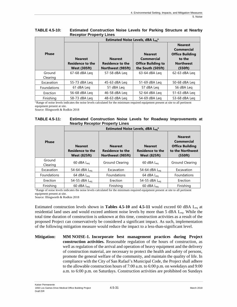
4. Environmental Setting, Impacts, and Mitigation Measures
5. Noise
Kaiser Permanente
1650 Los Gamos Drive Medical Office Building Project 4.5-31 March 2018
Draft EIR
TABLE 4.5-10: Estimated Construction Noise Levels for Parking Structure at Nearby Receptor Property Lines
Phase
Estimated Noise Levels, dBA Leqa
Nearest
Residence to the
West (305ft)
Nearest
Residence to the
Northwest (985ft)
Nearest
Commercial
Office Building to
the South (505ft)
Nearest
Commercial
Office Building
to the
Northwest
(550ft)
Ground
Clearing
67-68 dBA Leq 57-58 dBA Leq 63-64 dBA Leq 62-63 dBA Leq
Excavation 55-73 dBA Leq 45-63 dBA Leq 51-69 dBA Leq 50-68 dBA Leq
Foundations 61 dBA Leq 51 dBA Leq 57 dBA Leq 56 dBA Leq
Erection 56-68 dBA Leq 46-58 dBA Leq 52-64 dBA Leq 51-63 dBA Leq
Finishing 58-73 dBA Leq 48-63 dBA Leq 54-69 dBA Leq 53-68 dBA Leq a Range of noise levels indicates the noise levels calculated for the minimum required equipment present at site to all pertinent equipment present at site.
Source: Illingworth & Rodkin 2018
TABLE 4.5-11: Estimated Construction Noise Levels for Roadway Improvements at
Nearby Receptor Property Lines
Phase
Estimated Noise Levels, dBA Leqa
Nearest
Residence to the
West (825ft)
Nearest
Residence to the
Northwest (985ft)
Nearest
Residence to the
West (825ft)
Nearest
Commercial
Office Building
to the Northwest
(550ft)
Ground
Clearing 60 dBA Leq Ground Clearing 60 dBA Leq Ground Clearing
Excavation 54-64 dBA Leq Excavation 54-64 dBA Leq Excavation
Foundations 64 dBA Leq Foundations 64 dBA Leq Foundations
Erection 54-55 dBA Leq Erection 54-55 dBA Leq Erection
Finishing 60 dBA Leq Finishing 60 dBA Leq Finishing a Range of noise levels indicates the noise levels calculated for the minimum required equipment present at site to all pertinent
equipment present at site. Source: Illingworth & Rodkin 2018
Estimated construction levels shown in Tables 4.5-10 and 4.5-11 would exceed 60 dBA Leq at
residential land uses and would exceed ambient noise levels by more than 5 dBA Leq. While the
total time duration of construction is unknown at this time, construction activities as a result of the
proposed Project can conservatively be considered a significant impact. As such, implementation
of the following mitigation measure would reduce the impact to a less-than-significant level.
Mitigation: MM NOISE-1. Incorporate best management practices during Project
construction activities. Reasonable regulation of the hours of construction, as
well as regulation of the arrival and operation of heavy equipment and the delivery
of construction material, are necessary to protect the health and safety of persons,
promote the general welfare of the community, and maintain the quality of life. In
compliance with the City of San Rafael’s Municipal Code, the Project shall adhere
to the allowable construction hours of 7:00 a.m. to 6:00 p.m. on weekdays and 9:00
a.m. to 6:00 p.m. on Saturdays. Construction activities are prohibited on Sundays

4. Environmental Setting, Impacts, and Mitigation Measures
5. Noise
Kaiser Permanente
1650 Los Gamos Drive Medical Office Building Project 4.5-32 March 2018
Draft EIR
and national holidays. Additionally, the construction crew shall adhere to the
following construction best management practices to reduce construction noise
levels emanating from the site and minimize disruption and annoyance at existing
noise-sensitive receptors in the Project vicinity.
Construction Best Management Practices
In order to reduce potential significant impacts from temporary construction
activities, the Kaiser Permanente shall be required to develop a construction noise
control plan, including, but not limited to, the following available controls:
• Construct temporary noise barriers, where feasible, to screen stationary
noise-generating equipment. Temporary noise barrier fences would
provide a 5 dBA noise reduction if the noise barrier interrupts the line-of-
sight between the noise source and receptor and if the barrier is constructed
in a manner that eliminates any cracks or gaps.
• Equip all internal combustion engine-driven equipment with intake and
exhaust mufflers that are in good condition and appropriate for the
equipment.
• Unnecessary idling of internal combustion engines should be strictly
prohibited.
• Locate stationary noise-generating equipment, such as air compressors or
portable power generators, as far as possible from sensitive receptors as
feasible. If they must be located near receptors, adequate muffling (with
enclosures where feasible and appropriate) shall be used to reduce noise
levels at the adjacent sensitive receptors. Any enclosure openings or
venting shall face away from sensitive receptors.
• Utilize "quiet" air compressors and other stationary noise sources where
technology exists.
• Construction staging areas shall be established at locations that will create
the greatest distance between the construction-related noise sources and
noise-sensitive receptors nearest the Project site during all Project
construction.
• Locate material stockpiles, as well as maintenance/equipment staging and
parking areas, as far as feasible from residential receptors.
• Route construction-related traffic along major roadways and as far as
feasible from sensitive receptors.
• Control noise from construction workers’ radios to a point where they are
not audible at existing residences bordering the Project site.
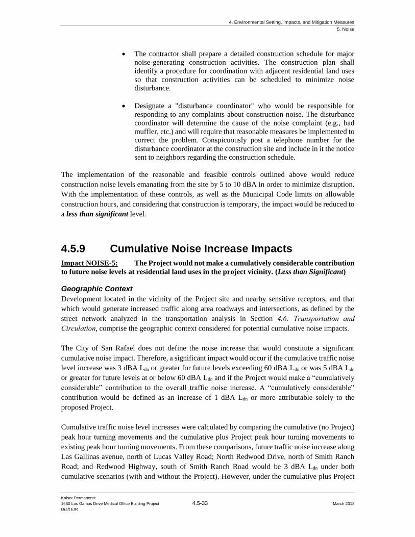
4. Environmental Setting, Impacts, and Mitigation Measures
5. Noise
Kaiser Permanente
1650 Los Gamos Drive Medical Office Building Project 4.5-33 March 2018
Draft EIR
• The contractor shall prepare a detailed construction schedule for major
noise-generating construction activities. The construction plan shall
identify a procedure for coordination with adjacent residential land uses
so that construction activities can be scheduled to minimize noise
disturbance.
• Designate a "disturbance coordinator" who would be responsible for
responding to any complaints about construction noise. The disturbance
coordinator will determine the cause of the noise complaint (e.g., bad
muffler, etc.) and will require that reasonable measures be implemented to
correct the problem. Conspicuously post a telephone number for the
disturbance coordinator at the construction site and include in it the notice
sent to neighbors regarding the construction schedule.
The implementation of the reasonable and feasible controls outlined above would reduce
construction noise levels emanating from the site by 5 to 10 dBA in order to minimize disruption.
With the implementation of these controls, as well as the Municipal Code limits on allowable
construction hours, and considering that construction is temporary, the impact would be reduced to
a less than significant level.
4.5.9 Cumulative Noise Increase Impacts
Impact NOISE-5: The Project would not make a cumulatively considerable contribution
to future noise levels at residential land uses in the project vicinity. (Less than Significant)
Geographic Context
Development located in the vicinity of the Project site and nearby sensitive receptors, and that
which would generate increased traffic along area roadways and intersections, as defined by the
street network analyzed in the transportation analysis in Section 4.6: Transportation and Circulation, comprise the geographic context considered for potential cumulative noise impacts.
The City of San Rafael does not define the noise increase that would constitute a significant
cumulative noise impact. Therefore, a significant impact would occur if the cumulative traffic noise
level increase was 3 dBA Ldn or greater for future levels exceeding 60 dBA Ldn or was 5 dBA Ldn
or greater for future levels at or below 60 dBA Ldn and if the Project would make a “cumulatively
considerable” contribution to the overall traffic noise increase. A “cumulatively considerable”
contribution would be defined as an increase of 1 dBA Ldn or more attributable solely to the
proposed Project.
Cumulative traffic noise level increases were calculated by comparing the cumulative (no Project)
peak hour turning movements and the cumulative plus Project peak hour turning movements to
existing peak hour turning movements. From these comparisons, future traffic noise increase along
Las Gallinas avenue, north of Lucas Valley Road; North Redwood Drive, north of Smith Ranch
Road; and Redwood Highway, south of Smith Ranch Road would be 3 dBA Ldn under both
cumulative scenarios (with and without the Project). However, under the cumulative plus Project
4. Environmental Setting, Impacts, and Mitigation Measures
5. Noise
Kaiser Permanente
1650 Los Gamos Drive Medical Office Building Project 4.5-34 March 2018
Draft EIR
traffic scenario, the increase from existing conditions was calculated to be 4 dBA Ldn, along Los
Gamos Drive, while the increase of the cumulative (no Project) would be 3 dBA Ldn. Since the
difference between the two cumulative scenarios would result in 1 dBA Ldn or more, the Project
would make a “cumulative considerable” contribution to the overall traffic noise increase along
Los Gamos Drive. However, the office buildings located along this roadway would not be
considered noise-sensitive, and therefore, this would impact would be considered less than
significant.
Mitigation: None required
4. Environmental Setting, Impacts, and Mitigation Measures
6. Transportation and Circulation
Kaiser Permanente
1650 Los Gamos Drive Medical Office Building Project 4.6-1 March 2018
Draft EIR
4.6 Transportation and Circulation
This section incorporates the setting information and analyses included in the Kaiser Medical Office Building 1650 Los Gamos Drive Final Traffic Impact Analysis (FTIA), prepared by Fehr & Peers
in February 2018. This section describes and evaluates issues related to Transportation and
Circulation in the context of the proposed Project. Discussed are the physical and regulatory setting;
the baseline for determining environmental impacts; the criteria used for determining the
significance of environmental impacts; and potential impacts and appropriate mitigation measures
when necessary for the various scenarios: Existing Plus Project; Baseline; Baseline Plus Project,
and Cumulative.
As described in Chapter 3: Project Description, the proposed Project involves the redevelopment
of an existing office building to permit the addition of medical office as an allowed use for the
existing approximately 150,000 square foot building located at 1650 Los Gamos Drive. The
existing building was constructed at approximately 148,000 square feet; however, the Planned
Development District that governs the Project site allows up to 150,000 square feet of office space
at the Project site. For the purpose of the analysis, Fehr & Peers conservatively assumed a 150,000
square-feet building, though the Project does not plan to rebuild or construct the remaining balance
allowed under the current Planned Development District.
The proposed Project also includes the construction of a maximum 476-space, three-level with
upper ramp, parking structure on the west side of Los Gamos Drive, where there currently is an
existing surface parking lot associated with the building. The Project will also continue to use 42
existing parking spaces located on the adjacent property at 1600 Los Gamos Drive via an existing
legal easement as well as the existing parking lots surrounding the medical office building at 1650
Los Gamos Drive. See Figure 4.6-1 below.
4.6.1 Setting
The existing transportation-related context for the proposed project is described below, beginning
with a description of the street network that serves the Project area. Existing transit service, bicycle
and pedestrian facilities, and on- and off-street parking in the vicinity of the Project are also described.
Intersection and freeway levels of service are then defined and current conditions for roadways and
intersections in the Project area vicinity are summarized.
4.6.1.1 Existing Roadway Network
The Project site is located at 1650 Los Gamos Drive in San Rafael, California. The Project site is
bounded by Lucas Valley Road to north, US Highway 101 to the east, and is bisected by Los Gamos
Drive running north to south. The Project site is surrounded by a mix of transportation resources
that provide local and regional access to the site, including U.S. Highway 101, Lucas Valley Road,
and local streets, bicycle lanes, sidewalks, and public transit. Primary access to the project site is
via Los Gamos Drive. See Figure 4.6-2 for roadways in the Project area.
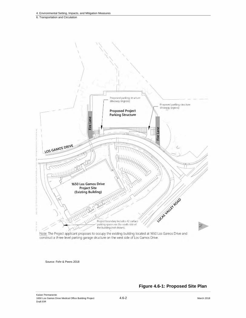
4. Environmental Setting, Impacts, and Mitigation Measures
6. Transportation and Circulation
Kaiser Permanente
1650 Los Gamos Drive Medical Office Building Project 4.6-2 March 2018
Draft EIR
Figure 4.6-1: Proposed Site Plan
Source: Fehr & Peers 2018
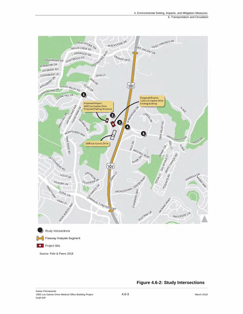
4. Environmental Setting, Impacts, and Mitigation Measures
6. Transportation and Circulation
Kaiser Permanente
1650 Los Gamos Drive Medical Office Building Project 4.6-3 March 2018
Draft EIR
Figure 4.6-2: Study Intersections
Source: Fehr & Peers 2018
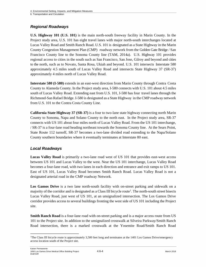
4. Environmental Setting, Impacts, and Mitigation Measures
6. Transportation and Circulation
Kaiser Permanente
1650 Los Gamos Drive Medical Office Building Project 4.6-4 March 2018
Draft EIR
Regional Roadways
U.S. Highway 101 (U.S. 101) is the main north-south freeway facility in Marin County. In the
Project study area, U.S. 101 has eight travel lanes with major north-south interchanges located at
Lucas Valley Road and Smith Ranch Road. U.S. 101 is designated as a State Highway in the Marin
County Congestion Management Plan (CMP) roadway network from the Golden Gate Bridge / San
Francisco County line to the Sonoma County line (TAM, 2014a). U.S. Highway 101 provides
regional access to cities in the south such as San Francisco, San Jose, Gilroy and beyond and cities
to the north, such as to Novato, Santa Rosa, Ukiah and beyond. U.S. 101 intersects Interstate 580
approximately 4.5 miles south of Lucas Valley Road and intersects State Highway 37 (SR-37)
approximately 4 miles north of Lucas Valley Road.
Interstate 580 (I-580) extends in an east-west direction from Marin County through Contra Costa
County to Alameda County. In the Project study area, I-580 connects with U.S. 101 about 4.5 miles
south of Lucas Valley Road. Extending east from U.S. 101, I-580 has four travel lanes through the
Richmond-San Rafael Bridge. I-580 is designated as a State Highway in the CMP roadway network
from U.S. 101 to the Contra Costa County Line.
California State Highway 37 (SR-37) is a four to two-lane state highway connecting north Marin
County to Sonoma, Napa and Solano County to the north east. In the Project study area, SR-37
connects with US 101 about four miles north of Lucas Valley Road. From the US 101 interchange,
/ SR-37 is a four-lane road heading northeast towards the Sonoma County line. At the Sears Point,
State Route 112 turnoff, SR-37 becomes a two-lane divided road extending to the Napa/Solano
County southern boundaries where it eventually terminates at Interstate 80 east.
Local Roadways
Lucas Valley Road is primarily a two-lane road west of US 101 that provides east-west access
between US 101 and Lucas Valley to the west. Near the US 101 interchange, Lucas Valley Road
becomes a four-lane road, with two lanes in each direction and entrance and exit ramps to US 101.
East of US 101, Lucas Valley Road becomes Smith Ranch Road. Lucas Valley Road is not a
designated arterial road in the CMP roadway Network.
Los Gamos Drive is a two lane north-south facility with on-street parking and sidewalk on a
majority of the corridor and is designated as a Class III bicycle route1. The north-south street bisects
Lucas Valley Road, just west of US 101, at an unsignalized intersection. The Los Gamos Drive
corridor provides access to several buildings fronting the west side of US 101 including the Project
site.
Smith Ranch Road is a four-lane road with on-street parking and is a major access route from US
101 to the Project site. In addition to the unsignalized crosswalk at Silveira Parkway/Smith Ranch
Road intersection, there is a marked crosswalk at the Yosemite Road/Smith Ranch Road
1The Class III bicycle route is approximately 3,500 feet long and terminates at the 1401 Los Gamos Drive/emergency
access location south of the Project site.
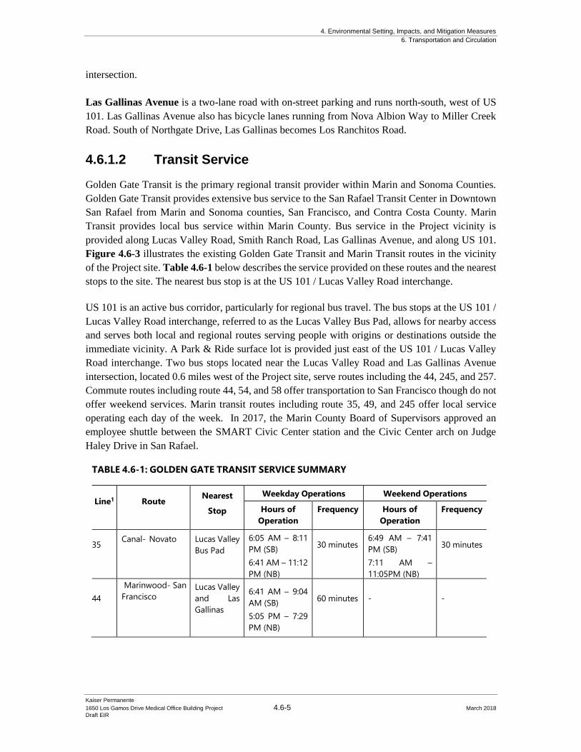
4. Environmental Setting, Impacts, and Mitigation Measures
6. Transportation and Circulation
Kaiser Permanente
1650 Los Gamos Drive Medical Office Building Project 4.6-5 March 2018
Draft EIR
intersection.
Las Gallinas Avenue is a two-lane road with on-street parking and runs north-south, west of US
101. Las Gallinas Avenue also has bicycle lanes running from Nova Albion Way to Miller Creek
Road. South of Northgate Drive, Las Gallinas becomes Los Ranchitos Road.
4.6.1.2 Transit Service
Golden Gate Transit is the primary regional transit provider within Marin and Sonoma Counties.
Golden Gate Transit provides extensive bus service to the San Rafael Transit Center in Downtown
San Rafael from Marin and Sonoma counties, San Francisco, and Contra Costa County. Marin
Transit provides local bus service within Marin County. Bus service in the Project vicinity is
provided along Lucas Valley Road, Smith Ranch Road, Las Gallinas Avenue, and along US 101.
Figure 4.6-3 illustrates the existing Golden Gate Transit and Marin Transit routes in the vicinity
of the Project site. Table 4.6-1 below describes the service provided on these routes and the nearest
stops to the site. The nearest bus stop is at the US 101 / Lucas Valley Road interchange.
US 101 is an active bus corridor, particularly for regional bus travel. The bus stops at the US 101 /
Lucas Valley Road interchange, referred to as the Lucas Valley Bus Pad, allows for nearby access
and serves both local and regional routes serving people with origins or destinations outside the
immediate vicinity. A Park & Ride surface lot is provided just east of the US 101 / Lucas Valley
Road interchange. Two bus stops located near the Lucas Valley Road and Las Gallinas Avenue
intersection, located 0.6 miles west of the Project site, serve routes including the 44, 245, and 257.
Commute routes including route 44, 54, and 58 offer transportation to San Francisco though do not
offer weekend services. Marin transit routes including route 35, 49, and 245 offer local service
operating each day of the week. In 2017, the Marin County Board of Supervisors approved an
employee shuttle between the SMART Civic Center station and the Civic Center arch on Judge
Haley Drive in San Rafael.
TABLE 4.6-1: GOLDEN GATE TRANSIT SERVICE SUMMARY
Line1
Route Nearest
Stop
Weekday Operations Weekend Operations
Hours of
Operation
Frequency Hours of
Operation
Frequency
35 Canal- Novato Lucas Valley
Bus Pad
6:05 AM – 8:11
PM (SB)
6:41 AM – 11:12
PM (NB)
30 minutes 6:49 AM – 7:41
PM (SB)
7:11 AM –
11:05PM (NB)
30 minutes
44
Marinwood- San
Francisco Lucas Valley
and Las
Gallinas
6:41 AM – 9:04
AM (SB)
5:05 PM – 7:29
PM (NB)
60 minutes
-
-
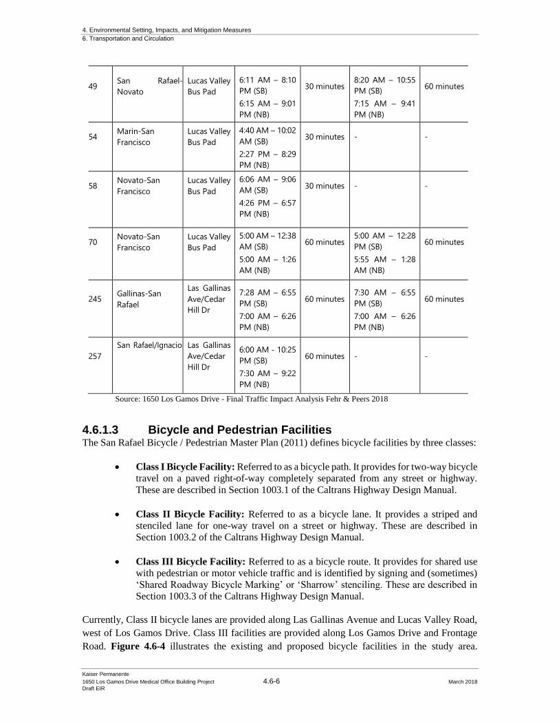
4. Environmental Setting, Impacts, and Mitigation Measures
6. Transportation and Circulation
Kaiser Permanente
1650 Los Gamos Drive Medical Office Building Project 4.6-6 March 2018
Draft EIR
49
San Rafael-
Novato
Lucas Valley
Bus Pad
6:11 AM – 8:10
PM (SB)
6:15 AM – 9:01
PM (NB)
30 minutes
8:20 AM – 10:55
PM (SB)
7:15 AM – 9:41
PM (NB)
60 minutes
54 Marin-San
Francisco
Lucas Valley
Bus Pad
4:40 AM – 10:02
AM (SB)
2:27 PM – 8:29
PM (NB)
30 minutes
-
-
58 Novato-San
Francisco
Lucas Valley
Bus Pad
6:06 AM – 9:06
AM (SB)
4:26 PM – 6:57
PM (NB)
30 minutes
-
-
70 Novato-San
Francisco
Lucas Valley
Bus Pad
5:00 AM – 12:38
AM (SB)
5:00 AM – 1:26
AM (NB)
60 minutes 5:00 AM – 12:28
PM (SB)
5:55 AM – 1:28
AM (NB)
60 minutes
245 Gallinas-San
Rafael
Las Gallinas
Ave/Cedar
Hill Dr
7:28 AM – 6:55
PM (SB)
7:00 AM – 6:26
PM (NB)
60 minutes 7:30 AM – 6:55
PM (SB)
7:00 AM – 6:26
PM (NB)
60 minutes
257
San Rafael/Ignacio Las Gallinas
Ave/Cedar
Hill Dr
6:00 AM - 10:25
PM (SB)
7:30 AM – 9:22
PM (NB)
60 minutes
-
-
Source: 1650 Los Gamos Drive - Final Traffic Impact Analysis Fehr & Peers 2018
4.6.1.3 Bicycle and Pedestrian Facilities The San Rafael Bicycle / Pedestrian Master Plan (2011) defines bicycle facilities by three classes:
• Class I Bicycle Facility: Referred to as a bicycle path. It provides for two-way bicycle
travel on a paved right-of-way completely separated from any street or highway.
These are described in Section 1003.1 of the Caltrans Highway Design Manual.
• Class II Bicycle Facility: Referred to as a bicycle lane. It provides a striped and
stenciled lane for one-way travel on a street or highway. These are described in
Section 1003.2 of the Caltrans Highway Design Manual.
• Class III Bicycle Facility: Referred to as a bicycle route. It provides for shared use
with pedestrian or motor vehicle traffic and is identified by signing and (sometimes)
‘Shared Roadway Bicycle Marking’ or ‘Sharrow’ stenciling. These are described in
Section 1003.3 of the Caltrans Highway Design Manual.
Currently, Class II bicycle lanes are provided along Las Gallinas Avenue and Lucas Valley Road,
west of Los Gamos Drive. Class III facilities are provided along Los Gamos Drive and Frontage
Road. Figure 4.6-4 illustrates the existing and proposed bicycle facilities in the study area.
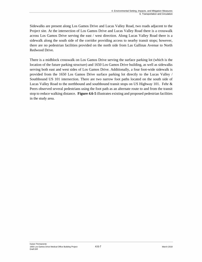
4. Environmental Setting, Impacts, and Mitigation Measures
6. Transportation and Circulation
Kaiser Permanente
1650 Los Gamos Drive Medical Office Building Project 4.6-7 March 2018
Draft EIR
Sidewalks are present along Los Gamos Drive and Lucas Valley Road, two roads adjacent to the
Project site. At the intersection of Los Gamos Drive and Lucas Valley Road there is a crosswalk
across Los Gamos Drive serving the east / west direction. Along Lucas Valley Road there is a
sidewalk along the south side of the corridor providing access to nearby transit stops; however,
there are no pedestrian facilities provided on the north side from Las Gallinas Avenue to North
Redwood Drive.
There is a midblock crosswalk on Los Gamos Drive serving the surface parking lot (which is the
location of the future parking structure) and 1650 Los Gamos Drive building, as well as sidewalks
serving both east and west sides of Los Gamos Drive. Additionally, a four foot-wide sidewalk is
provided from the 1650 Los Gamos Drive surface parking lot directly to the Lucas Valley /
Southbound US 101 intersection. There are two narrow foot paths located on the south side of
Lucas Valley Road to the northbound and southbound transit stops on US Highway 101. Fehr &
Peers observed several pedestrians using the foot path as an alternate route to and from the transit
stop to reduce walking distance. Figure 4.6-5 illustrates existing and proposed pedestrian facilities
in the study area.
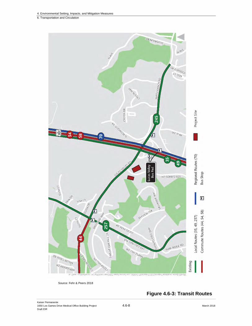
4. Environmental Setting, Impacts, and Mitigation Measures
6. Transportation and Circulation
Kaiser Permanente
1650 Los Gamos Drive Medical Office Building Project 4.6-8 March 2018
Draft EIR
Figure 4.6-3: Transit Routes
Source: Fehr & Peers 2018
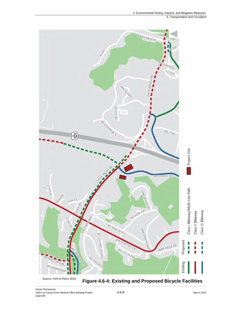
4. Environmental Setting, Impacts, and Mitigation Measures
6. Transportation and Circulation
Kaiser Permanente
1650 Los Gamos Drive Medical Office Building Project 4.6-9 March 2018
Draft EIR
Figure 4.6-4: Existing and Proposed Bicycle Facilities
Source: Fehr & Peers 2018
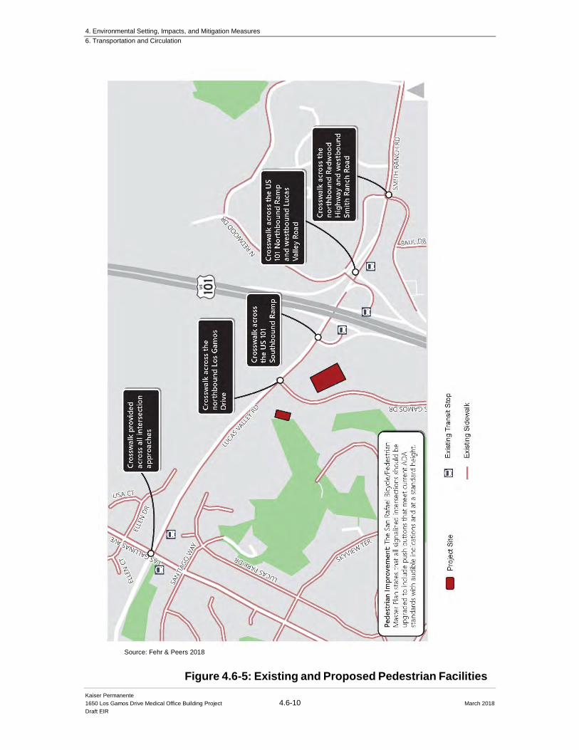
4. Environmental Setting, Impacts, and Mitigation Measures
6. Transportation and Circulation
Kaiser Permanente
1650 Los Gamos Drive Medical Office Building Project 4.6-10 March 2018
Draft EIR
Figure 4.6-5: Existing and Proposed Pedestrian Facilities
Source: Fehr & Peers 2018
4. Environmental Setting, Impacts, and Mitigation Measures
6. Transportation and Circulation
Kaiser Permanente
1650 Los Gamos Drive Medical Office Building Project 4.6-11 March 2018
Draft EIR
4.6.2 Regulatory Setting
4.6.2.1 State California Department of Transportation
The California Department of Transportation (Caltrans) manages interregional transportation,
including management and construction of the California highway system. In addition, Caltrans is
responsible for permitting and regulation of the use of state roadways. Within proximity of the
Project site, the freeway interchange at Lucas Valley Road/Smith Ranch Road and US Highway
101 falls under Caltrans’ jurisdiction.
4.6.2.2 Regional
San Rafael General Plan 2020
The San Rafael General Plan 2020 provides guiding principles for maintaining and managing
the City’s transportation network. Goals, policies, and programs pertaining to transportation and
circulation that are relevant to the proposed Project include the following (references to figures
in the following section pertain to figures contained in the General Plan 2020):
LU-2. Development Timing.
For health, safety and general welfare reasons, new development should only occur when
adequate infrastructure is available consistent with the following findings:
a. Project-related traffic will not cause the level of service established in the
Circulation Element to be exceeded;
b. Any circulation improvements needed to maintain the level of service standard
established in the Circulation Element have been programmed and funding has
been committed;
c. Environmental review of needed circulation improvement projects has been
completed;
d. The time frame for completion of the needed circulation improvements will not
cause the level of service in the Circulation Element to be exceeded, or the findings
set forth in Policy C-5 have been made;
C-1. Regional Transportation Planning.
Actively coordinate with other jurisdictions, regional transportation planning agencies, and
transit providers to expand and improve local and regional transportation choice. Work
cooperatively to improve transit and paratransit services, achieve needed highway corridor
improvements, and improve the regional bicycling network. As part of this effort, support
implementation of Marin County’s 25-Year Transportation Vision.
C-4. Safe Roadway Design.
Design of roadways should be safe and convenient for motor vehicles, transit, bicycles and
pedestrians. Place highest priority on safety. In order to maximize safety and multimodal
mobility, the City Council may determine that an intersection is exempt from the applicable
intersection level of service standard where it is determined that a circulation improvement
4. Environmental Setting, Impacts, and Mitigation Measures
6. Transportation and Circulation
Kaiser Permanente
1650 Los Gamos Drive Medical Office Building Project 4.6-12 March 2018
Draft EIR
is needed for public safety considerations, including bicycle and pedestrian safety, and/or
transit use improvements.
C-5. Traffic Level of Service Standards.
A. Intersection LOS. In order to ensure an effective roadway network, maintain
adequate traffic levels of service (LOS) consistent with standards for signalized
intersections in the A.M. and PM.
B. Arterial LOS. The City Traffic Engineer may apply arterial level of service
analysis as the primary method of analysis for any proposed development project.
C. Exemptions. Signalized intersections at Highway 101 and Interstate 580 on-
ramps and off-ramps are exempt from LOS standards because delay at these
locations is affected by regional traffic and not significantly impacted by local
measures.
D. Evaluation of Project Merits. In order to balance the City’s objectives to
provide affordable housing, maintain a vital economy and provide desired
community services with the need to manage traffic congestion, projects that
would exceed the level of service standards set forth above may be approved if the
City Council finds that the benefits of the project to the community outweigh the
resulting traffic impacts.
C-5a. LOS Methodology. Use appropriate methodologies for calculating traffic
Levels of Service, as determined by the City Traffic Engineer.
C-5.1. Vehicle Miles Traveled (VMT) Methodology for Environmental Review of
Traffic Impact.
Pursuant to Public Resources Code § 21099 and 21083 (provided under Senate Bill 743,
effective January 2016,) an alternative method for measuring transportation impacts of
projects will replace the Level of Service (LOS) methodology. For environmental review,
the use of the vehicle miles traveled (VMT) metric will be applied in assessing
development projects.
C-6. Proposed Improvements.
The proposed circulation improvements in Exhibit 21 have been identified as potentially
needed to improve safety and relieve congestion in San Rafael over the next 20 years.
Major Proposed Circulation Improvements include those improvements deemed necessary
to maintain City LOS standards. Other recommended roadway improvements include
additional improvements that may become necessary in the long-term and are desirable to
enhance San Rafael’s circulation system, but are not necessary to maintain LOS standards.
Specific improvements will be implemented as conditions require, and will be refined
during the design phase. Recognize that other feasible design solutions may become
available and be more effective in achieving the same goals as the improvements listed in
Exhibit 19, and allow for their implementation, consistent with the most recent engineering
standards. As conditions change, planned roadway improvements may be amended,
through the annual General Plan Review. Roadway improvements are implemented
through the Capital Improvements Program, and are typically funded through a variety of
sources, including Traffic Mitigation Fees. Environmental review is required.
4. Environmental Setting, Impacts, and Mitigation Measures
6. Transportation and Circulation
Kaiser Permanente
1650 Los Gamos Drive Medical Office Building Project 4.6-13 March 2018
Draft EIR
C-7. Circulation Improvements Funding.
Take a strong advocacy role in securing funding for planned circulation improvements.
Continue to seek comprehensive funding that includes Federal, State, County, and
Redevelopment funding, Local Traffic Mitigation Fees, and Assessment Districts. The
local development projects’ share of responsibility to fund improvements is based on: (1)
the generation of additional traffic that creates the need for the improvement; (2) the
improvement’s role in the overall traffic network; (3) the probability of securing funding
from alternative sources; and (4) the timing of the improvement.
C-8. Eliminating and Shifting Peak Hour Trips.
Support efforts to limit traffic congestion through eliminating low occupancy auto trips or
shifting peak hour trips to off-peak hours. Possible means include telecommuting, walking
and bicycling, flexible work schedules, car and vanpooling and other Transportation
Demand Management approaches.
C-9. Access for Emergency Services.
Provide safe routes for emergency vehicle access so that emergency services can be
delivered when Highway 101 or 580 are closed or congested with traffic.
C-11. Alternative Transportation Mode Users.
Encourage and promote individuals to use alternative modes of transportation, such as
regional and local transit, carpooling, bicycling, walking and use of low-impact alternative
vehicles. Support development of programs that provide incentives for individuals to
choose alternative modes.
C-12. Transportation Demand Management.
Work cooperatively with governmental agencies, non-profits, businesses, institutions and
residential neighborhoods to create new and effective Transportation Demand
Management (TDM) programs to minimize single occupancy automobile use and peak
period traffic demand.
C-25. Meeting Local Circulation Needs Around Highway Interchanges.
Work with appropriate agencies to address local circulation needs for all modes when
freeway improvements are planned and constructed.
C-26. Bicycle Plan Implementation.
Make bicycling and walking an integral part of daily life in San Rafael by implementing
the San Rafael’s Bicycle and Pedestrian Master Plan.
C-27. Pedestrian Plan Implementation.
Promote walking as the transportation mode of choice for short trips by implementing the
pedestrian element of the City’s Bicycle and Pedestrian Master Plan. In addition to policies
and programs outlined in the Bicycle and Pedestrian Plan, provide support for the
following programs:
C-32. Parking for Alternative Modes of Transportation.
Use preferential parking as an incentive to encourage alternative modes of transportation.
4. Environmental Setting, Impacts, and Mitigation Measures
6. Transportation and Circulation
Kaiser Permanente
1650 Los Gamos Drive Medical Office Building Project 4.6-14 March 2018
Draft EIR
Marin Countywide Plan
The Transportation Section of the Built Environment Element of the Marin Countywide Plan
provides guiding principles for maintaining and managing the County’s transportation network.
Although the proposed Project is contained within the San Rafael City Limits, potential
improvements to the local circulation system would be located in Marin County’s jurisdiction.
Goals, policies, and programs pertaining to transportation and circulation that are relevant to the
proposed Project include the following:
Goal TR-1. Safe and Efficient Movement of People and Goods. Provide a range of transportation options that meets the needs of residents, businesses, and travelers.
Policy TR-1.1, Manage Travel Demand. Improve the operation efficiency of the transportation system by reducing vehicle travel demand and provide opportunities for other modes of travel.
Policy TR-1.2, Maintain Service Standards. Establish level of service standards for vehicles on streets and highways and performance standards for transit, bicycles, pedestrians, and other modes of transportation.
Program TR-1.d, Coordinate with Local Agencies. Work with a proposed City-County Planning Committee, Department of Public Works, Transportation Authority of Marin, Metropolitan Transportation Commission, and other Bay Area counties to coordinate transportation system planning, including updating the County Congestion Management Program and the Capital Improvement Program to prioritize the projects that will meet the goals of the County Transportation Vision. Program TR-1e, Uphold Vehicle Level of Service Standards. Uphold peak-hour vehicle level of service standard of LOS D or better for urban and suburban arterials and LOS E or better for freeways and rural expressway. Level of service standards should adhere to established standards for designated roadways in the Congestion Management Program system.
Program TR-1g, Determine Appropriate Mitigation. Work with the Transportation Authority of Marin to monitor traffic impacts of development and identify mitigation requirements for proposed development that would cause a drop below adopted LOS, including transportation system improvements, impact fees, Transportation Demand Management strategies, direct support of alternative travel modes, or redesign the development of projects for transportation improvements.
Program TR-1s, Vehicle Miles Traveled (VMT) Reduction Monitoring and Implementation and Transportation Demand Management Program. Identify and require in new developments specific transportation demand management (TDM) strategies for reducing the VMT below levels that would otherwise occur.
Goal TR-2, Increased Bicycle and Pedestrian Access.
Expand bicycle and pedestrian facilities and access in and between neighborhoods, employment centers, shopping areas, schools, and recreational uses.
4. Environmental Setting, Impacts, and Mitigation Measures
6. Transportation and Circulation
Kaiser Permanente
1650 Los Gamos Drive Medical Office Building Project 4.6-15 March 2018
Draft EIR
Policy TR-2.2, Provide New Bicycle and Pedestrian Facilities. Where appropriate, require new development to provide trails or roadways and paths for use by bicycles and/or on-street bicycle and pedestrian facilities. In-lieu fees may be accepted if warranted in certain cases.
Program TR-2b, Adopt Standards for Pedestrian and Bicycle Access. As appropriate, require new development and redevelopment projects to address the following: bicycle and pedestrian access internally and to other areas through easements; safe access to public transportation and construction of paths that connect with other non-motorized routes; safe road crossings at major intersections for school children and seniors; and secure, weatherproof bicycle storage facilities and shower/changing room facilities for bicycle commuters. Ensure that such facilities will have ongoing maintenance.
Transportation Authority of Marin
The Transportation Authority of Marin (TAM) serves as the Congestion Management Agency
(CMA) of Marin County. As the County’s CMA, TAM is responsible for managing the county’s
blueprint to reduce congestion and improve air quality. TAM is authorized to set state and federal
funding priorities for transportation improvements affecting the Marin County Congestion
Management Program (CMP) transportation system (TAM, 2014). Roadways in proximity to the
Project site that are designated in the CMP roadway system include U.S. 101, I-580, and Sir Francis
Drake Boulevard. TAM forwards the County’s prioritized list of projects to the Metropolitan
Transportation Commission (Metropolitan Planning Organization [MPO] for the San Francisco Bay
Area) for incorporation into the regional list to receive state and federal funding.
Congestion Management Program
The CMP specifies a system of highways and roadways for which traffic level of service standards are
established. The CMP system includes all freeways, state highways, and principal arterials in the
County. The program sets level of service standards for all CMP roadway segments and intersections.
Lucas Valley Road has a level of service standard of LOS D, and the LOS standard for freeways (I-
580, U.S. 101) is LOS E. The CMP also contains an element promoting the use of alternative
transportation modes and ways to reduce future travel demand. Improving the county’s jobs/housing
balance and implementing travel demand management strategies are specifically mentioned as ways
of attaining the objectives of this element of the CMP. TAM requires local jurisdictions to analyze
impacts of new developments or land use policy changes on CMP facilities. TAM has adopted an
annual schedule for monitoring the CMP Roadway System. The last monitoring report was completed
in 2014 (TAM, 2014).
4. Environmental Setting, Impacts, and Mitigation Measures
6. Transportation and Circulation
Kaiser Permanente
1650 Los Gamos Drive Medical Office Building Project 4.6-16 March 2018
Draft EIR
4.6.3 Impact Analysis
4.6.3.1 Significance Criteria
Consistent with CEQA Guidelines Appendix G (Environmental Checklist), the Project could have
a significant impact if it would:
a) Conflict with an applicable plan, ordinance, or policy establishing measures of
effectiveness for the performance of the circulation system, taking into account all modes
of transportation, including mass transit, non-motorized travel, and relevant components
of the circulation system (including but not limited to intersections, streets, highways and
freeways, pedestrian and bicycle paths, and mass transit);
b) Conflict with an applicable congestion management program (CMP), including, but not
limited to, level of service (LOS) standards and travel demand measures, or other standards
established by the county congestion management agency for designated roads or
highways;
c) Result in a change in air traffic patterns, including either an increase in traffic levels or a
change in locations that results in substantial safety risks;
d) Substantially increase hazards due to a design feature (e.g., sharp curves or dangerous
intersections) or incompatible uses (e.g., farm equipment);
e) Result in inadequate emergency access; or
f) Conflict with adopted policies, plans, or programs regarding public transit, bicycle, or
pedestrian facilities, or otherwise decrease the performance or safety of such facilities.
In addition to the criteria above, the following standards were used to identify significant impacts
of the proposed Project:
San Rafael General Plan 2020
The following transportation and circulation significance criteria based on the CEQA Guidelines
and the San Rafael General Plan 2020 (City of San Rafael, 2004) are presented below.
The CEQA Guidelines specify that a project would have a significant traffic and circulation impact
if it:
• Conflicts with an applicable plan, ordinance or policy establishing measures of
effectiveness for the performance of the circulation system, taking into account all modes
of transportation including mass transit and non-motorized travel and relevant components
of the circulation system, including but not limited to intersections, streets, highways and
freeways, pedestrian and bicycle paths, and mass transit.
4. Environmental Setting, Impacts, and Mitigation Measures
6. Transportation and Circulation
Kaiser Permanente
1650 Los Gamos Drive Medical Office Building Project 4.6-17 March 2018
Draft EIR
• Conflicts with an applicable congestion management program, including, but not limited
to level of service standards and travel demand measures, or other standards established by
the county congestion management agency for designated roads or highways.
• Results in a change in air traffic patterns, including either an increase in traffic levels or a
change in location that results in substantial safety risks
• Substantially increases hazards due to a design feature (e.g., sharp curves or dangerous
intersections) or incompatible uses (e.g., farm equipment).
• Conflicts with adopted policies, plans, or programs regarding public transit, bicycle, or
pedestrian facilities, or otherwise decrease the performance or safety of such facilities.
Signalized Intersections
The San Rafael General Plan 2020 includes traffic LOS standards for signalized intersections and
arterials. These criteria and interpretations consistent with the San Rafael General Plan 2020 EIR (City of San Rafael, 2004), are presented below.
The citywide LOS standard from the San Rafael General Plan 2020 is LOS D except as noted
below:
• LOS E
o Downtown
o Irwin Street and Grand Avenue between 2nd Street and Mission Avenue
o Andersen Drive and West Francisco Boulevard
o Andersen Drive and Bellam Boulevard
o Freitas at Civic Center/Redwood Highway
o Merrydale at Civic Center Drive
• LOS F
o Mission Avenue and Irwin Street
The San Rafael General Plan 2020 defines the following as significant impacts:
• If a signalized intersection with baseline traffic volumes is operating at an acceptable
LOS and deteriorates to an unacceptable operation with the addition of project traffic
• If a signalized intersection with baseline traffic volumes is at an unacceptable LOS and
project traffic causes an increase in the delay of five seconds or more
The San Rafael General Plan 2020 states that signalized intersections along US 101 and Interstate
580 are exempt from LOS standards because delay at these locations are affected by regional traffic
and not significantly impacted by local measures.
4. Environmental Setting, Impacts, and Mitigation Measures
6. Transportation and Circulation
Kaiser Permanente
1650 Los Gamos Drive Medical Office Building Project 4.6-18 March 2018
Draft EIR
Unsignalized Intersections
The San Rafael General Plan 2020 does not provide significance thresholds for unsignalized
intersections. Therefore, this analysis utilizes the commonly accepted methodology provided in
the 2010 Highway Capacity Manual (HCM) as documented by the Transportation Research
Board. For the purposes of this analysis, a significant impact at an unsignalized intersection would
be identified based on the following:
• If an unsignalized intersection with baseline traffic volumes is operating at an
acceptable LOS (LOS A, B, C, D, or E) and deteriorates to an unacceptable operation
(LOS F) with the addition of Project traffic; or
• If an unsignalized intersection with baseline traffic volumes is already operating at LOS
F and Project traffic causes an increase in the delay of five seconds or more.
Freeway Interchanges
The San Rafael General Plan 2020 and TAM CMP do not provide significance thresholds for
freeway segments. Therefore, this analysis utilizes the commonly accepted methodology
consistent with other traffic impact studies completed in the surrounding area. For the purposes of this
analysis, a significant impact at a freeway segment would be identified based on the following:
• If operations on US 101 deteriorate from LOS E or better under conditions without the
project to LOS F during the AM or PM peak hour; or
• If operations on US 101 operating at unacceptable LOS F under conditions without the
project by causing the freeway volume over capacity ratio (v/c) to increase by 0.01 or
more (i.e. 1 percent of the freeway segment capacity) during the AM or PM peak hour.
4.6.3.2 Impacts Not Further Evaluated
Results in a change in air traffic patterns, including either an increase in traffic levels or a
change in locations that result in substantial safety risks. Due to the nature of the proposed Project,
there would be no impacts related to air traffic patterns as the Project would not introduce new air
traffic or interfere with existing air traffic. The nearest private airport is San Rafael Airport, about
one mile east of the Project site. This impact category, listed in the significance criteria above as an
impact topic to consider in a CEQA evaluation, is therefore not further examined.
4.6.3.3 Approach to Analysis
Intersection and freeway results will be summarized by Level of Service (LOS). LOS is a
qualitative description of operations ranging from LOS A, when the roadway facility has excess
capacity and vehicles experience little or no delay, to LOS F, where the volume of vehicles exceeds
the capacity, resulting in long queues and excessive delays. Typically, LOS E represents “at-
4. Environmental Setting, Impacts, and Mitigation Measures
6. Transportation and Circulation
Kaiser Permanente
1650 Los Gamos Drive Medical Office Building Project 4.6-19 March 2018
Draft EIR
capacity” conditions and LOS F represents “over-capacity” conditions. Intersection and freeway
LOS were established based on traffic analysis of the study intersections, conducted using a method
documented by the Transportation Research Board (TRB) in the 2010 HCM.
Intersections are generally the critical capacity-controlling elements of suburban roadway networks.
Therefore, the operations of critical intersections surrounding the Project site are used as indicators
of the adequacy of the vehicular circulation system. Five intersections were selected by City of San
Rafael staff as those most likely to be affected by the Project and thus warranting analysis.
The Fehr & Peers analysis for the proposed Project focused on the AM and PM peak hour operations
at the following intersections (Figure 4.6-1 above):
1. Lucas Valley Road and Las Gallinas Avenue
2. Lucas Valley Road and Los Gamos Drive
3. Lucas Valley Road and US 101 Southbound Ramps
4. Lucas Valley Road and Smith Ranch Road and US 101 Northbound Ramps
5. Smith Ranch Road and N Redwood Drive and Redwood Highway
Freeways provide regional access connecting different cities and communities. Near the Project
site, US 101 serves as a major regional freeway system and its operations are critical to provide
access to the Project site. Two freeway segments were selected as the most likely to be affected by
the Project: US 101 between Miller Creek and Lucas Valley Road and US 101 between Lucas
Valley Road and Manuel T Freitas Parkway.
Freeway segments are typically divided into four sections: merge, diverge, weave, and basic:
• Merge and diverge segments extend 1,500 feet downstream and upstream, respectively,
from the ramp gore (where the freeway mainline and ramp split)
• Weave segments must have a continuous auxiliary lane connecting the on-ramp and the
downstream off-ramp
• All other freeway segments not covered by the above are considered basic segments
Additionally, existing pedestrian, bicycle, and transit facilities within the Project study area were
identified and the Project’s impacts to these existing facilities were evaluated. The analysis
includes an evaluation of transportation conditions during a typical weekday AM and PM peak
hour, occurring between 7:00 to 9:00 AM and 4:00 to 6:00 PM, when the surrounding transportation
network is at its most congested.
4. Environmental Setting, Impacts, and Mitigation Measures
6. Transportation and Circulation
Kaiser Permanente
1650 Los Gamos Drive Medical Office Building Project 4.6-20 March 2018
Draft EIR
The Fehr & Peers 1650 Los Gamos FTIA report presents the analysis of the following scenarios:
▪ Existing No Project– Based on recently collected traffic counts (in order to
calibrate micro-simulation model).
▪ Existing Plus Project– Traffic volumes from existing conditions plus traffic
volume estimates for the proposed Project.
▪ Baseline No Project– Existing conditions volumes plus traffic estimates for approved,
but not yet constructed, developments; background traffic increases due to regional
growth expected prior to the proposed Project opening; and approved/funded
transportation system improvements expected to be in place when the Project opens.
▪ Baseline Plus Project– Traffic volumes from Baseline conditions plus traffic volume
estimates for the proposed Project.
▪ Cumulative No Project– Traffic estimates for development patterns as proposed in the
San Rafael General Plan 2020; background traffic increases due to regional growth
expected through year 2020; and approved/funded/proposed transportation system
improvements.
▪ Cumulative Plus Project– Traffic volumes from San Rafael General Plan 2020 conditions plus traffic volume estimates for the proposed Project
At the time of data collection (November 2015), the building was 34-percent occupied (50,000 sq
ft) with office and now it is 7-percent occupied with two-office tenants. However, since the time
the building was constructed in the late 1970’s, through 2006, the building was 100-percent
occupied by office uses. From 2006 to 2016 the building occupancy ranged from 25-percent to 40-
percent. The Great Recession and subsequent building purchase in 2015 for re-use contributed to a
lower occupancy rate than usual in the last ten years. Historically, the existing building has been
100-percent occupied with general office uses. Therefore, it is reasonable to foresee that, should
the Project not be approved, the building could continue to be 100-percent occupied with general
office uses without the need for a discretionary permit. Thus, for the purpose of this analysis the
Baseline No Project and Cumulative No Project assumes 100-percent office occupancy.
Detailed descriptions of travel demand forecasting methodologies per study scenario are presented
in the Fehr & Peers 1650 Los Gamos Drive FTIA report (Appendix E to this DEIR).
4.6.3.4 Analysis Methods
Study Intersections
The traffic analysis software Synchro/SimTraffic 9.0 was used for this study and was based on the
City’s existing traffic model. For purposes of modeling the entire network as a “system”, micro-
simulation (SimTraffic) was used. The primary difference between SimTraffic and HCM is that the
HCM analyzes intersections in isolation and does not include the effects of upstream or downstream
intersections, which directly affect traffic flow. SimTraffic provides measures of effectiveness that
are consistent with the HCM such as movement delay and weighted average delay.
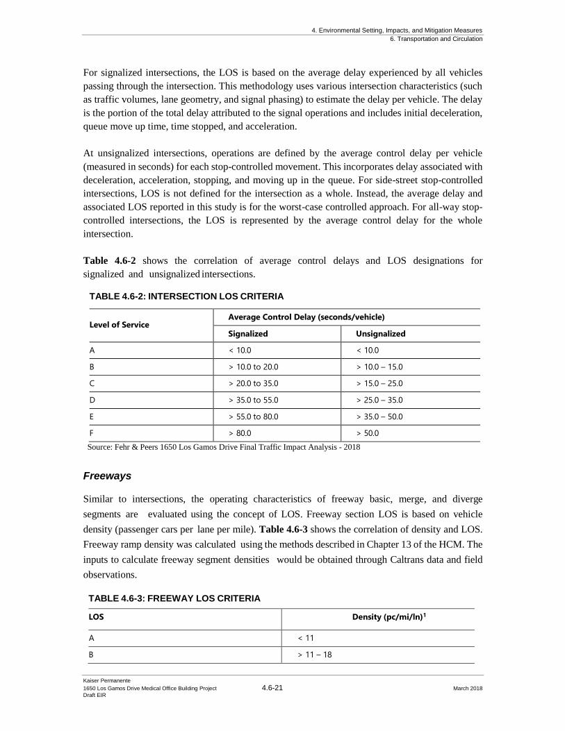
4. Environmental Setting, Impacts, and Mitigation Measures
6. Transportation and Circulation
Kaiser Permanente
1650 Los Gamos Drive Medical Office Building Project 4.6-21 March 2018
Draft EIR
For signalized intersections, the LOS is based on the average delay experienced by all vehicles
passing through the intersection. This methodology uses various intersection characteristics (such
as traffic volumes, lane geometry, and signal phasing) to estimate the delay per vehicle. The delay
is the portion of the total delay attributed to the signal operations and includes initial deceleration,
queue move up time, time stopped, and acceleration.
At unsignalized intersections, operations are defined by the average control delay per vehicle
(measured in seconds) for each stop-controlled movement. This incorporates delay associated with
deceleration, acceleration, stopping, and moving up in the queue. For side-street stop-controlled
intersections, LOS is not defined for the intersection as a whole. Instead, the average delay and
associated LOS reported in this study is for the worst-case controlled approach. For all-way stop-
controlled intersections, the LOS is represented by the average control delay for the whole
intersection.
Table 4.6-2 shows the correlation of average control delays and LOS designations for
signalized and unsignalized intersections.
TABLE 4.6-2: INTERSECTION LOS CRITERIA
Level of Service Average Control Delay (seconds/vehicle)
Signalized Unsignalized
A < 10.0 < 10.0
B > 10.0 to 20.0 > 10.0 – 15.0
C > 20.0 to 35.0 > 15.0 – 25.0
D > 35.0 to 55.0 > 25.0 – 35.0
E > 55.0 to 80.0 > 35.0 – 50.0
F > 80.0 > 50.0
Source: Fehr & Peers 1650 Los Gamos Drive Final Traffic Impact Analysis - 2018
Freeways
Similar to intersections, the operating characteristics of freeway basic, merge, and diverge
segments are evaluated using the concept of LOS. Freeway section LOS is based on vehicle
density (passenger cars per lane per mile). Table 4.6-3 shows the correlation of density and LOS.
Freeway ramp density was calculated using the methods described in Chapter 13 of the HCM. The
inputs to calculate freeway segment densities would be obtained through Caltrans data and field
observations.
TABLE 4.6-3: FREEWAY LOS CRITERIA
LOS Density (pc/mi/ln)1
A < 11
B > 11 – 18
4. Environmental Setting, Impacts, and Mitigation Measures
6. Transportation and Circulation
Kaiser Permanente
1650 Los Gamos Drive Medical Office Building Project 4.6-22 March 2018
Draft EIR
C > 18 – 26
D > 26 – 35
E > 35 – 45
F > 45
Notes: 1. pc/mi/ln = passenger car per mile per lane Source: 2010 Highway Capacity Manual.
Source: Fehr & Peers 1650 Los Gamos Drive Final Traffic Impact Analysis - 2018
The purpose of the freeway analysis is to determine the Project’s contribution to the available
capacity on the freeway; therefore, the Highway Capacity Software (HCS) was used to complete
this analysis. HCS is an appropriate analysis tool because it applies the freeway methodologies in
the HCM by accounting for the volume demand and available capacity by segment. The HCS tool
is a static model which does not account for downstream queues. However, since the purpose of
this analysis is to determine the Project’s contribution to the regional network, and not to determine
or mitigate existing bottlenecks or queues, the static model approach was the most appropriate to
account for the Project’s contribution. To supplement for existing queues as a result of downstream
bottlenecks, field observations were completed and included in analysis findings.
4.6.3.5 Data Collection
In November 2015, Fehr & Peers collected weekday morning (7:00 to 9:00 AM) and evening
(4:00 to 6:00 PM) peak period intersection turning movement counts at the study intersections,
including separate counts of pedestrians and bicyclists, supplemented with field observations
within the Project study area. Intersection count data was analyzed to identify the single hour with
the highest traffic volumes during the count periods. The weekday AM peak hour in the study area
is generally 7:45 to 8:45 AM and the weekday PM peak hour is generally from 5:00 to 6:00 PM.
Peak hour intersection volumes are summarized on Figure 4.6-6 along with existing lane
configuration and traffic control. The traffic counts for existing conditions are provided in
Appendix A of the Fehr & Peers 1650 Los Gamos Drive FTIA (see Appendix E to this DEIR).
4.6.3.6 Intersection Operations
Existing intersection operations were evaluated using the method described in Chapter 1 of the Fehr
& Peers 1650 Los Gamos Drive FTIA for the weekday AM and PM peak hours at all study
intersections. The existing levels of service of study intersections can be seen in Table 4.6-4.
Observed global peak hour factors were used at all intersections for the existing analysis. Pedestrian
and bicycle activity was also factored into the analysis.
All intersections are operating at an acceptable level of service C or better during the AM and PM
peak hour conditions, consistent with field observations conducted in November 2015. Appendix
B in the Fehr & Peers 1650 Los Gamos Drive FTIA presents all LOS calculations (see Appendix E to
this DEIR).
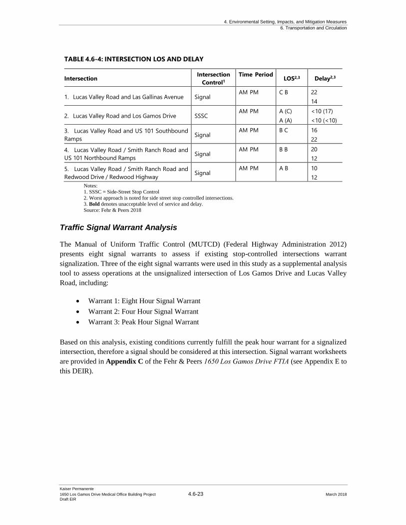
4. Environmental Setting, Impacts, and Mitigation Measures
6. Transportation and Circulation
Kaiser Permanente
1650 Los Gamos Drive Medical Office Building Project 4.6-23 March 2018
Draft EIR
TABLE 4.6-4: INTERSECTION LOS AND DELAY
Intersection Intersection
Control1
Time Period LOS2,3 Delay2,3
1. Lucas Valley Road and Las Gallinas Avenue
Signal AM PM C B 22
14
2. Lucas Valley Road and Los Gamos Drive
SSSC AM PM A (C)
A (A)
<10 (17)
<10 (<10)
3. Lucas Valley Road and US 101 Southbound
Ramps
Signal AM PM B C 16
22
4. Lucas Valley Road / Smith Ranch Road and
US 101 Northbound Ramps
Signal AM PM B B 20
12
5. Lucas Valley Road / Smith Ranch Road and
Redwood Drive / Redwood Highway
Signal AM PM A B 10
12
Notes:
1. SSSC = Side-Street Stop Control
2. Worst approach is noted for side street stop controlled intersections. 3. Bold denotes unacceptable level of service and delay.
Source: Fehr & Peers 2018
Traffic Signal Warrant Analysis
The Manual of Uniform Traffic Control (MUTCD) (Federal Highway Administration 2012)
presents eight signal warrants to assess if existing stop-controlled intersections warrant
signalization. Three of the eight signal warrants were used in this study as a supplemental analysis
tool to assess operations at the unsignalized intersection of Los Gamos Drive and Lucas Valley
Road, including:
• Warrant 1: Eight Hour Signal Warrant
• Warrant 2: Four Hour Signal Warrant
• Warrant 3: Peak Hour Signal Warrant
Based on this analysis, existing conditions currently fulfill the peak hour warrant for a signalized
intersection, therefore a signal should be considered at this intersection. Signal warrant worksheets
are provided in Appendix C of the Fehr & Peers 1650 Los Gamos Drive FTIA (see Appendix E to
this DEIR).
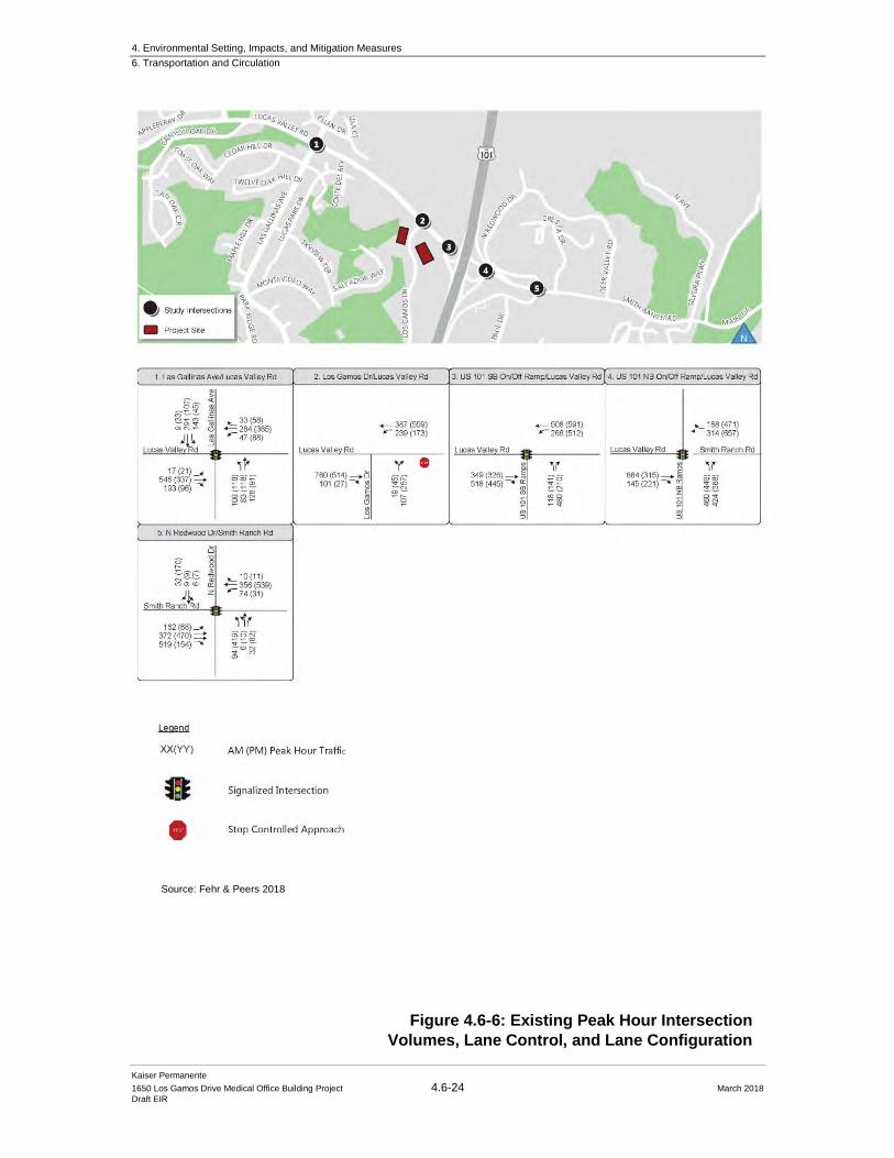
4. Environmental Setting, Impacts, and Mitigation Measures
6. Transportation and Circulation
Kaiser Permanente
1650 Los Gamos Drive Medical Office Building Project 4.6-24 March 2018
Draft EIR
Figure 4.6-6: Existing Peak Hour Intersection
Volumes, Lane Control, and Lane Configuration
Source: Fehr & Peers 2018
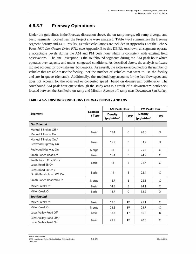
4. Environmental Setting, Impacts, and Mitigation Measures
6. Transportation and Circulation
Kaiser Permanente
1650 Los Gamos Drive Medical Office Building Project 4.6-25 March 2018
Draft EIR
4.6.3.7 Freeway Operations
Under the guidelines in the Freeway discussion above, the on-ramp merge, off-ramp diverge, and
basic segments located near the Project site were analyzed. Table 4.6-5 summarizes the freeway
segment density and LOS results. Detailed calculations are included in Appendix D of the Fehr &
Peers 1650 Los Gamos Drive FTIA (see Appendix E to this DEIR). As shown, all segments operate
at acceptable levels during the AM and PM peak hour which is consistent with existing field
observations. The one exception is the southbound segments during the AM peak hour which
operates over capacity and under congested conditions. As described above, the analysis software
did not account for downstream bottlenecks. As a result, the software accounted for the number of
vehicles that are able to use the facility, not the number of vehicles that want to use the facility
and are in queue (demand). Additionally, the methodology accounts for the free-flow speed and
does not account for the observed or congested speed based on downstream bottlenecks. The
southbound AM peak hour queue through the study area is a result of a downstream bottleneck
located between the San Pedro on-ramp and Mission Avenue off-ramp near Downtown San Rafael.
TABLE 4.6-5: EXISTING CONDITIONS FREEWAY DENSITY AND LOS
Segment
Segmen
t Type
AM Peak Hour PM Peak Hour
Density
(pc/mi/ln)1
LOS2
Density
(pc/mi/ln)1
LOS
Northbound
Manuel T Freitas Off /
Manuel T Freitas On Basic 19.4 C 28.6 D
Manuel T Freitas On /
Redwood Highway On Basic 15.9 B 33.7 D
Redwood Highway On Merge 18 B 25.5 C
Smith Ranch Road Off Basic 16.4 B 24.7 C
Smith Ranch Road Off /
Lucas Road EB On Basic 18 B 21.7 C
Lucas Road EB On /
Smith Ranch Road WB On Basic 14 B 22.4 C
Smith Ranch Road WB On Merge 16.7 B 25.5 C
Miller Creek Off Basic 14.5 B 24.1 C
Miller Creek On Basic 18.7 C 32.9 D
Southbound
Miller Creek Off Basic 19.8 F3 21.1 C
Miller Creek On Merge 28.8 F3 24.7 C
Lucas Valley Road Off Basic 18.3 F3 16.5 B
Lucas Valley Road Off /
Lucas Valley Road On Basic 21.9 F3 20.5 C
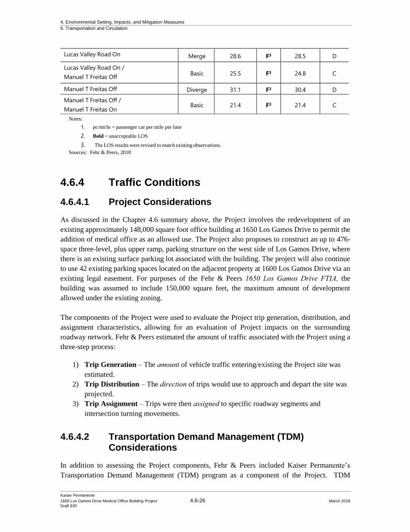
4. Environmental Setting, Impacts, and Mitigation Measures
6. Transportation and Circulation
Kaiser Permanente
1650 Los Gamos Drive Medical Office Building Project 4.6-26 March 2018
Draft EIR
Notes:
1. pc/mi/ln = passenger car per mile per lane
2. Bold = unacceptable LOS
3. The LOS results were revised to match existing observations.
Sources: Fehr & Peers, 2018
4.6.4 Traffic Conditions
4.6.4.1 Project Considerations
As discussed in the Chapter 4.6 summary above, the Project involves the redevelopment of an
existing approximately 148,000 square foot office building at 1650 Los Gamos Drive to permit the
addition of medical office as an allowed use. The Project also proposes to construct an up to 476-
space three-level, plus upper ramp, parking structure on the west side of Los Gamos Drive, where
there is an existing surface parking lot associated with the building. The project will also continue
to use 42 existing parking spaces located on the adjacent property at 1600 Los Gamos Drive via an
existing legal easement. For purposes of the Fehr & Peers 1650 Los Gamos Drive FTIA, the
building was assumed to include 150,000 square feet, the maximum amount of development
allowed under the existing zoning.
The components of the Project were used to evaluate the Project trip generation, distribution, and
assignment characteristics, allowing for an evaluation of Project impacts on the surrounding
roadway network. Fehr & Peers estimated the amount of traffic associated with the Project using a
three-step process:
1) Trip Generation – The amount of vehicle traffic entering/existing the Project site was
estimated.
2) Trip Distribution – The direction of trips would use to approach and depart the site was
projected.
3) Trip Assignment – Trips were then assigned to specific roadway segments and
intersection turning movements.
4.6.4.2 Transportation Demand Management (TDM)
Considerations
In addition to assessing the Project components, Fehr & Peers included Kaiser Permanente’s
Transportation Demand Management (TDM) program as a component of the Project. TDM
Lucas Valley Road On Merge 28.6 F3 28.5 D
Lucas Valley Road On /
Manuel T Freitas Off Basic 25.5 F3 24.8 C
Manuel T Freitas Off Diverge 31.1 F3 30.4 D
Manuel T Freitas Off /
Manuel T Freitas On Basic 21.4 F3 21.4 C

4. Environmental Setting, Impacts, and Mitigation Measures
6. Transportation and Circulation
Kaiser Permanente
1650 Los Gamos Drive Medical Office Building Project 4.6-27 March 2018
Draft EIR
programs are a set of tools that incentivize users to change their transportation mode choice from a
single occupant vehicle. As a result, a TDM program can reduce impacts to a transportation system
by reducing trip generation, air quality, energy use, and travel costs, while still preserving mobility
options. As part of the PD District approval, Kaiser Permanente is subject to participating in a TDM
program that includes:
• A TDM manager who is responsible for but not limited to: developing and disseminating
transportation information, aiding employees in the selection of transportation options,
communicating available transit alternatives, and informing tenants of the benefits of
flexible work schedules;
• A transit information center that describes current public transit, buspools, vanpools,
carpools and shuttle services serving the area;
• A carpool and vanpool matching program
In addition to the above required program, the Kaiser Permanente will include additional TDM
program strategies, most of which are currently implemented at nearby Kaiser Permanente
facilities, including:
• Commuter subsidy for transit, bicycle or vanpool use
• Pre-tax community spending accounts
• Guaranteed Ride Home program
• Internal website that provides information on the San Rafael Kaiser Permanente TDM
program and alternative modes of transportation to/from the site
• Designated bicycle parking on-site
• Local Kaiser Shuttle: An employee shuttle linking the SMART Station and San Rafael
Kaiser Permanente facilities
• Provide on-site amenities such as a café to reduce midday vehicle trips and exercise
programs to spread out some vehicle trips before the AM peak hour and following the PM
peak hour
• Partner with organizations to provide employees with additional information on
transportation options and encourage employees to attend Kaiser-sponsored events such as
Wellness Events
Kaiser Permanente’s TDM program will also include exploring additional program opportunities,
including:
• Partner with the City of San Rafael and nearby businesses to explore opportunities to
enhance nearby bicycle facilities
• Work with local transit providers to support improvements to the regional transit system
• Explore the dedication of on-site parking spaces for use by car-sharing services
• Partner with neighboring businesses (such as the Marin County Department of Education
and YMCA) to identify additional programs to increase transit usage and spread out peak
hour trips such as discounts for transit passes and/or a shared shuttle; and discounted gym
4. Environmental Setting, Impacts, and Mitigation Measures
6. Transportation and Circulation
Kaiser Permanente
1650 Los Gamos Drive Medical Office Building Project 4.6-28 March 2018
Draft EIR
memberships for nearby facilities
• Allow staff to adjust start/end their work times to better match transit schedules
As discussed in the 1650 Los Gamos Drive FTIA, Kaiser Permanente applies similar strategies at
other Bay Area locations to reduce vehicle trip generation. In order to understand the effectiveness
of the program, Kaiser Permanente is committed to completing an annual employee transportation
survey that will ask employees how the travel to the project site, time of day, and mode. The results
of the survey will be reviewed by Kaiser Permanente staff, such that adjustments to the TDM
program could be made in order to address employee needs. Based on guidance provided by the
California Air Pollution Control Officers Association (CAPCOA), the maximum vehicle trip
reduction for suburban developments such as the Project is generally accepted to be 15-percent.
Thus, it is expected that even with implementation of the comprehensive TDM program as
described above, vehicle trip generation would be reduced by no more than 15-percent.
In order to present a conservative analysis, Fehr & Peers did not make reductions to the Project trip
generation to account for the TDM strategies. Therefore, the Project trip generation in 1650 Los Gamos Drive FTIA is conservative and the actual number of trips generated by the Project may be
lower than presented and lower than the number of trips assumed for impact analysis purposes.
4.6.4.3 Project Trip Generation
Trip generation refers to the process of estimating the amount of vehicular traffic a project would
add to the surrounding roadway system. Estimates are created on a daily basis and for the peak one-
hour periods during the morning and evening commute periods when traffic volumes on the
adjacent streets are the highest. The Project trip generation was estimated using rates from the
Institute of Transportation Engineers Trip Generation (9th Edition) land use numbers 710 (office
building) and 720 (medical office building).
The net new Project trips represent the increase in vehicular trips that the building would generate
after the 150,000 square feet building is occupied by medical office instead of general office.
Table 4.6-6 shows the Project’s daily, weekday AM peak hour, and weekday PM peak hour
contribution. As shown, the Project would contribute net new 3,765 daily, 125 AM and 312 PM
peak hour trips, in addition to the trips that would be generated by the site’s permitted land uses
(Planned Development Allowed).
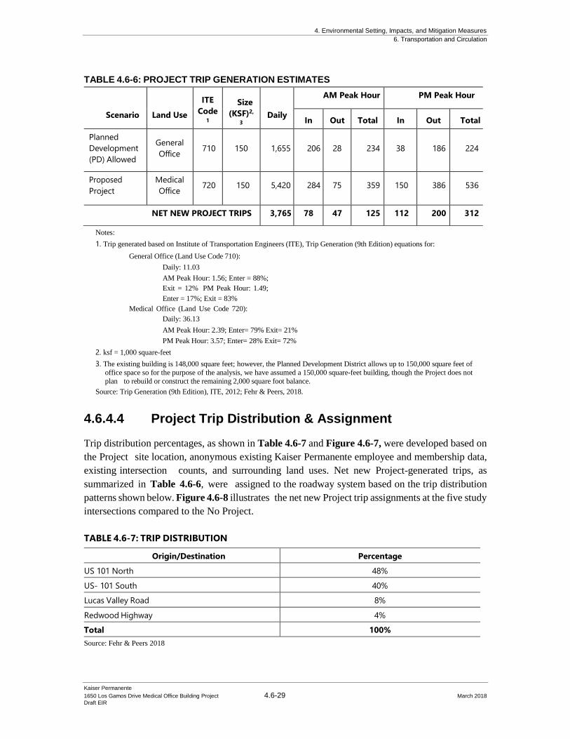
4. Environmental Setting, Impacts, and Mitigation Measures
6. Transportation and Circulation
Kaiser Permanente
1650 Los Gamos Drive Medical Office Building Project 4.6-29 March 2018
Draft EIR
Notes:
1. Trip generated based on Institute of Transportation Engineers (ITE), Trip Generation (9th Edition) equations for:
General Office (Land Use Code 710):
Daily: 11.03
AM Peak Hour: 1.56; Enter = 88%;
Exit = 12% PM Peak Hour: 1.49;
Enter = 17%; Exit = 83%
Medical Office (Land Use Code 720):
Daily: 36.13
AM Peak Hour: 2.39; Enter= 79% Exit= 21%
PM Peak Hour: 3.57; Enter= 28% Exit= 72%
2. ksf = 1,000 square-feet
3. The existing building is 148,000 square feet; however, the Planned Development District allows up to 150,000 square feet of
office space so for the purpose of the analysis, we have assumed a 150,000 square-feet building, though the Project does not
plan to rebuild or construct the remaining 2,000 square foot balance.
Source: Trip Generation (9th Edition), ITE, 2012; Fehr & Peers, 2018.
4.6.4.4 Project Trip Distribution & Assignment
Trip distribution percentages, as shown in Table 4.6-7 and Figure 4.6-7, were developed based on
the Project site location, anonymous existing Kaiser Permanente employee and membership data,
existing intersection counts, and surrounding land uses. Net new Project-generated trips, as
summarized in Table 4.6-6, were assigned to the roadway system based on the trip distribution
patterns shown below. Figure 4.6-8 illustrates the net new Project trip assignments at the five study
intersections compared to the No Project.
TABLE 4.6-6: PROJECT TRIP GENERATION ESTIMATES
Scenario
Land Use
ITE
Code 1
Size
(KSF)2,
3
Daily
AM Peak Hour PM Peak Hour
In Out Total In Out Total
Planned
Development
(PD) Allowed
General
Office
710
150
1,655
206
28
234
38
186
224
Proposed
Project
Medical
Office 720 150 5,420 284 75 359 150 386 536
NET NEW PROJECT TRIPS 3,765 78 47 125 112 200 312
TABLE 4.6-7: TRIP DISTRIBUTION
Origin/Destination Percentage
US 101 North 48%
US- 101 South 40%
Lucas Valley Road 8%
Redwood Highway 4%
Total 100%
Source: Fehr & Peers 2018
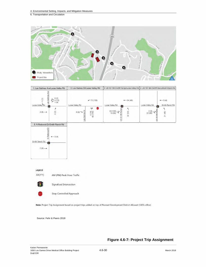
4. Environmental Setting, Impacts, and Mitigation Measures
6. Transportation and Circulation
Kaiser Permanente
1650 Los Gamos Drive Medical Office Building Project 4.6-30 March 2018
Draft EIR
Figure 4.6-8: Project trip Assignment Figure 4.6-7: Project Trip Assignment
Source: Fehr & Peers 2018
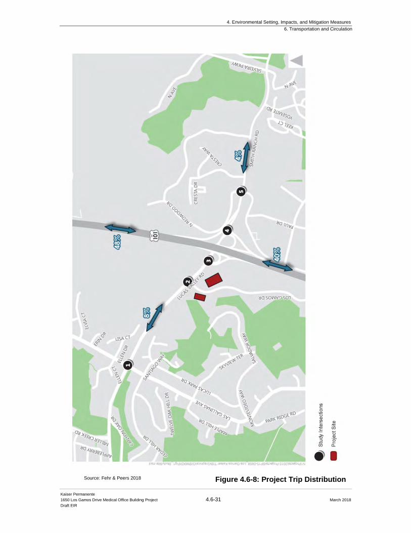
4. Environmental Setting, Impacts, and Mitigation Measures
6. Transportation and Circulation
Kaiser Permanente
1650 Los Gamos Drive Medical Office Building Project 4.6-31 March 2018
Draft EIR
Figure 4.6-8: Project Trip Distribution Source: Fehr & Peers 2018
4. Environmental Setting, Impacts, and Mitigation Measures
6. Transportation and Circulation
Kaiser Permanente
1650 Los Gamos Drive Medical Office Building Project 4.6-32 March 2018
Draft EIR
4.6.5 Vehicle Miles Traveled Analysis2
The San Rafael General Plan 2020 and EIR were prepared and evaluated using the LOS metric for
traffic related delay and impacts. As such, the Fehr & Peers 1650 Los Gamos Drive FTIA was
prepared with LOS to evaluate the Project’s potential traffic impacts. However, Fehr & Peers also
completed a Vehicle Miles Traveled (VMT) analysis for the Project. Although the City has adopted
the VMT analysis for new development projects, the CEQA Guidelines have not yet adopted this
methodology but is anticipated to be revised to include VMT analysis in the near future. Caltrans
has released new internal interim intergovernmental review (IGR) guidance to its districts which
accepts VMT analysis. The results of the Fehr & Peers’ VMT analysis are included in the 1650 Los Gamos Drive FTIA with methodology and an analysis summary consistent with Caltrans
procedures.
The VMT analysis forecasted the Project employee VMT and compared them to future projected
VMT based on the regional transportation and land use model provided by the Metropolitan
Transportation Commission (MTC) and the Association of Bay Area Governments (ABAG). The
proposed Project will move employees from existing compressed Kaiser facilities in Marin County
to the building at 1650 Los Gamos Drive. As such, the Project is not expected to generate significant
additional regional trips, rather, will redistribute them to a new location within the region. The
VMT analysis is based on the California Environmental Quality Act (CEQA) Guidelines on VMT
developed by the Governor’s Office of Planning and Research per SB 743 (Steinberg, 2013). SB
743 mandates a change in the way that public agencies evaluate the transportation impacts of
projects under CEQA, away from LOS. The proposed changes to the CEQA Guidelines are not yet
adopted; when they are, VMT will be the new metric for transportation analysis.
The proposed Project would include approximately 315 employees at full build out. Approximately
77-percent (245) of the staff at the proposed Project will be relocated from three existing Kaiser
Permanente facilities in Marin County: Downtown San Rafael, San Rafael medical Center, and
Novato. The remaining 23-percent (70) are expected to be new employees. The number of existing
Kaiser staff at other facilities that are estimated to move to the proposed Project are presented in
Table 4.6-8. Kaiser Permanente provided anonymous employee zip code data for existing
employees that work at the three main locations (of which employees are anticipated to transfer from
nearby Kaiser facilities to the new MOB). Figure 4.6-9 below illustrates the existing employee
residential distribution.
2 The Fehr & Peers 1650 Los Gamos Drive FTIA was prepared beginning in November 2015 when LOS was the
adopted methodology in the San Rafael General Plan 2020 for calculating traffic levels of service. In April 2017, the
City included Policy 5.1 Vehicle Miles Traveled (VMT) Methodology for Environmental Review of Traffic Impact to
replace the LOS methodology for transportation impacts. However, Fehr & Peers anticipated the analysis update and
prepared the 1650 Los Gamos Drive FTIA utilizing both LOS and VMT methodologies.
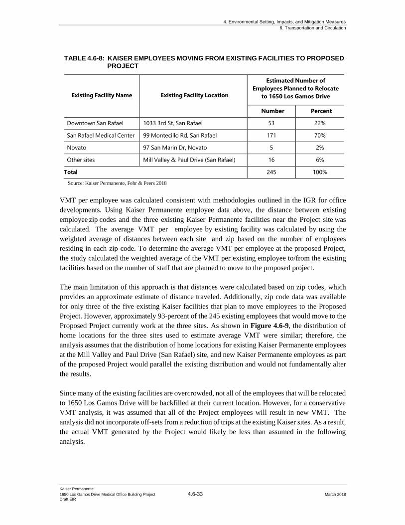
4. Environmental Setting, Impacts, and Mitigation Measures
6. Transportation and Circulation
Kaiser Permanente
1650 Los Gamos Drive Medical Office Building Project 4.6-33 March 2018
Draft EIR
TABLE 4.6-8: KAISER EMPLOYEES MOVING FROM EXISTING FACILITIES TO PROPOSED PROJECT
Existing Facility Name
Existing Facility Location
Estimated Number of
Employees Planned to Relocate
to 1650 Los Gamos Drive
Number Percent
Downtown San Rafael 1033 3rd St, San Rafael 53 22%
San Rafael Medical Center 99 Montecillo Rd, San Rafael 171 70%
Novato 97 San Marin Dr, Novato 5 2%
Other sites Mill Valley & Paul Drive (San Rafael)
16 6%
Total 245 100%
Source: Kaiser Permanente, Fehr & Peers 2018
VMT per employee was calculated consistent with methodologies outlined in the IGR for office
developments. Using Kaiser Permanente employee data above, the distance between existing
employee zip codes and the three existing Kaiser Permanente facilities near the Project site was
calculated. The average VMT per employee by existing facility was calculated by using the
weighted average of distances between each site and zip based on the number of employees
residing in each zip code. To determine the average VMT per employee at the proposed Project,
the study calculated the weighted average of the VMT per existing employee to/from the existing
facilities based on the number of staff that are planned to move to the proposed project.
The main limitation of this approach is that distances were calculated based on zip codes, which
provides an approximate estimate of distance traveled. Additionally, zip code data was available
for only three of the five existing Kaiser facilities that plan to move employees to the Proposed
Project. However, approximately 93-percent of the 245 existing employees that would move to the
Proposed Project currently work at the three sites. As shown in Figure 4.6-9, the distribution of
home locations for the three sites used to estimate average VMT were similar; therefore, the
analysis assumes that the distribution of home locations for existing Kaiser Permanente employees
at the Mill Valley and Paul Drive (San Rafael) site, and new Kaiser Permanente employees as part
of the proposed Project would parallel the existing distribution and would not fundamentally alter
the results.
Since many of the existing facilities are overcrowded, not all of the employees that will be relocated
to 1650 Los Gamos Drive will be backfilled at their current location. However, for a conservative
VMT analysis, it was assumed that all of the Project employees will result in new VMT. The
analysis did not incorporate off-sets from a reduction of trips at the existing Kaiser sites. As a result,
the actual VMT generated by the Project would likely be less than assumed in the following
analysis.
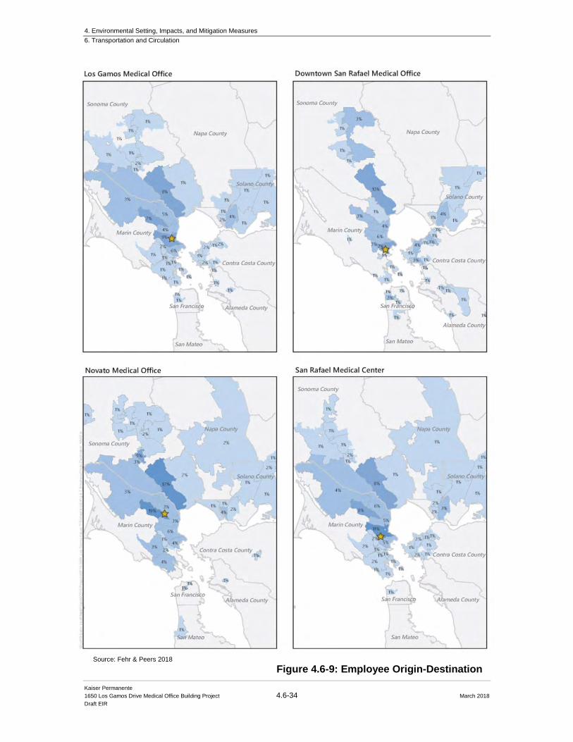
4. Environmental Setting, Impacts, and Mitigation Measures
6. Transportation and Circulation
Kaiser Permanente
1650 Los Gamos Drive Medical Office Building Project 4.6-34 March 2018
Draft EIR
Figure 4.6-8: Project trip Assignment Figure 4.6-9: Employee Origin-Destination Source: Fehr & Peers 2018
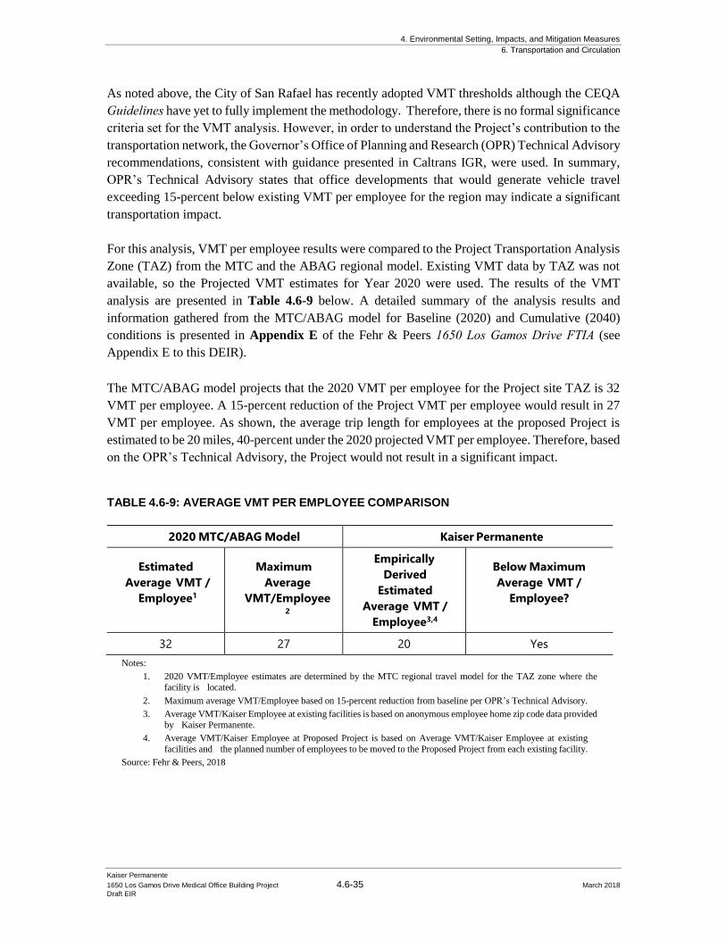
4. Environmental Setting, Impacts, and Mitigation Measures
6. Transportation and Circulation
Kaiser Permanente
1650 Los Gamos Drive Medical Office Building Project 4.6-35 March 2018
Draft EIR
As noted above, the City of San Rafael has recently adopted VMT thresholds although the CEQA
Guidelines have yet to fully implement the methodology. Therefore, there is no formal significance
criteria set for the VMT analysis. However, in order to understand the Project’s contribution to the
transportation network, the Governor’s Office of Planning and Research (OPR) Technical Advisory
recommendations, consistent with guidance presented in Caltrans IGR, were used. In summary,
OPR’s Technical Advisory states that office developments that would generate vehicle travel
exceeding 15-percent below existing VMT per employee for the region may indicate a significant
transportation impact.
For this analysis, VMT per employee results were compared to the Project Transportation Analysis
Zone (TAZ) from the MTC and the ABAG regional model. Existing VMT data by TAZ was not
available, so the Projected VMT estimates for Year 2020 were used. The results of the VMT
analysis are presented in Table 4.6-9 below. A detailed summary of the analysis results and
information gathered from the MTC/ABAG model for Baseline (2020) and Cumulative (2040)
conditions is presented in Appendix E of the Fehr & Peers 1650 Los Gamos Drive FTIA (see
Appendix E to this DEIR).
The MTC/ABAG model projects that the 2020 VMT per employee for the Project site TAZ is 32
VMT per employee. A 15-percent reduction of the Project VMT per employee would result in 27
VMT per employee. As shown, the average trip length for employees at the proposed Project is
estimated to be 20 miles, 40-percent under the 2020 projected VMT per employee. Therefore, based
on the OPR’s Technical Advisory, the Project would not result in a significant impact.
TABLE 4.6-9: AVERAGE VMT PER EMPLOYEE COMPARISON
2020 MTC/ABAG Model Kaiser Permanente
Estimated
Average VMT /
Employee1
Maximum
Average
VMT/Employee2
Empirically
Derived
Estimated
Average VMT /
Employee3,4
Below Maximum
Average VMT /
Employee?
32 27 20 Yes
Notes:
1. 2020 VMT/Employee estimates are determined by the MTC regional travel model for the TAZ zone where the
facility is located.
2. Maximum average VMT/Employee based on 15-percent reduction from baseline per OPR’s Technical Advisory.
3. Average VMT/Kaiser Employee at existing facilities is based on anonymous employee home zip code data provided
by Kaiser Permanente.
4. Average VMT/Kaiser Employee at Proposed Project is based on Average VMT/Kaiser Employee at existing
facilities and the planned number of employees to be moved to the Proposed Project from each existing facility.
Source: Fehr & Peers, 2018

4. Environmental Setting, Impacts, and Mitigation Measures
6. Transportation and Circulation
Kaiser Permanente
1650 Los Gamos Drive Medical Office Building Project 4.6-36 March 2018
Draft EIR
4.6.6 Existing Plus Project Impacts and Mitigations
4.6.6.1 Existing Plus Project Intersection Operations
Impact TRAF-1: Implementation of the Project would increase traffic volumes on area
roadways and affect levels of service at the local intersections and freeways under Existing
plus Project Conditions. (Significant and Unavoidable)
The Fehr & Peers 1650 Los Gamos Drive FTIA evaluated the potential traffic impacts under
Existing Plus Project conditions. In this scenario, no roadway improvements are anticipated as part
of the proposed Project. As such, no additional improvements were included as part of the Existing
Plus Project analysis.
Traffic Volumes
Project-generated traffic volumes were added to the existing peak hour traffic volumes to estimate
the Existing Plus Project peak hour traffic volumes as shown on Figure 4.6-10. No roadway
improvements were assumed as part of the Project. Existing Plus Project conditions were evaluated
using the methods described in Section 4.6.3.3: Approach to Analysis above. The Existing Plus
Project analysis results are presented in Table 4.6-10 and are based on the traffic volumes shown
on Figure 4.6-10.
TABLE 4.6-10: EXISTING INTERSECTION LEVEL OF SERVICE AND DELAY RESULTS
Intersection
Intersection
Control1
Time
Period
Existing
No Project
Existing
Plus Project
LOS2,3 Delay2,3 LOS2,3 Delay2,3
1. Lucas Valley Road and Las
Gallinas Avenue
Signal AM
PM
C
B
22
14
C
B
22
14
2. Lucas Valley Road and Los
Gamos Drive
SSSC AM
PM
A (C)
A (A)
<10 (17)
<10 (<10)
B (E)
D (F)
15 (37)
30 (>50)
3. Lucas Valley Road and
US 101 Southbound
Ramps
Signal AM
PM
B
C
16
22
C
D
24
51
4. Lucas Valley Road / Smith
Ranch Road and US 101
Northbound Ramps
Signal AM
PM
B
B
20
12
E
B
56
12
5. Lucas Valley Road / Smith
Ranch Road and Redwood
Drive / Redwood Highway
Signal AM
PM
A
B
10
12
A
B
10
12
Notes:
1. SSSC = Side-Street Stop Control
2. Worst approach is noted for side street stop controlled intersections. 3. Bold denotes unacceptable level of service and delay.
Sources: Fehr & Peers, 2016
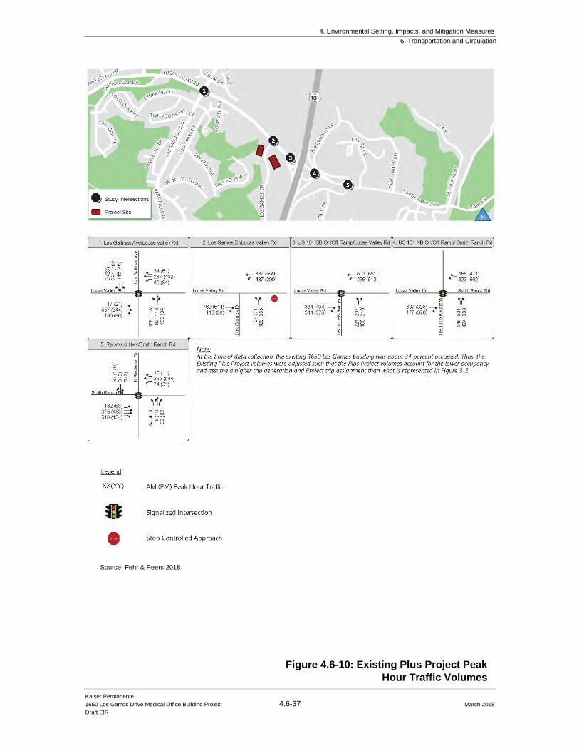
4. Environmental Setting, Impacts, and Mitigation Measures
6. Transportation and Circulation
Kaiser Permanente
1650 Los Gamos Drive Medical Office Building Project 4.6-37 March 2018
Draft EIR
Figure 4.6-10: Existing Plus Project Peak
Hour Traffic Volumes
Source: Fehr & Peers 2018
4. Environmental Setting, Impacts, and Mitigation Measures
6. Transportation and Circulation
Kaiser Permanente
1650 Los Gamos Drive Medical Office Building Project 4.6-38 March 2018
Draft EIR
As shown in Table 4.6-10, signalized intersections would continue to operate at LOS D or better
with the exception of the Lucas Valley Road/Smith Ranch Road/US 101 Northbound Ramps
intersection. The intersection operating conditions would worsen from LOS B to LOS E with the
Project during the AM peak hour and would continue to operate at the acceptable LOS B during
the PM peak hour. The Project’s contribution during the AM peak hour would worsen the
intersection operations below the LOS D threshold during the AM peak hour which triggers a
significant impact. However, the San Rafael General Plan 2020 exempts US 101 interchange
intersections from LOS standards because delay at these locations are affected by regional traffic
and not significantly impacted by local measures. Therefore, the Project’s contribution to the Lucas
Valley Road/Smith Ranch Road/US 101 intersection is not considered as part of the impact analysis
and is therefore not a significant impact. Though the Project does not result in a Project specific
impact, a potential improvement was identified for informational purposes. Signal timings should
be adjusted at the Lucas Valley Road/Smith Ranch Road/US 101 Northbound Ramps intersection
to account for the new intersection demand. With implementation, operations at the Lucas Valley
Road / Smith Ranch Road / US 101 Northbound Ramps would reduce the Project’s impact to
existing LOS standards. In addition, if the intersection were subject to the significance criteria, the
implementation of signal timing would result in the impact being reduced to a less than significant
level, similar to other intersections included in the Fehr & Peers 1650 Los Gamos Drive FTIA study.
The addition of Project traffic at the Lucas Valley Road/Los Gamos Drive side street stop-
controlled (unsignalized) intersection would increase vehicle delay during the AM and PM peak
hour. Although the intersection would continue to operate at LOS D or better during Existing Plus
Project conditions, average delay and associated LOS for the side-street stop-controlled intersection
is reported for the worst-case controlled approach in this study. During Existing Plus Project
conditions, Project traffic would worsen the side street stop-controlled approach from LOS C to
LOS E during the AM peak hour and LOS A to LOS F during the PM peak hour. As a result, the
Project’s contribution during the PM peak hour would result in a significant impact because the
Project’s contribution would worsen the intersection operations to an unacceptable LOS. Mitigation
Measure MM TRAF-1, described below, has been identified to address the impact.
Mitigation: MM TRAF-1. Signalize Lucas Valley Road / Los Gamos Drive. In
coordination with the City of San Rafael, the County of Marin Department of
Public Works, and Caltrans, Kaiser Permanente shall pay the fair share cost to
signalize the Lucas Valley Road / Los Gamos Drive intersection to mitigate poor
operating conditions. Signalizing the intersection is consistent with improvements
identified in the San Rafael General Plan 2020. Due to its close proximity to the
US-101 Ramp terminal intersections, the new signal should include traffic signal
interconnect and be coordinated with the adjacent interchange signals.
Additionally, interagency coordination will be required during design,
construction and maintenance of the new signal. Therefore, a memorandum of
understanding (MOU) will be required between the City of San Rafael and the
County of Marin to document the management and maintenance of the new signal,
since the US 101/Lucas Valley interchange signals and the new Lucas Valley Road
/ Los Gamos Drive signal would need to be operated and maintained by one or
4. Environmental Setting, Impacts, and Mitigation Measures
6. Transportation and Circulation
Kaiser Permanente
1650 Los Gamos Drive Medical Office Building Project 4.6-39 March 2018
Draft EIR
multiple agencies.
Signalizing the intersection would mitigate the project impact to a less than significant impact.
However, implementation of the mitigation measure requires the intersection improvements to be
fully funded and constructed. Therefore, until and unless the MOU and fair-share contributions are
finalized, and the design and construction of the intersection is permitted and approved, the Project
will result in a significant and unavoidable impact.
Signal Warrants
As mentioned in Section 4.6.3.5: Data Collection, the existing volumes fulfill the three signal
warrants, therefore a signal should be considered at the Lucas Valley Road/Los Gamos Drive
intersection. The addition of Project traffic would further qualify the intersection for a signal.
Furthermore, implementation of MM TRAF- 1: Signalize Lucas Valley Road/Los Gamos Drive
would mitigate the project impact during Existing Plus Project Conditions to a less than significant
level and no further mitigation would be required. However, as stated above, since implementation
of the mitigation measure requires the intersection improvements to be fully funded and constructed
and this action is outside of the Lead Agency’s direct control, this impact remains significant and
unavoidable.
4.6.6.2 Existing Plus Project Freeway Operations
Impact TRAF-2: Implementation of the Project would increase traffic volumes on
freeway segments and affect levels of the regional network under Existing plus Project
Conditions. (Less than Significant with Mitigation Incorporation)
Existing Plus Project conditions were evaluated using the methods described in Section 4.6.3.3: Approach to Analysis above. As described in Section 4.6.5: Vehicle Miles Traveled Analysis above,
the Project plans to shift existing employees from existing Kaiser Permanente facilities in Marin
County to the proposed Project site; however, the freeway analysis methodology assumes that all
Project trips are added to the Existing No Project freeway volumes. Therefore, the approach is
conservative and may be double counting vehicle trips that are already accounted for in the Existing
No Project volume.
The Existing Plus Project analysis results are presented in Table 4.6-11 and Table 4.6-12, for the
AM and PM peak hours, respectively. Detailed freeway level of service calculation sheets are
provided in Appendix D of the Fehr & Peers 1650 Los Gamos Drive FTIA (see Appendix E to this
DEIR).
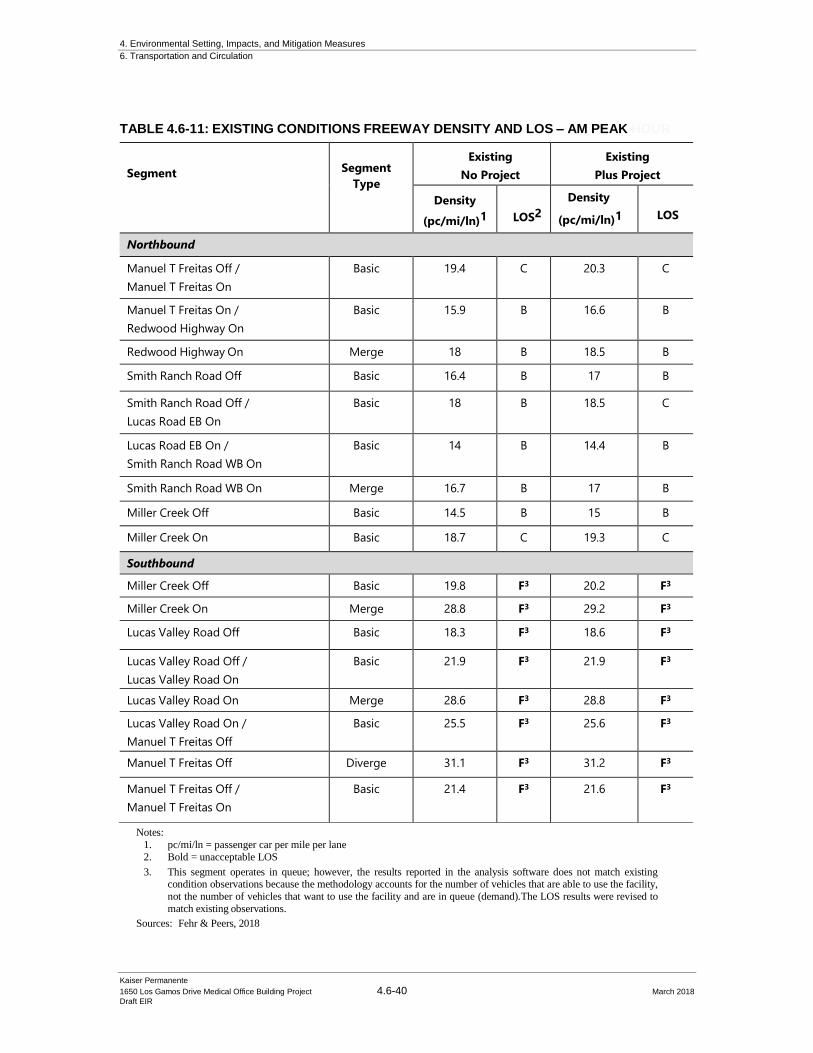
4. Environmental Setting, Impacts, and Mitigation Measures
6. Transportation and Circulation
Kaiser Permanente
1650 Los Gamos Drive Medical Office Building Project 4.6-40 March 2018
Draft EIR
Notes:
1. pc/mi/ln = passenger car per mile per lane
2. Bold = unacceptable LOS
3. This segment operates in queue; however, the results reported in the analysis software does not match existing condition observations because the methodology accounts for the number of vehicles that are able to use the facility,
not the number of vehicles that want to use the facility and are in queue (demand).The LOS results were revised to
match existing observations.
Sources: Fehr & Peers, 2018
TABLE 4.6-11: EXISTING CONDITIONS FREEWAY DENSITY AND LOS – AM PEAK HOUR
Segment
Segment
Type
Existing
No Project
Existing
Plus Project
Density
(pc/mi/ln)1 LOS2
Density
(pc/mi/ln)1 LOS
Northbound
Manuel T Freitas Off /
Manuel T Freitas On
Basic 19.4 C 20.3 C
Manuel T Freitas On /
Redwood Highway On
Basic 15.9 B 16.6 B
Redwood Highway On Merge 18 B 18.5 B
Smith Ranch Road Off Basic 16.4 B 17 B
Smith Ranch Road Off /
Lucas Road EB On
Basic 18 B 18.5 C
Lucas Road EB On /
Smith Ranch Road WB On
Basic 14 B 14.4 B
Smith Ranch Road WB On Merge 16.7 B 17 B
Miller Creek Off Basic 14.5 B 15 B
Miller Creek On Basic 18.7 C 19.3 C
Southbound
Miller Creek Off Basic 19.8 F3 20.2 F3
Miller Creek On Merge 28.8 F3 29.2 F3
Lucas Valley Road Off Basic 18.3 F3 18.6 F3
Lucas Valley Road Off /
Lucas Valley Road On
Basic 21.9 F3 21.9 F3
Lucas Valley Road On Merge 28.6 F3 28.8 F3
Lucas Valley Road On /
Manuel T Freitas Off
Basic 25.5 F3 25.6 F3
Manuel T Freitas Off Diverge 31.1 F3 31.2 F3
Manuel T Freitas Off /
Manuel T Freitas On
Basic 21.4 F3 21.6 F3
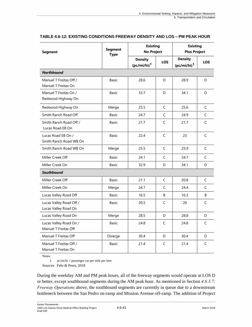
4. Environmental Setting, Impacts, and Mitigation Measures
6. Transportation and Circulation
Kaiser Permanente
1650 Los Gamos Drive Medical Office Building Project 4.6-41 March 2018
Draft EIR
TABLE 4.6-12: EXISTING CONDITIONS FREEWAY DENSITY AND LOS – PM PEAK HOUR
Segment
Segment
Type
Existing
No Project
Existing
Plus Project
Density
(pc/mi/ln)1
LOS Density
(pc/mi/ln)1 LOS
Northbound
Manuel T Freitas Off /
Manuel T Freitas On
Basic 28.6 D 28.9 D
Manuel T Freitas On /
Redwood Highway On
Basic 33.7 D 34.1 D
Redwood Highway On Merge 25.5 C 25.6 C
Smith Ranch Road Off Basic 24.7 C 24.9 C
Smith Ranch Road Off /
Lucas Road EB On
Basic 21.7 C 21.7 C
Lucas Road EB On /
Smith Ranch Road WB On
Basic 22.4 C 23 C
Smith Ranch Road WB On Merge 25.5 C 25.9 C
Miller Creek Off Basic 24.1 C 24.7 C
Miller Creek On Basic 32.9 D 34.1 D
Southbound
Miller Creek Off Basic 21.1 C 20.8 C
Miller Creek On Merge 24.7 C 24.4 C
Lucas Valley Road Off Basic 16.5 B 16.3 B
Lucas Valley Road Off /
Lucas Valley Road On
Basic 20.5 C 20 C
Lucas Valley Road On Merge 28.5 D 28.8 D
Lucas Valley Road On /
Manuel T Freitas Off
Basic 24.8 C 24.8 C
Manuel T Freitas Off Diverge 30.4 D 30.4 D
Manuel T Freitas Off /
Manuel T Freitas On
Basic 21.4 C 21.4 C
Notes:
1. pc/mi/ln = passenger car per mile per lane
Sources: Fehr & Peers, 2018
During the weekday AM and PM peak hours, all of the freeway segments would operate at LOS D
or better, except southbound segments during the AM peak hour. As mentioned in Section 4.6.3.7: Freeway Operations above, the southbound segments are currently in queue due to a downstream
bottleneck between the San Pedro on-ramp and Mission Avenue off-ramp. The addition of Project
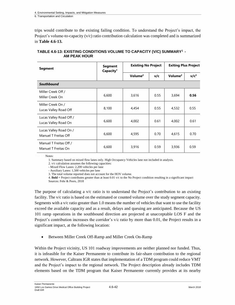
4. Environmental Setting, Impacts, and Mitigation Measures
6. Transportation and Circulation
Kaiser Permanente
1650 Los Gamos Drive Medical Office Building Project 4.6-42 March 2018
Draft EIR
trips would contribute to the existing failing condition. To understand the Project’s impact, the
Project’s volume-to-capacity (v/c) ratio contribution calculation was completed and is summarized
in Table 4.6-13.
TABLE 4.6-13: EXISTING CONDITIONS VOLUME TO CAPACITY (V/C) SUMMARY1 - AM PEAK HOUR
Segment Segment
Capacity1
Existing No Project Exiting Plus Project
Volume2 v/c Volume2
v/c3
Southbound
Miller Creek Off /
Miller Creek On 6,600 3,616 0.55 3,694 0.56
Miller Creek On /
Lucas Valley Road Off 8,100 4,454 0.55 4,532 0.55
Lucas Valley Road Off /
Lucas Valley Road On 6,600 4,002 0.61 4,002 0.61
Lucas Valley Road On /
Manuel T Freitas Off 6,600 4,595 0.70 4,615 0.70
Manuel T Freitas Off /
Manuel T Freitas On 6,600 3,916 0.59 3,936 0.59
TO TYNotes:
1. Summary based on mixed flow lanes only. High Occupancy Vehicles lane not included in analysis.
2. v/c calculation assumes the following capacities:
- Mixed Flow Lanes: 2,200 vehicles per lane
- Auxiliary Lanes: 1,500 vehicles per lane
3. The total volume reported does not account for the HOV volume. 4. Bold = Project contributes greater than at least 0.01 v/c to the No Project condition resulting in a significant impact
Sources: Fehr & Peers, 2018
The purpose of calculating a v/c ratio is to understand the Project’s contribution to an existing
facility. The v/c ratio is based on the estimated or counted volume over the study segment capacity.
Segments with a v/c ratio greater than 1.0 means the number of vehicles that want to use the facility
exceed the available capacity and as a result, delays and queuing are anticipated. Because the US
101 ramp operations in the southbound direction are projected at unacceptable LOS F and the
Project’s contribution increases the corridor’s v/c ratio by more than 0.01, the Project results in a
significant impact, at the following location:
• Between Miller Creek Off-Ramp and Miller Creek On-Ramp
Within the Project vicinity, US 101 roadway improvements are neither planned nor funded. Thus,
it is infeasible for the Kaiser Permanente to contribute its fair-share contribution to the regional
network. However, Caltrans IGR states that implementation of a TDM program could reduce VMT
and the Project’s impact to the regional network. The Project description already includes TDM
elements based on the TDM program that Kaiser Permanente currently provides at its nearby
4. Environmental Setting, Impacts, and Mitigation Measures
6. Transportation and Circulation
Kaiser Permanente
1650 Los Gamos Drive Medical Office Building Project 4.6-43 March 2018
Draft EIR
facilities. Kaiser Permanente’s proposed TDM goes beyond what is required under the
requirements of the existing PD District. In order to further reduce the Project’s impact to the
regional network and ensure the implementation of the Kaiser Permanente proposed TDM,
Mitigation Measure MM TRAF-2 would have Kaiser Permanente implement TDM measures
which would reduce trip allocation.
Mitigation: MM TRAF-2. Kaiser Permanente shall implement additional TDM
measures. Kaiser Permanente shall implement a TDM program, as described in
Chapter 3: Project Description and Section 4.6.4.2: Transportation Demand Management Considerations of this traffic impact chapter (Section 3.1.1 of the
1650 Los Gamos Drive FTIA). Implementation of these TDM strategies would go
beyond what is required as part of the PD District, with the goal of reducing
employee vehicle trips, thereby reducing the Project’s impact on the regional
network.
Based on a quantitative assessment of the TDM measures proposed in the 1650 Los Gamos Drive FTIA, the TDM strategies may yield a Project vehicle trip
generation reduction of up to 12-percent between the Miller Creek Off-Ramp and
Miller Creek On-Ramp. If maximally effective, implementation of the Project’s
TDM strategies would result in a project trip reduction of up to 10-15 AM peak
hour trips along this segment, which would result in a project contribution of less
than a 0.01 increase in volume to capacity ratio. As presented in the 1650 Los Gamos Drive FTIA, implementation of the Project’s TDM measures will achieve
this reduction, however, Kaiser will annually quantitatively analyze and monitor
employee vehicle trip generation data via comprehensive employee surveys and
make adjustments to its TDM measures as needed to achieve the stated reduction.
As described in the 4.6.4.2: Transportation Demand Management Considerations and the Fehr & Peers 1650 Los Gamos Drive FTIA, Kaiser Permanente shall
conduct an annual employee survey and prepare a monitoring report that evaluates
the effectiveness of the Project’s TDM Plan. The TDM program will be submitted
to the City of San Rafael for comment and review. Kaiser Permanente will
coordinate with the City of San Rafael, as necessary. The annual survey shall
demonstrate how the TDM measures reduce the Project’s impact to peak-hour
volume to capacity ratio for the Miller Creek On and Off Ramp.
Implementation of the TDM Program and annual monitoring report would reduce the Project’s
impact to less than significant.
4.6.6.3 Existing Plus Project On-Site Vehicle Access and Circulation
CEQA does not consider on-site vehicular access and circulation for significant environmental
impacts, however, Fehr & Peers evaluated the proposed Project’s access and circulation for
4. Environmental Setting, Impacts, and Mitigation Measures
6. Transportation and Circulation
Kaiser Permanente
1650 Los Gamos Drive Medical Office Building Project 4.6-44 March 2018
Draft EIR
information purposes. Access to the Project would be provided from five unsignalized driveways
as well as two additional driveways on either side of the proposed parking structure for fire access,
as indicated in Figure 4.6-1 above. Three driveways on the east side of Los Gamos Drive, which
are existing driveways, would lead to surface parking lots adjacent to the MOB building. The
existing northernmost driveway, located on the west side of Los Gamos Drive, would be moved
about 100 feet south and provide direct access to the proposed parking garage structure, with the
vehicular entrance located at the southern end of the parking structure. The relocated driveway
would provide a longer storage length between the driveway and vehicles traveling north to the Los
Gamos Drive / Lucas Valley Road intersection. The Initial Study concluded that the Project would
not substantially increase hazards due to a design feature since the Project will use existing
driveways, where feasible, and does not propose to change the roadway alignment. The revisions
to the site plan that have occurred since the Initial Study have been reviewed and no additional
hazards due to a design feature have been identified.
4.6.6.4 Existing Plus Project Bicycle and Pedestrian Impacts
Bicycling and pedestrian trips in the study area may increase as a result of the proposed Project.
Bicycle travel would likely occur along Lucas Valley Road and Los Gamos Drive since they
provide direct connections to the Project site and are designated bicycle facilities. Pedestrian travel
would likely occur on Lucas Valley Road as it provides direct access to nearby transit facilities.
The projected increase in vehicles at the intersections in the vicinity of the proposed Project may
result in an increase in vehicle-bicycle-pedestrian conflicts at intersections in the study area.
However, the proposed Project would not create potentially hazardous conditions for bicycles,
pedestrians, or otherwise interfere with bicycle and pedestrian accessibility to the site and adjoining
areas because the Project does not remove existing facilities and does not prohibit the construction
of proposed future facilities in the Project vicinity.
The Project includes construction of an approximately up to 476 car parking structure on the west
side of Los Gamos Drive which would increase the number of pedestrian crossings across Los
Gamos Drive. Due to the increase in pedestrian crossings, Kaiser Permanente will include
crosswalk enhancements to the existing crossing, located just north of the existing driveway into
the front side of 1650 Los Gamos Drive.
Enhancements include:
• Shifting the existing crosswalk north such that the crosswalk fronts the pedestrian
ingress/egress of the parking structure
• The addition of bulbouts on both sides of the road to increase pedestrian visibility
• The addition of a pedestrian-activated crossing beacon that would flashes lights to increase
a driver’s awareness of a potential pedestrian crossing.
The Project’s impact to bicycle and pedestrian facilities are considered less than significant and
mitigations are not required under Existing Plus Project conditions.
4. Environmental Setting, Impacts, and Mitigation Measures
6. Transportation and Circulation
Kaiser Permanente
1650 Los Gamos Drive Medical Office Building Project 4.6-45 March 2018
Draft EIR
4.6.6.5 Existing Plus Project Transit Impacts
Transit trips in the study area may increase as a result of the Project. As described above, a majority
of Kaiser Permanente staff will be relocated from existing Kaiser Permanente facilities in the area
to the proposed Project site. Thus, a majority of employees that may use transit are likely captured
in existing transit ridership. Therefore, the addition of new transit users will be limited to new staff.
Although the addition of new staff may increase transit trips as a result of the Project, however,
Project related transit trips would have no foreseeable impacts to transit operations because the
Project would not likely generate enough transit demand to exceed the capacity of existing or
planned transit service nor does it interfere with existing or future transit users. Therefore, the
Project impacts to transit facilities are considered less than significant and mitigations are not
required.
4.6.6.6 Parking Conditions
While parking is not considered an environmental impact under CEQA, Fehr & Peers prepared a
parking analysis, based on City of San Rafael parking requirements, in the 1650 Los Gamos Drive FTIA for information purposes. As such, the following discussion documents the parking related
to the proposed Project, but it is not evaluated in this EIR for environmental impacts. For medical
office uses, one (1) space is required for every 225-gross building square feet (4.4 spaces/1,000 sq
ft), resulting in a code requirement of 651 spaces (assuming a 148,000 sq ft medical office building).
Kaiser Permanente is proposing a higher parking ratio (4.85 spaces/1,000 sq. ft.) based on existing
parking demand at its nearby medical facilities (to avoid impacting surrounding streets). The
proposed parking plan includes 722 parking spaces which exceeds the City’s requirements by 71
spaces. Of the 722 parking spaces, there are approximately 22 accessible parking spaces (10 spaces
in the parking structure and 2 in the surface lot) which meets the minimum accessible parking
requirements from the United States Access Board; and no compact spaces.
The City of San Rafael Bicycle/Pedestrian Master Plan Update (2011) includes an objective to
provide bicycle parking in employment and commercial areas; and the City of San Rafael Code
of Ordinances requires a minimum number of short term and long term bicycle parking spaces
equivalent to 5-percent of the requirement for automobile parking spaces, with a minimum of
one two-bike capacity rack; therefore, the ordinance requires 38 short term bicycle parking spaces
(based on 148,000 sq ft medical office building). The Project will meet (or exceed) all City
requirements for bicycle parking spaces. Based on this review, the total number of parking spaces
the Project provides is sufficient and meets the City of San Rafael’s parking requirements.
4. Environmental Setting, Impacts, and Mitigation Measures
6. Transportation and Circulation
Kaiser Permanente
1650 Los Gamos Drive Medical Office Building Project 4.6-46 March 2018
Draft EIR
4.6.7 Baseline Plus Project Impacts and Mitigations
The Fehr & Peers 1650 Los Gamos Drive FTIA evaluated the potential traffic impacts under
Baseline Plus Project analysis. Consistent with the Existing Plus Project analysis, no roadway
improvements are anticipated as part of this scenario. The baseline scenario includes existing
transportation conditions plus traffic generated from approved developments that are not yet
constructed. Under the Baseline Condition, the San Rafael Airport Recreational Facility is included.
Traffic Volumes
The City of San Rafael maintains a database of baseline traffic volumes, which assumes the 100-
perecent occupied building at 1650 Los Gamos Drive, and provided Synchro files for use in the
Fehr & Peers 1650 Los Gamos Drive FTIA. The baseline peak hour intersection volumes, lane
configurations, and traffic controls at each intersection for the AM and PM peak hours is
summarized on Figure 4.6-11. Similar to Existing Plus Project conditions, Project traffic volumes
were added to the baseline peak hour traffic volumes to estimate the Baseline Plus Project peak
hour traffic volumes, summarized in Figure 4.6-12.
4.6.7.1 Baseline Plus Project Intersection Operations
Impact TRAF-3: The Project would contribute to deficient operations of the Lucas
Valley Road/Las Gallinas Avenue intersection by increasing the average delay by more than
five seconds under Baseline plus Project conditions. (Significant and Unavoidable)
Impact TRAF-4: The Project would contribute to deficient operations of the Lucas
Valley Road/Las Gamos Drive intersection by increasing the average delay by more than five
seconds under Baseline plus Project conditions. (Significant and Unavoidable)
The Lucas Valley Road/Las Gallinas Avenue intersection operates below LOS D during the
weekday AM and/or PM peak hour under Baseline No Project and Baseline Plus Project conditions.
Baseline No Project and Baseline Plus Project conditions were evaluated using the same methods
described in Section 4.6.3.2: Approach to Analysis above. The Baseline analysis results are
presented in Table 4.6-14, based on the traffic volumes presented in Figure 4.6-11 and Figure 4.6-
12, respectively. As shown on Table 4.6-14, the Lucas Valley Road / Smith Ranch Road / Redwood
Drive/Redwood Highway signalized intersection operates at LOS D or better during the Baseline
No Project and Baseline Plus Project scenarios, therefore the Project’s contribution to this
intersection is considered less than significant. However, two intersections trigger a significant
impact, as described below.

4. Environmental Setting, Impacts, and Mitigation Measures
6. Transportation and Circulation
Kaiser Permanente
1650 Los Gamos Drive Medical Office Building Project 4.6-47 March 2018
Draft EIR
Source: Fehr & Peers 2018
Figure 4.6-11: Baseline No Project Peak Hour
Intersection Volumes
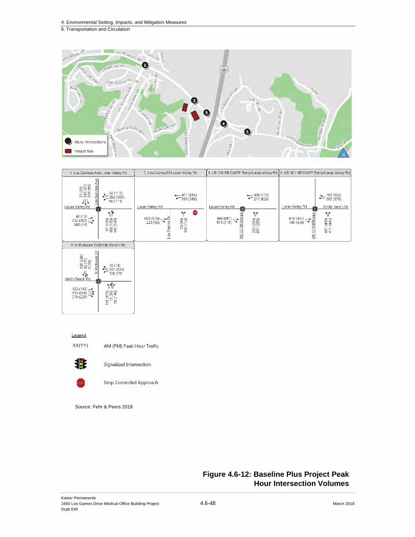
4. Environmental Setting, Impacts, and Mitigation Measures
6. Transportation and Circulation
Kaiser Permanente
1650 Los Gamos Drive Medical Office Building Project 4.6-48 March 2018
Draft EIR
Figure 4.6-12: Baseline Plus Project Peak
Hour Intersection Volumes
Source: Fehr & Peers 2018
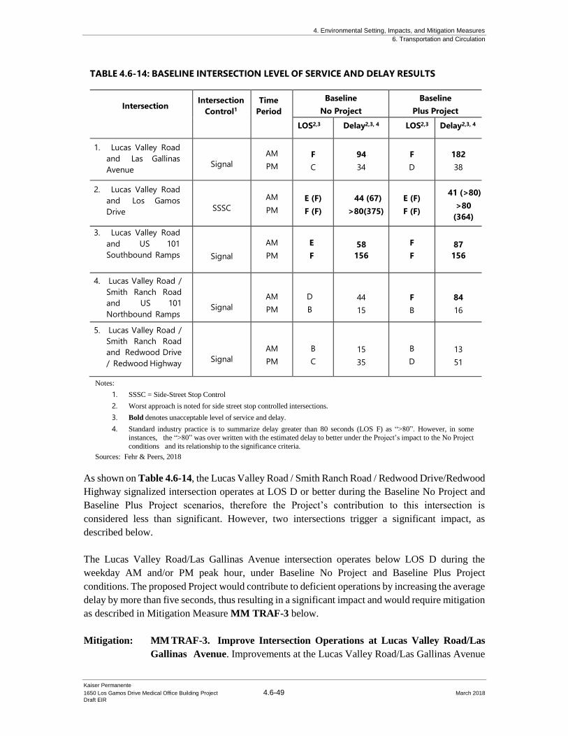
4. Environmental Setting, Impacts, and Mitigation Measures
6. Transportation and Circulation
Kaiser Permanente
1650 Los Gamos Drive Medical Office Building Project 4.6-49 March 2018
Draft EIR
TABLE 4.6-14: BASELINE INTERSECTION LEVEL OF SERVICE AND DELAY RESULTS
Intersection Intersection
Control1
Time
Period
Baseline
No Project
Baseline
Plus Project
LOS2,3 Delay2,3, 4 LOS2,3 Delay2,3, 4
1. Lucas Valley Road
and Las Gallinas
Avenue
Signal
AM
PM
F
C
94
34
F
D
182
38
2. Lucas Valley Road
and Los Gamos
Drive
SSSC
AM
PM
E (F)
F (F)
44 (67)
>80(375)
E (F)
F (F)
41 (>80)
>80
(364)
3. Lucas Valley Road
and US 101
Southbound Ramps
Signal
AM
PM
E
F
58
156
F
F
87
156
4. Lucas Valley Road /
Smith Ranch Road
and US 101
Northbound Ramps
Signal
AM
PM
D
B
44
15
F
B
84
16
5. Lucas Valley Road /
Smith Ranch Road
and Redwood Drive
/ Redwood Highway
Signal
AM
PM
B
C
15
35
B
D
13
51
Notes:
1. SSSC = Side-Street Stop Control
2. Worst approach is noted for side street stop controlled intersections.
3. Bold denotes unacceptable level of service and delay.
4. Standard industry practice is to summarize delay greater than 80 seconds (LOS F) as “>80”. However, in some
instances, the “>80” was over written with the estimated delay to better under the Project’s impact to the No Project
conditions and its relationship to the significance criteria.
Sources: Fehr & Peers, 2018
As shown on Table 4.6-14, the Lucas Valley Road / Smith Ranch Road / Redwood Drive/Redwood
Highway signalized intersection operates at LOS D or better during the Baseline No Project and
Baseline Plus Project scenarios, therefore the Project’s contribution to this intersection is
considered less than significant. However, two intersections trigger a significant impact, as
described below.
The Lucas Valley Road/Las Gallinas Avenue intersection operates below LOS D during the
weekday AM and/or PM peak hour, under Baseline No Project and Baseline Plus Project
conditions. The proposed Project would contribute to deficient operations by increasing the average
delay by more than five seconds, thus resulting in a significant impact and would require mitigation
as described in Mitigation Measure MM TRAF-3 below.
Mitigation: MM TRAF-3. Improve Intersection Operations at Lucas Valley Road/Las
Gallinas Avenue. Improvements at the Lucas Valley Road/Las Gallinas Avenue
4. Environmental Setting, Impacts, and Mitigation Measures
6. Transportation and Circulation
Kaiser Permanente
1650 Los Gamos Drive Medical Office Building Project 4.6-50 March 2018
Draft EIR
intersection have yet to be identified through the City of San Rafael’s General Plan
2020; however, several vehicle capacity improvements (such as reconfiguring the
intersection to remove channelized turn islands or replacing the existing signal
with a roundabout) may be considered by the City of San Rafael to mitigate poor
operating conditions at the intersection. Capacity increasing improvements include
various trade-offs, however. For example, adding capacity could facilitate more
vehicular traffic but this could also have an adverse impact to pedestrians and
bicyclists and result in the diversion of more pass-through traffic along Las
Gallinas Avenue and an increase in VMT. Although mitigation is possible at this
intersection to address Project impacts, the intersection is outside of the City’s
jurisdiction and specific improvements have yet to be identified by either the City
of San Rafael or the County of Marin. As such, the feasibility of potential
mitigations will require further study and coordination with local neighborhood
groups, the City of San Rafael, and the County of Marin, who operates and
maintains the existing traffic signal. Since the City cannot legally implement
mitigation measures outside of its jurisdiction, this potential mitigation is
infeasible from both a legal and public policy standpoint. Ultimately, the City
of San Rafael, in coordination with the County of Marin, would be responsible for
implementing improvements, of which Kaiser Permanente would pay its fair share;
however, as discussed above, since the intersection is not part of a traffic fee
program and intersection improvements have yet to be identified, the Project
would result in a significant and unavoidable impact.3
With the addition of Project traffic, the side street stop-controlled intersection at Lucas Valley
Road/Los Gamos Drive would experience increased vehicle delay during the AM peak hour. The
Project would add 102 trips to the stop-controlled northbound approach during the AM peak period,
which would contribute to deficient operations and increase average delay by more than five
seconds at the stopped controlled approach compared to Baseline No Project conditions. Therefore,
the Project impact to this intersection is significant and would require mitigation, as described in
Mitigation Measure MM TRAF-4 below.
Mitigation: MM TRAF-4. Signalize and Reconfigure the Lucas Valley Road/Los Gamos
Drive Intersection. In coordination with the City of San Rafael Department of
Public Works, the County of Marin Department of Public Works, and Caltrans,
Kaiser Permanente shall pay a fair share contribution to the reconfiguring and
signalization of the Lucas Valley Road/Los Gamos Drive Intersection. The San
Rafael General Plan 2020 (Exhibit 21 #24) identifies improvements at this
intersection, including signalizing the intersection, adding dual westbound left
turn lanes, reconfiguring the northbound approach, and removing existing
3 As described in MM TRAF-2, Kaiser Permanente shall include additional TDM measures to reduce the Project’s trip
generation and could potentially reduce the Project’s impact to the Lucas Valley Road / Las Gallinas Avenue
intersection. However, it is unknown if the reduction in vehicle trips would mitigate the Project’s contribution to the
intersection to less than significant.
4 The exhibits referenced in the San Rafael General Plan 2020 pertain to the numbering system from that document
4. Environmental Setting, Impacts, and Mitigation Measures
6. Transportation and Circulation
Kaiser Permanente
1650 Los Gamos Drive Medical Office Building Project 4.6-51 March 2018
Draft EIR
striped channelized islands, as illustrated in Figure 4.6-13. Due to its close
proximity to the US-101 Ramp terminal intersections, the new signal should
include traffic signal interconnect and be coordinated with the adjacent
interchange signals. Additionally, since the majority of the intersection is located
within the County of Marin jurisdiction, interagency coordination will be required
during design, construction and maintenance of the new signal. Furthermore, a
memorandum of understanding (MOU) will be required between the City of San
Rafael and the County of Marin to document the management and maintenance of
the intersection and signals since the US 101/Lucas Valley interchange signals and
the new Lucas Valley Road / Los Gamos Drive signal would be operated and
maintained by one or multiple agencies.
Implementing these improvements would mitigate the Project’s impact to less than significant.
However, until the intersection is fully funded, approved by the referenced public agencies, and
constructed, the impact to the level of service would remain. Therefore, until and unless the MOU
and fair-share contributions are finalized, the design and construction of the intersection is
permitted and approved by all parties, the Project will result in a significant and unavoidable
impact.
The Lucas Valley Road/US 101 Southbound Ramps intersection operates below LOS D during the
weekday AM and/or PM peak hour, under Baseline No Project and Baseline Plus Project
conditions. The proposed Project would contribute to deficient operations by increasing the average
delay by more than five seconds, triggering a significant impact during the AM peak hour.
However, as identified in the Existing Plus Project scenario, the San Rafael General Plan 2020
exempts US 101 interchange intersections from LOS standards because delay at these locations are
affected by regional traffic and not significantly impacted by local measures. Therefore, the
Project’s contribution to the Lucas Valley Road/US 101 Southbound Ramps intersection is also not
considered a significant impact.
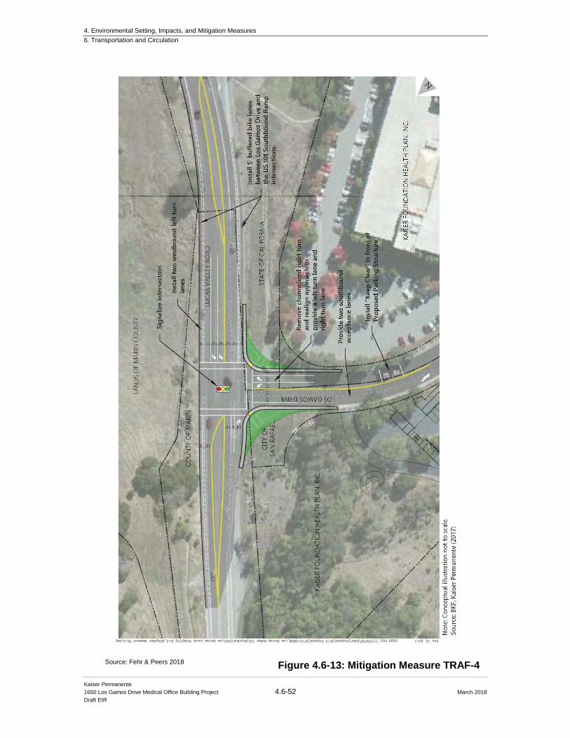
4. Environmental Setting, Impacts, and Mitigation Measures
6. Transportation and Circulation
Kaiser Permanente
1650 Los Gamos Drive Medical Office Building Project 4.6-52 March 2018
Draft EIR
Figure 4.6-13: Mitigation Measure TRAF-4 Source: Fehr & Peers 2018
4. Environmental Setting, Impacts, and Mitigation Measures
6. Transportation and Circulation
Kaiser Permanente
1650 Los Gamos Drive Medical Office Building Project 4.6-53 March 2018
Draft EIR
As discussed in Section 4.6.6: Existing Plus Project Impacts and Mitigations above, although the
Project was not evaluated for significant impacts for freeway interchanges, a potential improvement
was identified for informational purposes only. Signal timings could be adjusted at the Lucas Valley
Road/US 101 Southbound Ramps intersection to account for the new intersection demand. With
implementation, operations at the Lucas Valley Road / Smith Ranch Road / US 101 Southbound
Ramps would be improved as a result of the Project. If the intersection were subject to the
significance criteria, the implementation of signal timing would be considered a less than
significant impact, similar to other intersections included in the study.
The Lucas Valley Road/Smith Ranch Road/US 101 Northbound Ramps intersection also operates
below the LOS D threshold with the Project during the weekday AM peak hour, and thus would
result in a significant impact. In order to address this, the intersection should reconfigure the
eastbound approach to provide two through lanes, which is consistent with improvements identified
in the City of San Rafael General Plan 2020. However, as explained for the Southbound Ramps,
the intersection is part of the US 101 interchange, therefore it is exempt from the significance
criteria and the above mentioned potential improvement was identified for information purposes
only.
Signal Warrants
As mentioned above, the existing volumes fulfill the peak hour signal warrants, therefore a signal
should be considered at the Lucas Valley Road/Los Gamos Drive intersection. The addition of
Baseline growth and Project traffic would further qualify the intersection for a signal based on
Peak Hour Warrant (Warrant 3). Furthermore, implementation of mitigation measure MM
TRAF-1: Signalize Lucas Valley Road/Los Gamos Drive would mitigate the Project impact
during Baseline Plus Project conditions to a less than significant level. However, as stated above,
since implementation of the mitigation measure requires the intersection improvements to be fully
funded and constructed and this action is outside of the Lead Agency’s direct control, this impact
remains significant and unavoidable.
4.6.7.2 Baseline Plus Project Freeway Operations Baseline freeway conditions were evaluated using the same methods described in Section 4.6.4 Traffic Conditions above. The Baseline conditions analysis results are presented in Table 4.6-
15 and Table 4.6-16, for the AM and PM peak hours, respectively. Detailed freeway level of
service calculation sheets are provided in Appendix D in the 1650 Los Gamos Drive FTIA (see
Appendix E to this DEIR).
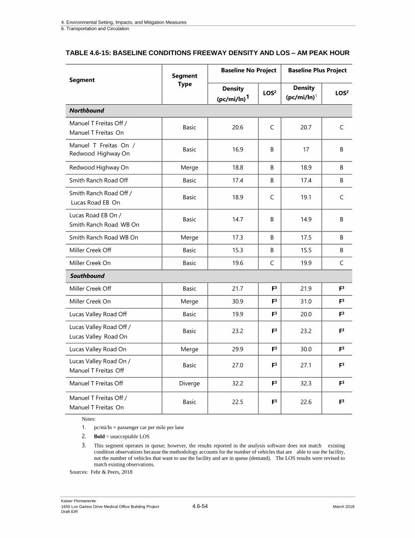
4. Environmental Setting, Impacts, and Mitigation Measures
6. Transportation and Circulation
Kaiser Permanente
1650 Los Gamos Drive Medical Office Building Project 4.6-54 March 2018
Draft EIR
TABLE 4.6-15: BASELINE CONDITIONS FREEWAY DENSITY AND LOS – AM PEAK HOUR
Segment
Segment
Type
Baseline No Project Baseline Plus Project
Density
(pc/mi/ln)1 LOS2
Density
(pc/mi/ln)1
LOS2
Northbound
Manuel T Freitas Off /
Manuel T Freitas On Basic 20.6 C 20.7 C
Manuel T Freitas On /
Redwood Highway On Basic 16.9 B 17 B
Redwood Highway On Merge 18.8 B 18.9 B
Smith Ranch Road Off Basic 17.4 B 17.4 B
Smith Ranch Road Off /
Lucas Road EB On Basic 18.9 C 19.1 C
Lucas Road EB On /
Smith Ranch Road WB On Basic 14.7 B 14.9 B
Smith Ranch Road WB On Merge 17.3 B 17.5 B
Miller Creek Off Basic 15.3 B 15.5 B
Miller Creek On Basic 19.6 C 19.9 C
Southbound
Miller Creek Off Basic 21.7 F3 21.9 F3
Miller Creek On Merge 30.9 F3 31.0 F3
Lucas Valley Road Off Basic 19.9 F3 20.0 F3
Lucas Valley Road Off /
Lucas Valley Road On Basic 23.2 F3 23.2 F3
Lucas Valley Road On Merge 29.9 F3 30.0 F3
Lucas Valley Road On /
Manuel T Freitas Off Basic 27.0 F3 27.1 F3
Manuel T Freitas Off Diverge 32.2 F3 32.3 F3
Manuel T Freitas Off /
Manuel T Freitas On Basic 22.5 F3 22.6 F3
Notes:
1. pc/mi/ln = passenger car per mile per lane
2. Bold = unacceptable LOS
3. This segment operates in queue; however, the results reported in the analysis software does not match existing
condition observations because the methodology accounts for the number of vehicles that are able to use the facility,
not the number of vehicles that want to use the facility and are in queue (demand). The LOS results were revised to
match existing observations.
Sources: Fehr & Peers, 2018
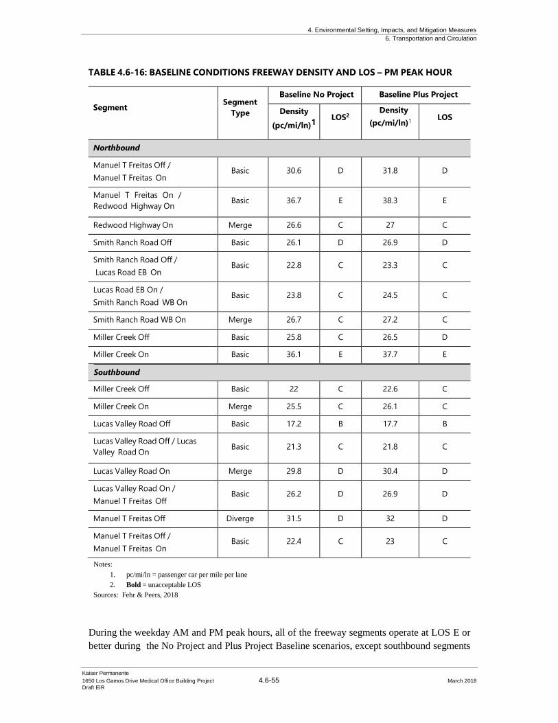
4. Environmental Setting, Impacts, and Mitigation Measures
6. Transportation and Circulation
Kaiser Permanente
1650 Los Gamos Drive Medical Office Building Project 4.6-55 March 2018
Draft EIR
TABLE 4.6-16: BASELINE CONDITIONS FREEWAY DENSITY AND LOS – PM PEAK HOUR
Segment
Segment
Type
Baseline No Project Baseline Plus Project
Density
(pc/mi/ln)1 LOS2
Density
(pc/mi/ln)1
LOS
Northbound
Manuel T Freitas Off /
Manuel T Freitas On Basic 30.6 D 31.8 D
Manuel T Freitas On /
Redwood Highway On Basic 36.7 E 38.3 E
Redwood Highway On Merge 26.6 C 27 C
Smith Ranch Road Off Basic 26.1 D 26.9 D
Smith Ranch Road Off /
Lucas Road EB On Basic 22.8 C 23.3 C
Lucas Road EB On /
Smith Ranch Road WB On Basic 23.8 C 24.5 C
Smith Ranch Road WB On Merge 26.7 C 27.2 C
Miller Creek Off Basic 25.8 C 26.5 D
Miller Creek On Basic 36.1 E 37.7 E
Southbound
Miller Creek Off Basic 22 C 22.6 C
Miller Creek On Merge 25.5 C 26.1 C
Lucas Valley Road Off Basic 17.2 B 17.7 B
Lucas Valley Road Off / Lucas
Valley Road On Basic 21.3 C 21.8 C
Lucas Valley Road On Merge 29.8 D 30.4 D
Lucas Valley Road On / Manuel T
Freitas Off Basic 26.2 D 26.9 D
Manuel T Freitas Off Diverge 31.5 D 32 D
Manuel T Freitas Off / Manuel T
Freitas On Basic 22.4 C 23 C
Miller Creek Off Basic 22 C 22.6 C
Miller Creek On Merge 25.5 C 26.1 C
Lucas Valley Road Off Basic 17.2 B 17.7 B
Lucas Valley Road Off / Lucas
Valley Road On Basic 21.3 C 21.8 C
Lucas Valley Road On Merge 29.8 D 30.4 D
Lucas Valley Road On /
Manuel T Freitas Off Basic 26.2 D 26.9 D
Manuel T Freitas Off Diverge 31.5 D 32 D
Manuel T Freitas Off /
Manuel T Freitas On Basic 22.4 C 23 C
Notes:
1. pc/mi/ln = passenger car per mile per lane
2. Bold = unacceptable LOS
Sources: Fehr & Peers, 2018
During the weekday AM and PM peak hours, all of the freeway segments operate at LOS E or
better during the No Project and Plus Project Baseline scenarios, except southbound segments
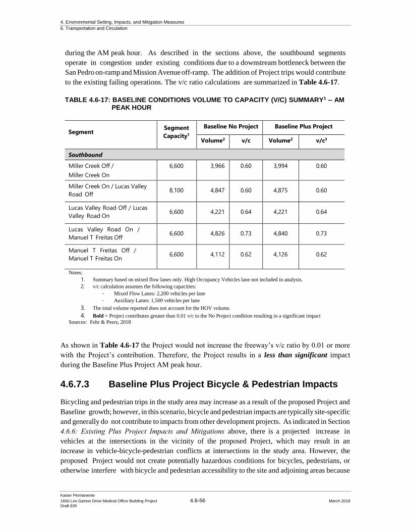
4. Environmental Setting, Impacts, and Mitigation Measures
6. Transportation and Circulation
Kaiser Permanente
1650 Los Gamos Drive Medical Office Building Project 4.6-56 March 2018
Draft EIR
during the AM peak hour. As described in the sections above, the southbound segments
operate in congestion under existing conditions due to a downstream bottleneck between the
San Pedro on-ramp and Mission Avenue off-ramp. The addition of Project trips would contribute
to the existing failing operations. The v/c ratio calculations are summarized in Table 4.6-17.
TABLE 4.6-17: BASELINE CONDITIONS VOLUME TO CAPACITY (V/C) SUMMARY1 – AM PEAK HOUR
Segment Segment
Capacity1
Baseline No Project Baseline Plus Project
Volume2 v/c Volume2
v/c3
Southbound
Miller Creek Off /
Miller Creek On
6,600 3,966 0.60 3,994 0.60
Miller Creek On / Lucas Valley
Road Off 8,100 4,847 0.60 4,875 0.60
Lucas Valley Road Off / Lucas
Valley Road On 6,600 4,221 0.64 4,221 0.64
Lucas Valley Road On /
Manuel T Freitas Off 6,600 4,826 0.73 4,840 0.73
Manuel T Freitas Off /
Manuel T Freitas On 6,600 4,112 0.62 4,126 0.62
Notes:
1. Summary based on mixed flow lanes only. High Occupancy Vehicles lane not included in analysis.
2. v/c calculation assumes the following capacities:
- Mixed Flow Lanes: 2,200 vehicles per lane
- Auxiliary Lanes: 1,500 vehicles per lane
3. The total volume reported does not account for the HOV volume.
4. Bold = Project contributes greater than 0.01 v/c to the No Project condition resulting in a significant impact
Sources: Fehr & Peers, 2018
As shown in Table 4.6-17 the Project would not increase the freeway’s v/c ratio by 0.01 or more
with the Project’s contribution. Therefore, the Project results in a less than significant impact
during the Baseline Plus Project AM peak hour.
4.6.7.3 Baseline Plus Project Bicycle & Pedestrian Impacts
Bicycling and pedestrian trips in the study area may increase as a result of the proposed Project and
Baseline growth; however, in this scenario, bicycle and pedestrian impacts are typically site-specific
and generally do not contribute to impacts from other development projects. As indicated in Section
4.6.6: Existing Plus Project Impacts and Mitigations above, there is a projected increase in
vehicles at the intersections in the vicinity of the proposed Project, which may result in an
increase in vehicle-bicycle-pedestrian conflicts at intersections in the study area. However, the
proposed Project would not create potentially hazardous conditions for bicycles, pedestrians, or
otherwise interfere with bicycle and pedestrian accessibility to the site and adjoining areas because
4. Environmental Setting, Impacts, and Mitigation Measures
6. Transportation and Circulation
Kaiser Permanente
1650 Los Gamos Drive Medical Office Building Project 4.6-57 March 2018
Draft EIR
the Project does not remove existing facilities and does not prohibit the construction of proposed
facilities in the Project vicinity. As described in Section 4.6.6.4 Existing Plus Project Bicycle and Pedestrian Impacts, the addition of the proposed parking structure on the west side of Los Gamos
Drive would result in an increase to pedestrian crossings across Los Gamos Drive. Thus, Kaiser
Permanente will include pedestrian enhancements to the existing Los Gamos Drive crossing,
just north of the 1650 Los Gamos Drive driveway. Therefore, the Project’s impact to bicycle
and pedestrian facilities are considered less than significant and mitigations are not required under
Baseline Plus Project conditions.
4.6.7.4 Baseline Plus Project Transit Impacts
Transit trips in the study area may increase as a result of the Project. However, Project related
transit trips would have no foreseeable impacts to transit operations because the Project would not
likely generate enough transit demand to exceed the capacity of existing or planned transit service
nor does it interfere with existing or future transit users. Therefore, the Project impacts to transit
facilities are considered less than significant and mitigations are not required.
4.6.8 Cumulative Conditions Impacts and Mitigation
The cumulative scenario includes traffic estimates and transportation infrastructure
improvements as proposed in the San Rafael General Plan 2020.
4.6.8.1 Assumed Roadway Improvements
The San Rafael General Plan 2020 identifies proposed roadway improvements along Lucas Valley
Road and Smith Ranch Road near the Project. Capital improvements include:
▪ Widening Lucas Valley Road to provide two westbound and two eastbound lanes
between Redwood Highway and Los Gamos Drive
▪ Widening the US 101 northbound and southbound off-ramps with additional right and
left turn lanes
▪ Signalizing the Los Gamos Drive / Lucas Valley Road intersection and coordinating
the new signal with adjacent intersections
▪ Providing the westbound Lucas Valley Road approach at Los Gamos Drive two left
turn lanes and two southbound receiving lanes on Los Gamos Drive
The improvements listed above were included in the Cumulative No Project and Cumulative Plus
Project scenarios.
The City of San Rafael Bicycle/Pedestrian Master Plan Update (2011) proposes to continue Class
II bicycle lanes along Lucas Valley Road and Smith Ranch Road, to the east. Additionally, a Class
I facility is proposed to extend north of Los Gamos Drive and connect to Marinwood Avenue.
Caltrans approved the Project Study Report (Project Development Support) [PSR (PDS)] for the
4. Environmental Setting, Impacts, and Mitigation Measures
6. Transportation and Circulation
Kaiser Permanente
1650 Los Gamos Drive Medical Office Building Project 4.6-58 March 2018
Draft EIR
Route 101/Lucas Valley Interchange Improvement Project in 2003. Caltrans prepared the PSR
(PDS) at the request of the City of San Rafael through the Marin County Congestion Management
Agency. The PSR (PDS) documents consensus between Caltrans and City of San Rafael on the
purpose-and-need, scope, and schedule of a project. As part of the PSR (PDS), project development
and capital costs are estimated. The next phase of project development is not yet funded.
Improvements for this interchange were not identified in the San Rafael General Plan 2020;
however, a supplementary cumulative analysis was completed for informational purposes and is
summarized in Section 4.6.8.3: Cumulative Conditions with Interchange Improvements below.
Traffic Volumes
Similar to the Baseline Condition, the analysis used cumulative traffic volumes from the City of
San Rafael’s traffic database which is consistent with assumptions developed in the City of San
Rafael General Plan 2020. The Cumulative No Project and Cumulative Plus Project peak hour
intersection volumes, lane configurations, and traffic controls at each Project intersection is
summarized in Figure 4.6-14 and 4.6-15, respectively.
4.6.8.2 Cumulative Intersection Operations
Impact TRAF-5. The addition of Project-related traffic would exacerbate the
Cumulative No Project condition and contribute more than 5 seconds of delay at the Lucas
Valley Road/Las Gallinas Avenue intersection. (Significant and Unavoidable).
Cumulative No Project and Cumulative Plus Project conditions were evaluated using the same
methods described in Section 4.6.4: Traffic Conditions. The Cumulative Plus Project analysis
results are presented in Table 4.6-18, based on the traffic volumes presented in Figures 4.6-14 and
4.6-15, respectively.
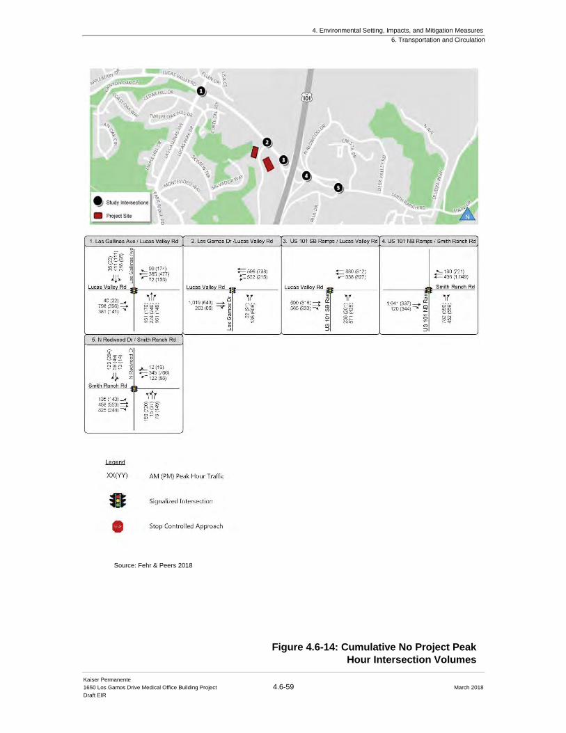
4. Environmental Setting, Impacts, and Mitigation Measures
6. Transportation and Circulation
Kaiser Permanente
1650 Los Gamos Drive Medical Office Building Project 4.6-59 March 2018
Draft EIR
Source: Fehr & Peers 2018
Figure 4.6-14: Cumulative No Project Peak
Hour Intersection Volumes
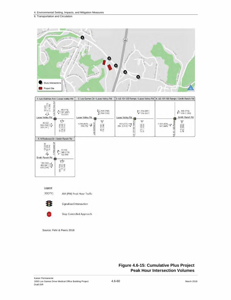
4. Environmental Setting, Impacts, and Mitigation Measures
6. Transportation and Circulation
Kaiser Permanente
1650 Los Gamos Drive Medical Office Building Project 4.6-60 March 2018
Draft EIR
Figure 4.6-15: Cumulative Plus Project
Peak Hour Intersection Volumes
Source: Fehr & Peers 2018
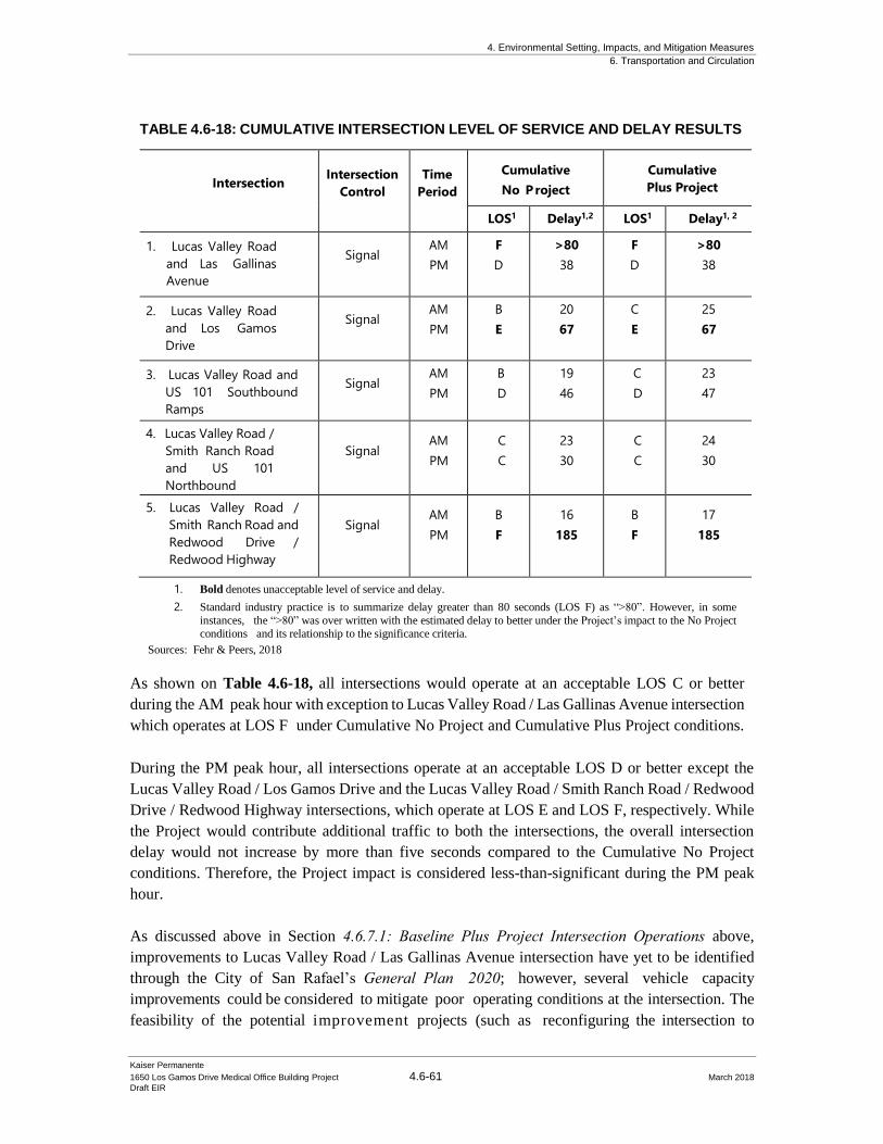
4. Environmental Setting, Impacts, and Mitigation Measures
6. Transportation and Circulation
Kaiser Permanente
1650 Los Gamos Drive Medical Office Building Project 4.6-61 March 2018
Draft EIR
TABLE 4.6-18: CUMULATIVE INTERSECTION LEVEL OF SERVICE AND DELAY RESULTS
Intersection
Intersection
Control
Time
Period
Cumulative
No Project
Cumulative
Plus Project
LOS1 Delay1,2
LOS1 Delay1, 2
1. Lucas Valley Road
and Las Gallinas
Avenue
Signal AM
PM
F
D
>80
38
F
D
>80
38
2. Lucas Valley Road
and Los Gamos
Drive
Signal AM
PM
B
E
20
67
C
E
25
67
3. Lucas Valley Road and
US 101 Southbound
Ramps
Signal AM
PM
B
D
19
46
C
D
23
47
4. Lucas Valley Road /
Smith Ranch Road
and US 101
Northbound
Ramps
Signal AM
PM
C
C
23
30
C
C
24
30
5. Lucas Valley Road /
Smith Ranch Road and
Redwood Drive /
Redwood Highway
Signal AM
PM
B
F
16
185
B
F
17
185
1. Bold denotes unacceptable level of service and delay.
2. Standard industry practice is to summarize delay greater than 80 seconds (LOS F) as “>80”. However, in some
instances, the “>80” was over written with the estimated delay to better under the Project’s impact to the No Project
conditions and its relationship to the significance criteria.
Sources: Fehr & Peers, 2018
As shown on Table 4.6-18, all intersections would operate at an acceptable LOS C or better
during the AM peak hour with exception to Lucas Valley Road / Las Gallinas Avenue intersection
which operates at LOS F under Cumulative No Project and Cumulative Plus Project conditions.
During the PM peak hour, all intersections operate at an acceptable LOS D or better except the
Lucas Valley Road / Los Gamos Drive and the Lucas Valley Road / Smith Ranch Road / Redwood
Drive / Redwood Highway intersections, which operate at LOS E and LOS F, respectively. While
the Project would contribute additional traffic to both the intersections, the overall intersection
delay would not increase by more than five seconds compared to the Cumulative No Project
conditions. Therefore, the Project impact is considered less-than-significant during the PM peak
hour.
As discussed above in Section 4.6.7.1: Baseline Plus Project Intersection Operations above,
improvements to Lucas Valley Road / Las Gallinas Avenue intersection have yet to be identified
through the City of San Rafael’s General Plan 2020; however, several vehicle capacity
improvements could be considered to mitigate poor operating conditions at the intersection. The
feasibility of the potential improvement projects (such as reconfiguring the intersection to
4. Environmental Setting, Impacts, and Mitigation Measures
6. Transportation and Circulation
Kaiser Permanente
1650 Los Gamos Drive Medical Office Building Project 4.6-62 March 2018
Draft EIR
remove channelized turn islands or replacing the existing signal with a roundabout) and any
potential adverse impacts will require further study and coordination with the City of San Rafael,
County of Marin, and the local community. Therefore, the following mitigation measure is
required to address potential impacts to the Lucas Valley Road / Las Gallinas Avenue
intersection:
Mitigation: Implementation of Mitigation Measure MM TRAF-3 would work
towards reducing the Project’s impact upon the local circulation network.
However, since the intersection is not part of a traffic fee program and
intersection improvements have yet to be identified, the Project would
result in a significant and unavoidable impact.
4.6.8.3 Cumulative Conditions with Interchange Improvements
In 2003, Caltrans approved the PSR (PDS) for the US 101/Lucas Valley Interchange Improvement
Project to relieve congestion at the existing interchange. The Project included modifications to the
interchange by replacing the existing southbound loop off-ramp with a new diagonal off-ramp on
the north side of Lucas Valley Road, which would meet Los Gamos Drive as the fourth leg of the
intersection. Additionally, the Project would construct a new southbound US 101 loop on-ramp to
serve traffic from westbound Smith Ranch Road, widen Lucas Valley Road the US 101 overpass,
and add a second right turn lane at the existing northbound off-ramp. The existing southbound on-
ramp on the south side of Lucas Valley Road would remain; however, the existing signal would be
removed and the eastbound right turn lane would be changed to a free movement. Figure 4.6-16
illustrates the proposed interchange improvements.
The PSR (PDS) is not yet funded and was not identified in the San Rafael General Plan 2020;
however, a supplementary cumulative analysis was completed for informational purposes,
summarized below.
The Cumulative with PSR (PDS) Interchange Improvements were evaluated using the same
methods described in Section 4.6.4.3: Trip Generation above. The Cumulative with PSR (PDS)
Interchange Improvements analysis results are presented in Table 4.6-19, based on the cumulative
traffic volumes presented in Figure 4.6-14 and Figure 4.6-15. Detailed LOS calculation
worksheets are included in Appendix B and queue summary worksheets in Appendix F of the
Fehr & Peers 1650 Los Gamos Drive FTIA (see Appendix E to this DEIR).
During the AM peak hour, Project traffic would result in an increase of more than five seconds in
average delay, the threshold for a Project-related impact, at the Lucas Valley Road/Las Gallinas
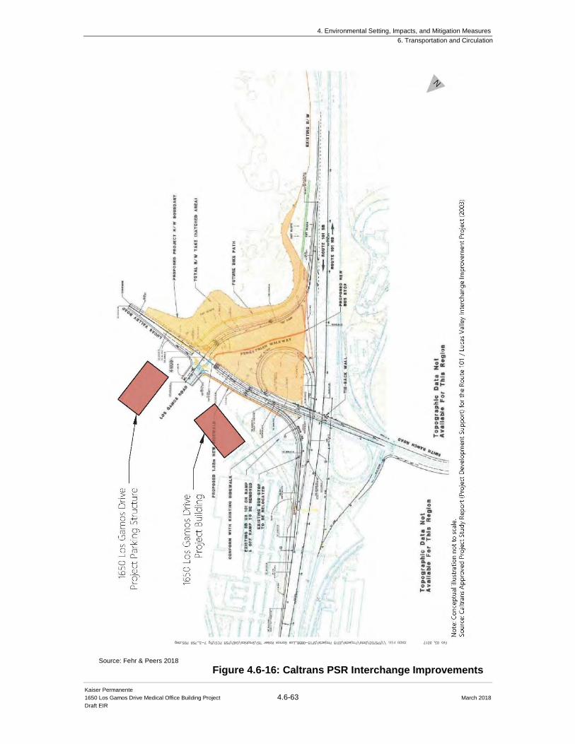
4. Environmental Setting, Impacts, and Mitigation Measures
6. Transportation and Circulation
Kaiser Permanente
1650 Los Gamos Drive Medical Office Building Project 4.6-63 March 2018
Draft EIR
Figure 4.6-16: Caltrans PSR Interchange Improvements Source: Fehr & Peers 2018
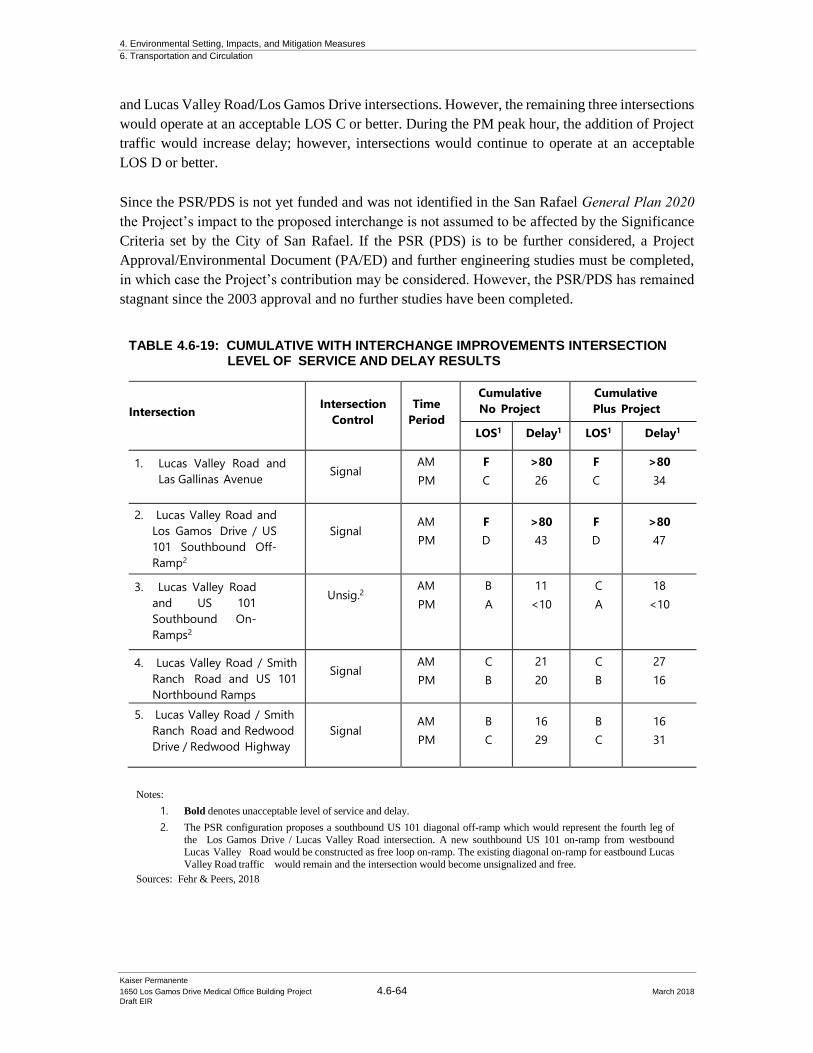
4. Environmental Setting, Impacts, and Mitigation Measures
6. Transportation and Circulation
Kaiser Permanente
1650 Los Gamos Drive Medical Office Building Project 4.6-64 March 2018
Draft EIR
and Lucas Valley Road/Los Gamos Drive intersections. However, the remaining three intersections
would operate at an acceptable LOS C or better. During the PM peak hour, the addition of Project
traffic would increase delay; however, intersections would continue to operate at an acceptable
LOS D or better.
Since the PSR/PDS is not yet funded and was not identified in the San Rafael General Plan 2020
the Project’s impact to the proposed interchange is not assumed to be affected by the Significance
Criteria set by the City of San Rafael. If the PSR (PDS) is to be further considered, a Project
Approval/Environmental Document (PA/ED) and further engineering studies must be completed,
in which case the Project’s contribution may be considered. However, the PSR/PDS has remained
stagnant since the 2003 approval and no further studies have been completed.
TABLE 4.6-19: CUMULATIVE WITH INTERCHANGE IMPROVEMENTS INTERSECTION LEVEL OF SERVICE AND DELAY RESULTS
Intersection
Intersection
Control
Time
Period
Cumulative
No Project
Cumulative
Plus Project
LOS1 Delay1
LOS1 Delay1
1. Lucas Valley Road and
Las Gallinas Avenue
Signal AM
PM
F
C
>80
26
F
C
>80
34
2. Lucas Valley Road and
Los Gamos Drive / US
101 Southbound Off-
Ramp2
Signal AM
PM
F
D
>80
43
F
D
>80
47
3. Lucas Valley Road
and US 101
Southbound On-
Ramps2
Unsig.2
AM
PM
B
A
11
<10
C
A
18
<10
4. Lucas Valley Road / Smith
Ranch Road and US 101
Northbound Ramps
Signal AM
PM
C
B
21
20
C
B
27
16
5. Lucas Valley Road / Smith
Ranch Road and Redwood
Drive / Redwood Highway
Signal AM
PM
B
C
16
29
B
C
16
31
Notes:
1. Bold denotes unacceptable level of service and delay.
2. The PSR configuration proposes a southbound US 101 diagonal off-ramp which would represent the fourth leg of
the Los Gamos Drive / Lucas Valley Road intersection. A new southbound US 101 on-ramp from westbound
Lucas Valley Road would be constructed as free loop on-ramp. The existing diagonal on-ramp for eastbound Lucas
Valley Road traffic would remain and the intersection would become unsignalized and free.
Sources: Fehr & Peers, 2018

4. Environmental Setting, Impacts, and Mitigation Measures
6. Transportation and Circulation
Kaiser Permanente
1650 Los Gamos Drive Medical Office Building Project 4.6-65 March 2018
Draft EIR
Signal Warrants
As described above, the City of San Rafael General Plan 2020 proposes to signalize the Lucas
Valley Road / Los Gamos Drive intersection. Therefore, no study intersection remains unsignalized
and needs to be evaluated as part of the signal warrant analysis.
4.6.8.4 Freeway Operations
Cumulative freeway conditions were evaluated using the same methods described in Section
4.6.3.1: Trip Generation above. The Cumulative conditions analysis results are presented in Table
4.6-20 and Table 4.6-21, for the AM and PM peak hours, respectively. Detailed freeway level of
service calculation sheets are provided in Appendix D of the 1650 Los Gamos Drive FTIA (see
Appendix E to this DEIR).
TABLE 4.6-20: CUMULATIVE CONDITIONS FREEWAY DENSITY AND LOS – AM PEAK HOUR
Segment
Segment
Type
Cumulative
No Project
Cumulative
Plus Project
Density
(pc/mi/ln)1 LOS2
Density
(pc/mi/ln)1
LOS
Northbound
Manuel T Freitas Off /
Manuel T Freitas On
Basic 25.4 C 25.4 C
Manuel T Freitas On /
Redwood Highway On
Basic 28.4 D 28.5 D
Redwood Highway On Merge 22 C 22 C
Smith Ranch Road Off Basic 21.1 C 21.2 C
Smith Ranch Road Off /
Lucas Road EB On
Basic 23 C 23.3 C
Lucas Road EB On /
Smith Ranch Road WB On
Basic 17.9 B 18.1 C
Smith Ranch Road WB On Merge 20.1 C 20.3 C
Miller Creek Off Basic 18.6 C 18.8 C
Miller Creek On Basic 24 C 24.3 C
Southbound
Miller Creek Off Basic 26.4 F3 26.5 F3
Miller Creek On Merge 36.0 F3 36.2 F3
Lucas Valley Road Off Basic 23.9 F3 24.1 F3
Lucas Valley Road Off /
Lucas Valley Road On
Basic 29.7 F3 29.7 F3
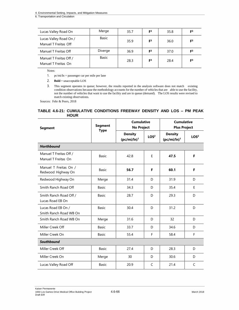
4. Environmental Setting, Impacts, and Mitigation Measures
6. Transportation and Circulation
Kaiser Permanente
1650 Los Gamos Drive Medical Office Building Project 4.6-66 March 2018
Draft EIR
Lucas Valley Road On Merge 35.7 F3 35.8 F3
Lucas Valley Road On /
Manuel T Freitas Off
Basic 35.9 F3 36.0 F3
Manuel T Freitas Off Diverge 36.9 F3 37.0 F3
Manuel T Freitas Off /
Manuel T Freitas On
Basic 28.3 F3 28.4 F3
Notes:
1. pc/mi/ln = passenger car per mile per lane
2. Bold = unacceptable LOS
3. This segment operates in queue; however, the results reported in the analysis software does not match existing
condition observations because the methodology accounts for the number of vehicles that are able to use the facility, not the number of vehicles that want to use the facility and are in queue (demand). The LOS results were revised to
match existing observations.
Sources: Fehr & Peers, 2018
TABLE 4.6-21: CUMULATIVE CONDITIONS FREEWAY DENSITY AND LOS – PM PEAK HOUR
Segment
Segment
Type
Cumulative
No Project
Cumulative
Plus Project
Density
(pc/mi/ln)1
LOS2
Density
(pc/mi/ln)1
LOS2
Northbound
Manuel T Freitas Off /
Manuel T Freitas On Basic 42.8 E 47.5 F
Manuel T Freitas On /
Redwood Highway On Basic 56.7 F 60.1 F
Redwood Highway On Merge 31.4 D 31.9 D
Smith Ranch Road Off Basic 34.3 D 35.4 E
Smith Ranch Road Off /
Lucas Road EB On
Basic 28.7 D 29.3 D
Lucas Road EB On /
Smith Ranch Road WB On
Basic 30.4 D 31.2 D
Smith Ranch Road WB On Merge 31.6 D 32 D
Miller Creek Off Basic 33.7 D 34.6 D
Miller Creek On Basic 55.4 F 58.4 F
Southbound
Miller Creek Off Basic 27.4 D 28.3 D
Miller Creek On Merge 30 D 30.6 D
Lucas Valley Road Off Basic 20.9 C 21.4 C
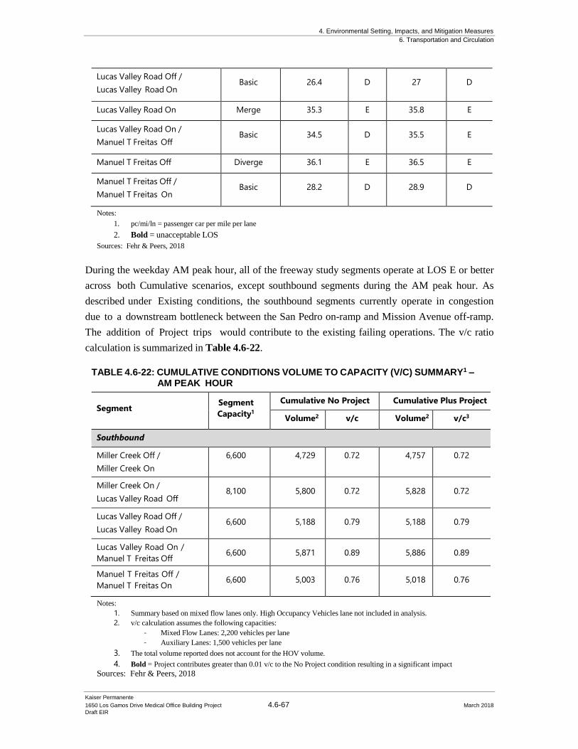
4. Environmental Setting, Impacts, and Mitigation Measures
6. Transportation and Circulation
Kaiser Permanente
1650 Los Gamos Drive Medical Office Building Project 4.6-67 March 2018
Draft EIR
Lucas Valley Road Off /
Lucas Valley Road On Basic 26.4 D 27 D
Lucas Valley Road On Merge 35.3 E 35.8 E
Lucas Valley Road On /
Manuel T Freitas Off Basic 34.5 D 35.5 E
Manuel T Freitas Off Diverge 36.1 E 36.5 E
Manuel T Freitas Off /
Manuel T Freitas On Basic 28.2 D 28.9 D
Notes:
1. pc/mi/ln = passenger car per mile per lane
2. Bold = unacceptable LOS
Sources: Fehr & Peers, 2018
During the weekday AM peak hour, all of the freeway study segments operate at LOS E or better
across both Cumulative scenarios, except southbound segments during the AM peak hour. As
described under Existing conditions, the southbound segments currently operate in congestion
due to a downstream bottleneck between the San Pedro on-ramp and Mission Avenue off-ramp.
The addition of Project trips would contribute to the existing failing operations. The v/c ratio
calculation is summarized in Table 4.6-22.
TABLE 4.6-22: CUMULATIVE CONDITIONS VOLUME TO CAPACITY (V/C) SUMMARY1 – AM PEAK HOUR
Segment Segment
Capacity1
Cumulative No Project Cumulative Plus Project
Volume2 v/c Volume2
v/c3
Southbound
Miller Creek Off /
Miller Creek On
6,600 4,729 0.72 4,757 0.72
Miller Creek On /
Lucas Valley Road Off 8,100 5,800 0.72 5,828 0.72
Lucas Valley Road Off /
Lucas Valley Road On 6,600 5,188 0.79 5,188 0.79
Lucas Valley Road On /
Manuel T Freitas Off 6,600 5,871 0.89 5,886 0.89
Manuel T Freitas Off /
Manuel T Freitas On 6,600 5,003 0.76 5,018 0.76
Notes:
1. Summary based on mixed flow lanes only. High Occupancy Vehicles lane not included in analysis.
2. v/c calculation assumes the following capacities:
- Mixed Flow Lanes: 2,200 vehicles per lane
- Auxiliary Lanes: 1,500 vehicles per lane
3. The total volume reported does not account for the HOV volume.
4. Bold = Project contributes greater than 0.01 v/c to the No Project condition resulting in a significant impact
Sources: Fehr & Peers, 2018
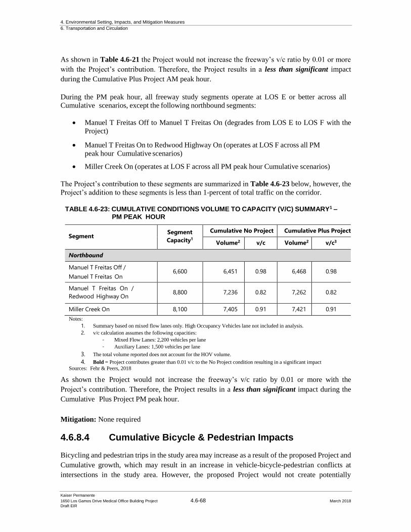
4. Environmental Setting, Impacts, and Mitigation Measures
6. Transportation and Circulation
Kaiser Permanente
1650 Los Gamos Drive Medical Office Building Project 4.6-68 March 2018
Draft EIR
As shown in Table 4.6-21 the Project would not increase the freeway’s v/c ratio by 0.01 or more
with the Project’s contribution. Therefore, the Project results in a less than significant impact
during the Cumulative Plus Project AM peak hour.
During the PM peak hour, all freeway study segments operate at LOS E or better across all
Cumulative scenarios, except the following northbound segments:
• Manuel T Freitas Off to Manuel T Freitas On (degrades from LOS E to LOS F with the
Project)
• Manuel T Freitas On to Redwood Highway On (operates at LOS F across all PM
peak hour Cumulative scenarios)
• Miller Creek On (operates at LOS F across all PM peak hour Cumulative scenarios)
The Project’s contribution to these segments are summarized in Table 4.6-23 below, however, the
Project’s addition to these segments is less than 1-percent of total traffic on the corridor.
TABLE 4.6-23: CUMULATIVE CONDITIONS VOLUME TO CAPACITY (V/C) SUMMARY1 –
PM PEAK HOUR
Segment Segment
Capacity1
Cumulative No Project Cumulative Plus Project
Volume2 v/c Volume2
v/c3
Northbound
Manuel T Freitas Off /
Manuel T Freitas On 6,600 6,451 0.98 6,468 0.98
Manuel T Freitas On /
Redwood Highway On 8,800 7,236 0.82 7,262 0.82
Miller Creek On 8,100 7,405 0.91 7,421 0.91
Notes:
1. Summary based on mixed flow lanes only. High Occupancy Vehicles lane not included in analysis.
2. v/c calculation assumes the following capacities:
- Mixed Flow Lanes: 2,200 vehicles per lane
- Auxiliary Lanes: 1,500 vehicles per lane
3. The total volume reported does not account for the HOV volume.
4. Bold = Project contributes greater than 0.01 v/c to the No Project condition resulting in a significant impact
Sources: Fehr & Peers, 2018
As shown the Project would not increase the freeway’s v/c ratio by 0.01 or more with the
Project’s contribution. Therefore, the Project results in a less than significant impact during the
Cumulative Plus Project PM peak hour.
Mitigation: None required
4.6.8.4 Cumulative Bicycle & Pedestrian Impacts
Bicycling and pedestrian trips in the study area may increase as a result of the proposed Project and
Cumulative growth, which may result in an increase in vehicle-bicycle-pedestrian conflicts at
intersections in the study area. However, the proposed Project would not create potentially
4. Environmental Setting, Impacts, and Mitigation Measures
6. Transportation and Circulation
Kaiser Permanente
1650 Los Gamos Drive Medical Office Building Project 4.6-69 March 2018
Draft EIR
hazardous conditions for bicycles, pedestrians, or otherwise interfere with bicycle and pedestrian
accessibility to the site and adjoining areas because the Project does not remove existing facilities
and does not prohibit the construction of proposed future facilities as documented under the
Cumulative Roadway Assumptions. As described in Section 4.6.6.4: Existing Plus Project Bicycle and Pedestrian Impacts above, the addition of the proposed parking structure on the west side of
Los Gamos Drive would result in an increase to pedestrian crossings across Los Gamos Drive.
Thus, Kaiser Permanente will include pedestrian enhancements to the existing Los Gamos Drive
crossing, just north of the 1650 Los Gamos Drive driveway. Therefore, the Project’s impact to
bicycle and pedestrian facilities are considered less than significant and mitigations are not
required under Cumulative Plus Project conditions.
Mitigation: None required
4.6.8.5 Cumulative Transit Impacts
Transit trips in the study area may increase as a result of the Project. However, Project related
transit trips would have no foreseeable impacts to transit operations because the Project would not
likely generate enough transit demand to exceed the capacity of existing or planned transit service
nor does it interfere with existing or future transit users. Therefore, the Project impacts to transit
facilities are considered less than significant and no mitigation is required.
Mitigation: None required
4. Environmental Setting, Impacts, and Mitigation Measures
6. Transportation and Circulation
Kaiser Permanente
1650 Los Gamos Drive Medical Office Building Project 4.6-70 March 2018
Draft EIR
This page intentionally left blank
Kaiser Permanente
1650 Los Gamos Drive Medical Office Building Project 5-1 March 2018
Draft EIR
CHAPTER 5
Alternatives
This chapter describes and evaluates alternatives to the Kaiser Permanente 1650 Los Gamos Drive
Medical Office Building Project, pursuant to CEQA Guidelines Section 15126.6. This chapter
provides a comparative evaluation of four alternatives to the proposed Project. The chapter
begins with a discussion of the scope of the alternatives considered , followed by a description
and evaluation of the alternatives. The chapter concludes with a discussion of the
Environmentally Superior alternative.
5.1 CEQA Requirements
CEQA requires an evaluation of the comparative effects of a range of reasonable alternatives to a
project. The alternatives considered should feasibly attain most of the basic objectives of the project
and avoid or substantially lessen one or more of the significant effects of the project. The discussion
of alternatives in an EIR is to focus on alternatives to the project or its location that are capable of
avoiding or substantially lessening significant effects of the project, even if such alternatives would
impede, to some degree, the attainment of the project objectives, or would be costlier (CEQA
Guidelines Sections 15126.6[a] and 15126.6[b]). The range of alternatives required in an EIR is
governed by a "rule of reason" that requires the EIR to set forth only those alternatives necessary
to permit a reasoned choice.
An EIR need not consider every conceivable alternative to a project. Rather, it must consider a
reasonable range of potentially feasible alternatives that will foster informed decision making
and public participation. Section 21083.3(b) of the CEQA statute further states that when a
proposed project is consistent with a city’s General Plan, and an EIR was prepared for said
plan, the review of the proposed project "need only to analyze the impacts peculiar to the
proposed project and which were not addressed as significant effects in the prior EIR, or which
substantial new information shows will be more significant than described in the prior EIR."
5.2 Factors Considered in Selection of Alternatives
This chapter presents a meaningful comparative analysis of the Project and the alternatives, and
discusses any alternatives that were considered by the City of San Rafael but that it rejected as
infeasible for detailed analysis in this DEIR. The CEQA Guidelines recommend that an EIR briefly
describe the rationale for selecting the alternatives to be discussed (CEQA Guidelines Section
15126.6[c]). The goal of the alternatives analysis considers the following factors:
5. Alternatives
Kaiser Permanente
1650 Los Gamos Drive Medical Office Building Project 5-2 March 2018
Draft EIR
• The extent to which the alternative would accomplish all or most of the basic goals and
objectives of the project;
• The extent to which the alternative would avoid or lessen the identified significant and
unavoidable environmental impacts of the project;
• The feasibility of the alternative, taking into account site suitability, availability of
infrastructure, general plan consistency, and consistency with other applicable plans and
regulatory limitations;
• The extent to which an alternative contributes to a “reasonable range” of alternatives
necessary to permit a reasoned choice; and
• The requirement of the CEQA Guidelines to consider a “no project” alternative and to
identify an “environmentally superior” alternative in addition to the no-project alternative.
5.2.1 Basic Goals and Objectives of the Project
As stated in the first factor bulleted above, the selection of alternatives shall consider the basic
goals and objectives of the Project.
The basic objectives of the Kaiser Permanente 1650 Los Gamos Medical Office Building (MOB)
Project are listed below, as initially presented in Section 3.3.1, Objectives of Proposed Project, in
Chapter 3, Project Description. Objectives of the proposed Project are intended to be consistent
with the policies of the City of San Rafael General Plan 2020 and the health care, economic, and
other considerations of Kaiser Permanente. The following specific project objectives have been
identified for the Project:
1. Provide high quality, affordable health care in new, approximately 150,000 square foot
centralized outpatient facility for Kaiser Permanente members and the greater Marin
County area by reusing an existing building and surface parking lot area in a practical and
cost-effective manner.
2. Immediately supplement and support existing Kaiser Permanente medical offices and
support services in the North Bay region in one consolidated location, allowing for the
ability to:
i. right-size spaces to decompress existing services and providers,
ii. modernize clinical areas of the existing Kaiser Permanente San Rafael
Medical Center, and
iii. provide enhanced medical services for local residents at a conveniently
located facility.
3. Facilitate the logical, orderly development of an infill site in order to achieve a beneficial
set of end uses at a site with good freeway access and proximity to public transportation.
4. Positively contribute to the local economy through new capital investment.
5. Alternatives
Kaiser Permanente
1650 Los Gamos Drive Medical Office Building Project 5-3 March 2018
Draft EIR
5. Design the new MOB in a manner so as to meet the evolving and varied health care
demands of Kaiser Permanente members and the residents of San Rafael within the
framework of Kaiser Permanente resources and changing health care industry practices.
6. Provide an environment that is easy to negotiate and access for pedestrians, bicyclists,
and vehicles, including persons with disabilities. Create pedestrian circulation that is clear
and safe.
7. Implement a MOB and parking structure that are aesthetically compatible with
surrounding development and do not unduly impact existing views.
5.2.2 Summary of Significant Impacts Identified with the
Project
The proposed Project and the Project objectives are described in detail in Chapter 3, Project Description, and the potential environmental effects of implementing the proposed Project are
analyzed in Chapter 4, Environmental Settings, Impacts and Mitigation Measures. As discussed in
in the Initial Study, several environmental issues were determined to not be significant, less than
significant, or less than significant with mitigation incorporation. The mitigation measures for
those environmental issues are incorporated into the Project as referenced in Appendix B. Project
impacts associated with the following environmental topics would be significant without the
implementation of mitigation measures, but would be reduced to a less than significant level if the
mitigation measures recommended in this DEIR are implemented:
• Air Quality
• Greenhouse Gas Emissions
As discussed in Chapter 4.6: Transportation and Circulation, although mitigations have been
identified to reduce Project impacts to less than significant levels, traffic impacts may remain
significant and unavoidable for purposes of this EIR analysis due to the timing and coordination
with third party jurisdictions required to implement the identified intersection improvements. As
such, the following environmental topics would be considered significant and unavoidable
• Transportation and Circulation
5.3 Alternatives Considered but Not Analyzed
Further in the DEIR
5.3.1 One Off-Site Project Location Alternative
The existing Kaiser Permanente San Rafael Medical Center at 99 Montecillo Road is landlocked and
without any near-term opportunities to expand on-site due to the current campus configuration and
site plan. As such, the primary objective of the Project is to provide a new MOB for Marin County
residents so as to decompress capacity at existing Kaiser Permanente medical offices and support
services in the North Bay region. Kaiser Permanente does not currently own or control any feasible
alternative sites in the geographical area that have the required land use and zoning designations that
5. Alternatives
Kaiser Permanente
1650 Los Gamos Drive Medical Office Building Project 5-4 March 2018
Draft EIR
could accommodate the development intensity proposed. To this end, Kaiser Permanente’s real estate
team has spent nearly a decade researching potentially feasible sites (those both on the market for
lease and/or for sale and potentially so) in the greater San Rafael geographical area.
With the exception of the current proposed Project site at 1650 Los Gamos Drive, other potential sites
were rejected from further consideration due to a variety of factors, including, but not limited to: size,
distance from Kaiser Permanente San Rafael Medical Center, and onsite contamination risks. In
determining the appropriateness of an off-site alternative, the City of San Rafael also evaluated the
reduction of potentially significant impacts that would be generated by the proposed Project and
assessed the viability of lessening the potential traffic and circulation and accompanying air quality
and GHG impacts elsewhere in Marin County. This includes identifying sites that are similarly
located near the highway and near intersections and access ramps that do not have existing conditions
at circulation capacity. As an initial matter, given the scarcity of available and comparable
development space in the San Rafael geographical area, there is no potential off-site location where
a new similar sized MOB could realistically and feasibly be developed, could meet the proposed
Project’s main objectives, or is ideally zoned for medical office use.
Because the subject property is located adjacent to a major highway (with highway interchange) and
includes an existing building with available parking, the comparison to new development at an
alternate location is not realistically possible, as there are no available or similar sized properties
located within the Project area. However, the impacts of developing a new MOB with the same
program, size, office space, and parking requirements as the existing office building on another
property in central Marin County would likely result in greater impacts than those identified with the
proposed Project. CEQA does not require that the EIR consider an off-site alterative if it would not
avoid or substantially lessen any of the significant effects of the Project to be considered for inclusion
in the EIR. Furthermore, CEQA does not require an off-site alternative to be analyzed if the lead
agency concludes that no feasible alternative locations exist. Here, a single offsite location alternative
was considered but not further evaluated because such an alternative would not: (i) meet the main
Project Objectives 1 and 2 above; (2) possibly not meet Project Objectives 3, 6, and 7; and (iii) is
infeasible (see alternative site feasibility factors put forth by the California Supreme Court in Citizens
of Goleta Valley v. Board of Supervisors, 52 Cal. 3d 553 (1990) (“A feasible alternative is one which
can be ‘accomplished in a successful manner within a reasonable period of time, taking into account
economic, environmental, social, and technological factors.’ (Pub. Resources Code, § 21061.1;
Guidelines, § 15364)). Alternatives that cannot be “realistically considered and successfully
accomplished” do not legally need to be reviewed in depth. Therefore, a scenario in which Kaiser
Permanente would develop a new MOB at a single off-site alternative location is not considered in
this DEIR analysis.
5.3.2 Multiple Off-Site Project Locations Alternative
Similar to the single off-site alternative concept, a multiple, smaller off-site project locations
alternative was not considered for many of the reasons stated above. Partitioning the proposed Project
into several smaller sized developments is potentially more likely than locating one large property for
an MOB development since the market for large office or medical office properties in Marin County
5. Alternatives
Kaiser Permanente
1650 Los Gamos Drive Medical Office Building Project 5-5 March 2018
Draft EIR
is limited at this time. As such, one alternative to meet the overall square footage needs for the Project
(approximately 150,000 square feet) would be to locate the use in several existing buildings with
ample available office space, adequate vehicular access, and ample parking. However, this would not
meet the objective of creating a single centralized facility that fits within the Kaiser Permanente
business model to provide a one-stop facility with supportive services. A review of available
commercial office space databases indicates that the largest possible available office space in the
Marin County area is just under 24,000 square feet1. Similarly, although there are many medium to
large sized office developments in the area (50,000 – 75,000 sq. ft.) with available office spaces for
lease, these buildings tend to have a high occupancy rate with limited opportunity for rentable office
spaces (i.e. one or two available offices at 2,000 to 3,000 sq. ft.).
As such, in order to achieve space needed for Kaiser Permanente, while also reducing the potential
significant impacts of the proposed Project, the multiple alternative-sites alternative would require
several office locations to meet the space needs for the Project. Dividing the medical offices into
several smaller facilities would require significantly more internal staffing and coordination between
the facilities and would not fit the Kaiser Permanente business model of providing medical services
as at centralized location. With a dispersal of medical services to several smaller locations, this
alternative would also require additional travel between disconnected medical center locations,
assuming the same number of proposed providers were staffed at several locations, and therefore
result in greater trip generation and possible transportation, air quality, and GHG emission impacts.
Finally, reducing or avoiding most of the potentially significant environmental impacts from the
proposed Project would more likely be achieved by the reduced Project alternative that is evaluated
below. For these reasons, the multiple off-site project locations alternative was not evaluated in
this DEIR.
5.4 Alternatives Selected for Consideration
With consideration given to the factors for alternatives selection discussed in Section 5.2, The City
of San Rafael identified the following reasonable range of project alternatives to be addressed in
this EIR:
1. No Project/No Medical Office Uses: Assumes there will be no new Kaiser Permanente
MOB at 1650 Los Gamos Drive and the existing commercial building would remain
used for office uses, with no addition of medical office uses. The general office and
parking lot uses would continue, and no new development would occur on the Project
site. Kaiser Permanente would continue to use its main medical campus at 99
Montecillo for medical office uses and would have limited ability for modernization
of existing spaces.
1 LoopNet online database: http://www.loopnet.com/for-sale/san-rafael-ca/?e=u, accessed October/November 2017
5. Alternatives
Kaiser Permanente
1650 Los Gamos Drive Medical Office Building Project 5-6 March 2018
Draft EIR
2. Reduced Medical Office Use: Assumes Kaiser Permanente reduces the amount of
proposed medical office uses in the existing 1650 Los Gamos Drive office building. The
reduced Project alternative assumes a total square foot program of the office building such
that the proposed Project’s overall peak hour traffic trips and parking structure needs do
not require mitigation to reduce potentially significant impacts.
3. Alternate Parking Structure Location: Assumes Kaiser Permanente would construct the
parking structure on the Project site’s eastern parcel, in the area currently utilized for
surface parking to the north and northeast of the existing office building. In order to
achieve the City’s Municipal Code minimum parking requirement for medical office use,
the alternate parking structure design would be taller than the three-level structure included
in the proposed Project.
4. Applicant-Implemented Traffic Improvements: Assumes Kaiser Permanente
voluntarily constructs an intersection improvement at Los Gamos Drive and Lucas Valley
Road and other related traffic or vehicular circulation improvements as part of the proposed
Project. As a result, there would be no required mitigation measure to reduce impact
significance related to AM and PM peak hour trips at Los Gamos Drive and Lucas Valley
Road intersection. However, permitting and construction of the intersection would still
require multi-agency coordination and entitlement review and approval.
The development program and key site characteristics for the Project and each alternative are
presented below in Table 5-1: Summary of Alternatives to the Project. Table 5-1 depicts the
basic components of each alternative for a side by side analysis of potential environmental impacts
and whether the impact significance changes based on the alternative. Each alternative is described
in greater detail in the comparative analysis that follows in Section 5.3.1. The environmentally
superior alternative that CEQA requires the EIR identify is discussed in Section 5.5.
5.4.1 Comparative Analysis of CEQA Alternatives
Throughout this section a description of each alternative is followed by a discussion of impacts and
how those impacts compare to those of the Project. As permitted by CEQA, the effects of the
alternatives are discussed in less detail than the impact discussions of the Project in Chapter 4 (CEQA
Guidelines Section 15126.6[d]). In most cases, the comparisons are qualitative and discussed in terms
of whether the alternative would avoid, worsen, reduce, or maintain the same degree of impact as
those identified with the proposed Project, as well as providing an overall impact determination.
The analysis is conducted at a sufficient level of detail to provide the public, other public agencies,
and Project decision-makers adequate information to fully evaluate the alternatives and approve
any of the alternatives without further environmental review. Impacts are stated as levels of
significance after implementation of mitigation measures identified in Chapter 4, except where
discussion of pre-mitigation effects is relevant to the comparison.
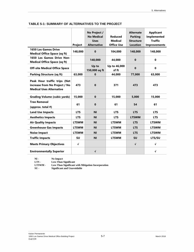
5. Alternatives
Kaiser Permanente
1650 Los Gamos Drive Medical Office Building Project 5-7 March 2018
Draft EIR
TABLE 5-1: SUMMARY OF ALTERNATIVES TO THE PROJECT
Project
No Project /
No Medical
Uses
Alternative
Reduced
Medical
Office Use
Alternate
Parking
Structure
Location
Applicant
Implemented
Traffic
Improvements
1650 Los Gamos Drive
Medical Office Space (sq ft) 148,000 0 104,000 148,000 148,000
1650 Los Gamos Drive Non-
Medical Office Space (sq ft) 148,000 44,000 0 0
Off-site Medical Office Space Up to
150,000 sq ft
Up to 46,000
sf ft 0 0
Parking Structure (sq ft) 63,000 0 44,000 77,000 63,000
Peak Hour traffic trips (Net
increase from No Project / No
Medical Uses Alternative
473 0 371 473 473
Grading Volume (cubic yards) 15,000 0 15,000 5,000 15,000
Tree Removal
(approx. total #) 61 0 61 54 61
Land Use Impacts LTS NI LTS LTS LTS
Aesthetics Impacts LTS NI LTS LTSWM LTS
Air Quality Impacts LTSWM NI LTSWM LTS LTSWM
Greenhouse Gas Impacts LTSWM NI LTSWM LTS LTSWM
Noise Impact LTSWM NI LTSWM LTS LTSWM
Traffic Impacts SU NI LTSWM SU LTS/SU
Meets Primary Objectives √ √ √
Environmentally Superior √ √
NI - No Impact
LTS - Less Than Significant
LTSWM - Less Than Significant with Mitigation Incorporation
SU - Significant and Unavoidable
5. Alternatives
Kaiser Permanente
1650 Los Gamos Drive Medical Office Building Project 5-8 March 2018
Draft EIR
5.5 Alternative 1: No Project / No Medical Office
Uses
5.5.1 Principle Characteristics
The No Project / No Medical Office Uses Alternative assumes that the Project site would generally
remain in its existing condition and would not be subject to redevelopment as an MOB. Under this
alternative, the existing commercial building would continue to be used for office uses, as currently
allowed under the PD District zoning. The owner of the building would actively market the
building to lease or sell for office uses. . There would be no new parking structure constructed on
the Project site and no traffic or intersection improvements proposed. Furthermore, Kaiser
Permanente’s existing medical office uses would remain at the main hospital campus at 99
Montecillo in Terra Linda and elsewhere at existing and potentially alternative location(s)
throughout Marin County and the region.
No new short-term air quality, GHG emissions, noise, or traffic impacts would occur during
construction at the Project site under this alternative and neither would any potential long-term
impacts associated with Project operation. No new roadway infrastructure or pedestrian
improvements at the Project site would be undertaken in the near future (unless funded and
implemented under General Plan programs). Although some environmental impacts would be
avoided under the No Project / No Medical Office Uses Alternative, this alternative would not have
the benefits of improved medical facility services for local residents, improved stormwater
drainage, improved pedestrian circulation and bicycle lanes on Lucas Valley Road, and roadway
infrastructure improvements. In addition, since the medical services that would have been located
at the project site would need to be provided at other locations, there may be unknown
environmental impacts at other locations.
Under this No Project / No Medical Office Uses Alternative, Kaiser Permanente would continue to
operate its existing facilities throughout Marin County, including, but not limited to, the Kaiser
Permanente medical office facilities in San Rafael, Novato, and at the main San Rafael Medical
Center campus at 99 Montecillo. However, as discussed previously, the Project is intended to
immediately relieve pressure on Kaiser Permanente’s existing facilities to ensure the most efficient
flow of members and provide the space necessary for today’s modern health care technology.
Thus, the No Project / No Medical Office Uses Alternative could result in short- and long-term
service reductions to Kaiser Permanente members and the community, impact existing facilities
outside the immediate service area and limit time-sensitive decisions on future potential growth
opportunities for the organization.
5.5.2 Relationship with Project Objectives
The No Project / No Medical Office Uses Alternative would not achieve any of the proposed Project
objectives. This alternative would maintain the current uses on site, which would not allow for a
new, modern, MOB nor would it relieve pressure on Kaiser Permanente’s existing facilities. No
new infrastructure or traffic improvements would be included in this alternative. Additionally, this
alternative would continue to contribute the same amount of vehicle trips at Kaiser Permanente’s
main campus at 99 Montecillo. Furthermore, use of the existing office building at 1650 Los Gamos
5. Alternatives
Kaiser Permanente
1650 Los Gamos Drive Medical Office Building Project 5-9 March 2018
Draft EIR
Drive would continue as a general office with daily usage and vehicular trips consistent with a
general office building.
5.5.3 Comparative Analysis of the No Project / No Medical
Office Uses Alternative
The No Project / No Medical Office Uses Alternative would maintain the existing office building
on the Project site. Under this alternative, there would be no excavation/grading, tree removal, or
change of use to the existing structures. The No Project / No Medical Office Uses Alternative
would result in the following impact levels:
• Air Quality: No Impact
• Greenhouse Gas Emissions: No Impact
• Noise: No Impact
• Land Use: No Impact
• Transportation and Circulation: No Impact
It is unknown at this time if there would be any other impacts if the proposed medical uses were
located at alternative locations in the region.
5.5.4 Feasibility
With regard to the No Project / No Medical Office Uses Alternative, it can be assumed that without
development of the proposed Project, redevelopment of the Project site would be postponed
indefinitely, new MOB facilities development would not be created on-site, and Kaiser Permanente
would be required to find an alternate location(s) for the proposed Project. Until new space could
be identified, Kaiser Permanente’s existing clinics and medical facilities in the North Bay region
would not be supplemented or supported as a result of this alternative, and therefore would continue
to experience the same operational loads and space challenges with regard to future modernization.
Although Kaiser Permanente may realize short-term cost savings specific to Project development
costs, the inability to develop a new, centralized MOB could affect its long-term operational
activities throughout Marin County.
5.6 Alternative 2: Reduced Medical Office Use
5.6.1 Principle Characteristics
The Reduced Medical Office Use Alternative is intended to reduce the effects of the proposed
Project on the transportation system and reduce associated environmental impacts such as air
quality and GHG emissions. The Reduced Medical Office Use alternative assumptions are based
on the traffic analysis results for the proposed Project. To determine how much the proposed
Project’s trip generation would need to decrease in order to reduce the proposed Project’s
transportation impact to less than significant, a high-level quantitative analysis was completed by
Kaiser Permanente’s traffic consultant Fehr & Peers.
5. Alternatives
Kaiser Permanente
1650 Los Gamos Drive Medical Office Building Project 5-10 March 2018
Draft EIR
The analysis compared the proposed Project’s added traffic delay and expected trip generation to
understand how each Project trip contributed to delay. The density reduction was then calculated
by determining the maximum delay that could be added to an intersection before triggering an
impact. The results of this quantitative analysis provide evidence that a trip generation reduction
between 10 and 20 percent will likely result in less than significant impacts.
Thus, this Reduced Medical Office Use Alternative proposes a reduction in the Project’s overall
trip generation by reducing the amount of medical office use at the Project site from 100 percent to
approximately 70 percent and keeping the remaining 30 percent of use as general office. As
described in the Section 5.2.1: Basic Goals and Objectives above, Kaiser Permanente requires an
approximately 150,000 square foot centralized facility with ample parking and the required medical
office space to support and supplement its existing uses. Thus, while reducing the Project’s
percentage of medical uses may reduce localized traffic impacts around 1650 Los Gamos Drive,
Kaiser Permanente would need to find a secondary site(s) to accommodate the remaining 30 percent
of uses that would not be located at 1650 Los Gamos.
Under this alternative, the total square footage of medical office use would be reduced from
approximately 148,000 square feet to approximately 104,000 square feet. As compared to the
proposed Project, the number of medical provider offices would decrease from 70 to roughly 50,
and the number of employees would decrease from approximately 315 at full buildout to
approximately 220. Some of the planned services would no longer be relocated to 1650 Los Gamos
Drive and would remain at one of other existing Kaiser Permanente facilities, primarily at the 99
Montecillo Road Kaiser Permanente San Rafael Medical Center or would be located at an
undetermined alternative off-site location(s). This would result in a much less efficient use of
resources; for instance, members would potentially need to drive to multiple locations to receive
the full suite of services they could otherwise find at one location. Therefore, this reduced density
alternative could still result in the same or more overall trip generation and GHG estimates, though
they will not all occur at this location.
This alternative assumes an approximately 70 percent occupancy by medical office use, with the
remainder of the building utilized by general office uses. As shown in Table 5.2, below, the
reduced medical density alternative would result in a daily trip reduction at 1650 Los Gamos of
approximately 20 percent and AM and PM peak hour trip reductions of approximately 11 percent
and 17 percent, respectively. Based on a qualitative review of the estimated traffic volumes, it is
likely that some intersections near the Project site (i.e., along Lucas Valley Road) would continue
to operate under LOS D. However, although the Reduced Medical Office Use alternative would
still result in poor operating traffic conditions along Lucas Valley Road, it would likely not result
in a significant and unavoidable impact at local intersections. At a regional level, the Project’s
impact to US-101 would likely continue to trigger an impact because the Project would increase
the volume to capacity (v/c) ratio by more than 0.01. However, with mitigation implementation
of the proposed Project’s TDM program, this will result in a less than significant impact with
mitigation.
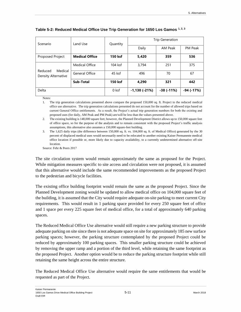
5. Alternatives
Kaiser Permanente
1650 Los Gamos Drive Medical Office Building Project 5-11 March 2018
Draft EIR
Table 5-2: Reduced Medical Office Use Trip Generation for 1650 Los Gamos 1, 2, 3
Scenario Land Use Quantity
Trip Generation
Daily AM Peak PM Peak
Proposed Project Medical Office 150 ksf 5,420 359 536
Reduced Medical
Density Alternative
Medical Office 104 ksf 3,794 251 375
General Office 45 ksf 496 70 67
Sub-Total 150 ksf 4,290 321 442
Delta 0 ksf -1,130 (-21%) -38 (-11%) -94 (-17%)
Notes:
1. The trip generation calculations presented above compare the proposed 150,000 sq. ft. Project to the reduced medical
office use alternative. The trip generation calculations presented do not account for the number of allowed trips based on
current General Office entitlements. As a result, the Project’s actual trip generation numbers for both the existing and
proposed uses (for daily, AM Peak and PM Peak) are/will be less than the values presented above.
2. The existing building is 148,000 square feet; however, the Planned Development District allows up to 150,000 square feet
of office space, so for the purpose of the analysis and to remain consistent with the proposed Project’s traffic analysis
assumptions, this alternative also assumes a 150,000 square-feet building.
3. The 1,625 daily trips (the difference between 150,000 sq. ft. vs. 104,000 sq. ft. of Medical Office) generated by the 30
percent of displaced medical uses would necessarily need to be relocated to another existing Kaiser Permanente medical
office location if possible or, more likely due to capacity availability, to a currently undetermined alternative off-site
location.
Source: Fehr & Peers 2017
The site circulation system would remain approximately the same as proposed for the Project.
While mitigation measures specific to site access and circulation were not proposed, it is assumed
that this alternative would include the same recommended improvements as the proposed Project
to the pedestrian and bicycle facilities.
The existing office building footprint would remain the same as the proposed Project. Since the
Planned Development zoning would be updated to allow medical office on 104,000 square feet of
the building, it is assumed that the City would require adequate on-site parking to meet current City
requirements. This would result in 1 parking space provided for every 250 square feet of office
and 1 space per every 225 square feet of medical office, for a total of approximately 640 parking
spaces.
The Reduced Medical Office Use alternative would still require a new parking structure to provide
adequate parking on site since there is not adequate space on site for approximately 185 new surface
parking spaces; however, the parking structure contemplated by the proposed Project could be
reduced by approximately 100 parking spaces. This smaller parking structure could be achieved
by removing the upper ramp and a portion of the third level, while retaining the same footprint as
the proposed Project. Another option would be to reduce the parking structure footprint while still
retaining the same height across the entire structure.
The Reduced Medical Office Use alternative would require the same entitlements that would be
requested as part of the Project.
5. Alternatives
Kaiser Permanente
1650 Los Gamos Drive Medical Office Building Project 5-12 March 2018
Draft EIR
5.6.2 Relationship with Project Objectives
The Reduced Medical Office Use alternative would achieve some of the Project objectives. This
alternative would maintain current general office uses on site, but would also allow medical office
uses in roughly 70% of the building as well. General site improvements included as part of the
proposed Project would be included in this alternative; however, major infrastructure
improvements, such as the signalized intersection at Los Gamos, would not be triggered by
increased vehicular trips and therefore would not be required nor implemented. In order to address
the remaining 30% of medical office space removed from this alternative, Kaiser would be required
to find alternative locations that may not be as centrally located or have ease of access or available
parking. As such, this alternative could potentially contribute the same amount of vehicle trips at
the main campus or elsewhere throughout Marin.
5.6.3 Comparative Analysis of the Reduced Medical Office
Alternative
The Reduced Medical Office Use alternative would maintain the existing office building on the
subject site but convert approximately 70% to medical office uses. Under this alternative, the
development of the parking structure would still be required, but off-site traffic and circulation
improvements would not be required. There would continue to be no demolition or change of the
existing office building. The Reduced Medical Office alternative would result in the following
impact levels:
• Land Use: No Impact
• Air Quality: Less than Significant with Mitigation Incorporation
• Greenhouse Gas Emissions: Less than Significant
• Noise: Less than Significant Impact with Mitigation Incorporation
• Transportation and Circulation: Less than Significant
It is unknown at this time if there would be any other impacts if the remaining 30% of the medical
uses were located at alternative locations in the region.
5.6.4 Feasibility
With regard to the Reduced Medical Office alternative, it can be assumed that a reduced medical
office use for Kaiser would limit the overall ability to maximize a centralized MOB with
modernized facilities. As the overall medical use would be reduced by approximately 30%, Kaiser
would be tasked with finding alternative locations or suspend the relocation of additional services.
This may also create a need for additional service and maintenance staff, as well as create additional
internal processes for patient and staffing coordination. Furthermore, Kaiser would be a landlord
to general office uses which could require additional staffing and/or security needs required for
managing tenants on-site. However, the ultimate net benefit/burden is unknown regarding how
these physical and programmatic requirements would impact Kaiser’s overall operational activities.
5. Alternatives
Kaiser Permanente
1650 Los Gamos Drive Medical Office Building Project 5-13 March 2018
Draft EIR
5.7 Alternative 3: Alternate Parking Structure
Location
5.7.1 Principle Characteristics
The Alternate Parking Structure Location Alternative assumes that Kaiser Permanente would
modify and relocate the proposed parking structure to the surface parking lot to the north of the
existing office building (southeast of Los Gamos Drive). This alternative assumes that the proposed
parking spaces required for Kaiser operations would still include up to 476 total spaces. This
alternative would locate the proposed parking structure within the footprint of the existing surface
parking lot to the south of Los Gamos Drive and eliminate the need to disturb the hillside to the
west of the western parcel. This alternative would result in an overall slightly smaller development
footprint but would require additional height to achieve the same parking ratio. This alternative
would displace the mature landscaping vegetation on the alternate site but would retain the mature
landscaping vegetation currently growing around the existing western surface parking lot and
would avoid any impacts to the root systems of the adjacent existing redwoods and other native
trees. The public sanitary sewer main, operated and maintained by the Las Gallinas Valley Sanitary
District would not need to be relocated, which would result decreased disturbance of the hillside
on the west side of Los Gamos Drive. The Alternate Parking Structure Location alternative would
potentially require new ingress and egress driveways off Los Gamos Drive and other vehicular and
circulation infrastructure. Figure 5-1 depicts the potential massing of the alternate parking
structure location in relation to the proposed parking structure.
5.7.2 Relationship with Project Objectives
Although this alternative would result in less short-term construction by eliminating excavation
into the hillside to build the parking structure, it would not offer any significant environmental
advantages in comparison with the proposed Project. This alternative does not avoid or
substantially reduce one or more of the proposed Project’s significant environmental impacts
because it would include the same amount of operational vehicle trips and result in similar impacts
and required mitigation measures. In addition, the Alternate Parking Structure Location alternative
would not meet Project Objective #7, in that it may create a structure that would be significantly
more visibly prominent at the corner of Lucas Valley Road and Los Gamos Drive. As the structure
would need to be taller than the proposed Project, it would be visible from neighboring residential
properties and dominate the view corridors along Lucas Valley Road.
5.7.3 Comparative Analysis of Alternate Parking Structure
Location Alternative
The Alternate Parking Structure Location alternative would still contribute the same amount
of traffic trips as the proposed Project. Impacts to Air Quality, GHG Emissions and
Transportation and Circulation would continue to be potentially significant without mitigation
implementation. Furthermore, the taller parking structure design, located closer to Lucas

5. Alternatives
Kaiser Permanente
1650 Los Gamos Drive Medical Office Building Project 5-14 March 2018
Draft EIR
Figure 5-1: Alternate Parking Structure Location
Source: Kaiser Permanente 2018

5. Alternatives
Kaiser Permanente
1650 Los Gamos Drive Medical Office Building Project 5-15 March 2018
Draft EIR
Valley Road and without the aid of existing screen trees could potentially present a new visual
impact. Although the City of San Rafael would require design review approval, this alternate
location would create new mass and bulk in an area that currently includes mature landscape
vegetation. In addition, this location would potentially be more visible from residents along
Salvatore Way. With regard to other potential environmental impacts, the Alternate Parking
Structure Location alternative would result in the following impact levels:
• Land Use: No Impact
• Aesthetics: Less than Significant with Mitigation Incorporation
• Air Quality: Less than Significant with Mitigation Incorporation
• Greenhouse Gas: Less than Significant with Mitigation Incorporation
• Noise: Less than Significant Impact with Mitigation Incorporation
• Transportation and Circulation: Significant and Unavoidable
5.7.4 Feasibility
The Alternate Parking Structure Location alternative would require construction of a smaller
footprint but taller parking structure. However, construction on the eastern surface lot would
require less excavation, grading, and tree removal/protection. The addition of a fourth or
potentially fifth deck to the parking structure would add costs as well as architectural treatments
required to minimize the visual impact of the taller structure in a more prominent location. Traffic
improvements to reduce potentially significant impacts would still be required, therefore, the
Alternate Parking Structure Location alternative could potentially be costlier than the proposed
Project while not reducing any of the potential environmental impacts.
5.8 Alternative 4: Applicant-Implemented Traffic
Improvements
5.8.1 Principle Characteristics
Under the Applicant-Implemented Traffic Improvements Alternative, Kaiser Permanente would
voluntarily undertake the cost of specific traffic and infrastructure improvements above and beyond
what is required by the City’s General Plan and the Project’s identified fair-share contribution to
improve intersection operations at Lucas Valley Road and Los Gamos Drive and the US 101
southbound and northbound ramps.
As discussed in the Fehr & Peers 1650 Los Gamos Drive Final Traffic Impact Analysis (FTIA), the
proposed Project would contribute vehicular trips to the Lucas Valley Road/Los Gamos Drive
intersection and result in a deterioration of the level of service (LOS), thus causing significant
impacts. Based on significance criteria adopted in the City of San Rafael General Plan 2020,
Kaiser Permanente would be required to mitigate for the impact. Mitigation measures MM TRAF-
1, MM TRAF-3, and MM TRAF-4 in Chapter 4.6 Transportation and Circulation of this DEIR
identify improvements that would improve impacted intersections and reduce potential adverse
effects to less than significant levels. However, implementation of the mitigation measures requires
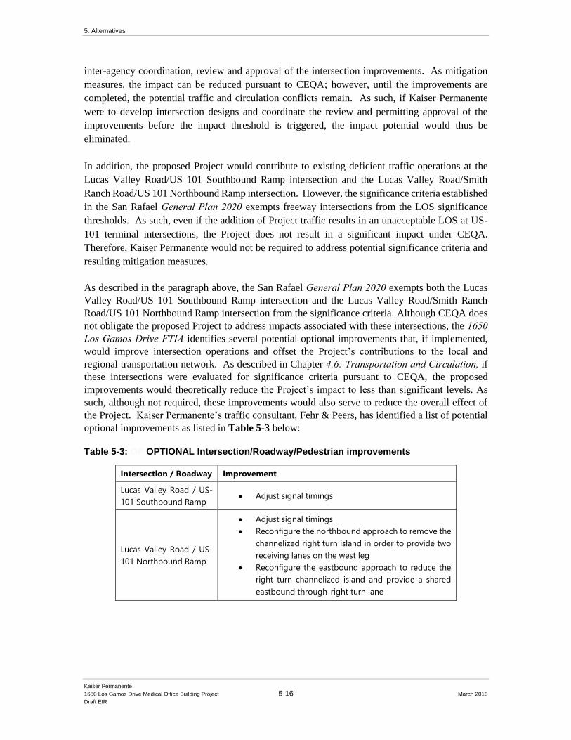
5. Alternatives
Kaiser Permanente
1650 Los Gamos Drive Medical Office Building Project 5-16 March 2018
Draft EIR
inter-agency coordination, review and approval of the intersection improvements. As mitigation
measures, the impact can be reduced pursuant to CEQA; however, until the improvements are
completed, the potential traffic and circulation conflicts remain. As such, if Kaiser Permanente
were to develop intersection designs and coordinate the review and permitting approval of the
improvements before the impact threshold is triggered, the impact potential would thus be
eliminated.
In addition, the proposed Project would contribute to existing deficient traffic operations at the
Lucas Valley Road/US 101 Southbound Ramp intersection and the Lucas Valley Road/Smith
Ranch Road/US 101 Northbound Ramp intersection. However, the significance criteria established
in the San Rafael General Plan 2020 exempts freeway intersections from the LOS significance
thresholds. As such, even if the addition of Project traffic results in an unacceptable LOS at US-
101 terminal intersections, the Project does not result in a significant impact under CEQA.
Therefore, Kaiser Permanente would not be required to address potential significance criteria and
resulting mitigation measures.
As described in the paragraph above, the San Rafael General Plan 2020 exempts both the Lucas
Valley Road/US 101 Southbound Ramp intersection and the Lucas Valley Road/Smith Ranch
Road/US 101 Northbound Ramp intersection from the significance criteria. Although CEQA does
not obligate the proposed Project to address impacts associated with these intersections, the 1650 Los Gamos Drive FTIA identifies several potential optional improvements that, if implemented,
would improve intersection operations and offset the Project’s contributions to the local and
regional transportation network. As described in Chapter 4.6: Transportation and Circulation, if these intersections were evaluated for significance criteria pursuant to CEQA, the proposed
improvements would theoretically reduce the Project’s impact to less than significant levels. As
such, although not required, these improvements would also serve to reduce the overall effect of
the Project. Kaiser Permanente’s traffic consultant, Fehr & Peers, has identified a list of potential
optional improvements as listed in Table 5-3 below:
Table 5-3: OP OPTIONAL Intersection/Roadway/Pedestrian improvements
Intersection / Roadway Improvement
Lucas Valley Road / US-
101 Southbound Ramp • Adjust signal timings
Lucas Valley Road / US-
101 Northbound Ramp
• Adjust signal timings
• Reconfigure the northbound approach to remove the
channelized right turn island in order to provide two
receiving lanes on the west leg
• Reconfigure the eastbound approach to reduce the
right turn channelized island and provide a shared
eastbound through-right turn lane

5. Alternatives
Kaiser Permanente
1650 Los Gamos Drive Medical Office Building Project 5-17 March 2018
Draft EIR
Los Gamos Drive
• Install high-visibility crosswalk with rapid rectangular
flashing beacon (RRFB) adjacent the proposed
parking structure pedestrian exit
• Shift Los Gamos Drive crosswalk and pedestrian
bridge on the east side of Los Gamos Drive to meet
the pedestrian exit at the proposed parking structure
Lucas Valley Road
• Improve the south side sidwalk between Los Gamos
Drive the US-101 Southbound Ramp intersections
• Improve the pedestrian path from the 1650 Los
Gamos Drive surface parking lot with to the Lucas
Valley Road / US-101 Ramp intersection with new
sidewalk and pedestrian lighting
Although Kaiser Permanente is not fully responsible under CEQA for implementing and/or funding
the noted optional improvements above, this Applicant-Implemented Traffic Improvements
Alternative would commit Kaiser Permanente to providing upfront funding to the City above its
fair-share contribution to construct these identified intersection improvements, subject to a
memorandum of understanding (MOU) and/or a reimbursement agreement. This alternative would
also increase community benefits and would address transportation impacts that are not considered
significant under the CEQA thresholds associated with the proposed Project impacts by ensuring
that suitable intersection/roadway improvements, or funding for such improvements, are provided.
5.8.2 Relationship with Project Objectives
The Applicant-Implemented Traffic Improvements Alternative would achieve all of the basic
objectives listed above. In addition, because this alternative would be providing up-front
improvements that would improve the existing vehicular and pedestrian circulation network, some
of the Project objectives would be further enhanced, including Objective #6. As a community
benefit, Kaiser would take the initiative to design, coordinate, and obtain permit approval for the
improvements listed above, and would thereby increase the functionality and safety of the local
circulation network. These improvements would reduce significant and unavoidable impacts and
would achieve all of the stated Project objectives.
5.8.3 Comparative Analysis of Applicant-Implemented
Traffic Improvements Alternative
The Applicant-Implemented Traffic Improvements Alternative would still contribute the same
amount of traffic trips as the proposed Project. However, impacts to Transportation and
Circulation would be reduced to less than significant, while impacts to Air Quality and GHG
Emissions would continue to be potentially significant without mitigation implementation.
With regard to other potential environmental impacts, the Applicant-Implemented Traffic
Improvements Alternative would result in the following impact levels:
5. Alternatives
Kaiser Permanente
1650 Los Gamos Drive Medical Office Building Project 5-18 March 2018
Draft EIR
• Land Use: No Impact
• Air Quality: Less than Significant with Mitigation Incorporation
• Greenhouse Gas: Less than Significant with Mitigation Incorporation
• Noise: Less than Significant with Mitigation Incorporation
• Traffic: Less than Significant (Lucas Valley Road / Los Gamos Drive intersection);
Significant and Unavoidable (Las Gallinas / Lucas Valley Road intersection)
5.8.4 Feasibility
The Applicant-Implemented Traffic Improvements Alternative provides more efficient and
improved intersection operations. In addition to principally addressing Objective #6 above, the
alternative would meet all of Kaiser Permanente’s main project objectives. Furthermore, this
alternative reduces the Project’s environmental impacts without requiring mitigation to reduce
potential impacts specific to traffic impacts. Although the alternative generally meets the Project
objectives and furthers community support of improved highway access and circulation, it would
require Kaiser Permanente to incur significant up-front costs to fund the improvements. The up-
front expenditures could potentially impact Kaiser Permanente’s operating budget and could
potentially impact its ability to provide affordable health care to the members and the communities
it serves (in conflict with Project Objective #1). However, Kaiser Permanente’s Marin membership
base and local community members would benefit from the improvements.
5.9 Environmentally Superior Alternative
CEQA Guidelines requires that an EIR identify an environmentally superior alternative (CEQA
Guidelines, Section 15126.6), which is the CEQA alternative that reduces or avoids the
environmental impacts identified for the Project to the greatest extent. The evaluation below first
considers the extent to which each of the CEQA alternatives reduces or avoids the significant and
unavoidable impacts identified for the proposed Project. These impacts are listed in Section 5.2.2.
The extent to which an alternative reduces or avoids the Project’s less-than-significant impacts, as
well as its potentially significant impacts that can be adequately mitigate, is also considered,
balanced by the relative degree to which the impact affects the physical environment.
5.9.1 No Project / No Medical Uses Alternative
As discussed in Section 5.5 the No Project/No Medical Uses Alternative would avoid all local
impacts identified with the Project for all environmental topics, including all significant and
unavoidable impacts identified in Section 5.2.2 above. Existing uses at the main campus at 99
Montecillo and potential new location(s) elsewhere in Marin County would remain. Although no
new local environmental impacts would occur as a result of the No Project / No Medical Uses
Alternative, there may be unknown new impacts at other locations due to ongoing operations and/or
expansion of services to alternative location(s). However, because the existing office building at
1650 Los Gamos Drive would remain as is, no parking structure would be required, and no local
traffic or circulation impacts would occur. The No Project / No Medical Uses Alternative would
5. Alternatives
Kaiser Permanente
1650 Los Gamos Drive Medical Office Building Project 5-19 March 2018
Draft EIR
avoid the potentially significant impacts specific to traffic and circulation (Impact TRAF-1 and
Impact TRAF-3), construction noise (NOI-1) and intersection and roadway segments (Impact
TRA-4). However, the No Project / No Medical Uses Alternative would fail to achieve the basic
goals and objectives of the Project (listed in Section 5.2.1).
5.9.2 Applicant-Implemented Traffic Improvements
Alternative
Per Section 15126.6(e)(2), if the environmentally superior alternative is the “no project” alternative,
the EIR shall also identify an environmentally superior alternative among the other alternatives. In
this case, as discussed in Section 5.8, the Applicant-Implemented Traffic Improvements Alternative
would avoid the significant impacts related to traffic impacts identified with the project, including
Impact TRAF-1 and Impact TRAF-4, by voluntarily gaining approvals and constructing the
intersection improvements at the Lucas Valley Road and Los Gamos Drive intersection.
Environmental impacts associated with other potential areas of concern, including air quality and
greenhouse gas emissions, can be mitigated to less than significant levels in this alternative. The
Applicant-Implemented Traffic Improvements Alternative would achieve (and enhance) all of the
main objectives of the proposed Project but would require increased investment and expenditure
by the Kaiser Permanente. However, Impact TRAF-3 would remain significant and unavoidable
for reasons discussed in Chapter 4.6 Transportation and Circulation due to the fact that the
mitigation measures identified are not proposed to be implemented by Marin County in the near
future. Regardless, this alternative, because it would significantly reduce potential impacts to the
local circulation network, especially impacts to the Los Gamos Drive / Lucas Valley Road
intersection, is considered the environmentally superior alternative.
5. Alternatives
Kaiser Permanente
1650 Los Gamos Drive Medical Office Building Project 5-20 March 2018
Draft EIR
This page intentionally left blank
Kaiser Permanente
1650 Los Gamos Drive Medical Office Building Project 6-1 March 2018
Draft EIR
CHAPTER 6
Impact Overview
Pursuant to State CEQA Guidelines, this section summarizes the significant and unavoidable and
cumulative effects identified in the DEIR, the potential for growth inducement from the Project,
significant irreversible environmental effects, and effects found not to be significant.
6.1 Significant and Unavoidable Impacts
Pursuant to CEQA Guidelines Section 15126.2(b), this DEIR has identified specific significant
environmental effects that cannot be avoided if the Project is implemented (see “Significant and
Unavoidable (SU)” in Section 4.0.3, Impact Classifications, in Chapter 4.0), as follows:
1. Impact TRAF-1: Implementation of the Project would increase traffic volumes on area
roadways and affect levels of service at the local intersections and freeways under Existing
plus Project Conditions.
2. Impact TRAF-3: The Project would contribute to deficient operations of the Lucas
Valley Road/Las Gallinas Avenue by increasing the average delay by more than five
seconds under Baseline plus Project conditions.
3. Impact TRAF-4: The Project would contribute to deficient operations of the Lucas
Valley Road/Las Gamos Drive intersection by increasing the average delay by more
than five seconds under Baseline plus Project conditions.
4. Impact TRAF-5. The addition of Project-related traffic would exacerbate the
Cumulative No Project condition and contribute more than 5 seconds of delay at the
Lucas Valley Road/Las Gallinas Avenue intersection.
As identified in Chapter 4.6 Transportation and Circulation, the basis for the significant and
unavoidable conclusion specific to transportation and circulation impacts, is because proposed
mitigation measures can only take into account a fair-share contribution from Kaiser Permanente to
address environmental impacts. In order to fully mitigate the Project’s affect, Kaiser Permanente,
the City of San Rafael, the County of Marin, and potentially Caltrans, must design, permit, and
construct the intersection improvements prior to final occupancy of the new MOB. As detailed in
Chapter 5, Alternative 4: Applicant-Implemented Traffic Improvements would reduce the
significance status of the Los Gamos Drive/Lucas Valley Road intersection because Kaiser
Permanente would be voluntarily responsible for designing and constructing the intersection
improvements as part of the overall Project entitlements. The Lucas Valley Road/Los Gallinas
Avenue intersection would continue to operate at an unacceptable level, however, as there is no
design or program in place in the County of Marin to address a redevelopment of the intersection.
6. Impact Overview
Kaiser Permanente
1650 Los Gamos Drive Medical Office Building Project 6-2 March 2018
Draft EIR
Pursuant to CEQA Guidelines Section 21081 (a) and (b), the City of San Rafael can approve the
Project on the basis that the proposed intersection improvements: (1) would be funded via the
appropriate mitigation measures requiring Kaiser Permanente’s fair share contribution; (2) would
need to be authorized by the County of Marin, and; (3) the economic and social benefits of the
Project outweigh the significant effects on the environment. In short, the intersection improvements
have been identified as required, yet the overall design and construction require further coordination
and approval from the City of San Rafael, Marin County, and Caltrans regardless of the Project’s
contribution to the traffic and circulation network. Therefore, these impacts are characterized as
significant and unavoidable.
The significant and avoidable impacts for the Project are identified in the environmental topic
sections included in Chapter 4.6 and are included in Table 2-1, Summary of Impacts, Mitigation
Measures, in Chapter 2.
6.2 Significant Irreversible Environmental Changes
Pursuant to CEQA Guidelines Section 21100(b)(2)(B) an EIR shall include a discussion of
significant irreversible environmental changes that would result from implementation of a project.
CEQA Guidelines Section 15126.2(c) describes irreversible environmental changes in the
following manner: “Uses of nonrenewable resources during the initial and continued phases of
the Project may be irreversible since a large commitment of such resources makes removal or
nonuse thereafter unlikely. Primary impacts and, particularly, secondary impacts (such as
highway improvement which provides access to a previously inaccessible area) generally commit
future generations to similar uses. Also, irreversible damage can result from environmental
accidents associated with the Project. Irretrievable commitments of resources should be evaluated
to assure that such current consumption is justified.”
Construction activities associated with the Project would result in an irretrievable and irreversible
commitment of non-renewable resources through the use of construction materials. This would
include the use of fossil fuels (such as gasoline, diesel and oil) during the construction period, and
the use of earth minerals and ores (such as concrete and steel). The Project would construct a new
parking structure and implement associated traffic infrastructure mitigation measure
improvements in areas that have already been developed, as well as build out the existing
building at 1650 Los Gamos Drive with new medical offices. Although off-site roadway
improvements are required, the overall scope of the improvements have been previously
identified in the San Rafael General Plan 2020; therefore, the Project would not modify regional
access or result in access to a previously inaccessible area. As a proposed medical office use the
Project is not characteristic of a land use type that would result in disturbance or land
modifications that could lead to irreversible environmental damage.
6. Impact Overview
Kaiser Permanente
1650 Los Gamos Drive Medical Office Building Project 6-3 March 2018
Draft EIR
6.3 Cumulative Impact
Pursuant to CEQA Guidelines Section 15065(a)(3), cumulative impacts are defined as occurring
when “the project has possible environmental effects that are individually limited but
cumulatively considerable. “Cumulatively considerable” means that the incremental effects of an
individual project are significant when viewed in connection with the effects of past projects, the
effects of other current projects, and the effects of probable future projects. Sections 15130 of the
CEQA Guidelines requires that an EIR evaluate potential environmental impacts that are
individually limited, but cumulatively significant.
Each environmental topic as analyzed in Chapter 4, includes a cumulative analysis at the
conclusion of each discussion. The City of San Rafael requires all projects to contribute traffic
mitigation fees as part of the entitlement process. These fees are allocated to planned
transportation improvements to address cumulative impacts associated with City-wide traffic
impacts. The proposed Project will contribute the required fees as a condition of final approval.
Therefore, contribution of the required fees and implementation of the mitigation measures
included in this DEIR ensure that the Project will not have a cumulatively significant impact.
As detailed in Chapter 4, there are no impacts that would be considered cumulatively significant
and therefore, the Project, as a whole, would not result in any cumulatively significant impacts.
6.4 Growth Inducement
Pursuant to CEQA Guidelines Section 15126.2(d), a project is considered growth-inducing if it
would directly or indirectly foster economic or population growth, or the construction of
additional housing, either directly or indirectly, in the surrounding environment. Examples of
projects likely to have significant growth-indicting impacts include extensions of expansions of
infrastructure systems beyond what is needed to serve project-specific demand, and development
of new residential subdivisions or industrial parks in areas that are currently only sparsely
developer or are undeveloped. Typically, redevelopment projects on infill sites that are
surrounded by existing urban uses are not considered growth-inducing because redevelopment by
itself usually does not facilitate development intensification on adjacent sites.
The proposed Project would feature a new use and intensity on the site (medical office)
previously developed for a similar use (general office). This new type of use is consistent with
the existing pattern of commercial uses in the surrounding area. The intensification of use, as
defined, is consistent with the City of San Rafael General Plan 2020 designation for the subject
property and is generally allowed in the office land use designation, although not allowed by the
current PD Zoning for the Project site. Therefore, the range of potential environmental impacts,
including growth-inducing impacts, considered in the San Rafael General Plan 2020 EIR for
development in the North San Rafael Commercial Center have been evaluated. Furthermore, the
proposed Project includes the relocation of specific existing services from areas throughout the
City of San Rafael and Marin County. As a result, the project is not considered growth-inducing.
6. Impact Overview
Kaiser Permanente
1650 Los Gamos Drive Medical Office Building Project 6-4 March 2018
Draft EIR
6.5 Effects Found not to be Significant
The City of San Rafael prepared an Initial Study for the proposed Project in June 2017 and
determined that the Project would have no impact, less than significant impact, or less than
significant impact after mitigation to the following environmental topics: agriculture resource,
biological resources, cultural resources, geology and soils, hazards and hazardous resources,
hydrology and water quality, mineral resources, population and housing, public services,
recreation, tribal cultural resources, and utilities and service systems. The impact and mitigation
measures included in the Initial Study are listed in Table 2-2 in Chapter 2 of this DEIR. The
Initial Study is provided in Appendix B to this DEIR. The Initial Study also determined that an
EIR should be prepared due to the Project’s potentially significant impact upon, land use and
planning, aesthetics, air quality, greenhouse gas emissions, noise and traffic and circulation. An
NOP to solicit public comments about the scope of the EIR was circulated on June 9, 2017, and a
public Scoping Hearing was held on July 10, 2017. Written comments received on the NOP and
public comments received during the scoping hearing were considered in the preparation of the
final scope for this document and evaluation of the proposed Project. As documented in this
DEIR, potentially significant impacts regarding land use and planning, aesthetics, air quality,
greenhouse gas emissions, and noise have been determined to be less than significant and/or less
than significant after implementation of mitigation measures contained herein.
Kaiser Permanente
1650 Los Gamos Drive Medical Office Building Project 7-1 March 2018
Draft EIR
CHAPTER 7
Report Preparation
7.1 Lead Agency
City of San Rafael
Community Development Department
1400 5th Street, Third floor
San Rafael, CA 94915
Raffi Boloyan, Planning Manager
7.2 Other Agencies/Persons Consulted
California Department of Transportation
Caltrans District 4
111 Grand Ave
Oakland, Ca 94612
Patricia Maurice, District Branch Chief
County of Marin
Department of Public Works
3501 Civic Center, Suite 304
San Rafael, Ca 94903
Berenice Davidson, Principal Civil Engineer
Robert Goralka, Traffic Engineer
7.3 Environmental Consultants
EIR Preparer
LAK Associates, LLC
PO Box 7043
Corte Madera, CA 94976
Sean Kennings, planning consultant
Transportation Consultant
Parisi Transportation Consulting
1750 Bridgeway, Suite B208

7.Report Preparation
Kaiser Permanente
1650 Los Gamos Drive Medical Office Building Project 7-2 March 2018
Draft EIR
Sausalito, CA 94965
Andre Lee, Traffic Engineer
Technical Subconsultants
Illingworth & Rodkin
505 Petaluma boulevard South
Petaluma, CA 94952
Michael Thill, Noise Analyst
James Reyff, Air Quality and Greenhouse Gas Emissions
Project Applicant Team
Kaiser Permanente
National Facilities Services - Kaiser Permanente
Kaiser Foundation Health Plan, Inc.
1950 Franklin Street - 12th Floor
Oakland, CA 94612
Catherine Reilly, Senior Land Use Manager
Fehr & Peers
Transportation Engineers
332 Pine Street, 4th Floor
San Francisco, CA 94104
Sarah Nadiranto Chan, PE TE, Senior Transportation Engineer
Design/Build Entity
C. Overaa & Co.
200 Parr Blvd.
Richmond, CA 94801
Colby Powell, Project Director
Parking & Structural Design
Walker Parking Consultants
601 California Street, Suite 820
San Francisco, CA 94108
Justin Chang, Principal Designer
Architecture & Renderings
Polytech Associates, Inc.
235 Pine Street, 17th Floor
San Francisco, CA 94104
Mehrnoush, Asanjani, Project Architect

7.Report Preparation
Kaiser Permanente
1650 Los Gamos Drive Medical Office Building Project 7-3 March 2018
Draft EIR
7.4 References
City of San Rafael
City of San Rafael Community Development Agency, 2017. San Rafael General Plan 2020,
available online at https://www.cityofsanrafael.org/generalplan-2020, adopted 2004.
City of San Rafael Community Development Agency, 2017. San Rafael Municipal Code, available online at
https://library.municode.com/ca/san_rafael/codes/codes_of_ordinances?nodeld=TIT14ZO
City of San Rafael, 2009. San Rafael Climate Change Action Plan, adopted April 20, 2009; San Rafael Qualified Greenhouse Gas Emission Reduction Strategy, adopted April 2011
City of San Rafael, 2011 Addendum (No. 2), to San Rafael General Plan 2020, Environmental Impact Report (Sch # 2003052031) June 2011
Land Use and Planning
Association of Bay Area Governments, Metropolitan Transportation Commission, (ABAG, et al),
2013. Plan Bay Area: Regional Transportation Plan and Sustainable Communities Strategy
for the San Francisco Bay Area 2013-2040
Association of Bay Area Governments (ABAG), 2012. Regional Housing Need Plan for the San Francisco Bay Area: 2014‐2022, June.
ABAG, Plan Bay Area 2040 Final Plan, July 2017,
Marin County Local Agency Formation Commission (LAFCO), 2006. San Rafael Area Service
Review and Sphere of Influence Update, January.
Marin County Community Development Agency (MCDA), 2015. Marin Countywide Plan,
available online at http://www.co.marin.ca.us/depts/cd/divisions/planning/plans-policies-
and-regulations, adopted November 6.
Marin County, 2015-2023. Marin County Housing Element, December 2014
Aesthetics
California Department of Transportation, 2011. Scenic Highway Guidelines. Website:
http://www.dot.ca.gov/hq/LandArch/scenic/guidelines/scenic_hwy_guidelines.pdf; accessed July
13, 2017.
Association of Bay Area Governments (ABAG), Not dated (ND). Blueprint 2001 for Bay Area Housing, Section 1-How to Prepare an Effective Housing Element: Analyzing Needs,
Resources, and Constraints (pp. 1-18). Available online at:
http://www.abag.ca.gov/planning/housingneeds/blueprint.html, accessed September 2011.
7.Report Preparation
Kaiser Permanente
1650 Los Gamos Drive Medical Office Building Project 7-4 March 2018
Draft EIR
Association of Bay Area Governments and Metropolitan Transportation Commission (ABAG and
MTC), 2011. Plan Bay Area: Initial Vision Scenario for Public Discussion, Executive
Summary, March 11.
Air Quality
Illingworth and Rodkin, Inc., 2017. 1650 Los Gamos Drive Air Quality and Greenhouse Gas Emissions Assessment, San Rafael, California, prepared for LAK Associates, LLC.,
February 16, 2018.
Bay Area Air Quality Management District (BAAQMD), 2017. Final 2017 Clean Air Plan
website, adopted April 19, 2017.
BAAQMD, 2017. Bay Area Air Pollution Summary – 2012-2016.
BAAQMD, 2017. California Environmental Quality Act Air Quality Guidelines, May 2017.
California Air Resources Board (CARB), 2014a. Ambient Air Quality Standards, last updated
September 8, 2014.
CARB, 2014b. Proposed Amendments to the Regulation for In-Use Off-Road Diesel-Fueled Fleets and the Off-Road Large Spark-Ignition Fleet Requirements, Appendix D: OSM and
Summary of Off-Road Emissions Inventory Update, October.
Greenhouse Gases and Climate Change
Illingworth & Rodkin, Inc., 2018. Kaiser Permanente 1650 Los Gamos Medical Office Building Project, Air Quality and Greenhouse Gas Emissions Assessment, San Rafael, California,
prepared for LAK Associates., February 16, 2018.
Intergovernmental Panel on Climate Change (IPCC), 2014. Summary for Policymakers, Climate Change 2007: The Physical Science Basis. Contribution of Working Group I to the Fifth Assessment Report of the Intergovernmental Panel on Climate Change (Solomon, S., D.
Qin, M. Manning, Z. Chen, M. Marquis, K.B. Averyt, M. Tignor and H.L. Miller (eds.).
Cambridge University Press, Cambridge, United Kingdom and New York, NY, USA
Bay Area Air Quality Management District (BAAQMD), 2017. Final 2017 Clean Air Plan
website, adopted April 19, 2017.
BAAQMD, 2017. California Environmental Quality Act Air Quality Guidelines, May 2017.
California Air Resources Board (CARB) California GHG Emission Inventory, available online at:
https://www.arb.ca.gov/cc/inventory/pubs/reports/2000_2015/ghg_inventory_trends_00-
15.pdf , June 6, 2017
U.S. Environmental Protection Agency (US EPA), 2016. Inventory of U.S. Greenhouse Gas Emissions and Sinks: 1990-2014, Executive Summary, available online at:
https://www.epa.gov/sites/production/files/2017-04/documents/us-ghg-inventory-2016-
chapter-executive-summary.pdf, accessed December 7, 2017.
7.Report Preparation
Kaiser Permanente
1650 Los Gamos Drive Medical Office Building Project 7-5 March 2018
Draft EIR
Noise
Illingworth & Rodkin, Inc., 2018. Kaiser Permanente 1650 Los Gamos Medical Office Building Project, Noise and Vibration Assessment, San Rafael, California, prepared for LAK
Associates., February 27, 2018.
Transportation and Circulation
Fehr & Peers Transportation Consultants, 2018. 1650 Los Gamos Drive Final Traffic Impact Analysis, February 2018.
California Department of Transportation (Caltrans), 2010. California Manual on Uniform Traffic Control Devices (MUTCD), Revision 2, amended April 7, 2017.
Golden Gate Transit, 2017. Transit Schedules, Routes 44, 54, 58, 70.
Institute of Transportation Engineers (ITE), 2010. Parking Generation, 4th Edition, Land Use
Codes: Clinic (#630) and Government Office Building (#730).
MCDA, 2007b Marin Countywide Plan Update, Final Environmental Impact Report, Section
4.2 Transportation, November 2007.
Marin County, Department of Public Works, 2002. Marin Countywide Plan, Built
Environmental Element Transportation Technical Report #1, July.
Marin Transit, 2017. Route 35, 49
Metropolitan Transportation Commission (MTC), 2009. Transportation 2035 Plan for the San Francisco Bay Area—Travel Forecasts Data Summary, April.
Transportation Authority of Marin (TAM), 2014a. Marin Congestion Management Program 2014 Update, September 11.
Transportation Authority of Marin (TAM), 2014b. Marin County Congestion Management Transportation System Performance Monitoring Report 2014.
Transportation Research Board (TRB), Highway Capacity Manual 2010, signalized Intersection Level of Service, December 2010.