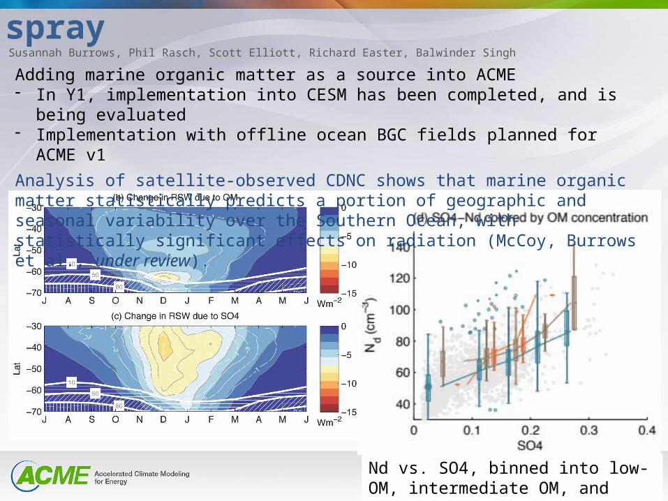
marine organic matter in sea spray nd vs. so4, binned into low-om, intermediate om, and high-om...
TRANSCRIPT
Marine organic matter in sea spray
Nd vs. SO4, binned into low-OM, intermediate OM, and high-OM groups
Adding marine organic matter as a source into ACME- In Y1, implementation into CESM has been completed, and is being evaluated- Implementation with offline ocean BGC fields planned for ACME v1
Analysis of satellite-observed CDNC shows that marine organic matter statistically predicts a portion of geographic and seasonal variability over the Southern Ocean, with statistically significant effects on radiation (McCoy, Burrows et al., under review).
Susannah Burrows, Phil Rasch, Scott Elliott, Richard Easter, Balwinder Singh
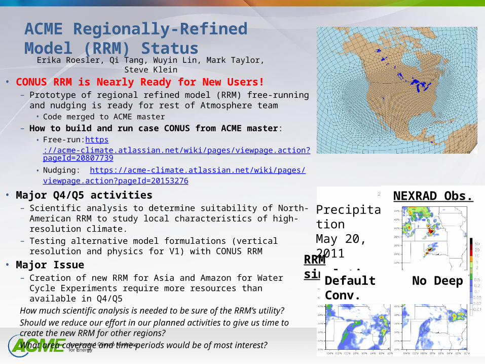
ACME Regionally-Refined Model (RRM) Status
• CONUS RRM is Nearly Ready for New Users!– Prototype of regional refined model (RRM) free-running and
nudging is ready for rest of Atmosphere team• Code merged to ACME master
– How to build and run case CONUS from ACME master:• Free-run:https
://acme-climate.atlassian.net/wiki/pages/viewpage.action?pageId=20807739
• Nudging: https://acme-climate.atlassian.net/wiki/pages/viewpage.action?pageId=20153276
• Major Q4/Q5 activities– Scientific analysis to determine suitability of North-American
RRM to study local characteristics of high-resolution climate.– Testing alternative model formulations (vertical resolution and
physics for V1) with CONUS RRM
• Major Issue– Creation of new RRM for Asia and Amazon for Water Cycle
Experiments require more resources than available in Q4/Q5
How much scientific analysis is needed to be sure of the RRM’s utility?
Should we reduce our effort in our planned activities to give us time to create the new RRM for other regions?
What area coverage and time-periods would be of most interest?
Erika Roesler, Qi Tang, Wuyin Lin, Mark Taylor, Steve Klein
PrecipitationMay 20, 2011
RRM simulations
Default No Deep Conv.
NEXRAD Obs.
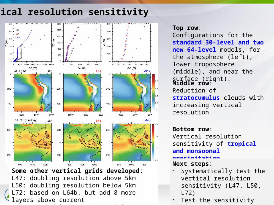
Top row: Configurations for the standard 30-level and two new 64-level models, for the atmosphere (left), lower troposphere (middle), and near the surface (right).
Vertical resolution sensitivity
Bottom row: Vertical resolution sensitivity of tropical and monsoonal precipitation
Middle row: Reduction of stratocumulus clouds with increasing vertical resolution
Next steps:- Systematically test the vertical
resolution sensitivity (L47, L50, L72)- Test the sensitivity with new model
physics (e.g., aerosol, cloud, convection)
Some other vertical grids developed:L47: doubling resolution above 5kmL50: doubling resolution below 5kmL72: based on L64b, but add 8 more layers above current model top (raise model top to 0.1 hPa)
Applications of Simulators in ACME
Plan for Q4 and Q5: Upgrade COSP and implement aerosol lidar simulator in ACME model Make cloud collection of COSP diagnostics functioning and perform the testing
for the AMIP ensemble runs of ACME model v0.1 As part of Convection task, examine the cloud simulations from the candidate
convection schemes through simulator diagnostics
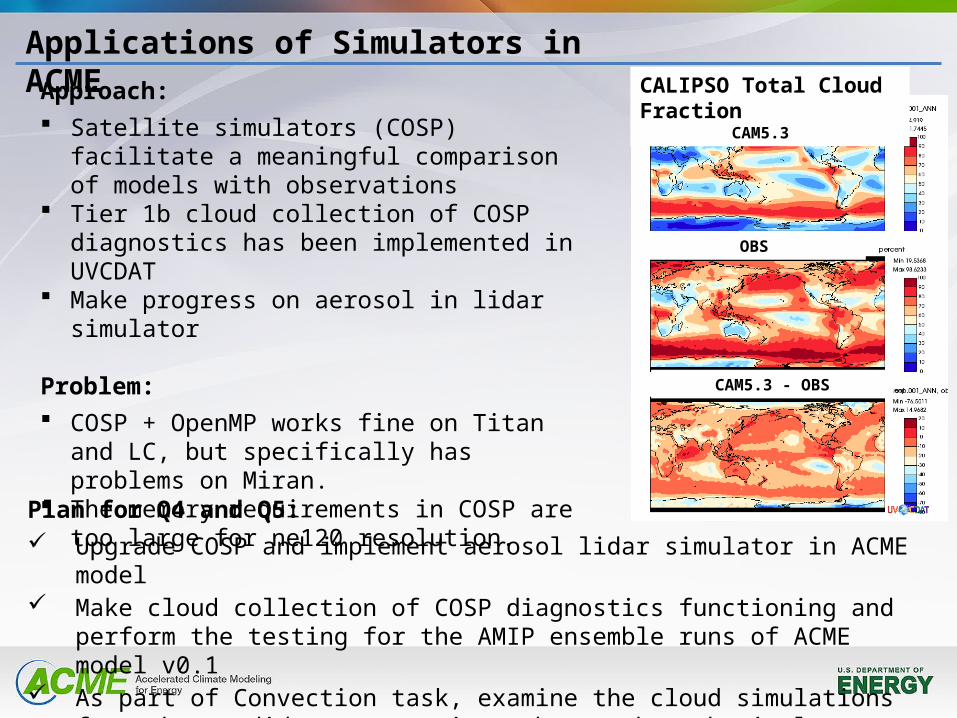
CALIPSO Total Cloud FractionCAM5.3
OBS
CAM5.3 - OBS
Approach: Satellite simulators (COSP) facilitate a
meaningful comparison of models with observations
Tier 1b cloud collection of COSP diagnostics has been implemented in UVCDAT
Make progress on aerosol in lidar simulator
Problem: COSP + OpenMP works fine on Titan and LC, but
specifically has problems on Miran. The memory requirements in COSP are too large
for ne120 resolution.
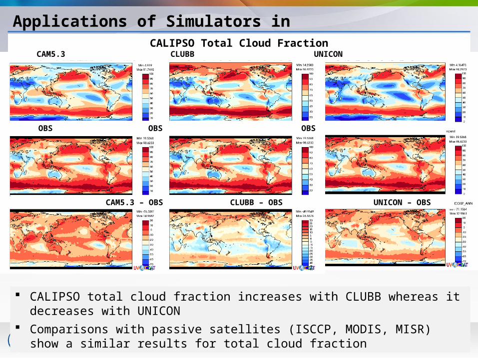
Applications of Simulators in ACME
OBS OBS OBS
CAM5.3 – OBS CLUBB – OBS UNICON – OBS
CALIPSO Total Cloud FractionCAM5.3 CLUBB UNICON
CALIPSO total cloud fraction increases with CLUBB whereas it decreases with UNICON
Comparisons with passive satellites (ISCCP, MODIS, MISR) show a similar results for total cloud fraction
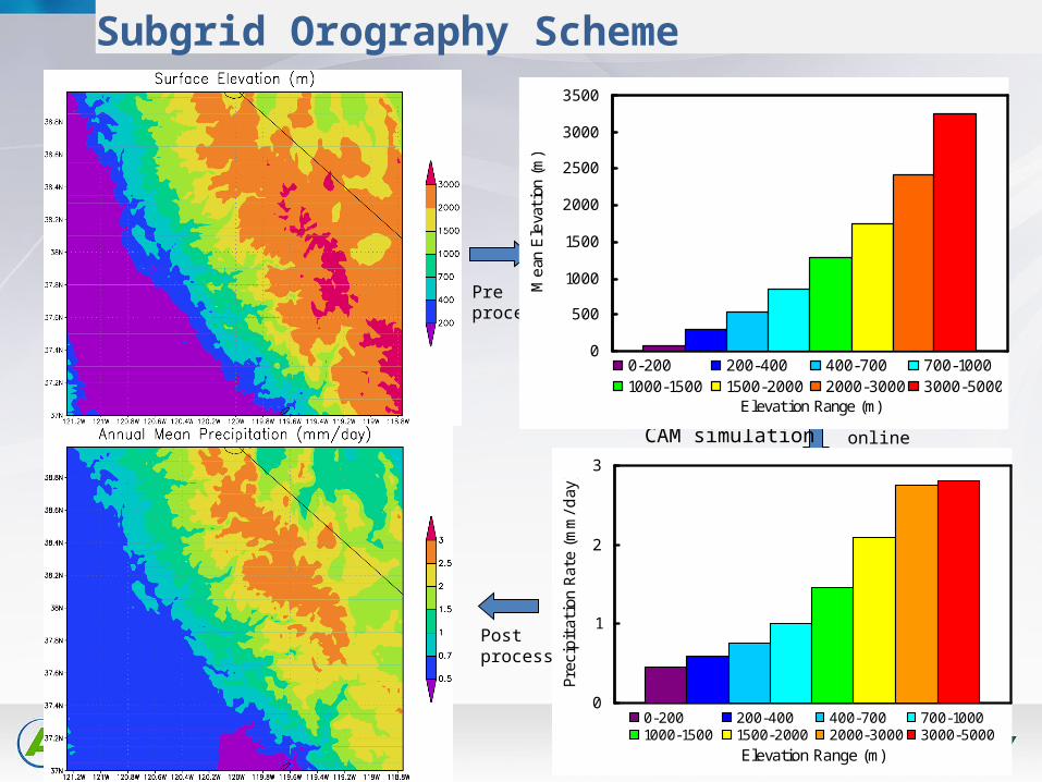
Subgrid Orography Scheme
0
1
2
3
Elevation Range (m)
Prec
ipit
atio
n Rat
e (m
m/d
ay)
0-200 200-400 400-700 700-10001000-1500 1500-2000 2000-3000 3000-5000
0
500
1000
1500
2000
2500
3000
3500
Elevation Range (m)
Mea
n E
leva
tion
(m
)
0-200 200-400 400-700 700-10001000-1500 1500-2000 2000-3000 3000-5000
Preprocess
online physics
Post process
input dataset
CAM simulation
CAM history
Code Changes
• Unlike any other parameterization– All column physics applied to each elevation class
• Mostly manifest at higher levels– phys_grid– phys_types– dp_coupling– history

Challenges
• Breaking the assumption that physics and dynamics apply to the same columns
• Distributing the heterogeneous number of physics columns across nodes
• Mapping between atmosphere and land on different grids• Passing information through the coupler• Accommodating a variable ice sheet surface elevation