march 12, 2014 cac packet
DESCRIPTION
ÂTRANSCRIPT
Our Mission is to protect, manage and improve the water resources of Capitol Region Watershed District.
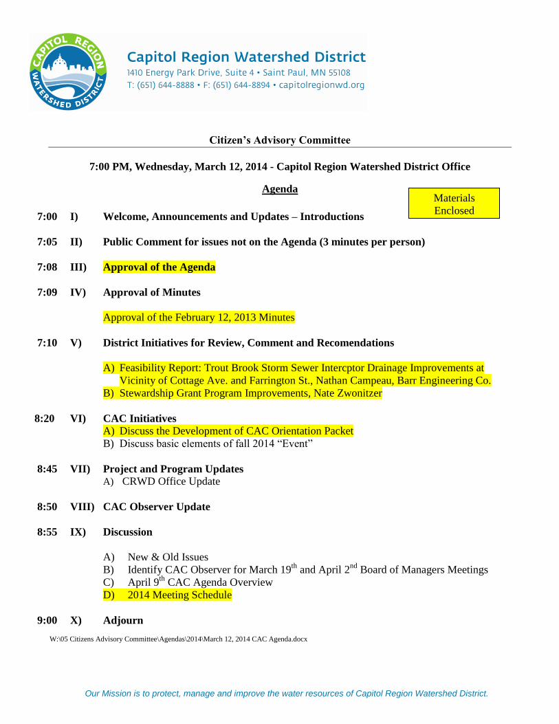
Citizen’s Advisory Committee
7:00 PM, Wednesday, March 12, 2014 - Capitol Region Watershed District Office
Agenda
7:00 I) Welcome, Announcements and Updates – Introductions
7:05 II) Public Comment for issues not on the Agenda (3 minutes per person)
7:08 III) Approval of the Agenda
7:09 IV) Approval of Minutes
Approval of the February 12, 2013 Minutes
7:10 V) District Initiatives for Review, Comment and Recomendations
A) Feasibility Report: Trout Brook Storm Sewer Intercptor Drainage Improvements at
Vicinity of Cottage Ave. and Farrington St., Nathan Campeau, Barr Engineering Co.
B) Stewardship Grant Program Improvements, Nate Zwonitzer
8:20 VI) CAC Initiatives
A) Discuss the Development of CAC Orientation Packet
B) Discuss basic elements of fall 2014 “Event”
8:45 VII) Project and Program Updates
A) CRWD Office Update
8:50 VIII) CAC Observer Update
8:55 IX) Discussion
A) New & Old Issues
B) Identify CAC Observer for March 19th
and April 2nd
Board of Managers Meetings
C) April 9th
CAC Agenda Overview
D) 2014 Meeting Schedule
9:00 X) Adjourn
W:\05 Citizens Advisory Committee\Agendas\2014\March 12, 2014 CAC Agenda.docx
Materials
Enclosed

1
Citizen Advisory Committee Meeting
Wednesday, February 12, 2014 – 7:00 p.m.
CAC Members Present:
Gwen Willems
Michelle Ulrich
Steve Duerre
David Arbeit
Bill Barton
Mike MacDonald
Janna Caywood
Members absent: Ted McCaslin, w/notice
Richard Weil, w/notice
Pat Byrne, w/notice
Katheryn Swanson, w/notice
Others Present:
Mark Doneux, CRWD
Michelle Sylvander, CRWD
Elizabeth Beckman, CRWD
Lindsay VanPatten, CRWD
Gustavo Castro, CRWD
Joe Collins, Board of Manager
Welcome, Announcements, and Updates
Ms. Willems opened the meeting at 7:00 p.m. with a request for any announcements. Ms. Willems gave an
update on the Water Quality Workshop that she attended. The workshop focused on conservation. Lindsay
VanPatten and Elizabeth Beckman were also in attendance.
Public Comments
There were no public comments.
Approval of Agenda
Ms. Willems asked for any additions or changes to the Agenda. There were no changes.
CAC 13-034 Motion: To approve the CAC February 12, 2014, agenda.
Barton/Duerre
Unanimously approved
Approval of the January 15, 2014 CAC Minutes
Ms. Willems requested any changes or corrections to the minutes.
CAC 13-035 Motion: To approve the CAC January 15, 2014 CAC Minutes.
Abreit/Duerre
Unanimously approved
District Initiatives
Draft

“Our mission is to protect, manage, and improve the water resources of the Capitol Region Watershed District.”
2
A) Ms. VanPatten reviewed the 2013 Partner Grants. CRWD Partner Grants support
organizations who share in our mission to protect, manage and improve water resources. Grants are awarded
once a year, and typically range from $2,000 to $20,000. Partner Grants have been awarded since 2007 to
help further education and outreach goals of CRWD.
In 2013, the Board approved staff to hire a consultant to develop an Education and Outreach Strategic Plan
for 2014-2015. Staff considered the goals and initiatives of the plan to help guide the 2014 grant review
process. Members of the CAC were part of the Partner Grant Review Committee. Ms. VanPatten reviewed
results of 2013 Partner Grant projects including Alliance for Sustainability, Mother Earth Festival, Como
Lake Neighbor Network, City of St. Paul – snow plowing blades and tempature sensors, Urban Roots –
engaging youth, Friends of the Mississippi, and Great River Greening. Ms. VanPatten also provided an
update on projects approved for 2014. The 2014 projects include: Community Compasity – partnering with
other watersheds, Central High School – working with parent group and a Watershed game that has been
partnered with Minnehaha Creek. Ms. VanPatten gave a general update on education and outreach work
from the last year. A good discussion occurred about the benefits of the partner grant program and how it
reaches many audiences that CRWD does not always connect with. The committee thanked Ms. VanPatten
for her update.
B) Mr. Castro provided an update and outline on the BMP Database. Since 2003, CRWD has
been providing BMP cost share grants, completing capital improvement projects since 2002, and issuing
permits for stormwater management practices since 2006. To date, CRWD has managed the information
related to the ownership and location of these BMPs in Excel spreadsheets. Mr. Castro said that staff is
exploring new technologies to obtain, file and to better manage this increasingly large amount of data. This
new technology will provided opportunities to share information with the general public and integrate
mapping capabilities with BMP inspection, function and maintenance. Mr. Castro gave a brief overview of
Database system and its mapping interface. The committee thanked Mr. Castro for his presentation.
CAC Initiatives
A) Discuss the Development of CAC Orientation Packet
Administrator Doneux gave a review of the CAC reinvigoration plan. A CAC charter group was formed by
CAC members Gwen Willems and David Arbeit, Board of Managers Mary Texer & Shirley Reider. This
group will draft a new charter to be reviewed at the March 12th
meeting.
An orientation packet was one of the action items in the reinvigoration plan. Gwen Willems, Michelle
Ulrich and Steve Duerre formed a subcommittee to begin drafting the information the CAC members would
like to have in a new member packet. Administrator Doneux suggested that the CAC draft the packet and
outsource the design work. The group discussed topics to include in the new member packet.
B) Discuss basic elements of fall 2014 “Event”
The group discussed ideas of having some kind of shared educational speaker to help bring awareness to the
watershed district. The Freshwater Society was noted for being a good source to find speakers. The group
agreed that they would like a topic and speaker that would connect with the public and provide an
opportunity to bring awareness of the watershed district. The hot topics for a speaker would be groundwater,
climate, and storm water reuse. Administrator Doneux will call Steve Woods to discuss a fall event.
C) Follow up discussion from December 11th
CAC meeting

“Our mission is to protect, manage, and improve the water resources of the Capitol Region Watershed District.”
3
This item has been moved to the March 12th
meeting.
Project and Program Updates
A) Lowertown Ballpark Update (Doneux)
Administrator Doneux reviewed the Lowertown Ballpark project. The City of St. Paul was awarded
$225,000 through the Special Grant program for stormwater elements at Lowertown Ballpark. These funds
can only be used for stormwater elements that treat runoff above and beyond what is required by CRWD
rules.
A unique opportunity to treat a portion of the adjacent Green Line Operation and Maintenance Facility
(OMF) roof through rainwater harvesting and reuse was identified. Experts in the area of rainwater reuse
developed a feasibility analysis, modeling, and cost estimates. The Board of Managers also awarded an
additional $100,000 in Special Grant funds to be used to pursue rainwater reuse for toilet flushing and
ballfield irrigation, with a total grant funding not to exceed $325,000. Funding is contingent on visible
cisterns or two interactive kiosks in high traffic location if cisterns are not visible. The Kiosks will educate
public on the reuse projects and be designed in cooperation with CRWD. Discussion occurred.
CAC Observer and Board of Managers Update
President Collins shared that CRWD and the City of St. Paul Directors of City Departments will be meeting
for a workshop on February 19, 2014. The workshop is about staying connected and keeping open
communication with the City.
Discussion –
A) New & Old Issues
There was no discussion.
B) Identify CAC Observer for February 19th Board of Managers Meeting and the March 5th
, 2014
Board of Managers Meeting
No members were identified.
C) CAC Agenda Overview
Former State Senator, Ellen Anderson will not be able to attend the March 12th
meeting. The board agreed to
invite other watershed districts to attend when Ellen Anderson is scheduled. Other items for the agenda will
included an update on the stewardship grant program and addition discussion on planning an event in the
fall.
Adjourn –
CAC 13-036 Motion: To adjourn.
Caywood/Barton
Unanimously approved
The meeting was adjourned at 9:05 PM.
Respectfully submitted,

“Our mission is to protect, manage, and improve the water resources of the Capitol Region Watershed District.”
4
Michelle Sylvander
W:\05 Citizens Advisory Committee\Minutes\2014\February 12, 2014 Draft Minutes.doc

Our Mission is to protect, manage and improve the water resources of Capitol Region Watershed District.
DATE: March 6, 2014 TO: CRWD Citizen’s Advisory Committee FROM: Anna Eleria, Water Resources Projects Manager and Nathan Campeau, Barr Engineering RE: TBI Farrington-Cottage Feasibility Study Report - Draft
Background In late 2011, CRWD staff was first made aware of a local flooding problem in the backyard of 300 Cottage Avenue West, which is adjacent to CRWD’s Trout Brook Storm Sewer Interceptor. This area receives runoff from its own property and neighboring properties to the east and from multi-family properties and BNSF right-of-way to the west. The existing flared inlet to TBI, which is upstream and west of the affected property, is undersized and improperly designed. The flared inlet frequently clogged up with organic debris and trash after a rainstorm and stormwater runoff bypassed the inlet and the associated berm and flowed into and ponded in the backyard of 300 Cottage Avenue. For a year and a half, CRWD staff conducted frequent minor maintenance work to improve drainage to the existing inlet. Issues In 2013, CRWD approached the localized flooding issue in two ways. First, CRWD hired a contractor in late summer 2013 to conduct more significant maintenance work that included clearing sediment, trash and debris from the area around the inlet, grading work in the ditch upstream of the inlet, and repairing and raising the berm. Based on follow-up inspections, the inlet has remained clear and open helping to ensure runoff from the west flows into TBI inlet. The work eliminated the need for CRWD staff to conduct any minor maintenance work last fall. Second, CRWD commenced a feasibility study to better understand the issue, evaluate its cause(s) and identify potential long-term solutions. The feasibility study, conducted by Barr Engineering, included field investigations, detailed modeling, and evaluation of flood mitigation alternatives including volume-reduction/water quality improvement strategies. The draft feasibility report has been completed and is enclosed for the CAC’s review and comment. Action Requested Review, comment and make recommendations on the draft report for the TBI Farrington-Cottage Feasibility Study enc: Draft TBI Farrington-Cottage Feasibility Study Report W:\06 Projects\Trout Brook Interceptor\TBI Farrington-Cottage\Board Memos\CAC Memo TBI Farrington Feasibility Study Report 03-12-14.docx
March 12, 2014 V. District Initiatives – A) TBI Farrington-Cottage Feasibility
Study Report (Eleria)

TITLE OF REPORT Date of Report
Feasibility Report: Trout Brook Storm Sewer Interceptor Drainage Improvements at Vicinity of Cottage Ave. and Farrington St.
Capitol Region Watershed District Saint Paul, MN Barr Engineering Co. J. Herbert, N. Campeau, and M. McKinney March 2014

Feasibility Report Trout Brook Storm Sewer Interceptor Drainage Improvements at Vicinity of Cottage Ave. and Farrington St. Prepared for Capitol Region Watershed District March 2014
4700 West 77th
Street Minneapolis, MN 55435-4803 Phone: (952) 832-2600 Fax: (952) 832-2601

P:\Mpls\23 MN\62\2362944\WorkFiles\TBI Engineer\Farrington Erosion and HH Study\Workfiles\Report\FarringtonCottage_Report March
2014.docx i
Feasibility Report Trout Brook Storm Sewer Interceptor Drainage Improvements at
Vicinity of Cottage Ave. and Farrington St.
March 2014
Table of Contents
1.0 Background ............................................................................................................................................ 1
1.1 Purpose ........................................................................................................................................ 1
1.2 Background and Scope ............................................................................................................... 1
1.3 Study Area .................................................................................................................................. 2
2.0 Modeling ................................................................................................................................................ 3
2.1 Delineation of Subwatersheds & Field Review .......................................................................... 3
2.2 Hydraulic and Hydrologic Modeling .......................................................................................... 3
2.3 Localized Flooding ..................................................................................................................... 4
2.4 Localized Flooding Mitigation Alternatives ............................................................................... 5
3.0 Results .................................................................................................................................................... 6
3.1 Alternative 1 – Replacement of Inlet Downstream of Farrington Ave. ...................................... 6
3.2 Alternative 2 – New Inlet Upstream of Farrington Ave. ............................................................ 6
3.3 Alternative 3 – Rain Garden Upstream of Farrington Ave. ........................................................ 7
3.4 Alternative 4 – New Inlet and Rain Garden Upstream of Farrington Ave. ................................ 9
4.0 Conclusion ............................................................................................................................................ 11
List of Tables
Table 1 Localized Flooding Inundation Area, Volume, and Depth ................................................ 4
Table 2 Flood Volume Sources. ................................................................................................... 5
Table 3 Alternative 1 Opinion of Cost .......................................................................................... 6
Table 4 Alternative 2 Opinion of Cost .......................................................................................... 7
Table 5 Alternative 3 Opinion of Cost .......................................................................................... 8
Table 6 Proposed Rain Garden Cost-Benefit Summary ................................................................. 9
Table 7 Alternative 4 Opinion of Cost ........................................................................................ 10
Table 8 Flood Mitigation Alternatives Summary ........................................................................ 10
List of Figures
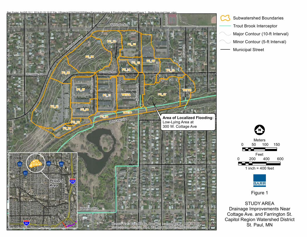
Figure 1 Study Area
Figure 2 Land Use
Figure 3 Storm sewer
Figure 4 Existing Inundation Area
Figure 5 Flood Mitigation Alternatives

P:\Mpls\23 MN\62\2362944\WorkFiles\TBI Engineer\Farrington Erosion and HH Study\Workfiles\Report\FarringtonCottage_Report March 2014.docx ii
List of Appendices
Appendix A Technical Addendum

P:\Mpls\23 MN\62\2362944\WorkFiles\TBI Engineer\Farrington Erosion and HH Study\Workfiles\Report\FarringtonCottage_Report March 2014.docx 1
1.0 Background
1.1 Purpose
The purpose of this feasibility report is to provide a summary related to potential Trout Brook Storm
Sewer Interceptor (TBI) drainage improvements in the vicinity of Cottage Ave. and Farrington St. in
Saint Paul, MN. Specifically, this report provides updates to the CRWD’s existing TBI XP-SWMM
model, and outlines potential localized flood mitigation alternatives and associated opinions of cost.
1.2 Background and Scope
The Capitol Region Watershed District (CRWD) is aware of a localized flooding concern at 300
Cottage Ave. W. The low-lying area on this property periodically experiences standing water
following precipitation events, prompting complaints from the homeowner. It is our understanding
that localized flooding does not impact any homes or other permanent structures. Upstream of the
localized flooding, there is a 12-inch inlet to the TBI. Possible sources of localized flooding include
(a) direct drainage to the property and (b) flow-bypassing the 12-inch inlet near the property.
In 2012, a detailed XP-SWMM model of the entire TBI system was developed. Although the 12-inch
inlet was included in the 2012 TBI model, watershed divides in the area were only developed to TBI
inlet points. Therefore, due to the unique local drainage, further refinement of the existing TBI model
in the vicinity of Cottage Ave. and Farrington St. was required to evaluate sources of localized
flooding and potential solutions.
To determine the probable sources of localized flooding at 300 Cottage Ave. W and determine
potential improvements, the following tasks were performed:
1. Delineate and field verify subwatersheds to the location of localized flooding and nearby
storm sewer inlets.
2. Update the CRWD’s existing XP-SWMM model to determine probable causes of localized
flooding.
3. Evaluate flood mitigation alternatives using the updated XP-SWMM model.
All existing conditions detailed modeling will be incorporated into the current version of the TBI XP -
SWMM model. This technical report summarizes findings related to the referenced tasks and will be
added to the 2012 TBI XP-SWMM model report as an addendum.

P:\Mpls\23 MN\62\2362944\WorkFiles\TBI Engineer\Farrington Erosion and HH Study\Workfiles\Report\FarringtonCottage_Report March 2014.docx 2
1.3 Study Area
The study area includes all potential sources of direct drainage to the localized flooding area on 300
Cottage Ave. W. This area is generally bounded to the North, East, South, and West by Arlington
Ave. W, Galtier St., the BNSF freight rail line, and W. Wheelock Pkwy., respectively. Figure 1
shows the extent of the study area, subwatershed divides, and the area of localized flooding.

P:\Mpls\23 MN\62\2362944\WorkFiles\TBI Engineer\Farrington Erosion and HH Study\Workfiles\Report\FarringtonCottage_Report March 2014.docx 3
2.0 Modeling
2.1 Delineation of Subwatersheds & Field Review
To better understand drainage patterns and potential sources of flooding in the vicinity of Cottage
Ave. and Farrington St., subwatersheds from the 2012 TBI XP-SWMM model were further refined
and subdivided. Typically, this involved redefining subwatersheds in the study area to represent
individual stormsewer inlets, catch basin clusters, and potential sources of direct drainage to the
localized flooding. The updated subwatershed divides were developed using a variety of data sources
including:
One-foot topography for the City of St. Paul.
High resolution (1 meter, resampled to 3.3 meter grid cell resolution) LiDAR data collected
by the National Geodetic Survey (NGS) for the Republican National Convention (RNC) in
June 2007 covering the entire study area, to supplement the data provided by the CRWD. It
was also used to create a Digital Elevation Model (DEM) that was used to develop model
input parameters.
As-built storm sewer plan sheets for the City of St. Paul. Figure 3 shows the existing
stormsewer network, including Trout Brook Interceptor, in the study area.
After initially refining subwatershed divides based on the data sources listed above, a field review
was conducted on June 25, 2013 to confirm drainage patterns and the location of storm sewer inlets.
Figure 1 illustrates the final watershed divides used in XP-SWMM modeling efforts. Nineteen
subwatersheds were defined within the study area, ranging in area from 0.3 to 6.8 acres.
2.2 Hydraulic and Hydrologic Modeling
CRWD’s 2012 XP-SWMM model was used for this analysis. Updated subwatershed divides in the
study area were incorporated into the existing model. This involved generating hydrologic
parameters for all new subwatersheds, and defining hydraulic parameters associated with storm sewer
flow and overland runoff within the project area. The Technical Addendum, included as Appendix A
of this report, details the hydrologic and hydraulic modeling assumptions used for this analysis.

P:\Mpls\23 MN\62\2362944\WorkFiles\TBI Engineer\Farrington Erosion and HH Study\Workfiles\Report\FarringtonCottage_Report March 2014.docx 4
2.3 Localized Flooding
Using the updated and refined XP-SWMM model, inundation mapping was performed for the 2-, 10-,
and 100-year rainfall events (Figure 4). Inundation area and localized flood depths are summarized in
Table 1. Modeling results suggest that the low-lying area near 300 Cottage Ave. W floods to a depth
of approximately two feet and four feet for the 2-year and 100-year rainfall events, respectively.
Based on 2007 LiDAR data, inundation depth would need to approach 10 feet to impact the apparent
low home located at 1355 Galtier St (Figure 4).
Table 1 Localized Flooding Inundation Area, Volume, and Depth
Return
Interval
Inundation
Area (ac)
Flooding
Depth (ft)
Flood Volume
(ac-ft)
2-yr 0.20 2.0 0.15
10-yr 0.46 3.1 0.52
100-yr 0.67 4.1 1.0
The hydrologic and hydraulic analyses indicate that there are two primary sources of runoff
contributing to localized flooding: (1) direct runoff from the subwatershed to the low-lying area and
(2) flow bypassing a 12-inch inlet to the TBI located to the southwest of the low-lying property. The
4.9-acre drainage area, identified as FC_17 on Figure 1 (direct drainage area to localized flooding),
produces the majority of flood volume, particularly for smaller events (Table 2) . Three acres of the
high density residential area between Western Ave. N and Farrington St. (FC_11 on Figure 2) is not
directly serviced by storm sewer. Stormwater runoff from this area is conveyed via a ditch to the 12-
inch inlet. High flows from the developed area periodically overwhelm the 12-inch inlet and overtop
the berm contributing to localized flooding. Modeling indicates that the 2-year, 24-hour rainfall event
generates runoff sufficient to overtop the berm. The field investigation performed on June 25, 2013
corroborates this modeling result, as obvious signs of erosion and minor-washout were observed
along the ditch between the developed area and the inlet, and from the toe of the berm to the low-
lying area.

P:\Mpls\23 MN\62\2362944\WorkFiles\TBI Engineer\Farrington Erosion and HH Study\Workfiles\Report\FarringtonCottage_Report March 2014.docx 5
Table 2 Flood Volume Sources.
Direct Drainage Bypassing 12-inch Inlet
Return
Interval
Total Flood
Volume (ac-ft)
Flood Volume
(ac-ft)
% of Total
Flood Volume
Flood Volume
(ac-ft)
% of Total
Flood Volume
2-yr 0.15 0.14 89.4 0.02 10.6
10-yr 0.52 0.38 72.9 0.14 27.1
100-yr 1.04 0.71 67.9 0.33 32.1
2.4 Localized Flooding Mitigation Alternatives
Localized flood mitigation alternatives were developed and evaluated using the updated XP-SWMM
model. Corrective measures were developed to improve stormwater conveyance and/or reduce
stormwater volumes. Strategies investigated included:
Increasing stormwater conveyance capacity by installing new TBI inlet.
Improving existing collector ditch and inlet locations.
Implementing volume-reduction strategies.
Ultimately, four potential mitigating measures were investigated. The following results section
provide brief descriptions of each of the four flood mitigation options evaluated and provide
preliminary opinions of construction costs for each alternative.

P:\Mpls\23 MN\62\2362944\WorkFiles\TBI Engineer\Farrington Erosion and HH Study\Workfiles\Report\FarringtonCottage_Report March 2014.docx 6
3.0 Results
All alternatives presented are located within CRWD’s TBI easement over BNSF property . Careful
review of the easement agreement with BNSF will be necessary to determine which alternatives, if
any, are allowed by the terms of the existing agreement.
3.1 Alternative 1 – Replacement of Inlet Downstream of Farrington Ave.
Replace the existing 12-inch inlet identified on Figure 3 with a 3-foot diameter beehive inlet
structure (Figure 5). The objective of this alternative is to increase stormwater conveyance capacity
into the TBI such that the berm (Figure 3) would no longer overtop during the 100-year rainfall
event.
Modeling indicates that the proposed 3-foot diameter beehive structure has sufficient capacity to
convey ditch-flow into the TBI without further modifications to the existing berm. For this
alternative, runoff to the low-lying area is generally limited to its direct drainage area. Reductions in
flood depth, flood volume, and inundation area associated with this alternative are shown in Table 8.
Table 3 Alternative 1 Opinion of Cost
Bid Item Item Description Unit Estimated
Quantity
Unit Price Total
Extension
1.1 Mobilization/Demobilization L.S. 1 $1,500 $1,500
1.2 Remove and dispose existing
inlet
L.S. 1 $1,000 $1,000
1.3 Beehive inlet EA 1 $1,500 $1,500
1.4 36" riser EA 1 $2,700 $2,700
1.5 Connect riser to TBI EA 1 $5,000 $5,000
1.6 Erosion control L.S. 1 $3,000 $3,000
1.7 Site Restoration L.S. 1 $1,000 $1,000
1.8 Contingency – Approx. 30%* L.S. 1 $5,000 $5,000
Total (Alternative 1) $20,700 *Contingency includes unforeseen construction costs that are not included in this conceptual-level opinion of cost.
3.2 Alternative 2 – New Inlet Upstream of Farrington Ave.
Retain the existing 12-inch inlet structure and install a 3-foot beehive structure along the
collector ditch which receives flow from the developed area between Western Ave. North and
Farrington St. not serviced by storm sewer (Figure 5). Due to erosion and minor wash-out
observed in this area, this alternative would require armoring and stabilization of the flow path from
the developed area to the proposed beehive. The Alternative 2 beehive structure is positioned in a

P:\Mpls\23 MN\62\2362944\WorkFiles\TBI Engineer\Farrington Erosion and HH Study\Workfiles\Report\FarringtonCottage_Report March 2014.docx 7
low point along this ditch which will provide pooling around the inlet to maximize conveyance into
the TBI. To efficiently route flow from the developed area between Western Avenue North and
Farrington Sttreet (Subwatershed FC_11) to the proposed inlet, it may be necessary to construct
additional curb in the southeast corner of the parking lot discharging runoff from the developed area
to the ditch.
Modeling indicates that the proposed 3-foot beehive structure has sufficient capacity to convey
runoff from the developed area into the TBI. Additionally, the 12-inch inlet has sufficient capacity to
convey runoff generated down-gradient of the beehive inlet location into the TBI. As with
Alternative 1, runoff to the low-lying area is generally limited to its direct drainage area. Reductions
in flood depth, flood volume, and inundation area associated with this alternative are shown in Table
8.
Table 4 Alternative 2 Opinion of Cost
Bid Item Item Description Unit Estimated
Quantity
Unit Price Total
Extension
2.1 Mobilization/Demobilization L.S. 1 $1,500 $1,500
2.2 Beehive inlet EA 1 $1,500 $1,500
2.3 36" riser EA 1 $4,000 $4,000
2.4 Connect riser to TBI EA 1 $5,000 $5,000
2.5 Inlet channel armoring L.S. 1 $2,000 $2,000
2.6 Erosion control L.S. 1 $3,000 $3,000
2.7 Site Restoration L.S. 1 $1,000 $1,000
2.8 Contingency – Approx. 30% L.S. 1 $5,500 $5,500
Total (Alternative 2) $23,500 *Contingency includes unforeseen construction costs that are not included in this conceptual -level opinion of cost.
3.3 Alternative 3 – Rain Garden Upstream of Farrington Ave.
Construct a rain garden in the collector ditch corridor to provide water quality treatment and
reduce stormwater volume (Figure 5). The rain garden is sized to remain within the TBI easement
and to maintain a distance of 25 feet from the centerline of BNSF’s railroad track. The existing TBI
easement will need to be reviewed and may need to be amended to provide adequate area for access
and repairs to the TBI if this alternative is to be implemented. This alternative assumes appropriate
soils for infiltration; however the rain garden could also be constructed as a filtration garden with an
underdrain discharging into TBI. County soils mapping suggests that this area is composed of
hydrologic soil group B soils that would be appropriate for infiltration practices. Site visits confirm
that this area is generally adequately drained; however, no soil borings have been taken.

P:\Mpls\23 MN\62\2362944\WorkFiles\TBI Engineer\Farrington Erosion and HH Study\Workfiles\Report\FarringtonCottage_Report March 2014.docx 8
The proposed rain garden has a footprint of over 3,000 ft2 (0.07 ac) and volume of 2,224 cubic feet,
which results in treatment 0.33- inches of runoff from the tributary impervious surfaces (1.85 ac).
The proposed rain garden assumes a 12-inch dead storage depth below the outlet, 3:1 side slopes, and
construction within the TBI storm sewer easement. Further expansion of the rain garden would
require extensive clearing of trees along the BNSF railroad.
Although a rain garden does provide volume reduction and attenuates peak flow from the developed
area, the berm identified on Figure 5 will continue to overtop into the localized flooding area during
the 10- and 100-year events. Reductions in flood depth, flood volume, and inundation area
associated with this alternative are shown in Table 8.
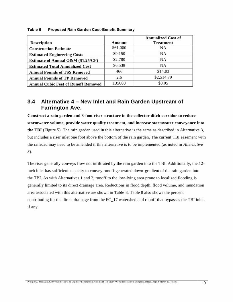
A water quality analysis was performed on the proposed rain garden using the MPCA’s Minimal
Impact Design Standards (MIDS) calculator. The proposed infiltration rain garden would annually
remove approximately 135,000 cubic feet of runoff volume, 466 pounds of total suspended solids
(TSS), and 2.6 pounds of total phosphorus (1.4 pounds of particulate phosphorus and 1.2 pounds of
dissolved phosphorus). Table 6 provides a cost-benefit analysis of the proposed rain garden, with the
following assumptions:
Design life of 35 years
Annual interest of 4%
Annual operations and maintenance (O&M) cost of $1.25 per cubic foot of treatment
Engineering costs for design and construction administration are estimated at 15% of the
construction costs
Table 5 Alternative 3 Opinion of Cost
Bid Item Item Description Unit Estimated
Quantity
Unit Price Total
Extension
3.1 Mobilization/Demobilization L.S. 1 $5,000 $5,000
3.2 Rain garden, complete SF 3,000 $12 $36,000
3.3 Inlet channel armoring L.S. 1 $2,000 $2,000
3.4 Erosion control L.S. 1 $3,000 $3,000
3.5 Site Restoration L.S. 1 $1,000 $1,000
3.6 Contingency - 30% L.S. 1 $14,000 $14,000
Total (Alternative 3) $61,000 *Contingency includes unforeseen construction costs that are not included in this conceptual -level opinion of cost.
P:\Mpls\23 MN\62\2362944\WorkFiles\TBI Engineer\Farrington Erosion and HH Study\Workfiles\Report\FarringtonCottage_Report March 2014.docx 9
Table 6 Proposed Rain Garden Cost-Benefit Summary
Description Amount
Annualized Cost of
Treatment
Construction Estimate $61,000 NA
Estimated Engineering Costs $9,150 NA
Estimate of Annual O&M ($1.25/CF) $2,780 NA
Estimated Total Annualized Cost $6,538 NA
Annual Pounds of TSS Removed 466 $14.03
Annual Pounds of TP Removed 2.6 $2,514.79
Annual Cubic Feet of Runoff Removed 135000 $0.05
3.4 Alternative 4 – New Inlet and Rain Garden Upstream of Farrington Ave.
Construct a rain garden and 3-foot riser structure in the collector ditch corridor to reduce
stormwater volume, provide water quality treatment, and increase stormwater conveyance into
the TBI (Figure 5). The rain garden used in this alternative is the same as described in Alternative 3,
but includes a riser inlet one foot above the bottom of the rain garden. The current TBI easement with
the railroad may need to be amended if this alternative is to be implemented (as noted in Alternative
3).
The riser generally conveys flow not infiltrated by the rain garden into the TBI. Additionally, the 12-
inch inlet has sufficient capacity to convey runoff generated down-gradient of the rain garden into
the TBI. As with Alternatives 1 and 2, runoff to the low-lying area prone to localized flooding is
generally limited to its direct drainage area. Reductions in flood depth, flood volume, and inundation
area associated with this alternative are shown in Table 8. Table 8 also shows the percent
contributing for the direct drainage from the FC_17 watershed and runoff that bypasses the TBI inlet,
if any.

P:\Mpls\23 MN\62\2362944\WorkFiles\TBI Engineer\Farrington Erosion and HH Study\Workfiles\Report\FarringtonCottage_Report March 2014.docx 10
Table 7 Alternative 4 Opinion of Cost
Bid Item Item Description Unit Estimated
Quantity
Unit Price Total
Extension
4.1 Mobilization/Demobilization L.S. 1 $6,000 $6,000
4.2 Rain garden SF 3,000 $12 $36,000
4.3 Beehive inlet EA 1 $1,500 $1,500
4.4 36" riser EA 1 $4,000 $4,000
4.5 Connect riser to TBI EA 1 $5,000 $5,000
4.6 Inlet channel armoring L.S. 1 $2,000 $2,000
4.7 Erosion control L.S. 1 $3,000 $3,000
4.8 Site Restoration L.S. 1 $1,000 $1,000
4.8 Contingency - 30% L.S. 1 $18,000 $18,000
Total (Alternative 1) $76,500 *Contingency includes unforeseen construction costs that are not included in this conceptual -level opinion of cost.
Table 8 Flood Mitigation Alternatives Summary
Flood Depth at Localized Flooding Area (feet)
Return
Interval
Existing
Condition Alt. 1 Alt. 2 Alt. 3 Alt. 4
2-yr 2.0 2.0 2.0 2.0 2.0
10-yr 3.1 2.8 2.8 3.1 2.8
100-yr 4.1 3.5 3.5 4.1 3.5
Inundation Area at Localized Flooding Area (acres)
Return
Interval
Existing
Condition Alt. 1 Alt. 2 Alt. 3 Alt. 4
2-yr 0.2 0.1 0.1 0.1 0.1
10-yr 0.5 0.4 0.4 0.5 0.4
100-yr 1.0 0.7 0.7 1.0 0.7
Flood Sources (% Flood Volume from Direct Drainage / % from Bypassing)
Return
Interval
Existing
Condition Alt. 1 Alt. 2 Alt. 3 Alt. 4
2-yr 89% / 11% 100% / 0% 100% / 0% 100% / 0% 100% / 0%
10-yr 73% / 27% 100% / 0% 100% / 0% 77% / 23% 100% / 0%
100-yr 68% / 32% 100% / 0% 100% / 0% 69% / 31% 100% / 0%

P:\Mpls\23 MN\62\2362944\WorkFiles\TBI Engineer\Farrington Erosion and HH Study\Workfiles\Report\FarringtonCottage_Report March 2014.docx 11
4.0 Conclusion
As noted, runoff from the 4.9-acre direct-drainage area (FC_17 on Figure 1) contributes to the
majority of localized flooding at the low-lying area. Table 8 shows that, although three of the four
options intercept flow along the collector ditch, localized flooding is not eliminated due to the direct
drainage from the houses and backyard areas in Subwatershed FC_17. In the modeled events, this
localized flooding does not appear to impact existing structures.
Alternatives 1, 2, and 4 produce the largest reductions in localized flood depth and inundation area
for the 10- and 100-year rainfall events. Additionally, Alternatives 2 and 4 provide the additional
benefit of significantly reducing flow and associated channel degradation in the collector ditch
between the developed area and the existing 12-inch inlet. Alternatives 3 and 4 have the additional
benefit of providing limited water quality treatment to 1.85 acres of impervious surface.

Figures
W Arlington Ave
W Maryland Ave
W Cottage Ave
W Wheelock Pkwy
N Fa
rringto
n St
BNSF Rail Line
Wes
tern A
ve
N Ga
ltier S
t
W Cottage Ave
FC_01
FC_09
FC_17TRT2A
FC_10
FC_16
FC_07FC_11
FC_12
FC_06 FC_18
FC_08
TRT7E
FC_03
FC_14
FC_04
FC_13
TRT3B
FC_02
Source: Esri, DigitalGlobe, GeoEye, i-cubed, USDA, USGS, AEX,Getmapping, Aerogrid, IGN, IGP, and the GIS User Community
Barr Footer: ArcGIS 10.1, 2014-01-15 15:57 File: I:\Projects\23\62\944\GIS\Maps\Farrington Erosion & Flooding\Maps\Figures\Figure 1 - Study Area.mxd User: mbm
!;N0 50 100 150
Meters
Figure 1STUDY AREA
Drainage Improvements NearCottage Ave. and Farrington St.
Capitol Region Watershed DistrictSt. Paul, MN
0 200 400 600Feet
Subwatershed BoundariesTrout Brook InterceptorMajor Contour (10-ft Interval)Minor Contour (5-ft Interval)Municipal Street
Area of Localized Flooding:Low-Lying Area at 300 W. Cottage Ave
§̈¦35E
§̈¦94
456753 456755456749
456731
ProjectArea
1 inch = 400 feet

W Arlington Ave
W Cottage Ave
W Wheelock Pkwy
N Fa
rringto
n St
W Ivy Ave
N Ga
ltier S
t
N Arun
del S
t
W Orange Ave
N Ma
tilda S
t
N Ma
rion S
t
Weste
rn Av
e
Virgin
ia St
N We
stern
Ave
N Cu
mberl
and S
t
N Vir
ginia
St
N Arun
del S
t
N Fa
rringto
n St
N Ga
ltier S
t
W Cottage Ave
N Ma
tilda S
t
FC_01
FC_09
FC_17TRT2A
FC_10
FC_16
FC_07FC_11
FC_12
FC_06FC_18
FC_08
TRT7E
FC_03
FC_14
FC_04
FC_13
TRT3B
FC_02
Source: Esri, DigitalGlobe, GeoEye, i-cubed, USDA, USGS, AEX,Getmapping, Aerogrid, IGN, IGP, and the GIS User Community
Barr Footer: ArcGIS 10.1, 2014-03-04 12:39 File: I:\Projects\23\62\944\GIS\Maps\Farrington Erosion & Flooding\Maps\Figures\Figure 2 - Land Use.mxd User: mbm
!;N0 50 100 150
Meters
Figure 2LAND USE
Drainage Improvements NearCottage Ave. and Farrington St.
Capitol Region Watershed DistrictSt. Paul, MN
0 200 400 600Feet
Subwatershed BoundariesImpervious AreaTrout Brook InterceptorCity of St. Paul StormsewerCommercialIndustrialInstitutionalParks and Open SpaceResidential High DensityResidential Low DensityRoadsUndevelopedWater
1 inch = 350 feet

!>
12 inRCP
96 inCEM
96 inCEM
96 inCEM
18 inRCP
96 in
CEM
96 inCEM
96 inCEM
54 in
RCP
36 in
RCP 96 in
CEM
12 in
RCP
27 in
RCP
18 inRCP
54 in
UNK
15 in
RCP
12 inRCP
30 in
RCP
12 inRCP
12 inRCP
30 in
RCP
15 in
RCP
W Arlington Ave
W Cottage Ave
W Wheelock Pkwy
N Fa
rringto
n St
W Ivy Ave
N Ga
ltier S
t
N Arun
del S
t
W Orange Ave
N Ma
tilda S
t
N Ma
rion S
t
Weste
rn Av
e
Virgin
ia St
N We
stern
Ave
N Cu
mberl
and S
t
N Vir
ginia
St
N Arun
del S
t
N Fa
rringto
n St
N Ga
ltier S
t
W Cottage Ave
N Ma
tilda S
t
FC_01
FC_09
FC_17TRT2A
FC_10
FC_16
FC_07FC_11
FC_12
FC_06FC_18
FC_08
TRT7E
FC_03
FC_14
FC_04TRT3B
FC_13
FC_02
Source: Esri, DigitalGlobe, GeoEye, i-cubed, USDA, USGS, AEX,Getmapping, Aerogrid, IGN, IGP, and the GIS User Community
Barr Footer: ArcGIS 10.1, 2014-03-04 12:42 File: I:\Projects\23\62\944\GIS\Maps\Farrington Erosion & Flooding\Maps\Figures\Figure 3 - Stormsewer.mxd User: mbm
!;N0 50 100 150
Meters
Figure 3STORMSEWER
Drainage Improvements NearCottage Ave. and Farrington St.
Capitol Region Watershed DistrictSt. Paul, MN
0 350 700Feet
Subwatershed Boundaries!> Existing 12" TBI Inlet
Existing Berm, Constructed in 2013Trout Brook InterceptorCity of St. Paul StormsewerMunicipal Street
1 inch = 350 feet
Existing Berm and Inlet

!A
W Ivy Ave
W Cottage Ave
N Ga
ltier S
t
N Fa
rringto
n St
N Ma
tilda S
t
N Ga
ltier S
t
N Fa
rringto
n St
FC_17TRT2A
TRT7E
FC_18
FC_16FC_14
TRT3B
FC_13FC_10
FC_11
Source: Esri, DigitalGlobe, GeoEye, i-cubed, USDA, USGS, AEX,Getmapping, Aerogrid, IGN, IGP, and the GIS User Community
Barr Footer: ArcGIS 10.1, 2014-03-04 11:57 File: I:\Projects\23\62\944\GIS\Maps\Farrington Erosion & Flooding\Maps\Figures\Figure 4 - Inundation Area.mxd User: mbm
!;N
0 25 50 75Meters
Figure 4EXISTING INUNDATION AREADrainage Improvements Near
Cottage Ave. and Farrington St.Capitol Region Watershed District
St. Paul, MN
0 150 300Feet
2-year Inundation Area10-year Inundation Area100-yr Inundation AreaSubwatershed Boundaries
!AApparent Low Home (1355 Galtier St.)
!> Existing 12" TBI InletExisting Berm, Constructed in 2013Trout Brook InterceptorCity of St. Paul StormsewerMunicipal Street
Source: Esri, DigitalGlobe,GeoEye, i-cubed, USDA,USGS, AEX, Getmapping,Aerogrid, IGN, IGP, and theGIS User Community
1 inch = 150 feet
Area of Localized Flooding:Low-Lying Area at300 W. Cottage Ave

!>
!>
Weste
rn Av
e
N Ma
tilda S
t
W Ivy Ave
N Fa
rringto
n St
N Fa
rringto
n St
TRT2AFC_11FC_17
FC_07
FC_04
TRT3B
FC_08
FC_16FC_10 FC_14 FC_18FC_06
FC_03
Source: Esri, DigitalGlobe, GeoEye, i-cubed, USDA, USGS, AEX,Getmapping, Aerogrid, IGN, IGP, and the GIS User Community
Barr Footer: ArcGIS 10.1, 2014-03-06 08:44 File: I:\Projects\23\62\944\GIS\Maps\Farrington Erosion & Flooding\Maps\Figures\Figure 5 - Restoration Alternatives2.mxd User: mbm
!;N0 25 50 75
Meters
Figure 5FLOOD MITIGATION
ALTERNATIVESDrainage Improvements Near
Cottage Ave. and Farrington St.Capitol Region Watershed District
St. Paul, MN
0 150 300Feet
Subwatershed BoundariesRainwater GardenDeveloped Area2-year Inundation Areafrom Direct Drainage 10-year Inundation Areafrom Direct Drainage 100-year Inundation Areafrom Direct Drainage
!> Beehive StructureExisting Berm, Constructed in 2013Trout Brook InterceptorCity of St. Paul StormsewerMunicipal Street
Source: Esri, DigitalGlobe,GeoEye, i-cubed, USDA,USGS, AEX, Getmapping,Aerogrid, IGN, IGP, and theGIS User Community
1 inch = 150 feet
Alternative 1:Beehive InletReplacing 12-inch InletEst. Cost: $20,700
Alternative 2:Beehive Structure Receiving Flow from Developed AreaEst. Cost: $23,500Alternative 4:Beehive Intlet (Riser) and Rainwater GardenReceiving Flow from Developed AreaEst. Cost: $76,500
Alternative 3:Rainwater Garden ReceivingFlow from Developed AreaEst. Cost: $61,000
Developed Drainage Area to Rain Garden
Existing Berm

Appendix A
Technical Addendum

1
P:\Mpls\23 MN\62\2362944\WorkFiles\TBI Engineer\Farrington Erosion and HH Study\Workfiles\Report\FarringtonCottage_Report_TechnicalAddendum.docx
Technical Addendum Hydrologic Modeling The 2012 XP-SWMM model was calibrated based on observed flow data from the three CRWD flow
monitoring stations and five CRWD pond monitoring stations. Many hydrologic parameters, including
Hortonian infiltration parameters and impervious depression storage, were adjusted during the calibration
process. Table 1 shows the hydrologic parameters which, after calibration, were locally constant within
the vicinity of Cottage Ave. and Farrington St. Hydrologic parameter values shown in Table 1 were
applied to all new subwatersheds in the study area, consistent with their use in the calibration process.
Table 1. 2012 XP-SWMM TBI Calibration Parameters.
Parameter Calibrated Value Minimum Infiltration Rate (Fc) 0.7 in/hr Infiltration Decay Rate (k) 0.003 s-1
Impervious Depression Storage (Ds) 0.1 in To ensure consistency throughout the entirety of the model, all hydrologic parameters not listed in Table
1 were generated based on the methodologies and assumptions described in Section 3.2 of the 2012 TBI
XP-SWMM report. This involved evaluating areal distributions of hydrologic soil group, impervious area,
slope, and land use type, and determining the longest flow path length for each new subwatershed. Figure
2 shows land use delineation within the project area. Associated hydrologic parameters, such as maximum
infiltration rate, directly connected impervious area, and watershed width were then calculated based on
the methodology described in 2012 TBI XP-SWMM report. Assumed parameter values used in the 2012
TBI XP-SWMM model for pervious and impervious roughness and pervious depression storage were
applied to the new subwatersheds. The 24-hour rainfall distribution and design event precipitation depths
used in 2012 TBI XP-SWMM modeling efforts were unchanged for this analysis.
Hydraulic Modeling Hydrographs generated from hydrologic modeling of subwatersheds within the project area were routed
to stormsewer inlets or to the location of flooding via overland conveyances. Where inlet control and
stormsewer surcharging were possible, storages, overflow conduits, and hydraulic control structures were
included to accurately account for all potential sources of overland flow to the location of flooding.

2
P:\Mpls\23 MN\62\2362944\WorkFiles\TBI Engineer\Farrington Erosion and HH Study\Workfiles\Report\FarringtonCottage_Report_TechnicalAddendum.docx
Stormsewer and Stormsewer Inlets The calibrated 2012 TBI XP-SWMM model did not explicitly model the small stormsewer network
draining the majority of the study area. For this reason, hydraulic parameters associated with all pipes in
the study area were generated and incorporated into the greater TBI stormsewer network. Figure 3 shows
stormsewer within the project area included in the original 2012 TBI model, and stormsewer pipe
segments added as part of this analysis.
To ensure consistency throughout the model, hydraulic parameters were generated based on methodology
and data sources outlined in Section 3.3 of the 2012 TBI model report. Pipe diameter, shape, invert
elevations, and slope were taken from City of St. Paul stormsewer CAD file data. Because rim elevations
were not specified within the City of St. Paul stormsewer CAD data file for the majority of added
stormsewer network, rim elevations were instead assumed from DEM data. A typical reinforced concrete
pipe (RCP) manning’s roughness value of 0.013 was assumed, and entrance and exit losses assigned to
each individual pipe segment were referenced from the Wurbs and James 2002 Water Resources
Engineering textbook. Two flared end section stormsewer inlets, including the 12-inch inlet to the TBI
near the location of flooding, were assigned appropriate inlet types in XP-SWMM. Both were modeled as
having grooved ends, projecting from the surrounding surface.
An earthen and rock dam surrounding the 12-inch inlet to the TBI was included in the model as a weir
structure, representing the improved berm that was initiated by CRWD and constructed in Summer 2013
by G. F. Jedlicki, Inc. Berm dimensions were developed from observations made during the June 25,
2013, site visit. Storage in the ditch behind the berm, and at all locations where inlet barrel capacity or
hydraulic structures could conceivably restrict flow, was determined using high-resolution LiDAR data
and was incorporated into the model.
Open-Channel Properties Open-channels were modeled within the project area to convey overland flow to TBI stormsewer inlets
and storage areas, including the location of flooding. The main collector ditch along the southern
boundary of the project area, parallel to and north of the BNSF freight rail line, was modeled as a series of
natural cross-sections and trapezoidal channels. Where the ditch profile could clearly be discerned from
elevation data, the ditch was modeled as a natural section. Natural cross-sections, developed from high-
resolution lidar data, were defined at the most constricting points along the ditch profile. All reaches
modeled as natural sections were extremely vegetated. For this reason, Manning’s roughness values of
0.12 and 0.14 were chosen for the center of channel and channel overbanks, respectively. These values

3
P:\Mpls\23 MN\62\2362944\WorkFiles\TBI Engineer\Farrington Erosion and HH Study\Workfiles\Report\FarringtonCottage_Report_TechnicalAddendum.docx
are typical for very weedy reaches, as defined by the Bedient, Huber and Vieux 2008 Hydrology and
Floodplain Analysis textbook. Where natural sections could not be defined, the collector ditch was
modeled as a trapezoidal channel two feet wide, 1.5 feet deep, with 2H:1V side slopes. Where the ditch
was densely vegetated, a Manning’s roughness value of 0.12 was assumed. Where the ditch was more
typical of a low-stage channel with some rocks and weeds, a value of 0.045 was used (Bedient et al.,
2008).
Overland flow from catch basin surcharging was modeled using wide, shallow trapezoidal channels.
Where catch basins surcharged onto paved road surfaces, the channel-bottom width was set equal to the
road width, and a manning’s roughness of 0.014, typical for overland flow over asphalt, was assumed
(Crawford and Linsley, 1966). Where catch basins surcharged onto grass or turf surfaces, Manning’s
overland flow roughness of 0.2, typical of light turf surfaces, was used (Crawford and Linsley, 1966), and
channel-bottom width was set to 10 feet.
Our Mission is to protect, manage and improve the water resources of Capitol Region Watershed District.
DATE: March 5th
, 2014
TO: CRWD Citizen Advisory Committee
FROM: Nate Zwonitzer, Urban BMP Specialist
RE: Stewardship Grant Program Updates
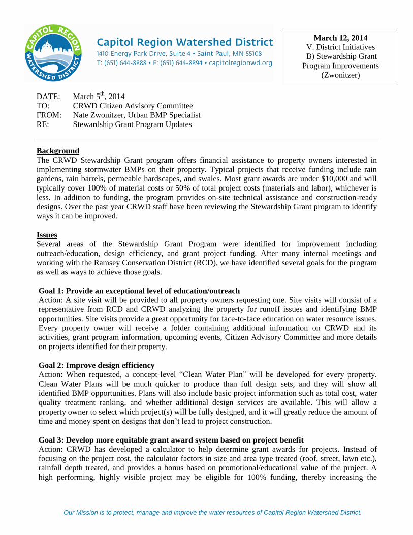
Background
The CRWD Stewardship Grant program offers financial assistance to property owners interested in
implementing stormwater BMPs on their property. Typical projects that receive funding include rain
gardens, rain barrels, permeable hardscapes, and swales. Most grant awards are under $10,000 and will
typically cover 100% of material costs or 50% of total project costs (materials and labor), whichever is
less. In addition to funding, the program provides on-site technical assistance and construction-ready
designs. Over the past year CRWD staff have been reviewing the Stewardship Grant program to identify
ways it can be improved.
Issues
Several areas of the Stewardship Grant Program were identified for improvement including
outreach/education, design efficiency, and grant project funding. After many internal meetings and
working with the Ramsey Conservation District (RCD), we have identified several goals for the program
as well as ways to achieve those goals.
Goal 1: Provide an exceptional level of education/outreach Action: A site visit will be provided to all property owners requesting one. Site visits will consist of a
representative from RCD and CRWD analyzing the property for runoff issues and identifying BMP
opportunities. Site visits provide a great opportunity for face-to-face education on water resource issues.
Every property owner will receive a folder containing additional information on CRWD and its
activities, grant program information, upcoming events, Citizen Advisory Committee and more details
on projects identified for their property.
Goal 2: Improve design efficiency
Action: When requested, a concept-level “Clean Water Plan” will be developed for every property.
Clean Water Plans will be much quicker to produce than full design sets, and they will show all
identified BMP opportunities. Plans will also include basic project information such as total cost, water
quality treatment ranking, and whether additional design services are available. This will allow a
property owner to select which project(s) will be fully designed, and it will greatly reduce the amount of
time and money spent on designs that don’t lead to project construction.
Goal 3: Develop more equitable grant award system based on project benefit Action: CRWD has developed a calculator to help determine grant awards for projects. Instead of
focusing on the project cost, the calculator factors in size and area type treated (roof, street, lawn etc.),
rainfall depth treated, and provides a bonus based on promotional/educational value of the project. A
high performing, highly visible project may be eligible for 100% funding, thereby increasing the
March 12, 2014
V. District Initiatives
B) Stewardship Grant
Program Improvements
(Zwonitzer)

2
likelihood it will be installed. Low performing, low visibility projects may not be eligible for full
designs or funding.
The following table summarizes the differences between the previous program and the updated
program.
What won’t change What will change
Continue to provide site visits and education
Continue to provide design services*
Continue to provide grant funding for projects*
*For high performing/visibility projects
A more robust package of educational
information will be provided
Clean Water Plans developed for every
property
Construction designs reserved for high quality
projects
Funding based on water quality/educational
value to encourage installation of superior
projects
Beginning with 2014 Stewardship Grant projects, we will be implementing these changes and modifying
them when necessary to meet the needs of property owners in CRWD.
Staff Request:
Feedback on proposed changes.
Enclosures: Sample Stewardship Grant folder and Clean Water Plan
W:\07 Programs\Stewardship Grant Program\2013\2013_Grant Program Changes\CAC Memo Stew Grant Updates 3-12-14.docx

24TH ST.
MIS
SIO
NS
T.
SV
AN
NE
SS
ST.
26TH ST.
25TH ST.
23RD ST.
30TH ST.
Construction
WATERSHED
www.capitolregionwd.org
WATERSHEDCAPITOL REGION WATERSHED DISTRICT
WHAT IS A WATERSHED?
A watershed is the area of land where water from rain or snowmelt runs off and drains to a water body such as a river, lake or pond. Watershed boundaries are defined by hills, mountains or other higher ground. Because all water eventually flows to a particular water body, all land is located in a distinct watershed. A good analogy of a waters hed is a bathtub. The “sides” of the tub define the boundary of the watershed while the “bottom” is the land area” that slopes slightly towards the “drain” or water body.
Water Resources
• Rivers
• Lakes• Wetlands• Stormwater Ponds
Stormwater Polutant Sources
• Fertilizers
WetlandsLakes
URBAN WATERSHEDS
Stormwater runoff is a major cause of water pollution. In an undeveloped environment, pervious ground surfaces filter and absorb stormwater from rain events as the runoff flows into nearby waters. In an urban setting with large amounts of impervious surfaces, much more of the rainwater is directly routed into engineered stormwater collection systems. In many older cities, the water collection systems combine stormwater with wastewater in combined sewer overflows (CSOs) before carrying it to wastewater management systems for treatment. Heavy-volume rain or snow events can overburden the collection and treatment systems, resulting in overflows of untreated wastewater (including chemical and microbial pollutants) into nearby receiving waters. This can result in unsafe recreational and drinking water, as well as potential harm to vegetation, fish, and other aquatic life.
• Streams and Creeks
• Motor Oil• Animal Waste
• Litter
• Road Salt• Fall Leaves

WATERSHED DISTRICTSCAPITOL REGION WATERSHED DISTRICT
WHAT IS A WATERSHED DISTRICT?
A watershed district is a special purpose unit of local government in charge of managing water resources within designated boundaries. Watershed districts work to protect and improve water quality in lakes, rivers, wetlands, and streams within their jurisdiction, and to protect residents and property against flooding. Minnesota was one of the first states to establish watershed districts as legal entities through the Minnesota Watershed Act of 1955. Minnesota has 46 watershed districts, including 13 in the metro area, working to protect our lakes, streams, wetlands and natural habitat. For more information about other MN watershed districts, visit the MN Association of Watershed Districts website www.mnwatershed.org.
CRWD Major Water Resources
• Como Lake• Lake McCarrons• Crosby Lake• Loeb Lake
CRWD Work
• Monitoring and Mapping
• Water Improvement Projects• Grants
Mississippi River
Como Lake
24TH ST.
MIS
SIO
NS
T.
SV
AN
NE
SS
ST.
26TH ST.
25TH ST.
23RD ST.
30TH ST.
Construction
SAINT PAUL, MN
CAPITOL REGION WATERSHED DISTRICTCapitol Region Watershed District (CRWD) originated from a small group of dedicated citizens who wanted to protect Como Lake. They petitioned the Board of Water and Soil Resources (BWSR) to create a watershed district, and in 1998 CRWD was formed. CRWD is a special purpose local unit of government created to manage and protect part of the Mississippi River Basin, along with the District’s wetlands, creeks and lakes that drain to the river. CRWD covers 40 square miles and includes portions of the cities of Falcon Heights, Lauderdale, Maplewood, Roseville and Saint Paul. Located within Ramsey County, CRWD has a population of 225,000 people. The Capitol Region Watershed District is comprised of numerous important water resources that all eventually discharge to the Mississippi River, its primary water resource. All CRWD lakes serve important recreational needs for District residents and visitors including fishing, boating and swimming. Water quality in CRWD lakes is monitored by Ramsey County, and groundwater underneath the land surface of the District provides non-drinking water for businesses and institutions. Few natural wetlands in the District remain because of their removal and alteration from urbanization and development over the past century.
• Mississippi River
www.capitolregionwd.org
• Technical Assistance• Permits
• Education and Outreach

CAPITOL REGION WATERSHED DISTRICT
Stormwater runoff occurs when precipitation from rain or snowmelt flows over the ground. Impervious surfaces like driveways, sidewalks, and streets prevent stormwater runoff from naturally soaking into the ground. Stormwater can pick up debris, chemicals, dirt, and other pollutants and flow into a storm sewer system or directly to a lake, stream, river, or wetland. Anything that enters a storm sewer system is discharged untreated into the waterbodies we use for swimming, fishing and providing drinking water.
• Action 2• Action 3• Action 4• Action 5
LawnSalt
24TH ST.
MIS
SIO
NS
T.
SV
AN
NE
SS
ST.
26TH ST.
25TH ST.
23RD ST.
30TH ST.
Construction
COMO LAKE, MN
• Action 1
www.capitolregionwd.org
• Action 2• Action 3• Action 4• Action 5
• Action 1• Action 2• Action 3• Action 4• Action 5
LeavesIrrigation
SUMMER
• Action 1
FALL
• Action 2• Action 3• Action 4• Action 5
• Action 1
GET INVOLVED!
No one wants an unhealthy, cloudy, green lake in their neighborhood. Clean water means fishing, swimming, and healthy aquatic plants and animals. It’s up to us to protect our lakes and rivers from eutrophication, a process that makes our water unhealthy and green from algae. To get involved considere becoming a member of the CRWD Citizen Advisory Comittee (CAC), or contact Elizabeth Beckman at CRWD for details [email protected].
WAYS TO HELP PROTECT YOUR WATERSHED

24TH ST.
MIS
SIO
NS
T.
SV
AN
NE
SS
ST.
26TH ST.
25TH ST.
23RD ST.
30TH ST.
Construction
www.capitolregionwd.org
WHAT IS A RAIN GARDEN?
A rain garden is a planted depression or a hole that allows rainwater runoff from impervious urban areas, like roofs, driveways, walkways, parking lots, and compacted lawn areas, the opportunity to be absorbed. The purpose of a rain garden is to improve water quality in near by bodies of water. Rain gardens can cut down on the amount of pollution reaching creeks and streams by up to 30%. Rain gardens can be planted with shrubs, perennials or native wildflowers and grasses to increase infiltration and attract a variety of birds. Native plants are recommended for rain gardens because they generally do not require fertilizer and are more tolerant of one’s local climate, soil, and water conditions, and attract local wildlife such as native birds.
1. Call 651-454-0002 to locate burried utilities.2. Determine how water runs across your property.3. Choose the best location for the rain garden (at least 10' from the basement and 4' from other surfaces)
4. If you have a wet spot in your yeard at the bottom of a slope, place the garden upslope.5. Layout the garden with a rope or garden hose.6. Dig a hole where the garden will be
7. Remove sod and soil 3" deeper than the depth of the raingarden.
8. Mix 3" of leaf compost into the soil9. Create an inlet and outlet and protect them from erosion with rocks or mulch.10. Add 3" of double shredded hardwood mulch.11. Plant!12. Water as needed for the remainder of the season. After year one there is no need tp water.13. Weed the raingarden and enjoy the blooming of plants.
STEP BY STEP RAIN GARDEN HOW-TO'S
For more details visit the Blue Thumb website www. bluethumb.org
RAIN GARDEN FACSHEETCAPITOL REGION WATERSHED DISTRICT
RAIN GARDEN
CAPITOL REGION WATERSHED DISTRICT
RAIN GARDEN MAINTENANCE
24TH ST.
MIS
SIO
NS
T.
SV
AN
NE
SS
ST.
26TH ST.
25TH ST.
23RD ST.
30TH ST.
Construction
www.capitolregionwd.org
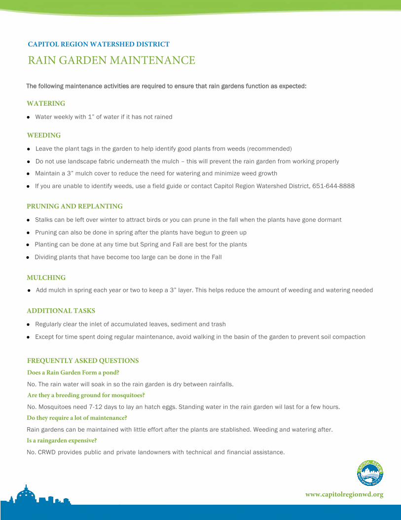
Water weekly with 1” of water if it has not rained
WATERING
Leave the plant tags in the garden to help identify good plants from weeds (recommended)
WEEDING
Do not use landscape fabric underneath the mulch – this will prevent the rain garden from working properly
Maintain a 3” mulch cover to reduce the need for watering and minimize weed growth
If you are unable to identify weeds, use a field guide or contact Capitol Region Watershed District, 651-644-8888
Stalks can be left over winter to attract birds or you can prune in the fall when the plants have gone dormant
PRUNING AND REPLANTING
Pruning can also be done in spring after the plants have begun to green up
Planting can be done at any time but Spring and Fall are best for the plants
Dividing plants that have become too large can be done in the Fall
Add mulch in spring each year or two to keep a 3” layer. This helps reduce the amount of weeding and watering needed
MULCHING
Regularly clear the inlet of accumulated leaves, sediment and trash
ADDITIONAL TASKS
Except for time spent doing regular maintenance, avoid walking in the basin of the garden to prevent soil compaction
The following maintenance activities are required to ensure that rain gardens function as expected:
FREQUENTLY ASKED QUESTIONSDoes a Rain Garden Form a pond?
No. The rain water will soak in so the rain garden is dry between rainfalls.
Are they a breeding ground for mosquitoes?
No. Mosquitoes need 7-12 days to lay an hatch eggs. Standing water in the rain garden wil last for a few hours.
Do they require a lot of maintenance?
Rain gardens can be maintained with little effort after the plants are stablished. Weeding and watering after.
Is a raingarden expensive?
No. CRWD provides public and private landowners with technical and financial assistance.

PROPOSED BMP’S LEGEND
John Johnson123 Water Street SouthSt. Paul, MN 55105
DOWNSPOUT (e)
RAIN BARREL(p)
HOUSE
PROPERTY LINE
PROPERTY LINE
WATE
R STREET
SIDEAWLK
ALLEY
GARAGE
WATER MOVEMENT
A
B
C
D
EF
G
RAINGARDEN
(e) = EXISTING, (p) = PROPOSED
CURB-CUT RAINGARDEN
PERMEABLE PAVERS/POROUS PAVEMENTClean Water Plan provided by:
Capitol Region Watershed District [CRWD] & Ramsey Conservation District [RCD]
Date: 3/3/14
NORT
H
BMP ID BMP Type Size (sq-ft) Cost Est. WQ RankDesign Services Available (Y/N)
A Rain Garden 65 900.00$ 4 YesB Rain Garden 65 825.00$ 5 YesC Rain Garden 115 1,200.00$ 2 YesD Rain Garden 105 1,100.00$ 3 YesE Curb-Cut Rain Garden 250 3,500.00$ 1 YesF Permeable Pavers 300 4,500.00$ 7 NoG Rain Barrel na 150.00$ 6 No
CLEAN WATER PLAN

STEWARDSHIP GRANT PROGRAMCAPITOL REGION WATERSHED DISTRICT
WHAT TYPES OF PROJECTS ARE INCLUDED IN THE PROGRAM?
The Stewardship grant program provides public and private landowners with technical and financial assistance to install water quality improvement projects known as “best management practices” (BMPs). Specifically, the program funds BMPs that reduce stormwater runoff, correct erosion and filter pollutants.
What You Can do to Help
• Downspouts Disconnection• Rainwater Reuse Systems• Permeable Surface• Green Roofs
Why Your Help is Important
• Improved Water Quality• Reduced Number of Flodding Events• Improved Groundwater Recharge
Downspouts
Rain Gardens
24TH ST.
MIS
SIO
NS
T.
SV
AN
NE
SS
ST.
26TH ST.
25TH ST.
23RD ST.
30TH ST.
Construction
STEWARDSHIP GRANT
• Rain Gardens
www.capitolregionwd.org
WHO IS ELIGIBLE?
Property owners within the Capitol Region Watershed District (CRWD) are eligible for grant funding. To find out if you are within the CRWD boundaries, contact the CRWD office or visit www.capitolregionwd.org.
WHY ARE THESE PROJECTS SUPPORTED WITH TAX DOLARS?
Stormwater runoff is the number one cause of water pollution. Reducing stormwater runoff by encouraging infiltration is key to keeping our lakes and rivers clean. With the vast majority of land in private ownership, partnerships with private landowners to install these practices are vitally important to improving the quality of our lakes, streams and wetlands.
• Enhanced Neighborhood Beauty
HOW DO I GET STARTED?
Step 1: Contact Gustavo Castro [email protected] to schedule a free site visit to identify project opportunities on your property.
Step 2: Work with the CRWD to complete your project plan and grant application. Applications are accepted year-round.
Step 3: Approval by the CRWD
Step 4: Implement the project.
Step 5: Submit information to CRWD to receive reimbursement.
• Native Planting

STORMWATER BEST MANAGEMENT PRACTICESCAPITOL REGION WATERSHED DISTRICT
RAIN GARDENS
A rain garden is a planted depression or a hole that allows rainwater runoff fromimpervious urban areas, like roofs, driveways, walkways, parking lots, andcompacted lawn areas, the opportunity to be absorbed. Rain gardens can beplanted with shrubs, perennials or native wildflowers and grasses to increase infiltration and attract a variety of birds and butterflies.
24TH ST.
MIS
SIO
NS
T.
SV
AN
NE
SS
ST.
26TH ST.
25TH ST.
23RD ST.
30TH ST.
Construction
www.capitolregionwd.org
RAINWATER REUSE SYSTEMS
Rainwater harvesting is the accumulation and deposition of rainwater for reusebefore it reaches the aquifer. This water can be reused for non-potable water use,such as irrigating potted plants, gardens and landscapes. Rain berrels can be usedindividually or linked together to capture large amounts of rainwater. A 55-gallon barrel is most common in residential areas but many configurations are possible.
PERMEABLE SURFACES
Permeable surfaces is a range of sustainable materials and techniques for permeable pavements that allow the movement of stormwater through the surface. In addition to reducing runoff, it filters pollutants from the water. Permeable surfaces can be used in parking lots, roads, driveways and sidewalks where no chemical or other hazardous materials are used
GREEN ROOFS
A green roof is a roof of a building that is partially or completely covered with vegetation and a growing medium, planted over a waterproofing membrane. It may also include additional layers such as a root barrier, drainage and irrigation systems. Roof gardens can be either extensive (soil depth 3" - 4") or intensive (soil depth 6" or greater). Intensive roofs allow for a grater variety of plant types.
NATIVE PLANTING
Native plants are adapted to the local climate and soil conditions where they naturally occur. Native plants work well for many landscaping and wildlife habitat plantings, because once established, they seldom need watering, mulching, protection from frost or continuous mowing. Native plants provide nectar, pollen, and seeds that serve as food for native butterflies, birds and other animals.
DOWNSPOUTS DISCONNECTION
Most downspouts carry water from our rooftops to the street, where water flows directly into stormdrains and streams. Streets are dirty so that water picks up a lot trash and chemicals along the way. You can do your part to keep trash and chemicals out of your neighborhood streams by directing your downspout into your yard or garden. The downspout and gutters remain in place.
CO
ST P
ER V
OLU
ME
OF
STRO
MW
ATE
R TR
EATE
D
LOW
HIGH

Capitol Region Watershed District 1410 Energy Park Drive, Suite 4 Saint Paul, MN 55108 Capitolregionwd.org (651) 644-8888
GRANT APPLICATION FORM
ONLY COMPLETE SECTION 2 IF YOU HAVE THE REQUIRED MATERIALS.
MAILING ADDRESS
PROJECT ADDRESS
LAST NAME FIRST NAME M.I.
LAST NAME FIRST NAME M.I.
STREET, NUMBER CITY ZIP
STREET, NUMBER CITY ZIP
SAME AS MAILING ADDRESS
HOME PHONE CELL / WORK EMAIL ADDRESS
HOME PHONE CELL / WORK EMAIL ADDRESS
PROJECT DESCRIPTION
ESTIMATED PROJECT COST
COST PROJECT DESIGN DETAILED COST ESTIMATE
BY CHECKING THIS BOX AND TYPING MY NAME BELOW, I AM APPLYING FOR GRANT FUNDS AND HAVE READ AND AGREE TO FOLLOW CRWD GRANT POLICIES.
APPLICANT INFORMATION APPLICANT #1
APPLICANT #2
(to be included with application)
REQUIRED APPLICATION MATERIALS
NAME (APPLICANT #1) NAME (APPLICANT #2)
Please submit form and required materials to: Gustavo Castro
[email protected] Fax: (651) 644-8894
SECT
ION
1SE
CTIO
N 2
*

STEWARDSHIP GRANT POLICIES
Page 1 of 3
1. OverviewCapitol Region Watershed District (CRWD) covers areas of Saint Paul, Roseville, Falcon Heights, Lauderdale and Maplewood. The area is highly developed -- about 42% impervious surfaces like streets and parking lots – so CRWD offers financial assistance to encourage private and public landowners to install clean water projects that protect and improve the Mississippi River as well as lakes and streams within the district. This program promotes water quality improvement by focusing on the reduction of phosphorus, sediment and the overall volume of stormwater runoff leading to
lakes and rivers.
2. Grant EligibilityCRWD partners with Ramsey Conservation District (RCD) to provide technical assistance to landowners interested in implementing water quality improvement projects on their property. To determine if you are eligible, contact CRWD at (651) 644-8888. CRWD may provide a free site visit and develop a Clean Water Plan that identifies water quality improvement projects for your property. Project information is available to help you complete projects, and reimbursement funding may be available.
3. Grant Award CalculationThe Stewardship Grant Program focuses on projects that reduce the amount of phosphorus and sediment in stormwater runoff as well as reducing the overall volume of runoff. Projects will be reviewed by RCD or CRWD staff to determine grant eligibility and reimbursement amount. Most awards are based on an approved cost estimate prepared by RCD, or a bid amount prepared by a qualified contractor. Grant reimbursement rates are calculated using a performance-based model. The more runoff treated by the project, the more funding it will receive. A maximum award amount is alsoincluded based on the typical cost for similar projects. CRWD reserves the right to modify these rates on a case-by-case basis.
4. ApplicationApplications for Stewardship Grants must be coordinated with the CRWD. Contact Gustavo Castro to begin the application process:
Gustavo CastroWater Resource SpecialistCapitol Region Watershed District [email protected] (651) 644-8888
A complete application package must be submitted for review to ensure the project is consistent with CRWD water quality goals and objectives. You can work with a contractor of your choosing to develop the required materials. Or, you can schedule a free site visit with CRWD staff. CRWD may provide the
Capitol Region Watershed District 1410 Energy Park Drive, Suite 4 Saint Paul, MN 55108 Capitolregionwd.org (651) 644-8888

Page 2 of 3
cost estimate and project design for the project without any costs for the applicant. Submittals required for application consideration include:
Grant Application (available at www.capitolregionwd.org)
Project designs including approximate size and drainage area
Cost estimate
5. Eligible Practices and Effective LifeProject eligibility will be determined by CRWD and RCD staff. Projects required by a CRWD, City or other permit or to correct a violation of CRWD Rules are not eligible for funding.
This is only a partial list of potentially eligible BMPs. For BMPs not listed below, the effective life will be determined on a case-by-case basis in consultation between CRWD and RCD technical staff. CRWD encourages landowners to maintain publicly funded BMPs in perpetuity. However, the “Effective Life” listed below is the minimum number of years that the CRWD requires a landowner to maintain the BMP in exchange for public funding of the project.
Best Management Practice (BMP) Effective Life
Rain Gardens 5
Shoreline/Streambank Restorationo Vegetative 5 o Structural (riprap, soil lift, etc.) 10
Pervious Hard Surface (pavers, asphalt etc.) 10
Critical Area Stabilizationo Vegetative 5 o Structural 10
6. Grant AwardsFor approved projects, the District may fund up to 100% of eligible cost. CRWD reserves the right toconsider funding requests exceeding the above guidelines on a case-by-case basis.
7. Proposal Review ScheduleApplications may be submitted year-round. Typically applicants will be notified of CRWD’s decision regarding their application within 10 business days.
8. Grant Agreement & AmendmentsThe Contract will be executed by CRWD upon approval by CRWD Administrator. Any amendment to the Contract terms shall be approved by CRWD Administrator and must be by mutual written agreement signed by all parties to the original contract.
9. Operation & Maintenance AgreementTo ensure that the expected operational life of a BMP is achieved, an Operation & Maintenance Agreement is incorporated into the contract specific to the practice receiving grant funds. Project maintenance is the sole responsibility of the applicant. CRWD will not accept any maintenance

Page 3 of 3
responsibility. By signing the contract, the applicant agrees to the terms of the maintenance agreement attached to the contract as Exhibit B.
10. Cost Estimates & Contractor BidsApplications must be accompanied by a CRWD approved cost estimate, typically prepared by RCD. The cost estimate should be divided into materials and labor and will be used to determine a maximum grant amount. Applicants must solicit, receive and submit at least two bids to CRWD for any contracted labor associated with the project. The applicant may choose any bid as they see fit, but reimbursement will be based on the lowest responsible bid at CRWD’s discretion. Aesthetic components of the project and maintenance costs are not eligible expenses.
11. PaymentPayments are reimbursement based and applicants must have an approved and fully executed grant agreement prior to beginning work in order to be eligible for reimbursement. After project completion, applicants must submit project photos along with a CRWD Voucher and Practice Certification Summary Form and copies of paid invoices and receipts. Staff of CRWD or RCD must inspect and certify that the project was completed according to the approved design standards, specifications and pollution reduction values. All claimed expenses will be reviewed and verified by CRWD staff as eligible, practical and reasonable. CRWD reserves the right to make adjustments to the costs submitted for reimbursement based on this review.
12. ScheduleProject installation must be started and completed by the dates identified in the Grant Assistance Contract. If the starting date is not met, the contract is automatically terminated upon that date and the applicant will need to reapply for funding. Additionally, applicants must not begin project installation prior to funding approval by CRWD. Any work completed prior to CRWD approval is at the applicant’s own expense and may not be eligible for grant reimbursement. The CRWD reserves the right to withdraw project funding at its discretion if the project is not completed by the date identified in the Grant Assistance Contract unless a written contract amendment to reschedule the work and funding is executed in accordance with Section 8 above.
13. Conformance to GuidelinesThe District reserves the right to withdraw funding for any project not completed in accordance with these guidelines or the terms of its executed Grant Contract. It is the applicant’s sole responsibility to acquire any/all required permits and approvals prior to commencement of their project, though CRWD may be able to assist.
14. Submitted InformationAny submitted information, including but not limited to applications, conceptual designs, contractor bids, cost estimates, final designs and specifications, copies of permits and proof of expenditures becomes part of the public record.

Capitol Region Watershed District 1410 Energy Park Drive, Suite 4 Saint Paul, MN 55108 Capitolregionwd.org (651) 644-8888
PROJECT ADDRESS
LAST NAME FIRST NAME M.I.
STREET, NUMBER CITY ZIP
HOME PHONE CELL / WORK EMAIL ADDRESS
I AM REQUESTING DESIGN SERVICES FOR THE ABOVE BMPs THROUGH THE CRWD. I AM AWARE THAT PUBLIC FUNDS WILL BE USED TO DESIGN THESE PRACTICES, AND IT IS MY INTENT TO CONSTRUCT THEM WHEN DESIGNS ARE COMPLETED.
APPLICANT INFORMATION
APPLICANT
NAME (APPLICANT #1)
STORMWATER BEST MANAGEMENT PRACTICES (BMPs) Complete the fields below with the information for all BMPs that you would like to request design services for.
COST ESTIMATE
TOTAL(Attach additional sheet if necessary)
DESIGN REQUEST & INTENT FORM Please submit form and required materials to:
Gustavo Castro [email protected]
Fax: (651) 644-8894
RANK BMP TYPE
* COMPLETE THIS FORM AFTER RECEIVEING YOU CLEAN WATER PLAN (CWP)

Our Mission is to protect, manage and improve the water resources of Capitol Region Watershed District.
DATE: March 6, 2014
TO: CRWD Citizens Advisory Committee
FROM: Mark Doneux, Administrator
RE: CAC Packet
Background
As part of the discussion to refocus the Citizen’s Advisory Committee (CAC), the committee decided to
develop an orientation packet for new committee members. At the February 12th
CAC meeting, a
general outline and content of the packet was discussed. Staff agreed to assemble the information and to
start the formatting process and return at the March CAC meeting with a rough draft of the packet for
further development by the committee.
Issues
Based on input from the February CAC meeting, staff assembled documents and formatted the materials
into a first draft of an orientation packet for new CAC members. This is a draft document and is
intended as a starting point for the Committee to begin editing and formatting the material. Any
and all material can be edited, rewritten, deleted, changed and/or reformatted. The key areas for
the CAC to focus on for this draft would be reviewing and commenting on the following sections:
a) CAC Framework -This section can become a stand-alone document to convey the overall
purpose and function of the Committee.
b) CAC Expectations - We included the items from State Statute and the CAC By-Laws for this
section but would like to hear from the Committee if you would like to include other
expectations.
c) CAC Contributions – Everyone needs to brainstorm a list of contributions made by the CAC
over the years.
d) CAC Bios – Please draft a short (2-3 sentence) personal bio to include in this section.
Again, the whole document is subject to editing however these sections need the most input from the
CAC to complete.
Action Requested
Provide, review, comment, edits and additions to the entire CAC Orientation Packet. Specific emphasis
should be placed on the following sections:
a) CAC Framework,
b) CAC Expectations,
c) CAC Contributions, and
d) CAC Bios.
Enclosure: Draft CAC Orientation Packet
W:\05 Citizens Advisory Committee\2014 Files\CAC Memo Orientation Packet 3-6-14.docx
March 12, 2014
VI. CAC Initiatives
A) Orientation Packet (Doneux)

Capitol Region Watershed District Citizen Advisory Committee
Capitol Region Watershed District (CRWD)originated from a small group of dedicated citizens who wanted to protect Como Lake. They petitioned the Board of Water and Soil Resources (BWSR) to create a watershed district, and in 1998 CRWD was formed. CRWD is a special purpose local unit of government created to manage and protect part of the Mississippi River Basin, along with the District’s wetlands, creeks and lakes that drain to the river.
CRWD covers 40 square miles and includes portions of the cities of Falcon Heights, Lauderdale, Maplewood, Roseville and Saint Paul. For a map of CRWD, click here. Located within Ramsey County, CRWD has a population of 225,000 people. CRWD drains to the Mississippi River, its primary water resource. CRWD lakes include Como Lake, Crosby Lake and Loeb Lake in Saint Paul and Lake McCarrons in Roseville.
CRWD is governed by a five-member Board of Managers that guides CRWD in the implementation of its Watershed Plan adopted in 2010. The work of CRWD is carried out by 14 staff members.
District MissionOur mission is to protect, manage and improve the water resources of the Capitol Region Watershed District.
CAC MissionThe Mission of the Citizen’s Advisory Committee is to assist and advise the Board of Managers by reflecting community values in the devel-opment of the projects and programs of the CRWD; and communicating information about the District’s mission, projects and programs back to the community.
1410 Energy Park Drive, Ste 4Saint Paul, MN 55108
651-644-8888 • fax 651-644-8894capitolregionwd.org
Introduction

Capitol Region Watershed District Citizen Advisory Committee
Mission of the Citizen Advisory CommitteeThe Mission of the Citizen’s Advisory Committee is to assist and advise the Board of Managers in accordance with state statute 103D.331. This is accomplished by reflecting community values in the development of the projects and programs of the CRWD and by communicating information, and giving feedback about projects and programs back to the community.
Roles and Responsibilities
•
The CAC will actively participate in Capitol Region Watershed District (CRWD) planning processes, watershed plan preparation, and long-term implementation of CRWD programs.
•
The CAC will be a communication link between the citizenry and CRWD Board of Managers.
•
Additional roles and responsibilities of the CAC shall be determined jointly by the CAC and the CRWD Board and can include such things as:
•
Identify issues that are relevant to the responsibilities of the district.
•
Assist with the ranking of issues.
•
Review and comment on the budget.
•
Review and comment on revised work plans and schedules as necessary.
•
Assist the Board in communicating with various community groups, organizations, and citizens on matters affecting the district.
•
Identify areas where additional education and information could assist the Citizen Advisory Committee in making recommendations.
• Provide responses to the Board within a reasonable time frame so decisions are not delayed.
Recruitment and AppointmentRecruitment
• The CRWD Board’s goal is that the CAC be diverse and represents multiple stakeholders within the watershed.
• One CAC member residing within Roseville, Falcon Heights, Maplewood, and each of St. PaulCommunity Councils shall be recruited.
• Existing CAC members will help recruit other members. All potential CAC members must applydirectly to and be appointed by the CRWD Board
Citizen Advisory Committee framework

Capitol Region Watershed District Citizen Advisory Committee
CAC framework (cont.)
Appointment
• An application form will be sent to individuals requesting appointment to the CAC.
• The Board will make a concerted effort to ensure that the CAC includes equal representation fromresidents throughout the watershed.
• The Board may appoint interested parties who do not reside within the watershed district to serveat the pleasure of the Board.
• The CRWD will appoint new CAC members based on a candidate’s:- Interest, availability, unique skills or experiences and their ability to meet the District’s goal of
CAC membership diversity.
CAC Organization• The CAC will elect its own leadership
• The CAC will create, update and operate under a set of bylaws that are adopted by the Committee and approved by the Board of Managers.
CAC InitiativesIn addition to the Roles and Responsibilities the CAC will undertake a number of their own initiates that builds its own knowledge base and creates more cohesion between committee members.
• Recruit new CAC members and maintain an orientation packet
• Sponsor guest speakers at CAC meetings
• Increase interaction with neighborhoods, receiving information and sharing it in two-way commu-nication
• Interact more with local governments.
• Sponsor an awards program to recognize outstanding citizens, partners and projects in the district.
• Stay abreast of water resource issues by attending the MAWD or other conferences.
• Attend more tours of projects/features in the CRWD, increasing the number of tours in thewatershed to at least two per year with the second tour focused on a particular project or facility
• Participate in legislative activities that impact the district
• Participate in public education about the CRWD and its projects
• Increase interaction between CAC members, district staff, and board managers

Capitol Region Watershed District Citizen Advisory Committee
Subd. 1a Duties of Minnesota statute 103D.331 Advisory Committee
(1) elect a chair from its membership;
(2) elect a recorder from its membership;
(3) establish a meeting schedule, which at a minimum meets annually;
(4) consider issues pertinent to the functions and purposes of the watershed district;
(5) review and comment on reports, minutes, activities, and proposed projects of the managers; and
(6) report to the managers the general content of advisory committee meetings and resulting recommendations.
CAC Bylaws, Section V. Participation
To ensure the efficient and effective working of the Citizen Advisory Committee, regular attendance at meetings is necessary. Accordingly, if a member fails to attend four consecutive (unexcused) regular meetings or fails to attend 8 of the 12 regular monthly meetings without notice, that member will forfeit his/her Citizen Advisory Committee membership. A member in jeopardy due to lack of attendance (above) shall be notified in the Citizen Advisory Committee minutes and by separate memorandum to the member that his/her attendance is required at the next regularly scheduled Citizen Advisory Committee meeting to avoid forfeiture of membership.
An absence shall be deemed excused if the member notified the Chair, another Citizen Advisory Committee member or District staff prior to the meeting. Excused absences shall be noted in the minutes of the meeting
Members of the Citizen Advisory Committee may request a leave of absence from the Citizen Advisory Committee by sending a letter to the Board of Managers. The Board of Managers may grant a leave of absence for a period of no less than three months and up to a maximum of one year. While a member is on leave of absence, they shall not be eligible to vote, and shall not be counted towards quorum.
Members shall communicate their intention to resign in writing to the Citizen Advisory Committee Secretary, who in turn will notify the Citizen Advisory Committee and the Board of Managers.
Advisory Committee members are encouraged to attend Board of Managers’ meetings and functions.
Expectations of CAC members

Capitol Region Watershed District Citizen Advisory Committee
CRWD 2013 organization chart
Capitol Region Watershed DistrictBoard of Managers
Joseph Collins, President
Mary Texer, Vice President
Michael R. Thienes, Treasurer
Seitu Jones, Secretary
Shirley Reider, Education/Information
Staff
Mark Doneux, Administrator
Elizabeth Beckman, Education & Outreach Coordinator
Anna Elera, Water Resource Specialist
Bob Fossum, Water Resource Project Manager
Forrest Kelley, Permit Coordinator
Michelle Sylvander, Office Manager
Britta Suppes, Monitoring Coordinator
Citizen Advisory Members
Ramsey County
Board of Commissioners

Capitol Region Watershed District Citizen Advisory Committee
Highlights of CAC contributions to District projects

Capitol Region Watershed District Citizen Advisory Committee
CRWD map
Lauderdale
Roseville
St. Paul
LakeMcCarrons
Como Lake
LoebLake
CrosbyLake
Mississippi R
iver
Mississippi R
iver
Falcon Heights
Little Canada
Proposed BMP LocationProposed BMP Location
TROUT BROOK
COMO
CROSBY
ST. ANTHONY PARK
DAVERN
ST. ANTHONY HILL
MISSISSIPPI RIVER BLVDEAST KITTSONDALE
PHALEN CREEK
DOWNTOWN
MCCARRONS LAKE
WEST KITTSONDALEURBAN
WEST SEVENTH
GOODRICH-WESTERN
HIDDEN FALLS
Capitol Region Watershed DistrictWatershed Extent and Subwatersheds
0 0.5 1 1.5 20.25Miles I DISCLAIMER: This map is neither a legally recorded map nor a survey, and is not intended to be used as one. This map is a compilation of records, information and data
located in various city, county, state and federal offices and other sources regarding the area shown, and is to be used for reference purposes only.
Major Highways
Major Waterbodies
Parks
CRWD
Subwatersheds
Falcon Heights
Lauderdale
Maplewood
Roseville
Saint Paul
Maplewood
Service Layer Credits: Copyright: ©2013 Esri, DeLorme, NAVTEQ
Lauderdale
Roseville
St. Paul
LakeMcCarrons
Como Lake
LoebLake
CrosbyLake
Mississippi R
iver
Mississippi R
iver
Falcon Heights
Little Canada
Proposed BMP LocationProposed BMP Location
TROUT BROOK
COMO
CROSBY
ST. ANTHONY PARK
DAVERN
ST. ANTHONY HILL
MISSISSIPPI RIVER BLVDEAST KITTSONDALE
PHALEN CREEK
DOWNTOWN
MCCARRONS LAKE
WEST KITTSONDALEURBAN
WEST SEVENTH
GOODRICH-WESTERN
HIDDEN FALLS
Capitol Region Watershed DistrictWatershed Extent and Subwatersheds
0 0.5 1 1.5 20.25Miles I DISCLAIMER: This map is neither a legally recorded map nor a survey, and is not intended to be used as one. This map is a compilation of records, information and data
located in various city, county, state and federal offices and other sources regarding the area shown, and is to be used for reference purposes only.
Major Highways
Major Waterbodies
Parks
CRWD
Subwatersheds
Falcon Heights
Lauderdale
Maplewood
Roseville
Saint Paul
Maplewood
Service Layer Credits: Copyright: ©2013 Esri, DeLorme, NAVTEQ

Capitol Region Watershed District Citizen Advisory Committee
103D.331 ADVISORY COMMITTEE.
Subdivision 1.Purpose.
The managers must annually appoint an advisory committee to advise and assist the managers on all matters affecting the interests of the watershed district and make recom-mendations to the managers on all contemplated projects and improvements in the watershed district.
Subd. 1a.Duties.
For purposes of carrying out its duties under this section the advisory committee shall:
(1) elect a chair from its membership;
(2) elect a recorder from its membership;
(3) establish a meeting schedule, which at a minimum meets annually;
(4) consider issues pertinent to the functions and purposes of the watershed district;
(5) review and comment on reports, minutes, activities, and proposed projects of the managers; and
(6) report to the managers the general content of advisory committee meetings and resulting recommendations.
Subd. 2.Members.
(a) The advisory committee consists of at least five members. If practicable, the advisory committee members selected should include a representative from each soil and water conservation district, a representative of each county, a member of a sporting organi-zation and a member of a farm organization. Other advisory committee members may be appointed at the discretion of the managers. The members must be residents of the watershed district, except representatives from soil and water conservation districts and counties, and serve at the pleasure of the managers.
(b) In addition, the managers may appoint other interested and technical persons who may or may not reside within the watershed district to serve at the pleasure of the managers.
Subd. 3.Expense reimbursement.
The managers may reimburse members of the advisory committee for actual traveling and other necessary expenses incurred in the performance of duties in the amount as provided for state employees.
2013 Minnesota statute

Capitol Region Watershed District Citizen Advisory Committee
Adopted August 4, 19991st Amendment May 2, 20012nd Amendment October 3, 20013rd Amendment August 11, 20044th Amendment February 10, 2010
I. PURPOSE AND AUTHORITY
The Citizen Advisory Committee is established to advise and assist the Capitol Region Watershed District Board of Managers with:
(a) District organizational development, planning processes, and program implementation
(b) District communications between the citizenry and the Board of Managers
(c) Consensus building and conflict resolution
(d) Additional roles as jointly determined by the Citizen Advisory Committee and Board of Managers
The Citizen Advisory Committee performs its duties in accordance with Minnesota Statutes 103D.3311.
II. MEMBERSHIP
Citizen Advisory Committee members are appointed by the Board of Managers and serve at the pleasure of the Board.
The Citizen Advisory Committee will be composed of a minimum of five members who are District residents, as required by Minnesota Statutes 103D.331, and a maximum number as required to represent the diverse interests of the District’s communities and neighborhoods. In addition, the Board of Managers may appoint interested and technical persons who are not District residents to the Citizen Advisory Committee to serve in an ex-officio capacity.
The Board of Managers determines length of term for Citizen Advisory Committee membership.
III. MEETINGS
Citizen Advisory Committee meetings shall be conducted in accordance with Robert’s Rules of Order.
Regular meetings shall be held on the Second Wednesday of each month. Those members present at the prior regularly scheduled meeting may make a variance from this meeting schedule by majority vote. Notice of the date, time, place and proposed agenda of the meeting shall be given at least seven days before the meeting.
Special and/or emergency meetings may be called by the Chair, and shall be limited in subject and scope to meet the need for such a meeting. Notice of special and emergency meetings should include the subject and scope of the meeting and be made 24 hours in advance of the meeting by mail, phone, fax or email.
A quorum to conduct Citizen Advisory Committee business will be the presence of at least five members or a simple majority of the members, whichever is least.
At the discretion of the co-chairs, a subcommittee or taskforce may be appointed to review proposals or to develop recommendations for the Citizen Advisory Committee’s consideration.
CAC bylaws

Capitol Region Watershed District Citizen Advisory Committee
The chair may appoint non-members who have expressed an interest in the topic or who have specialized expertise to a subcommittee or taskforce as appropriate. In the event that a regularly scheduled meeting is canceled or if there is not quorum to conduct business at a regularly scheduled meeting, a subcommittee or taskforce may meet during the time of the regularly scheduled meeting without providing 24-hour notice.
Prior to deliberation on an issue, a member who feels they have a potential financial conflict of interest shall disclose that information to the Chair and members. Members may also identify potential conflicts of interest of other members to the Chair and members. A majority vote of members present will determine whether the conflict of interest is substantial enough to exclude the member from voting on the issue. All conflicts of interest disclosures and the subsequent determi-nation on whether to exclude a member from a vote, shall be noted in the minutes.
All Citizen Advisory Committee meetings shall be public. Public participation at meetings will, to the extent possible, be for the purpose of presenting information or providing comments that were not previously available to the Citizen Advisory Committee.
IV. OFFICERS
Officers shall be elected for a one-year term. Elections shall be held during the regular Citizen Advisory Committee meeting in April. Candidates for office shall have been a Citizen Advisory Committee member for at least three months prior to the election. Officers shall be:
Two Co-Chairs, and Secretary
Duties of the officers:
(a) The two Co-Chairs prepare meeting agendas and preside at all regular and special meetings of the Citizen Advisory Committee. The co-chairs shall have the authority to appoint individuals to serve on subcommittees and taskforces as appropriate.
(b) One of the Co-Chairs presides at meetings whenever the other Chair is absent.
(c) Secretary administers the paperwork at each meeting, prepares and distributes meeting minutes, receives Citizen Advisory Committee members’ expense reports and forwards them to the Board of Managers, handles all Citizen Advisory Committee correspondence and maintains a Citizen Advisory Committee file of pertinent information.
Officers may delegate their duties to other Citizen Advisory Committee members or to District staff.
Any officer whose Citizen Advisory Committee membership ceases prior to the expiration of his/her term as an officer shall be replaced for the balance of his/her term by a special election of the Citizen Advisory Committee. Such special election shall be held during the second regular meeting of the Citizen Advisory Committee immediately following termination of the officer’s membership.
V. PARTICIPATION
To ensure the efficient and effective working of the Citizen Advisory Committee, regular attendance at meetings is necessary. Accordingly, if a member fails to attend four consecutive (unexcused) regular meetings or fails to attend 8 of the 12 regular monthly meetings without notice, that member will forfeit his/her Citizen Advisory Committee membership. A member in jeopardy due to lack of attendance (above) shall be notified in the Citizen Advisory Committee minutes and by separate memorandum to the member that his/her attendance is required at the next regularly scheduled Citizen Advisory Committee meeting to avoid forfeiture of membership.
CAC bylaws (cont.)

Capitol Region Watershed District Citizen Advisory Committee
An absence shall be deemed excused if the member notified the Chair, another Citizen Advisory Committee member or District staff prior to the meeting. Excused absences shall be noted in the minutes of the meeting.
Members of the Citizen Advisory Committee may request a leave of absence from the Citizen Advisory Committee by sending a letter to the Board of Managers. The Board of Managers may grant a leave of absence for a period of no less than three months and up to a maximum of one year. While a member is on leave of absence, they shall not be eligible to vote, and shall not be counted towards quorum.
Members shall communicate their intention to resign in writing to the Citizen Advisory Committee Secretary, who in turn will notify the Citizen Advisory Committee and the Board of Managers.
Advisory Committee members are encouraged to attend Board of Managers’ meetings and functions.
VI. REIMBURSEMENT
Citizen Advisory Committee members can be reimbursed for expenses incurred while carrying out the business of the District when such expenses are pre-approved by the Board of Managers. Typical reimbursements will be for travel, lodging, meals and supplies to attend and/or participate in confer-ences, workshops, tours, and meetings. Costs incurred in attending regular, special and emergency meetings of the Citizen Advisory Committee and the Board of Managers are not normally considered reimbursable expenses but can be reimbursed upon decision of the Board of Managers when need is demonstrated.
VII. AMENDMENTS
These by-laws may be amended by a two-thirds vote of the members present at any regular meeting of the whole Citizen Advisory Committee, provided that written notice setting forth in detail the content of the proposed amendment(s) has been presented at the prior regular meeting.
These by-laws shall be reviewed for possible changes or updates by approved motion of the Citizen’s Advisory Committee or Board of Managers.
By-laws and any changes thereto shall be submitted to the Capitol Region Watershed District Board of Managers for comment prior to adoption.
1 Minnesota Statues 103D.331. Watershed District Advisory Committee
Subdivision 1. Purpose. The managers must appoint an advisory committee to advise and assist the managers on all matters affecting the interests of the watershed district and make recommenda-tions to the managers on all contemplated projects and improvements in the watershed district.
Subd. 2. Members. (a) The advisory committee consists of at least five members. If practicable, the advisory committee members selected must include a supervisor of a soil and water conservation district, a member of a county board, a member of a sporting organization, and a member of a farm organization. Other advisory committee members may be appointed at the discretion of the managers. The members must be residents of the watershed district and serve at the pleasure of the managers.
(b) In addition, the managers may appoint other interested and technical persons who may or may not reside within the watershed district to serve at the pleasure of the managers.
Subd. 3. Expense reimbursement. The managers may reimburse members of the advisory committee for actual traveling and other necessary expenses incurred in the performance of duties in the amount as provided for state employees.
CAC bylaws (cont.)

Capitol Region Watershed District Citizen Advisory Committee
David Arbeit, Co-Chair1384 East Como Blvd.St. Paul, MN 55117(651) 489-6452 (H)[email protected]
Michael MacDonald1391 Almond AveSt. Paul MN 55108(952) [email protected]
Richard Weil25 Charles Ave.St. Paul, MN 55103(651) 698-7288 (H) (651) 210-5059 (O)[email protected]
William Barton533 Cretin Ave SouthSt. Paul MN 55116 (763) 551-3391 (O)(651) 699-5478 (H)[email protected]
Ted McCaslin1675 Lilac LaneMendota Heights, MN 55118(651) 644-4389(612) [email protected]
CAC membership roster
The Citizens Advisory Committee meets the 2nd Wednesday of each month
at 7:00 p.m.
RCD Supervisor LiaisonGwen Willems, Co-Chair1880 Tatum StreetFalcon Heights MN 55113(651) [email protected]
Pat Byrne243 S Lexington PkwySt. Paul, MN 55104(612) 224-3183 (H)[email protected]
Janna Caywood1395 Avon Street NorthSt. Paul, MN 55117(651) [email protected]
Steven Duerre76 BatesSt. Paul, MN 55106(651) 771-6001 (H) (651) 757-2318 (O)[email protected]
Kathryn SwansonApt. 41879 Portland AveSt Paul MN 55104(612) [email protected]
Michelle Ulrich, Secretary1561 Lincoln AveSt Paul MN 55105(651) [email protected]
Board Manager Joe Collins 534 W Orange AveSt. Paul, MN 55117(651) 488-5108 (H)[email protected]
Board Manager Mary Texer 113 Farrington StreetSt. Paul, MN 55102(612) 224-2919 (H)[email protected]
Board Manager Mike Thienes 284 S McCarrons BlvdRoseville MN 55113 (651) 489-1998 (H)[email protected]
Board Manager Seitu Jones 629 Kent StSt. Paul, MN 55103(651) 227-9328 (H)[email protected]
Board Manager Shirley A. Reider1725 Fairview Ave NoFalcon Heights, MN 55113(651) 644-7845 (H)(651) 647-6250 (O)[email protected]
Updated: June 6, 2013

Capitol Region Watershed District Citizen Advisory Committee
David Arbeit, Co-Chair
William Barton
Pat Byrne
Janna Caywood
Steve Duerre
Michael MacDonald
Ted McCaslin
Kathryn Swanson
Michelle Ulrich, Secretary
Richard Weil
Gwen Willems, Co-Chair
CAC member bios
Capitol Region Watershed District Citizen Advisory Committee
Updated: February 6, 2014
CAC Meeting Date District Initiatives CAC InitiativesJanuary 15, 2014 Lakes Analysis
Audubon Certification2014 CAC Meeting Plan
February 12, 2014 Partner Grant ReviewBMP Database Review
CAC Orientation PacketDiscuss 2014 “event”
March 12, 2014 Stewardship Grant Program UpdatesAdopt CAC Duties and Responsibilities
How to Be Effective with the Legislature
April 9, 2014 Awards Program Development Election of Officers
May 14, 2014 2013 Monitoring Program CAC Orientation Packet
June 11, 2014 Tour of District Projects
July 16, 2014 2015 Work Plan Development CAC Orientation Packet
August 13, 2014 CAC Orientation Packet
September 10, 2014
October 8, 2014
November 12, 2014
December 10, 2014 2015 Reappointment Recommendations
Pervious Parking Lot
Permit Program Update
Education Program Update
Groundwater Management Plan Update
CAC meeting calendar

1
Capitol Region Watershed District
Citizen Advisory Committee
2014 Agenda Plan
Updated: March 6, 2014
Pervious Parking Lot
Permit Program Update
Education Program Update
Groundwater Management Pan Update
W:\05 Citizens Advisory Committee\Agendas\2014\2014 CAC Agenda Plan 3-6-14.doc
CAC Meeting Date District Initiatives CAC Initiatives
January 15, 2014 Lakes Analysis
Audubon Certification
2014 CAC Meeting Plan
February 12, 2014
Partner Grant Review
BMP Database Review
CAC Orientation Packet
Discuss 2014 “Event”
March 12, 2014
-Farrington/Cottage Drainage Study
-Stewardship Grant Program Updates
-Adopt CAC Duties and
Responsibilities
-Event Planning
How to Be Effective with the
Legislature (Date Pending)
-CAC Orientation Packet
April 9, 2014
-Monitoring Program Review
-Awards Program Development
Election of Officers
CAC Orientation Packet
May 14, 2014
2013 Monitoring Report CAC Orientation Packet
June 11, 2014
Tour of District Projects
July 16, 2014
2015 Work Plan Development CAC Orientation Packet
August 13, 2014
CAC Orientation Packet
September 10, 2014
October 8, 2014
November 12, 2014
December 10, 2014
2015 Reappointment
Recommendations