mapping of priority areas for forest recovery using
TRANSCRIPT

R. Ra’e Ga DOI: 10.5380/raega Curitiba, v. 46, n. 3, p. 113 - 124, Set/2019 eISSN:2177-2738
MAPPING OF PRIORITY AREAS FOR FOREST RECOVERY USING MULTICRITERIA ANALYSIS IN THE BRAZILIAN ATLANTIC FOREST
MAPEAMENTO DE ÁREAS PRIORITÁRIAS PARA RECUPERAÇÃO UTILIZANDO ANÁLISE MULTICRITÉRIO NA FLORESTA ATLÂNTICA BRASILEIRA
Franciane Carla de Almeida1, Eduarda Martiniano de Oliveira Silveira2, Lara Lopes de Paiva3, Fausto Weimar Acerbi Junior4
ABSTRACT The collapse of a mining dam with 62 million cubic meters of mud in the Rio Doce basin resulted in the destruction of whole communities and large areas of the Atlantic Forest. As forest restoration activities are among the most costly conservation strategies, prioritization of restoration efforts is crucial. In the present article, this study mapped priority areas for forest recovery in a portion of the Rio Doce Basin (DO1) using a GIS-based (geographic information system) multicriteria decision analysis (MCDA) employing the weighted linear combination (WLC) method. Five factors with different weights were taken into consideration according to their level of importance: distance from the drainage network, distance from the native vegetation patches, slope, soil class and precipitation. A map of priority areas was produced in which 1.73% of the area was classified as very high priority for forest recovery, while 5.18% of the area was classified as high priority, 57.88% as medium priority, 1.34% as low priority and 0.00% as very low priority. The highest weights were attributed to the distance from the drainage network and the distance from native vegetation, revealing that areas of permanent preservation and those closer to forest fragments are priority areas for forest recovery. MCDA is a flexible and easy-to-implement method which generates maps with suitable solutions for forest recovery. The chosen approach can be replicated in regions that require support for decision making in environmental planning, such as the Pantanal biome, which is under considerable process of deforestation for the expansion of pastures. Keywords: tropical forests; spatial analysis; analytical hierarchical process. RESUMO O rompimento de uma barragem de rejeitos de mineração com 62 milhões de metros cúbicos de lama, na bacia do Rio Doce, resultou na destruição de comunidades inteiras e grandes áreas de Mata Atlântica próximas às margens dos rios. Como as atividades de restauração florestal estão entre as estratégias de conservação mais dispendiosas, este trabalho teve como objetivo definir e mapear as áreas prioritárias para recuperação florestal em uma porção da Bacia do Rio Doce (DO1). Para isso, utilizou-se a análise de decisão multicritério (MCDA) associada ao SIG (sistema de informações geográficas) e baseada no método de combinação linear ponderada (WLC). Cinco fatores foram considerados, recebendo pesos distintos de acordo com sua importância: distância da rede de drenagem, distância do fragmento de vegetação nativa, declividade, classe de solo e precipitação. O resultado foi um mapa de áreas prioritárias onde 1,73% das áreas foram classificadas com muito alta prioridade para recuperação florestal, enquanto 5,18% das áreas foram classificadas com alta prioridade, 57,88% com prioridade média, 1,34% com baixa prioridade e 0.00% com prioridade muito baixa. Os maiores pesos foram atribuídos aos fatores proximidade da rede de drenagem e proximidade de fragmentos de vegetação nativa, revelando que as áreas de preservação permanente e próximas a fragmentos florestais são áreas prioritárias para a recuperação florestal. A ADMC é um método flexível, de fácil implementação e produz mapas contendo soluções adequadas para conduzir ações de recuperação de forma rápida e eficiente. Este estudo pode ser replicado em diversas regiões que necessitam de apoio para a tomada de decisões no planejamento ambiental, como o bioma Pantanal, marcado pelo desmatamento para a expansão principalmente de pastagens. Palavras chave: florestas tropicais; análise espacial; processo analítico hierárquico.
1Universidade Federal deLavras,Lavras/MG, email:[email protected] 2Universidade Federal de Lavras, Lavras/MG, email: [email protected] 3 Universidade Federal de Lavras, Lavras/MG, email: [email protected] 4 Universidade Federal de Lavras, Lavras/MG, email: [email protected]

ALMEIDA, F. C., SILVEIRA, E. M. O., PAIVA, L. L., ACERBI JUNIOR, F. W.
MAPPING OF PRIORITY AREAS FOR FOREST RECOVERY USING MULTICRITERIA ANALYSIS IN THE BRAZILIAN ATLANTIC FOREST
114
Recebido em: 26/05/2019 Aceito em: 22/07/2019
1. INTRODUCTION
The Brazilian Atlantic Forest is a globally
important ecological hotspot (ARAUJO et al,
2015, p.659) and it is considered one of the most
important ecoregions for biodiversity
conservation in the world (MYERS et al, 2000,
p.855). However, this ecosystem is also one of
the most fragmented and most exploited
Brazilian biomes, which for centuries has endured
timber exploitation, agricultural development,
farming, exotic tree plantations and hunting
(SANTOS et al, 2018, p.414). Prior to European
settlement, the Atlantic Forest had covered c.
130 million hectares, but at present only 12.4% of
its original area remains (SOS MATA ATLÂNTICA,
2018).
Beyond the loss of biodiversity, human-
induced forest cover changes decrease water
quality due to soil erosion, thus increasing
nutrient and sediment loading in rivers (YANG et
al, 2016, p.31). As restoration activities are
among the most expensive conservation
strategies worldwide (HOLL et al, 2003, p.491),
the development of approaches for the
prioritization of restoration efforts is crucial
(FERNÁNDEZ; MORALES, 2016, p.1). Among these
approaches, MultiCriteria Decision Analysis
(MCDA) has been effectively used in forest
restoration efforts, as it allows the aggregation of
the criteria that represent critical characteristics
at the landscape scale (VALENTE et al, 2017, p.
54). The integration of MCDA with a GIS
(geographic information system) provides a
powerful spatial decision support system which
offers the opportunity to efficiently produce
maps. Indeed, GIS is a powerful tool to analyze
spatial data and to establish a process for
decision support (HAMADOUCHE et al, 2014,
p.419). Because of their spatial aggregation
functions, MCDA methods can facilitate decision
making in situations where several solutions are
available, thus various criteria must be taken into
account and decision makers are in conflict
(MENG; MALCZEWSKI, 2015, p.32).
The collapse of a mining dam located in
a Brazilian Atlantic Forest area on the 5th of
November 2015, which was considered one of
the biggest environmental disasters in the
country’s history, resulted in the destruction of
whole human communities by a river of mud and
mining waste. This calamity affected Rio Gualaxo
in the Brazilian district of Mariana, a tributary to
Rio Carmo and ultimately Rio Doce. The flood
affected 600 kilometers of riverbed and
destroyed human and animal lives as well as
several land cover classes (such as grasslands,
urban areas and native vegetation) and
permanent preservation areas (SILVEIRA et al,
2017, p.554). More recently, on the 25th of
January 2019, another mining dam collapsed in
the same region, in the city of Brumadinho,
leaving 212 people dead and 93 missing (PEREIRA
et al, 2019, p.122).
Mining dam collapses are examples of
fast land conversion and degradation, but this
region has also been affected by slower forms of
conversion and degradation, such as
deforestation and burning, which have resulted
in large expanses of degraded areas. Thus, it is
addressed the question of where is the best area
to restore the native vegetation by mapping and
identifying priority areas for forest recover in a
portion of Atlantic Forest in Rio Doce Basin
(DO1). A GIS-based multicriteria decision was
used with the employment of the weighted linear
combination (WLC) method for the aggregation
of criteria.
2. MATERIAL AND METHODS
Rio Gualaxo, a tributary to Rio Doce
which is located in the Brazilian district of
Mariana in the central region of Minas Gerais
(MG) state, was the main focus of this study due
to the collapse of a mining dam that resulted in
the destruction of permanent preservation areas
and forest remnants. The study area covers a
portion of the Rio Doce Basin (DO1), in MG state,
where vegetation is predominantly composed of

ALMEIDA, F. C., SILVEIRA, E. M. O., PAIVA, L. L., ACERBI JUNIOR, F. W.
MAPPING OF PRIORITY AREAS FOR FOREST RECOVERY USING MULTICRITERIA ANALYSIS IN THE BRAZILIAN ATLANTIC FOREST
115
Atlantic Forest types (Figure 1a). DO1 represents
24.65% of the total area of the Rio Doce Basin,
totaling 14,062 km² (Figure 1b), and it is
characterized by a hilly relief and abundant
tablelands. The climatic conditions are typical of
humid tropical highlands (SILVEIRA et al, 2017,
p.556). The effects of the flood on the permanent
preservation areas of Rio Gualaxu were clearly
visible on the ground and from remotely sensed
imagery (Figure 1c).
Figure 1. (a) Location of the study area (DO1) in MG state; (b) Landsat TM image R3 G2 B1 detailing the
DO1 and; (c) Illustration of the effects of the flood in permanent preservation areas of Rio Gualaxu,
before and after the environmental disaster. The main river is illustrated with a blue line. Source:
Authors.
MCDA was used to define priority areas
for forest restoration following four main steps
(Figure 2). The following data sets were
employed:
▪ Precipitation, acquired from
WorldClim (HIJMANS et al, 2005,
p.1966);
▪ Drainage network digitized by a
skilled interpreter using images
from Rapid Eye satellite (5 meters
spatial resolution);
▪ Land cover map provided by
Carvalho et al, (2006, p.37),
manually edited by a skilled
interpreter;
▪ Soil map (FEAM 2010);
▪ Digital elevation model (DEM)
obtained from ALOS PALSAR.
▪

ALMEIDA, F. C., SILVEIRA, E. M. O., PAIVA, L. L., ACERBI JUNIOR, F. W.
MAPPING OF PRIORITY AREAS FOR FOREST RECOVERY USING MULTICRITERIA ANALYSIS IN THE BRAZILIAN ATLANTIC FOREST
116
Figure 2. Methods flowchart detailing the four main steps to identify priority areas for forest recovery in
a portion of the Rio Doce Basin. Source: Authors.
Criteria describing suitable landscape,
terrain, edaphic and climatic characteristics and
their relative importance for selecting priority
areas for forest restoration were defined based
on expert knowledge about the region and
previous studies (FERNÁNDEZ; MORALES, 2016,
p.03; HOLL et al, 2003, p.500; KIKER et al, 2005,
p.95; MENG; MALCZEWSKI, 2015, p.30; RAMÍREZ-
TORO et al, 2017, p.02; SARTORI, 2010, p.05;
SILVA et al, 2017, p.02; VETTORAZZI, 2006, p.15;
YANG et al, 2016, p.27).
Precipitation was chosen as a suitable
climatic variable because its frequency, intensity
and duration directly influence soil erosion. The
proximity to drainage network was also selected
as an important attribute because riparian forests
contribute to soil and water conservation,
reducing both erosion and silting of the rivers.
Zones of 100, 200, 300 and 400 meters from the
drainage network were created, with the closer
ones having higher priority.
The proximity to forest patches obtained
from land cover maps (e.g. CARVALHO et al,
2006, p.37) allows the strategic selection of areas
that if restored, would form connections
between forest fragments and ecological
corridors that are important to the conservation
of biodiversity (VALENTE et al, 2017, p.56). Using
the land cover map of CARVALHO et al (2006,
p.37), the Euclidean distance between the forest
patches in the study area was calculated and
assigned greater priority to areas closer to forest
patches. Soil class and slope are directly
associated with landslides, with some soil classes
being more susceptible than others, depending
on their texture, physical, and chemical
characteristics. The slope of the land, which was
calculated from a DEM, has a strong influence on
the production of sediments, which affects both
the quality and quantity of water. The greater the
slope, the more susceptible the terrain is to
erosion, thus higher priorities assigned to steeper
slopes.
Land cover classes were considered
where forest recovery would be inappropriate,
such as water courses, areas already covered by
native vegetation and urban areas, as restricted
areas or constraints. This means that the final
ALMEIDA, F. C., SILVEIRA, E. M. O., PAIVA, L. L., ACERBI JUNIOR, F. W.
MAPPING OF PRIORITY AREAS FOR FOREST RECOVERY USING MULTICRITERIA ANALYSIS IN THE BRAZILIAN ATLANTIC FOREST
117
map of priority areas considered only the
territory within the boundaries of the Rio Doce
Basin (DO1), except for those areas with
inappropriate land cover classes.
The analytic hierarchy process (AHP) was
used to determine criteria weightings. By making
pairwise comparisons at each level of the
hierarchy, participants can develop relative
weights (priorities) to differentiate the
importance of the criteria. The scale
recommended by Saaty (1990, p.15) is from 1 to
9 (Table 1). The assumption is that if attribute A
is absolutely more important than attribute B and
it is rated at 9, then B must be absolutely less
important than A and it is valued at 1/9 (VALENTE
et al, 2017, p.55).
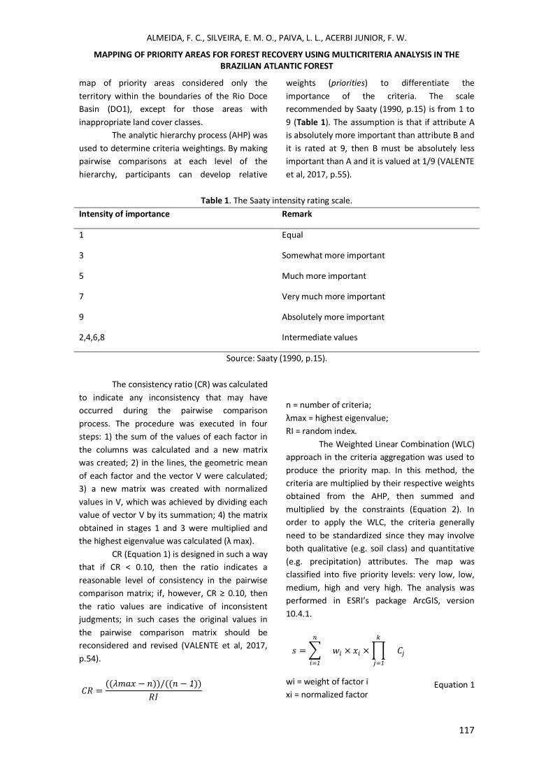
Table 1. The Saaty intensity rating scale.
Intensity of importance Remark
1 Equal
3 Somewhat more important
5 Much more important
7 Very much more important
9 Absolutely more important
2,4,6,8 Intermediate values
Source: Saaty (1990, p.15).
The consistency ratio (CR) was calculated
to indicate any inconsistency that may have
occurred during the pairwise comparison
process. The procedure was executed in four
steps: 1) the sum of the values of each factor in
the columns was calculated and a new matrix
was created; 2) in the lines, the geometric mean
of each factor and the vector V were calculated;
3) a new matrix was created with normalized
values in V, which was achieved by dividing each
value of vector V by its summation; 4) the matrix
obtained in stages 1 and 3 were multiplied and
the highest eigenvalue was calculated (λ max).
CR (Equation 1) is designed in such a way
that if CR < 0.10, then the ratio indicates a
reasonable level of consistency in the pairwise
comparison matrix; if, however, CR ≥ 0.10, then
the ratio values are indicative of inconsistent
judgments; in such cases the original values in
the pairwise comparison matrix should be
reconsidered and revised (VALENTE et al, 2017,
p.54).
𝐶𝑅 =((𝜆𝑚𝑎𝑥 − 𝑛))/((𝑛 − 1))
𝑅𝐼
Equation 1
n = number of criteria;
λmax = highest eigenvalue;
RI = random index.
The Weighted Linear Combination (WLC)
approach in the criteria aggregation was used to
produce the priority map. In this method, the
criteria are multiplied by their respective weights
obtained from the AHP, then summed and
multiplied by the constraints (Equation 2). In
order to apply the WLC, the criteria generally
need to be standardized since they may involve
both qualitative (e.g. soil class) and quantitative
(e.g. precipitation) attributes. The map was
classified into five priority levels: very low, low,
medium, high and very high. The analysis was
performed in ESRI’s package ArcGIS, version
10.4.1.
𝑠 =∑
𝑛
𝑖=1
𝑤𝑖 × 𝑥𝑖 ×∏
𝑘
𝑗=1
𝐶𝑗 Equation 2
wi = weight of factor i
xi = normalized factor
ALMEIDA, F. C., SILVEIRA, E. M. O., PAIVA, L. L., ACERBI JUNIOR, F. W.
MAPPING OF PRIORITY AREAS FOR FOREST RECOVERY USING MULTICRITERIA ANALYSIS IN THE BRAZILIAN ATLANTIC FOREST
118
k = number of restrictions
Cj = restrictions
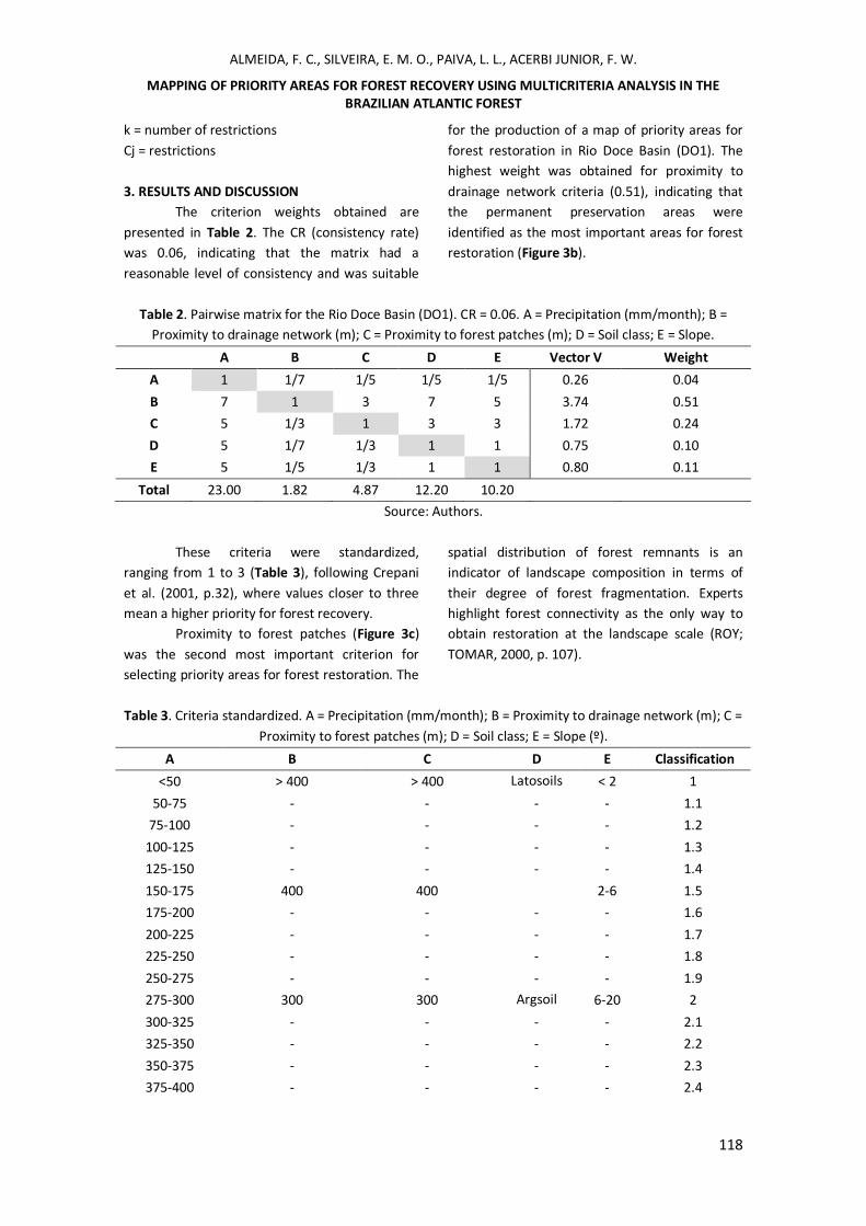
3. RESULTS AND DISCUSSION
The criterion weights obtained are
presented in Table 2. The CR (consistency rate)
was 0.06, indicating that the matrix had a
reasonable level of consistency and was suitable
for the production of a map of priority areas for
forest restoration in Rio Doce Basin (DO1). The
highest weight was obtained for proximity to
drainage network criteria (0.51), indicating that
the permanent preservation areas were
identified as the most important areas for forest
restoration (Figure 3b).
Table 2. Pairwise matrix for the Rio Doce Basin (DO1). CR = 0.06. A = Precipitation (mm/month); B =
Proximity to drainage network (m); C = Proximity to forest patches (m); D = Soil class; E = Slope.
A B C D E Vector V Weight
A 1 1/7 1/5 1/5 1/5 0.26 0.04
B 7 1 3 7 5 3.74 0.51
C 5 1/3 1 3 3 1.72 0.24
D 5 1/7 1/3 1 1 0.75 0.10
E 5 1/5 1/3 1 1 0.80 0.11
Total 23.00 1.82 4.87 12.20 10.20
Source: Authors.
These criteria were standardized,
ranging from 1 to 3 (Table 3), following Crepani
et al. (2001, p.32), where values closer to three
mean a higher priority for forest recovery.
Proximity to forest patches (Figure 3c)
was the second most important criterion for
selecting priority areas for forest restoration. The
spatial distribution of forest remnants is an
indicator of landscape composition in terms of
their degree of forest fragmentation. Experts
highlight forest connectivity as the only way to
obtain restoration at the landscape scale (ROY;
TOMAR, 2000, p. 107).
Table 3. Criteria standardized. A = Precipitation (mm/month); B = Proximity to drainage network (m); C =
Proximity to forest patches (m); D = Soil class; E = Slope (º).
A B C D E Classification
<50 > 400 > 400 Latosoils < 2 1
50-75 - - - - 1.1
75-100 - - - - 1.2
100-125 - - - - 1.3
125-150 - - - - 1.4
150-175 400 400 2-6 1.5
175-200 - - - - 1.6
200-225 - - - - 1.7
225-250 - - - - 1.8
250-275 - - - - 1.9
275-300 300 300 Argsoil 6-20 2
300-325 - - - - 2.1
325-350 - - - - 2.2
350-375 - - - - 2.3
375-400 - - - - 2.4
ALMEIDA, F. C., SILVEIRA, E. M. O., PAIVA, L. L., ACERBI JUNIOR, F. W.
MAPPING OF PRIORITY AREAS FOR FOREST RECOVERY USING MULTICRITERIA ANALYSIS IN THE BRAZILIAN ATLANTIC FOREST
119
400-425 200 200 Cambisoil 20-50 2.5
425-450 - - - - 2.6
450-475 - - - - 2.7
475-500 - - - - 2.8
500-525 - - - - 2.9
>525 100 100 Neosoil >50 3
Source: Crepani et al, (2001).
Slope (Figure 3e) was the third most
important criterion for the selection of priority
areas for forest restoration and it is directly
linked to erosion because steep slopes transform
potential energy into kinetics more quickly, thus
increasing the velocity of the water bodies and
their transport capacity. Therefore, these areas
are more susceptible to erosion which may be a
threat to conservation and forest preservation
(ROSA et al, 2000, p.179).
Soil types (Figure 3d) vary according to
physical characteristics (structure, texture,
permeability and density) and chemical
properties. Some types such as latosols and
argisols, which are more mature and deep soils,
are less susceptible to erosion, while other types
such as cambisols and neosols, which are
younger, shallow and with low drainage, are
more susceptible. These properties cause greater
or less resistance to the action of water even
under similar conditions of precipitation,
topography, and land cover (BERTONI;
LOMBARDI NETO, 1985, p.355).
Climate variables such as precipitation
control weathering directly. For example, rain
causes weathering of rocks and soil removal by
water erosion. The direct impact of the droplets
and the subsequent runoff are the active agents
of water erosion. Thus, as precipitation increases,
the classification value increases (Figure 3a).
However, the five criteria act together in the soil
erosion process, being essential in determining
the priority areas for recovery.

ALMEIDA, F. C., SILVEIRA, E. M. O., PAIVA, L. L., ACERBI JUNIOR, F. W.
MAPPING OF PRIORITY AREAS FOR FOREST RECOVERY USING MULTICRITERIA ANALYSIS IN THE BRAZILIAN ATLANTIC FOREST
120
Figure 3. Criteria classification ranging from 1 to 3: (a) Precipitation (mm/month); (b) Proximity to
drainage network (m); (c) Proximity to forest patches (m); (d) Soil class; (e) Slope (º). Source: Authors.
The resultant priority map (Figure 4),
indicated 1.73% of the Rio Doce Basin (DO1) with
very high priority (class 6) for forest recovery;
5.18% with high priority (class 5); 57.88% with
medium priority (class 4); 1.34% with low (class
3) and 0.00% with very low priority (class 2);
while restricted areas (class 1) represented
33.88% of the study area. From the total area of
DO1, 65% presented from medium to very high
recovery priority, indicating that the entire area is
highly degraded. Considering the permanent
preservation areas, 31.60% of the areas are in
very high priority zones, 26.31% in high priority
zones, 21.05% in medium and 15.80% in low
priority zones. A total of 5.24% of the total area
was in the restricted area (Figure 4b).
The large extent of areas classified as
medium to very high priority for forest recovery
is not only due to the environmental disaster
caused by the collapse of the mining dam that
occurred in the municipality of Mariana. The Rio
Doce basin is a region with diversified economic
activities such as coffee, sugarcane, and livestock.
In addition, it has 10 hydroelectric plants in
operation and the largest steel complex in Latin
America, which is associated with mining and
reforestation companies (STRAUCH, 1955, p.199).

ALMEIDA, F. C., SILVEIRA, E. M. O., PAIVA, L. L., ACERBI JUNIOR, F. W.
MAPPING OF PRIORITY AREAS FOR FOREST RECOVERY USING MULTICRITERIA ANALYSIS IN THE BRAZILIAN ATLANTIC FOREST
121
Figure 4. (a) Priority areas for forest restoration, (b) detailing the permanent preservation areas: (1)
Restricted areas; (2) Very low; (3) Low; (4) Medium; (5) High and (6) Very high priority areas. Source:
Authors.

ALMEIDA, F. C., SILVEIRA, E. M. O., PAIVA, L. L., ACERBI JUNIOR, F. W.
MAPPING OF PRIORITY AREAS FOR FOREST RECOVERY USING MULTICRITERIA ANALYSIS IN THE BRAZILIAN ATLANTIC FOREST
122
The method presented here may
potentially be replicated in areas that play an
important role in the global climate system such
as the Pantanal biome (BACANI et al, 2016, p. 01).
The Pantanal is one of the world’s most
biodiverse ecosystems, covering a continuous
area of approximately 150,000 km² (GONÇALVES
et al, 2011, p. 242), and it is classified as a
Biosphere Reserve and a World Heritage Site
(SCHWERDTFEGER et al, 2016, p. 2590). However,
the Pantanal biome is under considerable
pressure from deforestation for pasture
expansion, which places the ecological stability of
this region in danger. Thus, accurate monitoring
and understanding of land use/cover changes are
of great importance to both the scientific
community and local governments (HAN et al,
2015, p. 426), which can be achieved in part by
defining priority areas for restoration using
MCDA and GIS analysis. In fact, these tools can be
applied to many kinds of impacts, can be made
site and temporally specific, and can be applied
quantitatively as well as qualitatively
(FINNVEDEN et al, 2003, p. 103).
4. CONCLUSIONS
Multicriteria analysis can be applied to
diverse problems such as priority area mapping
for forest recovery, connectivity between forest
fragments, areas for landfill deployment, and
urban planning. However, a truth-based database
is necessary for the results to be satisfactory.
According to our final map, the watercourses of
the DO1 sub-basin have permanent preservation
areas with little or no vegetation cover, and the
proximity of the drainage network was shown to
be an important criterion for such analyses
(highest weight). Much of the area in the DO1
sub-basin is degraded and has medium to very
high priority for forest restoration.
5. ACKNOWLEDGMENTS
The authors would like to thank the
“Fundação de Amparo à Pesquisa do Estado de
Minas Gerais” (FAPEMIG - Brazil) and the
“Conselho Nacional de Desenvolvimento
Científico e Tecnológico” (CNPq - Brazil) for
financing part of this study.
REFERENCES
ARAUJO, L.S.; KOMONEN, A.; LOPES-ANDRADE, C.
Influences of landscape structure on diversity of
beetles associated with bracket fungi in Brazilian
Atlantic Forest. Biological Conservation, Oxford v
.191, p.659–666, 2015.
BACANI, V. M; SAKAMOTO, A. Y.; QUÉNOL, H.;
VANNIER, C.; CORGNE, S. Markov chains–cellular
automata modeling and multicriteria analysis of
land cover change in the Lower Nhecolândia sub
region of the Brazilian Pantanal wetland. Journal
of Applied Remote Sensing, Bellinghan, v. 10, n.
1, p. 1-20, 2016.
BERTONI, J.; LOMBARDI NETO, F.Conservação do
solo. São Paulo: Ícone, 1985. 355 p.
CARVALHO, L.M.T.; SCOLFORO, J.R.; OLIVEIRA,
A.D; MELLO, J.M.; OLIVEIRA, L.T.; ACERBI-JUNIOR,
F.W.; CAVALCANTI, H.C.; FILHO,
R.V.Procedimentos de mapeamento. Lavras:
Mapeamento e Inventário da Flora e dos
Reflorestamentos de Minas Gerais, 2006. p.37–
57.
CREPANI, E.; MEDEIROS, J. D.; HERNANDEZ FILHO,
P.; FLORENZANO, T. G.; DUARTE, V.; BARBOSA, C.
C. F. Sensoriamento remoto e geoprocessamento
aplicados ao zoneamento ecológico-econômico e
ao ordenamento territorial. São José dos
Campos: Inpe, 2001. 124p.
Fundação Estadual do Meio Ambiente (FEAM) –
Mapa de solos do Estado de Minas Gerais.
Disponível em:
<http://www.dps.ufv.br/?page_id=742> . Acesso
em: 28 junho 2018).
FERNÁNDEZ, I.C.; MORALES, N.S. A spatial
multicriteria decision analysis for selecting
priority sites for plant species restoration: a case
study from the Chilean biodiversity hotspot.

ALMEIDA, F. C., SILVEIRA, E. M. O., PAIVA, L. L., ACERBI JUNIOR, F. W.
MAPPING OF PRIORITY AREAS FOR FOREST RECOVERY USING MULTICRITERIA ANALYSIS IN THE BRAZILIAN ATLANTIC FOREST
123
Restoration Ecology, Hoboken, v.24, p.1–10,
2016.
FINNVEDEN, G., NILSSON, M., JOHANSSON, J.,
PERSSON, A., MOBERG, A., CARLSSON, T.
Strategic environmental assessment
methodologies e applications within the energy
sector. Environmental Impact Assessment
Review, New York, v. 23, p. 91-123, 2003.
GONÇALVES, H.C.; MERCANTE, M. A.; SANTOS,
E.T. Hydrological cycle. Brazilian Journal of
Biology, São Carlos v. 71, N.1, p. 241–253, 2011.
HAMADOUCHE, M.A.; MEDERVAL, K.; KOURI, L.;
REGAGBA, Z.; FEKIR, Y.; ANTEUR, D. GIS-based
multicriteria analysis: an approach to select
priority areas for preservation in the Ahaggar
National. Arabian Journal of Geosciences,
Heidelberg, v.7, n.2, p.419-434, 2014.
HAN, X.; CHEN, X.; FENG, L. Four decades of
winter wetland changes in Poyang Lake based on
Landsat observations between 1973 and 2013.
Remote Sensing of Environment, New York, v.
156, p. 426– 437, 2015.
HIJMANS, R.J.; CAMERON, S.E.; PARRA, J.L.;
JONES, P.G.; JARVIS, A. Very high resolution
interpolated climate surfaces for global land
areas. International Journal of Climatology,
Hoboken, v.25, p.1965–1978, 2005.
HOLL, K.D.; CRONE, E.E.; SCHULTZ, C.B. Landscape
Restoration: Moving from Generalities to
Methodologies. BioScience, Oxford, v.53, p.490-
502, 2003.
KIKER, G.A.; BRIDGES, T.S.; VARGHESE, A.;
SEAGER, T.P.; LINKOV, I. Application of
Multicriteria Decision Analysis in Environmental
Decision Making. Integrated Environmental
Assessment and Management, Hoboken, v.1,
n.2, p. 95–108, 2005.
MENG, Y.; MALCZEWSKI, J. A.GIS-based
multicriteria decision making approach for
evaluating accessibility to public parks. Journal of
Studies and Research in Human Geography,
Bucuresti, v.9, n.1, p. 29-41, 2015.
MYERS, N.; MITTERMEIER, R.A.; MITTERMEIER,
C.G.; FONSECA, G.A.B.; KENT, J. Biodiversity
hotspots for conservation priorities. Nature,
London, v.403, p.853–858, 2000.
PEREIRA, Luís Flávio; DE BARROS CRUZ, Gabriela;
GUIMARÃES, Ricardo Morato Fiúza. Impactos do
rompimento da barragem de rejeitos de
Brumadinho, Brasil: uma análise baseada nas
mudanças de cobertura da terra. Journal of
Environmental Analysis and Progress, v. 4, n. 2,
p. 122-129, 2019.
RAMÍREZ-TORO, W.; TORRES-MIRANDA, A.; RUIZ-
SANCHEZ, E.; LUNA-VEGA, I.; OYAMA, K. A.
Multicriteria Analysis for Prioritizing Areas for
Conservation of Oaks (Fagaceae: Quercus) in
Oaxaca, Southern Mexico. Tropical Conservation
Science, Thousand Oaks, v.10, p.01–29, 2017.
ROSA, D.; MORENO, J. A.; MAYOL, F.; BONSÓN, T.
Assessment of soil erosion vulnerability in
westerm Europe and potential impact on crop
productivity due to loss of soil depth using the
Impelero model. Agriculture, Ecosystems and
Environment, Amsterdam, v.81, p.179-190, 2000.
ROY, P. S.; TOMAR, S. Biodiversity
characterization at landscape level using
geospatial modeling technique. Biological
Conservation, v. 95, p. 95-109, 2000.
SAATY, T.L. How to make a decision: The
Analytic Hierarchy Process. European Journal of
Operational Research, Amsterdam, v.48, p.9–26,
1990.
SANTOS, J.S.; LEITE, C.C.C.; VIANA, J.C.C.;
SANTOS, A.R.; FERNANDES, M.M.; SOUZA ABREU,
V.; NASCIMETNO, T.P.; SANTOS, L.S.; MOURA
FERNANDES, M.R.; SILVA, G.F.; MENDONÇA, A.R.
Delimitation of ecological corridors in the
Brazilian Atlantic Forest. Ecological Indicators,
Amsterdam, v.88, p.414–424, 2018.
SARTORI, A.A.C. Análise multicritérios na
definição de áreas prioritárias à conectividade
entre fragmentos florestais. 2010 Dissertação
(Mestrado em Agronomia) – Faculdade de
Ciências Agronômicas, UNESP, Botucatu, 2010.
SCHWERDTFEGER, J.; HARTMANN, A.; WEILER, M.
A tracer-based simulation approach to quantify
seasonal dynamics of surface-groundwater

ALMEIDA, F. C., SILVEIRA, E. M. O., PAIVA, L. L., ACERBI JUNIOR, F. W.
MAPPING OF PRIORITY AREAS FOR FOREST RECOVERY USING MULTICRITERIA ANALYSIS IN THE BRAZILIAN ATLANTIC FOREST
124
interactions in the Pantanal wetland.
Hydrological Processes, Hoboken, v. 30, n.15, p.
2590-2602, 2016.
SILVA, V.A.M.; MELLO, K.; VETTORAZZI, C.A.;
COSTA, D.R.; VALENTE, R.A.Priority áreas for
forest conservation, aiming at the maintenance
of water resources, through the multicriteria
evaluation. 1. Rev. Árvore, Viçosa , v. 41, n.1,
Nov. 2017.
SILVEIRA, E.M.O.; ACERBI JÚNIOR, F.W.; MELLO,
J.M.; BUENO, I.T. Object-based change detection
using semivariogram indices derived from NDVI
images: The environmental disaster in Mariana,
Brazil. Ciência e Agrotecnologia, Viçosa, v.41,
p.554–564, 2017.
SOS Mata Atlântica. Atlas dos remanescentes
florestais da mata atlântica, período 2016-2017.
Disponível em:
<https://www.sosma.org.br/link/Atlas_Mata_Atl
antica_20162017_relatorio_tecnico_2018_final.p
df>.Acesso em: 02 mar 2019.
STRAUCH, N. A Bacia do Rio Doce. Rio de Janeiro:
IBGE. 1955. p. 199 .
VALENTE, A.R.; PETEAN, F.C. S.; VETTORAZZI, C.A.
Multicriteria decision analysis for prioritizing
areas for forest restoration. Cerne, Lavras, v.23,
p.53–60, 2017.
VETTORAZZI, C.A. Avaliação multicritérios, em
ambiente SIG, na definição de áreas prioritárias
à restauração florestal visando à conserva de
recursos hídricos. 2006. 151 p. Tese (Livre
Docência): ESALQ/USP Escola Superior de
Agricultura “Luiz de Queiroz” USP, Piracicaba.
2006.
YANG, W.; LIU, Y.; OU, C.; GABOR, S. Examining
water quality effects of riparian wetland loss and
restoration scenarios in a southern Ontario
watershed. Journal of Environmental
Management, London, v.174, p.26–34, 2016.