managing natural hazard risk in new zealand – … · managing natural hazard risk in new zealand...
TRANSCRIPT
Managing natural hazard risk in New Zealand –towards more resilient communities A think piece for local and central government andothers with a role in managing natural hazards
October 2014

This paper has been prepared by Gerard Willis (Enfocus Ltd). It was commissioned by LGNZ and Regional Councils. The paper identifies why natural hazard management is important in New Zealand; who the key players are (what roles they have and how they interact); what happens, and does not happen in practice (and why); and what some key challenges are in enhancing overall performance.
ContentsForeword 1Summary 31> Introduction 42> Background and methodology 63> The New Zealand hazardscape 84> Natural hazards and society 115> The law and policy context for natural hazard management 166> Roles and responsibilities for natural hazard management 227> Discussion and analysis 278> Strengths and weaknesses 339> Gaps and opportunities 3710> Conclusions and recommendations 4911> Appendices Appendix 1 – Tsunami heights at increasing return timesxxv 52 Appendix 2a – Indicative national risks 53 Appendix 2b – Comparison of New Zealand risks and existing criteria 54 Appendix 3 – Return period versus risk based approach to hazard management 55 Appendix 4 – Responses to questions on research priorities 57Glossary and references 59
1Managing natural hazard risk in New Zealand – towards more resilient communities
ForewordThose of us in local government have always known that managing natural hazards is important. It was, after all, the raison d’être of catchment boards, a fore-runner of regional councils.
While there is a lot of good work being done, in the world of contemporary local government most of us also know how easy it is to let natural hazards management drift along. Amongst the many calls on resources for the immediate issues, natural hazards can ‘default’ to a low priority. This is often aided by strong pressures from some sectors and individuals to create inertia or play down risks, because of perceived adverse consequences of hazard management interventions on specific investments and lifestyles.
Natural hazard management also has particular complexities. There are major knowledge gaps between what we need to know and what we actually know to enable sound planning and good decisions. There are also more than the normal alignment gaps due to the multitude of parties involved from both the private and public sectors and multiple individuals, communities and organisations. These often produce major differences between what we think or want people to do and what they actually do. Uncertainties also lead to significant implementation gaps, whereby actions, even when carefully thought to be the right actions, sometimes do not achieve their expected outcomes.
Natural hazards management is therefore a seriously challenging business, even if accorded a high priority with attendant resources.
Events of recent years both here and overseas, present a timely reminder that our hazardscape does not stand still, our knowledge of hazards and our vulnerability to events are both on the rise and we do need to stand back and take stock of whether we are doing the best we can as councils, the broader public sector, and as a country to manage the risks rationally and sustainably (socially and financially).
In the field of natural hazard management local government has extensive experience and expertise – more resides in the local government sector than in any other.
But local government does not have all the answers and it can’t manage risks in isolation. We are part of a bigger picture. Other players, notably central government agencies, have important roles. In meeting this challenge it will be important to strengthen the horizontal relationships with these agencies and avoid slipping further into hierarchical management that has proven counter-productive to resolving hazards (and other natural resource issues) in the past.
This paper has been commissioned because we want local and central government to think hard about how we might do better for our communities and how we might collectively take control of the responsibility for doing better.
New Zealand seems reasonably well regarded internationally for being conceptually in a ‘good practice’ space in our overall approach to natural hazards management and perhaps rightly so. We understand the need to apply effort across the continuum from hazard mitigation to adaptation, and across the four ‘Rs’ – from risk reduction, readiness, response and recovery aspects. We also comprehend the need to develop resilience at all levels starting with the individual. These concepts are generally well captured in our laws and organisational mandates. But below that important level of broad understanding and recognition, there are substantial questions that we need to consider about our collective organisational and operational effectiveness. Put simply, do we ‘walk the talk’ as well as we can or should?
Two core ideas dominate natural hazards management: 1. the need for issue and place-specific responses; and 2. the need for integration and collaboration to develop and
deliver those effective responses across the many players with a role to play.
Yet integration and collaboration are a great deal easier to require than they are to deliver. That is a key challenge.
There are myriad issues – this paper takes a helicopter view to progress a conversation.
2
On behalf of the Steering Group:Kelvin Berryman – Manager Natural Hazards Research Platform, GNS
Pat Helm – Security and Risk Group, Department of Prime Minister and Cabinet
Bryce Davies – Senior Manager External Relations, IAG
Richard Smith – Manager Science and Education, Earthquake Commission
Peter Kingsbury – Principal Advisor, Natural Resources
Steve Markham – Policy Manager, Tasman District Council
Clive Manley – Civil Defence Emergency Management Director, Auckland Council
Mike Adye – Group Manager Asset Management, Hawkes Bay Regional Council
Gary O’Meara – Chief Operating Officer, Capacity infrastructure Services
Don Chittock – Programme Manager Strategic Programmes, Environment Canterbury
Frances Sullivan – Principal Policy Advisor, LGNZ.
Coincidentally, this paper was being completed as the Local Government Insurance Market Review was released. That review encourages councils to spend more resources on risk profiling, risk management and risk mitigation to improve self-reliance and resilience. This paper is complementary in making some similar suggestions in the way councils manage risks to communities.
Also coincidentally within Central Government, a range of relevant activities are in progress. These include examinations and reviews of core national infrastructure and related community resilience, RMA reforms, national security, civil defence emergency management, and Government funded research systems and priorities. Natural hazards management is generally well recognised as a very important consideration for all these inter-related matters.
A key suggestion in this think piece is for the need for a more strategic collaborative approach to natural hazards management. This idea is elaborated on within the paper. In considering this, it is important to be clear that strategy, as we see it, is emphatically not about producing a large plan, or nationally directed top-down operational blueprint. Rather, strategy is about thoughtful purposeful action. It is about providing a framework for better, more integrated and cohesive decision-making and action at all levels. Strategy is about being as clear as possible about our collective aims and then testing opportunities and synergising capabilities to be as effective as possible.
I commend the paper to you and extend my appreciation to the members of the Steering Group who offered their time and expertise to develop this think piece. I also acknowledge those many people who assisted with input to the draft report or who later responded to the circulated draft leading to this final report. I note especially the expertise of Gerard Willis (Enfocus) in pulling the report together.
Basil Chamberlain Chief Executive Taranaki Regional Council
Managing natural hazard risk in New Zealand – towards more resilient communities 3
SummaryThis report reviews current arrangements for managing natural hazards risk in New Zealand. Although it is not premised on a belief that the current system is in a fundamentally poor state, it identifies a range of issues. These are:• little national ownership of the fourth “R” – risk reduction – with
a clear national emphasis on readiness, response and recovery;• although there are multiple national players involved there is a
lack of co-ordinated national leadership of risk reduction;• little monitoring of risk reduction activity or outcomes achieved;• no consistent basis to make natural hazard risk management
decisions;• dispersed information and guidance on natural hazards;• the public often relies on incomplete (and sometimes inaccurate)
information about hazards management; and• the context in which natural hazards management is occurring
is changing – the effect of climate change, in particular, is not appropriately accounted for.
In order to further define the issues and develop effective and targeted responses, it is recommended that Local Government New Zealand advocate on behalf of the local government sector for the following:1. Natural hazards and community resilience strategy: A pan
sector natural hazards management initiative to set clear strategic direction on: I. key practice issues (on a hazard by hazard basis) and the
appropriate policy response to hazard management generally; and
II. the appropriate place for local discretion and community-specific responses and national consistency in natural hazards management.
Importantly, the process and any output should be collectively developed across local and central government and the broader hazards management sector. This should be nationally led and supported, but not nationally imposed.2. Natural hazards policy platform: A mechanism to research and
resolve natural hazards policy issues. This may take the form of a natural hazards policy platform as a parallel structure to the existing natural hazards research platform. Such a mechanism would inform research needs and promote policy innovation on an on-going basis, using expertise from across the natural hazards management sector.
3. Single information portal: An enhanced and more integrated approach to making natural hazards information available. Bringing together existing natural hazards management guidance material for practitioners should drive greater alignment of thinking. Making information on the nature and location of natural hazards more accessible for the public (at either the national or regional level and including national datasets such as LiDAR), should aim to overcome existing issues with information quality and dissemination, and assist people to make better individual risk management decisions.

4
Introduction
1

Managing natural hazard risk in New Zealand – towards more resilient communities 5
New Zealand is more exposed to potential losses from natural hazards than ever before and that exposure continues to increase. Natural hazards are only hazardous when things we value get in their way. New Zealand’s vulnerability (the degree of loss that can be expected from a given hazard event) is high not just because we are a natural hazard-prone country, our vulnerability is high because:• We are a small economy, therefore, the shock of an event that
might be easily absorbed in a larger economy can have a severe impact in the New Zealand context.
• Decisions made long ago have dictated our settlement and land development patterns, increasing the consequences of many natural hazard events.
Although we actively manage for natural hazards, the reality of continuously increasing population, land use intensification (albeit with some risk mitigation controls and investments) in known hazard prone areas, and factors like climate change suggests that, at the broad level, risk might well be increasing faster than we have been responding.
This paper aims to position the local government sector, and others working on managing natural hazard risk, to develop a common understanding of:a. the risks associated with natural hazards (the “hazardscape”
we work within);b. the risks associated with the effects of climate change on
natural hazards;c. the opportunities for managing risk and the benefits of
doing so, having regard to an appropriate balance of risk reduction, readiness, response and recovery aspects – the internationally recognised (four R’s) elements of a hazards management framework;
d. the existing regime for managing natural hazards (the law and the players involved);
e. the strengths, weaknesses, opportunities and threats associated with how hazards are currently managed; and
f. the issues and options for possible change or enhancement of the existing management arrangements (including the setting of research priorities).
With a common and improved understanding of these things, local government, and others, can make meaningful steps to improve practices, develop better tools, target investment, and increase understanding and acceptance of public and private roles leading to a less vulnerable, more risk aware, and more resilient community.
This paper does not purport to be definitive on the nature of all the many challenges, or the possible responses, but is intended to progress a national conversation. It is deliberately described as a “think piece” for that reason.

6
Background and methodology
2

Managing natural hazard risk in New Zealand – towards more resilient communities 7
A number of recent natural hazard events (both in New Zealand and overseas) and a growing body of scientific knowledge on natural hazards have put the spotlight on our ability to respond to the risks. This includes our ability to make sound planning and policy decisions; the adequacy of information; and our preparedness for natural hazard events.
It is timely, therefore, to step back and consider whether we have a ‘fit for purpose’ management framework with all the necessary tools and capabilities (and collaboration) to ensure the system works in the best interest of New Zealanders.
2.1 Think piece developmentThis think piece is designed to stimulate discussion and engender debate with the aim of improving the management of natural hazard risk in New Zealand.
The draft of this paper was developed with input from the Steering Group and interviews with expert people from within and beyond the local government sector. It was then circulated to the local government sector and other interested parties for feedback. To assist feed back the draft paper posed a series of questions at the end of each chapter which informed the final think piece as presented.
The project received governance oversight from the Regional Chief Executives Group, the Regional Sector Group of LGNZ and the LGNZ National Council.
New Zealanders and their properties are exposed to an array of natural hazards. The management of those natural hazards is a challenging area of public sector management.
Central government agencies, local government, the private sector and individuals are all involved in some capacity in various dimensions of hazard risk management.
That said, as this paper outlines, much of the day-to-day statutory responsibility for managing risks associated with natural hazards (both pre-event and, except for very large events, post-event) rests solely with local government. Central government needs local government to perform that function well to safeguard New Zealand’s overall social and economic interests. At the same time, for a range of reasons, local government needs the support of central government to perform its hazards management responsibilities effectively and efficiently.
Importantly, managing natural hazards is an activity requiring collaboration between agencies (ie across local government, between local and central government and between government and various private sector players). It requires strong and effective ‘horizontal’ relationships rather than traditional hierarchical or ‘top down’ relationships.
The need for substantially more effective collaboration at present is perhaps evidenced in the current lack of a strong body of accepted ‘good practice,’ common terminology or even principles for practical management across agencies with a role in natural hazard management (particularly risk reduction) or the building of broader community resilience.
Natural hazards are neither certain in their likelihood nor their consequence. They present a risk (or rather a series of risks) that vary by place and by hazard. Potential impacts of natural hazards can be especially difficult to predict. That difficulty is compounded by the complex interdependencies in our modern social and economic infrastructure. Our ability to define risks in strict mathematical terms is limited meaning the ‘right’ hazard management decision is seldom obvious or beyond dispute. In that context we need clear principles to guide our management approach.

The New Zealand hazardscape
3
Managing natural hazard risk in New Zealand – towards more resilient communities 9
It is important to understand at the outset the significant exposure New Zealand has to natural hazards. Natural hazards represent a real risk for New Zealand. The potential consequences of hazards events, both in human life and economic terms, can be serious and deserve serious attention. It is easy to dismiss natural hazards as something that ‘might happen at some distant time’ and about which ‘nothing can be done anyway.’ The following sections suggest that view would be wrong on both counts.
Most natural hazards arise from one of two (or a combination of the two) natural sources:• geological processes (earthquakes, volcanoes, erosion and
landslide); or • meteorological processes (wind and heavy rainfall).
Due to its geography and location, New Zealand is severely exposed to both sources of hazards and the effects of climate change will exacerbate a number of natural hazard risks (including landslips, coastal erosion, liquefaction and inundation and flooding).
3.1 Geological processesNew Zealand lies in a geologically dynamic zone, straddling two moving sections of the earth’s crust – the Pacific and Australian plates. Along these plates there are many faults, about 50 of which are considered active, giving rise to large earthquakes at intervals of less than 2000 years.
The ocean crust of the Pacific Plate is descending under the Australian Plate in the eastern North Island and Marlborough – a process known as subduction. Subduction is also occurring near the south-western end of the South Island as (in contrast to what occurs in the north) the Australian Plate descends beneath the thicker continental crust of the Pacific Plate just offshore of Fiordland. In the middle of these two opposing subduction zones, over much of the South Island the crusts of the two plates meet head-on making the Southern Alps one of the fastest ‘growing’ mountain ranges in the world.
New Zealand experiences between 10,000-15,000 earthquakes every year, although only about 150-200 are felt by humans. Statistically, New Zealand can expect an earthquake of magnitude seven every 10 years. The major faultlines include the huge Alpine fault running up the length of the Southern Alps to Cook Strait and the continuous series of faults running from Wellington through the North Island to the Bay of Plenty. But there are many other known faultlines particularly east of the main Alpine fault and in the lower and central North Island.
The long narrow nature of New Zealand means that ninety-five per cent of New Zealanders live within 200 kilometres of the boundary where the Pacific and Australian plates meet.
Earthquakes can produce a range of hazards including fault rupture, ground-shaking and liquefaction. Earthquakes can also give rise to landslides and tsunamis.
The moving plates give rise not just to earthquakes. The zone is also part of a so-called ‘ring of fire’ – the rim of the Pacific plate where subducting plates allow magma to form and to rise up forming volcanoes. In New Zealand this occurs largely on the edge of the Australian plate (west of the main fault chain) as the Pacific plate subducts beneath it under the northern half of the North Island.
New Zealand has many extinct, dormant and active volcanoes. Active volcanoes include the Taranaki, Ruapehu, Tongariro (including Ngāuruhoe), and Whakaari (White Island) so-called ‘cone’ volcanoes. There are also two active calderas in the Taupo volcanic zone (Taupo and Okataina). All these features have erupted multiple times within the past 10,000 years, several of them many times within recorded history.
There are also volcanic fields in Northland and Auckland, north and western Waikato and Otago. Of these, only the Auckland field is considered active with the most recent eruptions around 1400AD. The other fields of scoria cones and craters are much older and considered extinct.
Volcanic hazards include ashfall, lava flow, pyroclastic flows, lahars, debris flows and tsunami 1.
1 Note that the tsunami risks facing New Zealand are from both local sources and also distant sources such as events in other parts of the Pacific Rim. An illustration of tsunami heights from waves of 100, 500 and 2500 years return periods is provided as Appendix 1.
10
3.2 Meteorological hazardsNew Zealand is no more safely located in relation to meteorological hazards. Lying in the path of the ‘roaring forties,’ New Zealand is buffeted by strong westerly weather patterns and occasional tropical cyclones from the north.
The dominant westerly pattern typically brings rain to the western parts of the country as moist air is forced upwards over mountains, but the combination of weather patterns and topography mean that heavy rain can occur at any time of the year in any part of the country.
Heavy rainfall in the northern part of the country can be associated with remnants of cyclones from the tropics that occasionally reach New Zealand, bringing gales and heavy rain, which may cause floods and associated effects. Cyclone Bola which struck the Hawkes Bay and Gisborne-East Cape area in 1988 is a recent example.
Extreme weather events result in flooding, accelerated erosion (many landslides are triggered by heavy rain) and wind damage to buildings, infrastructure and crops. New Zealand currently experiences a major flood every eight months (and, as discussed below, this can be expected to increase with climate change).
It is not just the weather but its combination with our topography and land use that makes the hazard. For example, New Zealand’s rugged land also affects the winds – they pick up speed as they are funnelled over mountains and through Cook Strait.
New Zealand’s uplifted land is rapidly eroding, creating deep valleys with hillsides that are prone to collapse. The topography (short steep rivers) and soils over most of the country generally favour a high (and quick) run-off both in total flow and in peak flood discharges. Over the past 100 years New Zealand has experienced over 1000 serious floods making flooding, due to intense or prolonged rain, by far the most frequent natural hazard New Zealand faces.
In addition to river flooding, severe weather events over the sea can produce seastorms (storm surges) that together with wave run-up, can flood low-lying coastal areas around the country.
Tornados can also be produced from thunderstorms and, although small and short-lived by some international standards, have proven destructive and have taken lives in the past. New Zealand experiences 20-30 tornados each year most in the north and west of the country. A tornado in Greymouth in 2005, for example, caused almost $10 million worth of damage.
Droughts and wildfire are other natural hazards related to meteorological conditions.
In many ways natural hazards have shaped New Zealand – both physically and culturally. Many of the seminal moments in New Zealand’s history relate to hazard events – from the Tarawera eruptions of 1886, to the Tangiwai rail tragedy in 1953 to the founding of the Wahine during a severe storm in 1968, to the Napier earthquake (1931) and most recently the devastating Canterbury (Darfield, 2010 and Christchurch, 2011) earthquakes.
Many other less lethal but hugely costly, and sometimes spectacular, events have dominated news headlines within the living memory of most adult New Zealanders – these include, for example, Cyclone Bola, Mt Ruapehu eruptions, the Edgecumbe earthquake, and the Abbotsford landslide.

Natural hazards and society
4
12
4.1 Historic decisions affecting contemporary vulnerabilityNineteenth century settlers founded many settlements near river mouths where there was freshwater, safe anchorage for ships, river access inland and often flat, fertile land for agriculture. Auckland was located within a volcanic field that erupted a mere 400 years earlier and New Plymouth near Mt Taranaki that had erupted just 150 years earlier. Wellington and Nelson were located on major faultlines. Christchurch too has been found to be located near a fault line and much of it on easily liquefiable land.
Similarly, the 19th and early 20th century clearance and farming of hilly country has allowed soil to be more readily mobilised during rain, generating silt that potentially raises riverbed levels and increases flood risk.
New Zealanders’ love of the coast has led to significant (and on-going) low-lying coastal development that is vulnerable both to tsunami (particularly on the east coast of the upper North Island) and to coastal erosion.
While no location is hazard risk free, those settlement and land use choices have undoubtedly left many New Zealanders, their livelihoods and properties vulnerable.
4.2 Growing vulnerabilityVulnerability to natural hazards continues to increase for two simple reasons.
First, urban growth and urban and rural land intensification continue to increase the potential severity and consequences of hazard events. There are now more people, often more valuable buildings and more businesses in areas that may be subject to future hazard events. Furthermore, as a society we have become less self-sufficient and more reliant on external services and infrastructure for daily survival, and communications, in the event of a hazard. Put simply, the proportion of the population whose health and welfare is inextricably linked to lifeline services such as electricity, water supplies and wastewater services, and to unencumbered access to the internet for primary communication and centralised large format shops for essential items, is greater than ever before. At the same time, business practices have themselves changed – often reducing their ability to operate or rapidly re-establish in the wake of a major hazard event. These practices include, for example, ‘just in time’ supply chains and outsourcing of services. These trends, coupled with reduced redundancy (spare capacity) in infrastructure
and interdependencies in infrastructure networks mean that a single, localised event can have significant and widespread consequences.
The second reason for increasing vulnerability relates to the frequency and severity of meteorological hazard events. Climate change is expected to raise average temperatures in New Zealand by around 1° by 2050 and more than 2° by the turn of the century 2. This temperature rise and the wider change to global weather patterns of which it is a part, is projected to have a number of implications for natural hazards in New Zealand:• The IPCC Fifth Assessment Report (IPCC AR5), states that under
a high emissions scenario (RCP8.5), global mean sea level would likely rise by 0.53 to 0.97 m by 2100, relative to 1986-2005, whereas with stringent mitigation (RCP2.6), the likely rise by 2100 would be 0.28 to 0.6 m (medium confidence.) That sea level rise, will, in combination with other hazard events increase the impact of storm surges, exacerbate coastal erosion (or decrease coastal accretion), increase ground water levels in coastal areas and in low lying areas result in coastal inundation.
• Precipitation (rainfall) patterns are expected to change with, in general, increased rainfall in the west (especially the Tasman, West Coast, Otago, Southland regions) and less in the east (especially the Northland, Auckland, Gisborne and Hawke’s Bay regions). Moreover, climate change is expected to lead to increases in extreme rainfall, especially in places where mean rainfall is expected to increase. This is likely to translate to more severe and frequent river flooding. Flooding and sediment deposition from rivers could be most severe in the coastal reaches of rivers if sea-level rise slows the flow of water out to the sea. In the eastern areas that are expected to become drier, droughts are likely to become more frequent and more prolonged.
• Annual mean westerly windflow across New Zealand is expected to increase by 10% by 2040 and beyond. By 2090, the mean westerly wind is expected to increase by more the 50% in winter and 20% in spring (with decreases at other times of around 20. There is also likely to be an increase in severe wind risk with perhaps a 10% increase in strong winds (eg winds greater than 10m/s or top 1st percentile) by 2090.
• Storms and extreme rainfall events are expected to increase in frequency and severity.
Each of the past three decades has been successively warmer than at any period since the mid 19th century3. Changes in precipitation patterns and climate variability, together with sea level rise, are predicted to continue to accelerate through the 21st century.
2 Note IPCC AR5 states that the global mean surface temperature change for the period 2016–2035 relative to 1986–2005 will likely be in the range of 0.3°C to 0.7°C (medium confidence). The IPCC AR5 report on impacts, adaptation and vulnerability considers risks based on 2° and 4° by 2100. This most recent assessment of climate change risks can be found at http://ipcc-wg2.gov/AR5/images/uploads/WGIIAR5-Chap25_FGDall.pdf.
3 Data from the last 30 years is used as completeness of data prior to that date is unknown

Managing natural hazard risk in New Zealand – towards more resilient communities 13
4.3 Consequences and costs4.3.1 Fatalities and property lossThe consequences of past hazard events have been severe in terms of both lives lost and in property losses.
Earthquakes are our most deadly hazard with 466 fatalities since European settlement (the vast majority of those being in the Napier and Canterbury quakes). Volcanic events are probably the next most deadly with 338 fatalities over the same period.
The financial cost of hazards can be measured (at least in part) by the insurance payout. Figure 1 shows the total insurance payment for major natural hazard events since the Wahine event of 1968 (note the log scale necessary to accommodate the extraordinary payout associated with the Canterbury earthquakes). The data indicates that, over the past 30 years, the insurance industry has paid out $28.3 billion (or, on average, $913 million per year) for damage caused by major natural hazard events. The data is, of course skewed by the enormous Canterbury earthquake payout/projected payout of $26.6 billion (including $12 billion from EQC). Excluding that event the payout is still $1.66 billion (or $53.5 million per year). In seven of the past 30 years the annual insurance payout had exceeded $100 million. Four of those seven $100 million plus payouts have occurred since 2005. Other costs would be associated with uninsured items.
Second in terms of insurance payment (after earthquakes) is flooding with a combined total (for about 60 flood major events) of approximately $865 million since 1969 (in 2011 dollar terms).
4.3.2 Broader costsFigure 1 only tells part of the story. The costs of hazards events are not counted just in the cost of replacing buildings and other property. Nor even in the number of human fatalities. Very significant costs can result from the economic and social disruption caused. Sometimes these are tangible (such as the number of hours or days businesses cannot operate at full production). Sometimes they are intangible, including social and cultural impacts that have both an immediate and sometimes on-going effects on people’s lives (including their willingness to want to continue to live in areas subject to hazards).
Other costs are associated with the public cost of responding to events. For example, government expenditure on civil defence responses during flood emergencies alone averaged about $15 million per year over the period 1976-2004.
The 2004 Manawatu floods provide an illustration of the extent of these types of costs. Insured losses from that event were $112 million. However, the cost to the agricultural sector alone in uninsured losses (lost production and uninsurable rehabilitation costs) were calculated at $185 million. The cost of emergency services and infrastructure repairs was put at a further $90 million. The flood was modelled as having a 150-year return period.
$(m
ill)
100000
10000
1000
100
10
0
19681970 1972
1974 1976 19781980
19821984
19861988
19901992
19941996
199820
0020
0220
0420
0620
0820
1020
12
Figure 1 – Total Insurance payout for major hazard event 1969-2013 (adjusted to 2011 dollars).
14
4.4 The natural hazard risks we faceRisk is the product of likelihood and consequence. As discussed later in this paper, there is on-going debate about the extent to which we can, or should attempt to, quantify risk associated with natural hazards.
It is probably fair to say that there are some natural hazards and some locations where probability and consequence can be reasonably well-determined and other cases where they cannot. There is also significant debate about how we should seek to respond to the risks we can identify and whether we should take a different approach to risk management in existing developed areas to new (greenfield) development.
Before addressing those issues, it is useful to understand the ‘big national risk picture’ (ie the risk New Zealand faces from natural hazards relative to other national risks). Appendix 2a sets out a schematic graph that attempts to depict relative national risks. It shows natural hazards representing the full range of risk profiles from catastrophic in consequence but low likelihood, to highly likely with minor consequence. However, the really big, catastrophic impacts are associated with events of relatively low likelihood. That can, however, lull us into a false sense of security. An event of low likelihood can also be described as one with a long return period. Return periods are calculated from long-term averages. In reality, an event can occur in much shorter timeframes than that indicated by the statistical return period; it is just that there is less likelihood of it doing so. (Appendix 3 explains this in greater detail).
It is also important to remember that you cannot look at a single hazard in isolation. The risk of a range of natural hazards needs to be layered to understand fully the risk profile of any particular location. Furthermore, each hazard presents a different risk profile. Some hazards have consequences that increase relative to increasing return periods. For others the relationship between return period (size of event) and consequence is much less direct.
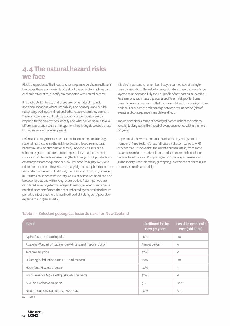
Table 1 considers a range of geological hazard risks at the national level by looking at the likelihood of event occurrence within the next 50 years.
Appendix 2b shows the annual individual fatality risk (AIFR) of a number of New Zealand’s natural hazard risks compared to AIFR of other risks. It shows that the risk of a human fatality from some hazards is similar to road accidents and some medical conditions such as heart disease. Comparing risks in this way is one means to judge society’s risk tolerability (accepting that the risk of death is just one measure of hazard risk).
Table 1 – Selected geological hazards risks for New Zealand
Event Likelihood in the next 50 years
Possible economic cost ($billions)
Alpine fault – M8 earthquake 30% >10
Ruapehu/Tongariro/Nguaruhoe/White Island major eruption Almost certain >1
Taranaki eruption 20% ~1
Hikurangi subduction zone M8+ and tsunami 10% >10
Hope fault M7.2 earthquake 50% ~1
South America M9+ earthquake & NZ tsunami 50% >1
Auckland volcanic eruption 5% >>10
NZ earthquake sequence like 1929-1942 50% >>10
Source: GNS

Managing natural hazard risk in New Zealand – towards more resilient communities 15
4.5 Managing our hazardscape: an overviewWe will never fully understand the risk of all hazards but we can gain a good idea of risk for some hazards in some locations. For some hazards we can, at a cost, mitigate the hazard itself by changing the probability of it occurring (e.g. river works limit the frequency of inundation from a flood event according to the design level of the works undertaken) but for most hazards we can do nothing about the likelihood of an event occurring. That is particularly true of seismic and volcanic hazards.
For those hazards we need to work to reduce the potential consequences should a hazard event occur. That can take many different forms including (for example):• not adding to risk by land use control that limits development
or further development in at-risk areas (or reducing risk through retreat);
• building structures to withstand certain events;• ensuring warning measures and evacuation plans are in place and
can be effectively implemented;• building lifeline infrastructure to withstand events (or be quickly
made functional again after an event); and• ensuring there are contingency plans in place to limit social and
economic disruption and restore functioning of communities in the wake of an event.
The mix of these pre and post event activities (and the appropriate emphasis to be placed on each of them) will vary by hazard and by place.
While we may never know everything about a hazard and its potential consequences, a lack of knowledge ought not to be a reason for doing nothing. Doing nothing is only a valid response if it is the express outcome of credible risk assessment.
The review of geological hazards included above illustrates that there is a real likelihood that one or more geological hazard event will occur within the planning horizons that local government should work to. The risk is real and not fanciful just because we see no physical sign of it today.
By understanding risk as best we can and with proper planning and analysis, the potential impact on our communities from a natural hazard event can be reduced. This paper is based on the premise that, if we act prudently now, we can greatly reduce future costs.

16
The law and policy context for natural hazard management
5
Managing natural hazard risk in New Zealand – towards more resilient communities 17
5.1.1 National CDEM StrategyAs noted above, under the CDEM Act central government must produce a national civil defence emergency management strategy (“the National Strategy”) and a civil defence emergency management plan (“the National CDEM Plan”).i
The National Strategyii includes five principles, four goals and multiple objectives. Of particular relevance to this report is Goal Two ‘to reduce the risks from hazards to New Zealand.’ This is to be achieved by:• improving the co-ordination, promotion and accessibility of
CDEM research;• developing a comprehensive understanding of New Zealand’s
hazardscape;• encouraging all CDEM stakeholders to reduce the risks from
hazards to an acceptable level; and• improving the co-ordination of government policy relevant
to CDEM.Common themes of the National Strategy are:• individual and community responsibility for safety and security
of livelihoods; • the government’s role being focused on coordination of multiple
agencies and organisations (in pre and post event action).
These are reflected in the CDEM vision of “resilient New Zealand – communities understanding and managing their hazards.” Consistent with government policy in related areas, there is a clear sense of devolution of responsibility, particularly for risk reduction, from central to local (i.e. communities and individuals).5
5.1.2 National CDEM PlanThe National Civil Defence Emergency Plan is promulgated by order-in-council. It has the seemingly broad purpose of:a. stating the hazards and risks to be managed at the national
level; andb. providing for the civil defence emergency management
arrangements to meet those hazards and risks.
The objectives of the plan, however, reveal a much narrower focus. They relate solely to achieving an effective whole-of-government approach to response and recovery activities in respect of national and local emergencies.
The statutory landscape for natural hazard management defies any ‘neat box’ description. In one dimension, natural hazard management is part of the civil defence emergency management regime defined by the Civil Defence Emergency Management Act 2002 (CDEM Act). However, as discussed below, a range of other statutes have important roles.
5.1 Civil Defence Emergency Management Act 2002The CDEM Act is framed around the so-called “four Rs” being:• reduction (of risk);• readiness (for an event);• response (when an event occurs); and• recovery (post event).
CDEM has as its purpose the:• promotion of the sustainable management of hazards;• encouragement of communities to achieve acceptable levels
of risk;• requirement for local authorities to co-ordinate four R activities
through regional CDEM groups; • alignment of local civil defence emergency management planning
with a national strategy and national plan; and• encouragement of the co-ordination of emergency management,
planning, and activities across the wide range of agencies with a stake in CDEM (through establishment of roles and functions for emergencies).
Consistent with that legislative scope, ‘civil defence emergency management’ is defined in the CDEM Act to include guarding against, preventing or reducing hazard. 4 In other words, the statutory mandate for action under CDEM is both pre and post event. Risk reduction (ie pre-event action) is a potentially broad field of activity but includes measures taken under the Resource Management Act (land use control) and Building Act (building design) as well as infrastructure investment (to decrease vulnerability and improve resilience) under the Local Government Act and Soil Conservation and Rivers Control Acts.
4 The CDEM states that civil defence emergency:(a) means the application of knowledge, measures, and practices that—
(i) are necessary or desirable for the safety of the public or property; and(ii) are designed to guard against, prevent, reduce, or overcome any hazard or harm or loss that may be associated with any emergency; and
(b) includes, without limitation, the planning, organisation, co-ordination, and implementation of those measures, knowledge, and practices.5 There are parallels with the RMA and also with the pest management system under the Biosecurity Act where central government has clear responsibility for incursions and exigencies
but regions are the primary player for management of established pests.

18
The term ‘emergency’ is defined in the CDEM Act as the “result of a happening.” That is, an emergency can only occur once an event happens and that event “causes or may cause loss of life or injury or illness or distress or in any way endangers the safety of the public or property.”
Accordingly, the National CDEM Plan has sections on readiness, response and recovery but not on risk reduction. In other words, although the term “civil defence emergency management” is defined to include risk reduction, the National CDEM Plan does not address that particular “R.”6 The official Guide to the National CDEM Plan makes a brief reference to risk reduction noting that:
Most hazard events occur at the local or regional level. Even large events consist of many, small incidents that together give the event its scale. Hence, New Zealand’s hazard and risk management and CDEM planning frameworks place a strong emphasis on local initiatives for risk reduction. Individuals, communities and local government are best placed to decide on the management options suited to them, for example through land-use planning and building control activities.
National risk reduction policies, programmes and services across central government aim to support local government, businesses and individuals to reduce risk at the community and personal level. Central government does so in many different ways. It develops and administers a broad framework of legislation.
The guide then references the Resource Management Act, the Local Government Act the Building Act and other legislation with reference to hazard risk reduction.
In simple terms, the National CDEM Plan sets out who is responsible for what in the event of an emergency and what national tools apply to readiness, response and recovery action. It does not set out who is to do what in terms of risk reduction (although the statutory scope of the national plan would seem to provide for it to do so). This indicates a clear demarcation of inferred responsibility.
Key definitions of the CDEM Regime
The CDEM Act and national plan together set out a number of definitions that usefully explain the relationships between concepts of hazard management• hazard is defined as “something that may cause, or
contribute substantially to the cause of, an emergency”• risk is defined as the likelihood and consequences of a
hazard• emergency is defined as a situation that:
(a) is the result of any happening, whether natural or otherwise, including, without limitation, any explosion, earthquake, eruption, tsunami, land movement, flood, storm, tornado, cyclone, serious fire, leakage or spillage of any dangerous gas or substance, technological failure, infestation, plague, epidemic, failure of or disruption to an emergency service or a lifeline utility, or actual or imminent attack or warlike act; and
(b) causes or may cause loss of life or injury or illness or distress or in any way that endangers the safety of the public or property in New Zealand or any part of New Zealand; and
(c) cannot be dealt with by emergency services, or otherwise requires a significant and co-ordinated response under this Act
• 4 Rs is defined as —(a) reduction (identifying and analysing long-term risks
to human life and property from natural or non-natural hazards; taking steps to eliminate these risks if practicable, and, if not, reducing the magnitude of their impact and the likelihood of their occurring); and
(b) readiness (developing operational systems and capabilities before a civil defence emergency happens, including self-help and response programmes for the general public, and specific programmes for emergency services, lifeline utilities, and other agencies); and
(c) response (actions taken immediately before, during, or directly after a civil defence emergency to save lives and property, and to help communities recover); and
(d) recovery (the co-ordinated efforts and processes used to bring about the immediate, medium-term, and long-term holistic regeneration of a community following a civil defence emergency).
6 Although the National CDEM Plan does note that it addresses the National CDEM Strategy objective of improving the co-ordination of the Government’s policy relevant to civil defence emergency management, which contributes to the National Strategy goal of reducing risk.
Managing natural hazard risk in New Zealand – towards more resilient communities 19
5.1.3 CDEM group plansAs noted above, the CDEM Act requires local authorities to establish CDEM groups comprising regional councils and territorial authorities (or unitary authorities). Membership is at the elected member/governance level. CDEM groups have broad functions across the four Rs. Each CDEM group maintains a CDEM Co-ordinating Executive Group consisting of the chief executive (or their representative) of each local authority plus representatives from the Police, fire service and health service. The principal task of these executive groups is to provide advice to the CDEM group and in particular develop CDEM group plans. These plans aim to integrate and co-ordinate civil defence emergency management planning and activity including, in particular, planning and delivering responses to emergencies.
5.2 Resource Management Act 1991The Resource Management Act 1991(RMA) and other statutes referred to below, are key tools in delivering the ‘hazards reduction’ dimension of the CDEM regime.
Natural hazards are a relevant planning concern under the RMA (as they were under the preceding Town and Country Planning Act 1977 – see the Second Schedule to that Act).
Section 30 (1) (c) (iv) of the RMA states that regional councils have the function of the control of the use of land for the purpose of the avoidance or mitigation of natural hazards.
Section 31 (1) (b) (i) states that territorial authorities have the function of the control of any actual or potential effects of the use, development, or protection of land for the purpose of the avoidance or mitigation of natural hazards.
These two functions overlap and the Regional Policy Statement (RPS) is required to specify the respective roles of regional councils and territorial authorities for the control of the use of land, with regard to natural hazards or particular natural hazards (section 62(1) (i)).
This means that, subject to the division of responsibility specified in the relevant RPS, regional and district plans, local authorities must control land use to avoid or mitigate natural hazards.7
Section 7(i) requires all those exercising functions under the Act to have particular regard to the effects of climate change.
Section 106 enables consent authorities to refuse to grant subdivision consent where the land, structure or use of the land is likely to be subject to, worsen, or result in material damage from specified natural hazards (being erosion, falling debris, subsidence, slippage or inundation).
Schedule 4 of the RMA requires (subject to plans) the assessment of environmental effects (AEE) that must be prepared to accompany an application for resource consent to consider:
“Any risk to the neighbourhood the wider community or the environment through natural hazards….”
This implies natural hazards will be a consideration in the assessment of resource consent applications (although the extent to which that is relevant will depend on the plan provisions and the type of consent required).
Further, section 35 subsection (5) (j) sets out a specific duty for councils to keep “records of natural hazards to the extent that the local authority considers appropriate for the effective discharge of its functions.”
The New Zealand Coastal Policy Statement (NZCPS) 2010 includes policies8 addressing coastal hazard risk but there are no other national instruments that provide policy direction on how hazards ought to be managed.9
The Government RMA reform proposals would, if enacted as proposed, see natural hazards elevated as a matter of national importance in Section 6 of the RMA.10
7 Natural hazards are defined in the RMA as any atmospheric or water related occurrence (including earthquake, tsunami, erosion, volcanic and geothermal activity, landslip, subsidence, sedimentation, wind, drought, fire, or flooding) the action of which adversely affects or may adversely affect human life, property, or
8 The NZCPS contains a number of policies relating to coastal hazard risk (Policies 24- 27). • Policy 24 requires councils to identify areas of coastal hazard (including tsunami).• Policy 25 requires councils to manage subdivisions, use and development in areas of coastal hazard risk to avoid increasing risk and to encourage redevelopment/ change in land use
that would reduce risk. Specific reference is made to avoiding or mitigating risks associated with tsunami.• Policy 26 seeks to protect and restore natural defences against coastal hazards (e.g. dune systems).• Policy 27 sets out strategies for protecting significant existing development from coastal risk. (This includes recognition that hard defensive structures may at times be the only practical
means of protecting people and property.) Of particular note, Policies 24, 25 and 27 all require consideration of coastal hazard risk over at least 100 years. However specific references in Policies 24 and 25 to tsunami suggest that
high consequence events with a return period over 100 years need to be considered.9 An NPS on flood management and an NES on sea level rise have previously been mooted but neither initiative was progressed.10 As proposed in the Summary of Reform Proposals 2013 document, the new provision would read “the management of significant risks from natural hazards”.
20
5.3 Building Act 2004Section 71(1) of the Building Act requires the territorial authority to refuse a building consent for building work if the land is subject to one or more natural hazards, or if the building work will accelerate or worsen the adverse effects because of the natural hazard on that land or other property.
However, section 71(1) need not apply if an applicant can satisfy the territorial authority that the land and building will be protected from the hazard.
The presumption of section 71 (1) is further reversed by section 72 which states that, despite section 71, the territorial authority must issue a building consent for building work on land subject to a natural hazard if:• the building work to which an application for a building consent
relates will not accelerate, worsen or result in a natural hazard on the land on which the building work is to be carried out or any other property; and
• the land is subject or is likely to be subject to one or more natural hazards; and
• it is reasonable to grant a waiver or modification of the Building Code in respect of the natural hazard concerned.
Where the territorial authority issues a building consent under section 72, it must impose a condition on the building consent and notify the Director-General of Land, resulting in a notation being placed on the certificate of title that the hazards exists. That process ensures territorial authorities are protected against civil liability when granting consent to build on land subject to a natural hazard.
For the purposes of these provisions natural hazard means any of the following:(a) erosion (including coastal erosion, bank erosion, and
sheet erosion);(b) falling debris (including soil, rock, snow, and ice);(c) subsidence;(d) inundation (including flooding, overland flow, storm surge,
tidal effects, and ponding); and(e) slippage.
The Building Act also requires new buildings to meet the performance requirements of the Building Code (these requirements are designed to protect against certain hazards (ground shaking and flooding).
In addition, the Building Act also includes provisions in relation to earthquake-prone buildings (sections 122-132A). Those provisions provide a threshold to define whether an existing building is earthquake prone and provide territorial authorities with the power to require owners to reduce or remove the danger their earthquake-prone building presents. This includes powers for territorial authorities to directly undertake strengthening or demolition work where the owner fails to do so (and recover the costs). Territorial authorities are required to develop an earthquake-prone building policy setting out how they will exercise the various powers available to them.
The Building Act (Earthquake-prone Buildings) Amendment Bill will, if enacted in its current form, be more directive of the required response by territorial authorities with regard to earthquake prone buildings. It will require:• territorial authorities to complete a seismic assessment of all
non-residential buildings and all multi-unit, multi-storey residential buildings in their areas within five years of changes to the new legislation taking effect;
• that all earthquake-prone buildings be strengthened, or demolished, within 20 years of the new legislation taking effect (i.e. assessment by territorial authorities within five years and strengthening within 15 years of assessment); and
• a publicly accessible register of earthquake-prone buildings (to be set up by MBIE).
5.4 Local Government and Official Information and Meetings Act Under the Local Government and Official Information and Meetings Act (LGOIMA) local authorities are obligated to issue Land Information Memoranda (LIM) on request.
A LIM must include information known to the territorial authority on (amongst other things) the potential erosion, avulsion, falling debris, subsidence, slippage, alluvion, or inundation related to the site. The territorial authority is not required to supply information in a LIM that is included in a district plan.

Managing natural hazard risk in New Zealand – towards more resilient communities 21
5.5.2 Soil Conservation and Rivers Control ActThe original Soil Conservation and Rivers Control Act 1941 (SCRC
Act) established a framework for the appointment of catchment authorities and a systematic approach to erosion and flood control issues. Many of the soil conservation reserves and flood protection schemes now administered by regional councils were developed with government and local government funding appropriated under the SCRC Act. There are hundreds of kilometres of stopbanks around the country that reduce flood risk and save millions of dollars of flood damage on a reasonably frequent basis.
While much of the original SCRC Act has since been repealed, it still provides powers for regional councils (and the Minister for the Environment) to undertake catchment works to promote soil conservation or minimise and prevent damage by floods and erosion. These works are subject to the RMA.
5.6 Overview of the legal frameworkNatural hazards and associated risks are not managed under a single statute. Rather, their effective management relies on the interplay of many statutes. Most of these statutes are enabling in nature, meaning they provide powers for agencies (mostly local government) rather than prescribing detailed requirements. Under this framework, effective management of natural hazards requires the many players exercising powers and responsibilities to do so in a coherent and co-ordinated way. The legislative picture is, however, a patchwork of laws from different eras and to some extent different philosophies and subject to different legislative purposes. The policy guidance within these statutes remains very high level and hence much is left to the discretion and judgement of those at the sharp end of implementation. Further, the integration of these statutes has not necessarily been thought out in a fully considered way. This is evidenced by (for example) the many different definitions of natural hazards included across the various statutes.
5.5 Other legislationA range of other Acts provides mandate and specific powers to address natural hazards. Not mentioned above is the Canterbury Earthquake Recovery Act 2011 and the various subordinate legislation relating to planning for rebuilding and recovery of affected communities in Canterbury. Clearly that legislation is critical to the Canterbury situation but does not have direct relevancy for New Zealand as a whole, and hence is not reviewed here.
Two other statutes relevant to local government across the country are outlined below.
5.5.1 Local Government Act 2002Under section 11A of the Local Government Act 2002 (LGA 2002) local authorities must have particular regard to the contribution that the core service of “the avoidance or mitigation of natural hazards” make to their communities.
A key requirement of the LGA 2002 is to prepare long term plans (LTPs) as a means to plan local authorities’ activities (expenditure) over a 10 year planning horizon and provide a basis for accountability (through the identification of community outcomes and the setting of required levels of service and performance measures in relation to groups of activities). The requirements of LTPs are set out in schedule 10 of the Act. Section 101A of the LGA 2002 states that as part of their LTP local authorities must prepare financial strategies including a requirement for asset management planning (i.e. what the expected capital expenditure for network infrastructure, flood protection and flood control works is to maintain existing levels of service).
Through the LTP and asset management planning process, local authorities must make decisions about what level of natural hazard protection their assets are to provide (in the case of flood protection works) or what level of event they are to withstand (in the case of network infrastructure).
An amendment to the LGA 2002 (passed in August 2014) requires a separate infrastructure strategy for a period of at least 30 consecutive financial years. It also requires explicit consideration of the resilience of infrastructure in the event of natural disasters and the identification and management of risks relating to such disasters, and the making of appropriate financial provision for those risks.
22
Roles and responsibilities for natural hazard management
6

Managing natural hazard risk in New Zealand – towards more resilient communities 23
6.2 Ministry for the EnvironmentThe Ministry for the Environment (MfE) is the government’s lead adviser on environmental management. This is defined under the Environment Act 1986. One of the specific functions of MfE under the Environment Act is to:
“provide the Government, its agencies, and other public authorities with advice on…..
(iv) the identification and likelihood of natural hazards and the reduction of the effects of natural hazards:
MfE also administers the Resource Management Act (RMA) and is responsible for overseeing and supporting implementation of the RMA by local authorities and other functionaries. This includes considering and, if appropriate, preparing national instruments under the RMA (i.e. National Policy Statements or National Environmental Standards) on natural hazard management. It might also involve preparation of non-statutory guidance and tools aimed at enhancing hazards management under the RMA.
One of the specific roles MfE plays is as owner and funder of the QP website (a partnership between the New Zealand Planning Institute, the Resource Management Law Association, Local Government New Zealand, the New Zealand Institute of Surveyors and the Ministry for the Environment). The QP website hosts a guidance note for resource management practitioners on hazards management.
6.3 Ministry for Business Innovation and EmploymentMinistry for Business Innovation and Employment (MBIE) is the government’s primary adviser on building and has responsibility for the Building Act and Code.
The Guide to the National CDEM Plan identifies over 60 agencies and organisations with general or specific responsibilities for civil defence emergency management. Most of these agencies and organisations are, however, involved only in the context of emergencies (response and recovery) or in infrastructure provisions (such as NZTA). Not all are reviewed here. The list of agencies that follows focuses on those with a role across all four Rs including, in particular, risk reduction.11
6.1 Ministry of Civil Defence Emergency ManagementThe Ministry of Civil Defence Emergency Management (MCDEM) is government’s lead policy advisor on civil defence emergency management. MCDEM was a relatively independent unit with the Department of Internal Affairs. From 1 April 2014 it was transferred to the Department of Prime Minister and Cabinet (DPMC) and is now business unit of the Department of the Prime Minister and Cabinet (DPMC).
Although its functions are often narrowly articulated to focus on initiating and co-ordinating any national emergency response from the CDEM sector, MCDEM has a broad role to ensure a coordinated approach, at both national and community level, to planning across the four Rs.
One of the specific functions of the Director of Civil Defence Emergency Management is to “develop, in consultation with the relevant persons and organisations that have responsibilities under this Act, any guidelines, codes, or technical standards that may be required for the purposes of this Act.”12
MCDEM has produced a range of Director Guidelines consistent with that function 13.
MCDEM is also responsible for monitoring and evaluation of the regime. This responsibility is discharged through (amongst other things) the preparation of a CDEM Capability Assessment Report every three years (the most recent of which was published in 2012).
11 Also relevant but not reviewed here is the Canterbury Earthquake Recovery Authority (CERA) which has a particular responsibility for earthquake recovery in Canterbury.12 The purposes of the Act include to:
(a) improve and promote the sustainable management of hazards (as that term is defined in this Act) in a way that contributes to the social, economic, cultural, and environmental well-being and safety of the public and also to the protection of property; and
(b) encourage and enable communities to achieve acceptable levels of risk (as that term is defined in this Act), including, without limitation,—(i) identifying, assessing, and managing risks; and(ii) consulting and communicating about risks; and(iii) identifying and implementing cost-effective risk reduction; and(iv) monitoring and reviewing the process; and …
13 These can be found at: http://www.civildefence.govt.nz/memwebsite.nsf/wpg_URL/For-the-CDEM-Sector-Publications-Index?OpenDocument
24
6.6 National Infrastructure Unit (within Treasury)The National Infrastructure Unit’s (NIU) role is to take a national overview of infrastructure priorities – providing cross-government co-ordination, planning and expertise. It has specific responsibilities to prepare the National Infrastructure Plan (NIP), establishing cross-government frameworks for infrastructure project appraisal and capital asset management, and as secretariat to the National Infrastructure Advisory Board.
The NIP sets out a vision that, by 2030, New Zealand’s infrastructure is resilient, co-ordinated and contributes to economic growth and increased quality of life. It is relevant to natural hazards management because it recognises that one of the eight key challenges for our infrastructure is that “New Zealand’s infrastructure is vulnerable to outages, including through natural hazards, and we have insufficient knowledge of network resilience at a national level.”
One of the principles of the NIP is that national infrastructure networks are able to deal with significant disruption and changing circumstances (such as those presented by natural hazards events).
The NIP is underscored by Treasury’s Living Standards Framework, a policy advice tool that addresses managing risk, sustainability, social infrastructure, economic growth, and equity issues for natural, social, human and economic capital stocks and flows.
6.7 Regional councilsRegional councils are charged with:• controlling the use of land for the purpose of the avoidance
or mitigation of natural hazards (section 30 RMA 1991), unless otherwise specified in the RPS;
• setting out (in the RPS) objectives, policies and methods relating to the avoidance and mitigation of natural hazards and specifying responsibilities for functions relating to natural hazards;
• addressing natural hazards risk in carrying out its other RMA planning and consent processing functions;
• co-ordinating regional CDEM Groups (and participating on such groups); and
• developing and maintaining soil conservation and river control (flood protection) schemes.
6.4 Department of ConservationThe Department of Conservation (DoC) is responsible for advising the Minister of Conservation on the preparation of the New Zealand Coastal Policy Statement and through that, sets and promotes policy on the implementation of the RMA hazard management functions in the coastal environment (including through making submissions on regional and district plans on behalf on the Minister).
6.5 Earthquake CommissionThe Earthquake Commission (EQC):• provides a level of natural disaster insurance for residential
property;• administers the Natural Disaster Fund (the national fund
maintained to meet natural disaster claims); and• funds research and education on natural disasters and ways of
reducing their impact.Research focuses on improving:• the detection and understanding of geological hazards
(particularly as the principal sponsor of GeoNet);14 • the evidence base for assessing likelihood and magnitude and the
pricing of New Zealand risks;• engineering solutions that will enhance performance in the built
environment and the public processes for establishing safety goals; and
• understanding of the socio-economic consequences of hazards and the measures required to reduce the vulnerability of New Zealand communities.
Further, EQC invests in the improvement of land use planning, building standards, best practice guidelines, civil defence readiness and recovery planning.
14 New Zealand’s nationwide, 24/7 geological hazard monitoring system.
Managing natural hazard risk in New Zealand – towards more resilient communities 25
6.10 Natural Hazards Research PlatformThe Natural Hazards Research Platform is a mechanism set up in 2009 to provide a stable, long-term strategic focus to the natural hazards research environment for all of the government’s investment in natural hazards research.
One of the key drivers of the platform is to move from competitive to collaborative hazards research environment. The ‘platform’ is essentially a virtual organisation consisting of the partners (GNS, NIWA, Auckland, Canterbury and Massey Universities and Opus) and associates, as well as a strategic group (consisting of representatives from a range of central agencies and local government), a technical advisory group and a Platform management group.
The Platform is obligated to provide the best science advice possible in the national interest.
6.11 CDEM groupsCDEM groups can be viewed as a consortium of local authorities, emergency services and others delivering civil defence emergency management in a co-ordinated manner. Their main role is to:
(a) integrate civil defence emergency management activity at the regional scale (via preparation of CDEM Group plans); and
(b) respond to and manage emergencies in their regions.
They have a number of associated functions including:• identifying and assessing risks;• communicating about risks; and• identifying and implementing cost effective risk reduction.
6.8 Territorial authoritiesTerritorial authorities are charged with:• controlling the effects of the use of land for the avoidance or
mitigation of natural hazards (section 31 RMA 1991);• exercising discretion under section 106 to refuse a subdivision
consent where the land is subject to certain hazards, 15 or the subsequent use of the land will exacerbate the hazard;
• controlling building under the Building Act by issuing permits for building that comply with the Building Code;
• issuing LIMs under the LGOIMA and project information memoranda PIMs under the Building Act; and
• participating in regional CDEM Groups.
6.9 Crown Research Institutes (CRIs)GNS is one of the principal natural hazards science providers. It undertakes scientific and policy research using a range of public funding sources (eg Envirolink). GNS has recently developed a web-based toolkit on Risk-Based Land Use Planning for Natural Hazard Risk Reduction (using Envirolink funding). Other guidelines produced by GNS include Guidelines for Assessing Planning and Policy and Consent Requirements for Landslide Prone Land, and New Zealand’s Next Top Model: Integrating Tsunami Modelling into Land Use Planning.
GNS also undertakes research projects in a commercial capacity and is frequently contracted by local government to undertake local and regional hazard assessments. GNS has also been contracted by EQC to provide GeoNet.
NIWA is the other CRI active in natural hazards research. It similarly provides science and research through both public funding and on a commercial basis.
In a joint venture GNS and NIWA have developed the Riskscape tool for analysing risks and impacts from five different hazard types. It converts hazard exposure information into the likely impacts for a locality or region, for example, damage and replacement costs, casualties, economic losses, infrastructure and business disruption, and number of people affected.
Hazards research is also undertaken by universities.
15 This is limited to erosion, falling debris, subsidence, slippage or inundation from any source. Legal advice to the SmartGrowth partner councils in Bay of Plenty (Simpson Grierson, May 2013) has stated the view that low probability events such as a tsunami is not caught by section 106 and that it is doubtful that a consent authority has the discretion to refuse subdivision consent or impose tsunami-related conditions.
26
6.14 Other commercial playersBanks, real estate agencies, valuers and other professional services (such as planners and engineers) all have a role in influencing people’s decisions to invest in property and/or natural hazard risk mitigation measures on their properties. Hence their understanding of the risks associated with natural hazards, and their fair, accurate and transparent communication of those risks is critical to rational risk management decision-making by individual property owners and prospective purchasers.
6.15 Individual property ownersIn terms of risk reduction, individual property owners have a central role in hazard management. Individual decisions can significantly increase (or decrease) the potential consequence of a hazard. These include decisions to:• invest in properties in hazard prone areas by developing/adding
value to buildings and associated infrastructure (renovation/extension works);
• pay prices for properties in hazard prone areas based on factors other than known hazard risk; and
• invest (or not) in property specific risk reduction initiatives (e.g. stop banks, debris barriers, alarms, evacuation plans, insurance etc).
6.16 Overview of roles and playersThere are many players with roles in the national natural hazard management regime. There are arrangements in place to promote coordination and collective, integrated planning and risk management (notably CDEM groups and Lifelines groups). There appears to be no formal arrangement to achieve co-ordination of policy advice to local government (being the main player in regulatory and operational risk reduction). A wide range of agencies provide (or are charged with providing) policy and/or good practice advice to local government.
6.12 Lifelines groupsThe Lifelines groups are voluntary groups bringing together infrastructure providers (“utilities”), the transportation sector, CDEM and the science community. These groups support their members in meeting their obligations with respect to networks providing the basic necessities of life and services essential to limiting the extent of an emergency. This is largely done through pre-event planning (reduction and readiness) – typically focusing on identifying key regional infrastructure vulnerabilities and making recommendations to mitigate risk and on relationship building (helpful in an emergency response).
Lifelines groups do not have a response role themselves although the providers they include contribute strongly following shock events. Lifelines groups are supported at the national level by the New Zealand Lifelines Committee.
6.13 Insurance companies and reinsurersInsurance provides the means by which people and businesses can cover the risk of loss or damage should a natural hazard event occur. In that sense insurance can reduce exposure to risk at both the individual and community level. Insurance also provides the means to respond to loss by making payouts that allow for rebuilding.
In theory, the premiums charged by an insurance company (assuming they represent individual property risk) can provide a financial incentive for individual risk reduction. In practice, however, price signals for risk are weak (and reducing). This is discussed further in section 7.3.5.
Reinsurers are the insurers used by insurance companies’ (i.e. those companies providing retail insurance cover). Retail insurance companies purchase insurance cover (reinsurance) for the policies they issue to cover their risk. The cost of reinsurance is a significant component of the costs faced by a policyholder. The extent to which reinsurers recognise risk, provide cover, and price that risk into reinsurance costs affects the ability for retail insurers to offer insurance cover (and ultimately whether, and at what price, those affected by natural hazards can cover their risk).

Managing natural hazard risk in New Zealand – towards more resilient communities 27
Discussion and analysis
7
28
7.2 Principles applying to the management of natural hazards The following principles apply to managing natural hazards:• Individual responsibility: People should be allowed to make
their own individual risk decisions provided they impose no moral hazard 16 on others (including the public at large).
• Subsidiarity: When collective management of risk is required, those collective management decisions should be made closest to the community most affected by the risk.
• Rational evidence based decision-making: Decisions on risk management should be based on good information and aim to ensure the benefits of action exceed the costs of inaction.
• Efficient intervention: The most cost effective tools and management approach should be applied to managing risk to an acceptable level. The least cost approach (taking into account all forms of cost and benefit) should be adopted.
• Proportionality: Action taken should be proportional to the end pursued and not deprive people of more than necessary to achieve the end. In the natural hazards context this extends to ensure the hazard is managed according to the level of risk it represents. We do not want to be overly restrictive when the risk is low nor do we want to under-invest when the risk is high.
• Reliability and predictability: Decision-making powers should not be exercised arbitrarily but follow known and consistent processes so that people know their rights and opportunities.
• Openness and transparency: Natural hazard management decisions should be made in an open and transparent way. Information about natural hazards and associated risk should be made publicly available.
• Integration: Public agencies exercising multiple functions should do so in a coherent and aligned way and ensure actions across different functional areas contribute to common goals.
• Four “Rs”: Not all risks can be avoided or otherwise reduced. Effective management means optimising the mix of reduction, readiness, response and recovery activities. But these do not operate in silos. In practice reducing risk can involve readiness and response measures. Similarly, recovery operations need to build in risk reduction for future events.
These principles are applied in the identification of the strengths, weaknesses and opportunities (SWOT analysis) in sections 8 and 9.
7.1 First principles assessmentThe fundamental rationale for public intervention in natural hazard management is that the sum of individuals’ risk management is insufficient to adequately manage the risk to the public at large.
This occurs because:• People do not always understand the risk or do not have the
information to understand and respond to risk.• People can have much sunk investment and are incentivised to
make risky decisions.• The person making the decision to accept risk is not always the
only person exposed to that risk.• The politics of public investment decisions means public
investment will often follow people even where the risk of loss or damage is potentially high.
• There is an economic and social cost associated with loss from a hazard event that extends beyond those who took the risk to expose themselves to the hazard.
Some argue that individual risk mitigation measures (even publicly mandated ones like the building standards) do not necessarily protect the wider community’s assets and interests. Land use planning can often be the only means to ensure that individually rational decisions do not lead to a collectively irrational outcome. That is, however, not a universally accepted proposition and the place of performance codes and whether the imposition of such codes obviates the need for other risk reduction responses (especially land use planning) continues to be a source of debate.
16 Moral hazard arises because an individual or institution does not take the full consequences and responsibilities of its actions, and therefore has a tendency to act less carefully than it otherwise would, leaving another party to hold some responsibility for the consequences of those actions.
Managing natural hazard risk in New Zealand – towards more resilient communities 29
7.3 Practice and strategic issuesLocal government’s ability to manage risk associated with natural hazards is challenging because of the context described in section 4 of this paper and more particularly because of four key issues with current practice. An understanding of these issues also underpins the SWOT analysis that follows.
7.3.1 Understanding risk and the place and limits of risk management
As noted earlier, managing natural hazards is about dealing with risk. Yet there is considerable confusion (even amongst professionals) about the concepts of hazard, vulnerability, risk, risk tolerance/acceptance, risk management and building resilience. (Note many of these terms are defined in the glossary included at the end of this paper).
The Auckland Council has recognised the complexity of terminology and concepts and commissioned GNS to develop a toolkit to aid internal and external communication.iii That initiative underscores the point made in this paper.
Risk itself is a rather abstract concept and understanding of risk and what managing risk involves in the natural hazards context is low. Two closely related issues are apparent.a. The first is the issue of how we measure and communicate
the level of risk a hazard represents and how we determine whether that risk is acceptable or not. While most understand, in conceptual terms, that risk is the combination of likelihood and consequence what that means in practice (how these things are combined and how we apply that principle to make decisions) is not agreed and is the subject of conflicting views and advice. In particular, there is much debate about the ability, necessity and value of quantifying risk. (Note this issue is discussed in greater detail in Section 8).
b. Closely related to the above point is the issue of resilience. Risk management is a proven tool for treating known or discrete risks, but it has distinct limitations for complex risks of the sort that are increasing in our society through unpredictable interactions or interdependencies. Many mistakes are made because people overlook the fact that classical risk management inevitably relies on critical assumptions. For example, it requires:• prior knowledge that the hazard or threat exists;• information on source, likelihood, nature, and scale;
• understanding of vulnerabilities, exposure, failure routes, chains of causality, etc;
• models and analytic processes that reliably represent the interactions occurring;
• consequences that can be anticipated, and mitigation developed; and
• ownership / responsibility defined and accepted.
To be effective, risk management depends on factors such as these, and others, being known and quantified ahead of time; and they assume that the systems and people affected will react as expected even in dynamic conditions.
However, there are always unknowns, as we have seen in many failures in the past, which is why the benefits of risk methodologies decline as risks become more complex. For that reason many champion the notion of resilience.
7.3.2 ResilienceThere are many definitions of resilience. The core idea usually centres on the capacity of a system (e.g. a community) to adapt to changing conditions without catastrophic loss of form or function. We talk about the adaptive capacity of an organisation in a complex and changing environment. Resilience can be regarded as complementary to risk management (but should not be expressed in risk terms since it is a quite different concept), and is best seen as an emergent property or outcome of what a system does, rather than a static property that the system has.
The two issues arising from this are:1. a lack of a common understanding amongst hazard management
practitioners about the concept of resilience and its relationship to the four Rs of risk management; and
2. uncertainty about when hazard managers should adopt an approach of building resilience generally as opposed to focusing solely on risk management and emphasising quantified risk assessment.
The lack of agreement on these approaches and concepts means the process to reach agreement on the responses to hazards can be characterised by people talking different languages making conflict inevitable. To reduce inconsistencies in approach there must be increased agreement on definitions and concepts particularly when working across professional disciplines.
30
7.3.3 Locating risk in the management framework of the RMAThe RMA itself does not currently refer to risk in the context of natural hazard management functions, referring instead to avoiding or mitigating the hazard (with hazard defined as “an occurrence”).17 Oddly, regional councils are tasked with controlling land use to avoid or mitigate the hazard itself. Territorial authorities are tasked with controlling the effects of land to avoid or mitigate the hazard.18 Neither is tasked with avoiding or mitigating the risk associated with a hazard despite that it is the management of that risk (through managing the effect of a potential hazard event (i.e. the potential consequence) that is the principal focus of planning effort. In many cases, land use control cannot influence whether a hazard event occurs. It can only ensure that when such an event occurs the consequence is bearable.
This oddity in the RMA’s articulation of functions does not appear to be causing problems. The Courts have (notwithstanding the problem outlined above) accepted that managing natural hazards is about risk management. They have further accepted that risk is the product of probability and consequence in all its forms (meaning an event with a high probability can be low risk if the consequence is low).
Nevertheless, dealing with risk within the RMA context is challenging.
The RMA is largely about managing (avoiding, remedying and mitigating) negative externalities (adverse effects). Managing land use (ie restricting the exercise of individual property rights) so as to avoid people creating or exacerbating a hazard (eg undertaking earthworks that leads to slope instability) fits well within the RMA philosophy. However, restricting rights to stop people exposing themselves to “unacceptable” risk from natural hazards, arguably, sits less comfortably in the Act.
One line of argument that remains in debate relates to the extent to which local authorities ought to be in the business of telling informed individuals what personal risk they should expose themselves to.
Counter arguments are that:• Those making decisions about risk to be taken are not necessarily
those (or only those) who will bear that risk. Dependants (children etc), visitors, workers, subsequent owners may all be required to bear the risk born from someone else’s decision.
• An individual decision to accept risk creates a precedent for development that can lead to demands for local authorities to invest in infrastructure that are difficult to resist, thereby placing public infrastructure at risk. Furthermore, costs and potential liabilities may be incurred by the wider public who may need to cover the costs of response and recovery operations in the event that a hazard occurs.
• Such action does have a worsening effect on risk (because it increases the consequence of a potential hazard event – even though probability of a hazard event is not changed) and hence is entirely consistent with the Act.
The Courts have given potentially inconsistent guidance on this point. In support of the argument against leaving risk management decisions to individuals the Environment Court had the following to say in Bay of Plenty Regional Council and Wahi Beach Protection Society Inc v Western Bay of Plenty District Council: 19
In response to the Society’s case (later discussed), it was argued [by the district council] that the voluntary assumption of risk by private property owners does not abrogate the Council’s responsibility of controlling the use of “at risk” land for the purpose of avoiding or mitigating natural hazards. We accept that submission, having regard to the Act’s purpose and provisions relating to the coastal environment, not to mention relevant principles and policies of the NZCPS …. Failure to manage known and actual and potential effects of natural hazards at Wahi and Pukehina Beaches under the Act’s regime would not in our view, be consistent with the legislative purpose of sustainability.
In other cases, however, the Courts have been prepared to accept that, while the council cannot “abrogate its responsibility” the control required to be exercised can be highly specific and focused on the individual rather than the wider issues. In Otago Regional Council v Dunedin City Council [2010]20 the Court stated:
There comes a point where a consent authority should not be paternalistic (at least not under the RMA) but leave people to be responsible for themselves, provided they do not place the moral hazard of things going wrong on other people.
17 Although in schedule 4 (Matters to be included in an assessment of effects on the environment) reference is made to “any risk…through natural hazards.”18 The Court has previously said that there is nothing to be read into this difference in function and that there is clear overlap between the two responsibilities.19 A27/0220 NZEnvC 120; [2010] NZRMA 263

Managing natural hazard risk in New Zealand – towards more resilient communities 31
In the latter case, a landowner wanted to construct a dwelling in a highly flood prone area. 21 The Court was satisfied that the landowner signing a deed (and requiring any subsequent landowners to sign the same deed) would address the moral hazard of other parties (including the Council) being inadvertently exposed to risk and cost. The Court found that the landowners were aware of, and understood, the risk they were taking and were taking steps to avoid any moral hazard.
In short, one of the fundamental issues of natural hazards management – whether, or to what extent, risk management should be left as a matter of individual informed choice versus a matter for local authority determination though land use planning – remains unsettled and a source of ongoing debate and confusion despite the clear statutory function of local authorities to manage land to avoid or mitigate natural hazards (evidenced by the fact that this issue continues to be debated in the Courts).
Most do, however, accept that above a certain threshold of potential impact (ie when the cost in lives or property is sufficiently broad across a community) public intervention in personal choice is warranted. Currently defining that point requires a case-by-case assessment.
7.3.4 The social barriers of property rights and property valuesFundamentally, avoiding or mitigating risk associated with natural hazards under the RMA means interfering with people’s property rights and affecting property values.
That often makes natural hazards management controversial and politically difficult. The simple release of natural hazard risk assessment information can be problematic. Even where property values are not affected the perception that value loss is inevitable can create an obstacle to rational planning and decision-making.
These problems are compounded by the fact that some of the most valuable land (in terms of both existing and future development) can be the most hazard prone land. That is particularly true for coastal property (but not always true where risks are very well understand and accepted – as demonstrated in Christchurch). There is often significant sunk investment (reflected in market value) and market pressure (demand for further development). There is also a high degree of ‘path dependency’ or ‘lock-in’ in some areas where long-term growth management and infrastructure planning has set expectations that are difficult to ‘undo’ even when improved hazard information becomes available.
7.3.5 Understanding the role, incentives and limits of banking and insurance in risk managementInsurance has a number of roles in natural hazard risk management, the most obvious being the provision of cover for natural hazards and the settlement of claims through the payment of money to recompense loss or the reinstatement of damaged property.
A less visible, but important risk reduction role is to influence land-use and development towards more appropriate risk taking through ‘risk signalling.’ This is achieved by highlighting the location, nature and scale of natural hazard risk through the availability of insurance cover and the underwriting rules and pricing applied to it. The strength of this signal grows as the premium increases to reflect greater risk or as the cover is reduced through underwriting to remove excessive risk. Ultimately cover is not provided at all. As industry continues to adopt greater risk-based pricing this strengthens the risk signalling potential of insurers pricing and underwriting.
21 Further, the Court accepted that a boat being kept on the property could address risk to personal safety.
32
Yet there are many factors that currently limit the effectiveness and potential of insurers’ current risk signals: the presence of the EQC (discussed further below); insurance based taxes such as the fire service levy; the availability of risk data; the multi-hazard nature of insurance cover; and consumer attitudes towards insurance and affordability. Indeed only around thirty percent of the cost of a typical home insurance policy relates to the risks present at the property.
Theoretically banks and other lending institutions could also play a significant role by adopting lending criteria that take account of the risk or loss or damage from a natural hazard. In practice, however, banks appear prepared to lend on any property that is insured.
The EQC system provides near universal, non-risk based residential insurance cover. It effectively socialises the cost of risk reduction with the majority of householders paying a flat rate regardless of individual property risk. While that offers an important social service, in terms of ensuring the affordability of insurance cover, it also mutes any price signals that might otherwise incentivise risk responsive behaviour by individual property owners. EQC is required to provide cover but has no input into the private investment decision. If a private insurance company is prepared to extend insurance cover that includes fire insurance, the EQC is obliged to also provide cover.
These issues mean that risk signalling by insurers and lenders is not currently an efficient or effective means of influencing land use decisions, unless cover and or funding is refused outright which brings with it the potential for significant economic consequences. Although the private insurance industry is working to remove some of the limitations discussed, there is only limited potential to make gains. If the insurance industry and EQC did take a strict risk based approach this would send stronger risk signals, but if taken too far would render the businesses and households in some high-risk locations uninsured as premiums would quickly become unaffordable.
Thus, while it is tempting to think that many difficult and potentially costly public intervention decisions can be avoided by relying on financiers and insurers making decisions and pricing their service based on risk of natural hazards, theirs is a supporting role.

Managing natural hazard risk in New Zealand – towards more resilient communities 33
Strengths and weaknesses
8
34
It is important to record that this paper has not been developed because of any sense that natural hazards management in New Zealand is in a fundamentally poor state. Indeed, the process of discussions with stakeholders that underpins the analysis in this report confirms that the overall hazard management system is generally well defined with few, if any, formal (i.e. statutory) barriers to effective management. Previous comments made by the OECD indicate their view is that New Zealand’s natural hazards regime is good by international standards.
Similarly, there is a sense that there has been improved hazard management since the CDEM Act came into effect in 2002. That view is consistent with the findings of the 2012 CDEM Capability Assessment Report.iv
Nevertheless there are both strengths and weaknesses in the current regime. As the Capability Report noted there is room for improvement. In developing this paper there was a strong sense amongst those advising the project that the room for improvement has probably been understated.
In particular, there is a clear sense that while New Zealand is a strong performer in terms of response and recovery, it is less so in terms of risk reduction and readiness. Particular concerns are expressed about our effectiveness in risk reduction.
8.1 StrengthsThe strengths of the regime are apparent from the discussion of the legislative framework and roles. Namely the natural hazards management regime has:• a clear national “four Rs” framework with specific functions
legislated for and a policy framework around which to organise activity;
• national arrangements in place to manage emergencies;• a national body with (theoretically) overall responsibility
across the four Rs;• an acceptance that many risk reduction decisions are best
made locally;• both national and regional CDEM planning and co-ordination
mechanisms mandated in statute and subordinate legislation;• both funding and research capability in the natural hazards
space; and• both broad and specific powers available under companion
legislation for relevant agencies to take action.
Obtaining information on the strengths of the hazards management system in practical terms is difficult. Successful hazards management is evidenced by an absence of damage or loss of life in the wake of events. By and large, hazard managers do not communicate success. For example the areas not flooded during and after a heavy rainfall event due to risk reduction activity are not reported.
There are often debriefs and performance reviews after national, regional and local CDEM responses to events and exercises. These are at various levels of formality and detail. Such reviews inevitably find matters that might have been done better, but the general view across the sector is that the emergency management parts of CDEM work well.
One common issue is defining where response ends and recovery begins. In practice recovery should start at the time of, or immediately after an event, so that CDEM requirements for managing the transition are more associated with management structures and funding arrangements.
8.2 WeaknessesRegional CDEM coordination, and most of the risk reduction activity, relies on local authorities but:• National leadership for risk reduction is dispersed across a
number of agencies and, as a result, unclear and not as effective as is might be.
• Although a mandatory function, CDEM is one of many functions of local government. In reality, it often assumes a low priority with local government focused on a range of more pressing issues. At the political level, in particular, there tends to be a lack of understanding and recognition of the importance of natural hazard management.
• Operations of local authorities in natural hazard risk reduction are often dispersed across an organisation and across a range of disciplines.
• There is significant variability in capacity across the local government sector. Many smaller territorial authorities resource CDEM at well below 1 FTE severely limiting the ability of the authority to engage across all council functions relevant to risk reduction (although this investment may be growing to some extent).
• The success of CDEM groups is reliant on having skilled and motivated individuals in the right role. These are in short supply.
• While the Lifelines groups promote enhanced understanding of
Managing natural hazard risk in New Zealand – towards more resilient communities 35
and planning for critical risks and vulnerabilities, implementation of responses to address those vulnerabilities relies on individual companies choosing to act / invest i.e. it is voluntary action. There is a sense (unconfirmed) that there may be agreement on required responses by individual lifeline service providers but not necessarily any action.
• There are specific legislative gaps and misalignments such as some natural hazards not being natural hazards for the purpose of some legislation; or the Building Act not being able to address issues associated with the land under buildings (these sorts of issues require further detailed investigation).
Perhaps most importantly, while there is strength at the national level around emergency management (ie response and recovery), as noted above, risk reduction is regarded as more problematic. While there is nothing stopping local authorities ‘doing the right thing,’ by the same token, there are practical, political and financial reasons why many of the risk reduction tools available are not always assertively used (noting here the exception of Canterbury where direct political intervention is evident). Furthermore, little is being done at the national level to help them to do so (i.e. work out what the right thing to do is, make sure the tools are there and provide the support to enable them to be effectively used).
Risk reduction through the exercise of hazard risk mitigation functions under the RMA is challenging due to:• the issues discussed in section 7.3;• lack of integration with broader CDEM risk reduction activity; and• an absence of collective agreement on ‘best practice.’
These are discussed in greater detail in the following sections.
In broad terms, however, these weaknesses are demonstrated by:• each decision that increases the risk associated with a natural
hazard beyond the ‘acceptable’ level; • not reducing risk when there is an ability to do so; and• making land use and development decisions without a reasoned
assessment of risk (what would and would not be acceptable risk to be borne by either individuals or communities).
There is no quantitative information on the scale of these issues. There is some evidence 22 that the Courts, at least, have never refused a subdivision or land use consent under the RMA for reasons of natural hazard risk. There is anecdotal evidence that risk is likely to be increasing as land use changes despite the RMA. In other words, while the powers and tools might well exist in the RMA and BA etc it is not clear that they are being used to reduce risk (sometimes for understandable reasons). Two examples are discussed briefly below.
22 In its recent advice to the SmartGrowth Partners, Simpson Grierson noted: “We have undertaken considerable legal research and are not aware of any decisions where the Court has refused subdivision or land use consents (in effect requiring land to be
retired) on the basis that the land is subject to a natural hazard and development should be avoided for that reason alone. This is even in cases involving the risk of inundation from storm surge, sea level and river rises. In these cases, consent has been declined for reasons other than the natural hazard risk.”

36
8.2.2 Matata debris flowIn the 2005 Matata debris flow event the readiness and response effort was generally regarded as highly effective with 538 people evacuated by emergency services and no loss of life despite 27 houses destroyed and a further 87 damaged.
Recovery was a joint local and central government and community-funded project that oversaw the clean up Matata, rebuild of houses and restoration of damaged infrastructure. Some risk reduction measures were put in place as part of the recovery process (stop banks, bunds and culverts to divert future flows). A debris detention structure (a flexible ring net) was proposed but not built due to doubt about its cost and effectiveness.
Some houses were rebuilt in the same or similar location on the basis that future risk would be addressed by the catchment projects. Some land previously occupied by housing was not rebuilt on. The rebuilt houses were granted permits under section 72 of the Building Act. Notations regarding hazard risk were placed on property titles and owners accepted their own risk.23
A quantitative assessment of the debris flow hazard risk was undertaken in 2013.viii That assessment found a significant area of Matata remained subject to ‘intolerable’ risk. That situation arose, at least in part, because a quantitative Matata-wide risk assessment had not been undertaken at that time and property owners own ‘risk assessments’ assumed the debris detention structure would be built as planned (despite being told at the time that there was no surety of that).
8.2.1 Canterbury earthquakesThe natural hazard management system was most tested by the recent Canterbury earthquakes. The Ministry of Civil Defence and Emergency Management (MCDEM) commissioned a full review of the CDEM response to the 22 February 2011 eventv (“the Review”). The Review identified a number of cooperation and coordination issues between the Christchurch City Council and the CDEM Group and was also critical of MCDEM but found that many other components of the emergency response system worked well. The review made a number of recommendations designed to improve capacity.
The Royal Commission on the Canterbury earthquakes considered aspects of risk reduction by looking at building design and performance. It also commented on broader roles and responsibilities in risk reduction (see volume 7, part 3 of the Report). In that regard it found that while some local authorities were active in commissioning advice on seismic risk, they were less attentive to applying it in a meaningful way in decision-making. The finding was made both in the context of councils’ ‘passive’ earthquake-prone buildings policies and planning responsibilities under the RMA. Reports relied on by the Royal Commissionvi & vii found that although information about earthquake related risk was at hand for a variety of reasons this had little influence on development decisions within Christchurch prior to the quakes.
The Canterbury events were, of course atypical of the nature and scale of natural hazard events agencies are accustomed to. Nevertheless, the fundamental finding that knowledge about hazards does not always translate to effective risk reduction decisions has wider application than just Christchurch.
23 The Whakatane District Council (WDC) had initially opposed the rebuild of these properties and sought a declaration from the Department of Building and Housing that they were unsafe buildings. The Department of Building and Housing however found that the risk was not sufficiently imminent and WDC was obliged to grant building consents.

Managing natural hazard risk in New Zealand – towards more resilient communities 37
Gaps and opportunities
9

38
9.1 Leadership and governance in risk reductionConsiderable effort has gone into ensuring there is clear leadership and governance across the CDEM sector (which may change on a case by case basis depending on the event to be managed) given the large number of organisations potentially involved. However, when it comes to risk reduction, leadership and governance remains fragmented and poorly (and under) defined.
The CDEM Act is broad ranging, in theory encompassing risk reduction. While MCDEM is responsible for the CDEM Act it is not the lead agency for the implementation of all parts of that Act.
That is apparent from the scope and nature of both the National Strategy and National CDEM Plan. The National CDEM Plan does not address risk reduction despite risk reduction being defined as part of CDEM. The National Strategy does include emphasis on risk reduction but fails to identify any lead agency noting only that risk reduction is the responsibility of all CDEM stakeholders.
Risk reduction is itself a complex and multi-faceted field of endeavour with much capacity building required to ensure a coherent and effective approach across the country. At present no single agency has responsibility for effective risk reduction at local, regional and national levels.• The Department of Conservation has involvement in policy
direction and risk standards for development in the coastal environment.
• MfE has the function under the Environment Act noted earlier, and has provided generic guidance on managing hazards under the RMA (QP Website) as well as some hazard-specific and climate change-related guidance.ix It has previously investigated (but abandoned) national policy instruments relating to coastal and flooding hazards. Other than that work there is little practical liaison between MfE and councils on RMA implementation of natural hazards management.
• MBIE has set building standards and is currently managing legislative change to better manage earthquake-prone buildings.
• Envirolink (funded by MBIE) has also commissioned NIWA to produce guidance on coastal setbacks.x
• The Department of Internal Affairs (DIA) is investigating flood river control performance metrics across regional councils.
• GNS has published several guides on land use planning and hazard risk management xi & xii.
• The Centre for Advanced Engineering has also published a guideline on land use planning and natural hazards.xiii
• The Parliamentary Commissioner for the Environment has published guidance on building on or near faultlines.xiv
• EQC and the MCDEM have roles in tool development and guidance.• Standards New Zealand has published NZS 9401:2008 Managing
Flood Risk – a Process Standard; and NZS4404:2010 Land Development and Subdivision as well as generic risk management guidance in the form of AS/NZS ISO 31000:2009 Risk Management Principles and Guidelines.
• The National Infrastructure Unit (within Treasury) is advancing infrastructure resilience and advocating to providers to be more active in CDEM and transparent on supply risks.
At the local and regional practitioner level there are many issues that remain to be tackled to ensure risk reduction (particularly in the implementation of resource management and building control functions) is undertaken efficiently and with consistent effectiveness.
Already there are some efforts by regional councils to fill the leadership void through fostering collaboration on natural hazards issues. At least one special interest group (SIG) exists, comprising practitioners in natural hazards management from regional councils and unitary authorities. While there is little formal connection between territorial authority practitioners, on-line networking occurs across local government planners and engineers on specific issues relevant to natural hazards (among many other issues), under local government online forums.
Although those initiatives are positive, the level of leadership provided is below that required to gain traction on complex and contentious issues.
While that suggests greater leadership is required, it ought not be leadership that supplants localised decision-making (being a core principle of effective hazards management). Rather, it should be leadership that supports local decision-making and capitalises on the extensive experience in protecting communities and managing natural hazards that resides in local government.
With that in mind, the comments below should be read as suggesting a need for an enhanced collective sense of leadership on natural hazards issues through existing local, regional and central agencies working more collaboratively. The comments should not be read as suggesting an existing or new central government agency should assume hierarchical dominance over local government.
Managing natural hazard risk in New Zealand – towards more resilient communities 39
At the collective level we need to lead and monitor progress so that we know:• what success in natural hazard risk reduction looks like;• how we are tracking as a country in this risk reduction;• whether there are hotspots (either spatial or by hazard) of
increased risk that need to be addressed; • what can be learnt from past practice and past events; and• where a nationally consistent approach is warranted and what is
best left to local discretion.And, we need to have someone taking responsibility for identifying
and helping resolve implementation issues by:• ensuring the policy tools and advice are available to those at the
sharp end of implementation and are consistent both across the country and across different functional areas;
• supporting practice and building capacity so that there is the human and intellectual capability in the sector; and
• ensuring science and research providers are focused on the key priorities.
In short, if a local authority needs something done to enhance its ability to reduce natural hazard risk that is outside its ability to deliver, to whom does it look to assist?
The principle of subsidiarity supports continued localised decision-making. However, efficient intervention in natural hazards management may require a greater role for collectively agreed action.
9.2 Policy integration and strategic alignmentPolicy development for natural hazards risk management occurs across various planning processes including, councils’ long term plans, CDEM group plans, regional policy statements, regional coastal plans, other regional plans, district plans and asset management plans.24
While the CDEM regime recognises and attempts to resolve the need for co-ordination and alignment between various planning activities, in practice, integration between those planning processes is weak. It is uncommon, for example for CDEM group processes to have any resource management planning input. Similarly, there is generally poor understanding amongst resource management planners about the activities of the CDEM groups. This applies at both the technical and operational levels.
Ideally, all functional areas would work to a common understanding of risk (and acceptable levels of risk) and hazard prioritisation at the regional level. For example, RMA planning responses and risk assessments would be informed by the activities of the CDEM group (eg what evacuation planning was in place and what level of evacuation is possible; what awareness raising activity was programmed and the expected effect of that etc). The extent and nature of land use control required to manage risk will often be dependent on the effectiveness or otherwise of those other CDEM activities. Similarly, what land use planning responses are in place can affect the need for other CDEM group activity. Land use planning would be one of a range of integrated responses aimed at keeping risk at acceptable levels. The same can be said of planning for structural measures in response to natural hazard risk. That is, the need for, and design parameters of, such measures need to be informed by the land use planning and CDEM activities that will affect the level of natural hazard risk requiring management.
One recent example of good integration between land use planning and CDEM activities is provided by the tsunami risk assessment carried out for SmartGrowth 25 in the Bay of Plenty.
In that process an initial tsunami risk assessment indicated risk to the urban development of an area would be intolerable. However, rerunning risk models after allowing for a mix of land use planning and CDEM (education and evacuation planning) responses indicated development could proceed with acceptable risk. That was, however, a rare example and one motivated by the desire to see a large area of coastline made available for new development. A more common experience is that RMA planning and CDEM planning operates in a more ‘silo-ed’ manner. That silo approach occurs across other areas of local government hazard-related activity including flood protection and some coastal protection that has historically adopted a structural or engineering approach based on risk standards set in isolation from the approaches taken to broader hazard management.
An interesting observation is the extent of litigation between territorial authorities and regional councils about natural hazards management under the RMA. This is despite the fact that regions and territorial authorities work collectively on CDEM groups. This reflects the different priorities and sometimes different professional philosophies that exist.
Currently, there is no formal or explicit relationship between the various hazards-relevant planning documents developed at the sub-national level. In short, the principle of integration may not be well applied in natural hazards management both between and within the different tiers of government.
24 In addition infrastructure strategies will be required once the Local Government Act 2002 Amendment Bill (No.3) is enacted.25 SmartGrowth is a multi-party regional urban growth management entity in the Bay of Plenty.
40
9.3 Consistency in risk assessment methodologyMost people managing hazards would probably argue they take a risk-based approach. There are, however, very significant differences of view about what a risk based approach entails.
There is an ISO Standard on Risk Managementxv but it is highly generic and process orientated. There is also a CDEM Director’s Guideline on CDEM group plans that includes a suggested qualitative methodology for risk assessmentxvi (designed to address the inconsistency in approach that prevailed in first generation CDEM plans). That guideline promotes the ‘SMG model’ (assessing seriousness, manageability and growth – of risk). Auckland has previously produced its own methodologyxvii that is still used (or used in part) by other regions.
Various CDEM groups have used these guidelines (sometimes with modification) to produce regional scale hazard risk assessments.26
There is also a recent hazards-specific risk assessment guideline produced by GNS.xviii This has yet to be widely adopted by councils (although Bay of Plenty Regional Council has applied it) and debate remains with the local government hazards management community as to the guide’s practicality.
In practice there are a range of approaches currently being taken to risk management both in the context of CDEM planning and natural hazards management by councils under the RMA.
Approaches currently taken to ‘risk assessment’ include:1. Qualitatively considering probability and consequence
(seriousness and manageability) of a hazard at:a. a regional scale (as done for CDEM Group purposes); or b. one or more hazard events in a particular locality (as required for
RMA planning purposes);as a means of prioritising and/or generally sizing the relative risk.
2. Quantified (where possible) assessment of likelihood and consequences of a range of possible events (up to a maximum probable event) but no combination of likelihood and consequence to yield a risk metric for each possible event.
3. As for 2 above but with the formal combination of likelihood and consequences through some form of index to provide a ‘risk’ estimate or metric for each possible event; and eithera. case-by-case evaluation of risk to determine the acceptability of
the risk; orb. evaluation of risk and risk reduction options against agreed risk
standards/thresholds.4. Narrowly or prescriptively approaching the evaluation of risk
response or treatment options. This includes, in particular, the application of design standards for buildings or structural measures based on the ability to withstand an event of a certain size (expressed as an event with a certain return period) without addressing structural failure risks, lifeline network reliance and resilience, or community tolerance for the residual risk. Building design standards and flood protection are the classic examples.
Some would argue that only option 3 (b) constitutes a genuine risk based approach. However, that option is seldom undertaken. 27 Practice varies between regions and within regions depending on the hazard being assessed and the purpose of assessment (CDEM Group planning versus RMA planning).
That variation is understandable. In addition to the high level risk-related issues outlined in section 7.3.1, associated issues with risk assessment are:• Systematic, quantified assessment can be expensive and
undertaking this for all hazards in all localities can be beyond the resources of councils.
• Not all hazards lend themselves to this form of assessment. In particular, some hazards occur on a random or continuous basis being influenced by multiple unknown factors (as distinct from a statistical pattern where a recurrence interval or annual probability can be estimated) and calculating likelihood is not viable.
• The relationship of existing ‘design standards’ for individual buildings or structural measures, to community wide hazard risk assessment is unclear and the subject of debate.
• The difficulties and confusion caused by multiple hazards affecting the same locality.
• There are no nationally agreed risk standards or thresholds of acceptability. There is a generally accepted rule of thumb for loss of life (ie individual annual fatality risk of 10-4) but that has no
26 See for example Horizons (for reference see endnote xxi) and Waikato (for reference see endnote xxii) CDEM Group risk assessments.27 Some recent exceptions to this include the assessment of rock fall risk on the Port Hills (Christchurch), and the assessment of tsunami risk at Papamoa (Bay of Plenty); Matata debris
flow risk (Bay of Plenty); and Whakatane and Ohope landslip risk (Bay of Plenty). Technical assessments of these are provided in the endnotes xix, vii, and xx to this report.

Managing natural hazard risk in New Zealand – towards more resilient communities 41
formal status. There are no standards for property and economic loss in New Zealand (or agreement about whether, or how, these might be designed28).
• Developing acceptable risk thresholds (ie levels of risk for which some response should be considered, or levels of residual risk that are acceptable) at a regional scale with communities is highly problematic as the concepts are abstract and the consequences of different standards are hard to model without considerable information and risk assessment effort, including careful communication with the exposed communities.
• Issues in relation to, in particular, risk responses and community acceptance of those responses are raised by needing to separately assess (and manage) the risk of events of low likelihood but very large potential consequences and events of very high probability but low potential consequence.
• Qualitative risk assessment (and an absence of a robust risk standard/threshold), while sufficient for most CDEM group planning purposes may not provide a robust enough evidential case to justify strong regulatory controls under the RMA.
At both the national and regional levels there seem to be differences of view about whether nationally acceptable risk standards for natural hazards are necessary and appropriate. Similarly there are highly variable opinions about the feasibility (and value) of determining risk standards on a regional basis (and if so whether these would be uniform across all hazards or vary by hazard and or locality).
There is little doubt that risk standards (and associated assessment against those standards) applied in context of planning under the RMA could be a major driver of the pattern of new development. Although, as discussed earlier, the opportunity for RMA planning controls to result in reduced natural hazard risk to existing areas tends, in practice, to be extremely limited (and highly variable by hazard).
Nevertheless, use of risk assessment and risk standards could be consistent with the principles of rational decision-making and proportionality discussed earlier. However, it is also important to note and accept the limitations of risk assessment as discussed in section 7.3.1. An increased emphasis on quantified risk assessment against quantified standards needs to go hand in hand with a clearer set of principles about when and in what circumstances this approach ought not to be attempted and instead greater emphasis placed on building community resilience generally. The principle of rational decision-making encompasses the notion that quantified assessment may not in fact yield the rational response it may purport to do. A rational approach would ensure there is full and accurate information available before there is reliance on quantified risk assessment in decisions regarding appropriate risk responses.
9.4 Information availability, comprehensibility and disclosureThere is a range of information-related issues and challenges that hamper more effective natural hazards decision-making. At present there are national databases and information analysis/management tools, regional information and local information. There are gaps and inadequacies at each level. Even for traditionally well known hazards information is incomplete. For example, while some work has been done on assessing probable maximum precipitation (PMP) it needs updating and, more importantly, hydrological model tools are required to convert the PMP into probable maximum flood flows (PMF) at the individual catchment scale. Tools to enable estimation of probable consequences from different hazard events are particularly lacking.
The lack of information about regional/local hazards (their likelihoods and potential consequences) has already been discussed as a reason why more systematic risk assessment has not been undertaken. The existence of quality information is a prerequisite for councils (and others) taking, what may be costly, risk reduction measures.
While we can never hope to know all we would like about natural hazards, from a national perspective, we would want to know most about the highest risk natural hazards. It is not clear whether that is currently the case. Certainly there is no national natural hazards information strategy that seeks to stocktake existing information, and identify and prioritise gaps.
There is, however, the Hazards Research Platform mentioned earlier. Section 9.7 outlines the research previously funded under the Platform.
9.4.1 Information availability and individualsConsistent with several of the principles identified earlier, rational individual decision-making is a key part of effective natural hazards management. That in turn requires individuals to have the best information available on which to base their risk management decisions (such as whether, or how much, to invest in upgrading or purchasing a property).
28 Most agree it should be based on a proportion of buildings or GDP loss (for example) rather than absolute numbers allowing for the impacts to relate to assessed within the geographic context in which they occur.
42
The Otago Regional Council has sought to compensate for the limitations of a LIM as a natural hazard information tool by developing an on-line regional hazards database that is searchable on an individual property basis.29 This can be used to identify all known natural hazards information for any specific part of the region. Otago is an exception however. In many parts of the country it would take a determined person to identify all the natural hazards information relevant to a specific property or locality. While the Otago approach is a very useful advancement, issues remain about peoples’ awareness and willingness to use the tool.
The question is whether a better means of natural hazards information disclosure is warranted and, if so, what the best means of achieving that might be. This is an issue that requires further option identification and analysis but in principle, an enhanced means of ensuring all relevant hazards information is received and understood by people during due diligence processes associated with property transactions (as a minimum) does seem to commend itself.
That would certainly enhance the ability to deliver on the principle of openness and transparency.
9.5 Residual and immitigable riskA fundamental assumption of managing natural hazards under the RMA is that risk can be reduced down to acceptable levels by intervention under that Act (controlling what use can be carried out on land) or by using methods and tools available to councils under other legislation (such as structural protection measures).
The reality, however, can be very different. This may be because:• It is not practical to undertake any risk reduction measures
(because of cost and /or technical limitations); and/or • The hazard affects existing development and removal of that
existing development is not feasible; and/or• Various hazard mitigation measures are applied but even after
they are applied, risk assessment indicates that the residual risk remains unacceptable.
There are various schools of thought on how this situation should be addressed. Practice is far from clear or settled on this issue. If, and when, councils move to more quantitative risk assessment this issue will become more apparent.
While awareness-raising campaigns are useful, the messages tend to be forgotten if efforts are not sustained. This reflects the social phenomenon that individual weighting of the significance of a natural hazard is directly proportional to the time since the last event, and the degree of loss experienced by that individual or their associates. That is why good information at critical decision points is important. A key tool to ensure information is made available to people at critical times (eg when they are doing due diligence on a property) is the Land Information Memorandum (LIM).
In practice, however, the LIM is a flawed means of natural hazard information disclosure. Reasons for this include the following:a. A LIM need only be issued on request and on payment of the
applicable administrative charge. There is no obligation to obtain a LIM at the time of property transfer. There are far more property transactions than there are LIMs issued.
b. Natural hazard information (or regulation) that can be found in the district plan need not be provided on a LIM.
c. LIMs often do not include all the known information on a natural hazard or contain inaccurate information. That is partly because:• much natural hazard information is held by regional councils
(whereas LIMs are issued by territorial authorities);• information on natural hazards for individual properties may not
be effectively retrieved from council’s records, meaning those preparing LIMs may be unaware of its existence;
• there can be incentives not to release information (if, for example, it is regarded as politically sensitive) despite councils being liable for not releasing information; and
• some natural hazard information is regarded as being not sufficiently property-specific.
d. At best LIMs are only accurate as at the date they are issued. Yet natural hazard information is updated and improves over time. If people rely on a previous LIM report they may well act on outdated information.
Further, councils have at times struggled with knowing what information needs, and need not, be included on LIMs (and what qualifications, if any, should be put on information provided). The 2013 High Court case involving coastal erosion hazard prediction lines along the Kapiti Coast exposed legal flaws in the way that information was presented in Kapiti District Council’s LIMs (M and V Weir v Kapiti Coast District Council CIV-2012-485-2577 (2013) NZHC 3522). While the Court concluded that some reference to the information gained from studies of coastal erosion potential along the Kapiti Coast must be included in LIMs, that information had to be qualified to reflect the various limitations, assumptions and scientific challenges to the study findings to help “… ensure fair balance in the LIM.”
29 This can be found at: http://hazards.orc.govt.nz/exponare/Default.aspx

Managing natural hazard risk in New Zealand – towards more resilient communities 43
Some clearer basis for councils to leave risk management decisions to existing individual landowners where all reasonably practicable risk reduction is in place would be useful. That would help define how the principle of individual responsibility ought to be applied.
9.6 Opportunities for better natural hazards managementWhile there are a number of weaknesses, gaps or challenges in natural hazards management practice in New Zealand, opportunities for better practice are also apparent.
There would appear to be three key opportunities for improvement.
9.6.1 A single natural hazards information portalAs discussed above, various agencies provide information on natural hazards. This is currently spread across a multitude of publications, databases and websites. The fragmentation of information is symptomatic of wider issues and to some extent masks the many differences in approach practised or advocated by different agencies.
An opportunity exists to bring much of that information together into a single portal or perhaps series of linked regional portals. Such a portal(s) could have two potential audiences:• professional natural hazard managers seeking authoritative
information to make regional and local hazard management decisions; and
• the general public seeking information on hazards that is relevant to their individual needs and risk management decision-making.
Modern web design with integrated database and GIS technology offers the opportunity to make the following information available through a single portal (accepting that there may be significant data integration and consistency challenges to address):• national scale information on the nature and extent of hazards
(such as Hazardscape);• national policy guidance (both generic and hazard-specific) on
various aspects of hazards risk reduction/ building resilience;• specific tools and methodologies (such as Riskscape and the GNS
guide on land use planning and risk based management) that may be applied in some risk assessment;
• national datasets to inform natural hazards management such as LiDAR; and
• localised studies of the nature and extent of particular hazards in particular locations.
In practice the menu of response options is often characterised as being either protect, accommodate or retreat. ‘Protect’ is some built or structural mitigation measure such as floodbanks, revetments, or building features that lessen the damage in an event. ‘Accommodate’ is some development regulation to control the location, density, form or even duration of built development, or a deliberate decision to not take any mitigation action. ‘Retreat’ includes abandonment or relocation of existing development, including infrastructure services.
It is generally held that any new development should only proceed if risk is within the acceptable range (setting aside for the moment the issue that the ‘acceptable range’ is currently nowhere defined).
It is more problematic when existing development faces risk beyond a tolerable level that is immitigable using reasonably practical measures. Options are:1. recognise that the level of risk that is achievable after the
application of all reasonably practicable risk reduction measures defines the level of tolerable risk for existing development and ensure that risk is not increased (by, for example, limiting new and additional development in the affected area); or
2. institute measures to encourage or compel abandonment, relocation or de-intensification of land use to reduce risk exposure (retreat, down-zoning etc).
Clearly the later course is far more problematic. While the legal tools exist, it is difficult to see how it can be implemented effectively without some form of (probably nationally funded) financial assistance mechanism similar perhaps to an EQC fund that might operate before an event rather than after an event. Such a mechanism does not currently exist and its design and implementation would raise many vexed public policy issues.
Even the first option of ‘not increasing risk’ is problematic as a difficult line must be drawn about what can be built and how much additional private investment in a privately owned property is allowable. In practice that would require councils to, for example, face the difficult task of telling a landholder that they cannot add an extra bedroom or garage to a property.
In some cases living with a high level of risk may be the only realistic option – or at least allowing property owners to make the decision about whether they are prepared to take the risk. Yet our legislation and policy frameworks do not clearly acknowledge that reality, thus placing councils in a difficult and uncertain position. Again, case law supports contrary approaches regarding local authority responsibility to take action.

44
• Agreeing some specific policy approaches to contentious issues that aim to avoid or reduce transaction costs between regional council and territorial authorities and communities, on natural hazard issues and hence avoid unproductive investment;
• clarifying and if necessary changing roles and responsibilities and ensuring alignment of legislation in relation to natural hazards, to avoid unnecessary gaps, duplications and mis-alignments;
• better aligning and explaining the inter-dependencies between land use planning responses, structural measures and other CDEM responses;
• promoting more consistent risk thresholds around the country (acceptable risk to life and, potentially, risk to property and to infrastructure operability) – though how you achieve that level of risk ought to remain subject to local/regional decision-making;
• examining and promoting any change to the architecture of the natural hazard management/CDEM system to promote more effective risk reduction – an example may be promoting a more meaningful and integrating role for CDEM Group plans by making them more relevant to RMA decision-making (and visa versa); and
• promoting targets and measures of performance that might be usefully adopted to monitor change in risk exposure nationally and regionally. 30 This may include measures already in common use (eg percent of buildings meeting the building code) and/or new (more risk-based) approaches. This provides the opportunity to avoid unhelpful performance measures being imposed on the local government sector.
A strategy may also assess and make recommendations for specific statutory instruments such as national policy statements and national environmental standards under the RMA.
An outstanding issue to resolve is whether any such strategy would need to be ‘national’ in the sense of being developed and imposed by a central government agency, or, whether such a strategy could be developed and agreed by a multi-party collective and remain ‘owned’ by the collective.
An alternative to a consolidated strategy would be to proceed with some or all of the individual matters listed above on a project-by-project basis.
This will have a number of benefits including, most obviously, making it easier for people to find authoritative information on natural hazards and associated risk. It would provide enhanced means of information disclosure and could be cross-referenced in LIMs. It may also help to identify, and encourage the resolution of, any inconsistencies in advice and guidance currently available.
Such a portal would require the full support and participation of local government and central government and private sector agencies.
9.6.2 A natural hazards management and community resilience strategyOne of the more common criticisms of natural hazards management in New Zealand is that there is no sense of a common goal or performance outcome for hazard managers to work towards.
Similarly there is no performance measurement so there is no means by which success (or failure) can be measured.
In the absence of a single agency with an overall hazard risk reduction mandate, there may be benefit attempting to drive greater cohesion in the collective action of all parties through a natural hazards risk reduction and community resilience strategy. This would have the added benefit of increasing levels of awareness, acceptance and responsiveness to natural hazard risks, including (where appropriate) encouraging greater consistency in approach to acceptable risk (albeit accepting differing circumstances around the country).
Such a strategy would aim to improve certainty and reduce barriers to local and regional natural hazards policy makers by:• setting a national/multi-agency goal for natural hazards
risk reduction;• identifying some principles for hazard reduction including
reinforcing, and perhaps better defining, the role of the individual and public agencies in hazard risk reduction;
• establishing priorities for action (ie what needs improving first), whether structural, legal, policy, information or financial;
• defining a clearer high-level policy framework (potentially on a hazard by hazard basis to guide local and regional policy making);
30 A recent report by the National Academy of Sciences in US made similar recommendation for metrics to measure resilience (see endnote xxiiv for reference).
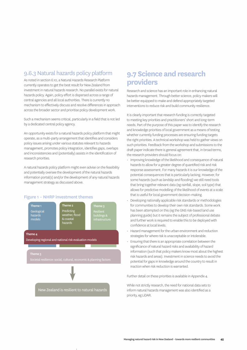
Managing natural hazard risk in New Zealand – towards more resilient communities 45
9.7 Science and research providersResearch and science has an important role in enhancing natural hazards management. Through better science, policy makers will be better equipped to make and defend appropriately targeted interventions to reduce risk and build community resilience.
It is clearly important that research funding is correctly targeted to meeting key priorities and practitioners’ short and long-term needs. Part of the purpose of this paper was to identify the research and knowledge priorities of local government as a means of testing whether currently funding processes are ensuring funding targets the right priorities. A technical workshop was held to gather views on such priorities. Feedback from the workshop and submissions to the draft paper indicate there is general agreement that, in broad terms, the research providers should focus on:• Improving knowledge of the likelihood and consequence of natural
hazards to allow for a greater degree of quantified risk and risk response assessment. For many hazards it is our knowledge of the potential consequences that is particularly lacking. However, for some hazards (such as landslip and flooding) we still need tools that bring together relevant data (eg rainfall, slope, soil type) that allows for predictive modelling of the likelihood of events at a scale that is useful for local government decision-making.
• Developing nationally applicable risk standards or methodologies for communities to develop their own risk standards. Some work has been attempted on this (eg the GNS risk-based land use planning guide) but it remains the subject of professional debate and further work is required to enable this to be deployed with confidence at local levels.
• Hazard management for the urban environment and reduction strategies for where risk is unacceptable or intolerable.
• Ensuring that there is an appropriate correlation between the significance of natural hazard risks and availability of hazard information (such that policy makers know most about the highest risk hazards and areas). Investment in science needs to avoid the potential for gaps in knowledge around the country to result in inaction when risk reduction is warranted.
Further detail on these priorities is available in Appendix 4.
While not strictly research, the need for national data sets to inform natural hazards management was also identified as a priority, eg LiDAR.
9.6.3 Natural hazards policy platformAs noted in section 6.10, a Natural Hazards Research Platform currently operates to get the best result for New Zealand from investment in natural hazards research. No parallel exists for natural hazards policy. Again, policy effort is dispersed across a range of central agencies and all local authorities. There is currently no mechanism to effectively discuss and resolve differences in approach across the broader sector and prioritise policy development work.
Such a mechanism seems critical, particularly in a field that is not led by a dedicated central policy agency.
An opportunity exists for a natural hazards policy platform that might operate, as a multi-party arrangement that identifies and considers policy issues arising under various statutes relevant to hazards management, promotes policy integration, identifies gaps, overlaps and inconsistencies and (potentially) assists in the identification of research priorities.
A natural hazards policy platform might even advise on the feasibility and potentially oversee the development of the natural hazards information portal(s) and/or the development of any natural hazards management strategy as discussed above.
Theme 1
Geological hazards models
New Zealand is resilient to natural hazards
Theme 2
Predicting weather, flood & coastal hazards
Theme 3
Resilient buildings & infrastructure
Theme 4
Developing regional and national risk evaluation models
Theme 3
Societal resilience: social, cultural, economic & planning factors
District Plans
Figure 1 – NHRP investment themes
46
9.7.1 Existing research prioritiesThe Natural Hazards Research Platform (“the Platform”) currently guides research investment by focusing on:• avoidance or mitigation of natural hazard risks that are likely
to result in a civil defence state of emergency (either local or national);
• avoidance or mitigation of natural hazard risks that could potentially cause catastrophic impacts on New Zealand’s economy, environment or social well-being, but may not result in the declaration of a national state of emergency; and
• community, organisational and infrastructural resilience to natural hazard events.
Including CRI core government funding, the Platform has around $17m per annum to invest annually. This funds both long-term basic research, as well as short-term applied research. That investment is spread across five themes:• geological hazard models;• predicting weather, flood, and coastal hazards;• developing regional and national risk evaluation models;• societal resilience: social, cultural, economic and planning
factors; and• resilient buildings and infrastructure.
These are shown diagrammatically in Figure 1.
Table 2 shows the current size and distribution of Platform investment across these themes. The research projects indicated are multi-year projects and some began in past years but continue to be funded (ie the table does not represent a single year).
CRIs receive funding directly for their core services. Some of that is invested in natural hazards research projects. Those projects are shown in the row labelled “CRI Direct Crown.” The row entitled “Platform negotiated” refers to the contracts that the Platform negotiates with providers (with the Platform selecting the best personal for the teams from across a range of research providers). The term “contest projects” refers to projects that are open to all providers through a contestable funding process. About 20% of investment falls into that category.
While Table 2 provides little detail, it is clear that geologic hazard models receive the largest share of Platform funding (currently $8.7 million of the total $21 million investment).
Overall Table 2 indicates an emphasis on probability and susceptibility research, resilience and recovery but relatively less emphasis on researching potential impacts and consequences.
9.7.2 National Science ChallengesIn 2013, Government announced ten “National Science Challenges.” One of these challenges is “Resilience to nature’s challenges – research into enhancing our resilience to natural disasters.” Each challenge includes new funding as well as some reallocation of CRI core funding. Business plans, research strategy’s, and detailed work programmes for each challenge were prepared in the first quarter of 2014. The main emphasis of this programme is on researching natural hazard consequences, impacts and options for natural hazard risk management. Note that this emphasis appears consistent with the general priorities identified in this paper.
Finally, not all hazards related research is funded through the Platform or the National Science Challenge. EQC, MBIE and BRANZ also fund natural hazard-relevant research outside of these arrangements. That research is not detailed here.
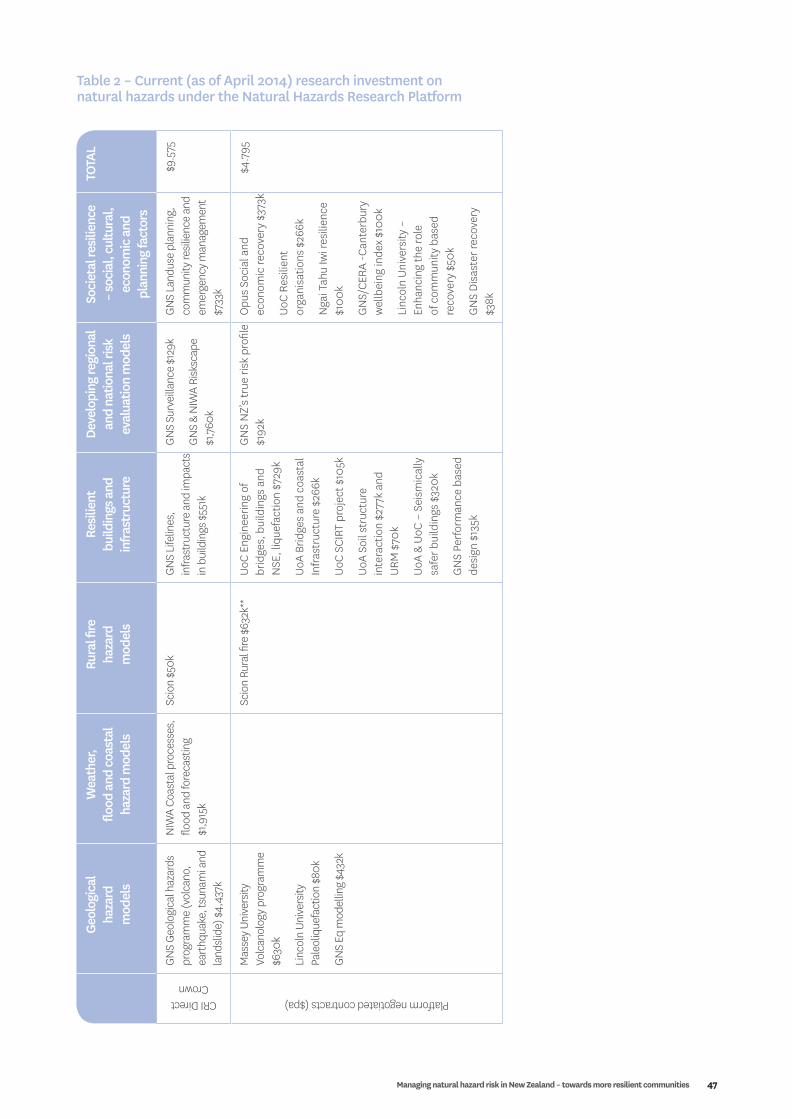
Managing natural hazard risk in New Zealand – towards more resilient communities 47
Geol
ogic
al
haza
rd
mod
els
Wea
ther
, flo
od a
nd c
oast
al
haza
rd m
odel
s
Rura
l fire
ha
zard
m
odel
s
Resi
lient
bu
ildin
gs a
nd
infra
stru
ctur
e
Deve
lopi
ng re
gion
al
and
natio
nal r
isk
eval
uatio
n m
odel
s
Soci
etal
resi
lienc
e –
soci
al, c
ultu
ral,
econ
omic
and
pl
anni
ng fa
ctor
s
TOTA
LCRI Direct
Crown
GNS
Geol
ogic
al h
azar
ds
prog
ram
me
(vol
cano
, ea
rthq
uake
, tsu
nam
i and
la
ndsli
de) $
4,43
7k
NIW
A Co
asta
l pro
cess
es,
flood
and
fore
cast
ing
$1,9
15k
Scio
n $5
0kGN
S Li
felin
es,
infra
stru
ctur
e an
d im
pact
s in
bui
ldin
gs $
551k
GNS
Surv
eilla
nce
$129
k
GNS
& N
IWA
Risk
scap
e $1
,760
k
GNS
Land
use
plan
ning
, co
mm
unity
resil
ienc
e an
d em
erge
ncy m
anag
emen
t $7
33k
$9.5
75
Platform negotiated contracts ($pa)
Mas
sey U
nive
rsity
Vo
lcan
olog
y pro
gram
me
$630
k
Linc
oln
Unive
rsity
Pa
leol
ique
fact
ion
$80k
GNS
Eq m
odel
ling
$432
k
Scio
n Ru
ral fi
re $
632k
**Uo
C En
gine
erin
g of
br
idge
s, b
uild
ings
and
N
SE, l
ique
fact
ion
$729
k
UoA
Brid
ges
and
coas
tal
Infra
stru
ctur
e $2
66k
UoC
SCIR
T pr
ojec
t $10
5k
UoA
Soil
stru
ctur
e in
tera
ctio
n $2
77k
and
URM
$70
k
UoA
& Uo
C –
Seis
mic
ally
sa
fer b
uild
ings
$32
0k
GN
S Pe
rform
ance
bas
ed
desi
gn $
135k
GN
S N
Z’s
true
risk
pro
file
$192
kO
pus
Soci
al a
nd
econ
omic
reco
very
$37
3k
UoC
Resi
lient
or
gani
satio
ns $
266k
Nga
i Tah
u Iw
i res
ilien
ce
$100
k
GN
S/CE
RA -C
ante
rbur
y w
ellb
eing
inde
x $1
00k
Linc
oln
Univ
ersi
ty –
En
hanc
ing
the
role
of
com
mun
ity b
ased
re
cove
ry $
50k
GN
S Di
sast
er re
cove
ry
$38k
$4.7
95
Table 2 – Current (as of April 2014) research investment on natural hazards under the Natural Hazards Research Platform

48
Geol
ogic
al
haza
rd
mod
els
Wea
ther
, flo
od a
nd c
oast
al
haza
rd m
odel
s
Rura
l fire
ha
zard
m
odel
s
Resi
lient
bu
ildin
gs a
nd
infra
stru
ctur
e
Deve
lopi
ng re
gion
al
and
natio
nal r
isk
eval
uatio
n m
odel
s
Soci
etal
resi
lienc
e –
soci
al, c
ultu
ral,
econ
omic
and
pl
anni
ng fa
ctor
s
TOTA
LContest Projects
(Total contract value)
NIW
A
• Ac
tive
subm
arin
e fa
ultin
g $2
80k
• Su
bmar
ine
land
slide
-ts
unam
i haz
ard
$440
k
Geom
arin
e Lt
d Gr
eat
meg
athr
ust e
arth
quak
e ha
zard
$45
0k
GNS
• H
ybrid
ear
thqu
ake
fore
cast
ing
mod
els
$200
k
• In
vers
ion
of G
PS
velo
citie
s$35
0k
• Ts
unam
i res
ilienc
e of
N
Z po
rts $
600k
• Al
pine
faul
t ear
thqu
ake
recu
rrenc
e $3
11k
GNS/
UoC
Quan
tifyin
g th
e co
ntrib
utio
n to
seism
ic
haza
rd fr
om so
urce
, pat
h &
site
$500
k
• St
orm
tide
haz
ards
in
estu
arie
s $30
0k
• De
term
inin
g w
ind
spee
d hi
ll sh
ape
mul
tiplie
rs $
420k
UoC
Resi
dual
cap
acity
an
d re
pairi
ng o
ptio
ns
$450
k
UoA
• Re
info
rced
con
cret
e w
alls
$230
k
• EB
F de
man
d an
d re
pair
$299
k
• Re
trofit
solu
tions
for
herit
age
URM
bui
ldin
gs
$300
k
GN
S G
roun
dwat
er a
nd
lique
fact
ion
$490
k
Mas
sey
21. M
atau
rang
a M
aori
for
volc
anic
haz
ard
$270
k
22. F
aste
r reb
uild
s with
M
RCGE
$25
0k
23. O
pus –
acc
epta
ble
seism
ic ri
sk o
f old
er
build
ings
$50
0k
GN
S –
Econ
omic
less
ons
from
Chr
istc
hurc
h $4
50k
$7.19
0
Total (mill)
$8.7
10$2
.635
$0.6
82$4
.322
$2.0
81$3
.130
$21.5
60

Managing natural hazard risk in New Zealand – towards more resilient communities 49
Conclusions and recommendations
10
50
e. Information on hazards to inform management action is dispersed across many agencies. Hazards managers are faced with an array of guidance on different aspects of hazard management (not necessarily coherent in its entirety).
f. The public often relies on incomplete (and sometimes inaccurate) information about natural hazards when making significant investment and risk management decisions.
g. Finally, the context within which we try to manage natural hazards risk continues to change but that is not always taken into account. In particular, the outlook for climate-driven natural hazards risk is not necessarily understood nor appropriately accounted for in national, regional or local risk and response assessments and decisions.
RecommendationsThat Local Government New Zealand:a. Note the conclusions relating to the strategic issues associated
with natural hazards management identified as items a to g.b. In order to further define issue identification and develop effective
and targeted responses to those issues, it is recommended that Local Government New Zealand advocate on behalf of the local government sector for the following:1. Natural hazards and community resilience strategy: A pan
sector natural hazards management initiative to set clear strategic direction on: III. key practice issues (on a hazard by hazard basis) and
the appropriate policy response to hazard management generally; and
IV. the appropriate place for local discretion and community-specific responses and national consistency in natural hazards management.
Importantly, the process and any output should be collectively developed across local and central government and the broader hazards management sector. This should be nationally led and supported, but not nationally imposed.
2. Natural hazards policy platform: A mechanism to research and resolve natural hazards policy issues. This may take the form of a natural hazards policy platform as a parallel structure to the existing natural hazards research platform. Such a mechanism would inform research needs and promote policy innovation on an on-going basis, using expertise from across the natural hazards management sector.
3. Single information portal: An enhanced and more integrated approach to making natural hazards information available. Bringing together existing natural hazards management guidance material for practitioners should drive greater alignment of thinking. Making information on the nature and location of natural hazards more accessible for the public (at either the national or regional level and including national datasets such as LiDAR), should aim to overcome existing issues with information quality and dissemination, and assist people to make better individual risk management decisions.
In natural hazards terms, New Zealand is a risky place. That is not going to change, and may get worse, both because of increasing population growth and development in vulnerable areas and because climate change may affect the frequency and severity of climate related hazards.
New Zealand has a well-developed CDEM system that aims to integrate the full range of risk management activity in a single co-ordinated system. Working within that system local government has, over a period of many years, successfully implemented a range of planning and operational responses delivering its statutory responsibilities and building more resilient communities.
However, managing risks associated with natural hazards is a seriously challenging business. Property rights and associated legal issues, information and knowledge gaps and the inevitable difficulty of keeping enough people focused, aligned and imbued with a sense of urgency often pose impediments to better and more effective outcomes.
What is very clear is the need for greater sharing of expertise, building of capacity, and alignment of thought across the local and central government sectors and beyond to the wider public and private sector players with roles to play.
That broad conclusion is reached because it is clear from the soundings taken as part of the preparation of this report that, despite a solid and sensible framework being in place and the numerous examples of good practice that can be found across local government, several major issues persist:a. There is little national ownership of risk reduction. The
overwhelming emphasis at the national level is on the readiness, response and recovery dimensions of CDEM. This is problematic since there are statutory functions requiring risk reduction efforts across several players and functional activities. Practical and cost effective management of natural hazards means achieving the optimal allocation of effort across all four “Rs” – something that will vary by natural hazard and by place.
b. While a variety of risk reduction activity is occurring (mostly at regional and territorial levels), it has little strategic leadership in terms of a clear direction and collective agreement on principles and practices. Further, there is a lack of clarity about where responsibility for natural hazard risk reduction lies. Given the challenging policy issues that exist, this is likely to be leading to sub optimal outcomes.
c. There is little or no monitoring of hazard risk outcomes or the effectiveness of risk reduction measures taken by management agencies. It is, therefore, difficult to assess system performance or confirm the proposition set out in 2 above.
d. There is not a consistent basis to make risk management decisions. There are various risk assessment methodologies, no standards of acceptable risk and as a consequence wide variation in practice. In general, there is a low level of quantified risk assessment.

Managing natural hazard risk in New Zealand – towards more resilient communities 51
Appendices
11
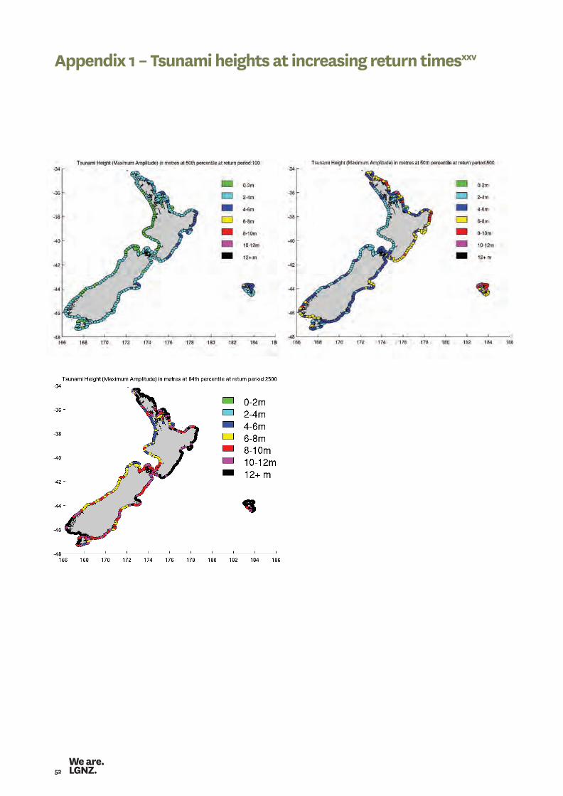
52
Appendix 1 – Tsunami heights at increasing return timesxxv
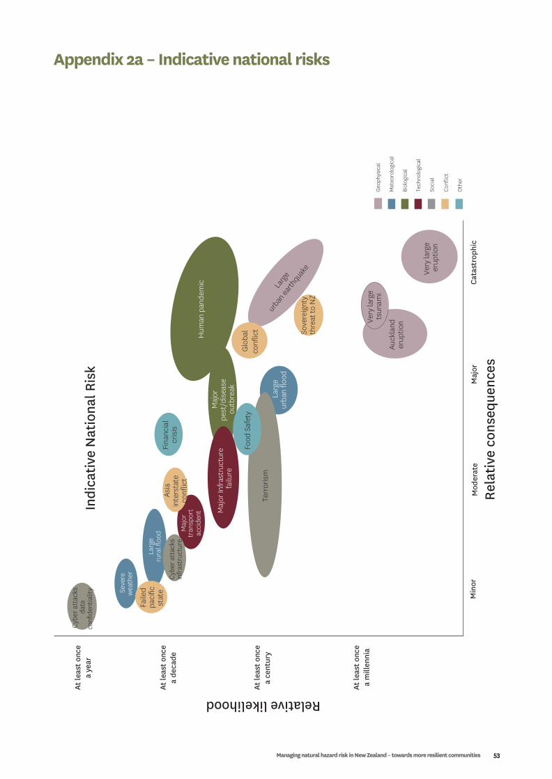
Managing natural hazard risk in New Zealand – towards more resilient communities 53
Appendix 2a – Indicative national risks
Relative likelihood
Rela
tive
cons
eque
nces
Very
larg
eer
uptio
n
Auck
land
erup
tion
Maj
orpe
st/d
isea
seou
tbre
ak
Terr
oris
m
Maj
or In
frast
ruct
ure
failu
re
Food
Saf
ety
Indi
cativ
e N
atio
nal R
isk
Min
orCa
tast
roph
icM
ajor
Mod
erat
e
Larg
eru
ral fl
ood
Seve
rew
eath
er
Very
larg
ets
unam
i
Larg
e
urban
earth
quake
Maj
ortr
ansp
ort
acci
dent
Hum
an p
ande
mic
Glo
bal
confl
ict
Faile
dpa
cific
stat
e
Geop
hysi
cal
Geop
hysi
cal
Met
eoro
logi
cal
Met
eoro
logi
cal
Biol
ogic
al
Biol
ogic
al
Tech
nolo
gica
l
Tech
nolo
gica
l
Soci
al
Soci
al
Oth
er
Oth
er
Confl
ict
Confl
ict
Asia
inte
rsta
teco
nflic
t
Sove
reig
nty
thre
at to
NZ
Cybe
r att
acks
infr
astr
uctu
re
Cybe
r att
acks
data
confi
dent
ialit
y
Fina
ncia
lcr
isis
At le
ast o
nce
a de
cade
At le
ast o
nce
a ye
ar
At le
ast o
nce
a ce
ntur
y
At le
ast o
nce
a m
illen
nia
Larg
eur
ban
flood
xx

54
Appendix 2b – Comparison of New Zealand risks and existing criteria
Not
es:
1. D
eriv
ed b
y th
e au
thor
s fro
m re
sults
of M
CDEM
risk
ass
essm
ent (
Optim
x, 2
002)
2. E
stim
ated
by
the
auth
ors b
ased
on
reas
onab
le e
vent
retu
rn p
erio
ds a
nd li
kely
con
sequ
ence
s - se
e Re
port
Sect
ion
4.1.2
3. U
pper
est
imat
e fo
r Hig
h Ri
sk z
ones
; arr
ow d
enot
s wid
e ra
nge
of ri
sks d
ownw
ard
(URS
, 200
3)4.
AIF
R at
2-4
m a
bov
e se
a le
vel,
no e
ffect
iven
ess a
ssum
ed fo
r war
ning
(Web
b, 2
005)
5. A
vera
ges o
ver l
arge
pop
ulat
ions
; arr
ows d
enot
e lik
elih
ood
of su
bst
antia
l gro
ups o
f peo
ple
at h
ighe
r/lo
wer
risk
6. B
ars s
how
rang
e of
val
ues a
cros
s age
ban
ds fo
r men
and
wom
en (M
inis
try o
f Hea
lth, 2
008)
Annual individual fatality risk
Lifetime (80 yrs) individual fatality risk
10-3
10-2
10-4
10-5
10-6
0.1
(10%
)1 i
n 10
0.01
(1%
)1 i
n 10
0
0.00
1(0
.1%)
1 in
1000
0.00
01(0
.01%
)1 i
n 10
,000
Exis
ting
crite
riaN
Z na
tura
lha
zard
risk
sN
Z ot
her
risk
s6
(X =
pop
ulat
ion
aver
age)
Hig
hest
tole
rabi
lity
leve
l
(HSE
-wor
kfor
ce)
Exis
ting
dam
s/sl
opes
(ANC
OLD
, AG
S,HS
E-p
ublic
)
New
dam
s/sl
opes
(ANC
OLD
, AG
S)
Impo
sed
risks
(haz
ardo
us f
acili
ties,
build
ing
seis
mic
desi
gn)
Flood
Wai
hoho
liday
cam
p(p
re-m
ove)
1 Tsunami4
Gisb
orne
Wel
lingt
onTi
mar
uNa
pier
Chris
tchu
rch
Wha
kata
neAu
ckla
nd E
ast
Inve
rcar
gill
Taur
anga
Seismic5
Wel
lingt
onRe
gion
Landslide/
flooding
Smal
l nos
.in
divi
dual
s,lo
calis
edex
ampl
es2
Flood
Tham
esCo
ast3
All N
Z pop
ulat
ion5
(sei
smic
, vol
cani
c..)
Cancer
Heart disease
Road accidents
Falls
Drowning
X
X
X
X
X

Managing natural hazard risk in New Zealand – towards more resilient communities 55
Secondly, return periods are based on the ‘on average’ approach. In fact an event with a return period of 50 years has a 2% chance of happening every year. Whereas an event with a return period of 100 years has a 1% chance of happening every year. An event with a 1000 year return period has a 0.1% chance of happening every year. It’s not that other events (ie events of other sizes) can’t happen over our 50 year period it is just that there’s a lower probability of them doing so.
In summary, there is a range of events that can happen over a defined planning period but they will have different probabilities of occurring and different levels of consequence – not necessarily in a linear relationship to probability – should they occur.
Planning for an event of one size and ignoring the potential for events of other sizes to occur does not seem a prudent approach to hazard management, especially in the absence of knowing the potential consequences of those other, admitted less likely, events (ie whether the consequence of a less frequent event would be just a ‘little bit more’ or an order of magnitude more, drastically effects the overall risk).
Those factors have caused some to advocate for a risk-based approach to hazards management. A risk based approach is simply saying that rather than looking at an event of a certain prescribed size as the basis for planning (ie can a subdivision survive an event of the size that has a statistical probability of happening once every 100 years?), we need to look at (and understand the potential consequences of) events of other sizes that could occur over the same (say) 100 year planning period. Importantly though, to understand risk associated with those other events we need to factor in that these other events will have a lesser probability of occurring over that 100 year period. We also need to factor in changing likelihoods of occurrence due to climate change. Probabilities calculated solely by looking back over a historical record will be increasingly inaccurate for many climate related hazards.
The provenance of the concept of a ‘return period’ is in engineering and building. In simple terms, specifying a return period is a way of defining the size of an event that a structure must be designed to withstand.
In other words, a building may be designed to survive an event of the size that occurs once in 50 years. However, if an event occurs within that 50 years that is (say) a one in a hundred year event we would not expect our building to survive it. A one in a hundred year event will be bigger than the event it is designed to withstand.
That approach works well in the engineering and building contexts as it provides a clear basis for building design.
However, two issues arise when we consider wider hazards management.
First, the relationship between the frequency of an event and consequences is not necessarily direct or linear for all hazards. An event of a size that occurs, on average, once in 50 years might have negligible consequences in a particular area while an event that occurs every 100 years might be catastrophic or negligible depending on the individual circumstances (eg what’s in that area – activities, number of people). 31 Similarly, an event that occurs every 200 years may not have consequences any greater than the one in 100 year event or it might have 100 times the consequence. Again, this will be dictated by individual circumstances. To properly understand this relationship we need to understand the shape of the risk curve. A typical risk curve is shown in Figure 1.
Appendix 3 – Return period versus risk based approach to hazard management
Likelihood
Consequence
Figure 1 – Typical risk curve
31 In a technical sense this would depend on the shape (slope) of the risk curve (the risk curve being the plotted relationship between the likelihood (probability) of occurrence and the consequences that would result at each likelihood.
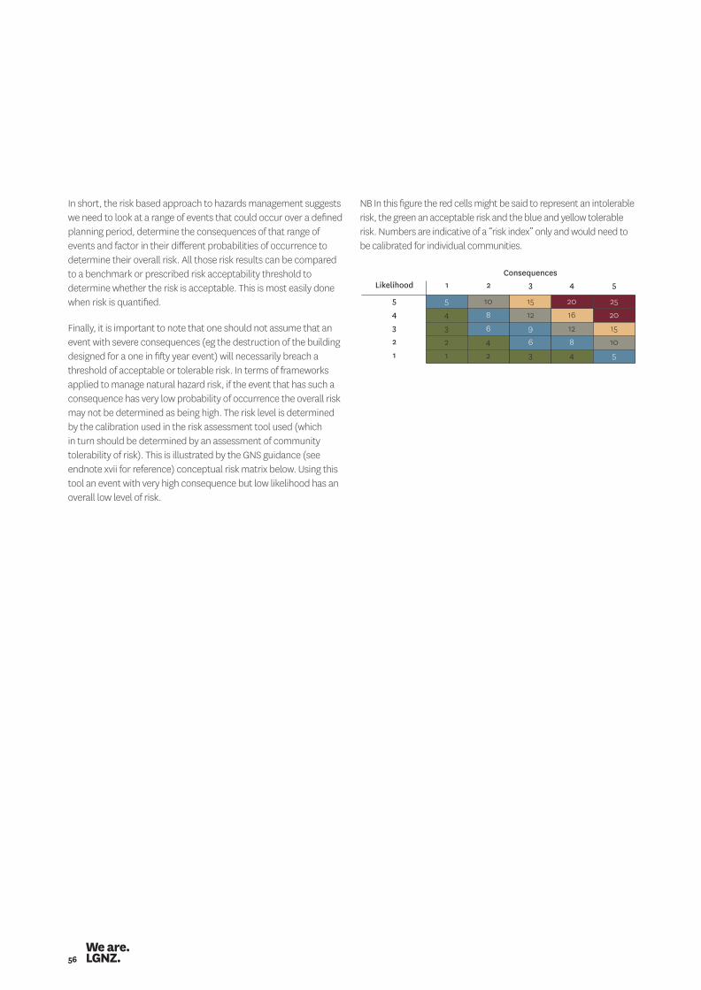
56
In short, the risk based approach to hazards management suggests we need to look at a range of events that could occur over a defined planning period, determine the consequences of that range of events and factor in their different probabilities of occurrence to determine their overall risk. All those risk results can be compared to a benchmark or prescribed risk acceptability threshold to determine whether the risk is acceptable. This is most easily done when risk is quantified.
Finally, it is important to note that one should not assume that an event with severe consequences (eg the destruction of the building designed for a one in fifty year event) will necessarily breach a threshold of acceptable or tolerable risk. In terms of frameworks applied to manage natural hazard risk, if the event that has such a consequence has very low probability of occurrence the overall risk may not be determined as being high. The risk level is determined by the calibration used in the risk assessment tool used (which in turn should be determined by an assessment of community tolerability of risk). This is illustrated by the GNS guidance (see endnote xvii for reference) conceptual risk matrix below. Using this tool an event with very high consequence but low likelihood has an overall low level of risk.
NB In this figure the red cells might be said to represent an intolerable risk, the green an acceptable risk and the blue and yellow tolerable risk. Numbers are indicative of a “risk index” only and would need to be calibrated for individual communities.
Likelihood
Consequences1
1
2
2
3
3
4
4
5
5
1
2
3
4
5
2
4
6
8
10
3
6
9
12
15
4
8
12
16
20
5
10
15
20
25
Managing natural hazard risk in New Zealand – towards more resilient communities 57
other hazards such as flooding, increasing intense rainfall events etc.
14) Hazard management for existing built environments and avoidance strategies where risk is unacceptable or intolerable. It could be useful to determine consistent levels of mitigation considered appropriate for existing urban areas which can then inform the work for greenfield developments.
15) Policy advice for risk reduction in existing urban areas.16) Multi-hazards and cascading hazards. A one-at-once approach
can lead to a misleading picture of vulnerability.17) Social science on perceived risk vs actual risk and effective
means of gaining appropriate uptake of hazard management.18) Other areas include governance, complexity, collaborative
discourses and decision science that could also inform the management of hazard risk.
Should research focus on developing national level data and tools or on more regional or local investigations? 19) Priority should be on both, regional level and national level,
and needs to be well integrated between these levels. For data, focus on regional and local investigations. It is difficult to get the required level of accuracy (robustness/defensibility) for subdivision/development from a national level dataset.
20) Availability of the data that’s already there would be a very good starting point. Then when we can see what we’ve got, and where the gaps are.
21) More cross-regional coordination of what investigations are being done, and collaboration to share costs- especially where richer and poorer regions can work alongside one another.
Are there particular hazards that should be prioritised for research ahead of others? 22) Prioritise those hazard types that have both, higher frequency and
higher impact. Prioritise hazards that will be influenced by future climate change and are likely to constrain land use (ie all hazards except seismic or volcanic). The identification and prioritisation of hazards should be guided by local and regional councils.
23) Hazards should be prioritised through proper risk analysis. Hazard analysis and research needs most of all to be objectively strategised. What we have seen in New Zealand to date is ‘disaster du jour.’ After 2004 it was all about tsunamis. After 2011 it was all about earthquakes.
24) Land stability has been a poor cousin on the whole.25) A multi hazard approach would be a better reflection of
vulnerability at any given location.
Part of the purpose of this paper was to identify the research and knowledge priorities of local government as a means of testing whether current processes ensure funding targets the right priorities. To this end a series of questions was posed in the draft thinkpiece. A summary of responses to these questions follows.
What do you consider should be the natural hazards research priorities? Potential studies which would benefit from leadership from central government or some centralised agency include: 1) Guidelines or technical advice on how to account for climate
change in modelling for flood hazard. 2) Extending flood series to better understand flood hazards
and risk and vulnerability.3) The impact of engineered flood solutions on long term
hazard mitigation. 4) The impact of high rainfall events and solutions to managing these. 5) Best practice on managing coastal hazards, particularly in relation
to coastal erosion and inundation. When does retreat become the most viable option and how can this be given effect to?
6) Implications of changes to earthquake strengthening of buildings on local community economies and potential links to district plan frameworks e.g. demolition of heritage buildings may be necessary as the costs of earthquake strengthening are prohibitive but what impact does this have on New Zealand’s overall heritage stock and how should this be managed?
7) The impact of liquefaction caused through earthquake events and possible solutions to manage these issues and effects.
8) Understanding the level of acceptable/tolerable risk that people are willing to put up with. This will need to involve further research into community views of risk management in different locations with exposure to different hazards, and an understanding of the level of acceptable risk before and after hazard events.
9) How do we prioritise one community above another?10) Investigation into RMA tools to address Existing Use Rights in areas
subject to natural hazards. Possible options include changes to the RMA or changes to the building code. Alternatively, section 68 (2A) of the RMA allows Regional Councils to put rules in their regional plans which could override existing use rights. This step may be taken voluntarily or could be directed through a NPS with the requirement to give effect to any NPS.
11) Development of national level data, tools and guidance to provide consistent direction for local government to apply and adapt where relevant for specific communities.
12) There is need for prioritisation of risk reduction in natural hazards planning, particularly as the other four R’s are well covered.
13) It is recognised that there is relatively adequate research and guidance information regarding sea level rise, but little around
Appendix 4 – Responses to questions on research priorities
58
If there is more than one priority how would you apportion investment between these priorities? 35) Identify the hazard and hazard risk first.36) Potential damage, widespread hazard or not, potential
applicability of the research, the importance of the issue the research addresses.
Are there other principles that should guide research priority setting? 37) There should be support for acquiring a base level of local
science information to a specific standard, eg fault avoidance mapping, then if regions want to undertake more intensive investigation it would be their discretion. This should be funded nationally.
38) Other principles could include: scale, significance, consequence, leadership, leverage, participation, vulnerability/weaknesses, opportunities to indirectly inform non-hazard policy and decision-making.
39) If the research informs reduction activity, put it ahead of research that informs response activity.
40) There is a need for more research on the application of past natural hazards research and accumulated knowledge and the degree to which it penetrates and informs consent processes that can ‘reduce’ hazards. Over the past few years there has been a trend towards researching more and more unlikely, yet potentially significant hazards but I don’t see a lot of this research leading to enhanced ‘reduction’ outcomes. Reduction gains have to be advocated or fought for – they are hard yards. Research (of a hazard) is a relatively soft and politically more acceptable option than land use controls.
41) As far as reduction activity under the RMA and Building Act is concerned, we need to effectively apply the natural hazard knowledge we already have before we rush off and gather knowledge about more obscure and less likely hazards that are unlikely to be considered ‘risky’ enough to merit land use or building controls.
42) A stocktake of existing research could help identify the gaps. 43) Ensuring that an integrated picture is painted through research. 44) Identifying and testing new developments internationally for
relevance in a New Zealand context eg adaptive management approaches that could be used in New Zealand.
26) A national scan that prioritises hazards in light of climate change, consequences and timeframes of decisions, is necessary first.
27) Flooding is currently the most frequent hazard risk experienced and was the most costly until the Canterbury earthquakes. Flooding is likely to be influenced by changes in frequency and intensity. It is known that sea level is rising and will have known impacts on coastal assets. These impacts could occur contemporaneously around New Zealand, or as increases in storm surges at the coast are felt. This is likely to affect low-lying settled areas through rising water tables and thus change flood flow paths. This latter area is poorly researched in New Zealand unlike in other jurisdictions (McGranahan, Balk, & Anderson, 2007).
Should research be orientated towards better understanding of the likelihood of events or, alternatively should we be placing more research effort of better understanding the consequences of events? 28) Both are equally important, but the priorities will differ
depending on the nature of the hazard.29) Multi hazards and cascading hazards. A one-at-once
approach can lead to a misleading picture of a particular area’s vulnerability.
30) The consequences on an event occurring is a higher priority for future research than the likelihood of an event occurring. Just because a hazard has a low likelihood of occurring, doesn’t mean it won’t, therefore the preparedness if it does is much more important. Furthermore, focus on likelihood of a hazard event can lead to complacency and increased exposure to risk where it could have been avoided.
31) There is adequate likelihood information currently. However, there needs to be better understanding of the drivers of decision-making (political, behavioural psychology and decision sciences) and the governance of decision-making about hazard risk as well as adaptive methods for addressing changing risk attendant on climate change.
Should research seek to identify particular vulnerabilities in our physical and social infrastructure? 32) Yes because it has an effect on the ‘consequences’ of an event.33) Definitely. And the cost of events – even small ones – and where
the cost falls. Putting a price on not adequately managing hazards is a good way of getting buy in for adequately managing them.
34) Yes this should be part of a national high level scan of risk. This should also identify vulnerable people and communities.
Managing natural hazard risk in New Zealand – towards more resilient communities 59
Glossary and references
60
Risk treatment is one step in the risk management process, aiming to reduce the level of risk. It involves selecting methods from risk avoidance, reduction/mitigation, transfer and acceptance; where:• Risk avoidance is the undertaking of measures to avoid risk
from natural hazards. These measures could include avoiding development in hazardous areas, relocating people or assets away from hazardous areas, or developing buffer zones.
• Risk reduction/mitigation is the undertaking of measures to reduce the risks form natural hazards, such as strengthening buildings against ground shaking from earthquakes.
• Risk transfer is the undertaking of measure to transfer risk from a natural hazard from one party to another, such as property insurance.
• Risk acceptance is the acceptance of the risk from a natural hazard; any realised losses will be borne by those parties exposed to the hazard. This is not specifically a treatment option as no action is taken, but as it is an option of addressing risk, it is included here.
Vulnerability is the characteristics and circumstances of elements at risk (eg human life and property) that make them susceptible to the damaging affects of a hazard.
Consequence is an impact on the natural, economic, built or social environment as the result of a hazard event. Consequences are influenced by the exposure and vulnerability of elements at risk (eg human life and property) to the hazard, and by the hazard characteristics.
Likelihood means the chance of something happening. This can be expressed as probability either quantitatively or qualitatively.
Natural hazards means any atmospheric, earth or water related occurrence (including earthquake, tsunami, erosion, volcanic and geothermal activity, landslip, subsidence, sedimentation, wind, drought, fire, or flooding), the action of which adversely affects or may adversely affect human life, property, the economy, or other aspects of the environment.
Residual risk is the risk that remains after risk treatment (ie though risk avoidance, reduction/mitigation, transfer or retention/acceptance) has been applied to reduce the potential consequences.
Resilience is the ability to adapt to the demands, challenges and changes encountered during and after a disaster.
Risk is the likelihood and consequences of a hazard.
Risk analysis means the use of available information to estimate the risk to individuals, populations or structures.
Risk assessment means the process of risk analysis and risk evaluation.
Risk management is the process that includes the following steps:• establishing the context;• risk identification;• risk analysis;• risk evaluation; and• risk treatment.
Glossary
Managing natural hazard risk in New Zealand – towards more resilient communities 61
i National Civil Defence Emergency Management Plan Order 2005, 2005/295.
ii Department of Internal Affairs, National Civil defence emergency Management Strategy, 2007.
i Saunders, W. S. A.; Potter, S. H.; Wright, KC.; Beben, J.; Becker, J. S.; McBride, S. 2013. Natural hazard risk communication toolkit, GNS Science Consultancy Report 2013/163. 70p.
iii Ministry of Civil defence emergency Management, CDEM Capability Assessment Report: Part 1, April 2012.
iv McLean I, Oughton D, Ellis S, Wakelin B, Rubin C, 2012. Review of the Civil Defence Emergency Management Response to the 22 February Christchurch Earthquake.
v Hill Young Cooper and Resource Management Group Ltd. (August 2011). Canterbury Fact Finding Project.
vi Enfocus Ltd, 2011. Management of Earthquake Risk by Canterbury Regional Council and Christchurch City Council. Christchurch, New Zealand: Canterbury Earthquakes Royal Commission.
vii Tonkin & Taylor Ltd, 2013. Quantitative Landslide Risk Assessment: Matata Escarpment.
viii Ministry for the Environment 2008. Coastal Hazards and Climate Change. A Guidance Manual for Local Government in New Zealand. 2nd edition. Revised by Ramsay, D, and Bell, R. (NIWA). Prepared for Ministry for the Environment. viii+127 p.
ix Ramsay, D.L., Gibberd, B., Dahm, J., Bell, R.G, 2012. Defining coastal hazard zones and setback lines. A guide to good practice. National Institute of Water & Atmospheric Research Ltd, Hamilton, New Zealand.
x These include the publication referenced in endnote xi and Saunders, W, & P. Glassey (Compilers) 2007. Guidelines for assessing planning, policy and consent requirements for landslide-prone land, GNS Science Miscellaneous Series 7.
xi Saunders, W.S.A.; Prasetya, G. and Leonard, G.S. 2011. New Zealand’s Next Top Model: Integrating tsunami inundation modelling into land use planning, GNS Science Miscellaneous Series 34, 42 p.
xii Centre for Advanced Engineering, 2009, Land Use Planning for Natural Hazards: Stewardship for the Future.
xiii Parliamentary Commissioner for the Environment, 2001. Building on the Edge: The use and development of land on or close to fault lines.
xiv International Standards Organisation, ISO 31000:2009, Risk management – Principles and guidelines, 2009.
xv Ministry of Civil Defence & Emergency Management. (2009). CDEM group plan review: Director’s guideline for civil defence emergency management groups [DGL 09/09].
xvi Auckland Local Authority Hazard Liaison Group. (2002). Hazard guideline No. 2: Hazard identification and risk assessment for local authorities, Technical Publication No. 106. Auckland: Auckland Regional Council.
xvii Saunders W.S.A, Beban J.G, and Kilvington M, 2013. Risk-based land use planning for natural hazard risk reduction, GNS Science Miscellaneous Series 67.97 p.
xviii Taig T, Massey C, Webb T, 2011. Canterbury Earthquakes Port Hills Slope Stability: Principles and Criteria for the Assessment of Risk from Slope Instability in the Port Hill, Christchurch, GNS Sciences Consultancy Report 2011/319.
xix Beban, J G, Cousins, W J, Wang X, Becker JS, 2012. Modelling of the tsunami risk to Papamoa, Wairaikei and Te Tumu assuming an altered ground level due to development of Wairakei and Te Tumu, and the implications for the SmartGrowth Strategy, GNS Science Consultancy Report 2012/54. 168 p.
xx Tonkin and Taylor, 2013. Quantitative Landslide Risk Assessment: Whakatane and Ohope Escarpments.
xxi Evan Lloyd, 2009, Hazards Risk Assessment in the Manawatu-Wanganui Region, Horizons Regional Council.
xxii Waikato CDEM Group, 2005. Hazard and Risk Analysis: Explanatory Notes 2004: A supporting document to the Waikato Civil Defence Emergency Management Group Plan.
xxiii National Academy of Sciences, 2012. Disaster Resilience: A National Perspective.
References

62
We are.Ashburton.Auckland.Bay of Plenty.Buller.Canterbury.Carterton.CentralHawke’s Bay.Central Otago.Chatham Islands.Christchurch.Clutha.Dunedin.Far North.
Gisborne.Gore.Greater Wellington.Grey.Hamilton.Hastings.Hauraki.Hawke’s Bay Region.Horizons.Horowhenua.Hurunui.Hutt City.Invercargill.
Kaikoura.Kaipara.Kapiti Coast.Kawerau.Mackenzie.Manawatu.Marlborough.Masterton.Matamata-Piako.Napier.Nelson.New Plymouth.Northland.Opotiki.
Otago.Otorohanga.Palmerston North.Porirua.Queenstown- Lakes.Rangitikei.Rotorua.Ruapehu.Selwyn.South Taranaki.South Waikato.South Wairarapa.Southland District.
Southland Region.Stratford.Taranaki.Tararua.Tasman.Taupo.Tauranga.Thames- Coromandel.Timaru.Upper Hutt.Waikato District.Waikato Region.Waimakariri.
Waimate.Waipa.Wairoa.Waitaki.Waitomo.Wanganui.Wellington.West Coast.Western Bay of Plenty.Westland.Whakatane.Whangarei.
LGNZ.
PO Box 1214 Wellington 6140New Zealand
P. 64 4 924 1200www.lgnz.co.nz