making the most of underground water storage … & powerpoint presentation making the most of...
TRANSCRIPT
ABSTRACT & POWERPOINT PRESENTATION
Making the Most of Underground Water Storage Facilities: Three Case Studies in Arizona
Robert F. Buss, P.E. Associate Vice President
Carollo Engineers Phoenix, Arizona
Managed Aquifer Recharge Symposium January 25-26, 2011 Irvine, California Symposium Organizers:
• National Water Research Institute • Orange County Water District • Water Research Foundation
www.nwri-usa.org/rechargesymposium2011.htm

1 Buss Making the most of Underground Water Storage Facilities: 3 Case Studies in Arizona
Making the most of Underground Water Storage Facilities: 3 Case Studies in Arizona
Topic: Operational Experience
Robert F. Buss - Carollo Engineers
ABSTRACT
Three case studies of how water providers in Arizona addressed their particular water resources challenges using spreading basins to recharge water underground for future recovery as well as make the most of these public water projects for other beneficial purposes. These providers are: the Central Arizona Water Conservancy District (CAWCD), the Town of Gilbert, and the City of Chandler. Lessons learned include:
1. Location is key to success, so take the time to find the right property and geology. 2. Make the recharge facility a place to visit for public education and recreation. 3. Team up with other city departments to maximize the use of the property.
Case 1: the CAWCD
The CAWCD’s primary mission is to deliver the State’s full allocation of 1.5 million acre-feet of Colorado River Project (CAP) water per year to Pima, Pinal, and Maricopa counties. The CAWCD has developed a series of artificial groundwater recharge projects in the Phoenix and Tucson Active Management Areas (AMA) to store excess CAP water underground for future recovery. The newest and largest of these facilitie is the Tonopah Desert Recharge Project (TDRP).

2 Buss Making the most of Underground Water Storage Facilities: 3 Case Studies in Arizona
TDRP’s current permitted volume over 20 years is 2 million acre-feet. This 541-acre site was designed with 207 acres of recharge area in 19 individual basins having sloping bottoms, a gravity delivery pipeline system, control building, remotely operated control valves for each basin and telemetry back to CAP Operations in Phoenix for monitoring and control. TDRP consistently exceeds the CAP’s design crteria of 2.5 feet infiltration per acre per day since operations began in January 2006 with an overall average infiltration rate of more than 5.3 feet per day. TDRP’s success is due to finding the right geology. Case 2: the Town of Gilbert The Riparian Preserve at Water Ranch was developed out of the Town’s need to manage it’s water resources to match the demands of its growing population. Designed with a modest infiltration capacity of 4 inches per day per acre, the Town leaders excited its citizenry by locating it adjacent to a County Library, and designing it with a 5-acre urban fishing lake, over 3 miles of hiking trails, picnic ramadas, play areas and numerous habitat educational opportunities.
Since its opening in 1998, the Riparian Preserve has enjoyed constant use by people in Gilbert and throughout the Valley of the Sun, and is an immensely popular urban destination. Case 3: the City of Chandler

3 Buss Making the most of Underground Water Storage Facilities: 3 Case Studies in Arizona
Taking over 8 years to plan, design and construct, the Chandler Heights Recharge Project (CHRP) is similar in its function and strategic need as the Riparian Preserve above.
This 113 acre showcase facility houses a police Sub-Station, Parks & Recreation educational facility, a 5-acre urban fishing lake, miles of hiking trails, habitat viewing opportunities, and 80-acres of recharge basins. It has been operating since 2008 and is a point of pride for Southeast Chandler.
Session 7: Operational Experience in
Arizona Systems

Making the most of Underground Water Storage Facilities:
3 Case Studies in Arizona
Presented by:Robert F. Buss, P.E.

Case Study 1: Tonopah Desert Recharge Project (TDRP)
• Owner: Central Arizona Water Conservation District (CAWCD)
Operational: 2006

Project Location Was Deliberately Chosen
• Western Maricopa County, 60 miles west of Phoenix
• Adjacent to the CAP Canal

Project Location Was Deliberately Chosen
• Site must meet the CAP storage goal of 150,000 AF / YR
• Not to Exceed 2 million AF CAP Water over 20 years

Looking NE Towards the TDRP Site – Pre Construction

Looking North Towards the TDRP Site – Post Construction

Project Elements Were Carefully Selected – Monitoring Wells

Project Elements Were Carefully Selected – Piezometer Wells

Project Elements Were Carefully Selected – 3 year
Performance Data
4/256/57/24 9/510
/2812/4
1/28
3/14/28
3/1 4/28
6/17/28
9/110/2812/1
2008 2009

Project Elements Were Carefully Selected – 3 year Performance
Data
• Design infiltration rate = 2.5 ft /ac /day
• Actual infiltration rate = 6 ft / ac / day
• Total 500,240 AF stored as of Dec 2009
• Aquifer is receiving water = GW level is about 125 feet

TDRP Recharge Basins Fact Sheet
Permitted Capacity
150,000 AF / YR
Recharge Area
19 Recharge basins over 207 acres
Estimated Recharge Rate
6 FT/ AC / Day

Recovery Plan Has Been Prepared and Reviewed – Direct Recovery
• Groundwater wells and pipelines– Located adjacent to CAP Canal, to pump
back into canal
– Recover GW from upper portion of aquifer

Recovery Plan Has Been Prepared and Reviewed – In-Direct
Recovery
• Customer can store CAP allocation at recharge facility.
• Withdraw same amount from their service area, using their GW wells.

Case Study 2: Riparian Preserve at Water Ranch
Owner: Town of Gilbert, Arizona Operational: 1999
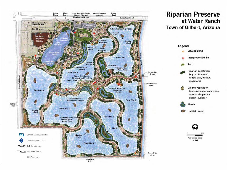
Riparian Preserve at Water Ranch
Demonstrates the Town’s commitment to:
• Plan for its future water resource needs
• Provide diverse recreation and learning opportunities
• Preserve open space and wildlife habitat

Riparian Preserve - located in the heart of the Town

Ramadas, Restrooms, and Education

Simplified Operations

Coordination with County Regional Library – view from inside

Riparian Preserve Recharge Basins Fact Sheet
Permitted Capacity
4,369 AF / YR
Recharge Area
7 Recharge basins over 36 acres
Estimated Recharge Rate
2.4 – 4.8 inches/day

Recharge Performance Data
• 40,330 AF water stored as of Dec 2010
• Aquifer is receiving water = GW level is about 149 feet below surface.

Case Study 3: Chandler Heights Recharge Project (CHRP)
Owner: City of Chandler, Arizona Operational: 2008

Master Plan Established Major Elements for Design Phase
• Site analysis
• Initial programming– Departmental coordination– Workshops
• Public participation
• Site plan development
• Permitting

Facility Planning Addressed Public Concerns and
Solicited Input
• Trails
• Fishing
• Habitat
• Programming
• Equestrian

Police Substation Integrated into Nontraditional Setting

Environmental Education Building w/classrooms
Environmental Education Building

Veterans Oasis Park Amenities: Moving Water & Shade
Recirculation Stream Basin 5 Stream

Chandler Heights Recharge Basins Fact Sheet
Permitted Capacity2,240 AF / YR
Recharge Area5 Recharge basins over 32 acres
Estimated Recharge Rate2.4 – 4.8 inches/day

The Lake and Campus are separate from Recharge Basins

The Recharge Basins are east of Lake and Campus

Recharge Data – 3 Years
• 2008 - 267 MG• 2009 - 425 MG • 2010 - 274 MG
• TOTAL = 966 MG
• Depth to Groundwater– 2008 - Varied from 35’ to 49’– 2009 - Varied from 38’ to 49’– 2010 – Varied from 38’ to 44’

Chandler Heights Recharge Project – looking NE

Summary & Findings
• Geology is key to efficient recharge performance.
• Deliberate public involvement on the design elements will win public support.
• Water, shade, education, fishing and trails are greatly desired by the public.
• Recharge facility can be a public “point of pride”.

Acknowledgements
Contributors: – Tim Gorey, Central Arizona Water
Conservation District (CAWCD)
– Patty Jordan, Town of Gilbert, Arizona– John Pinkston, City of Chandler, Arizona