underground gas · pdf fileunderground gas storage twenty-three natural gas and three...
TRANSCRIPT

New York State Oil, Gas and Mineral Resources, 2003
NYS DEC - Division of Mineral Resources 27 Twentieth Annual Report
UNDERGROUND GAS STORAGE
Twenty-three natural gas and three liquefied petroleum gas underground storage facilities operated in ten counties in the western and cen-tral parts of New York during 2003. Natural Gas Storage Table 9 summarizes the 2003 year-end status of underground natural gas storage in New York and Table 10 details activity during the year at each storage field. Storage operators injected 79.8 billion cubic feet of natural gas into storage during 2003 and delivered 73.4 billion cubic feet. New York’s storage reservoirs were 80% full at the end of the reporting year and year-end working gas in storage represented 62% of working capacity. Underground storage reser-voirs in New York State held a total of over 182.4 billion cubic feet of natural gas during 2003. More than 900 storage field wells were used during the year for injection, withdrawal or monitoring. More gas is stored in the Oriskany sandstone formation than in any other rock unit in New York State. Used for storage at ten fields includ-ing Stagecoach, the Oriskany accounted for 65% of total statewide capacity, 65% of work-ing storage capacity and 61% of total maximum daily deliverability. The largest single storage field with respect to capacity, Dominion Trans-mission’s Woodhull Field in Steuben County, can hold up to 35.9 billion cubic feet of gas in the Oriskany formation. Permit Applications - In December 2002 Wy-ckoff Storage Corporation submitted an applica-tion to develop a new underground natural gas storage field in a depleted gas production field in Steuben County. Although the Federal En-ergy Regulatory Commission (FERC) approved the project in October 2003, the company’s ap-plication for State approval was not adequate and the Division issued a notice of incomplete application in August 2003. In 2003 staff continued to review a proposal by
National Fuel Gas Supply Company to extend the boundary of its Beech Hill natural gas stor-age field in Allegany County. The application previously submitted by Seneca Lake Storage Inc. for a proposed salt cavern storage project in Schuyler County remains on hold by request of the applicant. Liquefied Petroleum Gas Storage New York’s three liquefied petroleum gas (LPG) underground storage facilities are in Cortland, Steuben and Schuyler Counties. The facilities store propane, butane and other liquid hydrocarbons for delivery to market as needed. Operators reported that 35,346,000 gallons of LPG were in storage at year-end 2003. The vol-ume stored at year-end represents 23 percent of total LPG storage capacity. Liquefied petroleum gas is stored in caverns excavated in the shales of the Genesee Group or solution mined out of the Salina Group salt for-mations, which are the same formations used by New York’s five solution mining facilities.
A well at the Woodhull Storage Field in Steuben County. The reservoir has the largest storage capacity in New York.

New York State Oil, Gas and Mineral Resources, 2003
NYS DEC - Division of Mineral Resources 28 Twentieth Annual Report
Onondaga
Oriskany
Medina
Salt Cavern
Total Number Fields 2 10 10 1 23 Wells
50 328 524 3 908 Acreage Reservoir 7,541 27,904 42,706 4 78,155 Total
13,577 60,780 102,918 4 177,279 Total Storage Gas Capacity (bcf) 10.700 134.754 59.280 2.340 207.074 Year-End (bcf)
8.767 110.063 48.254 0.170 167.255
Working Gas Capacity (bcf) 6.863 68.627 27.973 1.450 104.913 Year-End (bcf)
4.930 43.936 16.947 -0.720 65.094
Max Daily Deliverability (mmcf/day)
100
1,171
511
145
1,927
Table 9 - Summary and Year-End Status Underground Natural Gas Storage, 2003
Stagecoach Gas Field, which started operation in 2002, is the easternmost un-derground natural gas storage field in the US. The field uses innovative hori-zontal wells to increase gas flow. Well CNYOG W-4 is in the foreground and well W-8 and an equipment building are in the background.

!#*
!!!!!!!!!!
!
!!!!
!!
!!!!!!!!!!!!
!!!!!!!!!!
!!!
!!!!!
!
!!
!
!!!!!
!!
!
!!
!!!!
!!!!
!!!
!! !! !!!!! !!!!!!
!
!!!!!!!!!!!!!!!!
!!!!!!
!!! !!!!!!!!
!
!!
!!!!
!!!!!!
!!!!
!!! !!!!!!!! !!!!!!!!! !
!
!
!
!!!!!
!!!!!
!
!!!
!!
!
!
!!!
!!!
!!!!!!
!!!!
!!
!!!!
!
!
!!!!!
!!!!!!!!!!!!!!!!
!
!
!
!
!
!!
!
!
!!
!
!!
!
!!
!
!
!!
!!
! !
!! !!!!
!!!!
!!!!
!
!
!!
!
!
! ! !
!!
!!
!
!
! !!!
!
! !!! !!!! !!!
!!
!!
!
!!!!
!
!
!!! !!
!
!!
!!
!!!!!!!
!!!!!
!
!
!!!
!!
!!!!
!!
!! !
!
!!!
! !!!!
!!!!!!!
!
!!!!
!
!!!!!!
!!!!
!!!!
!!!!!
!
!!
!!!
!
!
!
!!!
!!!
!!!!
! !!
!
!!
!
!
!!!!!!!
!!
!
!!
!
!!!
!!
!
!
!!
!
!!!!!!
!!!
!
!!
!!!
!
!!!
!!!! !!!
!!
!!!!!
!!!!!
!!
!!!!!!
!
!
!
!
!
!
!!!
!
!!!
!!!
!
!
!
!!
!!! !
!
!
!
!!!!
!
!
!!!!
!
!!!!!!
!
!
!
!
!!
! !!
!
!!!!!
!
!
!! !
!!
!!!
!!
!
!!
!
!!!!!
!
!!!!!!!!!
!!!!!!
!!!!!!! !!!!!!!
! !!!!!! !!
!
!! !!!! !!!!!!!!!!!!!! !! !!!!!!!!! !!!!!! !!!!! !!!!!!!!!!!!
!
!!!!!!!!!!!!!!! !!!!!!! !!!!!! !! !!!!!! !!
!!
!!!
!
!!!!!!!!!! !
!!!!!!!
!
!!!!
!
!!!
!
!
!!!
!
!
!!!
!!
!!!!!!
!!
!!
!!!!!!!!!
!
!
!!
!
!
!!!
!
!!!
!!
!!
!!
!
!!
!!!!!!!
!!
!!
!
!!
!!!!!!!!!!!!!!!!!!!!!!!!!!!!
!
!!!!!
!
!!
!!
!!!!!!!!
!
!!!!!!!!!!!!!!
!!
!
!!!!!!!!!
!!!!!!!
!!!
!!
!!!
!!!!!!!!!!!!!!
!
!!!!!!!
!!
!
!!!!!
!
!
!!
!!!!!
!!!!
!!!!!!!!!
!! !! !!!!! !!!!!!
!
!!!!!!!!!!!!!!!!
!!!!!!
!!! !!!!!!!!
!!
!!
!!!!
!
!!
!!!!!
!!!!
!!! !!!!!!!! !!!!!!!!! !
!
!
!
!!!
!!!!!!!
!!
!!!!
!!
!!!!!
!!!!
!!
!!!!
!
!
!!!!!
!!!!!!!!!!!!!!!
!
!
!
!
!!
!
!
!!
#*
!
!!
!
!!
!
!
!!
!!
!
! !!!!
!!!!
!!!!
!
!!
!
!
! ! !
!!
!!
!
!
! !!!
!
! !!! !!!! !!!
!!
!!!
!!!
!
!
!!! !!
!
!!
!!!
!!!!!!!
!!!!!
!
!
!!!
!!
!!!!
!!
!! !
!
!!!!
! !!!!
!!!!!!!
!
!!!!
!
!!!!!!
!!!!
!!!!
!!!!!
!
!!
!!!
!
!
!
!!!
!!!
!!!!
!!!!
!
!!
!
!
!!!!!!!
!!
!
!!
!
!
!!!
!!
!
!
!!
!
!!!!!!
!!!
!
!!
!!!
!!!
!!!!
! !!!
!!
!!!!!
!!!!!
!!
!!!!!!
!
!
!
!
! !
!
!
!
!
!!!
!
!!!
!!!
!
!
!
!
!
!!
!! !
!
!
!
!!!!
!
!
!!!!
!
!!!!!!
!
!
!
!
!!
! !!
!
!!!!!
!
!
!! !
!!
!!!
!!
!
!!
!
!!!!!
!
!!!!!! !!!!!!! !!!!!!! !!
!!!!!!!!! !!!!!!!!!!
! !!! !!! !!! !!
!
!! !!!!! !!!!!!! !!!!!!!! !! !!!!!!
!!!
!!! !!!!!!! !!!!! !
!
!! !!!!!
!
!!!!!!!!
!!
!!!!!!!!
!!!
!!!!!!
!!
! !!!!
!!!!!
!
!!!!!! !! !
!
!!!!! !
!
!
!!!
!!
!!!
!
!!!!!!!!!! !
!!
!!!!!!!
!
!!!
!
#*
!!
!
!!!
!
!
!!!
!
!
!!!
!!
!
!!!
!
!!!
!!
!!
!!!!
!
!!!!
!
!
!
!
!
!!!
!
!
!
!
!!
!
!!!
!!
!!
!!
!
!!
!!
!!!!!!!!!!
! !!!!
!
!!!!
!!
!
!!
!!
!!
!
!!!!
!!!!
!!!!!
!
!
!!!
!
!!!
!!!
!!
!
!! ! !!!
!!
!!!!
!!
!
!!!
!!!!
!!
!!!!
!
!
!!
!
!!!
!
!!!
!
!
!!
!!!!!
!
!
!!
!!!
!
!!
!!!
!!!!
!
!
!!!
!
!!!!!
!!!!
!!!
!
!
!!!! !!
!!
!!!!!!
!!!
Map 4 - Underground Gas Storage andSolution Salt Mining Fields, 2003
Sheridan
NashvillePerrysburg
Lawtons
CollinsZoar
Derby
Colden
Holland
Bennington
Limestone
DaleWyoming Village
Honeoye
Wayne-Dundee
Well Type! Solution Mining
#* LPG Storage
! Natural Gas Storage
W IndependenceE Independence
N Greenwood
BPSI LPGAdrian Reef
Tuscarora
NYLPG
Texas Eastern LPG
Seneca Lake
Cargill
US Salt
Stagecoach
Greenwood
NYS D
EC D
ivision of Mineral Resources
Twentieth Annual Report
29
New
York State Oil, G
as and Mineral Resources, 2003
Morton Salt
Beech HillWoodhull

New York State Oil, Gas and Mineral Resources, 2003
NYS DEC - Division of Mineral Resources 30 Twentieth Annual Report
Total Number
Wells
Total Storage Capacity
(bcf)
Gas to Storage
(bcf)
Gas from Storage
(bcf)
Designed Max. Deliverability (mmcf/day)
Dominion Transmission, Inc.
Woodhull Field
51 35.904 19.388 16.813 357
Central NY Oil and Gas
Stagecoach Field
18 13.750 11.373 10.181 500
Columbia Gas Trans. Corp.
Dundee Field 134 11.000 3.961 3.856 77
Greenwood Field 6 3.600 0.137 0.082 5
N. Greenwood Field
2 3.200 0.384 0.388 9
Honeoye Storage Corp.
Honeoye Field
39 10.780 4.039 3.936 55
National Fuel Gas Supply
Beech Hill Field 56 23.000 4.170 4.989 66
Bennington Field 64 5.000 1.786 1.836 75
Colden Field 166 16.220 7.223 5.458 110
Collins Field 46 5.880 2.210 2.025 50
Derby Field 14 0.250 0.249 0.180 5
E. Independence Field 11 6.400 2.390 2.175 15
Holland Field 26 2.600 0.929 1.057 25
Lawtons Field 32 2.470 0.894 0.813 21
Limestone Field 14 19.800 1.482 1.406 37
Nashville Field 71 8.530 3.105 2.991 110
Perrysburg Field 40 3.850 1.386 0.994 35
Sheridan Field 26 3.700 0.924 0.674 25
Tuscarora Field 8 6.300 2.943 3.731 57
W. Independence Field 30 11.800 4.092 3.892 49
Zoar Field
39 2.200 0.816 0.795 40
NYS Electric & Gas
Seneca Lake Field
3 2.340 1.534 1.143 145
Steuben Gas Storage Co.
Adrian Reef Field
12 8.500 4.404 3.951 60
Totals 908 207.074 79.820 73.365 1,927
Table 10 - Summary Storage Field Activity, 2003

New York State Oil, Gas and Mineral Resources, 2003
NYS DEC - Division of Mineral Resources 31 Twentieth Annual Report
TRENTON-BLACK RIVER ACTIVITY
Top Producers for 2003 Fortuna Energy (Fortuna) acquired assets from Fairman Corporation, East Resources, Pennsyl-vania General Energy and Columbia Natural Resources, Inc. to become New York’s top Trenton-Black River producer in 2003. The Di-vision approved the transfer of 21 wells in Che-mung, Schuyler and Steuben Counties to For-tuna. Fortuna also drilled several more Trenton-Black River prospects on the acquired lands. Perhaps the most notable was the directionally-drilled Konstantinides 1 well in Chemung County which established a new State record for total measured depth at 14,475 feet. In 2003 Triana Energy became the State’s sec-ond largest Trenton-Black River producer through its acquisition of Columbia Natural Re-sources, Inc. The new company is registered as Columbia Natural Resources, LLC. Technological Advances Horizontal drilling of deep Trenton-Black River wells increased greatly during 2003. The hori-zontal re-drilling of a poorly producing vertical well, Henkel 1359 in Steuben County, yielded one of the State’s most productive wells to date. The Henkel well is now owned by Fortuna. In 2003 operators also made more use of three-dimensional (3D) seismic as they recognized the value of this type of data for selecting drill sites in complex reservoir systems. 2003 Permits/ Drilling Area Expands Trenton-Black River permitting activity contin-ued to climb in 2003 with 34 permit applica-tions submitted. The Division issued 38 Tren-ton-Black River drilling permits to nine differ-ent operators for ten different counties. Twenty-four wells were drilled in 2003, including the first wells to use modern exploration methods
and technology to target Trenton reserves in Wayne and Oswego Counties. These Wayne and Oswego County wells are significantly shal-lower than those in Chemung, Schuyler and Steuben Counties. The target formation is frac-tured limestone, not the typical hydrothermal dolomite of deep Trenton-Black River wells. The Department recognizes the possibility that these Wayne and Oswego County wells may have different producing characteristics than those wells drilled in the southern tier. Field-wide spacing orders will be needed for these shallower reservoirs if they prove be productive. The 1969 Order for Blue Tail Rooster Field in Cayuga County, the only Order for a shallow Trenton field issued to date, established 320-acre units and other well spacing requirements. Future proposals for shallow Trenton limestone units will include an evaluation of applicability of the Blue Tail Rooster model. Well Spacing and Integration The sole Trenton-Black River spacing and inte-gration hearing in 2003 was for the County Line Field in Chemung, Schuyler and Steuben Coun-ties. Royalties for the field have been collecting in an interest-bearing escrow account since the first well started production in 2001. The hearing process for both County Line Field and Terry Hill Field (hearing late 2002) was significantly extended when interested parties filed extensive legal briefs. Final rulings were still pending at the close of 2003. In 2003 Division Staff also expended consider-able effort assisting legal counsel on other is-sues related to Trenton-Black River activity. Staff evaluated public comments regarding two petitions submitted by Western Land Services (WLS). WLS requested declaratory rulings on DEC’s public hearing procedures and on the non-operator lessee’s eligibility to receive a working interest share of production.
New York State Oil, Gas and Mineral Resources, 2003
NYS DEC - Division of Mineral Resources 32 Twentieth Annual Report
Field Name
Longest Months Production for a
Well in Field
Number of
Wells*
Average MMCF Per Month
Per Well**
Total MMCF
Through 2003
Glodes Corner Road 96 12 10 8,795
Wilson Hollow 50 10 85 25,222
Muck Farm 40 4 40 6,437
Pine Hill 38 3 3 387
Quackenbush Hill 37 5 155 22,539
Terry Hill South 34 5 40 5,830
Langdon Hill 31 2 18 838
Cutler Creek 30 1 79 2,358
County Line 27 3 14 940
Sugar Hill 14 1 67 939
Ballyhack Creek 10 1 25 254
Whiskey Creek 1 1 23 23
Caton 3 1 7 21
Guyanoga Valley 5 1 16 82
Total All Trenton-Black River Fields to Year-End 2003
* Excludes Shut-in Wells ** Total field production divided by total months of production for all wells
Table 11 - Summary Cumulative Production to Year-End 2003, Trenton-Black River
74,665
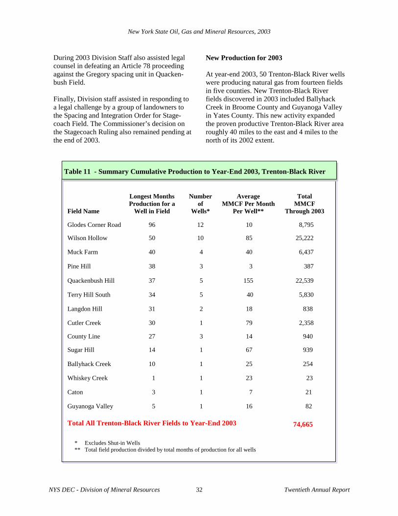
During 2003 Division Staff also assisted legal counsel in defeating an Article 78 proceeding against the Gregory spacing unit in Quacken-bush Field. Finally, Division staff assisted in responding to a legal challenge by a group of landowners to the Spacing and Integration Order for Stage-coach Field. The Commissioner’s decision on the Stagecoach Ruling also remained pending at the end of 2003.
New Production for 2003 At year-end 2003, 50 Trenton-Black River wells were producing natural gas from fourteen fields in five counties. New Trenton-Black River fields discovered in 2003 included Ballyhack Creek in Broome County and Guyanoga Valley in Yates County. This new activity expanded the proven productive Trenton-Black River area roughly 40 miles to the east and 4 miles to the north of its 2002 extent.

*
**
****
*
**
*
** ***** *
* *
*
*
***
* **
**
* **
** *
*
*
*
*
*
*
* ** *
***
*
**
**
*
*
*
*
*
STEUBEN
CAYUGA
TIOGA
BROOME
WAYNE
CHENANGO
MONROE
ONTARIOMADISON
ONONDAGA
YATES
LIVINGSTON
TOMPKINS
CORTLAND
CHEMUNG
SCHUYLERSENECA
Elmira
Corning
BinghamtonCaton
Riverside
Pine HillMuck Farm
Sugar HillCounty Line
Langdon HillWilson Hollow
Sexton Hollow
Ballyhack Creek
Guyanoga Valley
Terry Hill South
Glodes Corners Road
Quackenbush Hill
Cutler Creek
Whiskey Creek
NYS D
EC D
ivision of Mineral Resources
Twentieth Annual Report
New
York State Oil, G
as and Mineral Resources, 2003
33
Map 5 - Trenton Black-River Fields, Central NY, 2003
LegendFields Named But No 2003 Production
Fields With 2003 Production

New York State Oil, Gas and Mineral Resources, 2003
NYS DEC - Division of Mineral Resources 34 Twentieth Annual Report
Table 12 - Detailed Cumulative Production to Year-End 2003, Trenton-Black River*
Months Total Production Field and Wells API Number In Production MMCF
Wilson Hollow Field Howe 31101228140100 42 5,243 Jimerson 31101227710000 50 3,714 VanVleet 31101228520000 34 1,868 Fratercangelo 31101228840100 27 2,646 Rice 31101228250000 39 532 Parker 31015228910000 23 4,950 Hardy 31015229190100 23 1,279 Chemung SRA #1 31015229600000 19 1,992 Root 31015229750000 15 2,278 Lederer 31015229020100 23 720 Apenowich 31101230590000 0 shut-in Quackenbush Hill Field Lovell 31015228310000 37 11,927 Rhodes 31015228530000 31 3,598 Hartman 31101228920100 28 1,757 Henkel 31101228710100 30 3,684 Gregory 31015229180100 19 1,573 Andrews 31101230380000 0 shut-in Reed 31101230550000 0 shut-in Hepfner 31015230280000 0 shut-in Hakes 31101230540000 0 shut-in Glodes Corner Rd. Field Levandowski 31101216880000 74 1,028 Covert 1 31010216890100 74 1,004 Smith 31101217050000 72 976 Gray 31101215920000 96 854 Fox 31101217060000 72 918 Pizura 31101216920000 74 757 Bergstresser 31101217100000 72 887 Covert 2 31101227680000 48 856 Radigan 31101217030100 57 527
Field Total 25,222
Field Total 22,539

New York State Oil, Gas and Mineral Resources, 2003
NYS DEC - Division of Mineral Resources 35 Twentieth Annual Report
Months Total Production Field and Wells API Number In Production MMCF
Glodes Corners (cont.) Ballam-Carter 31101227690000 38 748 Evangelos 31101194970000 84 182 Kozak 31101217120000 71 58 Egresi 31101227720000 0 shut-in Muck Farm Field Snyder 31101227550000 40 2,631 McAllister 31101227480000 40 2,209 Smith 31101227470000 40 994 Faber 31101227450000 40 603 Terry Hill South Field Kimball 31015228570000 29 1,450 Lant 1 31015228620000 34 1,233 Broz 31015228260000 29 654 Clauss 31015228890100 27 463 Kienzle 31015228800100 25 629 Gublo 31015229100000 0 shut-in Cutler Creek Field Corning Game Club 31101228850000 30 2,358 County Line Field Whiteman 31015228390000 27 323 Purvis 31097228930000 18 433 Roy 31015229010000 22 184 Youmans 31101229760000 0 shut-in Sugar Hill Field SRA 2-1 31097228410000 14 939
Field Total 8,795
Field Total 5,830
Field Total 940
Field Total 6,437
Field Total 2,358
Field Total 939

New York State Oil, Gas and Mineral Resources, 2003
NYS DEC - Division of Mineral Resources 36 Twentieth Annual Report
Months Total Production Field and Wells API Number In Production MMCF
Langdon Hill Field Monahan 31015228380000 31 709 Usack 31015229330000 16 129 Konstantinides 31015230230000 0 shut-in Pine Hill Field Wolcott 31101227600100 36 178 Peck 31101227660000 38 157 S&D Farms 1 31101227580100 38 52 S&D Farms 1B 31101227590200 0 shut-in Ballyhack Creek Field Beagell 2 A 31007229950100 10 254 Butkowsky-1A 31007230560100 0 shut-in Guyanoga Valley Field Walters 31123227750100 5 82 Whiskey Creek Harndon 1 31101230400000 1 23 Caton Field Maxwell 1B 31101229630200 3 21 Riverside Field Pace 31101229580000 0 shut-in Seeley Creek Curren 31015230760000 0 shut-in
Field Total 254
Field Total 838
Field Total 387
Field Total 82
Field Total 23
Field Total 21
Field Total 0
Field Total 0

New York State Oil, Gas and Mineral Resources, 2003
NYS DEC - Division of Mineral Resources 37 Twentieth Annual Report
Landowners typically receive royalties
of 1/8 or 12.5% of the value of produc-
tion from a well draining their land.
Some landowners in the Trenton-Black
River trend are collecting royalties of
$100,000 or more per year.
Months Total Production Field and Wells API Number In Production MMCF
Sexton Hollow Field Grand Prix 1 31097228300000 0 shut-in Beans Stations Gray 31101229490000 0 shut-in
Meads Creek Schuyler SRA3-1 31097230720000 0 shut-in Moreland Ganung 2 31097230080000 0 shut-in West River Bay 1B 31069229850200 0 shut-in Total All Trenton-Black River Fields to Year-End 2003 74,665
Field Total 0
Field Total 0
Field Total 0
Field Total 0
Field Total 0
* Includes wells spudded on or before 12/31/03

New York State Oil, Gas and Mineral Resources, 2003
NYS DEC - Division of Mineral Resources 38 Twentieth Annual Report
Five solution mining facilities in New York (see Map 4 on page 29) produced 2.08 billion gallons of saturated brine, or about 2.5 million metric tons of salt, in 2003. Operators of these five facilities injected 2.19 billion gallons of fresh and recycled plant process water into bedded salt zones of the Upper Silurian Salina Group to recover the brine. Brine withdrawals for 2003 represent a slight decrease compared to 2002's figure of 2.17 billion gallons. The value of New York’s 2003 solution salt mining production is estimated at $100 million. The 144 operating wells reported in 2003 in-clude injection wells, withdrawal wells, wells equipped for both injection and withdrawal, and standby wells. Table 13 gives the number of
operating and plugged wells at each facility. U.S. Salt, Cargill, and Morton produced brine to supply on-site evaporation plants which manu-facture and package table salt, water condition-ing salt, and salt for other uses. Texas Brine and Occidental Chemical supplied chemical manu-facturing plants in Niagara Falls via 60-mile-long brine pipelines. In 2003 solution mining facilities accounted for approximately 60% of New York’s total mined salt production, with the remainder extracted by conventional underground mining. According to U.S. Geological Survey statistics, New York typically ranks third among the states in total annual salt production volume.
SOLUTION MINING
Operator
County
Town Year Started
Operating Wells
Plugged Wells
U.S. Salt
Schuyler Reading 1893 11 61
Cargill
Schuyler Dix 1898 17 13
Morton Wyoming Castile & Gainesville
1884 20 25
Occidental Chemical
Wyoming Middlebury (Dale Field)
1970 57 91
Texas Brine Wyoming Middlebury (Wyo. Vil. Field)
1984 39 ____
30 ___
Total 144 221
Table 13 - Status of Solution Salt Mining in New York, 2003

New York State Oil, Gas and Mineral Resources, 2003
NYS DEC - Division of Mineral Resources 39 Twentieth Annual Report
In 2003 permitting of stratigraphic and geother-mal wells in the greater New York City area became a significant workload for the Divi-sion’s Albany staff which cover the eastern half of the State. In fact New York County tied with Steuben County for the most number of drilling permits (26) issued in 2003. Site reviews for wells drilled in a city urban en-vironment are far different from those in rural areas where the majority of wells regulated by the Division are drilled. The factors that the Di-vision reviews for most permits, such as impacts to surface and groundwater resources, are re-placed by topics such as traffic control and sewer discharges which are handled by city agencies. Other siting concerns in an urban set-ting include avoidance of subsurface utilities, noise abatement, and emergency access and evacuation routes to and from buildings. Stratigraphic Wells In 2003 the New York City Department of Envi-ronmental Protection (NYCDEP) applied for 21 permits to drill stratigraphic wells and the Divi-sion issued 19 permits to the agency. NYCDEP drilled 13 wells to collect geologic information on the proposed route of City Water Tunnel #3. The tunnel is under construction 350 to 550 feet below the streets of Manhattan to supply drink-ing water for the city. Details on stratigraphic wells drilled and completed in 2003 are listed in the Appendices under New York County.
Geothermal Wells NYCDEP was not the only applicant to drill in New York City during 2003. Builders and de-velopers applied for permits to drill 15 geother-mal wells equipped with geoexchange technol-ogy. This type of well uses the earth as either a heat source or a heat sink, depending upon the season, by circulating water between the surface and the bottom of the well. Since the mean earth temperature beneath New York City is roughly 55EF, these wells are expected to have high op-erating efficiency. The Division issued seven permits to four different developers for New York City geothermal wells and all seven wells were drilled in 2003. The Paleontological Research Institute in Ithaca also applied for and drilled two geothermal wells in 2003 for their facility in Ithaca, Tomp-kins County. The website for this facility’s new museum features information on their geother-mal wells at http://www.priweb .org/museumoftheearth/geothermal.htm. In addition to Table 14 below, there are more details on drilling and completion of geothermal wells in the Appendices. The Division expects geothermal drilling to continue and perhaps even increase in future years due to the eco-nomic and environmental benefits associated with this technology, as well as the incentives from rising fuel costs and “Green Building” tax credits.
GEOTHERMAL AND STRATIGRAPHIC WELLS
Table 14 - Permitted Geothermal Wells, 2003
Company Wells Project Use/Purpose
Yarrow Development 3 South Street Seaport Residential
American Institute of Architects 2 AIA Building Commercial
Octagon Development 1 Apartments Residential
Paleontological Research Institute 2 Museum of the Earth Commercial
Location
NY City
NY City
NY City
Ithaca
A&F Commercial Builders 1 SCA-1 NY City Commercial

New York State Oil, Gas and Mineral Resources, 2003
NYS DEC - Division of Mineral Resources 40 Twentieth Annual Report
Drilling rig and cement truck on the sidewalk in front of the American Institute of Architects in downtown Manhattan, New York City. The workers are preparing to cement the casing in a geothermal well.