make straight in the desert a highway: ideology and ... and environmental conflict on the colorado...
TRANSCRIPT

Make Straight in the Desert a Highway:
Ideology and Environmental Conflict on the Colorado Plateau
by
Jedediah Smart Rogers
A Dissertation Presented in Partial Fulfillment of the Requirements for the Degree of
Doctor of Philosophy
Approved April 2011 by the Graduate Supervisory Committee:
Paul W. Hirt, Chair
Stephen J. Pyne Donald L. Fixico
ARIZONA STATE UNIVERSITY
May 2011

©2011 Jedediah Smart Rogers All rights reserved

i
ABSTRACT
In the rural, modern American West, two Manichean perspectives of the
human-nature relationship have contributed to vehement environmental conflicts.
Adopting developer Calvin Black and writer Edward Abbey as archetypes, I
explore the endurance of these two ideologies in the redrock canyon country of
southern Utah and northern Arizona. Black represents the historically dominant
anthropocentric view among Euro Americans that nature ought to be domesticated
and commoditized; the competing view, represented by Abbey, is eco-centric and
considers the intrinsic value of the broader ecological community beyond its
utilitarian function. I argue that environmental conflict in the canyon country has
been driven by ideologues who espouse one of these two deeply entrenched and
seemingly irreconcilable perspectives. Modern-day conflicts over wilderness, land
use, and rural development are endemic, rooted in heritage and culture and driven
by particular Anglo-American religious and secular beliefs that reflect differing
ways of “seeing” the land.
In particular these contending perspectives are reflected in the “built”
landscape. Using one especially ubiquitous human imprint on the land as both
trope and subject, I explore the political and cultural meanings of roads as
symbols variously of progress and of exploitation. Questions of road development
and public lands access became the center point of environmental conflict driven
by dichotomous worldviews that demonized the opposition and its position. What
developed in the last half century is a discourse dictated by categories created by

ii
ideologues. This dissertation not only explores the particular circumstances that
made these environmental contests volatile in an American desert, but it also
meditates broadly on the nature of environmental compromise and conflict, the
place of people in “wild” landscapes, and the discontents of rural communities
upended by new economic realities. This study illustrates generally how people
perceive the land, the technology they wield to manipulate it, and the broader
cultural and political transformations that result.

iii
ACKNOWLEDGMENTS
After years of working on this project, it is with sincere gratitude that I
now acknowledge my debts. The pleasure of writing this dissertation was in
hitting the road to visit some of the most spectacular places on the planet. Along
the way I met and spoke with many who are lucky to call the plateau country
home. Thanks to the people I interviewed and the anonymous few who directed
me to places or records. Maxine Deeter in the BLM Monticello field office and
Bill Stevens in the BLM Moab office opened up records to me. I also benefited
from the records provided by various county offices in southern and eastern Utah.
I wish to thank staff and archivists at Utah State Historical Society, Utah State
Archives and Records Service, Special Collections and Archives at the University
of Utah, Special Collections and Archives at Utah State University, Special
Collections at the University of Arizona, Denver Public Library, and Huntington
Library in Pasadena, California, for permitting me to consult their records.
I could not have traveled any of these trails without financial assistance,
and I thank those institutions that provided it: the Charles Redd Center for
Western Studies at Brigham Young University, Arizona State University (the
Office of the Vice President for Research and Economic Affairs, the Graduate
Research Support Program, and the Graduate College at Arizona State
University), the ASU Department of History, and the Mountain West Center for
Regional Studies at Utah State University. The U.S. Bureau of Reclamation
generously provided tuition aid and professional support.
iv
I owe special thanks to a few people who made meaningful contributions
to this dissertation. Paul Nelson not only introduced me to Clyde Kluckhohn and
allowed me to use his hand-drawn map, but he also generously drew me a second
map for this work. Neil Prendergast kindly did research for me in the Papers of
Edward Abbey at the University of Arizona, a debt that I have yet to repay.
Thanks to Carla Homstad-Lakes, my colleague at Historical Research Associates,
Inc. (HRA), for her thorough editing of several chapters. I completed the
manuscript while working for HRA in Missoula, Montana, and I thank my lucky
stars for having such supportive colleagues.
My largest scholarly debts are to Paul W. Hirt, who directed this
dissertation. I deeply admire his good cheer, personal integrity, and fertile mind.
He more than any other person influenced my thinking at ASU and shaped the
contours of this dissertation, prompting many of the initial questions that framed
my research agenda and helping to mold the chapters (sometimes many times
over) as I completed them. Thanks, too, to the other members of my dissertation
committee, Stephen J. Pyne and Donald L. Fixico, for offering perceptive and
useful comments throughout the writing process. My other ASU professors and
fellow graduate students made my relatively brief stay in Tempe intellectually
rigorous and memorable. To them all I give thanks.
Above all, I thank family for making this dissertation possible. I fondly
recall numerous times during my youth piling into my family’s orange
Volkswagen pop-up camper to set out for the canyon country. Love goes to my
dad, Randy Rogers (now deceased), and mom, Kristen Rogers-Iversen, for not

v
only introducing me to the region but for instilling in me a love for the land and
all the critters that live on it. Kristen and my step father, Ed Iversen, read and
contributed excellent comments on each chapter, for which I am grateful. So did
my extraordinary grandfather, William B. Smart. I know of no one with a deeper
love for the redrock canyon country, and he has labored many years to protect it
for future generations.
To Isaac and Lincoln—thanks go to them both for patiently putting up
with this ever-present project and an oft-distracted dad. It is with great pleasure
and a great deal of love that I announce an end to it. My life is full as I embark on
new paths. And to Holly, my polar star, I thank for taking the long and winding
road by my side. As the Psalmist states, “My steps have held to your paths; my
feet have not slipped.” To her I dedicate this work.

vi
The voice of him that crieth in the wilderness, Prepare ye the way of the Lord, make straight in the desert a highway for our God. Every valley shall be exalted, and every mountain and hill shall be made low: and the crooked shall be made straight, and the rough places plain:
Isaiah 40:3-4 It is a soul-shattering silence. You hold your breath and hear absolutely nothing. No rustling of leaves in the wind, no rumbling of distant traffic, no chatter of birds or insects or children. You are alone with God in that silence. There in the white flat silence I began for the first time to feel a slight sense of shame for what we were proposing to do. Did we really intend to invade this silence with our trucks and bulldozers and after a few years leave it a radioactive junkyard?
Freeman Dyson, Disturbing the Universe Almost all the country within their view was roadless, uninhabited, a wilderness. They meant to keep it that way.
Edward Abbey, The Monkey Wrench Gang Deep ecologists warn us not to be anthropocentric, but I know no way to look at the world, settled or wild, except through my own eyes. I know that it wasn’t created especially for my use, and I share the guilt for what members of my species . . . have done to it. But I am the only instrument that I have access to by which I can enjoy the world and try to understand it. So I must believe that, at least to human perception, a place is not a place until people have been born in it, grown up in it, lived in it . . . experienced and shaped it.
Wallace Stegner, Where the Bluebird Sings to the Lemonade Springs

vii
TABLE OF CONTENTS
Page
LIST OF MAPS ............................................................................................... viii
LIST OF IMAGES ............................................................................................. ix
CHAPTER
1 INTRODUCTION: ROADS AND THE NATURAL/ARTIFICAL
DUALITY......................................................................................... 1
2 PROLOGUE: FOUNDING NARRATIVES.......................................... 27
3 ABBEY’S ROAD, BLACK’S HIGHWAY: EDWARD ABBEY
AND CALVIN BLACK, DESERT ARCHETYPES........................ 60
4 ROADLESS IN NEGRO BILL CANYON: THE HUMAN IMPRINT
IN WILDERNESS......................................................................... 120
5 POLITICS AND POSTURING ON THE BURR TRAIL..................... 177
6 KEEP THE BOOK CLIFFS WILD AND HIGHWAY FREE: ENERGY
DEVELOPMENT AND THE “PRISTINE” LANDSCAPE ........... 225
7 GRAND STAIRCASE-ESCALANTE NATIONAL MONUMENT
AND THE HERITAGE OF ROADS ............................................. 269
8 EPILOGUE: A FRACTURED LANDSCAPE..................................... 313
BIBLIOGRAPHY ........................................................................................... 348
viii
LIST OF MAPS
Map Page
1. Natural features of the Canyon Country, circa 1900 ........................................ x
2. Natural and human features of the Canyon Country, present day.................... xi

ix
LIST OF IMAGES
Image Page
1. Landsat image of Lake Powell and vicinity ..................................................... 4
2. Platte D. Lyman, leader of the Hole-in-the-Rock party.................................. 32
3. Reenactment of the Hole-in-the-Rock expedition, 1971 ................................ 42
4. James Hanks’ hand-sketched map of his projected 1928 route to the top of
Wild Horse Mesa................................................................................... 46
5. Members of Clyde Kluckhohn’s Kaiparowitz Plateau Reconnaissance
Expedition, looking westward................................................................ 52
6. Edward Abbey ............................................................................................. 82
7. Old State Road 95, descending Comb Ridge, early 1950s ............................ 86
8. Construction of Utah 95 through the formidable Comb Ridge ...................... 86
9. The ferry at Hite, 1965................................................................................. 89
10. The new steel-arched bridge over the Dirty Devil River, 1965 .................... 89
11. A bulldozer blazing a trail in Mill Creek Canyon, adjacent to
Negro Bill Canyon WSA, July 4, 1980 ................................................ 155
12. A bulldozer returned to Mill Creek Canyon on July 7, 1980...................... 155
13. The Circle Cliffs, at the head of the Burr Trail .......................................... 182
14. Drill pads in the Uinta Basin, south of Vernal ........................................... 232
15. The cover of a promotional pamphlet on the Book Cliffs Highway ........... 250
16. An RS 2477 claim in the Grand Staircase-Escalante National Monument.. 303
17. Illegal ORV ride up Arch Canyon, with peaceful protesters ...................... 326

x
Map 1. Natural features of the Canyon Country, circa 1900 (not to scale). Map by Paul Nelson.

xi
Map 2. Natural and human features of the Canyon Country, present day (not scale). Map by Paul Nelson.
1
INTRODUCTION
ROADS AND THE NATURAL/ARTIFICIAL DUALITY
Edward Abbey began his essay “The Damnation of a Canyon” with the following
statement: “There was a time when, in my search for essences, I concluded that
the canyonland country has no heart. I was wrong. The canyonlands did have a
heart, a living heart, and that heart was Glen Canyon and the golden, flowing
Colorado River.” Abbey perhaps correctly identified the geographic center of the
canyonland country, a province of the Colorado Plateau, which encompasses a
large section of southeastern Utah, northeastern Arizona, southwestern Colorado,
and northwestern New Mexico. But here, by “heart” Abbey implied that the
canyon and free-flowing river represented the heart and mind of many who
remembered them before they were dammed. That is why he spoke of the “living
heart” in the past tense.1
An iconic dam now plugs—and has plugged for nearly fifty years—the
Colorado River at Glen Canyon. In the Southwest, nature produces the icons—the
Grand Canyon dwarfs them all, a massive crack in the earth formed over
millennia by a swift-flowing river cutting deeper into the earth’s crust. But there
is nothing natural about Glen Canyon Dam: formed of concrete and steel, tested in
1 Edward Abbey, “The Damnation of a Canyon,” The Serpents of Paradise: A Reader (Macmillan, 1996), 311. For a history of Glen Canyon Dam and its controversy, see Russell Martin, A Story That Stands Like a Dam: Glen Canyon and the Struggle for the Soul of the West (New York: Holt, 1989); James Lawrence Powell, Dead Pool: Lake Powell, Global Warming, and the Future of Water in the West (Berkeley and Los Angeles: University of California Press, 2008).
2
labs, managed by the Bureau of Reclamation and constructed over seven years by
an army of migrant construction workers living in a town sprung up just to house
the men and their families. The canyon too is now a different creation. The once
gently lapping, muddy waters of the river are now clear, blue, stagnant.
People have different ways of making sense of these changes to the
landscape. Some saw in the new dam engineering ingenuity and improvement.
The dam generated hydropower revenues and enabled the upper basin states to
store water that could be released to the lower basin states to meet their allocated
share of water from the Colorado River basin. It also served, according to its
advocates, a democratic purpose by making the Colorado River canyons more
accessible—motor boaters on the new reservoir formed behind the dam could
explore side canyons once accessible only to river rafters and hikers. Colorado
Congressman Wayne Aspinall referred to Lake Powell as having achieved great
success for enabling more people to experience wild places, “not just a few of
us.”2 The epigraph in Reclamation Commissioner Floyd Dominy’s promotional
tract Lake Powell: Jewel of the Colorado read: “Dear God, did you cast down/
Two hundred miles of canyon/ And mark, ‘For poets only’?/ Multitudes hunger/
For a lake in the sun.”3
2 Quoted in Steven C. Schulte, Wayne Aspinall and the Shaping of the American West (Boulder: University Press of Colorado, 2002), 196-97, note 67. 3 U.S. Department of the Interior, Bureau of Reclamation, Lake Powell: Jewel of the Colorado (Washington, D.C.: Government Printing Office, 1965). Gordon Michelle wrote the poem in the epigraph.

3
For many others, however, the dam was a blight on the landscape, a
lamentable transformation from sublime natural river to commercialized stagnant
reservoir. Some like Abbey bemoaned the dam’s existence and the irretrievable
losses that it caused. “I find it hard to learn to love cement, I am poorly impressed
by concrete aggregates and statistics in the cubic tons,” Abbey told an audience in
Salt Lake City a year before he died in 1989. “But in this weakness I am not
alone, for I belong to that ever growing number of Americans, probably a good
majority now, who have become aware that a fully urbanized, thoroughly
industrialized, thoroughly computerized social system is not suitable for human
habitation. Great for machinery, yes, but not fit for people.” After commenting on
the abundant varieties of plant and animal life once present in the canyon, he said,
“The difference between the present reservoir, with its silent, sterile shores and
debris-choked side canyons, and the original Glen Canyon is like the difference
between death and life. Glen Canyon was alive, Lake Powell is a graveyard.”4
Some might see in the lake, dimly, a wild and caged river aching to break
free of the tortuous confines of the dam. They long to restore the canyon and
rivers. This vision is a broader critique of technology and modernism, an
accusation that in this place ingenuity and development went too far. Indeed, even
some dam supporters mourned the loss of a canyon, animal life, wondrous alcoves
and side canyons. Barry Goldwater, conservative Arizona senator, lamented
toward the end of his career that he had ever voted for the act authorizing
4 Edward Abbey, Speech at the University of Utah, 1988, http://vimeo.com/11008593 (January 30, 2011).
4
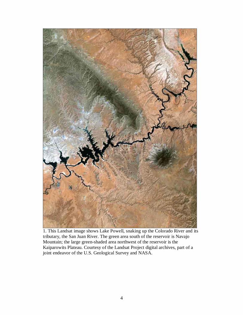
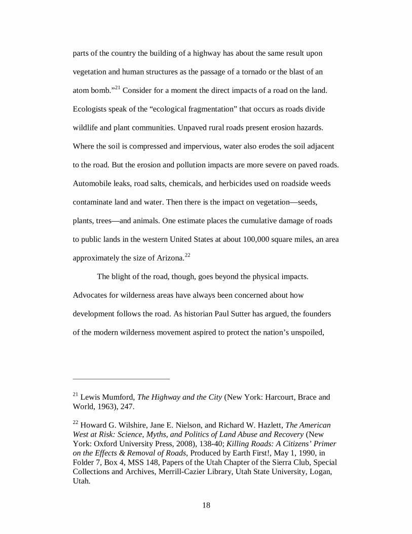
1. This Landsat image shows Lake Powell, snaking up the Colorado River and its tributary, the San Juan River. The green area south of the reservoir is Navajo Mountain; the large green-shaded area northwest of the reservoir is the Kaiparowits Plateau. Courtesy of the Landsat Project digital archives, part of a joint endeavor of the U.S. Geological Survey and NASA.

5
construction of Glen Canyon Dam.5 Then there are those who deplore the
desecration of ancient Indian sites, flooding of steps that had been etched in the
sandstone by the Dominguez-Escalante party in 1776 (the “Crossing of the
Fathers”), and forfeiture of other human imprints, stories, and memories on the
river. The concrete plug in Glen Canyon did not merely layer one human
formation (the dam) atop the earlier traces of human habitation in the canyon.
Rather, for those who criticize the dam, the artificial edifice had so thoroughly
overwhelmed nature, colossally modifying the river and canyon into a placid
reservoir, that the place had lost its very soul.
Indeed, the history of Glen Canyon is about a controversial constructed
landscape layered over a natural one, and of the evolving, malleable nature of
land and people’s perception of it. Glen Canyon was a site of contest over human
values, and those who favored radical modification of the canyon and river won
out. Material changes in the landscape reflect those contending values and desires
and the triumph of one vision over the other. The built landscape at Glen
Canyon—like built landscapes everywhere—is the product of many choices over
many years—cumulative cultural creations, products of tradition, what J. B.
Jackson refers to as “a composition of man-made or man-modified spaces to serve
as infrastructure or background for our collective existence.”6
5 Jim Stiles, “Let’s Drain Lake Powell,” The Canyon Country Zephyr (April/May 1997). 6 John Brinckerhoff Jackson, Discovering the Vernacular Landscape (New Haven, Conn.: Yale University Press, 1984), 8.
6
A central strain of environmental history is to explore this historical
“layering”—to read human worldviews, values, and ideas into the landscape to
understand how nature shapes and alters people and, in turn, how people shape
and alter nature. Environmental historians seek to understand the natural world as
both actor in the drama of history and as the setting in which people act. Thus,
culture develops in a dialectical relationship with nature. As Donald Worster, a
leader in the field of environmental history, writes, “Environmental history . . .
should think of itself as an edge field. It should put us in that complicated
situation where the facts of nature and the meanings that humans attach to nature
come together—interact, intermingle, conflict, contest, and influence one
another.” In the same essay, speaking specifically of the Grand Canyon, Worster
goes on to say:
On those plateaus a lot of cultural construction of nature has been going on. . . . And then we come to the great chasm itself, which drops away from our feet into deep evolutionary and geological time. A journey down into that chasm, I will suggest, leaves one with many questions about what we mean by history and about the role that nature has played in the construction of culture and human experience. I will argue that environmental history looks very different if you stay up on the plateau, prowling around the human structures and tourist interpretations that have accreted here, than if you plunge deep within the chasm.7
To Worster, the environmental historian’s job is to explore both angles—the way
people aim to transform the landscape to their liking, but also to trace the
influence of nature on people. The chapters that follow try to follow this
analytical model. The human actors in this study confronted a material reality in
7 Donald Worster, “Environmental History: The View at the Grand Canyon,” http://www.nps.gov/history/history/hisnps/NPSHistory/environmentalhistory.htm (February 25, 2011).

7
the arid and rugged landscape of the Colorado Plateau that tested and reshaped
them. Likewise, they attempted to impose their own vision on the land, sometimes
succeeding, often not. In the twentieth century, technology enabled people to
reorder the landscape on an even larger scale to give form to original visions of
the land. In the Southwest, Glen Canyon Dam is the ultimate symbol of this
transformation, directly facilitating the accessibility and industrialization of the
Colorado River canyon country.
If how we think about the world is reflected in what we build, then
looking at Glen Canyon Dam and the built environment on the Colorado Plateau
reveals much about the values and expectations that operated in that region. Euro-
Americans brought to the West a specific set of ideas like the irrigated garden
which informed how they lived and worked on the land. To the high plateaus
Mormons brought with them a curious mix of communal religious values and a
capitalistic ethos that drove them to see the land as commodity and to turn it to
more gainful uses. The dual ways that Mormons acted on the land reflected a kind
of tension in Mormon theology. Mormon scripture variously speaks of the earth
as “full” and ordained for the use of man, yet it also speaks of “stewardship” of
the earth and its animals and plants and resources. Scripture evokes both
entitlement and reverence. Both were at work on the plateau.
The stew of perceptions and expectations becomes richer when we
consider other peoples and groups on the land. In the transition from the Old
West, reliant on an extractive economy and traditional land uses like farming,
ranching, and mining, to the New West of cities and tourism, the region has

8
become a mixing pot of values, concerns, and economic interests. On the plateau,
ranchers, miners, oil and gas men, and ATVers live side by side with
environmentalists and river guides. The region inspired writers, artists, and
visitors to reflect on its twisted forms and exceptional landscape. Regardless of
their background, people of all stripes have developed a fierce loyalty to the
region, many calling it “home,” although it remains relatively sparsely populated.
It is a region that attracts a number of conflicting ways that people “see” the land:
the plateau country as vulnerable and compromised versus resilient and full of
untapped potential; as a scenic wonderland versus a hostile desert; as wild and
pristine versus inhabited and productive; as a land ordained by providence for
human labor versus a land ordained by providence as a refuge for nature.
Likewise, some see the remoteness of the region as a liability, while others see it
as perhaps its greatest asset.
Given these contending perceptions, it should not seem surprising that the
region is steeped in conflict. Perhaps this has always been so, but the rhetoric and
violence suggest a constancy and intensity that give the region a particular
identity. Quoting again from Donald Worster: “The post-[John Wesley] Powell
history of the West has been, to a very great degree, a story of that conflict over
ownership, regulation, and access to the land.” Then Worster challenged the
historian: “yet even now we have not yet written an adequate account of how that
conflict has unfolded or of how it has been fought on the ground from state to
state.”8

9
What follows is an exploration of this theme on the Colorado Plateau—a
region John Wesley Powell identified as a distinct province comprising
approximately 130,000 square miles and encompassing adjacent corners of Utah,
Colorado, New Mexico, and Arizona. I argue that conflicts over land and access
in that part of the country are endemic with identifiable root causes. Since some
of the conflicts accelerated into regional—even national—debates, the plateau’s
story of conflict illuminates the larger history of the West. The source of this
conflict derived from a fierce attachment to place—the values, beliefs, and
worldviews elicited from one’s interactions with or experiences on the land.9
Multiple, competing “senses of place” reflect the different ways people think
about the land. A main purpose of the study is to examine how competing visions
of place contributed to how people acted on the land and vied for control of it, in
addition to how the plateau country in turn shaped the cultures and conflicts that
developed there.
8 Worster, “Rediscovering the West: The Legacy of John Wesley Powell,” in Old West/New West: quo vadis?, ed. by Gene M. Gressley (Worland, Wyo.: High Plains Pub., 1994), 118, 120-21. In the sixteen years since Worster issued that challenge, some excellent works have addressed this topic. Charles Wilkinson’s Fire on the Plateau is a personal and nuanced perspective of natural resource development conflicts on the Colorado Plateau with a particular emphasis on Native Americans. Jacqueline Vaughn Switzer, Philip D. Brick, and R. McGreggor Cawley have each written about the rise of opposition movements like the Sagebrush Rebellion and the Wise-Use Movement that developed largely in response to the environmental movement. Most recently, Stephen Trimble’s Bargaining for Eden deftly presents a look at land-use disputes in the modern American West. 9 William Lang, “From Where We Are Standing: The Sense of Place and Environmental History,” Northwest Lands, Northwest Peoples: Readings in Environmental History, ed. by Dale D. Goble and Paul W. Hirt (Seattle: University of Washington Press, 1999), 91.

10
To state that conflict has become an essential characteristic of the plateau
region is not to admit that compromise has not existed there or that conflict has
not at times yielded salutary results. Nancy Langston argues in Where Water and
Land Meet that conflict actually improved management in the Malheur Lake
Basin in Oregon by “disrupt[ing] the hold of narrow orthodoxies on resource
management.” In the 1970s environmental lawsuits and conflicts over resource
use pushed managers to rethink traditional assumptions of land management.
Conflict also prompted some to think deeply about their positions and
assumptions, allowing a bit of light to illuminate new information and
perspective.10 As will be shown, however, the land-use conflicts on the Colorado
Plateau did not always yield the same fruitful outcomes. Certainly, there have
been a number of changed positions over the last few decades, but I am doubtful
that any comparable “softening” occurred in the plateau region as it did at
Malheur Lake. The plateau region was (and in many ways continues to be)
embroiled in endemic, seemingly irreconcilable ideological conflicts that are
directly tied to access and land use. It may be true that once-heated opposition to a
particular designation such as creation of the Grand Staircase-Escalante National
Monument has considerably cooled. But discontent and rage simmer near the
surface. The political system has essentially failed at efforts to achieve any
measure of consensus, or even to infuse civility in the debates. Many of the
environmental debates confronting this region are still mired in unhealthy
10 Nancy Langston, Where Water and Land Meet: A Western Landscape Transformed (Seattle: University of Washington Press, 2006), 9.

11
stalemates dating back generations. This study is designed to examine the varying
dimensions of these conflicts.
٭٭٭
Glen Canyon Dam may be the iconic symbol of conflict on the Colorado Plateau,
but another manmade object has come to represent the essence of conflict in that
region: the road. To the casual observer, this may not be immediately apparent.
The ubiquity and seemingly benign presence of the road belies its rather
controversial presence on the American landscape. But roads are more
complicated than the binary perception of either unnatural intrusions on the
landscape or benign features that serve a simple utilitarian purpose. They are
physical markers on the landscape, yes, but they are also laden with deep, cultural
meanings that have polarized the Colorado Plateau for over a generation.
Consider how a fresh roadcut reveals layers of rock and deep time. John
McPhee aptly refers to these cuts as “windows into the world as it was in other
times.” Without the layers of rock revealed by a newly cut road, geologists would
not have as full a picture of deep time, in some places the only thing that reveals
the naked rock. The road is, geologists tell McPhee, the stethoscope to a doctor,
the x-ray to a dentist, the Rosetta stone to an Egyptologist. “We as geologists are
fortunate to live in a period of great road building.” Indeed, McPhee writes, the
road is a portal that reveals the bones of the landscape and their imaginations
deeper into the earth.11 For historians, in the same metaphorical sense roads
11 John McPhee, Basin and Range (New York: Farrar, Straus, and Giroux, 1980), 10-11, 33.
12
expose other things as well: the human interaction with nature; how people
manipulate the land and the deeper, layered cultural impulses behind the
manipulation; how people move across the land and for what purpose. How
people move about the land, in turn, reveals human economic and political
systems. Indeed, as fixed, immovable features of the landscape, roads are useful
objects by which to understand how humans from a long time ago interacted with
each other and their natural environment.
In the twelfth century, the ancient Chacoans built an elaborate road system
in the Southwest, parts of which are still visible today. The roads ostensibly
connected points aligned on a meridian. Archeologists at first believed that roads
fanned out from Chaco and connected to outlying communities in the Southwest.
While some scholars today believe that this was true of short roads, they now
believe that in some cases roads projected out for a few kilometers then ended.
These roads apparently pointed the way to the traveler’s destination, although
they were not built the entire distance. A seeming exception is the Great North
Road—almost linking Chaco and Aztec—built over a long distance. Beginning at
Pueblo Alto in Chaco Canyon, the road runs due north and then curves at Kutz
Canyon. The road beyond Kutz Canyon has never been found, but archeologists
are convinced it did at one time extend north to Twin Angles Pueblo, northwest to
Salmon, and due north to connect to Aztec.12
12 Stephen H. Lekson, The Chaco Meridian: Centers of Political Power in the Ancient Southwest (Walnut Creek, Calif.: AltaMira Press, 1999), 114-117.

13
The Chacoans knew how to lay the roads in a straight line over long
distances and, more remarkably, had the engineering capacity to construct them.
The roads they built provide the shortest but, curiously, not necessarily the easiest
routes to various destinations. When the Navajos centuries later built roads in the
Four Corners area, for the most part they did not retrace Chaco routes—perhaps
due to this detail. Stephen Lekson asks why the Chacoans would construct wide
roads over rough terrain when a simple footpath over easier terrain would do. Did
the roads have a purpose beyond their utilitarian value? Undoubtedly the roads
were used to move goods and people, but they also seemed to be expressions of
cultural and technological power and perhaps even cosmic values. The Great
North Road appeared to have “connected an old place with a new place, an
emerging place.” Aside from, or in lieu of, the road’s usual function, the road
represented a monument to an earlier age and time, what John Stein and Andrew
Fowler call “time bridges, symbolic umbilicals that linked one age to another.”13
As time pieces, symbolically connecting one age to another, roads as
much as any other material object reveal epochal “layering.” Every modern road
has an antecedent; cow trails become wagon routes which become well-traveled
roads and highways. Connecting one age to another speaks to the road’s enduring
presence on the landscape. Paved roads are largely permanent fixtures on the
landscape, indelible markers of the human imprint—symbols of efficiency,
technological prowess, and conquest. They have meaning beyond their utilitarian
13 Quoted in Ibid., 117, 118, 126, 129-130.

14
function as objects that reveal most intimately the human relationship to land and
nature—and to other people.
From one point of view, roads become anthropocentric creations apart
from nature—even the antithesis of nature. Consider the contrast between rivers
and roads. Rivers are constantly in motion. Their flow transforms landscapes in
gradual as well as rapid increments, taking millions of years to trickle and ebb
through a rock canyon or altering, leveling, even destroying earth in a matter of
minutes with a rush of floodwater. The energy produced by rivers is immense, to
say nothing of the energy required to channel and contain them. Roads, of course,
require energy to build and serve a similar function as rivers in moving humans
from point A to point B, but the similarities stop there: roads are unmoving,
inorganic, and unnatural in every conceivable way. Their purpose is to resist
change as much as possible.
Until modern times, rivers and roads took people along comparable paths.
River waters shift with the slightest curve or grade, moving inexorably down until
there is no place lower to go. And water strikes the best possible compromise
between shortest distances and negotiable terrain. So, too, do roads, in the
broadest sense. The natural contours of the land dictated how and where people
moved on the land. As Craig Childs has written of the canyon country, “When
you walk out here, you walk the places where water has gone—the canyons, the
low places, and the pour-offs—because travel is too difficult against the grain of
gullies or up in the rough rock outcrops.”14 Not unlike early irrigation canals built
15
in gullies and depressions in the soil, early roads were built with an appreciation
for the character and nature of the land.15
To a certain degree, that is still true of roads. Even when we think about
that great human imprint, the road, it should be remembered that nature for the
most part dictates how people and machines move across the landscape. Roads
are built to rise and fall and turn with the landscape. Humans also historically
settle in places that can support a population—where water can be channeled,
where crops can be grown, where cattle can be raised. The land required a give
and take; the land tempered people and dictated settlement patterns and how
livelihoods would be made. But nature could always be improved upon. Humans
have long sought to tame the river, for instance. Rivers cut their own channels, so
that, as John Wesley Powell observed, in the high plateaus of the Colorado River
basin “the whole upper portion of the basin of the Colorado is traversed by a
labyrinth of these deep gorges.”16 John Seelye has observed in Beautiful Machine,
however, that “[t]he ‘proper’ channel for a river is not necessarily the one it has
carved for itself. By means of canals and locks it can be guided by men along a
straight and level line, thereby improving upon natural design.”17 The reclamation
14 Craig Child, The Secret Knowledge of Water: Discovering the Essence of the American Desert (Seattle, Wash.: Sasquatch Books, 2001), xii-xiii. 15 For an excellent discussion of the irrigator’s ditch following the contours of the land, see Mark Fiege, Irrigated Eden: The Making of an Agricultural Landscape in the American West (Seattle: University of Washington Press, 1999). 16 John Wesley Powell, The Exploration of the Colorado River and its Canyons (New York: Dover Publications, 1961), 29-30.

16
movement in the West was largely about “freeing” rivers from their natural course
and steering them into channels to serve human needs. Technology could also do
for roads what it did for rivers: enable road builders to carve roads up, over, and
through the roughest terrain on the planet.
Perhaps it is this overt intention toward the landscape—the imperialist
impulse to “improve” upon nature and subdue it for human purposes—that has
contributed to the dominant image of the road. This notion of roads as means and
symbols of “progress” and “civilization” has been ubiquitous in American
history.18 Roads were and continue to be celebrated as a means of economic
prosperity, contributing to the nation’s economic health and social welfare.
Thomas Jefferson argued in 1808 that surplus federal revenue ought to be used for
public road and canal projects. “Shall [the revenue] lie unproductive in the public
vaults,” he asked, “[o]r shall it not be appropriated to the improvement of roads,
17 John Seelye, Beautiful Machine (New York: Oxford University Press, 1991), 8-9. 18 See Clay McShane, Down the Asphalt Path: The Automobile and the American City (New York: Columbia University Press, 1995); Jane Holtz Kay, Asphalt Nation: How the Automobile Took Over America and How We Can Take It Back (University of California Press; 1 edition, October 1, 1998); David L. Lewis and Laurence Goldstein, eds., The Automobile and American Culture (University of Michigan Press, 1983); James J. Flink, The Automobile Age (The MIT Press, 1990); Rudi Volti, Cars and Culture: The Life Story of a Technology (Baltimore: Johns Hopkins University Press, 2006). Phil Patton, Open Road: A Celebration of the American Highway (New York: Simon and Schuster, 1986), 16; Tom Lewis, Divided Highways: Building the Interstate Highways, Transforming American Life (New York: Viking Penguin, 1997), ix. See also John B. Rae, The Road and the Car in American Life (The MIT Press; 1st Edition. edition (August 15, 1971); Mark H. Rose, Interstate: Express Highway Politics, 1939-1989 (University of Tennessee Press; Rev Sub edition, October 1990).

17
canals, rivers, education and other foundations of prosperity and union?”19
Indeed, at that time few could, or did, contest the moral authority of the road and
other facilitators of prosperity and stability. Through the nineteenth century and
into the twentieth, politicians, businessmen, poets, writers, and artists all
applauded these built features and their contribution to American society. Indeed,
roads became a symbol of freedom. In “Song of the Open Road,” Walt Whitman
effused “Afoot and lighthearted I take to the open road, Healthy, free, the world
before me, The long brown path before me leading wherever I choose.”20 Most of
all, roads represent the sine qua non of economic wealth, permitting the
movement of raw materials to factories and the movement of manufactured goods
to market; commerce depends on roads. In this sense, they occupy an
intermediary position between pristine nature and civilization.
While this notion has been historically dominant in the United States, it
was by no means singular. For some, roads represent the first blight on the
landscape, both the actual physical imprint as well as the economic development
that follows the building of the road. Speaking of the awesome, destructive power
of the road, the social critic and public intellectual Lewis Mumford probably
meant both senses when he wrote in 1963, “Perhaps our age will be known to the
future historian as the age of the bulldozer and the exterminator; and in many
19 Quoted in Nathan Miller, The Enterprise of a Free People: Aspects of Economic Development in New York State during the Canal Period, 1792-1838 (Ithaca: Cornell University Press, 1962), 30. 20 Originally published in Walt Whitman, Leaves of Grass (Philadelphia: David McKay, 1891-92), 120-29.
18
parts of the country the building of a highway has about the same result upon
vegetation and human structures as the passage of a tornado or the blast of an
atom bomb.”21 Consider for a moment the direct impacts of a road on the land.
Ecologists speak of the “ecological fragmentation” that occurs as roads divide
wildlife and plant communities. Unpaved rural roads present erosion hazards.
Where the soil is compressed and impervious, water also erodes the soil adjacent
to the road. But the erosion and pollution impacts are more severe on paved roads.
Automobile leaks, road salts, chemicals, and herbicides used on roadside weeds
contaminate land and water. Then there is the impact on vegetation—seeds,
plants, trees—and animals. One estimate places the cumulative damage of roads
to public lands in the western United States at about 100,000 square miles, an area
approximately the size of Arizona.22
The blight of the road, though, goes beyond the physical impacts.
Advocates for wilderness areas have always been concerned about how
development follows the road. As historian Paul Sutter has argued, the founders
of the modern wilderness movement aspired to protect the nation’s unspoiled,
21 Lewis Mumford, The Highway and the City (New York: Harcourt, Brace and World, 1963), 247. 22 Howard G. Wilshire, Jane E. Nielson, and Richard W. Hazlett, The American West at Risk: Science, Myths, and Politics of Land Abuse and Recovery (New York: Oxford University Press, 2008), 138-40; Killing Roads: A Citizens’ Primer on the Effects & Removal of Roads, Produced by Earth First!, May 1, 1990, in Folder 7, Box 4, MSS 148, Papers of the Utah Chapter of the Sierra Club, Special Collections and Archives, Merrill-Cazier Library, Utah State University, Logan, Utah.
19
wild lands from motorized access.23 The Wilderness Act of 1964 defines
wilderness as “roadless” and explicitly prohibits road construction in designated
wilderness areas.
These, then, are two ways of understanding roads—roads as progress and
roads as exploitative. A third ambivalent position seeks a balance between the
two: the road as desired but also lamented. While people value access, they
bemoan the effects of modernization on the landscape. Leo Marx called it the
pastoral dream, the middle landscape wherein people hoped to enjoy just the right
mix of nature and artifice, wildness and technology. Marx argued that the struggle
to reconcile the idea of pastoral landscape and the reality of an urbanized,
industrial landscape has long been a part of the American imagination.24
In the nineteenth and early twentieth century, road builders seemed to
posit that this middle landscape was possible to create. An engineer of a mid-
nineteenth century railroad that would hug the western shore of the Hudson River
responded to critics who feared the new rail might destroy the artistic landscape.
“To a very great extent the construction of the Road will improve the appearance
of the shore,” he wrote. “Rough points will be smoothed off, the irregular
indentations of the bays [will] be hidden and regularity and symmetry imparted to
the outline of the shore . . . adding to the interest, grandeur and beauty of the
23 See Paul Sutter, Driven Wild: How the Fight Against Automobiles Launched the Modern Wilderness Movement (Seattle: University of Washington Press, 2002). 24 Leo Marx, The Machine in the Garden: Technology and the Pastoral Ideal in America (New York: Oxford University Press, 1964).

20
whole.”25 In general, architects designed American parkways to blend seamlessly
into the natural and built landscapes. These roadways reflected the
democratization of the automobile and also the modernist impulse to create roads
that served motorists well. But the intention was often to harmoniously blend
engineering and the landscape to not dominate local tradition or defile the natural
environment. As Timothy Davis writes, “parkways helped to mediate the tension
between progress and nostalgia.”26
Created in the wake of the Second World War, the interstate highway
system overwhelmed nostalgia because it boasted functionality, efficiency, and
modernity. The new standard in the United States was modern design and
utilitarian value to move masses from one point to another in the shortest distance
possible. This is not to say that the graceful curves and striking vistas were
eliminated in the postwar era. In William Least Heat-Moon’s best-selling book,
Blue Highways, he documents his 13,000-mile long road trip in 1978 along back
roads and to places largely untouched by the modern interstate highway.27 Yet
these places had become increasingly difficult to find; parkways had satisfied
American demand for an integration of landscape aesthetics, traditional values,
25 Quoted in Thomas E. Rinaldi and Robert J. Yasinsac, Hudson Valley Ruins: Forgotten Landmarks of an American Landscape (Hanover: University Press of New England, 2006), 69-70. 26 Timothy Davis, “The Rise and Decline of the American Parkway,” in The World Beyond the Windshield: Roads and Landscapes in the United States and Europe, ed. by Christof Mauch and Thomas Zeller (Athens: Ohio University Press, 2008), 36. 27 William Least Heat-Moon, Blue Highways: A Journey into America (Fawcett, 1982).
21
and modernity, but in the postwar era it had become difficult to reconcile the
competing need to showcase historical sites or local culture and also to
accommodate higher speeds and heavier traffic. Eventually, engineers looked to
streamline road building by forgoing scenic or recreational features.
While some roadways in the United States had been designed strictly for
the purposes of aesthetics or scenery, roads constructed on the plateau tended to
be more utilitarian in design. Debates in the postwar period focused on competing
uses of the road. Creating roads to serve the traditional extractive economy also
promised a birth of a vibrant tourist economy showcasing the region’s scenic
wonders. Advocates often declared that roads would bring people into their
communities, promoting commerce and tourism. But the question remained of
how to walk the fine line between upgrading and improving roads to encourage
tourism but not to mark the communities as fly-bys for high-speed motorists. Few
rural folk presumed tourism would be a panacea to the region’s economic woes.
In some cases, roads harmed the very communities that they were intended to
serve. By isolating and disconnecting communities, new high-speed highways
like I-70 actually assisted in the demise of small towns along its path. A damning
argument against the proposed Book Cliffs highway was that the road would
hardly bring new visitors to Vernal, Utah, and Moab, Utah, but would only siphon
public funds away from direct community development.28
28 See Steven W. Lewis to Daryl Trotter, November 4, 1992, Folder 1, Box 12, MSS 200, Utah Wilderness Association Collection, Special Collections and Archives, Merrill-Cazier Library, Utah State University, Logan.
22
Increasingly, more people began to recognize and regret the road’s role in
the loss of wild landscapes. During the debates over Echo Park, the publisher
Alfred Knopf had argued that roads were needed to open areas like Dinosaur
National Monument to the public. Environmentalists retorted that it was precisely
because of inaccessibility that the high plateau country was not overly
developed.29 A growing chorus contended that wild areas ought to be preserved
because they represented the last remnants of primeval America. These lands
ought not to be open to traditional extraction, commercial, or tourist industries.
For some people, roads took on an increasingly sinister character on public lands
since they facilitated clearcut logging, industrial mining, and off-road vehicle
recreation. Environmentalists became ever more skeptical that the middle
landscape could be preserved. “What our national parks and forests really need
are not more good roads but more bad roads,” said Joseph Wood Krutch. “There’s
nothing like a good bad dirt road to screen out the faintly interested.”30 At the
same time, wilderness proponents began to argue that roads did not belong on
many wild landscapes at all. In 1970, wilderness champion John Saylor,
congressman from Pennsylvania, remarked that enjoyment of wilderness was
about “putting the American citizen back on his own two, God-given feet again,
in touch with nature. Let’s get him away for a blessed few moments from the
29 See U.S. Department of the Interior, Bureau of Reclamation, Essays from the Reclamation Centennial, Vol. 2 (Denver: Government Printing Office, 2008), 837. 30 Quoted in James I. McClintock, Nature’s Kindred Spirits: Aldo Leopold, Joseph Wood Krutch, Edward Abbey, Annie Dillard, and Gary Snyder (Madison: University of Wisconsin Press, 1994), 65.

23
omnipresent automobile, if we can, rather than catering to what is easiest and least
exerting. And let’s certainly not turn every quiet wilderness pathway into a
‘nature trail’ for motors.”31 Indeed, the threat of roads provided the impetus for
the preservation of wilderness. Any road could be seen as the camel’s nose under
the tent.
Although in 1964 the environmental movement was still in its nascence,
that year two events on the Colorado Plateau set the stage for the conflicts that
would follow. The Bureau of Reclamation completed Glen Canyon Dam and
closed the radial gates to begin filling Lake Powell. Ironically, the same year
Congress passed one of the most important environmental protection laws ever—
the Wilderness Act—which created a national wilderness preservation system
composed of millions of acres of the nation’s “roadless” lands. By 1964, then, two
divergent visions operated on the land. Each moved the land in new directions and
land, history, and ideology diverged. Roads, in their own way central to each
vision, took on new meanings.
٭٭٭
The case studies highlighted here represent some of the most contentious
environmental issues in the plateau country over the last half century. The
narrative begins with the arrival of Euro-Americans in the late nineteenth century
in what is now southeastern Utah. San Juan country is the setting and Mormon
pioneers the characters; by necessity, roads are their vehicle to settle a new land.
31 Quoted in Doug Scott, The Enduring Wilderness: Protecting Our Natural Heritage through the Wilderness Act (Golden, Colorado: Fulcrum, Pub., 2004), 13.
24
Their story prologues events to come more than a century later. Some new
characters—descendants of the pioneers—enter the story, but other groups also
appear, including the young adventurer and budding ethnographer Clyde
Kluckhohn who presents a striking counter narrative to the Mormons’ quest for
progress and subjugation of the land.
Chapter 3 continues the story in San Juan County, Utah, by portraying the
Manichean struggle between development and preservation through the twentieth-
century life stories of Calvin Black and Edward Abbey. Using two real-life mortal
foes who nevertheless respected each other does more than frame the debate; it
puts a human face on a conflict often characterized as a struggle between
nebulous abstract forces or ideologies. Each subsequent chapter moves from one
road controversy to another—from roads in proposed wilderness areas, to the
infamous Burr Trail, to a proposed highway through the Book Cliffs, to the web
of roads in Utah’s newest national monument. Black and Abbey continue to
weave through these stories, but new characters also emerge that both disrupt and
confirm the narrative structure established in Chapter 3. The organizing schema is
roughly chronological; this provides the form to the larger narrative of conflict. In
the end, the chapters are woven together by their association with roads, which
remain the focal point, historical objects through which other themes might be
revealed.
The road itself provides a fitting metaphor to describe the structure and
flow of this study. The destination at the end of the road—the outcome—is no
more important as the road itself—the process. The lessons to be learned from

25
these studies are clear, but there is no overriding outcome. In some cases, road
building has irreversibly transformed the land; in other cases roads have been
reclaimed by the land, either through concerted political effort or the long
duration of time or both. The stories do not follow a declension model or reveal a
defiled landscape. Comparing the Colorado Plateau to other distinct ecological
landscapes, the land has not been radically transformed on the ecological level as,
say, the Great Plains with disappearance within a century of native tall grasses
and bison by the millions.32 While the physical changes to the land caused by
roads are also real, the actual impact of the road on not just land and ecology but
society and culture is subjective. The story may be read in different ways,
depending on perspective. In the epilogue, I step off the road and provide my own
analysis of the road’s impact and the environmental conflicts discussed in earlier
chapters. The epilogue reflects back on several decades of intense conflict over
access and land use in the West. In a metaphorical sense, the road had ended. Yet
the epilogue does more than conclude and analyze; it also takes readers to one
more specific location in the plateau country to address conflicts over ORV and
ATV use which promise to endure in the West for some years to come.
These chapters are analytical case-studies situated in a particular time and
place, but they are also narrative episodes that address issues pertinent beyond the
canyons and plateaus of southern Utah. Each, then, is a meditation on broader
themes: the role of people in “wild” landscapes, the nature of environmental
32 See Sherry L. Smith, ed., The Future of the Southern Plains (Norman: University of Oklahoma Press, 2003), 226.

26
compromise and conflict, the nature of the tourist economy, perceptions of
“defiled” and “pristine” nature, and the discontents of rural communities upended
by new economic realities. In this way, I venture into the realm of ideas without
stepping too far from the geographic locality of my case studies. I intended to
broaden the applicability of the local without reducing it to the universal. This is
important because my assumption is that place matters. The curious mixture of
culture, geography, and history has created a context that makes the conflicts
unique. So, my intention is to highlight this peculiarity while at the same time
meditate on themes that apply beyond the specific locality.
Throughout time, humans have worked and reworked the land, attempting
to shape it to suit their needs and expectations. These visions have butted heads
with another human impulse—to keep nature as it is. I argue that, above all, roads
have become the symbols of the naturalness of a place, the yardstick by which to
measure the human imprint on the land. Each paved or dirt road, each roadless
area is a negotiated product of contending biases. Roads, then, tell us a great deal
about how people have built and rebuilt, adjusted and adopted, and transformed
the land; how thoroughly human objects like roads have blended into or
contrasted against the landscape; how landscape is, as geographers tell us, a
dialectic—suggesting that the form of the landscape is the product of social
practices, and that form in turn reshapes those social practices. So roads are not
mere tangible objects or simple carved lines, but impelling forces on the land that
reflect culture as well as create it.

27
PROLOGUE
FOUNDING NARRATIVES
Like any historical narrative, this history of conflict over land use and access has
beginnings. I refer to these beginnings as founding narratives—stories that
possess cultural meaning by identifying a people to a place or an idea. Consider
the tales about the Garden of Eden or the Abrahamic covenant: these are
paradigms people use to make sense of the world. Although the following
narratives are not as well known as the stories that drive the Judeo-Christian
tradition, they do have symbolic significance and possess staying power to inform
beliefs and worldviews, compel action, and inspire loyalty. Here I relate two
paradigmatic stories—founding narratives, if you will—about the landscape and
the people who encountered it. The first has become lore among the Mormons
whose ancestors settled the San Juan region, the tale of the Hole-in-the-Rock
expedition which in 1879 set out from Escalante, Utah, across a broken landscape
to make a home “on the San Juan river, at wherever point may be deemed
advisable.”1 The second is a counter narrative of young Clyde Kluckhohn, who in
the 1920s sought adventure, wonder, and sublimity in the same desert country
traversed by the Mormons a generation before, and whose story (literally and
figuratively) intersected with the Mormon narrative in surprising and intriguing
1 This was the original directive of the San Juan Mission, or Hole-in-the-Rock expedition, as it was later called. See David E. Miller, Hole-in-the-Rock: An Epic in the Colonization of the Great American West (Salt Lake City, University of Utah Press, 1959), 14. I rely on Miller’s account in my retelling of the Hole-in-the-Rock trek.

28
ways. Although distant in time to modern debates over public land use and access,
the symbolic and cultural power of these two opposing narratives help frame the
debate about human’s place on the land and responsibility to it and also help
inform the land ethic and perspective that directly developed in their wake.
٭٭٭
For over four hundred years since Garcia Lopez de Cardenas became the first
European to see the Rio Colorado (the red or colored river) near the Grand
Canyon, the plateau region of southern Utah and northern Arizona had become, in
the words of historian Donald Worster, “a part of the European and American
imagination.”2 It was mostly a region of the mind, since few Europeans prior to
the nineteenth century did more than peer in from the peripheries. Native
Americans, of course, had made their home there, but before the Mormon party in
1879, relatively few explorers, missionaries and traders had penetrated deeply into
the region which is now southeastern Utah. Indeed, the Mormons intent on
establishing settlements along the San Juan River and in the greater Four Corner’s
region knew nearly as little about the place as had the visitors who had preceded
them.
The first task of the newly “called” Mormons was to settle on the precise
route to the San Juan country. The party had considered taking a southern route,
and an advance party had been organized to travel from the jumping off point at
Paragonah, not far north of Cedar City in southwestern Utah, through northern
2 Donald Worster, A River Running West: The Life of John Wesley Powell (Oxford University Press), 128.

29
Arizona and Navajo Country and into the San Juan River region from the south.
But that party determined that the route was too dry and the distances between
water too great to be feasible for a party of several hundred men, women, and
children traveling in covered wagons. Moreover, the threat of Indian attack
prompted them to find another route—the advance party’s northern return route
along the well-worn Old Spanish Trail through central Utah. This route avoided
the broken canyons of southern Utah and land thought to be hostile through
northern Arizona, but the Old Spanish Trail (famously dubbed “the longest,
crookedest, toughest pack trail” in North America) was still dangerous and
arduous for Mexican traders carrying goods and slaves to California.3 The
advance party in charge of finding a suitable passage for wagons for the San Juan
Mission considered this route to be too long to take before the onset of winter.4
So instead of taking either the southern or the northern routes, Silas S.
Smith, leader designate of the Hole-in-the-Rock expedition, selected a more direct
route along the 37th parallel through Glen Canyon and the region bounded by the
Colorado and San Juan rivers. The settlers, he announced, would travel southeast
from Escalante, through the Escalante desert, to the rim of the Colorado River
where locals Andrew P. Schow and Reuben Collett had located a two-foot-wide
notch—a natural break in the canyon wall that allowed a descent to the river,
giving the expedition the name Hole-in-the-Rock—at the western rim of the
3 William B. Smart, Old Utah Trails (Salt Lake City: Utah Geographic Series, Inc., 1988), 42-51. 4 Miller, Hole-in-the-Rock, 17-30.
30
Colorado River. Based on Schow and Collett’s recommendation, Smith figured
the notch could be widened to allow passage of wagons and horses. The plan was
to descend to the river, cross it, and forge a trail eastward. What was beyond the
other side of the Colorado no one knew for certain; Schow and Collett had
explored only “a short distance,” probably up Cottonwood Canyon. They never
did reach the end of the canyon to catch a glimpse of the rough and broken
country beyond Grey Mesa and the Red House Cliffs. Instead, they returned and
reported favorably on the route they had located.5
On the strength of that report, and possibly that of Charles Hall, another
explorer credited with locating a route to the river and beyond, settlers
rendezvoused at Escalante in the fall of 1879. It had taken some settlers four
weeks to reach the town of Escalante from their homes in southern and central
Utah, but thus far the trek had passed through a familiar landscape that had
recently been settled.6 With their provisions already dwindling, the settlers bought
what they could in Escalante and continued forty miles southeast to Forty-Mile
Spring where the grasslands could accommodate their large number of cattle.
Almost immediately they found that their chosen route would take much longer
than original expected. The road’s condition became the perennial concern. Not
far from Escalante the party reached a point on the rim overlooking the country
that lay ahead, “and as far as we can see east and south the country looks very
5 Ibid., 34-42. 6 Wallace Stegner, Beyond the Hundredth Meridian: John Wesley Powell and the Second Opening of the West (Boston: Houghton-Mifflin, 1954), 161.
31
rough and broken.” Platte D. Lyman, a leader of the company and diarist, noted
the condition of the “road.” On November 21 it was “a soft sandy road,” and three
days later a “very heavy road,” probably meaning the route was rough and
difficult to traverse.7 As they wove in and out of sand-and-rock washes, the party
of men, women, and children encountered a landscape not entirely similar to the
desert homes they had left behind. Neither would be the broken country that lay
ahead.
As the main company traveled in a southeasterly direction, a small
exploring party moved ahead to locate the precise route into the San Juan region.
From Forty-Mile Spring, four men reached the notch at the rim and, with no rope
in tow, lowered each other over the ledge using blankets. Building on the path
forged by Schow and Collett, the party penetrated deeper into the canyon maze—
traveling ten miles in six days—but located no obvious route to build a road.
Meanwhile, a second exploring party hoped to find an alternative route via the
Colorado and San Juan rivers. Seven of the thirteen men in the party started down
the Colorado in a boat that they had lowered down to the river but shortly
returned to camp, having encountered “rapids” in Glen Canyon. The men traveled
southeast across box canyons, draws, and gulches to the San Juan region.8 Lyman
recorded, “The country here is almost entirely solid sand rock, high hills and
7 Journal of Platte D. Lyman, November 4, 21, and 24, 1879, in Miller, Hole-in-the-Rock, 160-161. 8 Ibid., 59.
32
mountains cut all to pieces by deep gulches which are in many places altogether
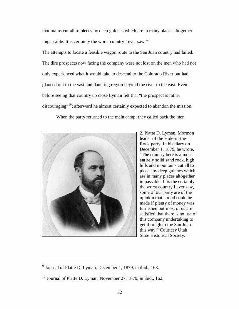
impassable. It is certainly the worst country I ever saw.”9
The attempts to locate a feasible wagon route to the San Juan country had failed.
The dire prospects now facing the company were not lost on the men who had not
only experienced what it would take to descend to the Colorado River but had
glanced out to the vast and daunting region beyond the river to the east. Even
before seeing that country up close Lyman felt that “the prospect is rather
discouraging”10; afterward he almost certainly expected to abandon the mission.
When the party returned to the main camp, they called back the men
2. Platte D. Lyman, Mormon leader of the Hole-in-the-Rock party. In his diary on December 1, 1879, he wrote, “The country here is almost entirely solid sand rock, high hills and mountains cut all to pieces by deep gulches which are in many places altogether impassable. It is the certainly the worst country I ever saw, some of our party are of the opinion that a road could be made if plenty of money was furnished but most of us are satisfied that there is no use of this company undertaking to get through to the San Juan this way.” Courtesy Utah State Historical Society.
9 Journal of Platte D. Lyman, December 1, 1879, in ibid., 163. 10 Journal of Platte D. Lyman, November 27, 1879, in ibid., 162.

33
working on the road from Forty-Mile to Fifty-Mile Spring and, at a conference,
gave the dire report. The consensus, minus one—the ardent George B. Hobbs—
was that a road could not be built. Nevertheless, the decision of whether to abort
the mission rested with Silas S. Smith, who in a restless night weighed the options
and the following day reported, in an improbable verdict, that they would
continue moving forward. The country was broken but not impassable. The party
had invested too much, traveled too far over too many difficult rocks, and the
cattle had eaten too much of the grass along the route to turn back now. Besides,
even if they did return, the members of the party had sold their homes and farms.
Moreover, the town of Escalante was ill-equipped to support the whole company
and livestock through the winter. Unanimously, the company sustained Smith’s
decision.11
The company’s task would be to build a road so that others would follow.
In other words, they set out not merely to traverse the terrain but to establish a
permanent route into southeastern Utah. It is curious to consider why they felt it
necessary to build it on this trip—why not send men back to do it after having a
better idea of the route? Perhaps the main reason was that sections of the route
like the notch at the rim of Glen Canyon could not be used without some road
work. The other answer is that they believed they had the requisite man-power to
do it now. In any case, the task of building the road was all consuming, requiring
large amounts of labor and supplies. In fact, in mid-December Silas Smith left his
company for what he hoped would be no more than three weeks to get additional
11 Ibid., 63-66.

34
gun powder and supplies, and to convince the territorial legislature to appropriate
money for the road construction. (His absence, in fact, lasted nearly five months,
and news of the $5,000 appropriation did not reach the settlers until after they had
reached their destination.) Lyman, acting company leader, put men to work on the
road and sent out yet another advance party “to the San Juan if it is possible to get
through.”12 This time the advance party did press through, northeasterly forty
miles to Clay Hill Pass, another forty miles to Grand Gulch, then to Comb Wash,
following a Navajo trail over Comb Ridge. The party reached Montezuma Creek
after traveling twelve days with eight days’ worth of provisions.13
Meanwhile, the main party reached the canyon rim of the Colorado River,
and men began work to widen the two-foot notch through which 250 people with
82 wagons and their livestock would eventually begin a two-thousand-foot
vertical descent to the river. The men used what little powder they had to widen
the slit and smooth the forty-five-degree grade. A second crew labored to carve a
road through loose boulders and steep grades the remaining way to the river,
totalling nearly a mile. A formidable obstacle in their descent was a solid wall of
sandstone on the left. Using powder and chisels, the men blasted out a shelf for
the left-side wheels, and, a few feet below, holes for oak stakes to be covered by
poles and rock. They called this section of the road “Uncle Ben’s Dugway” after
12 Journal of Platte D. Lyman, December 17, 1879, in ibid., 164. 13 Ibid., 83-91.
35
the man who designed it. It was a marvel if not extremely perilous—a road
literally suspended on a near-vertical cliff wall.14
The treacherous descent from the canyon’s rim to the river, for which the
expedition is best known, took place over two harrowing days in January 1880.
The first day forty wagons made the descent, and forty-two the next day, with no
loss of life or serious injury. At the Colorado, the wagons forded the river in a
ferry built by Charles Hall and continued up the opposite cliffs over a road built
by a third crew.15 Elizabeth (Lizzie) Decker’s description of the ordeal is worth
quoting in full:
We crossed the river on the 1st of Feb. all safe; was not half as scared as we thought we’d be, it was the easiest part of our journey. Coming down the hole in the rock to get to the river was ten times as bad. If you ever come this way it will scare you to death to look down it. It is about a mile from the top down to the river and it is almost strait down, the cliffs on each side are five hundred ft. high and there is just room enough for a wagon to go down. It nearly scared me to death. The first wagon I saw go down they put the brake on and rough locked the hind wheels and had a big rope fastened to the wagon and about ten men holding back on it and then they went down like they would smash everything. I’ll never forget that day. When we was walking down [to the river] Willie looked back and cried and asked me how we would get back home.16 What remained of the journey was over 100 more miles and more than
three months of labor to traverse what Lyman considered “impassable” country.
The company regrouped and repaired damaged wagons in Cottonwood Wash
while men resumed work on the road up the cliffs out of the wash—in many ways
14 Ibid., 96-97. 15 Ibid., 101-117. 16 L. Decker to Harrys Slideoff, February 22, 1880, in ibid., 197.

36
repeating the Hole-in-the-Rock episode. Lyman wrote rather tersely that for
several days they had been “building [the] road over and through solid rock.”
Beyond Cottonwood Wash, the land became “smoother and more open and looks
much better,” although Lyman’s diary continues to be sprinkled with references to
“rough,” “rocky,” and “sandy” conditions.17 Writing home to her parents from
Grey Mesa, Elizabeth Decker had difficulty describing the land: “It’s the roughest
country you or anybody else ever seen; it’s nothing in the world but rocks and
holes, hills and hollows.”18 For weeks the company inched forward, in wintery
conditions, over rock and sand encrusted with mud and snow. They traveled in a
northeasterly direction from Grey Mesa over Slick Rocks (“the mountains are just
one solid rock as smooth as an apple”19), to Lake Pagahrit (a natural lake and dam
formed in Lake Canyon), and down Clay Hill (the only passage through the Red
House Cliffs). From Clay Hill, the company caught a good view of the country,
but the route could not be direct: the road would arc northeast around Grand
Gulch, then southeast to Comb Wash. The company would then have to follow
the wash south to the San Juan River owing to the north-south Comb Ridge, a
rocky escarpment rising 1000 feet above the wash that afforded no possible
passage for teams and wagons. They would then follow the course of the river
around Comb Ridge to their destination.
17 Journal of Platte D. Lyman, February 9, 17 and 18, 1880, in ibid., 166-167. 18 Decker to Slideoff, February 22, 1880, in ibid., 197. 19 Decker to Slideoff, February 22, 1880, in ibid.

37
But there was an unforeseen hitch to this plan, for Comb Ridge ended
abruptly at the water’s edge. Where they hoped to skirt the ridge along the river,
that route proved impassable owing to the sheer cliffs that hung its banks. The
only conceivable route was a scramble straight up the rocky face of the nose of
Comb Ridge—what the settlers called San Juan Hill. Their earlier passage
through Hole-in-the-Rock had certainly been treacherous, but after 170 miles
building a road over rock, in canyon gorges, and through thick stands of pinyon-
juniper, the imminent pull up San Juan Hill to Comb Ridge must have seemed
absurdly insurmountable.
As they had at Hole-in-the-Rock, Cottonwood Canyon, and Clay Hill, the
company built a dugway, this time a full mile up the slope, with what little
powder and willpower remained. That took an arduous ten days. Then came the
grueling ordeal of slowly shuttling teams and wagons up the slope. On April 3
they advanced three miles, the next day four along the ridge’s precipice. At last,
the following day they arrived, ragged and depleted, at the site of Bluff. An
unknown member of the party inscribed the words “We Thank Thee Oh God” on
San Juan Hill. Beyond that, no one else wrote much of what transpired at Comb
Ridge’s summit, where—met with a breathtaking view of miles upon miles—the
beleaguered pioneers caught a first glimpse of their new home.20
٭٭٭
What can we glean from the Hole-in-the-Rock story? In southeastern Utah, the
chronicle is etched in the Mormon consciousness as deeply as the Mormon Trail,
20 Ibid., 136-137.
38
creating what historian Charles Peterson called the “Hole-in-the-Rock
mystique.”21 The overland trek lasted six grueling months through utterly remote
and wild country, and for what purpose? Seemingly to buffer the outer edges of
their territory by establishing a Mormon base in the Four Corners region and to
extend a religious reach by establishing friendly relations with American Indians
sparsely populated there. Mormons memorialize the trek as a story of physical
and spiritual redemption, of forebears dutifully responding to their prophet’s call
to bring light, order, community, and God to the wilderness.22 Historian Samuel
Schmieding sets the story of the Hole-in-the-Rock expedition in the context of the
Mormon quest for a “physical Zion representing God’s kingdom on earth.” “[F]or
the residents of San Juan County and Mormon society in general, the Hole-in-the-
Rock tale was a powerful narrative that provided proof of their divine purpose at a
time when the Mormon heroic age was blending into the mundane realities of
post-frontier life,” he writes. “The slick rock country provided a forum for
continuation of the hero’s trial.”23
Yet other meanings might also be culled that are neither celebratory nor
heroic. Consider what these “pioneers” endured as they stubbornly and
persistently attempted to conquer a landscape that was decidedly unconquerable.
21 Charles S. Peterson, Look to the Mountains: Southeastern Utah and the La Sal National Forest (Provo, Utah: Brigham Young University Press, 1975), 53. 22 “Second Annual Trip to Hole-in-the-Rock Written for the Record,” San Juan Record, October 2, 1941. 23 Samuel Joseph Schmieding, “Visions of a Sculptured Paradise: The Colorado Plateau as American Sacred Space” (Ph.D. dissertation, Arizona State University, 2002), 330.

39
These folks deemed that the land was destined to be tamed, that their duty to God
was to make straight the crooked path, and that their efforts in the cause were
heroic. The residue of the carved road in that impenetrable country is physical
evidence of their unquestioning faith in human ingenuity to subdue the land and
make it useful to humans. Braving a “wilderness of sand and rock” meant
negotiating slick sandstone mountains, canyon gorges, deep sand, and “a
treacherous river.” The story of the trek is etched tangibly on the land along the
trail—at Hole-in-the-Rock, Cottonwood Canyon, Slickrock, Comb Ridge, and
elsewhere. Another physical sign of the strain the land had demanded of the
unsuspecting pioneers is the site of Bluff itself. The company stopped short of
their intended destination, Montezuma, and founded Bluff at the base of Comb
Ridge—not for its desirability but because, in the words of one, “I was so tired
and sore that I had no desire to be any place except where I was.”24
Indeed, the real danger of the San Juan mission turned out not to be
Indians or cattlemen from Colorado, as originally feared. Nature itself proved the
most formidable adversary. On the trail, torrential rains mired wagon teams in
deep muddy sand. Broken terrain presented almost insurmountable barriers to
movement. Then once in Bluff, the company faced a new set of challenges:
perennial flooding of the San Juan River, poor soil, and isolation. In fact, the
Mormon pioneers never successfully irrigated and farmed in this country; not
until they turned from farming to ranching did they prosper on the land. But the
settlements they founded—Bluff, Blanding, and Monticello—were tenuous.
24 Quoted in Miller, Hole-in-the-Rock, 140.

40
The route forged by the Hole-in-the-Rock crew could hardly be called a
road, but that is indeed what the settlers imagined they were making—a
permanent, two-way road. Incredibly, for over a year some settlers continued to
use that trail. Lewellyn Harris, a Mormon missionary to Mexico, used the route in
early 1880. Members of the original company, including Lyman, made a return
trip in April 1880, covering in eight days what originally took four months to
travel.25 Surveyors for the Denver & Rio Grande Railroad briefly considered
running a line through the San Juan country, along the Hole-in-the-Rock route,
but came to their senses, “knowing the country to be impracticable between the
San Juan & Colorado.”26 Like the railway, the San Juan settlers looked for new
transportation links. Platte Lyman recommended a new road that would cross the
river near the Henry Mountains. Not quite a year to the day Bluff was founded,
Lyman noted in his diary that “a new road is being made from Escalante Creek to
the Colorado River at a point five miles above the mouth of Lake Wash, at which
place Brother hall [Charles Hall] has located his ferry, having moved his boat up
from Hole-in-the-Rock, which is an abandonment of that road.”27 The route to
Hall’s Crossing (now Highway 276) became the new east–west link before yet
another route further north at Hite’s Ferry replaced it.
25 Ibid., 178. 26 Denver & Rio Grande report by B. D. Cutchlow, Preliminary survey – Farmington to Escalante, 1880-1881, April 13, 1881, in Folder 11, Box 316, Geographical Section, Otis R. Marston Manuscript Collection, Huntington Library, San Marino, California. 27 Quoted in Cornelia Perkins, Marian Nielson, and Lenora Jones, Saga of the San Juan (San Juan County Daughters of Utah Pioneers, 1957), 78.

41
The original pioneer-carved road is still there to be traversed in parts by
foot, horse, jeep, or, for reenactment, wagon. The sweat, fatigue, and wonder of
that first journey produced a powerful founding narrative that continues to give
purpose and direction to San Juan residents. It is a cautionary tale. The narrative
certainly represents the indomitable spirit of industry and sacrifice, of
humankind’s struggle to tame nature and create a society in a most inhospitable
place. No one died on the Hole-in-the-Rock trail except for a stillborn baby, and
the new inhabitants did build lasting though tenuous settlements in the San Juan
country. That the settlers could celebrate with pride. Yet the settlers and their
descendents could not have mistaken the other lessons of the trek—of coming
face to face with a harsh land and very nearly being repelled by it. Of his father,
Lemuel Redd, who as a young man participated in the Hole-in-the-Rock
expedition, Charlie Redd said, “My father was a strong man, and reluctant to
display emotion; but whenever in later years the full pathos of San Juan Hill was
recalled either by himself or by someone else, the memory of such bitter struggles
was too much for him and he wept.”28
The struggle of the trail and of settling an unfamiliar landscape
contributed to the Mormons’ abiding connection to the land. For most settlers, the
San Juan country was disappointing. James Davis wrote, “I very much liked the
look of the country, but my wife felt that we were isolated from all civilization
and was very down hearted.”29 George W. Decker, at the time a young
28 Miller, Hole-in-the-Rock, 138, 140.

42
3. Reenactment of the Hole-in-the-Rock expedition, 1971. This view is looking northwest with the cleft in the Hole-in-the Rock in the background. Photo by Robert Clayton. Courtesy Utah State Historical Society. man of fifteen years, remembered it as “the most rugged gorge, the most
tempestuous river, the loneliest and most frightening country I have ever seen.”
Yet the toil and sheer work involved in settling the country acquainted them and
attached them to the land, probably in the same way that indigenous people felt a
similar knowledge of and attachment to the land. Speaking of the Hole-in-the-
29 Excerpts from the History of the Life of James Davis, in ibid., 156.

43
Rock, Decker remarked more than sixty years later that “to all that company of
pioneers, it certainly is hallowed ground.”30 Perhaps also was the entire road they
had built. For six months they labored on it. Then they set to work immediately to
build a city in the desert, transforming with technology, ingenuity, perseverance,
and faith the raw natural products of the land to serve human needs. The work that
set the course for the original settlers and generations that followed is also the
story that defines the advance of western culture. Their labor on the land imbued
their new home with meaning. And the settlers believed they belonged there. Of
course, they were not the first to lay down roots in that region—Native Americans
called the San Juan region home long before the Mormons arrived—but the
Mormons’ conquest theology put them in the center of the narrative.
٭٭٭
The Hole-in-the-Rock story is one of the founding narratives told about the
settlement of southeastern Utah. There are, of course, other narratives of a very
different sort that both converge and sharply diverge from Hole-in-the-Rock, and
perhaps none so well as Clyde Kluckhohn’s journey to the top of Wild Horse
Mesa.31
30 Transcript of George W. Decker’s Speech at Hole-in-the-Rock, 1941, in ibid., 200-203. 31 I am indebted to Paul Nelson, author of “Utah’s Canyon Country: Hope and Experience Approach an American Desert, 1500-1936” (Ph.D. dissertation, Southern Methodist University, 2009), for pointing out to me the possibility that Kluckhohn’s travels represented an alternative to the Hole-in-the-Rock expedition. Clyde Kluckhohn first published To the Foot of the Rainbow: A Tale of Twenty-five Hundred Miles of Wandering on Horseback Through the Southwest Enchanted Land (originally published New York: Century Co., 1927;

44
Kluckhohn is best known as a preeminent anthropologist at Harvard
University, but his acclaimed academic life was still in the future when as a young
man he embarked on several adventures into the backcountry of the American
Southwest. Kluckhohn was born in 1905 in Le Mars, Iowa. Still a teenager, he
began studies at Princeton University but ill health compelled him to take a break
from formal education and to move to a ranch in New Mexico for recovery. There
he first became acquainted with the Navajo culture and language, for which he
would later become famous, and with the broken and wild deserts of the
Southwest. For several years he and his young college companions and Navajo
guides journeyed into some of the most uninhabitable terrain on the planet.
Kluckhohn successively attempted to penetrate ever deeper into that “enchanted”
country. His journeys took him to Navajo Mountain, one of four sacred mountains
of the Navajo and described by Charles Bernheimer as “massive and majestic, the
commanding, long-distant object of this region. It fascinates, it hypnotizes, for the
eye is constantly drawn toward it.”32 The main attraction in Kluckhohn’s
imagination, however, was not Navajo Mountain, or even Rainbow Bridge,
recently “discovered” in 1909 and frequent destination for tourist outback treks,
still further north. Instead, he set his sights on an imposing geologic formation on
Albuquerque: University of New Mexico Press, 1992). His account of finally reaching the top of Wild Horse Mesa is found in Beyond the Rainbow (Boston: Christopher Publishing House, 1933), now out of print. A biography of Kluckhohn is in National Academy of Sciences, Biographical Memoirs, Vol. 37 (1964). For an overall view of Kluckhohn’s work, see the posthumous volume Culture and Behavior: The Collected Essays of Clyde Kluckhohn (Free Press, 1962), edited by his son, Richard Kluckhohn. 32 Quoted in Frederick H. Swanson, Dave Rust: A Life in the Canyons (Salt Lake City: University of Utah Press, 2007), 134.
45
the opposite side of the Colorado River. Apparently, it was primarily the mystery
and lore associated with a certain mesa and the potential of discovery—not
merely the sight or size of it—that attracted Kluckhohn’s attention. In 1922, “one
of John Wetherill’s cowpuncher-guides,” pointing off into the distance, told
Kluckhohn that “when you get on top of that little rise where you’ll find your last
Navajo hogan, look off to the north and west and you’ll see a big high mesa
stretch’ back a hundred miles into Utah. It’s way over across the San Juan and
Colorado, way beyond Rainbow Bridge, and they say no white man’s ever been
on it. Zane Grey tried to get there this last year, but the river was too high, and he
didn’t make it. Some people say he believes there’s Mormon villages of ‘sealed
wives’ on top of it, but I can tell you there ain’t nothing to that. Nobody could
ever get on top of that mesa.”33
The massive landform that gripped Kluckhohn’s imagination was Wild
Horse Mesa. Its geologic name is Kaiparowits Plateau; the Mormons referred to it
as Fifty-Mile Mountain. Feeling “an imperative call to adventure” on that “huge
tableland,” Kluckhohn led several parties in an attempt to reach the top of the
mesa between 1927 and 1929. William Gernon, James Hanks, Nelson Hagan, and
Lauriston Sharp—all young, former college friends—joined Kluckhohn as
members of the Kaiparowitz Plateau Reconnaissance Expedition in 1928—
although Gernon and Hagan later backed out over differences with Kluckhohn’s
leadership shortly into the expedition. The young compatriots kept a record and
33 Kluckhohn, Beyond the Rainbow, 13-14.
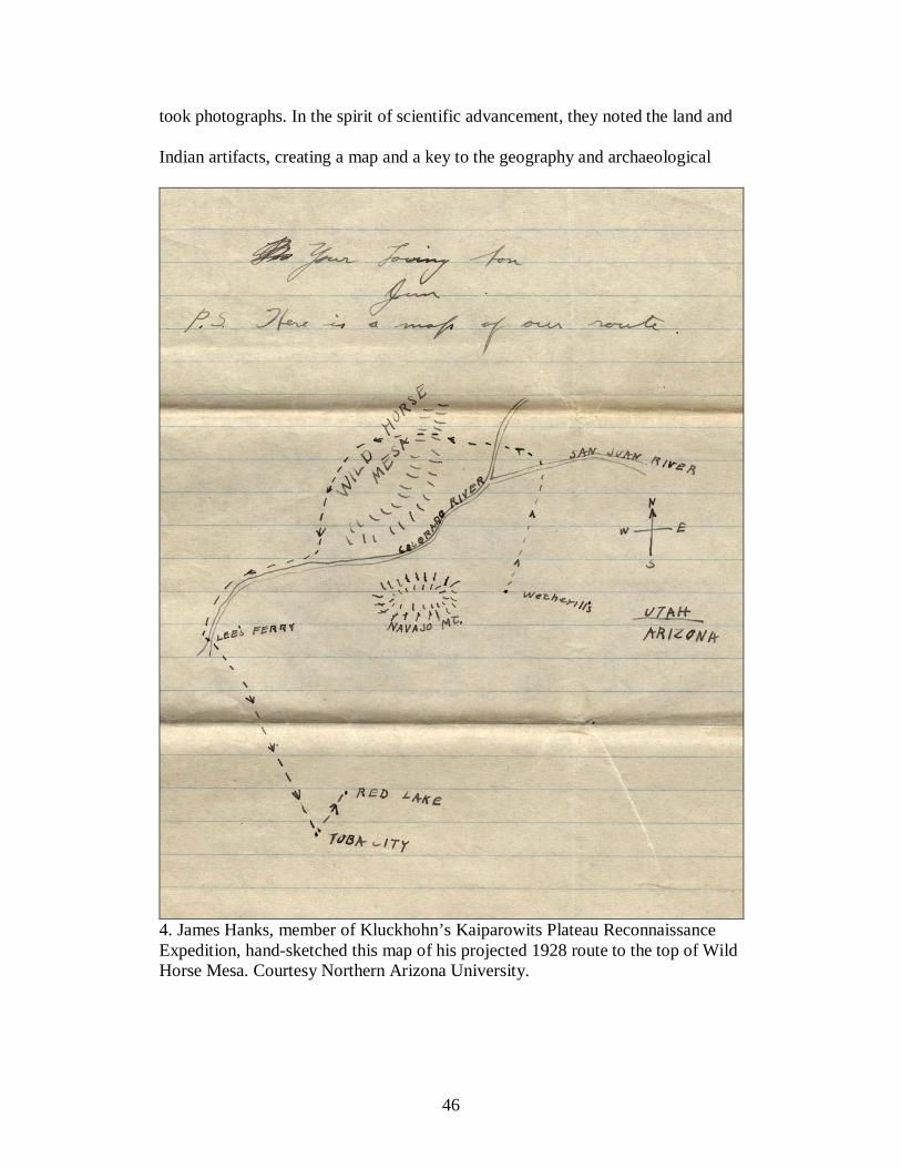
46
took photographs. In the spirit of scientific advancement, they noted the land and
Indian artifacts, creating a map and a key to the geography and archaeological
4. James Hanks, member of Kluckhohn’s Kaiparowits Plateau Reconnaissance Expedition, hand-sketched this map of his projected 1928 route to the top of Wild Horse Mesa. Courtesy Northern Arizona University.
47
sites on the mesa. But above all, the trek was a first-rate adventure. In a letter to
his mother written the night before starting out from the Wetherill’s trading post,
Hanks could not contain his excitement. “All last summer, and so far this summer
we have climbed every hill we came to, to get a look of ‘the country beyond.’
Now that we are really headed for it and will soon be there, where none have ever
gone before, I can not tell you how I feel. I suppose it is hard for you to realize,
but boys get such a kick out of going.”34
While Kluckhohn likewise attributed his sense of adventure to his youth,
he also believed that the impulse to explore the unknown and the wild was
uniquely American. He subscribed to that notion propounded by that “flourishing
school of historians” that the “Frontier has been the predominant influence in the
shaping of American character and culture.” Kluckhohn wrote from a Euro-
centric viewpoint in flourishes that resembled (maybe even mimicked) Frederick
Jackson Turner himself—of “restless, unanchored” Americans moving ever
westward, encountering “a sometimes pitiless and terrible land,” and of “the
terrible struggle for survival against the Indian and against the land itself.” This
constant process of westward expansion produced in Americans “a certain
freedom, a flexibility in our thinking and a vigor and independence in action” that
civilized western Europeans no longer possess. “We share, to be sure, in all the
splendid achievements of Western Europe because we have a common ancestry
alike in blood and in ideas with the men of Western Europe, but we share more
34 James Hanks to “Mother” [Mrs. Stanley Hanks], July 23, 1928, James J. Hanks Collection, The Cline Library Digital Archives, Northern Arizona University, Flagstaff.
48
distantly, more and more differently.” Kluckhohn attributed his own “craving for
the distant and unknown” to the larger American tradition.35
In a sense, then, Kluckhohn folded his own wilderness adventures into the
larger Turnerian conquest narrative. But his story also diverged from the
Turnerian narrative in important and crucial ways. Kluckhohn did not share with
the Mormons the notion of “conquering” place, or imposing a certain worldview
on to the land. This is not to say that his travels into unknown regions did not
produce apprehension—in his writings, Kluckhohn refers to the land as “savage,”
“ruthless,” “unfriendly,” and “forbidding”—but he also perceived something that
perhaps the Mormons did not, or at least did not care to mention. The land was
“ruthless,” he writes, “as well as magnificent.” Kluckhohn’s companion, James
Hanks, wrote that far from being something “frightening,” it was a “mere
pleasure” to trek into that wild and untrammeled landscape.36 Kluckhohn and his
compatriots welcomed the challenges of encountering a wild landscape. In fact,
they rejoiced in it: “We rejoiced that there were yet regions uncrossed by trail
where one would be able to travel days or weeks without meeting even a
wandering Indian. We rejoiced that the fine isolation of the Mesa was all but
impregnably guarded, on the south at least, by the rock-bound courses of two
powerful treacherous rivers. All the American blood in us was glad for this fierce
35 Kluckhohn, Beyond the Rainbow, 15-17. 36 Hanks to “Mother,” June 22, 1928, James J. Hanks Collection.

49
landscape, for this land stretched out in utter solitude, for this last considerable
frontier.”37
It may be that, upon reflection, Kluckhohn “rejoiced” upon encountering
such a “fierce landscape,” but his actual journey to Wild Horse Mesa was
dangerous and in some cases harrowing. From Rainbow Bridge, the party traveled
to Surprise Valley and then to Ben Wetherill’s trading post. After joining a
Navajo guide by the name of Hosteen Dogi, they traveled north to the San Juan
River, then westward to cross the Colorado River. From there, they would attempt
to scale the ever elusive mesa, the prize of their journey.
At the San Juan River, the party’s horses struggled and nearly sank in the
wet sand, soaking the men’s supply. On the north side of the river, the men
followed “an old Indian trail” out of San Juan Canyon, where they then observed
“that savage world of rock.” They moved westward toward the Colorado River.
Kluckhohn reveled in both the immensity and the intimacy of the landscape. “Its
charm lies in its vastness, its very silence, its freedom from human intercourse.
Round every corner one hopes to discover a new rock, bridge or a mighty house
of the dead.” Occasionally, they stumbled upon “a lovely oasis” at the head of a
side canyon, where they would lapse into “a pleasant lethargy.” About a day’s
journey from the Colorado River, the men came upon something extraordinary
and totally unexpected: Dogi “showed us clear evidence of trail building of a type
that Indians would never have done. We faintly remembered a story of Mormons
coming down from central Utah and making a bold way over the Colorado to the
37 Kluckhohn, Beyond the Rainbow, 14-15.

50
founding of Bluff and other settlements east on the San Juan.” The next morning,
the men spotted canyon walls cut by the Colorado and “the rock window which
gave Hole-in-the-Rock its name.”38
In his account, Kluckhohn spends some time describing the river
crossings. Members of the party apparently expected crossing the Colorado to be
rather uneventful, particularly compared to years’ past. In an early letter, James
Hanks assured his “anxious” mother that an Indian guide would “take us to the
Colorado and across,” and that “since the river is at present very low, and there is
an iron boat to row us across everything is rosy.”39 Kluckhohn, however, provides
a harrowing and perhaps slightly embellished account of the Colorado crossing.
Finding the river much swifter than they anticipated, Kluckhohn and Hanks rowed
the “tattered, torn, and patched” metal boat furiously to get to the other side.
Then, realizing the animals would not swim across without persuasion, rowed
back. The sun and heat, trapped within the canyon walls, were intense. They
finally forced the horses and “the even less enthusiastic mules” into the river. At
last on the other side, the animals “stood there shivering and motionless, dripping,
panting, terrified, exhausted.” The next day the boat made seven more crossings
until all the supplies had been moved, but each time the current swept the boat
downstream, and each time the men arduously towed it back up the river.40
38 Ibid., 182-183. 39 Hanks to “Mother,” July 23, 1928, James J. Hanks Collection. 40 Kluckhohn, Beyond the Rainbow, 183-188.

51
In the ascent up the canyon walls, the men and animals scrabbled up the
various grades, essentially following the route forged by the Mormon pioneers
from their descent of Hole-in-the-Rock. They even found an old pickaxe and part
of a wagon wheel that had belonged to them. Kluckhohn notes that along a
section of the route “the footholds chipped in the rock by our Mormon friends”
made passage possible. Seeing these markings in the rock again caused
Kluckhohn to turn his thoughts to the Hole-in-the-Rock settlers. “Building a
‘road’ over the rocks was a matter of unending labor with pickaxe and black
powder, unending labor over long months. Only the ecstasy of a new religion
could have given them the courage to abide in this frightening world, faced
always by the possibility of attack from hostile Indians.” Kluckhohn seems to
have bought into the heroic telling of that journey; to him, as to Bluff residents
who told the “tales of heroic men and fearless women,” it represented an epic
undertaking in a “hostile” world. Yet for all his rhapsodic praise, Kluckhohn did
not so much celebrate the settling of the San Juan but the incredible trek through
what he called “this frightening world.” Kluckhohn preferred the country to
remain unsettled, unpeopled; it was the isolation that intrigued him most.41
Upon reaching the top of the canyon at Hole-in-the-Rock, the mesa came
into view, and “[o]ur hearts leaped up,” Kluckhohn writes. The men slept at the
foot of Wild Horse Mesa and in the morning began the ascent. They had no
problem reaching the second bench where they admired the “queer obelisks of
clay with huge rock boulders perched on top of them” that from a distance had
41 Ibid., 188-191.
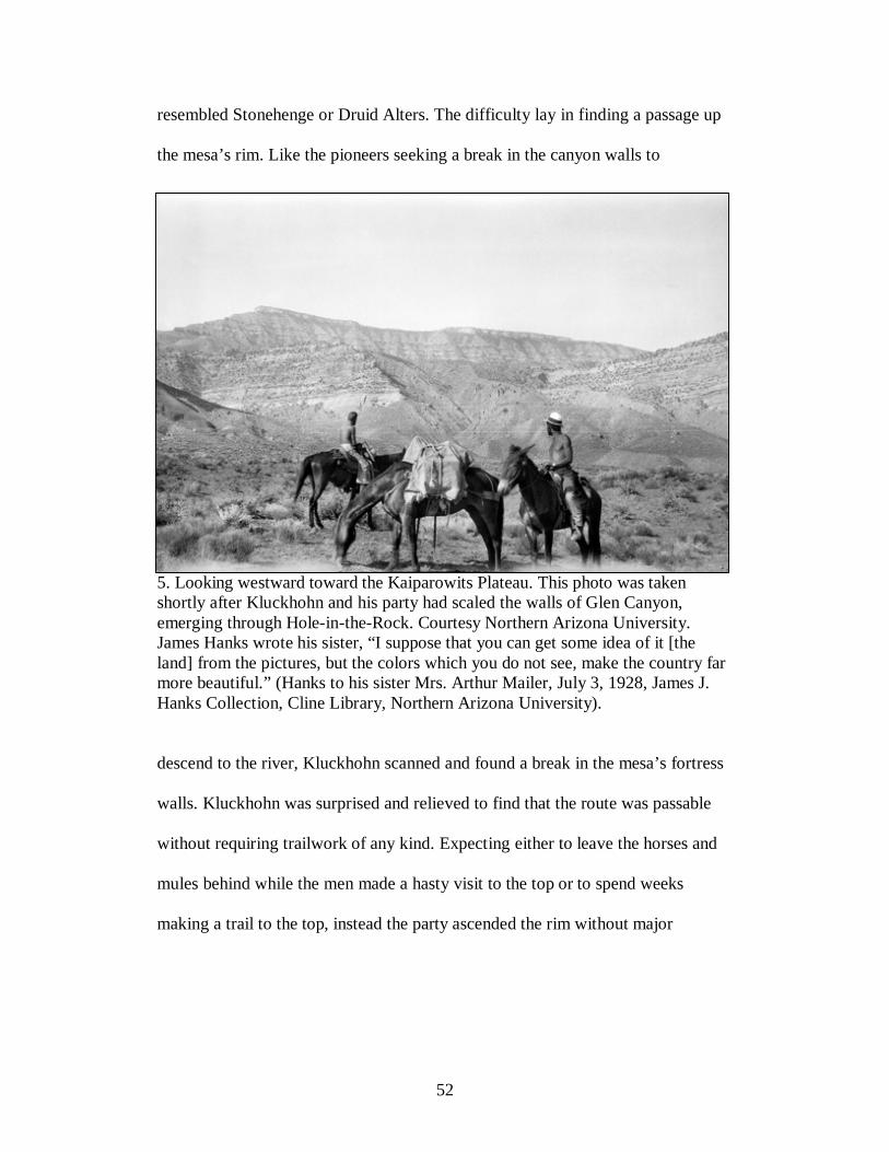
52
resembled Stonehenge or Druid Alters. The difficulty lay in finding a passage up
the mesa’s rim. Like the pioneers seeking a break in the canyon walls to
5. Looking westward toward the Kaiparowits Plateau. This photo was taken shortly after Kluckhohn and his party had scaled the walls of Glen Canyon, emerging through Hole-in-the-Rock. Courtesy Northern Arizona University. James Hanks wrote his sister, “I suppose that you can get some idea of it [the land] from the pictures, but the colors which you do not see, make the country far more beautiful.” (Hanks to his sister Mrs. Arthur Mailer, July 3, 1928, James J. Hanks Collection, Cline Library, Northern Arizona University). descend to the river, Kluckhohn scanned and found a break in the mesa’s fortress
walls. Kluckhohn was surprised and relieved to find that the route was passable
without requiring trailwork of any kind. Expecting either to leave the horses and
mules behind while the men made a hasty visit to the top or to spend weeks
making a trail to the top, instead the party ascended the rim without major
53
incident. Kluckholm wrote “[a]t 12:15 p.m. on the 31st day of July we were
actually on the top of the Mesa and our six-year-old dream was accomplished.”42
What they discovered at the top delighted them. Sagebrush, pinon and
cedar trees, and tall grasses—“this enchanted island of vegetation in the desert
sea”—blanketed the mesa top. They enjoyed the cool breeze. “We had expected
Inferno,” Kluckhohn wrote, “but we found Paradise.” What made it “paradise”
most of all was that “[h]ere in this quiet valley shut off from all the noise and dirt
of the world was rest and comfort, and off beyond the rim lay soul-stirring
grandeur.”43
The party was also pleased to find evidence of ancient humans. Shortly
after reaching the top, they spotted “what was unmistakably a prehistoric trail.”
Further on the mesa they encountered several Indian cliff dwelling and pictograph
sites. But other discoveries on the mesa and alongside those ancient sites
disheartened them. There were initials carved on a basswood tree, “Ken Porter”
etched on the walls of Pictograph Cave, and “Tillman Felix, Arden Woolsey:
February, 1928” carved in a cliff dwelling. Cattle trails crossed the mesa “where it
was possible” and “in some places where it wasn’t.” The evidence of modern
humans clearly disappointed, but they tried not to let this spoil the experience.
“We had been so long steeped in the Arizona beliefs about the Mesa that the
finding of dates, initials, and cattle altered our fundamental attitudes but little.
Psychologically, Wild Horse Mesa was still the one virgin outpost of the
42 Ibid., 191-194. 43 Ibid., 194-195.
54
vanishing frontier,” he writes.44 Kluckhohn nevertheless learned the hard way that
what to him from the Arizona side had seemed so impenetrable was actually quite
easily accessible from the north in Utah. The mesa was better known than he
could have imagined: since 1915 the Kaiparowits region had become the site of
federal surveying and exploration, and other men had apparently beaten
Kluckhohn to the top from the southern side. In 1922, six years earlier, Dave Rust
led a party from the Crossing of the Fathers to “the crest of the Kaiparowits
Plateau,” where he ran into Raymond Moore who was studying the economic
geology of the region.45
But on the mesa Kluckhohn thought of none of that. Indeed, his thoughts
turned to federal protection of the place. He wanted to extend a proposal by
Charles Bernheimer and John Wetherill and others to create a national park from
Rainbow Bridge to Wild Horse Mesa. “[I]t is Mesa Verde on an exaggerated
scale,” he wrote of the mesa’s qualifications. “The panoramas from the rim are
more magnificent. Indeed for sublimity of scenery Wild Horse Mesa surpasses
even Grand Canyon.” But he seemed to quickly reconsider for something more
fitting for this wild, unspoiled place: “a national preserve denied to settlement.”
44 Ibid., 204. 45 Swanson, Rust, 171-172. Working between 1910 and 1938, Herbert Gregory was the first to officially survey the Kaiparowits and the San Juan regions. See Gregory, Navajo Region (Washington, D.C.: Government Printing Office, 1916); Gregory and Raymond C. Moore, The Kaiparowits Region: A Geographic and Geologic Reconnaissance of Parts of Utah and Arizona, Geological Survey Professional Paper 164 (Washington, D.C.: Government Printing Office, 1931); Gregory, San Juan Country (Washington, D.C.: Government Printing Office, 1938).
55
Did he—could he—imagine a road carrying comfortable tourists to the mesa’s
top? No, undoubtedly he did not. In essence, he proposed a wilderness preserve
that prohibited development of any kind. He emphasized in all caps, “NO
ROADS, NO BUILT TRAILS”—penning these words perhaps coincidently
around the time of the founding of the Wilderness Society and of the U.S. Forest
Service’s earliest wild and primitive areas.46
٭٭٭
In 1931, three years later, Kluckhohn returned to attempt another triumphal trek to
the top of Wild Horse Mesa essentially along his 1928 route. The waters at the
San Juan were so high that he probably wisely concluded that even if he were to
make it to the other side, the Colorado River promised to be even higher, swifter,
and more difficult to cross. So he turned back, repelled by “the Mesa’s stalwart
allies, the San Juan and Colorado.” This, however, did not much bother him.
“Despite our disappointment, I am a little glad that our last effort was repulsed,
that Wild Horse Mesa proved itself still a stronghold not lightly to be taken.”47
Indeed, Kluckhohn believed that the region bounded by the San Juan and
Colorado River represented some of the last vestiges of “unexplored and
unsurveyed regions of the world,” but he was not so innocent to believe that this
“last frontier” would remain untouched. He spent his early adult years in the
plateau region during a time when it was beginning to experience the forces of
modernity. Kluckhohn recognized this—that even then efforts were being made to
46 Kluckhohn, Beyond the Rainbow, 207-209. 47 Ibid., 268-271.

56
penetrate that impenetrable country. The federal government was then
undertaking construction of a massive dam in Boulder Canyon that would result
in the creation of Lake Mead. The year 1929 marked the opening of a bridge near
Lee’s Ferry over the Colorado River. Fortunately, he felt, the plateau country
generally and Wild Horse Mesa specifically presented a formidable “stronghold,”
a natural defense from development.48 Kluckhohn would likely be horrified that
today the wild and impenetrable Kaiparowits Plateau is eyed by developers for its
vast energy potential. What would he think of the San Juan and Colorado rivers—
the swift waters that he so laboriously forded—tamed into a placid reservoir by
Glen Canyon Dam? Kluckhohn would undoubtedly be surprised at how much this
seemingly vast region has been altered in the 85 years since his travels.
Kluckhohn is important, not simply because he provides a delightful and
rhapsodic account of a young man’s encounter with the Southwest, but also
because he belongs to and possibly helped to inspire the broader counter-cultural
tradition that gave rise to wilderness activism in the twentieth century. Indeed, his
story provides a counter-narrative to the Mormon Hole-in-the-Rock Expedition.
Unlike the Mormon settlers a generation before, Kluckhohn’s purpose was not to
etch permanent transportation routes and habitations into the land; his was a
journey that would linger briefly and then depart. He shared much in common
with the next generation of activists who would fiercely defend the region’s
remaining wild lands from roads and development. He sought, as many have
since, in the deep canyons and high mesas an encounter with the sublime, a retreat
48 Ibid., 270-271.
57
from modern culture that by the 1920s and 30s had become a matter of concern.
Another wilderness itinerant of the plateau country, the better known Everett
Ruess, said it this way in a 1934 letter to his brother:
As to when I shall return to civilization, it will not be soon, I think. I have not tired of the wilderness; rather I enjoy its beauty and the vagrant life I lead more keenly all the time. I prefer the saddle to the street car, and the star-sprinkled sky to the roof, the obscure and difficult trail leading into the unknown to any paved highway, and the deep peace of the wild to the discontent bred by cities. Do you blame me then for staying here where I feel that I belong and am one with the world about me?49 Like Ruess, Kluckhohn also did more than simply wander into the
canyons; he wrote about his travels in inspiring and powerful prose. But if his
writings seem too romanticized, they are also deeply rooted in a familiarity and
love of the land. To him, the land held an allure and mystery, and all the more so
because it was roadless, largely unsettled. With each road leading to a destination,
he realized, something was being lost. Speaking of Rainbow Bridge, located
across the Colorado River from the Kaiparowits Plateau, a contemporary of
Kluckhohn, Richard Frothingam, wrote, “If this sublime illustration of the forces
of Nature were accessible by a Pullman sleeper or motor car, its name would be
on all men’s tongues.”50 To Kluckhohn, that would be something to lament. A
49 Quoted in On Desert Trails with Everett Ruess, Commemorative Edition (Salt Lake City: Gibbs Smith, Publisher, 2000), 53. For more on Ruess’ sojourns into the wild, see W.L. Rusho, Everett Ruess: A Vagabond for Beauty (Salt Lake City: Gibbs-Smith, 1983). 50 Quoted in Thomas J. Harvey, “The Storehouse of Unlived Years: Producing the Space of the Old West in Modern America” (Ph.D. dissertation, University of Utah, 2004), 257.
58
road leading to the top of Wild Horse Mesa would have reduced his grueling,
once-in-a-lifetime adventure to a mere weekend excursion.
In this way, Kluckhohn is an ideological progenitor of later twentieth-
century writers such as Wallace Stegner, Edward Abbey, T. C. Watkins, and
Terry Tempest Williams who have written passionately about the preservation of
Canyon County wilderness.51 His thinking was an ideological antecedent for the
counter-cultural position that, contrary to the dominant worldview (reflected here
by the Hole-in-the-Rock pioneers), the earth’s sole purpose is not to serve man,
that humans are merely part of nature and not lords over it, and that some crooked
paths ought to remain crooked. His was an alternative way of perceiving and
acting on the land—one of two contending cultural paradigms that later operated
in the conflicts over land and access on the Colorado Plateau.
These particular cultural paradigms are both universal and highly specific
to the plateau country. The impulse to perceive the land as either something to
domesticate or something to keep wild is not by any means unique to the region,
but the combination of unique geological features, cultural influences, and
preconceived expectations of the region gave those impulses a particular vitality.
The redrock country of southern Utah and northern Arizona had become by the
1920s, according to historian Thomas Harvey, “a particular place within Anglo-
American culture,” but it was a place that held very different meanings to
51 For a sampling of these authors’ work, see Stegner, ed., This Is Dinosaur: Echo Park and Its Magic Rivers (New York: Knopf, 1955); Abbey, Desert Solitaire: A Season in the Wilderness (New York: Random House, 1968); Watkins, Red Rock Chronicles: Saving Wild Utah (Baltimore: Johns Hopkins, 2000); Williams, Red: Passion and Patience in the Desert (New York: Pantheon, 2001).

59
different people.52 The people who visited or sought to make the region home
certainly recognized it as unique and distinct from other landscapes, and yet they
brought with them very different cultural ideas and expectations that informed
how they ought to and how they would ultimately act on the land. Kluckhohn may
not have realized this as a young adventurer, but he would later understand that
how he perceived the landscape was a product of the culture that he carried with
him. Later in his academic career he (with Henry A. Murray) wrote, “Culture
directs and often distorts man’s perception of the external world. . . . Culture acts
as a set of blinders, or a series of lenses, through which men view their
environments.”53 Yet he probably could not have known just how wildly those
perceptions, distorted by culture, would diverge later in the twentieth century over
similar issues that he had concerned himself with as a young man.
52 Harvey, “The Storehouse of Unlived Years,” 3. 53 Clyde Kluckhohn and Henry A. Murray, “The Determinants of Personality,” in Personality in Nature, Society, and Culture, ed. by Kluckhohn and Murray (New York: Knopf, 1948), 45.

60
CHAPTER 3
ABBEY’S ROAD, BLACK’S HIGHWAY: EDWARD ABBEY AND CALVIN BLACK, DESERT ARCHETYPES
In Edward Abbey’s fiction novel The Monkey Wrench Gang (1975), George
Hayduke, a Vietnam Vet; Seldom Seen Smith, a Jack-Mormon outfitter; Doc
Sarvis, a physician; and Bonnie Abbzug, Sarvis’s girlfriend, stand atop Comb
Ridge with the San Juan country in southeastern Utah spread out before them.
From the northern summit the motley group sees “a turmoil of dust and activity.
Whine of motors, snort and growl of distant diesels.” The equipment is at work
building State Road 95 (soon to become Utah Highway 95, or U-95), a new
modern highway through mostly trackless wild lands connecting the towns of
Blanding and Hanksville. Eager to get a better view of the road operations, the
comrades drive a few miles closer toward the construction activities. From their
position on the ridge their eyes follow the machinery and men at work on the
road.1
They note the construction details. The bulldozers have left pinyon pine
and cedar “smashed and bleeding, into heaps of brush, where they would be left to
die and decompose.” A second wave of bulldozers have ripped up loose rock; and
drill rigs have blasted into bedrock and dump trucks have carried the rubble to the
fill sites. “Powdered stone floated on the air as the engines roared,” Abbey wrote.
“Resonant vibrations shuddered through the bone structure of the earth. More
1 Edward Abbey, The Monkey Wrench Gang (New York: Harper-Collins Publishers, Inc., 2000; originally published in 1975), 78-79.
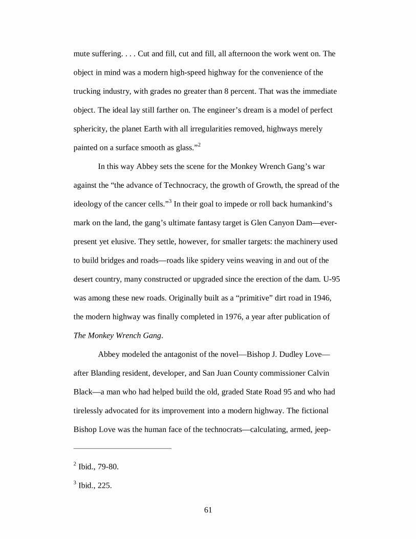
61
mute suffering. . . . Cut and fill, cut and fill, all afternoon the work went on. The
object in mind was a modern high-speed highway for the convenience of the
trucking industry, with grades no greater than 8 percent. That was the immediate
object. The ideal lay still farther on. The engineer’s dream is a model of perfect
sphericity, the planet Earth with all irregularities removed, highways merely
painted on a surface smooth as glass.”2
In this way Abbey sets the scene for the Monkey Wrench Gang’s war
against the “the advance of Technocracy, the growth of Growth, the spread of the
ideology of the cancer cells.”3 In their goal to impede or roll back humankind’s
mark on the land, the gang’s ultimate fantasy target is Glen Canyon Dam—ever-
present yet elusive. They settle, however, for smaller targets: the machinery used
to build bridges and roads—roads like spidery veins weaving in and out of the
desert country, many constructed or upgraded since the erection of the dam. U-95
was among these new roads. Originally built as a “primitive” dirt road in 1946,
the modern highway was finally completed in 1976, a year after publication of
The Monkey Wrench Gang.
Abbey modeled the antagonist of the novel—Bishop J. Dudley Love—
after Blanding resident, developer, and San Juan County commissioner Calvin
Black—a man who had helped build the old, graded State Road 95 and who had
tirelessly advocated for its improvement into a modern highway. The fictional
Bishop Love was the human face of the technocrats—calculating, armed, jeep-
2 Ibid., 79-80. 3 Ibid., 225.
62
revving, yellow-toothed—leading a sheriff’s posse to apprehend the four lawless
renegades. To be sure, Bishop Love was a caricature, described in the novel as a
man who could hear a dollar bill fall on a shag rug. Yet the real-life man who
inspired the character of Bishop Love was larger than life in his own way—a self-
made millionaire, a strong-willed, in-your-face developer and miner and county
commissioner in San Juan County with a long career championing limited
government, state ownership of federal lands, and maximum economic
development of natural resources. The Monkey Wrench Gang made him infamous,
but by his own will and force of personality he had already created a legacy for
himself. He was the face of development and “progress” in southern Utah.
The lives of Edward Abbey and Calvin Black become intermeshed in a
broad clash over development and preservation in the Southwest. U-95 is a good
place to begin to tell the story. Figuratively, the highway can trace the path of the
controversy. Although Black and Abbey seldom confronted each other face to
face, the evolution of the highway weaved their life stories together in
provocative ways. Edward Abbey first gained access to a country he later grew to
love via a road (State Road 95) that his future nemesis—Cal Black—had helped
to build. This fact epitomizes a basic irony: the very roads Abbey and others have
fought against are the same roads that allow them access to the country they
passionately defend. Yet however ironic (and complex) the life stories of Abbey
and Black may be, each man became, through their own force of character and
hard-line positions on matters of development and preservation, figureheads of
particular ideologies at work in the modern West.

63
٭٭٭
Portrayed as the Mormon bishop of Blanding, Calvin Black hailed from the outer
periphery of the Mormon cultural region. The Hole-in-the-Rock expedition and
the settlement of the San Juan country had been among the last Mormon efforts to
extend their domain. Although originally conceived as yet one more site among
many future sites of a geo-political empire sweeping throughout not only the
Intermountain West but also—at least in imagination—the whole of North and
South America, political pressure and changing economic and social realities at
last ground Mormon expansionist plans to a halt. Brigham Young may have
believed that in the deserts and mountains of the West he was creating a temporal
and spiritual homeland where the Saints would assume center stage in the cosmic
events of the Last Days.4 But by the end of the nineteenth century, the Mormon
quest for empire had been entirely subsumed into the mainstream body politic.
Young’s plans to establish a relative autarchy achieved through home industry
and manufacture was not to be; whereas Mormons had established roots in places
throughout the West in an effort to develop economical self-sufficient and
4 William Mulder, “The Mormons in American History,” University of Utah Bulletin 48, No. 11 (January 1957), 26. Just prior to his death in June 1844, Joseph Smith had boldly articulated his religious and geo-political and economic aspirations: “I calculate to be one of the instruments of setting up the kingdom of Daniel by the word of the Lord, and I intend to lay a foundation that will revolutionize the whole world.” Quoted in Joseph Smith, Jr., et al., History of the Church of Jesus Christ of Latter-day Saints, Period 1, History of Joseph Smith, the Prophet, by Himself, 6 vols., ed. B. H. Roberts (Salt Lake City: Published by the Church and Deseret Book Co., 1902-12), 6:365.

64
politically autonomous communities, by the twentieth century continued isolation
was seen as neither possible nor even desirable.5
The rocky transition from provincial isolation to national incorporation
was climaxing in the decade following the Mormon settlement of southeastern
Utah and would further play out in the decades to follow. It would be, in many
respects, a slow and tortuous process. The tension between accommodation and
retrenchment—a tension perhaps never fully resolved among Mormons—
characterized the settlers’ relationship to religious “outsiders” and to the land. In
one sense, the isolating character of the region appealed to their special sense of
inhabiting a sacred homeland, but in another it frustrated their yearning to reap the
economic benefits of incorporation into the American mainstream. When the
Hole-in-the-Rock party entered the San Juan country, they found themselves at
odds with the region’s earlier inhabitants, engaged in a land tussle between Ute
Indians and especially cattle outfits such as Edmund and Harold Carlisles’ Kansas
and New Mexico Cattle and Land Company which were already utilizing the
region for their economic enterprises. Yet Mormons also channeled their energies
toward carving out a ranching economic empire that both pitted the Mormon
settlers against and also required a close association with the “gentile” world.6
5 Leonard Arrington, Great Basin Kingdom: An Economic History of the Latter-Day Saints (Cambridge, Massachusetts: Harvard University Press, 1958), 195-231. 6 See Charles S. Peterson, Look to the Mountains: Southeastern Utah and the La Sal National Forest (Provo, Utah: Brigham Young University Press, 1975), 92-100; Robert S. McPherson, “Monticello,” in Utah History Encyclopedia, ed. Allen Kent Powell (Salt Lake City: University of Utah Press, 1994).

65
The adoption of ranching as the economic mainstay reflected in one sense
a jettison of old Mormonism and traditional notions of Mormon place. Most
Mormon settlements in the Great Basin were characterized by the “Plat of
Zion”—Joseph Smith’s idea of a village’s square patterns and wide streets
surrounded by farm- and pasture-land. The design was economic but also, as
Samuel Schmieding observes, to provide sacred center points “where spiritual
energies concentrated in waiting for the sacred event, the surrounding landscape
sustenance for God’s chosen people.”7 Indeed, the Mormon village lying at the
base of the Rocky Mountains produced a powerful image of order, permanence,
stateliness, godliness. The image is a common American motif—the agrarian
myth—in which farmers diverted water from streams that originated in the snowy
mountain peaks and carefully laid out their farms in square sections and straight-
lined canals and laterals that gave the appearance of mastery over nature.
Technology made the image possible.8 It was an image that had some
representation in southeastern Utah; Bluff attempted to follow the Mormon
village pattern, as ranchers congregated in the community rather than in the open
range, and even Blanding bore the marks of other Mormon towns with its
7 Samuel Joseph Schmieding, “Visions of a Sculptured Paradise: The Colorado Plateau as American Sacred Space” (Ph.D. dissertation, Arizona State University, 2002), 317-18. 8 For a discussion of the agrarian myth, see Donald Worster, “The Kingdom, the Power, and the Water,” in The Wealth of Nations: Environmental History and the Ecological Imagination (New York: Oxford University Press, 1993), 117-122. See also Wallace Stegner, Mormon Country (Lincoln: University of Nebraska Press, 1942), 21-32; Richard V. Francaviglia, The Mormon Landscape (New York: AMS Press, 1978).
66
irrigation canals, sturdy homes, and stately streets laid out on a grid. Blanding
may not have been founded on the same communal impulse of Bluff, but it was
predominantly (and nearly exclusively for many years) Mormon—what historian
Charles Peterson refers to as “the heir of old Bluff,” which had mostly been
abandoned by the original settlers by 1920.9
But the visual representation could not be perfectly reproduced. The
original settlers of San Juan found that their new home could not be as easily
transformed into an orderly, stately landscape. Like elsewhere in Utah and the
West it was arid country: but its red rock, broken canyons, and poor soils looked
quite different from where the Saints predominantly settled along the Wasatch
Front. Beyond appearances, the San Juan country was a poor place to wield the
technology of irrigation. Probably no more than several thousand irrigable acres
exist in all the county, and even most of those lie along the tempestuous and
unpredictable San Juan River, which could (and did) flood at any time—in one
instance destroying a season’s labor. Creating a productive landscape could not be
easily achieved by diverting water from rivers for irrigation. Mormons impounded
and diverted water for irrigation everywhere they settled. The great Colorado
River and many of its tributaries in the Four Corners region, however, remained
largely wild and untapped as an irrigated water supply partly because the soil was
not amenable to agriculture and partly because rivers had cut so deeply into the
earth that diverting it to fields proved impossible.
9 Peterson, Look to the Mountains, 47-49.
67
While irrigation canals provided the sense of human permanence
elsewhere in Mormon country, settlers in San Juan turned to roads to order and to
stabilize a chaotic landscape. Roads, not fields, reflected order and mastery. As
such, they promised to transform the country from a “wasteland” to a
“productive” Eden, becoming as Charles Peterson observes “the major business of
the county court.” Yet road building and improvement to existing trails
progressed slowly. Despite the expenditure of public funds (often to the detriment
of education and other services) and the first push of boosters hoping to cash in on
oil discoveries in San Juan County to turn rutted wagon trails into highways, the
reality of well-built roads remained far off. Through the first half of the twentieth
century, the San Juan region had the deserved reputation as one of the most
remote, inaccessible regions in the United States.10 Even visitors who exulted in
the primitive and wild qualities of the region found the primitive modes of
transportation to be an annoyance. Robert B. Aird, reflecting on his 1923 travels
in the San Juan region, wrote that although he had deliberately sought “the
untamed ruggedness and the grandeur of extreme nature,” the rough terrain and
other “limitations prevented our even exploring as much as we wished.” He
wrote: “[T]he rugged nature of the San Juan country, the great scarcity of
waterholes, and the very meagerness of our outfit prevented our attaining that
almost perfect sense of freedom of Wordsworth when he said, ‘and should the
chosen guide be nothing better than a wandering cloud, I cannot miss my way.’”11
10 Peterson, Look to the Mountains, 46, 219-20.
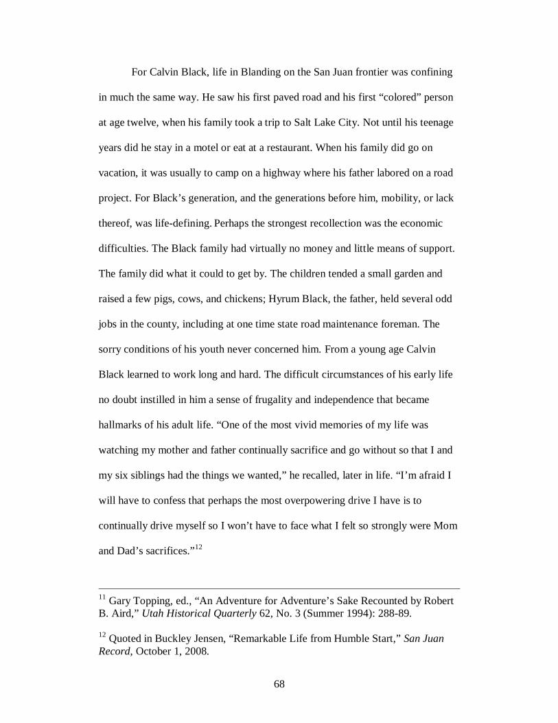
68
For Calvin Black, life in Blanding on the San Juan frontier was confining
in much the same way. He saw his first paved road and his first “colored” person
at age twelve, when his family took a trip to Salt Lake City. Not until his teenage
years did he stay in a motel or eat at a restaurant. When his family did go on
vacation, it was usually to camp on a highway where his father labored on a road
project. For Black’s generation, and the generations before him, mobility, or lack
thereof, was life-defining. Perhaps the strongest recollection was the economic
difficulties. The Black family had virtually no money and little means of support.
The family did what it could to get by. The children tended a small garden and
raised a few pigs, cows, and chickens; Hyrum Black, the father, held several odd
jobs in the county, including at one time state road maintenance foreman. The
sorry conditions of his youth never concerned him. From a young age Calvin
Black learned to work long and hard. The difficult circumstances of his early life
no doubt instilled in him a sense of frugality and independence that became
hallmarks of his adult life. “One of the most vivid memories of my life was
watching my mother and father continually sacrifice and go without so that I and
my six siblings had the things we wanted,” he recalled, later in life. “I’m afraid I
will have to confess that perhaps the most overpowering drive I have is to
continually drive myself so I won’t have to face what I felt so strongly were Mom
and Dad’s sacrifices.”12
11 Gary Topping, ed., “An Adventure for Adventure’s Sake Recounted by Robert B. Aird,” Utah Historical Quarterly 62, No. 3 (Summer 1994): 288-89. 12 Quoted in Buckley Jensen, “Remarkable Life from Humble Start,” San Juan Record, October 1, 2008.

69
Blanding’s isolation and limited economic opportunity compelled many of
Calvin’s school mates to leave the county in search of education or work. For
him, college may have been an option, but because his sister’s attendance there
had placed a terrible financial burden on his parents, he decided to start working
right away. Black decided to give trucking a try. He and his father bought a truck
which they used to haul ore over the network of gravel and dirt road in the county.
Then, when there was nothing for him to haul, Black got into the mining
business.13
Mining requires good roads—not necessarily well-graded but at least wide
and smooth enough to accommodate large equipment. Because miners staked
their claims where minerals occurred regardless of the proximity to towns or
contours of the land, miner’s roads resembled a hastily constructed web—with
threads reaching out to some of the unlikeliest places on the high desert. Among
the loneliest spots is the uranium Whirlwind Mine, one of Black’s earlier ones, on
a section of state land within the boundaries of the Navajo Reservation. Because
no road from Oljato, a trading post on the Navajo Reservation near the Utah-
Arizona border, led to the state section, Black and his partners, Merwyn and
Burdett Shumway, built the road themselves. Black later called the twenty miles
to the mine “flat,” but “flat” is a relative term, and in that country this flat road
13 Calvin Black, interview by Lynn Coppel, transcript, May 29, 1978, Southeastern Utah Project, Utah State Historical Society and California State University, Fullerton, Oral History Program; Calvin Black, interview by Milan Pavlovich and Jeffrey Jones, transcript, July 24, 1970, Uranium Industry Project, Utah State Historical Society and California State University, Fullerton, Oral History Program.
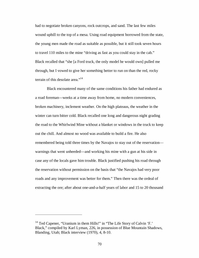
70
had to negotiate broken canyons, rock outcrops, and sand. The last few miles
wound uphill to the top of a mesa. Using road equipment borrowed from the state,
the young men made the road as suitable as possible, but it still took seven hours
to travel 110 miles to the mine “driving as fast as you could stay in the cab.”
Black recalled that “she [a Ford truck, the only model he would own] pulled me
through, but I vowed to give her something better to run on than the red, rocky
terrain of this desolate area.”14
Black encountered many of the same conditions his father had endured as
a road foreman—weeks at a time away from home, no modern conveniences,
broken machinery, inclement weather. On the high plateaus, the weather in the
winter can turn bitter cold. Black recalled one long and dangerous night grading
the road to the Whirlwind Mine without a blanket or windows in the truck to keep
out the chill. And almost no wood was available to build a fire. He also
remembered being told three times by the Navajos to stay out of the reservation—
warnings that went unheeded—and working his mine with a gun at his side in
case any of the locals gave him trouble. Black justified pushing his road through
the reservation without permission on the basis that “the Navajos had very poor
roads and any improvement was better for them.” Then there was the ordeal of
extracting the ore; after about one-and-a-half years of labor and 15 to 20 thousand
14 Ted Capener, “Uranium in them Hills!” in “The Life Story of Calvin ‘F.’ Black,” compiled by Karl Lyman, 226, in possession of Blue Mountain Shadows, Blanding, Utah; Black interview (1970), 4, 8-10.

71
dollars, the miners made their first shipment of ore. And each load of ore required
twenty-two hours on the road—traveling 220 miles at ten miles an hour.15
The difficult process of locating a mine, building a road, and hauling the
ore re-played itself throughout the Four Corners region. At the dawn of the atomic
age, the Atomic Energy Commission (AEC) offered rock-bottom prices for
uranium in ore that could be processed at the mill in Monticello. Later, the AEC
opened a mill in Durango, Colorado, and added a fifty-cent-per-pound bonus on
uranium. San Juaners scrambled to locate and file claims and produce ore. Still,
small operations barely survived even at that higher price. Yet again the AEC
raised prices, setting off a boom in development on the eastern edge of the
Colorado Plateau. The uranium boom, coupled with the discovery in 1954 of
some of the nation’s most important oil fields, had a marked effect on the county.
Motels, trailer courts, grocery stores, and even towns sprang up in remote places
to cater to the influx of prospectors and miners. But what transformed the land
most indelibly was the hundreds of miles of new roads—not unlike the one
leading to the Whirlwind mine—built by miners, prospectors, and engineers. The
AEC, under the rationale of national security, funded much of the road building as
part of its Access Road Program.16
15 “The Life Story of Calvin ‘F.’ Black,” 4; Black interview (1970), 7-9. 16 See Gary Shumway, “A History of the Uranium Industry on the Colorado Plateau” (Ph.D. dissertation, University of Southern California, 1970), 219-26; Christopher Smith, “Uranium Oxide: Yellowcake Not All It's Cooked Up to Be,” Salt Lake Tribune, August 4, 2003; Powell, ed., San Juan County, 282-98; Michael Amundson, Yellowcake Towns: Uranium Mining Communities in the American West (Boulder: University of Colorado Press, 2002).
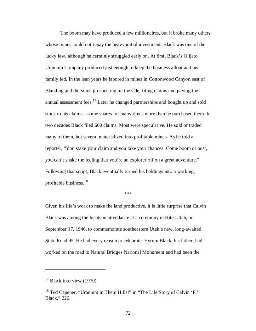
72
The boom may have produced a few millionaires, but it broke many others
whose mines could not repay the heavy initial investment. Black was one of the
lucky few, although he certainly struggled early on. At first, Black’s Olijato
Uranium Company produced just enough to keep the business afloat and his
family fed. In the lean years he labored in mines in Cottonwood Canyon east of
Blanding and did some prospecting on the side, filing claims and paying the
annual assessment fees.17 Later he changed partnerships and bought up and sold
stock to his claims—some shares for many times more than he purchased them. In
two decades Black filed 600 claims. Most were speculative. He sold or traded
many of them, but several materialized into profitable mines. As he told a
reporter, “You stake your claim and you take your chances. Come boom or bust,
you can’t shake the feeling that you’re an explorer off on a great adventure.”
Following that script, Black eventually turned his holdings into a working,
profitable business.18
٭٭٭
Given his life’s work to make the land productive, it is little surprise that Calvin
Black was among the locals in attendance at a ceremony in Hite, Utah, on
September 17, 1946, to commemorate southeastern Utah’s new, long-awaited
State Road 95. He had every reason to celebrate. Hyrum Black, his father, had
worked on the road to Natural Bridges National Monument and had been the
17 Black interview (1970). 18 Ted Capener, “Uranium in Them Hills!” in “The Life Story of Calvin ‘F.’ Black,” 226.

73
maintenance foreman in charge of extending it to the Colorado River. Calvin
spent long days and nights helping his father push that road to the river. At the
dedication, he heard speakers extol the virtues and necessities of roads. Speakers
praised the road builders for carrying on the work of their forbearers. Ephraim
Pectol of Wayne County told the crowd, “All who made this trek will go into
history as pioneers for the future automobile road and the future development of
this great Wonderland.”19
Developing that part of the country was a slow and arduous process. Well
into the mid-twentieth century, San Juan County remained much as the Hole-in-
the-Rock pioneers found it in the nineteenth century. Part of the problem was
geographical: the region was isolated from major population centers and difficult
to access. The county’s western portion is a twisted maze of canyons, mesas,
mountains, and imposing geologic barriers to land travel. East of Comb Ridge, the
land levels out to a broken expanse of sage. The few sparsely settled towns—in
1951 the New York Times referred to Blanding as a “trading post”20—hugged the
San Juan River or lay northward to the east of Comb Ridge and the Abajo
Mountains. The best road—dirt for most of the way—ran north to Moab, but
19 Proceedings of dedication of Hite Road and Chaffin’s Ferry at Chaffin’s Ranch, Hite, Utah, September 17, 1946 [hereafter “Hite booklet”], 7, Folder 20, Box 311, Geographical Section, Otis R. Marston Manuscript Collection, Huntington Library, San Marino, California. See also David H. Mann, “Missing (Road) Link Is Ready to Open,” Salt Lake Tribune, September 1, 1946. 20 “Access Roads to Open Up Scenic Southeast Utah Wonderland,” San Juan Record, May 17, 1951.

74
other roads led east to Colorado and south into Arizona. State Road 95 was the
first permanent road in San Juan County to run west.21
Building State Road 95 was merely the first step in realizing the promise
of a conquered landscape. The road was by all measures primitive. The road
builders did not have access to modern bulldozers and graders. The Utah
Department of Roads did not forge a new route or barrel through hillsides, but
instead followed the route forged in the 1930s from Blanding to Natural Bridges
National Monument and the old pioneer route the rest of the way to the Colorado
River. The road was circuitous over rough and wild country. As J. M. Adams said
at the dedication of State Road 95, the road would “make it possible to open the
way for thousands of acres of land and will make these desert wastes productive
of agricultural and mining products. If a region has the finest climate, the best soil
and every other natural asset, if it cannot boast of a good road, it is still a waste
land. To the beginning of something finer we have entered upon this project.”22
Like road builders, farmers also spoke the language of conquest—taming
rivers, domesticating the land—but in fact what they to set out to achieve was
more subtle than that. As Mark Fiege writes, “farmers and engineers believed that
they were developing and perfecting the earth’s raw potential. Indeed, the earth
itself at times seemed like God’s unfinished construction site; its topographical
features already carried the outlines of a future landscape that the irrigators would
21 Utah State Road Commission, General Highway Map, San Juan County, Utah, 1948, Folder 19, Box 390, Geographical Section, Marston Collection. 22 Hite booklet, 18.
75
complete. As a manifestation of providential design, the earth seemed to invite the
dams and canals that the irrigators would build.”23 The central point here is that
the task was not merely to subdue nature but to work with it—and in the process
complete it. Workers of the land took natural landscapes and transformed them
into human landscapes. Do this required technology, but it also required
knowledge of natural processes and perhaps even an appreciation for the natural
world—its limitations and its capabilities. Engineers were best positioned for this
work, for they considered themselves to be, as Linda Lorraine Nash writes,
“intermediaries between the natural and social worlds, as those most capable of
understanding nature and natural laws, and as those best equipped to shape human
use of the landscape.”
The road builder’s task was to find passage over the natural barriers that
seemed to divinely forbid access. This is not to say that they did not use the
contours of the land to their advantage. The first roads did follow the steep grades,
curves and elevations of the land. The task, however, was to provide passage over
and around rough places, not to “improve” the land the same way agriculture did.
Roads cleared the land of vegetation; modern technology enabled them to barrel
over and around some of the roughest places on the planet. If not principally to
conquer nature, engineering became the principle means to reshape nature.24
23 Mark Fiege, Irrigated Eden: The Making of an Agricultural Landscape in the American West (Seattle: University of Washington Press, 1999), 17. 24 Linda Lorraine Nash, “Transforming the Central Valley: Body, Identity, and Environment in California, 1850-1970” (Ph.D. dissertation, University of Washington, 2000), 192, 195.

76
That first effort to construct an east-west route across the Colorado River
in southeastern Utah may have excited the local crowd, but a perfected road it was
not. In fact, it was quite rough, as Edward Abbey recalled in an essay providing
the best physical description available of the original State Road 95.25 By 1953,
when Abbey first encountered the road, even the original road dedicated in 1946
had been modified—the route descended Comb Ridge instead of arcing north of it
along the base of the Abajo Mountains—but its rough, primitive character was
just as it had always been. Abbey portrays the road cutting through an entirely
wild and open country—what he refers to as a sea of warped and eroded red rock
set against a backdrop of distant buttes, mesas, and Laccolithic mountains—as
rough and primitive as the landscape it traversed. Abbey encountered sand pits,
potholes, ruts, and a precipitous drop along the harrowing descent down Comb
Ridge. The journey required periodically stopping and working on the road to
make it passable. At one point his truck got a flat tire. Admittedly, Abbey had no
intention to move quickly over the road, but even still nearly a full day had been
required to reach Natural Bridges National Monument only thirty or thirty-five
miles from their starting point.
On the second day, the small group descended toward the river over a “red
wasteland” of dust, sand, and sandstone. At Fry Canyon, Abbey recalls driving
across “a little wooden bridge that looked like it might have been built by old
Cass Hite himself, or even Padre Escalante, centuries before.” The trail continued
25 See Edward Abbey, “How It Was,” in Slickrock: The Canyon Country of Southeastern Utah, Photographs and commentary by Philip Hyde (New York: Scribner’s and Sierra Club, 1971), 18-31.
77
on to more miles of axle-busting ruts and deep sand in the bottom wash of White
Canyon. Before the day’s end, the little party reached the river and the old
settlement of Hite, inhabited by a few families and a handful of “prospectors,
miners, bums, exiles, remittance men.” From there, they rode Art Chaffin’s
“home-designed ferry,” reached the other side, and continued on the journey up
North Wash.
Abbey writes in his essay that he took it for granted that the road would
remain rough and primitive, but even as the new dirt road was being completed,
plans were made to improve it. At the dedication of the road in September 1946,
speakers spent perhaps as much time reflecting on the need to upgrade the road as
they spent praising it. Utah Governor Herbert Maw, who in the ultimate irony
arrived at the dedication late, delayed by the poor conditions of the new road, told
the gathering, “Today you come down here and you are praising this road. It isn’t
such a hot road (Applause). Incidentally let me tell you this: I think it is a disgrace
to the state of Utah to, after a hundred years, force the citizens who live in the
outlying areas to travel over the kinds of roads some of them travel over
(Applause).” What he meant was that they deserved a modern highway, paved
and oiled, with three lanes and the curves widened. He continued: “I want to say
that we should never permit a condition to continue, where any town in Utah is
not connected to a main highway with an oiled road.” The statement was indeed
visionary—oiled roads connecting every town in Utah.26 Speakers speculated
wistfully about the day, perhaps twenty years out, when the crooked path would
26 Hite booklet, 40-41.
78
be made straight. Certain of the righteousness of their work, the celebrants on that
September day in 1946 would be surprised by and unsympathetic toward Abbey’s
nostalgic defense of remoteness and the rough roads that kept parts of San Juan
County so wild and untamed.
٭٭٭
Edward Abbey is known as an iconoclastic writer of the West—a man of
contradiction and fire who spoke and wrote passionately about the western
landscape and the preservation of open spaces. Few writers more clearly and
unmistakably identified with the American Southwest. Unlike Black, however,
Abbey was a transplant to the West. Born in the town of Indiana, Pennsylvania,
and raised on a farm in the backwoods of the Allegheny Mountains near Home,
Pennsylvania (which he often erroneously claimed as his birthplace), he gained a
certain appreciation and nostalgia for green Appalachia. In Norway, where he
traveled in 1952 on a Fulbright, the pastoral landscape reminded him of home: “I
easily remember my home. Yes, yes, I think of home, I think of Home.” He later
argued that “home” was not the place of your childhood but “where you have
found your happiness.” Where, then, did Abbey find his happiness? He later said
his “home” was in “those mountains, those forests, those wild free lost full-of-
wonder places which rise yet (may they always!) above the stench and squalor of
the towns.”27
27 James M. Cahalan, Edward Abbey: A Life (Tucson: University of Arizona Press, 2001), 24-25; Edward Abbey, Desert Solitaire: A Season in the Wilderness (Ballantine Books), 298; Abbey to Marian Skedgell, Managing Editor of E. P.

79
Abbey later reflected on what he believed was a pivotal event: a 1944
hitchhiking trip at age 17 to the West. In his essay “Hallelujah, on the Bum,” he
wrote of encountering the front range of the Rocky Mountains: “An impossible
beauty, like a boy’s first sight of an undressed girl, the image of those mountains
struck a fundamental chord in my imagination that has sounded ever since.”28
Other encounters left indelible impressions in his mind. He would
frequently get in a car and drive to wherever the roads took him. Those
remarkable experiences derived not so much from the destination as the journey,
and he savored them. In his essay about the first time he drove old State Road 95,
he writes of an unexpected confrontation with a flash flood in North Wash along
the Colorado River. “From within the flood, under the rolling red waters, you
could hear the grating and grumble of big rocks, boulders, as they clashed on one
another, a sound like the grinding of molars in a pair of leviathan jaws. The kind
of sound, in other words, for which neither imagination nor fantasy can ever
really prepare you. The unbelievable reality of the real.” With the floodwaters still
rushing below them, Abbey and his companions set up camp. Abbey recalls the
ecstasy of listening to the roar of the waters while smelling the juniper fire, tasting
the beans and bacon, and enjoying the beauty that surrounded him. The next
morning everything was serene, though the flood left the road nearly
Dutton & Co., March 10, 1970, Folder 6, Box 3, MS 271, Papers of Edward Abbey, Special Collections, University of Arizona, Tucson. 28 Quoted in Cahalan, Edward Abbey, 28-29.
80
unrecognizable. The day after was spent getting the truck out of North Wash, but
he wrote the hard labor “was worth every minute of it.”29
In this and in other writings, Abbey articulates what historian Thomas
Dunlap has called a “faith in nature,” believing not merely in protecting the earth,
but that nature alone has rights that ought to be respected. Here, Abbey makes the
case for a personal connection to wild land and to the power of nature to heal,
rejuvenate, enliven. Dunlap refers to environmentalism as a kind of religion, akin
to traditional religion in its power to bring meaning and purpose to individuals.
Unlike other pursuits with origins in the Enlightenment, environmentalism
appealed to reason, but like religion it also “looked beyond knowledge, seeking
meaning, and believed each of us needed to form conscious ties to the world.”30 In
Abbey’s writings you sense his belief in a deeper meaning that might be found in
the natural world: the mystery, the charm, the majestic. His was an emotional
though not otherworldly experience in nature, for he believed the Earthly
experience was all that was needed. But his abiding connection to nature was
arguably as strong as another’s connection to the divine or the supernatural. He
looked to no other power or meaning in the universe beyond the material world
under his feet.
Abbey sought to experience nature directly, and he came to know well the
environment of the American West. He wrote of these experiences; his large
29 Abbey, “How It Was,” 18-31. 30 Thomas R. Dunlap, Faith in Nature: Environmentalism as Religious Quest (Seattle: University of Washington Press, 2004), 19.
81
corpus of writing reads like a travelogue. Usually he inserted himself in his
writings, using his personal experiences as material. Some of his seasonal park
ranger jobs such as at Organ Pipe Cactus, the north rim of the Grand Canyon and,
most famously, Arches, provided the material for his books. Desert Solitaire: A
Season in the Wilderness, first published in 1968 and now considered an
environmental classic, is based roughly on Abbey’s 1956-57 seasons as park
ranger in Arches National Park but is also a collection of experiences at several
locations over the course of a few years.31 In it, Abbey provides what may be
called nature musings on everything from rocks and rivers to flora and fauna to
human’s relationship to nature. More than nature writing, however, Deseret
Solitaire reads as a celebration of wilderness and as a call to protect and preserve
land from motorized travel and industrial development.
To be sure, Abbey understood the virtues of growth and development—
limited though those virtues might be in his mind. Roads facilitated economic
growth, and growth produced jobs, and jobs allowed locals to remain in small
backwater communities without being forced to look elsewhere for work.
Speaking in 1978 about southern Utahns who advocated for construction of a
massive power plant on the Kaiparowits Plateau, he said, “Those people aren’t
stupid. They live in the cleanest, healthiest, most beautiful place in the world.”
Yet, he dedicated his life to warning westerners to be wary of the camel’s nose
under the tent when they invite “just a little industrialization so all their kids will
have jobs and a little industrialization has a tendency always to become a little
31 Cahalan, Edward Abbey, 102.

82
more . . . and then a little more. Until you wake up one day to find yourself in
some place like Gary, Indiana.”32
Abbey believed some places ought to be left undefiled and that the
government was obliged to protect those places by limiting access and
development. At one point he even proposed banning all forms of motorized
travel in national parks. Access would not be totally restricted—people could
enter and leave as they pleased on foot, horseback, even in “a team and wagon”—
but not in a motorized vehicle. In a letter addressed to Horace Albright, former
director of the NPS, Abbey opined, “The parks should be for people—not for
machines.”33
6. Edward Abbey, holding up a copy of his new non-fiction book The Journey Home (1977), with the cover image of a cracked Glen Canyon Dam.
32 Emphasis mine; Winfred Blevins, “Mariah Interviews Edward Abbey, ‘The Thoreau of the American Desert,’” Mariah: The Complete Outdoor Magazine (October/November 1978): 91. 33 Abbey to Albright, March 13, 1970, Folder 6, Box 3, Abbey Papers.

83
And Abbey’s message to keep the West’s remaining wildlands wild and
primitive reached a devoted following. People took notice of the accelerated
development occurring throughout the West in the decades following World War
II, in the national forests and parks and in the primitive backcountry. A man from
Cheney, Washington, wrote Abbey nostalgically, “As you say, we old codgers
have had a chance to see the country as it once was, and thank God for that.” He
wrote that he spent his childhood on a ranch along the Fremont River in south-
central Utah. Returning to the ranch after a long absence, he was horrified to
discover “a 70 mph highway [State Road 24] right through the middle [of it].”34
The irony was that Abbey, perhaps more than any other writer, introduced people
to the sites and sounds of the red rock and canyon country, and his writing
provided an irresistible lure to many to see for themselves this majestic country.
But he did not often divulge the location of a sublime wilderness or canyon; he
preferred these places remain incognito.35 Still, some places were already being
discovered and developed, and neither Abbey nor anyone else could stop it,
despite futile attempts. At the end of Desert Solitaire Abbey despairs of the new
road building taking place in Arches. In fact, he admits that when nobody was
looking he pulled up stakes put in by road surveyors.
When Abbey first arrived in Arches in 1956, the park was still a primitive
backcountry, undiscovered and relatively scarce of travelers. But gradually more
visitors poured in, facilitated by the new road. Ultimately, he lost his beloved
34 Virgil Hays to Abbey, November 8, 1970, Folder 6, Box 2, Abbey Papers. 35 See Cahalan, Edward Abbey, 107.
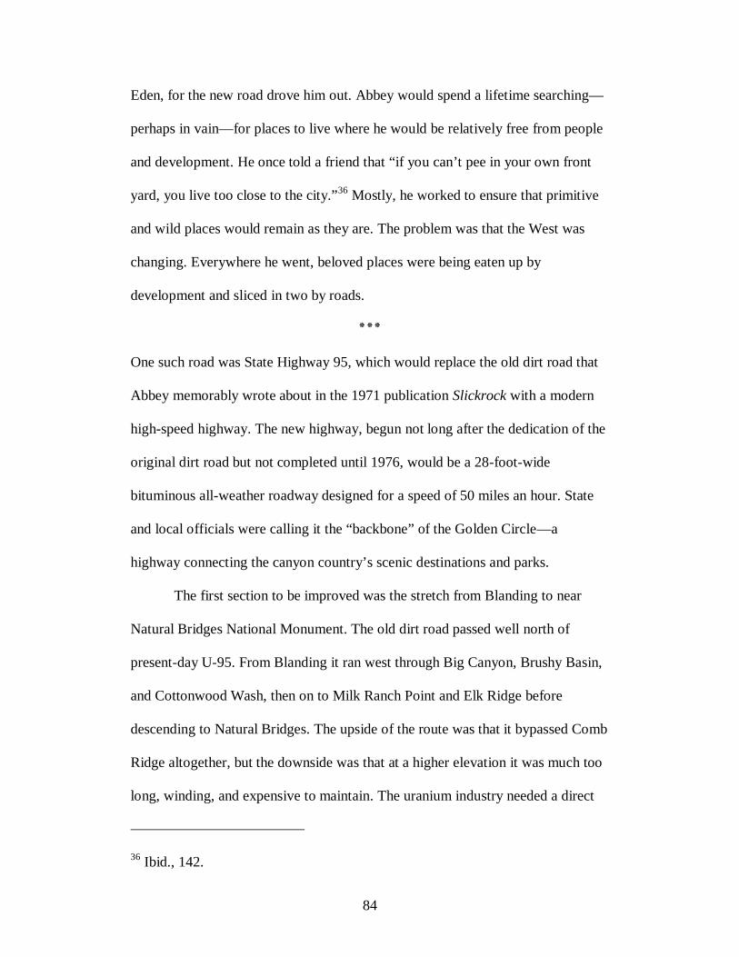
84
Eden, for the new road drove him out. Abbey would spend a lifetime searching—
perhaps in vain—for places to live where he would be relatively free from people
and development. He once told a friend that “if you can’t pee in your own front
yard, you live too close to the city.”36 Mostly, he worked to ensure that primitive
and wild places would remain as they are. The problem was that the West was
changing. Everywhere he went, beloved places were being eaten up by
development and sliced in two by roads.
٭٭٭
One such road was State Highway 95, which would replace the old dirt road that
Abbey memorably wrote about in the 1971 publication Slickrock with a modern
high-speed highway. The new highway, begun not long after the dedication of the
original dirt road but not completed until 1976, would be a 28-foot-wide
bituminous all-weather roadway designed for a speed of 50 miles an hour. State
and local officials were calling it the “backbone” of the Golden Circle—a
highway connecting the canyon country’s scenic destinations and parks.
The first section to be improved was the stretch from Blanding to near
Natural Bridges National Monument. The old dirt road passed well north of
present-day U-95. From Blanding it ran west through Big Canyon, Brushy Basin,
and Cottonwood Wash, then on to Milk Ranch Point and Elk Ridge before
descending to Natural Bridges. The upside of the route was that it bypassed Comb
Ridge altogether, but the downside was that at a higher elevation it was much too
long, winding, and expensive to maintain. The uranium industry needed a direct
36 Ibid., 142.
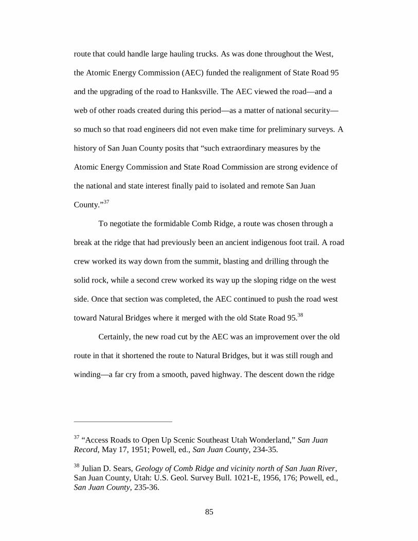
85
route that could handle large hauling trucks. As was done throughout the West,
the Atomic Energy Commission (AEC) funded the realignment of State Road 95
and the upgrading of the road to Hanksville. The AEC viewed the road—and a
web of other roads created during this period—as a matter of national security—
so much so that road engineers did not even make time for preliminary surveys. A
history of San Juan County posits that “such extraordinary measures by the
Atomic Energy Commission and State Road Commission are strong evidence of
the national and state interest finally paid to isolated and remote San Juan
County.”37
To negotiate the formidable Comb Ridge, a route was chosen through a
break at the ridge that had previously been an ancient indigenous foot trail. A road
crew worked its way down from the summit, blasting and drilling through the
solid rock, while a second crew worked its way up the sloping ridge on the west
side. Once that section was completed, the AEC continued to push the road west
toward Natural Bridges where it merged with the old State Road 95.38
Certainly, the new road cut by the AEC was an improvement over the old
route in that it shortened the route to Natural Bridges, but it was still rough and
winding—a far cry from a smooth, paved highway. The descent down the ridge
37 “Access Roads to Open Up Scenic Southeast Utah Wonderland,” San Juan Record, May 17, 1951; Powell, ed., San Juan County, 234-35. 38 Julian D. Sears, Geology of Comb Ridge and vicinity north of San Juan River, San Juan County, Utah: U.S. Geol. Survey Bull. 1021-E, 1956, 176; Powell, ed., San Juan County, 235-36.
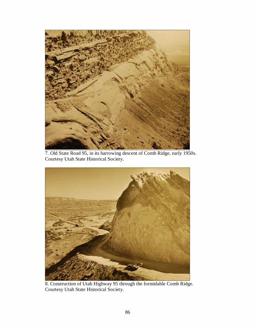
86
7. Old State Road 95, in its harrowing descent of Comb Ridge, early 1950s. Courtesy Utah State Historical Society.
8. Construction of Utah Highway 95 through the formidable Comb Ridge. Courtesy Utah State Historical Society.

87
was especially harrowing—the very route that Abbey used in 1953—and was
frequented by large uranium trucks on a continual basis. To create an even
straighter highway would require yet another cut through the ridge. Bisecting a
passage through that seemingly impenetrable wall of sandstone was the
engineering feat of the highway. This time there was no attempt to conform the
road to the existing landscape; using the muscle of machinery and explosives,
road crews in the early 1970s blasted out a huge slice of the rock. The dugway
leading up to the cut was possibly bolstered by the rock that had been cut loose
from the summit. Now, motorists speed by without even the thought that at one
time the ridge had been nearly impenetrable.39
Like the section of road through the ridge, the remaining highway took
form in phases over several decades. In the 1950s the AEC built the “improved”
route to Natural Bridges and graded the rest; beginning in the 1960s road crews
realigned and paved various sections. The Utah Department of Transportation
divided the new highway into manageable sections; the BLM granted right of way
and ensured compliance of construction requirements.
The first funding cycle, secured in 1964, would be used to build the
bridges. Unlike the old days, there could be no simple crossing at Hite. The site of
the ferry that shuttled passengers and automobiles across the perpetually moving
Colorado River would soon become the upper end of Lake Powell—what Abbey
referred to as “a motionless body of murky green effluent, dead, stagnant, dull, a
39 Robert S. McPherson, Comb Ridge and Its People: The Ethnohistory of a Rock (Logan: Utah State University Press, 2009), 192.

88
scum of oil floating on the surface.”40 Whereas the old road snaked down Farley
Canyon and crossed the Colorado River at Hite Ferry, the new highway would arc
around the north end of the reservoir and cross not just the Colorado but the Dirty
Devil River as well. A third bridge was also planned where the road crossed to the
north side of straight-walled White Canyon. In each case, the steel-arch modern
bridges contrasted sharply against the twisted, rugged landscape. Completed in
1965-66, costing nearly $2 million, they created the only road crossing of the
Colorado River between Glen Canyon Dam in Arizona and Moab, Utah.41 In a
1970 U.S. Senate hearing about extending Canyonlands and Glen Canyon NRA,
Harry H. Heland, Utah State Road Commission director of highways, touted the
existing accomplishment of State Route 95 for crossing three deep canyons near
the north of Lake Powell. “National recognition afforded these two bridges in the
desert for their esthetic values is evidence that Utah has taken the effort necessary
to provide road service in an esthetic manner,” he argued.42 In his mind, these
three manmade steel bridges were every bit as impressive and important as the
three sandstone natural bridges in their namesake monument forty miles east.
40 Abbey, The Monkey Wrench Gang, 120. 41 Dedication Ceremony for the Colorado River Bridge, Dirty Devil River Bridge, White Canyon Bridge, June 3, 1966, Box 1, Series 9917, Road Commission, Department of Highways Dedication Program Booklets, Utah State Archives and Records Service, Salt Lake City. 42 Statement of Harry Heland, from United States, Congress, Senate, Committee on Interior and Insular Affairs, Subcommittee on Parks and Recreation, Canyonlands National Park and Glen Canyon National Recreational Area: Hearing, Ninety-first Congress, Second session, on S. 26 and S. 27, May 5, 1970 (Washington: U.S. Government Printing Office, 1970), 85.
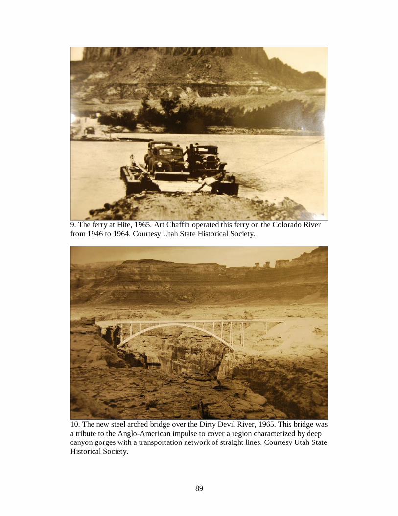
89
9. The ferry at Hite, 1965. Art Chaffin operated this ferry on the Colorado River from 1946 to 1964. Courtesy Utah State Historical Society.
10. The new steel arched bridge over the Dirty Devil River, 1965. This bridge was a tribute to the Anglo-American impulse to cover a region characterized by deep canyon gorges with a transportation network of straight lines. Courtesy Utah State Historical Society.
90
Some people believed that road engineers were creating a road that
complemented the desert aesthetic. Where visible from the highway, the old road
was to be obliterated and seeded for a “natural” appearance. Where the old road
could not be seen from the new, no restoration or landscaping was required. The
BLM carefully considered which grasses to use in reseeding the cleared land on
the highway’s shoulders. Native plants like four-wing saltbush, sand drop seed,
black brush, or sagebrush offered a more natural appearance than exotics.43 Since
the highway would pass through range land used by deer as well as domestic
livestock, road designers had to determine the best way to build a road and
fencing for winter range cattle without harming deer migration moving from
winter to summer ranges. Three-strand barbed-wired fences were used to keep
cattle off the highway while still allowing wildlife passage. The BLM also
recommended no blasting in a section of the highway between Atomic Rock to
Fry Canyon during bighorn sheep lambing season May through June. In general,
it had instructed road crews to use non-intrusive road building methods to
minimize the road scars and the adverse impacts to land and water resources.44
43 Frank G. Shields, BLM District Manager, Monticello, September 5, 1972, notes; “Environmental Analysis, Bureau of Public Roads – U-6593, U-95 Atomic Rock to White Canyon Segment,” May 10, 1974; both documents on file in the BLM field office, Monticello, Utah. 44 Sheridan Hansen, Area Manager, October 9, 1968; Thomas Moore, Chief Division Resource Management, to R/W U 6468 and U 6670, June 19, 1969, Folder “U-95, The Needle – U-261, UTU-6468”; “Comments on U-95 (White Canyon) Staff Report,” June 28, 1973; “Environmental Analysis, Bureau of Public Roads – U-6593, U-95 Atomic Rock to White Canyon Segment,” May 10, 1974; all documents on file in the BLM field office, Monticello, Utah. See “Environmental Analysis, Bureau of Public Roads – U-6593, U-95 Atomic Rock
91
Road construction is, however, by nature a highly environmentally
disturbing act. U-95 entailed heavy cuts to the land and cultural resources. In one
section of the highway, construction crews to inadvertently destroy several key
archaeological sites west of Mule Canyon, completely destroying a site showing
evidence of late Basketmaker or Pueblo I occupation, another small Pueblo site, a
Basketmaker site revealing evidence of a pit house, and a large site that had
contained important late Basketmaker and Pueblo pit structures and dwellings.
Only a pit structure and trash at the last site could be salvaged.45
Road cuts had other impacts on the landscape. In some sections of the
highway such as up Elk Ridge and to Cedar Mesa, engineers forged brand new
routes instead of overlaying the new highway over the existing road alignment.
Making a new alignment cut an entirely new path through the broken country,
resulting in further damage to the land, soil, and vegetation. It was violent work,
even though the engineers designed the construction to be as unobtrusive as
to White Canyon Segment,” May 10, 1974; Frank G. Shields, BLM District Manager, Monticello, to BLM State Director, November 3, 1972, folder “U-95 U-6670 Federal H. A.”; both documents on file in the BLM field office, Monticello, Utah. 45 See “Negative Environmental Impact Declaration, U-95 White Canyon to Atomic Rock,” [1973]; Frank G. Shields, BLM District Manager, Monticello, to BLM State Director, Utah, April 27, 1973, memorandum; “Analysis and Recommendations for Archeological Values – U-95,” Staff Report written by Richard E. Fike, April 23, 1973, Folder “U-95 U-6670 Federal H. A.”; all documents on file in the BLM field office, Monticello, Utah. For the BLM’s reaction to the damage, see Blaine J. Kay, Director, Utah State Department of Highways, to R. D. Nielson, BLM State Director, April 18, 1973; “Report of Meeting with officials of Utah State Highway Department, University of Utah, and Bureau of Land Management in reference to highway U-95 – May 30, 1973,” written by R. D. Nielson, June 6, 1973, Folder “U-95 U-6670 Federal H. A.”; both documents on file in the BLM field office, Monticello, Utah.

92
possible. Of particular concern was the section of highway from Atomic Rock to
White Canyon, a stretch that adheres mostly to the old alignment. Still, the impact
to the landscape was tremendous. Since the new road would straighten out and
eliminate sharp curves and dangerous dips in the road, even where following the
old road, straightening the road would take the highway off the old road by up to
150 yards.46 Road architects attempted to mitigate damage to the landscape
wherever possible. The BLM feared that a highway culvert might cause
irreparable damage to Fry Canyon, a deep narrow gorge adjacent to White
Canyon a few miles west of Natural Bridges. Instead, they proposed building a
new bridge across the canyon, not unlike the old one used for the old road. In fact,
the Scenic Highway Group had lobbied to keep the old bridge over Fry Canyon
and approaches to it left in place. The Utah State Department of Highways argued
that keeping the old bridge would be a liability. Bob Brock of the BLM proposed
a new bridge with a walkway for those interested in viewing the canyon. Again,
the Utah State Department of Highways ruled that the walkway would be a
liability, and one was never built.47
Through 1976 road crews blasted, cut, filled, graded, and paved sections
of U-95. Completion of each section became a matter of celebration. On
November 2, 1974, C. Alfred Frost blessed the road, Mormon style. He began by
46 Frank A. Ularich, Engineer, Utah State Department of Highways, August 14, 1973, memorandum, on file in the BLM field office, Monticello, Utah. 47 Bob Brock, BLM, “U-95 – Atomic Rock to White Canyon,” Staff Report, June 27, 1973; Ularich, August 14, 1973, memorandum; both documents on file in the BLM field office, Monticello, Utah.
93
thanking “our Heavenly Father” for the men and women who worked on the road,
then asked that it be blessed “for the beneficial use of man—that it be used for
commercy and industry in transporting the necessary goods and materials
necessary for mankind to pursue his livelihood here on earth” and that man would
“travel this graceful road” to “get away from the strife and hustle and bustle of his
life” and “have his soul renewed.”48
٭٭٭
Who, then, would benefit from the new highway and for what would it be used?
Seldom Seen, a character in Abbey’s novel The Monkey Wrench Gang, assured
his companions that “The only folks [who] want this road are the mining
companies and the oil companies and people like Bishop Love. And the Highway
Department, which their religion is building roads. Nobody else ever heard of
it.”49 That about fits the original purposes of the road when the AEC covered the
costs: to provide access for prospectors and haulers moving ore to the processing
plants. The circle of benefactors widened when the waters of Lake Powell reached
Hite. Now the road would benefit the marinas and hotels and stores that would
cater to the boaters and sightseers, but roads boosters also recognized its broader
impact on tourism in southern Utah. Calvin Black had argued most earnestly
during the highway’s construction that it “will not only provide for local needs,
but will connect the hundreds of thousands of acres of beautiful, scenic lands the
48 County Commission Minutes, November 18, 1974, Roll Accession 160296, Series 84229, San Juan County (Utah), County Commission Minutes, Utah State Archives and Records Service, Salt Lake City, Utah. 49 Abbey, The Monkey Wrench Gang, 77-78, 313.
94
Congress has designated as National Parks, Monuments and Recreation Areas for
the use and enjoyment of all Americans.”50
What Black did not state explicitly but would have been known by anyone
who knew him was that he stood to gain from the highway’s construction. Since
dedication of the original road in 1946, he had dreamed of its completion and had
prepared for it. After making a start in the mines, Black had become a successful
entrepreneur with businesses and real estate in several western states and in his
home county so numerous they read like a directory.51 Among his many
developments in the late 1950s and early 1960s, the largest and perhaps Black’s
preferred was development at Hall’s Crossing on Lake Powell. One of his sons
remembers going to the site “while there was still a river there and Dad was trying
50 Calvin Black, Commissioner, San Juan County Commission, to Henry C. Helland, Director, Utah State Department of Highways, [1972], on file in BLM field office, Monticello, Utah. See also R. D. Nielson, State Director, BLM, to Helland, August 15, 1972, on file in BLM field office, Monticello, Utah. 51 He bought stock and real estate in Carlsbad, New Mexico, considered buying land in California, and purchased property at Hall’s Crossing for a marina on the anticipated Lake Powell. He bought up additional mining claims or the interest of his partners, like Rust Black. In February 1965, he recorded about “investigating the purchase of a sawmill” and a “Wax Museum.” In 1966 he considered more land purchases including land in Park City, Utah; ranches in Nevada and Loa, Utah; and a mine in Montezuma, Utah. And he discussed many other business deals. In March 1966 alone he pondered purchasing a motel in Monticello, two motels in Blanding, and several other businesses and properties. He made an offer on a shopping center in Phoenix, leased an oil well in Tucson, and considered copper leaching in Milford, Utah. His empire continued to grow. In 1968 he and a business partner bought Silver Saddle Café in Blanding, and he explored the possibility of a mortuary and a car dealership in Boise, Idaho. The next year he purchased the local radio station and another in Page, Arizona. To manage these holdings spread across the state he kept a car in Salt Lake City, a truck in Kanab, a truck at Hall’s Crossing, and numerous vehicles and a small plane in Blanding. Excerpts from the Journals of Calvin Black, in “The Life Story of Calvin ‘F.’ Black,” 113, 115, 116, 117, 120, 123.

95
to explain to me the development that was going to take place there.” The lake
would have a marina, stores, facilities, and a ferry. The idea for a ferry across the
reservoir germinated while he was in the army stationed in New York where he
took a ride on the Staten Island Ferry. When he returned home from the service in
1957, not long after passage of the Colorado River Storage Project Act, he
believed a “water highway” on the lake would be possible to connect the two
sides of the lake and transport tourists up and down the lake, as far south as
Wahweap and north to Hite, and maybe up the San Juan River. By working with
nature, he believed, a new water road would be the easiest ever built in the canyon
country.52
Black put his energies into the developments at the future site of the lake
marina. Partnering with J. Frank Wright, an old river runner who had worked with
Norman Nevills, he formed the Lake Powell Ferry Service, Inc. and received a
concession permit from the NPS for a marina, trailer court, and the ferry.
Beginning in October 1963, his company operated a small barge on the river and
a boat dock—“a small wooden platform with a barrel of gas and a hand pump”—a
trailer court, an office and a store.53 To expand the marina required a good road
52 Cal Black to Henry C. Helland, Director of Utah State Department of Highways, no date, on file in the BLM office in Monticello, Utah; “The Life Story of Calvin ‘F’ Black,” 7-8; Black interview (1970), 57-58; Calvin Black, “History of the John Atlantic Burr,” May 4, 1985, in possession of Blue Mountain Shadows, Blanding, Utah. 53 “Development of Halls Crossing,” 97; Black, “History of the John Atlantic Burr”; “Narrative History of Halls Crossing,” December 26, 1971, in “The Life Story of Calvin ‘F’ Black,” 105-107; Diary, in “The Life Story of Calvin ‘F’
96
connecting the reservoir to the U-95, then under construction. Black went to work
championing the upgrading of the old dirt road to the location. “When there is an
oiled road into Halls Crossing,” he estimated, “I believe there will be need for at
least 40 motel rooms, a restaurant of 60 seats, slip, buoy and dry storage facilities
for 200 boats, a trailer court of at least 50 spaces, and, of course, employee
housing, a school, service station, and other related facilities.”54
Pushed by Black, construction of Highway 276 to Hall’s Crossing was a
major undertaking. The National Park Service dumped several million dollars for
construction of the road within the Glen Canyon National Recreation Area, and
half a million on facilities in the Bullfrog Basin area across the bay. When
completed, Highway 276 provided direct access to Hall’s Crossing and by ferry to
Bullfrog Marina and the new paved road running north from Bullfrog to U-95.55
Gradually, Hall’s Crossing expanded (a floating gas barge, pumps, service station,
office, trailer court, repair shop, and dry storage yard) but not into the city Black
hoped to create, with schools, golf course, swimming pools (for those too timid to
Black,” 113, 115; “Interview with son Alan Taylor (Buddy) Black,” in “The Life Story of Calvin ‘F’ Black,” 51. 54 “Narrative History of Halls Crossing,” December 26, 1971, in “The Life Story of Calvin ‘F’ Black,” 105-107; Black to Gerald Matthews, Utah Department of Highways, March 19, 1967, Folder 23, Box 1, Reel 1, Series 20902, Governor Rampton County Trip Records, Utah State Archives and Records Service, Salt Lake City. 55 San Juan County to the Secretary of Commerce, no date, Folder 3, Box 1, Reel 1, Governor Rampton County Trip Records; Allan T. Howe to Black, May 24, 1971, in San Juan County Commission Minutes, June 7, 1971, San Juan County (Utah), County Commission Minutes.
97
brave the lake), and parks. Part of Black’s original vision was realized in 1984
with dedication of the long-sought ferry at Hall’s Crossing.56
٭٭٭
To Edward Abbey, construction of U-95 and its offshoots like Highway 276
defiled the land he had grown to love and know so well. The highway
straightened out and obliterated the charm of the old road that Abbey remembered
so fondly. Mostly, Abbey objected that this intruding highway would provide a
route for industry and big business, grown even bigger since the dammed waters
of Lake Powell reached Hite. As Moab native and wilderness advocate Ken
Sleight blamed “local people, starting with Calvin Black,” and “the prevailing
culture” in Utah. “[Black] wanted to build roads and he did build roads and it was
very hard,” Sleight told reporter Ken Verdoia in an interview. “U-95, right after
Lake Powell, well, after the filling, here comes roads, . . . and off those roads
come more roads, hooking up all the various concession sites that they decided
on. And now . . . they still want to make more roads.”57
It was the composite development and industrialization of the canyon
country that inspired The Monkey Wrench Gang. Ken Sleight suspects that Abbey
conceived the idea for the novel in 1967. Sleight, who had made a living leading
river rafting expeditions since 1953, knew of Abbey through his writings, but they
met when Abbey, who was working as a park ranger at Lee’s Ferry, approached
56 “Development of Halls Crossing,” 98. 57 “Interview: Ken Sleight,” in Glen Canyon: A Dam, Water and the West http://www.kued.org/productions/glencanyon/interviews/sleight.html (March 8, 2011).

98
Sleight to inspect his outfit. They sat at the edge of a boat and talked of Lake
Foul, as Sleight always called Lake Powell, until two or three in the morning.
“We spoke with derision about the Glen Canyon Dam. That god-awful dam was
destined to become the object of many discussions.” A few hours after Sleight
launched his boat on the river, Abbey pulled alongside in his ranger powerboat
and called to him, “Ken, we’ll take that god-damned dam down yet.”58
Abbey began writing the novel in earnest in the early 1970s. He wrote in
his journal on February 28, 1971, that it was “time to be thinkin’ of work, man.
Time for the Wild bunch to ride again, the wooden shoe mob, THE MONKEY
WRENCH GANG! Strikes! Again!”59 Abbey believed that people were ready for
the political and social message of his book. In the Foreword to a new Ballantine
edition of The Brave Cowboy, republished in 1970, fourteen years after originally
published during the “Good Old Ike Era,” Abbey wrote that the nation had
become more receptive to anarchism and defending wilderness. “Now both ideas
are flourishing in the fiery heads of the boldest of the young. For which I say,
Praise Be.”60
Abbey’s struggle was against the builders and developers bent on taming
the nation’s wild, primitive areas. Calvin Black with his strong persona, ambition,
58 Cahalan, Edward Abbey, 108-09; Ken Sleight, interview by the author, April 20, 2009. 59 Edward Abbey, Confessions of a Barbarian: Selections from the Journals of Edward Abbey, 1951-1989 (Little, Brown and Company, 1994). 60 Edward Abbey, “A Foreword to the new Ballantine edition of The Brave Cowboy,” March 1970, Folder 6, Box 3, Abbey Papers.

99
and unflinching commitment to road building probably seemed a logical choice to
play the Gang’s principal antagonist. Perhaps Abbey heard about Black during his
stint as a ranger in Arches National Park. More likely he came to know Black in
the 1960s after he returned to southeastern Utah to work as a ranger at
Canyonlands. Abbey would later move back to Tucson, but while writing The
Monkey Wrench Gang he kept close tabs on affairs in the Four Corners area by
asking Moab native Ken Sleight, “What damn thing is Cal Black up to now?”61
Probably even Abbey did not know the extent of Black’s economic empire, but
apparently he knew enough to construct a composite portrait—although an
exaggerated caricature—of Black as Bishop Love. Black was easily cast as a
profit-motivated western capitalist. And with Black’s business connections tied to
construction of the highway, critics like to point out that his support for this road
and others was self-serving. As Abbey’s monkeywrencher Seldom Seen Smith
(based loosely on Ken Sleight) sarcastically acknowledged, the road was “to help
out the poor fellas that own the uranium mines and the truck fleets and the
marinas on Lake Powell, that’s what it’s for. They gotta eat too.”62
The fictional Bishop Love was not simply a developer but, as his name
implies, a Mormon ecclesiastical leader. If readers remember much at all about
the antagonist, it is of a jeep-revving, power-hungry Mormon bishop. One of the
Gang says of Bishop Love, “We got plenty like him in Utah. They run things as
61 Cahalan, Edward Abbey, 157–59. 62 Abbey, The Monkey Wrench Gang, 77-78.

100
best they can for God and Jesus and what them two don't want, why, fellas like
Bishop Love pick up.”63
That the local leader of the posse was a Mormon is not surprising, given
that a majority in southeastern Utah belong to the LDS church. Making the
antagonist a Mormon was for Abbey a broader critique of the Mormon Church.
Abbey cared little for Mormonism’s founder, Joseph Smith, or Smith’s claims of
a golden bible, although Abbey’s disdain was probably no more for Mormonism
than for any other organized religion. Still, as he wrote in his journal, he respected
their “agrarian socialism, communal feeling, healthy and sane way of life. A good
way of life.” Mormons exhibited a kind of social behavior that—paradoxically, in
light of today’s Mormon culture—flourished for a time on the cooperation of
egalitarianism, not the competition of capitalism. In Desert Solitaire, he praises
Mormons for building “coherent, self-sustaining communities with a vigorous
common life in which all could participate, free of any great disparities in wealth,
small enough to make each member important.” Abbey had a fairly idealized
view of the earlier Mormon pioneer period and, like his disdain for the various
reincarnations of State Road 95, he lamented the “evil institution” that the church
had become. “Like all institutions, they think they’re doing good. The Mormon
church has sold out completely to the capitalist system. They are one hundred
percent in favor of industrial development and profit making—damn the
consequences. . . . They made a religion out of money making!” That seemed to
be complaint number one. Then he rattled off a few more—among them the
63 Ibid., 241, 249, 250.
101
crackdown on dissidents, narrow mindedness, and treatment of women as
“breeding machines.”64
It is this less-flattering opinion and portrayal of Mormonism and its
culture that emerges in The Monkey Wrench Gang. If there was ever something to
admire about the Mormons, that something had been abandoned in the pursuit of a
better, more comfortable life. The problem for Abbey and environmentalists was
that as a block Mormons generally opposed wilderness protection. Whether this
stance stemmed from their theological notion that the earth is full and created for
the use of man, or because their isolation and independence created a fierce
resistance to government oversight of the land—or both—Mormons in southern
Utah are among the most conservative in the country. Abbey’s portrayal of rural
Mormons is as two-dimensional, simple-minded, power-hungry denizens—not
unlike earlier popular characterizations in novels like Zane Grey’s Riders of the
Purple Sage.65
Abbey, on the other hand, put his faith (if you want to call it that)
elsewhere, believing that capitalism defiled rather than perfected nature. Thomas
Dunlap has characterized environmentalism as a kind of secular religion that
challenged certain ideas in Western culture, and indeed, The Monkey Wrench
Gang is both product and sacred text of that movement. The novel belonged to the
postwar counterculture generation of cynics, anarchists, and anti-modernists who
64 Interview with Abbey in Doug Biggers, “From Abbey’s Tower,” Tucson’s Mountain Newsreal (September 1979): 6-7. 65 Zane Grey, Riders of the Purple Sage (Random House, 2007; originally published in 1912).
102
had become disillusioned with technology because of the specter of nuclear war,
distrustful of the industrial machine because it killed individualism and polluted
the planet, and skeptical of government because it catered to war mongers and
capitalists. Like others of the countercultural generation living during the Vietnam
War, Abbey believed it necessary to make major structural changes to western
civilization by dismantling the industrial economy and starting over. In nature,
Abbey and others of his generation sought refuge, and perhaps the foundation of a
new society and culture. Abbey’s novel laid out a vision and a strategy in its
defense.
Abbey practiced what he preached. In April 1975 he and a friend snuck
into White Canyon on U-95 and, reminiscent of the mischievous
monkeywrenchers in his not-yet-published novel, damaged the road equipment to
the tune of $20,000 by pouring sand or sugar in fuel tanks or shooting holes
through machinery tires at the construction site. Above all, Abbey wanted to drive
a bulldozer off a cliff like Hayduke, but he settled for smaller acts of sabotage,
because he could not get the engine to start. Abbey may have also been
responsible the next year when somebody put 110 pounds of sugar in the gas
tanks of twenty vehicles building U-95 and caused $50,000 in damages. Later, in
a 1984 interview, Abbey admitted, tongue-in-cheek, that he did “quite a bit of
field research for that book. . . I was full of rage and it made me feel good
temporarily.”66 Temporarily, because while the damage was expensive and
66 Cahalan, Edward Abbey, 160-61; “U-95 outlook is good,” San Juan Record, January 29, 1976.

103
certainly an impediment to U-95, it did not long delay the $23 million highway
project.
Authorities went after a handful of suspects known to be opposed to the
highway and development in general. Ken Sleight believes that Black instigated
the search against him. Black even publicly accused Sleight of carrying out the
sabotage, though he had no evidence to back up his claims. “I was about to sue
the bastard,” Ken later recalled. “It got kind of nasty after a while.”67 No evidence
turned up against Sleight or anyone else; the perpetrators so well hid their tracks
that the investigation uncovered nothing, nor was anyone ever charged for the
sabotage. At that time Black had no idea that his man was Abbey or that Abbey’s
as-yet-unpublished novel would soon provide added fuel to the simmering
emotions in the Southwest.
The only satisfaction road supporters got was during one of the few times
Black and Abbey—who in later years shared a cordial relationship—spent time
together. According to Black’s wife, Carolyn Black, someone filled Abbey’s gas
tank with dirt while the two nemeses dined together in a Blanding café.68
The covert monkey wrenching was one of a few confrontations that
occurred close to completion of the highway. According to a brief note in his
diary, in January 1976 Black had a physical confrontation with those who
belonged to what he called the “Sahara Club” over construction of the highway,
but we know nothing more about the exchange. The Sierra Club protested gravel
67 Sleight, interview by the author. 68 Carolyn Black, interview by the author, August 11, 2006.

104
removal from Glen Canyon National Recreation Area for construction of the
highway but later decided to negotiate.69 Neither the monkey wrenching nor the
protest, however, put a halt to the highway project. In 1976 U-95—the Trail of the
Ancients Scenic Byway—was completed and dedicated, promising to open up
southeastern Utah’s scenic and mineral riches.
٭٭٭
The life stories are reflections of and contributions to dominant Euro American
ideologies at work in an American desert. Each man articulated and represented a
compelling vision of how to act on the land. Abbey’s environmental ethic
articulated in his sizable corpus of literature dipped into ideas that have deep roots
in American culture. Before Abbey, intellectuals had begun to express what
James Meadowcroft calls “a veneration of nature and the natural” and other
modern green perspectives. These views did not coalesce into a mainstream
political philosophy until the 1970s. Although the environmental movement
incorporated a diverse collection of ideas and ideologies, some essential points
were common throughout all green philosophies: the fundamental value of nature,
the reality of natural limit, and a rejection of the capitalistic development mode.
Any green ideology posited the need to restructure the human relationship to the
non-human world that acknowledges the human connection and interdependence
to nature rather than sole dominion or lordship over it. Meadowcroft maintains
69 Journal in “The Life Story of Calvin ‘F’ Black,” 119, 123.
105
that the environmental movement widely rejected the modern industrial machine
that equates “progress” with economic growth.70
From one standpoint, these ideas suggest an eco-centrism that is decidedly
neutral when it comes to humans’ place in the natural world. Critics of the green
philosophy at times deride environmentalists for caring more about the spotted
owl or any other species than their own. It is a charge oft-leveled by some in the
conservative, rural West, suggesting a necessary choice between eco-friendly
practices and the well-being of human beings. Yet Meadowcroft points to a fourth
shared idea—that living in sustainable harmony with nature “will also set humans
free” to live more authentic, happy lives.71 Abbey believed not only that industrial
development wrecked the environment but that it ultimately did a disservice to the
communities it aimed to help. In the undefiled natural world, Abbey found his
peace. To him the natural world existed and operated perfectly independent
beyond human need, yet humans could also play an integral moral role in it.
Black’s ideology, interestingly, contains woven strands of religious and
secular ideas about land and nature. His was a faith in economic growth, in the
power of technology to mold the natural world into a commodity, and in man’s
preeminent role in this undertaking. Each of these ideas derived in part from the
dominant American mainstream, but they also had particular prominence in
Mormon religious beliefs. Black’s notion of “creating”—that is, turning raw
70 James Meadowcroft, “Green Political Perspectives at the Dawn of the Twenty-First Century,” in Reassessing Political Ideologies: The Durability of Dissent, ed. Michael Freeden (New York: Routledge: 2001), 176. 71 Ibid., 177.

106
materials into usable, consumable products (like desert into irrigated farmland or
trees into 2x4s)—is more closely aligned with Mormon theology than mainstream
Christian doctrine. To most of Christendom, when God created the earth he did so
ex nihilo. Mormons do not share this belief that God created the earth and his
spirit children out of nothing but that he (always male) organized “intelligences”
and matter from preexistent forms.72 The idea of organizing a chaotic mess into an
organized form is a useful way to think about what Black meant by creation.
Although certainly not a uniquely Mormon concept, the organization of raw
materials into useable products had theological precedence for Black. By so
creating they were co-partners with God.
Other notions of land use advanced by Black also paralleled Mormon
theology. Black’s rhetoric that the land and its bounties were entitlements derived
widely from Mormon (and Christian) belief that God created the earth for
human’s use and dominion. Homo sapiens, designed in God’s image, sat atop the
food chain, the capstone of God’s creation, and heirs of celestial glory. In
Mormonism’s peculiar theology, this point is especially emphasized. Joseph
Smith and other early Mormons spoke not merely of humans as “angels” of God
but as total heirs to his glory and possessions.73 Taken to the logical (some might
72 For Joseph Smith’s teachings on this subject, see Teachings of the Prophet Joseph Smith, compiled by Joseph Fielding Smith (Salt Lake City: Deseret Book Co., 1977), 350-354. 73 On June 16, 1844, Joseph Smith declared that “every man who reigns in celestial glory is a God to his dominions. . . . They who obtain a glorious resurrection from the dead, are exalted far above principalities, powers, thrones,

107
say heretical) extreme, Mormons consider themselves Gods in embryo, destined,
in fact, to become possessors of their own worlds and humanoid populations.
Such anthropocentrism easily suggests the sense of entitlement for land and its
resources that many Mormons in southern Utah felt. The idea of eternal increase
finds satisfying expression on earth as Mormons accumulate large property,
homes, cars, families, and jobs as physical expressions of divine favor.
Historians and other scholars disagree, however, on the overall impact of
how Christian notions of land, God, and creation contribute to how people
perceive and transform the land. Lynn White, Jr., and Roderick Nash have argued
that Judeo-Christian religious culture is responsible to a large degree for many of
the world’s ecological challenges because, in the words of White, Jr., it “not only
established a dualism of man and nature but also insisted that it is God’s will that
man exploit nature for his proper ends.” In reading scripture, humans saw the
creation story as God setting man above the rest of creation, thus giving them
dominion over the earth and its resources.74 Mark Maryboy, a Navajo who served
with Black on the San Juan County commission, recognized this type of thinking
among his Mormon colleagues. In quoting Mormon leader Brigham Young as
saying, “Build cities, adorn your habitations, make gardens, orchards, and
vineyards, and render the earth so pleasant that when you look upon your labors,
you may do so with pleasure, and that angels may delight to come and visit your
dominions and angels, and are expressly declared to be heirs of God and joint heirs with Jesus Christ, all having eternal power.” Ibid., 374. 74 Lynn White, Jr., “The Historical Roots of Our Ecological Crisis,” Science 155 (March 1967): 1203-07; Roderick Nash, Wilderness and the American Mind (3d ed. New Haven: Yale University Press, 1982), 13-20.
108
beautiful locations,” Maryboy added, “It is an interesting religious notion that
angels would not be willing to visit God’s creation until man had improved upon
it.”75
Yet another reading of Christian scripture may be gleaned—one not of
dominion but of stewardship. Wendell Berry, historian Thomas G. Alexander,
Mormon apologist Hugh W. Nibley, and others have argued that Christian
scripture points to a different relationship between man and earth, one that is if
not akin to modern-day environmental thinking is at least in line with the view
that humans are more participants in a larger ecological system than lords over the
Earth.76 Indeed, early Mormons embraced a communalistic ideology that was at
odds with the individualistic, capitalistic mainstream. Brigham Young and other
early church leaders sometimes spoke against private landownership. They railed
against excessive timber cutting or destructive grazing practices. Yet their notion
of steward was usually understood as gardener or improver. While they often
spoke of caring for the land, the idea was not so much to live in harmony with
nature as it was to bring nature harmoniously into the ideals of a celestial place.
75 Quoted in Ken Sleight, “The Political Mark Maryboy,” Canyon Country Zephyr, October-November 1998. 76 See Berry, The Gift of Good Land: Further Essays Cultural and Agricultural (San Francisco: North Point, 1981); Alexander, “Stewardship and Enterprises: The LDS Church and the Wasatch Oasis Environment, 1847-1930,” Western Historical Quarterly 25 (autumn 1994): 341-66; Nibley, “Brigham Young on the Environment,” 3-29, in To the Glory of God: Mormon Essays on Great Issues—Environment, Commitment, Love, Peace, Youth, Man ed. by Truman Madsen and Charles D. Tate (Salt Lake City: Deseret Book, 1972).

109
Modern-day Mormons living in San Juan County would not disabuse these
ideas. They, too, articulate a land ethic that, if not eco-centric, at least
acknowledges the need to manage (“tend”) wisely the land and its resources. It is
not uncommon to hear ranchers with deep roots in the region claim to be the “true
environmentalists.” But neither should it be forgotten that the ideological
descendants of the region’s original Mormon settlers perceive the land and its
resources in primarily anthropocentric terms. Some of this is certainly driven by
religious notions. Consider the words of scientist and Mormon apostle John
Widtsoe who so clearly and unapologetically attempted to convey the spirit of
Genesis: “The destiny of man is to possess the whole earth; the destiny of the
earth is to be subject to man. There can be no full conquest of the earth, and no
real satisfaction to humanity, if large portions of the earth remain beyond his
highest control.”77 Yet to attribute this statement solely to religious ideology
would be a mistake, however, since it so clearly blends the religious and secular
notions of land as historically dominant in American culture. Mormons today
espouse what writer and activist Stephen Trimble calls “the sanctity of industrious
hard work” as zealously as they had once embraced communal ownership of
resources. “Secular entrepreneurial energy replaced sacred stewardship.”78
77 John Widtsoe, Success on Irrigation Projects (New York: John Wiley & Sons, Inc., 1928). 78 Stephen Trimble, Bargaining for Eden: The Fight for the Last Open Spaces in America (Berkeley and Los Angeles, California: University of California Press, 2008), 41 (see also pp. 203-207).

110
Religious notion’s now dovetail neatly into the dominant thinking of the
American mainstream.
Both Abbey’s and Black’s worldviews had developed primarily through
lived experiences in the Southwest. The land gave form to their visions. To Black,
the country was big enough for as many roads as could be built to service
developments along the lake. “You could honestly say that when we build these
roads, because of the vastness and nature of the area, it will make little more of a
mark than to plow the ocean!” he exclaimed rhetorically to a congressional
subcommittee in 1970.79 Paved roads like those built to Hall’s Crossing or into
Arches and the Needles District in Canyonlands National Park “opened” nature’s
wonders to the public while still retaining the natural feel and appearance of the
place. Building roads was just the first act of creation. Like old State Road 95,
roads might be improved, made faster, slicker, and straighter. Then the lakeside
marinas, gas stations, visitor’s centers, and more roads extending like tentacles to
the outer hinterlands would surely follow.
As a young man, Black affirmed that roads were infeasible in the broken
canyon country. “After I started prospecting and saw how rough that country was,
it just did not ever seem possible—building a road,” he said of upgrading the dirt
road to a modern paved highway. But by the time Calvin Black reached
79 Statement of Calvin Black, County Commissioner, San Juan County, Utah, from United States, Congress, Senate, Committee on Interior and Insular Affairs, Subcommittee on Parks and Recreation, Canyonlands National Park and Glen Canyon National Recreational Area: Hearing, Ninety-first Congress, Second session, on S. 26 and S. 27, May 5, 1970 (Washington: U.S. Government Printing Office, 1970), 58.
111
adulthood, he had begun to appreciate the power of machines to transform the
land or at least his perception of it. He took his first airplane ride at the age of
twenty-five. “When I saw that country from the air for the first time, it did not
look as big and formidable as it had.” He appreciated modern Cat tractors and
graders for their ability to cut and grade and fill in a way his father as road
foreman had never known. As an independent miner, Black built his own access
roads to his mines, became a strong advocate of road building (including U-95),
and later as San Juan county commissioner secured state and federal funds to pave
other poorly maintained dirt roads. Roads were essential; they belonged on the
landscape, providing the means to extract wealth from the land. No man was more
responsible for the network of modern roads in the county.80 His infatuation with
roads was such that BLM veterans recall how Black thought the term “black is
beautiful” referred to asphalt.81
In his lifetime, Black witnessed the powerful impact of road building in
the desert. With completion of Glen Canyon Dam, U-95, and the promise of new
oil and gas wells or mines, marinas, hotels, and gas stations, at last—it seemed—
San Juan County was becoming a destination. Part of this new promise stemmed
from a heightened sense of a newfound power over the land—that where once the
broken terrain set the limits, now technology and human ingenuity proved the
greater force. Faith in progress likely transformed attitudes about the land and
80 Black, “San Juan County Roads and Resources,” in San Juan County, Utah, ed. by Powell, 244-45. 81 Christopher Smith, “Utahn’s War Let’s Visit the Tomb of a Well-Known Sagebrush Soldier,” Salt Lake Tribune, November 2, 1995.
112
nature. Now that the county could be crossed by high-speed vehicles, the land did
not seem so forbidding, vast, or untouchable. Now that bulldozers and graders
tore through the east−west length of the county paving new roads, now that the
lake allowed boaters to weave in and out of the Colorado River side canyons, the
physical barriers to travel were not so great. Once technology allowed human
access to some of the remotest places on the planet, tourists’ perceptions of place
shifted from fear to awed appreciation of beauty. And for the residents of
southeastern Utah, the mental inertia based on the land’s perceived limits gave
way to a new kind of faith in human power over nature.
Whereas Black came from a tradition that viewed the lived-in landscape as
paramount, Abbey believed that the spirit of the desert demanded apartness from
people. Abbey recalls the story in Desert Solitaire of driving the old Flint Trail,
built by uranium miners like Black but subsequently abandoned because they
found nothing worth bringing up in trucks. He reveled in taking that trail in a
four-wheel-drive jeep, “up and down hills, in and out of washes and along the
spines of ridges.” Each traveled mile was rougher than the last until finally he
reached the end of the road, about as far away from “civilization” as it was
possible to be. It was as though the road draws you unwittingly yet irresistibly in,
luring you to stay and linger, to your peril with limited supplies until necessity
forces you to exit the way you came in.82
Indeed, Abbey writes that “this sweet virginal primitive land will be
grateful for my departure and the absence of the tourists.” To him, the paradox
82 Abbey, “Terra Incognita: Into the Maze,” in Desert Solitaire, 313-29.

113
was that while the desert—“desolate and still and strange”—called to him and
roads provided passage, the desert could not be inhabited. Arches National Park
was one of those places that stood apart from the rest of industrialized modern
America. Even he longed to return to “this new America of concrete and iron”
which he found repulsive and welcome at the same time. But he expresses
ambivalence about whether the desert would survive the impending onslaught of
cars and tourists and modern development. Abbey could not know if the desert he
was leaving, perhaps permanently, would ever be the same again. A new main
road into Arches would be built, and then perhaps paved roads to every scenic
attraction in the park, propelling people in and out of the park at a pace that did
not allow the visitors to have the kind of intimate experience of the place that
Abbey craved and wrote about so movingly.83
In other words, he was increasingly skeptical that the middle landscape
described by Leo Marx could be preserved.84 Old State Road 95 built in 1946
represented the ideal. In his mind, the old rough roads used by locals for so many
years had almost blended into the landscape. Abbey referred to the original dirt
road as “primitive,” which evokes the image of wilderness untrammeled by man.
Not so with the new modern high-speed highway. There was something about
paving over, about erasing the natural contours of the land, about the audacity of
cutting through natural barriers instead of going around them, about new steel
83 Quotes in Abbey, Desert Solitaire, 293, 302, 334. 84 See Leo Marx, The Machine in the Garden: Technology and the Pastoral Ideal in America (New York: Oxford University Press, 1964).

114
bridges spanning previously unspannable gorges and canyons. There was
something about speeding by without consideration of the character of the terrain,
without feeling the place. The loss was not only nature’s but a deeply felt human
loss.
In his essay recalling old State Road 95 before the lake submerged the old
trail and the modern highway bridged the canyons and carved deep scars into the
ridges, Abbey wrote,
All of this [the new road], the engineers and politicians and bankers will tell you, makes the region easily accessible to everybody, no matter how fat, feeble or flaccid. That is a lie. It is a lie. For those who go there now, smooth, comfortable, quick and easy, sliding through as slick as grease, will never be able to see what we saw. They will never feel what we felt. They will never know what we knew, or understand what we cannot forget.85
In lamenting the loss of the old road, Abbey did not reflect on time primeval
before people had permanently scarred the landscape. He emphasized pre-
industrialization, not pre-human contact, and wrote about a primitive backcountry,
not a pristine, untouched wilderness. In a way he was contrasting a romanticized
view of the pioneer period with the profoundly more cynical view of a destructive
and transformative modern era. But it was also recognition that the canyon
country has a deep human history that should be acknowledged, if not celebrated.
A reviewer from the National Park Service criticized Abbey for referring to the
Escalante River region as a “clean and pristine wilderness” in an unpublished
essay originally intended for American Heritage. The country, the reviewer noted,
had a history of mining and grazing and even then was being drilled for oil. “Of
85 Abbey, “How It Was.”

115
course the Escalante area is not an untouched wilderness—but what is?” Abbey
responded simply. “The old corrals and cabins do not detract from the land’s
primitive quality; and as for that oil-drilling near Davis Gulch, the last I heard it
was a dry hole. Anyway, all the more reason to have the area made official
wilderness, quick. Before they do muck it up.”86
Machines and technology provide the difference between a primitive
landscape and a fully domesticated one. Of course, it is all a matter of perspective.
What to some is degradation is progress to others. What to some is loss to others
is gain. Where to some construction means overwhelming nature, to others it
represents improving on nature or at least using the fruits of what nature so
generously endows.
٭٭٭
Perhaps it is unfair to characterize Black and Abbey as Manichean opposites. In a
sense, neither man fits squarely in the boxes popular perceptions put them in.
Abbey never felt entirely comfortable with the self-styled environmental crowd. If
“progress” is development, and development brings ecological ruin, Abbey’s
monkeywrenchers do not entirely represent the antithesis to progress. Hayduke
and Seldom Seen Smith drove big cars and tossed their beer cans out the window
like the rest of them. In “The Second Rape of the West” Abbey famously
confessed, “Of course I litter the public highway. Every chance I get. After all,
86 John M. Morehead, National Park Service, to Rita Gordon, American Heritage Magazine, November 4, 1969; Abbey to Morehead, February 27, 1970, Folder 6, Box 3, Abbey Papers.

116
it’s not the beer cans that are ugly; it’s the highway that is ugly.”87 For Black,
despite his reputation as a hard-headed money-maker, people who knew him
speak nearly unanimously of his magnanimity and good nature. Although his
opponents say that having an argument with Black was like “riding a bull,” he
disarmed his critics by his command of the issues and facts, not personal attacks
or insults. Moreover, while he made no apologies for his drive to develop and
“improve” the land, he also spoke of having a regard for the environment and
styled himself as one of the “true environmentalists.” Calling Abbey an
“environmentalist” and Black a “developer” is a good method of characterizing
positions or ideologies but not necessarily true to life.
Still, I am not the first to point out the contest between these two warring
factions. Abbey received at the tail end of his life an interesting letter from Tom
Austin, the Chief of Police in Blanding, Utah, who had grown up on a Midwest
farm, then “migrated to Utah to keep from starving to death.” He said that while
in college his professors had introduced him to Abbey’s work, which spoke to
him as someone who had fallen in love with the Southwest. Later, after joining
the police department, he read The Monkey Wrench Gang at the behest of his
colleagues “so I would know what to watch for if any of ‘those long-haired-
hippie-bastards’ showed up in my town.” As a cop he “highly resented the tactics”
of the Gang but admitted that he enjoyed the story. Austin tells Abbey that in a
87 Quoted in Cahalan, Edward Abbey, 154. For a full discussion of the contradictions and ironies in Abbey’s life and work, see David Mark Pozza, “The Unity of Opposites in the Works of Edward Abbey” (Ph.D. dissertation, Indiana University of Pennsylvania, 2001).

117
college paper he represented Abbey as “the figurehead of the radical
environmental movement in the United States” and Calvin Black as a “leader
among the radical materialistic factions in the state of Utah and certainly San Juan
County.” The representations probably seemed natural to Austin. In his writings
Abbey had been a persistent “voice in the wilderness” urging direct action to
defend the earth. The Monkey Wrench Gang in particular helped inspire the
creation of Earth First!88 Austin undoubtedly knew and worked with Black. By
the mid 1980s Black had a reputation in the state and even beyond its borders—
and especially among environmentalists—for being a determined and successful
developer.89
The Monkey Wrench Gang itself helps to establish the bifurcation. In a
sense, the novel characterizes to the point of exaggeration. Abbey’s novel is
purposefully irreverent and provocative but, according to him, “though fictional in
form, is based strictly on historical fact. Everything in it is real or actually
happened. And it all began just one year from today.” He was not just referring to
the sand in the gas tanks or the chases by quasi-official local vigilantes. He meant
the engineers who would stop at nothing to achieve “perfect sphericity” and men
like Bishop Love who “can hear a dollar bill drop on a shag rug.” Abbey was also
sure that the wheels of “progress” would roll on, and he was sure that people
would come to the defense of Mother Earth. The novel is a reflection of a
88 Susan Zakin, Coyotes and Town Dogs: Earth First! and the Environmental Movement (New York: Viking, 1993), 6-7. 89 Tom Austin to Edward Abbey, February 1986, Folder 4, Box 2, Abbey Papers.
118
contemporary situation and a projection for the future. The two stories—the one
of industrial progress, the other of environmental defense—had already begun to
diverge and branch apart as the two groups dug in and announced their positions.
Both men in life and death carefully crafted their personas and achieved
iconic status. Abbey is better known because his writing immortalized the
Southwest, attracted a cult following, and is respected literature in its own right.
But Black has a following of his own, mostly among southeastern Utahns. Like
Abbey, his life and work lives on—in the developments and especially roads that
he helped to create.
The story of conflict between development and wilderness neither began
nor ended with the two men, but each came to represent the ideological poles. On
one side, a man who “loved to get on a CAT, take out a few trees, [and] build a
few roads,”90 and on the other, a man who yearned for a world less encumbered
by crowds and destructive machines. Seldom did the two men directly cross paths,
but the antagonism on both sides was always present. At a speech given at the
University of Utah in 1988, Abbey said, “It may be true that Utah has the world’s
worst county commissioners. I’m thinking primarily of San Juan, Grand, and
Garfield counties.” Making special reference to “my old friend Calvin Black from
Blanding” as being among that group, he paused to ask, “Hey Cal, are you out
there? Got any new plots for sale?” to the delight of his audience. Despite jabbing
public statements, Abbey respected Black “as a person.” Late in 1988, in a letter
90 Carolyn Black interview.

119
of condolence upon learning his old nemesis had contracted cancer, Abbey wrote
to Black:
Dear Cal— I hear rumors that you’ve come down with a serious illness. If true, I hope you beat it. Although you and I probably disagree about almost everything, you should know that I have never felt the slightest ill-will toward you as a person. Furthermore, you still owe me an airplane ride. Good luck & best wishes, Ed Abbey.
Sadly, Abbey died unexpectedly a few months after penning the note, a year
before Black succumbed to cancer.91
In life and in death, Black and Abbey each represented an ideological
posture in the cultural and environmental battles of the West. Each articulated
compelling visions of acting on the land. In the 1970s over construction of U-95,
these perspectives had begun to come into conflict. The road forged a new path, a
beginning. It was, for people who welcomed it, the long-awaited east−west route
across the Colorado River. For Abbey and like-minded, it was a lamentable scar
on the land, and—like Glen Canyon Dam—a call to action. In other contexts, on
other roads, the conflicts would become even more intense, perhaps even more
polarizing.
91 Abbey, Speech at the University of Utah, 1988, http://vimeo.com/11008593 (January 30, 2011); Abbey to Black, December 1, 1988, in “The Life Story of Calvin ‘F.’ Black.”
120
CHAPTER 4
ROADLESS IN NEGRO BILL CANYON: THE HUMAN IMPRINT IN WILDERNESS
In the canyon reaches just north of Moab, Utah, the Colorado River jogs around
the northwest point of Porcupine Rim and takes another turn around Big Bend
before briefly emerging from the deep canyons into the north end of Spanish
Valley above Moab. About midway along this stretch between Big Bend and the
river’s confluence with Highway 191, a small creek has slit open the rock cliff on
the south side of the mighty Colorado. The place is Negro Bill Canyon. At the
base of the canyon, Navajo sandstone walls streaked with black desert varnish rise
like sentinels. In the canyon bottoms a perennial, unnamed trickle of water laps
gently over the rock and sand. A trail follows the small creek, then, after a few
miles, negotiates higher ground to reach Morning Glory Arch. To traverse that
trail is to witness one of the largest natural arches in the world, but it is also to
walk past many human markings that are no longer easy to see. If you know
where to look, an outline is visible of an old road, now closed, that entered the
canyon from the west and followed the high ground above the creek for a time
before descending and crossing the creek along its course about a mile and a half
up the canyon. Built in the days of the uranium boom, the road led to William
“Negro Bill” Granstaff’s old nineteenth-century homestead and to uranium
mining claims of the modern era.
When the Bureau of Land Management (BLM) earmarked Negro Bill
Canyon for wilderness study in 1979, the road became the centerpiece of a

121
volatile conflict over access, road definition, and land use in wilderness areas. In
the narrowest sense, the debate revolved around the question of whether the old
remnants of the canyon jeep trail disqualified the area from wilderness status. The
1964 Wilderness Act required the Department of Interior to inventory all of its
“roadless” lands of 5,000 acres or larger and judge whether they should be added
to the National Wilderness Preservation System. This section of the Act
encouraged a widespread presumption that wilderness is roadless and any road
therefore disqualified the surrounding area from being considered for wilderness
protection. But what constituted a road? In the BLM wilderness area review of the
late 1970s, the agency adopted a nuanced definition that classified each vehicle
route according to whether it had been built by machinery or by hand tools;
whether it had been used and maintained on a regular basis; and whether it was
considered a “public thoroughfare” under an old nineteenth-century mining law
known as R.S. 2477. The BLM ultimately distinguished a “road” from a “way,”
with the latter defined as a temporary road maintained solely by the passage of
vehicles that did not impinge on the wilderness characteristics of a particular area.
Consequently, conflicts over whether an area should be protected as
wilderness or remain open to resource development often boiled down to what
appeared to be arcane debates over whether a particular route was a road or a way.
Many locals in Grand County, Utah, living a stone’s throw from Negro Bill
Canyon, balked at this federal effort to create a spectrum of road definitions. To
them, the distinction between a road and a way obfuscated a long history of
humans working and living on the land. If someone had worked a small mine in a
122
remote canyon and occasionally used a motor vehicle to access it, then the area
was not a wilderness, they argued. Opponents of wilderness advocated for stricter
definitions of “roadless” to minimize the potential acreage that might be
considered for protection. Advocates of wilderness on the other hand argued for
more flexible definitions to maximize the areas that might be protected.
٭٭٭
The movement to designate certain lands as wilderness derived from the idea to
open up the nation’s scenic lands to an over-stimulated, consumer-oriented
society while simultaneously protecting its wild lands. Wilderness was not, as
Roderick Nash argues, a rejection of civilization. Rather, it was a means to strike
balance, to ensure that the industrial machine did not entirely dominate or subdue
nature. Technological and industrial “progress” had their place and importance,
but increasingly in the twentieth century they also came to represent many of the
problems of modern society. Human beings, growing in number, possessed the
technology to alter the landscape to a greater extent than ever before. In fact,
evidence was mounting that a mechanized and highly technological society had
already transformed the land in irreversible ways. From the outset, the Wilderness
Act of 1964 framed wilderness preservation as a means to “assure that an
increasing population, accompanied by expanding settlement and growing
mechanization, does not occupy and modify all areas within the United States.”1
1 Roderick Nash, Wilderness and the American Mind (New Haven: Yale University Press, 1973; Rev. ed.), 241-42; Wilderness Act of September 3, 1964 (P.L 88-577, 78 Stat. 890).

123
The Forest Service had been experimenting with the wilderness idea for
decades before Congress passed the Wilderness Act, thanks to the efforts of Aldo
Leopold, Arthur Carhart, and Bob Marshall. The agency had created “primitive”
areas since the 1920s, but these were administrative designations not protected
under federal law. The 1964 act established a national wilderness system and
immediately designated 9.1 million acres of national forest wilderness that was to
remain “unimpaired” and retain “its primeval character and influence.” The initial
act to establish wilderness was merely a prelude; the wilderness system would be
organic and expanding. Section (3)(b) of the act mandated that the Forest Service
initiate a review of its remaining “primitive” areas and make a recommendation to
Congress within ten years of which areas should be included in the wilderness
system. Furthermore, the Wilderness Act stipulated that Forest Service roadless
areas could not be “impaired” until Congress took action. Next, Congress told the
land agencies in the Interior Department to inventory their roadless lands and
make recommendations.2
The Wilderness Act did not specifically require the Forest Service to
extend the review process beyond its already administratively designated
wilderness, wild, and primitive areas, but the Forest Service determined that a
2 Michael Frome, Battle for the Wilderness (Salt Lake City: University of Utah Press, 1997; original printing in 1974), 213-25; Doug Scott, The Enduring Wilderness: Protecting Our Natural Heritage through the Wilderness Act (Golden, Colorado: Fulcrum, Pub., 2004), 57. For information on the Wilderness Act and its origins, see Paul S. Sutter, Driven Wild: How the Fight Against Automobiles Launched the Modern Wilderness Movement (Seattle: University of Washington Press, 2002); and Mark Harvey, Wilderness Forever: Howard Zahnizer and the Path to the Wilderness Act (Seattle: University of Washington Press, 2005).
124
review of its lands did not violate the spirit of the legislation. In 1971, then, the
Forest Service initiated the Roadless Area Review and Evaluation (RARE) study.
After a court decision in the mid-1970s declared that RARE had major flaws, the
Forest Service began a second nationwide roadless review in 1977. Completed in
1979, RARE II, as the new roadless review was called, recommended 15.6
million acres for wilderness, 10.6 million for further study, and release of the
rest.3 Throughout the process, the pro-wilderness faction fought against Gifford
Pinchot-style utilitarian conservationists urging commoditization of the public
domain. Wilderness proponents believed that preservation belonged at the table of
multiple use (which Congress had already affirmed in Section 2 of the 1960
Multiple-Use Sustained-Yield Act) while at the same time hoped to allay fears
that the wilderness designation would “lock up” valuable resources for use.
In the Wilderness Act, the two sides seemed to have reached a tentative
compromise. Although the act essentially prohibited development and motorized
access to officially designated wilderness, it allowed grazing, existing mining
uses, and even water development if deemed appropriate by the president of the
United States. Existing mining claims would be recognized and new mining
claims could be filed until December 31, 1983; the President could authorize
water development; the Secretary of Agriculture could recognize existing grazing
permits in wilderness areas. These were important compromises included in the
bill to appease those fearful that wilderness would lock out resource
3 R. McGreggor Cawley, Federal Land, Western Anger: The Sagebrush Rebellion and Environmental Politics (Lawrence: University Press of Kansas, 1993), 45.

125
development.4 Wayne Aspinall of Colorado, perhaps the most persistent and
effective opponent of the Wilderness Act in Congress, backed the final
compromise version of the bill in large part because it clearly demarcated those
areas to be managed for economic uses and those that would be protected. In one
place roads and development would be allowed, while in another they would be
off limits. Put another way, designating one area for wilderness essentially meant
permanently opening another for commercial use. “If we stop mining and stop
grazing and stop water development and stop lumber harvesting in an area, we
have stopped maximum use,” Aspinall explained. “I am not afraid to stop
maximum use in some areas” lacking high commercial value.5
Among the acres designed as wilderness in 1964 were forest lands not
considered to have high commercial value. Congress deliberately omitted the
lands administered by the Bureau of Land Management (BLM)—the most
undesirable, least valuable of the federal lands—from the wilderness system.
Although some proponents of wilderness wanted these BLM lands included in the
1964 legislation, the compromise bill left them out, in large part because it was
difficult to sell to the public and to some conservationists that relatively unknown,
4 Some of the fiercest battles over wilderness designation have stemmed from these loopholes in the Wilderness Act. Among the more contentious debates centered around Bureau of Reclamation plans to build water developments in places like the Gila Wilderness in New Mexico, the Bob Marshall Wilderness in Montana, the Flat Top Wilderness in Colorado, and primitive areas in Idaho. 5 Quoted in Carol Edmonds, Wayne Aspinall: Mr. Chairman (Lakewood, Colorado: Great America Printing Co., 1980), 162.

126
low elevation, vegetatively monotonous desert lands deserved to be included in a
national wilderness preservation system.6
That BLM lands became valuable in an economic sense reflects a shift
from the old days when the government could not dispose of the unappropriated
domain fast enough. Westerners who had once believed these areas to be
wastelands now had the motivation and means to exploit them for their resources.
The mechanization of the nation contributed to this shift. Technology pushed
roads and development deeper into wild country. Roads could now be built over
rough terrain and across long distances, and technology could extract valuable
minerals from deep below the earth’s surface. But there was also another shift: the
same mechanization that invited economic exploitation also introduced an
industrial society to recognize in the West’s open lands ecological and aesthetic
values quite apart from commercial uses.
In the second half of the twentieth century, more conservationists began to
recognize the value of desert lands and the need to protect some of them from
industry and private gain. This recognition was subtle but profound. While people
had been using the land for generations, only slowly did perceptions shift from
places that nobody wanted or hidden treasures to threatened, fragile places in need
of protection. In a 1985 speech about protecting remaining BLM roadless areas,
Dick Carter of the Utah Wilderness Association clearly made this point. “Sorry,
these are known lands and not hidden and too many of us want them,” he said.
“It’s time to change our thinking—these are the last great remains of wilderness
6 Cawley, The Sagebrush Rebellion, 46.

127
in the United States and they have been discovered and coveted, if you will. And
they will be lost unless we look truthfully at BLM lands and quit hiding them in
our collective romanticism.”7
The agency charged with oversight of these lands was for the most part
slow in responding to the call to protect wild lands from being overrun by
developers. Congress created the Bureau of Land Management in 1946 by
merging the General Land Office and the United States Grazing Service. The
newly created Bureau of Land Management inherited from the former the older
tradition of disposal and from the latter the government’s desire to promote
commercial use of the public lands. In fact, the BLM was left to drift with no new
management directives aside from the duties and responsibilities of its two
predecessor organizations. Under the early leadership of Marion Clawson and
Edward Woozley, the agency became committed to the principle of multiple use
and to the classification of lands for their “best” and “highest” use, which, by
BLM standards, tended to be either grazing or mining. Even into the 1970s the
BLM catered to traditional extractive industries, although like its sister land
agencies, it had begun to bring recreational interests into its fold.8
Notably, congress passed a provision broadening the reach of the
Wilderness Act by initiating a wilderness review process on BLM lands. In 1969
7 “Defending the Desert,” A Speech by Dick Carter at the Utah Wilderness Association Annual Rendezvous, Salt Lake City, Utah, April 27, 1985, Folder 11, Box 7, MSS 200, Utah Wilderness Association Collection, Special Collections and Archives, Merrill-Cazier Library, Utah State University, Logan, Utah. 8 Cawley, The Sagebrush Rebellion, 35-36.
128
national environmental organizations urged the Public Land Law Review
Commission, charged with making a recommendation to the president on the
future of the nation’s public lands, to extend the Wilderness Act to the BLM. In
its final report, the commission proposed expanding the wilderness review
process to areas not specifically mandated in the original wilderness legislation.
The BLM’s new policy directive to begin a review of public land for wilderness
designation was tucked into the Federal Land Policy and Management Act of
1976 (FLPMA). The act did far more than mandate a wilderness review;
sometimes referred to as BLM’s “Organic Act,” FLPMA established guidelines
and policies for managing its lands. Notably it stated that the federal government
would retain the public lands in perpetuity unless “it is determined that disposal of
a particular parcel will serve the national interest.” Management was to be based
on principles of sustained yield, multiple use, and conservation “in a manner that
will protect the quality of scientific, scenic, historical, ecological, environmental,
air and atmospheric, water resource, and archeological values.” Finally, the BLM
had its management directive.9 Yet the act muddied as much as it clarified.
Charged with mediating between varying interests in an increasingly polarized
environment, the BLM had the unenviable task of being all things to all people—
to serve its traditional users alongside its newer, preservationist-oriented
constituency.
٭٭٭
9 U.S. Department of the Interior, Bureau of Land Management and Office of the Solicitor, The Federal Land Policy and Management Act, As Amended (Washington, D.C.: Government Printing Office, 2001), 1-2.

129
FLPMA established criteria in Section 603 for identifying areas with wilderness
characteristics. The Wilderness Policy and Review Procedures dated February
1978 set the guidelines for conducting the review. The process was to begin with
an initial inventory to identify areas exhibiting wilderness values. Then a more
intensive review would be made, followed by a study. Those areas formerly
designated as natural or primitive prior to November 1, 1975, were to be reported
to the president by July 1, 1980. Otherwise, the law gave the interior department
until October 21, 1991, to report recommendations to the president. The Carter
administration, however, fast-tracked the process by requiring BLM state
directors to report their recommendations by September 30, 1980, “or sooner, if
possible within limits of man power and funding.” The rapidly approaching
deadlines meant rapid-fire review and evaluation of vast sections of the public
lands held by the BLM. The directive was for the state BLM director to evaluate
the public lands all at once, with the option of conducting smaller, regional
reviews if resources were not available.10
The review would be based on the criteria established in the 1964
legislation. The public lands would be evaluated on four criteria—size,
roadlessness, naturalness, and outstanding opportunities for solitude and primitive
recreation. The question of size was the most objective. The area must be at least
5,000 contiguous acres, not including private or state holdings within the unit’s
boundaries. Smaller areas could be considered if they met specific characteristics.
10 U.S. Department of the Interior, Bureau of Land Management, Wilderness Inventory Handbook: Policy, Direction, Procedures, and Guidance for Conducting Wilderness Inventory of the Public Lands, September 27, 1978, 3-4.
130
If the size criteria was straightforward, evidence of outstanding opportunities for
solitude or a primitive and unconfined type of recreation was trickier. Indeed,
what affords a solitary experience for one individual may be different for another.
Still, the criteria did not make or break the initial inventory, since if an area did
not meet the standards it might move on to intensive review anyway.11
Really at issue were roadlessness and naturalness, qualities which might
on the surface appear to be fairly clear-cut. It would seem easy to determine
whether something is a road or not a road, or whether a human “intrusion” had
made a substantial impact on the land, thus detracting from the naturalness of the
area. In fact, assessing wilderness integrity was fraught with more difficulties than
might be imagined. It may have been otherwise had the review assessed the
“natural integrity” of an ecosystem or a place. Instead, the standard was “apparent
naturalness,” which according to the handbook “refers to whether or not an area
looks natural to the average visitor who is not familiar with the biological
composition of natural ecosystems versus man-affected ecosystems in a given
area.” Indeed, given a large percentage of BLM lands have been heavily grazed
that hardly anything can be said to be ecologically untouched by humans (and
their livestock). This is a key reason why “apparent naturalness” remained the
judging criteria. Focus on the perception of naturalness contributed to the idea
that the size of the area was important, since a larger area might absorb greater
human impacts better than smaller areas. So, the concern was not the human
11 Wilderness Inventory Handbook, 13-14; Associate Director, BLM, to “All SD’s,” June 28, 1979, 6-7, Folder 5, Box 23, Utah Wilderness Association Collection.

131
impact itself so much as the noticeability of the human imprint. Even noticeable
impacts might be mitigated, because for potential wilderness areas the BLM
guidebook permitted returning human developments to a natural condition “by
natural processes or by hand labor.”12
In one sense, the criteria embraced an expansive definition of wilderness
that more closely aligned with what some believed to be the original intention of
the 1964 Wilderness Act. It would be easy to assume that when the Act referred to
wilderness as “an area of undeveloped Federal land retaining its primeval
character and influence, without permanent improvements or human habitation”
and as “an area where the earth and its community of life are untrammeled by
man,” that it implied a clear-cut definition of wilderness. To so assume would be
a mistake. Howard Zahnizer selected the term “untrammeled” deliberately: a
trammel is a net used to catch fish or birds, so untrammeled, as Zahnizer
understood it, meant “free, unbound, unhampered, unchecked.”13 That is, un-
worked areas, not those completely devoid of the human presence, as one might
infer. Many areas considered for wilderness designation since passage of the
Wilderness Act had been worked, in some case intensively. It is not uncommon to
encounter a barbed wire fence, old corral, line shack, or the outline of an old road
in wilderness areas. By the standards proponents applied to wilderness
12 Wilderness Inventory Handbook, 12-14, 27; Associate Director, BLM, to “All SD’s,” June 28, 1979, 4-6, 8, Folder 5, Box 23, Utah Wilderness Association Collection. 13 Mark Harvey, Wilderness Forever: Howard Zahnizer and the Path to the Wilderness Act (Seattle: University of Washington Press, 2005), 203.
132
designation, these do not constitute permanent human markings because
“permanent” refers to structures intentionally maintained for current and future
use. Thus, the 1964 act used qualifying language to define wilderness, stating that
an area of wilderness “generally appears to have been affected primarily by the
forces of nature, with the imprint of man’s work substantially unnoticeable”
(emphasis added).14 Wilderness was not to stand outside of the human experience;
rather, wilderness often contained marks of human presence and undertakings.
These criteria seemed a departure from traditional notions of wilderness as
“pristine” or entirely untouched by humans. According to the “purity doctrine,” as
wilderness advocates derisively called it, wilderness should contain no trace of
man’s imprint. Wilderness opponents often favored a purer definition of
wilderness as a place where humans had never been, could not go, or would have
no intention to visit. “There is only one or two places in this country [Grand
County, Utah] that would fit the description of wilderness, and one is that big
stand of rocks on that rim [west of Moab]—you can’t walk them, let alone make a
road through them,” said Ray Tibbetts, a long-time resident of Moab, Utah.
“They’re there because they’re there, and that makes it a wilderness. Another one,
there’s a big island out by Dead Horse Point. I don’t know if it’s got 5000 acres,
but on top of that mesa is wilderness because there are no roads, you get up there
and it gives you the attitude that that’s what it is.”15
14 Wilderness Act of September 3, 1964 (P.L 88-577, 78 Stat. 890); italics mine. 15 Raymond Tibbetts, interview by the author, July 3, 2008.
133
Defining wilderness as pristine and as a place untouched by humans might
be seen as a tactic opponents used to keep more land in the multiple-use
framework. The presence of trails and stock ponds and mining claims made it
difficult to convince opponents of wilderness that the area’s highest use was to
protect it and leave it untrammeled. If a place had been grazed or accessed for
mining, then it belonged to the ranchers and miners. If it had seen no human
intrusion or was largely inaccessible, then the highest use might be wilderness.
This line of reasoning had been applied by the Forest Service in its early
wilderness evaluations—to clearly distinguish “pristine” areas in the high country
from more accessible forest areas in the lowlands that the agency thought might
better serve the needs of the commercial timber industry. Moreover, with passage
of FLPMA, some believed wilderness designation of the public domain was
unnecessary; as John F. Tanner of the Association of Counties wrote in 1978, the
law already contained “adequate provision for the protection of wilderness
values” by the BLM without formal congressional designation of wilderness
areas.16
In the years after passage of the Wilderness Act, debates in Congress
addressed the original intent of the act and ultimately rejected the purity doctrine
and definition of wilderness as unwanted wastelands. Congress eventually passed
16 See Kevin Marsh, Drawing Lines in the Forest: Creating Wilderness Areas in the Pacific Northwest (Seattle: University of Washington Press, 2007), 71-76; John F. Tanner, Executive Director of Utah Association of Counties, to Scott M. Matheson, Governor of Utah, September 26, 1978, Folder 20, Box 4, Reel 4, Series 19269, Governor Matheson County Records, Utah State Archives and Records Service, Salt Lake City, Utah.
134
legislation adding lands in the eastern states—many of them with long histories of
human use and habitation—to the wilderness system. For instance, when in 1968
Congress designated the 3,700-acre Great Swamp Wilderness in New Jersey, the
roadbed and the utility lines in the area had to be removed—and are today no
longer visible on the land.17 In debates preceding passage of the Endangered
American Wilderness Act of 1978, Congress specifically addressed the purity
doctrine and determined not only that areas where the human imprint was “minor”
or at least not “substantially noticeable” might still be considered for wilderness,
but that a wide range of recreation would be permitted in wilderness areas. As
Idaho Senator Frank Church stated in regard to the purity doctrine in 1973,
“Nothing could be more contrary to the meaning and intent of the Wilderness Act.
The effect of such an interpretation would be to automatically disqualify almost
everything, for few if any lands on this continent—or any other—have escaped
man’s imprint to some degree.”18
The statutory dismantling of the “purity” doctrine meant that lands like
Negro Bill Canyon, which were close to towns, might still be considered for
wilderness designation. The BLM wilderness review proceeded on the same
assumption—that places previously inhabited and worked by humans ought to be
considered for wilderness if the human impacts were “substantially unnoticeable.”
17 Scott, The Enduring Wilderness, 61. 18 House Report of the Endangered American Wilderness Bill (Report 95-540, July 27, 1977); quoted in Marsh, Drawing Lines in the Forest, 73, 125.

135
Proponents of wilderness recognized that the criteria would open the process to
many more acres than would otherwise be considered.
٭٭٭
No quality came to define wilderness more precisely than roadlessness. The act
specifically prohibited a “permanent road within any wilderness area.” Just what
constituted a “road” was a matter of great debate. The debate hinged largely on
the interpretation of Revised Statute 2477, a little known clause in the mining
laws of 1866 that reads, “The right of way for the construction of highways
[meaning roads] over public lands, not reserved for public uses, is hereby
granted.” R.S. 2477, passed during a time when the government sought to
encourage settlement of the West, gave states and counties carte blanche right-of-
way over the public lands. In that way, the federal government reduced the burden
of overseeing development of these roads; anyone had a right to build and use a
road. Many roads that crisscross the public lands owe their existence to this
statute. R.S. 2477 clearly served its original purpose, but it was also highly
controversial. FLPMA repealed R.S. 2477 while still permitting, or
“grandfathering,” existing rights-of-way established prior to 1976. It was no
longer permissible to build a road over public land without permission, but if a
county could prove that a road had been in place prior to 1976 and used for public
purposes, the government would recognize the road and allow its maintenance.
This opened the door for counties to claim R.S. 2477 right-of-way on thousands
136
of dirt trails, tracks, and routes crossing public lands, national parks and wildlife
refuges.19
The question of 2477 status revolved partly around what constituted a
“highway” under R.S. 2477 and who might designate it as such. The Department
of the Interior regional solicitor general in Salt Lake City believed the proper
place to answer these questions was in the state and its courts. The state of Utah
considered a route to be a “public thoroughfare” if it was used continuously by the
public for ten years. A road may have been built by private interests to reach a
stock pond or mining claim. Those private interests may have constructed it and
maintained it but had no right to restrict the public’s use of it where it crossed
public land. If the public failed to use it, they had no right-of-way. But if the
public did use it (for hunting, hiking, collecting, etc.), the road would remain open
to the public, according to the Utah statutes, “until abandoned or vacated by order
of the highway authorities having jurisdiction over such highway.” Utah state law
dictated that roads not otherwise designated belonged to counties, unless the road
never became a “public thoroughfare,” in which case it became property of the
United States.20
Yet according to a federal solicitor general, if a road had been built by an
individual to a mining claim and subsequently abandoned, ownership of the road
19 Terri Martin, “RS 2477: A Loophole for Vandals,” High Country News, March 21, 1994. 20 Regional Solicitor, SLCU, to State Directors of Utah, BLM, SLCU, April 24, 1978, Folder 14, Box 5, Series III, MSS 148, Papers of the Utah Chapter of the Sierra Club, Special Collections and Archives, Merrill-Cazier Library, Utah State University, Logan, Utah.
137
would revert to the federal government. The solicitor general argued that claims
to roads, trails, and ways made in accordance with state law were legitimate only
if for ten years prior to passage of FLPMA these routes had been in “continuous”
public use. The sticking point was where roads met these criteria but sat at odds
with federal land use plans, like wilderness designation.21
Federal road definitions instinctively went against the grain for those who
believed a road was self-evident. Many thought that if you could drive on it,
however rough and slow it might be, it constituted a road, regardless of its history
or use. In response to the federal definitions, in 1978 the Utah State legislature
passed a law establishing the Class D road system. According to the legislation, a
Class D road was “any road, way, or other land surface route that has been or is
established by use or constructed and is maintained to provide for usage by the
public” not already designated in the state road system. Under this definition,
even rough four-wheel tracks or primitive jeep trails qualified as roads. In this
way, opponents of wilderness aimed to assert as much authority as possible in
identifying and protecting “roads” while minimizing the amount of acreage
considered suitable for wilderness. Clearly, the state law was an aggressive stance
to assert as much “home rule” as possible over the federal lands. Opponents of
wilderness designation in Utah sought to secure a strong position vis-à-vis the
BLM by claiming the existence of and authority over vehicle routes on public
lands. Numerous such roads existed in Grand County, not least the short route up
21 Regional Solicitor to State Director, April 24, 1978, Folder 14, Box 5, Series III, Sierra Club Papers.
138
Negro Bill Canyon, which was among the “roads” added to the Utah state road
system in 1978.22
٭٭٭
Negro Bill Canyon derives its name from “Negro Bill” Granstaff, its earliest
inhabitant. As the legend goes, in 1881 William Granstaff used the canyon to
evade angry Moabites seeking his blood, but details of the incident and his
subsequent life in the canyon are scant. He reportedly ran a homestead and grazed
cattle in the canyon. John Riis in Ranger Trails wrote that Granstaff must have
had a rough past because he had multiple gunshot scars on his body.23 The road
up the canyon undoubtedly began as a small trail, fit for equestrian travel. Not
until about 1940 was a short segment of the trail widened to allow motorized
access. As part of a new road being built along the south bank of the Colorado
River, the Utah State Road Commission had to run the new road a short distance
up Negro Bill Canyon because the old existing wooden bridge across the
perennial stream running out of the canyon was not strong enough to hold a
bulldozer. After that, the road was used and lengthened, possibly by ranchers but
primarily by prospectors. Also, at the time of the wilderness inventory, D. H.
22 State Road System Designation, 1978, Budget Session, Enrolled copy of S. B. No. 37, in Folder 14, Box 5, Series III, Sierra Club Papers. 23 John Riis, Ranger Trails (Richmond, Virginia: The Dietz Press, 1937), 83-84. John Riis, an employee of the U.S. Forest Service in the early twentieth century, was son of the famous social reformer and journalist Jacob Riis.

139
Shields and Mike Shumway had staked two hundred mining claims in the
canyon.24
Trails like this are not hard to identify, especially from the upper table
lands above the canyon. There was no logical order to the trails, except to the
people who first forged them. They developed like other roads in this country,
first as stock trails, then seismograph roads for oil and gas exploration, mining
roads, and jeep roads. As one mining company moved out and another moved in,
new routes appeared. As Ray Tibbetts explained, “Sometimes you’d have a road
here and another hundred yards you’d have another road parallel to it, because
they didn’t care. The bulldozer operator got more money by putting in a new
road.”25
The human presence in the canyon did not escape the BLM staff charged
with carrying out the wilderness review of the area. The staffers did not believe
the trails and routes disqualified Negro Bill Canyon from wilderness
consideration. The initial review counted twenty-four miles of “ways,” five
livestock reservoirs, and five miles of fence in the proposed area. In any case, the
pinion-juniper cover generally concealed the ways from view except for one
particular area on the higher ground between the canyon and Porcupine Rim. The
canyon itself had “little evidence of human activity and still appear[ed] very
24 Sterling C. Davis, Utah Department of Transportation, to Craig Rayle, Sierra Club, September 10, 1979, Folder 2, Box 8, Utah Wilderness Association Collection; James Baker, “Winning [and Losing] the West,” Sierra, May/June 1985. 25 Tibbetts interview.

140
natural” and was “deep and winding so that sights and sounds of other people
would be easily avoided.” On the whole, the area contained “outstanding
opportunities for solitude in the sandstone” and “basically retains its natural
appearance.”26 Thus, the review concluded that the 27,600-acre area merited
wilderness consideration. It did, however, recommend removing from the
wilderness review the smaller Negro Bill West unit located between the canyon
and Moab. Lacking the red sandstone formations and canyon of the main Negro
Bill unit, the smaller unit was less than 5,000 acres and was therefore dropped
from the wilderness review process.27
The 27,600-acre Negro Bill Canyon Wilderness Study Area (WSA, an
acronym used by the BLM to identify roadless areas that merited consideration as
wilderness) was among the over 6.3 million acres identified by the BLM in the
statewide initial inventory for wilderness consideration. The entire process was
highly controversial. The areas that BLM officials earmarked for wilderness study
and the areas thrown out of the process were heavily debated. Not unlike the FS’s
RARE I, the BLM’s initial wilderness inventory pleased no one. Wilderness
proponents derided the initial BLM wilderness review in the same way they
criticized RARE I. At least early on in the inventory, the BLM did not adequately
involve the public or apply wilderness criteria consistently.28 Moreover, critics
26 Wilderness Inventory, Situation Evaluation, Negro Bill Canyon, UT-060-138, on file in the BLM office, Moab, Utah; Tibbetts interview. 27 Wilderness Inventory, Situation Evaluation, Negro Bill Canyon, UT-060-138B, on file in the BLM office, Moab, Utah.
141
claimed that the process was hasty and shoddy, and that many more acres should
have been included in the inventory. The BLM’s Janet Ross confirmed these
deficiencies, at least in the Moab district, where she worked as a wilderness
specialist on the review, but later quit in disgust over the process. Ross
remembers, after she was hired as a wilderness specialist, asking the wilderness
coordinator Laura Webb how to do a proper wilderness inventory and being told,
“Oh, it doesn't matter. Just make it up as you go along.” According to Ross, the
initial wilderness review of Mancos Mesa in San Juan County was done in just
one day, one indication that the review was rushed—what she referred to as a
“frustrating experience” and “a total political boondoggle.”29
On the other side, the anti-wilderness camp was just as critical of the
wilderness review, but for different reasons. They believed that land had been
incorrectly inventoried as roadless and they accused the BLM of being run by
environmentalists sympathetic to the idea of wilderness. When the inventory
identified in the Moab District contained the highest percentage of land in the
state designated for wilderness study, it was a hard pill to swallow. The federal
government already owned and managed between 80 to 90 percent of the land in
the district; now opponents feared WSA status would “lock up” a large portion of
that from economic development.
28 In June 1979 the Associate Director urged staff to inspire “continued public confidence and successful completion of the wilderness review.” Associate Director, BLM, to “All SD’s,” June 28, 1979, Folder 5, Box 23, Utah Wilderness Association Collection. 29 Amy Irvine, “Janet Ross: Claiming the Land on Her Own Terms,” Canyon Country Zephyr, August-September 1999.
142
Raw emotions erupted in a wilderness study open house held by BLM
staff to discuss the initial round of wilderness review. Sixty people showed up to
the meeting in Monticello, Utah on April 11, 1979. Nine out of ten opposed
wilderness of any kind. A few favored wilderness in Grand Gulch or Dark
Canyon. While the exchange at that meeting was civil, a meeting the next day in
Blanding turned heated. Janet Ross on the BLM staff noted that San Juan county
commissioner Calvin Black came bursting into the room and started screaming at
Bob Turri and Paul Happel for proposing areas that had roads. Black purportedly
declared, “We’ve had enough of you guys telling us what to do. I’m not a violent
man, but I’m getting to the point where I’ll blow up bridges, ruins, and vehicles.
We’re going to start a revolution. We’re going to get back our lands. We’re going
to sabotage your vehicles. You had better start going out in two’s and three’s,
because we’re going to take care of you BLMers.” BLM wilderness inventory
team leader Paul Happel responded, “Mr. Black, I hope you are not threatening
me.” Black replied, “I’m not threatening you, I’m promising you.” Local resident
Devar Shumway then said, “If Cal will be our leader, I’ll be the first to follow
him.”30
The tense and threatening atmosphere continued in the evening meeting
when more citizens arrived to express their disgust for wilderness, government
oversight, and a BLM supposedly run by “bureaucrats, over-educated, and
outsiders.” The confrontation devolved as Black called one BLM employee a
30 Moab District Staff Report, written by Janet Ross, April 11 and 12, 1979, Reel 1, Series 19269, Governor Matheson County Records, Utah State Archives and Records Service.
143
parasite on society. “All things in life come from the earth, and you’ve never
produced anything,” he said to Bonnie Neumann, a BLM employee. Black praised
the work of those extracting materials from nature as honest productive labor
while denigrating the service work of BLM employees.31
A few weeks later, Black visited the Moab office with a copy of the staff
report in his hands, concerned about the words he had used at the wilderness
inventory open house. Although still opposed the wilderness concept, he told
BLM staff that San Juan County was willing to cooperate by doing wilderness
field inventories and submitting data to BLM.32 In later attempts to explain his
words, he said his action reflected what “people were saying in their anger and
frustration” in response to the actions of the BLM in the wilderness review. In
short, he claimed he played the part of messenger. “I feared that talk might turn
into action,” he later wrote, implying that his was a benign role in escalating that
tension.33 The minutes of the wilderness open house meeting, however, give a
different impression—of Black as the leading voice of anger and incitement.
31 Moab District Staff Report, written by Janet Ross, April 11 and 12, 1979, Reel 1, Governor Matheson County Records. 32 Moab District Staff Report, written by Ed Scherick, May 24, 1979, Reel 1, Governor Matheson County Records. 33 Raymond Wheeler, “Boom! Boom! Boom! War on the Colorado Plateau,” in Reopening the Western Frontier, ed. Ed Marston (Washington, D.C.: Island Press, 1989), 298. Black said something similar to Gunn McKay in Moab, “that residents are frustrated with federal agencies and are actually considering committing acts of vandalism on areas of land being considered for possible wilderness designation ‘if they don’t start paying attention to us.’ ‘People might get hurt. There’s going to be a lot of vandalism.’” (Letter to the Editor, San Juan Record, April 26, 1979). In an undated letter, Bill Haase wrote, “I was at the

144
Probably too much could be made of this episode. But Black likely had a
personal reason to be critical of the review, given that his own mining claims—
like one at the head of Moqui Canyon within the Mancos Mesa wilderness study
area—might be impacted by the designation. Yet Black’s monkey wrenching
rhetoric was uncharacteristic of a man who normally spoke in a measured tone.
Navajo Mark Maryboy once said that arguing with Cal Black was like riding a
bull, but it was the force of his personality and the weight of his argument that
bucked you off the saddle, not the threatening nature of his words. “When Calvin
goes in for the kill, he leans into the person and gets into their face. Most whites
just move right back and their hands show how nervous they are. I have learned to
lean right in and touch him while staring him right in the eye, but I have to be
ready with facts and figures that support what I am saying.”34 It was an aggressive
style, but more posturing and showmanship than actual threat of violence. Black
meant it when he said, “I’m not a violent man.”
Still, the atmosphere in southeastern Utah was unsettling. Dick Carter of
the Utah Wilderness Society claimed he had been threatened by men in pickup
meeting [where Black threatened employees] so I know the threats by Black were very real, and not just what ‘other’ people were saying. Black got swept up in the emotionalism of his own rhetoric that evening. [Joseph] Bauman [of the Deseret News] concluded his article by saying that Black had better spread the gospel of non-violent dissent before someone gets hurt. Personally, I think Cal Black got burned over those statements. Rumor has it that Frank Gregg called some of the Utah congressional delegation and requested tham [sic] to put a lid on Black. This may be the case, as things have been relatively quiet down here.” See Haase to Brian Beard, no date, Folder 3, Box III.A: 12, Sierra Club Papers. 34 Mark Maryboy, “We Can’t Drink Black Gold,” Speech to the Hinckley Institute of Politics, January 11, 1990, Folder 1, Box 1, Mss B 663, Mark Maryboy Papers, Utah State Historical Society, Salt Lake City.
145
trucks near Hanksville, and BLM District Manager Gene Day endured all kinds of
hatred, threats, and lawsuits. “Some of [Black’s] townspeople, their marbles
already loosened, their fears incited by Black, is where the problem lies,” wrote
BLM employee Bill Haase of the palpable tension over the wilderness review.
“Put a gun in their hands and someone will get blown away. After last Thursday’s
meeting, we all go to bed with this fear. It’s hard to sleep when friends and their
families are potential targets.”35
The threats of rebellion and violence reflected a general sentiment and
growing political movement among those who objected to wilderness designation,
environmental regulations, and federal ownership of the public lands. All of these
concerns came to rest under the cloak of a movement known as the Sagebrush
Rebellion. But the “Rebels” were simply pouring new wine into old bottles. Many
westerners had long resented the federal presence in the West, although the writer
and historian Bernard DeVoto has observed the irony of western attitudes toward
the federal government, summed up in the phrase “Get out and give us more
money.”36 Anger and mistrust never boiled far from the surface, usually over
perceived “rights” and “sovereignty” to exercise jurisdiction over land and
resources. Rebels spoke of the West being on “unequal footing” with the East,
since most public lands was in the West. Although the Sagebrush Rebellion which
35 Dick Carter, Letter to the Editor, Deseret News, July 10, 1980; Bill Haase to Brian Beard, April 15, 1979, Folder 3, Box 12, Series III, Sierra Club Papers. 36 See Bernard DeVoto, “The West Against Itself,” 45-73, in The Western Paradox: A Conservation Reader, ed. Douglas Brinkley and Patricia Nelson Limerick (New Haven: Yale University Press, 2001).
146
began in Nevada in 1979 was mostly political theater, the movement to transfer
ownership of the public lands to the western states received quite a bit of support
from westerners of all strips, perhaps particularly by western politicians. It was
both a rural and an urban movement given lip service by congressional delegates,
state legislatures, and western state governors and embraced according to public
opinion polls by a slight majority of citizens of the Rocky Mountain States. Orrin
Hatch was joined by Utah’s other senator, Jake Garn; Dennis DeConcini and
Barry Goldwater of Arizona; Alan Simpson and Malcolm Wallop of Wyoming;
and Paul Laxalt and Howard Cannon of Nevada when he introduced Senate Bill
1680 on August 3, 1979, calling for the “return” of “rightful title” to public lands
and national forests in the West.37 Utah legislators also expressed antigovernment
sentiment; for example, during a special session some wore insignias that read,
“Welcome to the West: Property, U.S. Government.”38
Part of the problem was that rural westerners like those in Moab felt
shackled by increasing federal restrictions and powerless to advance their own
desires. The Sagebrush Rebellion offered a regional forum to resist environmental
legislation and federal intrusion into local autonomy. Other organizations like the
Western Association of Land Users (WALU), organized and headed by Moabite
Ray Tibbetts, had similar objectives. According to Tibbetts, some groups
sympathetic to the objectives of WALU were afraid of speaking out. A rancher
37 Senator Orrin Hatch, Congressional Record—Senate (August 3, 1979): S. 11657. 38 “How about Cutting Back Utah’s Biggest Landlord?” Deseret News, June 16, 1978.
147
was reluctant to criticize federal land management for fear of getting hit with a
notice of trespass or being harassed by the BLM. A group of river runners had
refused to join the group because the BLM controlled permits to the rivers.39
However, probably only a few hesitated to join for fear of reprisal. The new
organization had a strong following among people who objected to the direction
taken by the BLM in administering its lands under FLPMA especially those who
feared restricted access to the public domain.
For individuals sympathetic to the Sagebrush Rebellion and members of
WALU the wilderness study designation in Negro Bill Canyon seemed the ideal
opportunity to translate frustration into action. About a year before the Sagebrush
Rebellion caught the nation’s attention, prospector Mike Shumway had driven his
bulldozer a mile and a half into the canyon to access D. H. Shields’ mining
claims. A few months later, as the BLM prepared to initiate its wilderness review,
the BLM worked out an agreement with Shields that kept access open to the
mining claims but closed the road to the public. The BLM then dug a trench and
placed boulders at the mouth of the road. According to Shields’ account, after the
initial wilderness review had been finalized by mid-1979, the BLM sent Shields a
letter instructing him to discontinue work at the mine or face fines or even a jail
sentence for non-compliance. Shields was understandably disappointed. “I don’t
understand the reason why they all of a sudden have this absolute authority over
mining prospectors and developers, when they said that the area was open to
multiple use when I decided to stake the open area several years ago,” he
39 Tibbetts interview.

148
complained. “I just know that I must be allowed to at least complete the minimum
work or I will lose my claims.”40
Unfortunately, we do not have the other side of the story, but several
aspects of Shields’ version of events seem wrong. Since the BLM had placed
boulders at the mouth of the canyon, it probably forbade Shields from driving up
the canyon in a motorized vehicle. Furthermore, the BLM had waived a provision
in the 1872 mining act requiring miners to complete $100 worth of assessment
each year on their claim. While Shields made it sound like the BLM told him he
could not have access to his claim, in fact the BLM did not have authority to deny
miners access to valid claims, even in a designated wilderness area. The BLM
could not and would not order Shields to stop work on his mine; it would only be
able to restrict motorized access and certain kinds of surface disturbances. Likely,
Shields was doing work on his claims with a motor vehicle in violation of the
BLM effort to close the road and was told to stop his vehicular use in the WSA or
face fines.
In the meantime, Grand County commissioners decided to call attention to
BLM’s management of Negro Bill Canyon by opening up the road and putting it
on the county’s class D road system. On July 7, 1979, Mike Shumway removed
the boulders from the road and again drove his bulldozer partway up the canyon.41
40 D. H. Shields, Letter to the Editor, Times-Independent, July 19, 1979; Margot Hornblower, “BLM Manager on Front Lines of Sagebrush Rebellion in Utah,” Los Angeles Times, December 16, 1979. 41 Apparently, the dozer advanced up the road a mile and a half, the same distance Shumway had originally constructed it in 1978. U.S. Department of the Interior,
149
Ray Tibbetts remembers standing next to Jim McPherson of the county
commission when the dozer started its slow ascent into the canyon. McPherson
questioned whether they were in the right for opening the road. Tibbetts
answered, “Jim, you know damn well we are.”42
The BLM responded by replacing the barrier. Then it happened again—
Shumway, with the apparent blessing of Grand County commissioners, removed
the boulders. The federal government issued a cease and desist order for
Shumway and demanded a court order to request an assessment of damages and
prevent anyone from removing future barricades. The BLM had no intention of
replacing the boulders a third time, but in late August it installed a cable across
the road about a quarter of a mile up the canyon. The commission had the cable
cut. After an unknown individual or group rolled rocks onto the road from the
cliff above, the county once again moved in and removed the boulders from the
road.43
Interior Board of Land Appeal, In re: the Bureau of Land Management’s Decision to Exclude Negro Bill Inventory Unit, UT-060-138 from further Wilderness Review, IBLA 81-655, Sierra Club’s Statement of Reasons, 4-5, Folder 3, Box 8, Utah Wilderness Association Collection. 42 Tibbetts interview. 43 Hornblower, “BLM Manager on Front Lines of Sagebrush Rebellion in Utah”; Joseph Bauman, “BLM’s Canyon Barricade Removed,” Deseret News, August 7, 1979; Lee Holley, “U.S. Suing Grand County for Road,” Salt Lake Tribune, August 16, 1979; “Vandalism Continues . . .,” Times-Independent, August 30, 1979; “Pot Continues to Simmer over Disputed Road in Negro Bill Canyon,” Times-Independent, September 6, 1979; letter to Alfred Richins, Utah State Department of Transportation, September 2, 1979, Folder 2, Box 8, Utah Wilderness Association Collection.

150
Running a dozer up the road and oiling and graveling a short portion of it
was intended as much to assert county control of the road and make the canyon
ineligible for wilderness designation as it was to provide vehicular access to
Shields’ mining claims. To the county, the issue was public access to the public
lands, for Shields and anyone else who wanted to get into the canyon. The road
was still rough, but the week after the county removed the boulders the first time,
about fifty locals managed it in four-wheel-drive trucks and held a picnic. The
outing was a flagrant display of contempt for the BLM’s wilderness policy and
rebellion against BLM’s authority. The road, they hoped to show, existed and
served a public purpose. Tibbetts clearly believed that the human markings in the
canyon disqualified the area for wilderness consideration. “You can’t take a place
with a road on it and call it roadless,” said Tibbetts on the day of the outing.
“Once the roads are in, that bed will be here forever. And, as you can see, there
are cement foundations here and there where people have tried to put cabins or
parts of the road.”44
Yet no one had any delusions that the area was pristine wilderness. The
rebels’ purpose was not to prove whether it was or it was not, or to “reveal” the
human markings on the land. The debate was more political than that. It was not
about debating the nuances of the law. Instead, the action to open the road was
deliberately designed to call attention to what they perceived as an overbearing
federal land management. Opening the road was a direct action to assert
44 Helen Lacko, “The Good Ol’ Boys vs. the BLM in Negro Bill Canyon,” Utah Holiday (August 1979), 12.

151
ownership of the road and, by extension, hundreds of others like it. And it was
almost certainly a deliberate strategy to sabotage the wilderness process by
improving or maintaining a road in a “roadless” area.
٭٭٭
The man making the decisions in Negro Bill Canyon and responsible for the
wilderness inventory in southeastern Utah was BLM District Manager S. Gene
Day. As head of the BLM district office, Day occupied a powerful seat in
southeastern Utah. He had the final say in that local office of the BLM to
determine what could be done on the public lands and in signing off on the
wilderness inventory. It did not help matters that he projected obstinacy and some
arrogance. That, at least, was the perspective of his largely conservative
constituency, some of whom threatened him and treated him with contempt.
Although Day was a self-described environmentalist, wilderness and
environmental allies also found him difficult to work with. They reprimanded his
every move. When in early 1980 Day scheduled, rescheduled, and finally
cancelled a field trip with environmental reps to see firsthand off-highway vehicle
(OHV) damage to the environment and archeological sites in Comb Wash, Brian
Beard of the Utah Chapter of the Sierra Club fired off an angry letter. “This action
is becoming all to[o] famil[i]ar with your office, its lack of responsibility and
concern for our natural environment.” Rocco Dodson of the Sierra Club Legal
Defense Fund, Inc., chided Beard for being “too angry”; “I guess what I’m saying
is that an underhanded, uncooperative, incompetant [sic] district manager is bad
152
enough; we don’t want an an[g]ry under-handed, uncooperative, incompetent
district manager.”45
Given the tension over Negro Bill Canyon, Day was no doubt eager to
appease both sides, but especially wilderness opponents. Not long after the
“musical bulldozers” incidents, he quietly reduced the wilderness study area in
Negro Bill Canyon by more than one third. The proposed WSA now encompassed
primarily the canyon and much of the high land situated between the canyon and
Porcupine Ridge. Deleted from the study area were those places “intruded by
roads” and lacking “primitive recreation” like Porcupine Ridge and the Slickrock
bike trail.46
Although the reduction of the unit to 8,406 acres was probably designed to
appease those opposed to wilderness, the concession did not have the desired
effect. The drama at Negro Bill only escalated. The following year, the
commissioners planned a large public rally in Negro Bill Canyon. They hoped to
make a big show of it by inviting neighboring counties (who chose not to take
part) and the media and by staging the event on July 4, which of course linked
their cause to the venerated Declaration of Independence. When, exactly, Day and
his staff learned of more protests in Negro Bill Canyon is unclear, but they
seemed eager to extend a second olive branch. On June 23, 1980, Del Backus of
45 Beard to Day, June 2, 1980; Dodson to Beard, June 5, 1980; both documents in Folder 3, Box 8, Series III, Sierra Club Papers. 46 “Initial Wilderness Inventory, Summary of Changes in the Situation Evaluation, Negro Bill Canyon, UT-060-138,” unpublished report on file in the BLM office, Moab, Utah.

153
the BLM reported in a county commission meeting that “BLM was ready to put
the picnic area in Negro Bill Canyon if the county wants to take over maintenance
of the road.” No mention was made whether the BLM would drop the area from
the wilderness review, but a picnic site and improved road up the canyon would
certainly have been a nonconforming use in a wilderness area. Probably because
the commission was interested in seeing the protest through, however, Ray
Tibbetts on behalf of the commission soundly rejected the offer “until he sees
more positive signs of BLM cooperation with the county.”47
The original plan to take a bulldozer up the canyon changed when Utah
Governor Scott Matheson reportedly suggested, “Why don’t you go to another
location and grade a road that’s already on state land? That way it really removes
you, but you don’t have to elaborate on that.” In other words, no one would have
to know it was on state land. The protest would still serve its intended purpose to
call attention to federal land ownership and management without the threat of
reprisal by the government. On July 1, 1980, the county commissioners convened
a public meeting to announce the planned protest. They justified the action as
“protecting the Health & Welfare of the Citizens.”48
But no one informed the BLM that the protest had been moved to a section
of state land within the proposed Millcreek wilderness area just to the east of the
proposed Negro Bill Canyon wilderness area. BLM officials and federal marshals
47 Grand County Commission Minutes, June 23, 1980, copies at Grand County offices, Moab, Utah. 48 Tibbetts interview; Grand County Commission Minutes, July 1 and July 21, 1980, copies at Grand County offices, Moab, Utah.

154
who had planned to make arrests showed up at the mouth of the canyon;
everybody else—250 to 300 people—gathered at the Moab City Park and
caravanned in eighty four-wheel-drive vehicles and a few cars over dirt roads to
the site in Mill Creek Canyon. Once up on the Salt Flats, brief speeches, mostly
from the commissioners, welcomed the crowd. Harvey Merrell criticized “the
cancerous growth of the [federal] bureaucracy” and promised to “take control of
our destiny in Southeastern Utah.” Larry Jacobs, also a commissioner, reportedly
proclaimed in religious syntax, “We have prayed we are doing the right thing, and
at this point I think we are doing the right thing.” After the speeches, a bulldozer
displaying a U.S. flag and flashing a sticker that read “I’m a Sagebrush Rebel”
lowered its blade and drove a few hundred yards.49
The scene was attended overwhelmingly by locals opposed to wilderness
and sympathetic to the county’s actions. Members of the media also attended, as
did a few people critical of the county’s action. Reportedly, a “big old tough
environmentalist” in an act of defiance stepped in front of the dozer and strewed
himself across the dirt road. The dozer lunged forward, spitting dirt. The man
sprung up and jumped out of the way. The commission had given strict
instructions that the protest would be non-violent; the dozer operator apparently
wanted to scare the man. However, a couple of “husky miner boys” determined to
“get that son of a bitch” and “whop him good.” Not long after the display, the
young men met the environmentalist at the pub and purportedly broke his
49 Joe Bauman, “250 Watch ‘Rebellion’ Dozer Cut BLM Land,” Deseret News, July 5, 1980; Bill Davis, “County Action Aims to Challenge ‘Organic Act,’” Times-Independent, July 10, 1980.
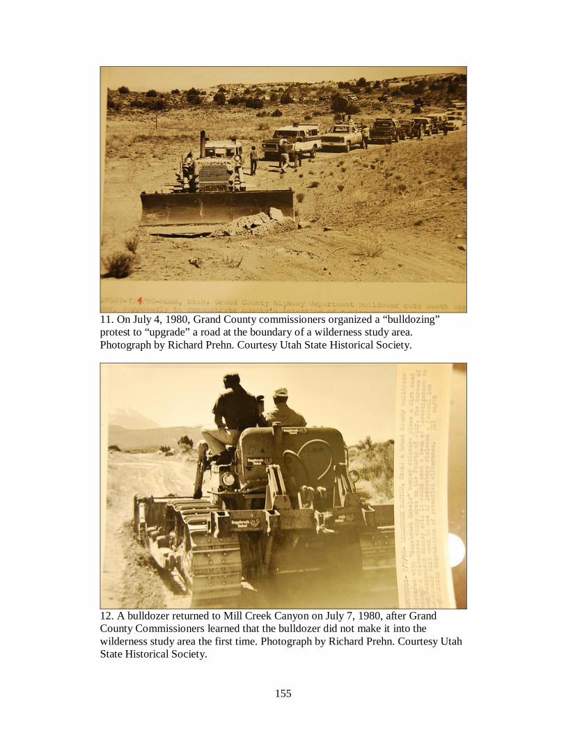
155
11. On July 4, 1980, Grand County commissioners organized a “bulldozing” protest to “upgrade” a road at the boundary of a wilderness study area. Photograph by Richard Prehn. Courtesy Utah State Historical Society.
12. A bulldozer returned to Mill Creek Canyon on July 7, 1980, after Grand County Commissioners learned that the bulldozer did not make it into the wilderness study area the first time. Photograph by Richard Prehn. Courtesy Utah State Historical Society.
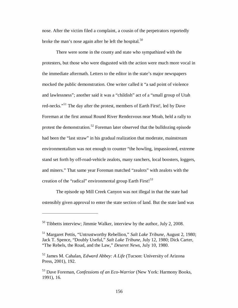
156
nose. After the victim filed a complaint, a cousin of the perpetrators reportedly
broke the man’s nose again after he left the hospital.50
There were some in the county and state who sympathized with the
protesters, but those who were disgusted with the action were much more vocal in
the immediate aftermath. Letters to the editor in the state’s major newspapers
mocked the public demonstration. One writer called it “a sad point of violence
and lawlessness”; another said it was a “childish” act of a “small group of Utah
red-necks.”51 The day after the protest, members of Earth First!, led by Dave
Foreman at the first annual Round River Rendezvous near Moab, held a rally to
protest the demonstration.52 Foreman later observed that the bulldozing episode
had been the “last straw” in his gradual realization that moderate, mainstream
environmentalism was not enough to counter “the howling, impassioned, extreme
stand set forth by off-road-vehicle zealots, many ranchers, local boosters, loggers,
and miners.” That same year Foreman matched “zealots” with zealots with the
creation of the “radical” environmental group Earth First!53
The episode up Mill Creek Canyon was not illegal in that the state had
ostensibly given approval to enter the state section of land. But the state land was
50 Tibbetts interview; Jimmie Walker, interview by the author, July 2, 2008. 51 Margaret Pettis, “Untrustworthy Rebellion,” Salt Lake Tribune, August 2, 1980; Jack T. Spence, “Doubly Useful,” Salt Lake Tribune, July 12, 1980; Dick Carter, “The Rebels, the Road, and the Law,” Deseret News, July 10, 1980. 52 James M. Cahalan, Edward Abbey: A Life (Tucson: University of Arizona Press, 2001), 192. 53 Dave Foreman, Confessions of an Eco-Warrior (New York: Harmony Books, 1991), 16.

157
inside the wilderness study area, and the BLM in charge of the wilderness review
had not given the county right of way. The commissioners maintained that the
county owned the road and many others by authority of R.S. 2477. But Tibbetts
and others certainly were not ignorant of the real legal challenges. Before the
protest, Utah’s assistant attorney general Richard L Dewsnup made clear that the
attorney general’s office would not become involved in the protest, nor would it
legally defend those who did if the United States filed a lawsuit. To him, although
sympathetic to its proposed aims, the protest was nothing more than “a local
reaction to local frustrations.”54
Ronald L. Rencher, United States Attorney, District of Utah, called the
action of July 4 “intentional, deliberate, and in violation of the laws of the United
States,” and demanded that the county commission restore the area, within ten
days, to the condition it was “prior to July 4, 1980.” If they failed to comply, then
the restoration would occur anyway, and Grand County would be charged with
the bill, or the expenses would be deducted from federal funds coming into the
county. Aldine J. Coffman, Jr., considered it amusing that the county had been
ordered to restore the area to its pre-July 1980 condition. He sarcastically replied
to Rencher that “prior to July 4, 1980, the road was a road. . . . Demand that the
road be restored to a road is really a concurrence with the acts of maintenance
conducted by the Grand County Commission.”55 Records do not state what
54 Richard L. Dewsnup to Ron Steele, June 27, 1980, Folder 12, Box 15, Series 19161, Governor Matheson Natural Resources Working Files, Utah State Archives and Records Service, Salt Lake City, Utah.
158
eventually became of the exchange, but in the end the county commissioners
probably got the better of the situation. By the end of the year, at the behest of
BLM Director Frank Gregg to investigate BLM’s Moab office, more than half of
the units in the Moab area including the Negro Bill Canyon WSA were deleted
from the intensive wilderness review.56
٭٭٭
The decision to eliminate these potential wilderness areas was made in November
at the end of the intensive inventory. The decision devastated wilderness
proponents. Of the over five million roadless acres reviewed, the BLM identified
only 1.9 million acres that they felt met the wilderness criteria, which together
with Instant Study Areas (ISAs, which automatically qualified for wilderness
study because of their pre-FLPMA status as Primitive or Outstanding Natural
Areas) and previously identified WSAs raised the total roadless acres considered
suitable for wilderness to 2.46 million.57
Negro Bill had been dropped from the final inventory based on the
rationale that “the remaining natural area in this unit is less than 5,000 acres and
the pattern of non-Federal lands adversely affects opportunities for solitude and
primitive and unconfined recreation.” The BLM also announced that it would
55 Rencher to Grand County Commissioners, July 22, 1980; Aldine J. Coffman, Jr., to Rencher, July 30, 1980; both documents in Grand County Commission Minutes, August 4, 1980, copies at Grand County offices, Moab, Utah. 56 Grand County Commission Minutes, August 4, 1980, copies at Grand County offices, Moab, Utah. 57 Doug Goodman and Daniel McCool, eds., Contested Landscape: The Politics of Wilderness in Utah and the West (Salt Lake City: University of Utah Press, 1999), 44-45.

159
drop the original lawsuit related to the illegal removal of barricades at the mouth
of the canyon in August 1979. In a memorandum outlining the agreement “to
preserve the beauty of Negro Bill Canyon and at the same time make it available
for public use,” the county agreed to remove the road up the canyon from the
Class D system. The BLM in turn would maintain the one-fourth-mile section of
road and permit the county to construct a parking and picnic area at its head. The
agreement gave the county what it wanted—road access to the canyon and its
elimination from wilderness consideration—while still retaining federal oversight
over motorized use of the canyon.58
The county commissioners and their allies had clearly influenced the
process of wilderness designation in Grand County. When the BLM had initiated
the wilderness inventory, the process was almost immediately greeted with
outcry, derision, and civil disobedience by the wilderness opponents and county
commissioners. Through the process, a BLM staffer quit over how the inventory
was being carried out, the District Manager S. Gene Day was transferred at the
behest of the anti-wilderness crowd, and the BLM published an inventory that
seemed designed to satisfy wilderness opponents. The lessons learned from this
trajectory by the opponents and proponents of wilderness were important: it
reinforced a local tradition of radical dissent on both sides. Locals opposed to
wilderness saw that emotional outbursts and threats and uncompromising
58 IBLA, Sierra Club, Statement of Reasons, 7; “BLM Settles Negro Bill Canyon Feud,” Cedar City Spectrum, December 2, 1980; Memorandum of Understanding between Grand County and the BLM, November 24, 1980, Folder 4, Box 11, Series III, Sierra Club Papers.

160
demands got the desired response from the federal government. They could and
did cow the BLM into submission. The environmentalists in turn learned that
reasonable participation in the inventory process was futile as the agency
recommendations were deeply skewed by local intimidation from anti-wilderness
forces. The BLM wilderness inventory was one factor that “radicalized”
environmental debates in Utah.
Wilderness proponents did not take the deletions to the wilderness
inventory lying down though. Several environmental organizations led by the
Utah Wilderness Association banded together to file an appeal to the Interior
Department’s Board of Land Appeals (IBLA), alleging deep flaws in the BLM’s
inventory process. The 1,400-page appeal—the largest wilderness appeal ever
filed before the IBLA59—disputed BLM decisions on 925,000 acres in twenty-
nine units. This complaint against exclusion of the Negro Bill Canyon WSA, led
by the Utah Chapter of the Sierra Club, was a compendium of how the BLM had
failed in compliance with FLPMA and wilderness review policy. In the initial and
intensive reviews the BLM shaved off areas “completely natural and other areas
with imprints that are substantially unnoticeable.” The environmental plaintiffs
charged that the BLM improperly deleted from the inventory large areas of
roadless lands meeting wilderness criteria and modified the inventory record to
support their decision to delete the unit. The statement submitted to the IBLA
suggested these violations were intentional. BLM Moab District Manager Gene
59 Dick Carter, “Defending the Desert,” Speech at the Utah Wilderness Association Annual Rendezvous, Salt Lake City, Utah, April 27, 1985, Folder 11, Box 7, Utah Wilderness Association Collection.

161
Day had been quoted by a staffer as stating, “When in doubt, throw it out and give
the public and private interests a chance to promote its inclusion.”60
The criticism of the review process was no small matter. The appeal not
merely protested the exclusion of individual units but pointed to chronic structural
problems that could possibly disqualify the review. BLM had made efforts to
review potential wilderness areas as openly as possible. Yet the process was
heavily derided by critics on both sides of the debate. If those against wilderness
designation had expressed their frustration and anger during the process, pro-
wilderness groups felt betrayed with the release of the intensive review. The
WSAs remaining on the map dated November 1980 were mere remnants of
larger, contiguous roadless areas proposed in April 1979.
Environmentalists got a boost for their appeal in subsequent federal
oversight hearings on the BLM wilderness review process when the House
Subcommittee on Public Lands and National Parks concluded that two million
acres of rejected roadless lands ought to be reconsidered. Outspoken critics like
Congressman John Seiberling of Ohio accused the BLM of intentionally
excluding roadless areas with purported mineral value, although this could not be
definitively established. The Interior Department responded that “the inventory in
Utah was as accurate and consistent as possible,” yet, as has been shown, the
BLM inventory at least in the Moab district had been repeatedly manipulated by
60 IBLA, Sierra Club, Statement of Reasons, 8-9.

162
political pressure from locals waving the Sagebrush Rebellion banner opposed to
wilderness designation.61
Again bolstering the environmentalist’s position, a Department of the
Interior solicitor upheld the Sierra Club’s complaint that in the case of the Negro
Bill Canyon WSA, the BLM had failed to follow wilderness review policy,
wrongly altered the record without proper documentation, and incorrectly
assessed the area’s solitude and recreation potential. Consequently, the IBLA
directed the BLM in a decision dated March 15, 1982, to reconsider areas with
potential wilderness characteristics. The decision sent BLM back to the drawing
board. The same person who made the initial field report at Negro Bill—Diana
Webb—returned to the area to comply with the court decision. Unlike its previous
review, this time the BLM used roads as the boundaries for the wilderness study
area. To resolve the problem of access to state land sections, the BLM now
proposed “cherry stemming” a road by closing a narrow portion of land on the
northern portion of the unit that connected state land and the unit boundary. The
BLM did include in the unit a mineral exploration road that it claimed was
essentially unnoticeable and did not affect the naturalness of the area.62 S. Gene
Day defended the decision to allow certain roads to be constructed within
61 Goodman and McCool, eds., Contested Landscape, 46-47. 62 Supplemental Wilderness Inventory, UT-060-138, Negro Bill Canyon, May 4, 1982, files in the BLM office in Moab, Utah; “Final Wilderness Inventory Decision on Negro Bill Canyon,” September 1, 1982, signed by State Director Roland G. Robison, Series 8, Public Policy (Conservation) Department – Bureau of Land Management, CONS 130, Wilderness Society Records, Denver Public Library.

163
wilderness study in order to enable prospectors to access their legitimate claims.
As he wrote Katherine P. Kitchell of the Slickrock Country Council, “We assure
you that the BLM will uphold its responsibility for protection of N[egro] B[ill]
C[anyon], as you suggest. In some cases, however, a flat denial of road grading
would be irresponsible and contrary to law.” For that reason, he explained, the
federal government did not pursue legal action against Grand County over the
bulldozing incident.63
James Catlin of the Utah Chapter of the Sierra Club responded to Diana
Webb’s inventory by contesting its assessment of roads on the bench lands. The
Porcupine Rim Trail forming the proposed eastern boundary of the unit, he
argued, received infrequent travel and was difficult to see as it wound up and over
rocks. And the old mail trail to Miner’s Basin had a cover of regrowth. Catlin
maintained that the cherry-stemmed seismograph routes and the “constructed
access routes” defining the northern recommended boundary were insignificant
and hardly qualifying as roads at all. Therefore, he proposed extending the unit
north to encompass Drinks Canyon. Thus, he argued that although the upper
bench lands were not as well vegetated as the canyon and possessed a few road
scars, they ought not to be disqualified from wilderness consideration. In some
ways, they presented superb wilderness qualities with their amazing vistas—the
63 S. Gene Day, BLM District Manager, to Katherine P. Kitchell, Slickrock Country Council, July 1982, Folder 21, Box 17, Series 8, Wilderness Society Records.

164
view of Arches National Park to the north, Manti-La Sal Mountains to the east,
and deep canyons of the Colorado to the west.64
While the high bench routes were debated, the crux of the court suit
centered on the road up the canyon. The post-IBLA decision summary evaluation
noted that “about ½ mile of the road existed pre-FLPMA.” There seems to have
been some question about the road’s length; Catlin pointed to a statement from
acting BLM manager C. Delano Backus that sometime “between 1935 and 1966”
a road one-quarter-mile long had been constructed but was closed due to traffic
concerns on Highway 128. “The road was abandoned and allowed to revegetate.
There does not appear to have been any maintenance work done after this period.”
Not until Shumway reopened the road in 1978 was the route again accessed.
Catline thus contended that because it had been constructed illegally after
FLPMA, the road did not qualify under R.S. 2477 and in no way impeded
wilderness designation of the canyon.65
In July 1982, the BLM once again reversed its decision at Negro Bill
Canyon and reinstated the WSA at the size of 7,620 acres. While the BLM
recognized that a portion of the unit possessed wilderness characteristics, it did
not agree that roads on northern boundaries were unnoticeable or sufficiently
unused. The proposed WSA excluded some seismographic route on the upper
bench lands and cherry-stemmed the road up the canyon on the grounds that since
64 James Catlin, Conservation Chairman, Utah Chapter of the Sierra Club, to Roland Robinson, Utah State Director, BLM, June 16, 1982, on file in BLM field office, Moab, Utah. 65 Ibid.
165
the mining claims had been staked and accessed prior to passage of FLPMA, “the
claimant has the right by law to construct roads to these claims and drill on
them.”66 Nevertheless, pro-wilderness groups were pleased to get the unit
reinstated. “It was a victory—a small one—for us, in that it reversed the BLM’s
earlier stand to throw out the entire area,” said Rob Smith of the Sierra Club and
the Wilderness Society in Salt Lake City.67
The court decision left some of the original players to consider taking
action once more at Negro Bill Canyon. Ray Tibbetts mulled over staging another
protest; D. H. Shields wanted to drill a uranium hole in the canyon in the fall.68
The issue, however, was one for the courts. The Red Rock 4-Wheelers Club of
Moab stepped up to appeal the reinstatement of the WSA.69 For another half a
year the Sierra Club and the Red Rock 4-Wheelers Club led by George Schultz
(who also worked for the Cotter Company, a uranium mining business, and who,
ironically, was married to the BLM’s wilderness coordinator in the Moab District,
Laura Webb) continued to contest wilderness designation in Negro Bill Canyon.
On January 10, 1983, the Utah Chapter of the Sierra Club filed a petition to block
the appeal of the Red Rock 4-Wheelers. The IBLA eventually affirmed the
66 Intervenor’s Response, IBLA 83-99. 67 Quoted in “Negro Bill Battle Reheats,” Deseret News, September 22, 1982. 68 Jim Woolf, “Negro Bill Canyon Battle Brewing Again,” Salt Lake Tribune, June 7, 1982; Lynn Jackson, memorandum, September 3, 1982, on file in BLM field office, Moab, Utah. 69 “BLM Utah News Digest,” November 5, 1982, on file in BLM field office, Moab, Utah.

166
BLM’s decision to classify the unit as a WSA but not to bring the deleted 1,800
acres back into the unit.70 Later in the year, the Utah BLM made its final decision
by designating 538,000 acres (12 units) as WSAs, of which the Negro Bill
Canyon unit was a part.71
The victory that the wilderness proponents scored in court is part of a
seemingly endless debate and fight for wilderness designation in Utah’s BLM
wild lands. Wilderness designation remains an open question. In 1991 the state of
Utah submitted the Utah State Wilderness Study Report recommending
wilderness designation on BLM lands, but congress never acted on these or any
other proposals to designate BLM wilderness on a large scale in Utah. The Moab
Field Office, which is part of the Canyon Country District, contains
approximately 1.8 million acres, of which approximately 355,000 acres are
WSAs, and another 5000 acres are designated wilderness.72 The WSAs are
presently managed to preserve and protect their wilderness characteristics. At
Negro Bill Canyon, that means the old road up the canyon has been closed to
motorized vehicles and nearly reclaimed by nature.
70 Ruling by the Interior Board of Land Appeals, IBLA 83-99, Answer of the Bureau of Land Management to Appellant’s Statement of Reasons. February 10, 1983, in Folder 21, Box 17, Series 8, Wilderness Society Records. 71 Scoping the Utah Statewide Wilderness EIS: Public Scoping Issues and Alternatives, [July 20, 1984], 27; Rock Pring to Utah BLM Wilderness Inventory Appellants, April 16, 1985, Folder 9, Box 2, Utah Wilderness Association Collection. 72 For information from the Utah State Wilderness Study Report (1991), see http://www.blm.gov/ut/st/en/prog/blm_special_areas/wilderness_study_areas/ut_wilderness_study.html (January 22, 2011). The present size of the Negro Bill Canyon WSA is 7,560 acres.

167
٭٭٭
The Wilderness Act seems to have provided a clear and unambiguous definition
when it stated that wilderness was “an area of undeveloped Federal land retaining
its primeval character and influence, without permanent improvements or human
habitation” and as “an area where the earth and its community of life are
untrammeled by man.” The idea of identifying permanent human markings was
important to determine whether a place had wilderness characteristics deserving
of protection. Opponents of wilderness used the criteria for roadlessness and the
absence of permanent human intrusions to their advantage by pointing to
numerous earlier uses of human habitation, grazing, mining, and recreation. At
Negro Bill Canyon the tactic was to point to the deep human history and their
lingering imprints on the land and, if need be, create new imprints so there would
be no question of the area’s unsuitability for wilderness designation. Roads
specifically became the very means by which opponents battled wilderness
designation in the area. Ken Sleight once accused Calvin Black of building roads
“just so they couldn’t designate wilderness in those areas.”73 The presence of a
road, to them, signaled that the area, in fact, ought to be used for human purposes.
Roads became veritable symbols that confirmed one’s association with and
entitlement to the land.
The protests and violent rhetoric caught Utah BLM personnel off guard. It
seems they did not anticipate just how heated the debate over wilderness would
become. BLM official Arnold Petty curiously stated in June 1979 that, “A
73 Sleight, interview by the author.
168
thorough and professional inventory process should insure that there will be no
valid basis for questioning the inventory results.”74 He could not have been more
wrong. Defining wilderness characteristics is not straightforward or clear cut as
Petty and others apparently believed. It is, rather, a subjective process of “seeing”
on the land what people want to see. Permanent markings are to others temporary,
and vice versa. What was wild and natural to some was domesticated to others. It
is in part this subjectivity, I suggest, that makes designation so highly debated and
controversial. Setting aside areas for wilderness consideration is not merely a
matter of locating clearly demarcated natural areas and calling it wilderness. It is
rather a process that integrates the culture, biases, and perceptions of the people
who create them, manage them, and recreate on them.
What is interesting is that the BLM wilderness review process, perhaps in
contrast to the RARE reviews, was set up at least tacitly to acknowledge the
ambiguities of designating wilderness areas and the inherent problems of
assessing their qualities. The BLM employed a flexible definition of wilderness in
part because it is nearly impossible to find pristine land completely untouched by
humans, but also because it subscribed to the view that eliminating permanent
human impacts on the land is neither entirely possible nor desirable, a point
suggested by the Wilderness Act and FLPMA directing the wilderness reviews. In
the first place, human markings are often temporary and may over time be
reclaimed to nature. In Negro Bill Canyon the road that was once so clearly
visible can hardly be seen at all. What this suggests is that those who so
74 Goodman and McCool, eds., Contested Landscape, 41.
169
vociferously insisted that the road was a permanent fixture were wrong; it was no
more permanent than any of the other “natural” features of the canyon like the
vegetation, wildlife, or course of the stream. Nature is constantly changing;
nothing is truly permanent on the land.
This does not mean that human imprints cannot have a long lasting
presence on the land. In the court case over wilderness designation at Negro Bill
Canyon, the anti-wilderness contingent repeatedly pointed out those places where
human imprints still remained after many years. In a Statement of Reasons
protesting designation of the WSA in Negro Bill Canyon, the Red Rock 4-
Wheelers noted: “The road is a physical thing. It can be seen, felt, and
photographed. It exists upon the face of the earth. It is reality.” And especially on
the dry bench lands above the canyon, road scars remain for many years.75 Still, if
left alone, even they will eventually disappear from sight. The question that some
land managers face is what to do with the old cabin, mining pit, or road in a
wilderness area. Let them turn to mulch or become overgrown by vegetation, or
remove them or otherwise mitigate their impact to make the area more compatible
with wilderness?
But the case could also be made that lingering scars notwithstanding,
human impacts like roads do not damage the ecological condition of wilderness or
in some way render it useless as a place of renewal. Roderick Nash has argued
75 U.S. Department of the Interior, Office of Hearings and Appeals, Interior Board of Land Appeals, In Re BLM Decision to Identify 7,620 acres as a WSA in Unit UT-060-138, Statement of Reasons, IBLA 83-99, filed by Red Rock 4-Wheelers, written January 4, 1983.

170
that how the wilderness area is used by modern humans threatens the wilderness
quality of an area more than the mere presence of a road, mine, or dam.76 In fact,
wilderness proponents sometimes argued that existing human imprints in
wilderness may be something not to be erased from the landscape but a worthy
feature of it. George Wuerthner of the Montana Wilderness Alliance, in keeping
with a bioregional approach to wilderness designation, proposed creating
wilderness areas that encompassed not only mountain peaks but low-lying valley
areas as well. To get around the problem of roads that “bisect otherwise roadless
country,” he proposed closing these roads to motorized traffic and allowing them
to “remain open for horse drawn wagons.” This would help satisfy wilderness
opponents who say that wilderness discriminates against people who cannot walk
or otherwise enjoy wilderness without the aid of a motorized vehicle. When
potential wilderness areas contain private inholdings like ranches, Wuerthner
proposed turning these places into dude ranches that could be used by wilderness
“explorers.” These “wagon wilderness” areas, as Wuerthner called them, would
“alter the view of many people that wild places are only for the young and fit.”
Roads, then, would serve wilderness rather than merely be a case against it.77
To conceive of a road—or what used to be a road but is now a “trail” or
wagon route—may be hard for some wilderness proponents to conceive. Roads,
after all, have become powerful cultural symbols as facilitators of “progress” and
exploitation, the dichotomous divisions that so often emerge in environmental
76 Nash, Wilderness and the American Mind, 264. 77 George Wuerthner, “Wagon Wilderness,” Earth First!, March 20, 1986, 21.

171
battles. Defining wilderness as roadless was essentially a means to keep vehicles
(and thus development) outside of these special areas. Further, while certain
human impacts on the land may not physically threaten the wildness of an area,
they may invade the spirit of wilderness. The idea to keep man-made objects out
of nature is more to satisfy some human desire or need than to protect ecological
systems or keep the land undefiled. It serves as a reminder, in the words of
Edward Abbey, “that out there is a different world, older and greater and deeper
by far than ours, a world which surrounds and sustains the little world of men as
sea and sky surround and sustain a ship.”78 It is the sense that human “intrusions”
in wilderness areas distract the mind from the idea that nature exists totally
separate and independent of human beings.
Nevertheless, even the seemingly demarcated wilderness presents
opportunities to explore humanity’s place in nature. “There are among
environmentalists a sentimental fringe, people who respond … with blind
preservationism in all circumstances,” wrote Wallace Stegner on the place of
human beings in wilderness. “But you can’t do that. You manifestly can’t go that
far, though it would be nice, visually and in other ways; people do have to live
too. Some kind of compromise has to be made.” His essay, a history of Dinosaur,
referred to the monument as “almost unspoiled” and only “relatively unmarked.”
The area could best be seen as “a palimpsest of human history, speculation,
rumor, fantasy, ambition, science, controversy, and conflicting plans for use.” To
78 Edward Abbey, Desert Solitaire: A Season in the Wilderness (New York: Ballantine Books, 1971; originally published in 1968), 45.

172
him, the human “marks” belonged on the landscape; the Anasazi petroglyphs,
Spanish carvings on a huge cottonwood, William Henry Ashley’s name on a rock,
etc.—which he referred to as “marks of human passage.”79
Stegner is apt to quote on the meaning of human marks on the land, since
in the debates over the original passage of the Wilderness Act in 1964 he was an
eloquent spokesperson for designating areas that had been “wounded” by the
works of men. In his famous 1960 letter explaining the need for wilderness,
Wallace Stegner argued that even if the land had been “deflowered,” that did not
mean that it might as well be “harvested.” The western deserts had been “scarred
somewhat by prospectors,” he wrote. “In that desert climate the dozer and jeep
tracks will not soon melt back into the earth, but the country has a way of making
the scars insignificant.” To Stegner it did not matter that the marks of humans
remained on the land. In arguing for wilderness, he appropriated the argument
sometimes attributed to locals opposed to wilderness: that the land is large enough
to absorb the human footprint. How would the track of an off-road vehicle or the
tailing of a mine despoil a place as vast as the deserts of southern Utah? Stegner
concurred, but he meant something different. To him, these “wounds,” as he
called them, do not destroy the central essence or character of these places, but
neither ought they to continue. The damage was a matter of degree. In 1960, the
land had been merely wounded.80
79 Wallace Stegner, “The Marks of Human Passage,” in This Is Dinosaur: Echo Park Country and Its Magic Rivers, ed. Wallace Stegner (Boulder, Colorado: Roberts Rinehard, 1985; first published in New York: Knopf, 1955).
173
Writing the introduction to a republication of his letter 20 years after it
was written, Stegner gives the sense that the “wounds” on the land, as he
originally called them, have become more severe, lasting. Whereas before he
pointed to the lingering jeep tracks or mine pits, he pointed to the clear vistas and
virtually untouched landscape. Now, he wrote in 1980, “It is in danger of being
made—of helping to make itself—into a sacrifice area. Its air is already less clear,
its distances less sharp. Its water table, if these mines and plants and pipelines are
created, will sink out of sight, its springs will dry up, its streams will shrink and
go intermittent. But there will be more blazing illumination along the Las Vegas
Strip, and the little Mormon towns of Wayne and Garfield and Kane Counties will
acquire some interesting modern problems.” In 1980, he writes, “We are 20 years
closer to showdown,” living with urgency to see the acres still waiting to be
protected. Writing as the BLM wilderness process heated up, he reflected on the
need to designate deserts and dry-grasslands areas as wilderness. Although the
Wilderness Act of 1964 did not start the BLM wilderness process, Stegner “spoke
with some feeling about the deserts of southern Utah,” recognizing that these
areas deserved protection too. These desert places were in danger of being
despoiled, he wrote, and the biggest threat was a possible state and private
takeover of the federal lands under the banner of the Sagebrush Rebellion.81
80 Wallace Stegner’s Wilderness Letter, written to the Outdoor Recreation Resources Review Commission, December 3, 1960, at http://wilderness.org/content/wilderness-letter (March 14, 2011). 81 Wallace Stegner, “The Geography of Hope,” Living Wilderness 44 (December 1980), 12-17.
174
As the Negro Bill Canyon episode suggests, wilderness supporters and the
wilderness opposition are locked in an endless debate over the existence and
nature of vehicle routes and other human imprints on wilderness and potential
wilderness lands. The telling thing about these debates is that while the original
statutory justification for wilderness prohibits certain human developments like
roads in wilderness areas, congress had already specifically rejected the erroneous
notion that only “pristine” lands would be considered for wilderness designation.
Thus, debating over whether there are road scars or an old cabin or mine tailings
in areas being considered for wilderness designation actually masks the central
issue of which of the remaining roadless areas on public lands we will leave in a
more or less wild and natural state and which ones we will leave available for
development. Ironically, those who want the maximum amount of land open to
development argue most vociferously for the incompatibility of wilderness
wherever there is any visible human imprint on the land. They insist that humans
and wilderness are absolutely distinct and incompatible, while on the other end of
the spectrum wilderness proponents generally embrace the historic human
presence as compatible with wilderness preservation.
This would suggest that the idea of wilderness does not promote and
enforce the human/nature dualism as argued by historian William Cronon in his
controversial article, “The Trouble with Wilderness, or, Getting Back to the
Wrong Nature.” Cronon critiques the idea of distinguishing between wild, pristine
wilderness areas and domesticated, worked, inhabited areas. By treating nature
and culture as separate categories, he says, the modern wilderness movement

175
creates “a dualistic vision in which the human is entirely outside the natural” and
does not reflect the right way to live in the world.82 Rather, just the opposite—the
anti-wilderness crowd often makes that argument, insisting that wilderness by
definition means out-of-the-way places largely untouched (and inaccessible) by
humans. Ironically, wilderness opponents sometimes deride environmental
romanticism, saying wilderness enthusiasts don’t embrace people in nature. This
is not to say that environmentalists do not sometimes see the need to advocate for
distinct geographic boundaries and characteristics. Wilderness advocates argue
that boundaries are needed to protect areas from what Doug Scott calls
development “nibbl[ing] away at wild places in an insatiable, creeping process
fatal to wilderness.”83 Indeed, breaking down the clear demarcation between
“untrammeled” wilderness and human landscapes leaves room for developers to
further justify their activities on the land. But these advocates have not advanced
the position that wilderness reflects a wide divide between nature and culture.84
The central issue is not about legal definitions and ideological posturing; it
is about what we allow ourselves to do on land that is “publicly owned” and
therefore subject to democratic processes of decision making. Where do we give
free rein to our acquisitive desires and when do we restrain ourselves? In Negro
82 William Cronon, “The Trouble with Wilderness; or, Getting Back to the Wrong Nature,” in Uncommon Ground: Toward Reinventing Nature (New York: Norton, 1995), 69-90. 83 Scott, The Enduring Wilderness, 15. 84 See J. R. McNeill, “Observations on the Nature and Culture of Environmental History,” Theory and History 42, No. 4, Theme Issue 42: Environment and History (December 2003), 34.

176
Bill Canyon, where some road scars are still visible on the land, the question
remains: Do we permanently designate it—and other areas like it—wilderness,
off-limits to motorized vehicles? That debate over which places ought to be off
limits to motorized vehicles and which places ought to be opened not only to
vehicles but to development will always be with us. It is a legitimate debate that
we should all take part, but the petty question of whether jeep marks, mine holes,
old cabins, or cows ought not to confuse the issue. Perhaps for this reason, Negro
Bill Canyon is instructive: a reminder that wilderness has been and ought to be
considered in places close to home that bear the human imprint.

177
CHAPTER 5
POLITICS AND POSTURING ON THE BURR TRAIL
Aside from wilderness, perhaps no environmental issue aroused more ire and
contention in the canyon country over the last generation than the debate over the
Burr Trail, a 66-mile dirt road connecting the tiny town of Boulder with the
Bullfrog Marina on Lake Powell. As at Negro Bill Canyon, the issue revolved
around the question of the county’s claim to the road. How the federal courts and
the Interior department sorted out these issues established precedence for modern-
day R.S. 2477 claims. Through these legal battles and the rise of environmental
activism to “save” the canyon country from despoliation, the conflict emerged on
the national scene. The road itself—half paved, half dirt—bears the scars of the
debate.
Upon first glance, the issue at stake seems to be about two rigid positions,
the one insistent on having a paved road, the other just as determined to keep the
trail (and the surrounding region) as primitive as possible. Environmentalists
were, justifiably perhaps, concerned about the direct and indirect environmental
impacts of a paved road. Indeed, the route would have to be widened and
straightened in sections, which would potentially affect the surrounding landscape
and the aesthetic sensibilities of it. The central issue, though, went beyond the
direct environmental degradation to the intrusion that a well-traveled road would
bring in a mostly unsettled region. The road became a powerful symbol for the
binary categories of progress and exploitation. Interestingly, these notions came to

178
signify a power struggle that turned a rather local road-building story into a
national discussion of environmental activism, local governance, and
development in Utah’s canyon country. In broad strokes, the Burr Trail saga is not
about the Burr Trail at all—it is about perceiving, remembering, using, and
contesting place. In this case, the conflict thrust into the public sphere a place that
was, ironically, among the most isolated in the country, dotted by a few tiny,
mostly Mormon towns.
٭٭٭
The town of Boulder is situated squarely within the Escalante River Basin. The
region is now well known for the maze of sandstone canyons drained by the
Escalante River and its tributaries, although it is a diverse topography that
includes a multi-layered collection of canyons, high elevation mountains, forested
plateaus, and desert expanses. The Boulder, Escalante, and Henry Mountains
loom along the outer edges of the basin. To the west and the south, the land
descends into dry, desert country—broken and uneven, sculpted over millions of
years by wind and water which has created a labyrinth of swaths in the sandstone.
Franklin B. Woolley described the scene in 1866 at a magnificent perch at Bowns
Point on the Aquarius Plateau. “Stretching away as far as the Eye can see a naked
barren plain of red and white Sandstone crossed in all directions by innumerable
gorges,” he wrote. “Occasional high buttes rising above the general level, the
country gradually rising up to the ridges marking the ‘breakers’ or rocky bluffs of
the larger streams. The Sun shining down on this vast red plain almost dazzled

179
our eyes by the reflection as it was thrown back from the fiery surface.”1 To
Woolley, the stark contrasts of color and form presented a spectacle perhaps
unlike any other.
Although the combination of high mountain terrain and rough canyon
gorges make this one of the most isolated regions in the lower 48 states, evidence
of ancient human habitation abounds. Over centuries, people have passed through,
and some have made it home. In the first millennia, the Escalante region was part
of a larger cultural site inhabited by Archaic, Anasazi, Fremont, and Numic
peoples. The town of Boulder at the Burr Trail’s western terminus overlays a
large Kayenta Anasazi village abandoned circa 1275 C.E.; an early Mormon
settler, Amasa Lyman, extended an ancient ditch to divert water for irrigation.2
Evidence of indigenous habitation are scattered elsewhere throughout the region,
sometimes in what seems the most unlikely places—in deep canyon gorges or on
lonely mesa tops. One wonders whether these peoples felt as isolated and
disconnected as the Euro American visitors and settlers who came later came.3
Not until the late nineteenth century did Euro-Americans settle the region,
no doubt partly due to the region’s inaccessibility but also perhaps to the negative
reports of its suitability for agriculture. In his 1879 Report on the Lands of the
1 Quoted in Frederick H. Swanson, Dave Rust: A Life in the Canyons (Salt Lake City: University of Utah Press, 2007), 167. 2 Linda King Newell and Vivian Linford Talbot, A History of Garfield County, Utah Centennial County History Series (Utah State Historical Society/Garfield County Commission, 1998), 183. 3 “Current Research,” American Antiquity, Vol. 56, No. 4 (October 1991), 729.

180
Arid Region of the United States, with a More Detailed Account of the Lands of
Utah, John Wesley Powell had warned of the limitations of irrigated agriculture in
the West, especially in the high plateau region like the Escalante. In Utah, he
wrote, “agriculture is there dependent upon irrigation. Only a small part of the
territory, however, can be redeemed, as high, rugged mountains and elevated
plateaus occupy much of its area.” In southeastern Utah especially, the
topography of the land is poorly suited for irrigated agriculture. “The Colorado
River runs through the southeastern portion of the Territory and carries a great
volume of water,” he observed, “but no portion of it can be utilized within the
Territory from the fact that its channel is so much below the adjacent lands.”4 The
terrain better suited timber cutting and grazing than irrigated agriculture. Yet
Mormon settlers seemed intent on proving Powell wrong. They made the agrarian
model of orderly town sites and farms to work relatively well in the Fremont and
Sevier River valleys. Even the town of Escalante in the Potato Valley followed
the typical Mormon farm village plat. Powell had been correct that the land was
limiting—farmers even in well-watered valleys in south-central Utah contended
with short growing seasons, harsh winters, and low value crops like grains and
forage—but the typical Mormon farm village model worked well enough.
4 John Wesley Powell, Report on the Lands of the Arid Regions of the United States, 2nd ed. (Washington, D.C.: Government Printing Office, 1879), 6-7. See chapters by Powell, “The Lands of Utah,” 93-112; Clarence Dutton, “Irrigable Lands of the Valley of the Sevier River,” 128-49; and A. H. Thompson, “Irrigable Lands of That Portion of Utah Drained by the Colorado River and its Tributaries,” 150-64.

181
Boulder’s pedigree was different in that it acquired a dependence on cattle
ranching. Motivated by the lure of new land for their herds, ranchers expanded
their control over public rangelands and established homesteads at the base of
Boulder Mountain in the 1880s. The first settlers and the generations that
followed encountered the hardships of living in a rough, isolated place. The
settlers diverted water from Boulder and Salt creeks, although the climate and
terrain were certainly not ideal for agriculture. Whatever they consumed had to be
homegrown or produced locally. One difficulty of living in Boulder stemmed
from the lack of good roads. In fact, Boulder was one of the last communities in
the United States to gain automobile access. The town’s main road to Escalante
was not built until 1935, and not fully paved until 1971.5
Interestingly, in a region where mobility is limited, Boulder residents
traditionally relied on an economic practice that is, in fact, highly mobile.
Ranchers depend on a large land base for grazing and on the capability of moving
cattle from one place to another. Even today this is accomplished by horse over
rough terrain, but ranchers still require good trails. This suggests the origins of the
Burr Trail. What the locals call the “low” country or “winter range” to the east of
Boulder all the way to the river is desert country—the change from mountain to
desert is almost instantaneous. Every year at the end of summer ranchers drove
their cattle east to the lower, warmer grasslands. The trek was no gently sloping
journey. Like steps, the trail dropped from one area to the next—from the upper
step of white and red rock and sandy soil to a flat plateau in the shadow of the
5 See Newell and Talbot, A History of Garfield County, 181-191, 302-303.
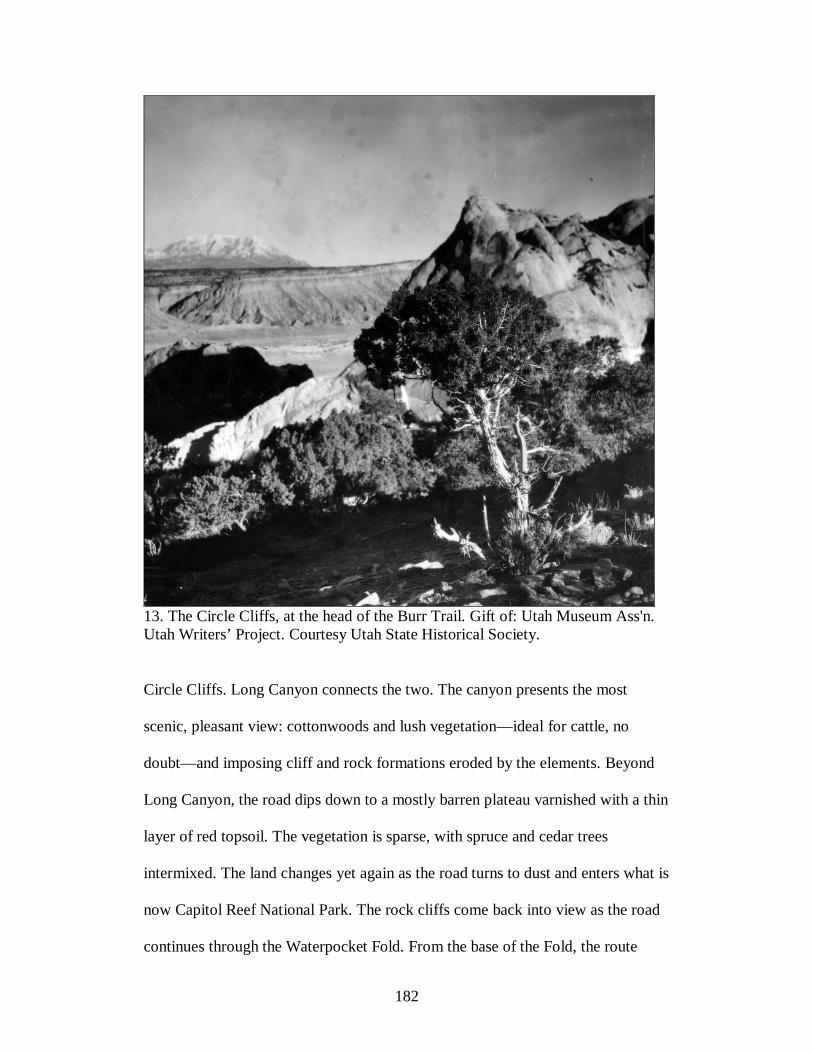
182
13. The Circle Cliffs, at the head of the Burr Trail. Gift of: Utah Museum Ass'n. Utah Writers’ Project. Courtesy Utah State Historical Society.
Circle Cliffs. Long Canyon connects the two. The canyon presents the most
scenic, pleasant view: cottonwoods and lush vegetation—ideal for cattle, no
doubt—and imposing cliff and rock formations eroded by the elements. Beyond
Long Canyon, the road dips down to a mostly barren plateau varnished with a thin
layer of red topsoil. The vegetation is sparse, with spruce and cedar trees
intermixed. The land changes yet again as the road turns to dust and enters what is
now Capitol Reef National Park. The rock cliffs come back into view as the road
continues through the Waterpocket Fold. From the base of the Fold, the route
183
turns south and essentially follows the wash. But it is not easy going; at one half-
mile stretch the road crosses the creek no fewer than six times, making the route
impassable during periods of high flood. Further on, the road follows Middle
Point, descends and crosses Bullfrog Creek, and eventually continues on to
Bullfrog Marina, although ranchers would never have taken their cattle that far.
Josephine Catherine Chatterly Wood provides what is undoubtedly the
earliest description of the trail. “It is the most God-forsaken and wild looking
country that was ever traveled,” she wrote in her journal on October 30, 1882. “It
is mostly uphill and sandy knee and then sheets of solid rock for the poor animals
to pull over and slide down. I never saw the poor horses pull and paw as they
done today.”6 And over the next eighty-five years the trail remained famously
rough and primitive. On a wet day the soil turned to a deep clay mud, but even in
dry weather the sandy soil was not easily traversed. If the route proved difficult
for an animal to traverse, for a vehicle it was probably even more difficult, even
in dry conditions. Lincoln Lyman, a Boulder resident, noted that along a portion
of the route, the sand was “bad enough” that all motorists could do was to take a
run at the sand, back up, and try again. Eventually, the automobile made it by
“crawl[ing] up right out of there.”7
6 Quoted in Joseph M. Bauman, Jr., “The Burr Trail,” in Utah History Encyclopedia, ed. by Allan Kent Powell (Salt Lake City: University of Utah Press, 1994). 7 Lincoln Lyman, quote printed on a sign at the border of the Grand Staircase-Escalante National Monument on the Burr Trail.
184
The condition of the Burr Trail suggests many problems of ranching and
livestock management. This was rugged country with poor roads and scattered
populations. Rounding up cattle and herding them from mountains to ranches
taxed even the experienced cowhand. Cattle on the open range tend to scatter, and
with no fences or plots they cannot congregate. This made rescue efforts
problematic, and dropping hay in centralized locations was not an option. Roads
provided the only manageable way to save cattle from exposure. For instance,
when deep snows hit the range area southeast of Tropic in late January 1979, local
ranchers and the state cooperated in locating cattle by airplane and grading a road
using CAT tractors. Some cattle died of exposure, but rescue efforts saved nearly
a thousand cattle. In the Loa, Bicknell area, ranchers were not as fortunate. The
cattle were lost in the Henry Mountains, and while planes and bulldozers helped
ranchers locate five hundred head, some six hundred cattle remained missing.8
٭٭٭
The Burr Trail might have begun as a cow trail, but county officials had in mind a
much different purpose for it. The creation of Lake Powell and the Glen Canyon
National Recreation Area in 1972 convinced local boosters that they finally had
something to showcase, a destination that promised to attract thousands if not
millions of people to southeastern Utah. Lake Powell’s main marina at Hall’s
Crossing could be accessed by U-95 from the north or east. A paved Burr Trail
8 Kenneth Creer to Scott Matheson, February 14, 1979; Garfield County Commission to Governor Matheson, March 5, 1979; both documents on Reel 1, Series 19269, Governor Matheson County Records, Utah State Archives and Records Service, Salt Lake City, Utah.

185
would directly connect Garfield County to the marina from the west, as well as
induce tourists to drive through county towns. Not improving the Burr Trail
meant the county would miss out on business: instead most east-west traffic
would travel U-95.
Paved roads seemed central to unlocking the region’s wonders, market its
scenery, and attract tourists into the country. By mid-twentieth century, many
local boosters and state politicians believed that parks and the roads leading to
them would provide a significant economic boost to the economy of southern
Utah. Making this vision a reality would entail developments on a large scale. Just
as Cal Black envisioned development at Hall’s Crossing, similar-minded
businessmen and locals envisaged comparable pockets of expansion throughout
the region. The idea of the “Grand Circle” road network derived from this
perspective. Since the end of World War II road builders had been responsible for
shortening the drive into this country. The design that eventually coalesced took
shape as a road system that connected the major towns and parks in the Four
Corner’s area. Tourist-centered infrastructure promised to “open” southern Utah’s
national parks and scenic wonders to the world. All this, it was argued, would
attract the crowds, and revenues would trickle down into the local economies.
The pie-in-the-sky developments never materialized. The original plan for
Canyonlands National Park had been to outfit the Needles District—a collection
of colorful spires of Cedar Mesa Sandstone—with roads, hotels, and other
services, not unlike the development at Grand Canyon’s north rim. Despite the
persistent efforts of some (including Cal Black), the National Park Service never

186
made these developments. The state and local advocates for a paved Burr Trail in
the 1980s believed there was clearly a connection between disappointing
recreational visitations in southern Utah and appropriate development of the
national parks and the public lands. Some tourism advocates blamed the low
visitation in the Escalante River region and other backcountry destinations on a
lack of adequate tourist facilities.
Local and state officials recognized that a tourist-based economy was not
ideal. In pitching the plan for a paved Burr Trail to Senator Howard Metzenbaum
(D-Ohio), Utah Senator Jake Garn expressed clearly that he saw no alternative
than to push for roads and the infrastructure to support tourist populations.
National environmental laws and regulations had consistently shut out industrial
development in the region, he argued, contributing to the withdrawal of three coal
power plants and two major proposed coal mining operations. The largest project
was a proposal to build four massive, open-pit coal mines and a coal-burning
power plant on the Kaiparowits Plateau, south of Escalante. “If southern Utah is
going to be forever denied the opportunity to develop itself industrially,” Garn
wrote, “then I for one can not sit back and just watch it happen. I am going to do
everything I can to develop its economic base centered around tourism.”9 The
hope was that a paved Burr Trail would attract not only more tourists to the area
but wealthier ones as well. Boulder resident Del LeFevre postulated it would
9 See Jake Garn to Howard M. Metzenbaum, July 31, 1986, Folder 2, Box 5, Series VIII, MSS 148, Papers of the Utah Chapter of the Sierra Club, Special Collections and Archives, Merrill-Cazier Library, Utah State University, Logan, Utah.

187
attract a new type of tourist. “[The visitors now] come in here in a Volkswagon
and their backpacks,” he said. “They buy a dollar gas and a dollar groceries, and
they’re gone for a week. You can’t blame them, but paving the road would open
this end of the county up to the people who stay at the motels and eat at the cafes
and spend some bucks in the county.”10
Senator Garn, Utah’s other congressional delegates, and Governor Scott
Matheson all contended that if tourism was to become “the natural foundation of
our state’s rural economy,” the top priority would be to complete or upgrade the
unfinished road corridors connecting the state’s parks and scenic destinations. U-
95 had been the “backbone” of the Grand Circle, but many other roads created
vital links as well. In fact, by the time politicians, environmentalists and locals
began to debate the future of the Burr Trail, nearly all of the roads deemed
essential had already been paved. Only the road over Boulder Mountain
connecting Boulder to Highway 12 remained unfinished. When completed, that
last section would essentially complete the Grand Circle. Road boosters were
now, however, touting the Burr Trail as the “proposed Central link” to the Grand
Circle Adventure. The Burr Trail would provide a two-way route connecting the
county to the marinas at Halls Crossing where the state planned to build a ferry
(dedicated in 1985) connecting both sides of the reservoir. State funds had been
used to build the ferry there; an improved Burr Trail would usher more tourists to
10 Iver Peterson, “Blacktop for a Desert Trail Spurs Southwest Tourism Debate,” Special to the New York Times, no date, in Folder 13, Box 15, Series 8, Public Policy (Conservation) Department – Bureau of Land Management, CONS130, Wilderness Society Records, Denver Public Library; “At Four Corners, 2 Views on Trail,” Milwaukee Journal, October 21, 1983, 17.

188
it. The road would also enable more people to experience the wild Escalante
outback.11
The disputes over how and where the Grand Circle road network would
develop provide additional context to the Burr Trail conflict. Most of the roads
and highways proposed as part of the Grand Circle and advocated by the Utah
State Department of Highways would have simply improved or paved existing
roads, but others were new routes through previously undeveloped places. In
many ways, the plan was audacity, planned roads through rough, impossible
terrain.12 The most controversial of all was an entirely new route from Glen
Canyon City in southern Utah running in a northwesterly direction along the
western side of Lake Powell, crossing some of the most rugged terrain on the
planet. The road-building plan met resistance from conservation groups and
others who believed that any new roadways ought to take advantage of existing
routes and connect local communities instead of forging new paths. The fight over
the Trans-Escalante highway went public, and conservationists scored a major
victory when the proposal died not long after congressional hearings were held in
Washington, D.C. in 1972.13
11 See Draft letter to Editor, June 4, 1984, Folder 13, Box 3, Reel 6, Matheson Natural Resources Files. For Matheson’s aide’s proposed changes to the language in the letter, see Jim Butler to Matheson, June 4, 1984, Folder 13, Box 3, Reel 6, Matheson Natural Resources Files. 12 See Utah State Department of Highways, “Scenic Roads for the Golden Circle,” Folder 17, Box 32, MSS 132, Gary Smith Papers, Special Collections and Archives, Utah State University, Logan.
189
Ironically, in those hearings regarding the Trans-Escalante highway
conservationists had recommended instead to “upgrade” some of the existing dirt
roads—like the Burr Trail—a move they would oppose a decade later. During
debates over construction of the Trans-Escalante highway, conservation groups
had argued that development ought to be on existing roadways to minimize the
impact to the land and boost the economies of local communities along those
routes.14 In fact, in 1972, some environmentalists testified in opposition to the
Trans-Escalante highway by recommending an upgraded Burr Trail instead. More
than a decade later, however, Ruth Frear of the Burr Trail Committee insisted that
the intention of environmentalists was never to pave or realign the road, but to
turn it into a “fine dirt road.” In her view, a paved road would change the
“character” of the country.15 Burr Trail backers, however, labeled the position of
wilderness groups as duplicitous. As Utah Governor Matheson and the entire Utah
congressional delegation noted in a letter, “While today we are certain some ‘hard
liners’ will argue that upgrading the present dirt track was not meant to imply
actual paving of the road, we believe any reasonable interpretation of the 1972
13 Paul Nelson, “Not Getting Along: A Brief History of Conflict in Utah’s Canyon Country,” unpublished article in the author’s possession. 14 In 1965, Ken Sleight, as president of the Escalante Chamber of Commerce, had endorsed a proposal for a road “across the Circle Cliffs and the Burr Trail area” as an alternative to the trans-Escalante highway. See Ken Sleight to Utah Governor Calvin L. Rampton, October 28, 1965; Minutes of the Five County Organization, October 1, 1965; both documents in Folder 10, Box 27, Series III, Sierra Club Papers. 15 Ruth A. Frear, Chair of the Burr Trail Committee, to Jake Garn, U.S. Senator, June 16, 1984, Folder 20, Box 15, Series 8, Wilderness Society Records.
190
testimony would conclude that a safe, all-weather scenic road was exactly what
was intended.”16
It may have been that in the 1960s and early 1970s, some conservationists
had supported an upgraded—even paved—Burr Trail. But times had changed in
the 10-plus years since. Environmental activists had become more determined to
protect remaining wild lands in the Escalante region and the Colorado Plateau
generally. Jim Catlin, in the Utah Sierran, observed that “as recently as our
childhood much more of Utah was truly wild and untouched.” The impulse to
protect what portions of “wild” Utah remained derived in part from this sense of
nostalgia. In his argument in opposition to the Burr Trail paving plan, Catlin
reflected on what explorer’s of the backcountry used to find only a short time
before.
There was no road across the San Rafael Swell, no road down the Fremont river through what is now Capitol Reef National Park. A very rough track was the route to Glen Canyon. Now we have U95 which covers the drowning of the lower Dirty Devil and the Colorado River. White Canyon by natural Bridges was serviced by a rough dirt road. All the roads into Canyonlands and Arches National Park areas were either nonexistent or dirt. The potash plant near Dead Horse Point, the power plant plumes south of Price, and the Navajo power plant plumes didn’t exist.
A newly paved Burr Trail would further threaten a section of Utah’s backcountry
with “increasing mechanized use of this very fragile area.” Catlin did not expect
the pressure to pave roads to relent, although he argued that it had been shown
16 Form letter to newspaper editor signed by Governor Matheson, Senator Orrin Hatch, Senator Jake Garn, Congressman James Hansen, Congressman Howard Nielson, and Congressman Dan Marriott, June 11, 1984, Folder 20, Box 15, Series 8, Wilderness Society Records.

191
that new roads often divert business away from communities and provide little
boost to their economies.17
Catlin’s comments suggest environmental activists’ opposition to paving
the Burr Trail in absolute, uncompromising terms. The activists painted a picture
of the landscape as a place as close to primeval wilderness as could be had in the
lower 48 states. Here was a chance to memorialize what SUWA co-founder Clive
Kincaid called “another Utah—as close to time warp as one can find.”18 Terri
Martin of the National Parks and Conservation Association observed that the
“battle to protect the Burr Trail as a rural, scenic, backcountry road is a battle for
the Escalante Canyons.”19 In response to this perceived threat to Utah’s
backcountry, a handful of local environmental activists organized groups to fight
the proposal. Gordon Anderson and Lucy Wallingford, both of Moab, Utah,
organized the “Save the Burr Trail” committee to campaign against federal
appropriations to improve the road. The Southern Utah Wilderness Association
also organized in the early 1980s primarily in response to the Burr Trail.
Even middle-of-the-road proposals concerned environmentalists who
worried about what upgrading the road would do to the wilderness characteristics
of the region. In 1985, National Park Service Director William Penn Mott, Jr.
17 Jim Catlin, “Paving the Burr Trail, Motives and Reasons,” Utah Sierran, n.date, copy in Folder 9, Box 6, Series VIII, Sierra Club Papers. 18 Clive Kincaid, “My View: Preserve the Unique Character of Picturesque Burr Trail,” Deseret News, February 14, 1986. 19 Ruth A. Frear, “The Burr Trail?” Folder 10, Box 6, Series VIII, Sierra Club Papers.
192
proposed upgrading the Burr Trail to an “all weather gravel surface.” Paving
would only take place in “the most critical portions of the road.” The proposal left
environmentalists disappointed because these “critical” portions of the road
happened to be in the most environmentally sensitive areas like Long Canyon, the
switchbacks down the Fold, and the descent of the Gulch.20
Just how a new road would negotiate the Waterpocket Fold was a matter
of special concern. The Fold is an imposing, majestic geologic formation.
Massive, tilted bare rocks protrude, revealing geologic layers and hues in all their
variety. It stretches nearly a hundred miles north to south, the length of Capitol
Reef National Park. Lyndon Johnson, in his last day in office in 1969, had
increased the size of Capitol Reef by six times just to include the entire length of
the Fold—a move that infuriated stockman concerned that the designation would
curtail their grazing privileges.21 From Navajo Knob on the north end of Capital
Reef, the view south is dizzying. The Fold tilted downward, moving the land and
water eastward toward the Colorado River. Indeed, the canyons and plateau begin
here, and the interplay between geologic forces and climate plainly evident as the
eye pans eastward from Dixie National Forest to the Fold and beyond. In fact, this
view of the Fold—Capitol Reef’s spine—is usually all that motorists see. Like
Comb Ridge east of the Colorado River, the Fold is a mostly impenetrable barrier
to land travel, with a few exceptions. The Fremont River cuts a crack in the
20 Burr Trail Update, Folder 13, Box 15, Series 8, Wilderness Society Records. 21 Kenneth Reich, “Utah Parks Expansion Infuriates Small Town,” Los Angeles Times, November 23, 1969, in Folder 8, Box 316, Geographical Section, Otis R. Marston Manuscript Collection, Huntington Library, San Marino, California.
193
otherwise impenetrable rock wall; a road, Highway 24, follows the course of the
river. In this northern part of the park lies a rich human history of land use: the
park showcases ancient and modern human artifacts, as well as spectacular rock
formations. The Fremont Indians were the area’s first inhabitants, and petroglyphs
inscribed on the rock walls are reminders of their past. The Mormons had a town
along the river until the establishment of the park in 1937; all that remains of the
town is the old schoolhouse and orchards still maintained by the NPS. The sole
paved road through the Fold presents a scenic tour of this spectacular landscape.
The other motorized route down the Fold, the Burr Trail to the south, is where
cattleman had located a weak point in an otherwise almost impossible barrier.
John Burr had been the first to use the precipitous descent down the east face of
the fold along an ancient Indian trail. Upgraded to a gravel road, the route
descends down a zigzag of hairpin switchbacks.
An “improved” Burr Trail would have to contend with the steep descent
and sharp turns of the Fold. The jointly produced BLM and NPS draft
Environmental Assessment, released in May 1985, downplayed the environmental
impact of the Garn proposal but still acknowledged that new cuts over the Fold
would have to be made.22
٭٭٭
The debate over the fate of the Burr Trail took a turn in early 1987 when the State
Community Impact Board, which distributes mineral leasing revenues to local
22 U.S. Department of the Interior, Bureau of Land Management and National Park Service, Draft Environmental Assessment on Paving Boulder-to-Bullfrog Road, Garfield County, Utah, May 1985, 13-18.

194
governments, gave Garfield County $2 million to begin roadwork on the first 28
miles of the road. The decision to begin funding an “improved” Burr Trail did not
come easily for state lawmakers. Many state lawmakers questioned the benefit of
paving a rural road that the Utah Department of Transportation had estimated
might ultimately cost as much as $80 million in public funds. Critics of the road
plan had simply assumed that the high cost of the project would be its best
defense.23 Now, with the camel’s nose in the tent, a coalition of environmental
groups aggressively pursued another line of defense—litigation. In February
Wayne Petty of Moyle and Draper and Lori Potter of the Sierra Club Legal
Defense Fund, Inc., threatened to bring an action of injunctive relief against
Garfield County, whose representatives had awarded a construction contract to
Harper Excavating, Inc.24 When the county refused, Petty and Potter sought a
temporary restraining order against the county in district court to prevent road
construction.
The environmentalist’s legal position advanced several related points. The
first, immediate argument was that county would have to comply with an
environmental review before it made any major changes to the road. The lawyers
referenced potential “injury” to adjacent wilderness study areas. They claimed
23 See Clive Kincaid to Mr. Sigma, September 16, 1985, Folder 20, Box 15, Series 8; Terry [Sopher] to Chuck [Clusen], November 13, 1985, memorandum, Folder 13, Box 15, Series 8, both documents in Wilderness Society Records. 24 “Paving to Begin in Spring on 27 Miles of Burr Trail,” Deseret News, January 24, 1987, 2B; Katie Thomas, “Official Defends Plan to Pave Burr Trail,” Salt Lake Tribune, January 29, 1987, 12A; Wayne Petty and Lori Potter to Roland Robison, February 9, 1987, Folder 2, Box 16, Series 8, Wilderness Society Records.

195
that the public interest required an injunction, since any damage to the land, they
argued, “far outweighs any potential loss by reason of a postponement of road
building activity.”25
The larger concern centered on the validity and scope of the county’s
claim to the road’s right-of-way. Invoking its rights under the mining law of 1872
granting rights-of-way for “highways” over public lands, the county argued that
the long history of travel and use on the Burr Trail unmistakably gave the county
legal rights. The plaintiffs cited precedence that 2477 roads were to be used “for
the purpose originally granted,” referring to 1984 correspondence in which BLM
state director Roland Robison maintained that while “Garfield County does have a
right-of-way for this road,” it did not have a right to make a “substantial deviation
or realignment from the existing right-of-way.” However, in a letter from Robison
to Petty on February 13, 1987, no mention was made of any realignment
restrictions; he simply held that the county “is entitled to carry out improvement
and maintenance activities on the roadway within it,” and intimated that the BLM
had no intention of interfering with that right—a point which the county
capitalized on in court. Robison also referred to FLPMA, the legislation
25 Complaint, Sierra Club, National Parks and Conservation Association, Southern Utah Wilderness Alliance, Wilderness Society, Plaintiffs, vs. Donald P. Hodel, U.S. Department of the Interior, Bureau of Land Management, Garfield County, Harper Excavating, Inc., Defendants, Folder 5, Box VIII.A: 5: Burr Trail, Sierra Club Papers; Darrell Knuffke to George Frampton, Peter Coppelman, Chuck Clusen, John McComb, and Terry Sopher, February 9, 1987, Folder 2, Box 16, Wilderness Society Records; Plaintiffs’ Brief in Support of their Motion for Preliminary Injunction or Temporary Restraining Order, Folder 2, Box 16, Series 8, Wilderness Society Records; Joseph Bauman, “Groups Sue to Block Burr Trail Road Work,” Deseret News, February 18-19, 1987, B9.

196
governing rights-of-way on BLM lands, and noted that it made no mention of the
scope of maintenance that might be done on a 2477 claim. The county maintained
that it had the right to expand the roadway and alignment to “accommodate
increased tourism activity in the region.”26
In court testimony to establish the origins and evolution of the road,
defendants held that the road had been in use since the late nineteenth century and
continually upgraded since the 1930s, as “an important link between the east part
of Garfield County and the west part,” thus giving the county claim to right-of-
way. But they walked a tightrope, because while they insisted the county had
regularly maintained the road, they also had to give the impression that the road
was in serious need of upgrade. A local, Margie Spence of Ticcabo, testified that
the road was well maintained since 1946—as long as she had lived in the
Escalante region—and had been used widely by “farmers and ranchers, by oil and
gas people, by school people, by health people, and sheriff’s, and so forth.” She
and other locals characterized it as “a pretty good country road” in need of an
upgrade. For most of the year Spence traveled that road two times a week for
work, and others did the same thing in a LTD Ford or a Chevy Celebrity. To make
the case that the route had been well maintained, the defendants had to show that
26 William J. Lockhart, Attorney for SUWA, to Robison, April 14, 1984; Robison to Lockhart, May 16, 1984, both documents in Folder 2, Box 5, Series VIII, Sierra Club Papers; Petty to Harper Excavating, Inc., February 12, 1987; Plaintiffs’ Brief in Support of their Motion for Preliminary Injunction or Temporary Restraining Order, Folder 2, Box 16, Series 8, Wilderness Society Records; Roland G. Robison to Wayne G. Petty, February 13, 1987, Folder 5, Box VIII.A: 5: Burr Trail, Sierra Club Papers.
197
normal cars could drive it. Describing the conditions of the road when wet, she
claimed she could not “remember how many times” she had skidded off.27
The testifiers also spoke of the potential uses for the road. As John S.
Williams, another witness for the defense, stated, “It, in fact, was created for the
desire to uncover or discover the natural resource—the potentials of Garfield
County.” The Burr Trail would, they hoped, play an important role in future
developments, benefiting Kirkwood Oil and Gas Company and others. Besides
the locals, hikers, backpackers, boaters, and sightseers traversed it. And Williams
believed that road use would surely increase in the coming years, indicating a
spike in use over the last two years “mostly from this publicity.”28
In March 1987, District Judge Aldon J. Anderson ruled that the proposed
road upgrades were “of a substantial nature” to warrant further study before
beginning construction. He therefore ordered the county to produce an
environmental assessment where the road improvements might impact adjoining
BLM wilderness study areas. In his opinion, stated after giving the order,
Anderson believed the county had a right-of-way to a through road but questioned
their right to widen and realign it to attract more tourists. The initial ruling gave
27 Margie Spence, Statement Under Oath in Re: Boulder-Bullfrog Road, Reported by Paul G. McMullin of St. George, February 21, 1987, 1, 4-5, 10-11, Special Collections, J. Willard Marriott Library, University of Utah, Salt Lake City; Thomas Hatch, Statement Under Oath in Re: Boulder-Bullfrog Road, February 21, 1987, 13, Special Collections, J. Willard Marriott Library, University of Utah, Salt Lake City; Joseph Bauman, “Teacher Testifies about Terrors of Commuting on the Burr Trail,” Deseret News, February 26-27, 1987, 6B. 28 John Williams, Statement Under Oath in Re: Boulder-Bullfrog Road, February 21, 1987, Special Collections, J. Willard Marriott Library, University of Utah, Salt Lake City.
198
parties on both sides the sense that the “battle is a long way from being over,” in
the words of Ronald Thompson, attorney for Garfield County.29 Indeed, it was
only the beginning.
٭٭٭
Rather abruptly, the court stalemate ended when the district judge gave Garfield
County the go-ahead to grade the road in December 1987.30 In earnest, county
officials, according to a Southern Utah Wilderness Alliance bulletin, “assembled
every piece of heavy machinery at its disposal and began moving earth” in Long
Canyon’s steep-walled riparian environment. While the plaintiff’s legal team
worked to put a stop to the construction work, environmentalists called in the
media to document the damage to soil, water, and vegetative resources. The stage
had been set for a face-off between two opposing sides on the Burr Trail. With
reporters and cameras poised, county officials signaled to rev the bulldozers. But
the machines failed to start. Abruptly, the story of the day turned from of the
potential destruction of a canyon to suspected sabotage of road machinery.31
Burr Trail backers had feared that opponents would resort to sabotage or
other methods of harassment to hinder road building. The same month that
29 Rodd G. Wagner, “Judge Delays Burr Trail, Calls for Further Study,” Salt Lake Tribune, March 11, 1987, B1; “‘Pave Burr Trail,’ 7 of 8 Speakers Say,” Deseret News, January 5, 1988. 30 Rodd G. Wagner, “Judge Gives Go-Ahead to Burr Trail Improvements,” Salt Lake Tribune, December 1, 1987; Bauman, “Burr Trail Suspect Vows to Fight.” 31 SUWA Bulletin, No. 3, December 22, 1987, Folder 6, Box 5, Series VIII, Sierra Club Papers; Joseph Bauman, “Burr Trail Suspect Vows to Fight,” Deseret News, December 19, 1987.
199
conservation groups filed a lawsuit in the district court, SUWA distributed a flier
that contained a drawing by artist R. Crumb depicting a group of people engaged
in monkey wrenching activities under the heading, “Save—Don’t Pave—The
Burr Trail.” The plaintiffs in the suit immediately distanced themselves from the
provocative flier. Fred Swanson of SUWA, who wrote the text to the flier,
claimed that “[t]he drawing was added to the flier without our knowledge, without
our consent. We want to make clear that we do not condone in any way any
equipment sabotage or other acts of monkey-wrenching.” The lawyer in the court
case, Wayne Petty, assured the county that he was “instructing my clients that
under no circumstances are they to engage in any activity which constitutes threat,
harassment, intimidation or attempts to do any of the foregoing.”32
Predictably, then, county officials reacted forcefully to prevent ecotage to
four bulldozers in late 1987, accusing local Boulder resident Grant Johnson of the
vandalism. County officials believed they had every reason to suspect Johnson,
who had none of the genealogy of most Boulder residents. A job as a uranium
miner drew him into the area in 1975, but the wildness and isolation induced him
to stay. After mining, he worked for a contractor repairing ancient Indian ruins
and with his wife gathered and sold seeds of desert wildflowers. The country
suited his interests as a lover of wild lands. He spent his spare time exploring the
backcountry, and he used his energy to defend it from despoilment. In the mid-
32 Joseph Bauman, “Naturalists Deny Responsibility for Cartoon,” Deseret News, February 27, 1987; Patrick B. Nolan to Petty, February 17, 1987, Folder 2, Box 16, Series 8, Wilderness Society Records; Petty to Nolan, February 26, 1987, Folder 2, Box 16, Series 8, Wilderness Society Records.
200
1980s, as a founding member of the Save the Burr Trail Committee and the
Southern Utah Wilderness Alliance (SUWA), he took lone stands against the Burr
Trail paving plan at public meetings. Although personable and mild mannered,
Johnson made numerous enemies in Boulder and beyond. Locals in Escalante
burned in effigy Johnson and Clive Kincaid, another Boulder resident and founder
of SUWA, just as they had done to Robert Redford a decade earlier for publicly
opposing a proposed coal mine and power plant on the Kaiparowits Plateau.33
Based on evidence reportedly linking Johnson’s shoe print to the scene of the
crime, the county sheriff hauled him to jail (insulting all the while, according to
Johnson, by calling him “an animal living in a rat-infested trailer”) on an original
bail of $250,000, higher than famed Mormon documents forger and murderer
Mark Hoffman’s bail at the same time.34
The suspected sabotage in the canyon infused emotional drama into a
conflict that was already highly overwrought. Johnson attributed the hostility to
the “political side” and not local ranchers in Boulder with whom he had “worked
out personal relationships.” He claimed that county officials had hatched the
scheme “to take my land and throw me out of the county.” Johnson was
eventually acquitted of all charges connected to the supposed vandalism, but the
33 Biographical information on Johnson comes from Iver Peterson, “Blacktop for a Desert Trail Spurs Southwest Tourism Debate,” Special to the New York Times, no date, in Folder 13, Box 15, Series 8, Wilderness Society Records; Grant Johnson, interview by the author, April 22, 2009. 34 Bauman, “Burr Trail Suspect Vows to Fight.” For the resolution of the case, see Katie Thomas, “Suspect in Burr Trail Vandalism Admits to Two Drug Charges,” Salt Lake Tribune, October 18, 1990.

201
entire affair came at a high price to him personally. While the case was being
investigated, he and his wife endured intimidation and threats. Boulder resident
Larry Davis told Johnson and his wife to leave town because he heard rumors that
people would shoot at them from the road. Johnson faced 2 ½ years of expensive
legal expenses and endured public humiliation. The media misrepresented his
character, as in a 5-minute clip on the Burr Trail for The Today Show. They took a
phrase by Johnson, “man created God to give him the Earth to do whatever he
wants,” and twisted it to say “God created the earth so man could do what he
wanted with it,” making him sound like a fundamentalist Christian.35
Johnson was also ostracized by his own people. Johnson became alienated
from Clive Kincaid and SUWA two years earlier, but the charges of vandalism
further distanced him from the organization that he had a small role in creating.
Since the charges of sabotage gave bad publicity to the Burr Trail and to other
environmental issues in the state, environmentalists in other organizations also
condemned Johnson’s alleged actions and distanced themselves from his
perceived brand of environmentalism. Darrell Knuffke of the Wilderness Society
referred to him as “a tattered relic of the Sixties who is suspected of sabotaging
road-building equipment on the trail, which is felonious, and who told a national
audience that he talks to rocks and they to him, which is merely ridiculous.”36
35 Bauman, “Burr Trail Suspect Vows to Fight”; Grant Johnson interview; Larry Johnson interview. 36 Johnson interview; “Charges Dismissed in Burr Vandalism,” Deseret News, December 22, 1988; Knuffke to George Frampton, Syd Butler, and Ron Tipton, September 29, 1988, Folder 34, Box 11, Series 10, Wilderness Society Records;

202
Edward Abbey, in a speech at the University of Utah in 1988, publicly defended
Johnson, although he, too, assumed Johnson to be the monkey wrencher. “They
charge this poor guy with vandalism when these county commissioners in
Garfield are doing their best to destroy one of the most beautiful primitive areas
left in the whole state of Utah. Who are the true criminals in Garfield County?” he
asked. “Well, not the fellow who tried to save the Burr Trail from final
destruction, but that little gang of county commissioners and BLM bureaucrats
who have been conspiring together for years to vandalize, industrialize, and
pollute the land that is the rightful property of all Americans.”37
٭٭٭
The hostility toward Grant Johnson was perhaps emblematic of the in-fighting
between environmental organizations over the appropriate strategy to fight the
Burr Trail. At the beginning of the controversy environmentalists from the Sierra
Club, Wilderness Society, and the newly organized Southern Utah Wilderness
Alliance (SUWA) had formulated a “no compromise” position on the basis that
the road would, in the words of Doug Scott of the Sierra Club, “inevitably lead to
exactly the kind of heavy industrial development in that entire region of Utah
which the Club has strenuously opposed, legally and politically, for a
generation.”38 Still, the parties conspiring against paving also recognized the
SUWA Bulletin No. 3, December 22, 1987, Folder 6, Box 5, Series VIII, Sierra Club Papers. 37 Edward Abbey, Speech at the University of Utah, 1988, http://vimeo.com/11008593 (January 30, 2011).
203
virtues of compromise, if the terms were right. In late 1985, some
environmentalists urged compromise, as long as “[we] get something for it in
terms of protection of the land.” One compromise proposal would be to allow the
county to pave a portion of the road—twelve miles under the Mott proposal—and
gravel the rest if the environmentalists got their way on right-of-way, wilderness
designation, and other key provisions like no commercial hauling. Specifically,
they insisted on “minimal improvements,” federal right-of-way, trade out of state
sections bordering the road, and wilderness designation of 350,000 acres adjacent
to the Burr Trail. In their notes, they apparently agreed to compromise on a full
paved road “if [we] get 1.1 million acre wilderness designation,” meaning the
350,000 acres under the Utah Wilderness Coalition proposal in addition to
wilderness in NPS areas.39
This last provision seems more like a slap in the face than a
compromise—not far from what Edward Abbey sardonically proposed at a public
hearing the Trans-Escalante Highway: “Give us back our river [Colorado] and our
canyon [Glen Canyon], as they used to be and as they always should be, and you
can have your new highway.”40 Still, these examples illustrate that even the most
38 See Doug Scott, Conservation Leader of the Sierra Club, to Chuck Clusen, John McComb, Terry Sopher, Debbie Sease, Darrell Knuffke, and Maggie Fox, February 12, 1986, Folder 2, Box 5, Series VIII, Sierra Club Papers. 39 Terry to Chuck [Clusen], November 13, 1985, memorandum, Folder 13, Box 15, Series 8, CONS130, Denver Public Library; Terri Martin to Maggie Fox, Darrel Knuffke, Clive Kincaid, Bill Lienisch, and Fred Swanson, January 21, 1986, Folder 2, Box 5, Series VIII, Sierra Club Papers.

204
hardened activists might have been willing to compromise if the terms were right.
Indeed, environmental protection is a game of compromise—of giving up
something to get something. To win—much less survive—in the arena of multi-
interest group politics, environmentalists had to adjust to the realities of the
political system, a system that large, national environmental groups understood
well. They hired lobbyists and lawyers and negotiators. They wrangled in court
and in the halls of congress, but they also sat down across from their opponents to
work out deals. In the process they made hard decisions, compromised, and
sometimes gave up cherished positions in exchange for a gain of higher priority.
That was the game of politics.
“Radical” environmentalism, as it is derisively called by some, developed
in part in response to what some believed to be appeasement by mainstream
environmental organizations. Some environmentalists questioned other
environmentalists who accepted donations from corporate interests or for not
having nature’s best interests at heart. Dave Foreman, who lobbied for the
Wilderness Society in Washington, D.C. in the 1970s, believed that some
mainstream environmental groups were bartering away too many wilderness
areas, critical wildlife habitats, and open spaces in the name of compromise. In
1980, frustrated by business as usual approach of mainstream environmental
organizations, helped to organize Earth First! Foreman and the other founders of
Earth First! had been influenced by such nineteenth century conservation
40 Edward Abbey, “Statement for Glen Canyon National Recreation Area Hearing, Kanab, Utah, May 15, 1975,” in Folder 6, Box 7, MS 271, Papers of Edward Abbey, Special Collections, University of Arizona, Tucson.
205
stalwarts as Henry David Thoreau and John Muir and by the writings of Aldo
Leopold, Rachel Carson, and Edward Abbey in formulating the eco-centric
position that human beings merely belonged to the web of life, not lords over it.
Earth First!ers adopted the slogan “No Compromise in Defense of Mother
Earth!,” and Foreman penned Ecodefense: A Field Guide to Monkeywrenching
(1985) that taught would-be saboteurs techniques to take out road equipment and
stall development. Not surprisingly, this new “radical” environmentalism became
closely associated with extra-vigilante sabotage.41 On the Burr Trail, Earth First!
co-founder Dave Forman made perhaps the most uncompromising proposal of all:
close the road (along with the Hole-in-the-Rock road) to “unite slickrock canyon
country north and south of this road into one huge Wilderness.”42
In its early years SUWA was ideologically a close kin to Earth First!
Articles published in the Earth First! journal praised the leaders of the new
grassroots organization for being “a couple of self-righteous royal pains in the
41 For a discussion of Earth First! monkey wrenching activities, see Susan Zakin, Coyotes and Town Dogs: Earth First! and the Environmental Movement (New York: Viking, 1993); Derek Wall, Earth First! and the Anti-Roads Movement: Radical Environmentalism and Comparative Social Movements (New York: Routledge: 1999). In Utah, incidences of sabotage reportedly spiked; Sheriff Rigby Wright of San Juan County investigated fifty-plus cases of sabotage to machinery in five years, although few of these cases could be solved. Law enforcement and authorities sometimes kept instances of sabotage quiet to avoid inspiring more attacks. See “Lobbying Forsaken for ‘Ecotage,’” Rocky Mountain News, October 17, 1982, 14. 42 George Wuerthner, “Wilderness: A Bioregional Approach,” Earth First!, December 21, 1985, 23; “Earth First! Proposes 16 Million Acres of Wilderness for Utah BLM,” Earth First!, May 1, 1986, 1.

206
opposition’s ass” that deserved Earth First!ers’ support.43 Like Earth First!,
SUWA had been started by a couple of fed up and disillusioned
environmentalists. As Grant Johnson explained, SUWA arose, in part, out of
frustration with the Utah Wilderness Association’s role in the wilderness
campaign leading up the 1984 designation of wilderness on Utah national forest
land. Johnson recalled that he “was under the impress that Dick Carter had traded
most qualifying wilderness on Boulder Mountain [in Garfield County] for the
Uinta wilderness in the Forest Service wilderness bill.” Using the Save the Burr
Trail committee mailing list, Johnson along with recent transplant to southern
Utah Clive Kincaid and Robert Weed together formed SUWA. Determined to see
that no slice of wilderness-worthy land would be lost to the BLM wilderness
review, SUWA subsequently coordinated the formation of the Utah Wilderness
Coalition and the drafting of a 5.2-million-acre (later increased to a 5.7-million-
acre) wilderness proposal in Utah, significantly more than the 3-million-acre
proposal of the Utah Wilderness Association. The proposal was considered so
extreme (though not nearly so as Earth First!’s 16 million acre BLM wilderness
proposal in Utah) by some that Senator Jake Garn dismissively referred to it as
“ridiculous” and that any chance of becoming reality would be “over his dead
body.”44
43 Head of Joaquin, “Sleaze from the Slickrock,” Earth First!, December 21, 1985, 26. See also Leslie Lyon, “Lessons from the Utah Wilderness Battle,” Earth First!, May 1, 1991, 14.
207
The Utah Wilderness Coalition had clearly been organized to counter the
Utah Wilderness Association’s more conciliatory influence in the Utah wilderness
debate. During the Burr Trail debate, Carter remained convinced that emphasis on
the Burr Trail siphoned energy and resources away from the far more important
BLM wilderness debate. “It is far more important to focus the battle of preserving
roadless lands as wilderness than diverging into piecemeal opposition of already
constructed roadways such as the Burr Trail,” he wrote. “The ‘Glen Canyon Dam’
issue of the 80’s is not the Burr Trail.”45 But that position proved an unpopular
one. “You know some very nasty and unnecessary things have been said over the
last few months about UWA & me,” he wrote Terri Martin of the National Parks
and Conservation Association in May 1985. Disappointed at “how little
reconciliation is going on,” he told Martin how “hurt” he had been “when I saw
the Burr Trail alert signed by everybody but us.”46 Meanwhile, Doug Scott of the
Sierra Club proposed sidelining “Dick Carter and his followers who are too
willing to compromise” by “taking a hard, no compromise line” on the Burr Trail.
In his estimation, such an approach would “be very positive for our longer-term
agenda in Utah,” since it would “give us a continuing press hook for the Coalition
and SUWA” and “further solidify the collaboration between all of us, building an
44 “Garn Assails Wild Proposal,” Deseret News, October 14, 1988. For Earth First!’s wilderness proposal, see “Earth First! Proposes 16 Million Acres of Wilderness for Utah BLM,” Earth First!, May 1, 1986, 1, 4. 45 “The Burr Trail,” January 10, 1985, Folder 10, Box 6, Series VIII, Sierra Club Papers. 46 Dick Carter to Terri Martin, May 29, 1985, Folder 8, Box 1, Utah Wilderness Association Collection.

208
ever firmer base on which to proceed with the Utah wilderness fight in the years
(probably quite a few of them) ahead.”47
Yet Lawson LeGate of the Sierra Club had come to agree with Carter that
reaching a compromise with Garfield County officials would be preferable than to
prolong a costly and bitter lawsuit. In a letter to Carter, LeGate acknowledged that
their positions were, in essence, similar. And he indicated that plaintiffs in the
court case had opened closed-door discussions with the county “for many weeks
about reaching a negotiated settlement.” Notes from these meetings show that
environmentalists agreed to pave the road with a red surface as long as
commercial hauling, utility lines, roadside development, and shoulders at cliff
sides would be prohibited. In exchange, the county would give up claims to right-
of-way. Environmentalists also lobbied the county to support wilderness
designation for the Escalante River Canyons and Mount Pennell areas (which
county officials “really balked at”). The county reportedly agreed that no
construction would begin on sections of roads as long as conservationists
remained committed to the negotiations. Nevertheless, it was a precarious
agreement; environmentalists knew any understanding between the groups was
“so preliminary and sufficiently vague as to allow them [the county] to raise the
stakes on us in this manner.”48
47 Doug Scott to Chuck Clusen, John McComb, Terry Sopher, Debbie, Sease, Darrell Knuffke, and Maggie Fox, February 12, 1986, Folder 3, Box 17, Series 8, Wilderness Society Records.
209
LeGate reasoned that compromise would yield substantial benefit to the
environmental community. A deal with the county would put an end to expensive
court battles while enabling environmentalists to maintain some leverage. The
idea was to allow the county to pave the road in exchange for its claim to RS 2477
rights. That issue in particular was important, because if Garfield County obtained
2477 rights to the Burr Trail, it would possibly serve as precedence on other 2477
claims in the state. LeGate believed that a compromise would convince the public
that the environmentalists were willing to work with rural county officials on the
other side of the ideological divide. It would, in effect, be “good publicity.” And
he thought a compromise would suit the needs of the county as well, since county
officials wanted to put an end to the expensive legal proceedings but needed
something to show their constituents after a long court battle.49
Still, while LeGate and others saw an opportunity to protect the land along
the Burr Trail and prevent commercial use of the road, the trade off was
tremendous. Agreeing to the paved road left conservationists in a tough position.
For instance, if they supported it, they might be required to testify before
Congress in favor of paving the road through a section of Capital Reef National
Park. “The prospect of testifying in favor of paving the Burr Trail before a
48 Lawson LeGate to Dick Carter, [1988]; Hand-written notes, no date [circa October/November 1988]; both documents in Folder 20, Box 15, Series 8, Wilderness Society Records. 49 Hand-written notes, no date [circa October/November 1988]; Confidential Internal Memo: Burr Trail Opening Positions, October 30, 1988; both documents in Folder 20, Box 15, Series 8, Wilderness Society Records. See also Mike Medberry to Peter Coppelman, Syd Butler, Ron Tipton, June 8, 1988, Folder 20, Box 15, Series 8, Wilderness Society Records.

210
Congressional hearing of any sort leaves me ice cold.” Then there was the
question of who would have jurisdiction over the road. SUWA and the Sierra
Club supported a BLM road over a road in the national park because it would
generate less use, but the NPCA would only accept that scenario “with kicks and
screams.” Environmentalists reached no consensus on these issues.50
SUWA’s new executive director Brant Calkin recoiled at the prospect of
compromise. In a confidential letter addressed to the certain members of the
environmental community, he reasoned:
Why negotiate with the county? The shorthand theory is that we can get a better road, one that is less damaging to the land and the traveler than if the county went ahead on its own. I have never been persuaded that the difference for the land is significant or worth conceding. And I frankly don’t care much for what happens in the minds of the drivers of a paved road. The most essential point, I feel, is that paving the Burr Trail in any color or configuration is death to the wildness that remains in the area of the road. I do not contemplate negotiating the diameter and hue of the rope that hangs me.51
The idea that Calkin was articulating was that a paved road diminished the
integrity of the land. Rather than using federal funds to pave for the road
construction, he believed that the county should have to fight for every dollar that
the road paving scheme required. Calkin also questioned the usefulness of the
compromise to secure passage of wilderness areas, and, furthermore, he doubted
50 Hand-written notes, no date [circa October/November 1988]; see also confidential internal memo, October 30, 1988; Confidential Internal Memo: Burr Trail Opening Positions, October 30, 1988, Folder 20, Box 15, Series 8, Wilderness Society Records. 51 Brant [Calkin] to Lawson, Terry, Mike, Darrell, Wayne, SUWA Board, and others, December 14, 1988, Folder 20, Box 15, Series 8, Wilderness Society Records. For information on Calkin’s background, see Scott Groene, “Brant Calkin,” Canyon Country Zephyr, August-September 1999, 16.

211
much would come from these discussions beyond resolution of just the Burr Trail
anyway. “The Burr Trail discussions came about as a result of conflict, not
cooperation. The cooperation will continue only as long as the conflicts and
ability of each side to serve its needs continue,” he explained. He doubted very
much that a “shot-gun marriage on the Burr Trail” would lead to better relations
between sides.52
Calkin urged his colleagues to use their limited resources to fight paving
the road if negotiations with the county were to continue. He held no illusions that
the fight would be easy or cheap, but fighting to protect the wildness of the land
and to preserve the “unique and worthwhile experience” of driving the dirt road
was worth it. Although the lawsuit had drained their budget and resources, he
made a plea to continue the fight, to raise additional funds, and to sink the
county’s credibility. “It is time to declare the county’s position as unilateral and
uncompromising, and for us to put the blame for the destruction of the road where
it belongs—on the county.”53
٭٭٭
By December 1988 it had become clear that Garfield County had no intention of
compromising anyway. No doubt emboldened by the Utah legislature’s sudden
act of appropriating $2 million of mineral royalties on federal lands for paving the
road, county officials broke off the talks, with the apparent intention of
52 Brant to Lawson, et al., December 14, 1988, Folder 20, Box 15, Series 8, Wilderness Society Records. 53 Ibid.
212
proceeding with the road work. Although the plaintiffs had hoped the county
would hold off on construction to ensure road work was done properly, not
deviating from the alignment, the county insisted that it would begin work
immediately after the BLM released its EA. The plaintiffs knew the county’s
insistence on immediately beginning road work put the tentative agreement “in
serious jeopardy,” but they were utterly blinded-sided when on December 3,
1988, the county once again called out its bulldozers to continue work on the
road.54
Technically, the county would break no laws by commencing
construction. Hearings in November had persuaded the court that to issue an
Order Partially Dissolving Injunction for certain sections of the road that did not
adversely impact the WSAs was acceptable. The sections adjoining the WSAs
would still be governed by the injunction and were subject to NEPA compliance.
Long Canyon belonged to a part not protected by the injunction, and construction
could therefore legally begin. Incidentally, Judge Aldon J. Anderson indicated
that proceeding with the work without having notified the plaintiffs was in “bad
faith,” and he therefore “requested” the county to cease construction until both
parties agreed on how it would proceed, or he would issue a restraining order.55
54 “Unnecessary Legislative Hast on Latest Burr Trail Paving,” Salt Lake Tribune, October 8, 1988, A-10; Wayne Petty to Ronald Thompson, November 18, 1988, Folder 20, Box 15, Series 8, Wilderness Society Records; Mike Medberry to George Frampton, et al, December 4, 1988, Folder 20, Box 15, Series 8, Wilderness Society Records. 55 Wayne Petty to Ronald Thompson, November 30, 1988; Aldon J. Anderson (judge), December 2, 1988, Order Partially Dissolving Injunction, Civil No. 87C-
213
In March 1989 the defendants petitioned the judge for complete
dissolution of the injunction, a move that the plaintiffs promptly appealed.
Meanwhile, the plaintiffs lost another appeal to prevent the county from using a
gravel site near the road. Throughout different phases of the case the plaintiffs
continued to challenge the county on seemingly insignificant points just to keep
construction at bay—on boundary issues, width of the proposed road, and
possible impact on spotted owls, which may not have nested near the road
anyway.56 On May 16, 1990, the district court dissolved the injunction, and the
plaintiffs appealed. Grand County Commissioner Louise Liston expressed her
frustration at the process: “The environmental groups have undertaken every
activity, whether or not reasonably justified, to make each step as drawn out,
complicated and expensive as possible. I believe there is no doubt that this is part
of their strategy and that anyone attempting to carry out a project which they want
to stop will be faced with the same tactics.”57
Just as environmental groups decided to continue the lawsuit on the basis
that the Burr Trail was part of a larger battle over the preservation of wild places
0120A, in the U.S. Court for the District of Utah, Central Division, Sierra Club, et al., vs. Donald P. Hodel, et al.; Petty to S[ierra] C[lub], N[ational] P[arks] C[onservation] A[ssociation], SUWA, W[ilderness] S[ociety], December 5, 1988; all documents in Folder 20, Box 15, Series 8, Wilderness Society Records. See also Rodd G. Wagner, “Judge Scolds County for Rushing Burr Trail Work,” Salt Lake Tribune, December 12, 1987. 56 “Garfield Gets OK to Use Nearby Gravel on Burr Trail,” Salt Lake Tribune, August 12, 1989. 57 Wayne Petty to Sierra Club, et al, March 27, 1989, Folder 20, Box 15, Series 8, Wilderness Society Records; Louise Liston, Garfield County Commissioner, to Paul Young, March 25, 1991, Folder 5, Box 6, Series VIII, Sierra Club Papers.
214
in southern Utah, Liston believed that the lawsuit would prove to be precedent
setting in the larger battle over Revised Statute 2477 claims in the West. She and
her fellow colleague on the commission Thomas Hatch believed that the time and
money invested in the case would be well worth it. “Every single governmental
entity in Utah which relies upon R.S. 2477 for rights-of-way has benefited
immeasurably by the efforts which Garfield County had undertaken in this case,”
Liston wrote.58
Liston was right that the Burr Trail case had already made a material
impact on 2477 claims. In 1988, Interior secretary Donald Hodel, responding to
decisions in the Burr Trail case, signed a new department policy to “recognize
with some certainty the existence, or lack thereof, of public grants obtained under
RS-2477.” The policy showed land agencies how to resolve 2477 disputes by
outlining rights-of-way criteria. For “construction,” Hodel applied a loose
definition: “a physical act of reading the highway.” This could mean something as
simple as clearing away vegetation or large rocks, and it could stretch out over
several years. Significantly, Hodel ruled that “the passage of vehicles by users
over time may equal actual construction” and that a “public highway” could be “a
pedestrial or pack animal trail.” Because earlier Interior regulations given in 1938
stated that “the grant becomes effective upon the construction or establishing of
58 Louise Liston to Paul Young, March 25, 1991, Folder 5, Box 6, Series VIII, Sierra Club Papers. See also Notes on a KUED Live Production in Escalante, March 1, 1988, Folder 13, Box 1, Utah Wilderness Association Collection.

215
highways,” the new policy confirmed 2477 claims to be self-executing. No action
from government agencies was necessary to make the claims valid.59
This was an overly generous definition of 2477 claims emboldened county
governments in southern Utah determined to see that every nearly every dirt track
within their political borders had 2477 rights. Not long after the Hodel decision,
and in response to the Burr Trail case, the BLM issued an invitation to Garfield
and other counties to compile a list of 2477 roads within their county borders.
Indeed, FLPMA mandates the identification of such roads. Brian Bremner,
Garfield County engineer, subsequently submitted the lists of claims, which
numbered 76. Neighboring Wayne County identified 116—enough in these two
counties alone to “blanket the public lands,” as William Lockhart, an attorney
representing environmental groups in the lawsuit, noted.60
Lockhart had essentially two problems with the BLM’s inventory. The
first was that the process was rushed, possibly in order to reach a deadline by the
end of 1991, without public participation in these designations. The second was
that “[e]very single one of these road claims potentially involves extremely
detailed research on the reserved status of the ‘road’ or [right-of-way] in
question.” He maintained that before designating 2477 roads, the Department of
59 Memorandum from Secretary of the Interior Donald Hodel to Assistant Secretaries, Subject: Departmental Policy on Section 8 of the Act of July 26, 1866, Revised Statute 2477 (Repealed), Grant of Right-of-Way for Public Highways (RS-2477). 60 Wendell Chappell, Wayne County Roads Commission, to Kay Erickson, BLM, August 26, 1991; Brian Bremner to Kay Erickson, September 26, 1991; Bill Lockhart to Stan Sloss, October, 29, 1991; all documents in Folder 10, Box 30, Series III, Sierra Club Papers.
216
the Interior ought to thoroughly address when each road had been constructed and
used (in Utah, over a 10-year period).61 Plaintiffs worried that the BLM process
would require a “mere assertion of a pre-1976 right of way, without insisting on a
rigorous demonstration of fulfillment of the factual and legal elements necessary
to establishing a valid right under R.S. 2477.” A superficial review of these claims
would undermine the fundamental purpose of FLPMA to retain and protect the
nation’s public lands. Environmentalists pointed to previous instances of the BLM
setting dangerous precedent; in 1984, they had “hereby accepted in perpetuity”
200 roads (900 miles) in the San Juan Resource Area in Utah as 2477 roads with
no more than a map and short listing. Environmentalists believed that despite
Hodel’s opinion, the onus rested on the county to prove it met the requirements to
claim right-of-way to the road in question.62
The Hodel policy would be overturned by later administrations, but it
contributed to the divisions that had been manifested in the Burr Trail controversy
from the start. Certainly it encouraged the county’s belief that they had legitimate
legal and political rights to the roads within their borders. This sense of
entitlement would spill over into more recent battles over roads on the public
lands as in the Escalante Grand-Staircase National Monument.
61 Draft letter to Hon. Cy Jamison, no date; Bill Lockhart to Stan Sloss, October 17, 1991, Folder 10, Box 30, Series III, Sierra Club Papers. 62 “BLM’s Recognition of an R.S. 2477 Right-of-Way for Garfield County Improperly Rests Entirely upon Assertion . . .,” no date, Folder 10, Box 30, Series III, Sierra Club Papers, references letter from Edward R. Scherick, BLM, to San Juan County Commission, May 9, 1984, approving the county’s 2477 claims. See full document in Folder 7, Box 5, Sierra Club Papers.

217
On the Burr Trail, the courts sided with the county’s claim that it had the
valid right-of-way to the western portion of the road. Although the environmental
groups attempted to appeal the court’s decisions and to delay construction, the
IBLA not only recognized the county’s 2477 right to the road, but it also granted
the county under the so-called “Harper contract” the right to grade and gravel the
segment of the road from Boulder to the west boundary of Capitol Reef National
Park, including those areas not adjacent to the WSAs.63 Eventually, the county
would successfully call out road crews to pave the western section of the Burr
Trail. In a sense, then, after years of wrangling with environmentalists, the
Garfield County commissioners eventually got what they wanted.
٭٭٭
In the two decades since the court decision, the ultimate fate of the road remains
unresolved. The courts had established the county claim to the right-of-way to the
first 28 miles on the western side, but ownership of the entire length of the road
has yet to be determined. Those first 28 miles up to Capital Reef National Park
are paved and maintained by Garfield County, while the rest of the road remains
dirt. The scars of the controversy are imprinted on the land. And more marks have
been made since 1991—as when Garfield County bulldozed a hillside within the
park boundaries without the NPS’s permission, which Terri Martin of the
63 See Ronald W. Thompson, Attorney for Thompson, Hughes & Reber, to Wayne G. Petty, Attorney for Moyle & Draper, January 7, 1991, Folder 9, Box 6, Series VIII, Sierra Club Papers; Letter to Charles Lundy, January 28, 1991, Folder 7, Box 5, Series VIII, Sierra Club Papers.
218
National Parks and Conservation Association called “a deliberate act of
destruction, vandalism and arrogance.”64
The story of the Burr Trail stamped its mark on Utah’s environmental
movement as well. Although attracting national attention, the Burr Trail marked
the emergence of local environmental activism in southern Utah, giving rise to
organizations like Save the Burr Trail and the Southern Utah Wilderness Alliance
run by people like Ruth Frear, Clive Kincaid and Grant Johnson. SUWA came
into being as grassroots environmental organization in much the same way that a
handful of discontents organized Earth First! in 1980. A 1991 article in the Earth
First! journal characterized SUWA’s early newsletters as “brash, defiant, and full
of exciting war stories.”65 While some locals believed that Kincaid and others
were merely agents of national environmental groups and did not care about local
issues at all, in fact, the Burr Trail was mostly fought by Utah-based activists who
cared a great deal about the future of the canyon country. But the conflict also
unearthed fissures within the Utah environmental community, marking the demise
of Dick Carter’s moderate, compromise-driven Utah Wilderness Association and
the emergence of more hard-line organizations like SUWA.
Frustrated environmentalists opposed to taking it to the courts pointed to
the irony of having “spent years debating the merit of a highway project when the
64 Quoted in Elizabeth Manning, “Utah’s Burr Trail Still Leads to Court,” High Country News, 1994. See also Joe Costanzo, “Federal Judge Rejects Burr Trail Right of Way,” Deseret News, April 30, 1998, B2; Elizabeth G. Daerr, “Court Rules for NPS at Burr Trail,” NPCA Park News, January/February 2001, 19-20. 65 Leslie Lyon, “Lessons from the Utah Wilderness Battle,” Earth First!, May 1, 1991, 14.
219
issue of real concern is wilderness.”66 For years the Escalante region had been a
key target of Utah wilderness advocacy groups; in fact, a few years after passage
of the Wilderness Act of 1964, the Escalante Wilderness Committee considered
the Escalante region, for all its inaccessibility and beauty, to be “one of the last
areas of desert canyon country that can qualify as wilderness.”67 Some
environmentalists insisted that efforts would have been better spent fighting for
designation of the nearly one million acres, or a third of the county, identified as
wilderness study areas by the BLM. They may have been right. Although some
activist had wanted the Burr Trail lawsuit to be a “forerunner of how wilderness
would be pursued through the courts,” it ended in defeat with Garfield County
retaining 2477 rights to the road. By essentially taking the Burr Trail debate out of
public hands and turning it over to lawyers, the long-drawn-out court battle may
have actually deadened enthusiasm for the issue.68
Among some, then, was a pointed frustration on emphasizing roads over
wilderness. The pragmatism of wilderness advocates like Dick Carter was an
obvious attempt to forge connections, common ground, and compromise among
locals for a specific purpose: to protect as much land as possible. If the objective
was to win as much territory as possible, the benefits of compromise are
unmistakable: you let me have my space and I will let you have yours; I will give
66 See hand-written notes “Trials of the Burr Trail,” no date, Folder 9, Box 1, Utah Wilderness Association Collection. 67 Quoted in Reich, “Utah Parks Expansion Infuriates Small Town.” 68 “Trials of the Burr Trail,” no date, Folder 9, Box 1, Utah Wilderness Association Collection.

220
you your road and you let me have my wilderness area. The oddity is why some
environmentalists chose to pursue a course that deemphasized—in fact,
abandoned—the political discourse of compromise even when it may have been
against their better interest. “They seem to enjoy a fight to the death even if they
lose!” wrote one frustrated local environmentalist who thought it was better to
pursue a compromise-driven strategy that to take a hard-line approach on the Burr
Trail.69
The ultimate strategy to fight the Burr Trail in the courts, however,
derived not so much from the threat of a paved road as from the prevailing
cultural and political winds in rural Utah. In much the same way that the
Sagebrush Rebels contesting wilderness designation in Negro Bill Canyon refused
to work with the BLM, the pro-Burr Trail faction seemed uninterested in reaching
compromise. The county commissioners leading the fight took a hard line, not
only defending a paved road but vigorously proclaiming the righteousness of their
cause and the venality of their opponents. Demanding full privileges to use the
public lands for economic purposes, they held bitter lasting resentments against
all efforts by environmentalists and federal land managers to establish an
alternative management framework on those lands. They mostly refused to
compromise and therefore got quite a bit more of what they wanted when
politicians stepped in to craft the necessary compromises. Wilderness proponents
from Earth First! and the home-grown Southern Utah Wilderness Alliance
69 “Trials of the Burr Trail,” no date, Folder 9, Box 1, Utah Wilderness Association Collection.

221
recognized that given the ideological posturing of the other side, playing nice
yielded little benefit unless the other side was willing to play nice too.
Environmentalists had come to understand the necessity of compromise in the
national political arena. But in the rural West dominated by radical libertarian
anti-greens in the 1980s, Earth First! argued that the environmental movement
needed a few uncompromising groups to counter the uncompromising positions of
their opponents—to fight fire with fire.
The development of these hard-line positions contributed to the harsh and
violent rhetoric and positions and an unwillingness to understand the other side or
to discern value in a position other than your own. Certainly, ideology figured
prominently. Most striking is how each side labeled the other. Both sides
demonized, reducing the opposition to caricatures or two-faced hypocrites.
Perhaps inevitably, then, perceptions and memories became negative and cynical.
A local storekeeper in Boulder recalls a day during the Burr Trail stalemate when
Clive Kincaid walked into her store to buy shotgun shells to put out a noisy robin.
Her point was to underscore Kincaid’s duplicitous relationship to nature.
Regardless of her conclusions, the most telling thing was that she chose to
remember and tell the story at all. The same ideological fervor in others drove
them to perceive Grant Johnson as a villain and a violent saboteur. What is
probably unknown to them is that several years after these accusations, Johnson
actually gave to Harper Construction at no charge the excess of his 1.5 cubic feet
of water right to Deer Creek for construction purposes.70

222
All this suggests that at its core, the Burr Trail conflict was a political and
ideological contest. Because ideology, posturing, and showmanship were largely a
part of the debate, both sides dug in hard-line positions even when compromise
might have served their best interests. Environmentalists may point to a victory in
preventing the remaining trail from being paved, but that came at a high cost and
erosion of good will and possible future alliances with locals in a larger fight over
wilderness that has yet to conclude. Likewise, the county successfully negotiated
a court ruling allowing a portion of the road to be paved but also at great cost.
Moreover, the very road that they so ardently defend—perhaps to some degree
just to chagrin their opponents—continues to drain the county budget; the type of
surface used to pave the road, “chip-seal,” is less expensive than asphalt but
requires more maintenance. It is no small irony but extremely telling that Del
LeFevre, a once vocal proponent of the paved road, now laments that the Burr
Trail was ever paved at all. The hard surface is not only costly to maintain, but the
traffic it has attracted also disrupts his cattle drives. Moreover, perhaps having
realized that a paved Burr Trail changed the isolation (and character) of Boulder,
LeFevre remarked in 1996, “We wanted it for us, not tourists.”71
LeFevre’s sentiments speak to the real dilemma that rural places like
Boulder confront. The quest to some degree has been to build trails and roads—to
make the country accessible. Yet the very inaccessibility created a kind of
nostalgic attachment to the land’s character and a fierce pride in the ability to
70 Elaine Roundy, interview by the author, October 27, 2008. 71 Larry Johnson interview; LeFevre quote in Matthew Brown, “A Town in Turmoil,” Salt Lake Tribune, September 3, 1996.
223
survive there. Tales are retold and handed down of living almost entirely in
isolation, highlighting a pride in independence and self-sufficiency. As much as
the road promised to open Boulder to economic development, it also threatened
the very characteristics that made it unique. As Russ Henrie of Panguitch noted,
“People are attracted to Boulder and Escalante precisely because they are at the
end of the paved road. This could be capitalized on without being destroyed.
People come here for adventure, excitement, and for recreation, a renewal of
traditional values and ties to the natural beauty of the earth. People can get an
‘easy trip thru’ anywhere.”72 Even hard-line proponents of the Burr Trail probably
shared the impulse to maintain the traditional even as they labored to bring
modern comforts, industry, and tourist dollars to their town. Paving the Burr Trail,
then, afforded a kind of devil’s bargain, a lure that was difficult to pass up and to
swallow at the same time.73
Like other roads, the Burr Trail strikingly illuminates two divergent
perspectives of nature: one of a fragile, wild landscape and the other of an
inhabited, working landscape. The road itself became the synecdoche for both
these perspectives. Environmentalists could accept that the Burr Trail existed, but
it was a lone corridor in an otherwise virgin country. Improving the road—even
paving the road—was not so much the issue as keeping residual development out.
It was more than simply losing the “experience” of traveling a primitive road—
72 Henrie, Letter to the Editor, “Forget Paving.” 73 For more on how the westerners have grappled with this issue of boosterism and tourism, see Hal K. Rothman, Devil’s Bargains: Tourism in the Twentieth-Century American West (Lawrence: University of Kansas Press, 1998).

224
much like Abbey lamented with construction of U-95. The threat was to the very
character and integrity of the land. Roads alone typically do not arouse such
intense ardor as the Burr Trail did. But roads cutting through the wild country of
southeastern Utah sometimes do. Not all roads are equal; a road through “virgin”
land has a greater impact than one road among many. While the environmentalist
community came close to ensuring that the Burr Trail remained rough and
primitive, they would later perfectly succeed in keeping a highway out of the vast
and incomparable Book Cliffs.
225
CHAPTER 6
KEEP THE BOOK CLIFFS WILD AND HIGHWAY FREE: ENERGY DEVELOPMENT AND THE “PRISTINE” LANDSCAPE
In the late 1980s, commissioners in Grand and Uintah counties hatched a plan to
build a scenic, high-speed highway from Vernal, Utah, to Interstate 70 (near
Cisco, Utah) through the incomparable Book Cliffs, a geologic feature that forms
a long downward arc across the northeastern corner of Utah and northern region
of the plateau country. It was a proposal that instantly generated a great deal of
consternation among those who wished to see the Book Cliffs remain “wild and
highway free.”1 The proposed Book Cliffs highway controversy is intriguing—but
not because it attracted national attention or because environmentalists wore
themselves out fighting it like they had done opposing the Burr Trail. Rather, the
episode interestingly reveals divergent perceptions and expectations of the land’s
highest and best use. The geologic features of the Book Cliffs are impressive, and
though within eye-shot of I-70 are little known and not as highly prized as other
destinations on the Colorado Plateau. From an aesthetic point of view the region
is not immediately visually striking; the cliffs are, in part, of the redrock variety,
but the dull-colored shale is drab and the broken-sand cliffs less attractive than the
smooth, stark-red assortment found in southeastern Utah. Visitors in the
nineteenth century avoided the place—labeling it strange, barren, unproductive.
1 In 1992, B. J. Nichols produced a bumper sticker that read “Keep the BOOK CLIFFS Wild & HIGHWAY FREE,” located in Folder 1, Box 12, Series: Moab District, MSS 200, Utah Wilderness Association Collection, Special Collections and Archives, Merrill-Cazier Library, Utah State University, Logan, Utah.

226
Even into the twentieth century the Book Cliffs have hardly been considered a
tourist destination. To some, the region disappointed partly because it did not
conform to preconceived notions of wilderness beauty.
Yet at closer inspection, the Book Cliffs are neither devoid of aesthetic
appeal nor economic value. Indeed, comparable geologic formations cannot be
found anywhere else in the world. The Book Cliffs region features a diverse
collection of landscapes and ecosystems that support a unique array of wildlife,
from numerous species of small mammals, birds, amphibians and reptiles to large
game such as Rocky Mountain elk, antelope, mountain lion, black bear, and even
bison, moose, and Rocky Mountain bighorn sheep. Although less known than
other Colorado Plateau landscapes, in its own right the Book Cliffs are
remarkable. While opposing the proposed highway, environmentalists extolled
certain virtues—the geologic formations, the wildlife, the expansiveness of the
landscape—all characteristics that could be seen. The debate turned, however,
toward what could not be seen: energy and mineral resources below the surface.
Suddenly, to some the region presented promise in a way that belied its rather
austere appearance. Energy companies eyed it for the vast oil and gas reserves
lying beneath the surface waiting to be “recovered,” while many
environmentalists derided the road proposal and associated energy development
as death to the wildness, uniqueness, and “pristine” characteristics of the region.
Thus, the proposed highway opened up the perennial debate between dual
perspectives not only about the value of land and its “highest” use but about the
wilderness aesthetic.
227
٭٭٭
Historically, the northeastern corner of Utah was about as isolated and wild as
was the southeastern corner. The northern boundary of the northeastern region is
flanked by the high Uintas, the only major Rocky Mountain range to run in an
east−west direction. The rivers from the mountains drain the Uintah Basin and
eventually converge in the Green River, a Colorado River tributary. The basin is a
place of extremes: of searing heat in summer and plummeting temperatures in
winter. The Ute Indians considered the region part of their traditional homeland,
but they used the basin more for hunting than for settlement. LDS church
president Brigham Young set his sights on settling the basin in 1861, lured in part
from reports that the region contained “fertile vales, extensive meadows, and wide
pasture-ranges.” But Young called off the enterprise after an exploring party
reported that the region was “one vast ‘contiguity of waste,’” fit only for
“nomadic purposes, hunting grounds for Indians and to hold the world together.”2
This repulsion was not an uncommon initial reaction for visitors who were merely
interested in the land’s economic benefits. When in 1848 Mormon Lawyer Pratt
set eyes on the San Rafael Swell in central Utah, he wrote that “if there is no
mineral wealth in these mountains I can hardly conceive of what earthly use a
large proportion of this country was designed for!”3 To millenarian-minded
2 Deseret News, September 25 and 28, 1861; quoted in Jedediah S. Rogers, “One vast ‘contiguity of waste’: Documents from an Early Attempt to Expand the Mormon Kingdom into the Uinta Basin, 1861,” Utah Historical Quarterly 73, No. 3 (Summer 2005), 250.
228
Mormons, they didn’t understand why God would create these “waste” places for
no immediately recognizable purpose to satisfy human need. Indeed, the lands in
northeastern Utah—including the Book Cliffs region—possessed the qualities of
“the other” as the opposite of fertile, flat and lush. The scripture “every mountain
and hill shall be made low” was not merely allegorical but represented the
impulse to inhabit spaces that could be used.4
Mormons would not settle this basin region until the early twentieth
century when the federal government opened up a portion of the Uintah Valley
Reservation to white settlement. Meanwhile, homesteaders, ranchers, and
cowboys from Colorado also trickled into the area seeking the promise of cheap
land and profitable enterprise. In time, the basin became a mixing ground where
Mormon and “gentile” settlers planted small towns and homesteads on the high
valley soils drained by the cold mountain rivers running south and southeast from
the High Uintas. The Ute Indians who had occupied a role in the Uinta Basin for
centuries had by the twentieth century been relegated to 6,769.173 square miles of
northeastern Utah on the Uintah and Ouray Indian Reservation, located on the
west end of the Book Cliffs.
But those settlements were located in the relatively arable sections of the
basin drained by the Strawberry and White rivers. To the south, the land becomes
even drier and rougher and more “undesirable” than the northern portion of the
Uinta Basin. Outlining the southern rim of the basin, the Book Cliffs and the Roan
3 Quoted in William B. Smart, Old Utah Trails (Salt Lake City: Utah Geographic Series, Inc., 1988), 54. 4 Isaiah 40:4.
229
Cliffs are the major geologic features of the region, extending 190 miles in length.
Resembling the curvature of a massive bound book, the Book Cliffs form a solid
wall of protruding sedimentary sandstone. Portions of the greater Books Cliffs
region are forested and mountainous, reaching as high as 8,000 feet. The proposed
highway would extend into the heart of this remote region.
We know little of what early explorers and settlers thought of the Book
Cliffs region since they largely avoided it altogether. Coincidentally, however, the
corridor of the proposed highway had been a route of migration since before the
arrival of Euro Americans into the region. The Uinta-ats (Uinta), a band of Utes,
reportedly used the route to move between summer and winter hunting areas.
Trappers may have also followed Westwater Creek through the Book and Roan
cliffs into the Uinta Basin. The early French fur trader Antoine Robidoux likely
traveled at least a portion of the route, as he left an inscription at the confluence of
East Canyon and Middle Canyon and another near P.R. Springs. Historian Doc
Marston has suggested that the Robidoux inscription was an advertisement of
sorts alerting Indians to the trading post(s) that he had established in the Uinta
Basin. The routes established by the Ute and early Euro American fur trappers
were clearly visible on the land. When Lieutenant John W. Gunnison conducted
railroad surveys in 1850s he noted “heavy Indian trails” leading to the Westwater
Creek area as well as following the Dolores River north.5 Still, the Book Cliffs
region was then and continues to be now a place sparsely populated. In the words
5 Mike Milligan, Westwater Lost and Found (Logan: Utah State University Press, 2004), 17-19. Milligan evaluates Marston’s claim on pages 19-22.
230
of one homesteader in the early twentieth century, the region was “wild and
remote and could be harsh at times.”6
Over the last hundred years, however, oil and gas development has
transformed a large portion of the region from a mostly untrammeled landscape to
a worked and domesticated one. The first mineral exploration and subsequent
development in the Uinta Basin dated to the early twentieth century near P.R.
Springs. A road connected Ouray on the Uintah and Ouray Indian Reservation to
P.R. Springs and then to Watson, a small town that mined Gilsonite. Later in the
1940s, mining companies dug wells for oil and gas, and for the next half century
created a web of roads to reach claims.7 These and other areas have remained
major petroleum producers. Topographic maps published by the Bureau of Land
Management (BLM) in the 1990s labeled in large print the southern portion of
Uintah County as “Oil Shale Reserve.” Other place names underscore the
dominant economic activity in the region: San Arroyo Gas Field, Cisco Dome Oil
Field, and Buck Canyon Gas Field.8
It is easy to imagine the energy potential of the Book Cliffs region.
Eastern Utah and western Colorado contain vast stores of oil, gas, gilsonite, oil
shale, tar sands, sand, gravel, and other mineral resources. Some scientists believe
6 George Long, “Book Cliffs Harsh on Settlers,” Vernal Express, March 6, 1996. 7 “Road Creates Misconceptions,” Vernal Express, November 20, 1991. 8 U.S. Department of the Interior, Bureau of Land Management, Utah: Westwater, BLM Edition, Surface Management Status, 1993; U.S. Department of the Interior, Bureau of Land Management, Utah: Seep Ridge, BLM Edition, Surface Management Status, 1999.
231
it contains among the largest reserves of oil and natural gas in the world.9 The oil
dates back to the Eocene when a lake covered much of the region. The organic
matter that settled in the lake’s bottom, covered in mud and sediment. These
many layers of organic matter eventually hardened. Intense pressure and heat
turns the organic matter into a form of oil or natural gas, which settled in pockets
within the rock layers or in porous rock such as sandstone. In eastern Utah, the oil
and natural gas reserves are embedded deep within the sedimentary rock, or shale,
so they are more difficult and expensive to extract.
The planned highway would cut through this vast region with underlying
oil, shale, and tar sands. This highway would complement others reaching out like
spidery veins to the vast energy resources: good roads wide enough to move
equipment and machinery into the backcountry. Typically the mining companies
constructed roads leading to a location where a well would be drilled. Some roads
connected other roads, but many dead-ended at the well sites, spreading out like
branches of a tree. In addition to road-building, oil and gas development requires
other extensive infrastructure like pipelines, electric distribution lines, compressor
sites, well sites, and gas collecting plants: indeed, this is an intensive enterprise.
In the Book Cliffs, liquid oil is trapped in vertical shafts or seams. Mining
companies can try to drill precisely into the seam—or the oil might be tapped
from the side by drilling a horizontal well—but it is a risky business.10 Where the
9 See “Green River Basin Oil Shale Formation – Oil Field,” http://oilshalegas.com/greenriveroilshale.html (September 13, 2010). 10 Jerry McNeil, interview by the author, October 28, 2008.

232
oil is embedded in shale or surrounds rock in an oily film, no cost-effective
method exists to mine the resource. The rock would need to be mined from large
pits or, if the shale resides deep within the earth, underground shafts. The rock
would then be pulverized and heated and hydrogen added to make the oil
refinable. Moreover, the process of converting oil shale and tar sands to refined
oil is highly water intensive, requiring an estimated three to four barrels of water
for each barrel of oil produced.11
14. Drill pads in the Uinta Basin, south of Vernal. Copyright Lin Alder.
For a brief time in the 1970s, people’s voices quickened when they spoke
of the basin’s role in solving the nation’s energy shortage. Dreams of the
bounteous energy potential cached underground in eastern Utah and in large
11 Howard G. Wilshire, Jane E. Nielson, and Richard W. Hazlett, The American West at Risk: Science, Myth, and Politics of Land Abuse and Recovery (Oxford University Press, 2008), 317-318.

233
sections of Wyoming and Colorado became subsumed in the larger narrative of
energy production. Richard Nixon had originally articulated a plan centered on
nuclear power production, but Jimmy Carter later shifted the focus to coal, which
exists abundantly in the Uintah Basin. Some predicted a boom in energy resource
development in the Uintah Basin and elsewhere in the West. The U-tar division of
the Bighorn Oil Company operated a pilot plant the vicinity of the P.R. Springs
area. Several oil companies explored and proposed tar sand development projects
in the area, although nothing came of these proposals.12 Oil and natural gas
extraction remained viable, however. From 1985 to 1990, natural gas production
increased 18 percent in Uintah County. Uintah and Grand counties reportedly had
a combined 4,028 oil and gas wells, with over half (2,506) “producing.” The
potential energy stores that could be tapped were extensive. According to a 1992
USGS report, oil shale in the Green River Formation contained an estimated 321
billion barrels of oil. This estimate did not account, however, for recoverable
quantities under existing economic and operating conditions. Recoverable oil
reserves worldwide, according to the 2007 BP Statistical Review, approximated
1,239 billion barrels of oil reserves—over 755 billion barrels located in the
Middle East compared to about 30 billion barrels in the United States.
Recoverable natural gas reserves totaled nearly 238 trillion cubic feet in the
12 Appendix B: Tar Sands Development Background and Technology Overview, B-16, at http://ostseis.anl.gov/documents/fpeis/vol3/OSTS_FPEIS_vol3_App_B.pdf (March 10, 2011).

234
United States and approximately 6,290 trillion cubic feet worldwide.13 Economic
boosters in northeastern Utah anticipated a time when the technology existed to
unleash the region’s energy potential and when the price of petroleum reached
high enough to pay for its high costs of extraction.
٭٭٭
Eager to see this resource exploited, Bryon Merrell, in a 1985 Uintah County
Commission meeting, proposed “surfacing” a 53-mile stretch of the Seep Ridge
Road “thereby deterring major users from going to Grand Junction, Co.” The
justification had nothing to do with funneling tourism through eastern Utah.
Merrell had in mind an energy development corridor benefiting Mobile,
Kirkwood, Duncan, Getty, Texaco, Intercorp, Geo Kinetics, Northwest, TXO,
Bradshaw, and other major oil companies. Neal Domgaard gave an approving nod
to the proposal, as long as mineral lease payments funded it.14
Prior to 1988, the federal government returned a portion of mineral lease
royalties collected from mineral development to western states where those
royalties originated. The money went into a state slush fund that state officials
13 See U.S. Department of the Interior, Bureau of Land Management, Moab and Vernal Districts, Utah, Draft EIS Ouray to Interstate 70 Highway, Prepared for Uintah and Grand Counties, Utah, September 1992, 3-39 – 3-45, copy in BLM field office, Moab, Utah; “Highway Funding Possible with Mineral Development,” Vernal Express, November 20, 1991. For statistics on global oil and natural gas reserves, see “World Proved Reserves of Oil and Natural Gas, Most Recent Estimates,” http://www.eia.doe.gov/international/reserves.html (March 10, 2011). 14 Uintah County Commission Minutes, June 17, 1985, on file in Uintah County Recorder’s Office, Vernal, Utah. See also John Maynard, “Counties Working Together on Road over the Book Cliffs,” Times-Independent, February 23, 1989.
235
controlled. Grand and San Juan County commissioners worked to change Utah’s
allocation method to return a percentage of royalties not to the state, but to the
counties on the basis of mineral production. The new system of mineral lease
funding allocation prompted the formation of special transportation districts. As
Ray Tibbetts of Moab later recalled: “Someone at the [state of Utah] attorney
general’s office said they needed to come up with a new district to hold [the
money]. ‘Have you got any idea?’ [Jimmie Walker] said, ‘Yea, the most
important thing we have that needs help is roads. Not only San Juan but Grand
County, all of them—these roads, there is always a perpetual need, new
equipment and so forth.’ So they provided a new service district based on
roads.”15
This new method of receiving royalty payments was warmly received in
mineral-producing counties, but some objected to the revenue going toward a
roads district rather than schools or other community needs. In Grand County
especially, many residents felt that the district formation had been backhanded
and not in the county’s best interests. In November 1988, a few days after the
development-minded Jimmie Walker and Dutch Zimmerman lost reelection,
primarily due to their support of an unpopular proposal to build a toxic waste
incinerator in Cisco, Utah, the outbound commissioners announced the formation
of a new transportation district that would direct the use of mineral lease
payments for road building within the county. Remarkably, Walker, Zimmerman,
and David Knutson appointed Zimmerman, Robert Shumway, and Ollie Knutson
15 Raymond Tibbetts, interview by the author, July 3, 2008.
236
(Commissioner Knutson’s father) to the district’s governing board and Walker as
the district’s new paid director. While Moab resident and The Canyon Country
Zephyr editor Jim Stiles wrote that many citizens of Grand County had believed
that the 1988 election reflected a “New Day” for county politics—“a new found
environmental awareness and a movement away from the promotion of industries
that could threaten the beauty of the canyon country and the health of the people
who live here”—they soon discovered that the outgoing commissioners would
continue to have their hands in the county coffers.16
If the staffing of this new district was not controversial enough, the
district’s first matter of business was none other than to propose a highway
through the Book Cliffs. This would satisfy the initial purpose for the special
service transportation districts: to use money derived from the mineral lease fund
to support more energy development. The Grand County Special Service District
joined the also-newly organized Uintah County Special Service Transportation
District in scheming to build a highway through what is undoubtedly one of the
most vast, rugged, isolated regions in the lower 48 states. Of the highway’s
origins, Jimmie Walker simply said, “We always wanted to improve access
between here [Moab, Utah] and there [Vernal, Utah]. We got the idea that the best
way to do that was to build a good road.”17 That “good road” would replace the
16 Jim Stiles, “The Book Cliffs Highway—Half a Million Dollars and Still Flushing,” Catalyst (November 1992), 10-11. 17 Jimmie Walker, interview by the author, July 2, 2008.

237
well-established Seep Ridge Road through Middle Canyon over the Book Cliffs
and down Hay Canyon into Grand County.
The Uintah County district also pushed quickly on the highway
construction, using a $6 million loan from the Community Impact Board that
would be repaid using mineral lease funds.18 From the beginning, the highway
scheme appeared to be a shady business deal. The company that received the first
contract to build the initial section of the road through the Ute Indian reservation,
Creamer and Noble Engineering, had lobbied for the state to pass legislation
returning mineral lease money directly to counties. David Knutson admitted to
Zephyr editor Jim Stiles in 1989 that county officials did not even consider giving
the contract to another construction company. “Basically we told [Steve Creamer]
that if he could find the money for Grand County to do this project, he could do
the engineering on it. It was more of a gentleman’s agreement,” Knutson said.
Knutson’s comments later became public, and Steve Creamer, being interviewed
by KTVX News in Salt Lake City, appeared on camera and, according to Stiles,
“shakily denied any wrong-doing.”19
The new road would serve other commercial interests as well. Proponents
of the highway did not hide the fact that the road would principally serve the oil
and gas industry, justified on the basis that mineral lease funds would be used to
18 Uintah Special Service Transportation District, News Release, August 14, 1989, on file in the transportation district office, Vernal, Utah. 19 Jim Stiles, “Twenty Years of the Zephyr,” Canyon Country Zephyr, February-March 2009; “A Candid Conversation with Commissioner David Knutson,” Canyon Country Zephyr, Vol. 1, No. 6, September 1989, 6.

238
pay for it. Members of the special service districts and other road proponents
pointed to other benefits the road would provide, in large part to not appear as
pawns of the oil and gas industry and partly because they actually did believe it
would facilitate increased tourism and revenue to eastern Utah. Still, seeking to
justify construction of a multi-million-dollar highway to save motorists a
projected 37 miles (based on one possible route) to go from Ouray to Cisco, Utah,
seemed to many ludicrous. Providing access to the oil and gas companies was
apparently the end game. Ostensibly, the underlying purpose of the road would be
to facilitate development of energy resources in southern Uintah County and the
greater Book Cliffs area—a point that the Grand County transportation district’s
1989 “Application for Transportation and Utility Systems and Facilities on
Federal Lands” made perfectly clear. According to the document, the highway’s
“primary purpose” would be “to provide improved access into the tar sand, oil
shale, natural gas and oil deposits located on public lands in that area.” The
application rejected the alternative to “improve” existing routes from Ouray to
Cisco on the basis that none of the routes “provides access to the energy fields”
and therefore failed to satisfy “the primary need of the project.”20 Tom Wardell,
manager of the Uintah Special Service District, later bluntly admitted, “We are
trying to give something back to the [gas and oil] companies by providing them
with a better road system.” Uintah County Commissioner Max Adams was even
more upfront in noting the need to access “some of the richest oil deposits in the
20 See Stiles, “The Book Cliffs Highway,” 12.
239
world. We need access to that. We need a way to get the deposits out of the
area.”21
Adams may have sincerely believed that the greatest public good would
derive from economic development of the region’s energy resources—that it
would channel motorists “through Canyon lands rather than around and into
Colorado” and would contribute to public revenue through oil development.22 He
and other Uintah County leaders believed they had the full support of the
community to push ahead on the highway. Even the Ute Indian Tribe, expressing
support for a road running from “Ouray to East Cisco,” granted a 25-year right of
way for construction across a portion of the reservation. In a meeting of the
Uintah Special Service District, district members felt comfortable proceeding with
the project given “the many letters from all around the valley and area in support
of the Seep Ridge Road.”23
Yet the challenges in constructing the highway were considerable. The
first was the matter of cost, which the Utah Department of Transportation
estimated would total up to $40 million, no doubt due to construction a straight-
21 Quoted in Howe, “Big Times for the Book Cliffs,” 26; Janet Lunt, “BLM Waiting for EIS on Ouray to Cisco Highway,” Uintah Basin Standard, February 5, 1992. 22 Uintah Special Service Transportation District, Minutes, December 19, 1989, on file in the transportation district office, Vernal, Utah. See also Minutes of the Regular Public Meeting of the Uintah County Commission, February 21, 1989, on file in Uintah County Recorder’s Office, Vernal, Utah. 23 Uintah Special Service Transportation District, Public Meeting, May 17, 31, and September 26, 1989, on file in the transportation district office, Vernal, Utah.
240
line highway across a broken landscape.24 Along most of the route on the Uintah
County side, the new highway would traverse an existing alignment, but
straightening and widening it would require major engineering feats. And some
parts of the proposed road—particularly in Grand County—would have to be built
over an entirely new alignment. And none of the possible alignments through the
Book Cliffs was ideal. Zane White noted the problems road crews would have
facing “flash floods, snow levels . . . [and] deep ravines.” For some road county
advocates, the route that would be the easiest to built—through East Canyon—
would also be non-sensical, since it would drop motorists close to the Utah-
Colorado line, saving motorists a mere 37 miles of driving distance.25
Concerned than the less comprehensive Environmental Assessments (EA)
would not stand up in court considering the extraordinary level of environmental
impacts, county officials worked out an agreement with BLM manager Gene
Nodine for the preparation of an Environmental Impact Statement (EIS) before
construction contracts would be awarded.26 The BLM and the county road
districts signed a memorandum of understanding (MOU) outlining the BLM’s
responsibility for the EIS and the districts’ responsibility to fund it. The
24 Uintah Special Service Transportation District, Minutes, April 10, 1989; Uintah Special Service Transportation District, Joint Meeting, Minutes, April 12, 1989; Uintah Special Service Transportation District, Minutes, September 21, 1989; all documents on file in the transportation district office, Vernal, Utah. 25 See Uintah Special Service Transportation District, Minutes, May 17, 1989, on file in the transportation district office, Vernal, Utah. 26 Vicki J. Barker, “In-depth EIS Recommended on Book Cliffs Proposal,” Deseret News, July 29, 1989; Uintah Special Service District, Minutes, December 11, 1989, on file in the transportation district office, Vernal, Utah.

241
construction of the highway was invariably dependent on funding and
coordination between the two counties. According to the minutes of a Uintah
County Commission meeting in October 1990, “The Commission said that the
Transportation District has already spent over a million dollars on the road and
intend to build the whole road with help from Grand County. If there were no
funds available from either source, then the project could be halted.”27
٭٭٭
The plan to construct the highway would seemingly set the course for the future
of the Book Cliffs region—to be valued for its energy-generating potential. The
highway would provide a straight path to that end, a physical and symbolic mark
on the land pointing to what some considered the land’s best use. What
constituted the land’s best use, however, differed between groups.
Environmentalists, eager to see the Book Cliffs region remain as primitive as
possible, feared that the web of roads would greatly increase private development.
Developers, on the other hand, fretted that wilderness designation would “lock-
up” energy resources. Hunting interests, although generally supportive of
increased vehicular access to the backcountry, lined up opposed to the highway
proposal due to the perceived impacts it would have on wildlife resources. All of
these sides converged in the early 1990s; the proposed highway became the
27 Uintah Special Service Transportation District, News Release, December 19, 1989, on file in the transportation district office, Vernal, Utah; Minutes of the Regular Public Meeting of the Uintah County Commission, October 2, 1990, on file in Uintah County Recorder’s Office, Vernal, Utah.
242
lynchpin that would largely determine the future of development and land use in
the Book Cliffs.
Wilderness advocates considered the greater Book Cliffs region to be one
of the best and last remaining larger, intact unprotected “roadless” areas in Utah.
During its initial wilderness inventory initiated in 1979, the BLM had earmarked
practically the entire region for wilderness consideration. When the BLM
eventually settled on the proposed wilderness study areas, Unit 100 and Unit 068
were within the Book and Roan cliffs. Unit 100 even overlapped the original
existing route that was the template for the proposed highway. The BLM
eventually whittled the units down to more modest-sized areas hugging the
western and southern boundary of the Uintah and Ouray Indian Reservation.28 Yet
the long-standing “Citizens’ Wilderness Proposal for Bureau of Land
Management Lands in Utah,” endorsed by the Southern Utah Wilderness Alliance
and other environmental groups, identified large sections of intact wilderness
lands in what the proposal refers to as the Books Cliffs/Desolation Canyon
region.29
Conservationists criticized oil and gas development as the most serious
threat to the environmental integrity of the Book Cliffs region. In December 1981,
28 U.S. Department of the Interior, Bureau of Land Management, Wilderness Inventory, State of Utah, April 1979; U.S. Department of the Interior, Bureau of Land Management, Utah BLM Intensive Wilderness Inventory, Wilderness Study Areas, November 1980. 29 For a map of the BLM wilderness proposal, see http://www.suwa.org/site/PageServer?pagename=ARRWAclickablemap (March 9, 2011).

243
the Utah Wilderness Association filed suit in the Federal District Court against the
BLM to cease “significant road construction” within wilderness inventory units in
the Book Cliffs. The plaintiffs claimed that the oil and gas permits for road
construction granted in the wilderness units had been issued without proper
consideration of environmental laws.30 Although the BLM had acknowledged the
potential impacts of road construction and petroleum development in the Book
Cliffs region in its 1982 Grand Resource Area Resource Management Plan (RMP)
/ Environmental Impact Statement (EIS), environmentalists found federal
protection to be lacking.31 Before a congressional audience, Sierra Club
representative Debbie Sease pointed specifically to how the Book Cliffs RMP left
the “widest range of action” because it “does not set goals and priorities for these
various resources.” According to Sease, the RMP avoided designation of
“critical” areas and provided inadequate protection of land and resources. “What
seems to be missing is the will of the agency to enforce and implement the spirit
30 Utah Wilderness Association, “Utah Wilderness Association Files Suit Against BLM for Road Building in Book Cliffs Wilderness Inventory Units,” Folder 9, Box 2, Utah Wilderness Association Collection. 31 U.S. Department of the Interior, Bureau of Land Management, Management Situation Analysis for the Grand Resource Area Resource Management Plan/Environmental Impact Statement, Moab District, Utah, Grand Resource Area, 1982, 4-9, 4-10, in Box III.A: 2, MSS 148, Papers of the Utah Chapter of the Sierra Club, Special Collections and Archives, Merrill-Cazier Library, Utah State University, Logan, Utah. The RMP acknowledged the threat of motorized use and energy development: “Changes in the nature and extent of vehicle use in the Book Cliffs could result in serious damage to the fragile watershed, wildlife and wilderness values. It is possible that recreational vehicle use will increase over the next several years as oil and gas exploration activity introduces more people to the area and results in the building of new roads. Hence, it is important that the BLM monitor the Book Cliffs area.”
244
and the letter of the law,” Sease said, speaking specifically of the 1976 Federal
Land Policy and Management Act.32
Thus, there was no clear management directive for the Book Cliffs region.
Although the BLM had ostensibly tried to satisfy multiple interests in its
management of the Book Cliffs region, each interest group had particular designs
on the land. The region was, in some people’s eyes, a blank sheet. What would
become of it? Would Congress designate large sections of it as wilderness, or
would the region largely remain open to petroleum development? Might oil and
gas development be curtailed to have as minimal an impact on the land as
possible? What about special land use designations to protect large-game wildlife
for hunting interests? Some private in-holdings existed in the region; how would
private landownership remain compatible, if at all, with public land uses? The
contending interests all jockeyed to get the BLM to allocate as much land as
possible to their favored use, marshalling their strongest arguments and portraying
the other uses as largely incompatible. Each of the varying interests—state and
federal agencies, existing landowners, the petroleum industry, environmental
groups, local citizens—had its own design for the region.
One vision that began to attract attention was the Book Cliffs as wildlife
preserve. Indeed, due to its relative isolation the region was home to an
impressive collection of land mammals and birds: black bears, cougars, elk, mule
32 Statement of Debbie Sease, Washington Rep. for the Sierra Club, Regarding the Reauthorization of the BLM before the House Interior Subcommittee on National Parks and Public Lands, Honorable Bruce Vento, Chairman, April 11, 1989, Folder 12, Box III.A:5, Sierra Club Papers.
245
deer, antelope, mountain lions, sage grouse, beavers, and waterfowl, and in fewer
numbers bald eagles, hawks, falcons, cutthroat trout, moose, bighorn sheep, and
bison. In 1970 an elk herd was successfully reintroduced into the Book Cliffs
region, and other re-wilding efforts have concentrated on bison, which had once
occupied the area. The Spanish missionary Escalante in 1776 recorded a buffalo
herd sighting north of the cliffs near present-day Jensen, Utah. The Ute tribe
introduced a small herd of bison on the Hill Creek Extension of the Uintah and
Ouray Reservation in 1986. Since then, bison have begun to repopulate the Book
Cliffs.33
When the Uintah and Grand county districts worked toward a Book Cliffs
highway, Fish and Wildlife Service officials protested “increases in traffic and
hunting” that would surely result. In one sense, the road promised to provide
better access to hunters who considered the region a premier hunting ground, and
in turn, more game wardens would be required to manage hunting. Conversely,
sportsmen expressed their own concerns that the road would possibly adversely
affect wildlife and that “pristine areas [ought] to be maintained for protection and
management of trophy hunting.” The Fish and Wildlife Service believed there to
be “large tracs [sic] of land that could be closed to road traffic in order to preserve
pristine conditions.” Yet the county commissioners staunchly resisted any
mention of closing off tracts of land for private hunting or any other preservation
33 Draft EIS Ouray to Interstate 70 Highway, 3-19, copy in BLM field office, Moab, Utah; Bison Herd Unit Management Plan, Book Cliffs, Bitter Creek and Little Creek, Herd Unit #10A and #10C, Wildlife Board Approval, November 29, 2007, http://wildlife.utah.gov/hunting/biggame/pdf/bison_10.pdf (August 11, 2010).

246
purpose, placing their hopes for economic development on oil & gas extraction. In
1987, Uintah County commissioners had talked of pressure to close Seep Ridge
Road to create a “private game reserve,” which if done would set a dangerous
precedent. It is unclear what was meant by a “private” reserve, but in any case
hunting interests lobbied to protect elk and other game in the region.34 Members
of the transportation district supported the commission’s position and “reiterated
their commitment to an improvement through this area of Oil leases,” although
they also acknowledged balancing “Oil development, tourism, hunters, and
adversaries” through “cooperation and communication between parties.”35
Hunting and conservation interests were dually satisfied with the creation
of the Book Cliffs Conservation Initiative. In 1989, purportedly while sitting
around a campfire somewhere on the Book Cliffs, personnel from the BLM and
the Utah Division of Wildlife Resources concocted a plan to buy up privately
owned ranches, phase out or limit grazing, and populate and reintroduce some
game species into the area. In time, state and federal agencies joined forces with
the Rocky Mountain Elk Foundation, the Nature Conservancy, and a handful of
longtime ranchers and other private landowners willing to sell their property for
this purpose. Within a few years, the conservation area encompassed
approximately 20,000 acres of public lands. Grazing leases were retired on more
than 600,000 acres of state and federal lands to encourage more wildlife. As
34 Minutes of the Regular Public Meeting of the Uintah County Commission, September 8, 1987, on file in Uintah County Recorder’s Office, Vernal, Utah. 35 Uintah Special Service Transportation District, Minutes, December 19, 1989, on file in the transportation district office, Vernal, Utah.
247
reported in the Grand County Roads Special Service District meeting, “originally
[the conservation area] had boundaries nearly identical to the tar sands deposits in
the Book Cliffs” but had then “expanded to the Indian lands on the West and to
the Colorado line on the east down to the WSA on the South.”36
The initiative garnered support not only among environmentalists and
sportsmen but also locals—at least early on—in part because hunting provides
significant economic benefits to local communities and because the conservation
area did not aim to cut off oil and gas access and development entirely. Grazing
was permitted to a lesser degree, and some oil and gas development would still be
allowed. When the Utah State Legislature appropriated $2 million to the Division
of Wildlife Resources to purchase the 7,515-acre S&H Book Cliffs Ranch, it used
carefully crafted language acknowledging “major reserves of gas, oil, coal, and
other mineral resources,” and the continued desire to develop them. In particular,
the bill prioritized energy development over conservation on state trust lands. The
state was also careful not to support extended federal ownership or control;
through land swaps, it ensured that the conservation initiative did not result in a
net gain of federal lands.37
36 Grand County Roads Special Service District No. 1, Minutes, July 18, 1992. See “Michelle Nijhuis, “Oil Clashes with Elk in the Book Cliffs,” High Country News, April 13, 1998, online. 37 S. B. No. 114, An Act Relating to the Division of Wildlife Resources; Providing for a $2,000,000 Appropriation to the Division of Wildlife Resources to Purchase the S & H Book Cliffs Ranch for the Book Cliffs Conservation Initiative; Providing for Administration of the Land; and Providing an Effective Date, February 13, 1992, Folder 6, Box 2, Utah Wilderness Association Collection.

248
If the conservation area did not seriously threaten oil and gas development
in the Book Cliffs region, wilderness designation did, at least to a degree.
Conversely, the proposed highway would ostensibly impact the region’s
wilderness characteristics and wildlife resources. The highway would bisect the
Winter Ridge WSA and pass immediately adjacent to the Flume Canyon WSA. In
a record of decision (ROD), the BLM allowed a section of the proposed route in
the WSAs to be marked and surveyed to determine environmental effects. In
September 1991, the Utah Chapter Sierra Club and the Utah Wildlife Leadership
Coalition appealed a BLM decision, arguing that it violated section 603 of
FLPMA directing the BLM to manage WSAs “in a manner so as not to impair the
suitability of such areas for preservation as a wilderness.” Environmental groups
led by The Utah Chapter of the Sierra Club and the Utah Wildlife Leadership
Coalition also argued that the BLM should have conducted a full-scale
environmental inventory to determine what impact, if any, the proposed highway
would have on endangered species like peregrine falcons, bald eagles, and other
wildlife and plants.38
38 See “BLM Approves Road Survey in Wilderness Study Area,” Vernal Express, October 2, 1991; Paul M. Andrews, Area Manager, BLM, to Thom Wardell, Uintah Service Special District, October 29, 1991, Folder 6, Box 4, Sierra Club Papers; “Wilderness Groups Protest Seep Ridge Road,” Vernal Express, November 6, 1991; “Seep Ridge Road Project Creates Concerns for Environmental Special-Interest Groups,” Basin Standard (Roosevelt, Utah), November 27, 1991; Utah Chapter Sierra Club and Utah Wildlife Leadership Coalition, IBLA 92-77, Utah EA-1991-19, Proposed Ouray to Cisco Highway, Order, January 7, 1992, Folder 9, Box 4, Sierra Club Papers; Sierra Club Utah Chapter Issue Alert, Book Cliffs Highway Hearings Upcoming in Salt Lake, Vernal, and Moab, no date, Folder 6, Box 4, Sierra Club Papers.

249
Wilderness advocates were further concerned when Utah Congressman
Bill Orton weighed in on the fate of the highway and wilderness designation by
confidently declaring in 1991, a full year before the release of the BLM’s draft
EIS, that “there will be a road through [the Book Cliffs] area.” To the dismay of
environmentalists, he threatened to introduce legislation to “delist” Winter Ridge
WSA by congressional action if the EIS ultimately concluded that the route
through it would “do the least damage to the environment, cost the least amount
of money, be the easiest and safest to maintain, and so on.”39 With this option on
the table, environmentalists and other interests opposed to the highway waited
anxiously for release of the EIS.
٭٭٭
In the first few years since it had been officially proposed, the Book Cliffs
highway attracted limited media coverage and debate. In Grand County, the
highway plan had attracted some resistance, although Steve Creamer in a
presentation to the Uintah County Commission explained it more as opposition
“to the past County Commissioners than to the road.”40 And as the release date of
the draft EIS neared, the sides more clearly aligned in opposing factions.
In Grand County, the roads district circulated the pamphlet “Book Cliffs
Highway: The Pathway of Progress.” The cover image displays a rod-straight
39 Mark MacAllister, “Orton Paves the Way for Book Cliffs Highway,” Utah Sierran, Vol. 24, No. 12 (Dec/Jan 1991), 1-2. 40 Uintah Special Service Transportation District, Minutes, June 27, 1989, on file in the transportation district office, Vernal, Utah.

250
15. The cover of a promotional pamphlet on the Book Cliffs Highway. This image unwittingly spoke to the environmentalists’ concern that the proposed highway would unalterably change the character and landscape of the Book Cliffs. Courtesy of Special Collections and Archives, Merrill-Cazier Library, Utah State University, Logan, Utah.

251
road slicing the Book Cliffs knifelike down the middle, with huge chunks carved
out with comical precision. The second page states in bold, “The Book Cliffs
Highway will be the only paved road through a multiple-use region about as large
as the states of Connecticut and Rhode Island combined.”41 Along with
facilitating mineral revenues to the county, the highway would provide a public
north-south access serving hunters, hikers, and mountain bikers. Motorists would
enjoy a smooth drive through cragged country and intermittent scenic stops that
showcased the character of the place. Indeed, the pamphlet highlighted the vision
of the basin’s first community builders who dreamt of roads, towns, dams,
prosperity. The need for a Book Cliffs highway reflected that founding vision,
deeply rooted in the Turnerian narrative of American history and magnified
through a particular lens of “progress.” Glenn Anderson, arguing on behalf of the
proposed highway, penned in a letter to the editor “the Lord made the earth for
everyone and admonished Adam to subdue it and produce for the good of man.”
Believing the road-building task to be God-ordained, he advocated vociferously
for it and dismissed “this non-sense” of the road affecting wildlife. Anderson and
other highway advocates merely assumed that economic and growth would
benefit the county and perhaps trickle down to locals; that roads enable the aged
and disabled to access the region’s magnificent landscape; that roads benignly
impact wildlife populations; that there was no way to “ruin” a place as expansive
as the Book and Roan cliffs. These were plausible arguments that appealed to
41 See pamphlet in Folder 1, Box 12, Utah Wilderness Association Collection.

252
deeply entrenched notions of progress and the ideal of advancing a democratic
and prosperous society.42
But not all locals—and certainly not the highway’s opponents—bought
into this kind of thinking. Gary Martin, a recent transplant to the Uintah Basin,
spoke of living in a place where “it’s quiet, the air is clean and my wife and
children are safe on the streets.” He, too, could appeal to the traditional,
conservative impulse of the community in his opposition to the road and question
the idea of growth for growth’s sake. “Go back east and look at what people like
you and the county commissioners have done, or simply go visit Springdale or
Moab, here in Utah,” he explained. “The world is a crowded place and sitting here
in the Uintah Basin you don’t get a fee[l] for it. If you have any sense you will do
your best to keep people out of here for as long as you can. There is only so much
free space and when it is gone there will be no more.”43 Martin’s words reflected
the growing lamentation over loss of open space and the industrialization of the
West.
Critics not only questioned “growth for growth’s sake” but also spending
millions on a road project that might better support local communities in other
ways. Will Durrant of the Uintah Mountain Club recommended the money be
spent on education or repairing and upgrading crumbling infrastructure already in
place. Why, he wondered, should millions be spent to build a new road—and
potentially millions more for maintaining it until the state took it over, if ever—
42 Glenn Anderson, Letter to the Editor, Vernal Express, December 11, 1991. 43 Gary Martin, Letter to the Editor, Vernal Express, December 11, 1991.
253
primarily to benefit one specific industry? “What could this community do with a
fraction of the money it will take to pave this White Elephant across the unpaved
Book Cliffs?” queried Durrant. “For a fraction of the $80 million, could we have a
fully-staffed and accredited four-year college in our town? Sure we could. Could
we have a permanent endowment fund for the library? A perpetual scholarship
fund for deserving high school seniors? You bet we could.”44
Martin and Durrant were a few of the many voices that by 1992 had begun
to question the proposed highway and its many implications. In scoping
workshops to acquire public input prior to the drafting of the EIS, the Utah Trail
Machine Association inquired about ORV recreation in the region; the Utah
Hunters Federation had no specific concern other than “detriment effects” on
hunting opportunities; the Ute Tribal chairman opposed an alternative route for
the road that crossed partway through the Hill Creek Extension of the Indian
reservation; the Utah Division of Wildlife held that “a high quality, all season
highway can only detract from the Cisco Desert and Book Cliffs attractiveness as
remote wildlands.”45
Despite the many legitimate voices beginning to protest the project,
members of the county transportation districts remained confident that the BLM
would provide the green light as soon as the EIS was released. In Grand County,
one person remarked that “perhaps by the first of the year work on the project
44 Will Durrant, Letter to the Editor, Vernal Express, November 27, 1991. 45 Proposed Ouray to Cisco Highway, Scoping for Draft Environmental Impact Statement (DEIS), Public Comment Analysis, no date, Folder 1, Box 27, Series III, Sierra Club Papers.

254
may begin.”46 Conceivably based on that optimism, the district threw additional
money at the project in the hopes of generating public support. The Grand County
district considered making “a[n] information film for the Book Cliffs Highway
project,” and authorized $7,500 to fund it. Another idea was to set up a booth at
the county fair to provide information on the project, which essentially meant
extolling its benefits. These activities would be funded by the district; a resolution
passed on August 15, 1992, allocating $15,000 and possibly more for the
promotional film. While some complained that these expenditures were wasteful
and the district was overstepping its granted authority, in a closed-door meeting
the district reaffirmed the original motion to allocate funds, with only Ollie
Knutson as the dissenting commission member.47
Meanwhile, public officials began queuing up along either side of the
project. In June 1992, the Vernal Area Chamber of Commerce Board of Directors
voted to support the proposed highway. Roosevelt mayor Leonard Ferguson
voiced support for the road partly because it would enable locals to travel more
quickly to Moab. Later, the Moab City Council, the mayor of Vernal, and the
Duchesne City Council came out publicly opposing the highway. Even some oil
and gas companies operating in the Book Cliffs region like Beartooth Oil & Gas
46 Grand County Roads Special Service District No. 1, Minutes, May 16, 1992, on file in Grand County offices, Moab, Utah. 47 Grand County Roads Special Service District No. 1, Minutes, August 15, 1992, on file in Grand County offices, Moab, Utah.
255
and Northstar Gas withdrew project support, instead advocating a general
improvement to the region’s dirt roads.48
The BLM finally completed the draft EIS in September 1992, which
proposed a compromise, concluding that the existing alignment could be paved
without significant widening or grading. The proposed Ouray to Interstate 70
Highway would generally follow the Seep Ridge Road to Pine Spring Canyon,
where it would extend into Pine Spring Canyon and Main Canyon to Pretty
Valley Ridge. The route would continue on a dirt road along the ridge and
connect to an existing road through Hay Canyon, East Canyon, and continue
south to I-70 near Cisco. In total, the highway would shorten the driving distance
between Vernal and Crescent Junction on I-70 by a paltry 38 miles.49
The EIS also sought to evaluate the possible presence of some wildlife
species not known to be residents of the area. Based on a “historic sighting” in
1958 of a Mexican spotted owl, a federally listed “threatened” species, near PR
Springs and on the recommendation of the Fish and Wildlife Service, the BLM
directed a survey of suitable owl habitats that might be disturbed by road
construction. The BLM apparently identified owls—possibly a spotted owl—but
members of the Grand County Special Services District expressed skepticism,
noting that “no such reports [have been] given to the sponsors of the survey.”
48 See “Chamber Backs Highway through Book Cliffs Area,” Vernal Express, June 3, 1992; Aldon Rachele, “Roosevelt, Vernal Mayors Give Pros and Cons to Road,” Basin Life, November 17, 1992; Stiles, “The Book Cliffs Highway,” 12. 49 Draft EIS Ouray to Interstate 70 Highway, 2-4, copy in BLM field office, Moab, Utah.
256
Jerry McNeil of Moab maintains that BLM personnel played a tape recorder with
the sound of a spotted owl, but they spotted no actual owls in the Book Cliffs.50
In other ways, defenders of the highway urged the BLM to proceed, as
planned, with the project. At a public meeting, Jay Mealey of Crown Energy
spoke of the benefits of the road for tar sands development. The proposed road, he
said, “will dramatically improve access/economic viability for developing tar
sands in Uintah Basin and PR Springs.” Crown Energy representatives cited
anticipated benefits of tar sand development at “[f]ive million barrels of oil,
thousands of jobs, and millions in tax revenue.”51
In the end, however, the opposition’s case would tip the scales. At a public
meeting on November 4, 1992, Toni Wall represented approximately 3,000
hunters who opposed the highway.52 The BLM received about 700 letters, mostly
from critics who expressed their dismay at the report’s recommendations. One
wrote that the conclusions of the draft EIS were “arbitrary and capricious and not
50 Assistant Field Supervisor, U.S. Fish and Wildlife Service, to Moab District Manager, BLM, January 9, 1992, in Draft EIS Ouray to Interstate 70 Highway, C-6, copy in BLM field office, Moab, Utah; Grand County Roads Special Service District No. 1, Minutes, July 18, 1992; Jerry McNeil, interview by the author, October 28, 2008. 51 Mark MacAllister, “Book Cliff’s Update,” Utah Sierran, December 1992 – January 1993; Public Hearing on Book Cliffs Highway DEIS, Salt Lake City, November 4, 1992, Folder 1, Box 12, Utah Wilderness Association Collection. See also Grand County Roads Special Service District No. 1, Minutes, September 19 and November 21, 1992, on file in Grand County offices, Moab, Utah. 52 Public Hearing on Book Cliffs Highway DEIS, Salt Lake City, November 4, 1992, Folder 1, Box 12, Utah Wilderness Association Collection.

257
supported by existing fact.”53 An attorney in Salt Lake City, William R. Russell,
wrote that “such a highway would put huge numbers of wildlife at risk, befoul a
rather pristine area, and change the character of these remote Cliffs forever!”54
George Nickas of the Utah Wilderness Association did not mince words, calling
the project “without merit” and underscoring the “irregularities” and “blatant
violation of the law” in the environmental review process. “We urge and plead
with BLM to reconsider this entire project. This highway threatens to blow apart
one of the greatest opportunities we will ever have to restore, on one small part of
our planet, the wildlife heritage that once existed in North America,” he
concluded. “It will take much more than the initial steps contemplated in the Book
Cliffs Conservation Initiative, but it’s a good beginning. Conversely, the Book
Cliffs Highway is probably the greatest step backward imaginable.”55
While many sportsmen and environmentalists outside Uintah and Grand
counties spoke out against the project, many other voices of opposition came from
local residents, particularly in Grand County. Jim Stiles dedicated a full issue of
the October 1992 Canyon Country Zephyr to discuss the issue, which reflected the
concern many locals had to the highway. The proposed Book Cliffs highway was
53 Stephen Lewis to Daryl Trotter, BLM, November 4, 1992, Folder 1, Box 12, Utah Wilderness Association Collection. 54 William R. Russell to Daryl Trotter, BLM, November 18, 1992, Folder 1, Box 12, Utah Wilderness Association Collection. 55 George Nickas, Assistant Coordinator, UWA, to Daryl Trotter, BLM, December 8, 1992, Folder 1, Box 12, Utah Wilderness Association Collection. For even stronger language, see the draft letter in Folder 1, Box 12, Utah Wilderness Association Collection.
258
ultimately defeated not so much by “outside” environmentalists attempting to
impose a particular worldview on rural communities in eastern Utah, but by
citizens and local officials who represented the new demographic of the New
West.
The changes in Grand County and to a lesser extent Uintah County
reflected larger societal changes in the American West. From 1970 to 1995 the
interior West grew faster than the rest of the country.56 And the people making the
West home little resembled the traditional populations characterized by the Old
West. They were river runners, mountain bikers, backcountry enthusiasts, artists,
writers, and winter birds; and they came for the scenery, wide-open spaces, clean
air, climate, and recreational opportunities. The cultural, political, and
environmental impact of this new, emergent demographic was unmistakable, and,
in some cases, unsettling. Even for people who celebrated the rise of a new
tourist-based economy dawn of the New West, it soon became clear that, as
Charles Wilkinson has noted, “hordes of tourists can wreck the land every bit as
thoroughly as an openpit mine.” Yet to Wilkinson the benefits of a diverse,
vibrant population far outweighed the environmental challenges. Writing about
what has become the New West capital of southern Utah, he observes, “Moab’s
good and creative people are experimenting, working hard to craft a sensible
56 William Riebsame, ed., Atlas of the New West: Portrait of a Changing Region (New York: Norton, 1997), 55.

259
relationship between our species and a jagged, erratic, redrock stretch of land that
not long ago we scorned but that we now know is sacred.”57
It is this shifting mindset and the emergent demographic in rural Utah that
clearly and decisively put an end to the proposed highway project. County
residents killed the proposal, and they modified the county political system to
ensure that a similar proposal would never crop up again. In the 1992 local
elections, frustrated with the political in-dealing of the commission, Grand
County residents voted for a complete re-haul of the county political system,
replacing the commission-style government with a council system, in large part
due to the role of the commission in proposing and spearheading the Book Cliffs
highway proposal. Within a few months of the election, the entire highway
proposal had collapsed. The new Grand County Council passed a resolution that
revoked the authority of the county transportation district and terminated the
Book Cliffs Highway MOU between the BLM and the Grand and Uintah County
Special Service Districts. The council also withdrew the county’s right-of-way
application to the Book Cliffs highway alignment. With the MOU no longer in
force, the BLM halted work on the EIS. Grand County Council chairman Charles
Peterson justified the move, concluding that “the benefits of the Highway would
not justify its costs; geophysical evidence shows that the proposed route is not a
suitable place for constructing or maintaining a highway, nor would the highway
provide useful access to Grand County’s oil, gas, and mineral reserves; and,
57 Charles Wilkinson, “Paradise Revised,” in Atlas of the New West, 17-18, 22. See also William R. Travis, New Geographies of the American West: Land Use and the Changing Patterns of Place (Washington, D.C.: Island Press, 2007).

260
finally, public sentiment in the County is strongly in favor of putting the County’s
limited resources to work on other priorities.”58
Grand County’s withdrawal left Uintah County in a difficult and
unenviable position. The right-of-way application jointly filed by the two counties
was now defunct, and Uintah County was left to start the process over and go at it
alone.59 But Uintah County officials have never officially surrendered the idea; in
fact, in the 2000s they made renewed strides to pave their portion of the road. In
Uintah County, the proposal to pave Seep Ridge Road never met with the same
resistance that it did in neighboring Grand County, where support for the project
had crumbled. To Jimmie Walker, the defeat was crushing. Walker publicly
complained that environmentalists and federal personnel had “sabotaged” the
highway project. He also took a shot at the Book Cliffs Conservation Initiative,
which he referred to as a “real boondoggle.” He even later criticized oil interests
who “never learned how to fight” and those who abandoned him when he needed
their support the most. “It put me in a position of how Custer felt,” he said. “They
made a big enough deal over the Book Cliffs thing, how it was going to do all this
damage, and how it was costly, and whatever other excuse.” To the end, he
maintained his position that 38 miles means a lot to tourists and the long-haul
trucker, and that the highway would have provided net benefits to the county.60
58 Charlie Peterson, Chairman of the Grand County Council, to Roger Zortman, BLM Moab District Manager, May 14, 1993, file in BLM field office, Vernal, Utah. 59 See Zortman to Wardell, May 20, 1993, file in BLM field office, Vernal, Utah.

261
٭٭٭
For all the good that Walker claimed the project would do for Grand County
residents, he could not possibly perceive why it attracted such vehement
opposition. What he did not understand was the lure of wild places untouched by
modern roads. It was not merely that the road would locally impact wilderness
characteristics or the immediate environment. Rather, the road would intrude on
the wildness of the place, underscoring the fact that large roadless places on the
Earth were becoming fewer with the resulting effects permanent and irreversible.
The sense of loss derived partly from the growing realization that too much of the
country’s wild lands were being gobbled up by development. These lost places
would never be reclaimed, environmentalists argued, with growing populations
ever crowding into shrinking land masses.
Individuals responded to increasing population pressures on the land,
justifying the need to develop or preserve resources, depending on their
perspective. Environmental activists, considering the larger Book Cliffs region to
be a bastion of wildness, argued that the region warranted protection precisely
because of increasing pressure for land and resources, just as others believed that
the region’s vast mineral resources ought to be developed for the betterment of
humans.
The notion of the highway slicing through a roadless and “pristine” region
belied the reality of development in the Book Cliffs region. The Book Cliffs
60 Layne Miller, “Residents Debate Merits of Book Cliffs Road,” Sun Advocate, December 17, 1992, in Folder 1, Box 12, Utah Wilderness Association Collection; Walker interview, July 2, 2008.
262
contained an extensive network of oil and gas roads and pumping wells, as well as
future mineral lease development. Some development-minded individuals liked to
reference the massive energy potential of the Uintah Basin and other petroleum-
rich regions in the West, although even if those resources could be tapped, it still
would not be technologically possible or economically efficient to do so.
Supporters of the Book Cliffs highway, however, referenced the presence of these
minerals as justification for the road and other infrastructure developments.
“What really galled me about this whole damn thing, we kept talking to our
governor and our people from the state level, and they wouldn’t have done
anything about biting off this damn wilderness being put right on top of that damn
thing,” complained Ray Tibbetts of Moab, Utah. “I mean, here’s the breadbasket
of Utah and Uintah County, with all these minerals and reserves of energy, you
can’t believe, and they weren’t worried about it being locked up forever.” He then
referenced recent success in developing these resources, particularly natural gas.
“There’s more natural gas being passed along the Book Cliffs than you can shake
a fist at.”61
Yet Tibbetts uses blanket statements to describe a landscape that is hardly
uniform and a resource that has in no way been “locked up.” The northern portion
of the region in Uintah County was much more intensively developed than in
Grand County. In a letter to BLM district manager Daryl Trotter, John Wilson
describes driving the length of the proposed highway alignment “to see what the
route and the area in question was like.” Driving in a 4WD, he crossed the Green
61 Tibbetts interview.
263
River and for 25 miles “saw a lot of oil truck activity.” Continuing, however, he
encountered “a beautiful, pristine, and deserted area.”62 To many, like Wilson,
familiar with the area, the region carved by the proposed highway could not be
characterized in general statements. Contrasting the heavily developed gas lands
in southern Uintah County to the less developed portions of the Book Cliffs and
East Tavaputs Plateau, to classify the regions as either “energy rich” or “pristine
wildlands” captures only a portion of the character of the land. The classification
is a narrative device that does not reflect actual land use activities and
designations on the land.
Furthermore, assessing the extent to which the region is an energy field or
a wilderness is, in part, a matter of perception. The blanket stereotype of the Book
Cliffs that lingers today is the region as “wild” because it appears to be a barren
wasteland, inhospitable to human use. Some may view it devoid of qualities worth
preserving in “pristine” form—an expansive wasteland perhaps exhibiting little
by way of scenic wonder and beauty or rich in ecological diversity. Yet arguments
along this line enabled the development-oriented community to advance their own
self interest while appearing benign in so doing. If the land is worthless, if it is
relatively barren and unseemly and unforgiving, why not turn it over to the oil and
gas interests? Why not put it to its best and highest use, which, some argued, was
clearly energy development?
62 John F. Wilson to Daryl Trotter, November 28, 1992, Folder 1, Box 12, Utah Wilderness Association Collection.
264
To some, the natural order of nature suggested its own use. From an
economic or utilitarian perspective, the high, inaccessible mountain peaks may
best be allocated for wilderness, the lower wooded slopes for timber production,
the grassland valleys and canyons for grazing, and mineral-rich areas to mining
and energy development. The idea of a best and highest use implies that each area
of land offers a variety of values and that each area of land should be allocated to
that use which maximizes present net value. Nature establishes the order,
dictating where people settle, work, and move about the land. Sometimes this was
a matter of limitations imposed by a lack of technology or resources—it is not
possible to build cities or graze cattle or build roads just anywhere—but here it
seemed to confirm the natural order of things. The debate over the Book Cliffs
highway reflects these dominant perceptions of the natural order. Because the
region contained what some people believed to be nearly unlimited economic
potential and did not conform perfectly to ideal perceptions of beauty (at least in
relation to elsewhere in the Canyon Country), developers easily justified their
actions on the land. By contrast, some people by the late twentieth century had
become awakened to the region’s own qualities that made it worth of defense
against roads and energy development. In other words, many people today
recognize within that landscape beauty, life, vitality, wonder, and spirituality that
likely escaped the imagination of most early visitors and settlers. This way of
“seeing” the land—quite different than the perspective that merely notes the
land’s utilitarian purpose—enabled one visitor to the Book Cliffs to wonder,

265
while he was driving through Hay and East Canyons, “why anyone would pave a
highway across this somewhat barren but unique ecosystem?”63
By contrast, early explorers and even settlers expected little from what
they considered to be a barren landscape. In the nineteenth and early twentieth
centuries, the Book Cliffs, Uintah Basin, and other areas in the arid West were
places to be avoided. Even the millenarian-minded William H. Smart, a Mormon
leader who spearheaded settlement in the Basin in the early twentieth century, late
in life disappointingly realized, according to his biographer, that his initial dream
of a growing, flourishing Mormon settlement in the Uintah Basin could not be
realized.64 Yet it is a curious thing of history how perceptions change. Smart
would likely be astonished at how much wealth is extracted from the place he so
tirelessly attempted to develop. The basin still supports ranching and marginally
productive irrigation farmland, but the region’s most lucrative industry is
petroleum extraction. According to a 2007 report of the Utah Governor’s Office,
crude oil production in the Uinta Basin (comprising Uintah and Duchesne
counties) reached 11.4 million barrels and natural gas production reached 226
BCF in 2006. The oil and gas industry directly and indirectly accounted for nearly
half of all employment and 38.7 percent of all property taxes paid in the basin.
Uintah and Duchesne counties also collected a combined $30.3 million in federal
63 Letter from Stephen Lewis, November 4, 1992, Folder 1, Box 12, Utah Wilderness Association Collection. 64 William B. Smart, Mormonism’s Last Colonizer: The Life and Times of William H. Smart (Logan: Utah State University, 2008), 303-04.

266
mineral royalties. The region has economically benefited in recent years from a
spike in the value of crude oil and natural gas.65
As we have seen, the debate surrounding the proposed highway largely
hinged on these dual expectations of the land as barren and unproductive versus
the land as full and valuable. Constituents on both sides “discovered” the bounties
and value of the land, and they variously used these discoveries to advance their
positions. The West contains countless landscapes that have similarly been re-
imagined, reinvented. The challenge in the modern West, in every case, is to
evaluate how places become significant for their economic and social values.
Consider the ongoing controversy over water resources in Nevada and the
Southern Nevada Water Authority’s (SNWA) attempt to wrest water away from
ranchers and farmers in central Nevada and western Utah. Once valued only by
relatively few ranchers, the groundwater they hold is now considered a valuable
source for southern Nevada’s seemingly insatiable growth. Indeed, the
perceptions of “abundance” paradoxically derive from the reality of scarcity. Only
after Las Vegas overused its water rights to the Colorado River and its tributaries
did it begin to notice the “abundant” groundwater reserves in central Nevada. The
same might be said of energy development in eastern Utah: the added urgency to
tap into energy resources developed in large part out of the national debate over
the scarcity of domestic energy supplies and rising prices.
65 Utah Governor’s Office, The Structure and Economic Impact of Utah’s Oil and Gas Exploration and Production Industry, Phase I – The Uinta Basin, Prepared by Bureau of Economic and Business Research, October 2007, 1-3.
267
The parallel between water and energy resource may be further extended.
In both cases, the development dreams defy economic or technological
possibility. Even if Pat Mulroy of SNWA was able to successfully claim water
rights for southern Nevada, the challenge and cost of piping it to Las Vegas would
be enormous, though likely not prohibitive. Yet this groundwater supply is finite
In the case of energy development, the resource is there in abundance, but the
ability to extract it in economic and environmentally viable ways remains elusive.
The technology simply does not yet exist to extract oil from shale economically
and efficiently. Perhaps the main point is that both resources—groundwater and
petroleum—are non-renewable and can easily be depleted. Managing for wildlife,
recreation, and healthy watersheds is an activity that does not entail extraction to
depletion, unless done improperly, whereas extracting fossil petroleum and fossil
water is a short term project that ultimately must be replaced with something
more sustainable. Advocating for responsible development of renewable
resources is to acknowledge the limitations of the land and the need to protect the
land over the long term. By contrast, non-renewable resource development is very
often short sighted in terms of the long-term health of the environment and of the
people and other living things that make it home. These are two differing ways of
perceiving and acting on the land.
Whether referring to water or oil and gas, the mentality of those who push
for non-renewable resource development is the same: that resources ought to be
mustered—even at the cost of people and the environment—to serve human
interest. It is an anthropocentric view of the earth, one derived from a particular

268
worldview that has, perhaps until recent years, been the dominant ideology
operating on the Colorado Plateau. It may be that proponents of the highway and
energy developers believed that these activities on the land would be
environmentally safe and relatively unobtrusive, but consideration of nature and
its creatures was secondary to the primary purpose of transforming the land for
man’s benefit. The remarkable thing, as the Book Cliffs highway episode reveals
in Grand County, is that in the last few decades a competing ideology has
developed that not only attracts adherents but has become strong enough to defeat
the “traditional” mindset that has driven economic development in the West
generally and on the Colorado Plateau in particular. Yet some parts of the plateau
country have been slower than others to transition to the New West, and perhaps
none so slow than the small, Mormon towns adjacent to the Grand Staircase-
Escalante National Monument near the Utah-Arizona border.

269
CHAPTER 7
GRAND STAIRCASE-ESCALANTE NATIONAL MONUMENT AND THE HERITAGE OF ROADS
The designation of Grand Staircase-Escalante National Monument in September
1996 threw into question the status of a network of two-track dirt routes
crisscrossing a huge swath of southern Utah’s canyon country. Locals had been
working, living, and recreating on the land for generations and knew this region
well: as visually proven by those very road scars. Fearing that the monument’s
designation would severely restrict human access and erase their markings from
the landscape, southern Utahns in droves decried it as an act of federal oppression
and mounted a deliberate strategy to invoke county 2477 rights to roads within its
borders. This took the form of pushing for roads to be recognized in the
monument’s management plan and, since 2003, overtly asserting control of roads
by removing or replacing road signs within the monument. The checkers match
between the county and BLM—each exerting jurisdiction over roads within the
monument—has yet to conclude, and since each road must go through its own
legal process of recognition, it seems likely that the contentions will continue well
into the future.
Only in the context of 2477 rights does the furor over the monument’s
designation become clear. And only after probing closely at the meaning of
roads—culturally and symbolically—is it apparent that roads have become
symbols of larger concerns over the future of rural communities in the modern
American West. There is a hint of paradox that in hoping to preserve tradition and
270
culture, many locals opposed a land-use designation that had celebration of
heritage as its design. President Bill Clinton recognized that this place had a rich
human history, and he intended that history to serve a purpose of the monument.
But those opposing the designation wanted not to memorialize a place’s history
but to retain a sense of culture and tradition which they thought was best
exemplified by autonomy to live, work, and move about the land as they pleased.
Thus, roads were more than mere props employed to assert control; they were
objects of considerable social and political meaning that represented a way of life
and livelihood. Many residents refused to cede control of the objects that enabled
movement about the land. The hard-line position of officials and citizens of Kane
County was, in fact, anger over being marginalized in the changing economic
realities of the modern West. They viewed the monument as another design of the
federal government and environmental groups to push them off their land for the
sake of creating wild, untrammeled landscapes.1
٭٭٭
Although politically one unit, the Grand Staircase-Escalante National Monument
actually comprises three distinct geologic sections: the Grand Staircase and
1 The controversies surrounding the monument’s creation and management have been well covered in newspaper articles, magazines, journals, and books. For book-length treatments, see R. B. Keiter, S. B. George, and J. Walker, eds., Visions of the Grand Staircase-Escalante: Examining Utah’s Newest National Monument (Salt Lake City: Utah Museum of Natural History/Wallace Stegner Center, 1998); Paul Larmer, ed., Give and Take: How the Clinton Administration’s Public Lands Offensive Transformed the American West (Paonia, Colorado: High Country News Books, 2004); and Sarah Fleisher Trainor, “Conflicting Values, Contested Terrain: Mormon, Paiute and Wilderness Advocate Values of the Grand Staircase-Escalante National Monument (Utah),” (Ph.D. dissertation, University of California, Berkeley, 2002).

271
Vermillion Cliffs, the imposing Kaiparowits Plateau, and the canyons of the
Escalante River. The region is vast and varied, ranging from gorges, washes,
cliffs, hills, sand, and forest. Mark Taylor tried to describe the essential and
distinctive character of this dramatic landscape. “This land evolves, morphs, and
transforms,” he writes. “It repeats itself, beginning or ending something new;
finishing or starting something old. It is unpredictable yet predictable, different
but the same, unique but uniform.” For some, the Grand Staircase-Escalante
National Monument is easily as magnificent as any other landforms in
southeastern Utah. The region inspires wonder, renewal, contemplation; it is huge,
wild, and mysterious, a place as isolated and fractured as any in the United States,
reflecting “the immense power of the natural world.”2
Like other places on the Colorado Plateau, this region is sparsely
populated and lays in proximity to some of the world’s best-known natural and
recreational attractions—Bryce Canyon, Lake Powell, Grand Canyon—but the
area within the monument’s borders have until recently been little known. Cattle
vastly outnumber people. A handful of towns sparsely ring the outer edges of the
monument. Like other communities in the canyon country, these towns are
generally settled and populated by Mormons. The largest of these is Kanab. It is
perhaps a paradox of history that in 1910 Kanab elected the first women-only city
council in the United States, since in modern times the town exhibits a rather anti-
progressive bent as arguably the most conservative town in one of the country’s
2 Wild and Beautiful: Grand Staircase-Escalante National Monument, Photography by Anselm Spring with text by Mark A. Taylor (Salt Lake City: Gibbs Smith Publisher, 1998), 16, 18.
272
most conservative regions. In 1976 Edward Abbey referred to “that little circle of
greedy yahoos in Kanab” intent on industrializing southern Utah.3
Abbey undoubtedly knew that early Kanab residents welcomed with open
arms a planned power plant on the Kaiparowits Plateau and the proposed Trans-
Escalante Highway that would have run north from Glen Canyon City along the
west side of Lake Powell to provide “access to southern Kaiparowitz [sic]
coalfield and other mineralized areas in Kane County.”4 But although Abbey
accused Kanabites of wanting only to make a buck, locals have been on the losing
side of many large-scale development projects. Neither the power plant nor the
highway materialized, primarily because of the determined opposition that the
development projects attracted from a nascent environmental movement. The
Kaiparowits Plateau and surrounding region have long been considered by the
preservationist-minded as among the largest unprotected wild and “roadless”
areas remaining in the continental United States. During the life of these
proposals, conservationists successfully defeated two projects that they believed
would surely destroy the wild character of the region.
For local advocates of development, the disappointments mounted over
the years, contributing to the perception that preservationists wanted to make the
area a wilderness playground for themselves. Mark Killian of the Arizona House
3 Edward Abbey to Editors of the New York Times, New York, April 2, 1976, Folder 10, Box 3, MS 271, Papers of Edward Abbey, Special Collections, University of Arizona, Tucson. 4 “Summary of Pertinent Info, Kane Co., 1969,” Folder 31, Box 1, Reel 2, Series 20902, Governor Rampton County Trip Records, Utah State Archives and Records Service, Salt Lake City.
273
of Representatives blamed the 1995 closure of the Kaibab Forest Products mill in
Fredonia, Arizona (7 miles south of Kanab) on “environmentalist radicals” who
had filed a lawsuit challenging the impact of logging on the Mexican spotted owl
and the Northern goshawk. “I am sad to live in a time when wild birds matter
more than the ability of a mother and a father to raise their children,” he
reportedly lamented.5 Editorials and locals began to refer to themselves as an
endangered species trying to eke out a living in a “hostile” environment. In their
anger and desperation, many targeted environmentalists as a convenient villain,
even if their problems undoubtedly derived more from the nebulous economic
forces of modernization and globalization than from the legal arm of the Southern
Utah Wilderness Alliance (SUWA). Kane County Commissioner Joe C. Judd
bemoaned that environmentalists “have tried to push us into a corner. . . . There
are groups that don’t live here and yet tell us how to govern the people. There are
groups drawing the line in the sand.”6
In Kanab, advocates of development have been nothing if not persistent.
Although the closing of the mill in Fredonia lost 200 jobs, many locals believed
that energy development on the Kaiparowits Plateau promised to more than offset
the losses. Perhaps they had good reason to hold on to an indomitable faith in the
power of technology to extract rich mineral resources from the land. According to
estimates of the Utah Geological Survey, the Kaiparowits Plateau reportedly
5 “Kaibab Closure Angers Lawmakers,” Southern Utah News, December 7, 1994, 1-2. 6 Kane County Commission Minutes, April 23, 1996, originals on file in the county offices in Kanab, Utah.
274
contains 11.375 billion tons of “recoverable” coal.7 The massive mine and power
plant on the Kaiparowits proposed in the 1960s never materialized, but local
officials continued to await the day when the resource could be extracted.8 The
prospects of energy development again brightened in the late 1980s when a Dutch
mining company, Andalex Resources, Inc., received leases from the BLM to
extract 2.5 million tons of coal per year on the Kaiparowits Plateau near Smokey
Hollow. By Andalex estimates, the proposed mine would provide hundreds of
jobs and $10 million a year in state and federal taxes. Proponents of the mine also
pointed to the relatively benign surface disturbance that the mine would have on
the plateau. The Western States Coalition commended the “40 acre coal mine that
could supply the State of Utah with enough energy for a thousand years.”9
7 Office of Energy and Resource Planning, “Summary of the Coal Resources of Kaiparowits Plateau and Its Value,” October 9, 1996, http://geology.utah.gov/online/c/c-93/gsekcoal.htm (March 11, 2011). The World Energy Council estimates that some 850 billion tons of recoverable coal are available worldwide. See “Survey of Energy Resources 2007,” http://www.worldenergy.org/publications/survey_of_energy_resources_2007/coal/627.asp (March 11, 2011). 8 Predictably, during the BLM wilderness inventories of the late 1970s and early 1980s, Kane County officials protested proposals to designate as wilderness places in the county given “the manifest and manifold imprints of man and the vast reservoirs of mineral resources scattered throughout the proposed Wilderness Study Areas of Kane County.” The officials urged the BLM to approve a program of the Gulf Mineral Resource Company and Exxon Mineral Company to explore for uranium deposits on Fifty-Mile Mountain and Fifty-Mile Bench. See Kane County response to Environmental Assessment of the Gulf Mineral Resource Company’s Proposed Uranium Drilling Project, October 19, 1981, Folder 24, Box 6, Reel 13, Series 19161, Governor Matheson Natural Resources Working Files, Utah State Archives and Records Service, Salt Lake City. 9 Dixie Brunner, “Kane County – A National Monument?” Southern Utah News, September 11, 1996; Western States Coalition, “Federal Government Land-Grab:

275
But SUWA filed an objection to the information in Andalex’s application.
The Smoky Hollow Mine proposal, SUWA maintained, would penetrate the heart
of the Kaiparowits, located adjacent to two wilderness study areas: Wahweap and
Burning Hills. The surface disturbances from the mine would indeed be minimal,
as proponents promised, but the underground mines would generate impacts of
their own: namely, subsidence potentially harmful to wildlife and archeological
resources, generally impacting the wilderness qualities of the land. Perhaps worst
of all, the mining operations would require movement and construction across the
landscape on a grand scale. Twenty-two miles of paved roads and power lines
would have to be built to access the mine. SUWA estimated that large industrial
trucks would leave the mine on average every 5 ½ minutes for 40 years, creating
unsafe driving conditions and huge taxpayer expenses to build the roads.10 Indeed,
the prospect of publicly financed roads on the Kaiparowits enabling trucks to
move coal from the mine to rail spurs near Cedar City, Utah or Moapa, Nevada—
more than 200 miles away—concerned not only environmentalists but also the
local communities surely to be impacted by the coal operations. SUWA attorney
Heidi McIntosh put the environmentalists’ concerns in the simplest of terms:
“Many people want [the Kaiparowits Plateau] left untouched. Andalex wants to
First Utah, Then ?????” no date, File: UT: Andalex Mine, Box 26, CONS 227, The Wilderness Society Four Corners Regional Office Records, Denver Public Library, Denver, Colorado. 10 Dixie Brunner, “SUWA Objects to Andalex Mine Permit Application,” Southern Utah News, October 5, 1994; SUWA, “Smoky Hollow Mine Proposal,” no date, File: UT:BLM:GSENM:TWS Proposal, Box 26, Wilderness Society Four Corners Regional Office Records.

276
take its resources. There’s a difference of opinion about the future of the
Kaiparowits.”11
These serious concerns notwithstanding, the Andalex coal mine on the
Kaiparowits seemed destined to be realized. In early 1996 Kane County officials,
eager to advance the project, offered to construct a public road to the Smokey
Hollow area. The idea was to supply safe and convenient access to county public
lands and school trust lands; enable federal lands resource development; provide
access for recreation, hunting, wildlife management, grazing, and mining;
improve transportation from Kane County to Escalante; and create a scenic
byway. In a letter to BLM officials, the county commissioners wrote that they
were in “full and total support of responsible development of all the natural
resources in the Smoky Mountain area,” and that they advocated using public
funding to build public access roads that promised to have a large return to the
economy of the county and state.12
٭٭٭
The question of whether the country would be open or closed to large-scale
industrial development dates back to at least the 1930s when President Franklin
11 Dixie Brunner, “SUWA Objects to Andalex Mine Permit Application,” Southern Utah News, October 5, 1994. For more on the proposed Andalex mine, see Marta Murvosh, “Funding Sought to Plan Southern Corridor,” The Spectrum, November 14, 1995; Phillip Bimstein to Bill Clinton, September 16, 1996, File: UT: Andalex Mine, Box 26, Wilderness Society Four Corners Regional Office Records; Charles Wilkinson, Fire on the Plateau: Conflict and Endurance in the American Southwest (Washington, D.C.: Island Press, 1999), 326-27. 12 Kane County Commission to Mike Noel, BLM, January 22, 1996, File: UT: Andalex Mine, Box 26, Wilderness Society Four Corners Regional Office Records.
277
D. Roosevelt’s Secretary of the Interior, Harold Ickes, proposed a gigantic
monument encompassing 4 million acres and spanning from present-day
Canyonlands south to the Utah-Arizona border.13 By the 1990s, environmental
groups were actively seeking federal legislation to preserve the region’s
wilderness qualities. The Escalante Canyons Study Act of 1991, H.R. 4015,
directed the Interior secretary to conduct a study to determine the suitability of a
national park designation for the Escalante Canyon region. In 1992, another bill,
H.R. 5415, proposed the establishment of the Canyons of the Escalante National
Conservation Area, recommending mixed land-use designations at the Secretary
of the Interior’s discretion. Some areas would permit grazing, others would
become wilderness, and still other sections—like Fifty Mile Mountain—would be
released from wilderness consideration.14 Two years later, in 1994, the governor
of Utah organized a task force to consider yet another proposal called “Canyons
of the Escalante, A National Ecoregion.” It was novel in its attempt to bring
competing interests together to co-create a plan for the region, and some headway
was made among traditional land users and environmentalists. In the end, though,
the task force came up short. In a workshop held in Boulder, Utah, locals
attending the hearing overwhelming objected to any kind of government
involvement. Meanwhile, environmentalists insisted that the regional approach
13 See Elmo R. Richardson, “Federal Park Policy in Utah: The Escalante National Monument Controversy of 1935-1940,” Utah Historical Quarterly 33 (Spring 1965): 109-33. 14 See documents in Box 7, Series: Cedar City District, RG: BLM, MSS 200, Utah Wilderness Association Collection, Special Collections and Archives, Merrill-Cazier Library, Utah State University, Logan.

278
emphasized economy over ecosystem management. “If this proposal is to succeed
it must transcend the idea that the wild and natural lands are not as important as
the multiple-use or enterprise lands,” wrote Dick Carter of the Utah Wilderness
Association to Brad Barber, deputy director of the Governor’s Office of Planning
and Budget. To Carter, it seemed that the proposal was “driven by production of
revenue rather than preservation of the Escalante ecosystems,” an observation
essentially echoed by Thomas C. Jensen of the Grand Canyon Trust and Terri
Martin of the National Parks and Conservation Association.15
By 1996, wilderness advocates eager for a mantle of federal protection and
movement to end the state’s wilderness stalemate believed that they ought to
“nationalize” the debate over preservation and development on the plateau. Some
advocated making the Kaiparowits region the poster child for the Utah Wilderness
Coalition’s 5.7-million-acre wilderness proposal on BLM lands; others proposed
pushing for national monument status.16 The debate did enter the national stage,
but in a way that few could have possibly anticipated. In the summer of 1996 the
Clinton administration by its own initiative forged ahead on a plan to designate a
large national monument at Utah’s southernmost border.
15 Brad T. Barber to Citizens Interested in Canyons of the Escalante, November 9, 1994; Escalante Community Workshop Comments, Boulder, Utah, September 20, 1994; Dick Carter to Brad Barber, September 5, 1994; Thomas C. Jensen to Michael O. Leavitt, Governor of Utah, October 21, 1994; Terri Martin to Leavitt, October 18, 1994; all documents in Folder 2, Box 7, Utah Wilderness Association Collection. 16 See hand- and type-written notes, January 22, 1996, File: UT: Andalex Mine, Box 26, Wilderness Society Four Corners Regional Office Records.
279
The last time a president had wielded the Antiquities Act was in 1978
when Jimmy Carter created 15 new national monuments in Alaska. President Bill
Clinton, strapped with a reelection campaign, must have surmised that creating
the monument would be a politically popular move—possibly bringing Arizona
into the democratic column—although it would further alienate Utah (solidly in
the Republican camp anyway). But he must have also known that the move would
protect a region greatly deserving of protection.17 He explained his reasoning in a
September 18, 1996, speech on the rim of the Grand Canyon: “This high, rugged,
and remote region, where bold plateaus and multi-hued cliffs run for distances
that defy human perspective, was the last place in the continental United States to
be mapped. Even today, this unspoiled natural area remains a frontier, a quality
that greatly enhances the monument’s value for scientific study. The monument
has a long and dignified human history: it is a place where one can see how nature
shapes human endeavors in the American West, where distance and aridity have
been pitted against our dreams and courage.”18
In sweeping literary language reminiscent of the Wilderness Act of 1964,
Clinton presented two strikingly different justifications for the monument’s
creation: for its wilderness qualities and for its “human history.” These were
statements surely designed to evoke awe and reverence for the place, but it did
little to flatter locals opposed to the designation. This history was theirs, they felt,
17 Bill Clinton, My Life (New York: Alfred A. Knopf, 2004), 727-728. 18 Quoted in James R. Skillen, The Nation’s Largest Landlord: The Bureau of Land Management in the American West (Lawrence: University Press of Kansas, 2009), 152. See Proclamation No. 6920, 3 C.F.R § 64 (2008).
280
and Clinton’s memorialization would celebrate the human past but stymie their
future. Clinton clearly stated in his proclamation that existing land uses would
continue, with some exceptions, but new development on 1.8 million acres of
southern Utah public lands would essentially be prohibited. To some locals, it was
one thing to celebrate the hardy, brave souls who explored and settled the region,
but it was quite another to shut out their descendents from pursuing an economic
livelihood on the land. The Southern Utah News editorialized that “Tourists may
someday drive through our towns and tell their kids, ‘look honey, that’s where a
lot of hardy people used to be able to live.’”19
Nothing angered opponents of the monument more than the perceived
arrogance of the Clinton administration developing the proposal behind closed
doors. In fact, using the broad executive authorities granted by the Antiquities Act
of 1906, Clinton and his team conceived and developed the monument plan
without consulting local and state interests that would have likely been opposed to
the designation. The Clinton administration did, however, work with a number of
Utah residents and environmentalists in drafting the proposal. When just hours
before the ceremony was to begin on September 18, Secretary of the Interior
Bruce Babbitt asked William B. Smart, Utah’s representative on the Grand
Canyon Trust board of directors, what would make the monument more palatable
for Utahns, Smart recommended that the president promise to trade Utah school
lands in the monument for federal lands of equal or greater value and to expedite
19 “Dixie Speaks” Editorial, Southern Utah News, September 11, 1996.

281
trades of other school lands throughout the state for more accessible federal land.
That promise was included at the last minute in the president’s proclamation.20
Yet for most residents of Kanab and the tiny communities that ring the
outer edges of the monument, the image of Clinton and Vice-President Al Gore
standing at the Grand Canyon in Arizona gave the appearance that the designation
had been the work of “outside” interests. Former Kane County Commissioner
Vance Esplin said, “This whole thing burns me up. Clinton didn’t even have
enough guts to come here. He stayed 70 miles away.” Gerald W. Berry, in a letter
to the editor, went even further by making the entirely unsubstantiated claim that
Clinton proclaimed the monument in the presence of “hundreds of people who
neither live in the state, nor have vested interests here.”21 Clinton and Gore may
not have had direct ties to southern Utah (in his proclamation address, Clinton
could only reflect on a memorable trip to the Grand Canyon where he “found a
place on a rock” and “was all alone” to contemplate the majestic scene before
him), but many Utahns hardily welcomed the monument. The explosive rhetoric
of many southern Utah residents opposed to the monument merely reflected the
erroneous perception that pro-wilderness interests were merely “outside”
interests.
20 William B. Smart, “Stewardship of the Earth,” unpublished manuscript in the author’s possession. 21 Dixie Brunner, “President Inks National Monument,” Southern Utah News, September 25, 1996; Carol Sullivan, “Former Commissioner Esplin Thinks Rait is in the SUWA,” Southern Utah News, September 25, 1996; Gerald Berry, “Letter to Pres. Clinton,” Southern Utah News, September 25, 1996.

282
Not to be outdone by the president’s posturing, Kane County officials
staged their own events designed to attract media and national attention. Within a
week of the Clinton announcement, commissioners held a “Loss of Rights” rally
where they released into the air black balloons in protest. Just moments after the
rally concluded, Commissioner Judd and Kanab City Councilman Roger Holland,
just off the plane from D.C., spoke at the press conference of meeting with the
Utah and Arizona congressional delegates. There, they learned the full extent of
the monument’s surprise: previous to the September 14 announcement of the
proposed monument in the Washington Post, not even Utah’s congressional
delegates knew of the designation or how large the monument would even be.
They reported that the rally the previous week received the capital’s attention and
that the rally that day “brought a lot of impact,” although he did not state
specifically just what that was.22 County officials hoped to stir up sympathy and
indignation of the designation by “portray[ing] to the public the negative effects
of the National Monument designation on Kane County, as well as the public in
general.” The county officials sardonically recommended putting Kane County
citizens on the endangered species list. “Kane County humans would be the first
humans declared a dying breed that must have its environment protected. This
could be a HUGE media blitz.”23
22 Carol Sullivan, “Local Reps Arrive from Washington, DC in Time for Press Conference,” Southern Utah News, September 25, 1996. See also Dixie Brunner and Carol Sullivan, “Commission Gets Public Reaction to National Monument Designation,” Southern Utah News, September 18, 1996.

283
In October 1996, the commissioners planned a protest by replaying what
in southern Utah had become a grand tradition: they called out bulldozers to put
blade to dirt on their own county roads within the monument’s boundaries.
Protesting the monument’s designation prompted this action, but it was also made
in response to a bill then before congress titled America’s Red Rock Wilderness
Act. A Sierra Club outing group witnessed firsthand the bulldozer damage in
Right-Hand Collett Canyon on the Kaiparowits Plateau. At one point, the dozer
cut a “completely new route through a wash” while another grader had to back up
after taking a wrong turn and running up against a gully. “Obviously, the vehicle
tracks the grader was following were so faint he couldn’t tell where the so-called
road was,” surmised Susan Sweigert of the Wasatch Mountain Club.24 Clearly,
this action alarmed and outraged Utah environmentalists. Alex Levinson and
Jessica Woodhouse of the Sierra Club wrote, “The designation of the Escalante-
Grand Staircase National Monument was the culmination of twenty years of
Sierra Club activism in southern Utah. This hard-won victory is jeopardized by
illegal county road expansion.”25 This, of course, was the intention of the
commissioners. What would become of the monument, what would be allowed
within its borders, hinged on the question of access. If counties could hold on to
23 See Kane County Commission Minutes, October 11, 1996, originals on file in the county offices in Kanab, Utah. 24 Susan Sweigert, “Garfield County’s Revenge,” Catalyst, December 1996, n.p., copy in Folder 7, Box 4, MSS 148, Papers of the Utah Chapter of the Sierra Club, Special Collections and Archives, Merrill-Cazier Library, Utah State University, Logan. 25 Alex Levinson and Jessica Woodhouse to Phil Berry, et al, October 25, 1996, Folder 7, Box 4, Sierra Club Papers.

284
the web of roads created over time, they hoped they could determine how the
monument would be used. Environmentalists hoped that the designation provided
the opportunity to rewrite the future of the Kaiparowits Plateau, Escalante region,
and Grand Staircase largely devoid of roads and extractive land uses.
On October 18, the BLM responded to what the commissioners called
“routine maintenance” by filing suit against the county (and Garfield and San
Juan counties, also involved in illegal road maintenance).26 The Utah Chapter of
the Sierra Club and SUWA, believing the commissioners and protesters were
“taking bulldozers and scrapers and widening old two track jeep roads” in an
attempt to hijack the area’s wilderness characteristics, subsequently asked to be
interveners in the suit “to prevent the federal government from caving in or
otherwise compromising on any key issues.”27 Meanwhile, SUWA volunteers
fanned out into the backcountry to document and map roads claimed by the
counties, identifying numerous cases of what they called “illegal damage to public
property.”28 These outings were part of a larger effort of the Utah Wilderness
Coalition’s Road Survey Project initiated even before the monument’s creation to
document 200-plus “roads” in the borders of its 5.7-million-acre Citizens’
Redrock Wilderness proposal, many within the monument. Known as “road
26 Larry Warren, “UT Counties Bulldoze the BLM, Park Service,” High Country News, October 28, 1996. 27 See Levinson and Woodhouse to Berry, et al, October 25, 1996, Folder 7, Box 4, Sierra Club Papers. 28 Gordon J. Swenson, et al, of the Utah Wilderness Coalition, Letter to the Editor, Southern Utah News, September 11, 1996.

285
warriors” and armed with camera, compass, and tape measure, these volunteers
hiked the length of well-traveled dirt roads as well as two-track ruts that had not
been driven on for a long time, not just in the monument but throughout southern
Utah.29
At the time of the monument’s creation, over 6,000 R.S. 2477 claims were
then in contention in Utah, by far the largest count in the western states. The
status of these claims had yet to be finalized. Secretary of the Interior Donald
Hodel’s 2477 policy during the height of the Burr Trail conflict in 1988 had
asserted that the Interior Department could “administratively recognize” certain
2477 claims. Later, in 1993, the Department of the Interior in a report to Congress
stated that the administrative recognition of 2477 claims under the Hodel policy
“are recognitions of ‘claims’ and are useful only for limited purposes,” and “are
not intended to be binding, or a final agency action.” The 1993 report asserted that
a final determination of the validity of a 2477 claim would be made in the courts.
The following year, however, the Interior Department introduced a proposal to
create a process that would result in “binding determinations of [the] existence
and validity” of 2477 claims. Congress soundly rejected this proposal and any
attempt to make a final determination on 2477 claims without express
congressional authorization. Indeed, the Clinton administration further alienated
2477 proponents when in 1997 Secretary of the Interior Bruce Babbitt revoked the
Hodel policy, although the department would continue to “give its views” on
29 Susan Sweigert, “On the ‘Road’ in Southern Utah,” Catalyst, April 1997, 16-17; Cheryl Fox, “‘Road Warriors’ Spread out over Utah,” High Country News, August 4, 1997.

286
asserted 2477 claims in cases where there was a “demonstrated, compelling, and
immediate need.”30 This department policy only forestalled any immediate
resolution between locals who claimed 2477 rights and other people who insisted
that advocates of 2477 rights would need to “prove” their claims. The dispute
over whether the county had already obtained rights-of-way through construction
of the road or whether they would be required to demonstrate construction on
each disputed roadway continues to follow a lengthy process through the courts
up to the present.
٭٭٭
The local reaction rightly reflected that from a conceptual and practical point of
view the designation changed everything. In the stroke of a pen, 1.8 million acres
in southern Utah had a new land-use designation with new management priorities.
Yet questions lingered over what Clinton did not clearly spell out in his
proclamation address. Would the monument be managed primarily to protect its
wilderness characteristics? Would facilities be built to cater to tourists and
recreationists who would now be drawn to the region? What about Old West
economic activities? The proclamation specifically stated that “nothing in this
proclamation shall be deemed to affect existing permits or leases for, or levels of,
30 U.S. Government Accountability Office, “Recognition of R.S. 2477 Rights-of-Way Under the Department of the Interior’s FLPMA Disclaimer Rules and its Memorandum of Understanding with the State of Utah,” February 6, 2004, at www.suwa.org; “Background on RS 2477,” in Folder 7, Box 4, Sierra Club Papers. See U.S. Department of the Interior, Report to Congress on R.S. 2477: The History and Management of R.S. 2477 Right-of-Way Claims on Federal and Other Lands, June 1993, 25-26; “Revised Statute 2477 Rights-of-Way,” 59 Fed. Reg. 39216 (August 1, 1994).
287
livestock grazing on federal lands within the monument.”31 Yet would the
designation affect ranching operations over the long term? What about
congressional funding? Utah Senator Robert Bennett, a staunch opponent of the
monument and member of the Senate Appropriations Committee, had threatened
to withhold congressional funding. Indeed, as Jim Ruch wrote Bruce Babbitt
shortly after the monument’s designation, creating the monument was the easy
part; deciding how it would be managed would be much trickier.32
Nearly everyone took it for granted that the monument would be turned
over to the National Park Service (NPS), the traditional caretaker of national
parks and monuments. These designated locales are always afforded some kind of
protection, but the number of facilities designed to accommodate (and encourage)
tourism and the development permitted within their boundaries varies widely.
Indeed, from the Park Service’s origins debates over what it means to keep
national parks “unimpaired” have persisted between those who wish to fully outfit
parks for mass tourism and those who advocate minimal development. The
possibility that the NPS would turn the Grand Staircase-Escalante into a
recreational Mecca concerned many environmentalists. Shortly after the
announcement of the monument, SUWA staff issued a call to action: “We cannot
let this national monument become a magnet for visitation like southern Utah’s
31 Proclamation No. 6920, 3 C.F.R § 64,67 (2008). 32 Jim Ruch to Bruce Babbitt, October 15, 1996, File: UT:BLM:GSENM:TWS Management Plan Project, Box 26, Wilderness Society Four Corners Regional Office Records.

288
national parks have become.”33 Others also recognized the threat, one even
wondering if a coal mine would not have been preferable to unmitigated tourism.
“Which is worse—a coal mine on the Kaiparowits Plateau, or visitor center, large
over-crowded campgrounds, RV dumps, millions of visitors, ranger housing, etc.,
etc. at Calf Creek Falls,” Ron Hamblin of Monroe, Utah, queried. “I started
fighting coal mining on the Kaiparowits in the 1970’s, but I would rather see that
than what the park service will do to the Escalante River.”34
An NPS-run Grand Staircase-Escalante National Monument was not to be,
however. In a surprise move, the Interior department announced that the BLM
would assume jurisdiction of the monument, a concession to the local, anti-
monument crowd more accustomed to BLM’s management style.35 To
environmentalists, this presented a challenge and an opportunity. On one hand,
some worried that the BLM as head of a national monument would be “captive”
to industry and development interests, just as some believed the BLM had been
prior to its designation. During the Andalex mine debate, for example,
environmentalists had charged Kanab BLM staffers with being resistant to
33 SUWA Staff to SUWA Members, no date, File: UT: BLM/wilderness/GSENM?clips, Box 26, Wilderness Society Four Corners Regional Office Records. 34 Letter to the Editor, Southern Utah News, September 18, 1996. 35 Clinton went on to establish 14 other monuments in 7 western states to be managed by the BLM, touching off a new era in federal land management. See Mark Squillace, “The Antiquities Act and the Exercise of Presidential Power: The Clinton Years,” in The Antiquities Act: A Century of American Archaeology, Historic Preservation, and Nature Conservation, ed. by David Harmon, Francis P. McManamon, and Dwight T. Pitcaithley (Tucson: University of Arizona Press, 2006); Skillen, The Nation’s Largest Landlord, 211.
289
environmental and wilderness protection. Valerie P. Cohen wrote to the Secretary
of the Interior that “BLM employees managing the Andalex EIS process in
Kanab, Utah, publicly displayed consistent bias against citizens perceived as
‘environmentalists.’”36 Cohen probably foremost referred to Mike Noel, a native
Utahn and BLM employee who held a master’s degree in plant biology. Noel had
refused to comply with the environmentalists’ FOIA request to see traffic
information on the road leading to the Andalex mine and later quit his federal job
with the BLM shortly after designation of the national monument.37 On the other
hand, the BLM might be convinced to manage the monument as more of a
scientific laboratory and ecological preserve than as a mass tourist destination.
Charles Wilkinson, who served as special counsel to the Interior Department and
on a work group that drafted the proclamation, noted that the original intent was
to make Grand Staircase-Escalante a “wilderness monument.” The proclamation
declaring the monument’s purpose to preserve an “unspoiled natural area”
suggested to him that even the BLM would minimize roads and developments in
the monument. Although historically the BLM had been wed to extractive land
36 Valerie P. Cohen to Bruce Babbitt, November 17, 1997; Zukoski to Eaton and Suzanne Jones of the Wilderness Society, and Valerie Cohen of the Taxpayers for Safe Utah Road, November 18, 1996; both documents in File: UT: Andalex Mine, Box 26, Wilderness Society Four Corners Regional Office Records. 37 Pam Eaton to Fran Hunt and Ken Rait, August 16, 1996; Ted Zukoski to Pam Eaton, Fran Hunt, and Ken Rait, August 16, 1996; Zukoski to Eaton and Suzanne Jones of the Wilderness Society, and Valerie Cohen of the Taxpayers for Safe Utah Road, November 18, 1996; all documents in Folder “UT: Andalex Mine,” Box 26, Wilderness Society Four Corners Regional Office Records.
290
uses, the Clinton administration reportedly considered the new management move
to be a way to redefine the BLM’s mission.38
Environmentalists also held that position, arguing that the monument’s
principal value resided in its wilderness characteristics. They generally expected
the BLM to act the part of the good environmental steward, and they vigorously
challenged the notion that the BLM was just a safe haven for motorized vehicles
and industrial development. SUWA vowed to “work vigilantly to stop”
lawmakers from appropriating funds to build roads and visitor centers. Roger
Holland found this position by environmentalists to be duplicitous, recalling the
words of Ken Rait of SUWA that local people “ought to learn which side their
bread is buttered on, [that] tourism is their salvation.” Wilderness enthusiasts now
hoped to minimize tourism when they had previously trumpeted it as the future of
southern Utah’s economy.39
Further, environmentalists hoped to snuff out any vestiges of mining in the
monument, including the highly controversial proposed Andalex mine. On this
matter Clinton had been very clear in his proclamation address: “We can’t have
mines everywhere, and we shouldn’t have mines which threaten our national
treasures . . . I hope that Andalex, a foreign company, will . . . work with us to
find a way to pursue its mining operations elsewhere.” Although the president did
not immediately put the coal proposal to rest (in a press briefing, Secretary of the
Interior Bruce Babbitt noted that while the monument put an end to new mining
38 Wilkinson, Fire on the Plateau, 330-31. 39 Roger Holland, Editorial, Southern Utah News, October 9, 1996.
291
claims, existing claims would continue to be acknowledged but put through a
vigorous environmental process), the monument clearly presented severe
challenges to the mining operation—particularly securing environmental
clearance to push roads and power lines to the mine site over monument lands.
Moreover, the mining would have to be compatible with the purposes of the
monument that President Clinton had hinted at but not yet clearly defined.40
Still, the possibility of large amounts of energy resources lying dormant
within the monument aroused the wide-eyed dreams and dismay of many: the
Utah Geological Survey released a report in 1997 stating that the area has
between 221 and 312 billion tons of recoverable coal, 17 billion located in school
trust lands. The proposed Andalex plant was the closest thing to tapping into this
mighty resource. The statistics on the monument’s energy potential did not
consider, of course, the issue of whether the resources could even be accessed and
extracted. “That a mineral is present means nothing,” said the Sierra Club’s
Lawson LeGate. “The question is whether you can get it out of the ground
economically.”41 Whatever the economics of the issue, however, in early 1997
Andalex withdrew its application to mine coal in the Kaiparowits.42
40 Press Briefing by Babbitt, Mike McCurry, and Joe Lockhart, Grand Canyon National Park, September 18, 1996, File: UT:BLM:GSENM:TWS Proposal, Box 26, Wilderness Society Four Corners Regional Office Records. 41 Jim Woolf, “Monument Contains Billion in Coal,” Salt Lake Tribune, January 23, 1997. 42 “Andalex Yanks Request to Mine at Kaiparowits,” Deseret News, January 25, 1997.

292
With the coal mine out of the picture, some Kanab residents began to
advance tourism as the monument’s primary use and the need for Kanab residents
to act the part of good hosts. While some avowed that their anger would evoke
sympathy, not distaste, among visitors, others insisted that they move forward and
accept the new reality rather than fight, gripe, and bicker, no matter how
frustrating the situation. Just after the monument’s designation, Porter Arbogast, a
Kanab City businessman and member of the local chamber of commerce,
expressed concern in the local newspaper about “portraying ourselves negatively,
for the world to see.” He contended that “as hard as it is to accept this new
national monument, it is futile to resist in principle.” The reasonable course to
take, he insisted, was to advantageously use their position to seize control of how
the monument would be managed instead of burning Robert Redford in effigy.
County commissioners similarly conceded that the monument was there to stay
but that the best way to fight it was to earn concessions from the BLM either
through funding for county planning or legal avenues.43
Thus, while many local and state politicians spoke vehemently against the
monument, they nevertheless hoped to significantly influence how it would be
managed. Governor Michael Leavitt told Kane County locals that he felt “strongly
about co-operation and helping to plan the National Monument,” perhaps because
43 Porter Argogast, “Strength Comes from Diversity,” Southern Utah News, October 2, 1996. See also Rinda Alldredge, “‘Black Wednesday,’” Southern Utah News, October 9, 1996; Carol Sullivan, “New Monument Continues to Consume Commissioners,” Southern Utah News, October 30, 1996; “Dixie Speaks,” Southern Utah News, June 11, 1997.
293
he and others recognized that the monument might serve their advantage.44 The
governor’s position raised the ire of some hard-liners; Melvin K. Dalton of
Monticello, Utah, wrote perhaps tongue-in-cheek to Governor Leavitt that “the
ink would not have been dry on the Escalante National Monument proclamation
before I would have had a bulldozer building a road to each one of the state
sections in the monument.” He then counseled the governor, “I would not trade
the state sections out unless I could get ALL the federal land left in Utah into the
state’s hands.”45 Yet for all their rhetoric even county officials were resigned to
the monument’s reality and hopeful that at least they would have a say in shaping
its management plan. Shortly after the designation, the Kane County Commission
had passed a resolution declaring that it would insist on “tourist centers and paved
roads” if the monument became reality.46 Local and county politicians supposed
they had every reason to think that the monument would serve as a tourist park;
Commissioner Judd believed that Interior secretary Bruce Babbitt and President
Clinton wanted a park with roads to provide access to the visitors who would
surely come. He even believed that the monument might be made to “serve us”—
meaning, of course, to provide the area with a strong economic base.47 Further,
44 Kane County Commission Minutes, April 2, 1997, Reel 7, Series 83799, Kane County (Utah), County Commission Minutes, Utah State Archives and Records Service, Salt Lake City. 45 Melvin K. Dalton, “Letter to Gov. Leavitt,” Southern Utah News, October 2, 1996. 46 Kane County Commission Minutes, October 3, 1996, Reel 6, Kane County (Utah), County Commission Minutes.

294
while county officials recognized that the president had specifically excluded coal
mining from the Kaiparowits Plateau, they presumed other economic ventures
might be viable. Some believed it was possible to strike a balance between
preservation and development—to have, as Porter Arbogast noted on January 14,
1997, “industry and ecology working together to maximize profit and minimize
impacts” and to “make sure trail developments don’t impact ranchers or
ecology.”48
Jerry Meredith, the new Grand Staircase-Escalante National Monument
director, told a gathering at the Kanab/Fredonia United Church in December 1996
that he understood the challenge of trying to please so many different
constituents. “Cows are way easier to manage than people,” he joked. He assured
the crowd that Bruce Babbitt wanted “a multiple-use monument,” and he urged
citizens and the county government to get involved in providing input to draft the
monument’s management plan.49 In a public meeting held on June 12, 1997, the
Kane County Commission urged locals to provide input for the management plan,
for they must have genuinely felt confident they would have a say in it. “This is
47 Carol Sullivan, “Public Hearing on Monument Brings Some Answers, More Questions,” Southern Utah News, February 5, 1997. 48 Kane County Commission Minutes, January 14, 1997, Reel 7, Kane County (Utah), County Commission Minutes. 49 Dixie Brunner, “Monument Director Meets with Community Members,” Southern Utah News, December 18, 1996. See also Carol Sullivan, “Public Hearing on Monument,” 14.

295
an opportunity to determine the out come of the Monument if we are smart
enough to use it,” the commissioners told the local crowd.50
٭٭٭
In subsequent years, county leaders would work closely with BLM and state
officials to hammer out a management plan that would maintain access and
traditional land-use in the monument. The major issues hinged on existing rights
and access. In November 1998, county officials signed an agreement with the
BLM that would essentially settle the question of roads and access within the
monument’s boundaries. The November 4 agreement with the BLM would
dissolve county 2477 rights to two roads in the monument—Skutumpah and
Smokey Mountain Roads—and the Moquith Mountain Road. In exchange, other
roads within the monument would remain open; even those that the BLM planned
to close to the public would still be accessible to ranchers and other land users
with existing rights.51
Yet some county residents lambasted the commission’s handling of the
monument road issue. In a February 1999 meeting of the Kane County
Commission, Jesse Frost, president of People for the USA, a recently organized
pro-states’ rights grassroots group, argued that the November 4 agreement had
illegally “relinquished RS2477 rights in the monument.” The following week
50 Kane County Commission Minutes, June 12, 1997, Reel 7, Kane County (Utah), County Commission Minutes. 51 Kane County Commission Minutes, January 11, 1999; Kane County Commission Minutes, February 22, 1999; both documents in Reel 7, Kane County (Utah), County Commission Minutes.
296
Frost raised the issue again, remonstrating that the agreement curtailed county
rights. Mike Noel, Vice President of People for the USA, similarly protested.
“This agreement does give up rights. Most roads are RS2477 in Kane County.
State statute to close public roads requires a public hearing and even the BLM
cannot close a road without public comment. We do not need to give up our
roads, heritage and culture.” Pressed by Kane County Commissioner Joe Judd for
specifics, Noel retorted, “These roads are our roads. Why do we have to ask
them?” Judd responded, “Our intent is to negotiate to avoid a lawsuit. What do
you want us to do?” Rancher Calvin Johnson replied: “We want you to avoid this
agreement. The ground work has not been done. Roads have not been clarified.
Don’t sell us down the road. We’ve lost our rights. Please help us protect them.”52
Responding to these claims that the county had traded its birthright, the
commissioners maintained that they simply signed the agreement to keep the
county out of court. They insisted that fighting a costly legal battle might drag out
for months and possibly years with no guarantee of a desired outcome. Judd
believed it expedient to learn from neighbors in Garfield County about the
expensive, dragged-out suit over the Burr Trail. He agreed with the county’s
position on wilderness proposals within their borders. Nevertheless, the
commission would refrain from a final decision until the public had also weighed
in on the issue.53
52 Kane County Commission Minutes, February 22, 1999, Reel 7, Kane County (Utah), County Commission Minutes; Carol Sullivan, “Tempers Flare over Roads in the Monument,” Southern Utah News, March 3, 1999.

297
The local public response was swift and seemingly decisive. At a public
meeting in June 1999, Mark Habbeshaw of the Canyon 4x4 Club stated, “90% of
southern Utah roads qualify for RS2477 status and are vested property rights with
constitutional rights of protection.” Lamar LeVevor from Garfield County
advocated “unlimited access” to the monument’s roads. Bob Ott from Garfield
County endorsed maintaining major roads in the monument—Skutumpah,
Kodachrome and Cottonwood—and urged the paving of at least one road “all the
way through the monument.” Karl Shakespear of the local cattlemen’s association
spoke against road closure.54 According to a poll taken by People for the USA,
not one citizen of Kane County that had been polled wanted the county to sign the
road agreement. “These people feel it would be a grave mistake to sign away our
granted rights,” J. H. Frost and Brent Mackelprang wrote to the county
commission. “These rights were granted by congress and are protected by the
constitution, they should not be given up or traded for a privilege that can be
revoked by the BLM.”55
The county commission came under increasing pressure to back out of the
road agreement and instead mount an aggressive campaign for county road rights.
At another public meeting in July 1999, Terril Honey of the road committee spoke
53 Sullivan, “Tempers Flare over Roads in the Monument”; Sullivan, “Cattleman Worried about Changes Taking Place in the Monument,” Southern Utah News, March 31, 1999; Kane County Commission Minutes, May 24, 1999, Reel 7, Kane County (Utah), County Commission Minutes. 54 Kane County Commission Minutes, June 14, 1999, Reel 7, Kane County (Utah), County Commission Minutes. 55 Kane County Commission Minutes, June 28, 1999, on file in Kane County offices, Kanab, Utah.

298
for everyone present when he acknowledged “the effects this road closure will
have on the people of Kane County.” He then spoke of the environmental
“extremists” who wanted “zero access.” “[I]f we turn the roads over to the
government we are turning the power over to the extremists,” he said. Mike
Habbeshaw then requested that the commission make a policy for R.S. 2477 roads
and commit not to sign the agreement.56 Two weeks later, the commissioners
convened another public meeting, attended by about 600 people, at the local high
school. The speakers were especially determined, even belligerent. Mike Noel, the
ex-BLM staffer, told the crowd that “BLM authorization is not required for work
on roads” and urged the county to “fight lawsuit with all the might that you have.”
Another resident said that in conversations with Utah’s congressional delegation,
“they are all appalled that the County is signing this agreement.” The
commissioners closed the meeting by bowing to the public’s wishes to pass a
motion essentially informing the BLM that the county would assert its 2477
rights.57 The next month the commission officially motioned to “abandon the
signing of the Road Agreement” and to “continue to work on a way to identify
Kane County Road rights within the Monument.”58
٭٭٭
56 Kane County Commission Minutes, July 12, 1999, on file in Kane County offices, Kanab, Utah. 57 Kane County Commission Minutes, July 26, 1999, on file in Kane County offices, Kanab, Utah. 58 Kane County Commission Minutes, August 23, 1999, on file in Kane County offices, Kanab, Utah.
299
That August 1999 decision to renege on the roads agreement would prove to be
pivotal. Although the BLM administratively determined to proceed with its
management plan and close some county-claimed 2477 roads in the monument
(while still leaving open nearly 1,000 miles of roads to motorized vehicles), Kane
County has officially resisted the closure in the courts and on the ground. The
pro-access group People for the USA urged the county commission to fight the
issue in court. Even after the People for the USA disbanded in 2000 due to lack of
funds, county officials and other determined individuals have directly continued
to contest 2477 rights.
The county’s contention that it held rights to the dirt routes and roads
within the monument received a major boost in 2003 when the Department of the
Interior under the Bush administration entered into a Memorandum of
Understanding with the state of Utah that established a process for the Department
to evaluate certain 2477 rights-of-way on BLM state land. The MOU permitted
the state or any county to use the disclaimer process for “eligible roads.”
Governor Leavitt defended the MOU by claiming that it was high time to resolve
a 30-year dispute by “an open administrative process” instead of by “a closed
process decided by the courts.”59
The new regulations and the MOU had plenty of critics, however, who
believed that leaving the matter of 2477 claims open to administrative decision
59 GAO, “Recognition of R.S. 2477 Rights-of-Way Under the Department of the Interior’s FLPMA Disclaimer Rules and its Memorandum of Understanding with the State of Utah,” February 6, 2004, at www.suwa.org; Michael Leavitt, “Governor Suggests ‘Common Ground’ Solution,” Salt Lake Tribune, April 20, 2003, AA4.

300
would, in the words of SUWA attorney Heidi McIntosh, “disqualify vast,
spectacular scenic territory from congressional protection as wilderness or other
protective status.” Indeed, McIntosh insisted that the MOU offered loopholes that
recognized valid 2477 rights without establishing the legal claim that the route
was a “highway” and had been “constructed.”60 A group of conservation-minded
members of congress also weighed in, claiming that the regulations might be
“contrary to law” and “devoid of any standards or criteria to be applied in
assessing the validity of asserted claims.” Urging the secretary to suspend the
disclaimer regulations, Mark Udall and 86 other members of congress
acknowledged that “whether intentional or not, issuance of the Department’s new
disclaimer regulations has prompted an accelerating wave of road-building
expectations in many States.” Perhaps nowhere more so than in Utah.61
In 2003, emboldened, perhaps, by the softened 2477 policy, Kane County
commissioners made their most daring move yet by unilaterally removing dozens
of BLM signs on monument roads with limited access in defiance of the BLM’s
existing transportation plan. Mark Habbeshaw, newly elected to the commission,
had the signs delivered to BLM headquarters in Kanab with a note defending the
county’s actions. In September, several state and county officials requested that
the Interior department demote Dave Hunsaker, monument director. The
60 Heidi McIntosh, “Activist Says Governor’s Process Is Flawed, Unfair,” Salt Lake Tribune, April 20, 2003, AA4. 61 Mark Udall, House of Representatives, to Gale Norton, Secretary of the Interior, April 16, 2003, at www.suwa.org. See also GAO, “Recognition of R.S. 2477 Rights-of-Way.”
301
department initiated a criminal investigation of Kane County officials involved in
the sign removal, but no legal action was ever taken. Two years later, in the spring
of 2005, the drama escalated when Kane County officials undermined federal
authority by placing their own signs on county-claimed routes within the
monument. These signs, in some cases placed alongside BLM markers limiting or
closing routes, invited ORV use. This time, The Wilderness Society and SUWA
interceded by initiating legal action against the country for violating federal law.62
Through direct confrontation, Habbeshaw and other like-minded county
officials hoped to force the BLM to play its hand by taking the county to court
where a case could be made in favor of 2477 rights. The New York Times summed
it up: “Kane County’s commissioners are in a land war with the government,
claiming ownership of hundreds of miles of dirt roads, dry washes and riverbeds
on the 1.7 million-acre monument and adjoining federal lands. The more vestigial
rights-of-way they own, the commissioners believe, the more they can control
what happens on the land around them.”63 County officials continue to assert that
they will not let the matter rest until the courts make a final decision. They have
even refused to maintain county roads within the monument—even those
uncontested by environmentalists and the federal government. This was a passive-
aggressive means of getting the case heard. As Mike Noel wrote, “Moving off the
62 “Kane County Signage & RS 2477,” Earthjustice, http://www.earthjustice.org/our_work/cases/2005/kane-county-signage-rs-2477 (December 17, 2010); Joshua Zaffos, “Serendipity in the Desert,” High Country News, January 24, 2011, 18. 63 Quoted in Protecting America’s Redrock Wilderness: The Facts about R.S. 2477, no date, www.suwa.org.
302
roads and not continuing to maintain a road that the federal court says does not
belong to Kane County or the state until adjudicated was the only way to get the
quiet title act case heard.”64
Although this particular strategy is unique to Kane County, the defense of
2477 claims in Kane County stands at the forefront of the fight for 2477 claims in
the rural West. In southern Utah, the defense is many more times intense than
anywhere else in the country. By the turn of the twenty-first century, the total
number of 2477 claims pending in all western states totaled 5,132, with five
thousand of those in Utah alone.65 R.S. 2477 proponents argue that every two-
track trail blazed on public lands prior to 1976 belongs, by definition, to the
counties. Any “road” closure, then, was met with resistance. In 2008, when the
BLM drafted a Resource Management Plan that would close hundreds of miles of
roads in Kane County, anti-fed locals believed that the management plan had been
influenced by “big environmental groups . . . whose majority of members resides
in the East, have never set foot on our red earth, and . . . who want this back
country to themselves.”66
64 Heidi McIntosh, “RS 2477 and the Skutumpah Debacle,” Redrock Wilderness: The Newsletter of the Southern Utah Wilderness Alliance, Vol. 27, No. 3 (Autumn/Winter 2010), 16-17; Brian Bremner, interview by the author, April 22, 2009. 65 Christa Powell and Buck Swaney, “Divided Highway: The Politics of the Roadless Debate,” 180, in Contested Landscape: The Politics of Wilderness in Utah and the West, ed. by Doug Goodman and Daniel McCool (Salt Lake City: University of Utah Press, 1999). Mark Udall, House of Representatives, to Gale Norton, Secretary of the Interior, April 16, 2003, at www.suwa.org, noted that Utah claimed 15,000 R.S. 2477 routes on public lands.
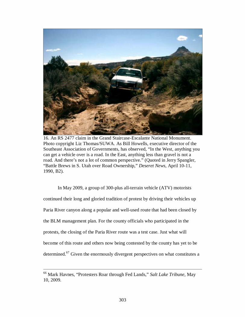
303
16. An RS 2477 claim in the Grand Staircase-Escalante National Monument. Photo copyright Liz Thomas/SUWA. As Bill Howells, executive director of the Southeast Association of Governments, has observed, “In the West, anything you can get a vehicle over is a road. In the East, anything less than gravel is not a road. And there’s not a lot of common perspective.” (Quoted in Jerry Spangler, “Battle Brews in S. Utah over Road Ownership,” Deseret News, April 10-11, 1990, B2).
In May 2009, a group of 300-plus all-terrain vehicle (ATV) motorists
continued their long and gloried tradition of protest by driving their vehicles up
Paria River canyon along a popular and well-used route that had been closed by
the BLM management plan. For the county officials who participated in the
protests, the closing of the Paria River route was a test case. Just what will
become of this route and others now being contested by the county has yet to be
determined.67 Given the enormously divergent perspectives on what constitutes a
66 Mark Havnes, “Protesters Roar through Fed Lands,” Salt Lake Tribune, May 10, 2009.

304
road and who owns it, road conflicts like those in Paria Canyon seem destined to
play out for many more years to come. While the 1976 legislative intent of RS
2477 had been to resolve county road ownership swiftly within a few years of the
act, and despite Donald Hodel’s 1988 attempt to settle the matter, 2477 claims
have thus far limped sluggishly through the courts and may continue to do so well
into the future. And rather than settle the issue at once, the procedure will surely
be taken road by road, plausibly spawning ceaseless litigation and courtroom
theatrics.
٭٭٭
One may step back and consider the cause of such vehemence and passion.
Although this type of anti-fed anger is not uncommon in southern Utah, to
characterize it as representative would be overdrawn. There is evidence that a new
era of understanding and co-existence is dawning in southern Utah’s capital.
Monument supporters predicted in the 1990s that with time, even conservative,
hard-nosed locals would come to welcome and accept the monument as their own.
That may be true for some. Further, the overwhelming demographic majority that
pioneer-stock Mormons have held in Kanab has slowly eroded. As Joshua Zaffos
recently observed in a cover story for the High Country News, Kanab is now
home to a world premier animal sanctuary and a growing community of
wilderness lovers and other progressives. Although newcomers often create a kind
of tension among old timers, in this case their presence seems to have a
67 Quoted in Zaffos, “Serendipity in the Desert,” 17; Havnes, “Protesters Roar through Fed Lands.”

305
moderating presence. Zaffos observes that “a kind of détente appears to be
emerging” in “Utah’s bitter cultural wars.”68
Yet the anti-fed sentiment cannot be easily dismissed, primarily because it
is interwoven with deep resentment over the perceived erosion of culture,
heritage, and tradition in the rural West. The federal government and its alleged
environmental allies make an easy target. In Kanab and elsewhere in the West, the
storyline often goes that for generations their ancestors lived and worked on the
land, often just scraping by but always making do on the endowments of nature
and their own fortitude. In recent decades, they feel that that fierce independence
has been unfairly tempered by an overbearing, even dictatorial federal
government intent on imposing heavy-handed environmental regulations and land
use restrictions. And the matter is not merely about economics. It is also about
what some regard as the erosion of local culture and heritage. “New West, Old
West, that’s what this is about,” said Kane County commissioner Habbeshaw. To
him it is honorable to resist “New West” changes to preserve (for a short time, at
least) what remains of the traditional “Old West” culture. “Are we going to
eventually lose the Old West, the traditions and the culture, [and] shift towards a
New West and urban life? You bet we are. But why rush to it?”69
Thus, the road—the object celebrated as a means of “progress”—has
become a metaphor and sword for tradition and conservation. Roads become
artifacts, reminders of the past. Far from being the means of growth and change,
68 Zaffos, “Serendipity in the Desert,” 14, 16. 69 Quoted in Ibid., 19.

306
as many generations once understood them to be, roads are now symbols of local
culture and tradition that has slowly eroded over the years. The irony, of course, is
that leaders of a conservative-minded town, Kanab, had for years supported
industrial development that would have transformed their towns and landscapes—
on the Grand Staircase, on the Kaiparowits, in the Escalante region. Indeed, locals
may not entirely understand the factors influencing cultural changes in their
communities. As Bill Hedden of the Grand Canyon Trust put it: “Nearly
everywhere traditional economies are in decline, creating hardship, dislocation
and no small amount of desperation . . . and neither [environmentalists] nor Bill
Clinton did it to us.”70
From one perspective, the creation of Grand Staircase-Escalante was
actually an attempt to push southern Utah and northern Arizona communities into
a post-Old West era. The proclamation thus encouraged the collection of
scientific, economic, and policy-related information—to consider biota within the
monument and the changing nature of communities outside of it. The monument
was designed to consider rural people and their communities as a part of the
monument “ecosystem”—to sustain human populations while at the same time
protecting natural ecosystems. Even environmentalists, happy to welcome the
Grand Staircase-Escalante to southern Utah’s constellation of monuments and
parks, acknowledged the need to provide in the management plan a mechanism to
satisfy all these needs—economic, environmental, and cultural. To Gregory Aplet
70 Brent Israelsen, “Staircase Still Strikes Sparks Among Utahns,” Salt Lake Tribune, September 16, 2000.
307
and Pamela Pride Eaton, the challenge was to “see these communities develop in
a way that helps sustain the wild character of the monument.” The communities in
the vicinity of the monument, they wrote in 1997, “possess a rural character that
contributes to the remoteness of the place.” The major goal ought to be to find a
way to meet these community’s needs without seeing them become
“overdeveloped, commercialized gateways.” In formulating a policy that would
protect the environment and the human presence on the land, the Wilderness
Society suggested considering the impacts of human beings on the land—the
impacts of hunting on wildlife, cattle on cryptobiotic soil, water management on
floods, roads on vegetation—and their role in the broader ecosystem.71
Yet in advancing the position that the monument may serve as an
acceptable “middle” ground where people, animals, and wildness exist in
harmony, environmentalists either underestimated or dismissed the major cultural
forces that contributed to its opposition. Many likely assumed that when locals
learned of the material gains that could be had from the monument, they would
happily embrace it. It is not, however, a simple matter of economics. The Kane
County road debates centered not merely on the economic value of access but on
the cultural and historical meaning of roads. The road itself did not matter as
much as the freedom that the road represented. Locals had become accustomed to
71 Gregory Aplet and Pamela Pride Eaton to A. J. Meredith, October 29, 1997, File: UT:BLM:GSENM:TWS Management Plan Project, Box 26, Wilderness Society Four Corners Regional Office Records. See also Internal Discussion Draft, “Shaping the Future of the Grand Staircase-Escalante National Monument, Utah: A Project of The Wilderness Society,” File: UT:BLM:GSENM:TWS Management Plan Project, Box 26, Wilderness Society Four Corners Regional Office Records.

308
moving about the landscape as they pleased. Many attributed the freedom of the
road with family, home, and community. These roads enabled fathers and
grandfathers to take their children camping or hunting. The road, then, bridged
generational gaps. In response to the idea that some roads ought to be closed to
motorized traffic but open to foot traffic, Bruce Bolander of Irving, California,
stated “many people can’t do that. I have chronic sciatica now and I can’t do it.
Our parents (in their 80s) and our kids (as young as two) have made these trips
and wouldn’t have been able to see this great country close-up any other way.”72
Locals convinced that the monument designation was an abuse of
presidential power would also acknowledge that this heavy-handedness and the
closure of local “roads” had a degrading effect on local heritage and culture.
Local Mormons in southern Utah believed that their ancestors had settled in the
“outposts” of the West to flee perceived federal oppression. Utah Representative
Thomas V. Hatch and Garfield County Commission D. Maloy Dodds referred to
Brigham Young (“a visionary leader”) who directed the settlement of southern
Utah “where they could make their own decisions and practice a lifestyle sacred
and peculiar to them.” The monument creation was a continuation of this
government oppression that had included a war against the United States in 1857
and federal legislation in the 1880s designed to stamp out the practice of plural
marriage and the Mormon Church’s iron grip on politics in the Utah Territory. To
Hatch and Dodds, President Clinton “wiped out economic freedom from southern
72 Bruce Bolander, “Keep All of Our Trails Open,” Southern Utah News, January 2, 2008.

309
Utah,” permanently altering the “home” that had been a shelter for Mormons for
nearly 150 years.73
To anti-monument locals, management of the monument had also
obscured this human heritage. The official monument map handed to tourists by
the BLM shows only the main, well-used roads. It details the handful of roads
open to travel and omits the rest, giving a flawed impression that movement
within the monument is orderly. By design perhaps it is, but there is an extensive
underworld of roads and trails (often no more than rut marks) that have yet to be
reclaimed to the grass and brush. What are we to believe about these? Are we to
think anything at all about them, consider their original purpose, or perhaps future
utility? The BLM and the environmental community claim that they no longer
serve any useful purpose either as artifacts nor as practical design; that the land’s
highest and best use is to revert back to the “natural” landscape. Locals, in
contrast, insist that obscuring these roads on official monument maps puts visitors
in danger of losing their way or taking a wrong turn in a twisted and brutal
landscape. The landscape that appears comprehensible, even friendly, on the maps
is in fact chaotic, disorganized, and dangerous. The roads themselves, like the
landscapes they traverse, are random, uneven, rough. Seeing the landscape in this
way is more than practical, however; it is two different ways of perceiving the
world: the one eco-centric, the other anthropocentric—both perhaps idealized, an
amalgam of reality and imagination. When these two perspectives collide, as
73 Thomas V. Hatch, Utah Representative, and D. Maloy Dodds, Garfield County Commissioner, “What has Happened in America,” Southern Utah News, September 25, 1996.
310
shown in this and previous chapters, the effect can be explosive and longstanding.
Even when (if ever) the courts issue a final ruling on RS 2477 in the monument,
these cultural divisions will persist. As debates grounded in history, culture and
heritage, they have deep and abiding roots.
Environmentalism may be partly to blame for these divisions. In an article
published in Jim Stiles’ The Canyon Country Zephyr in 2006, Loch Wade of
Boulder, Utah, blamed the animosity on the environmental movement’s alienation
of the “working and peasant classes.” Instead of forming close ties to the blue-
collar working class, environmentalists pursue a legal and political course that
alienates people from the very individuals who “stand to benefit the most from
environmental justice.” He pointed specifically to the “debacle” in Kane County
over roads and the environmentalists’ aggressive lawsuit and threats against the
county for posting signs within the monument. “By working in channels of power,
instead of at the grass roots level,” writes Wade, “the green movement has
allowed the political right to fill the vacuum by cynically appealing to the
emotional sensitivities of the working poor, who have come to see the reactionary
conservative movement as the protector of their rights and way of life.” Wade
argues that the environmental movement ought to pursue a “pragmatic” strategy
that supports the lower economic classes instead of embracing the attitude that
they are collateral damage in the quest to preserve nature. “This will mean that in
some cases, humans will have to come first,” Wade notes. “But if this pragmatism
is based on a willingness to strike a balance that moves towards overall
sustainability, then there is a chance for rapprochement between the greens and

311
working people. Such an alliance, in my view, is the green movement’s only hope
for lasting victory.”74
This has, of course, long been a complaint lodged against
environmentalism, and the charges seem particularly true in the case of Utah’s
largest home-grown environmental organization. In another article in the same
issue of The Zephyr, Stiles writes about SUWA’s huge “war chest” (accumulated
from a few wealthy donors) but declining membership. The main mission is to
work to pass a 9.3-million-acre BLM wilderness bill, an issue that above all
alienates the rural poor from the good work of environmental organizations. But
Stiles notes that many other “environmental” issues need to be addressed, ranging
from urban and suburban development and its impact on sensitive ecosystems to a
new proposal to build a controversial water pipeline from Lake Powell to St.
George. SUWA, a wilderness advocacy group, would not be expected to be active
in urban and suburban issues, water pipelines, and working class justice. Yet the
argument may still be valid—that environmentalist have lost (or failed to attract)
natural allies in the rural and working-class West by not addressing these broader
environmental and social issues.75
Further, it may be possible for environmentalists to convince rural
westerners that what is environmentally healthy for the land is also good for local
culture, tradition, and jobs. In 2010, Utah Governor Gary Herbert approved a
74 Loch Wade, “The Stagnation of the Environmental Movement,” Canyon Country Zephyr, April-May, 2006, 4. 75 Jim Stiles, “Take It or Leave It…….,” Canyon Country Zephyr, April-May, 2006, 2-3.

312
permit for a coal mine near the small town of Alton, just ten miles from Bryce
Canyon National Park and not far from the northwestern edge of the Grand
Staircase-Escalante. Whereas the earlier Andalex mine would have been
underground, this would be Utah’s first-ever strip mine, exposing an ugly scar
next to what actor and environmental activist Robert Redford calls “an iconic
landscape.” To Redford, here is a case of Utah’s shortsightedness in acting against
its better self interest. Not only is the health of wildness at stake, so are jobs. “We
could continue to pretend these fights are about jobs versus the environment. But
the truth is that beautiful wild places like Panguitch support vibrant tourism
industries which mean jobs.”76
Wilderness advocates and environmental activists need to make this
argument while at the same time recognizing and legitimizing the deeply held
cultural feelings that many southern Utahns have for the land. When all southern
Utahns equate the health of the land with the health of their communities and the
revitalization of local culture and heritage, then they may begin to see wilderness
advocates as allies instead of ideological enemies—and they may truly be in a
position to reclaim their heritage. Until then, we can expect to hear more about the
obstinacy of Kane County officials for years to come.
76 Robert Redford, “Utah Approves a Mine Next to Bryce Canyon for Coal America Doesn’t Need,” Huffington Post, December 14, 2010, http://www.huffingtonpost.com/robert-redford/utah-approves-a-mine-next_b_795955.html (December 14, 2010).

313
EPILOGUE
A FRACTURED LANDSCAPE
If we step back from the place-based case studies and take a broader perspective
of the region, some broad generalizations begin to emerge. From an elevated
vantage point, the lay of the land comes into view—a vast region with mesas,
plateaus, and mountains that protrude like islands within a sea of sand, rock and
canyon gorges. It is a land of contrasts, with colors and forms so varied that no
generalized description is possible. To some observers, this region is a last bastion
of the wild and primitive. The beauty and spaciousness and uniqueness of the
landscape inspires passionate defense. Despite common perception, however, the
plateau country is not virgin territory. Indeed, human markings—roads, perhaps
above all—abound. Roads are ubiquitous, even in this region. They appear in
nearly every location imaginable—crisscrossing desert expanses, persisting up
rocky mesas, creeping along the bottoms of river gorges. The actual paved roads
that appear on a highway map may be relatively few—invoking the image of
vastness and roadlessness—but in fact the human presence and impact are
unmistakable. Any local or county map would show this: roads in a web-like
pattern, running in all directions, sometimes connecting points, sometimes not.
The idea of the plateau region as a physically and ecologically fractured landscape
derives, in part, from the actual imprint of all of these roads in the area.
Yet the plateau region is fractured in another metaphorical sense, as it is
gripped in seemingly endless and endemic conflicts over values, beliefs, and
314
ideas. I have argued that the environmental conflicts of the last four decades on
the Colorado Plateau have been primarily irreconcilable, driven by polarizing
factions intent on stamping a particular ideology on the landscape. The physical
fracture directly correlates to the metaphorical fracture because numerous
alterations to the built environment over the last forty years were the result of
debating, wrangling, arguing, and contesting values and ideas. The casual
observer might not know this, however; it would not be immediately apparent that
the roads above Negro Bill Canyon WSA were the site of protest during the BLM
wilderness study process, or that the semi-paved Burr Trail had once been the
subject of perhaps Utah’s most volatile environmental conflict.
These divisions have continued to persist, and I would argue that conflict
in the region today continues to be driven in part by ideology. The region is still
enveloped in an unhealthy culture of distrust and resentment toward “the other,” a
dig-your-heels-in bunker mentality that has enabled the conflicts already
addressed in this study. However ideological, these conflicts are not static; they
have developed in a specific region during a specific time over specific issues. As
circumstances change and as new issues develop, conflicts in the region may
become less divisive. There is abundant evidence that this has already begun to
happen; despite the continued, seemingly timeless challenges of balancing
industrial and recreational development and environmental preservation in a
desert landscape, it may be possible, as we shall see, to have cordial and
productive conversations that move beyond deadlock and ideological obstinacy.

315
How these conflicts have evolved over time and in pockets of the region
has been the subject of this study. To assess where we are headed and take a look
at the future of any possible resolutions requires returning from our elevated perch
to one more particular location within this landscape. Thus, before reflecting on
the case studies just presented, we will take a detour off the main road to a
popular side canyon in San Juan County, Utah, to examine a relatively new road
issue that is currently dividing the West in two. Finally we come full circle,
ending where we began, not far from where the Hole-in-the-Rock pioneers passed
through and where Edward Abbey covertly sabotaged road equipment on U-95.
٭٭٭
Perhaps at first glance, Arch Canyon appears as an ordinary side canyon of Comb
Wash, which empties into the San Juan River. But in fact, Arch Canyon is
considered by locals and visitors alike as a rare gem. Near the canyon’s mouth is
Arch Canyon Ruin, a major Ancestral Puebloan site. For those who made this
dwelling home between 700 and 1,000 years ago, it afforded close proximity to
the slow-flowing, perennial stream and fertile soils of the canyon bottom. Follow
the canyon further to encounter more evidence of ancient habitation. Seemingly,
around every turn is a new and delightful site, some near the canyon bottom,
others situated higher up on the canyon walls. Farther up still are the stately
natural sandstone formations of Cathedral Arch, Angel Arch, and Keystone Arch.
After completion of U-95 in 1976, Arch Canyon became even more accessible,
located by dirt road only a few miles from the highway. It should not seem
surprising, then, that this enchanting, easily accessible place attracts people.
316
The canyon is dually managed by the BLM in the lower, easier-to-access
canyon and by the Forest Service in the upper canyon all the way to the Abajo
Mountains. Their specific challenge is to manage a place with a long history of
use, one that is contested by many interests who similarly value the canyon but
advocate different ways of managing it. This dynamic of use versus preservation
has been present for at least four decades in Arch Canyon. This story is worth
telling because it highlights the evolution of a relatively recent type of
controversy in the Canyon Country—off-road (ORVs) and all-terrain (ATVs)
vehicles. In the twenty-first century, off-road vehicles have a pervasive presence
on the land, presenting threats to the land’s integrity, challenges to land managers,
and flashpoints of contention.
The BLM has played an active but inconsistent role in managing vehicle
access in Arch Canyon, at times proposing limited access and other times
recommending full vehicle access to the canyon. In 1973, in its South San Juan
Management Framework Plan, the BLM decided to close the canyon to off-road
vehicles to protect resources.1 Despite being implemented, the decision to close
the canyon to vehicles seems to have been weakly enforced—although according
to William Browning of Salt Lake City, from at least 1972 to 1976, a fence at the
mouth of the canyon blocked vehicle access.2 Whatever the barriers to entry into
the canyon, off-road motorists were traveling up the canyon increasingly by the
1 Scott Groene, Attorney, SUWA, to James Parker, State Director, BLM, November 3, 1989, in BLM field office, Monticello, Utah. 2 Affidavit of William Browning in Opposition to San Juan County, no date [circa 1990], in BLM field office, Monticello, Utah.
317
late 1970s. A 1978 BLM report noted that the canyon was “receiving increased
ORV traffic approximately five miles from the mouth of the canyon,” which
contributed to the erosion of the hillside below Arch Canyon Ruin. BLM
employee Fred Blackburn recommended indefinitely closing Arch Canyon to
vehicles.3 But the damage sustained was more than the hillside; in 1979 BLM
rangers noted “extensive ORV tracks” for six miles up the canyon and noted “pot
holes dug either earlier this year or last year near [the] mouth of Arch Canyon in a
large ruin area.”4 According to William R. Haase of the Utah Chapter Sierra Club,
the damage from ORV use was extensive in Arch Canyon compared to
disturbance in adjacent Mule Canyon, which in its upper reaches remained
“absolutely pristine and contains no evidence of modern man.”5
The practice of illegally disturbing ancient Indian sites like those in Arch
Canyon was then becoming widespread. In 1979 and 1980, the BLM’s Kane
Gulch Ranger Station documented dozens of incidents of vandalism in the San
Juan area, noting “heavy vandalism” and “fresh diggings.” The official incident
report observed vandalism “to be very Blatant, and becoming more numerous
3 Fred Blackburn, BLM, Staff Report, June 11, 1978, Folder 3, Box 8, Series III, MSS 148, Papers of the Utah Chapter of the Sierra Club, Special Collections and Archives, Merrill-Cazier Library, Utah State University, Logan, Utah. 4 U.S. Department of the Interior, BLM, Moab District Office, San Juan Resource Area, Kane Gulch Ranger Station, Incident Report, Incident No. GG-79-45, Cedar Mesa, August 12, 1979, Folder 3, Box 8, Series III, Sierra Club Papers. See also Jerry W. Ballard, Outdoor Recreation Planner, BLM, Staff Report, May 19, 1980, Folder 3, Box 8, Series III, Sierra Club Papers. 5 William R. Haase, Public Comment Sheet, Unit No. UT-060-205, Mule and Arch Canyons, no date, Folder 3, Box 8, Series III, Sierra Club Papers.

318
especially in locations close to Blanding.” At Cedar Mesa, the BLM report stated
that the “[a]rea has had increased ORV Travel resulting in impacts to environment
and Archaeology.” At one location, the BLM personnel followed motorcycle
tracks veering off beyond the dead end of a narrow road to a small dwelling site
that had been vandalized for its treasures. “Of significance here is that
motorcycles may be being used to comb wide areas of land for archeological
sites,” wrote the BLM employee. “This abuse of ORVs may be of consideration
in the ORV planning and designations of areas where site densities are high.”6
These incidences suggest the problems that ORV use presents to land
managers. By definition, ORVs veer off the designated road, using their small
frames and specifically tailored gears to maneuver over and around some of the
roughest places on the planet. In fact, no road construction equipment is
necessary; these vehicles simply push the road farther on—beyond to new places
that even road builders had not gone. The ORVs, quite literally, extend the road.
The tracks of off-road vehicles are not light, especially on the fragile soils of the
desert. The markings extend out like tentacles, suggesting anew the potential for
road building in the West.
Critics of increased ORV use on public lands also point out that motorized
recreation in the backcountry is a lazy way of experiencing nature. Edward Abbey
produced a most searing critique in a letter directed to the editors of Esquire
6 See U.S. Department of the Interior, BLM, Moab District Office, San Juan Resource Area, Kane Gulch Ranger Station, Incident Reports, 1979-1980, Folder 3, Box 8, Series III, Sierra Club Papers.
319
Magazine in 1976. ORVs were “a goddamned plague,” he wrote. Of the people
who use them, he wrote:
The fat pink soft slobs who go roaring over the landscape in these over-sized over-priced over-advertised mechanical mastodons are people too lazy to walk, too ignorant to saddle a horse, too cheap and clumsy to paddle a canoe. Like cattle or sheep, they travel in herds, scared to death of going anywhere alone, and they leave their sign and spoor all over the back country: Coors beercans, Styrofoam cups, plastic spoons, balls of Kleenex, and wads of toilet paper, spent cartridge shells, crushed gopher snakes, smashed sagebrush, broken trees, dead chipmunks, wounded deer, eroded trails, bullet-riddled petroglyphs, spray-paint signatures, vandalized Indian ruins, fouled-up waterholes, and polluted springs, and smouldering campfires piled with incombustible tinfoil, filtertips, broken bottles. Etc.
Abbey then castigated federal land managers for “doing far too little” to “stop this
motorized invasion of what little wild country still remains in America.”7
If Abbey unfairly characterized all ORV users, he hinted rightly at the
enormous challenge they present to land agencies charged with protecting the
resources of the public lands. Roads are tidy; they can be followed and tracked,
connecting point to point. ORV tracks, conversely, wind around, over, and
through, weave across the land in erratic marks like a pattern on a crazy quilt.
These kinds of “roads” are not the products of careful planning to move from one
point to another. Rather, they are the imprint of impulse, of humans’ drive to seek
out a new place beyond the next ridge or around the next canyon bend. This is not
to say that ORVers do not or cannot follow existing routes, but it would seem that
the impulse to discover and even conquer is not easily repressed. As one of the
7 Abbey to Editors, Esquire Magazine, New York, September 11, 1976, Folder 10, Box 3, MS 271, Papers of Edward Abbey, Special Collections, University of Arizona, Tucson.
320
BLM staffers noted in May 1980 regarding a patrol of Alkali Ridge in San Juan
County, “a great number of new roads that have been developed in the area . . .
made it difficult to see if there was any new archaeological vandalism in the
area.”8
Some environmentalists opined that new motorized tracks in Arch Canyon
and elsewhere in the county had been created with sinister motives. Brian Beard
of the Utah Chapter of the Sierra Club alleged that San Juan County officials had
instructed people to “dig in ruins” and “drive four wheel vehicles to establish
roads” in an effort to damage the wilderness characteristics of these areas so they
could not be set aside for protection. He and other environmentalists petitioned
BLM District Manager S. Gene Day to close Arch Canyon, pursuant to Executive
Order 11989, directing land managers to “immediately close such areas or trails to
the type of off road vehicle causing such effects.”9
The BLM response to Beard in no way complied with the request to close
the canyon to vehicles. BLM personnel reported that “the road follows the
drainage bottom the entire length of the canyon,” and that “[t]ravel through the
canyon appears to be extremely light.” In fact, ORV traces were so minimal, the
agency said, that vegetation had begun to grow back along the road bed due to
little use in the spring and summer of 1979. Day, the district manager, refused to
8 Jerry W. Ballard, Outdoor Recreation Planner, BLM, Staff Report, May 19, 1980, Folder 3, Box 8, Series III, Sierra Club Papers. 9 Brian Beard, President, Utah Chapter of the Sierra Club, to Gene Day, District Manager, BLM, May 17, 1979; “Destruction of Arch Canyon,” Utah Chapter Sierra Club Newsletter, no date; both documents in Folder 3, Box 8, Series III, Sierra Club Papers.

321
budge—the canyon would remain open to ORV use. A member of the Utah
Chapter Sierra Club speculated, “Perhaps, BLM plans to turn Arch Canyon in to
a[n] ORV play ground prejudice their eyes into seeing only ‘slight damage.’”10
٭٭٭
To get a sense of just what an ORV playground looks like, visit the annual Jeep
Safari in Moab or one of Jeep Jamboree USA’s events held throughout the
country. Every year since 1967, hundreds of ORV enthusiasts have converged
during these weekends in the Mecca of ORV use—Moab, Utah—to drive their
vehicles along designated routes in the redrock backcountry. The Jeep Jamboree
USA, sponsored by Jeep-Chrysler to “access the inaccessible,” holds events in
out-of-the-way places throughout the country, but a good number occur in
southern Utah. In 1989, Jeep-Chrysler held its first annual jamboree in San Juan
County’s Arch Canyon.
The advertised event did not go unnoticed by environmentalists disquieted
about the impact of the ORV use in the canyon. Prior to the Jamboree, the
Southern Utah Wilderness Alliance called the BLM office and requested a copy
of the environmental assessment (EA) done for this large gathering of ORVs, but
they were told that the event would be “categorically excluded” from
environmental review. After being pressured to complete the assessment, the
BLM released the EA on March 28, 1989, three days before the scheduled event.
SUWA then requested a stay of the event to force the BLM to hold the outing “in
10 Letter to Rocco Dodson, Sierra Club Legal Defense Fund, September 6, 1980, Folder 3, Box 8, Series III, Sierra Club Papers.
322
a non-riparian area,” which the BLM refused to do. Thus, 100 jeeps congregated
as planned for the first annual Arch Canyon Jeep Jamboree.11
SUWA refused to let the matter rest and appealed the decision of the
BLM. The United States Department of Interior Board of Land Appeals (IBLA)
determined on October 12, 1989, that the BLM had improperly permitted the
jamboree to be held. The IBLA also ruled that the BLM had not properly
validated county 2477 rights-of-way claims. Based on this decision, Scott Groene
of SUWA concluded that the BLM was responsible to actively correct ORV
misuse in the canyon, and he echoed what Brian Beard of the Sierra Club had
recommended ten years earlier: “to inform the public that motorized vehicles are
no longer allowed there by placing signs at the mouth of the canyon, and perhaps
initially patrolling the area on heavy use weekends. The BLM has created this
problem and now must take steps to solve it.”12
Although the BLM field office believed that it had authority to validate
county-asserted 2477 claims, the IBLA decision clearly stated that the BLM had
the obligation “to define and determine” the county right-of-way before
permitting its use on the basis of county assertion. Even after the decision,
however, the BLM continued to operate as though the county had a legal right-of-
11 Groene to Parker, November 3, 1989; February 23, 1990, document, in BLM field office, Monticello, Utah. 12 Groene to Parker, November 3, 1989; Michael F. Heyrend, Staff Council, SUWA, Jane Leeson, Utah Representative, WS, and Rudy Lukez, Conservation Chair, Utah Chapter Sierra Club, to Gene Nodine, District Manager, BLM, February 23, 1990, in BLM field office, Monticello, Utah.

323
way to Arch Canyon road when, in fact, this claim had yet to be properly
decided.13
To cover its bases, pursuant to the IBLA ruling and in anticipation of a
1990 jamboree in Arch Canyon, the county filed materials with the BLM for
consideration of 2477 status. Once again, SUWA contested the adequacy of the
county’s 2477 application and otherwise demanded that the BLM take action to
close the canyon to ORV use and deny Jeep Jamboree a 1990 permit. The BLM
district manager, Kenneth Rhea, responded that under Interior Secretary Donald
Hodel’s policy the BLM had full authority to make a “factual” determination as to
whether Arch Canyon road satisfies the following provisions: (1) land is public
land, (2) construction occurred, and (3) is considered a public road.14 Meanwhile,
locals mailed letters with the hope of convincing the BLM that the road met these
criteria. Calvin Black even wrote in, saying that he had used the road for multiple
purposes several times a year since 1959 and that “I have personally used a shovel
and picked and rolled rocks out of the way through the years and have removed
trees occasionally as they have fallen across the road.”15 Still, environmentalists
13 Heyrend, et al., to Nodine, February 23, 1990, in BLM field office, Monticello, Utah. 14 Kenneth Rhae, District Manager, BLM, to Michael Heyrend, SUWA, March 9, 1990, in BLM field office, Monticello, Utah. 15 Calvin Black to Ed Scherick, Bureau of Land Management, January 25, 1990, in BLM field office, Monticello, Utah. See also Cleal Bradford, Executive Director, White Mesa Ute Council, to Dan J. Gliniecki, Manager, Chrysler Motors Corporation, March 23, 1990; Statement by Lynn F. Lyman of Blanding, Utah, November 28, 1989, in BLM field office, Monticello, Utah.
324
scored a victory when Jeep Jamboree announced that it would cancel the event at
Arch Canyon and move it to a less sensitive area.
Nonetheless, the canyon would not be spared from dozens of jeep tire
scars, for a roughly organized group of jeepers showed up anyway on the same
weekend the jamboree was scheduled. Twenty-five jeeps congregated at the
mouth of Arch Canyon with drivers intent on riding up the canyon in direct
violation of the BLM’s dictate to close it while awaiting a final 2477
determination. The man who would observe and report the offending motorists
was none other than SUWA attorney Michael Heyrend who was there anticipating
a quiet weekend of backpacking in Arch Canyon. No sooner had he started up the
canyon by foot, he heard the roar of motors. Rushing back to the gate at the
canyon’s mouth, he witnessed the vehicles in a row, revving up for entry. “It
looked like Patton’s army,” he recalled. Heyrend confronted the motorists: “This
is closed to off-road vehicles . . . Legally you guys can’t go up.” After learning
that none of the jeepers had permits for entry, he further insisted. “Watch us,” was
the reply, as they proceeded past him. “The people who were going up the canyon
were very hostile to me—their facial expressions, they muttered, that kind of
thing. . . . I felt like a civil rights worker in 1962 in Selma, Alabama,” he relayed.
He did manage to write down some of the license plate numbers as the vehicles
drove by. Several days later, when he returned to his car, he found a t-shirt with
an obscene drawing of a man in hiking boots. The note accompanying the shirt

325
read: “With Our Compliments. We could have used your tactics & Screwed your
Vehicle Up.”16
Later Ken Rhae referred to the ORVers as “just a bunch of people who
apparently go together . . . up the canyon.” Since it was not a commercial outing,
Rhae supposed that no charges would be made.17 Incensed, BLM District
Manager Gene Nodine took a different stance. “Here we’ve been doing our
utmost to cooperate, and [get] everybody to be a partner in the whole thing. Then
we find out that this particular incident has taken place.” He stated that the
individuals who participated in the incident could be charged, although apparently
no charges or citations were ever made.18
After 1990, resolution of the conflict over motorized use in Arch Canyon
remained in abeyance. The BLM confirmed the county’s 2477 rights to the Arch
Canyon road on the basis that the limited construction work on the road had been
sufficient and that the road had been open for public use prior to 1976. BLM area
manager Edward Scherick signed the administrative decision on April 30, 1990,
which stated: “the road asserted by San Juan County, known as the Arch Canyon
road, is a valid use of the public lands.” SUWA appealed the 2477 decision, and
16 “Four-Wheel Drives Overrun Arch Canyon,” SUWA Newsletter, Vol. VII, No. 1, Winter/Spring 1990, 1, 3-5; Joseph Bauman, “Who is Forcing Wilderness Issue,” Deseret News, April 13, 1990, A7. 17 Joseph Bauman, “Environmentalists Angry at Renegade 4-Wheelers Driving up Arch Canyon,” Deseret News, April 11-12, 1990. 18 Joseph Bauman, “Charges are Possible against 4-Wheel-Drive Group, BLM Chief Says,” Deseret News, April 12-13, 1990.

326
the IBLA determined to suspend the 2477 status until the Department of the
Interior developed a R.S. 2477 policy.19
٭٭٭
The issue of road jurisdiction resumed in 2004 when the BLM rejected a multi-
year permit for jeep jamborees in Arch Canyon. But Lynn Stevens, a San Juan
County commissioner and the state coordinator of the Utah governor’s Public
Lands Policy Coordinating Office, defied the BLM by leading the jamboree up
the canyon anyway. The BLM reversed course and granted the permit, which was
17. Illegal ORV ride up Arch Canyon, with peaceful protesters. Photo copyright Liz Thomas/SUWA.
19 BLM, Administrative Decision, April 30, 1990, BLM Field Office, Monticello, Utah; BLM Rules Arch Canyon Road Remains Open, Despite Protest,” Times-Independent, May 3, 1990; Lawson LeGate, “‘Public Road’ is a Jeep Trail,” Deseret News, June 19, 1990.

327
then appealed by environmentalists. The permit wound its way through a maze of
legal procedures and in the end was remanded back to the BLM.20
In 2006, the BLM issued a five-year permit to hold Easter Jeep Safari
events in Grand and San Juan counties. Arch Canyon, previously the setting for
the Jeep Jamboree, had now been opened up to the Jeep Safari sponsored by the
Red Rock 4-Wheelers of Moab, Utah. Dan Kent of Red Rock Forests, an
environmental group, vented, “It really makes a mockery of the BLM’s
statements that they’re trying to take care of the land and make things better when
they go and open the Jeep Safari to new routes. Arch Canyon is a unique and
valuable place biologically, and for them to go and dump a big event like this into
such a pristine area is just a sham. It’s beyond the pale.” The BLM claimed it
carefully reviewed the Jeep Safari proposal, evaluated all the trails in the San Juan
County for consideration, and ultimately determined that Arch Canyon would be a
suitable site for the outing. BLM Monticello Field Office manager Sandra Meyers
remarked, “We studied it very hard and we feel we made the right decision. We
care very much, but we are a multiple use agency.”21
SUWA attorney Liz Thomas appealed to the BLM once again in October
2006 to close what she called the Arch Canyon “ORV ‘route’” after it sustained
damage from high floods. Thomas pointed out that at least in the lower portion of
20 Reply, San Juan County, April 20, 2004, in BLM field office, Monticello, Utah. 21 Quoted in Lisa J. Church, “BLM Renews Red-Rock 4-Wheelers’ Jeep Safari Permits,” Times-Independent, no date, http://www.moabtimes.com/view/full_story/66793/article-BLM-renews-Red-Rock-4-Wheelers--Jeep-Safari-permits (March 7, 2011).
328
the canyon which she had observed, the flood waters had “essentially obliterated”
the trail. She even argued that the ORV ruts made the flood worse than it would
have been, pointing to the “deep trenches, gullies and ledges that resulted as flood
water was channeled down these linear tracks.” Without the aid of a clearly
defined route, she argued, ORV users attempting to maneuver up the canyon
posed a threat to the environment and to themselves. Because the contemporary
San Juan Management Resource Plan Arch Canyon limited motorized vehicles
“to designated routes,” and because the BLM had yet to officially designate a
route in the canyon, Thomas urged the Monticello Field Office to close the route
to vehicle traffic.22
In response to Thomas’s request, the BLM sent personnel to the canyon to
inspect the road to determine “what needed to be done.” Meyers concluded that
the flood event did not warrant an emergency closure. Rather, she decided to post
closure signs and barriers where some vehicles had “detoured” to maneuver
around the deep incisions created by the flood along portions of the road. The
BLM field office manager also allowed local volunteers to reconstruct the
“original route.” On November 18 and 25, 2006, members of San Juan Public
Entry and Access Rights (SPEAR) and other locals repaired road damage from
the storm using shovels, picks, and other tools to remove debris and rock from the
22 Liz Thomas, SUWA, to Sandy Meyers, Manager, BLM Monticello Field Office, October 13, 2006, in BLM field office, Monticello, Utah.

329
road’s bed. BLM personnel joined in the road work, posting signs and barriers
where ORV users had veered from the main road.23
Rejecting the BLM response as entirely unacceptable and seeking a ban on
motorized recreation in Arch Canyon, SUWA filed its 400-page “Petition to
Preserve Arch Canyon’s Natural and Cultural Heritage” in December 2006.
Mustering support from tribal leaders and local business owners, conservationists
argued that ORV use in the canyon threatened both cultural resources that were
significant to the Navajo and Hopi tribes and the integrity of the natural
ecosystem. According to the petition, ORV users targeted Arch Canyon “for use
in ORV events,” contributing to the development of new routes “along the stream
and to archaeological sites” and threatening “prehistoric middens along the
way.”24 Given the threat of new routes and potential damage to more ancient
artifacts, environmentalists urged the BLM to close the canyon to motorized use.
As Liz Thomas of SUWA stated, “there are thousands of miles of ORV routes in
southern Utah located in less sensitive areas where ORV use may be appropriate.
But some special places should be protected.”25
23 Sandra Meyers telephone conversation with Liz Thomas, October 19, 2006; Sandra Meyers to Liz Thomas, December 19, 2006, in BLM field office, Monticello, Utah; “S.P.E.A.R. Sponsors Road Repair Efforts in Beautiful Arch Canyon,” San Juan Record, November 29, 2006, 2. 24 SUWA, “SUWA: BLM Ignores Request to Protect Arch Canyon,” San Juan Record, March 21, 2007; “Petition to Preserve Arch Canyon’s Natural and Cultural Heritage,” December 2006, iii-iv, available at http://www.suwa.org/site/DocServer/Arch_Petition_final_reduced.pdf?docID=861 (March 7, 2011).

330
In 2007, the BLM denied SUWA’s petition. Disappointed, Scott Groene,
also of SUWA, remarked, “The BLM has done a terrible job of managing this
canyon. They’ve allowed it to be over-run with off-road vehicles and jeeps in a
way that has smashed down streamside vegetation, [and] led to pollution of the
water.”26 In February 2010, however, the BLM agreed to reconsider the petition
to assess the effects of motorized vehicle use in the canyon and issue a new
decision regarding motorized use in Arch Canyon. In the official review of the
petition, the BLM decided to keep the route open to motorized vehicles, although
the report acknowledged that “a large increase in ORV use beyond the current
levels in the Canyon could pose future risks” to the resources of Arch Canyon.
The BLM outlined steps that would be taken to “prevent those possible future
risks from occurring,” including close monitoring of motorized use in the
canyon.27
٭٭٭
The story of Arch Canyon reveals both the challenges and the promises of land
management in the plateau region today. At first glance, the conflict over access
and land use in Arch Canyon reads like the others explored in this study: two
25 John Hollenhorst, “Petition Filed to Ban Vehicles in Arch Canyon, Near Blanding,” December 26, 2006, copy of article in the BLM field office, Monticello, Utah. 26 “SUWA: BLM Ignores Request to Protect Arch Canyon,” San Juan Record, March 21, 2007. 27 Decision Record on Southern Utah Wilderness Alliance “Petition to Preserve Arch Canyon’s Natural and Cultural Heritage,” October 13, 2010, available at http://www.suwa.org/site/DocServer/archCanyon_BLMDecision.pdf (November 29, 2010).

331
opposing, loggerhead sides largely unwilling to bend or even to reach a
compromise. Even the options seem diametrically opposed—either close the
canyon to motorized use or open it to motorized use. Furthermore, ORV use
seems to exacerbate the conflicts. ORVers tend to line up on one side of the
cultural spectrum and demand the right to access; driving these machines as a
symbol of freedom and Americanness. On the other side, critics argue that ORV
use is a lazy and environmentally destructive way to enjoy nature, and that indeed
true freedom and Americanness is experiencing nature without being confined to
a machine. These are two philosophical positions regarding how to experience
wild places, and they both make their way into debates over public land access
and use.
Indeed, the proliferation of ORV use on public lands suggests a new road-
related management problem. ORV and ATV use is a blending of the so-called
Old West and the New West. It is a form of mass recreation that complements
nicely the tourist economy of the New West. But it is also a pursuit enjoyed by
traditional land users who have long valued mobility in a rough and broken
country. Their vehicles allow them to traverse the untraversable, to view the
country how they want to, unfettered by the confines of a road. In other words,
this horse on wheels is here to stay. Contrary to Edward Abbey’s prediction in
1976 that “the coming and inevitable day of gasoline rationing . . . will retire all
these goddamned ORVs and ‘escape machines’ to the junkyards where they
belong,” the ORV and ATV have not only grown up with the modern West,
332
playing an integral role in its transformation, but have steadily increased in
popularity.28
Because ORV and ATV use is a blending of the Old West and the New
West, the sides of the debate between permitting ORV use on public lands and
restricting or banning ORV use are not so clearly defined. Development-minded
southern Utah residents have widely embraced this form of recreation, but it is
also a form of transportation in the canyon country that has a long history among
people generally opposed to road construction. SUWA contested jeep safari
events held on public lands, but, at least according to Ken Davey writing in the
Canyon Country Zephyr, local environmentalists in Moab welcomed the events to
their community. As Davey reasoned, “The Safari has always stressed the
importance of responsible land use, and by publicizing the beauty of the region, it
tends to promote preservation of undeveloped canyons.” Besides, the events pump
tourist dollars into a twenty-first-century regional economy that relies heavily on
tourism.29
Abbey himself is a bit of a contradiction, because he railed against the
very form of transportation that he often used to penetrate deep into the
backcountry. In Abbey’s writings, he describes rocky adventures on what could
hardly be called a road into some of the roughest and isolated pockets of the
canyon country. Clearly, he preferred the experience of jeeping the rocky
28 Abbey to Editors, Esquire, September 11, 1976, Folder 10, Box 3, Abbey Papers. 29 Ken Davey, “Jeepers v Environmentalists,” Canyon Country Zephyr, March 1991, 22.

333
backcountry trail to driving the slick-paved highway. Moving quickly over the
landscape was not as important as feeling and seeing and braving it as one would
do by jeep over a rough, backcountry trail. That very line of reasoning drove him
and others to contest construction of the Trans-Escalante highway, Utah Highway
95, the Burr Trail, the Book Cliffs highway, and other road projects. Yet he also
posited that use of even primitive trails by off-road motorists ought to be limited.
In 1974, in response to a National Park Service proposal to create wilderness in
Canyonlands National Park, he proposed additional steps to close roads that he
himself had once used for exhilarating backcountry experiences. Abbey justified
his proposal on the basis “that the preservation of wildlife . . . takes priority over
motorized recreation, that most of the canyon country remains wide open to jeep
and trailbike exploration, and that if wilderness is to be preserved at all, it must be
preserved in our national parks and in areas extensive enough to be
meaningful.”30
Critics like Abbey may always believe that areas designated as wilderness
or at least off-limits to ORV use may never be enough, but this is not to say that
many if not most constituents may be pleased with the way the public lands are
being managed. It may not always be a matter of either/or. At Arch Canyon, the
BLM field office manager decided to allow ORV use in the canyon but to take
steps in the future to limit motorized use in the canyon if the BLM determined
that motorized use posed a threat to the canyon’s resources. Moreover, the BLM
30 Edward Abbey and Renee Abbey to Hearing Officer, c/o Superintendent, Canyonlands National Park, September 9, 1974, Folder 8, Box 3, Abbey Papers.

334
has attempted to keep ORV use to specific trails—to open the main road up the
canyon to ORV travel but to close off the branch trails that had developed over
time.
In other words, the BLM need not and does not operate within a black and
white paradigm. Federal land managers daily make decisions that cater to a wide
ranging constituency. This is reflected in the BLM’s waffling management
decisions. Several times land managers changed course by variously restricting
access and then opening it back up to use. This behavior led to charges by
environmentalists that the BLM was not doing its job to protect the land from
destructive uses. ORV users could be just as frustrated by the BLM’s
inconsistency. Few people were entirely satisfied by the BLM’s management of
Arch Canyon. While some conservationists recognized that the BLM had made
efforts to protect the invaluable natural and archeological treasures of the canyon
from motorized use by placing designated route signs and barriers in the canyon,
Veronica Egan, a member of Great Old Broads for Wilderness, wrote, “history
shows us time and again that the agency has neither the personnel nor the funds,
and the public often lacks the self restraint,” to prevent damage from occurring
anyway.31 Yet, even if the BLM did have the personnel and funding, it would
likely be impossible for the agency to please everyone anyway. For one thing,
places like Arch Canyon, previously out of the way and used by a handful of
locals, are now being discovered and “loved to death.” As Robert Turri of the San
31 Veronica Egan to Sandra Meyers, November 21, 2006, in BLM field office, Monticello, Utah.

335
Juan Resource District of the BLM said in 1990, “A few years ago, no one had
heard of Arch Canyon. Now we get several calls a day from people asking what’s
there and how to get to it.”32 Moreover, land managers often do not have adequate
resources to manage the public lands properly. Beyond that, defining the “proper”
thing is a matter of contention. To expect land managers to manage the landscape
precisely how “environmentalists” or “developers” would want is disingenuous
and possibly wrong-headed. As we have seen in previous chapters, managing the
public lands (in other words, negotiating controversy) is a highly localized and
subjective affair, contingent upon a number of variables including personalities,
culture, and circumstances.
The lesson of Arch Canyon is that these are localized conflicts caught up
in national debates. However politicized and contentious these conflicts become,
they are being resolved on the local level by people on the ground. It may be true
that some people refuse to compromise or to find solutions that may be in the best
interest of all groups, but there are many others willing to negotiate and to make
decisions. In some cases, the decision is to open a road to ORV use; in others, to
close it; whether to issue grazing permits; or a matter deciding how best to
manage a newly created national monument. These are hard decisions that are
being made by land managers and by varying interests on a day-to-day basis.
There have been some good efforts to break through the deadlock in a
spirit of cooperation. In The Western Confluence: A Guide to Governing Natural
32 Quoted in Carol Poster, “Arch Canyon Road: To Be or Not To Be,” Utah Holiday (July 1990), 46.

336
Resources (2004), Matthew McKinney and William Harmon write that they sense
the West has moved toward collaboration and cooperation in recent years. They
outline strategies to break through the deadlock through negotiation,
collaboration, and consensus building. These strategies entail working toward
decentralization, or devolution, in which community stewardship and indigenous
knowledge become valued contributors to land management decisions. This is
possible not by overhauling the current system, as the Sagebrush Rebels hoped to
do, but through adaptation—by working within the system to rebuild trust and to
give locals a voice in the governing process while also not disregarding national
interests. Harmon and McKinney call for creating a sustainable culture that
integrates diverse people, needs, interests, and visions. This seems like a level-
headed, moderate approach to address deeply rooted divisions that polarize the
West today.33
Perhaps the best example of the collaborative process advocated by
McKinney and Harmon is a coalition of ranchers, environmentalists, and
scientists that had been organized to end a decades-long deadlock over land use
on the public lands in northern New Mexico. The Quivira Coalition brought
together a love of place and mutual respect to broker peace between historically
warring interests. The hope was to mobilize what was being called “The Radical
Center” to enter into productive, meaningful conversations about the future of the
33 Matthew McKinney and William Harmon, The Western Confluence: A Guide to Governing Natural Resources (Washington, D.C.: Island Press, 2004). See also Daniel Kemmis, This Sovereign Land: A New Vision for Governing the West (Washington, D.C.: Island Press, 2001); Bruce Babbitt, Cities in the Wilderness: A New Vision of Land Use in America (Washington, D.C.: Island Press, 2005).
337
American West and its people. And it is based on an acknowledgement that
ranchers—some sixth-generation—know how to manage the land. It is to pay
deference to their home-grown knowledge, familiarity with their homeland, and
right to make a living on it. Yet ranchers in turn recognize the need to protect,
even preserve the land—often from urban and suburban sprawl.34
Organizing “The Radical Center” requires working together with other
people who hold positions different from one’s own but who share no less of a
committed environmental ethic. As William deBuys, a major player in the Quivira
Coalition, put it, “You don’t get people to adopt an ethic by beating them over the
head with your version while pretending they have none of their own.” He argues
that environmentalism must change its tactics, from a dogged insistence on
stopping unwanted projects through litigation and regulatory intervention to
identifying “with a positive vision and positive accomplishments that will make
life better for the people of the region.”35 Other groups like the Malpai
Borderlands Group and the Grand Canyon Trust have begun to do just that, and
often with resounding success.36 And although the mixing of strange bed-fellows
seems odd, particularly given the dominant ideologies featured in the previous
34 Ed Marston, “Forging a West that Works: Overview,” The Quivera Coalition, Vol. 5, No. 4 (February 2003), 1-3. 35 William deBuys, “Looking for the ‘Radical Center,’” The Quivera Coalition, Vol. 4, No. 3 (July 2001), 10. See also Barbara H. Johnson, ed., Forging a West That Works: An Invitation to the Radical Center: Essays on Ranching, Conservation, and Science (Santa Fe, New Mexico: Quivira Coalition, 2003). 36 See Nathan Sayre, Working Wilderness: The Malpai Borderlands Group Story and the Future of the Western Range (Rio Nuevo, 2006); Peter R. Decker, Old Fences, New Neighbors (Tucson: University of Arizona Press, 1998).
338
case studies, this type of cooperation is not wholly unique to the West. For all
their talk and appearance of self-sufficient individualists, westerners settled and
worked together—perhaps most of all Mormons, who during the pioneer era
sometimes communally shared and developed resources. It is with some irony
today that Mormons are among the most conservative, capitalistic Americans in
the country. A recognition of their roots of community cooperation may be a good
place to start formulating strategies to resolve land and resource conflicts on the
Colorado Plateau. As Wallace Stegner aptly observed in The Sound of Mountain
Water (1946), “When [the West] fully learns that cooperation, not rugged
individualism, is the quality that most characterizes and preserves it, then . . . it
has a chance to create a society to match its scenery.”37
٭٭٭
Westerners have yet to achieve that society to which Stegner refers, but we
continue to try—each person, group, and community playing a part to realize a
particular vision. The problem, of course, is that individual visions vary,
contradict, and conflict. Indeed, the dominant visions represented by Edward
Abbey and Calvin Black are diametrically opposed; the realization of one
generally leads to failure in the other. That is why it is common to hear
environmentalists lament that every year wilderness is sacrificed in a game of
attrition; that each protected acre is precious because more acres are being lost
than preserved. Grant Johnson, Boulder resident and co-founder of the Southern
37 Wallace Stegner, The Sound of Mountain Water (Garden City, New York: Doubleday, 1969).
339
Utah Wilderness Alliance, expressed a sense of “melancholy or worse at seeing
30 years of change in the canyon country.”38 Likewise, ORV and ATV users and
advocates of development generally feel much the same way. For them, each
primitive road, each canyon or wash, each mesa top is precious but in danger of
being “closed off” by environmentalists or federal land agencies. When the BLM
issued a five-year permit to the Red-Rock 4-Wheelers, environmentalists were not
the only ones to complain. As Ber Knight of the Red Rock 4-Wheelers expressed
in disappointment over modifications that the BLM had made to his five-year use
permit up Arch Canyon, “It’s a game of attrition, really. Every year we lose a
little more. These are well-established routes and there’s a long history of use.”39
Both sides have tended to blame the other for the losses. Because both
sides feel powerless, melancholic at the changes to the landscape, and trepidation
facing a future of increasing competition among resources, they tend to believe
that they are victims of someone else’s greed or avarice. Circumstances have been
particularly jolting in the last half century in which the American West generally
has undergone a tumultuous transition from the Old West to the New West. The
old resource economy was dying and a new one was taking its place. That,
together with a growing concern over environment and wilderness protection, has
38 Grant Johnson, “A Personal Early SUWA History,” http://www.canyoncountryzephyr.com/oldzephyr/aug-sept2005/feedback.html (July 21, 2010). 39 Quoted in Lisa J. Church, “BLM Renews Red-Rock 4-Wheelers’ Jeep Safari Permits,” Times-Independent, no date, http://www.moabtimes.com/view/full_story/66793/article-BLM-renews-Red-Rock-4-Wheelers--Jeep-Safari-permits (August 11, 2010).
340
created a perfect storm in the West. The varying sides have butted heads over how
to make sense of these changes. Under these conditions, conflict operated as the
dominant paradigm.
Through the case studies I have tried to show that these are ideologically
driven conflicts that are endemic to southern Utah. Even in cases where material
needs or wants are satisfied, fundamentally opposing ideological positions
reproduced themselves in local cultures. In the foregoing cases studies,
commissioners bulldozed roads in symbolic protest, built roads and prolonged
lawsuits just to make a point, and insisted on a paved highway at exorbitant cost
through some of the roughest terrain on the planet. In Kane County, locals
claimed roads as their entitled birthright, even if they no longer served a useful
purpose or if their sole purpose was to show that the road once had a purpose.
Thus, the debate moves from the material (practical) to the ideological
(symbolic). Both sides appropriate symbols and meanings that reinforce a
particular worldview.
As divisions persist and deepen, new storylines—founding narratives, as I
referred to them in the Prologue—begin to emerge—ones that emphasize not
possibility but despair. For descendents of Mormon pioneers who continue to
make southeastern Utah home, they may think less of the promise of entering a
new landscape, theirs by birthright through the sweat of their ancestors and theirs
to domesticate as they choose, than of the frustration of inhabiting a place that
they perceive to be dominated by environmentalists and federal regulation. For
341
environmentalists, the narrative is less the discovery of a brand new, untrammeled
landscape than it is a landscape mucked up by cows, bulldozers, and people.
Thus, in a sense, the competing worldviews represented by the treks of
Hole-in-the-Rock pioneers and Kluckhohn—and played out by Abbey and
Black—remain solidly in place. The ideological kin of Black and Abbey continue
to hold hard-line stances on many issues; the towns that dot the Canyon Country
of Utah remain bastions of conservatism and anti-environmentalism. These folks
repeatedly appeal to the heritage that is being stripped away by what they
consider to be an overbearing federal government and environmental regulations.
For instance, in August 2009, and again the following year, Rep. Mike Noel, R-
Kanab, organized a Sagebrush Rebellion-type rally on the steps of Utah’s state
capitol. “This is a beginning,” he told the crowd at the 2009 gathering. “We have
got to be extreme in the way we take back these public lands.”40 In March 2010,
Noel sponsored a resolution within the state legislature calling for Congress to
respect local authority over roads on public lands, with special mention of the
Hole-in-the-Rock road. The spirit of that first wagon trek into the San Juan region
is as pertinent today as ever. Margaret Dayton, state senator from Orem and
descendent of Mormon pioneers, said, “It is one of the last covered-wagon roads,
and it’s been a road for over 150 years.”41
40 Tom Wharton, “Thousands Ride to the State Capitol to ‘Take Back Utah,’” Salt Lake Tribune, August 9, 2009; Cathy McKitrick, “Off-Road Struggle Takes to Streets of SLC,” Salt Lake Tribune, August 29, 2010. 41 Quoted in Brandon Loomis, “Utah Legislature calls on Congress to allow local control of old roads,” Salt Lake Tribune, March 11, 2010. In January 2011, Utah
342
Yet the culture of environmental politics in the canyon country is not as
clear-cut as it once was. The ideologues are still influential, but the positions and
players have shifted over the years. In counties throughout southern Utah, more
moderate-minded officials are taking over. This shift occurred several decades
ago in Grand County and even now appears to be happening in Kane County,
where in 2010 the more moderate Jim Matson replaced Mark Habbeshaw on the
commission. Matson, though conservative, apparently has little use for more
lawsuits and public displays of anti-fed anger. “We just need to figure out what
we can do cooperatively [with federal agencies], and then agree to disagree
amicably, if and when there’s a difference of opinion on how to do this stuff,” he
said. “There’s much more to work on and I think that agreements can be made
[rather] than to spend all of our time with these distractions. And, sometimes,
when these things get to be ideologically based, they’re huge distractions.”42
In much the same way that some rural conservatives disavow the hard-line
stance that has often dominated discourse over environmental issues, some
commentators on the other side of the cultural and political divide acknowledge
faults in the environmental position. Jim Stiles, long-time Moab, Utah, resident
and editor of the Canyon Country Zephyr, has a lot to say about
environmentalists’ contribution to unhealthy environmental clashes. In 2001 he
officials announced that they would sue the federal government for control of the nearly 3,000 disputed roads in Utah then controlled by the BLM. See Brandon Loomis, “Now Utah Plans to Sue Feds for Road Access,” Salt Lake Tribune, January 19, 2011. 42 Quoted in Joshua Zaffos, “Serendipity in the Desert,” High Country News, January 24, 2011, 21.

343
pointed to “a strange and troubling contradiction. A love-hate relationship that
often tears away at the very principles and values we hold most dear. We came
here 20 years ago, embarrassingly self-righteous and blinded by the black and
white simplicity of idealistic youth. We came here to save the canyon country
[from industrial development].” Yet, he and his comrades (Abbey may be counted
among them) did not initially think that their journey into the backcountry would
contribute to what Stiles referred to as a “staggering demographic shift and a
cultural and recreational revolution” that transformed Moab and similar
communities throughout the West into overcrowded tourist destinations.43
Meanwhile, Stiles has argued that the environmental movement has
changed, too, becoming more and more corporatized. He refers to it as the
“greening” of the environmental movement. “[W]ith even local ‘grass roots’
green organizations boasting million dollar payrolls, what incentive is there to
actually put themselves out of business?” he asks rhetorically. This is in fact a
type of ideology, driven in part by the need to increase the payroll than the desire
to find satisfying local solutions to environmental problems. In 2010, Dick Carter,
the founding member of the Utah Wilderness Association in the late 1970s,
reacted to these changes within the environmental movement by announcing that
then end of the High Uintas Preservation Council, which he had co-founded.
Explaining his decision, Carter wrote: “Of late, the environmental/conservation
movement has just left me behind. It is a vastly different movement with a deeply
43 “2009: The Contradictions of Our Lives,” at http://www.canyoncountryzephyr.com/oldzephyr/feb-march2009/20yrs.html (March 9, 2011).
344
different psychology, different expectations and engaged in a very different
manner than was my experience. Conversation is not expected nor sought. Little
blobs of light filter through now and again but we have been unable to shed that
light on a hopeful path.” The long-time activist felt like he had been left behind by
larger, perhaps more radical environmentalists with a different “psychology.”44
To Jim Stiles, Carter’s exit was like a “death in the family.” The problem,
he editorialized, was that no one exhibited the urgency or candor to face the real
problems facing the region and the nation today. What we need today are “real,
genuine heroes.” The environmental movement needs a heart and a soul, he
writes. “In 2010,” he writes, “the corruption and banality of environmentalism
and ‘progressives’ is beyond my comprehension. There are no idealists left. I
don’t know who the ‘good guys’ are anymore.”45 The nostalgia for the past
extends to the “bad guys” as well. Moab resident Ken Sleight remarked in 1993,
“The people I miss were individuals. You can say what you want about them, and
yes, I disagreed with them, but they were colorful and unique. They’re being
shoved out, and yes, I miss them. They had minds of their own; they had
character.”46
44 “High Uintas Environmental Group to Disband,” Salt Lake Tribune, July 12, 2010; Jim Stiles, “Take It or Leave It . . .,” The Canyon Country Zephyr, August-September 2010, http://www.canyoncountryzephyr.com/newzephyr/august-september2010/index.html (September 11, 2010). 45 Stiles, “Take It or Leave It . . .” 46 Quoted in Vaughn Roche, “‘Seldom Seen Smith’ Mourns a Lost Canyon and Dead Foes,” High Country News, October 18, 1993.
345
Stiles’ and Sleight’s commentaries are poignant. Perhaps rightfully they
lament the loss of “real urgency,” “honesty,” and “candor” on both sides. The
Abbeys and the Blacks make the world seem black and white, and they provide
easy targets. Each knew who the enemy was. In the modern West we face shades
of grey, and we confront the reality that the good guys are not always good, and
the bad guys not always bad. This has always been so, but the conflicts in the
1970s to the present always had identifiable foes. Abbey and Black provided the
ideological and philosophical underpinnings to the debates. They were social
critics who articulated a particular vision or worldview and who generated
interest, passion, and righteous anger. As outspoken advocates of a certain
position, they framed the contours of the debate, and as symbols of an ideology,
they continue to hold meaning to people like Stiles and Sleight.
Yet although some may lament the blurring of these categories, the black
and white of Abbey and Black is in the narratives we tell about them, or that they
would tell about themselves, not in the people themselves. They are a narrative
device. We may hold them up as timeless symbols of differing ways to understand
“progress,” but they were in real life—as all of us are—complex products of
culture and environment. Thus, to follow too closely to either man and to his
thinking would be a mistake. We may reflect on these narratives that played out
(and in some cases continue to play out) so prominently in southeastern Utah, but
we might also forge our own way—teetered as we are to our own culture,
heritage, and preconceived notions of the land. There are other, alternative voices
in the West today that more attuned to specific circumstances and needs in the
346
region and that fall somewhere in the middle of ideological spectrum. In other
words, ideologues may have their place in the West, but they do not represent the
whole spectrum, nor are they the ones who ultimately make the compromises and
decisions most of the time, nor should we use them as role models for how to
address the challenge of balanced, sustainable, responsible land management on
the Colorado Plateau. Perhaps what we need now is to blur the distinction
between “good” and “bad,” since those categories may have been what
exacerbated the conflicts in the first place. The land ethic and respect for all living
creatures—humans included—that is needed for the health of the land and rural
communities can only be achieved, I believe, when we do away with categories
altogether.
There are always opportunities to move beyond the ideological. It is
possible for westerners to look beyond the ideologues and focus on finding real
solutions to real problems: to do what the BLM does on a daily basis and
maneuver around the demands of a restless constituency. It may be that some will
always be discontent, but as varying parties work to ensure that the material
interests of concerned stakeholders are being considered, then conflict may lessen.
It may be that, over the last forty years, the conflicts have been primarily
irreconcilable, but these conflicts had been shaped in a specific place and by
specific people. These conflicts, then, are historical artifacts; they need not be
reproduced.
We may finally look beyond two-faced caricatures that reinforce our own
particular vision of the world. Perhaps we need to return to a land ethic that

347
embraces the best of both of the original narratives—one that reflects the Mormon
pioneers’ and the conservationists’ deep and abiding love and respect for the land.
Perhaps it is time that we politely acknowledge the Abbeys and the Blacks at the
extreme, then return to the business of crafting a middle-of-the-road compromise.
348
SELECTED BIBLIOGRAPHY PRIMARY SOURCES
Manuscript Collections and Rare Materials Black, Calvin. “History of the John Atlantic Burr.” May 4, 1985. In possession of Blue Mountain Shadows, Blanding, Utah. Denver Public Library, Denver, Colorado
The Wilderness Society Records. CONS130 The Wilderness Society Four Corners Regional Office Records. CONS227
Garfield County Recorder’s Office, Panguitch, Utah
Garfield County Commission Minutes Grand County Recorder’s Office, Moab, Utah
Grand County Commission Minutes Huntington Library, Pasadena, California
Otis R. Marston Manuscript Collection, Geographical Section Kane County Recorder’s Office, Kanab, Utah
Kane County Commission Minutes Lyman, Karl. “The Life Story of Calvin ‘F’ Black.” In possession of Blue Mountain Shadows, Blanding, Utah. Northern Arizona University, The Cline Library Digital Archives, Flagstaff, Arizona
James J. Hanks Collection San Juan County Recorder’s Office, Monticello, Utah
San Juan County Commission Minutes Uintah County Recorder’s Office, Vernal, Utah
Uintah County Commission Minutes University of Arizona, The University of Arizona Library, Special Collections, Tucson, Arizona
Papers of Edward Abbey. MS 271 University of Utah, J. Willard Marriott Library, Special Collections, Salt Lake City, Utah
The Barry Scholl Papers. ACCN 1842 Herbert E. Gregory Photograph Collection. Collection No. UU_P0013
349
Wayne Owens Papers. MS 0108 Utah State Archives and Records Service, Salt Lake City, Utah
Department of Transportation. Office of Community Relations Subject Photographs. Series 25473
Governor Rampton County Trip Records. Series 20902 Governor Matheson County Records. Series 19269 Governor Matheson Natural Resources Working Files. Series 19161 Kanab (Utah). Kanab and Kane County Economic Development Strategic
Plans. Series 24973 Kane County (Utah). County Commission Minutes. Series 83799 Kane (Utah) General Plan. Series 24208 Road Commission. Department of Highways Dedication Program
Booklets. Series 9917 Road Minutes from Uintah County (Utah). County Commission. Series
25405 San Juan County (Utah). County Commission Minutes. Series 84229 Uintah County (Utah). County Commission Minutes. Series 13890
Utah State Historical Society, Salt Lake City, Utah Mark Maryboy Manuscript Collection. Mss B 663
Utah State University, Merrill-Cazier Library, Special Collections and Archives, Logan, Utah
Utah Wilderness Association Collection. MSS 200 Papers of the Utah Chapter of the Sierra Club. MSS 148 Gary Smith Papers. MSS 132
U.S. Department of the Interior, Bureau of Land Management Moab Field Office, Utah Monticello Field Office, Utah Vernal Field Office, Utah
Interviews (Transcripts in Author’s Possession) Black, Calvin. Interview by Milan Pavlovich and Jeffrey Jones. July 24, 1970. Southeastern Utah Project, Utah State Historical Society and California State University, Fullerton, Oral History Program. ______. Interview by Lynn Coppel. May 29, 1978. Southeastern Utah Project, Utah State Historical Society and California State University, Fullerton, Oral History Program. Bremner, Brian. Interview by the author. Panguitch, Utah. April 22, 2009
350
Davis, Larry. Interview by the author. Boulder, Utah. October 2008. Johnson, Grant. Interview by the author. Boulder, Utah. October 2008. Tibbetts, Raymond. Interview by the author. Moab, Utah. July 3, 2008 Walker, Jimmie. Interview by the author. Moab, Utah. July 2, 2008
Journals, Magazines and Newspapers Canyon Country Zephyr (Moab, Utah) Deseret News (Salt Lake City, Utah) Earth First! Journal High Country News (Paonia, Colorado) Salt Lake Tribune San Juan Record (Blanding, Utah) Sierra Magazine Southern Utah News (Kanab, Utah) Times–Independent (Moab, Utah) Uintah Basin Standard (Roosevelt, Utah) Vernal Express (Vernal, Utah) SECONDARY SOURCES
Selected Books, Articles, and Essays Abbey, Edward. Desert Solitaire: A Season in the Wilderness. New York: Random House, 1968. ______. Hayduke Lives! Boston: Little Brown and Company, 1990. ______. The Monkey Wrench Gang. Philadelphia: Lippincott, 1975.

351
Abbey, Edward and Philip Hyde. Slickrock: Endangered Canyons of the Southwest. New York: Sierra Club/Charles Scribner and Sons, 1971 Alexander, Thomas G. Utah, The Right Place, Revised Edition. Salt Lake City: Gibbs M. Smith, 2003. Amundson, Michael. Yellowcake Towns: Uranium Mining Communities in the American West. Boulder: University of Colorado Press, 2002. Arrington, Leonard. Great Basin Kingdom: An Economic History of the Latter-Day Saints. Cambridge, Massachusetts: Harvard University Press, 1958. Athearn, Robert. The Mythic West in 20th Century America. Lawrence: Kansas University Press, 1980. Aton, James M., and Robert S. McPherson. River Flowing from the Sunrise: An Environmental History of the Lower San Juan. Logan: Utah State University Press, 2000. Babbitt, Bruce. Cities in the Wilderness: A New Vision of Land Use in America. Washington, D.C.: Island Press, 2005. Baden, John A., and Donald Snow, eds. The Next West: Public Lands, Community, and Economy in the American West. Washington, D.C.: Island Press, 1997. Behan, Richard. Plundered Promise: Capitalism, Politics, and the Fate of the Public Lands. Washington, D.C.: Island Press, 2001. Benson, Jackson J. Wallace Stegner: His Life and Work. New York: Penguin Books, 1996. Bishop, James, Jr. Epitaph for a Desert Anarchist: The Life and Legacy of Edward Abbey. New York: Atheneum, 1994. Brick, Philip D, and R. McGreggor Cawley. A Wolf in the Garden: The Land Rights Movement and the New Environmental Debate. Lanham, MD: Rowman & Littlefield, 1996. Brooks, Joanna. “‘Genealogy is in our blood’: Terry Tempest Williams and the Redemption of ‘Native’ Mormonism.” In True West: Authenticity and the American West. Ed. William R. Handley and Nathaniel Lewis. Lincoln: University of Nebraska Press, 2004. Brower, David, ed. The Place No One Knew. San Francisco: Sierra Club, 1963.
352
Brown, Kenneth. Four Corners: History, Land and People of the Desert Southwest. New York: Harper Collins, 1995. Cahalan, James M. Edward Abbey: A Life. Tucson: University of Arizona Press, 2001. Cawley, R. McGreggor. Federal Land, Western Anger: The Sagebrush Rebellion and Environmental Politics. Lawrence: University of Kansas Press, 1993. Clawson, Marion. The Federal Lands since 1956; Recent Trends in Use and Management. Washington, D.C.: Resources for the Future; Distributed by Johns Hopkins Press, [1967]. ______. The Bureau of Land Management. New York: Praeger Publishing, 1971. Crampton, C. Gregory. Standing Up Country: The Canyon Lands of Utah and Arizona. New York: Knopf, 1964. Cronon, William. “Modes of Prophecy and Production: Placing Nature in History,” Journal of American History 76 (March, 1990): 1122-1131. ______. “The Trouble with Wilderness; Or Getting Back to the Wrong Nature.” In Uncommon Ground: Rethinking the Human Place in Nature. Ed. William Cronon. New York: Norton, 1995. Davis, Charles, ed. Western Public Lands and Environmental Politics. Boulder, Colorado: Westview Press, 1997. Decker, Peter R. Old Fences, New Neighbors. Tucson: University of Arizona Press, 1998. DeVoto, Bernard. The Western Paradox: A Conservation Reader. Edited by Douglas Brinkley and Patricia Nelson Limerick. New Haven: Yale University Press, 2001. Dunlap, Thomas R. Faith in Nature: Environmentalism as Religious Quest. Seattle: University of Washington Press, 2001. Durning, Alan Thein. This Place on Earth: Home and the Practice of Permanence. Seattle: Sasquatch Books, 1996. Ellis, Jeffrey C. Ellis. “On the Search for a Root Cause: Essentialist Tendencies in Environmental Discourse.” In Uncommon Ground: Rethinking the Human Place in Nature. Ed. William Cronon. New York: Norton, 1995.

353
Farmer, Jared. Glen Canyon Dammed: Inventing Lake Powell and the Canyon Country. Tucson: University of Arizona, 1999. ______. On Zion’s Mount: Mormons, Indians, and the American Landscape. Cambridge: Harvard University Press, 2008. Firmage, Richard A. A History of Grand County. Salt Lake City: Utah State Historical Society and Grand County Commission, 1996. Foss, Phillip O. Politics and Grass: The Administration of Grazing on the Public Domain. Seattle: University of Washington Press, 1960. Foss, Phillip O., ed. Politics and Ecology. Belmont, California: Duxbury Press, 1972. Fradkin, Philip L. A River No More: The Colorado River and the West. Tucson: University of Arizona Press, 1981. Francaviglia, Richard V. Believing In Place: A Spiritual Geography of the Great Basin. Las Vegas: University of Nevada Press, 2003. ______. The Mormon Landscape. New York: AMS Press, 1978. Frome, Michael. Battle for the Wilderness, Revised edition. Salt Lake City: University of Utah Press, 1997. Geary, Edward A. The Proper Edge of the Sky: The High Plateau Country of Utah. Salt Lake City: University of Utah Press, 1992. ______. A History of Emery County. Salt Lake City: Utah State Historical Society and Emery County Commission, 1996. Gomez, Arthur R. Quest for the Golden Circle: The Four Corners and the Metropolitan West, 1945-1970. Albuquerque: University of New Mexico Press, 1994. Goodman, Doug, and Daniel McCool, eds. Contested Landscape: The Politics of Wilderness in Utah and the West. Salt Lake City: University of Utah Press, 1999. Gressley, Gene M., ed. Old West/New West: quo vadis? Worland, Wyo.: High Plains Pub., 1994. Harper, Kimball, Jr., ed. Natural History of the Colorado Plateau and Great Basin. Niwot, Colorado: University Press of Colorado, 1994.

354
Harvey, Mark W. T. A Symbol of Wilderness: Echo Park and the American Conservation Movement. Seattle: University of Washington Press, 2000; originally published by University of New Mexico Press, 1994. Havlick, David G. No Place Distant: Roads and Motorized Recreation on America’s Public Lands. Washington, D.C.: Island Press, 2002. Hays, Samuel P. Beauty, Health and Permanence: Environmental Politics in the United States, 1955-1985. Cambridge, Mass.: Cambridge University Press, 1987. Hess, Karl, and John A. Baden, eds. Writers on the Range. Niwot, Colorado: University Press of Colorado, 1998. Hirt, Paul. Conspiracy of Optimism: Management of the National Forests since World War Two. Lincoln: University of Nebraska Press, 1994. Huggard, Christopher J., and Arthur R. Gomez, eds. Forests under Fire: A Century of Ecosystem Management in the Southwest. Tucson: University of Arizona Press, 2001. Jackson, Richard. “Righteousness and Environmental Change: The Mormons and the Environment,” Charles Redd Monographs in Western History No. 5 (Thomas G. Alexander, ed.). Provo: Brigham Young University Press, 1975 (21-43). Johnson, Barbara H. ed. Forging a West That Works: An Invitation to the Radical Center: Essays on Ranching, Conservation, and Science. Santa Fe: Quivira Coalition, 2003. Keiter, Robert B., Sarah B. George, and Joro Walker, eds. Visions of the Grand-Staircase-Escalante: Examining Utah’s Newest National Monument. Salt Lake City: Utah Museum of Natural History/Wallace Stegner Center, 1998. Kemmis, Daniel. This Sovereign Land: A New Vision for Governing the West. Washington, D.C.: Island Press, 2001. Ketcham, Christopher. “Off-Road Rules: Timber, Mining and Off-Road-Vehicle Lobbyists Advocate Staking Road Claims All Over the West.” Mother Jones, July 2007. Kneese, Allen V., and F. Lee Brown. The Southwest under Stress: National Resource Development Issues in a Regional Setting. Baltimore: Johns Hopkins University Press, 1981. Lamm, Richard D., and Michael McCarthy. The Angry West: A Vulnerable Land and Its Future. Boston: Houghton Mifflin, 1982.

355
Lang, William L. “From Where We Are Standing: The Sense of Place and Environmental History.” In Northwest Lands, Northwest Peoples: Readings in Environmental History. Dale D. Goble and Paul W. Hirt, eds. Seattle: University of Washington Press, 1999. ______. “Using and Abusing Abundance: The Western Resource Economy and the Environment.” In Historians and the American West. Michael P. Malone, ed. Lincoln: University of Nebraska Press, 1983. Larmer, Paul, ed. Give and Take: How the Clinton Administration’s Public Lands Offensive Transformed the American West. Paonia, Colorado: High Country News Books, 2004. Levine, Andrew. The American Ideology: A Critique. New York: Routledge, 2004. Limerick, Patricia Nelson. Desert Passages: Encounters with the American Desert. Albuquerque: University of New Mexico Press, 1985. ______. The Legacy of Conquest: The Unbroken Past of the American West. New York: Norton, 1987. Louter, David. Windshield Wilderness: Cars, Roads, and Nature in Washington’s National Parks. Seattle: University of Washington Press, 2006. MacDonald, Bonney. “Authoring an Authentic Place: Environmental and Literary Stewardship in Stegner and Kittredge.” In True West: Authenticity and the American West. Ed. William R. Handley and Nathaniel Lewis. Lincoln: University of Nebraska Press, 2004. Marsh, Kevin. Drawing Lines in the Forest: Creating Wilderness Areas in the Pacific Northwest. Seattle: University of Washington Press, 2007. Marston, Ed, ed. Reopening the Western Frontier. Washington, D.C.: Island Press, 1989. Martin, Russell. A Story That Stands Like a Dam: Glen Canyon and the Struggle for the Soul of the West. New York: Holt, 1989. Marx, Leo. The Machine in the Garden: Technology and the Pastoral Ideal in America. New York: Oxford University Press, 1964. Matheson, Scott M., and James M. Kee. Out of Balance. Salt Lake City: Peregrine Smith Books, 1986.
356
Mauch, Christof, and Thomas Zeller, eds. The World Beyond the Windshield: Roads and Landscapes in the United States and Europe. Athens: Ohio University Press, 2008. Mayer, Carl, and George Riley. Public Domain, Private Dominion. Sierra Club Books, 1985. McKinney, Matthew, and William Harmon. The Western Confluence: A Guide to Governing Natural Resources. Washington, D.C.: Island Press, 2004. McPhee, John. Basin and Range. New York: Farrar, Straus, and Giroux, 1980. ______. The Control of Nature. New York: Farrar, Straus, 1989. ______. Encounters with the Archdruid. New York: Farrar, Straus, and Giroux, 1971. McPherson, Robert S. Comb Ridge and Its People: The Ethnohistory of a Rock. Logan: Utah State University Press, 2009. ______. A History of San Juan County: In the Palm of Time. Salt Lake City: Utah State Historical Society and San Juan County Commission, 1995. Meadowcroft, James. “Green Political Perspectives at the Dawn of the Twenty-First Century.” 175-192. In Reassessing Political Ideologies: The Durability of Dissent. Ed. Michael Freeden. New York: Routledge: 2001. Meinig, Donald. “The Mormon Culture Region.” Cultural Geography: Selected Reading. New York: Thomas Crowell, 1967. Merrill, Karen R. Public Lands and Political Meaning: Ranchers, the Government, and the Property Between Them. Berkeley, University of California Press, 2002. Miller, David E. Hole-in-the-Rock: An Epic in the Colonization of the Great American West. Salt Lake City: University of Utah Press, 1966. Milligan, Mike. Westwater Lost and Found. Logan: Utah State University Press, 2004. Milner II, Clyde A., Carol A. O’Connor, and Martha A. Sandweiss, eds. The Oxford History of the American West. Oxford University Press, 1994. Muhn, James, and Hanson R. Stuart. Opportunity and Challenge: The Story of BLM. Washington, D.C.: U.S. Department of the Interior, 1988.

357
Mumford, Lewis. The Highway and the City. New York: Harcourt, Brace and World, 1963. Nash, Gerald D. The Federal Landscape: An Economic History of the Twentieth Century West. Tucson: University of Arizona, 1999. Nash, Roderick. The Rights of Nature: A History of Environmental Ethics. Madison: University of Wisconsin Press, 1989. ______. Wilderness and the American Mind. New Haven, Connecticut: Yale University Press, 1967. Nelson, Lowry. The Mormon Village: A Pattern and Technique of Land Settlement. Salt Lake City: University of Utah Press, 1952. Nelson, Robert H. Public Lands and Private Rights: The Failure of Scientific Management. Lanham: Rowman & Littlefield, 1995. Nibley, Hugh. “Brigham Young on the Environment,” in To the Glory of God: Mormon Essays on Great Issues- The Environment, Commitment, Love, Peace, Youth, Man (Truman Madsen and Charles D. Tate, eds.) Salt Lake City: Deseret Book Company, 1972 (3-29). Nicholas, Liza, Elaine M. Bapis, and Thomas J. Harvey, eds. Imagining the Big Open: Nature, Identity, and Play in the New West. Salt Lake City: University of Utah Press, 2003 Nie, Martin A. “In Wilderness Is Dissension: The Contentious Battle over Utah’s Wilderness Is Marked by a Cultural Clash.” Forum for Applied Research and Public Policy, Vol. 14, 1999. Oelschlaeger, Max. The Idea of Wilderness: From Prehistory to the Age of Ecology. New Haven: Yale University Press, 1991. ______, ed. The Wilderness Condition: Essays on Environment and Civilization. San Francisco: Sierra Club Books, 1992. Potter, David M. People of Plenty: Economic Abundance and the American Character. Chicago, 1954. Powell, Allen Kent. San Juan County, Utah: People, Resources, and History. Salt Lake City: Utah Historical Society, 1983. ______, ed. Utah History Encyclopedia. Salt Lake City: University of Utah Press, 1994.
358
Powell, James Lawrence. Dead Pool: Lake Powell, Global Warming, and the Future of Water in the West. Berkeley and Los Angeles: University of California Press, 2008. Powell, John Wesley. Report on the Lands of the Arid Regions of the United States. 2nd ed. Washington, D.C.: Government Printing Office, 1879. Rasband, James R. “Questioning the Rule of Capture Metaphor for Nineteenth Century Public Land Law: A Look at R.S. 2477.” Environmental Law, Vol. 35, 2005. Relph, E. Place and Placelessness. London: Pion Limited, 1976. Reisner, Marc. Cadillac Desert: The American West and Its Disappearing Water. New York: Viking, 1986. Riebsame, William, ed. Atlas of the New West: Portrait of a Changing Region. New York: Norton, 1997. Ringholz, Raye G. Uranium Frenzy: Boom and Bust on the Colorado Plateau. Albuquerque: University of New Mexico Press, 1989. Roth, Dennis. The Wilderness Movement and the National Forests: 1964-1980. U.S. Department of Agriculture, Forest Service, 1984. Rothman, Hal K. America’s National Monuments: The Politics of Preservation. Lawrence: University of Kansas Press, 1989. ______. Devil’s Bargains: Tourism in the Twentieth-Century American West. Lawrence: University of Kansas Press, 1998. ______. Preserving Different Pasts: The American National Monuments. Urbana: University of Illinois Press, 1989. Rothman, Hal K., ed. Reopening the American West. Tucson: University of Arizona Press, 1998. Rowley, William D. U.S. Forest Service Grazing and Rangelands: A History. College Station: Texas A&M University Press, 1985. Roylance, Ward. The Enchanted Wilderness: A Redrock Odyssey. Torrey, Utah: Four Corners West, 1986. Sayre, Nathan. Working Wilderness: The Malpai Borderlands Group Story and the Future of the Western Range. Rio Nuevo, 2006.
359
Scott, Doug. The Enduring Wilderness: Protecting Our Natural Heritage through the Wilderness Act. Golden, Colorado: Fulcrum Publishing, 2004. Shanks, Bernard. This Land is Your Land: The Struggle to Save America’s Public Land. San Francisco: Sierra Club Books, 1984. Shepard, Paul. Man in the Landscape: A Historical View of the Esthetics of Nature. New York: Knopf, 1966. Skillen, James R. The Nation’s Largest Landlord: The Bureau of Land Management in the American West. Lawrence: University Press of Kansas, 2009. Smart, William B. Old Utah Trails. Salt Lake City: Utah Geographic Series, Inc., 1988. Smith, Henry Nash. Virgin Land: The American West as Symbol and Myth. Cambridge: Harvard University Press, 1950. Starrs, Paul F. Let the Cowboy Ride: Cattle Ranching in the American West. Baltimore: Johns Hopkins University Press, 1998. Stegner, Wallace. Mormon Country. Lincoln: University of Nebraska Press, 1942. ______, ed. This Is Dinosaur: Echo Park and Its Magic Rivers. New York: Knopf, 1955. Sutter, Paul. Driven Wild: How the Fight Against Automobiles Launched the Modern Wilderness Movement. Seattle: University of Washington Press, 2004. Swanson, Frederick H. Dave Rust: A Life in the Canyons. Salt Lake City: University of Utah Press, 2007. Switzer, Jacqueline Vaughn. Green Backlash: The History and Politics of the Environmental Opposition in the U.S. Boulder, Colorado: Lynne Rienner Pub., 1997. Thybony, Scott. Canyon Country Parklands: Treasures of the Great Plateau. Washington, D.C.: National Geographic Society, 1993. Topping, Gary. Glen Canyon and the San Juan Country. Moscow: University of Idaho Press, 1997. Travis, William R. New Geographies of the American West: Land Use and the Changing Patterns of Place. Washington, D.C.: Island Press, 2007.

360
Trimble, Stephen. Bargaining for Eden: The Fight for the Last Open Spaces in America. Berkeley and Los Angeles: University of California Press, 2008. ______. Blessed by Light: Visions of the Colorado Plateau. Layton, Utah: Peregrine-Smith, 1986. Tuan, Yi-Fu. Passing Strange and Wonderful: Aesthetics, Nature, and Culture. Washington, D.C.: Island Press, 1993. Turner, Frederick. Beyond Geography: The Western Spirit Against the Wilderness. New Brunswick: Rutgers University Press, 1983. Udall, Stewart, Patricia Nelson Limerick, Charles F. Wilkinson, John M. Volkman, and William Kittridge. Beyond the Mythic West. Salt Lake City: Peregrine Smith Books, 1990. The Utah Wilderness Coalition. Wilderness at the Edge: A Citizen Proposal to Protect Utah’s Canyons and Deserts. Salt Lake City, 1990. Webb, Robert H., Jayne Belnap, and John S. Weisheit. Cataract Canyon: A Human and Environmental History of the Rivers in Canyonlands. Salt Lake City: University of Utah Press, 2004. White, Lynn. “The Historical Roots of Our Ecological Crisis.” In Machina ex Deo: Essays in the Dynamism of Western Culture. Cambridge: 1968. White, Richard. “Are You an Environmentalist or Do You Work For a Living?: Work and Nature.” In Uncommon Ground: Rethinking the Human Place in Nature. New York: Norton. White, Richard, and John Findlay, eds. Power and Place in the North American West. Seattle: University of Washington Press, 1999. Wiley, Peter, and Robert Gottlieb. Empires in the Sun: The Rise of the New American West. New York, 1982. Wilkinson, Charles. Crossing the Next Meridian: Land, Water, and the Future of the West. Washington, D.C.: Island Press, 1992. ______. Fire on the Plateau: Conflict and Endurance in the American Southwest. Washington D.C.: Island Press, 1999. Williams, Terry Tempest. Red: Passion and Patience in the Desert. New York: Pantheon, 2001.
361
Williams, Terry Tempest, William B. Smart, Gibbs M. Smith, eds. New Genesis: A Mormon Reader on Land and Community. Layton, Utah: Gibbs Smith, Publisher, 1998. Wilshire, Howard G., Jane E. Nielson, and Richard W. Hazlett. The American West at Risk: Science, Myth, and Politics of Land Abuse and Recovery. New York: Oxford University Press, 2008. Worster, Donald. Nature’s Economy: A History of Ecological Ideas, 2nd ed. New York: Cambridge University Press, 1994. ______. Rivers of Empire: Water, Aridity and the Growth of the American West. New York: Pantheon, 1985. ______. A River Running West: The Life of John Wesley Powell. New York: Oxford University Press, 2001. ______. “The Kingdom, the Power, and the Water.” In The Wealth of Nations: Environmental History and the Ecological Imagination. New York: Oxford University Press, 1993. ______. Under Western Skies: Nature and History in the American West. New York: Oxford University Press, 1992. Zakin, Susan. Coyotes and Town Dogs: Earth First! and the Environmental Movement. New York: Viking, 1993. Zaslowsky, Dyan. These American Lands: Parks, Wilderness, and the Public Lands. New York: Henry Holt, 1984.
Unpublished Manuscripts, Theses, and Dissertations Harvey, Thomas J. “The Storehouse of Unlived Years: Producing the Space of the Old West in Modern America.” Ph.D. dissertation, University of Utah, 2004. Luke, Adam M. “Manufacturing the Wilderness: The Role of Local Communities, Activists, and Industry in Creating Wilderness and Public Land Policy.” MS thesis, Utah State University, 2007. Nash, Linda Lorraine. “Transforming the Central Valley: Body, Identity, and Environment in California, 1850-1970.” Ph.D. dissertation, University of Washington, 2000.

362
Nelson, Paul Thomas. “Utah’s Canyon Country: Hope and Experience Approach an American Desert, 1500-1936.” Ph.D. dissertation, Southern Methodist University, 2009. Pozza, David Mark. “The Unity of Opposites in the Works of Edward Abbey.” Ph.D. dissertation, Indiana University of Pennsylvania, 2001. Sawyer, Timothy Leighton. “Writing the American Desert: Abbey, Austin, Stegner and Williams and the Preservation of the Arid West.” Ph.D. dissertation, University of New Mexico, 2001. Schmieding, Samuel Joseph. “Visions of a Sculptured Paradise: The Colorado Plateau as American Sacred Space.” Ph.D. dissertation, Arizona State University, 2002. Shumway, Gary. “A History of the Uranium Industry on the Colorado Plateau.” Ph.D. dissertation, University of Southern California, 1970. Smart, William B. “Stewardship of the Earth.” Unpublished manuscript in the author’s possession. Trainor, Sarah Fleisher. “Conflicting Values, Contested Terrain: Mormon, Paiute and Wilderness Advocate Values of the Grand Staircase-Escalante National Monument (Utah).” Ph.D. dissertation, University of California, Berkeley, 2002. Wells, Christopher. “Car Country: Automobiles, Roads, and the Shaping of the Modern American Landscape, 1890-1929.” Ph.D. dissertation, University of Wisconsin-Madison, 2004.