m h c r 16 20 boston mdf. assachusetts istorical …
TRANSCRIPT

Follow Massachusetts Historical Commission Survey Manual instructions for completing this form. 12/12
FORM B - BUILDING MASSACHUSETTS HISTORICAL COMMISSION MASSACHUSETTS ARCHIVES BUILDING 220 MORRISSEY BOULEVARD BOSTON, MASSACHUSETTS 02125 Photograph
Locus Map (north is up)
Recorded by: John D. Clemson Organization: Medford Historical Commission Date (month / year): December 2018
Assessor’s Number USGS Quad Area(s) Form Number R 16 20 Boston
North MDF.
MDF. Town/City: Medford
Place: (neighborhood or village): Wellington
Address: 202 Middlesex Avenue
Historic Name: Henry L. and Harriet Cornell House
Uses: Present: single-family residential
Original: single-family residential
Date of Construction: 1890-1893
Source: maps, deeds
Style/Form: Queen Anne/ gable block
Architect/Builder: unknown
Exterior Material: Foundation: stone
Wall/Trim: asbestos shingle and vinyl/ vinyl panning
Roof: asphalt shingle
Outbuildings/Secondary Structures: Large carriage house, part of original build. Major Alterations (with dates): Siding and trim, recent decades.
Condition: Fair
Moved: no yes Date:
Acreage: 0.165 acre
Setting: Densely settled mix of wood-frame residential and commercial dating to between the late-19th and early 20th centuries.

INVENTORY FORM B CONTINUATION SHEET MEDFORD 202 MIDDLESEX AVENUE
MASSACHUSETTS HISTORICAL COMMISSION Area(s) Form No. 220 MORRISSEY BOULEVARD, BOSTON, MASSACHUSETTS 02125
Continuation sheet 1
MDF. MDF.
Recommended for listing in the National Register of Historic Places. If checked, you must attach a completed National Register Criteria Statement form.
ARCHITECTURAL DESCRIPTION:
Located in the center of Wellington Farms, a large subdivision of 1855 undertaken by members of the Wellington family, the Henry L. and Harriet Cornell House was constructed between 1890 and 1893 for its namesakes. Including over 400 parcels, the gridded subdivision covered about 160 acres on mostly numbered east-west streets. Until the end of the 19th century, the building of single-family and duplex houses was focused on the center and east blocks of Fifth and Fourth streets, with some houses to their north and south. Among the earliest wave of buildings constructed in Wellington during the 1880s and 1890s, the subject house is a large-scale, two-and-a-half-story gabled pile with additional massing. Its most prominent feature is a three-story tower centered on the generally symmetrical façade capped by a steeply pitched hip. A large, gabled, cornice-height service ell is centered on the rear elevation. The building’s dimensions are a generous 32 feet wide by 24 feet deep. The ell is 19 feet wide and 22 feet deep. Like several other examples located elsewhere in Wellington, the entry sequence is unusual, being located in the right (north) side of the tower rather than the forward-facing plane of the façade. The re-entrant angle in front of the entry is sheltered by an open, flat-roofed porch. The only other variation to the building’s rectangular footprint and profile is a canted corner cut into the first story of the left (southeast) corner, a not uncommon characteristic of Queen Anne design.
Although the house appears to have lost some detail due to mid-to-late 20th century residing campaigns, much of it may
survive under vinyl panning at the cornice levels and in a break in the side gables, where the tips are furred out above the third-story window lintels. These heavy, sculptural features may include moldings and decorative shaped shingles. The house also has a “two-tone” scheme, with a molded band course at the second-floor level. This feature has been preserved with varied siding that may have preserved the original shingled upper portion and clapboarded lower portion that originally provided contrasting textures and colors to the building, another defining characteristic of Queen Anne design. The fenestration pattern is generally regular and symmetrical with the exception of the tower, which is lit by bands of paired and tri-part windows, and the canted corner, where a continuous band of standard windows wraps around the corner of the building at the first level. The window openings appear to retain their original two-over-two sash and back-band casings, and a stained-glass sash appears to survive in the second level of the tower.
The house is sited at a moderate setback in the center of the block between Riverside Avenue and 4th Street. It is
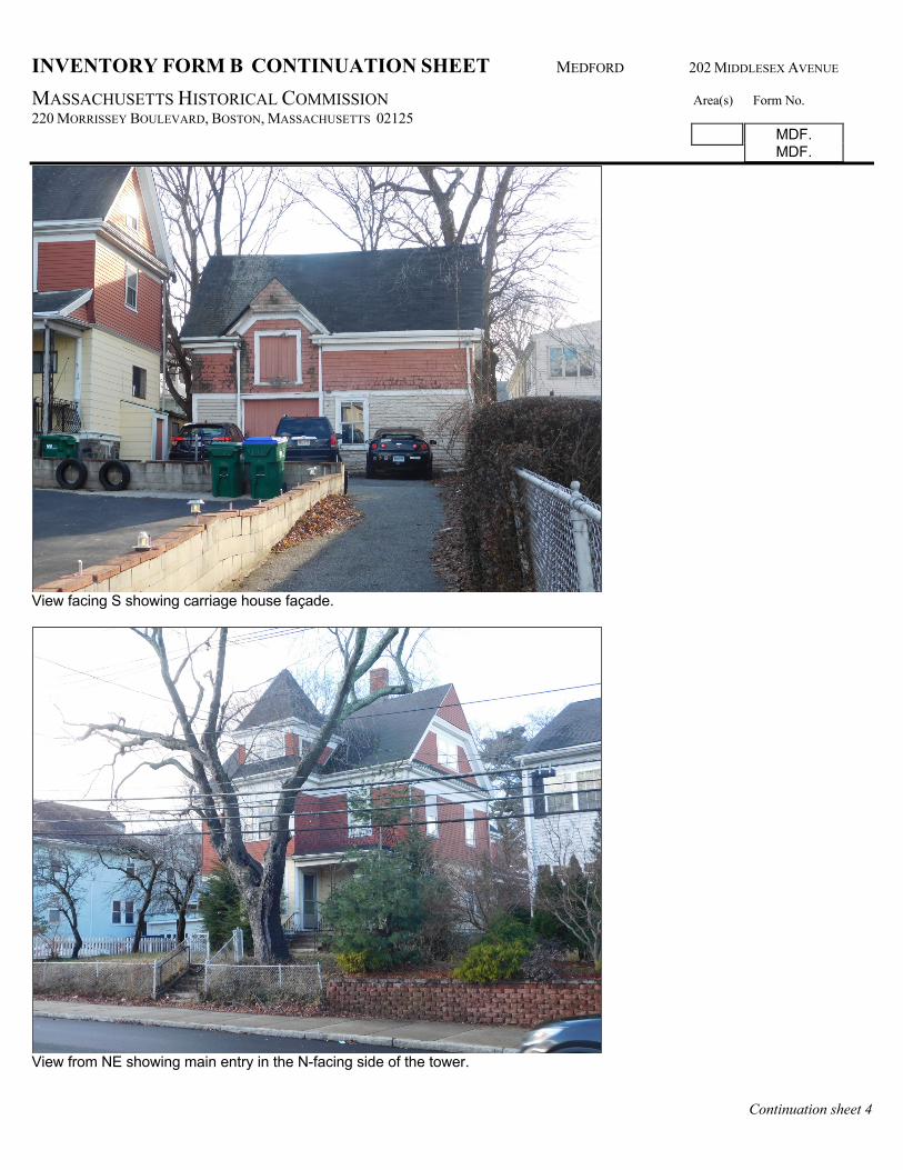
placed on a gentle earthen rise planted with border and foundation plantings. The lot is surrounded by a low chain-link fence. The property is currently half of its original acreage, which originally filled the southwest corner of Middlesex Avenue and 4th Street until 2006 when it was subdivided. The property includes a generous carriage house that matches the main house in terms of its two-tone finishes and clipped gables; however the carriage house retains its original shingle, clapboard, and molded-trim finishes. It could serve as a model for a restoration of the main house. The façade of the carriage house, which faces north toward 4th Street, retains its off-set cargo door set within a clipped façade gable. The main carriage door, sash and casings survive as well. HISTORICAL NARRATIVE
The Henry L. and Harriet Cornell House is part of the initial development that occurred during the 1880s and 1890s on the blocks flanking the Riverside Avenue/ Fifth Street corridor, the center of the Wellington Farms subdivision. The larger gridded subdivision, covering about 160 acres, included over 400 parcels on mostly east-west streets. The early ownership of the subject property suggests the degree to which lots in the Wellington subdivision may have been subject to speculation during its first three decades. Originally comprised of lot 102 in the 1855 Wellington subdivision, its ownership has been traced to an 1857 conveyance from Samuel N. and Lydia Brown to Alden White of Kingston, farmer, This deed also describes the property as “…being the same conveyed to me (Brown) by Ezra D. Conant subject to a mortgage given by said Conant to Isaac

INVENTORY FORM B CONTINUATION SHEET MEDFORD 202 MIDDLESEX AVENUE
MASSACHUSETTS HISTORICAL COMMISSION Area(s) Form No. 220 MORRISSEY BOULEVARD, BOSTON, MASSACHUSETTS 02125
Continuation sheet 2
MDF. MDF.
Wellington for $475.” 1 No reference was given for that deed, however, and it has not yet been located. In 1860 White sold the property to Renslow Crosby of Medford, gentleman.2 That year Crosby conveyed the property through a third party, Martin C. Glover, to himself and his wife, Clarissa M. This instrument references a set of “conditions and restrictions” that included the following:
…no building should be placed upon said lots any nearer the streets on said plan laid down, than 20 feet, that no nuisance to dwelling houses shall be erected, continued or carried on upon any of said lots – that all and every of the dwelling houses erected on any of said lots shall be of the value and cost of $1,000, and upon the lots selected and fronting on 5th, 6th, and 7th streets on Apsley Avenue [later Middlesex between 1874 and 1876], and on that part of 4th Street between Craddock and Bradbury avenues all and every of the dwelling houses shall be of the cost and value of $2,500; all said conditions to be in full force for 30 years…3
There is no evidence that either Conant, White, or the Crosbys made improvements to the property. Although period census returns reveal that Crosby was a neighbor of both Isaac and James Wellington, as well as Martin C. Glover during the 1860s, he evidently resided at a house and connected barn on the southwest corner of Riverside and Middlesex avenues (not extant), where he was labelled as owner in 1889. Both Crosby and Glover were jewelry manufacturers. By 1880 the Crosbys had moved to Newton and subject house was not depicted on any map until 1898.4 Renslow Crosby may have been related to the Wellingtons in some manner that has not yet been ascertained; James Wellington’s daughter Angelina (born ca. 1824) was married to Darius Crosby (1821-1903), clerk, but a connection between Renslow and Darius has yet to be established. They had different fathers and birthplaces. Martin Colburn Glover (1824-1864) was married to Mary Ann Wellington (1832-1903), a daughter of Isaac Wellington (1787-1880). Glover was a jewelry manufacturer, as was Renslow Crosby, the latter a founder of Ripley & Crosby, later Ripley-Howland & Co. (1869), jewelry manufacturers, 321 Washington Street, Boston. In 1890 Renslow and Clarissa M. Crosby sold the subject property to Henry L. Cornell. Consideration was $1, buildings were not mentioned in the description, and no mortgage was recorded. In 1890 Cornell resided at 11 Fifth Avenue but by 1893 was living at “Middlesex Avenue, corner of 4th,” the subject house. Henry Lyman Cornell (1852-1935) was a music teacher and vocal musician of opera. Little could be ascertained about his career through readily available records, but several brief newspaper accounts suggest he was actively performing in Boston as a basso during the 1880s. In 1900 the household, identified as 202 Middlesex Avenue, included his wife, Harriet Sophia (Withington, 1849-1940), whom he married in 1874, three sons, and three daughters born between 1879 and 1899. In 1930, at which time the house was valued at $10,000, the household included his daughter, Shirley (b. 1880) and her husband Leroy H. Robbins (b. 1880), a real estate broker.5 In 2006 the property, at the time comprised of 13,200 square feet, was obtained by John A. Carney from Maurino DaSilva Costa and Maria Natalia Costa. Later that year Carney subdivided the property and sold a 7,200 square foot residual lot with the main house and carriage house to subsequent owners. A large duplex facing Middlesex Avenue was placed on the corner lot.6 BIBLIOGRAPHY and/or REFERENCES Maps and atlases: 1855 H.F. Walling. “Map of Medford....” 1875 F. W. Beers, County Atlas of Middlesex, Massachusetts. 1880 O. H. Bailey [Bird’s Eye View of] Medford. 1889 Geo. H. Walker & Co., Atlas of Middlesex County, Massachusetts.
1 MCSRD 763:221 (1857); although this deed does not reference the original mortgage instrument, it includes the identity of its holder, Isaac Wellington, and the date, 1855. 2 MCSRD 838:126 (1860). 3 MCSRD 843:329-331 (1860). 4 1860, 1870, 1880 Federal Census; 1889 Walker county atlas. 5 Marriage: Newburyport vital records; Mason membership card; 1900, 1930 Federal Census; 1890-1938 Medford town and city directories; Boston Daily Globe, May 16, 1886, p. 8; Mar. 3, 1889, p. 13. 6 MCSRD 47334:223 (Apr. 2006); 47749:277 (May 2006).

INVENTORY FORM B CONTINUATION SHEET MEDFORD 202 MIDDLESEX AVENUE
MASSACHUSETTS HISTORICAL COMMISSION Area(s) Form No. 220 MORRISSEY BOULEVARD, BOSTON, MASSACHUSETTS 02125
Continuation sheet 3
MDF. MDF.
1898 Geo. W. Stadly & Co., Atlas of the City of Medford.... 1900 Geo. W. Stadly & Co., Atlas of Middlesex County, Massachusetts, Volume 1. 1892, 1897, 1903, 1910, 1936, 1936-1950 Sanborn Insurance Atlases. Ancestry.com: see footnotes Charles Brooks and James M. Usher, History of the Town of Medford, Middlesex County, Massachusetts, From its First
Settlement in 1630 to 1855; Revised, Enlarged and Brought Down to 1885 (Rand, Avery & Co., 1886) Middlesex County South Registry of Deeds, in notes as MCSRD book:page.
A section of MCSRD plan 6:3 (1855) showing the Wellington subdivision as originally planned. The subject property is indicated by a red arrow.
INVENTORY FORM B CONTINUATION SHEET MEDFORD 202 MIDDLESEX AVENUE
MASSACHUSETTS HISTORICAL COMMISSION Area(s) Form No. 220 MORRISSEY BOULEVARD, BOSTON, MASSACHUSETTS 02125
Continuation sheet 4
MDF. MDF.
View facing S showing carriage house façade.
View from NE showing main entry in the N-facing side of the tower.