los helados porphyry copper-gold deposit chile...south america during that time. 3. i am a...
TRANSCRIPT

Technical Report
on the
Los Helados Porphyry Copper-Gold Deposit
Chile
NGEx Minerals Ltd. 2000 – 885 West Georgia Street
Vancouver, BC, Canada
F. Devine, M.Sc., P.Geo. Report Date: August 6, 2019
G. Zandonai, RM CMC Effective Date: April 26, 2019
G. Di Prisco, Ph.D., P.Geo.

Los Helados Deposit, Chile
NI 43-101 Technical Report
TOC ii September 2019
C O N T E N T S
1.0 SUMMARY .............................................................................................................1-1 1.1 Introduction .................................................................................................1-1 1.2 Project Description and Location .................................................................1-1
1.2.1 Location ...........................................................................................1-1 1.2.2 Ownership .......................................................................................1-1 1.2.3 Mineral Tenure and Surface Rights .................................................1-2 1.2.4 Agreements .....................................................................................1-2 1.2.5 Royalties ..........................................................................................1-2
1.3 Accessibility, Climate, Local Resources, Infrastructure and Physiography ..1-3 1.4 History .........................................................................................................1-3 1.5 Geological Setting and Mineralization .........................................................1-3 1.6 Exploration ..................................................................................................1-4 1.7 Drilling .........................................................................................................1-4 1.8 Sampling and Analysis ................................................................................1-5 1.9 Data Verification ..........................................................................................1-6 1.10 Metallurgical Testwork.................................................................................1-6 1.11 Mineral Resource Estimates........................................................................1-7 1.12 Mineral Resource Statement .......................................................................1-8 1.13 Recommendations ......................................................................................1-9
2.0 INTRODUCTION .................................................................................................. 2-11 2.1 Terms of Reference .................................................................................. 2-11 2.2 Qualified Persons ...................................................................................... 2-11 2.3 Site Visits and Scope of Personal Inspection ............................................ 2-11 2.4 Effective Dates .......................................................................................... 2-12 2.5 Information Sources and References ........................................................ 2-12 2.6 Previous Technical Reports ...................................................................... 2-12
3.0 RELIANCE ON OTHER EXPERTS ........................................................................3-1 3.1 Ownership, Mineral Tenure and Surface Rights ..........................................3-1 3.2 Environmental, Permitting and Social ..........................................................3-1
4.0 PROPERTY DESCRIPTION AND LOCATION .......................................................4-3 4.1 Project Location ..........................................................................................4-3 4.2 Project Ownership .......................................................................................4-3 4.3 Joint Exploration Agreement .......................................................................4-4 4.4 Mineral Tenure (Chile).................................................................................4-4
4.4.1 Option Agreements ..........................................................................4-5 4.4.2 Surface Rights ............................................................................... 4-14 4.4.3 Royalties and Encumbrances ........................................................ 4-14 4.4.4 Permits .......................................................................................... 4-14 4.4.5 Environmental Liabilities ................................................................ 4-14
4.5 Mineral Tenure (Argentina) ....................................................................... 4-15 4.5.1 Surface Rights ............................................................................... 4-15 4.5.2 Royalties and Encumbrances ........................................................ 4-16 4.5.3 Permits .......................................................................................... 4-16 4.5.4 Environmental Liabilities ................................................................ 4-16
4.6 Mining Integration and Complementation Treaty ....................................... 4-18

Los Helados Deposit, Chile
NI 43-101 Technical Report
TOC iii September 2019
5.0 ACCESSIBILITY, CLIMATE, LOCAL RESOURCES, INFRASTRUCTURE, AND PHYSIOGRAPHY ...................................................................................................5-1 5.1 Accessibility ................................................................................................5-1
5.1.1 Climate ............................................................................................5-1 5.1.2 Local Resources and Infrastructure .................................................5-2 5.1.3 Physiography ...................................................................................5-3
6.0 HISTORY ...............................................................................................................6-1 7.0 GEOLOGICAL SETTING AND MINERALIZATION .................................................7-1
7.1 Regional Geology ........................................................................................7-1 7.2 Project Geology...........................................................................................7-3 7.3 Deposit Description .....................................................................................7-3
7.3.1 Los Helados ....................................................................................7-3 8.0 DEPOSIT TYPES ...................................................................................................8-1 9.0 EXPLORATION ......................................................................................................9-3
9.1 Previous Work .............................................................................................9-3 9.1.1 Grids and Surveys ...........................................................................9-3 9.1.2 Geological Mapping .........................................................................9-3 9.1.3 Geochemical Sampling ....................................................................9-7 9.1.4 Geophysics ......................................................................................9-7 9.1.5 Pits and Trenches ............................................................................9-7
9.2 Exploration Potential ...................................................................................9-7 9.2.1 Los Helados Deposit........................................................................9-7 9.2.2 Regional Targets .............................................................................9-8
10.0 DRILLING ............................................................................................................. 10-8 10.1.1 Geological Logging ...................................................................... 10-11 10.1.2 Geotechnical Logging and Testing ............................................... 10-11 10.1.3 Recovery ..................................................................................... 10-11 10.1.4 Collar Surveys ............................................................................. 10-11 10.1.5 Downhole Surveys ....................................................................... 10-12 10.1.6 Sample Length/True Thickness ................................................... 10-12
11.0 SAMPLE PREPARATION, ANALYSES, AND SECURITY .................................... 11-1 11.1 Sampling Methods .................................................................................... 11-1
11.1.1 Surface Sampling .......................................................................... 11-1 11.1.2 Drill Sampling ................................................................................ 11-1
11.2 Density Determinations ............................................................................. 11-1 11.3 Analytical and Test Laboratories ............................................................... 11-2 11.4 Sample Preparation and Analysis ............................................................. 11-2
11.4.1 RC ................................................................................................. 11-2 11.4.2 Core .............................................................................................. 11-2
11.5 Quality Assurance and Quality Control ...................................................... 11-3 11.5.1 RC ................................................................................................. 11-3 11.5.2 Core .............................................................................................. 11-3 11.5.3 External Assay Checks .................................................................. 11-4
11.6 Databases ................................................................................................. 11-4 11.7 Sample Storage ........................................................................................ 11-4 11.8 Sample Security ........................................................................................ 11-5 11.9 Comments on Section 11 .......................................................................... 11-5
12.0 DATA VERIFICATION .......................................................................................... 12-5

Los Helados Deposit, Chile
NI 43-101 Technical Report
TOC iv September 2019
12.1 Gino Zandonai .......................................................................................... 12-5 12.2 Fionnuala Devine ...................................................................................... 12-5 12.3 Comments on Section 12 .......................................................................... 12-6
13.0 MINERAL PROCESSING AND METALLURGICAL TESTING .............................. 12-7 13.1 Metallurgical Testwork............................................................................... 12-7
13.1.1 Introduction .................................................................................... 12-7 13.1.2 Geometallurgical Domains ............................................................. 12-7 13.1.3 Head Sample Characterization ...................................................... 12-8 13.1.4 Mineralogy ..................................................................................... 12-9 13.1.5 Physical Characterization ............................................................ 12-10 13.1.6 Gravity Recoverable Gold ............................................................ 12-13 13.1.7 Conventional Flotation ................................................................. 12-13 13.1.8 Metallurgical Variability ................................................................ 12-17 13.1.9 Deleterious Elements ................................................................... 12-17
14.0 MINERAL RESOURCE ESTIMATES.................................................................. 14-18 14.1 Introduction ............................................................................................. 14-18 14.2 Geological Models ................................................................................... 14-18 14.3 Exploratory Data Analysis ....................................................................... 14-18 14.4 Density Assignment ................................................................................ 14-19 14.5 Grade Capping/Outlier Restrictions ......................................................... 14-19 14.6 Composites ............................................................................................. 14-19 14.7 Variography ............................................................................................. 14-19 14.8 Estimation/Interpolation Methods ............................................................ 14-19 14.9 Block Model Validation ............................................................................ 14-20 14.10 Classification of Mineral Resources......................................................... 14-20 14.11 Reasonable Prospects of Eventual Economic Extraction ........................ 14-20 14.12 Mineral Resource Statement ................................................................... 14-22 14.13 Factors That May Affect the Mineral Resource Estimate ......................... 14-23
23.0 ADJACENT PROPERTIES ................................................................................... 23-1 24.0 OTHER RELEVANT DATA AND INFORMATION ................................................. 24-1 25.0 INTERPRETATION AND CONCLUSIONS ........................................................... 25-2
25.1 Mineral Tenure, Surface Rights and Royalties .......................................... 25-2 25.2 Exploration ................................................................................................ 25-2 25.3 Geology and Mineralization ....................................................................... 25-3 25.4 Drilling ....................................................................................................... 25-3 25.5 Sampling and Assay ................................................................................. 25-3 25.6 Data Verification ........................................................................................ 25-3 25.7 Metallurgical Testwork............................................................................... 25-3 25.8 Mineral Resource Estimation..................................................................... 25-4
26.0 RECOMMENDATIONS......................................................................................... 26-1 26.1 Phase I ...................................................................................................... 26-1
26.1.1 Mineral Resource .......................................................................... 26-1 26.1.2 Mine Planning ................................................................................ 26-1
26.2 Phase II ..................................................................................................... 26-1 26.2.1 Infrastructure ................................................................................. 26-1 26.2.2 Environmental, Permitting and Stakeholder Considerations........... 26-2 26.2.3 Report Compilation ........................................................................ 26-2
26.3 Budget Estimate ........................................................................................ 26-2

Los Helados Deposit, Chile
NI 43-101 Technical Report
TOC v September 2019
27.0 REFERENCES ..................................................................................................... 27-1

Los Helados Deposit, Chile
NI 43-101 Technical Report
TOC vi September 2019
T A B L E S
Table 1-1: Mineral Resource Estimate for Los Helados (base case is highlighted) ......................... 1-9 Table 1-2: Recommendations Costs .............................................................................................. 1-10 Table 4-1: Exploitation Mining Concessions Under Option ................................................................. 4-5 Table 4-2: Exploitation Mining Concessions (Granted) ....................................................................... 4-7 Table 4-3: Exploration Mining Concessions (Granted)........................................................................ 4-8 Table 4-4:Exploration Mining Concessions in the Process of Being Granted ................................... 4-10 Table 4-5: Exploitation Mining Concessions for the Los Helados Project in Argentina ................. 4-15 Table 10-1: Drill Summary Table ....................................................................................................... 10-9 Table 11-1: Los Helados Specific Gravity Values by Lithological Domain ....................................... 11-1 Table 13-1: Composite Description, Los Helados Phase I ............................................................... 12-8 Table 13-2: Composite Description, Los Helados Phase II .............................................................. 12-9 Table 13-3: Head Grade Chemical Characterization, Los Helados Phase I .................................... 12-9 Table 13-4: Head Grade Chemical Characterization, Los Helados Phase II ................................... 12-9 Table 13-5: Los Helados - Py:Cp Ratios. ........................................................................................ 12-10 Table 13-6: Composite Samples Head Physical Characterization, Los Helados Phase I ...... 12-11 Table 13-7: Composite Samples Head Physical Characterization, Los Helados Phase II ............ 12-11 Table 13-8: Variability Samples Physical Characterization Los Helados Phase II ........................ 12-11 Table 13-9: Metal Recovery from Flotation LCT, Los Helados Phase I ......................................... 12-14 Table 13-10:Composite Samples Metal Recovery from Flotation LCT, Los Helados Phase II....... 12-15 Table 13-11:Composite Samples Elements and Impurities Contained in the LCT Final
Concentrate, Los Helados Phase II ............................................................................ 12-15 Table 13-12:Variability Samples Metal Recovery from Flotation LCT, Los Helados Phase II ........ 12-15 Table 13-13:Variability Samples Elements and Impurities Contained in the LCT Final
Concentrate, Los Helados Phase II ............................................................................ 12-16 Table 13-14:Pyrite Content Estimation in Feed and Concentrate LCT, Los Helados Phase II ...... 12-16 Table 14-1: Parameters to Estimate Equivalent Copper ................................................................ 14-22 Table 14-2: Mineral Resource Estimate for Los Helados Assuming Underground Block Cave
Methods (base case is highlighted) ............................................................................. 14-23 Table 26-1: Recommendations Costs .............................................................................................. 26-3

Los Helados Deposit, Chile
NI 43-101 Technical Report
TOC vii September 2019
T A B L E O F F I G U R E S
Figure 4-4-1: Project Location Plan ................................................................................................. 4-3 Figure 4-2: Mineral Tenure Map ........................................................................................................ 4-18 Figure 5-1: Project Access Plan ........................................................................................................ 5-2 Figure 7-1: Late Oligocene-Miocene porphyry belt in the area of El Indio to Maricunga .................. 7-2 Figure 7-2: Regional Geological Map of the Project Area ................................................................. 7-4 Figure 7-3: Los Helados Deposit Geology Map .................................................................................. 7-6 Figure 7-4: Los Helados Section UTM-6,864,800 (4800) North (looking north) ................................. 7-9 Figure 7-5: Los Helados Deposit Alteration Map ............................................................................... 7-12 Figure 7-6: Los Helados Section UTM-6,864,900 North – Alteration and Mineral Zones (looking
north) ............................................................................................................................. 7-13 Figure 8-1: Porphyry Copper Belts and Major Porphyry Copper Deposits in the Andes .................. 8-2 Figure 9-1: Cerro Blanco Prospect – Lithology ................................................................................... 9-5 Figure 9-2: Cerro Blanco Prospect - Alteration ................................................................................... 9-6 Figure 10-1: Drill-Hole Collar Location Map .................................................................................... 10-10 Figure 10-2: Example Drill Section 4900 N ..................................................................................... 10-13 Figure 13-1: Elemental Copper Deportment, Los Helados ............................................................. 12-12

Los Helados Deposit, Chile
NI 43-101 Technical Report
TOC viii September 2019
CERTIFICATE OF QUALIFIED PERSON
To accompany the technical report entitled: “Technical Report on the Los Helados Porphyry Copper- Gold Deposit, Chile” prepared for NGEx Minerals Ltd. (the “Issuer”) dated August 6, 2019, with an effective date April 26, 2019 (the “Technical Report”).
I, Fionnuala Anna Marie Devine, P. Geo., do hereby certify that:
1. I am a geologist with Merlin Geosciences Inc. with an office at 178 – 6th Street, Atlin, BC, Canada, V0W 1A0, telephone +1 250-651-7569, email [email protected].
2. I graduated in Geological Sciences from The University of British Columbia with a Bachelor of Science degree in 2002; and completed a Master of Science degree from Carleton University in 2005. I have practiced my profession continuously since 2005. I have been involved in mineral exploration for base and precious metals in a variety of deposit types in North and South America during that time.
3. I am a Professional Geoscientist registered with Engineers and Geoscientists BC, license # 40876.
4. I first visited the project site in January, 2014. My most recent visit to the project area was in
February, 2017, when I spent six days on site, supervising and guiding the geological mapping
of the Cerro Blanco area undertaken by staff geologists. This personal inspection is considered
current as there has been no new material scientific or technical information about the property
since then. Since February 2017, I have had frequent contact with NGEx company personnel
during subsequent field seasons (post-2017) and have maintained current knowledge of work
completed on various of the Company’s projects including Los Helados. Through this contact I
has confirmed that there has been no new material scientific or technical information about Los
Helados since my last visit in February of 2017.
5. I have read the definition of “qualified person” set out in National Instrument 43-101 Standards of Disclosure for Mineral Projects (“NI 43-101”) and certify that by virtue of my education, affiliation to a professional association and past relevant work experience, I fulfill the requirements to be a “qualified person” for the purposes of NI 43-101.
6. As a qualified person, I am independent of the Issuer as defined in Section 1.5 of NI 43-101.
7. I am a co-author of the Technical Report, responsible for Sections 1 (except 1.10, 1.11, 1.12), 2, 3, 4, 5, 6, 7, 8, 9, 10, 11, 12, 23, 24, 25 (except 25.7, 25.8), 26, 27 of the Technical Report, and I accept professional responsibility for those sections of the Technical Report.
8. I have been involved in exploration of the property since 2014, including surface geological mapping and core reviews in 2015, and 2017. My most recent visit to the property was February 2017.
9. As of the date of this certificate, to the best of my knowledge, information and belief, the portion of the Technical Report for which I am responsible contains all scientific and technical information that is required to be disclosed to make the portion of the Technical Report for which I am responsible not misleading.
10. I have read NI 43-101 and Form 43-101F1, and the Technical Report has been prepared in compliance with NI 43-101 and Form 43-101F1.
Dated this 6th day of August, 2019 in Atlin, B.C., Canada.
“original signed”
Fionnuala Anna Marie Devine, P. Geo Merlin Geosciences Inc.

Los Helados Deposit, Chile
NI 43-101 Technical Report
TOC ix September 2019
CERTIFICATE OF QUALIFIED PERSON
To accompany the technical report entitled: “Technical Report on the Los Helados Porphyry Copper-Gold Deposit, Chile” prepared for NGEx Minerals Ltd. (the “Issuer”) dated August 6, 2019, with an effective April 26, 2019 (the “Technical Report”).
I, Gino Zandonai, MSc. (CSM), CP (RM CMC #0155)., do hereby certify that:
1 I am an independent mining engineer and qualified person, residing at Camino de Los Refugios 17770, Comuna de Lo Barnechea, Santiago, Chile, tel +56 (9) 97915596, email [email protected]. I am employed as managing director by DGCS SA.
2 I graduated in civil & mining engineering from the University of La Serena, Chile with degrees of Licenciado en Ciencias de la Ingenieria (B.Sc.) in 1989, and from the Colorado School of Mines, Golden, Co, USA with a M.Sc. in Mining Engineering in 1999
3 I am a Competent Person duly qualified in Estimation of Mineral Resources and Reserves (Record No. 0155) from the Examination Board of Competences in Mining Resources and Reserves of Chile, Law 20.235, subscribed to the Committee for Mineral Reserves International Reporting Standards (CRIRSCO #0155) and am a Registered Member of the Chilean Mining Commission. I am a “qualified person” for the purposes of NI 43-101 due to my experience and current affiliation with a professional organization as defined in NI 43-101.
4 I first visited the property and the core logging facility in January, 2012.
5 I have read the definition of “qualified person” set out in National Instrument 43-101 Standards of Disclosure for Mineral Projects (“NI 43-101”) and certify that by virtue of my education, affiliation to a professional association and past relevant work experience, I fulfill the requirements to be a “qualified person” for the purposes of NI 43-101.
6 As a qualified person, I am independent of the Issuer as defined in Section 1.5 of NI 43-101.
7 I am a co-author of the Technical Report, responsible for sections 1.11, 1.12, 14 and 25.8 of the Technical Report, and I accept professional responsibility for those sections of the Technical Report.
8 I have had prior involvement with the subject property, having completed the initial mineral resource estimation in 2012 and updates to the mineral resource estimation in 2013 and 2014.
9 As of the date of this certificate, to the best of my knowledge, information and belief, the portion of the Technical Report for which I am responsible contains all scientific and technical information that is required to be disclosed to make the portion of the Technical Report for which I am responsible not misleading.
10 I have read NI 43-101 and Form 43-101F1, and the Technical Report has been prepared in compliance with NI 43-101 and Form 43-101F1.
Dated this 6h day of August, 2019 in Santiago, Chile.
“signed and sealed”
Gino Zandonai, MSc. (CSM), CP (RM CMC #0155)

Los Helados Deposit, Chile
NI 43-101 Technical Report
TOC x September 2019
CERTIFICATE of AUTHOR
To accompany the technical report entitled: “Technical Report on the Los Helados Porphyry Copper-Gold Deposit, Chile” prepared for NGEx Minerals Ltd. (the “Issuer”) dated August 6, 2019, with an effective April 26, 2019 (the “Technical Report”).
I, Mr. Giovanni Di Prisco , Ph.D., P. Geo do hereby certify that:
1. I am a consulting geologist -mineralogist and President of: Terra Mineralogical Services Inc.
1565 Champlain Drive, Peterborough, Ontario, Canada, K9L 1N5
2. I graduated with a Doctoral degree (Ph.D.) in Applied Geology/ Exploration Geology from the University of Franche Comté, in Besançon, France in 1983.
3. I am a practicing member of the Association of the Professional Geologist of Ontario (#0366)
4. I have worked as a geologist for a total of 36 years since my graduation from university.
5. I have read the definition of “qualified person” set out in National Instrument 43-101 (“NI
43-101”) and certify that by reason of my education, affiliation with a professional
Association (as defined in NI 43-101) and past relevant work experience; I fulfill the
requirements to be a “qualified person” for the purposes of NI 43-101.
6. I am responsible for the preparation of section 1.10, 13, 25.7 of the technical report relating to the Los Helados project.
7. I reviewed the technical reports regarding the metallurgical test program of Los Helados.
8. I am not aware of any material fact or material change with respect to the subject matter
of the Technical Report that is not reflected in the Technical Report, the omission to disclose which makes the Technical Report misleading.
9. I am independent of the issuer applying all of the tests in section 1.5 of National
Instrument 43-101.
10. I have read National Instrument 43-101 and Form 43-101F1, and the Technical Report
has been prepared in compliance with that instrument and form.
Dated this 6th Day of August, 2019
“Signed and Sealed”
Giovanni Di Prisco, Ph.D., P.Geo.
President- Consulting Geometallurgist
Terra Mineralogical Services Inc.

Los Helados Deposit, Chile
NI 43-101 Technical Report
Page 1-1 September 2019
1.0 SUMMARY
1.1 Introduction
This independent NI 43-101 Technical Report (the “Report”) was prepared in connection with a Plan of Arrangement (the “Transaction”), whereby NGEx Minerals Ltd. acquired from NGEx Resources Inc. (“NGEx”) its interest in the Los Helados Project and NGEx distributed the NGEx Minerals Ltd. shares to the NGEx shareholders at the effective time of the Transaction. Following completion of the Transaction, NGEx Minerals Ltd. now controls the Los Helados Project.
Subsequent to completion of the Transaction, NGEx Minerals Ltd. applied for listing on the TSXV. This report was prepared in support of the listing application.
Sources of information used in this report include previous technical reports and internal company reports on the project and original work by the report authors. The consultants who are responsible for this Report are Ms. Fionnuala Devine, Mr. Gino Zandonai and Mr. Giovanni Di Prisco, all of whom are independent of the Company.
1.2 Project Description and Location
1.2.1 Location
The Los Helados Project is located in Chile 135 km southeast of the city of Copiapó.
The deposit is centred at 28.3408º S, 69.5857º W.
1.2.2 Ownership
The Los Helados project is comprised of claims in Chile owned by NGEx’s Chilean
subsidiary, Minera Frontera del Oro S.C.M (MFDO) (the “MFDO” Claims), and claims in
Argentina owned by its Argentine subsidiaries RioEx S.A. (the “La Rioja Properties”) and
Pampa Exploraciones S.A. (the “Pampa Claims”). NGEx holds an indirect
approximately 63% interest in the MFDO Claims, a 60% interest in the La Rioja
Properties and a 100% interest in the Pampa Claims. The MFDO Claims and the La
Rioja Properties are subject to a joint exploration agreement with Pan Pacific Copper
Co., Ltd. (“PPC”) which holds the remaining approximately 37% and 40% respective
interests. The Los Helados deposit is located entirely within Chile on claims held by
MFDO.
NGEx acts as the operator of the project and both parties are required to contribute their
pro-rata share of expenditures or dilute their interest in the Project. PPC has not been
contributing to project expenditures in Chile since 2015 and as a result the PPC interest
in the MFDO claims is being diluted.

Los Helados Deposit, Chile
NI 43-101 Technical Report
Page 1-2 September 2019
For the purposes of this Report, the NGEx parent and subsidiary companies are referred
to interchangeably as “NGEx”.
1.2.3 Mineral Tenure and Surface Rights
Legal opinion was provided that supported that in Chile, NGEX is owner of 30
Exploitation Mining Concessions already granted, 97 Exploration Mining Concessions
(53 of them already granted and 44 in the process of being granted) and three unilateral
and irrevocable options to purchase seven exploitation concessions. The total area
covered by the titles in Chile, including overlapping claims, is approximately 31,428 ha.
Total area excluding overlapping claims is 20,930 ha. of which 5,628 ha are covered by
exploitation concessions. The mineral resource is located on these exploitation
concessions, entirely within Chile.
Surface land rights in the area of the Los Helados are held by a local community
“Comunidad Civil Ex Estancia Pulido”. NGEx has an agreement (the “Pulido
Agreement”) dated August 25, 2016 that provides for surface access and occupation
and to conduct exploration and exploitation activities including construction and
operation of a mine in return for annual payments and bullet payments on achievement
of certain project milestones as well as a 0.6% Net Profits Royalty.
NGEx also has in place two additional agreements with property owners providing for
easements to allow transportation along roads which transect the properties.
Legal opinion was provided that supported that NGEx owns five exploitation licenses
(minas) in La Rioja Province and one in San Juan Province. Concessions held by NGEx
total approximately 4,255 ha. None of the Mineral Resource occurs in Argentina.
The properties in La Rioja are located in the Iglesias Department of the Province of La
Rioja, in the area called “Usos Múltiples” (“Multiple Uses”), which is the marginal area of
the Laguna Brava Provincial Reserve, where mining activities are fully authorized.
1.2.4 Agreements
The Chile Properties include three separate option agreements for small claim groups
within the overall property perimeter in Chile and a Joint Exploration Agreement with
PPC.
1.2.5 Royalties
The Government of Chile levies a mining tax that is a tax on operational mining income,
applied on a sliding-scale rate basis of between 5% and 14% depending on operating
margins. In addition, the Pulido Agreement includes a 0.6% Net Profits Interest royalty.
The properties Nacimientos I, Potro I, Potro II and Potro III are subject to payment of
USD2.0M in the event that any of the rights which make up these claims actually become

Los Helados Deposit, Chile
NI 43-101 Technical Report
Page 1-3 September 2019
productive as mining fields. Furthermore, NGEx shall pay the owners a Net Smelting
Return royalty of 0.5% of the amount of the project benefits over 10 years, less costs.
The property Solitario 17 is subject to a payment of 7% Net Profits Interest.
1.3 Accessibility, Climate, Local Resources, Infrastructure and Physiography
The Los Helados Project is located in Chile, in the Andes Mountains, straddling the
Chile–Argentina border. The deposit itself is entirely within Chile. Elevations range from
approximately 3,000 m to 5,300 m at the international boundary. Topography is quite
rugged on the Chilean (western) slope of the mountains, and more subdued on the
Argentine (eastern) slope which is typically comprised of broad, flat-bottomed valleys
with moderately steep slopes.
Access to the Project is from Copiapó, a driving distance of about 170 km, or three
hours.
The climate in the Project area is dry to arid and the temperatures are moderate to cold.
Annual precipitation is about 250 mm, with snow at higher altitudes in the winter.
Exploration fieldwork is generally possible from mid-October to early May. It is
anticipated that mining operations could be conducted year round.
The most important logistics centre in the region is Copiapó. Copiapó has a population
of approximately 150,000 people, an airport with daily scheduled flights to Santiago and
Antofagasta, and companies that offer mining and exploration services.
1.4 History
There is no record of significant exploration activity at Los Helados prior to NGEx’s
interest. There are no historical Mineral Resource estimates, and no reported
production from the area. The Los Helados deposit was discovered by NGEx in 2008.
1.5 Geological Setting and Mineralization
Based on geological features and location, the Los Helados deposit is classified as a
porphyry Cu-Au system.
Mineralization at Los Helados is primarily hosted by a Miocene magmatic–hydrothermal
breccia that forms a roughly circular, pipe-like body with minimum dimensions of
1,100 m east–west, 1,200 m north–south, and at least 1,500 m vertically. The breccia
formed during intrusion of a mid-Miocene dacitic porphyry intrusive system, and
developed in the cupola zone of an intermineral porphyry intrusion. A broad halo of
moderate to low grade Cu–Au mineralization surrounds the breccia, which diminishes in
grade with increasing distance from the breccia contact. The breccia limits have been
established by drilling to the west, east and south; however, the northern limit of the

Los Helados Deposit, Chile
NI 43-101 Technical Report
Page 1-4 September 2019
breccia body has not yet been defined. The system also remains open at depth, and
the lateral extent of the breccia at depth is poorly constrained by the current drilling.
Four mineral zones are recognized within the deposit based on sulphide occurrence. In
order of increasing depth, the zones are: pyrite only, pyrite>chalcopyrite,
chalcopyrite>pyrite and chalcopyrite only. This sulphide zoning sequence reflects a
progressive downward increase in the amount of chalcopyrite relative to pyrite.
Recent internal NGEx studies have suggested the presence of a discrete, higher-grade
breccia phase occurring along the western and southwestern margins of the magmatic–
hydrothermal breccia. This high-grade breccia zone has not been fully delineated, and
remains open for further extension.
1.6 Exploration
Work programs conducted by NGEx include geological mapping; soil, rock-chip and
talus sampling; a number of geophysical surveys including induced polarization (IP)–
resistivity, magnetometer, and Mount Isa Mine’s Distributed Acquisition System
methodology (MIMDAS) surveys; reverse circulation (RC) and core drilling, and Mineral
Resource estimation. A number of environmental baseline studies have been
undertaken.
1.7 Drilling
Eight drilling campaigns have been carried out at the Los Helados deposit, from 2006 to
2015. No drilling was conducted during the 2013–2014 season or subsequent to 2015.
Drilling to date totals 75,634 m in 88 drill holes, of which five holes (1,366 m) are RC
and 83 holes (74,268 m) are core. The core drilling produced 33,936 m of NQ (47.6 mm
diameter) core and 40,332 m of HQ size (63.5 mm) core. Three of the core holes were
drilled for geotechnical information and have been maintained as whole core (i.e. not
sampled for assay).
Core was photographed, logged for detailed lithology, alteration and mineralization
features, and (RQD) and recovery data were collected. Several of the drill holes were
also logged for geotechnical information.
Core recovery data were not systematically collected on holes drilled before the 2010–
2011 campaign. Core recovery from holes drilled at Los Helados between 2011 and
2015 (representing 78% of the total drill metres) averages 97%.
Collar locations were surveyed using a differential global positioning system (GPS)
instrument. Down-hole surveys were carried out at 50 m intervals on average, using a
Reflex multi-shot instrument up to the 2011–2012 drilling campaign. Starting with the
2012–2013 drilling, an SRG-gyroscope survey was completed for each drill hole by

Los Helados Deposit, Chile
NI 43-101 Technical Report
Page 1-5 September 2019
Comprobe Limitada. On average, measurements were collected at 30 m intervals down
the hole.
Drill hole orientations are generally appropriate for the mineralization style. The Los
Helados deposit is a porphyry system with disseminated mineralization. Reported and
described interval thicknesses are considered true thicknesses.
1.8 Sampling and Analysis
Drill holes were typically sampled on 2 m intervals.
A total of 25,158 core samples were systematically measured for specific gravity at Los
Helados, beginning with the 2010–2011 drilling program. SG was measured by NGEx
technicians using the water immersion method.
Prior to 2009, ALS Chemex (ALS) in Chile was used as the primary analytical laboratory
and the analytical package used was a 27-element inductively-coupled plasma atomic
emission spectrometry method (ICP-AES) following a four-acid digestion, Au fire-assay
atomic absorption (AA) finish and trace mercury by cold vapor/AA.
Beginning in 2009, all samples were analyzed by ACME Analytical Laboratories Ltd.
(ACME) in Santiago, Chile following sample preparation at ACME’s sample preparation
laboratory in Copiapo, Chile.
Sample preparation for core from the Los Helados deposit included drying, crushing to
better than 85% passing 10 mesh and pulverizing to 95% passing 200 mesh. Sample
digestion was done by a multi-acid attack. Gold was determined by fire assay with an
atomic absorption spectroscopy (AAS) finish based on a 30 g sample. A suite of 37
elements, including Cu, was determined by ICP-emission spectroscopy (ES) analyses.
Samples analyzed before the 2010–2011 campaign had Cu re-assayed by AAS only if
the ICP result exceeded the detection upper limit of 10,000 ppm. Beginning in 2010–
2011, all samples with copper grades over 5,000 ppm Cu were re-assayed by AAS.
Starting in 2011–2012, Cu determinations in all samples were done by both ICP and
AAS. Mercury concentration was determined by cold vapour/AA in all samples up to
2010–2011.
Prior to 2009, quality control was limited to the preparation and analysis of field
duplicates from the drill samples.
A rigorous quality control (QC) protocol was implemented in 2009–2010, beginning with
drill hole LHDH05, and has been followed since then with minor variations. Quality
assurance and quality control (QA/QC) includes insertion of standard reference
materials (SRMs), coarse blank samples and duplicate samples. A set of 522 pulps,
representing 3.5% of total samples for the 2012–2013 drilling campaign at Los Helados,
were selected for a second analysis round at ALS in Chile.

Los Helados Deposit, Chile
NI 43-101 Technical Report
Page 1-6 September 2019
1.9 Data Verification
Data verification has been conducted by independent consultants in support of various
technical reports on the Project, including by the current Qualified Persons. This work
has included field visits (drill collar monumenting; location checks for selected drill
collars); witness sampling; QA/QC data reviews; spot checks of the assay database
against assay certificates; reviews of the lithology and alteration information in drill core
against drill logs; reviews of collar elevations in the database against collar elevations
in the digital elevation model provided by NGEx; downhole survey deviation reviews;
reviews of QA/QC data including standard, blank and duplicate sample performances;
and a review of check sampling on pulps completed by a check laboratory.
A reasonable level of verification has been completed during the work conducted to date,
and no material issues have been identified from the verification programs undertaken.
The data verification programs undertaken on the data collected from the Project
conclude that the data adequately reflect deposit dimensions, true widths of
mineralization, and the style of the deposit, and adequately support the geological
interpretations, and the analytical and database quality.
1.10 Metallurgical Testwork
A two phase metallurgical test work program was conducted at SGS Minerals S.A.
(SGS) laboratories in Santiago, Chile under the supervision of Amec Foster Wheeler.
Vendor testing was also conducted by Thyssenkrupp on selected samples from the Los
Helados deposit.
The main activities completed during the metallurgical test program carried out were:
• Sample selection for the metallurgical test programs
• Chemical characterization including mineralogical analysis
• Physical characterization
• Gold recovery using gravity processing techniques
• Copper, gold and silver recovery using conventional sulphide flotation practices
• Settling testwork
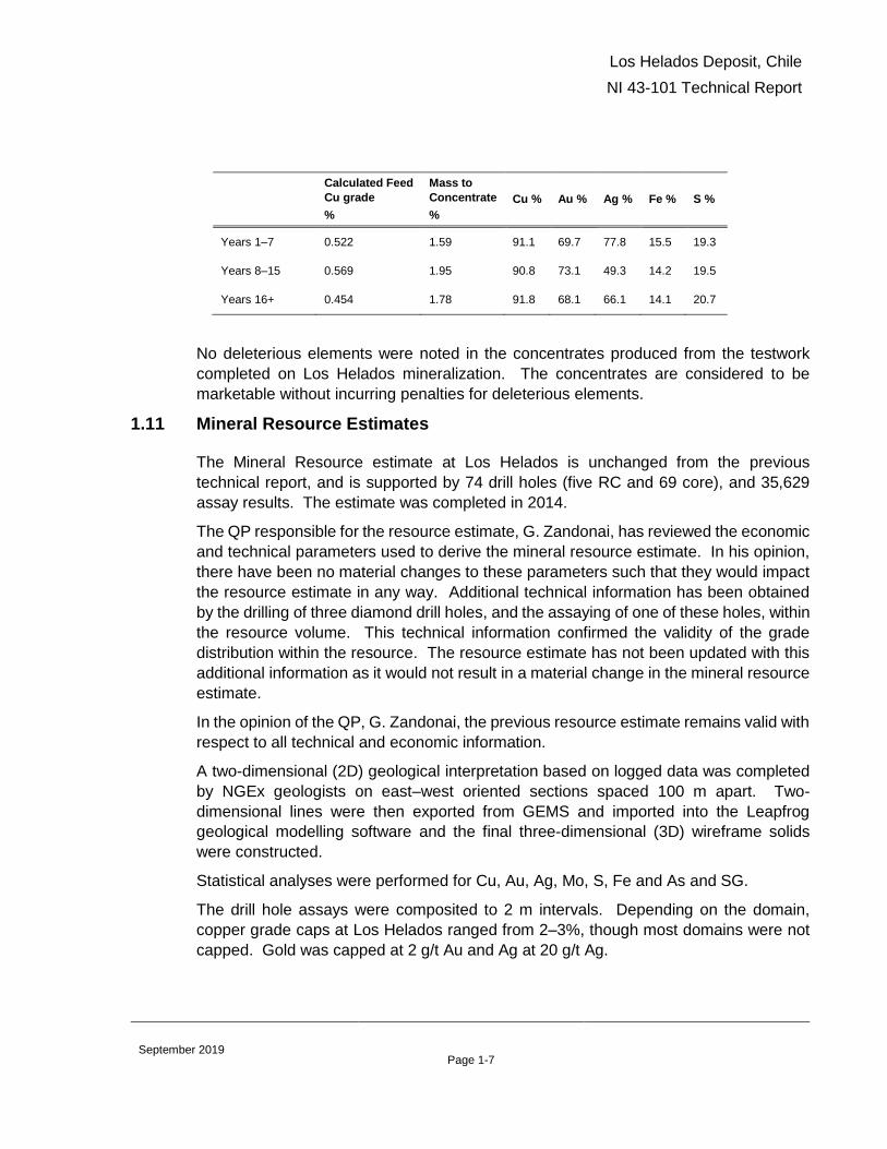
For the second phase of testwork, composite samples were created to represent
production periods from a conceptual mine schedule. Results of locked-cycle tests on
each of those composites is presented below.
Zone/Parameter Global Recovery to Final Concentrate
Los Helados Deposit, Chile
NI 43-101 Technical Report
Page 1-7 September 2019
Calculated Feed
Cu grade
%
Mass to
Concentrate
%
Cu % Au % Ag % Fe % S %
Years 1–7 0.522 1.59 91.1 69.7 77.8 15.5 19.3
Years 8–15 0.569 1.95 90.8 73.1 49.3 14.2 19.5
Years 16+ 0.454 1.78 91.8 68.1 66.1 14.1 20.7
No deleterious elements were noted in the concentrates produced from the testwork
completed on Los Helados mineralization. The concentrates are considered to be
marketable without incurring penalties for deleterious elements.
1.11 Mineral Resource Estimates
The Mineral Resource estimate at Los Helados is unchanged from the previous
technical report, and is supported by 74 drill holes (five RC and 69 core), and 35,629
assay results. The estimate was completed in 2014.
The QP responsible for the resource estimate, G. Zandonai, has reviewed the economic
and technical parameters used to derive the mineral resource estimate. In his opinion,
there have been no material changes to these parameters such that they would impact
the resource estimate in any way. Additional technical information has been obtained
by the drilling of three diamond drill holes, and the assaying of one of these holes, within
the resource volume. This technical information confirmed the validity of the grade
distribution within the resource. The resource estimate has not been updated with this
additional information as it would not result in a material change in the mineral resource
estimate.
In the opinion of the QP, G. Zandonai, the previous resource estimate remains valid with
respect to all technical and economic information.
A two-dimensional (2D) geological interpretation based on logged data was completed
by NGEx geologists on east–west oriented sections spaced 100 m apart. Two-
dimensional lines were then exported from GEMS and imported into the Leapfrog
geological modelling software and the final three-dimensional (3D) wireframe solids
were constructed.
Statistical analyses were performed for Cu, Au, Ag, Mo, S, Fe and As and SG.
The drill hole assays were composited to 2 m intervals. Depending on the domain,
copper grade caps at Los Helados ranged from 2–3%, though most domains were not
capped. Gold was capped at 2 g/t Au and Ag at 20 g/t Ag.

Los Helados Deposit, Chile
NI 43-101 Technical Report
Page 1-8 September 2019
Ordinary kriging (OK) and inverse distance squared (ID2) weighting interpolation was
done in a single pass. All elements (Cu, Au, Ag, Mo, As, S and Fe) were interpolated
using OK.
Model validation was carried out using visual comparison of blocks and sample grades
in plan and section views; statistical comparison of the block and composite grade
distributions; and swath plots to compare OK, ID2 and NN estimates.
The classification of the Mineral Resources was done as a two-step process. An initial
step which considered the geostatistical analysis of Cu grades in the deposit was
modified by a final revision to ensure consistency in the classification.
In order to evaluate the potential for reasonable prospects of eventual economic
extraction block cave shapes were generated for Los Helados by using different diluted
copper equivalent (CuEq) cutoff grades and calculating a conceptual NPV for each
shape.
A CuEq grade was calculated using US$3.00/lb Cu, US$1,300/oz Au and US$23/oz Ag,
and includes a provision for selling costs and metallurgical recoveries corresponding to
the three metallurgical zones defined by depth below surface. The base-case diluted
cutoff grade of 0.33% CuEq was determined as the lowest cutoff grade which produced
a positive NPV, and the base case Mineral Resource estimate is the sum of all the blocks
within this block cave.
1.12 Mineral Resource Statement
The Mineral Resource estimate for Los Helados, assuming block cave underground
mining methods, is reported using the 2014 CIM Definition Standards. Indicated and
Inferred classifications only have been estimated; no Measured Mineral Resources were
classified.
The Mineral Resource estimate was prepared by Mr. Gino Zandonai, RM CMC and has
an effective date of April 26, 2019.
Mineral Resource estimate at the base case cutoff grade of 0.33% CuEq is included as
Table 1-1. This table also shows the sensitivity of the resource to different cutoff grades.
Mineral Resources that are not Mineral Reserves do not have demonstrated economic
viability.

Los Helados Deposit, Chile
NI 43-101 Technical Report
Page 1-9 September 2019
Table 1-1: Mineral Resource Estimate for Los Helados (base case is highlighted)
Los Helados Indicated Mineral Resource
Tonnage Resource Grade Contained Metal
Cutoff
(CuEq)
(million
tonnes)
Cu
(%)
Au
(g/t)
Ag
(g/t)
CuEq
(%)
Cu
(billion
lbs)
Au
(million
oz)
Ag
(million
oz)
0.58 531 0.50 0.21 1.66 0.65 5.9 3.6 28.3
0.50 981 0.45 0.18 1.56 0.58 9.7 5.7 49.2
0.44 1,395 0.42 0.16 1.52 0.54 12.9 7.2 68.2
0.40 1,733 0.40 0.15 1.45 0.51 15.3 8.4 80.8
0.33 2,099 0.38 0.15 1.37 0.48 17.6 10.1 92.5
Los Helados Inferred Mineral Resource
Tonnage Resource Grade Contained Metal
Cutoff
(CuEq)
(million
tonnes)
Cu
(%)
Au
(g/t)
Ag
(g/t)
CuEq
(%)
Cu
(billion
lbs)
Au
(million
oz)
Ag
(million
oz)
0.58 There are no Inferred Mineral Resources inside the mining shape at this cutoff grade
0.50 41 0.41 0.13 1.78 0.51 0.4 0.2 2.3
0.44 176 0.37 0.11 1.61 0.45 1.4 0.6 9.1
0.40 399 0.35 0.10 1.47 0.43 3.1 1.3 18.9
0.33 827 0.32 0.10 1.32 0.39 5.8 2.7 35.1
Notes to accompany Los Helados Mineral Resource table
1. Mineral Resource estimate has an effective date of April 26, 2019. The Qualified Person for the estimate is Mr.
Gino Zandonai, RM CMC.
2. Mineral Resources that are not Mineral Reserves do not have demonstrated economic viability
3. Mineral Resources are reported using a copper equivalent (CuEq) cutoff grade. Copper equivalent is calculated
using US$3.00/lb copper, US$1,300/oz gold and US$23/oz Ag, and includes a provision for selling costs and
metallurgical recoveries corresponding to three zones defined by depth below surface. The formulas used are:
CuEq% = Cu% + 0.6264*Au (g/t) + 0.0047*Ag (g/t) for the Upper Zone (surface to ~ 250 m); Cu% + 0.6366*Au (g/t)
+ 0.0077*Ag (g/t) for the Intermediate Zone (~250 m to ~600 m); Cu% + 0.6337*Au (g/t) + 0.0096*Ag (g/t) for the
Deep Zone (> ~600 m)
4. Cutoff grades refer to diluted cutoff grades used to generate the corresponding block cave shapes. For each cutoff
grade, the tonnes and grade represent the total Indicated or Inferred undiluted material within each of these shapes.
5. Mineral Resources are reported within block cave underground mining shapes based on diluted CuEq grades,
US$13.07/t operating costs and include a provision for capital expenditure. The base case cutoff grade of 0.33%
CuEq was derived through an economic evaluation of several block cave shapes developed over a range of different
cutoff grades and is the cutoff grade which results in a zero net present value
6. Totals may not sum due to rounding as required by reporting guidelines
1.13 Recommendations
Los Helados is a significant copper-gold-silver deposit that clearly warrants additional
work to continue to de-risk it through additional engineering studies. This work should
proceed in two phases, leading to the completion of a revised standalone PEA study.
None of the recommended work has been initiated as of the date of this report.
The Phase 1 work program comprises updating the mineral resource and investigating
options and trade off studies for mine planning.

Los Helados Deposit, Chile
NI 43-101 Technical Report
Page 1-10 September 2019
Assays from drillhole LHDH072 completed in 2015 are available, but have not been
incorporated into the current mineral resource. Additional geological studies have also
resulted in a slight revision to the geological interpretation. The mineral resource should
be updated to incorporate these changes.
Following the resource update, continuation and refinement of the mine planning
exercises completed as part of the standalone and Project Constellation PEA’s should
be undertaken. The goal of these studies should be to investigate alternate mining
methods, such as sub-level caving, which could potentially reduce the up-front capital
expenditure requirements and shorten the lead time to production.
A second phase of work should involve updating the previous Los Helados standalone
PEA to incorporate the updated resource model and mine planning work, including
various project optimizations from the Los Helados portion of Project Constellation.
Information should be incorporated into a stand-alone PEA document. Table 1-2
summarizes the costs to complete Phases 1 and 2 of the recommendations.
Table 1-2: Recommendations Costs
Program Phase Area Estimated Costs
(US$ x 1,000)
Phase 1
Resource Update 70
Mine Planning Studies 130
Subtotal 200
Phase 2
Mine Design & Production Schedule Optimization 250
Infrastructure 100
Environmental Studies and Field Work 250
Study Management and Reporting 200
Subtotal 800
Total 1,000

Los Helados Deposit, Chile
NI 43-101 Technical Report
Page 2-11 September 2019
2.0 INTRODUCTION
2.1 Terms of Reference
This independent NI 43-101 Technical Report (the “Report”) was prepared in connection with a Plan of Arrangement (the “Transaction”), whereby NGEx Minerals Ltd. acquired from NGEx Resources Inc. (“NGEx”) its interest in the Los Helados Project and NGEx distributed the NGEx Minerals Ltd. shares to the NGEx shareholders at the effective time of the Transaction. Following completion of the Transaction, NGEx Minerals Ltd. now controls the Los Helados Project.
Subsequent to completion of the Transaction, NGEx Minerals Ltd. applied for listing on the TSXV. This report was prepared in support of the listing application.
Sources of information used in this report include previous technical reports and internal company reports on the project and original work by the report authors.
The consultants who are responsible for this Report are Ms. Fionnuala Devine, Mr. Gino
Zandonai and Mr. Giovanni Di Prisco, all of whom are independent of the Company.
Currency is expressed in U.S. dollars and metric units are used, unless otherwise stated.
The Report uses Canadian English. For the purposes of this Report, the parent and
subsidiary companies are referred to interchangeably as “NGEx”.
2.2 Qualified Persons
The following serve as the qualified persons (QPs) for this Technical Report as defined
in National Instrument 43-101, Standards of Disclosure for Mineral Projects, and in
compliance with Form 43-101F1.
• Fionnuala Devine, M.Sc., P.Geo.
o Sections 1 (except 1.10, 1.11, 1.12), 2, 3, 4, 5, 6, 7, 8, 9, 10, 11, 12,
23, 24, 25 (except 25.7, 25.8), 26, 27.
• Gino Zandonai, RM CMC.
o Sections 1.11, 1.12, 14, 25.8.
• Giovanni Di Prisco, Ph.D., P.Geo.
o Sections 1.10, 13, 25.7.
2.3 Site Visits and Scope of Personal Inspection
Gino Zandonai visited the Los Helados site on January 9, 2012 and has been to the core
logging facility twice between January 2012 and October 2012. During the site visit, Mr.
Zandonai reviewed the data collection and drill programs in support of resource
estimation. During the core facility visit, he reviewed a number of activities and

Los Helados Deposit, Chile
NI 43-101 Technical Report
Page 2-12 September 2019
processes related to core logging, core storage, geological interpretation and data
management.
Fionnuala Devine visited the Los Helados core facility in Copiapó on January 15, 2014
and January 30, 2015. She spent nine days at the project site from February 25th -
March 5th, 2015 to map the surface geology, during which time drilling was underway.
Her most recent visit to the project area was in February, 2017, when she spent six days
on site, supervising and guiding the geological mapping of the Cerro Blanco area
undertaken by staff geologists. This personal inspection is considered current as there
has been no new material scientific or technical information about the property since
then.
Since February 2017, Ms. Devine has had frequent contact with NGEx company
personnel during subsequent field seasons (post-2017) and has maintained current
knowledge of work completed on various of the Company’s projects including Los
Helados. Through this contact she has confirmed that there has been no new material
scientific or technical information about Los Helados since her last visit in February of
2017.
2.4 Effective Dates
The Effective Date of this report is April 26, 2019.
2.5 Information Sources and References
The key information sources for the Report included previous technical reports and the
reports and documents listed in Section 2.6 (Previous Technical Reports), Section 3.0
(Reliance on Other Experts), and Section 27.0 (References) of this Report.
Additional information was sought from NGEx personnel where required.
2.6 Previous Technical Reports
The following technical reports have been filed on the Los Helados Project by NGEx:
• Charchaflié, D. and LeCouteur, P.C., 2012: Geological Report on the Los Helados
Property, III Region of Atacama, Chile: technical report prepared by LPF Consulting
SRL and Micron Geological Limited for NGEx Resources Inc., effective date 15
February, 2012
• Zandonai, G., Carmichael, R., and Charchaflié, D., 2012: Mineral Resource
Estimate for the Los Helados Property, Region III of Atacama, Chile: technical report
prepared by LPF Consulting SRL, NGEx and Micron Geological Limited for NGEx
Resources Inc., effective date 15 October, 2012

Los Helados Deposit, Chile
NI 43-101 Technical Report
Page 2-13 September 2019
• Zandonai, G., Carmichael, R., Charchaflié, D., and Frost, D., 2013: Updated Mineral
Resource Estimate for the Los Helados Property, Region III of Atacama, Chile:
technical report prepared by Behre Dolbear, NGEx, LPF Consulting SRL, and AMEC
for NGEx Resources Inc., effective date 15 October, 2013
• Zandonai, G., and Frost, D., 2013: Updated Mineral Resource Estimate for the Los
Helados Property, Region III of Atacama, Chile: technical report prepared by Behre
Dolbear and AMEC for NGEx Resources Inc., effective date 15 October, 2013,
amended 24 March 2014
• Quiñones, C., Ovalle, A., Frost, D., Priscu, D., Khera, V., Pizarro, N., and Zandonai,
G., 2014: Los Helados Cu-Au Deposit, Atacama Region III, Chile, NI 43-101
Technical Report on Preliminary Economic Assessment: technical report prepared
by AMEC and Behre Dolbear for NGEx Resources Inc., effective date 1 October,
2014.
• Ovalle, A., et.al., 2016: Constellation Project; Incorporating the Los Helados Deposit,
Chile and the Josemaria Deposit, Argentina, NI43-101 Technical Report on
Preliminary Economic Assessment; Effective Date 12 February 2016, Amended 31
March 2016.
• Devine, F., et.al., 2018: Technical Report on the Los Helados Porphyry Copper-Gold
Deposit, Chile; Effective Date 27 May 2017, Report Date 14 December 2018.

Los Helados Deposit, Chile
NI 43-101 Technical Report
Page 3-1 September 2019
3.0 RELIANCE ON OTHER EXPERTS
The QPs have relied upon the following other expert reports, which provided information
regarding mineral rights, surface rights, property agreements, royalties, and taxation of
this Report as noted below.
3.1 Ownership, Mineral Tenure and Surface Rights
The QPs have not independently reviewed ownership of the Project area and the
underlying property agreements. The QPs have also not independently reviewed the
Project mineral tenure and the overlying surface rights. The QPs have fully relied upon,
and disclaim responsibility for, information derived from NGEx staff and legal experts
retained by NGEx for this information through the following documents:
• Bofill Mir & Álvarez J – Title Opinion Letter to TSX-V, August 5, 2019;
• Nicholson y Cano Abogados – NGEx Minerals Ltd.- Los Helados Project – RioEx
S.A., August 3, 2019;
• Nicholson y Cano Abogados – NGEx Minerals Ltd. Los Helados Project – Pampa
Exploraciones SA, August 3, 2019.
This information is used in Section 4 of the Report and in support of the Mineral
Resource estimate in Section 14.
3.2 Environmental, Permitting and Social
The QPs have not independently reviewed the Project environmental, permitting and
social information. The QPs have fully relied upon, and disclaim responsibility for,
environmental and social information derived from experts retained by NGEx for this
information through the following documents:
• BGC Engineering, 2013. Proyectos de Exploraciones Minera Vicuña: Los Helados,
Josemaría y Filo del Sol: Estudio Glacial y Periglacial. Informe Final. Report
prepared for MFDO y DEPROMINSA, March 2013.
• BGC Engineering, 2014a: Los Helados Linea Base Preliminar Geociencias:
report to NGEx, October 2014
• BGC Engineering, 2014b: Los Helados Línea Base Preliminar Aire y Agua: report
to NGEx, October 2014
• BGC Engineering, 2014c: Los Helados Línea Base Preliminar Biota Terrestre:
report to NGEx, October 2014
• BGC Engineering, 2014d: Los Helados Linea Base Preliminar Medio Humano:
report to NGEx, October 2014

Los Helados Deposit, Chile
NI 43-101 Technical Report
Page 3-2 September 2019
• BGC Engineering, 2015a: Los Helados, Josemaría, and Filo del Sol – Cryology
Summary: report prepared for NGEx, October 2015
• BGC Engineering, 2015b: Environmental Sensitivities for Engineering Design:
report prepared for MFDO, July 2015
• BGC Engineering, 2015c: Los Helados Project Baseline Summary: report
prepared for MFDO, October 2015
• BGC Engineering, 2015d: Los Helados Project Design Criteria from Environmental
Regulations and Guidelines, Rev 1: report prepared for MFDO, March 2015
• BGC Engineering 2015e, Los Helados Línea Base Preliminar Clima y Aire, report
prepared for MFDO, August 2015
• BGC Engineering 2015f, Los Helados Línea Base Preliminar Geociencias, report
prepared for MFDO, August 2015
• BGC Engineering 2015g, Los Helados Línea Base Preliminar Agua, report prepared
for MFDO, October 2015
• BGC Engineering 2015h, Los Helados Línea Base Preliminar Limnología, report
prepared for MFDO, October 2015
• BGC Engineering 2015i, Los Helados Línea Base Preliminar Biota Terrestre, report
prepared for MFDO, October 2015
• BGC Engineering 2015j, Línea Base Geoquímica – Caracterización de Mineral y
Estériles, report prepared for MFDO, September 2015
This information is used in support of the Mineral Resource estimate in Section 14.

Los Helados Deposit, Chile
NI 43-101 Technical Report
Page 4-3 September 2019
4.0 PROPERTY DESCRIPTION AND LOCATION
4.1 Project Location
The Los Helados deposit is located about 125 km southeast of the city of Copiapó in
Chile (Figure 4-4-1). The approximate deposit latitude and longitude centroid is
28.3408º S, 69.5857º W (decimal degrees, WGS84 datum).
Figure 4-4-1: Project Location Plan
Note: Figure after Charchaflié, 2012. Red stars on plan indicate projects held by NGEx, crossed picks are operating
mines or development properties held by third parties.
4.2 Project Ownership
The Los Helados project is comprised of claims in Chile owned by NGEx’s Chilean
subsidiary, Minera Frontera del Oro S.C.M (MFDO) (the “MFDO” Claims), and claims in
Argentina owned by its Argentine subsidiaries RioEx S.A. (the “La Rioja Properties”) and
Pampa Exploraçiones S.A. (the “Pampa Claims”). NGEx holds an indirect
approximately 63% interest in the MFDO Claims, a 60% interest in the La Rioja
Properties and a 100% interest in the Pampa Claims. The MFDO Claims and the La
Rioja Properties are subject to a joint exploration agreement with Pan Pacific Copper
Co., Ltd. (“PPC”) which holds the remaining approximately 37% and 40% respective
interests.
The Los Helados mineral resource is entirely located in Chile, on the MFDO Claims.

Los Helados Deposit, Chile
NI 43-101 Technical Report
Page 4-4 September 2019
4.3 Joint Exploration Agreement
Part of the Los Helados project is subject to a Joint Exploration Agreement (Joint
Venture) with Pan Pacific Copper Co., Ltd. (the PPC JEA), whereby NGEx holds
approximately a 63% interest and PPC holds approximately a 37% interest in the MFDO
Claims, and NGEx holds a 60% interest and PPC holds a 40% interest in the La Rioja
Properties. PPC is a Japanese mining and smelting company that is owned by JX
Nippon Mining and Metals and Mitsui Mining and Smelting.
The PPC JEA applies to the MFDO Claims and the La Rioja Properties, however the
terms of the agreement are slightly different for each property.
On the MFDO claims, each party (Participant) in the PPC JEA is expected to fund its
pro-rata share of expenditures or be diluted. If the Participant interest in the Joint
Venture is diluted to below 5%, the Participant interest will automatically convert to a
0.5% net smelter return royalty (NSR). The Pan Pacific Copper JEA includes a
reciprocal right of first offer in the event that one Participant wishes to sell its interest.
PPC has not been contributing to their share of expenditures on the MFDO Claims under
the JEA since 2015. As a result of this, they are incurring ongoing dilution of their project
interest resulting in the NGEx interest increasing and the PPC interest decreasing, over
time, in proportion to expenditures on the project.
On the La Rioja Properties, PPC is deemed to have funded US$ 3.5 million in
expenditures which is offset against future funding obligations of PPC on the La Rioja
Properties. Therefore the ownership interest on the La Rioja Properties is 60% in favour
of NGEx and 40% in favour of PPC.
For as long as NGEx holds at least a 50% interest in the Joint Venture, NGEx has the
right to act as the Operator.
4.4 Mineral Tenure (Chile)
Legal opinion was provided that supported that in Chile, NGEX is owner of 30
Exploitation Mining Concessions already granted, 97 Exploration Mining Concessions
(53 of them already granted and 44 in the process of being granted) and three unilateral
and irrevocable options to purchase 7 exploitation concessions. The 44 concessions
in the process of being granted are being constituted to replace mining concessions
held by MFDO that have expired recently, or will soon expire.
The total area covered by the titles in Chile, including overlapping claims, is
approximately 31,428 ha. Total area excluding overlapping claims is 20,930 ha. of
which 5,628 ha are covered by exploitation concessions. The Los Helados deposit is
covered by concessions “Limite 23 1 al 245” and “Limite 24 1 al 215”. All of the property
in Chile, including the option agreements, is subject to the PPC JEA as described
above.
Los Helados Deposit, Chile
NI 43-101 Technical Report
Page 4-5 September 2019
Details of the identification number, status, area in hectares and name of the titles are
presented in Error! Reference source not found. to Error! Reference source not
found.4. Figure 4-2 is a location plan showing the mineral tenure.
Third parties may have pre-emptive rights to some of the area covered by the properties.
These are listed in the tables below, where applicable.
The exploration concessions in the process of being granted listed in Table 4-4 are being
constituted to replace exploration concessions listed in Table 4-3 which will expire in
2019.
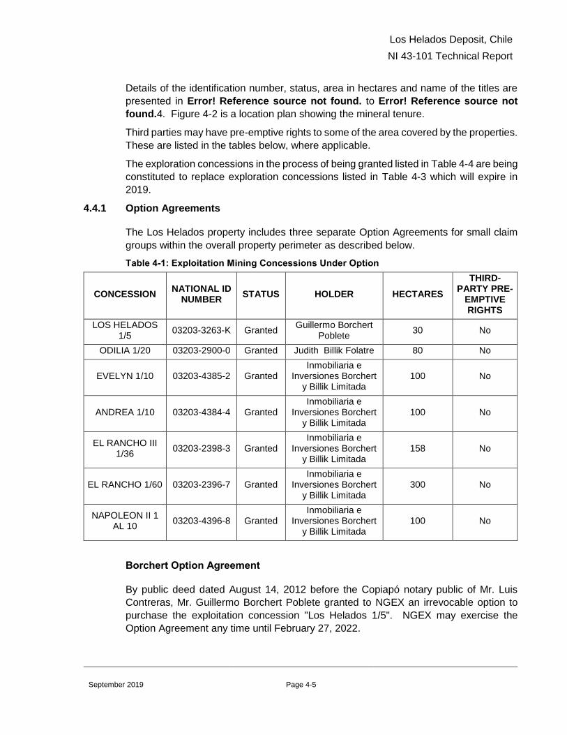
4.4.1 Option Agreements
The Los Helados property includes three separate Option Agreements for small claim
groups within the overall property perimeter as described below.
Table 4-1: Exploitation Mining Concessions Under Option
CONCESSION NATIONAL ID
NUMBER STATUS HOLDER HECTARES
THIRD-PARTY PRE-
EMPTIVE RIGHTS
LOS HELADOS 1/5
03203-3263-K Granted Guillermo Borchert
Poblete 30 No
ODILIA 1/20 03203-2900-0 Granted Judith Billik Folatre 80 No
EVELYN 1/10 03203-4385-2 Granted Inmobiliaria e
Inversiones Borchert y Billik Limitada
100 No
ANDREA 1/10 03203-4384-4 Granted Inmobiliaria e
Inversiones Borchert y Billik Limitada
100 No
EL RANCHO III 1/36
03203-2398-3 Granted Inmobiliaria e
Inversiones Borchert y Billik Limitada
158 No
EL RANCHO 1/60 03203-2396-7 Granted Inmobiliaria e
Inversiones Borchert y Billik Limitada
300 No
NAPOLEON II 1 AL 10
03203-4396-8 Granted Inmobiliaria e
Inversiones Borchert y Billik Limitada
100 No
Borchert Option Agreement
By public deed dated August 14, 2012 before the Copiapó notary public of Mr. Luis
Contreras, Mr. Guillermo Borchert Poblete granted to NGEX an irrevocable option to
purchase the exploitation concession "Los Helados 1/5". NGEX may exercise the
Option Agreement any time until February 27, 2022.

Los Helados Deposit, Chile
NI 43-101 Technical Report
Page 4-6 September 2019
The purchase price of the Option Agreement is US$875,000, to be paid in installments
during the term of the Option Agreement. To the date of this report, NGEX has made
advance payments totalling US$432,000, with a balance of US$443,000 remaining to
exercise the option. There are no work commitments.
Billik Option Agreement
By public deed dated August 14, 2012 before the Copiapó notary public of Mr. Luis
Contreras, Ms. Judith Perla Billik Folatre granted to NGEX an irrevocable option to
purchase the exploitation concession “Odilia 1/20”. NGEX may exercise the Option
Agreement any time until February 27, 2022.
The purchase price the each Option Agreement is US$875,000, to be paid in
installments during the term of the Option Agreement. To the date of this report, NGEX
has made advance payments totalling US$432,000, with a balance of US$443,000
remaining to exercise the option. There are no work commitments.
Sociedad Contractual Minera Borchert Billik Option
Sociedad Contractual Minera Borchert Billik granted NGEX a unilateral and irrevocable
option on 28 February 2013 to purchase the exploitation mining concessions “El Rancho
1 al 60”, “El Rancho III 1/60”, “Napoleón II 1/10”, “Evelyn 1/10” and “Andrea 1/10”. NGEX
may exercise the Option Agreement any time until February 27, 2022.
The purchase price of the Option Agreement is US$1,150,000, to be paid in installments
during the term of the Option Agreement. To the date of this report, NGEX has made
advance payments totalling US$776,000, with a balance of US$374,000 remaining to
exercise the option. There are no work commitments.

Los Helados Deposit, Chile
NI 43-101 Technical Report
Page 4-7 September 2019
Table 4-2: Exploitation Mining Concessions (Granted)
CONCESSION NATIONAL ID
NUMBER HOLDER HECTARES
THIRD-PARTY PRE-
EMPTIVE RIGHTS1
LIMITE 1 1 AL 40 03203-4788-2 MFDO 200 No
LIMITE 2 1 AL 40 03203-4789-0 MFDO 200 No
LIMITE 3 1 AL 26 03203-4790-4 MFDO 116 No
LIMITE 4 1 AL 35 03203-4791-2 MFDO 168 No
LIMITE 5 1 AL 51 03203-4792-0 MFDO 255 No
LIMITE 6 1 AL 49 03203-4793-9 MFDO 234 No
LIMITE 7 1 AL 30 03203-4794-7 MFDO 131 No
LIMITE 23 1 AL 10 03203-5806-K MFDO 50 No
LIMITE 8 1 AL 174 03203-6215-6 MFDO 174 No
LIMITE 9 1 AL 158 03203-6216-4 MFDO 158 No
LIMITE 10 1 AL 96 03203-6217-2 MFDO 96 No
LIMITE 11 1 AL 235 03203-6218-0 MFDO 235 No
LIMITE 12 1 AL 141 03203-6219-9 MFDO 141 No
LIMITE 13 1 AL 20 03203-6220-2 MFDO 20 No
LIMITE 14 1 AL 200 03203-6221-0 MFDO 200 No
LIMITE 15 1 AL 200 03203-6222-9 MFDO 200 No
LIMITE 16 1 AL 220 03203-6223-7 MFDO 220 No
LIMITE 17 1 AL 198 03203-6224-5 MFDO 198 No
LIMITE 18 1 AL 199 03203-6225-3 MFDO 199 No
LIMITE 19 1 AL 190 03203-6226-1 MFDO 190 No
LIMITE 20 1 AL 143 03203-6227-k MFDO 143 No
LIMITE 21 1 AL 110 03203-6228-8 MFDO 110 No
LIMITE 22 1 AL 14 03203-6229-6 MFDO 14 No
LIMITE 23 1 AL 245 03203-6230-k MFDO 245 No
LIMITE 24 1 AL 215 03203-6231-8 MFDO 215 No
LIMITE 25 1 AL 129 03203-6232-6 MFDO 129 No
LIMITE 26 1 AL 190 03203-6233-4 MFDO 190 No
LIMITE 27 1 AL 218 03203-6235-0 MFDO 218 No
LIMITE TERCERA 1 AL 100 03203-6214-8 MFDO 100 No
LIMITE 26A 1 AL 11 03203-6234-2 MFDO 11 No
1 If yes, the surface (hectares) where MFDO holds pre-emptive rights is indicated in brackets.

Los Helados Deposit, Chile
NI 43-101 Technical Report
Page 4-8 September 2019
Table 4-3: Exploration Mining Concessions (Granted)
CONCESSION NATIONAL ID
NUMBER HOLDER HECTARES
EXPIRATION DATE
THIRD-PARTY PRE-EMPTIVE
RIGHTS2
REFUGIO I 29 03203-E764-K MFDO 200 10.03.2019 Yes
(112)
LOS HELADOS SEGUNDA 48
03203-E788-7 MFDO 300 10.03.2019 Yes
(250)
LOS HELADOS SEGUNDA 45
03203-E787-9 MFDO 300 10.03.2019 No
LOS HELADOS SEGUNDA 40
03203-E786-0 MFDO 300 10.03.2019 Yes
(290)
LOS HELADOS SEGUNDA 36
03203-E785-2 MFDO 200 10.03.2019 No
LOS HELADOS SEGUNDA 33
03203-E784-4 MFDO 300 10.03.2019 Yes
(10)
LOS HELADOS SEGUNDA 29
03203-E783-6 MFDO 300 10.03.2019 No
LOS HELADOS SEGUNDA 26
03203-E782-8 MFDO 300 10.03.2019 No
LOS HELADOS SEGUNDA 21
03203-E781-K MFDO 300 10.03.2019 Yes
(275)
LOS HELADOS SEGUNDA 17
03203-E780-1 MFDO 300 10.03.2019 No
LOS HELADOS SEGUNDA 14
03203-E779-8 MFDO 300 10.03.2019 No
REFUGIO I 28 03203-E805-0 MFDO 200 10.10.2019 Yes
(145)
LOS HELADOS SEGUNDA 9
03203-E807-7 MFDO 300 10.10.2019 No
LOS HELADOS SEGUNDA 47
03203-E817-4 MFDO 200 10.10.2019 No
LOS HELADOS SEGUNDA 43
03203-E816-6 MFDO 300 10.10.2019 No
LOS HELADOS SEGUNDA 39
03203-E815-8 MFDO 300 10.10.2019 Yes
(298)
LOS HELADOS SEGUNDA 35
03203-E814-K MFDO 200 10.10.2019 No
2 If yes, the surface (hectares) where MFDO holds pre-emptive rights in each specific property is indicated in brackets.

Los Helados Deposit, Chile
NI 43-101 Technical Report
Page 4-9 September 2019
LOS HELADOS SEGUNDA 31
03203-E813-1 MFDO 300 10.10.2019 No
LOS HELADOS SEGUNDA 3
03203-E806-9 MFDO 200 10.10.2019 No
LOS HELADOS SEGUNDA 28
03203-E812-3 MFDO 300 10.10.2019 Yes
(120)
LOS HELADOS SEGUNDA 24
03203-E811-5 MFDO 300 10.10.2019 Yes
(180)
LOS HELADOS SEGUNDA 20
03203-E810-7 MFDO 300 10.10.2019 Yes
(150)
LOS HELADOS SEGUNDA 16
03203-E809-3 MFDO 300 10.10.2019 No
LOS HELADOS SEGUNDA 12
03203-E808-5 MFDO 200 10.10.2019 Yes
(175)
LOS HELADOS SEGUNDA 4
03203-E778-K MFDO 300 10.26.2019 No
MAGDA I 27B 03203-E868-9 MFDO 100 10.31.2019 Yes
(47)
LOS HELADOS SEGUNDA 5
03203-E843-3 MFDO 300 10.31.2019 No
LOS HELADOS SEGUNDA 44
03203-E864-6 MFDO 300 10.31.2019 No
LOS HELADOS SEGUNDA 37
03203-E860-3 MFDO 200 10.31.2019 No
LOS HELADOS SEGUNDA 25
03203-E855-7 MFDO 300 10.31.2019 No
LOS HELADOS SEGUNDA 18
03203-E851-4 MFDO 300 10.31.2019 No
LOS HELADOS SEGUNDA 10
03203-E847-6 MFDO 300 10.31.2019 Yes
(250)
LOS HELADOS SEGUNDA 8
03203-E846-8 MFDO 300 11.03.2019 No
LOS HELADOS SEGUNDA 6
03203-E844-1 MFDO 300 11.03.2019 No
LOS HELADOS SEGUNDA 50
03203-E867-0 MFDO 300 11.03.2019 No
LOS HELADOS SEGUNDA 46
03203-E865-4 MFDO 100 11.03.2019 No
LOS HELADOS SEGUNDA 42
03203-E863-8 MFDO 200 11.03.2019 Yes
(95)
LOS HELADOS SEGUNDA 38
03203-E861-1 MFDO 200 11.03.2019 No

Los Helados Deposit, Chile
NI 43-101 Technical Report
Page 4-10 September 2019
LOS HELADOS SEGUNDA 34
03203-E859-K MFDO 300 11.03.2019 Yes
(78)
LOS HELADOS SEGUNDA 30
03203-E857-3 MFDO 300 11.03.2019 No
LOS HELADOS SEGUNDA 27
03203-E856-5 MFDO 300 11.03.2019 No
LOS HELADOS SEGUNDA 23
03203-E854-9 MFDO 200 11.03.2019 Yes
(180)
LOS HELADOS SEGUNDA 2
03203-E842-5 MFDO 300 11.03.2019 No
LOS HELADOS SEGUNDA 19
03203-E852-2 MFDO 300 11.03.2019 No
LOS HELADOS SEGUNDA 15
03203-E850-6 MFDO 300 11.03.2019 No
LOS HELADOS SEGUNDA 11
03203-E848-4 MFDO 100 11.03.2019 No
LOS HELADOS SEGUNDA 49
03203-E866-2 MFDO 300 11.17.2019 No
LOS HELADOS SEGUNDA 32
03203-E858-1 MFDO 300 11.17.2019 Yes
(244)
LOS HELADOS SEGUNDA 22
03203-E853-0 MFDO 100 11.17.2019 Yes
(25)
LOS HELADOS SEGUNDA 13
03203-E849-2 MFDO 300 11.17.2019 No
LOS HELADOS SEGUNDA 1
03203-E841-7 MFDO 300 11.17.2019 No
LOS HELADOS SEGUNDA 7
03203-E845-K MFDO 300 11.23.2019 No
LOS HELADOS SEGUNDA 41
03203-E862-K MFDO 300 11.24.2019 Yes
(292)
Table 4-4:Exploration Mining Concessions in the Process of Being Granted
CONCESSION NATIONAL ID NUMBER
HOLDER HECTARES EXPIRATION
DATE
THIRD-PARTY PRE-EMPTIVE
RIGHTS3
LOS HELADOS II N
03203-F548-0
MFDO 300 02.04.2021 Yes
(100)
3 If yes, the surface (hectares) where MFDO holds pre-emptive rights is indicated in brackets.

Los Helados Deposit, Chile
NI 43-101 Technical Report
Page 4-11 September 2019
LOS HELADOS II J
03203-F544-8
MFDO 300 02.04.2021 Yes4
LOS HELADOS II F
03203-F540-5
MFDO 300 02.04.2021 Yes5
LOS HELADOS II B
03203-F537-5
MFDO 300 02.04.2021 Yes6
LOS HELADOS II P
03203-F550-2
MFDO 300 02.05.2021 Yes
(240)
LOS HELADOS II L
03203-F546-4
MFDO 300 02.05.2021 Yes7
LOS HELADOS II H
03203-F542-1
MFDO 300 02.05.2021 No
LOS HELADOS II D
03203-F539-1
MFDO 300 02.05.2021 Yes8
LOS HELADOS II 51
03203-F535-9
MFDO 200 02.05.2021 Yes
(150)
LOS HELADOS II O
03203-F549-9
MFDO 300 02.17.2021 Yes
(250)
LOS HELADOS II K
03203-F545-6
MFDO 300 02.17.2021 Yes
(150)
LOS HELADOS II G
03203-F541-3
MFDO 300 02.17.2021 No
LOS HELADOS II C
03203-F538-3
MFDO 300 02.17.2021 Yes9
LOS HELADOS II M
03203-F547-2
MFDO 300 03.21.2021 Yes10
LOS HELADOS II I
03203-F543-K
MFDO 300 03.21.2021 No
LOS HELADOS II A
03203-F536-7
MFDO 300 03.21.2021 No
4 Can’t be calculated due to uncertain national boundary location.
5 Same as footnote #4.
6 Same as footnote #4.
7 Same as footnote #4.
8 Same as footnote #4.
9 Same as footnote #4.
10 Same as footnote #4.

Los Helados Deposit, Chile
NI 43-101 Technical Report
Page 4-12 September 2019
LOS HELADOS II E
03203F615-0 MFDO 300 04.04.2021 Yes11
REFUGIO II 26* 03203-F657-
6 MFDO 200 05.16.2021
No
REFUGIO II 22* 03203-F656-
8 MFDO 300 05.16.2021
No
REFUGIO II 18* 03203-F655-
K MFDO 200 05.16.2021
No
REFUGIO II 13* 03203-F654-
1 MFDO 300 05.16.2021
No
REFUGIO II 9* 03203-F653-
3 MFDO 300 05.16.2021
Yes
(250)
REFUGIO II 5* 03203-F652-
5 MFDO 200 05.16.2021
No
REFUGIO II 2* 03203-F651-
7 MFDO 300 05.16.2021
No
REFUGIO II 27* 03203-F664-
9 MFDO 300 05.27.2021
Yes
(175)
REFUGIO II 3* 03203-F661-
4 MFDO 300 05.27.2021
No
REFUGIO II 11* 03203-F662-
2 MFDO 300 05.27.2021
No
REFUGIO II 23* 03203-F660-
6 MFDO 300 05.28.2021
Yes
(243)
REFUGIO II 19* 03203-F663-
0 MFDO 200 05.28.2021
No
REFUGIO II 15* 03203-F659-
2 MFDO 200 05.28.2021
No
REFUGIO II 24 03203-F677-
0 MFDO 300 05.30.2021
Yes
(190)
REFUGIO II 20 03203-F676-
2 MFDO 200 05.30.2021
No
REFUGIO II 16 03203-F675-
4 MFDO 200 05.30.2021
No
REFUGIO II 12 03203-F674-
6 MFDO 300 05.30.2021
No
REFUGIO II 8 03203-F673-
8 MFDO 300 05.30.2021
No
REFUGIO II 4 03203-F672-
K MFDO 200 05.30.2021
No
11 Same as footnote #4.

Los Helados Deposit, Chile
NI 43-101 Technical Report
Page 4-13 September 2019
REFUGIO II 7* 03203-F658-
4 MFDO 200 06.09.2021
No
REFUGIO II 25 03203-F691-
6 MFDO 200 06.27.2021
No
REFUGIO II 21 03203-F690-
8 MFDO 300 06.27.2021
No
REFUGIO II 17 03203-F689-
4 MFDO 100 06.27.2021
No
REFUGIO II 14 03203-F688-
6 MFDO 300 06.27.2021
No
REFUGIO II 10 03203-F687-
8 MFDO 300 06.27.2021
Yes
(280)
REFUGIO II 6 03203-F686-
K MFDO 300 06.27.2021
No
REFUGIO II 1 03203-F685-
1 MFDO 200 06.27.2021
No

Los Helados Deposit, Chile
NI 43-101 Technical Report
Page 4-14 September 2019
4.4.2 Surface Rights
Surface land rights in the area of the Los Helados are held by a local community
“Comunidad Civil Ex Estancia Pulido”. NGEx has an agreement (the “Pulido
Agreement”) dated August 25, 2016 that provides for surface access and occupation
and to conduct exploration and exploitation activities including construction and
operation of a mine in return for annual payments and bullet payments on achievement
of certain project milestones. There is a 0.6% Net Profits Interest payable under this
agreement.
NGEX also has in place two additional agreements with property owners providing for
easements to allow transportation along roads which transect the properties.
4.4.3 Royalties and Encumbrances
The concessions are not subject to royalties, back-in rights or other obligations in favour
of third parties and all concessions are free of mortgages, encumbrances, prohibitions
and injunctions, with the exception of a 0.6% Net Profits Interest (“NPI Royalty”) as part
of the Pulido Agreement. The NPI Royalty is payable after recovery of investment
required to develop a mining operation on the project.
Chilean government royalties are levied in the form of a mining tax on operational mining
income, applied on a sliding-scale rate basis of between 5% and 14% depending on
operating margins.
4.4.4 Permits
Under resolution N° 73, dated 4 May, 2006, the III Region office of the National
Environmental Commission (CONAMA III Region) approved the Environmental Impact
Declaration (DIA) presented by NGEX for the first stage of exploration of the Los
Helados Project. Under this resolution, NGEX was authorized to conduct an exploration
campaign that could include an aggregate amount of 4,000 m of drilling.
Through resolution N° 71, dated 21 March, 2012, the CONAMA III Region approved a
subsequent DIA presented by NGEX for the expansion of exploration activities at Los
Helados. Under this resolution, NGEX was authorized to expand the exploration
campaign with an approval for an aggregate amount of 180,000 m of drilling to be
completed within three years. NGEx has not yet requested to the environmental
authority to renew its exploration authorizations.
4.4.5 Environmental Liabilities
Existing environmental liabilities are limited to those associated with exploration-stage
properties, and would involve removal of the exploration camps and rehabilitation of drill
sites and drill site access roads.

Los Helados Deposit, Chile
NI 43-101 Technical Report
Page 4-15 September 2019
4.5 Mineral Tenure (Argentina)
Legal opinion was provided that supported that NGEx owns five exploitation licenses
(minas) in La Rioja Province and one in San Juan Province. Concessions held by NGEx
total approximately 4,255 ha. None of the Mineral Resource occurs in Argentina.
Details of the identification number, status, area in hectares and name of the titles are
presented in Table 4-4. Figure 4-2 is a location plan showing the mineral tenure.
The Potro I and Nacimientos I exploitation licenses are affected by the unresolved
boundary between the provinces of La Rioja and San Juan, however they overlap, so
the area in question will be covered by an NGEx-owned license no matter where the
final border is located.
An annual exploration fee due to the Province of La Rioja is paid in proportion to the
number of mining units covered by each exploitation license (mina). These fees were
increased by the Argentine Government as of the first half of 2015. Each mining unit
covers 100 ha and costs ARP$3,200 per year.
The Argentine Mining Code also requires the presentation of a plan of investment for
each exploitation license (mina). The plan of investment contemplates a minimum
expenditure of 300 times the annual fee and should be accomplished within five years
following the presentation.
Table 4-5: Exploitation Mining Concessions for the Los Helados Project in Argentina
Concession File Number Hectares Mining Units Annual Fee
(ARP$)
Chola 1* 037-F-04 2,500 25 80,000
Potro I* 169-F-97 1,073 11 35,200
Potro II* 170-F-97 531 6 19,200
Potro III* 48-F-99 151 2 6,400
Solitario 17** 61-P-96 2,100 21 67,200
Nacimientos 1** 520-0348-D-99 1,446 15 46,272
Note: ARP$ = Argentinean peso
* Part of the La Rioja Properties – owned 60% by NGEx
** Part of the Pampa Claims – owned 100% by NGEx
4.5.1 Surface Rights
The Argentine Mining Code (AMC) sets out rules under which surface rights and
easements can be granted for a mining operation, and covers aspects including land
occupation, rights-of-way, access routes, transport routes, rail lines, water usage and
any other infrastructure needed for operations.
In general, compensation must be paid to the affected landowner in proportion to the
amount of damage or inconvenience incurred. However, no provisions or regulations
have been enacted as to the nature or amount of the compensation payment.

Los Helados Deposit, Chile
NI 43-101 Technical Report
Page 4-16 September 2019
In instances where no agreement can be reached with the landowner, the AMC provides
the mining right holder with the right to expropriate the required property.
The properties in La Rioja are located in the Iglesias Department of the Province of La
Rioja, in the area called “Usos Múltiples” (“Multiple Uses”), which is the marginal area of
the Laguna Brava Provincial Reserve, where mining activities are fully authorized.
4.5.2 Royalties and Encumbrances
The properties Nacimientos I, Potro I, Potro II and Potro III are subject to payment of
USD2.0M in the event that any of the rights which make up these claims actually become
productive as mining fields. Furthermore, NGEx shall pay the owners a Net Smelting
Return royalty of 0.5% of the amount of the project benefits over 10 years, less costs.
The property Solitario 17 is subject to a payment of 7% Net Profits Interest.
The property Chola 1 is subject to a Net Smelter Return (NSR) payment of 1%, with
RioEx retaining a right of first refusal.
4.5.3 Permits
The properties in Argentina have an approved environmental impact report and current
permits to allow for exploration activities to take place.
4.5.4 Environmental Liabilities
Environmental liabilities on the La Rioja Properties are limited to reclamation of a few
drill platforms and associated access roads.

Los Helados Deposit, Chile
NI 43-101 Technical Report
Page 4-17 September 2019

Los Helados Deposit, Chile
NI 43-101 Technical Report
Page 4-18 September 2019
Figure 4-2: Mineral Tenure Map
4.6 Mining Integration and Complementation Treaty
On December 29, 1997, Chile and Argentina signed the "Tratado entre la República de
Chile y la República Argentina sobre Integración y Complementación Minera" (Mining
Integration and Complementation Treaty between Chile and Argentina; or the Treaty), in an effort to strengthen their historic bonds of peace and friendship, and intensify
the integration of their mining activities.
The Treaty provides a legal framework to facilitate the development of mining projects
located in the border area of both countries. The Treaty objective is to facilitate the
exploration and exploitation of mining projects within the area of the Treaty.
On August 20, 1999, Chile and Argentina subscribed to the Complementary Protocol
and, in this way, on July 18, 2001, an Administrative Commission was created.
Additional Protocols have been signed between Chile and Argentina which provide more
detailed regulations applicable to specific mining projects.
One of these Protocols, and the first granted for exploration purposes, is NGEx´s
“Proyecto de Prospección Minera Vicuña” (Vicuña Mining Prospection Project), dated
January 6, 2006. This Protocol allows for prospecting and exploration activities in the
Los Helados area, on both sides of the international boundary. The main benefit of the
Vicuña Additional Protocol is the authorization which allows for people and equipment
to freely cross the border in support of exploration and prospecting activities within an
area defined as an “operational area”.
In September 2012, the “Proyecto de Prospección Minera Vicuña” was amended by the
“Protocol of Amendment to Article 8”. With this amendment, the defined “operational
area” was expanded, enabling a new border crossing area to be demarcated.
In late 2018, MFDO filed a presentation before the Committee, requesting it issue a new Specific Additional Protocol for the Los Helados Project, in order to update certain changes in the organization of NGEx and its mining properties. Specifically, the purpose of the new amendment seeks to reflect a new Operation Area for Los Helados and Josemaría projects to accommodate the change in ownership created by the spinout transaction, and a joint Operation Area to be used among the Josemaría, Los Helados and Filo del Sol projects.
As at the date hereof, the Committee has not issued the new protocol, therefore NGEx (and the Los Helados Project) remain to be bound by the terms of the Vicuña Protocol currently in force.

Los Helados Deposit, Chile
NI 43-101 Technical Report
Page 5-1 September 2019
5.0 ACCESSIBILITY, CLIMATE, LOCAL RESOURCES, INFRASTRUCTURE,
AND PHYSIOGRAPHY
5.1 Accessibility
The Los Helados Project area is located 130 km southeast of the city of Copiapó, Chile
(Figure 5-1). The area is accessible by road, a driving distance of about 170 km from
Copiapó. Copiapó has a modern airport, with several daily flights to Santiago.
The C-35 paved road from Copiapó passes in a southeasterly direction through the town
of Tierra Amarilla and Punta del Cobre, along the Copiapó River valley, through the
small villages of Pabellon, Los Loros, La Guardia, and Iglesia Colorada. After these
small villages, the road continues towards the El Potro bridge. At about kilometre 130,
the paved road ends, and the last 35 km to the project area is gravel. Access is generally
possible during the summer months from September to May, but may be curtailed if
there is inclement weather.
5.1.1 Climate
The climate in the Los Helados area is dry to arid and the temperatures are moderate
to cold. Annual precipitation is about 250 mm, with snow at higher altitudes in the winter.
Exploration fieldwork is generally possible from mid-October to early May.

Los Helados Deposit, Chile
NI 43-101 Technical Report
Page 5-2 September 2019
Figure 5-1: Project Access Plan
Figure prepared by Amec Foster Wheeler using Turisco map base, 2015.
5.1.2 Local Resources and Infrastructure
The most important logistics centre in the region is Copiapó. Copiapó has a population
of approximately 150,000 people, an airport with daily scheduled flights to Santiago and
Antofagasta and companies that offer abundant services for mining and exploration.
There is no infrastructure in the area except for the Los Helados exploration camp which
is located 15 km towards Copiapo from the deposit, at an elevation of 3,400 masl. The
camp consists of portable structures with infrastructure for septic, water distribution and
electricity generation.

Los Helados Deposit, Chile
NI 43-101 Technical Report
Page 5-3 September 2019
5.1.3 Physiography
Los Helados is located in the Andes Mountains, straddling the Chile–Argentina border.
Elevations range from approximately 3,000 masl near the Los Helados camp to 5,300
masl at the international border. Topography is quite rugged on the Chilean (western)
slope of the mountains and more subdued on the Argentine (eastern) slope which
consists of broad, flat-bottomed valleys with moderately steep slopes. Los Helados is
in a seismically-active area.
The Los Helados deposit is located in a valley with a surface elevation of 4,500 masl.
The valley has steep sides to the east and south, and drains toward the north. The
elevation change from the bottom of the valley to the top of surrounding peaks is on the
order of 800 m.
The Los Helados Project area is arid and there is little or no vegetation on the ridges
and only minor vegetation in the valleys that have running water. There is no vegetation
at surface overlying the deposit and most of the immediate deposit area is rock and
colluvium. At the lower altitudes near the Los Helados exploration camp, there is sparse
vegetation consisting of low bushes and grasses.

Los Helados Deposit, Chile
NI 43-101 Technical Report
Page 6-1 September 2019
6.0 HISTORY
There is no reported production from the Project area.
There is no record of significant exploration activity prior to NGEx’s staking of the
property in 2004.
The first mineral exploration in the area was carried out by Shell (subsequently Billiton)
at the end of the 1980s. This work apparently included geological mapping, rock, talus
and stream sediment geochemical sampling, test pits for sampling and mapping, and
some geophysical surveying.
In 1994, Barrick Gold apparently worked in the general area for approximately 15 days,
sampling stream sediments and rocks for geochemistry, however results are unknown.
Work completed by NGEx is discussed in Section 9.

Los Helados Deposit, Chile
NI 43-101 Technical Report
Page 7-1 September 2019
7.0 GEOLOGICAL SETTING AND MINERALIZATION
7.1 Regional Geology
The Potro area in the central Andes encompasses the crest of the range along the Chile-
Argentina border and the area westward into Argentina at approximately 28.5° N latitude
(Figure 7-1). It lies within the present-day non-volcanic segment of the Andes,
correlative with the flat-slab portion of the subducted Nazca plate.
The basement in the area includes Permian-Triassic granitic and volcanic rocks,
intruded by Triassic tonalite-diorite intrusive complexes. The Triassic extensional rift
basin deposits and the Jurassic – Early Cretaceous back arc basin sedimentary rocks
that are found farther north are not present in the area, and Eocene volcanic and
intrusive rocks are preserved predominantly only to the east and north. Latest Oligocene
to Miocene porphyry intrusions and associated porphyry Cu-Au and epithermal
mineralization occur primarily within the Permo-Triassic basement rocks, but also locally
within relatively small remnants of Late Oligocene to Miocene sedimentary and volcanic
rocks where they have escaped erosion.
A high degree of tectonic inversion in the area has led to the predominant exposure of
basement rocks and the lack of preservation of overlying sedimentary and volcanic
sequences. Faults related to extension during the pre-Andean and early Andean arc
development were reactivated as early as Late Oligocene, followed by a main pulse of
compression and inversion as high-angle reverse faults in the Miocene. The Potro fault
is a significant reverse structural feature in the region, responsible for a large degree of
upthrow of the Paleozoic basement rocks to the west and their juxtaposition with
younger sedimentary units.
Mineral exploration is focused on copper and gold mineralization related to porphyry and
epithermal systems developed during the main Late Oligocene to Miocene compressive
stage of Andean arc development. The Maricunga belt to the north is notable for its
porphyry Au-Cu systems and the El Indio belt to the south, including Pascua Lama,
hosts world-class high-sulphidation epithermal deposits. The Potro area has historically
been overshadowed by these two high-profile metallogenic belts, partly due to the lack
of preservation of extensive Miocene volcanic rocks which was incorrectly interpreted to
reflect a paucity of Miocene mineral deposits. Mpodozis and Kay (2003) proposed that
the Potro area is in fact prospective for porphyry Cu-Au and epithermal systems, and
subsequent work by NGEx has shown this to be the case, with the discovery of
Josemaria, Filo del Sol, and Los Helados deposits with Late Oligocene to Late Miocene
ages. While the contemporaneous volcanic rocks have been largely removed through
erosion, the porphyry and local epithermal systems remain, although they are
predominantly developed within the basement and older sedimentary rocks, rather than
within Late Oligocene to Miocene volcanic sequences.

Los Helados Deposit, Chile
NI 43-101 Technical Report
Page 7-2 September 2019
Figure 7-1: Late Oligocene-Miocene porphyry belt in the area of El Indio to Maricunga
Note: After Sillitoe et al. (in press) and references therein.

Los Helados Deposit, Chile
NI 43-101 Technical Report
Page 7-3 September 2019
7.2 Project Geology
The Los Helados project area is underlain most extensively by Permo-Triassic rocks
assigned to the Choiyoi Group that form the Andean basement in the region (Figure 7-
2). They include granite cut by a tonalitic intrusive complex of probable Middle Triassic
age. Swarms of andesite dykes, which are typical of the Permo-Triassic in this region,
cut the older Permo-Triassic units.
Inferred Late Oligocene to Miocene sedimentary and volcanic rocks are located in the
southern part of the area, in the footwall of the Los Helados fault, and to the east in the
areas less affected by Miocene uplift. Regional faults, such as the Los Helados fault,
were active as early as Late Oligocene, but particularly post-20 Ma when the most
significant compressive stage of Andean mountain building began. The uplift due to this
compressive event is responsible for the more deeply eroded nature of the area,
extensively exposing the basement rocks and eroding the Late Oligocene to Miocene
sequences.
The Late Oligocene-Miocene volcanosedimentary rocks are also best preserved south
of a northwest-trending structural corridor that includes the Los Helados deposit.
Discontinuous, high-angle, commonly sinistral northwest-trending faults are mapped
across an area approximately 10km wide. Some south-side down displacement across
this domain may be responsible for deeper erosion of the northern domain that includes
Los Helados. The Los Helados porphyry system is hosted entirely within basement
rocks. Its age of ~13.5 Ma indicates that it was emplaced well into the main stage of
Andean uplift when older volcanic sequences had already been uplifted and eroded,
leaving younger dacitic porphyritic complexes to be emplaced into the remnant
basement.
7.3 Deposit Description
7.3.1 Los Helados
The Los Helados porphyry Cu-Au system is exposed in a high-elevation, northwest-
facing cirque with high topographic relief. The bottom of the elongated cirque, where
the uppermost part of the deposit is exposed at surface, is at 4500 metres above sea
level, while the sides of the valley rise steeply above to 5300 metres on the eastern side:
a difference of at least 800 metres. The abundant rock exposures on this steep eastern
slope provide the best outcrop for mapping geological relationships at surface, including
excellent alteration vectors towards the largely covered deposit in the cirque bottom.

Los Helados Deposit, Chile
NI 43-101 Technical Report
Page 7-4 September 2019
Figure 7-2: Regional Geological Map of the Project Area
Figure 7-2
Figure courtesy NGEx, 2018

Los Helados Deposit, Chile
NI 43-101 Technical Report
Page 7-5 September 2019
The host rocks to the deposit are largely Permo-Triassic in age. Granite is the oldest,
and most regionally extensive unit. It is intruded by a tonalitic- to dioritic intrusive
complex as well as fine-grained andesite dykes, typical of the Permo-Triassic in the
region. A rhyodacitic to rhyolitic feldspar-phyric intrusion has previously been
interpreted to pre-date the mafic units, however recent work suggest that the rhyodacitic
intrusion is a pre-mineral porphyry of Eocene to Late Oligocene age (Martinez et al.,
2015).
The deposit occurs in the upper part of a mid-Miocene porphyry/breccia system that was
emplaced into basement rocks and the pre-mineral rhyodacitic intrusion (Figure 7-3).
Copper-gold mineralization is predominantly hosted within the magmatic-hydrothermal
breccias and contemporaneous dacitic porphyries, with some peripheral mineralization
also within the immediate country rock although grades rapidly decline away from the
breccia and porphyry intrusive contacts.
A progressive intrusive sequence is defined that includes at least two main hydrothermal
breccia events related to discrete magmatic pulses during emplacement of a dacitic
porphyry intrusive complex, with dates ranging from ~14 to 13.6 Ma (Guitart, in prep.).
A pre-mineral quartz-feldspar porphyry intrusion is cut and overprinted by the
intermineral phases. A fine-grained plagioclase crowded porphyry intrusion is
interpreted to be contemporaneous and causative of the main, volumetrically most
important, hydrothermal breccia body which occurs directly above it within the deposit
area. A cement-rich breccia variant occurs along the eastern side of the main breccia
body, extending upwards in a pipe-like shape to surface in the northern part of the
deposit. A second intermineral porphyry intrusive phase, the bimodal plagioclase
porphyry, cuts the matrix-rich hydrothermal breccia as north-trending dykes mainly in
the central and eastern side of the deposit. Together, these intermineral phases
represent the bulk of the host rock within the deposit, and are the locus of hydrothermal
alteration. A late-mineral biotite plagioclase porphyry phase occurs locally at depth as
narrow dykes that cut-out grade.
The deposit is situated on a structural zone of high-angle, north-west-trending faults with
minor left-lateral and high-angle reverse motion, as well as subsidiary north-south faults.
Offsets of the Permian-Triassic units are mapped, and there is evidence for some fault
control on the development of alteration zones, implying that the fault zone may have
helped localize emplacement of the porphyry system. Some post-mineral movement
reported on these faults may in fact be broadly syn-mineral.

Los Helados Deposit, Chile
NI 43-101 Technical Report
Page 7-6 September 2019
Figure 7-3: Los Helados Deposit Geology Map
Note: Figure courtesy NGEx, 2018

Los Helados Deposit, Chile
NI 43-101 Technical Report
Page 7-7 September 2019
Lithology
A section through the central deposit area (Figure 7-4) shows the main lithological
relationships.
Permo-Triassic basement units
Granite (GRN) underlies the majority of the project area, particularly outside of the
deposit area. The medium- to fine-grained granite with minor granodiorite is included
within the Montosa-El Potro plutonic complex (265-245 Ma; Martínez et al., 2015).
Narrow, fine-grained mafic (“andesitic”) dykes (PAND) cut both the granite. They are
northeast-trending in the deposit area and are vertical to steeply northwest‐dipping.
They can be difficult to distinguish from fine-grained dykes related to the tonalitic
intrusive complex.
An intrusive complex of tonalitic composition (CI) pre‐dates the Los Helados breccia
body; clasts of the intrusive complex are entrained within the breccia. While it has not
been dated directly, a sample of similar lithology was taken approximately 3 kilometres
from Los Helados and returned an age of Middle Triassic (Guitart, in prep.). The main
mass of the intrusive complex is situated in the north of the Los Helados area. Intrusive
breccia textures with coarse‐grained tonalite are common, although the unit ranges to
plagioclase porphyritic in places. Fine-grained dykes related to the complex trend
northeast, are black and fine‐grained to aphanitic.
A feldspar-phyric rhyolitic to rhyodacitic intrusive body (DAC) with lateral northeast-
trending dykes underlies the area of the east of the deposit. It intrudes the granite but
in some sections is interpreted to be cut by mafic dykes. However, mapped relationships
support an interpretation that the rhyodacitic dykes cut the andesitic dykes as well as
the tonalite intrusive complex. If this is the case, it fits well with Eocene to Late
Oligocene age rhyolitic to dacitic porphyry intrusions mapped in the region (Martínez et
al., 2015). The rhyodacitic unit is mapped only in the immediate deposit area and its
contact with the granite may be a control on the emplacement of the younger Miocene
porphyry system.
Miocene porphyry system
The earliest Miocene porphyry phase is the quartz-feldspar porphyry (QFP), occurring
as a body in the southern part of the deposit. It is included as distinctive quartz-phyric
clasts within the later breccia and intrusive phases, and is extensively veined and
mineralized.

Los Helados Deposit, Chile
NI 43-101 Technical Report
Page 7-8 September 2019
The first intermineral porphyry phase is a fine-grained plagioclase crowded porphyry
(FGPCP), intersected down to 1200 metres that forms intrusive fingers extending
upwards into the deposit. It is interpreted to be genetically related to the main matrix-
rich hydrothermal breccia body which occurs immediately above it. Fluidized juvenile
clasts of the FGPCP are documented within the breccia near the contacts with the
porphyry.
The matrix-rich hydrothermal breccia (BXM and BXP) includes several different domains
classified based on clast type and matrix component, although it is typically
characterized by an abundant fine matrix component (20-30%) with less than 2%
hydrothermal cement. Clast types vary with distance from the basement wall rock
contacts, as well as with distance from the porphyry intrusions that are cut. The central
part of the breccia is polymictic (BXP), including a variety of clast types found within the
basement and earlier porphyry phases, with clasts ranging up to several metres in size.
In contrast, the outermost parts of the breccia are monomictic (BXM), including only
immediately local rock types. The breccia is also transitional into the country rock,
grading from areas with transported breccia fragments, to jigsaw fit textures, out to
fractured and then coherent wall rock.
A second inter- to late-mineral porphyry intrusive phase, a bimodal plagioclase porphyry,
occurs locally as relatively narrow dykes within the system. It contains two sizes of
plagioclase phenocrysts, as well as biotite booklets, within a dacitic groundmass. A
spatial relationship between this porphyry phase and the cement-rich breccia has been
suggested, with possible entrainment of juvenile clasts within the cement-rich breccia
that have similar composition.
A late-mineral suite of biotite-phyric weakly porphyritic dykes do not outcrop but are
logged at depth within the system. They have sharp contacts with earlier units, and a
much lesser degree of alteration and veining.

Los Helados Deposit, Chile
NI 43-101 Technical Report
Page 7-9 September 2019
Figure 7-4: Los Helados Section UTM-6,864,800 (4800) North (looking north)
Note: Figure after Guitart (in prep.)

Los Helados Deposit, Chile
NI 43-101 Technical Report
Page 7-10 September 2019
Alteration
Five main alteration types are recorded within the Los Helados system: potassic,
chlorite-sericite, sericitic, advanced argillic and argillic. Each has a distinctive mineral
assemblage, which can be significantly controlled by the host rock lithology with a large
difference between assemblages in felsic and mafic rocks types. Together, where
mapped on surface, these types define an alteration footprint of approximately 3
kilometres north-south and 2 kilometres east-west (Figure 7-5). The steep topography
and erosion in the valley bottom into the uppermost part of the deposit allow for clear
alteration vectoring to the central part of the system.
The lowermost exposed part of the system at surface includes limited exposures of
chlorite-sericite alteration largely overprinted by strong sericitic. The sericitic alteration
is strong to intense in the lowermost exposures with a quartz-sericite-pyrite assemblage
that gives way upslope and outwards to a sericite-quartz-dominant assemblage with no
pyrite. Sericite gives way to illite in the outermost regions with a transition to a weak
propylitic halo. Argillic alteration, predominantly montmorillonite, is recorded locally,
particularly intense along some fracture zones within the peripheral parts of the system.
In the southernmost southeast part of the system a recrystallization of the granitic host
rock is locally accompanied by pyrophyllite and limited northwest-trending sheeted
quartz veins. It is interpreted to represent a peripheral manifestation of the upper
advanced argillic domain. The central part of the system, at much lower elevations also
preserved advanced argillic alteration, largely pyrophyllite, telescoped down to depth
within the central part of the system immediately above the breccia body.
The potassic domain is not exposed at surface, and is intersected in drilling from
approximately 200 metres to the deepest part drilled to-date at approximately 1200
metres. Biotite is the defining mineral of the potassic domain where mafic host rocks
are altered, while K-feldspar dominates in the relatively felsic units. Remnants of
overprinted potassic alteration are found in the lowermost outcrops at surface, as
inherited quartz-sulphide and quartz-tourmaline veins within intense sericitic alteration.
The chlorite-sericite domain overlies and overprints the potassic domain, with chlorite-
hematite defining the assemblage in altered mafic lithologies and chlorite-sericite-clay
in the felsic host rocks.

Los Helados Deposit, Chile
NI 43-101 Technical Report
Page 7-11 September 2019
Mineral Zones
Four mineral zones are recognized within the deposit based on sulphide occurrence.
Zone definition does not include late pyrite veinlets or the total volume of sulphides
present in the rock. In order of increasing depth, the zones are: Pyrite-only (Py);
pyrite>chalcopyrite (Py>Cpy); chalcopyrite>pyrite (Cpy>Py); and chalcopyrite-only
(Cpy).
This sulphide zoning sequence reflects a progressive downward increase in the amount
of chalcopyrite relative to pyrite.
Figure 7-6 is a section through the deposit showing the sulphide zoning sequence in
relation to the major alteration zones.

Los Helados Deposit, Chile
NI 43-101 Technical Report
Page 7-12 September 2019
Figure 7-5: Los Helados Deposit Alteration Map
Note: Figure courtesy NGEx, 2018

Los Helados Deposit, Chile
NI 43-101 Technical Report
Page 7-13 September 2019
Figure 7-6: Los Helados Section UTM-6,864,900 North – Alteration and Mineral Zones (looking north)
Note: Figure courtesy NGEx, 2013

Los Helados Deposit, Chile
NI 43-101 Technical Report
Page 7-14 September 2019
Mineralization
The copper–gold mineralization at Los Helados is primarily hosted within the Miocene
magmatic–hydrothermal breccia which forms a roughly circular, pipe-like body with
minimum dimensions of 1,100 m east–west, 1,200 m north–south and at least 1,500 m
vertically. The breccia body is surrounded by a broad halo of moderate to low grade
Cu–Au mineralization which diminishes in grade with increasing distance from the
breccia contact.
The breccia limits have been established by drilling to the west, east and south;
however, the northern limit of the breccia body has not yet been identified. The system
also remains open at depth, and the lateral extent of the breccia at depth is also poorly
constrained by the current drilling. The eastern contact appears to be subvertical,
whereas the western contact dips outwards at roughly 70°, hence the width of the
breccia body increases progressively downwards.
Copper grade increases downwards, either in the lower parts of the sericitic zone or in
the underlying chlorite–sericite alteration zone, and elevated grades are maintained into
the potassic alteration zone. Within the central part of the breccia body, consistent
grades on the order of 0.5% Cu and 0.2-0.3 g/t Au in the core zone are flanked by
domains of ~0.3-0.4 % Cu and 0.1-0.2 g/t Au. High grade zones exceeding 1% Cu and
1.5 g/t Au are found locally. Although Cu grades typically diminish towards the bottoms
of the deepest holes drilled to date, there is an exception in that drill hole LHDH34
encountered some of the better grades of the deposit (>1%Cu and >1.5 g/t Au) in a
breccia body at 900 metres.
Gold grades generally correlate well with Cu; however, within the sericitic alteration
zones, where pyrite content exceeds chalcopyrite, high Au grades can be locally
independent from Cu values and are hosted by narrow veins.
Consistently high Cu and Au grades are present in the potassic and chlorite–sericite
zones where chalcopyrite is more abundant than pyrite.

Los Helados Deposit, Chile
NI 43-101 Technical Report
Page 8-1 September 2019
8.0 DEPOSIT TYPES
Based on geological features and location, the Los Helados deposit is classified as a
porphyry Cu–Au system. Porphyries are well documented along the Andes and
represent a widespread type of deposit in Chile (Figure 8-1).
Porphyry deposits in general are large, low- to medium-grade magmatic-hydrothermal
deposits in which primary (hypogene) sulfide minerals occur as veinlets and
disseminations within large volumes of altered rock. They are spatially and genetically
related to felsic to intermediate porphyritic intrusions (Seedorf et al., 2005). The large
size and styles of mineralization (e.g., veins, vein sets, stockworks, fractures, 'crackled
zones', and breccia pipes), and association with intrusions distinguish porphyry deposits
from a variety of other deposit types that may be peripherally associated, including
skarns, high-temperature mantos, breccia pipes, peripheral geothermal veins, and
epithermal precious metal deposits. Secondary minerals may be developed in
supergene-enriched zones in porphyry Cu deposits by weathering of primary sulfides.
Such zones typically have significantly higher Cu grades, thereby enhancing the
potential for economic exploitation (Sinclair, 2007).
Porphyry deposits occur throughout the world in extensive, relatively narrow, linear
metallogenic provinces. They are predominantly associated with Mesozoic to Cenozoic
orogenic belts in western North and South America and around the western margin of
the Pacific Basin, particularly within the South East Asian Archipelago. However, major
deposits also occur within Paleozoic orogens in Central Asia and eastern North America,
and to a lesser extent, within Precambrian terranes (Sinclair, 2007).
Porphyry deposits are large and typically contain hundreds of millions of tonnes of
mineralization, although they range in size from tens of millions to billions of tonnes.
Grades for the different metals vary considerably but generally average less than 1%.
In typical porphyry copper deposits, Cu grades range from 0.2% to more than 1% Cu;
Mo content ranges from approximately 0.005% to about 0.03% Mo; Au contents range
from 0.004 g/t Au to 0.35 g/t Au; and Ag content ranges from 0.2 g/t to 5 g/t Ag (Sinclair,
2007).

Los Helados Deposit, Chile
NI 43-101 Technical Report
Page 8-2 September 2019
Figure 8-1: Porphyry Copper Belts and Major Porphyry Copper Deposits in the Andes
Note: Figure courtesy NGEx, October 2013; modified from Sillitoe and Perelló (2005)

Los Helados Deposit, Chile
NI 43-101 Technical Report
Page 9-3 September 2019
9.0 EXPLORATION
The Los Helados deposit was discovered by drilling during the 2007-2008 season. The
first diamond drill hole, LHDH01, intersected the main breccia body and returned 518
metres grading 0.47% copper and 0.31 g/t gold from 12 metres down hole. This hole
was following up on encouraging results from RC holes drilled the previous season. The
true significance of the discovery was not recognized until the drilling of hole LHDH16
in the 2010-2011 season. This hole intersected a 737 metre interval of 0.64% copper
and 0.30 g/t gold from 40 metres down hole, with the last 8 metres averaging 1.0%
copper.
Mineral Resource estimates were completed on behalf of NGEx in 2012 and updated in
2013 and 2014.
A preliminary economic assessment in 2014 studied the Los Helados deposit as a stand-
alone block cave mining operation. Two options were evaluated, a 65 kt/d operation
and a larger 130 kt/d throughput alternative, based on an assumption of a conventional
sulphide flotation process. Under the assumptions in the Los Helados 2014 PEA,
underground mining of the Los Helados deposit returned positive economics.
A second PEA completed in early 2016 evaluated Project Constellation, a mining project
which combined the Los Helados and Josemaria deposits, both feeding a common
processing facility located in Argentina. This study concluded that the project could
support long-term copper, gold and silver production and was economically attractive.
9.1 Previous Work
9.1.1 Grids and Surveys
Drill collar data are reported using the WGS84 datum. Survey control for the project
area has been done with differential GPS.
The base topography used for Mineral Resource estimation was obtained from PhotoSat
Information Ltd. in Vancouver who provided a 5 m digital elevation model (DEM)
produced from stereo 2.5 m resolution satellite images.
9.1.2 Geological Mapping
LandSAT and ASTER satellite imagery interpretation was conducted as part of early-
stage exploration target definition.
Several phases of geological mapping have been completed at Los Helados, with each
phase building on and refining the previous phase. The most current geological map
was completed by Fionnuala Devine in February 2015, updated in 2017 with information
from Guitart (in prep.), and results are presented in Section 7 of this report.

Los Helados Deposit, Chile
NI 43-101 Technical Report
Page 9-4 September 2019
The most recent phase of geological mapping for the project investigated the area around
the Cerro Blanco prospect (Figure 7-2). This mapping project was supervised by F.
Devine and completed during the 2016-2017 field season. Road construction to provide
access to the entire north slope of the area was also completed as part of this program.
The Cerro Blanco porphyry copper prospect lies on the border between Chile and Argentina, 3 km to the east of the Los Helados deposit.
The Cerro Blanco system is centred on a main plagioclase‐biotite‐quartz‐hornblende porphyry intrusion (with few satellite dykes) that in exposed dimension is roughly 200 metres wide and 750 metres long, north‐south elongate. This porphyry body is compositionally similar (nearly identical) to the Sillimanita porphyry intrusions 5 kilometres to the south. The age of both porphyry intrusive complexes is assumed to be Late Oligocene (~27 Ma) based on a K‐Ar age on biotite from Sillimanita.
Potassic alteration is preserved within the porphyry intrusions, it is overprinted and surrounded by strong sericite‐chlorite‐clay (SCC) alteration in the granites. The entire SCC alteration domain is 1 km wide by 2.5 kilometres long, but open to the north. Phyllic alteration flanks and locally overprints the SCC alteration. A marginal propylitic alteration of secondary hematite and chlorite occurs most outboard of all other alteration and is in‐part overprinted by the younger Los Helados system.
Copper and gold mineralization is centred on the potassic zone and is strongly spatially coincident with the strongest SCC alteration. Values of 1000 ppm (0.1 %) copper are consistently measured in talus in the area affected by SCC alteration. Single stage quartz ± chalcopyrite veins define a domain 2 km long (N‐S) and 500 metres wide. The upper parts of this zone are strongly oxidized and secondary copper and iron minerals are common. The northern mapped extension of the vein zone, at the base of the northern cliffs, is less oxidized and primary chalcopyrite is more common, although the volume of chalcopyrite appears to match the volume of oxidized chalcopyrite in the upper parts of the system.
A post‐mineral, high‐angle reverse fault (NNE‐trending) cuts the Cerro Blanco system. Fault strands enclose post‐mineral Miocene volcanic rocks. The mineralized zone is cut‐off by this fault which uplifts the western part of the system. Mineralization may be found on the western side of the fault to the north where colour anomalies persist, but have not yet been visited due to limited access.
The lithology map for Cerro Blanco is shown as Figure 9-1 and the alteration map is Figure 9-2.

Los Helados Deposit, Chile
NI 43-101 Technical Report
Page 9-5 September 2019
Figure 9-1: Cerro Blanco Prospect – Lithology

Los Helados Deposit, Chile
NI 43-101 Technical Report
Page 9-6 September 2019
Figure 9-2: Cerro Blanco Prospect - Alteration

Los Helados Deposit, Chile
NI 43-101 Technical Report
Page 9-7 September 2019
9.1.3 Geochemical Sampling
During the period 2004–2010, 156 rock chip, and 322 soil and talus samples were
collected. No surface geochemical sampling has been done since 2010.
Rock chip samples returned relatively low copper and gold grades consistent with the
observed lithological and alteration assemblages on surface. These results were
interpreted to indicate a potential porphyry system at depth.
Soil and talus geochemistry proved to be a useful tool define the mineralization.
Although Cu and Au grades were relatively low in the soil and talus samples, the shape
of the resulting anomaly showed a good correlation to surface exposures of dacite and
breccias.
9.1.4 Geophysics
IP geophysical surveying was carried out at Los Helados over the main deposit area
during the 2005–2006, 2009–2010, 2010–2011 and 2011–2012 field seasons.
Magnetometry and two lines of MIMDAS surveying have also been completed.
The IP surveys outline a pyritic halo that shows as a high chargeability ring feature
around the breccia body.
9.1.5 Pits and Trenches
Minor surface trenching was completed at Los Helados during the 2004–2005, season
with some low-grade copper and gold mineralization detected as a result of the program.
9.2 Exploration Potential
9.2.1 Los Helados Deposit
The Los Helados deposit remains open at depth and to the north. Recent internal NGEx
studies have indicated the presence of a discrete, higher-grade breccia phase along the
western and southwestern breccia margins. The breccia dips at about 70º to the west,
and remains untested at depth.
The genetic model for the deposit, and porphyry deposits in general, describes breccias
as occurring within, and being sourced from, the upper portions of mineralizing porphyry
systems. Los Helados is unique in that it is a single, very large breccia body rather than
a more typical porphyritic intrusive with disseminated and stockwork-hosted
mineralization. The genetic model, as well as analogy with other porphyry deposits in
the Andes, suggests there is potential to continue to expand the deposit at depth.

Los Helados Deposit, Chile
NI 43-101 Technical Report
Page 10-8 September 2019
Drilling has intersected the boundary between the breccia and host granite to the south,
west and east of the deposit; however granite has not been intersected to the north, and
the breccia remains open in this direction.
9.2.2 Regional Targets
Several exploration targets were developed in the Los Helados area during the surface
exploration programs that led to the discovery of the deposit. At that time, prior to the
discovery of Los Helados, several targets were being advanced in parallel, ultimately
resulting in the initial drill program. Once the Los Helados deposit was discovered, all
the exploration effort shifted to deposit definition drilling, and exploration on the other
exploration targets was suspended.
These additional targets include geochemical anomalies similar in size and tenor to
those that were identified over the known deposit, and have mapped alteration features
that are consistent with porphyry-style mineralization. The highest-priority targets occur
along two parallel north–south-oriented trends interpreted to represent large-scale
structural breaks. The western trend includes the Los Helados deposit, while the
eastern trend links the Josemaría deposit in the south with the Caserones deposit in the
north.
Given that porphyry deposits occur in clusters, and the exploration targets are in the
vicinity of the Los Helados deposit, there is excellent potential to identify new porphyry-
hosted mineralization. Additional exploration work is recommended in order to continue
to advance them.
10.0 DRILLING
Eight drilling campaigns have been carried out at the Los Helados deposit, from 2006 to
2015. No drilling was conducted during the 2013–2014 season or subsequent to 2015.
All drilling was done by NGEx, including the deposit discovery holes.
Drilling to date totals 75,634 m in 88 drill holes (Table 10-1), of which five holes (1,366 m)
are RC and 83 holes (74,268 m) are core. The core drilling produced 33,936 m of NQ
(47.6 mm diameter) core and 40,332 m of HQ size (63.5 mm) core. This drilling includes
three holes (LHDHG01, LHDHG02 and LHDHG03) drilled for geotechnical information
which were not sampled for assay.
The drilling included a number of holes drilled in one season and subsequently re-
entered, and deepened in a later season. If this deepening was successful, no new drill-
hole name was created. For some holes, however, the drill string wedged off the main
hole creating a daughter hole starting at the kick-off depth in the main hole. In these
cases, the daughter hole was indicated by a -1 or -2 following the original drill-hole name.

Los Helados Deposit, Chile
NI 43-101 Technical Report
Page 10-9 September 2019
Drill hole collar locations are shown in Figure 10-1.
Table 10-1: Drill Summary Table
Season Drill Type Number Of
Holes Metres
2006–2007 RC 5 1,366
2007–2008 Core 2 1,037
2008–2009 Core 2 1,529
2009–2010 Core 6 4,031
2010–2011 Core 14 9,641
2011–2012 Core 25 22,022
2012–2013 Core 31 32,665
2013–2014 Core — —
2014–2015 Core 3 3,341
Total 88 75,634

Los Helados Deposit, Chile
NI 43-101 Technical Report
Page 10-10 September 2019
Figure 10-1: Drill-Hole Collar Location Map
Note: Figure courtesy NGEx, 2015. Holes shown in red are three drill holes drilled subsequent to the resource estimate, during the 2014–2015 field
season (LHDH72, LHDHG02 and LHDHG03). Only one of these drill holes, LHDH72 was assayed, the other two were geotechnical holes and have
been retained as whole core.
Los Helados Deposit, Chile
NI 43-101 Technical Report
Page 10-11 September 2019
10.1.1 Geological Logging
Drill core was transported by pickup truck by company personnel from the drill sites to
the Los Helados camp. At the camp core logging facility, the core was photographed,
logged for RQD and recovery, and a quick log of the key geological features was
prepared. The core was then packaged for delivery by NGEx personnel to the
company’s core logging and sampling facility located in Copiapó for sampling, detailed
logging, and core storage.
10.1.2 Geotechnical Logging and Testing
Specific geotechnical core logging was performed on six drill holes (3,350 m) to estimate
the rock mass rating (RMRL90,) with 18 UCS laboratory tests and 717 point load tests
also performed.
Subsequent to this, a dedicated block cave geomechanics study was conducted, which
included drilling two oriented geotechnical drill holes (2,100 m). Testing included;
televiewer surveys, Lugeon testing (also known as Packer testing, which is an in-situ
testing method widely used to estimate the average hydraulic conductivity of rock
formations), and 230 point load tests.
An additional geomechanics laboratory testing program was conducted consisting of 84
UCS tests, 46 elastic property tests, 51 tensile tests, and 55 triaxial tests. Geotechnical
logging, televiewer surveys and Lugeon tests were also performed on a single core hole
(1,100 m) drilled as part of this campaign.
10.1.3 Recovery
Core recovery data was not systematically collected on holes drilled before the 2010–
2011 campaign. Visual inspection by Charchaflié (as reported in Charchaflié and Le
Couteur 2012), indicated that overall recovery was very good and was estimated to be
more than 90%.
Starting with the 2011–2012 field season, core recovery and RQD were measured at
the camp. Recovery was measured with a metric tape between drill core marks,
annotated and the percentage recovery calculated. RQD was calculated as the total
length of recovered core that exceeded or equals 10 cm.
Core recovery from holes drilled between 2012 and 2015 averages 97%.
10.1.4 Collar Surveys
Drill collar locations were surveyed using a differential GPS system.

Los Helados Deposit, Chile
NI 43-101 Technical Report
Page 10-12 September 2019
10.1.5 Downhole Surveys
The RC holes and the first four core holes were not surveyed down-hole for azimuth or
inclination. Measurements from LHDH23 and LHDH24 were accidentally erased before
being downloaded to a computer. All other holes were surveyed for down-hole
deflection.
Down-hole surveys were carried out using a Reflex multi-shot instrument up to the
2011–2012 drilling campaign. On average, measurements were collected at 50 m
intervals down the hole.
For the 2012–2013 and 2014–2015 drilling, a SRG-gyroscope survey was completed
for each drill hole by Comprobe Limitada. On average, measurements were collected
at 30 m intervals down the hole.
10.1.6 Sample Length/True Thickness
The Los Helados deposit is a porphyry deposit with disseminated mineralization.
Reported and described interval thicknesses are considered true thicknesses. A drill
section through the deposit illustrating the typical drill orientations in relation to the
mineralization is illustrated in Figure 10-2.

Los Helados Deposit, Chile
NI 43-101 Technical Report
Page 10-13 September 2019
Figure 10-2: Example Drill Section 4900 N
Note: Figure courtesy NGEx, October 2013. Figure illustrates drill hole orientations, and provides histograms showing
copper and gold grade variations including areas of higher grades in a lower-grade interval. The lithological interpretation
shown has been simplified from the actual more detailed geological interpretation used in the wire-framing.

Los Helados Deposit, Chile
NI 43-101 Technical Report
Page 11-1 September 2019
11.0 SAMPLE PREPARATION, ANALYSES, AND SECURITY
11.1 Sampling Methods
11.1.1 Surface Sampling
Soil and talus samples were collected from small holes deep enough to sample the
interval below the iron-cemented horizon. Talus samples were composited from 10
stations located within 5 m along 100 m long, east–west or north–south oriented lines.
Sampled material was finer than #10 Tyler mesh.
Rock outcrops and trenches were sampled by collecting approximately 1–3 kg of chips.
The sample location, length and a geological description were recorded.
11.1.2 Drill Sampling
RC holes drilled during the 2006–2007 campaign were sampled on 2 m intervals.
Drill core was sampled continuously from the beginning of recovery to the end of the
hole. Samples are generally 2 m long (except for the initial drill holes, LHDH01 to
LHDH04, which were sampled on 1 m intervals). Core was oriented in the core box prior
to sampling to ensure that vein material would be evenly sampled. Drill core was cut in
half using a circular, water-cooled rock saw. Half-cores were randomly weighed and
compared in order to verify that 50% of the material was sampled.
One half of the core was used as a geochemical sample and the other half was stored
in boxes or trays for reference and future revisions. Prior to 2011, rice sacks were
delivered to the laboratory using a private courier with dispatch tracking. Beginning in
October 2011, samples were delivered directly to the ACME preparation facilities in
Copiapó by NGEx personnel, considerably reducing turn-around times from previous
programs.
11.2 Density Determinations
A total of 25,158 core samples have been systematically measured for SG, beginning
with the 2010–2011 drilling program. Specific gravity was measured by NGEx
technicians using the water immersion method at the Company core logging and
sampling facility in Copiapó. Density information for each lithological domain is shown
in Table 11-1.
Table 11-1: Los Helados Specific Gravity Values by Lithological Domain
BXM BXP DAC CI GRN PAND PANDP
Value 2.68 2.66 2.67 2.73 2.66 2.62 2.62

Los Helados Deposit, Chile
NI 43-101 Technical Report
Page 11-2 September 2019
11.3 Analytical and Test Laboratories
ALS Chemex (ALS) in Chile was used as the primary analytical laboratory for the five
RC holes. At the time of analysis, ALS held ISO9001 accreditations for selected
procedures.
The primary assay laboratory for the core drilling programs has been ACME
Laboratories in Chile (ACME). ACME is an internationally certified laboratory. In 1994,
ACME began adapting its Quality Management System to an ISO9000 model. ACME
implemented a quality system compliant with the ISO9001 Model for Quality Assurance
and ISO/IEC17025 General Requirements for the Competence of Testing and
Calibration Laboratories. In 2005 the Santiago laboratory received ISO 9001:2000
registration and in July 2010 the Copiapó facility was added to the Santiago registration.
The Santiago hub laboratory has also been ISO 17025:2005 compliant since 2012.
ISO/IEC 17025 includes ISO 9001 and ISO 9002 specifications, CAN-P-1579 (Mineral
Analysis) for specific registered tests by the Standard Council of Canada. CAN-P-1579
is the Standard Council of Canada’s requirements for the accreditation of mineral
analysis testing laboratories.
Vigalab SA (Vigalab; now part of the Intertek Group) was used as an umpire (check)
laboratory. At the time of the analyses, Vigalab held ISO9001:2009 accreditation.
11.4 Sample Preparation and Analysis
11.4.1 RC
For the RC drill program, the analytical package used was a 27 element suite via four-
acid digest, ICP-AES analysis and for gold, a fire-assay AA finish. Mercury was
analysed by cold vapour/AA.
11.4.2 Core
ACME’s sample preparation started with organizing the received batch and assigning a
job order. Samples were sorted and weighed. If the number of samples differed from
that indicated on the requisition, NGEx was contacted. Sample preparation continued
with:
• Drying in a large electric oven with temperature control
• Crushing to better than 85% passing 10 mesh
• Splitting to a 0.5 kg subsample
• Pulverizing the subsample to 95% passing 200 mesh
• Screening to pass 200 mesh.

Los Helados Deposit, Chile
NI 43-101 Technical Report
Page 11-3 September 2019
Bags with 150 g of pulp were submitted internally to ACME’s assaying facilities in
Santiago.
Sample digestion was done by a multi-acid attack with the exception of one submission
during the 2009–2010 campaign.
Gold was determined by fire assay with an atomic absorption spectroscopy (AAS) finish
based on a 30 g sample. A suite of 37 elements, including copper, was determined by
ICP-emission spectroscopy (ES) analyses.
Samples analyzed before the 2010–2011 campaign had Cu reassayed by AAS only if
the ICP result exceeded the upper detection limit of 10,000 ppm. Beginning in 2010, all
samples with copper grades over 5,000 ppm Cu were re-assayed by AAS. Starting in
2012, Cu determinations in all samples were done by both ICP and AAS.
Mercury concentration was determined by cold vapour/AA in all samples up to 2010.
11.5 Quality Assurance and Quality Control
11.5.1 RC
Thirty two field duplicates representing 3.2% of total samples were analysed, but no
blanks or standard materials were inserted in sample batches to control laboratory
performance.
As there are only five RC holes in the deposit and the 1,366 m of drilling in these holes
represents about 2% of the current drill metres, the lack of quality assurance/quality
control (QA/QC) data for the RC drilling is not a significant risk to the resource estimate.
11.5.2 Core
Insertion Rates
No QA/QC program was in place for samples from drill holes LHDH01 to LHDH04, from
the 2009–2010 drill program, which corresponds to 2,540 samples representing 3.6% of
the metres drilled.
A quality control program was implemented for the 2009-2010 drilling campaign,
beginning with LHDH05, and has been in place for all subsequent drill programs. The
2010–2011 campaign included two standards, whereas for subsequent campaigns three
standards were used. Coarse blank samples and duplicate samples were inserted and
collected from the beginning of the QA/QC programs.

Los Helados Deposit, Chile
NI 43-101 Technical Report
Page 11-4 September 2019
Reference Materials
NGEx acquired CRMs from SGS Argentina and CDN Laboratories and used these
CRMs for drill programs completed prior to 2012.
NGEx used materials from Los Helados to create SRMs for the 2011–2012 and 2012–
2013 drilling campaigns. The samples were prepared by Vigalab. Coarse rejects were
selected from drill-hole intervals in the database with assayed Cu and Au grades. Each
grade range was used to generate a standard for that range. The resulting standard
material was subject to round-robin analysis at four laboratories in Chile, ACME, Actlabs,
ALS and Vigalab. Each laboratory received one envelope of each of the three standard
materials. Data from the four laboratories were considered in assigning best values to
the SRMs.
Coarse Blanks
NGEx obtained blank material from an andesite outcrop located near Los Helados for
the 2011–2012 drilling campaign. During the 2012–2013 campaign, material used for
blanks was white quartz, which was purchased in Copiapó.
Duplicates
NGEx collected field duplicates, coarse duplicates and pulp duplicates during both the
2011–2012 and 2012–2013 drilling campaigns.
11.5.3 External Assay Checks
A set of 522 pulps, representing 3.5% of total samples for the 2012–2013 drilling
campaign, were selected for a second analysis round at ALS in Chile.
11.6 Databases
Drill hole data are stored in a GEOVIA GEMS database, which is a Microsoft Access
database platform created and manipulated using GEMS.
Data stored for each drill hole include collar information, downhole surveys, codes and
comments for lithology, alteration and mineralization, assays, specific gravity, magnetic
susceptibility, recovery, RQD and metallurgical sample information.
11.7 Sample Storage
Drill core is stored in a core storage yard in Copiapó. RC drill chips are stored in lidded,
plastic core trays, most of which are also kept in Copiapó.
The laboratory returned the pulps and coarse reject for each sample that was sent for
analysis. These are stored at the Copiapó facility.

Los Helados Deposit, Chile
NI 43-101 Technical Report
Page 12-5 September 2019
During 2015, due to unseasonable heavy rains, a portion of the drill core stored in the
facility was affected by flooding, and the core and sample pulps and rejects were moved
to a new facility, also in Copiapó.
11.8 Sample Security
The logging facility is fenced, locked when not occupied, and is secure. Samples are
handled only by company employees or their designates (i.e. laboratory personnel).
NGEx noted that samples are in the control of an NGEx employee or contractor to NGEx
from the time they leave the site until they arrive in Copiapó.
11.9 Comments on Section 11
Sample collection, preparation, analysis and security are in line with industry-standard
methods for porphyry deposits.
Specific gravity data are collected using industry-standard methods. There are sufficient
estimates to support tonnage estimates for the various lithologies.
Drill programs included insertion of blank, duplicate and standard reference material
samples. QA/QC program results do not indicate any problems with the analytical
programs.
The QP is of the opinion that the quality of the Cu, Au and Ag analytical data is
sufficiently reliable to support Mineral Resource estimation without limitations on Mineral
Resource confidence categories.
12.0 DATA VERIFICATION
12.1 Gino Zandonai
Data verification included witness sampling; QA/QC data reviews; spot checks of the
assay database against assay certificates; and the lithology and alteration information
in drill core were reviewed and checked against the drill logs. No issues that would
affect Mineral Resource estimation were noted from the reviews. This verification was
completed by G. Zandonai, a QP for the current report.
12.2 Fionnuala Devine
Data verification included nine days of surface mapping over the deposit area and
correlation of the geological information with the drill database. Work was completed
with the assistance of reviews and discussions with NGEx geologists. During the 2014
season the core facility in Copiapó was visited including a review of the deposit geology
and the logging procedure. Most recently, Ms. Devine was responsible for updating the

Los Helados Deposit, Chile
NI 43-101 Technical Report
Page 12-6 September 2019
geological map of the deposit area, which included confirmation of relationships in a
standalone 3D model of all available drill data. The same model was used to confirm
information presented in this report.
12.3 Comments on Section 12
The QP considers that a reasonable level of verification has been completed at Los
Helados during the work conducted to date, and that no material issues would have
been left unidentified from the verification programs undertaken.
Mineral Resource estimates and preliminary mine planning can be supported by the
data collected.

Los Helados Deposit, Chile
NI 43-101 Technical Report
Page 12-7 September 2019
13.0 MINERAL PROCESSING AND METALLURGICAL TESTING
13.1 Metallurgical Testwork
13.1.1 Introduction
Two Los Helados metallurgical testwork programs were conducted at SGS Minerals S.A.
(SGS) in Santiago, Chile in 2013 and 2015. Two separate reports were produced by
SGS for the Los Helados Project:
• Programa Metalúrgico de Conminución y Flotación en Mineral de Cobre - Oro,
Proyecto Los Helados - 2013
• Programa Metalúrgico de Conminución y Flotación en Mineral de Cobre - Oro,
Proyecto Los Helados – Fase II - 2015
Vendor testing was also conducted by Thyssenkrupp on selected samples from the Los
Helados deposit.
The main activities completed during the development of the metallurgical test program
were:
• Sample selection for the metallurgical test programs
• Chemical characterization including mineralogical analysis
• Physical characterization
• Gold recovery using gravity processing techniques
• Copper, gold and silver recovery using conventional sulphide flotation practices
• Settling testwork.
13.1.2 Geometallurgical Domains
In Phase I of the program, tests were conducted on three different composite samples
representing different depths within the deposit (Table 13-1). Each composite was made
up of 20 individual drill core sub-samples. The goal at the time was to select samples
that were representative of the deposit grades and lithologies from three depth intervals.
Upon completion of the first metallurgical testwork program, it was concluded that the
deposit was largely homogeneous throughout with respect to chemical and physical
characteristics.

Los Helados Deposit, Chile
NI 43-101 Technical Report
Page 12-8 September 2019
Table 13-1: Composite Description, Los Helados Phase I
Deposit Zone Depth From Surface (m)
Proportion of Cu This
Zone Represents In
The Deposit
(%)
Proportion of Tonnage This
Zone Represents In The
Deposit
(%)
Upper 0 to 200–250 6 9
Intermediate 200–250 to 500–600 32 34
Deep deeper than 500–600 62 57
An updated geological model was subsequently developed for Los Helados, which led
to the second testwork phase which focused primarily on the characteristics of the
deposit at different periods within a conceptual block cave production plan. In the
second round of metallurgical testwork the deposit homogeneity was confirmed. Three
separate composites were created representing production years 1–7, production years
8–15 and production years 16 onward (16+) of a conceptual production plan (Table
13-2). Generally, material for years 1-7 is located at the bottom of the core of the
deposit, years 8-15 material is concentrically outward of the core and years 16+ material
is near-surface and around the periphery of the deposit.
The portions of the individual samples that remained following creation of the Phase II
samples were used to create 30 variability samples for comminution and flotation
testwork.
13.1.3 Head Sample Characterization
Representative splits from each of three different composite samples from each of the
Phase I and II programs were chemically analyzed for contained elements. The results
show that there was some variability in Cu feed grades for all of the composite samples,
and low impurity levels throughout the deposit (Table 13-3 and Table 13-4).

Los Helados Deposit, Chile
NI 43-101 Technical Report
Page 12-9 September 2019
Table 13-2: Composite Description, Los Helados Phase II
Deposit Zone Main Characteristic Proportion Of Tonnage This
Zone Represents In The Deposit (%)
Sample ID
Years 1–7 Early production period 13 Years 1–7
Years 8–15 Mid production period 17 Years 8–15
Year 16 onward Later production period 70 Year 16+
Table 13-3: Head Grade Chemical Characterization, Los Helados Phase I
Sample ID/Test CuT
%
Fe
%
S
%
Au
g/t
Ag
g/t
Mo
ppm
As
ppm
Hg
ppm
Upper zone 0.293 3.71 4.29 0.244 0.85 4 20 <2
Intermediate zone 0.468 3.72 3.61 0.205 1.45 71 7 <2
Deep zone 0.812 4.14 2.96 0.249 2.70 54 <1 <2
Table 13-4: Head Grade Chemical Characterization, Los Helados Phase II
Sample ID/Test CuT
%
Cu Sol
%
Fe
%
S
%
Au
g/t
Ag
g/t
Mo
ppm
As
ppm
Hg
ppm
1-7 years 0.543 0.006 3.28 2.78 0.17 2.7 30 5 <0.1
8-.15 years 0.585 0.003 4.34 3.59 0.22 2.5 28 4 <0.1
+16 years 0.456 0.003 3.88 3.19 0.17 0.5 66 5 <0.1
Note: CuT = total copper; Cu Sol = soluble copper.
13.1.4 Mineralogy
A QemScan mineralogical analysis was completed on representative splits of each of
the samples for the Phase I and Phase II programs to better understand the mineralogy
of each of the zones in the deposit. The analysis showed that the samples contain
mainly quartz and phyllosilicates, indicating that the amount and type of gangue mineral
is consistent at different depths within the deposit.
Other minor minerals noted in the samples include feldspars, Fe and Ti oxides, pyrite,
and Cu sulphide minerals.
The pyrite to copper sulphide weight ratio is shown in Table 13-5. The higher the pyrite
to copper sulphide ratio, the more difficult it can be to separate Cu minerals from pyrite
using conventional sulfide flotation techniques.

Los Helados Deposit, Chile
NI 43-101 Technical Report
Page 12-10 September 2019
Table 13-5: Los Helados - Py:Cp Ratios.
Sample Py : Cp Ratio
Upper 6.4
Intermediate 2.8
Deep 0.8
1-7 years 1.5
8-15 years 2.5
+16 years 2.7
In order to improve this separation, the Phase II testwork program targeted:
• Use of optimum regrind sizes in cleaner flotation
• Pyrite depression using lime buffering
• Selective flotation techniques using selective collectors.
The mineralogical analysis indicated that the main copper sulphide mineral present is
chalcopyrite (97% average by weight) with traces of chalcocite/digenite and bornite
(Figure 13-1).
13.1.5 Physical Characterization
Physical characterization testwork was carried out on representative splits for each of
the three samples for the Phase I program. The characterization work included Bond
ball mill work indices (BWi), Bond rod mill work indices (RWi), abrasion indices (Ai), SAG
power index (SPI) testing, and semi-autogenous grind (SAG) mill competency (SMC)
tests. The average results for these tests are provided in Table 13-6.
The results show that the three composite samples tested can be classified as hard
material according to the SMC test results. This classification was also confirmed by
the results of the SPI test conducted. In relation to the BWi and RWi results, the three
composite samples tested can be considered as moderately hard. Finally, all the
samples tested reported a low Ai classification (low to moderate consumption rates of
grinding media and other process plant wear consumables).
In Phase II of the program, physical characterization test work was carried out on three
composite samples and 30 variability samples. Specifically, the characterization work
included BWi, RWi and SMC testing. Additional work included specific gravity and Ai
determinations for each of the three composite samples (Table 13-7). The variability
test results (Table 13-8) show that the hardness of the material within each zone defined
is very homogeneous and classified as very hard material (A x b < 30) to hard material
(A x b 30 to 38). This confirmed the Phase I tests results that the deposit is

Los Helados Deposit, Chile
NI 43-101 Technical Report
Page 12-11 September 2019
homogeneous from a hardness perspective and contains very competent material
throughout.
Table 13-6: Composite Samples Head Physical Characterization, Los Helados Phase I
Sample
ID/Test
Specific
gravity
Bond Ball
BWi
(kWh/mt)
Bond Rod
RWI
(kWh/mt)
Bond
Abrasion
index Ai
SMC
Axb
DWi
Kwh/
m3
Mia
Kwh/t
Mih
kWh/t
Mic
kWh/t
Upper zone 2.78 16.03 16.3 0.081 31.9 8.54 23.5 18.2 9.4
Intermediate
zone 2.82 17.10 16.4 0.155 29.1 9.31 25.4 20.1 10.4
Deep zone 2.83 16.12 15.8 0.185 28.1 9.50 26.2 20.8 10.7
Table 13-7: Composite Samples Head Physical Characterization, Los Helados Phase II
Sample ID/Test Specific Gravity Bond Abrasion Index
(Ai)
Years 1–7 2.762 0.265
Years 8–15 2.792 0.223
Years 16+ 2.760 0.197
Table 13-8: Variability Samples Physical Characterization Los Helados Phase II
Zone/Parameter Sample ID/Test Specific Gravity Bond Ball BWi
(kWh/mt)
Bond Rod RWi
(kWh/mt)
SMC
(A x b)
Years 1–7 VAR 1 to VAR 10 2.61 to 2.74 15.16 to 20.18 13.48 to 17.90 22.0 to 28.7
Years 8–15 VAR 11 to VAR 20 2.66 to 2.77 15.82 to 18.73 14.84 to 17.82 22.0 to 26.0
Years 16+ VAR 21 to VAR 30 2.66 to 2.76 15.57 to 18.92 14.53 to 18.28 23.0 to 31.8

Los Helados Deposit, Chile
NI 43-101 Technical Report
Page 12-12 September 2019
Figure 13-1: Elemental Copper Deportment, Los Helados
Note: Phase I to right, Phase II to left. Figure prepared Amec Foster Wheeler, 2015. Table to the left uses the Spanish convention where decimal points are represented
as commas, e.g. 0,06 = 0.06.
1-7 years 8-15 years + 16 years
Tennantite/Enargite 0,06 0,00 0,14
Covellite 0,03 0,06 0,05
Chalcocite 0,55 0,77 1,25
Bornite 0,14 0,07 0,49
Chalcopyrite 99,22 99,11 98,07
0%
10%
20%
30%
40%
50%
60%
70%
80%
90%
100%
Ele
me
nta
l C
u i
n S
am
ple
(%
)
Sample
Upper zone
Intermediate zone
Deep zone
Enargite/Tennantite 0.28 0.00 0.00
Covellite 1.06 0.06 0.07
Chalcocite/Digenita 2.60 0.53 1.03
Bornite 1.90 0.07 1.36
Chalcopyrite 94.16 99.34 97.54
0%
10%
20%
30%
40%
50%
60%
70%
80%
90%
100%
Ele
me
nta
l Cu
in
Sa
mp
le (
%)

Los Helados Deposit, Chile
NI 43-101 Technical Report
Page 12-13 September 2019
13.1.6 Gravity Recoverable Gold
Standard Knelson three-stage gravity recoverable gold tests were conducted. The
results indicate that the deposit does not contain appreciable free Au and that most of
the Au in the deposit is contained in sulphide minerals. This conclusion is supported by
the results of the sulphide flotation test work which has good Au recoveries.
13.1.7 Conventional Flotation
A sulphide flotation program was developed in the Phase I program on three fresh
composite samples for the production of Au–Ag rich Cu concentrates, using a
conventional sulphide flotation circuit flowsheet. The flotation program consisted of the
evaluation of roughing and cleaning stages with the following variables assessed:
• Primary grind and cleaner regrind size effects
• Collector, frother and pulp solids percentage effect on rougher flotation
• Evaluation of pH on rougher and cleaner flotation stages.
Four separate locked cycle tests were completed for each zone of the deposit utilizing
different conditions. The optimized results for each sample from the locked cycle tests
considering the average of the last three cycles are presented in Table 13-9 where the
metal recoveries are reported.
For the Phase II program, the flotation testwork was performed on three new composites
and 30 variability samples in order to improve the copper recoveries and grades from
the first program and to understand the deposit variability. Flotation parameter
evaluations were performed on the three composite samples, and the optimum
parameters then applied to the variability samples in OCTs.
Variables for the OCTs included:
• Rougher flotation:
− Primary grind feed size effect
− Collector effect
− pH and depressor effect for pyrite depression
− Rougher stage flotation residence time.
• Cleaning flotation:
− Rougher concentrate regrind size effect
− pH and depressor effect for pyrite depression
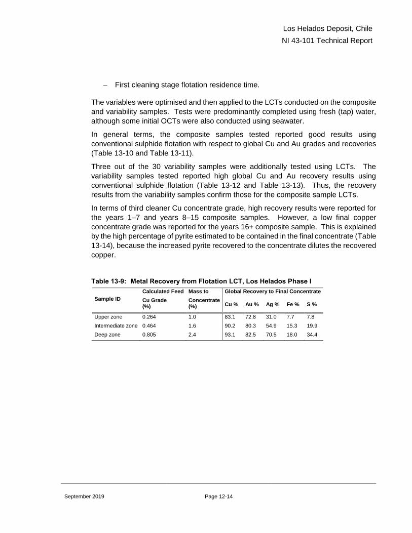
Los Helados Deposit, Chile
NI 43-101 Technical Report
Page 12-14 September 2019
− First cleaning stage flotation residence time.
The variables were optimised and then applied to the LCTs conducted on the composite
and variability samples. Tests were predominantly completed using fresh (tap) water,
although some initial OCTs were also conducted using seawater.
In general terms, the composite samples tested reported good results using
conventional sulphide flotation with respect to global Cu and Au grades and recoveries
(Table 13-10 and Table 13-11).
Three out of the 30 variability samples were additionally tested using LCTs. The
variability samples tested reported high global Cu and Au recovery results using
conventional sulphide flotation (Table 13-12 and Table 13-13). Thus, the recovery
results from the variability samples confirm those for the composite sample LCTs.
In terms of third cleaner Cu concentrate grade, high recovery results were reported for
the years 1–7 and years 8–15 composite samples. However, a low final copper
concentrate grade was reported for the years 16+ composite sample. This is explained
by the high percentage of pyrite estimated to be contained in the final concentrate (Table
13-14), because the increased pyrite recovered to the concentrate dilutes the recovered
copper.
Table 13-9: Metal Recovery from Flotation LCT, Los Helados Phase I
Sample ID
Calculated Feed
Cu Grade (%)
Mass to
Concentrate (%)
Global Recovery to Final Concentrate
Cu % Au % Ag % Fe % S %
Upper zone 0.264 1.0 83.1 72.8 31.0 7.7 7.8
Intermediate zone 0.464 1.6 90.2 80.3 54.9 15.3 19.9
Deep zone 0.805 2.4 93.1 82.5 70.5 18.0 34.4

Los Helados Deposit, Chile
NI 43-101 Technical Report
Page 12-15 September 2019
Table 13-10: Composite Samples Metal Recovery from Flotation LCT, Los Helados
Phase II
Zone/Parameter
Calculated Feed
Cu grade
%
Mass to
Concentrate
%
Global Recovery to Final Concentrate
Cu % Au % Ag % Fe % S %
Years 1–7 0.522 1.59 91.1 69.7 77.8 15.5 19.3
Years 8–15 0.569 1.95 90.8 73.1 49.3 14.2 19.5
Years 16+ 0.454 1.78 91.8 68.1 66.1 14.1 20.7
Table 13-11: Composite Samples Elements and Impurities Contained in the LCT Final
Concentrate, Los Helados Phase II
Element Final Concentrate Grades
Years 1–7 Years 8–15 Years 16+
Calculated feed Cu grade % 0.522 0.569 0.454
Cu % 29.9 26.5 23.4
Au g/t 6.5 8.3 6.8
Ag g/t 70 50 53
Fe % 28.1 29.5 31.8
S % 33.7 34.7 37.3
Cu Sol % 0.042 0.088 0.091
Cd % <0.001 <0.001 <0.001
Zn % 0.284 0.062 0.108
As % 0.024 0.013 0.005
Insoluble % 6.17 8.58 7.52
Hg ppm 3.1 1.2 0.7
Sb % <0.005 <0.005 <0.005
Cl % 0.021 0.031 0.011
Table 13-12: Variability Samples Metal Recovery from Flotation LCT, Los Helados
Phase II
Zone/Parameter
Calculated Feed
Cu Grade
%
Mass to
Concentrate
%
Global Recovery to Final Concentrate
Cu % Au % Ag % Fe % S %
VAR 5 0.663 2.15 92.1 76.0 66.4 18.3 25.2
VAR 17 0.510 1.73 90.8 72.7 66.2 10.5 18.7
VAR 29 0.490 2.45 89.5 70.7 40.0 20.9 18.1

Los Helados Deposit, Chile
NI 43-101 Technical Report
Page 12-16 September 2019
Table 13-13: Variability Samples Elements and Impurities Contained in the LCT Final
Concentrate, Los Helados Phase II
Element Final Concentrate Grades
VAR 5 VAR 17 VAR 29
Calculated feed Cu grade % 0.663 0.510 0.490
Cu % 28.3 26.8 17.9
Au g/t 9,0 7.0 7.4
Ag g/t 70 63 18
Fe % 28.5 27.7 36.6
S % 33.3 31.7 39.8
Cu Sol % 0.112 0.111 0.126
Cd % <0.001 <0.001 <0.001
Zn % 0.132 0.097 0.036
As % <0.005 <0.005 0.009
Insoluble % 5.03 7.12 4.31
Hg ppm <0.1 0.4 0.7
Sb % <0.005 <0.005 <0.005
Cl % 0.01 <0.005 0.013
Table 13-14: Pyrite Content Estimation in Feed and Concentrate LCT, Los Helados
Phase II
Zone/Parameter Sample ID
Calculated Feed
Cu Grade
%
Feed Estimated
Pyrite Content %
Concentrate
Cu Grade
%
Concentrate
Estimated Pyrite
Content %
Years 1–7 Years 1–7 0.522 5.1 29,9 3.9
Years 8–15 Years 8–15 0.569 7.8 26,5 13.4
Years 16+ Years 16+ 0.454 7.6 23,4 24.2
Years 1–7 VAR 5 0.663 6.0 28.3 7.73
Years 8–15 VAR 17 0.510 8.7 26.8 8.90
Years 16+ VAR 29 0.490 8.2 17.9 44.84

Los Helados Deposit, Chile
NI 43-101 Technical Report
Page 12-17 September 2019
Additional optimization work will need to be conducted for the years 16+ years sample
in order to improve the overall concentrate copper grade.
13.1.8 Metallurgical Variability
The metallurgical testwork to date is based on samples which adequately represent the
variability of the deposit with respect to physical and chemical characterisation for this
stage of study. Additional testwork will be required to support more advanced mining
studies. Physical characterisation was conducted on variability samples with relatively
consistent results. Flotation open circuit tests confirmed that the deposit is reasonably
homogeneous with respect to physical and chemical properties.
13.1.9 Deleterious Elements
No major deleterious elements issues were noted in the concentrates produced from
the testwork completed. The concentrates are considered to be marketable without
incurring penalties for deleterious elements.

Los Helados Deposit, Chile
NI 43-101 Technical Report
Page 14-18 September 2019
14.0 MINERAL RESOURCE ESTIMATES
The Mineral Resource estimate discussed in this section is unchanged from that
described in Ovalle et al. (2016).
14.1 Introduction
The Mineral Resource estimate for the Los Helados deposit was prepared by and under
the supervision of, Mr. Gino Zandonai, RM CMC. The Mineral Resource estimate is
supported by 74 drill holes (five RC and 69 core), and 35,629 assay results.
Three drill holes were drilled subsequent to the resource estimate, during the 2014–
2015 field season (LHDH72, LHDHG02 and LHDHG03). Only one of these drill holes,
LHDH72 was assayed, the other two were geotechnical holes and have been retained
as whole core. The data from LHDH72 provide an excellent check on the validity of the
block model and the assayed values correspond very well to the grades of the adjacent
blocks.
The QP responsible for the resource estimate, G. Zandonai, has reviewed the economic
and technical parameters used to derive the mineral resource estimate. In his opinion,
there have been no material changes to these parameters such that they would impact
the resource estimate in any way.
In the opinion of the QP, G. Zandonai, the previous resource estimate remains valid with
respect to all technical and economic information, and accordingly the effective date of
the estimate is April 26, 2019.
14.2 Geological Models
A 2D interpretation based on logged data was completed by NGEx geologists on east–
west oriented sections spaced 100 m apart. Two-dimensional lines were then exported
from GEMS and imported into the Leapfrog geological modelling software and the final
3D wireframe solids were constructed.
Three separate layers within the model were constructed to guide the resource
estimation: lithology; alteration and mineral zones (minzones). Prior to the completion
of the geological model, metallurgical zone models were also constructed in order to
assign each block to a metallurgical sample domain.
14.3 Exploratory Data Analysis
Statistical analyses were performed for Cu, Au, Ag, Mo, S, Fe and As and SG samples
and included reviews of the number of samples, total length, minimum, maximum mean
value, standard deviation, and CV.

Los Helados Deposit, Chile
NI 43-101 Technical Report
Page 14-19 September 2019
All lithological contacts were treated as hard boundaries during the grade interpolation
process.
14.4 Density Assignment
Density values used in estimation are outlined in Section 11-2.
14.5 Grade Capping/Outlier Restrictions
An examination of the grade distributions resulted in grade capping being applied in
certain domains. Depending on the domain, Cu caps ranged from 2–3% Cu, though
most domains were not capped. Gold was capped at 2 g/t Au and Ag at 20 g/t Ag.
14.6 Composites
The drill hole assays were composited to 2 m intervals to maintain the majority sampling
interval (93% of assayed intervals at 2 m) and to avoid spreading composites across
geological domains in case of larger composite sizes.
14.7 Variography
Experimental variogram analysis for Cu, Au, Ag, Mo, As, Fe and S was performed using
the composites based on the lithology domains. The experimental variography was
performed using Supervisor.
14.8 Estimation/Interpolation Methods
A 3D block model of the deposit was built with 25 x 25 x 15 m (X,Y,Z) blocks for Mineral
Resource estimation purposes. The block model covered an area of 2.5 km by 1.95 km
on plan, and had a 2.5 km vertical extent.
The interpolation plan and the search distances for OK and ID2 weighting methods were
based on the geostatistical analysis and variogram parameters. According to this plan,
Cu, Au, Ag, Mo, As, S and Fe were interpolated within the lithology zones in the model.
All elements were interpolated using OK. The ID2 and NN methods were performed only
for Cu and Au for validation and checking purposes of the global bias.
OK and ID2 interpolation was done in a single pass. A minimum of two and a maximum
of 50 composites, with maximum 15 composites from the same hole were used for the
interpolation, to allow maximum spread of the data used to estimate blocks. For
estimation of the kriging and block variance, a 3 x 3 x 3 discretization of the block was
selected. The major, semi-major and minor axes of the search ellipse were set to the
corresponding radius defined by the omnidirectional variograms.

Los Helados Deposit, Chile
NI 43-101 Technical Report
Page 14-20 September 2019
14.9 Block Model Validation
Model validation was carried out using visual comparison of blocks and sample grades
in plan and section views. A statistical comparison of the block and composite grade
distributions and swath plots to compare OK, ID2 and NN estimates were also used.
14.10 Classification of Mineral Resources
Mineral Resource classification uses the 2014 CIM Definition Standards. Classifications
were based on a two-step process, as follows:
• Indicated: distance to the nearest drill hole from the centre of the block less than or
equal to 75 m and at least three drill holes used for the grade interpolation and the
kriging efficiency estimation greater than 0.33
• Inferred: distance to the nearest drill hole from the block 75 to 150 m, at least two
drill holes used for the grade interpolation, and kriging efficiency estimation less than
0.33
Two smoothed buffer wireframes were created in Leapfrog, one at 75 m and one at 150
m. Inferred blocks inside the 75 m wireframe were re-classified as Indicated, while any
Indicated blocks outside of the 75 m buffer but within the 150 m buffer were re-classified
as Inferred. A final phase of visual inspection of the resulting classification was
performed for validation purposes.
14.11 Reasonable Prospects of Eventual Economic Extraction
Underground, block cave mining shapes were generated using the following
assumptions:
• Cu price: US$3.00/lb
• Au price: US$1,300/oz
• Ag price: US$23/oz
• Operating cost (incl. G&A): US$13.07/t
• Capital cost: Provision based on production rate
• Metallurgical recoveries as follows (average life-of-mine):
− Upper Zone (between the surface and 200–250 m depth): 83.1% Cu, 72.8%
Au and 31% Ag
− Intermediate Zone (between 200–250 m and approximately 500–600 m depth):
90.2% Cu, 80.3% Au and 54.9% Ag
− Deep Zone (>500–600 m depth): 93.1% Cu, 82.5% Au and 70.5% Ag.
Los Helados Deposit, Chile
NI 43-101 Technical Report
Page 14-21 September 2019
• Dilution: Laubscher’s model.
A CuEq grade was calculated using US$3.00/lb Cu, US$1,300/oz Au and US$23/oz Ag,
and includes a provision for selling costs (Table 14-1) and metallurgical recoveries
corresponding to the three zones that were defined by depth below surface.
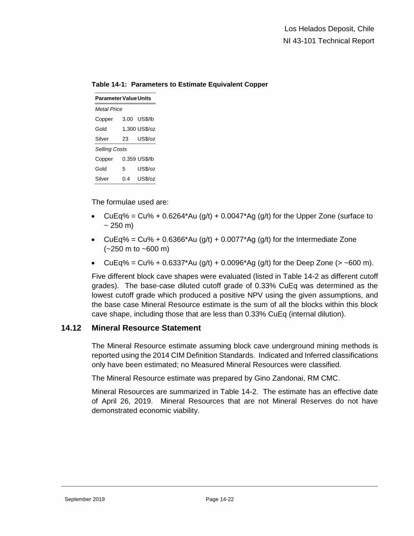
Los Helados Deposit, Chile
NI 43-101 Technical Report
Page 14-22 September 2019
Table 14-1: Parameters to Estimate Equivalent Copper
Parameter Value Units
Metal Price
Copper 3.00 US$/lb
Gold 1,300 US$/oz
Silver 23 US$/oz
Selling Costs
Copper 0.359 US$/lb
Gold 5 US$/oz
Silver 0.4 US$/oz
The formulae used are:
• CuEq% = Cu% + 0.6264*Au (g/t) + 0.0047*Ag (g/t) for the Upper Zone (surface to
~ 250 m)
• CuEq% = Cu% + 0.6366*Au (g/t) + 0.0077*Ag (g/t) for the Intermediate Zone
(~250 m to ~600 m)
• CuEq% = Cu% + 0.6337*Au (g/t) + 0.0096*Ag (g/t) for the Deep Zone (> ~600 m).
Five different block cave shapes were evaluated (listed in Table 14-2 as different cutoff
grades). The base-case diluted cutoff grade of 0.33% CuEq was determined as the
lowest cutoff grade which produced a positive NPV using the given assumptions, and
the base case Mineral Resource estimate is the sum of all the blocks within this block
cave shape, including those that are less than 0.33% CuEq (internal dilution).
14.12 Mineral Resource Statement
The Mineral Resource estimate assuming block cave underground mining methods is
reported using the 2014 CIM Definition Standards. Indicated and Inferred classifications
only have been estimated; no Measured Mineral Resources were classified.
The Mineral Resource estimate was prepared by Gino Zandonai, RM CMC.
Mineral Resources are summarized in Table 14-2. The estimate has an effective date
of April 26, 2019. Mineral Resources that are not Mineral Reserves do not have
demonstrated economic viability.

Los Helados Deposit, Chile
NI 43-101 Technical Report
Page 14-23 September 2019
Table 14-2: Mineral Resource Estimate for Los Helados Assuming Underground Block
Cave Methods (base case is highlighted)
Los Helados Indicated Mineral Resource
Tonnage Resource Grade Contained Metal
Cutoff
(CuEq)
(million
tonnes)
Cu
(%)
Au
(g/t)
Ag
(g/t)
CuEq
(%)
Cu
(billion
lbs)
Au
(million
oz)
Ag
(million
oz)
0.58 531 0.50 0.21 1.66 0.65 5.9 3.6 28.3
0.50 981 0.45 0.18 1.56 0.58 9.7 5.7 49.2
0.44 1,395 0.42 0.16 1.52 0.54 12.9 7.2 68.2
0.40 1,733 0.40 0.15 1.45 0.51 15.3 8.4 80.8
0.33 2,099 0.38 0.15 1.37 0.48 17.6 10.1 92.5
Los Helados Inferred Mineral Resource
Tonnage Resource Grade Contained Metal
Cutoff
(CuEq)
(million
tonnes)
Cu
(%)
Au
(g/t)
Ag
(g/t)
CuEq
(%)
Cu
(billion
lbs)
Au
(million
oz)
Ag
(million
oz)
0.58 There are no Inferred Mineral Resources inside the mining shape at this cutoff grade
0.50 41 0.41 0.13 1.78 0.51 0.4 0.2 2.3
0.44 176 0.37 0.11 1.61 0.45 1.4 0.6 9.1
0.40 399 0.35 0.10 1.47 0.43 3.1 1.3 18.9
0.33 827 0.32 0.10 1.32 0.39 5.8 2.7 35.1
Notes to accompany Los Helados Mineral Resource table
1. Mineral Resource estimate has an effective date of April 26, 2019. The Qualified Person for the estimate is Mr.
Gino Zandonai, RM CMC.
2. Mineral Resources that are not Mineral Reserves do not have demonstrated economic viability
3. Mineral Resources are reported using a copper equivalent (CuEq) cutoff grade. Copper equivalent is calculated
using US$3.00/lb copper, US$1,300/oz gold and US$23/oz Ag, and includes a provision for selling costs and
metallurgical recoveries corresponding to three zones defined by depth below surface. The formulas used are:
CuEq% = Cu% + 0.6264*Au (g/t) + 0.0047*Ag (g/t) for the Upper Zone (surface to ~ 250 m); Cu% + 0.6366*Au (g/t)
+ 0.0077*Ag (g/t) for the Intermediate Zone (~250 m to ~600 m); Cu% + 0.6337*Au (g/t) + 0.0096*Ag (g/t) for the
Deep Zone (> ~600 m)
4. Cutoff grades refer to diluted cutoff grades used to generate the corresponding block cave shapes. For each cutoff
grade, the tonnes and grade represent the total Indicated or Inferred undiluted material within each of these shapes.
5. Mineral Resources are reported within block cave underground mining shapes based on diluted CuEq grades,
US$13.07/t operating costs and include a provision for capital expenditure. The base case cutoff grade of 0.33%
CuEq was derived through an economic evaluation of several block cave shapes developed over a range of different
cutoff grades and is the cutoff grade which results in a zero net present value
6. Totals may not sum due to rounding as required by reporting guidelines
14.13 Factors That May Affect the Mineral Resource Estimate
Mineral Resource estimates may be affected by the following factors:
• Changes in interpretations of mineralization geometry and continuity of
mineralization zones

Los Helados Deposit, Chile
NI 43-101 Technical Report
Page 14-24 September 2019
• Assumptions used in generating the block cave shapes for the Mineral Resources
considered amenable to underground mining methods, including geotechnical and
hydrogeological parameters
• Metallurgical and mining recoveries
• Operating and capital cost assumptions
• Metal price and exchange rate assumptions
• Concentrate grade and smelting/refining terms
• Confidence in the modifying factors, including assumptions that surface rights to
allow infrastructure such as tailings storage facilities and desalination plants to be
constructed will be forthcoming
• Delays or other issues in reaching agreements with local or regulatory authorities
and stakeholders
• Changes in land tenure requirements or in permitting requirements.

Los Helados Deposit, Chile
NI 43-101 Technical Report
Page 23-1 September 2019
23.0 ADJACENT PROPERTIES
This section is not relevant to this Report.

Los Helados Deposit, Chile
NI 43-101 Technical Report
Page 24-1 September 2019
24.0 OTHER RELEVANT DATA AND INFORMATION
The Los Helados deposit has been investigated and reported in two Preliminary
Economic Assessments.
The first was reported in “Los Helados Cu-Au Deposit, Atacama Region III, Chile, NI 43-
101 Technical Report on Preliminary Economic Assessment” and was completed by
AMEC with an effective date of October 1, 2014. This study considered a stand alone
operation, mining the deposit as a block cave underground mine with a processing plant
and associated infrastructure in Chile.
The second study was reported in “Constellation Project Incorporating the Los Helados
deposit, Chile and the Josemaria Deposit, Argentina, NI 43-101 Technical Report on
Preliminary Economic Assessment” with an effective date of February 12, 2016. This
study evaluated a combined operation, beginning with an open pit mine at Josemaria
which provided early production while the block cave at Los Helados was ramped up.
Both deposits were processed at a central flotation plant located in Argentina.
Geotechnical evaluations were performed using available geological models, and drill
hole data from 45 holes in the exploration database that had lithology, survey and
geotechnical data such as RQD (measured by NGEx).
These data were augmented by specific geotechnical core logging performed on six drill
holes (3,350 m) to estimate the rock mass rating (RMRL90,) with 18 UCS laboratory tests
and 717 point load tests also performed.
Subsequent to this, a dedicated block cave geomechanics study was conducted, which
included drilling two oriented geotechnical drill holes (2,100 m). Testing included;
televiewer surveys, Lugeon testing (also known as Packer testing, which is an in-situ
testing method widely used to estimate the average hydraulic conductivity of rock
formations), and 230 point load tests.
An additional geomechanics laboratory testing program was conducted consisting of 84
UCS tests, 46 elastic property tests, 51 tensile tests, and 55 triaxial tests. Geotechnical
logging, televiewer surveys and Lugeon tests were also performed on a single core hole
(1,100 m) drilled as part of this campaign.

Los Helados Deposit, Chile
NI 43-101 Technical Report
Page 25-2 September 2019
25.0 INTERPRETATION AND CONCLUSIONS
25.1 Mineral Tenure, Surface Rights and Royalties
Legal opinion provided supports that NGEx currently holds an indirect majority interest
in the Los Helados Project, consisting of a 63% interest in the MFDO Claims in Chile
which cover the deposit, a 60% interest in the La Rioja Properties and a 100% interest
in the Pampa Claims, both located in Argentina. The MFDO Claims and the La Rioja
Properties are held jointly with Pan Pacific Copper Corporation, Ltd.
Legal opinion provided supports that the mineral tenures held are valid and that the
mineral tenure is sufficient to support declaration of Mineral Resources.
Surface land rights in the area of the Los Helados deposit (in Chile) are held by a local
community “Comunidad Civil Ex Estancia Pulido”. NGEx has an agreement (the “Pulido
Agreement”) dated August 25, 2016 that provides for surface access and occupation
and to conduct exploration and exploitation activities including construction and
operation of a mine in return for annual payments and bullet payments on achievement
of certain project milestones.
There are no royalties payable on Los Helados except for the 0.6% Net Profits interest
due under the Pulido Agreement. The Government of Chile levies a mining tax that is a
tax on operational mining income, applied on a sliding-scale rate basis of between 5%
and 14% depending on operating margins.
NGEx is not aware of any significant environmental, social or permitting issues that
would prevent future exploitation of the Project deposit other than as discussed in this
Report.
25.2 Exploration
Exploration activities conducted by NGEx resulted in the discovery of the Los Helados
deposit. Exploration activities completed have been appropriate to the deposit style.
Once the main deposit was discovered, all the exploration effort shifted to deposit
definition drilling, and exploration on the other exploration targets was suspended.
These additional targets include geochemical anomalies similar in size and tenor to
those that were identified over the known deposit, and have coincident geophysical
targets and mapped alteration features that are consistent with porphyry-style
mineralization. Given that porphyry deposits occur in clusters, and the exploration
targets are in the vicinity of the Los Helados deposit, there is excellent exploration
potential to identify additional porphyry-hosted mineralization. Additional exploration
work is recommended in order to continue to advance them.
The Los Helados deposit remains open at depth and to the north.

Los Helados Deposit, Chile
NI 43-101 Technical Report
Page 25-3 September 2019
25.3 Geology and Mineralization
The knowledge of the deposit settings, lithologies, mineralization and alteration controls
on copper and gold grades are sufficient to support Mineral Resource estimation.
25.4 Drilling
The quantity and quality of the lithological, collar and down-hole survey data collected
in the exploration and infill drill programs completed are sufficient to support Mineral
Resource estimation.
25.5 Sampling and Assay
The quality of the copper and gold analytical data is sufficiently reliable to support
Mineral Resource estimation without limitations on Mineral Resource confidence
categories.
25.6 Data Verification
A reasonable level of verification has been completed during the work conducted to date,
and no material issues would have been left unidentified from the verification programs
undertaken. Mineral Resource estimates can be supported by the data collected.
25.7 Metallurgical Testwork
Two phases of metallurgical testwork have been conducted.
Recovery estimates for Cu, Au, and Ag have been established from this work. High Cu
recoveries were achieved using a conventional sulphide flotation process. The process
also reported relatively high Au and average Ag recoveries. Concentrates containing
saleable Cu, Au and Ag grades were obtained using a conventional sulphide flotation
process.
The metallurgical testwork to date is based on samples which adequately represent the
variability of the deposit with respect to physical and chemical characterisation for this
stage of study. Additional testwork will be required to support more detailed studies.
Flotation open circuit tests confirmed that the deposit is reasonably homogeneous with
respect to physical and chemical properties, although limited variability testing will be
required going forward.
Low levels of concentrate impurities such as As, Cd, and Hg reported to the final Cu
concentrate, and are below the generally accepted levels at which penalties are
imposed.
There is still some pyrite reporting to the final flotation concentrate samples. It is
understood from analysis of these concentrates and the minerals present, and due to

Los Helados Deposit, Chile
NI 43-101 Technical Report
Page 25-4 September 2019
the fact that fixed flowsheet conditions were employed, that these levels of pyrite could
be reduced, resulting in higher Cu grade concentrates.
25.8 Mineral Resource Estimation
Mineral Resource estimation follows standard industry procedures. Mineral Resources
are classified using the 2014 CIM Definition Standards. Estimates assume block cave
mining at Los Helados. Reasonable prospects of eventual economic extraction were
applied, considering that mining method, and appropriately constrains the estimate.
The QP responsible for the resource estimate, G. Zandonai, has reviewed the economic
and technical parameters used to derive the mineral resource estimate. In his opinion,
there have been no material changes to these parameters such that they would impact
the resource estimate in any way.
In the opinion of the QP, G. Zandonai, the previous resource estimate remains valid with
respect to all technical and economic information, and accordingly the effective date of
the estimate is April 26, 2019.
Factors that can affect the estimate include: changes in interpretations of mineralization
geometry and continuity of mineralization zones; assumptions used in generating the
block cave shapes, including geotechnical and hydrogeological parameters;
metallurgical recoveries; operating and capital cost assumptions; metal price and
exchange rate assumptions; concentrate grade and smelting/refining terms; confidence
in the modifying factors, including assumptions that surface rights to allow infrastructure
such as tailings storage facilities and desalination plants to be constructed will be
forthcoming; delays or other issues in reaching agreements with local or regulatory
authorities and changes in land tenure requirements or in permitting requirements from
those discussed in this Report.

Los Helados Deposit, Chile
NI 43-101 Technical Report
Page 26-1 September 2019
26.0 RECOMMENDATIONS
Los Helados is a significant copper-gold-silver deposit that clearly warrants additional
work to continue to de-risk it through additional engineering studies. This work should
proceed in two phases, leading to the completion of a revised standalone PEA study.
26.1 Phase I
The Phase 1 work program comprises updating the mineral resource and investigating
options and trade off studies for mine planning.
26.1.1 Mineral Resource
Assays from drillhole LHDH072 completed in 2015 are available, but have not been
incorporated into the current mineral resource. Additional geological studies have also
resulted in a slight revision to the geological interpretation. The mineral resource should
be updated to incorporate these changes. The current resource is considered to be
robust, and it is not anticipated that an update will result in a significant change in the
overall tonnage or grade, however some of the Indicated material is likely to be classified
as Measured with the additional drill information.
There are also two geotechnical holes which have been maintained as whole core (i.e.
have not been sampled for assay). Consideration should be given to sampling and
assaying these holes and incorporation of this new data into the resource update which
should further increase the Measured mineral resource.
26.1.2 Mine Planning
Following the resource update, continuation and refinement of the mine planning
exercises completed as part of the standalone and Project Constellation PEA’s should
be undertaken. The goal of these studies should be to investigate alternate mining
methods, such as sub-level caving, which could potentially reduce the up-front capital
expenditure requirements and shorten the lead time to production.
26.2 Phase II
A second phase of work should involve updating the previous Los Helados stand alone
PEA to incorporate the updated resource model and mine planning work, including
various project optimizations from the Los Helados portion of Project Constellation.
26.2.1 Infrastructure
A review should be conducted of all infrastructure location and design assumptions.
This should include:
• Additional modeling in support of mine dewatering and project water supply

Los Helados Deposit, Chile
NI 43-101 Technical Report
Page 26-2 September 2019
• Proposed locations of the mill feed material handling systems (e.g. conveyors,
transfer stations)
• A trade-off study that assesses the optimal tailings disposal method, TSF locations
and construction methods
• A review of power supply alternatives
• Alternative considerations for tunnel and road locations
• Review of optimal camp locations
• Evaluation of assumptions as to the port infrastructure and port access.
26.2.2 Environmental, Permitting and Stakeholder Considerations
A PEA level, project-licensing strategy should be designed that takes into account the
regulatory framework, social context and environmental sensitivities of the Project.
The following steps are recommended for the formulation and execution of the licensing
strategy to the pre-feasibility level:
• Align the legal, environmental and social licensing strategy to the strategic objectives
of the project
• Carry out a risk assessment on these strategies and generate risk response
approaches
• Design a plan for the Environmental Impact Assessment (EIA), permitting and public
participation, addressing the issues identified to date and promoting feedback into
the strategy
• Analyze the environmental aspects of the preferred option in order to understand the
interaction with sensitive issues and areas
• Apply environmental design criteria based on national regulations and international
guidelines
• Continue ongoing baseline environmental programs
26.2.3 Report Compilation
Information should be incorporated into a stand-alone PEA document.
26.3 Budget Estimate
Table 26-1 summarizes the costs to complete Phases 1 and 2 of the recommendations.

Los Helados Deposit, Chile
NI 43-101 Technical Report
Page 26-3 September 2019
Table 26-1: Recommendations Costs
Program Phase Area Estimated Costs
(US$ x 1,000)
Phase 1
Resource Update 70
Mine Planning Studies 130
Subtotal 200
Phase 2
Mine Design & Production Schedule Optimization 250
Infrastructure 100
Environmental Studies and Field Work 250
Study Management and Reporting 200
Subtotal 800
Total 1,000

Los Helados Deposit, Chile
NI 43-101 Technical Report
Page 27-1 September 2019
27.0 REFERENCES
Arrieta, J.A., Guitart A. and Richard, F. 2012: Descripción Secciones Geológicas,
Proyecto Los Helados: NGEx internal report
Barrett, J. 2011: Final Report for A Pole-Dipole Induced Polarization / Resistivity Survey
at the Los Helados Project Region III, Chile: report prepared for NGEx by Zonge
Ingenieria y Geofisica (Chile) S.A.
Canadian Institute of Mining, Metallurgy and Petroleum (CIM), 2003: Estimation of
Mineral Resources and Mineral Reserves, Best Practice Guidelines: Canadian
Institute of Mining, Metallurgy and Petroleum, November 23, 2003,
http://www.cim.org/committees/estimation2003.pdf
Canadian Institute of Mining, Metallurgy and Petroleum (CIM), 2014: CIM Standards for
Mineral Resources and Mineral Reserves, Definitions and Guidelines: Canadian
Institute of Mining, Metallurgy and Petroleum, May 2014
Canadian Securities Administrators (CSA), 2011: National Instrument 43-101,
Standards of Disclosure for Mineral Projects: Canadian Securities
Administrators
Charchaflié, D. 2011: 2011–2012 Campaign Standard Preparation: NGEx internal
report
Charchaflié, D. and LeCouteur, P.C., 2012: Geological Report on the Los Helados
Property, III Region of Atacama, Chile: technical report prepared by LPF
Consulting SRL and Micron Geological Limited for NGEx Resources Inc.,
effective date 15 February, 2012
Guitart, A. (in prep): The timing of porphyry intrusions and breccias associated with the development of the Los Helados porphyry copper deposit, Chile. Unpublished M.Sc. thesis, The University of British Columbia, Vancouver, Canada.
Martínez, F., Peña, M., and Arriagada, C., 2015, Geología de las áreas Iglesia
Colorada-Cerro del Potro y Cerro Mondaquita, Región de Atacama. Escala
1:100,000: Servicio Nacional de Geología y Minería, Carta Geológica de Chile,
Serie Geología Básica 179–180, 67 p.

Los Helados Deposit, Chile
NI 43-101 Technical Report
Page 27-2 September 2019
Mpodozis C., and Kay, S., 2003: Neogene Tectonics, Ages and Mineralization Along
the Transition Zone Between the El Indio and Maricunga Mineral Belts (Argentine
and Chile 28°-29°): Actas 10° Congreso Geológico de Chile, CD ROM, 1 p.
NGEx 2010: Vicuña Project, Los Helados, 2009–2010 Exploration Report: NGEx
internal report to JOGMEC, English translation Oct 2012.
Oriolo, S., Japas, M.S., Cristallini, E.O., and Giménez, M., 2014, Cross-strike
structures controlling magmatism emplacement in a flat-slab setting
(Precordillera, Central Andes of Argentina): Geological Society, London,
Special Publications, v. 394, p. 113–127.
Ovalle, A., et.al., 2016: Constellation Project; Incorporating the Los Helados Deposit,
Chile and the Josemaria Deposit, Argentina, NI43-101 Technical Report on
Preliminary Economic Assessment; Effective Date 12 February 2016, Amended
31 March 2016.
Seedorf, E., Dilles, J.H., Proffett, J.M.Jr., Einaudi, M.T., et al., 2005, Porphyry deposits:
Characteristics and origin of hypogene features; Society of Economic
Geologists, Economic Geology 100th Anniversary Volume, pp251-298.
Sillitoe, R.H., 2011: Preliminary Model for Los Helados Porphyry Copper-Gold Prospect,
Northern Chile: internal report prepared for NGEx Resources Inc
Sillitoe, R.H., 2012: Further Comments on the Model for Los Helados Porphyry Copper-
Gold Prospect, Northern Chile: internal report prepared for NGEx Resources Inc
Sillitoe, R.H., and Perelló, J., 2005: Andean Copper Province: Tectonomagmatic
Settings, Deposit Types, Metallogeny, Exploration, and Discovery: Economic
Geology 100th Anniversary Volume, p. 845–890
Sinclair, W.D. (2007) Porphyry Deposits. In: Goodfellow, W.D., Ed., Mineral Deposits of
Canada: A Synthesis of Major Deposit-Types, District Metallogeny, the Evolution
of Geological Provinces, and Exploration Methods, Geological Association of
Canada, Mineral Deposits Division, Special Publication, Canada, Newfoundland,
223-243.
Quiñones, C., Ovalle, A., Frost, D., Priscu, D., Khera, V., Pizarro, N., and Zandonai, G.,
2014: Los Helados Cu-Au Deposit, Atacama Region III, Chile, NI 43-101
Technical Report on Preliminary Economic Assessment: technical report
prepared by AMEC and Behre Dolbear for NGEx Resources Inc., effective date
1 October, 2014.

Los Helados Deposit, Chile
NI 43-101 Technical Report
Page 27-3 September 2019
Zandonai, G., Carmichael, R., and Charchaflié, D., 2012: Mineral Resource Estimate
for the Los Helados Property, Region III of Atacama, Chile: technical report
prepared by LPF Consulting SRL, NGEx and Micron Geological Limited for
NGEx Resources Inc., effective date 15 October, 2012
Zandonai, G., and Frost, D., 2013: Updated Mineral Resource Estimate for the Los
Helados Property, Region III of Atacama, Chile: technical report prepared by
Behre Dolbear and AMEC for NGEx Resources Inc., effective date 15 October,
2013, amended 24 March 2014