long term autonomous ocean remote sensing … term autonomous ocean remote sensing utilizing the...
TRANSCRIPT
Long Term Autonomous Ocean Remote Sensing Utilizing the Wave Glider
J. Griffith, K. VanderLugt, Matt Cosad Liquid Robotics
1329 Moffett Park Drive Sunnyvale, CA 94089
Abstract—Rising costs of ship time and increasing budgetary restrictions make installation and maintenance of fixed, mid-ocean buoys a logistical and financial challenge. To address these challenges, Liquid Robotics (LRI) has developed the Wave Glider, an autonomous, mobile remote sensing solution. In November 2011, LRI deployed four Wave Gliders on a mission to cross the Pacific Ocean (the PacX) from San Francisco to Australia (two vehicles) or Japan (two vehicles) while transmitting data on weather conditions, wave profiles, sea surface temperatures, and biological conditions (fluorometry) in real-time. This report evaluates the vehicle’s ability to operate as an ocean going data platform by comparing data from the onboard weather sensors with NDBC buoy 51000 200 nmi northeast of Maui. The report also analyzes data transmitted from all four vehicles as they passed directly through a tropical storm 580 nmi northeast of Hawaii. The results provide solid evidence that the Wave Glider as deployed would provide a suitable and highly efficient platform for the observation of sea surface and lower atmospheric conditions over extended sampling periods.
I. INTRODUCTION Acquiring high resolution information of mid-oceanic
conditions is challenging across spatial and temporal scales. Instruments deployed during ship operations provide adequate spatial resolution but typically on a short period of time whereas the deployment of moored buoys provides continuous data over long periods of time, but from a fixed location. While satellites provide both spatial and temporal information, in-situ measurements for data calibration are still needed for accurate reporting and modeling. In addition to the need of high spatial and temporal resolution data, the rising costs of ships, buoys, and satellite in the face of challenging fiscal environments warrant the development of new, cost-effective monitoring technologies.
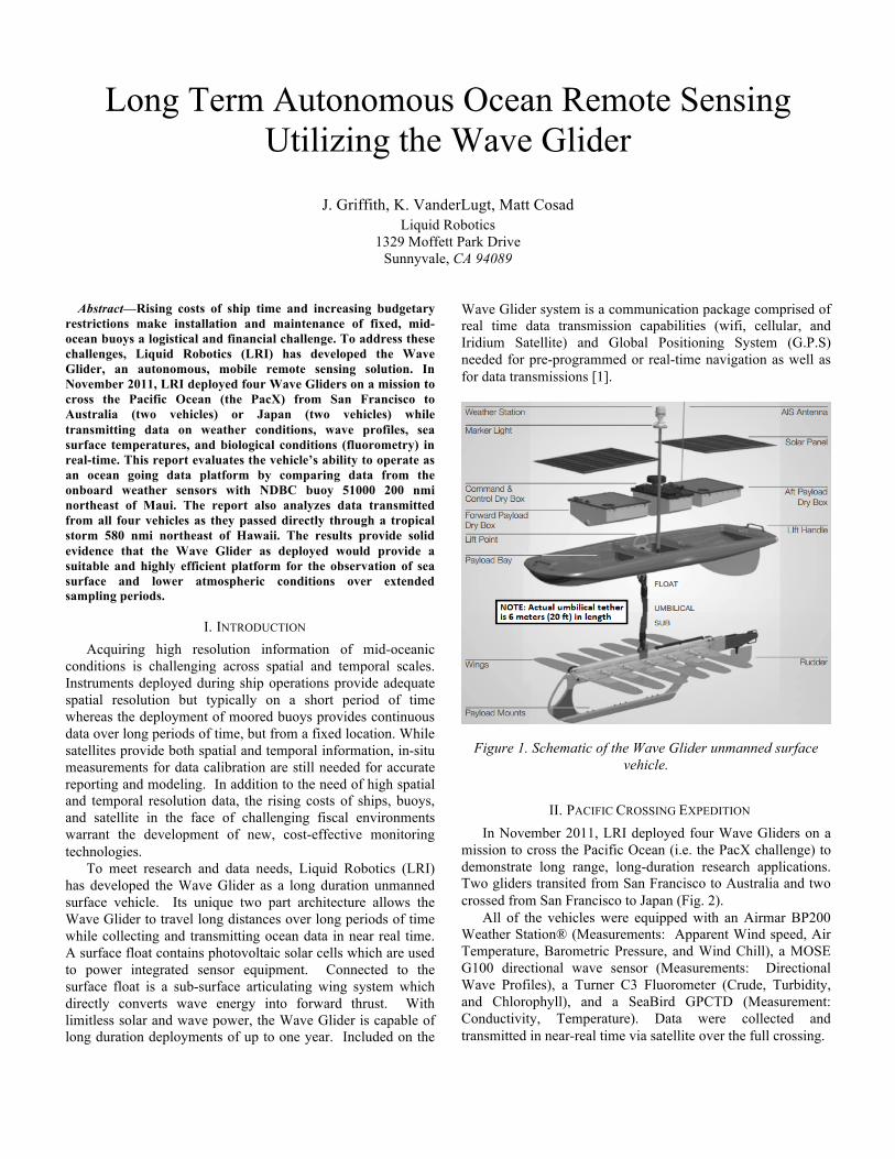
To meet research and data needs, Liquid Robotics (LRI) has developed the Wave Glider as a long duration unmanned surface vehicle. Its unique two part architecture allows the Wave Glider to travel long distances over long periods of time while collecting and transmitting ocean data in near real time. A surface float contains photovoltaic solar cells which are used to power integrated sensor equipment. Connected to the surface float is a sub-surface articulating wing system which directly converts wave energy into forward thrust. With limitless solar and wave power, the Wave Glider is capable of long duration deployments of up to one year. Included on the
Wave Glider system is a communication package comprised of real time data transmission capabilities (wifi, cellular, and Iridium Satellite) and Global Positioning System (G.P.S) needed for pre-programmed or real-time navigation as well as for data transmissions [1].
Figure 1. Schematic of the Wave Glider unmanned surface
vehicle.
II. PACIFIC CROSSING EXPEDITION In November 2011, LRI deployed four Wave Gliders on a
mission to cross the Pacific Ocean (i.e. the PacX challenge) to demonstrate long range, long-duration research applications. Two gliders transited from San Francisco to Australia and two crossed from San Francisco to Japan (Fig. 2).
All of the vehicles were equipped with an Airmar BP200 Weather Station® (Measurements: Apparent Wind speed, Air Temperature, Barometric Pressure, and Wind Chill), a MOSE G100 directional wave sensor (Measurements: Directional Wave Profiles), a Turner C3 Fluorometer (Crude, Turbidity, and Chlorophyll), and a SeaBird GPCTD (Measurement: Conductivity, Temperature). Data were collected and transmitted in near-real time via satellite over the full crossing.
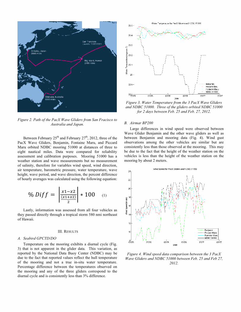
Figure 2. Path of the PacX Wave Gliders from San Fracisco to Australia and Japan.
Between February 25th and February 27th, 2012, three of the
PacX Wave Gliders, Benjamin, Fontaine Maru, and Piccard Maru orbited NDBC mooring 51000 at distances of three to eight nautical miles. Data were compared for reliability assessment and calibration purposes. Mooring 51000 has a weather station and wave measurements but no measurement of salinity, therefore for variables wind speed, wind direction, air temperature, barometric pressure, water temperature, wave height, wave period, and wave direction, the percent difference of hourly averages was calculated using the following equation:
% 𝐷𝑖𝑓𝑓 = !!!!!!!!!!
!
∗ 100 (1)
Lastly, information was assessed from all four vehicles as
they passed directly through a tropical storm 580 nmi northeast of Hawaii.
III. RESULTS
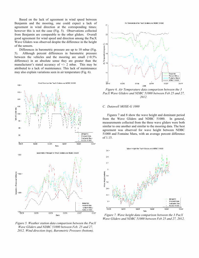
A. Seabird GPCTD/DO Temperature on the mooring exhibits a diurnal cycle (Fig.
3) that is not apparent in the glider data. This variation, as reported by the National Data Buoy Center (NDBC) may be due to the fact that reported values reflect the hull temperature of the mooring and not a true in-situ water temperature. Percentage difference between the temperatures observed on the mooring and any of the three gliders correspond to the diurnal cycle and is consistently less than 3% difference.
Figure 3. Water Temperature from the 3 PacX Wave Gliders and NDBC 51000. Three of the gliders orbited NDBC 51000
for 2 days between Feb. 25 and Feb. 27, 2012.
B. Airmar BP200 Large differences in wind speed were observed between
Wave Glider Benjamin and the other wave gliders as well as between Benjamin and mooring data (Fig. 4). Wind gust observations among the other vehicles are similar but are consistently less than those observed at the mooring. This may be due to the fact that the height of the weather station on the vehicles is less than the height of the weather station on the mooring by about 2 meters.
Figure 4. Wind speed data comparison between the 3 PacX Wave Gliders and NDBC 51000 between Feb. 25 and Feb 27,
2012.
Based on the lack of agreement in wind speed between Benjamin and the mooring, one could expect a lack of agreement in wind direction at the corresponding times; however this is not the case (Fig. 5). Observations collected from Benjamin are comparable to the other gliders. Overall good agreement for wind speed and direction among the PacX Wave Gliders was observed despite the difference in the height of the sensors.
Differences in barometric pressure are up to 10 mbar (Fig. 5). Although percent differences in barometric pressure between the vehicles and the mooring are small (<0.5% difference) in an absolute sense they are greater than the manufacturer’s stated accuracy of +/- 2 mbar. This may be attributed to a lack of maintenance. This lack of maintenance may also explain variations seen in air temperature (Fig. 6).
Figure 5. Weather station data comparison between the PacX
Wave Gliders and NDBC 51000 between Feb. 25 and 27, 2012. Wind direction (top), Barometric Pressure (bottom).
Figure 6. Air Temperature data comparison between the 3
PacX Wave Gliders and NDBC 51000 between Feb 25 and 27, 2012.
C. Datawell MOSE-G 1000 Figures 7 and 8 show the wave height and dominant period
from the Wave Gliders and NDBC 51000. In general, measurements collected from the three wave gliders were both similar to one another and similar to the mooring data. The best agreement was observed for wave height between NDBC 51000 and Fontaine Maru, with an average percent difference of 1.15.
Figure 7. Wave height data comparison between the 3 PacX
Wave Gliders and NDBC 51000 between Feb 25 and 27, 2012.

Figure 8. Wave period data comparison between the 3 PacX
Wave Gliders and NDBC 51000 between Feb 25 and 27, 2012.
D. Sea Storm Assessment In tropical storm conditions [2] lasting 4 days, all of the
vehicles recorded sustained winds of up to 40 knots with gusts up to 80 knots. This data compares favorably to satellite imagery from the ASCAT satellite data. The vehicles also measured sustained wave heights of 7m along with a barometric pressure drop to a low of 985 mbar (Fig. 9).
The recording of wave height was discontinued in all three vehicles from February 8 to February 10. This occurred during peak storm conditions in which cloud cover limited the solar panel’s ability to recharge the Wave Glider’s on-board batteries. As battery capacity dropped, individual sensors were turned off to maintain power for the vehicle’s core functions (communication, navigation, etc.).
Figure 9. Storm data from all 4 vehicles as they passed
through a tropical storm 580 nmi NE of Hawaii including wind gust, wave height, and barometric pressure
IV. DISCUSSION Wave Gliders are capable of providing high spatial and
temporal resolution of mid-oceanic conditions relating to sea surface and lower atmospheric observations. Wave Gliders successfully crossed from San Francisco to Kawaihae, Hawaii in a single unassisted transit over 4 months and 3200 miles, thus breaking the world record [3]. These vehicles were outfitted with a robust METOC sensor package including Fluorometers which required significant power consumption. Wave Gliders in this exercise were able to navigate successfully across varying current and wave conditions, and performing station keep around moored buoy 51000 both using pre-programmed navigation way points as well as through piloting in real-time. Such capabilities are applicable in planned future research missions in which wave gliders will be redirected in near real time, as a result of receiving and assessing in-situ observations.

Wave Gliders in this exercise performed successfully and continued to transmit METOC data through tropical storm conditions. Planned future efforts will build upon this work, in which several Wave Gliders will be launched for the purposes of gathering in-situ data in the path and immediate vicinity of Hurricanes. This is anticipated to provide researchers with sufficient data to improve hurricane intensity models and forecasting.
Comparisons to moored buoy data in this exercise demonstrated that Wave Gliders are consistent and comparable. Some variation in observation can be expected in relation to micro-spatial variability in oceanic conditions. Further assessments will be made to elucidate these spatial differences. However, comparable results provide proof of concept for the ability of Wave Glider to either replace or augment a portion of existing moored weather and climate buoys and at a fraction of the cost.
Comparison of wind speed data between PacX vehicles and ASCAT, demonstrated the ability for Wave Glider to not only provide in-situ calibration for satellite data but also provide data continuity through the transition of new generation satellites such as in the coming JPSS-1. Further efforts are planned to compare Wave Glider data with additional satellite and oceanic data sources for calibration purposes
V. CONCLUSION In conclusion, the Pacific crossing has provided solid
evidence that the Wave Glider as deployed would provide a suitable and highly efficient platform for the observation of sea surface and lower atmospheric conditions over extended sampling periods. The system could be used to quickly and efficiently increase the operational density of ocean observations without the need for expensive deployment and recovery vessels.
REFERENCES [1] J. Manley and S. Willcox, “The Wave Glider: A Persistent
Platform for Ocean Science,” Proc. IEEE OCEANS, Sydney, Australia, 2010.
[2] Chris Landsea, 2011, “What is a tropical disturbance, tropical depression, or tropical storm,” http://www.aoml.noaa.gov/hrd/tcfaq/A5.html.
[3] BBC, 2012, “Swimming robots break world distance record in Pacific,” http://www.bbc.com/news/technology-17367984