liss neighbourhood plan group - lissnp.org.uk · liss neighbourhood plan group . march 2016 . ......
TRANSCRIPT

Liss Neighbourhood Plan Group March 2016
View of St Mary’s Church from public footpath in north part of site
Landscape development brief for Land at Brows Farm, Liss
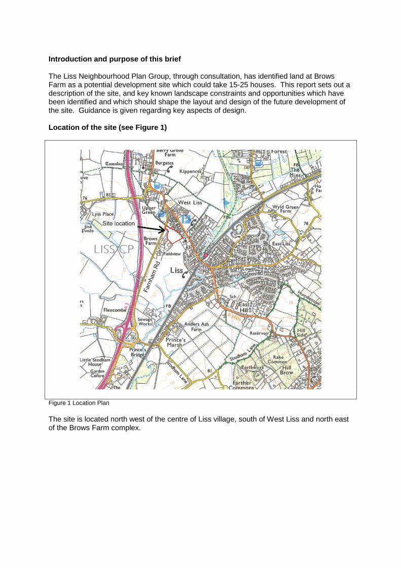
Introduction and purpose of this brief The Liss Neighbourhood Plan Group, through consultation, has identified land at Brows Farm as a potential development site which could take 15-25 houses. This report sets out a description of the site, and key known landscape constraints and opportunities which have been identified and which should shape the layout and design of the future development of the site. Guidance is given regarding key aspects of design. Location of the site (see Figure 1)
Figure 1 Location Plan The site is located north west of the centre of Liss village, south of West Liss and north east of the Brows Farm complex.
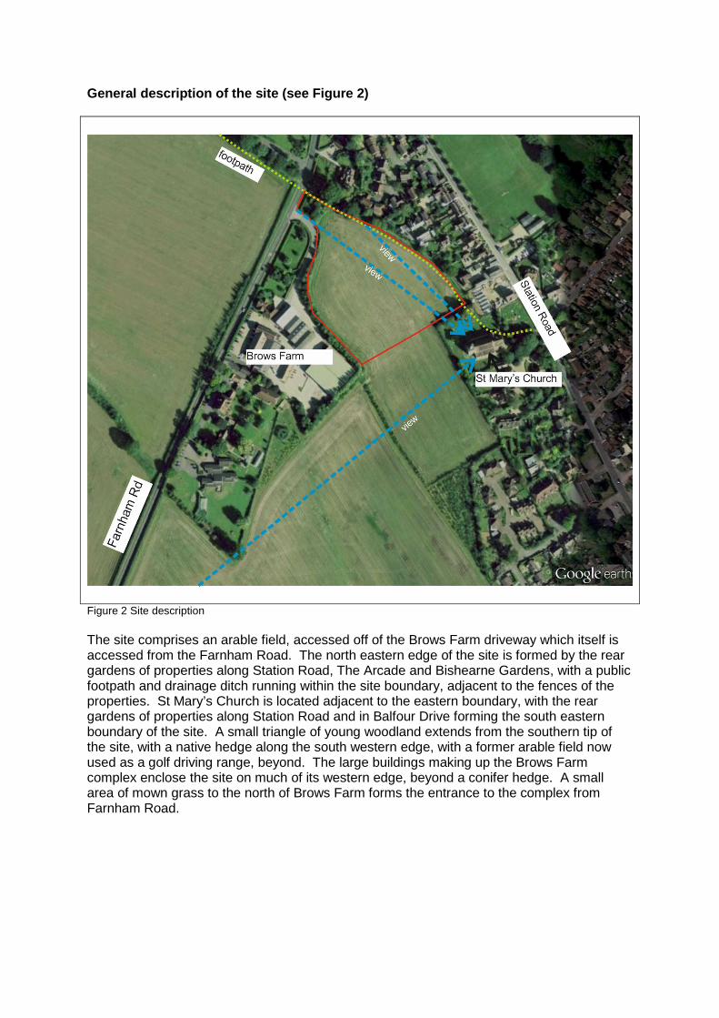
General description of the site (see Figure 2)
Figure 2 Site description The site comprises an arable field, accessed off of the Brows Farm driveway which itself is accessed from the Farnham Road. The north eastern edge of the site is formed by the rear gardens of properties along Station Road, The Arcade and Bishearne Gardens, with a public footpath and drainage ditch running within the site boundary, adjacent to the fences of the properties. St Mary’s Church is located adjacent to the eastern boundary, with the rear gardens of properties along Station Road and in Balfour Drive forming the south eastern boundary of the site. A small triangle of young woodland extends from the southern tip of the site, with a native hedge along the south western edge, with a former arable field now used as a golf driving range, beyond. The large buildings making up the Brows Farm complex enclose the site on much of its western edge, beyond a conifer hedge. A small area of mown grass to the north of Brows Farm forms the entrance to the complex from Farnham Road.
Detailed description of site elements Topography The site slopes evenly down from north to south and from west to east. The gardens of adjacent properties to the north east sit at a lower level than the site, with up to 1m difference. The level change is formed in some cases by low retaining structures and in some cases by planted banks. Vegetation Arable crops cover the majority of the site on a seasonal basis, with bare soil when the crop is cleared. Mature trees (including some oaks) grow on the northern boundary, along with a variety of shrubs and hedges which form the boundaries of adjacent residential properties, the latter extending along much of the eastern and south eastern edges of the site, including the church yard. A mixed native hedge forms the south western boundary with the driving range and further north along this edge and surrounding the business park the boundary is formed in part by a tall mixed hedge. Rough grass grows along the drainage ditch running inside the north eastern boundary. Hydrology The ditch along the north western edge of the field is presumed to catch run off from the field but may also be part of a wider hydrological system. During the wet winter of 2015/16 the field is sitting wet, particularly just north of the church yard. The public footpath is also muddy. Soils Details of the soil type do not form part of this study. However, the soil has characteristics which enable it to support arable crops and it is known that generally in the area the underlying clay creates slowly permeable, seasonally waterlogged soils. Access and connections The public footpath running within the north eastern edge of the site connects across Farnham Road towards the A3 and with the wider public footpath network in the countryside beyond. To the east of the site, the footpath passes through the church yard, onto Station Road and into the village centre. Vehicular access to the site is from the Brows Farm access road to the north west. Heritage The site forms the rural setting for the Grade II Listed St Mary’s Church. Views There are important views of St Mary’s Church from Farnham Road to the south west and through a gap in the hedgerow at the access road. Views heading south on the footpath within the site (see front cover photo) also focus on the church but longer views to Hill Brow ridge and the South Downs are also possible from within the site, as are filtered views west to the Hangers. The large buildings of Brows Farm and the somewhat raw quality of parts of the village edge detract from an otherwise scenic and rural landscape. Built form There are large, agricultural buildings at Brows Farm to the west and residential buildings predominantly of 2-3 storeys in small plots to the east, with some larger houses and gardens and the church and church yard. Landscape character The site is within character area 7A Liss and upper Rother Valley as identified in the Liss Parish Community Landscape Character Assessment (2006). Key characteristics of this
character area represented in the site are mixed farmland, hedges and footpaths. The site itself is semi-enclosed, more open to the south and while largely rural in nature is somewhat affected by the large buildings at Brows Farm and the noise of the nearby A3 traffic. Site analysis – opportunities, constraints and further studies Topography A full topographical survey would be needed, including levels of immediately adjacent land, particularly to the east, where the land drops down into neighbouring gardens. The ground floor levels of new houses would need to be carefully designed to minimise artificial landform and to integrate the development into the surrounding landscape in a sympathetic manner. Vegetation A full arboricultural survey to BS5837 would need to accompany any planning application to ensure there are no unacceptable impacts on existing trees and hedgerows. A phase 1 habitat survey would need to be carried out to identify any ecological constraints and any further protected species studies. Opportunities to enhance existing vegetation and biodiversity, such as replacing the conifer content of the hedge with native species, adding new native hedge and tree planting and developing areas of wildflower meadow should be taken. A new mixed native hedgerow with native hedgerow trees should be included between the main field and the public footpath, to allow views over the hedge but to create a softer edge to the rear gardens. Any opportunities to link habitats should be taken, including linking the area of young woodland with new tree planting within the site. A management plan would need to be developed to ensure the long-term health and survival of planting and open spaces for the benefit of the community and of wildlife. Hydrology Any application should be accompanied by a study which shows the function the site currently has in the local hydrological system and how the proposed development would affect this. Measures would need to be included to ensure there would be no flooding issues caused to surrounding areas and where possible that existing problems could be resolved with new surface water strategies. Proposals should include sustainable urban drainage systems to ensure the infiltration and attenuation of surface water and also function as ecological features with amenity value. Soils Management of soils should comply with the Construction Code of Practice for the Sustainable Use of Soils on Construction Sites, including the commissioning of a Soil Resources Survey showing the areas and type of topsoil and subsoil to be stripped, haul routes, the methods to be used, and the location, type and management of each soil stockpile. The results of the soil resource survey should be incorporated into a site working strategy (e.g. Site Waste Management Plan or Material Management Plan). Access and connections The public footpath through the site provides an important link between Station Road and the village centre and Farnham Road / West Liss. It will be equally important in linking the proposed housing site with Station Road, but the path would require surfacing to create an all-weather surface and this surfacing would need to continue through the church yard. A need for overflow parking serving the church at busy times has been identified and there is potential for parking to be provided on the Brows Farm complex, from where a new path could be created to link across the site to the church. There is the opportunity for much of the site to remain undeveloped as public open space, managed as a community amenity and wildlife resource, provided that activities would not affect the rural character or important views. Impacts on local vehicular traffic will need to be assessed.

Heritage A study of the impact of development on the setting of St Mary’s Church would need to be carried out, and any mitigation implemented to minimise harm. Views A Landscape and Visual Impact Appraisal in line with the Guidelines for Landscape and Visual Impact Assessments (2013) would need to be carried out by a suitably qualified landscape architect to fully inform proposals for the site’s development and to ensure that key views are retained and enhanced where possible, for example to soften the settlement edge along part of the eastern boundary. Built form The scale of new buildings will need to be carefully considered to avoid adverse impacts on the character of the village including the church. The three dimensional form of development should reflect that of housing to the north and east, not the Brows Farm buildings, and should protect and enhance the setting of the church. The houses should be predominantly 2 storey. A study of local buildings and their materials should be carried out to inform the design. Opportunities for renewable energy features to be incorporated into the new buildings should be maximised. Landscape character Proposals for the site should respect and enhance local character. Development and design principles (see Figs 3, 4 and 5) The key constraints and opportunities identified above lead to a layout which:
• Protects the open setting of St Mary’s Church; • Protects the open setting of the public footpath; • Protects and enhances views of St Mary’s Church.

Figure 3 Development principles The suggested layout sites the houses on the north western edge of the site, against the existing hedge, with the access road between the houses and the hedge. The houses face onto a generous open space, with parking and gardens set behind the houses. This would create an attractive setting to the open space, a pleasant outlook for the new residents, and provide informal surveillance of the open space. Any tree planting would need to be designed to avoid blocking views of the church.
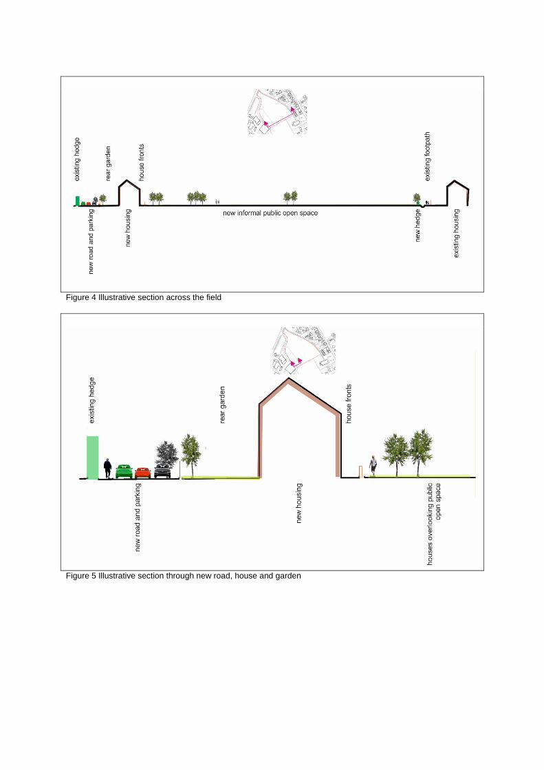
Figure 4 Illustrative section across the field
Figure 5 Illustrative section through new road, house and garden
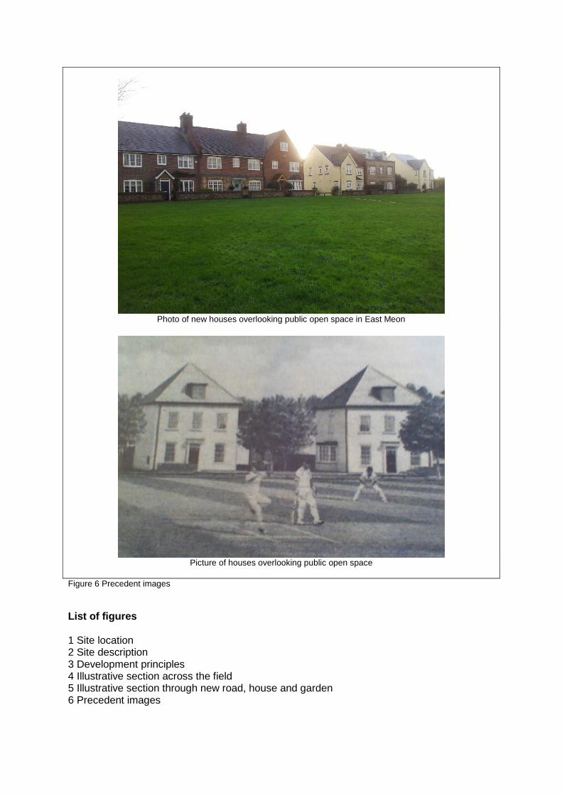
Photo of new houses overlooking public open space in East Meon
Picture of houses overlooking public open space
Figure 6 Precedent images List of figures 1 Site location 2 Site description 3 Development principles 4 Illustrative section across the field 5 Illustrative section through new road, house and garden 6 Precedent images