levelling airborne and ground gamma-ray ... atomic energy agency a global radioelement baseline •...
TRANSCRIPT

International Symposium on Uranium Raw Material for Nuclear Fuel Cycle:Exploration, Mining, Production, Supply and Demand, Economics and
Environmental Issues, Vienna, Austria, 22-26 June 2009
LEVELLING AIRBORNE AND GROUND GAMMA-RAY SPECTROMETRIC DATA TO ASSIST URANIUM EXPLORATION
M. Matolin, Charles University in Prague, Czech RepublicB. Minty, Geoscience Australia, Canberra, Australia

GLOBAL GAMMA-RAY SPECTROMETRY AND TOTAL COUNT COVERAGE
Compiled by Sally Barritt, 2005
Radioelement Mapping, IAEA (in press)

International Atomic Energy AgencyA GLOBAL RADIOELEMENT BASELINE
• In the fifty years past, airborne and ground gamma-ray spectrometry and gamma total count surveys covered more than 50 % of the area of continents.• Gamma-ray spectrometry was recognized as powerful technique for K, U and Th mapping. • In order to standardize radiometric data, and make their full use, IAEA initiated a project of „A Global Radioelement Baseline“.• Publication:Radioelement Mapping, IAEA (in press).

A GLOBAL RADIOELEMENT BASELINE• A global radioelement baseline for gamma-ray spectrometric data
requires that all gamma-ray data be acquired and processed in a globally consistent way.
• Instrument calibration:Primary reference standards for laboratorygamma-ray spectrometry issued by the IAEASeibersdorf Laboratory in 1987.
• A global network of calibration facilitiesfor field radiometric instruments. 44.8 % K 400 ppm U 800 ppm Th
Czech RepublicAustria

TOPICS
• Levelling airborne gamma-ray spectrometric dataTHE RADIOMETRIC MAP OF AUSTRALIA
Data: Geoscience Australia
• Levelling ground gamma-ray spectrometric dataGEOMETRICAL CORRECTION FOR GROUND MEASUREMENT
Data: Charles University in Prague

AUSTRALIA – AIRBORNE GAMMA-RAY SPECTROMETRY SURVEY COVERAGE
In Australia, over 80 % of thecontinent is covered byairborne gamma-ray spectrometryflown over the past 40 years.Standard data were reported inK, U, and Th concentration.Sub-standard data were reported in counts per second.
Geoscience Australia

AUSTRALIA – AIRBORNE GAMMA-RAY SPECTROMETRY SURVEY COVERAGE
540 airborne gamma-rayspectrometric surveys.Differences in surveyparameters: flying heightprofile separationdetector volume energy window widthstandards and calibrationdata processing
Results are not directlycomparable.
Geoscience Australia
1970 – 2008
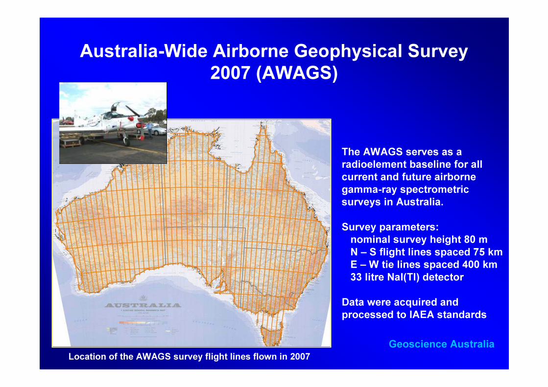
Australia-Wide Airborne Geophysical Survey 2007 (AWAGS)
The AWAGS serves as a radioelement baseline for allcurrent and future airbornegamma-ray spectrometricsurveys in Australia.Survey parameters:nominal survey height 80 mN – S flight lines spaced 75 kmE – W tie lines spaced 400 km33 litre NaI(Tl) detector
Data were acquired andprocessed to IAEA standards
Geoscience AustraliaLocation of the AWAGS survey flight lines flown in 2007

AWAGS BACK-CALIBRATION
Location of 47 AWAGS back-calibration field sites
Correction factors for airborne data derivedfrom precise ground gamma-ray spectrometry
Geoscience Australia
GR-320
BACK-CALIBRATION
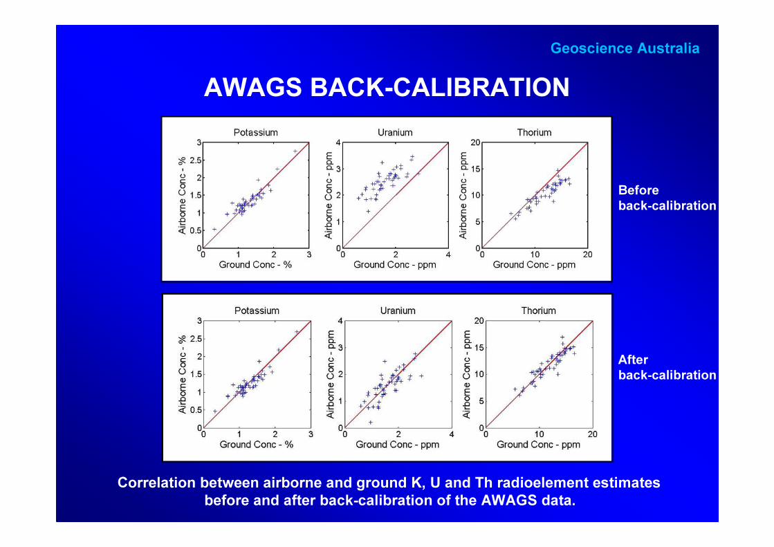
AWAGS BACK-CALIBRATION
Correlation between airborne and ground K, U and Th radioelement estimatesbefore and after back-calibration of the AWAGS data.
Geoscience Australia
Beforeback-calibration
Afterback-calibration

LEVELLING THE AUSTRALIAN NATIONAL RADIOMETRIC DATABASE
21
21 12
yy
yy SyGy +=
10
0
y2
10
0
y1
y1 y2
Geoscience Australia
Shift and scalingadjustment

LEVELLING THE AUSTRALIAN NATIONAL RADIOMETRIC DATABASE
Concentration of thorium before grid levelling
Concentration of thorium after grid levellingGeoscience Australia

THE RADIOMETRIC MAP OF AUSTRALIA
Potassium
Uranium
Thorium
Geoscience Australia
Benefits:* A consistent map* Uranium and thorium potential* Integration with other geophysical data sets* Derivation of a terrestrial gamma dose rate map* Comparison of geochemical patterns in survey areas
* Heat flow studies and geothermal energy* Background map for radioactive contamination

THE RADIOMETRIC MAP OF AUSTRALIA
Ternary radioelement map of Australia(K-red, eU-blue, eTh-green)
Geoscience Australia
The Radiometric Map of Australia link: www.ga.gov.au/minerals/research/national/radiometric

LEVELLING GROUND GAMMA-RAY SPECTROMETRIC DATA
ω = 2π (sr) ω = 2π (sr) ω > 2π (sr)+ attenuation of gamma calibration
rays in air geometry
Source – detector geometry is specified by the solid angle ω subtended by the sourceat the detector
Detector
Gammarays
Earth´ssurface
Charles University in Prague

FIELD EXPERIMENTSThe descrease in gamma radiation with height above
the earth surfaceCzech Republic
Test site – crystalline rocks
Charles University in Prague
Range of measurements 0 – 3 min increments 0.2 m

FIELD EXPERIMENTSThe descrease in gamma radiation with height above
the earth surface
Flying height0 – 3 m0 – 1 mgroundAbove
0.00660.00840.00820.0067µ (m-1) airborne0.01560.01290.02220.0168µ (m-1) ground 5.46.410.47.2Decrease gamma (%)261517651461Energy (keV)ThUKTCParameter
Decrease in gammaradiation at low altitudesis relatively high and shouldbe considered for grounddata levelling
Charles University in Prague
Ih = I0 E2(µh)µ – linear attenuation coefficient
of gamma rays in air (m-1)

FIELD EXPERIMENTSThe increase in gamma radiation in a shallow hole and
estimate of correction factors
Range of depth 0 – 0.4 m.Field assays of K, U, Th and soil sampleswere taken in increments of depth 0.04 m. K, U and Th in soil samples were alsoanalyzed in laboratory.
Charles University in Prague
Gammarays

GAMMA RADIATION OF A TRUNCATED CONE
]}sec)[(cos)()sec(cos)({21221222222
1
ϕµµϕµµϕµϕµµ
ρπ lhElhEhEhEkcI +++−−=
h
l
φ – plane angle
Detector
Absorptionlayer, µ2
Source of radiationµ1
E2 – integral exponential function of the second kind
Solid angle of detectionω = 2π (1 – cos φ)
Charles University in Prague

FIELD EXPERIMENTSThe increase in gamma radiation in a shallow hole and
estimate of correction factors
2π · 1.00ω (sr)
Geometrical model 2π · 1.910.520.520.520.52Experiment0.410.590.390.420.4Geometrical model 2π · 1.680.590.590.590.59Experiment0.590.760.530.600.2
1.001.001.001.000.0Based onThUKTCDepth (m)
Estimates of multiplication correction constants for radiometric measurementin shallow holes
Correction factors for theconversion of apparent K, U, and Thconcentrations determined in shallowhole to concentrations measured atthe surface
Charles University in Prague
