level of service d for systems level planning · introduction •2000 highway capacity manual...
TRANSCRIPT


INTRODUCTION
• 2000 HIGHWAY CAPACITY MANUAL
• 2005 ITRE NCLOS SOFTWARE
VERSION 2.1
• LEVEL OF SERVICE COMMITTEE
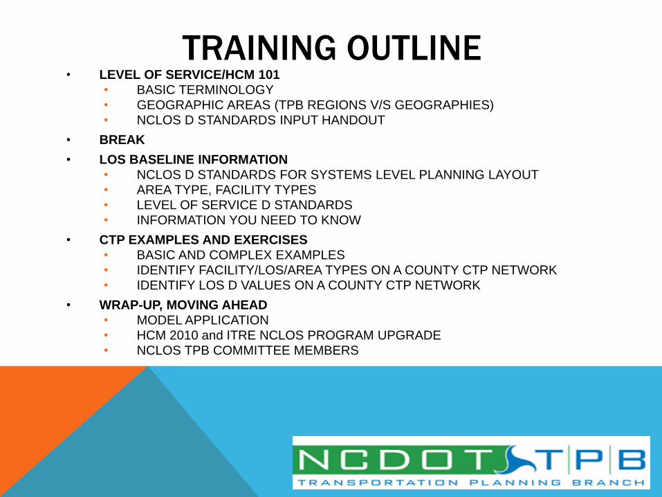
TRAINING OUTLINE • LEVEL OF SERVICE/HCM 101
• BASIC TERMINOLOGY
• GEOGRAPHIC AREAS (TPB REGIONS V/S GEOGRAPHIES)
• NCLOS D STANDARDS INPUT HANDOUT
• BREAK
• LOS BASELINE INFORMATION
• NCLOS D STANDARDS FOR SYSTEMS LEVEL PLANNING LAYOUT
• AREA TYPE, FACILITY TYPES
• LEVEL OF SERVICE D STANDARDS
• INFORMATION YOU NEED TO KNOW
• CTP EXAMPLES AND EXERCISES
• BASIC AND COMPLEX EXAMPLES
• IDENTIFY FACILITY/LOS/AREA TYPES ON A COUNTY CTP NETWORK
• IDENTIFY LOS D VALUES ON A COUNTY CTP NETWORK
• WRAP-UP, MOVING AHEAD
• MODEL APPLICATION
• HCM 2010 and ITRE NCLOS PROGRAM UPGRADE
• NCLOS TPB COMMITTEE MEMBERS

• Capacity – definition • “The capacity of a facility is the maximum hourly rate at which persons or vehicles reasonably can be expected to traverse a point or a uniform section of a lane or roadway during a given time period under prevailing roadway, traffic, and control conditions.” (HCM 2000)
• Roadway conditions, e.g…. • number of lanes, lane width, shoulder width, development.
• Traffic Conditions, e.g…. • vehicle mix, directional and lane distribution.
• Control Conditions, e.g…. • signal phasing, cycle length, green time, coordination.
•Level of Service – definition • “Level of service (LOS) is a quality measure describing operational conditions within a traffic stream, generally in terms of such service measures as speed and travel time, freedom to maneuver, traffic interruptions, and comfort and convenience.” (HCM 2000) • Six levels of service, A through __
• Each LOS represents a range of conditions.
• One or more service measures determines LOS. (What are service measures for freeway,expressway, etc?)
• Safety (does/does not) determine service levels.
Q & A: BASIC LOS/HCM DEFINITIONS

• Free Flow Speed (FFS)
• Base Free Flow Speed (BFFS)
• Average Travel Speed (ATS)
• Traffic Signals Per Mile
• Interchanges Per Mile
• Access Points Per Mile
• Density
• Lane/Shoulder Width
• Lateral Clearance
•g/C Ratio
• Arrival Type
• % Time Spent Following
• % No Passing
• Truck Percentage
• Automatic Traffic Recorder (ATR) Sites
• K Factor
• D Factor
• Peak Hour Factor
• Driver Population Factor
• Terrain Type (Level/Rolling/Mountainous)
Q & A: BASIC LOS/HCM DEFINITIONS

FACILITY TYPES CTP HCM CTP DEFINING
CHARACTERISTICS
Service Measure
(LOS CRITERIA)
FREEWAY Freeway Full control of access Density
EXPRESSWAY Multilane
Highway
Limited access, divided,
no traffic signals
Density
BOULEVARD Arterial Partial access, traffic
signals, divided
ATS
OTHER MAJOR
THOROUGHFARES
Arterial or
2-Lane Highway
Undivided,
US or NC route
ATS or
ATS and PTSF
MINOR
THOROUGHFARES
Arterial or
2-Lane Highway
Undivided,
SR route
ATS or
ATS and PTSF

TPB GEOGRAPHIC AREAS
NOT NECESSARILY TRUE
GEOGRAPHIC AREAS!!
Examples? Hickory (Piedmont) Fayetteville (Piedmont)

!!! BREAK !!!
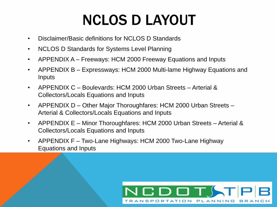
NCLOS D LAYOUT • Disclaimer/Basic definitions for NCLOS D Standards
• NCLOS D Standards for Systems Level Planning
• APPENDIX A – Freeways: HCM 2000 Freeway Equations and Inputs
• APPENDIX B – Expressways: HCM 2000 Multi-lame Highway Equations and
Inputs
• APPENDIX C – Boulevards: HCM 2000 Urban Streets – Arterial &
Collectors/Locals Equations and Inputs
• APPENDIX D – Other Major Thoroughfares: HCM 2000 Urban Streets –
Arterial & Collectors/Locals Equations and Inputs
• APPENDIX E – Minor Thoroughfares: HCM 2000 Urban Streets – Arterial &
Collectors/Locals Equations and Inputs
• APPENDIX F – Two-Lane Highways: HCM 2000 Two-Lane Highway
Equations and Inputs
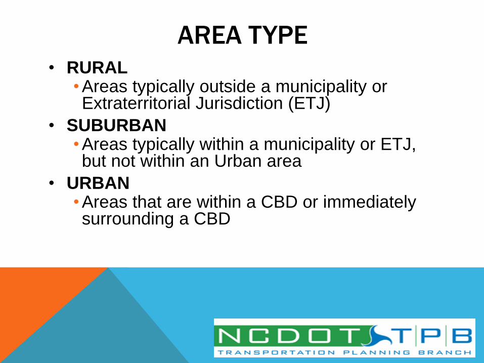
AREA TYPE • RURAL
• Areas typically outside a municipality or Extraterritorial Jurisdiction (ETJ)
• SUBURBAN • Areas typically within a municipality or ETJ, but not within an Urban area
• URBAN • Areas that are within a CBD or immediately surrounding a CBD
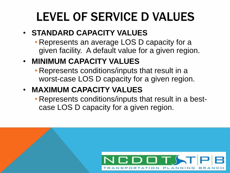
LEVEL OF SERVICE D VALUES
• STANDARD CAPACITY VALUES
• Represents an average LOS D capacity for a given facility. A default value for a given region.
• MINIMUM CAPACITY VALUES
• Represents conditions/inputs that result in a worst-case LOS D capacity for a given region.
• MAXIMUM CAPACITY VALUES
• Represents conditions/inputs that result in a best-case LOS D capacity for a given region.

CTP FACILITY TYPES • FREEWAYS
• EXPRESSWAYS
• BOULEVARDS • Divided 2-6+ lane facilities
• OTHER MAJOR THOROUGHFARES • Undivided facilities (US/NC routes = 2-5 lanes, SR/Local routes = 4-5
lanes) typically within a municipality or ETJ
• MINOR THOROUGHFARES • Undivided facilities (SR/Local routes = 2-3 lanes) within a typically
municipality or ETJ
• RURAL TWO-LANE HIGHWAYS • 2-lane undivided facility outside a municipality or ETJ. These facilities are
classified as other major thoroughfares if they are a US or NC route and minor thoroughfares if they are a secondary/local route.
FINALLY, Volumes shown represent the point at which traffic transitions from a LOS D to LOS E.
Q & A: DATA YOU NEED TO KNOW AND RESOURCES
• Lanes Per Direction
• Location of Facility (Urban, Suburban, Rural)
• Type of Facility *
• Divided/Undivided Facility
• K Factor
• D Factor
• Truck Percentage **
• Lane Width
* Applicable for Other Major Thoroughfares versus Minor Thoroughfares
** Applicable for Freeways, Expressways, and Rural 2-Lane Highways

USING NCLOS D STANDARDS
• Basic Example
• Complex Example
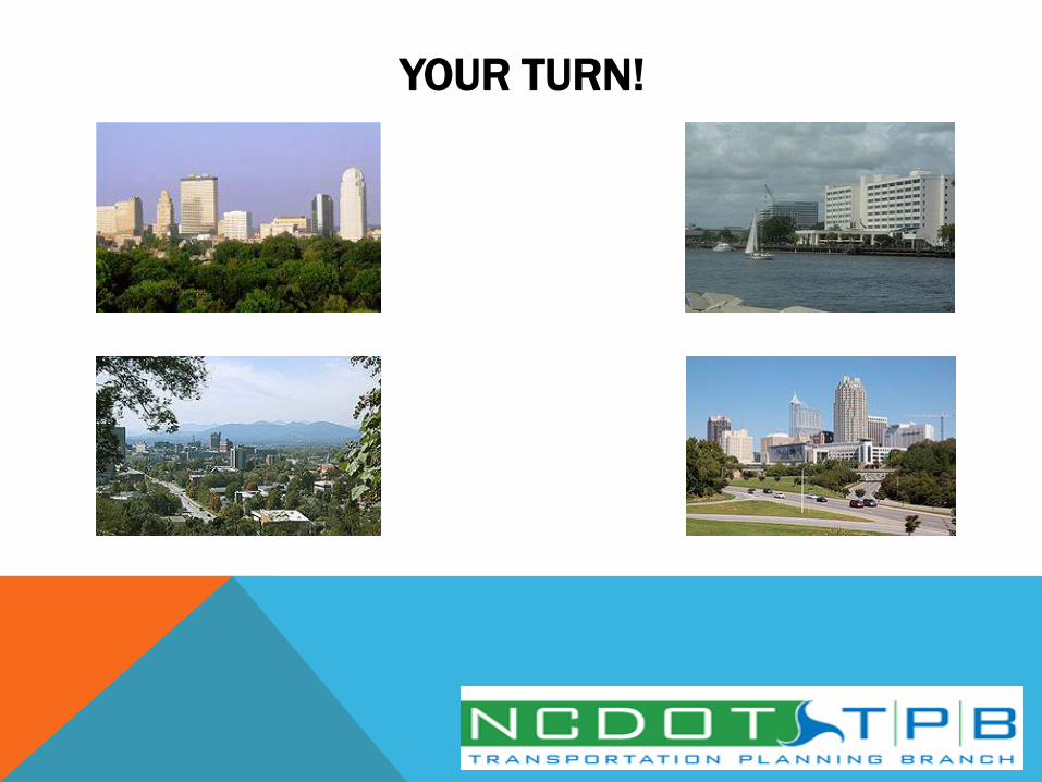
• Your Turn!
• Identify CTP Facility Type
• Identify NCLOS Facility Type
• Identify Area Type (Urban, Suburban,
Rural)
• Find Capacity

•Facility: I-40
•Section: From NC 210
(Exit 319) to NC 242 (Exit
325)
•4-lane divided cross-
section
•Full control of access
•19% Trucks
CTP Facility Type? Why?
Freeway – Multi-lane
divided facility, full control
of access
NCLOS Type? Why?
Freeway – Multi-lane
divided, full control of
access
Area Type? Why?
Rural, outside a
municipality or ETJ
Capacity? Why?
58,000 – 19% Trucks, Rural
EXAMPLE 1

•Facility: Cleveland Rd (SR
Route)
•Section: Barber Mill Rd to
NC 210
•3-lane undivided cross-
section
•45 MPH
•Includes driveways and
traffic signals
•Lower than average K
Factor/Directional
CTP Facility Type? Why?
Minor Thoroughfare – 3-lane
facility, undivided, low access
control
NCLOS Type? Why?
Minor Thoroughfare– 3-lane
undivided, not a US/NC route
Area Type? Why?
Rural, outside a municipality
or ETJ
Capacity? Why?
17,300, 3-lane, Lower than
average K Factor/Directional
(Maximum LOS)
EXAMPLE 2
YOUR TURN!
•Facility: I-95
•Section: Brogden Rd
(Exit 93) to East
Anderson St (Exit 98)
•In Smithfield/Selma ETJ
•6-lane divided cross-
section
•Full control of access
•24% Trucks
CTP Facility Type? Why?
Freeway – Multi-lane
divided facility, full control
of access
NCLOS Type? Why?
Freeway – Multi-lane
divided facility, full control
of access
Area Type? Why?
Suburban – inside the ETJ,
but not in or around the
CBD
Capacity? Why?
84,600 – 24% Trucks
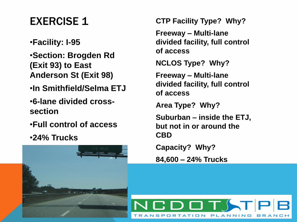
EXERCISE 1
•Facility: US 70
•Section: US 70
Business to US 70
Alternate
•4-lane divided cross-
section
•Only interchanges and
right-in/right-out access
•Rural Area
•No traffic signals
•12% Trucks
CTP Facility Type? Why?
Expressway – Multi-lane
divided facility, high access
control, no traffic signals
NCLOS Type? Why?
Expressway – Multi-lane
divided facility, high access
control, no traffic signals
Area Type? Why?
Rural – outside
municipality/ETJ
Capacity? Why?
56,100 – 12% Trucks
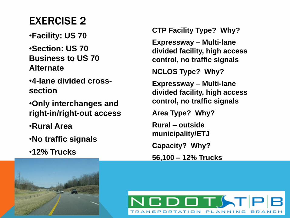
EXERCISE 2

•Facility: US 70
Business
•In Clayton, leading into
CBD
•4-lane divided cross-
section
•Includes traffic signals
and driveways
•45 MPH
CTP Facility Type? Why?
Boulevard – Divided facility
with traffic signals
NCLOS Type? Why?
Boulevard – Divided facility
with traffic signals
Area Type? Why?
Urban – leading into CBD
Capacity?
35,100
EXERCISE 3

•Facility: Princeton-
Kenly Road (SR Route)
•Section: Truckstop
Road to NC 222
•In Kenly ETJ
•2-lane cross-section
with driveways
•10-foot lanes
•35 MPH
CTP Facility Type? Why?
Minor Thoroughfare– 2-
lane undivided, low access
control
NCLOS Type? Why?
Minor Thoroughfare – 2-
lane undivided facility, not
a US/NC route, low access
control
Area Type? Why?
Suburban – Within an ETJ
Capacity? Why?
9,500 – 10-foot lanes
EXERCISE 4

•Facility: US 701
•Section: Sticklands
Crossroad to county
line, outside any ETJ
•2-lane cross-section
with driveways
•12-foot lanes
•55 MPH
•Average conditions
CTP Facility Type? Why?
Major Thoroughfare – US
route, undivided
NCLOS Type? Why?
Rural 2-lane Highway – 2-
lane undivided facility,
outside a municipality or
ETJ
Area Type? Why?
N/A – Uses Rural 2-lane
Highway Methodology
Capacity? Why?
12,400 – 12-foot lanes
EXERCISE 5

•Facility: Devils
Racetrack Road (SR
Route)
•Section: US 701 to
county line, outside ETJ
•2-lane cross-section
with driveways
•10-foot lanes
•55 MPH
•Extremely tight curves
with less than average
travel conditions
CTP Facility Type? Why?
Minor Thoroughfare – SR route,
2-lanes, undivided
NCLOS Type? Why?
Rural 2-lane Highway – 2-lane
undivided facility, outside a
municipality or ETJ
Area Type? Why?
N/A – Uses Rural 2-lane Highway
Methodology
Capacity? Why?
9,000 – 10-foot lanes/less than
average travel conditions
(Minimum LOS)
EXERCISE 6
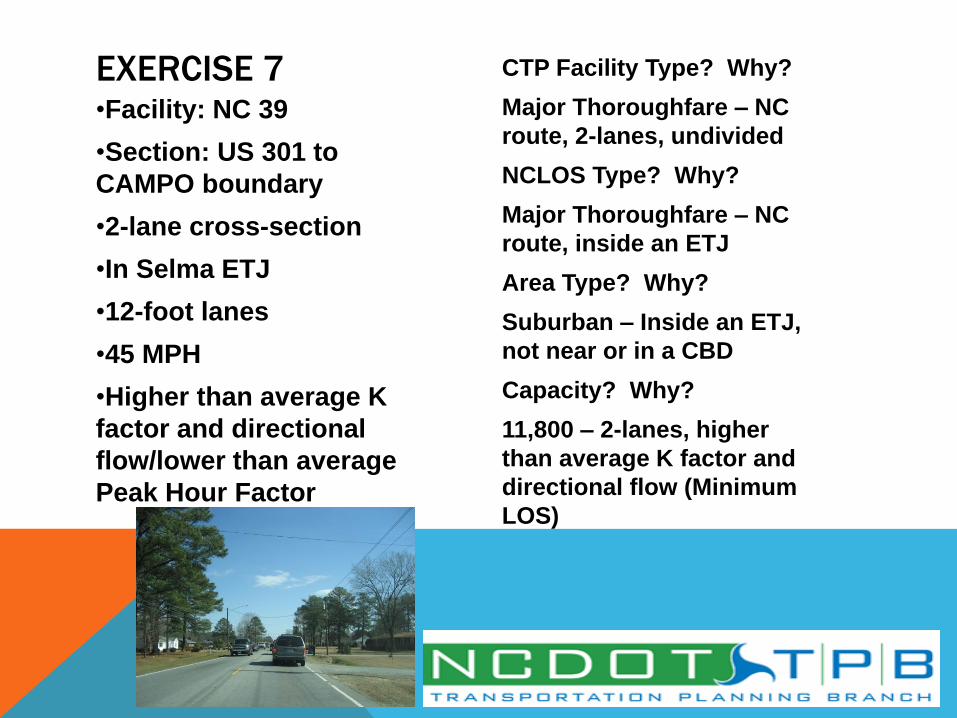
•Facility: NC 39
•Section: US 301 to
CAMPO boundary
•2-lane cross-section
•In Selma ETJ
•12-foot lanes
•45 MPH
•Higher than average K
factor and directional
flow/lower than average
Peak Hour Factor
CTP Facility Type? Why?
Major Thoroughfare – NC
route, 2-lanes, undivided
NCLOS Type? Why?
Major Thoroughfare – NC
route, inside an ETJ
Area Type? Why?
Suburban – Inside an ETJ,
not near or in a CBD
Capacity? Why?
11,800 – 2-lanes, higher
than average K factor and
directional flow (Minimum
LOS)
EXERCISE 7
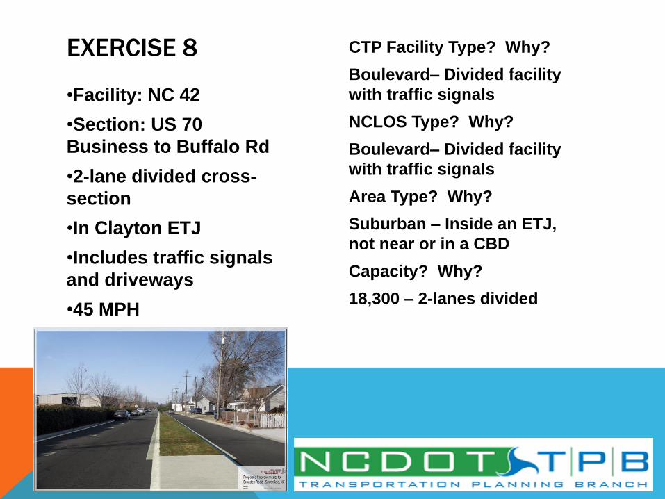
•Facility: NC 42
•Section: US 70
Business to Buffalo Rd
•2-lane divided cross-
section
•In Clayton ETJ
•Includes traffic signals
and driveways
•45 MPH
CTP Facility Type? Why?
Boulevard– Divided facility
with traffic signals
NCLOS Type? Why?
Boulevard– Divided facility
with traffic signals
Area Type? Why?
Suburban – Inside an ETJ,
not near or in a CBD
Capacity? Why?
18,300 – 2-lanes divided
EXERCISE 8

THAT’S A WRAP/MOVING AHEAD
• NCLOS D Standards in Small Urban Model Development
• One-Way Pairs (They still exist!)
• Current NCLOS D Standards for Systems Level Planning
Based on HCM 2000 and the 2005 ITRE NCLOS Version 2.1.
ITRE and NCDOT to update NCLOS based on HCM 2010,
which is slated to be complete by the end of 2012. Some of
the LOS Committee Members are members of this Steering
Committee and Implementation Team.
• When the new ITRE NCLOS Program is released, the
NCLOS D Standards for Systems Level Planning will be
updated and expanded.

THANK YOU FOR YOUR PARTICIPATION!
NCLOS Committee Members:
• Jamal Alavi, PE
• Pam Cook, PE
• Scott Walston, PE
• David Keilson, PE, Presenter
• Sarah Lee, EI, Presenter
• Mark Eatman, EI
• Hong Qi Lu
• J. Andy Bailey