lessons learned from the tsunami disaster caused by … learned from the tsunami disaster caused by...
TRANSCRIPT

Lessons learned from the tsunami disaster caused by
the 2011 Great East Japan Earthquake
and improvements in JMA's tsunami warning system
October 2013
Japan Meteorological Agency
Lessons learned from the tsunami disaster caused by the 2011 Great East Japan Earthquake and
improvements in JMA's tsunami warning system
Abstract
A huge tsunami generated by the 2011 Great East Japan Earthquake (also known as the 2011 off the
Pacific coast of Tohoku Earthquake) that struck at 14:46 JST (UTC+9) on March 11, 2011, hit a huge
stretch of the Pacific coast of Japan and caused severe damage over an area extending from the Tohoku
district to the Kanto district. In the aftermath of the disaster, the Japan Meteorological Agency (JMA)
investigated the content and expressions of the tsunami warning bulletins released as well as the timing of
their issuance in relation to this occurrence at that time. The results were used to support consideration of
how tsunami warnings could be improved in their role as a type of disaster preparedness information to
protect life. The investigation revealed several problems, including the underestimation of earthquake
magnitude promptly determined after the quake which in turn caused the underestimation of forecast
tsunami heights. Another issue was the inappropriate announcement of tsunami observations; all the
observed tsunami heights were announced even while waves were still small, which caused some people
to believe evacuation was unnecessary for what they thought was a minor tsunami.
JMA’s tsunami warnings must be timely, easy to understand and useful for organizations related to
disaster prevention. To overcome the problems found in the investigation and to better meet these
requirements, JMA improved the approach used in its tsunami warning system and enhanced the content
and expressions of bulletins so that warnings urge people to evacuate as appropriate. As part of such
improvements, JMA also remains active in its awareness-raising efforts as a key area in the appropriate
usage of warnings and successful evacuation.
Based on these activities, JMA introduced a new tsunami warning system on March 7, 2013.

1. Preface
The 2011 Great East Japan Earthquake (also known as the 2011 off the Pacific coast of Tohoku
Earthquake) had a magnitude of 9.0 – the largest recorded in Japan since instrumental seismic observation
began. The massive tsunami it generated hit Japanese coastal areas and caused severe damage, with the
number of deaths and missing people reaching around 20,000. (The disaster is referred to here as the
Great East Japan Earthquake and Tsunami.)
JMA issued an initial tsunami warning around three minutes after the quake. However, the magnitude
of the quake and the estimated tsunami heights in the initial warning were significantly underestimated
due to the characteristics of the promptly estimated magnitude. Around 28 minutes after the earthquake,
JMA updated the tsunami warning based on data from a GPS buoy located about 10 km off the coast, but
the standard operating procedure involving the use of data from observations made farther offshore for
more timely warning updates had not yet been established. To address the evident problems experienced
in this regard, JMA set up an investigative commission consisting of experts, representatives from related
disaster prevention organizations and the press. As part of the commission’s activities, the Agency invited
suggestions from municipalities and the public to support investigation of the content and expressions of
tsunami warning bulletins as well as the timing of their issuance in this case with the ultimate aim of
improving the tsunami warning system. JMA then incorporated approved suggestions into its
improvements in February 2012 and introduced the new tsunami warning system on March 7, 2013.
This leaflet outlines work conducted by JMA in relation to the Great East Japan Earthquake and
Tsunami, highlights the lessons learned from the disaster, and describes how the tsunami warning system
was improved as a result.
Damaged areas in the aftermath of the Great East Japan Earthquake and Tsunami
Ofunato Onagawa

2. JMA Tsunami Warnings/Advisories and tsunami monitoring
Even before the Great East Japan Earthquake and Tsunami, JMA operated a seismic network with
around 280 seismometers collecting observation data in real time and monitoring the information
gathered around the clock. When an earthquake occurs, JMA determines its location and magnitude using
these data and issues Tsunami Warnings/Advisories immediately if a tsunami strike is expected.
To enable immediate issuance of initial tsunami warnings, JMA has conducted computer simulation of
tsunamis with earthquake scenarios involving various locations and magnitudes, and the results related to
tsunami arrival times and heights are stored in a database. When a large earthquake occurs, the operation
system quickly calculates its hypocenter and magnitude, searches the tsunami database with reference to
these calculations and selects the most closely matching results. JMA then issues Tsunami
Warnings/Advisories using estimated tsunami heights for each coastal region expected to be affected (66
individual regions are defined to cover all coastal areas of the country and support smoother disaster
response) (see Figs. 1 and 2).
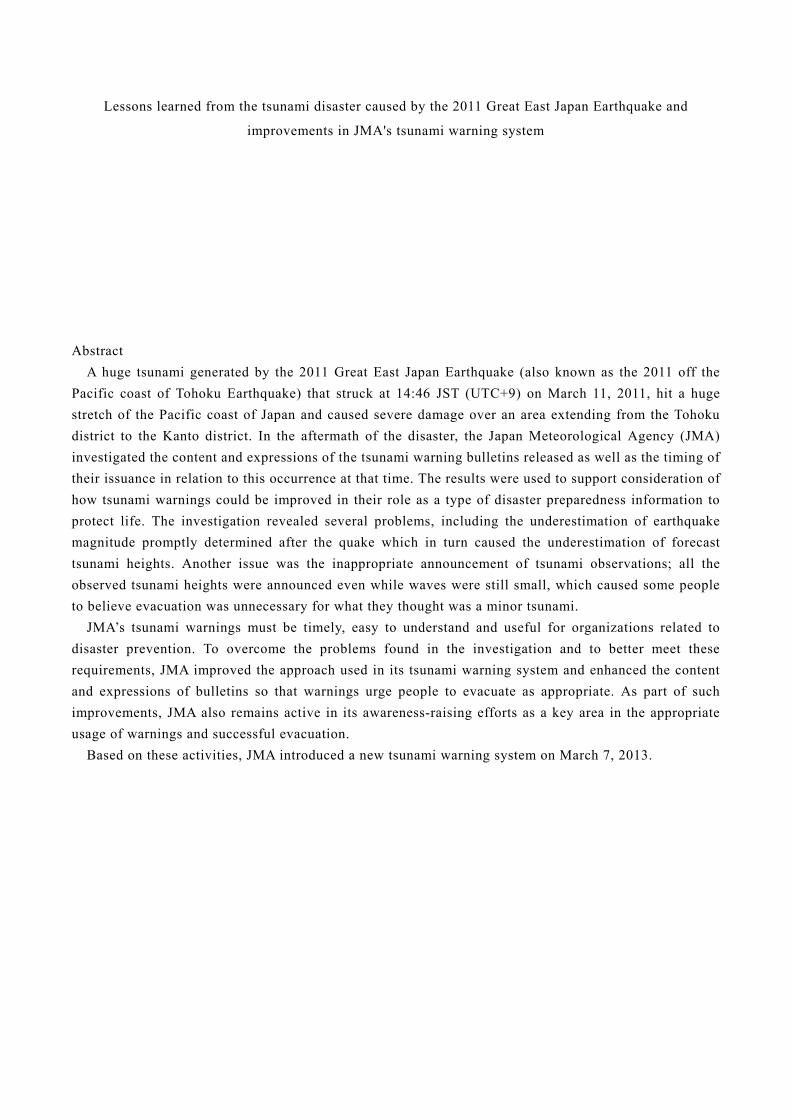
JMA also monitors sea level data at around 220 stations including some operated by other related
organizations (see Fig. 3). When tsunamis are detected, JMA uses these data to update tsunami warnings
and issue tsunami observation information on the arrival times and scale of the highest waves observed as
of the time of issuance.
Fig. 1 Tsunami forecast method Fig. 2 Tsunami forecast regions
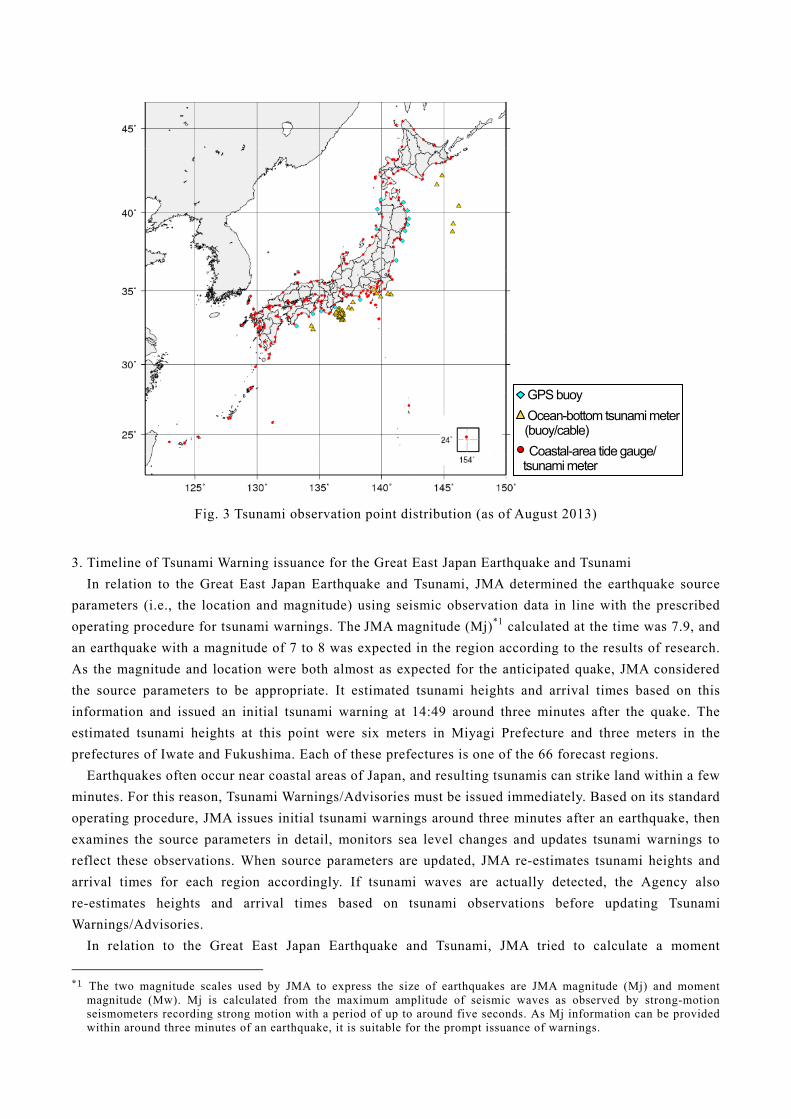
Fig. 3 Tsunami observation point distribution (as of August 2013)
3. Timeline of Tsunami Warning issuance for the Great East Japan Earthquake and Tsunami
In relation to the Great East Japan Earthquake and Tsunami, JMA determined the earthquake source
parameters (i.e., the location and magnitude) using seismic observation data in line with the prescribed
operating procedure for tsunami warnings. The JMA magnitude (Mj)*1 calculated at the time was 7.9, and
an earthquake with a magnitude of 7 to 8 was expected in the region according to the results of research.
As the magnitude and location were both almost as expected for the anticipated quake, JMA considered
the source parameters to be appropriate. It estimated tsunami heights and arrival times based on this
information and issued an initial tsunami warning at 14:49 around three minutes after the quake. The
estimated tsunami heights at this point were six meters in Miyagi Prefecture and three meters in the
prefectures of Iwate and Fukushima. Each of these prefectures is one of the 66 forecast regions.
Earthquakes often occur near coastal areas of Japan, and resulting tsunamis can strike land within a few
minutes. For this reason, Tsunami Warnings/Advisories must be issued immediately. Based on its standard
operating procedure, JMA issues initial tsunami warnings around three minutes after an earthquake, then
examines the source parameters in detail, monitors sea level changes and updates tsunami warnings to
reflect these observations. When source parameters are updated, JMA re-estimates tsunami heights and
arrival times for each region accordingly. If tsunami waves are actually detected, the Agency also
re-estimates heights and arrival times based on tsunami observations before updating Tsunami
Warnings/Advisories.
In relation to the Great East Japan Earthquake and Tsunami, JMA tried to calculate a moment
*1 The two magnitude scales used by JMA to express the size of earthquakes are JMA magnitude (Mj) and moment
magnitude (Mw). Mj is calculated from the maximum amplitude of seismic waves as observed by strong-motion seismometers recording strong motion with a period of up to around five seconds. As Mj information can be provided within around three minutes of an earthquake, it is suitable for the prompt issuance of warnings.
GPS buoy
Ocean-bottom tsunami meter (buoy/cable)
Coastal-area tide gauge/ tsunami meter
magnitude (Mw)*2 based on waveforms from broad-band seismometers around 15 minutes after the tremor.
However, as the waveforms were saturated at most of the broad-band seismometers deployed in Japan due
to the strong shaking, JMA was unable to calculate the Mw within 15 minutes and thus could not update
Tsunami Warnings/Advisories based on this value.
However, a GPS buoy deployed by the Ports and Harbours Bureau (PHB) of the Ministry of Land,
Infrastructure, Transport and Tourism (MLIT) around 10 km off Kamaishi City in Iwate Prefecture
recorded a rapid increase in sea level at around 15:10. This enabled JMA to issue a second tsunami
warning and upgrade the estimated tsunami heights to over 10 meters for Miyagi Prefecture and to 6
meters for the prefectures of Iwate and Fukushima. JMA continued to upgrade these heights and expand
the area where tsunami warnings were in effect based on observation data from GPS buoys and tide
gauges in coastal areas (see Fig. 4).
Fig. 4 Timeline of Tsunami Warning issuance for the Great East Japan Earthquake and Tsunami
The maximum tsunami heights observed were nearly 10 meters along the Pacific coast of the Tohoku
district. Specifically, the values were 8.5 meters or higher for Miyako (Iwate Prefecture), 8.0 meters or
higher for Ofunato (Iwate Prefecture), 8.6 meters or higher for Ishinomakishi Ayukawa (Miyagi
*2 Moment magnitude (Mw) precisely expresses the scale of seismic faulting. It is calculated from seismic waves
(including those with very long periods exceeding several tens of seconds) recorded by broad-band seismometers, and represents the exact scale of huge earthquakes. The source mechanism of earthquakes (e.g., reverse fault, strike slip) can also be analyzed at the same time with these data. However, it takes around 15 minutes to calculate Mw values because seismic data covering periods of 10 minutes are used.
After the issuance of initial tsunami warnings (i), a tsunami was detected by a GPS buoy and other gauges. Based on this, JMA upgraded tsunami warnings (ii), (iii). A value of Mw 8.8 was determined at around 15:40.
* Station belonging to the Japan Coast Guard ** Station belonging to PHB
14:46 Earthquake
(i) 14:49 Initial Tsunami Warning 14:50 Estimated Tsunami Heights:
Miyagi: 6 m; Iwate: 3 m; Fukushima: 3 m; Pacific Coast of Aomori Pref.: 1 m
(ii) 15:14 Tsunami Warning Upgrade Estimated Tsunami Heights:
Miyagi: over 10 m; Iwate: 6 m; Fukushima: 6 m; Pacific coast of Aomori Pref.: 3 m
(iii) 15:30 Tsunami Warning Upgrade 15:31 Estimated Tsunami Heights:
Iwate - Kujukuri and Sotobo area: over 10 m;Pacific Coast of Aomori Pref.: 8 m
Observation data (real time)
Observation data (obtained later)
Estimated heights in warnings

Prefecture) and 9.3 meters or higher for Soma (Fukushima Prefecture) (see Fig. 5). The expression “or
higher” means that higher tsunamis were expected to hit these areas but observation facilities were
washed away or damaged and the flow of data was interrupted. According to field surveys later conducted
by JMA around observation facilities, wave heights based on tsunami track data reached up to 16 meters
in Ofunato (Iwate Prefecture), and much higher run-up heights were concluded by other research survey
teams for some locations.
JMA determined a magnitude of Mw 8.8 around 50 minutes after the earthquake by analyzing global
seismic data. However, because tsunami warnings had already been updated with much larger estimated
heights at 15:30 based on tsunami observations, JMA did not use this Mw value for the warning update.
As Tsunami Warning/Advisory updating was the first priority, the issuance of earthquake information
with the Mw 8.8 value and other source parameters was postponed until 17:48. (The Mw value was later
finalized as 9.0 based on more precise analysis.)
Fig. 5 Tsunami heights recorded at observation facilities The columnar arrows indicate tsunami heights recorded at observation facilities that were damaged and from which data were missing for a certain period. Accordingly, the actual heights may have been greater.

4. Problems to be addressed and solutions concluded for tsunami warning operation
The problems detailed in the previous chapter can be summarized as follows:
(1) Problems in tsunami warning operation
#1: The magnitude of Mj 7.9 that was promptly estimated and used in the initial tsunami warning was an
underestimation.*3
#2: Forecast tsunami heights were also underestimated due to the magnitude underestimation. This may
have caused some people to think that the tsunami waves would not top seawalls and possibly
contributed to delays in evacuation.
#3: The Mw value was not calculated for around 15 minutes due to broad-band seismic data saturation.
The operating procedure for tsunami warning updates based on data from ocean-bottom
tsunami-meters (water pressure gauges) deployed farther offshore than GPS buoys had also not
been established at the time.
#4: Minimal tsunami heights announced in Tsunami Observation Information (such as Initial Tsunami
Observation: 0.2 meters) may have misled people into thinking that the tsunami would not be large
and caused delays or interruptions in evacuation.
(2) Solutions to improve tsunami warning operation
(i) Basic policy
(a) JMA in principle issues initial tsunami warnings within around three minutes after an earthquake to
maximize the time available for evacuation.
(b) The Agency now issues initial tsunami warnings based on the predefined maximum magnitude
when initial estimation for the scale of the tsunami source (i.e., crustal movement on the sea floor) is
uncertain, as seen with earthquakes measuring around 8 or more in magnitude*3. After obtaining
reliable results from earthquake and/or tsunami analysis, JMA will update tsunami warnings based
on more precise information. The maximum magnitude is used in such cases because second
warnings may not reach people in some situations (e.g., electricity failure); accordingly, it is
important not to include underestimations in initial warnings.
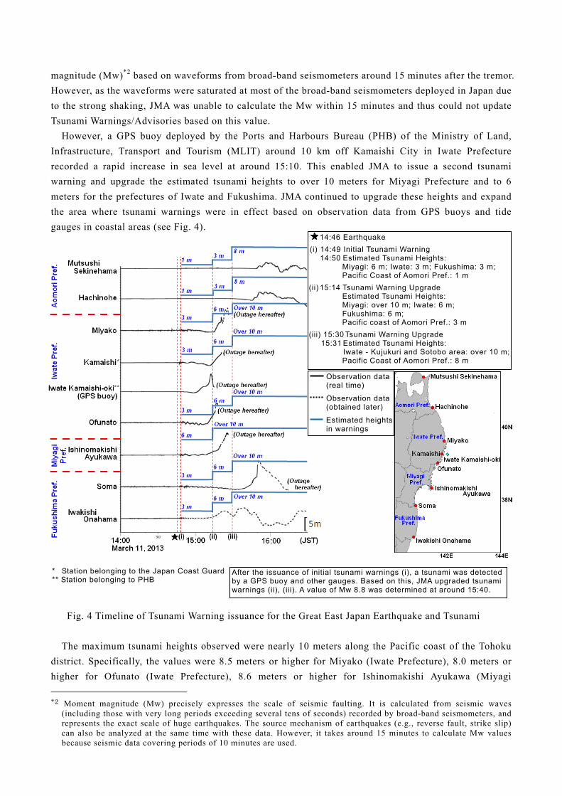
(ii) Technical improvements (response to problems #1 and #3)
(a) Measures for detecting magnitude underestimation
For huge earthquakes with a magnitude of 8 or more and for those generating much larger
tsunamis than their magnitude would suggest (known as tsunami earthquakes), it is difficult to
determine a precise magnitude value within around three minutes. Accordingly, JMA has introduced
methods to quickly highlight the possibility of underestimation in calculated magnitudes. When such
a possibility is recognized, the Agency issues an initial tsunami warning based on the largest seismic
fault expected in the area of the earthquake or on the predefined maximum magnitude to avoid
underestimation (see Section (iii) (a) for information on bulletin content and expressions).
Examples of methods for checking the possibility of underestimation are shown in Figure 6. JMA
continues to introduce various methods other than those shown here, as well as
investigating/improving them and developing useful new techniques.
*3 Longer-period seismic waves are larger when a huge earthquake with a magnitude of 8 or more occurs, but seismic
waves with a short period of up to around five seconds are almost the same as those for smaller earthquakes. The Mj value is therefore underestimated for huge earthquakes, whose scale can thus not be estimated accurately.
(b) Prompt updating of tsunami warnings
JMA updates initial tsunami warnings based on more precise information from the latest
earthquake and tsunami observation data. In order to obtain the Mw values necessary for timely and
stable updating within around 15 minutes, the Agency installed 80 broad-band strong-motion
seismometers in Japan to measure broad-band seismic waveforms without saturation even in the
event of a huge tremor. The Agency also installed 3 DART buoys (water-pressure gauges) off the
Pacific coast of the Tohoku district, and uses data from these units along with information from
ocean-bottom tsunami meters deployed offshore by other related organizations for earlier detection
of tsunamis, estimation of tsunami heights in coastal areas and issuance of warning updates as
needed.
(c) Enhancement of observation facilities
In the case of the Great East Japan Earthquake and Tsunami, observed data became unavailable
because seismic and tsunami observation facilities were damaged, terrestrial data networks were
interrupted and power was lost for extended periods. To avoid any repetition of such data
unavailability, JMA enhanced its observation facilities by installing satellite-link telecommunication
equipment as a backup in case of landline network interruption. The work involved setting up an
emergency power supply to cover a period of up to 72 hours in the event of a long-term blackout,
1. Mw estimation from seismic waveform data on various period components
Mw is estimated directly from displacement waveforms calculated using accelerometer data (the value for the Great East Japan Earthquake reached 8.8 within 140 seconds).
2. Mw estimation from seismic waveform data on long-period components
Mw is roughly estimated in relation to the amplitude of long-period waveforms recorded by broad-band strong-motion seismometers.
3. Mw estimation from the size of thestrong-motion area
Mw is estimated from the size of the strong-motion area asdetermined from the observed seismic intensity distribution.
Fig. 6 Methods for checking the possibility of
magnitude underestimation
Short period (6 sec.)
Long period (200 – 1,000 sec.)
The Great East Japan Earthquake in 2011 (Mw 9.0)
The Tokachi-oki Earthquake in 2003 (Mj 8.0)
The Great East Japan Earthquake in 2011 (Mw 9.0)
The Tokachi-oki Earthquake in 2003 (Mj 8.0)
700 km
300 km
Nst: number of stations
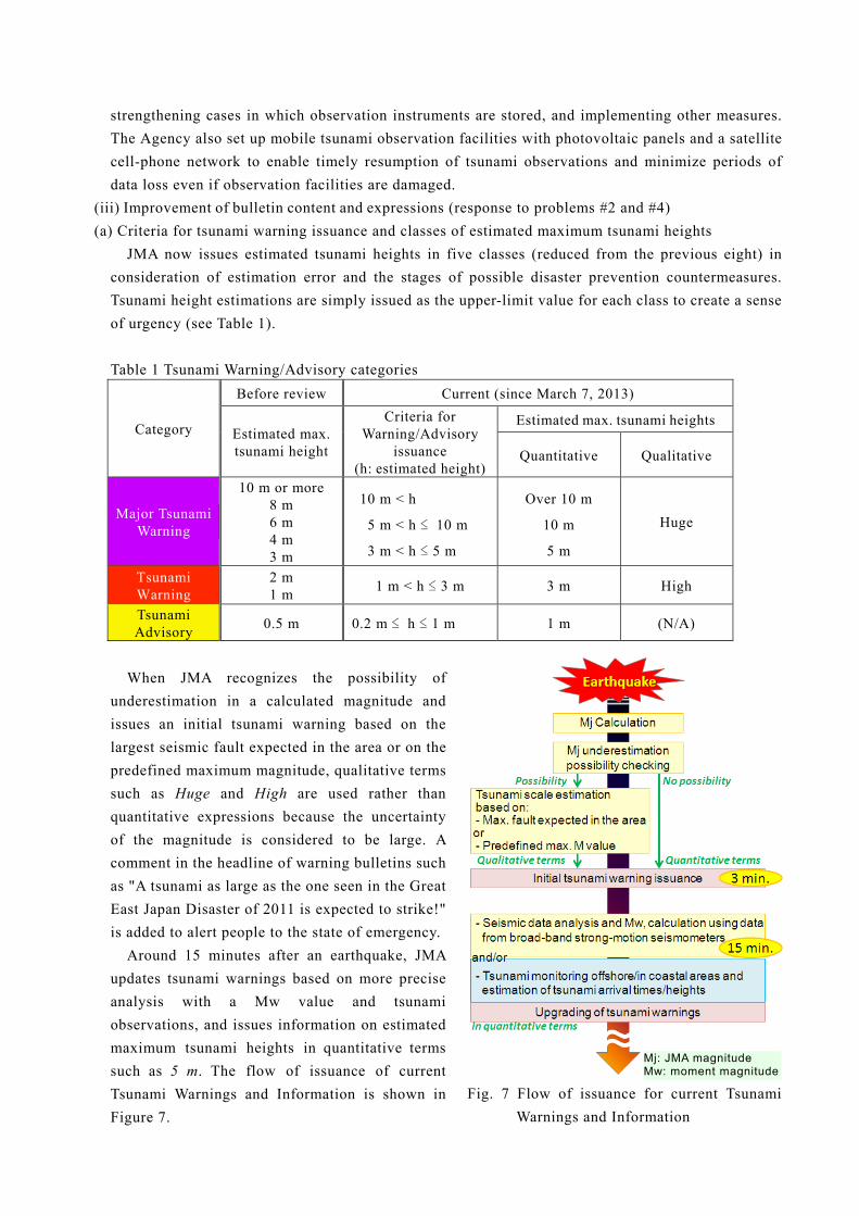
strengthening cases in which observation instruments are stored, and implementing other measures.
The Agency also set up mobile tsunami observation facilities with photovoltaic panels and a satellite
cell-phone network to enable timely resumption of tsunami observations and minimize periods of
data loss even if observation facilities are damaged.
(iii) Improvement of bulletin content and expressions (response to problems #2 and #4)
(a) Criteria for tsunami warning issuance and classes of estimated maximum tsunami heights
JMA now issues estimated tsunami heights in five classes (reduced from the previous eight) in
consideration of estimation error and the stages of possible disaster prevention countermeasures.
Tsunami height estimations are simply issued as the upper-limit value for each class to create a sense
of urgency (see Table 1).
Table 1 Tsunami Warning/Advisory categories
Category
Before review Current (since March 7, 2013)
Estimated max. tsunami height
Criteria for Warning/Advisory
issuance (h: estimated height)
Estimated max. tsunami heights
Quantitative Qualitative
Major Tsunami Warning
10 m or more 8 m 6 m 4 m 3 m
10 m < h
5 m < h ≤ 10 m
3 m < h ≤ 5 m
Over 10 m
10 m
5 m
Huge
Tsunami Warning
2 m 1 m
1 m < h ≤ 3 m 3 m High
Tsunami Advisory
0.5 m 0.2 m ≤ h ≤ 1 m 1 m (N/A)
When JMA recognizes the possibility of
underestimation in a calculated magnitude and
issues an initial tsunami warning based on the
largest seismic fault expected in the area or on the
predefined maximum magnitude, qualitative terms
such as Huge and High are used rather than
quantitative expressions because the uncertainty
of the magnitude is considered to be large. A
comment in the headline of warning bulletins such
as "A tsunami as large as the one seen in the Great
East Japan Disaster of 2011 is expected to strike!"
is added to alert people to the state of emergency.
Around 15 minutes after an earthquake, JMA
updates tsunami warnings based on more precise
analysis with a Mw value and tsunami
observations, and issues information on estimated
maximum tsunami heights in quantitative terms
such as 5 m. The flow of issuance of current
Tsunami Warnings and Information is shown in
Figure 7.
Fig. 7 Flow of issuance for current Tsunami
Warnings and Information
Mj: JMA magnitude Mw: moment magnitude

(b) Estimated tsunami arrival times
JMA information on estimated tsunami arrival times for each tsunami forecast region includes the
times at which tsunami waves are expected to hit first in any part of that area and estimated arrival
times for certain tsunami observation points. Within this framework, tsunamis may hit some areas an
hour or more after the estimated times even in the same forecast region. JMA now notes this in its
bulletins.
(c) Tsunami observed in coastal areas
In regard to observed tsunami heights in coastal areas, JMA announces only arrival times and
initial movements (rise/fall) for the first waves to avoid creating a misunderstanding that waves will
be small. Information on arrival times and the scale of the highest waves observed as of the time of
issuance is also provided to alert people that higher waves continue to approach. While a Major
Tsunami Warning and/or Tsunami Warning is in effect but tsunami waves appear much smaller than
estimated, JMA issues Currently Observing announcements rather than exact values (see Table 2).
Tsunami waves often hit repeatedly, and those arriving later may be higher. As the biggest waves
may hit several hours after initial strikes in coastal areas, JMA warns people to stay in safe places
until Tsunami Warnings are cleared.
Table 2 Expressions used for observed maximum heights in coastal areas (current)
Warnings/Advisories in effect
Observed height Information bulletin expression
Major Tsunami Warning
> 1 m Actual values
≤ 1 m Currently Observing announcements
Tsunami Warning ≥ 0.2 m Actual values
< 0.2 m Currently Observing announcements
Tsunami Advisory (All cases) Actual values (Slight for very small waves)
(d) Tsunami observed via offshore gauges
The Great East Japan Earthquake and Tsunami proved that offshore observation such as that
conducted via GPS buoys is highly useful in updating tsunami warnings. As a result, JMA now
promptly issues a new bulletin called Tsunami Information (Tsunami Observations at Offshore
Gauges) based on detected generation of tsunami waves offshore to alert people that coastal areas
may be stricken shortly.
The Agency also issues this information along with data on estimated tsunami heights for coastal
areas as calculated from offshore measurements. While a Major Tsunami Warning and/or a Tsunami
Warning is in effect and estimated tsunami heights for coastal areas are small, JMA does not provide
actual values for observed tsunami heights offshore or estimated maximum tsunami heights for
coastal areas until the thresholds for issuance are reached. Instead, the phrase Currently Observing is
used for observed heights offshore and Currently Investigating is used for estimated heights in
coastal areas in the same way as for observations in coastal areas (see Table 3).

Table 3 Expressions used for maximum heights observed via offshore gauges and
estimated maximum heights in coastal areas (current)
Warnings/Advisories in effect
Estimated tsunami heights for coastal
areas
Information bulletin expressions Observed heights at
offshore gauges Estimated heights in
coastal areas
Major Tsunami Warning
> 3 m Actual values Actual values
≤ 3 m Currently Observing Currently Investigating
Tsunami Warning > 1 m Actual values Actual values
≤ 1 m Currently Observing Currently Investigating
Tsunami Advisory (All cases) Actual values
(Slight for very small waves)
Actual values
5. Education and awareness-raising efforts regarding tsunami disaster prevention
Evacuating to higher ground and/or to places far from the coast before a tsunami hits is the only way to
ensure survival from such waves.
To ensure appropriate evacuation, it is necessary to understand the
timing, circumstances and information of JMA tsunami warnings.
JMA considers it important for people to properly understand the
risks of tsunami waves and evacuate as necessary. In particular, such
understanding includes awareness of changes made to the tsunami
warning system since the Great East Japan Earthquake and Tsunami,
such as the use of the qualitative expressions Huge and High based
on predefined maximum tsunami heights as well as prompt updates
to warnings and issuance of tsunami observation information from
offshore gauges. Against such a background, JMA places high
priority on education and awareness-raising efforts as reflected by
its production and distribution of related leaflets and posters as well
as its work in conducting visiting lectures and symposiums.
JMA created two videos called Escape the Tsunami! and
Preparing for Tsunamis to emphasize the necessity of education on
mitigating the effects of disasters and deciding to evacuate
independently without waiting for tsunami warnings – two
considerations whose importance was clarified by the Great East Japan Earthquake and Tsunami. JMA has
distributed these videos to schools throughout Japan to support community efforts for disaster mitigation.
The resources are also available on the JMA website (http://www.seisvol.kishou.go.jp/eq/eng/
tsunami/tsunami_warning.html).
Fig. 8: Start of New Tsunami
Warning System Operation
leaflet

6. Closing notes
Although methods involving the use of earthquake source parameters are effective for the prompt
issuance of tsunami warnings in the case of ordinary earthquakes, it is difficult to estimate the actual
scale of tsunami waves from the magnitude for tsunami earthquakes and seabed landslides. In
consideration of such cases, JMA is developing methods to support the prompt estimation of tsunami
heights for coastal areas based on data observed by offshore gauges. In addition to this method, it is also
necessary to develop various ways to quickly determine the scale of tsunamis in coastal areas.
JMA remains committed to its efforts to improve tsunami warning operations and enhance awareness
regarding the importance of evacuation in the event of a tsunami.
References • Japan Meteorological Agency, 2013: “Improvements in JMA's Tsunami Warning/Advisory Operation
System,” http://www.seisvol.kishou.go.jp/eq/tsunami_keihou_kaizen/index.html (in Japanese) • Japan Meteorological Agency, 2012: “Report on the 2011 off the Pacific Coast of Tohoku Earthquake,
Volumes I and II,” Technical Report of the Japan Meteorological Agency, Vol. 133, http://www.jma.go.jp/jma/kishou/books/gizyutu/133/gizyutu_133.html (in Japanese)