legacy trail extension project - feasibility study
TRANSCRIPT
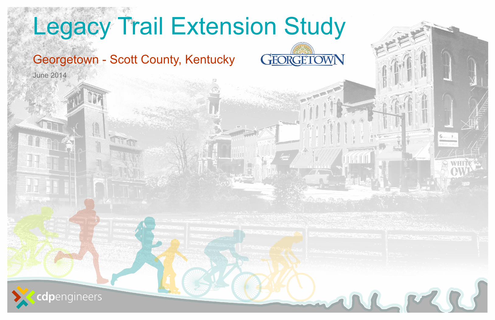
Legacy Trail Extension StudyGeorgetown - Scott County, KentuckyJune 2014

4
This study is dedicated in memory of Dick Robinson. Not only was Dick a devoted bicycle enthusiast, he was an active member of the community, an educator, mentor, and close friend to many. He was a primary initiator for the extension of the Legacy Trail. His efforts and devotion to the project lead to the support that made this study possible.
3
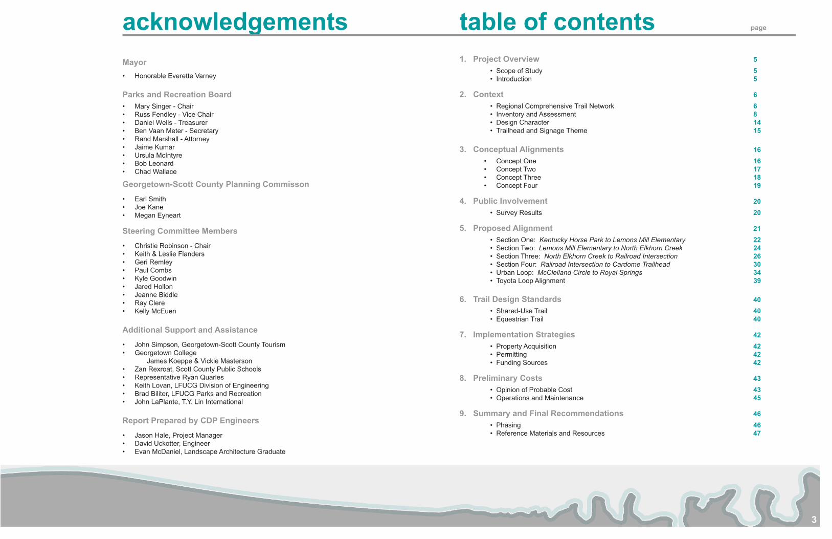
acknowledgementsMayor• Honorable Everette Varney
Parks and Recreation Board• Mary Singer - Chair• Russ Fendley - Vice Chair• Daniel Wells - Treasurer• Ben Vaan Meter - Secretary• Rand Marshall - Attorney• Jaime Kumar• Ursula McIntyre• Bob Leonard• Chad Wallace
Georgetown-Scott County Planning Commisson
• Earl Smith• Joe Kane• Megan Eyneart
Steering Committee Members
• Christie Robinson - Chair• Keith & Leslie Flanders• Geri Remley• Paul Combs• Kyle Goodwin• Jared Hollon• Jeanne Biddle• Ray Clere• Kelly McEuen
Additional Support and Assistance
• John Simpson, Georgetown-Scott County Tourism• Georgetown College
James Koeppe & Vickie Masterson• Zan Rexroat, Scott County Public Schools• Representative Ryan Quarles• Keith Lovan, LFUCG Division of Engineering • Brad Biliter, LFUCG Parks and Recreation• John LaPlante, T.Y. Lin International
Report Prepared by CDP Engineers
• Jason Hale, Project Manager• David Uckotter, Engineer• Evan McDaniel, Landscape Architecture Graduate
table of contents page
1. Project Overview 5• Scope of Study 5• Introduction 5
2. Context 6• Regional Comprehensive Trail Network 6• Inventory and Assessment 8• Design Character 14• Trailhead and Signage Theme 15
3. Conceptual Alignments 16• Concept One 16• Concept Two 17• Concept Three 18• Concept Four 19
4. Public Involvement 20• Survey Results 20
5. Proposed Alignment 21• Section One: Kentucky Horse Park to Lemons Mill Elementary 22• Section Two: Lemons Mill Elementary to North Elkhorn Creek 24• Section Three: North Elkhorn Creek to Railroad Intersection 26• Section Four: Railroad Intersection to Cardome Trailhead 30• Urban Loop: McClelland Circle to Royal Springs 34• Toyota Loop Alignment 39
6. Trail Design Standards 40• Shared-Use Trail 40• Equestrian Trail 40
7. Implementation Strategies 42• Property Acquisition 42• Permitting 42• Funding Sources 42
8. Preliminary Costs 43• Opinion of Probable Cost 43• Operations and Maintenance 45
9. Summary and Final Recommendations 46• Phasing 46• Reference Materials and Resources 47
5
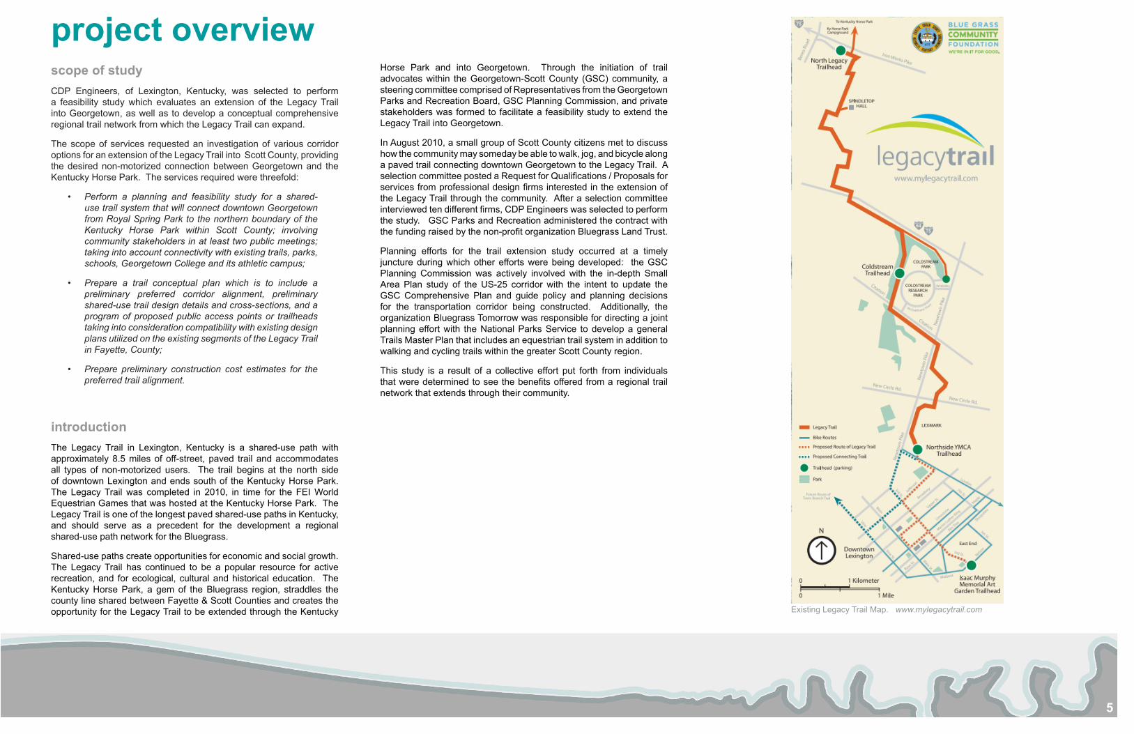
project overviewscope of studyCDP Engineers, of Lexington, Kentucky, was selected to perform a feasibility study which evaluates an extension of the Legacy Trail into Georgetown, as well as to develop a conceptual comprehensive regional trail network from which the Legacy Trail can expand.
The scope of services requested an investigation of various corridor options for an extension of the Legacy Trail into Scott County, providing the desired non-motorized connection between Georgetown and the Kentucky Horse Park. The services required were threefold:
• Perform a planning and feasibility study for a shared-use trail system that will connect downtown Georgetown from Royal Spring Park to the northern boundary of the Kentucky Horse Park within Scott County; involving community stakeholders in at least two public meetings; taking into account connectivity with existing trails, parks, schools, Georgetown College and its athletic campus;
• Prepare a trail conceptual plan which is to include a preliminary preferred corridor alignment, preliminary shared-use trail design details and cross-sections, and a program of proposed public access points or trailheads taking into consideration compatibility with existing design plans utilized on the existing segments of the Legacy Trail in Fayette, County;
• Prepare preliminary construction cost estimates for the preferred trail alignment.
introductionThe Legacy Trail in Lexington, Kentucky is a shared-use path with approximately 8.5 miles of off-street, paved trail and accommodates all types of non-motorized users. The trail begins at the north side of downtown Lexington and ends south of the Kentucky Horse Park. The Legacy Trail was completed in 2010, in time for the FEI World Equestrian Games that was hosted at the Kentucky Horse Park. The Legacy Trail is one of the longest paved shared-use paths in Kentucky, and should serve as a precedent for the development a regional shared-use path network for the Bluegrass.
Shared-use paths create opportunities for economic and social growth. The Legacy Trail has continued to be a popular resource for active recreation, and for ecological, cultural and historical education. The Kentucky Horse Park, a gem of the Bluegrass region, straddles the county line shared between Fayette & Scott Counties and creates the opportunity for the Legacy Trail to be extended through the Kentucky
Horse Park and into Georgetown. Through the initiation of trail advocates within the Georgetown-Scott County (GSC) community, a steering committee comprised of Representatives from the Georgetown Parks and Recreation Board, GSC Planning Commission, and private stakeholders was formed to facilitate a feasibility study to extend the Legacy Trail into Georgetown.
In August 2010, a small group of Scott County citizens met to discuss how the community may someday be able to walk, jog, and bicycle along a paved trail connecting downtown Georgetown to the Legacy Trail. A selection committee posted a Request for Qualifications / Proposals for services from professional design firms interested in the extension of the Legacy Trail through the community. After a selection committee interviewed ten different firms, CDP Engineers was selected to perform the study. GSC Parks and Recreation administered the contract with the funding raised by the non-profit organization Bluegrass Land Trust.
Planning efforts for the trail extension study occurred at a timely juncture during which other efforts were being developed: the GSC Planning Commission was actively involved with the in-depth Small Area Plan study of the US-25 corridor with the intent to update the GSC Comprehensive Plan and guide policy and planning decisions for the transportation corridor being constructed. Additionally, the organization Bluegrass Tomorrow was responsible for directing a joint planning effort with the National Parks Service to develop a general Trails Master Plan that includes an equestrian trail system in addition to walking and cycling trails within the greater Scott County region.
This study is a result of a collective effort put forth from individuals that were determined to see the benefits offered from a regional trail network that extends through their community.
Existing Legacy Trail Map. www.mylegacytrail.com
6
context: REGIONAL COMPREHENSIVE TRAIL NETWORKMany of its residents already know that Georgetown contains some features which are unique to this region and, in many instances, unique to our state and nation. These features are already recognized by citizens within the county and promoted by Georgetown-Scott County Tourism Commission among other individuals and organizations. Take for instance the historical significance of architectural features present at the Cardome Centre, the Scott County Courthouse, and Georgetown College. Royal Springs should also be considered a significant site which is not only Kentucky’s largest spring-based public water system, but also provided water for Baptist minister Elijah Craig where it is reported that some, if not the first, bourbon whiskey was produced.
Other attractions found in outlying areas of Scott County include but are not limited to Ward Hall, Evan’s Orchard, the Scott County Reservoir, and the Elkhorn Creek present great destinations for connection along a multi-use path. In addition to the features, the outlying communities of Stamping Ground and Sadieville would be desirable destinations to connect with a regional trail network. Midway is nearly as close to downtown Georgetown as Stamping Ground, so it could be considered a worthwhile node for connection as well. Even the Toyota manufacturing plant should be considered a destination since it employs a large population of workers which itself is a large community of potential trail users.
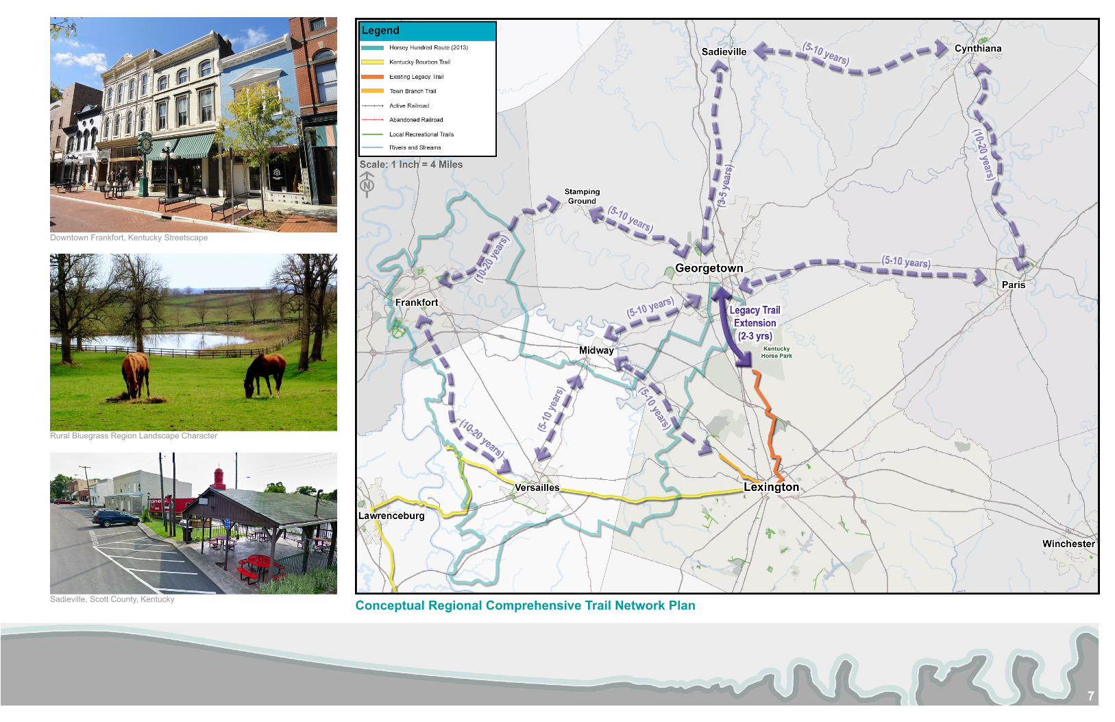
Though our scope of work is to evaluate and determine the best connection from the northern limits of the Kentucky Horse Park to downtown Georgetown, we must consider potential connections beyond our focus area if the intent is to construct a successful trail network that also becomes a tourist destination. In addition to Lexington, other regional connections should consider Frankfort, Midway, and Versailles. The Horsey Hundred is an annual cycling event that is hosted by Georgetown-Scott County but extends over 100-miles within the Inner Bluegrass region by following a path which changes annually and utilizes the existing road network. The success of this event saw over 2,000 participants in 2013 and should demonstrate the interest in shared-use cycling facilities – not to mention the potential to generate tourism dollars and spur additional economic development.
Bourbon is a part of this region’s unique heritage within Kentucky and also generates millions of dollars in tax revenue annually. Another successful route within the region is the Bourbon Trail with approximately 2.5 million visitors in the past five years. The trail also hosts an
annual foot race, The Bourbon Chase, which connects the numerous distilleries along a 200-mile race through central Kentucky and hosts as many as 4,000 racers. This event features heritage which is unique to this region and appeals to many visitors across the nation. Combine this with picturesque views of the scenic Bluegrass Region and our distinctive horse farm industry and the bluegrass truly hosts attractions that are found nowhere else.
Numerous outlying communities offer nodes of connection from the trail extension proposed through Georgetown. With the existing network of trails within parks and neighborhoods of Georgetown, there is opportunity to connect not only these, but extend further into Lexington and outlying community nodes. Sadieville has an existing horse trail network and is currently pursuing the “Trail Town” designation. The Legacy Trail currently is located within Lexington, beginning at the YMCA on Loudon Avenue, connects to the Coldstream Research Campus, and terminates just south of the Kentucky Horse Park at Iron Works Pike. But future extensions to this trail will connect to downtown Lexington and hopefully through the Kentucky Horse Park and north to Georgetown. Other prominent trail spurs exist within Lexington as well: the Brighton East Trail consists of approximately 4 miles southeastward from Man O’ War Boulevard toward Chilesburg, and the Town Branch Trail is planned to extend from Rupp Arena to Masterson Station. This final leg of the route has already been constructed and connects to another network of trails on the north western side of the city. Hisle Park is another recently opened park located on the northeast side of Lexington and consists of 280-acres of land that may serve as a future connection from Georgetown. There are plans to expand and open an additional tract in a future phase of the park which should be of particular interest to horseback trail riders since the park already offers 2.5 miles of trails for pedestrian and horseback trail riders.
The focus of this study is an extension of the Legacy Trail from Lexington into downtown Georgetown, the existing network of trails and bike routes must be evaluated. But if the study limited its focus solely to this route alone, we would be remiss of the opportunity to consider connecting to a broader network of trails extending beyond our focus area. It is for this reason that downtown Georgetown should not be considered the terminus of the trail, but maybe another destination along a larger regional trail system where the experience highlights significant features within our central Kentucky Region. Picture a large trail network that leads from Lexington to Frankfort and connects several communities along the way. A loop
system could even be developed which links numerous towns in a continuous circuit. This wouldn’t exclude the possibility for additional connections because increased connectivity is encouraged if the trail network is intended to attract users. However, a primary trail “spine” could be defined from which other secondary spurs could then connect other communities or destinations.
Trails are proven to generate tourism, and revenue as a result. However, skepticism toward safety and security exists even when data supports that little to no criminal activity has occurred along many shared-use facilities. This perception of crime may lead to the avoidance and misconception of security of trails particularly among many private land owners. Research has revealed that crime rates are lower on trail networks than the overall region in which they are located – this includes urban, suburban, and rural areas. But trail networks poses little risk to adjacent landowners, and the more heavily a trail is used, the less criminal activity can be expected. Facilities with more trail users have fewer security issues. A partnership between local law enforcement that can routinely police these locations and the communities where the trailheads are located is the most effective way to address perceived criminal activity.
Once a complete trail nework is developed that offers an experience unique to the Bluegrass, the public will take ownership and provide the foundation for a successful system. There are existing trail networks within various parks and neighborhoods in Georgetown – Scott County, but two significant trails which extend from Lexington toward Scott County are the Town Branch Trail and the Legacy Trail. Linking these existing trails and developing an interconnected trail system that spans the Bluegrass region will allow for success on the level of other trail systems in the country; such as, The Monon Rail Trail (16.7 miles), The Dawkins Trail (36 miles), The Little Miami Bike Trail (68.5 miles), and the Virginia Creeper Trail (35 miles).
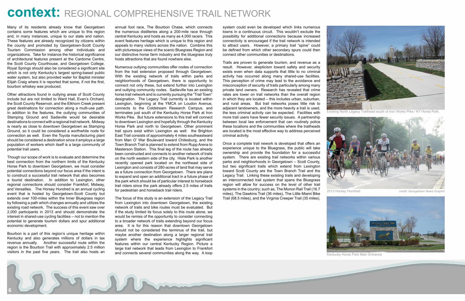
Existing North Legacy Trailhead south of Iron Works Pike / KY Horse Park.
2013 Horsey Hundred credit: Georgetown News Graphic
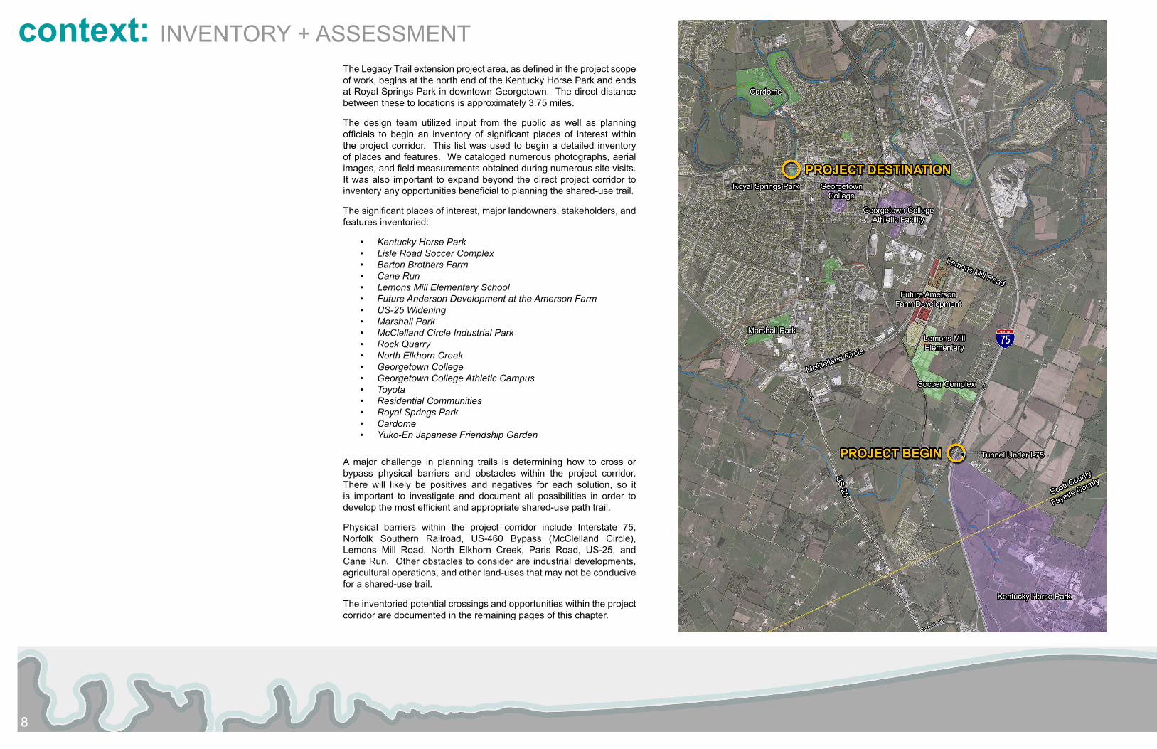
Kentucky Horse Park Main Entrance
7
Downtown Frankfort, Kentucky Streetscape
Rural Bluegrass Region Landscape Character
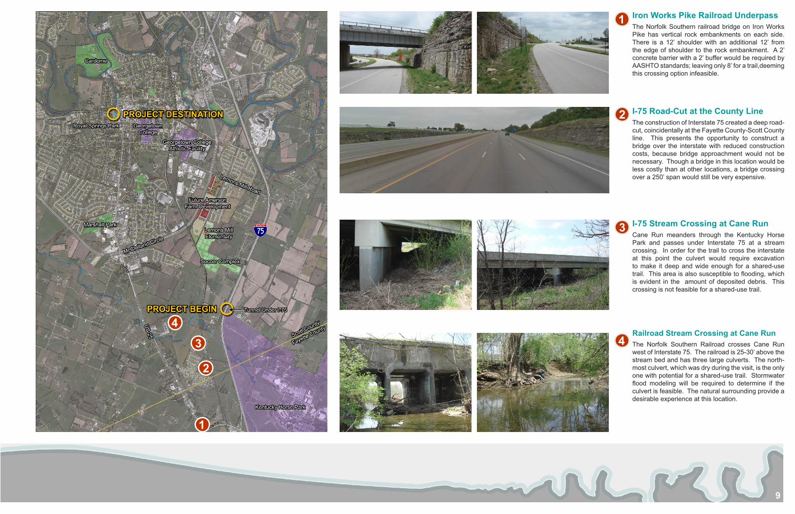
Sadieville, Scott County, Kentucky Conceptual Regional Comprehensive Trail Network Plan
8
context: INVENTORY + ASSESSMENTThe Legacy Trail extension project area, as defined in the project scope of work, begins at the north end of the Kentucky Horse Park and ends at Royal Springs Park in downtown Georgetown. The direct distance between these to locations is approximately 3.75 miles.
The design team utilized input from the public as well as planning officials to begin an inventory of significant places of interest within the project corridor. This list was used to begin a detailed inventory of places and features. We cataloged numerous photographs, aerial images, and field measurements obtained during numerous site visits. It was also important to expand beyond the direct project corridor to inventory any opportunities beneficial to planning the shared-use trail.
The significant places of interest, major landowners, stakeholders, and features inventoried:
• Kentucky Horse Park• Lisle Road Soccer Complex• Barton Brothers Farm• Cane Run• Lemons Mill Elementary School• Future Anderson Development at the Amerson Farm• US-25 Widening• Marshall Park• McClelland Circle Industrial Park• Rock Quarry• North Elkhorn Creek• Georgetown College • Georgetown College Athletic Campus• Toyota• Residential Communities• Royal Springs Park• Cardome• Yuko-En Japanese Friendship Garden
A major challenge in planning trails is determining how to cross or bypass physical barriers and obstacles within the project corridor. There will likely be positives and negatives for each solution, so it is important to investigate and document all possibilities in order to develop the most efficient and appropriate shared-use path trail.
Physical barriers within the project corridor include Interstate 75, Norfolk Southern Railroad, US-460 Bypass (McClelland Circle), Lemons Mill Road, North Elkhorn Creek, Paris Road, US-25, and Cane Run. Other obstacles to consider are industrial developments, agricultural operations, and other land-uses that may not be conducive for a shared-use trail.
The inventoried potential crossings and opportunities within the project corridor are documented in the remaining pages of this chapter.
9
Iron Works Pike Railroad UnderpassThe Norfolk Southern railroad bridge on Iron Works Pike has vertical rock embankments on each side. There is a 12’ shoulder with an additional 12’ from the edge of shoulder to the rock embankment. A 2’ concrete barrier with a 2’ buffer would be required by AASHTO standards; leaving only 8’ for a trail,deeming this crossing option infeasible.
I-75 Road-Cut at the County LineThe construction of Interstate 75 created a deep road-cut, coincidentally at the Fayette County-Scott County line. This presents the opportunity to construct a bridge over the interstate with reduced construction costs, because bridge approachment would not be necessary. Though a bridge in this location would be less costly than at other locations, a bridge crossing over a 250’ span would still be very expensive.
I-75 Stream Crossing at Cane RunCane Run meanders through the Kentucky Horse Park and passes under Interstate 75 at a stream crossing. In order for the trail to cross the interstate at this point the culvert would require excavation to make it deep and wide enough for a shared-use trail. This area is also susceptible to flooding, which is evident in the amount of deposited debris. This crossing is not feasible for a shared-use trail.
Railroad Stream Crossing at Cane RunThe Norfolk Southern Railroad crosses Cane Run west of Interstate 75. The railroad is 25-30’ above the stream bed and has three large culverts. The north-most culvert, which was dry during the visit, is the only one with potential for a shared-use trail. Stormwater flood modeling will be required to determine if the culvert is feasible. The natural surrounding provide a desirable experience at this location.
2
3
4
1
1
2
3
4
10
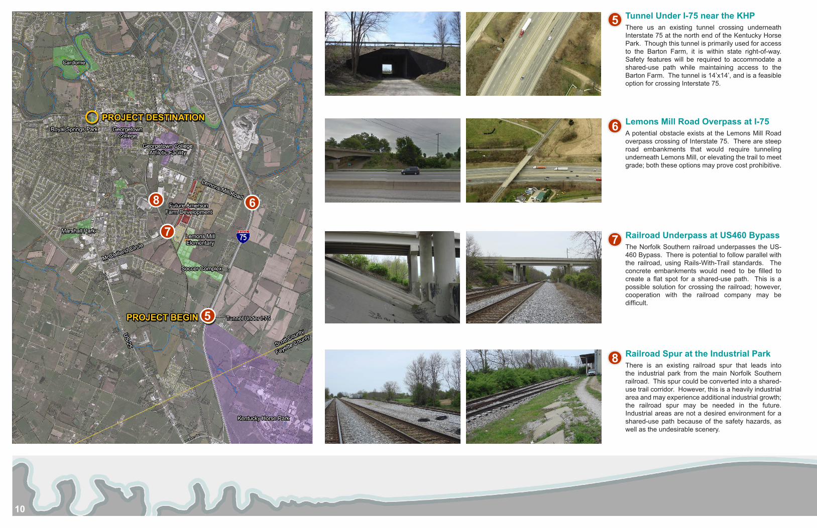
Tunnel Under I-75 near the KHPThere us an existing tunnel crossing underneath Interstate 75 at the north end of the Kentucky Horse Park. Though this tunnel is primarily used for access to the Barton Farm, it is within state right-of-way. Safety features will be required to accommodate a shared-use path while maintaining access to the Barton Farm. The tunnel is 14’x14’, and is a feasible option for crossing Interstate 75.
Lemons Mill Road Overpass at I-75A potential obstacle exists at the Lemons Mill Road overpass crossing of Interstate 75. There are steep road embankments that would require tunneling underneath Lemons Mill, or elevating the trail to meet grade; both these options may prove cost prohibitive.
Railroad Underpass at US460 BypassThe Norfolk Southern railroad underpasses the US-460 Bypass. There is potential to follow parallel with the railroad, using Rails-With-Trail standards. The concrete embankments would need to be filled to create a flat spot for a shared-use path. This is a possible solution for crossing the railroad; however, cooperation with the railroad company may be difficult.
Railroad Spur at the Industrial ParkThere is an existing railroad spur that leads into the industrial park from the main Norfolk Southern railroad. This spur could be converted into a shared-use trail corridor. However, this is a heavily industrial area and may experience additional industrial growth; the railroad spur may be needed in the future. Industrial areas are not a desired environment for a shared-use path because of the safety hazards, as well as the undesirable scenery.
7
6
5
8
5
6
7
8
11
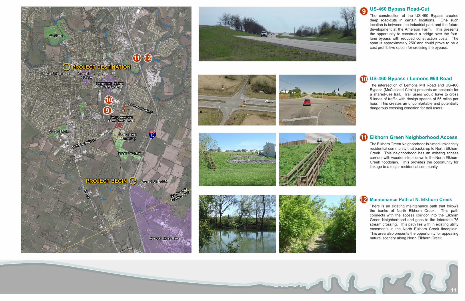
US-460 Bypass Road-CutThe construction of the US-460 Bypass created deep road-cuts in certain locations. One such location is between the industrial park and the future development at the Amerson Farm. This presents the opportunity to construct a bridge over the four-lane bypass with reduced construction costs. The span is approximately 250’ and could prove to be a cost prohibitive option for crossing the bypass.
US-460 Bypass / Lemons Mill RoadThe intersection of Lemons Mill Road and US-460 Bypass (McClelland Circle) presents an obstacle for a shared-use trail. Trail users would have to cross 5 lanes of traffic with design speeds of 55 miles per hour. This creates an uncomfortable and potentially dangerous crossing condition for trail users.
Elkhorn Green Neighborhood AccessThe Elkhorn Green Neighborhood is a medium density residential community that backs-up to North Elkhorn Creek. This neighborhood has an existing access corridor with wooden steps down to the North Elkhorn Creek floodplain. This provides the opportunity for linkage to a major residential community.
Maintenance Path at N. Elkhorn CreekThere is an existing maintenance path that follows the banks of North Elkhorn Creek. This path connects with the access corridor into the Elkhorn Green Neighborhood and goes to the Interstate 75 stream crossing. This path lies with in existing utility easements in the North Elkhorn Creek floodplain. This area also presents the opportunity for appealing natural scenery along North Elkhorn Creek.
9
9
10
10
11
11
12
12
12
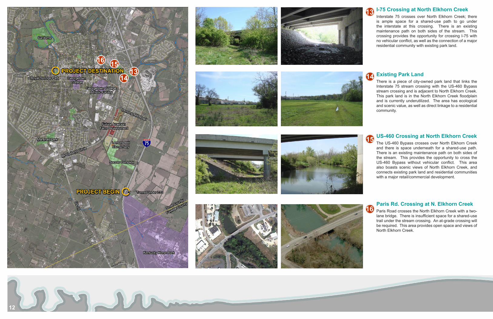
I-75 Crossing at North Elkhorn CreekInterstate 75 crosses over North Elkhorn Creek; there is ample space for a shared-use path to go under the interstate at this crossing. There is an existing maintenance path on both sides of the stream. This crossing provides the opportunity for crossing I-75 with no vehicular conflict, as well as the connection of a major residential community with existing park land.
Existing Park LandThere is a piece of city-owned park land that links the Interstate 75 stream crossing with the US-460 Bypass stream crossing and is adjacent to North Elkhorn Creek. This park land is in the North Elkhorn Creek floodplain and is currently underutilized. The area has ecological and scenic value, as well as direct linkage to a residential community.
US-460 Crossing at North Elkhorn CreekThe US-460 Bypass crosses over North Elkhorn Creek and there is space underneath for a shared-use path. There is an existing maintenance path on both sides of the stream. This provides the opportunity to cross the US-460 Bypass without vehicular conflict. This area also boasts scenic views of North Elkhorn Creek, and connects existing park land and residential communities with a major retail/commercial development.
Paris Rd. Crossing at N. Elkhorn CreekParis Road crosses the North Elkhorn Creek with a two-lane bridge. There is insufficient space for a shared-use trail under the stream crossing. An at-grade crossing will be required. This area provides open space and views of North Elkhorn Creek.
13
13 1414
15
15
16
16
13
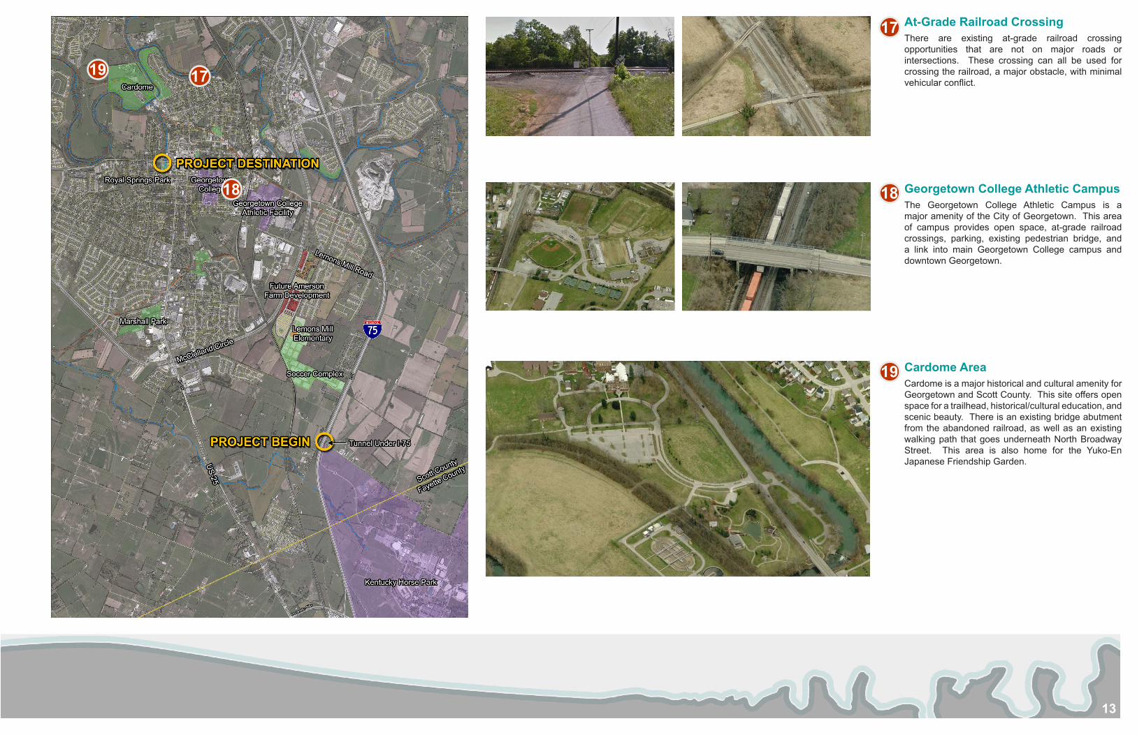
At-Grade Railroad CrossingThere are existing at-grade railroad crossing opportunities that are not on major roads or intersections. These crossing can all be used for crossing the railroad, a major obstacle, with minimal vehicular conflict.
Georgetown College Athletic CampusThe Georgetown College Athletic Campus is a major amenity of the City of Georgetown. This area of campus provides open space, at-grade railroad crossings, parking, existing pedestrian bridge, and a link into main Georgetown College campus and downtown Georgetown.
Cardome AreaCardome is a major historical and cultural amenity for Georgetown and Scott County. This site offers open space for a trailhead, historical/cultural education, and scenic beauty. There is an existing bridge abutment from the abandoned railroad, as well as an existing walking path that goes underneath North Broadway Street. This area is also home for the Yuko-En Japanese Friendship Garden.
1818
17
17
19
19
14
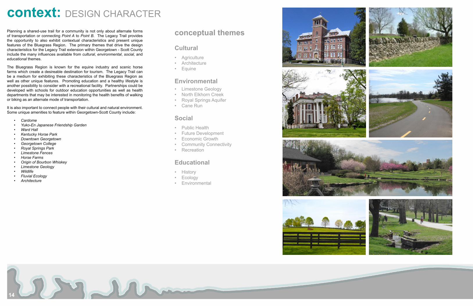
context: DESIGN CHARACTER
conceptual themes
Cultural • Agriculture• Architecture• Equine
Environmental• Limestone Geology• North Elkhorn Creek• Royal Springs Aquifer• Cane Run
Social• Public Health• Future Development• Economic Growth• Community Connectivity• Recreation
Educational• History• Ecology• Environmental
Planning a shared-use trail for a community is not only about alternate forms of transportation or connecting Point A to Point B. The Legacy Trail provides the opportunity to also exhibit contextual characteristics and present unique features of the Bluegrass Region. The primary themes that drive the design characteristics for the Legacy Trail extension within Georgetown - Scott County include the many influences available from cultural, environmental, social, and educational themes.
The Bluegrass Region is known for the equine industry and scenic horse farms which create a desireable destination for tourism. The Legacy Trail can be a medium for exhibiting these characteristics of the Bluegrass Region as well as other unique features. Promoting education and a healthy lifestyle is another possibility to consider with a recreational facility. Partnerships could be developed with schools for outdoor education opportunities as well as health departments that may be interested in monitoring the health benefits of walking or biking as an alternate mode of transportation.
It is also important to connect people with their cultural and natural environment. Some unique amenities to feature within Georgetown-Scott County include:
• Cardome • Yuko-En Japanese Friendship Garden• Ward Hall• Kentucky Horse Park• Downtown Georgetown• Georgetown College• Royal Springs Park• Limestone Fences• Horse Farms• Origin of Bourbon Whiskey• Limestone Geology• Wildlife• Fluvial Ecology• Architecture
15
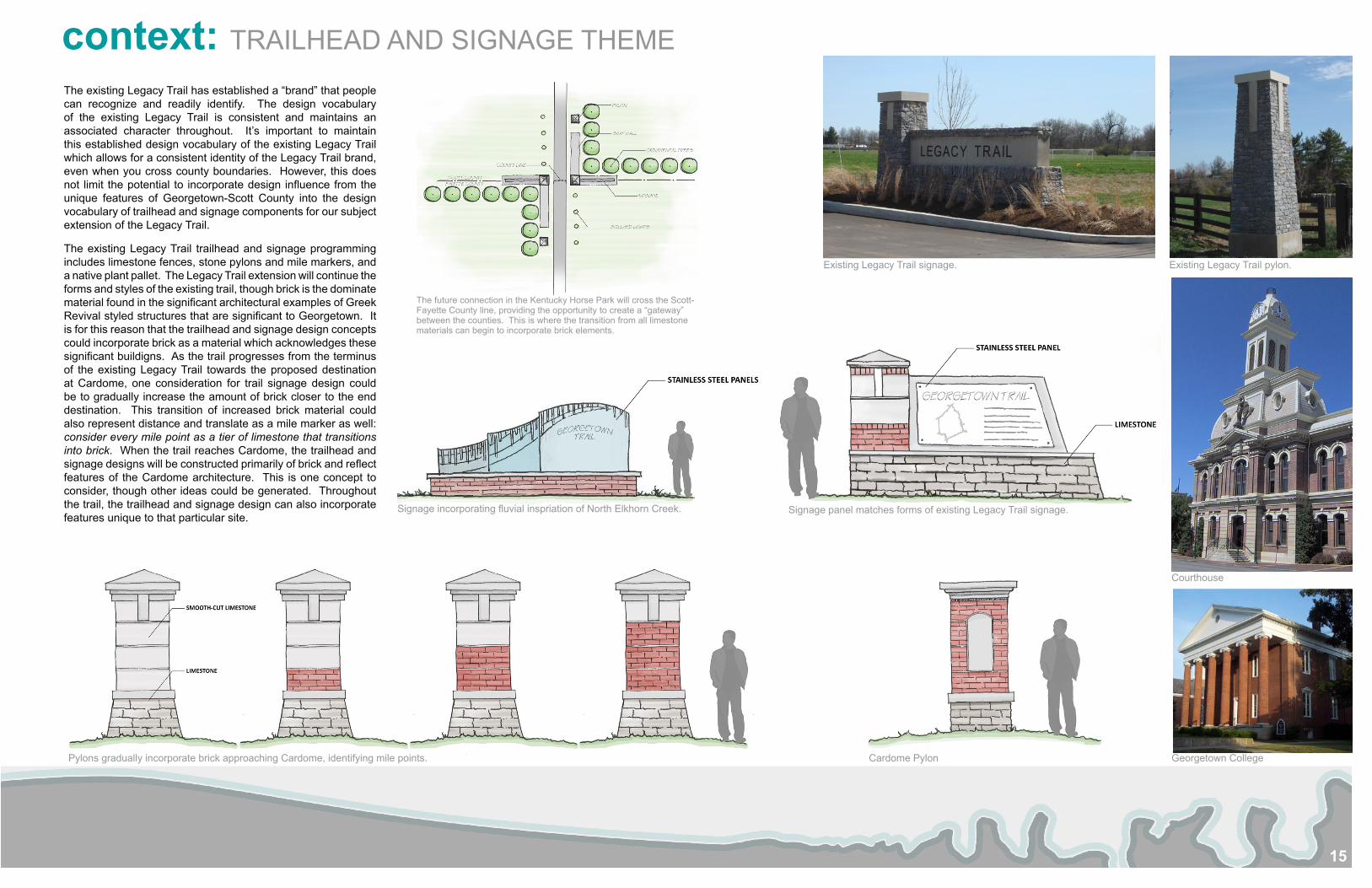
context: TRAILHEAD AND SIGNAGE THEME
The existing Legacy Trail has established a “brand” that people can recognize and readily identify. The design vocabulary of the existing Legacy Trail is consistent and maintains an associated character throughout. It’s important to maintain this established design vocabulary of the existing Legacy Trail which allows for a consistent identity of the Legacy Trail brand, even when you cross county boundaries. However, this does not limit the potential to incorporate design influence from the unique features of Georgetown-Scott County into the design vocabulary of trailhead and signage components for our subject extension of the Legacy Trail.
The existing Legacy Trail trailhead and signage programming includes limestone fences, stone pylons and mile markers, and a native plant pallet. The Legacy Trail extension will continue the forms and styles of the existing trail, though brick is the dominate material found in the significant architectural examples of Greek Revival styled structures that are significant to Georgetown. It is for this reason that the trailhead and signage design concepts could incorporate brick as a material which acknowledges these significant buildigns. As the trail progresses from the terminus of the existing Legacy Trail towards the proposed destination at Cardome, one consideration for trail signage design could be to gradually increase the amount of brick closer to the end destination. This transition of increased brick material could also represent distance and translate as a mile marker as well: consider every mile point as a tier of limestone that transitions into brick. When the trail reaches Cardome, the trailhead and signage designs will be constructed primarily of brick and reflect features of the Cardome architecture. This is one concept to consider, though other ideas could be generated. Throughout the trail, the trailhead and signage design can also incorporate features unique to that particular site.
The future connection in the Kentucky Horse Park will cross the Scott-Fayette County line, providing the opportunity to create a “gateway” between the counties. This is where the transition from all limestone materials can begin to incorporate brick elements.
Signage incorporating fluvial inspriation of North Elkhorn Creek. Signage panel matches forms of existing Legacy Trail signage.
Existing Legacy Trail signage. Existing Legacy Trail pylon.
Courthouse
Georgetown CollegeCardome PylonPylons gradually incorporate brick approaching Cardome, identifying mile points.
16
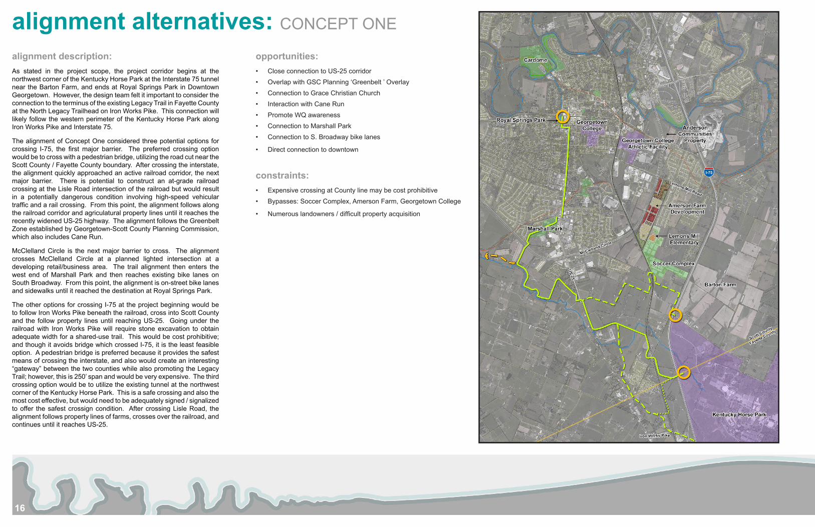
alignment alternatives: CONCEPT ONE
opportunities:• Close connection to US-25 corridor• Overlap with GSC Planning ‘Greenbelt ’ Overlay • Connection to Grace Christian Church• Interaction with Cane Run• Promote WQ awareness • Connection to Marshall Park• Connection to S. Broadway bike lanes
• Direct connection to downtown
constraints:• Expensive crossing at County line may be cost prohibitive• Bypasses: Soccer Complex, Amerson Farm, Georgetown College
• Numerous landowners / difficult property acquisition
alignment description:As stated in the project scope, the project corridor begins at the northwest corner of the Kentucky Horse Park at the Interstate 75 tunnel near the Barton Farm, and ends at Royal Springs Park in Downtown Georgetown. However, the design team felt it important to consider the connection to the terminus of the existing Legacy Trail in Fayette County at the North Legacy Trailhead on Iron Works Pike. This connection will likely follow the western perimeter of the Kentucky Horse Park along Iron Works Pike and Interstate 75.
The alignment of Concept One considered three potential options for crossing I-75, the first major barrier. The preferred crossing option would be to cross with a pedestrian bridge, utilizing the road cut near the Scott County / Fayette County boundary. After crossing the interstate, the alignment quickly approached an active railroad corridor, the next major barrier. There is potential to construct an at-grade railroad crossing at the Lisle Road intersection of the railroad but would result in a potentially dangerous condition involving high-speed vehicular traffic and a rail crossing. From this point, the alignment follows along the railroad corridor and agriculatural property lines until it reaches the recently widened US-25 highway. The alignment follows the Greenbelt Zone established by Georgetown-Scott County Planning Commission, which also includes Cane Run.
McClelland Circle is the next major barrier to cross. The alignment crosses McClelland Circle at a planned lighted intersection at a developing retail/business area. The trail alignment then enters the west end of Marshall Park and then reaches existing bike lanes on South Broadway. From this point, the alignment is on-street bike lanes and sidewalks until it reached the destination at Royal Springs Park.
The other options for crossing I-75 at the project beginning would be to follow Iron Works Pike beneath the railroad, cross into Scott County and the follow property lines until reaching US-25. Going under the railroad with Iron Works Pike will require stone excavation to obtain adequate width for a shared-use trail. This would be cost prohibitive; and though it avoids bridge which crossed I-75, it is the least feasible option. A pedestrian bridge is preferred because it provides the safest means of crossing the interstate, and also would create an interesting “gateway” between the two counties while also promoting the Legacy Trail; however, this is 250’ span and would be very expensive. The third crossing option would be to utilize the existing tunnel at the northwest corner of the Kentucky Horse Park. This is a safe crossing and also the most cost effective, but would need to be adequately signed / signalized to offer the safest crossign condition. After crossing Lisle Road, the alignment follows property lines of farms, crosses over the railroad, and continues until it reaches US-25.
17
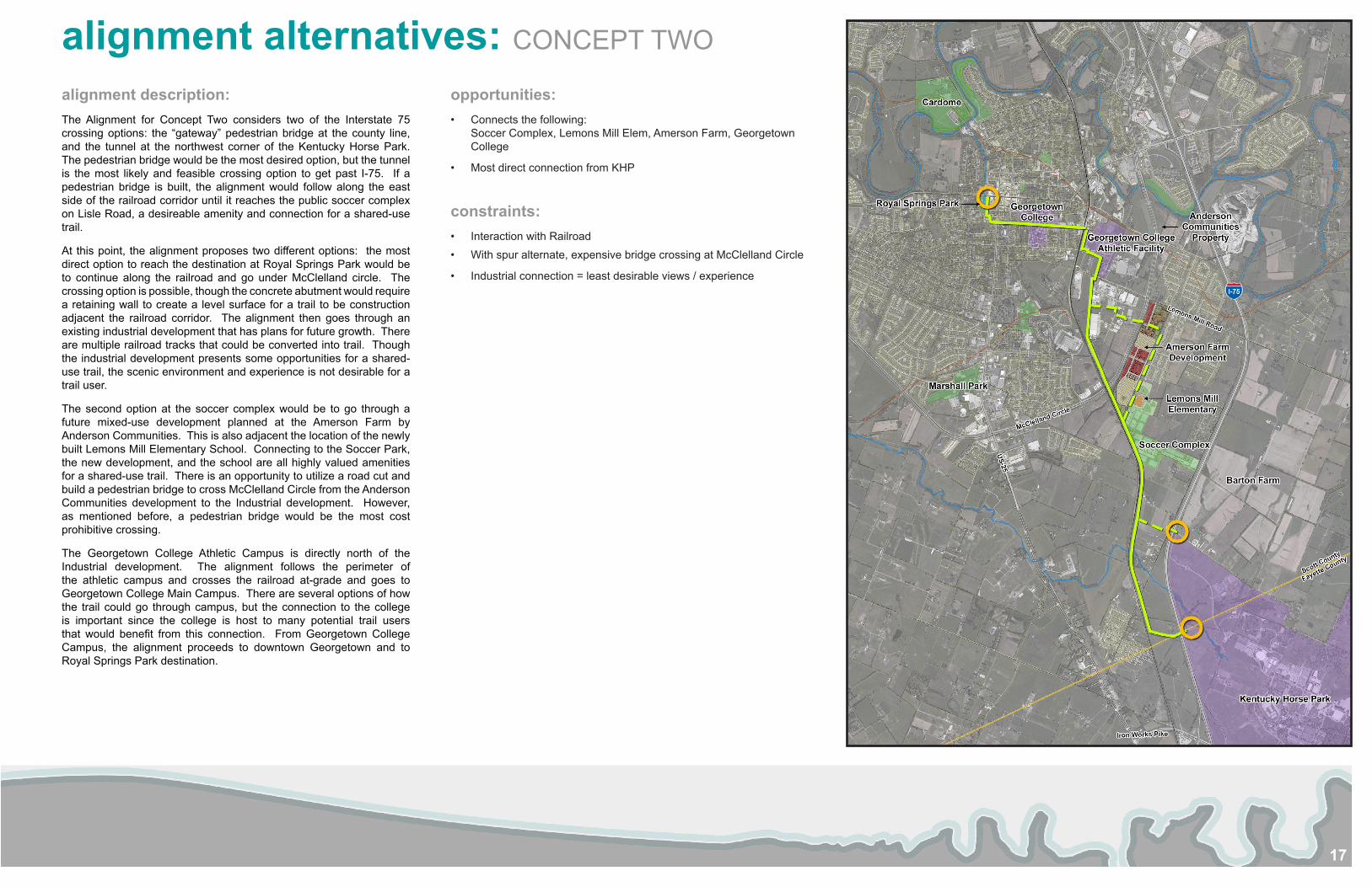
alignment alternatives: CONCEPT TWO
opportunities:• Connects the following:
Soccer Complex, Lemons Mill Elem, Amerson Farm, Georgetown College
• Most direct connection from KHP
constraints:• Interaction with Railroad• With spur alternate, expensive bridge crossing at McClelland Circle
• Industrial connection = least desirable views / experience
alignment description:The Alignment for Concept Two considers two of the Interstate 75 crossing options: the “gateway” pedestrian bridge at the county line, and the tunnel at the northwest corner of the Kentucky Horse Park. The pedestrian bridge would be the most desired option, but the tunnel is the most likely and feasible crossing option to get past I-75. If a pedestrian bridge is built, the alignment would follow along the east side of the railroad corridor until it reaches the public soccer complex on Lisle Road, a desireable amenity and connection for a shared-use trail.
At this point, the alignment proposes two different options: the most direct option to reach the destination at Royal Springs Park would be to continue along the railroad and go under McClelland circle. The crossing option is possible, though the concrete abutment would require a retaining wall to create a level surface for a trail to be construction adjacent the railroad corridor. The alignment then goes through an existing industrial development that has plans for future growth. There are multiple railroad tracks that could be converted into trail. Though the industrial development presents some opportunities for a shared-use trail, the scenic environment and experience is not desirable for a trail user.
The second option at the soccer complex would be to go through a future mixed-use development planned at the Amerson Farm by Anderson Communities. This is also adjacent the location of the newly built Lemons Mill Elementary School. Connecting to the Soccer Park, the new development, and the school are all highly valued amenities for a shared-use trail. There is an opportunity to utilize a road cut and build a pedestrian bridge to cross McClelland Circle from the Anderson Communities development to the Industrial development. However, as mentioned before, a pedestrian bridge would be the most cost prohibitive crossing.
The Georgetown College Athletic Campus is directly north of the Industrial development. The alignment follows the perimeter of the athletic campus and crosses the railroad at-grade and goes to Georgetown College Main Campus. There are several options of how the trail could go through campus, but the connection to the college is important since the college is host to many potential trail users that would benefit from this connection. From Georgetown College Campus, the alignment proceeds to downtown Georgetown and to Royal Springs Park destination.
18
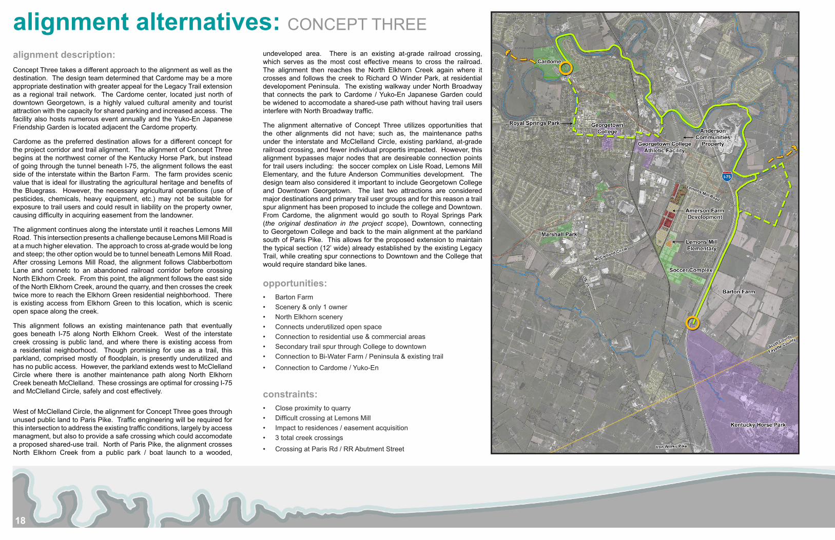
alignment alternatives: CONCEPT THREE
alignment description:Concept Three takes a different approach to the alignment as well as the destination. The design team determined that Cardome may be a more appropriate destination with greater appeal for the Legacy Trail extension as a regional trail network. The Cardome center, located just north of downtown Georgetown, is a highly valued cultural amenity and tourist attraction with the capacity for shared parking and increased access. The facility also hosts numerous event annually and the Yuko-En Japanese Friendship Garden is located adjacent the Cardome property.
Cardome as the preferred destination allows for a different concept for the project corridor and trail alignment. The alignment of Concept Three begins at the northwest corner of the Kentucky Horse Park, but instead of going through the tunnel beneath I-75, the alignment follows the east side of the interstate within the Barton Farm. The farm provides scenic value that is ideal for illustrating the agricultural heritage and benefits of the Bluegrass. However, the necessary agricultural operations (use of pesticides, chemicals, heavy equipment, etc.) may not be suitable for exposure to trail users and could result in liability on the property owner, causing difficulty in acquiring easement from the landowner.
The alignment continues along the interstate until it reaches Lemons Mill Road. This intersection presents a challenge because Lemons Mill Road is at a much higher elevation. The approach to cross at-grade would be long and steep; the other option would be to tunnel beneath Lemons Mill Road. After crossing Lemons Mill Road, the alignment follows Clabberbottom Lane and connetc to an abandoned railroad corridor before crossing North Elkhorn Creek. From this point, the alignment follows the east side of the North Elkhorn Creek, around the quarry, and then crosses the creek twice more to reach the Elkhorn Green residential neighborhood. There is existing access from Elkhorn Green to this location, which is scenic open space along the creek.
This alignment follows an existing maintenance path that eventually goes beneath I-75 along North Elkhorn Creek. West of the interstate creek crossing is public land, and where there is existing access from a residential neighborhood. Though promising for use as a trail, this parkland, comprised mostly of floodplain, is presently underutilized and has no public access. However, the parkland extends west to McClelland Circle where there is another maintenance path along North Elkhorn Creek beneath McClelland. These crossings are optimal for crossing I-75 and McClelland Circle, safely and cost effectively.
West of McClelland Circle, the alignment for Concept Three goes through unused public land to Paris Pike. Traffic engineering will be required for this intersection to address the existing traffic conditions, largely by access managment, but also to provide a safe crossing which could accomodate a proposed shared-use trail. North of Paris Pike, the alignment crosses North Elkhorn Creek from a public park / boat launch to a wooded,
undeveloped area. There is an existing at-grade railroad crossing, which serves as the most cost effective means to cross the railroad. The alignment then reaches the North Elkhorn Creek again where it crosses and follows the creek to Richard O Winder Park, at residential developoment Peninsula. The existing walkway under North Broadway that connects the park to Cardome / Yuko-En Japanese Garden could be widened to accomodate a shared-use path without having trail users interfere with North Broadway traffic.
The alignment alternative of Concept Three utilizes opportunities that the other alignments did not have; such as, the maintenance paths under the interstate and McClelland Circle, existing parkland, at-grade railroad crossing, and fewer individual propertis impacted. However, this alignment bypasses major nodes that are desireable connection points for trail users including: the soccer complex on Lisle Road, Lemons Mill Elementary, and the future Anderson Communities development. The design team also considered it important to include Georgetown College and Downtown Georgetown. The last two attractions are considered major destinations and primary trail user groups and for this reason a trail spur alignment has been proposed to include the college and Downtown. From Cardome, the alignment would go south to Royal Springs Park (the original destination in the project scope), Downtown, connecting to Georgetown College and back to the main alignment at the parkland south of Paris Pike. This allows for the proposed extension to maintain the typical section (12’ wide) already established by the existing Legacy Trail, while creating spur connections to Downtown and the College that would require standard bike lanes.
opportunities:• Barton Farm• Scenery & only 1 owner• North Elkhorn scenery• Connects underutilized open space• Connection to residential use & commercial areas • Secondary trail spur through College to downtown• Connection to Bi-Water Farm / Peninsula & existing trail • Connection to Cardome / Yuko-En
constraints:• Close proximity to quarry• Difficult crossing at Lemons Mill• Impact to residences / easement acquisition• 3 total creek crossings• Crossing at Paris Rd / RR Abutment Street
19
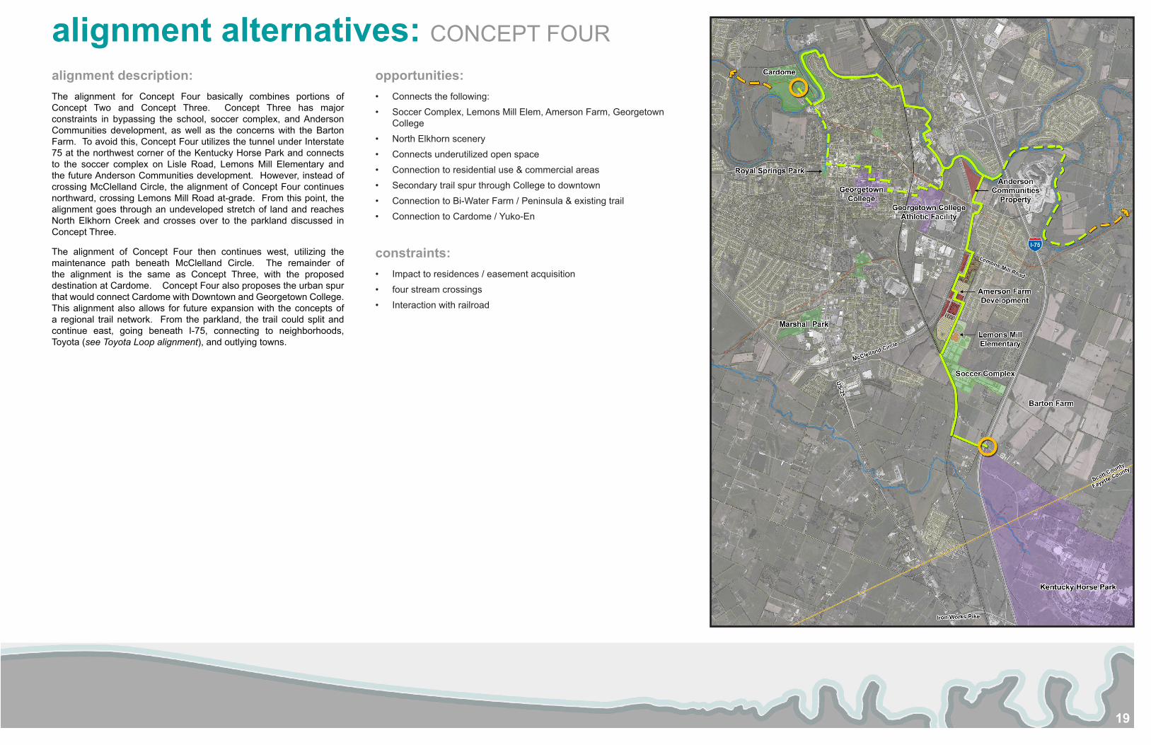
alignment alternatives: CONCEPT FOUR
opportunities:• Connects the following:• Soccer Complex, Lemons Mill Elem, Amerson Farm, Georgetown
College• North Elkhorn scenery• Connects underutilized open space• Connection to residential use & commercial areas • Secondary trail spur through College to downtown• Connection to Bi-Water Farm / Peninsula & existing trail • Connection to Cardome / Yuko-En
constraints:• Impact to residences / easement acquisition• four stream crossings• Interaction with railroad
alignment description:The alignment for Concept Four basically combines portions of Concept Two and Concept Three. Concept Three has major constraints in bypassing the school, soccer complex, and Anderson Communities development, as well as the concerns with the Barton Farm. To avoid this, Concept Four utilizes the tunnel under Interstate 75 at the northwest corner of the Kentucky Horse Park and connects to the soccer complex on Lisle Road, Lemons Mill Elementary and the future Anderson Communities development. However, instead of crossing McClelland Circle, the alignment of Concept Four continues northward, crossing Lemons Mill Road at-grade. From this point, the alignment goes through an undeveloped stretch of land and reaches North Elkhorn Creek and crosses over to the parkland discussed in Concept Three.
The alignment of Concept Four then continues west, utilizing the maintenance path beneath McClelland Circle. The remainder of the alignment is the same as Concept Three, with the proposed destination at Cardome. Concept Four also proposes the urban spur that would connect Cardome with Downtown and Georgetown College. This alignment also allows for future expansion with the concepts of a regional trail network. From the parkland, the trail could split and continue east, going beneath I-75, connecting to neighborhoods, Toyota (see Toyota Loop alignment), and outlying towns.
20
public involvement
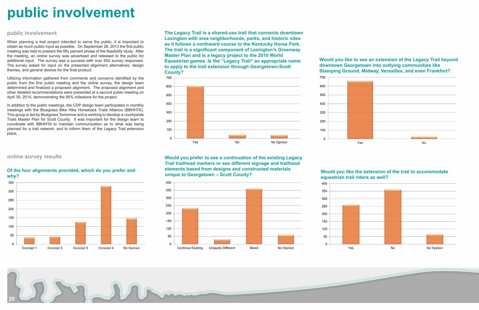
Would you like to see an extension of the Legacy Trail beyond downtown Georgetown into outlying communities like Stamping Ground, Midway, Versailles, and even Frankfort?
Would you prefer to see a continuation of the existing Legacy Trail trailhead markers or see different signage and trailhead elements based from designs and constructed materials unique to Georgetown – Scott County?
The Legacy Trail is a shared-use trail that connects downtown Lexington with area neighborhoods, parks, and historic sites as it follows a northward course to the Kentucky Horse Park. The trail is a significant component of Lexington’s Greenway Master Plan and is a legacy project to the 2010 World Equestrian games. Is the “Legacy Trail” an appropriate name to apply to the trail extension through Georgetown-Scott County?
Would you like the extension of the trail to accommodate equestrian trail riders as well?
Of the four alignments provided, which do you prefer and why?
public involvementWhen planning a trail project intended to serve the public, it is important to obtain as much public input as possible. On September 26, 2013 the first public meeting was held to present the fifty percent phase of the feasibility study. After the meeting, an online survey was advertised and released to the public for additional input. The survey was a success with over 650 survey responses. The survey asked for input on the presented alignment alternatives, design themes, and general desires for the final product.
Utilizing information gathered from comments and concerns identified by the public from the first public meeting and the online survey, the design team determined and finalized a proposed alignment. The proposed alignment and other detailed recommendations were presented at a second public meeting on April 30, 2014, demonstrating the 90% milestone for the project.
In addition to the public meetings, the CDP design team participated in monthly meetings with the Bluegrass Bike Hike Horseback Trails Alliance (BBHHTA). This group is led by Bluegrass Tomorrow and is working to develop a countywide Trails Master Plan for Scott County. It was important for the design team to coordinate with BBHHTA to maintain communication as to what was being planned for a trail network, and to inform them of the Legacy Trail extension plans.
online survey results
21
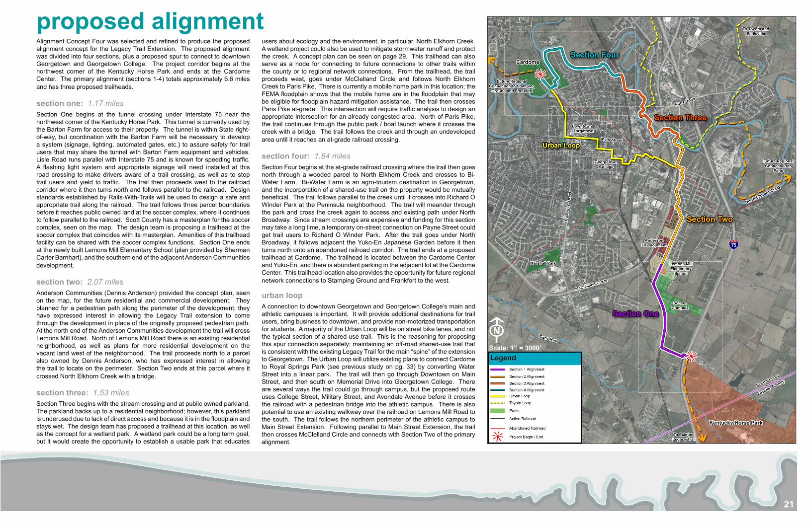
proposed alignmentAlignment Concept Four was selected and refined to produce the proposed alignment concept for the Legacy Trail Extension. The proposed alignment was divided into four sections, plus a proposed spur to connect to downtown Georgetown and Georgetown College. The project corridor begins at the northwest corner of the Kentucky Horse Park and ends at the Cardome Center. The primary alignment (sections 1-4) totals approximately 6.6 miles and has three proposed trailheads.
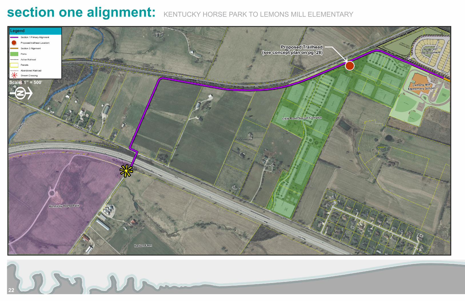
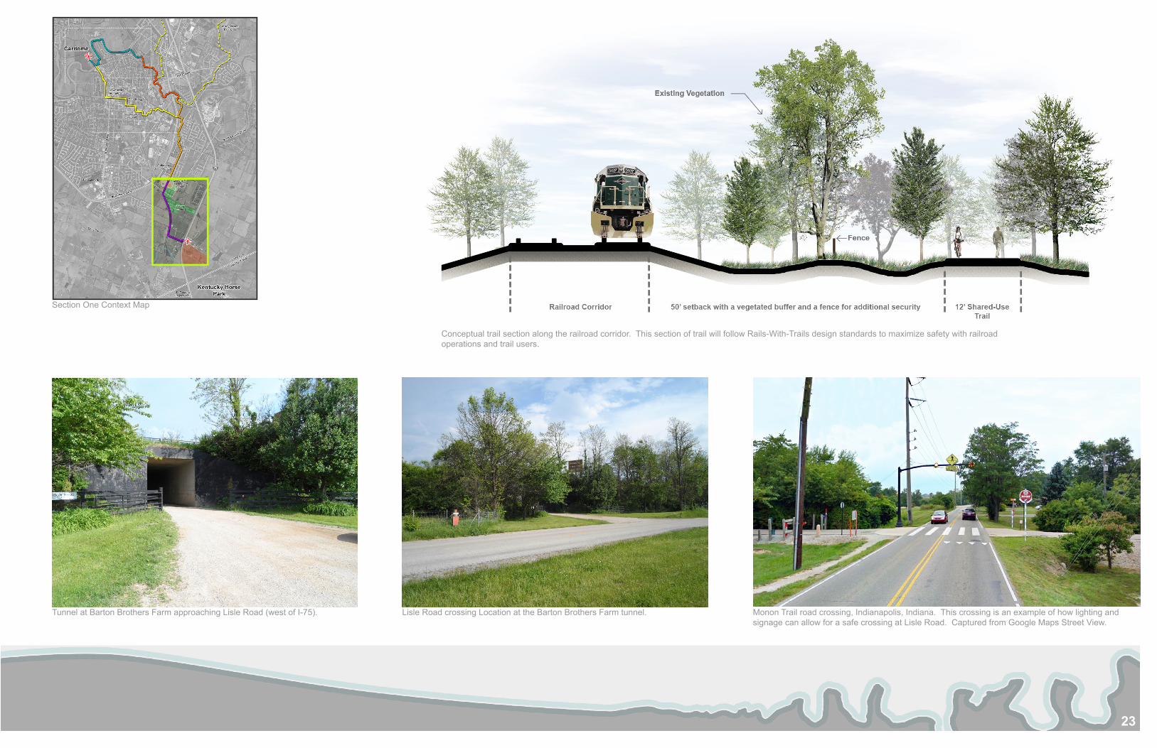
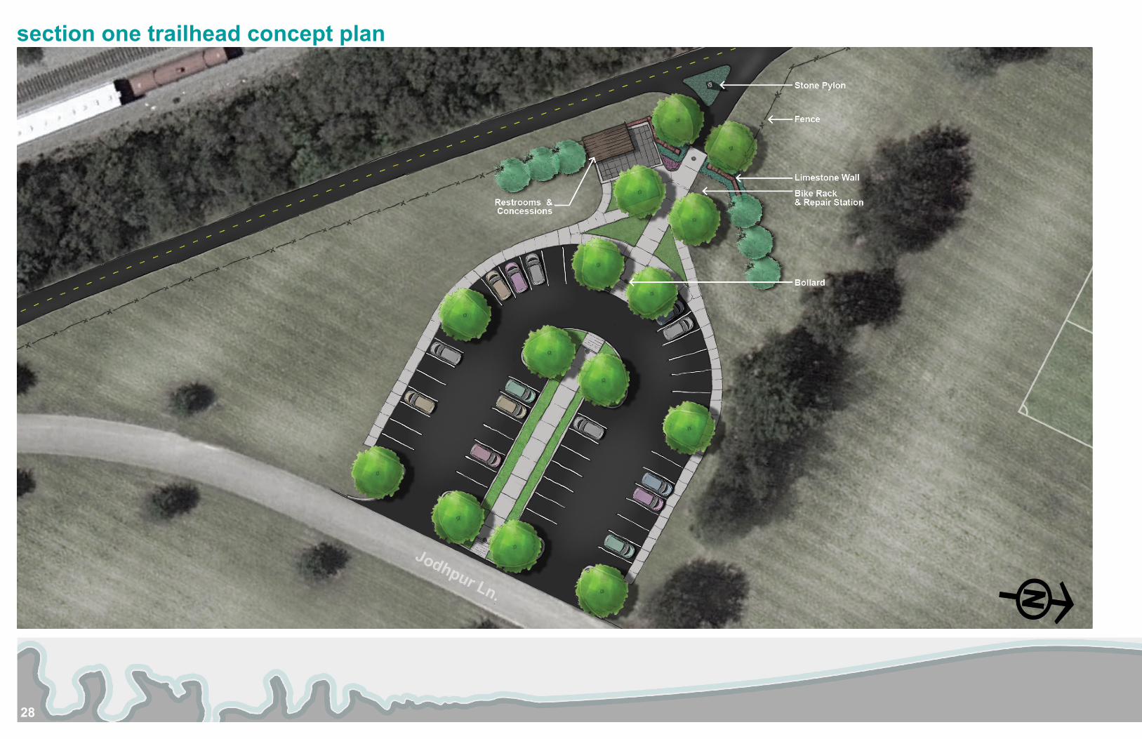
section one: 1.17 milesSection One begins at the tunnel crossing under Interstate 75 near the northwest corner of the Kentucky Horse Park. This tunnel is currently used by the Barton Farm for access to their property. The tunnel is within State right-of-way, but coordination with the Barton Farm will be necessary to develop a system (signage, lighting, automated gates, etc.) to assure safety for trail users that may share the tunnel with Barton Farm equipment and vehicles. Lisle Road runs parallel with Interstate 75 and is known for speeding traffic. A flashing light system and appropriate signage will need installed at this road crossing to make drivers aware of a trail crossing, as well as to stop trail users and yield to traffic. The trail then proceeds west to the railroad corridor where it then turns north and follows parallel to the railroad. Design standards established by Rails-With-Trails will be used to design a safe and appropriate trail along the railroad. The trail follows three parcel boundaries before it reaches public owned land at the soccer complex, where it continues to follow parallel to the railroad. Scott County has a masterplan for the soccer complex, seen on the map. The design team is proposing a trailhead at the soccer complex that coincides with its masterplan. Amenities of this trailhead facility can be shared with the soccer complex functions. Section One ends at the newly built Lemons Mill Elementary School (plan provided by Sherman Carter Barnhart), and the southern end of the adjacent Anderson Communities development.
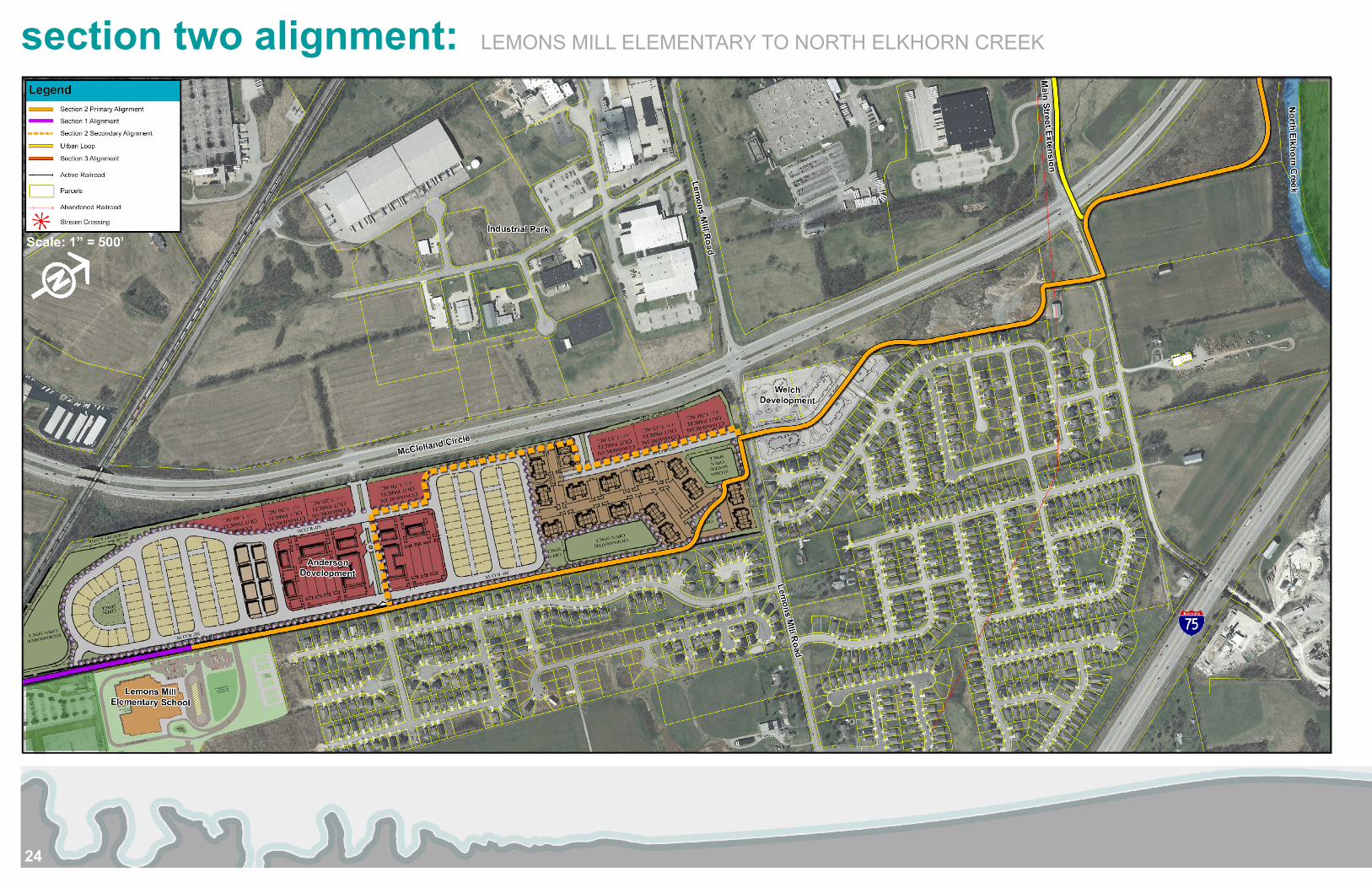
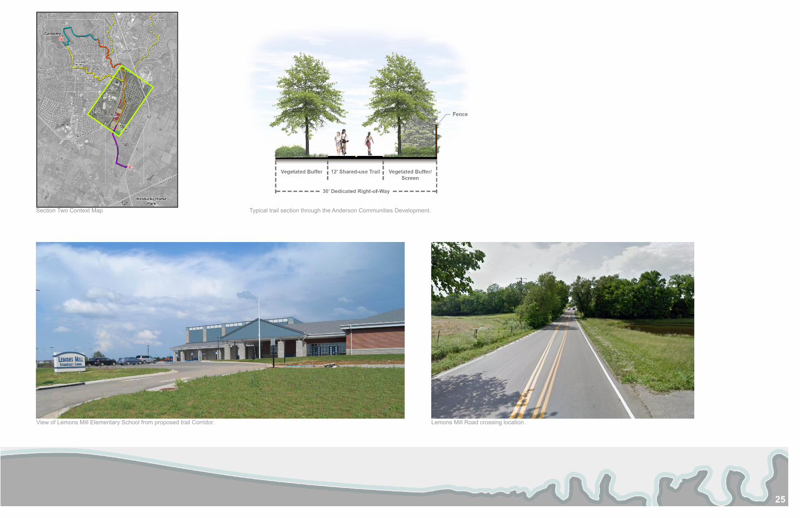
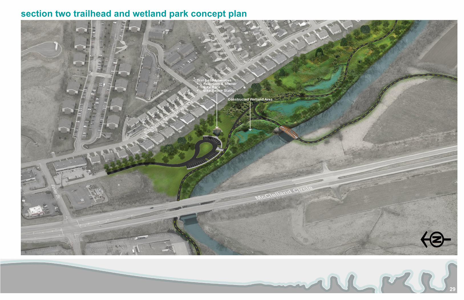
section two: 2.07 milesAnderson Communities (Dennis Anderson) provided the concept plan, seen on the map, for the future residential and commercial development. They planned for a pedestrian path along the perimeter of the development; they have expressed interest in allowing the Legacy Trail extension to come through the development in place of the originally proposed pedestrian path. At the north end of the Anderson Communities development the trail will cross Lemons Mill Road. North of Lemons Mill Road there is an existing residential neighborhood, as well as plans for more residential development on the vacant land west of the neighborhood. The trail proceeds north to a parcel also owned by Dennis Anderson, who has expressed interest in allowing the trail to locate on the perimeter. Section Two ends at this parcel where it crossed North Elkhorn Creek with a bridge.
section three: 1.53 milesSection Three begins with the stream crossing and at public owned parkland. The parkland backs up to a residential neighborhood; however, this parkland is underused due to lack of direct access and because it is in the floodplain and stays wet. The design team has proposed a trailhead at this location, as well as the concept for a wetland park. A wetland park could be a long term goal, but it would create the opportunity to establish a usable park that educates
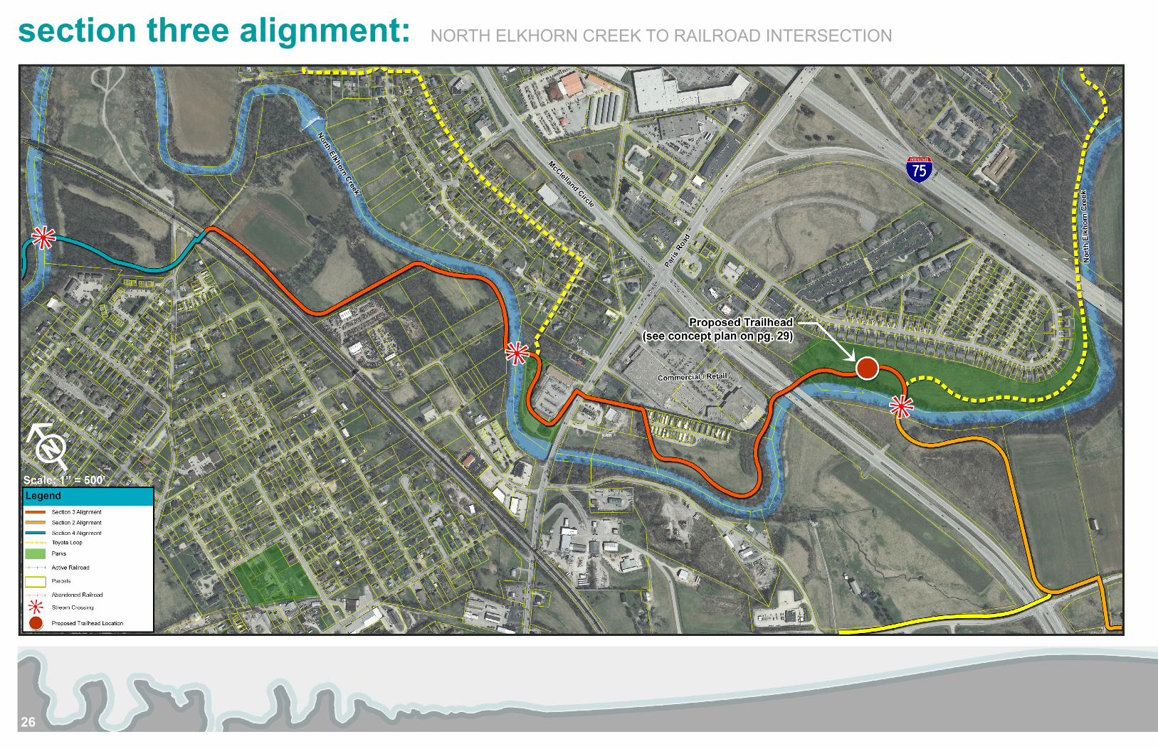
users about ecology and the environment, in particular, North Elkhorn Creek. A wetland project could also be used to mitigate stormwater runoff and protect the creek. A concept plan can be seen on page 29. This trailhead can also serve as a node for connecting to future connections to other trails within the county or to regional network connections. From the trailhead, the trail proceeds west, goes under McClelland Circle and follows North Elkhorn Creek to Paris Pike. There is currently a mobile home park in this location; the FEMA floodplain shows that the mobile home are in the floodplain that may be eligible for floodplain hazard mitigation assistance. The trail then crosses Paris Pike at-grade. This intersection will require traffic analysis to design an appropriate intersection for an already congested area. North of Paris Pike, the trail continues through the public park / boat launch where it crosses the creek with a bridge. The trail follows the creek and through an undeveloped area until it reaches an at-grade railroad crossing.
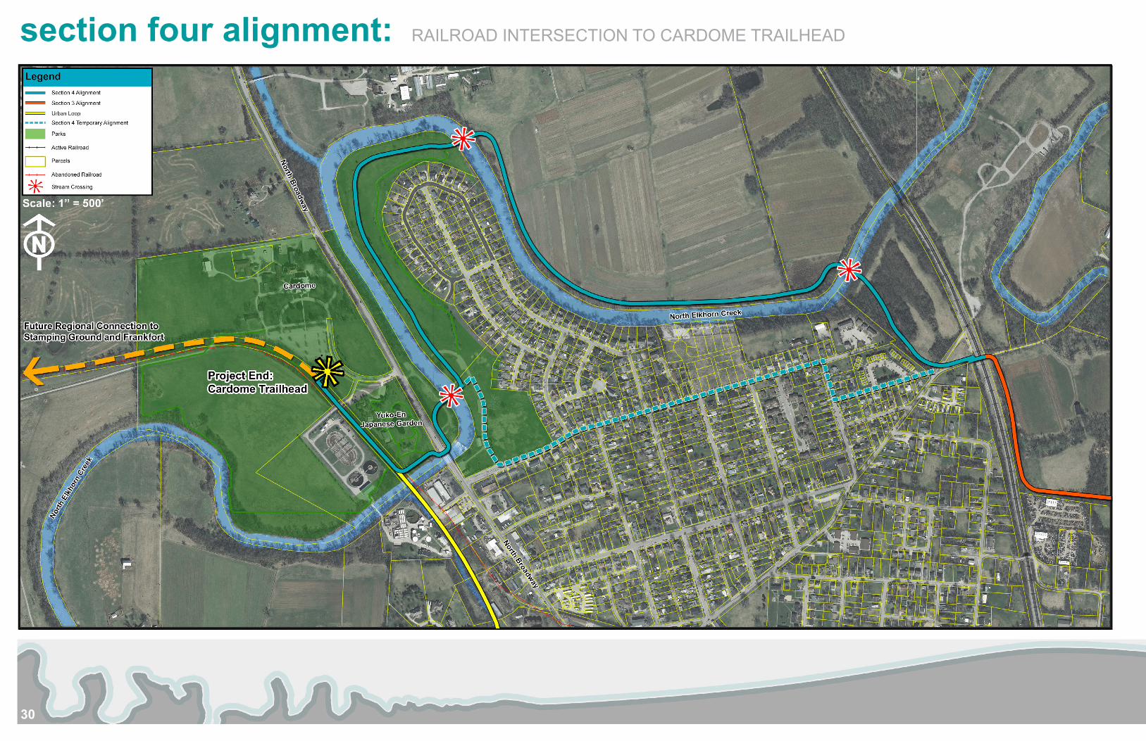
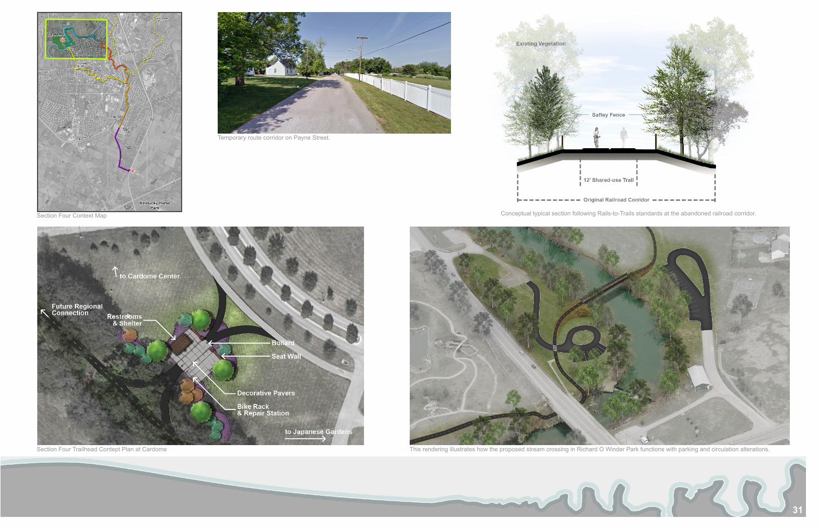
section four: 1.84 milesSection Four begins at the at-grade railroad crossing where the trail then goes north through a wooded parcel to North Elkhorn Creek and crosses to Bi-Water Farm. Bi-Water Farm is an agro-tourism destination in Georgetown, and the incorporation of a shared-use trail on the property would be mutually beneficial. The trail follows parallel to the creek until it crosses into Richard O Winder Park at the Peninsula neighborhood. The trail will meander through the park and cross the creek again to access and existing path under North Broadway. Since stream crossings are expensive and funding for this section may take a long time, a temporary on-street connection on Payne Street could get trail users to Richard O Winder Park. After the trail goes under North Broadway, it follows adjacent the Yuko-En Japanese Garden before it then turns north onto an abandoned railroad corridor. The trail ends at a proposed trailhead at Cardome. The trailhead is located between the Cardome Center and Yuko-En, and there is abundant parking in the adjacent lot at the Cardome Center. This trailhead location also provides the opportunity for future regional network connections to Stamping Ground and Frankfort to the west.
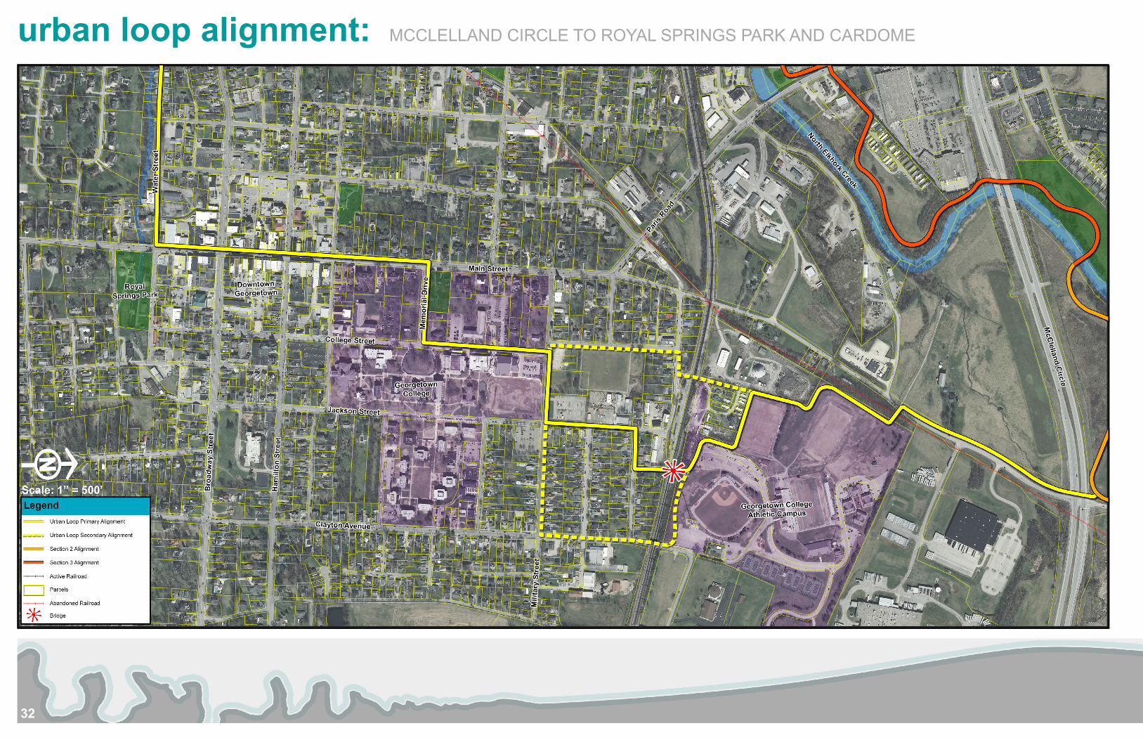
urban loopA connection to downtown Georgetown and Georgetown College’s main and athletic campuses is important. It will provide additional destinations for trail users, bring business to downtown, and provide non-motorized transportation for students. A majority of the Urban Loop will be on street bike lanes, and not the typical section of a shared-use trail. This is the reasoning for proposing this spur connection separately; maintaining an off-road shared-use trail that is consistent with the existing Legacy Trail for the main “spine” of the extension to Georgetown. The Urban Loop will utilize existing plans to connect Cardome to Royal Springs Park (see previous study on pg. 33) by converting Water Street into a linear park. The trail will then go through Downtown on Main Street, and then south on Memorial Drive into Georgetown College. There are several ways the trail could go through campus, but the proposed route uses College Street, Military Street, and Avondale Avenue before it crosses the railroad with a pedestrian bridge into the athletic campus. There is also potential to use an existing walkway over the railroad on Lemons Mill Road to the south. The trail follows the northern perimeter of the athletic campus to Main Street Extension. Following parallel to Main Street Extension, the trail then crosses McClelland Circle and connects with Section Two of the primary alignment.
22
section one alignment: KENTUCKY HORSE PARK TO LEMONS MILL ELEMENTARY
23
Tunnel at Barton Brothers Farm approaching Lisle Road (west of I-75).
Section One Context Map
Conceptual trail section along the railroad corridor. This section of trail will follow Rails-With-Trails design standards to maximize safety with railroad operations and trail users.
Lisle Road crossing Location at the Barton Brothers Farm tunnel. Monon Trail road crossing, Indianapolis, Indiana. This crossing is an example of how lighting and signage can allow for a safe crossing at Lisle Road. Captured from Google Maps Street View.
24
section two alignment: LEMONS MILL ELEMENTARY TO NORTH ELKHORN CREEK
25
Section Two Context Map Typical trail section through the Anderson Communities Development.
View of Lemons Mill Elementary School from proposed trail Corridor. Lemons Mill Road crossing location.
26
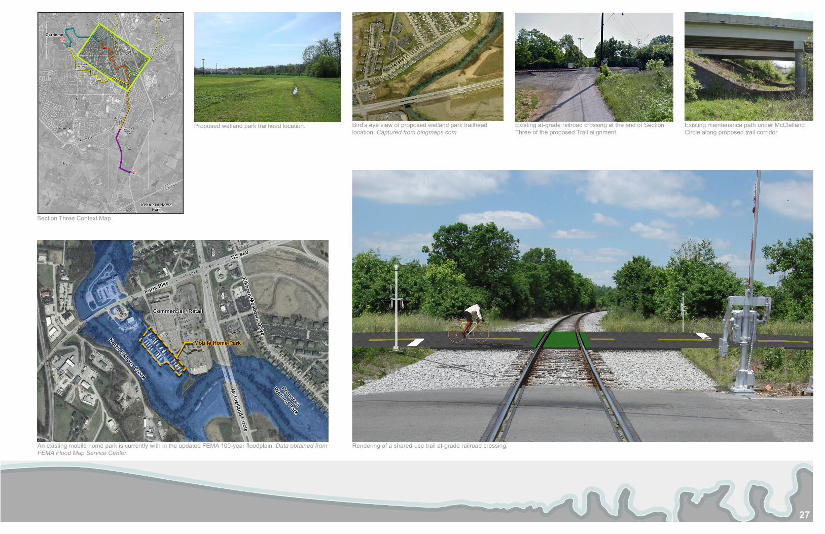
section three alignment: NORTH ELKHORN CREEK TO RAILROAD INTERSECTION
27
Section Three Context Map
Proposed wetland park trailhead location. Bird’s eye view of proposed wetland park trailhead location. Captured from bingmaps.com
An existing mobile home park is currently with in the updated FEMA 100-year floodplain. Data obtained from FEMA Flood Map Service Center.
Rendering of a shared-use trail at-grade railroad crossing.
Existing at-grade railroad crossing at the end of Section Three of the proposed Trail alignment.
Existing maintenance path under McClelland Circle along proposed trail corridor.
28
section one trailhead concept plan
29
section two trailhead and wetland park concept plan
30
section four alignment: RAILROAD INTERSECTION TO CARDOME TRAILHEAD
31
Section Four Context Map
Section Four Trailhead Contept Plan at Cardome This rendering illustrates how the proposed stream crossing in Richard O Winder Park functions with parking and circulation alterations.
Temporary route corridor on Payne Street.
Conceptual typical section following Rails-to-Trails standards at the abandoned railroad corridor.
32
urban loop alignment: MCCLELLAND CIRCLE TO ROYAL SPRINGS PARK AND CARDOME
33
Urban Loop Context Map
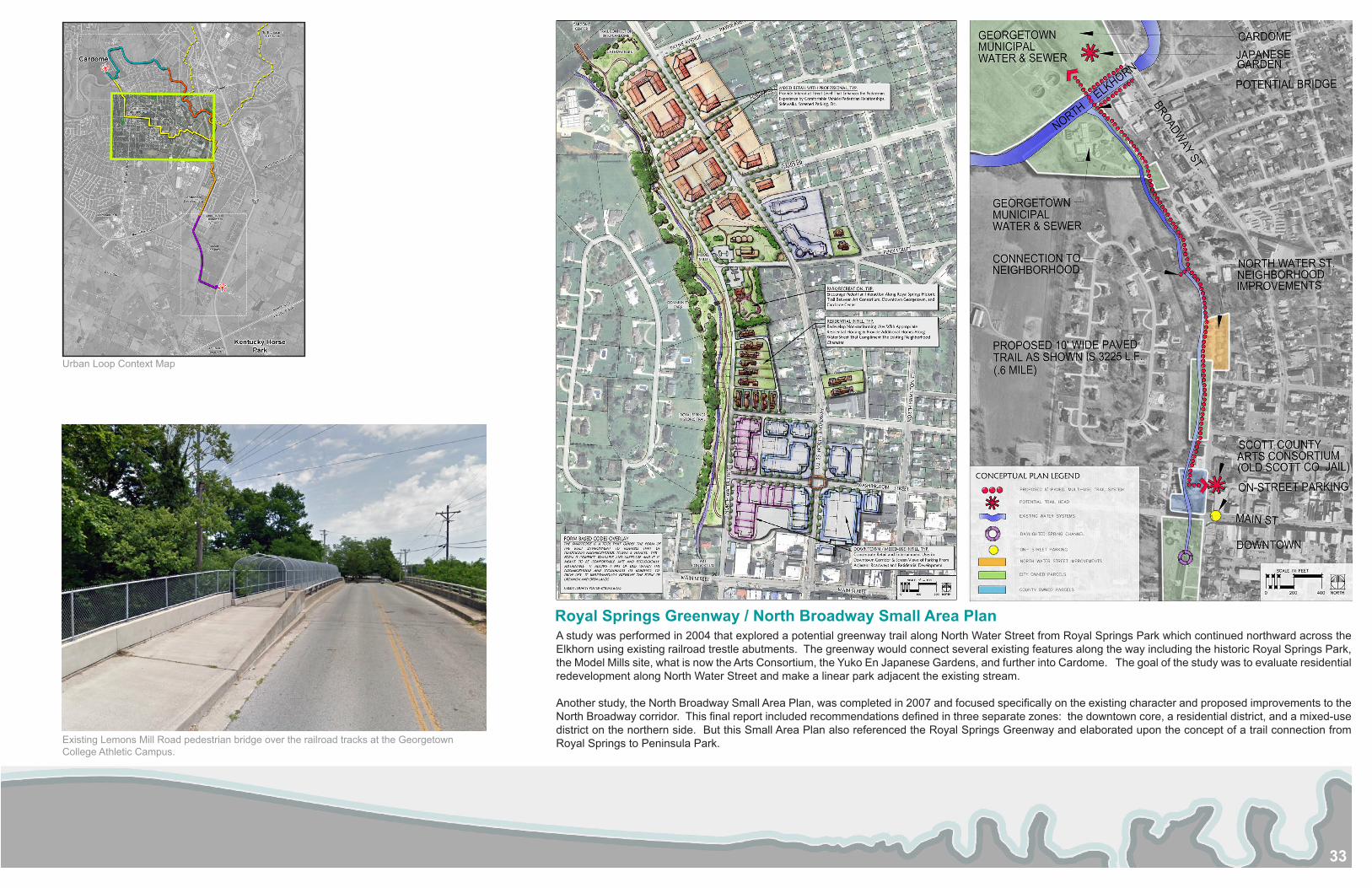
Existing Lemons Mill Road pedestrian bridge over the railroad tracks at the Georgetown College Athletic Campus.
A study was performed in 2004 that explored a potential greenway trail along North Water Street from Royal Springs Park which continued northward across the Elkhorn using existing railroad trestle abutments. The greenway would connect several existing features along the way including the historic Royal Springs Park, the Model Mills site, what is now the Arts Consortium, the Yuko En Japanese Gardens, and further into Cardome. The goal of the study was to evaluate residential redevelopment along North Water Street and make a linear park adjacent the existing stream.
Another study, the North Broadway Small Area Plan, was completed in 2007 and focused specifically on the existing character and proposed improvements to the North Broadway corridor. This final report included recommendations defined in three separate zones: the downtown core, a residential district, and a mixed-use district on the northern side. But this Small Area Plan also referenced the Royal Springs Greenway and elaborated upon the concept of a trail connection from Royal Springs to Peninsula Park.
Royal Springs Greenway / North Broadway Small Area Plan
34
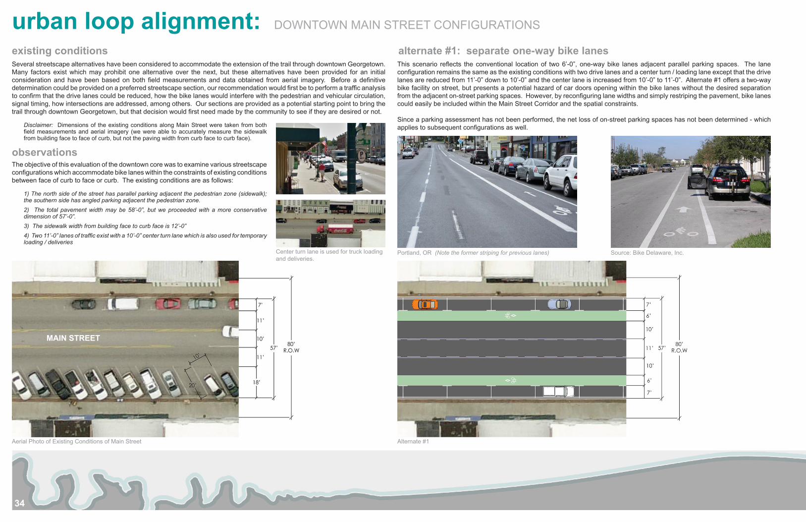
Several streetscape alternatives have been considered to accommodate the extension of the trail through downtown Georgetown. Many factors exist which may prohibit one alternative over the next, but these alternatives have been provided for an initial consideration and have been based on both field measurements and data obtained from aerial imagery. Before a definitive determination could be provided on a preferred streetscape section, our recommendation would first be to perform a traffic analysis to confirm that the drive lanes could be reduced, how the bike lanes would interfere with the pedestrian and vehicular circulation, signal timing, how intersections are addressed, among others. Our sections are provided as a potential starting point to bring the trail through downtown Georgetown, but that decision would first need made by the community to see if they are desired or not.
Disclaimer: Dimensions of the existing conditions along Main Street were taken from both field measurements and aerial imagery (we were able to accurately measure the sidewalk from building face to face of curb, but not the paving width from curb face to curb face).
observationsThe objective of this evaluation of the downtown core was to examine various streetscape configurations which accommodate bike lanes within the constraints of existing conditions between face of curb to face or curb. The existing conditions are as follows:
1) The north side of the street has parallel parking adjacent the pedestrian zone (sidewalk); the southern side has angled parking adjacent the pedestrian zone.2) The total pavement width may be 58’-0”, but we proceeded with a more conservative dimension of 57’-0”.3) The sidewalk width from building face to curb face is 12’-0”4) Two 11’-0” lanes of traffic exist with a 10’-0” center turn lane which is also used for temporary loading / deliveries
This scenario reflects the conventional location of two 6’-0”, one-way bike lanes adjacent parallel parking spaces. The lane configuration remains the same as the existing conditions with two drive lanes and a center turn / loading lane except that the drive lanes are reduced from 11’-0” down to 10’-0” and the center lane is increased from 10’-0” to 11’-0”. Alternate #1 offers a two-way bike facility on street, but presents a potential hazard of car doors opening within the bike lanes without the desired separation from the adjacent on-street parking spaces. However, by reconfiguring lane widths and simply restriping the pavement, bike lanes could easily be included within the Main Street Corridor and the spatial constraints.
Since a parking assessment has not been performed, the net loss of on-street parking spaces has not been determined - which applies to subsequent configurations as well.
existing conditions alternate #1: separate one-way bike lanes
Aerial Photo of Existing Conditions of Main Street Alternate #1
Portland, OR (Note the former striping for previous lanes)Center turn lane is used for truck loading and deliveries.
Source: Bike Delaware, Inc.
MAIN STREET
urban loop alignment: DOWNTOWN MAIN STREET CONFIGURATIONS
35
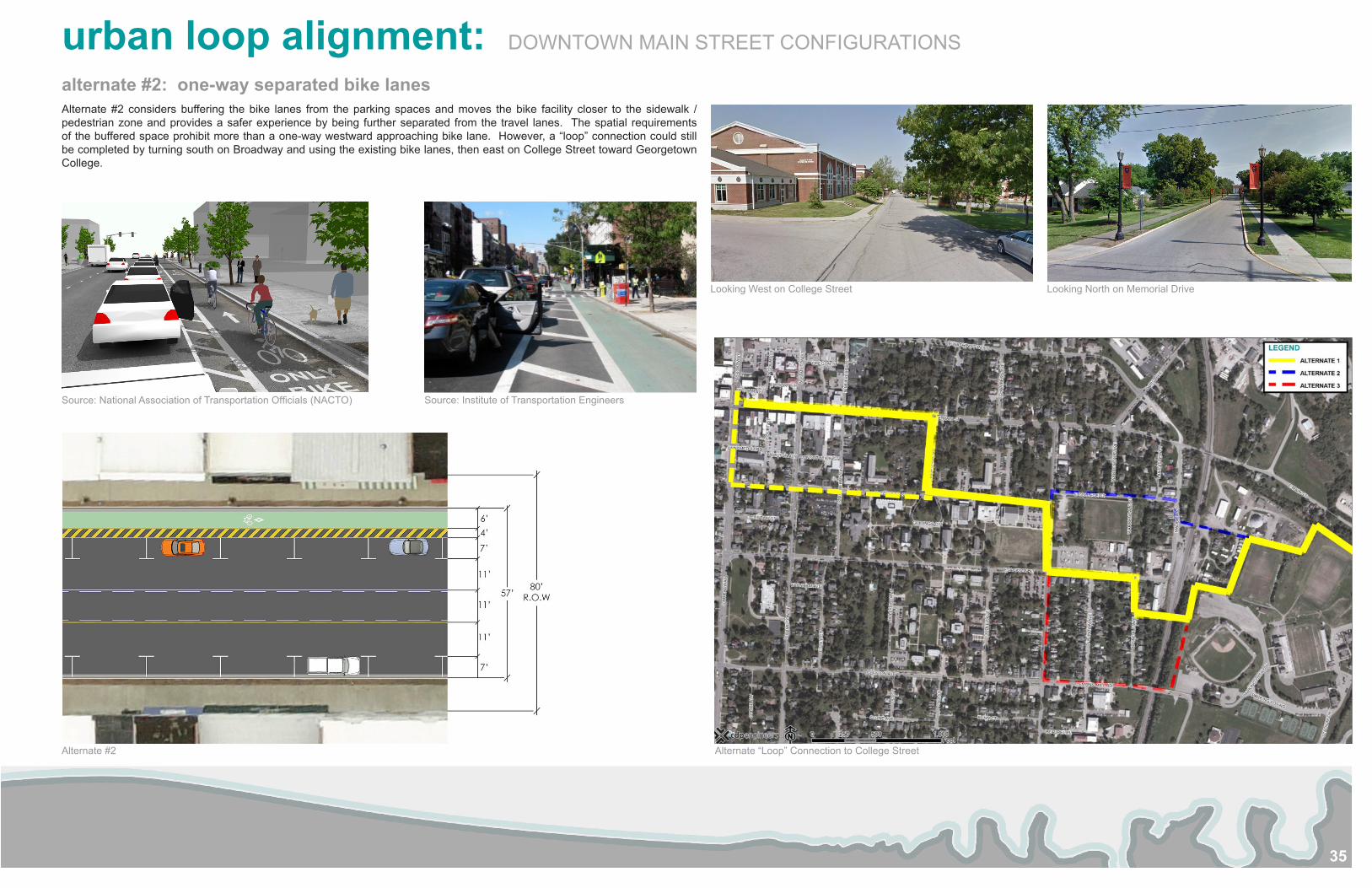
Alternate #2 considers buffering the bike lanes from the parking spaces and moves the bike facility closer to the sidewalk / pedestrian zone and provides a safer experience by being further separated from the travel lanes. The spatial requirements of the buffered space prohibit more than a one-way westward approaching bike lane. However, a “loop” connection could still be completed by turning south on Broadway and using the existing bike lanes, then east on College Street toward Georgetown College.
alternate #2: one-way separated bike lanes
Alternate #2
Source: National Association of Transportation Officials (NACTO) Source: Institute of Transportation Engineers
Looking West on College Street Looking North on Memorial Drive
Alternate “Loop” Connection to College Street
urban loop alignment: DOWNTOWN MAIN STREET CONFIGURATIONS
36
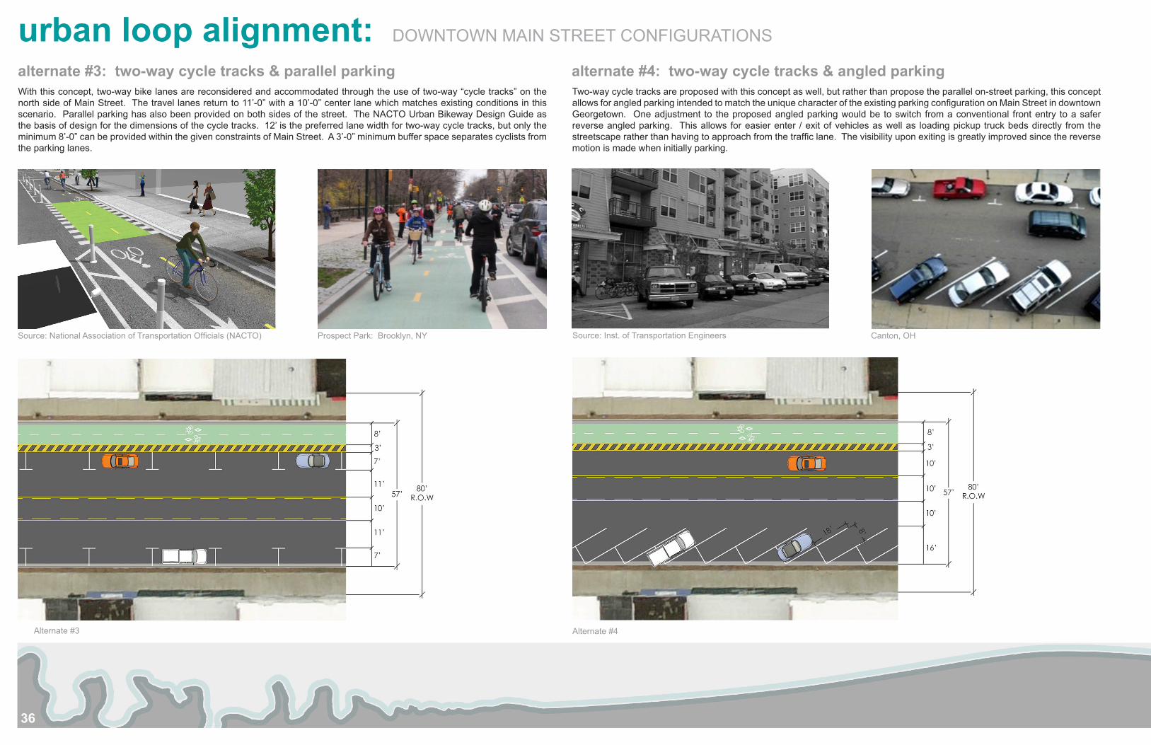
With this concept, two-way bike lanes are reconsidered and accommodated through the use of two-way “cycle tracks” on the north side of Main Street. The travel lanes return to 11’-0” with a 10’-0” center lane which matches existing conditions in this scenario. Parallel parking has also been provided on both sides of the street. The NACTO Urban Bikeway Design Guide as the basis of design for the dimensions of the cycle tracks. 12’ is the preferred lane width for two-way cycle tracks, but only the minimum 8’-0” can be provided within the given constraints of Main Street. A 3’-0” minimum buffer space separates cyclists from the parking lanes.
Two-way cycle tracks are proposed with this concept as well, but rather than propose the parallel on-street parking, this concept allows for angled parking intended to match the unique character of the existing parking configuration on Main Street in downtown Georgetown. One adjustment to the proposed angled parking would be to switch from a conventional front entry to a safer reverse angled parking. This allows for easier enter / exit of vehicles as well as loading pickup truck beds directly from the streetscape rather than having to approach from the traffic lane. The visibility upon exiting is greatly improved since the reverse motion is made when initially parking.
alternate #3: two-way cycle tracks & parallel parking alternate #4: two-way cycle tracks & angled parking
Alternate #3
Source: National Association of Transportation Officials (NACTO) Prospect Park: Brooklyn, NY Source: Inst. of Transportation Engineers Canton, OH
Alternate #4
urban loop alignment: DOWNTOWN MAIN STREET CONFIGURATIONS
37
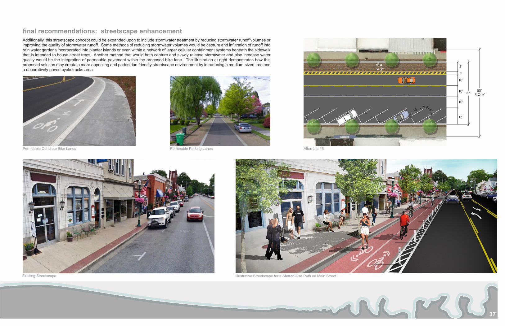
Additionally, this streetscape concept could be expanded upon to include stormwater treatment by reducing stormwater runoff volumes or improving the quality of stormwater runoff. Some methods of reducing stormwater volumes would be capture and infiltration of runoff into rain water gardens incorporated into planter islands or even within a network of larger cellular containment systems beneath the sidewalk that is intended to house street trees. Another method that would both capture and slowly release stormwater and also increase water quality would be the integration of permeable pavement within the proposed bike lane. The illustration at right demonstrates how this proposed solution may create a more appealing and pedestrian friendly streetscape environment by introducing a medium-sized tree and a decoratively paved cycle tracks area.
Permeable Concrete Bike Lanes Permeable Parking Lanes
final recommendations: streetscape enhancement
Existing Streetscape Illustrative Streetscape for a Shared-Use Path on Main Street
Alternate #5
38
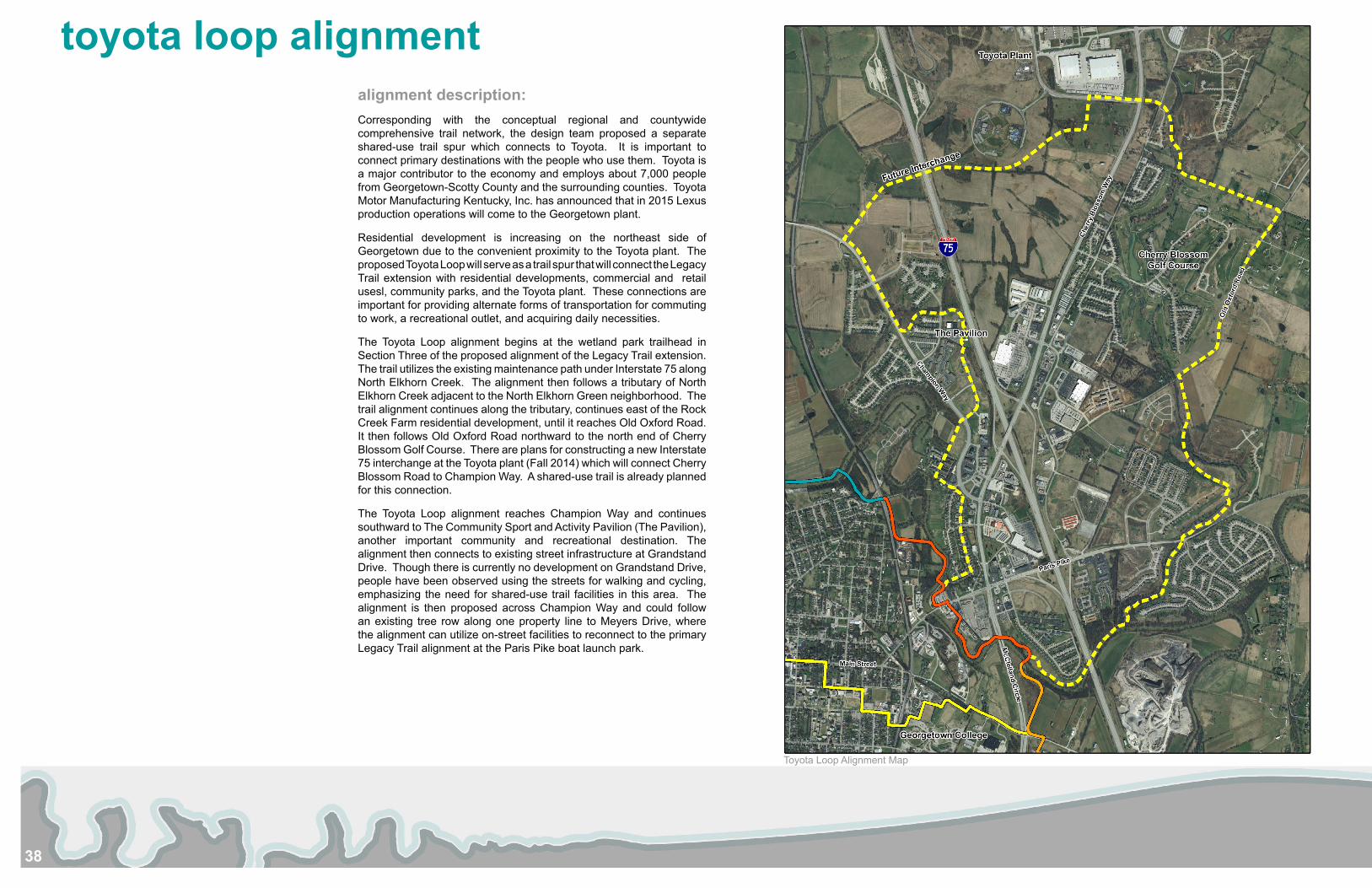
toyota loop alignmentalignment description:Corresponding with the conceptual regional and countywide comprehensive trail network, the design team proposed a separate shared-use trail spur which connects to Toyota. It is important to connect primary destinations with the people who use them. Toyota is a major contributor to the economy and employs about 7,000 people from Georgetown-Scotty County and the surrounding counties. Toyota Motor Manufacturing Kentucky, Inc. has announced that in 2015 Lexus production operations will come to the Georgetown plant.
Residential development is increasing on the northeast side of Georgetown due to the convenient proximity to the Toyota plant. The proposed Toyota Loop will serve as a trail spur that will connect the Legacy Trail extension with residential developments, commercial and retail usesl, community parks, and the Toyota plant. These connections are important for providing alternate forms of transportation for commuting to work, a recreational outlet, and acquiring daily necessities.
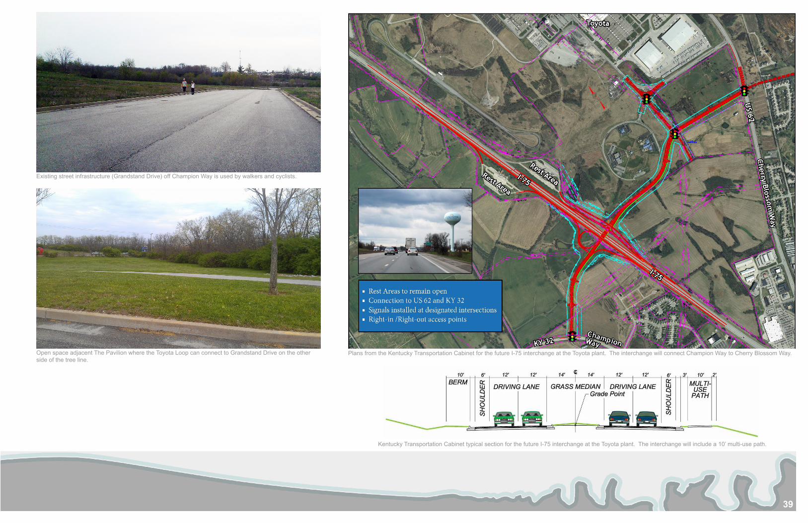
The Toyota Loop alignment begins at the wetland park trailhead in Section Three of the proposed alignment of the Legacy Trail extension. The trail utilizes the existing maintenance path under Interstate 75 along North Elkhorn Creek. The alignment then follows a tributary of North Elkhorn Creek adjacent to the North Elkhorn Green neighborhood. The trail alignment continues along the tributary, continues east of the Rock Creek Farm residential development, until it reaches Old Oxford Road. It then follows Old Oxford Road northward to the north end of Cherry Blossom Golf Course. There are plans for constructing a new Interstate 75 interchange at the Toyota plant (Fall 2014) which will connect Cherry Blossom Road to Champion Way. A shared-use trail is already planned for this connection.
The Toyota Loop alignment reaches Champion Way and continues southward to The Community Sport and Activity Pavilion (The Pavilion), another important community and recreational destination. The alignment then connects to existing street infrastructure at Grandstand Drive. Though there is currently no development on Grandstand Drive, people have been observed using the streets for walking and cycling, emphasizing the need for shared-use trail facilities in this area. The alignment is then proposed across Champion Way and could follow an existing tree row along one property line to Meyers Drive, where the alignment can utilize on-street facilities to reconnect to the primary Legacy Trail alignment at the Paris Pike boat launch park.
Toyota Loop Alignment Map
39
Existing street infrastructure (Grandstand Drive) off Champion Way is used by walkers and cyclists.
Open space adjacent The Pavilion where the Toyota Loop can connect to Grandstand Drive on the other side of the tree line.
Plans from the Kentucky Transportation Cabinet for the future I-75 interchange at the Toyota plant. The interchange will connect Champion Way to Cherry Blossom Way.
Kentucky Transportation Cabinet typical section for the future I-75 interchange at the Toyota plant. The interchange will include a 10’ multi-use path.
40
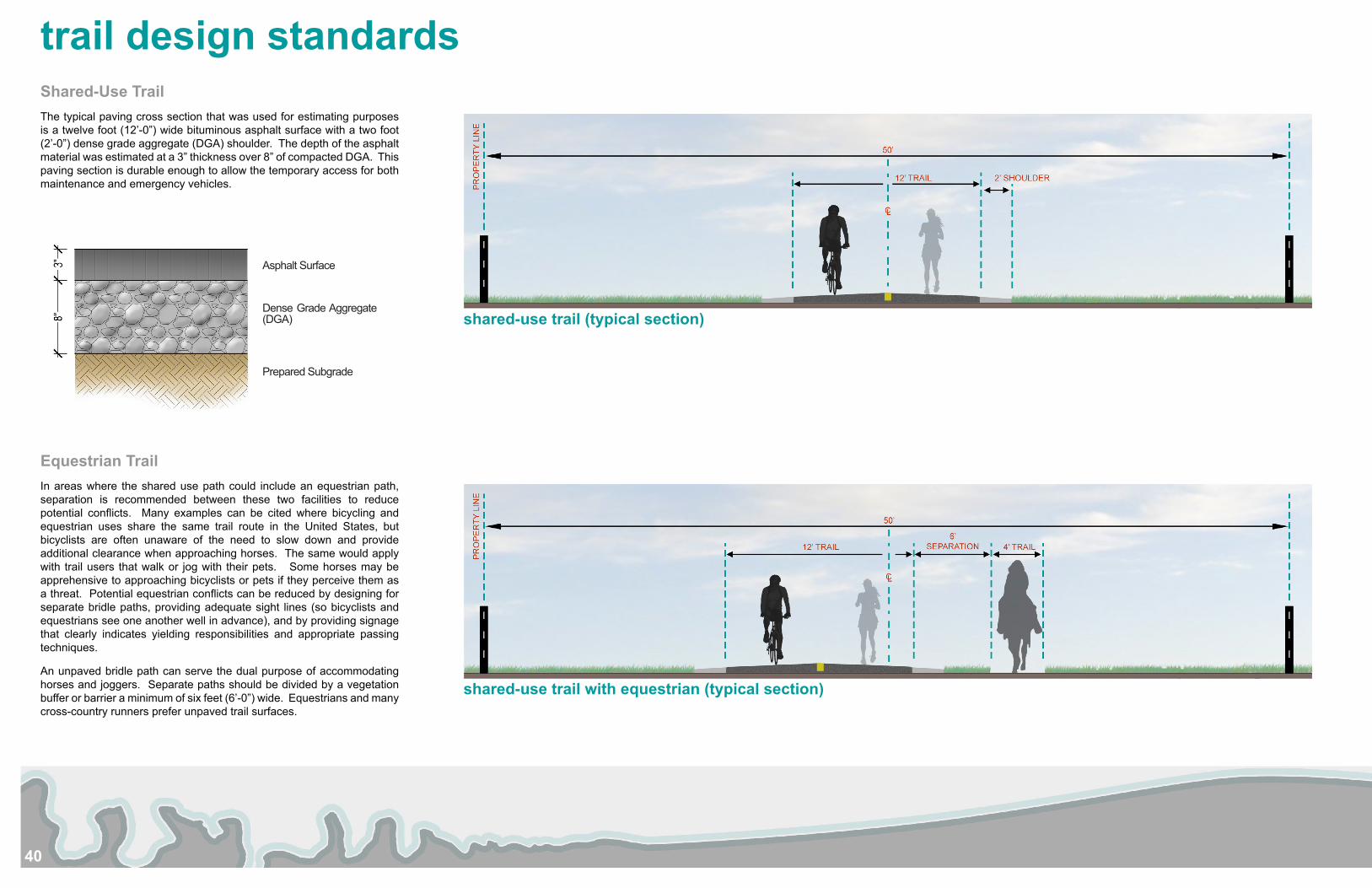
Shared-Use TrailThe typical paving cross section that was used for estimating purposes is a twelve foot (12’-0”) wide bituminous asphalt surface with a two foot (2’-0”) dense grade aggregate (DGA) shoulder. The depth of the asphalt material was estimated at a 3” thickness over 8” of compacted DGA. This paving section is durable enough to allow the temporary access for both maintenance and emergency vehicles.
Equestrian TrailIn areas where the shared use path could include an equestrian path, separation is recommended between these two facilities to reduce potential conflicts. Many examples can be cited where bicycling and equestrian uses share the same trail route in the United States, but bicyclists are often unaware of the need to slow down and provide additional clearance when approaching horses. The same would apply with trail users that walk or jog with their pets. Some horses may be apprehensive to approaching bicyclists or pets if they perceive them as a threat. Potential equestrian conflicts can be reduced by designing for separate bridle paths, providing adequate sight lines (so bicyclists and equestrians see one another well in advance), and by providing signage that clearly indicates yielding responsibilities and appropriate passing techniques.
An unpaved bridle path can serve the dual purpose of accommodating horses and joggers. Separate paths should be divided by a vegetation buffer or barrier a minimum of six feet (6’-0”) wide. Equestrians and many cross-country runners prefer unpaved trail surfaces.
trail design standards
shared-use trail (typical section)
shared-use trail with equestrian (typical section)
Asphalt Surface
Dense Grade Aggregate (DGA)
Prepared Subgrade
41
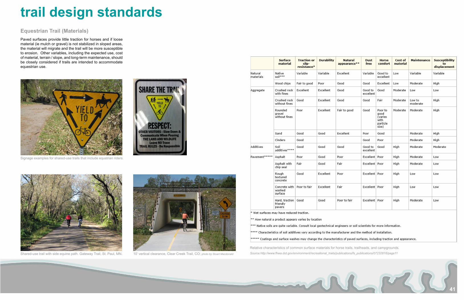
trail design standardsEquestrian Trail (Materials)Paved surfaces provide little traction for horses and if loose material (ie mulch or gravel) is not stabilized in sloped areas, the material will migrate and the trail will be more susceptible to erosion. Other variables, including the expected use, cost of material, terrain / slope, and long-term maintenance, should be closely considered if trails are intended to accommodate equestrian use.
Relative characteristics of common surface materials for horse trails, trailheads, and campgrounds. Source:http://www.fhwa.dot.gov/environment/recreational_trails/publications/fs_publications/07232816/page11
Signage examples for shared-use trails that include equstrian riders.
Shared-use trail with side equine path. Gateway Trail, St. Paul, MN. 10’ vertical clearance, Clear Creek Trail, CO; photo by Stuart Macdonald
42
Property negotiations and / or easement acquisition on known affected properties for the initial trail sections could begin immediately.
Additionally, there are funds available through the U.S. Department of Homeland Security Federal Emergency Management Agency (FEMA) that provides states and local governments funding to purchase parcels that are known to be impacted during flood events. The Hazard Mitigation Assistance (HMA) Unified Guidance specifically intends to reduce or eliminate the long-term risk to people and property from damage resulting from natural disasters. Within the HMA Unified Guidance, there are five programs outlined for funding:
1. Hazard Mitigation Grant Program (HMGP)HMGP is available, when authorized under a Presidential major disaster declaration, in the areas of the State requested by the Governor.
2. Pre-Disaster Mitigation (PDM)The PDM program is designed to assist States, Territories, Indian Tribal governments, and local communities to implement a sustained pre-disaster natural hazard mitigation program to reduce overall risk to the population and structures from future hazard events, while also reducing reliance on Federal funding from future disasters.
3. Flood Mitigation Assistance (FMA)
The FMA program is authorized with the goal of reducing or eliminating claims under the National Flood Insurance Program (NFIP).
4. Repetitive Flood Claims (RFC)
It is the goal of the RFC program to reduce flood damages to individual properties for which one or more claim payments for losses have been made under flood insurance coverage and that will result in the greatest savings to the National Flood Insurance Fund (NFIF) in the shortest period of time
5. Severe Repetitive Loss (SRL)
The SRL program is authorized with the goal of reducing flood damages to residential properties that have experienced severe repetitive losses under flood insurance coverage and that will result in the greatest savings to the NFIF in the shortest period of time.
Source: Hazard Mitigation Assistance Unified Guidance
While the statutory origins of the programs differ, all share the common goal of reducing the risk of loss of life and property due to natural hazards. One potential application could consider the mobile homes and some adjacent parcels located south of Paris Pike and west of McClelland. According to the FEMA Flood Insurance Rate (FIRM) map, nearly all the mobile homes and the adjacent parcels south of Paris Road are located within the floodplain:
If subject parcels have had histories of claimed damages, they are eligible to receive funding. They may also be eligible to receive Pre-Disaster Mitigation (PDM) funding by simply being located within the AE Zone of the floodplain.
PermittingVarious permits will be required to develop the entire Legacy Trail plan. The following is a brief listing of probable required permits:
Local – Local permits for right of way encroachments or other activities will be required.
Railroad – Railroad permits will be required if any direct or indirect construction is placed on railroad right of way. This could include culvert or stream redirection, bridges or underpasses, utilized portions of right of way for the project or crossing the railroad, even at locations where there are existing road crossings.
Kentucky Transportation Cabinet – KYTC permits will be required on all state maintained right of way
Kentucky eClearinghouse – The submission of documentation to the eClearinghouse will be required to obtain environmental clearance for any portions of the project that include state or federal funding. The eClearinghouse will obtain comments for the Kentucky Fish and Wildlife Department as well as the State Historic Preservation Office, addressing topics such as historic properties, floodplain management, wetlands protection, endangered species, and farmlands protection. This covers basic (or Phase 1) environmental assessment. Additional environmental review has not been considered in this estimate.
US Army Corps of Engineers – Section 404 Permit. Section 404 of the Clean Water Act regulates the discharge of dredged and fill material into the waters of the United States, including rivers, lakes streams and most wetlands. Regulated activities include
fills, water resource projects, infrastructure development.
Kentucky Division of Water:
Floodplain Construction Permit. The Kentucky Division of Water, Floodplain Management Section has the primary responsibility for the approval or denial of proposed construction and other activities in the 100-year floodplain of all streams in the Commonwealth. Typical activities permitted are dams, bridges, culverts, residential and commercial buildings, placement of fill, stream alterations or relocations, small impoundments and water and wastewater treatment plants.
401 KAR, Water Quality Certification Permit. The §401 Water Quality Certification Program of the Kentucky Division of Water is the Commonwealth’s review and authorization of selected federal license and permits. Activities that may require a certification from the Kentucky Division of Water, Water Quality Certification Section include:
• Placement of dredged or fill materials into waters of the state and/or wetlands
• Structural fill such as culverts and bridge supports
• Road and utility crossings
• Dredging, excavation, channel widening, or straightening
• Flooding, excavating, draining and/or filling a wetland
• Bank sloping; stabilization
• Stream channel relocation
• Water diversions
• Divert, obstruct or change the natural flow or bed of any waters of the state (e.g. debris removal, bank stabilization or culverting)
• Construct a barrier across a stream, channel, or watercourse that will create a reservoir: dams, weirs, dikes, levees or other similar structures
Funding SourcesThough other methods of securing funding exist, the following may be the most applicable for the intended design and construction of the proposed Legacy Trail Extension project:
Transportation Alternatives Program (TAP)• 80% / 20% Match• $13 Million for KY in FY 2014
Congestion Mitigation and Air Quality (CMAQ)• $10 Million for KY in 2014 (apart from TAP)
Recreational Trails Program (RTP)• 50% / 50% Match• $100K Maximum grant amount• $1.4 Million for KY (apart from TAP)
Tax Incremental Financing (TIF)• Allows a portion of tax revenue generated from private development in blighted areas to be used for public infrastructure improvements.
USEPA Clean Water Act - Section 319 Grants• A program that provides funding for projects designed to mitigate nonpoint source pollution that can demonstrate improvements to storm water quality.
Corporate / Private SponsorsThe 2010 World Equestrian Games was the catalyst for the Legacy Trail. For a major trail development to advance further, having support outside the public sector will be an important factor. Being able to demonstrate the interest, or better still, the commitment of an outside sponsor will add additional leverage to the interest developed by the community which will be expected to continue by the local government agencies, in our case is Georgetown - Scott County.
A remarkable (and possibly similar) example to cite for the Trans Canada Trail was the corporate involvement of Diamler - Chrysler (now Jeep) as a major supporter. The Trans Canada Trail is the world’s largest trail network with 14,000 miles planned and 10,400 miles of currently usable trail. Diamler - Chrysler sponsored a pavilion with donors names inscribed on panels and developed a program where donors could “own” a linear stretch of trail according to their sponsorship level.
The similar comparison for Georgetown would be Toyota. The manufacturer plays such an important role in the community. The contributions of this corporation would not need to be substantial, but the leverage with government and in generating overall public interest would be remarkable to further generate enthusiasm for the succes of the Legacy Trail Extension.
implementation strategiesProperty Acquisition
43
preliminary costs
Right Of Way / Property Requirements:The category of Property Requirements considers the land necessary to construct the proposed trail and how property will be acquired. Land for the trail will include property currently owned by the Georgetown-Scott County Government, donated land, access easements, or fee-simple purchase, that will need to be purchased from private land owners and recorded as a conservation easement or dedicated as public land. Though some property owners have pledged their support and intend to donate access easement in locations, no property has been designated at the conclusion of this study. Values for this land have been included in the figures listed for property to be acquired as a maximum dollar figure for acquisition and the total project cost has been reflected accordingly.
For the purpose of developing this opinion of probable cost, various property values obtained from the Georgetown Scott County PVA have been gathered and averaged for residential, commercial, and agricultural land uses. The recommended width of Right of Way is 50’. The average width of 40’-0” has been used for estimating purposes, recognizing there will be some narrow sections in developed areas. The desired width in rural areas, outside our focused study area, may be increased to accommodate equestrian use.
Construction:The following is a summary of the construction items that were considered, but have been condensed into the individual trail sections:
General Conditions include construction staking, mobilization of construction equipment, maintenance of traffic, and demobilization.
Demolition considers the work associated with site protection devices, protection of existing trees to remain, clearing and grubbing of vegetation to be removed, and the disposal of additional features to be removed.
Proposed Improvements:The proposed improvements category includes figures for materials (asphalt riding surface, stone base, fencing, etc.) and labor associated with the trail construction, installation and maintenance of sediment and erosion control measures, necessary modifications to existing streets (when applicable), “at-grade” street crossings, railroad crossings, fencing, mile markers, and general site restoration.
Trailhead and Amenities includes restroom facilities, pavement (both asphalt and concrete where applicable), plantings, site furnishings (bollards, seating, bike racks, trash receptacles, and lighting), bicycle repair stations, interpretive or orientation signage, stone and/or brick monuments, and all required utilities (water, electric, and sanitary sewer). This category would include pavement associated with the trailhead and vehicular use areas only. Figures associated with trail
construction are considered within the “Proposed Improvements” category.
Storm Drainage considers the piping, headwall structures, labor, materials, and incidentals required to complete the storm drainage improvements required to manage storm water runoff.
Stream Crossings include the cost associated with the manufacturing of pre-fabricated bridges, their delivery, construction, decking material, installation of structural footings and abutments, wing-walls, and guardrails.
Miscellaneous items include the relocation of utilities, signage / signal requirements, pavement striping, and permitting.
Design Fees:Design Fees can be expected to vary according to section, but in general, this category includes the civil / site design requirements for the trail alignment as well as grading and drainage. Additionally, the design fees can include geotechnical engineering, structural design for proposed stream crossings along the trail, and construction observation / reporting requirements.
Opinion of Probable Cost
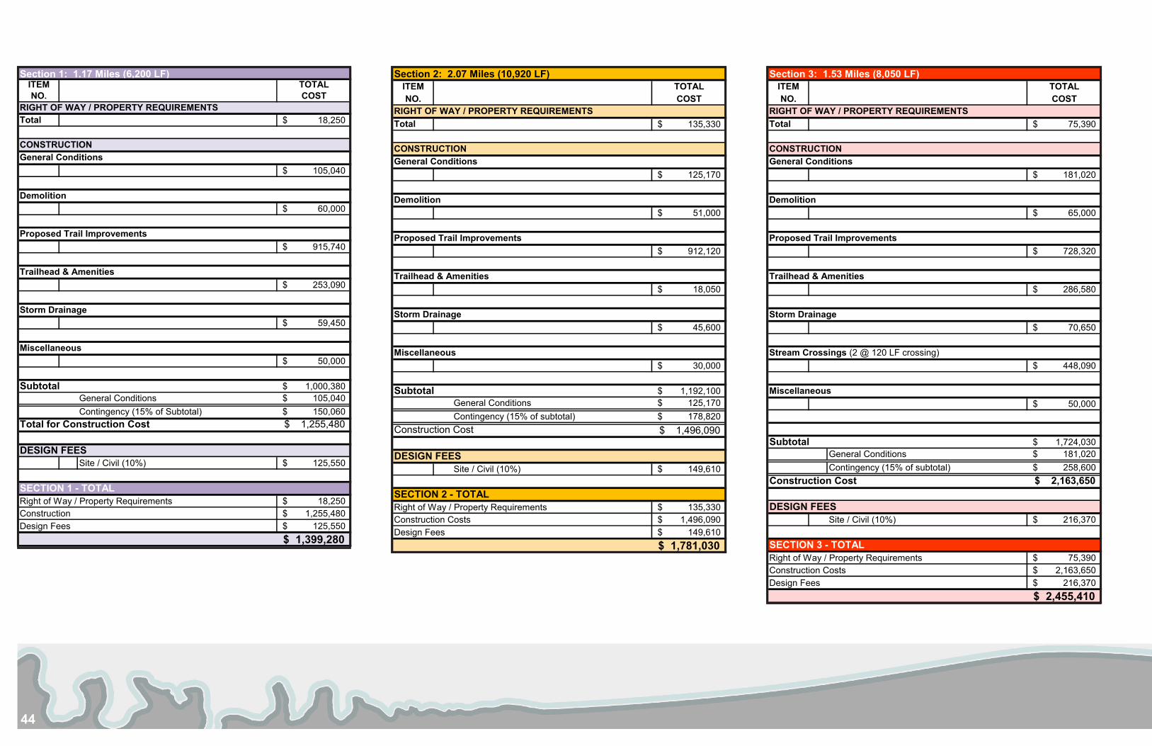
44
ITEM TOTALNO. COST
Total 135,330$
125,170$
51,000$
912,120$
18,050$
45,600$
30,000$
1,192,100$ General Conditions 125,170$ Contingency (15% of subtotal) 178,820$
Construction Cost 1,496,090$
Site / Civil (10%) 149,610$
Right of Way / Property Requirements 135,330$ Construction Costs 1,496,090$ Design Fees 149,610$
1,781,030$
Storm Drainage
Miscellaneous
Subtotal
DESIGN FEES
SECTION 2 - TOTAL
RIGHT OF WAY / PROPERTY REQUIREMENTS
CONSTRUCTIONGeneral Conditions
Demolition
Proposed Trail Improvements
Trailhead & Amenities
Section 2: 2.07 Miles (10,920 LF)ITEM TOTALNO. COST
Total 75,390$
181,020$
65,000$
728,320$
286,580$
70,650$
448,090$
50,000$
1,724,030$ General Conditions 181,020$ Contingency (15% of subtotal) 258,600$
Construction Cost 2,163,650$
Site / Civil (10%) 216,370$
Right of Way / Property Requirements 75,390$ Construction Costs 2,163,650$ Design Fees 216,370$
2,455,410$
Stream Crossings (2 @ 120 LF crossing)
Miscellaneous
Subtotal
DESIGN FEES
SECTION 3 - TOTAL
CONSTRUCTIONGeneral Conditions
Demolition
Proposed Trail Improvements
Trailhead & Amenities
Storm Drainage
RIGHT OF WAY / PROPERTY REQUIREMENTS
Section 3: 1.53 Miles (8,050 LF)ITEM TOTALNO. COST
Total 18,250$
105,040$
60,000$
915,740$
253,090$
59,450$
50,000$
1,000,380$ General Conditions 105,040$ Contingency (15% of Subtotal) 150,060$
Total for Construction Cost 1,255,480$
Site / Civil (10%) 125,550$
Right of Way / Property Requirements 18,250$ Construction 1,255,480$ Design Fees 125,550$
1,399,280$
SECTION 1 - TOTAL
Proposed Trail Improvements
Trailhead & Amenities
Storm Drainage
Miscellaneous
Subtotal
DESIGN FEES
General Conditions
Demolition
Section 1: 1.17 Miles (6,200 LF)
RIGHT OF WAY / PROPERTY REQUIREMENTS
CONSTRUCTION
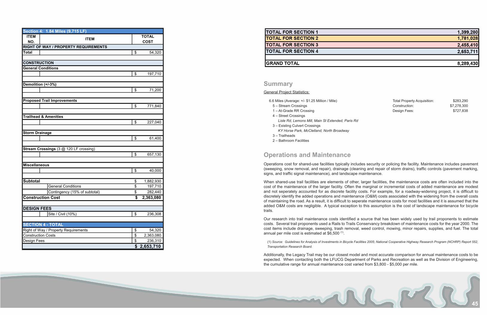
45
SummaryGeneral Project Statistics:
6.6 Miles (Average: +/- $1.25 Million / Mile) Total Property Acquisition: $283,290 5 – Stream Crossings Construction: $7,278,3001 – At-Grade RR Crossing Design Fees: $727,8384 – Street Crossings
Lisle Rd, Lemons Mill, Main St Extended, Paris Rd3 – Existing Culvert Crossings
KY Horse Park, McClelland, North Broadway3 – Trailheads 2 – Bathroom Facilities
Operations and MaintenanceOperations cost for shared-use facilities typically includes security or policing the facility. Maintenance includes pavement (sweeping, snow removal, and repair), drainage (cleaning and repair of storm drains), traffic controls (pavement marking, signs, and traffic signal maintenance), and landscape maintenance.
When shared-use trail facilities are elements of other, larger facilities, the maintenance costs are often included into the cost of the maintenance of the larger facility. Often the marginal or incremental costs of added maintenance are modest and not seperately accounted for as discrete facility costs. For example, for a roadway-widening project, it is difficult to discretely identify the added operations and maintenance (O&M) costs associated with the widening from the overall costs of maintaining the road. As a result, it is difficult to seperate maintenance costs for most facilities and it is assumed that the added O&M costs are negligible. A typical exception to this assumption is the cost of landscape maintenance for bicycle trails.
Our research into trail maintenance costs identified a source that has been widely used by trail proponents to estimate costs. Several trail proponents used a Rails to Trails Conservancy breakdown of maintenance costs for the year 2000. The cost items include drainage, sweeping, trash removal, weed control, mowing, minor repairs, supplies, and fuel. The total annual per mile cost is estimated at $6,500 (1).
(1) Source: Guidelines for Analysis of Investments in Bicycle Facilities 2005; National Cooperative Highway Research Program (NCHRP) Report 552, Transportation Research Board.
Additionally, the Legacy Trail may be our closest model and most accurate comparison for annual maintenance costs to be expected. When contacting both the LFUCG Department of Parks and Recreation as well as the Division of Engineering, the cumulative range for annual maintenance cost varied from $3,800 - $5,000 per mile.
ITEM TOTALNO. COST
Total 54,320$
197,710$
71,200$
771,840$
227,040$
61,400$
657,130$
40,000$
1,882,930$ General Conditions 197,710$ Contingency (15% of subtotal) 282,440$
Construction Cost 2,363,080$
Site / Civil (10%) 236,308$
Right of Way / Property Requirements 54,320$ Construction Costs 2,363,080$ Design Fees 236,310$
2,653,710$
Subtotal
DESIGN FEES
SECTION 4 - TOTAL
General Conditions
Demolition (+/-3%)
Proposed Trail Improvements
Trailhead & Amenities
Storm Drainage
Stream Crossings (3 @ 120 LF crossing)
ITEM
RIGHT OF WAY / PROPERTY REQUIREMENTS
CONSTRUCTION
Miscellaneous
Section 4: 1.84 Miles (9,715 LF)
46
summary and final recommendationsThe Legacy Trail Extension through Scott County should be considered a long range plan that may take longer than 10 years to implement. However the phasing of the various sections or components can begin immediately and should. It is the intent of this study to serve as a guide for future grant applications. It is important to outline projects in advance so that when funding becomes available, there is a trail component or feature that can be pursued as part of a larger plan. Here is a tentative schedule for the extents of the proposed trail sections:
Section Two: 1 – 2 years Section One: 2 – 3 years Section Three: 3 – 5 years Section Four: 5 – 10 years (and Urban Loop)
Additionally, there could be certain components, such as trailhead features that are designed and constructed separately from the larger section of trail. Take for example the trailhead at the existing Scott County Soccer Complex proposed as part of Trail Section One. This trailhead feature could be phased for construction prior to the design and installation of the trail because it could serve the community as a facility before the trail is constructed, but simultaneously be used to generate interest in the trail project. By classifying the feature as a trailhead, this component would be eligible to receive matching grant funds through Recreational Trails Program or Transportation Alternative Programs for design and construction.
The trailhead concept shown in Section 3 that is referred to as “Wetland Park” would require fill to be placed in the approaches to the bridge crossing. Since this area is located within the floodplain, there would need to be additional containment area provided which would counter any decreased capacity within the floodplain resulting from the added fill used in the approaches. The excavated areas could be designed as restored wetland habitat and could be funded in part with Federal 319(h) – Clean Water Act money if the project demonstrates an improvement to water quality. There are also numerous funding sources available through the following federal agencies: US Fish & Wildlife, Natural Resources Conservation Service (NRCS), USDA Forest Service; and the following state agencies: Department of Natural Resources, Fish and Wildlife Management, and the Division of Water Quality. The use of funds from these agencies could offset the costs associated with constructing new wetlands. Presently the area where the park is proposed is low in elevation and holds water after rain events making it difficult for the City of Georgetown to maintain. The flat terrain could easily be reverted to wetlands and would result in less area for the city to mow regularly.
Acquiring Property Located in the Floodplain:
The trailer park located adjacent Paris Road is within the floodplain according to FEMA Flood Insurance Rate Maps. Two specific categories of eligibility for the FEMA Hazard Mitigation Assistance (HMA) program that could assist with the acquisition of this property are 1) the Pre-Disaster Mitigation and 2) Flood Mitigation Assistance. The trail could then be located along the corridor indicated in Section 3 west of the proposed Wetland Park.
Recreational features such as ball field and trails are features that are better located within the floodplain than residential units, especially if they respond to the terrain and do not propose an increase to the existing flood elevation.
Steering Committee:
A steering committee has already been formed and was heavily involved in the development of this feasibility study. It is highly important, in order for this project to succeed, that the steering committee maintain momentum established by the existing Legacy trail and its success to date. Collaboration with city and state government officials, as well as potential corporate and private stakeholders, is necessary to continue the efforts in obtaining funding and construction phases of the trail. Momentum carried forward by the steering committee is pertinent to extend the Legacy Trail from Lexington to Georgetown, and to establish a shared legacy for the Bluegrass Region.
Phasing
47
reference materials
American Association of State Highway and Transportation Officials (AASHTO). (2012). Guide for the development of bicycle facilities. American Trails. (1990). Trails for all Americans. Retrieved February, 19, 2011, from http://www.nps.gov/ncrc/programs/rtca/helpfultools/trailsforall.pdfDocumenting Economic and Community Benefits of Trails, Russell Irvine, 1999. National Recreational TrailsFabos, J.G. (1995). Introduction and overview: the greenway movement, uses and potentials of greenways. Landscape and Urban Planning, 33, 1-13.FEMA Map Service Center. https://msc.fema.gov/webapp/wcs/stores/servlet/FemaWelcomeView?storeId=10001&catalogId=10001&langId=-1Flink, C., Olka, K., & Searns, R. (2001). Trails for the twenty-first century: planning, design, and management manual for multi-use trails, second edition.
Washington, DC: Island PressGeorgetown-Scott County Planning Commission. (2009) Scott County zoning map. Retrieved April 11, 2013, from http://www.gscplanning.com/maps/
ScottCountyZoning24x36.pdfGuidelines for Analysis of Investments in Bicycle Facilities 2005; National Cooperative Highway Research Program (NCHRP) Report 552, Transportation Research
Board.Hazard Mitigation Grant Program, Pre-Disaster Mitigation Program, Flood Mitigation Assistance Program, Repetitive Flood Claims Program, Severe Repetitive Loss Program: June 1, 2010. Federal Emergency Management Agency Department of Homeland Security.
Jackson, Laura E. (2003). The relationship of urban design to human health and condition. Landscape and Urban Planning, 64, 191-200.Kentucky Trasportation Cabinet. http://transportation.ky.govLeinberger, C. (2008). The option of urbanism: investing in a new american dream. Washington, DC: Island Press.National Association of City Transportation Officials (NACTO). www.nacto.orgRDG Martin Shukert & Ciaccio Dennell Group. (1994). A Network of Discovery: A Comprehensive Trails Plan for the State of Nebraska. Retrieved February 4, 2013,
from http://www.nlc.state.ne.us/docs/nlcwesterntrails/networkofdiscovery/NetworkDiscovery.pdfStrand Associates, Inc. & CBA, Inc. (2009). Feasibility study: the legacy trail. Retrieved March 23, 2012, from http://www.lexingtonky.gov/Modules/ShowDocument.
aspx?documentid=7532Toyota Motor Manufacturing Kentucky, Inc. http://www.toyotageorgetown.comU.S. Department of Transportation. (2002). Rails-with-trails: lessons learned (FTA-MA-26-0052-04-). Retrieved from http://www.fhwa.dot.gov/environment/rectrails/
rwt/railswithtrails.pdf