landscape management & priority sites 2014-19 · landscape management & priority sites...
TRANSCRIPT
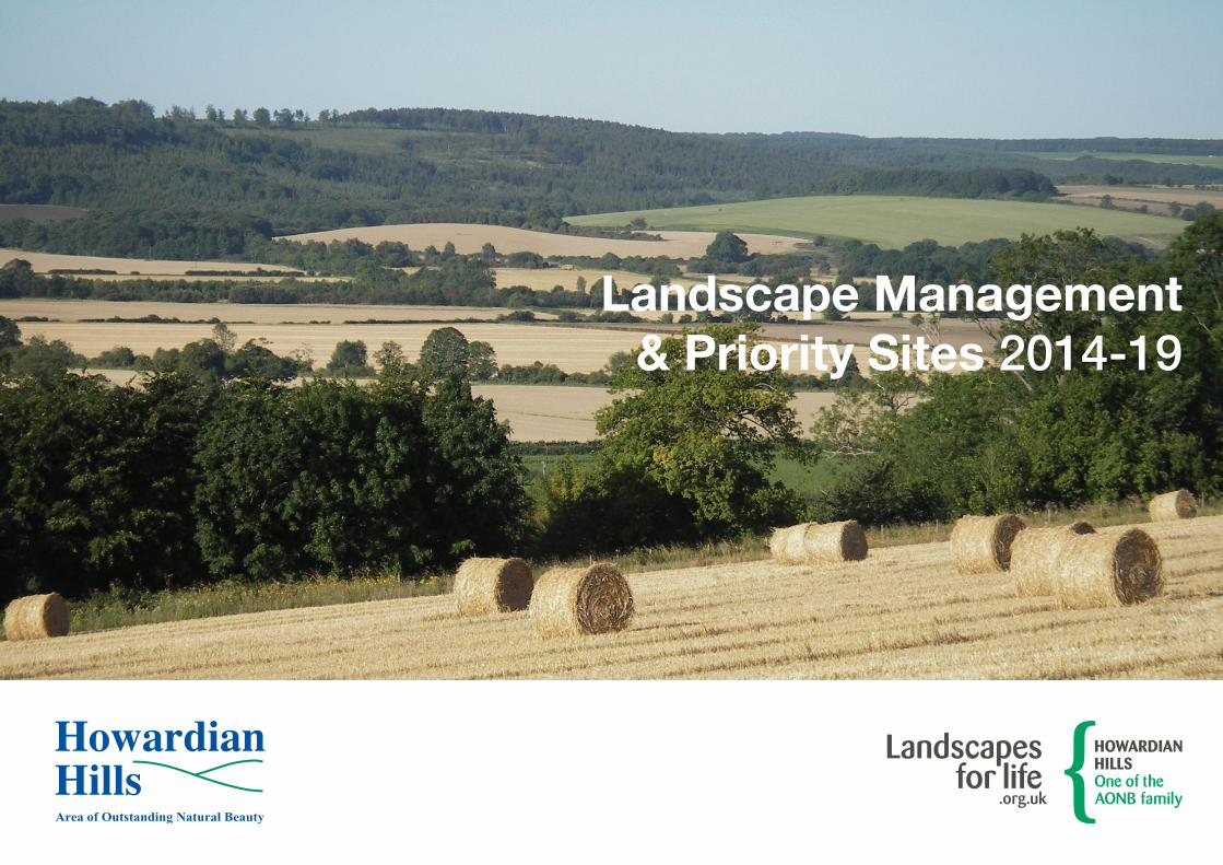
Landscape Management & Priority Sites 2014-19
2
How
ardi
an H
ills A
ON
B M
anag
emen
t P
lan
2014
-201
9
Landscape Management & Priority SitesManagement ZonesThe landscape character areas identified in Section 1.5 form a convenient framework for considering specific parts of the AONB in more detail.
The Landscape Management sub-sections deal with the issues in each particular landscape character area. The specific Priority Sites have been included because each of them makes a particularly important contribution to the conservation and enhancement of the AONB’s Special Qualities. As such they are key sites for management or restoration (as applicable). The management priorities and suggested actions are not however intended to be prescriptive or exclusive. They should be viewed as strategic recommendations intended to guide the activities of farmers, landowners and the various agencies that have an influence upon the management of the Howardian Hills. It is hoped that they will help local communities, organisations and individuals to work together to improve their own environment within an agreed framework. In combination with the Objectives, they will also be used to determine priorities for local
funding and to decide where additional financial incentives might be needed.
Condition/RiskAn assessment of the Condition or Risk category of each site is given, where this is known:
SSSI – Natural England information.
SINC – Assessment criteria to be agreed.
SM – English Heritage information.
Other Historic Environment Priority Sites – Assessment criteria to be agreed.
Condition assessments allow the monitoring of site condition over time, as well as providing information for the Condition Indicators that measure the overall health of the component features that make up the AONB’s Special Qualities.
Reference numbers in this part of the Plan refer to sites located on the large map, which can be found on the CD on the inside of the back cover. It should be noted that nearly all these sites are on private land and access is only available via existing Public Rights of Way or by express permission of the landowner.
Site designations:
SSSI – Site of Special Scientific Interest. (National importance)
SINC – Site of Importance for Nature Conservation. (Local importance)
SM – Scheduled Monument. (National importance)
RPG – Registered Park and Garden. (National importance)
PLATEAU (Zone 1)
Landscape Management
Retain and reinforce the ‘isolated almost upland’ character, resist unsympathetic development and explore opportunities to diversify and soften the impact of ‘hard-edged’ woodlands:
• As opportunities arise, encourage diversification and re-design of conifer plantations, to increase variety and reflect local characteristics and topographical features. Give priority to open space, natural regeneration or broadleaved planting along woodland edges and roadsides; also natural regeneration or broadleaved planting adjacent to existing fragments of semi-natural broadleaved woodland.
3
ww
w.h
owar
dian
hills
.org
.uk
• Encourage sensitive felling operations in terms of scale and phasing, especially in visually prominent locations.
• Discourage large-scale extensions to existing woods.
• Retain fragments of former heathland vegetation and encourage regeneration wherever possible during future woodland management operations.
• Encourage appropriate planting to integrate the more prominent buildings and structures into the landscape.
• Encourage maintenance and, where appropriate, the rebuilding of traditional drystone walls where these form a characteristic feature.
Natural Environment Priority Sites
Encourage the creation of broadleaved riparian woodland corridors and restoration of heathland habitats within existing conifer plantations.
• Grimston Moor (1.1) – SINC. Extensive areas of heathland vegetation under pine plantations. Encourage management as more open heathland habitat mosaic.
• High Lions Wood (1.2) – SINC. A mature secondary birch woodland with an acidic heath flora. Ensure retention as native broadleaved woodland.
• Yearsley Moor Woodlands (1.5) – SINC. An extensive site with a patchwork of both semi-natural and heavily modified habitats, arising from afforested open heathland/designed landscape (Gilling Castle). Habitats include calcareous ash woodland, calcareous & neutral grasslands, flushes, a sphagnum mire, veteran Scots pines and coniferised potential oak-birch woodland. Significant removal of rhododendron 2009-2011. Ensure retention and appropriate management of existing semi-natural habitats and encourage restoration of appropriate areas to heathland and broadleaved woodland.
Historic Environment Priority Sites
Many prehistoric burial mounds, most of which are Scheduled Monuments, lie in this Zone. Evidence also of an extensive system of hollow-ways. Opportunities to encourage greater public appreciation of the historic landscape.
• Neolithic long barrow, Black Hill (2.1) – SM. Vulnerable. Install protective roadside kerbing.
• Round barrows, Yearsley (2.2) – SM. Vulnerable & Low/Not at Risk. Reduce erosion by stock.
• Round barrows, Black Moor (2.3) – SM. At Risk. Control bracken and establish a benign vegetation cover.
• Round barrows, Grimston Moor (2.4) – SM. At Risk, Vulnerable & Low/Not at Risk. Control tree and scrub growth. Control bracken and establish a benign vegetation cover.
• Round barrows, Coney Hills (2.5) – SM. At Risk & Vulnerable. Reduce impact of arable ploughing. Control scrub growth. Reduce impact of burrowing animals.
• Field system, Swathgill (2.6) – Encourage sympathetic management of prehistoric field system & barrow and seek to improve condition within an agricultural regime.
• Limekiln, Blackdale Plantation (2.7) – Keep structure clear of vegetation and produce management plan.
• Cropmarks of Iron Age/Roman field systems and enclosures, Grimston Howl (2.8) – Encourage continuation of sympathetic management agreement (ELS) and seek to improve condition within an agricultural regime. Detailed survey of woodland fringes required to identify whether cropmarks survive as upstanding features.
4
How
ardi
an H
ills A
ON
B M
anag
emen
t P
lan
2014
-201
9
• Hollow-ways, Grimston Moor, Black Moor and Yearsley Moor (2.9) – Community survey work completed in 2012. Avoid damage by heavy machinery
Recreation Priority Sites
• Yearsley Moor (3.1) – A popular car parking area for walkers. Parking area expanded and re-surfaced in 2012. Information board installed in 2013 as part of Lime & Ice Yearsley Moor project. Monitor condition.
• Grimston Grange (3.2) – A County Council chippings dump to the north-west of Grimston Grange crossroads. Monitor usage and condition.
• High Lions Lodge (3.3) – An area of Common Land formerly used as tipping area for soil and rubble. Explore opportunities for restoration to more appropriate use/appearance.
• Grimston Moor (3.4) – Private road leading to Forestry Commission woodland. Improve entrance gate arrangement/signage to facilitate access.
NORTHERN PLATEAU FRINGE (Zone 2A)
Landscape Management
Seek opportunities to diversify and soften the impact of woodlands and restore key elements of the former historic parkland character:
• As opportunities arise, encourage diversification and re-design of conifer plantations, to increase variety and reflect local characteristics and topographical features. Give priority to open space, natural regeneration or broadleaved planting along woodland edges and roadsides; also natural regeneration or broadleaved planting adjacent to existing fragments of semi-natural broadleaved woodland.
• Encourage sympathetic felling operations in terms of scale and phasing, especially where visually prominent.
• Encourage preparation/implementation of long-term landscape management plans for the historic grounds of Newburgh Priory and Gilling Castle.
• Where appropriate, maintain and restore landscape features associated with former parkland, e.g. estate walls, avenues, parkland copses/trees and lakes.
• Discourage new woodland planting proposals that detract from the character of the historic parklands.
• Work with the North York Moors National Park to develop integrated cross-boundary habitat/landscape corridors.
Natural Environment Priority Sites
Encourage the creation of broadleaved riparian woodland corridors and restoration of heathland habitats within existing conifer plantations.
• Colley Broach Road Pasture (1.3) – SINC. A large field of mainly unimproved neutral and marshy grassland. Encourage continuation of existing management agreement (HLS) to safeguard interest.
• Boggs Plantation (1.4) – SINC. The best example of a semi-natural valley alder wood in the AONB. Ensure retention as native broadleaved woodland.
• Yearsley Moor Woodlands (1.5) – SINC. An extensive site with a patchwork of both semi-natural and heavily modified habitats, arising from afforested open heathland/designed landscape (Gilling Castle). Habitats include calcareous ash woodland, calcareous & neutral grasslands, flushes, a sphagnum mire, veteran Scots pines and coniferised potential oak-birch woodland.
5
ww
w.h
owar
dian
hills
.org
.uk
Significant removal of rhododendron 2009-2011. Ensure retention and appropriate management of existing semi-natural habitats and encourage restoration of appropriate areas to heathland and broadleaved woodland.
• Park Wood Fishponds and The Wilderness (1.6) – SINC. A complex of habitats comprising open water, fen, wet alder woodland and drier sessile oak woodland. Conifer regeneration removed from oak woodland in 2003. Significant removal of rhododendron 2011-2013. Encourage preparation of site management plan to maximise conservation interest and define future management priorities. Ensure retention as native broadleaved woodland.
Historic Environment Priority Sites
A variety of prehistoric and later earthwork features are present in this Zone.
• Round barrows, Four Acre Wood and adjacent (2.11) – SM. At Risk & Low/Not at Risk. Control scrub growth. Control bracken and establish a benign vegetation cover. Reduce impact of arable ploughing. Reduce erosion by stock.
• Cross dyke, Roman Plantation (2.12) – SM. At Risk & Low/Not at Risk. Control scrub growth. Control bracken and establish a benign vegetation cover.
• Round barrow, Yearsley Moor (2.13) – SM. Low/Not at Risk. Minimise impact of forestry.
• Hollow-ways, Grimston Moor, Black Moor and Yearsley Moor (2.9) – Community survey work completed in 2012. Avoid damage by heavy machinery.
• The Stripe, Mount Plantation, Roman Plantation and Heron Lye Gill, Newburgh (2.14) – Reduce impact of forestry, encourage more sympathetic management and improve understanding of features in woodland, initially through a management plan (see below).
Encourage preparation and implementation of management plans that identify opportunities for conserving, enhancing and restoring elements of the historic landscape, both within and beyond the registered parkland:
• Newburgh Priory (2.15) – RPG. Not at Risk
• Gilling Castle (2.16) – RPG. Not at Risk
In liaison with owners, encourage repair of Listed Buildings at Risk using grant resources available from
local authorities and Government agencies. Where appropriate, explore opportunities for suitable changes of use to ensure their long-term contribution to the cultural heritage of the area:
• Mill, Newburgh Park (2.17)
• The Mount, Newburgh Park (2.105)
• Park House, Newburgh Park (2.106)
Recreation Priority Sites
• Newburgh Priory Lake (3.5) – A popular surfaced roadside lay-by giving views over Newburgh Priory Lake. Monitor level of use at peak periods.
• Yearsley Moor and Gilling Castle (3.6) – A large area of principally conifer woodland, much of which once formed the designed landscape associated with Gilling Castle. The majority of the woodland is leased by the Forestry Commission and well-used public footpaths link Yearsley Moor with the Park Wood fishponds. Extensively used by mountain bikers, walkers and horse riders. Information board and sculpture seats installed in 2013 as part of Lime & Ice Yearsley Moor project. Liaise with Forestry Commission on issues/conflicts as appropriate.
6
How
ardi
an H
ills A
ON
B M
anag
emen
t P
lan
2014
-201
9
WESTERN PLATEAU FRINGE (Zone 2B)
Landscape Management
Strengthen the existing landscape framework of hedges and hedgerow trees. Protect the open character of the higher ground and encourage greater tree cover on steeper slopes:
• Encourage planting of new small to medium-sized areas of broadleaved or mixed woodland on steeper slopes and valley shoulders. Discourage woodland planting on higher flatter ground and protect long-distance views.
• Encourage planting of hedgerow trees and copses using native species, to strengthen existing landscape pattern.
• Promote the retention, restoration and sympathetic management of hedges, particularly those in the most visible locations and those associated with the remnant strip field system at Oulston.
Historic Environment Priority Sites
A variety of prehistoric and later earthwork features are present in this Zone.
• Medieval village & field system, Thornton-on-the-Hill (2.18) – Manage the whole area of earthworks under a stable grass sward.
• Lynchets, ridge & furrow field system and other earthworks, Oulston (2.19) – Manage the whole area of earthworks under a stable grass sward.
SOUTHERN PLATEAU FRINGE (Zone 2C)
Landscape Management
Strengthen the framework of hedges and encourage woodlands on steeper slopes and valley shoulders:
• Encourage planting of trees and copses using native species, to strengthen existing landscape pattern.
• Promote the retention, restoration and sympathetic management of hedges, particularly those in the most visible locations and those associated with the remnant strip field system near Hardy Bank.
• Conserve areas of Ancient Semi-Natural Woodland and promote appropriate forms of management.
• Encourage small-scale extensions of existing valley woodlands and new woodlands on the steeper slopes of the scarp face and valley shoulders, using native species or mixtures where plantations are already varied in character.
• In the valleys, maintain the more diverse landscape by retaining the small-scale field pattern and areas of semi-improved pasture along streams and on steeper slopes.
Natural Environment Priority Sites
• Hardy Bank (1.8) – SINC. A small area of Ancient woodland with an open canopy, reputed to be a remnant of the Forest of Galtres. Ensure retention as native broadleaved woodland.
• Moorside (Black Fir) Plantation (1.9) – SINC. A mature oak woodland, probably on an Ancient site. Ensure retention as native broadleaved woodland.
• Oulston Reservoir (1.10) – SINC. Two artificial lakes. The lower one is mesotrophic and has extensive areas of adjacent fen meadow. The upper lake is more eutrophic. Discourage practices that would damage or pollute aquatic habitats. Encourage sympathetic management of adjacent semi-natural fen and grassland habitats.
• Peel Wood and Grassland (1.11) – SINC. An interesting complex of habitats including broadleaved woodland, scrub and grassland. Native woodland area extended by new planting in 2005. Encourage continuation of existing management agreement (HLS) on part of site to safeguard interest.
7
ww
w.h
owar
dian
hills
.org
.uk
• Dale Wood (1.12) – SINC. One of the largest areas of semi-natural woodland in the AONB, with a variety of different plant communities. Ensure retention of native broadleaved woodland and encourage restoration of replanted sections.
Historic Environment Priority Sites
Archaeological survey to identify features related to woodland management would be highly worthwhile in this Zone and would aid understanding of the origins of the woods. Elsewhere, retain surviving earthworks under a stable grass sward.
• Cross dyke, Roman Plantation (2.12) – SM. At Risk & Low/Not at Risk. Control scrub growth. Control bracken and establish a benign vegetation cover.
• Round barrows, Oulston Moor (2.20) – SM. Vulnerable. Control tree & scrub growth and bracken. Establish a benign vegetation cover.
• Limekiln, New Piece Moor (2.21) – Trees and scrub removed in 2000. Monitor condition.
Recreation Priority Sites
• Oulston Moor (3.7) – A popular starting point for circular walks around Pond Head and Oulston. Monitor usage and condition.
SOUTHERN MOORS FRINGE (Zone 2D)
Landscape Management
Conserve the ‘traditional’ landscape character, reinforce the existing framework of hedges, trees and woods and soften the impact of discordant features:
• Maintain the diverse character of the landscape by retaining the small-scale field pattern and areas of pasture.
• Encourage planting of hedgerow trees and copses using native species, to strengthen existing landscape pattern.
• Promote the retention, restoration and sympathetic management of hedges associated with the extensive remnant strip field systems near Ampleforth.
• Promote sympathetic management of watercourses to enhance their visual and wildlife value.
• Try to integrate modern developments into the landscape through appropriate forms of tree planting.
• Encourage small-scale extensions of existing woods on the steeper slopes of spurs.
• Work with the North York Moors National Park to develop integrated cross-boundary habitat/landscape corridors.
Natural Environment Priority Sites
• Thorpe Spring Wood (1.13) – SINC. A largely semi-natural ash and oak woodland. Ensure retention as native broadleaved woodland.
Historic Environment Priority Sites
• Medieval field system, Oswaldkirk Hall (2.22) – Manage under a stable grass sward.
EASTERN MOORS FRINGE (Zone 2E)
Landscape Management
Strengthen the existing framework of hedges and hedgerow trees and promote appropriate forms of woodland management:
• Conserve areas of Ancient Semi-Natural Woodland and promote appropriate forms of management. In Ancient replanted woodland, encourage greater use of native broadleaves. Elsewhere retain mixture of woodland types.
• Promote the retention, restoration and sympathetic management of hedges, particularly those in the most visible locations and those associated with the remnant strip field system near Sproxton.
8
How
ardi
an H
ills A
ON
B M
anag
emen
t P
lan
2014
-201
9
• Encourage planting of hedgerow trees, copses and small woods using native species to reinforce existing landscape pattern, especially in association with streams and areas of pasture.
• Promote sympathetic management of watercourses to enhance their visual and wildlife value.
• Work with the North York Moors National Park to develop integrated cross-boundary habitat/landscape corridors.
Natural Environment Priority Sites
• Robson’s Spring (1.14) – SINC. An area of calcareous ash woodland with a rich ground flora and forming part of a larger woodland complex. Some parts have been replanted with conifers. Ensure retention of native broadleaved woodland and encourage restoration of replanted sections.
• East Plock Woods (1.15) – SINC. A plantation of beech, sycamore and larch on an Ancient site. Encourage restoration to native broadleaved woodland.
• River Rye, Helmsley Bridge to West Ness (1.16) – SINC. A stretch of ‘natural’ river, the banks of which support a varied flora and fauna. Discourage management practices that would damage or pollute
the river system and associated habitats. Manage tree canopy to benefit river ecosystem and manage invasive non-native species (mink, Himalayan balsam).
Historic Environment Priority Sites
• Cropmarks of field system, Newton Grange Farm (2.23) – Seek to improve condition within an agricultural regime.
SOUTHERN RIDGE (Zone 3A)
Landscape Management
Conserve the landscape balance between broadleaved woodland and farmland and restore those features which have declined or been lost:
• Retain broadleaved character of woodlands and encourage greater use of native broadleaves wherever possible.
• Encourage planting of hedgerow trees and copses using native species, to strengthen landscape pattern.
• Promote the retention, restoration and sympathetic management of hedges, particularly those in the most visible locations and those associated with the remnant strip field system at Skewsby.
• Promote sympathetic management of watercourses to enhance their visual and wildlife value.
• Continue restoration of character of highway corridor along foot of scarp.
Natural Environment Priority Sites
• Fairy Dell (1.17) – SINC. A species-rich unimproved pasture with a spring, stream and pond. Encourage negotiation of management agreement to safeguard remaining interest.
• Stearsby Hag (1.18) – SINC. A large plantation of beech and sycamore on an Ancient site. Encourage restoration to native broadleaved woodland.
• Stearsby Hag Grassland (1.19) – SINC. A small fragment of semi-improved neutral grassland on a steep bank. Encourage sympathetic management to safeguard interest.
Historic Environment Priority Sites
• Round barrow, Stearsby Hag (2.24) – SM. At Risk. Control tree and scrub growth. Control bracken and establish a benign vegetation cover.
• City of Troy Maze, Stearsby Hag (2.25) – Continue with current sympathetic management regime.
• Limekiln, High Wood (2.26) – Keep structure clear of vegetation and prepare management plan.
9
ww
w.h
owar
dian
hills
.org
.uk
• Cropmarks of prehistoric dyke and triple bank, Cop Howe (2.28) – Seek to improve condition within an agricultural regime. Survey adjacent woodland fringes for upstanding remains and seek to manage sympathetically.
• Ridge & furrow field system, Brandsby (2.29) – Very good surviving remains of a medieval field system. Manage under a stable grass sward.
In liaison with owners, encourage repair of Listed Buildings at Risk using grant resources available from local authorities and Government agencies. Where appropriate, explore opportunities for suitable changes of use to ensure their long-term contribution to the cultural heritage of the area:
• Witherholme Hall, Whenby (2.107)
SOUTH EAST RIDGE (Zone 3B)
Landscape Management
Try to restore a more strongly hedged landscape framework, with a higher density of tree cover and promote more woodland planting to integrate the area more closely with adjoining landscapes:
• Encourage appropriate management of Ancient Woodland Sites, with greater use of native broadleaves.
• Encourage planting of new small to medium-sized areas of broadleaved or mixed woodland at locations which do not interrupt long-distance views, particularly on the more open scarp slopes and valley sides towards the south of the area and in association with farmsteads.
• Encourage planting of hedgerow trees and copses using native species, to reinforce landscape pattern.
• Promote the retention, restoration and sympathetic management of hedges, particularly those in the most visible locations and those associated with the remnant strip field systems at Ganthorpe, Bulmer and Crambe.
• On scarp slopes, tributary valleys and around villages, maintain the more diverse character by retaining the small-scale field pattern and areas of pasture.
• Conserve and enhance areas of parkland.
• Ensure any upgrading of the A64 trunk road respects the character and high quality of the landscape and find opportunities for new planting in the highway corridor.
Natural Environment Priority Sites
• Little Dale, Mowthorpe (1.20) – SINC. An area of unimproved marshy grassland with a varied flora. Scrub control and fen cutting in 2007; scrub control and site fenced in 2008 and grazing by Exmoor ponies introduced. Encourage continuation of management agreement (AONB) to safeguard interest. Continue scrub control and habitat management.
• Bulmer Beck Mire (1.21) – SINC. An area of rank fen grassland and marshy flushes. Re-fenced in 2002 and grazing by Exmoor ponies introduced. Encourage new management agreement to safeguard interest, as site has been withdrawn from HLS.
• Bulmer Mire (1.22) – SINC. An area of marshy grassland at the foot of a small valley. Encourage sympathetic management to safeguard interest.
• Bulmer Hag (1.23) – SINC. An area of oak woodland on an Ancient site, much of which has a semi-natural appearance. Sections have been replanted with conifers. Ensure retention of native broadleaved woodland and encourage restoration of replanted sections.
10
How
ardi
an H
ills A
ON
B M
anag
emen
t P
lan
2014
-201
9
Historic Environment Priority Sites
• Round barrow, Terrington (2.30) – SM. Vulnerable. Control tree and scrub growth.
• Earthworks of ridge & furrow and settlement shrinkage, High Stittenham (2.31) – Manage the whole area of earthworks under a stable grass sward.
• Field system, Mill Fields (2.32) – Encourage removal of tipped infill material. Manage the whole area of earthworks under a stable grass sward.
• Earthworks of medieval field system, lynchets and possible enclosure, Whitwell-on-the-Hill (2.33) – Manage the whole area of earthworks under a stable grass sward.
NORTH RIDGE (Zone 3C)
Landscape Management
Maintain the contrast between the wooded scarp slope and open dip slope, reinforce the framework of hedges and encourage sensitive woodland management:
• Discourage new isolated woodland planting proposals on northern dip slope, to retain open landscape character.
• Encourage sensitive felling operations in terms of scale and phasing, especially where visually prominent.
• Conserve areas of Ancient Semi-Natural Woodland and promote appropriate forms of management. In Ancient replanted woodland, encourage greater use of native broadleaves, especially towards prominent skylines and in association with parklands.
• Promote the retention, restoration and sympathetic management of hedges, particularly those in the most visible locations and those associated with the remnant strip field systems near Swinton, Easthorpe, Barton-le-Street, Slingsby and Hovingham.
• Conserve historic linear field pattern and network of ancient trackways.
• Discourage extension of limestone quarries beyond existing permitted areas and try to reduce impact through planting.
Natural Environment Priority Sites
• Wath Quarry (1.24) – SSSI. A quarry face of geological interest. Support continued sympathetic management through agreement with Natural England. Condition – Favourable.
• Scar Wood (1.25) – SINC. One of the three best ash woodlands in the AONB, with a rich flora. Sections have been replanted with
non-native species. Two areas of young sycamore plantation restored to native broadleaves in 2007 & 2008. Ensure retention of native broadleaved woodland and encourage restoration of replanted sections. Discourage extension of quarrying activity.
• Grange Farm, Gilling (1.26) – SINC. A small area of unimproved calcareous grassland, including the site of a former quarry. Encourage negotiation of agreement to ensure sympathetic management.
• Mill Wood (1.27) – SINC. An area of semi-natural oak-birch woodland with ash on the upper slopes. Ensure retention as native broadleaved woodland.
• Calf Close Wood (1.28) – SINC. An area of oak-ash woodland on an Ancient site, much of which has a semi-natural appearance although some areas originate from planting. Ensure retention of native broadleaved woodland and encourage restoration of replanted sections.
• Horse Coppice (1.29) – SINC. An area of mainly mature oak woodland on an Ancient site, although probably originates from planting. Hazel partially re-coppiced in 2000. Ensure retention as native broadleaved woodland.
11
ww
w.h
owar
dian
hills
.org
.uk
• Disused Quarry at Wath (1.30) – SINC. An area of calcareous grassland in a disused quarry. Carry out survey to identify areas of conservation value and management priorities.
• Wath Wood Boundary (1.31) – SINC. A small area of unimproved calcareous grassland on the northern edge of Wath Wood. Invading scrub removed in 2000. Sward maintained by rabbit grazing. Encourage continuation of existing management agreement (HLS).
• Wath Wood & Hollin Hill Plantation (1.32) – SINC. A large area of Ancient woodland, sections of which retain a semi-natural character with a notable flora. Other sections have been replanted with conifers. Ensure retention of native broadleaved woodland and encourage restoration of replanted sections.
• Hollin Hill Bogs (1.33) – SINC. A relatively large area of spring-fed semi-natural alder carr of high conservation interest. Ensure retention as native broadleaved woodland. Manage invasive non-native species (Himalayan balsam).
• Slingsby Banks Wood (1.34) – SINC. An area of oak woodland on an Ancient site, although originating from replanting. Contains several recent plantings of conifers. Ensure retention of native
broadleaved woodland and encourage restoration of replanted sections.
• Slingsby Bank Verges (1.35) – SINC. A length of species-rich calcareous grassland on a roadside verge. Encourage continuation of sympathetic management.
• Slingsby Disused Quarry (1.36) – SINC. Unimproved and semi-improved calcareous grassland on an old quarry site. Invading scrub cleared in 2007. Encourage continuation of sympathetic grassland management.
• Coneysthorpe Banks Wood (1.37) – SINC. A large plantation of mainly larch, sycamore and Norway spruce on an Ancient site. Ensure retention of native broadleaved woodland and encourage continuing restoration of replanted sections.
• Amotherby Lane (1.38) – SINC. A small patch of calcareous grassland containing knapweed broomrape, within an area of scrub. Rabbit fenced in 1998 and cut rotationally. Greater knapweed planted in 2012, to augment natural population. Encourage continuation of existing management, to safeguard interest.
• Hildenley Top Reservoir (1.39) – SINC. Species-rich calcareous grassland on a covered reservoir. Managed
by Yorkshire Water and generally cut sympathetically. Encourage continuation of existing management.
• Broughton Lane (1.40) – SINC. Species-rich verges along a green lane, containing a significant population of knapweed broomrape. Encourage sympathetic management by gypsy pony grazier, to safeguard interest.
• Cawton Bank (1.41) – An area of semi-improved neutral grassland on a steep bank. Fenced in 2003 and grazing by Exmoor ponies introduced. Encourage continuation of existing management agreement (HLS) to safeguard and maintain interest.
Historic Environment Priority Sites
High priority area within the arable land of the scarp slope, with many nationally important cropmarks of prehistoric land use, both scheduled and unscheduled, needing further investigation and conservation. Initiate a programme of work to characterise the type and extent of remains as well as degree of preservation. Use as the basis for advising on programmes of management to fully protect important features.
12
How
ardi
an H
ills A
ON
B M
anag
emen
t P
lan
2014
-201
9
• Linear dyke, Coneysthorpe Banks Wood (2.34) – SM. Vulnerable. Control tree & plant growth and bracken. Establish a benign vegetation cover.
• Round barrow, Hovingham (2.35) – SM. Vulnerable. Reduce impact of arable clipping. Encourage continuation of existing management agreements (EH & HLS) to safeguard interest.
• Round barrows, Hovingham High Wood (2.36) – SM. At Risk & Vulnerable. Control tree & scrub growth and bracken. Reduce impact of forestry. Establish a benign vegetation cover.
• Round barrows, Hovingham South Wood (2.37) – SM. At Risk & Low/Not at Risk. Control bracken and reduce impact of forestry. Establish a benign vegetation cover.
• Linear dyke, Fryton West, Fryton East and Slingsby Banks Woods (2.38) – SM. Vulnerable. Control tree & scrub growth and bracken. Establish a benign vegetation cover.
• Round barrows, Fryton East and Fryton West Woods (2.39) – SM. Vulnerable. Control tree & scrub growth and reduce impact of forestry. Establish a benign vegetation cover.
• Round barrow and cross dyke, Scarrish Wood (2.40) – SM. Vulnerable. Reduce impact of forestry. Control bracken and establish a benign vegetation cover.
• Cross dyke, Coneysthorpe Banks Wood (2.41) – SM. Low/Not at Risk.
• Round barrows, Easthorpe (2.42) – SM. At Risk. Reduce impact of arable ploughing. Establish a benign vegetation cover.
• Cropmarks of ancient trackways and settlements, Barton and Slingsby Heights (2.43) – Seek to improve condition within an agricultural regime.
• Probable Roman camp, Diana Hill (2.44) – Seek to improve condition within an agricultural regime.
• Moated site, Wath (2.45) – Carry out further investigation to assess historic value.
• Field systems, Easthorpe Hall (2.46) – Manage the whole area of earthworks under a stable grass sward.
• Field systems, Hildenley Hall Estate (2.47) – Manage the whole area of earthworks under a stable grass sward.
• Limekiln, Kitscrew Wood (2.48) – Encourage control of scrub and consolidation works as necessary.
• Limekiln and bridge, Hildenley Wood (2.49) – Scrub and trees removed from limekiln in 2010. Keep structures clear of vegetation, survey area to check for other features and prepare management plan.
• Limekiln, Scar Wood (2.50) – Trees removed in 2006. Front wall consolidated and re-built in 2011. Monitor condition.
• Cropmark complex of square barrows, double-ditched trackway and enclosures, Cawton (2.51) – Seek to improve condition within an agricultural regime.
• Orchard, Slingsby (2.52) – Historic orchard, containing many old species of apple tree. Encourage implementation of management plan.
• Limekiln, Hovingham Spa (2.53) – Control scrub growth and clear tipped debris to establish how much of original structure remains.
Encourage the preparation and implementation of management plans that identify opportunities for conserving, enhancing and restoring elements of the historic landscape:
• Hovingham Park (2.54)
• Swinton Grange (2.55)
13
ww
w.h
owar
dian
hills
.org
.uk
CAULKLEYS BANK (Zone 3D)
Landscape Management
Strengthen the framework of hedges and seek opportunities to extend woodland and tree cover while retaining the essentially open character of the dip slope:
• In existing woodlands, encourage sympathetic felling operations in terms of scale and phasing, especially where visually prominent.
• Promote the retention, restoration and sympathetic management of hedges, particularly those in the most visible locations and those associated with the remnant strip field systems at Nunnington and near West Ness.
• Encourage planting of hedgerow trees and copses using native species, to reinforce landscape pattern.
• Conserve and reinforce linear tree belts, avenues and other parkland features.
• Encourage planting of new small areas of broadleaved or mixed woodland towards the foot of the dip slope, in locations that do not interrupt long-distance views.
Natural Environment Priority Sites
• Nunnington Cutting & Quarries (1.42) – SSSI. Two disused quarries and an
adjacent railway cutting of geological interest. Support continued sympathetic management through agreement with Natural England. Condition – Favourable.
• River Rye, Helmsley Bridge to West Ness (1.16) – SINC. A stretch of ‘natural’ river, the banks of which support a varied flora and fauna. Discourage management practices that would damage or pollute the river system and associated habitats. Manage tree canopy to benefit river ecosystem and manage invasive non-native species (mink, Himalayan balsam).
• Caulkleys Bank (1.43) – SINC. Species-rich unimproved calcareous pasture on a steep hillside. Encourage continuation of sympathetic management and negotiation of new agreement (HLS).
• Caulkleys Wood (1.44) – SINC. A calcareous ash woodland on an escarpment, parts of which have been replanted with non-native species. Ensure retention of native broadleaved woodland and encourage restoration of replanted sections.
Historic Environment Priority Sites
This area has many similarities with Zone 3C, having many cropmarks of prehistoric landscape features, although none are scheduled.
• Earthworks, Stonegrave Church and adjacent (2.56) – SM. Low/Not at Risk.
• Earthworks, East Newton Hall (2.57) – Encourage continuation of existing management agreement (ELS) to safeguard interest.
• Cropmarks of prehistoric/Roman enclosures and trackways, Caulkleys Bank (2.58) – Seek to improve condition within an agricultural regime.
• 2/3 limekilns, Limekiln Plantation (2.59) – Keep structures clear of vegetation, survey area to check for other features and prepare management plan.
• Limekiln, Quarry Plantation (2.60) – Trees removed in 2004 & 2006. Encourage continued control of scrub and consolidation works as necessary.
• Cropmarks of probable Iron Age square barrow cemetery, Caulkleys Bank (2.61) – Seek to improve condition within an agricultural regime.
Encourage the implementation of the management plan to conserve, enhance and restore elements of the historic landscape:
• Nunnington Hall (2.62) – RPG. Not at Risk.
14
How
ardi
an H
ills A
ON
B M
anag
emen
t P
lan
2014
-201
9
Recreation Priority Sites
• Caulkleys Bank (3.8) – A popular gravelled roadside lay-by, giving panoramic views over the Vale of Pickering. Provides access to well-used Public Rights of Way to east and west. Encourage appropriate maintenance to provide a level surface suitable for a wide range of users. Maintain informal provision of information and landscape interpretation.
• Nunnington Hall (3.9) – 17th century manor house owned by the National Trust and attracting around 60,000 visitors annually. The Hall is served by a large landscaped car park and an additional overflow car park. Monitor ability of overflow car park to cope with peak demands.
• Nunnington (3.10) – A large informal parking area on the site of former sawmill. Monitor current ad hoc usage.
VALE OF YORK (Zone 4A)
Landscape Management
Strengthen the landscape framework by restoration of hedges, hedgerow trees and copses while retaining the contrast with more heavily wooded areas to the north and south:
• Encourage planting of hedgerow trees and copses using native species, to reinforce landscape pattern.
• Promote the retention, restoration and sympathetic management of hedges, particularly those in the most visible locations.
• Encourage planting of new small areas of broadleaved or mixed woodland.
• Promote sympathetic management of watercourses to enhance their visual and wildlife value. Encourage retention of semi-natural vegetation on remaining sections of disused railway.
• Work with the North York Moors National Park to develop integrated cross-boundary habitat/landscape corridors.
Natural Environment Priority Sites
• Foxfoot Hay (1.45) – SINC. A wide ditch with semi-natural marginal vegetation. Encourage continuation of existing management agreement (HLS) on adjacent land.
• Thorpe Grange (1.46) – SINC. An area of neutral grassland with patches of scrub, on a disused railway. Fenced in 2004, to allow introduction of conservation grazing. Encourage continuation of sympathetic management.
Historic Environment Priority Sites
Where pockets of ridge & furrow survive, retain the whole area under a stable grass sward. Where cropmark features of prehistoric date have been identified, explore options to remove from cultivation, reduce plough depth or similar options.
• Monastic precinct and water management earthworks, Byland Abbey (2.108) – SM. Low/Not at Risk. Reduce erosion by stock.
VALE OF PICKERING (Zone 4B)
Landscape Management
Strengthen the landscape framework by restoration of hedges, hedgerow trees and copses while retaining the contrast with more heavily wooded slopes to the north and south:
• Encourage planting of hedgerow trees and copses using native species, to reinforce existing landscape pattern.
• Promote the retention, restoration and sympathetic management of hedges, particularly those in the most visible locations and those associated with the remnant strip field systems at Ampleforth, Stonegrave and Hovingham.
15
ww
w.h
owar
dian
hills
.org
.uk
• Encourage planting of new small areas of broadleaved or mixed woodland.
• Promote sympathetic management of watercourses to enhance their visual and wildlife value.
Natural Environment Priority Sites
• Thorpe Grange (1.46) – SINC. An area of neutral grassland with patches of scrub, on a disused railway. Fenced in 2004, to allow introduction of conservation grazing. Encourage continuation of sympathetic management.
• Cawton Fens (1.47) – SINC. Two areas of calcareous fen, abandoned as arable land in 1985. Eastern area fenced in 2003 and grazing by Exmoor ponies introduced. Encourage continuation of existing management agreement (HLS) to safeguard interest.
Historic Environment Priority Sites
Two areas of cropmarks of prehistoric enclosures at Hovingham Carrs and north of Mill Holm Plantation would be suitable for exploring options to remove from cultivation, reduce plough depth or similar options.
• Cross in Churchyard, Gilling (2.64) – SM. Vulnerable. Consolidate to prevent collapse.
CRAYKE (Zone 4C)
Landscape Management
Retain and enhance the strong hedge and hedgerow tree pattern and encourage new areas of small-scale woodland:
• Promote the retention, restoration and sympathetic management of hedges, particularly those in the most visible locations and those associated with the extensive remnant strip field system at Crayke.
• Encourage planting of hedgerow trees and copses using native species, to reinforce existing pattern.
• Encourage new small-scale plantations using native species or mixtures.
• Promote sympathetic management of watercourses to enhance their visual and wildlife value.
Historic Environment Priority Sites
Where pockets of ridge & furrow survive, particularly around Crayke Manor and Crayke Castle, retain the whole area under a stable grass sward.
Where cropmark features of prehistoric date have been identified, explore options to remove from cultivation, reduce plough depth or similar options.
• Crayke Castle (2.66) – SM. Low/Not at Risk. Reduce impact of animal burrowing.
CASTLE HOWARD BASIN (Zone 5)
Landscape Management
Conserve and enhance the integrity of the historic designed landscape:
• Continue to update and implement the landscape restoration and management plan, to safeguard the integrity of the historic landscape.
• Where appropriate, maintain and restore landscape features associated with former parkland, e.g. parkland trees, walls and avenues.
• Discourage new woodland planting proposals that would detract from the landscape character of the historic parkland. Encourage retention of strong broadleaved woodland character through long-term conversion of conifer plantations.
• In the outer basin, promote the retention, restoration and sympathetic management of existing hedges, particularly those associated with the remnant strip field systems near Coneysthorpe and Easthorpe, and encourage planting of hedgerow trees.
16
How
ardi
an H
ills A
ON
B M
anag
emen
t P
lan
2014
-201
9
Natural Environment Priority Sites
• Castle Howard Avenue and Park (1.48) – SINC. The older parts of the Avenue and the car park contain many trees that are now of a considerable age. Survey work in 2003 confirmed that these support invertebrate populations of County importance. Encourage retention and appropriate management of veteran trees wherever possible.
• Castle Howard Great Lake (1.49) – SINC. A wetland of ornithological interest, particularly for wintering wildfowl and passage birds. Encourage preparation of management plan, to maximise conservation interest and define future priorities. Discourage practices that would damage or pollute aquatic habitats.
• Brandrith Wood (1.50) – SINC. An oak woodland, mostly on an Ancient site but probably originating from plantation. Areas have been replanted with non-native species. Ensure retention of native broadleaved woodland and encourage restoration of replanted sections.
• Castle Howard Terrace, Temple and New River (1.51) – SINC. A complex of mown, improved and unimproved grassland, a landscaped pond and an area of mire. Assess conservation management priorities.
• Gillylees and Pretty Woods (1.52) – SINC. A large woodland complex with a mosaic of habitat types including areas of Ancient woodland, although much replanted with non-native species. Ensure retention of native broadleaved woodland and encourage restoration of replanted sections.
• Nova Scotia (1.53) – SINC. A large mainly semi-natural secondary woodland of ash and birch with an interesting flora. Some sections have been replanted with conifers. Ensure retention of native broadleaved woodland and encourage restoration of replanted sections.
• Horse Close Rush (1.54) – SINC. A plantation of oak, beech and sycamore with high invertebrate value, on an Ancient site. Ensure retention of native broadleaved woodland and encourage restoration of replanted sections.
Historic Environment Priority Sites
Although this Zone already has considerable protection due to the inclusion of Castle Howard and its grounds in the Register of Parks and Gardens, this should not hinder greater understanding of the complexity of the landscape, which includes much earlier and pre-parkland features such as the round barrow in The Avenue. Conservation of such complementary features is needed.
Initiate further survey of historic structures and landscape features, including veteran trees, to explore the detailed chronology of the landscape. Encourage enhanced or continued high-quality management measures, and encourage greater public appreciation of the historic landscape.
• Round barrow, Castle Howard Avenue (2.67) – SM. Low/Not at Risk.
• Round barrow, Welburn (2.68) – SM. Low/Not at Risk. Reduce impact of arable clipping. Encourage continuation of sympathetic management agreement (ELS) to safeguard interest.
• Round barrow, Pretty Wood (2.69) – SM. Vulnerable. Reduce impact of forestry.
• Ice House, Castle Howard (2.70) – Monitor condition.
• Medieval ridge & furrow field systems, Coneysthorpe (2.71) – There are indications that these may have been deliberately incorporated into the park. Manage the whole area of earthworks under a stable grass sward.
• Parish boundary, Brick Kiln Wood (2.72) – This survives as an upstanding earthwork. Seek to maintain visibility and prevent damage.
17
ww
w.h
owar
dian
hills
.org
.uk
• Mill, Todd Wood (2.73) – Trees and scrub removed in 2000 & 2005. Remains of buildings consolidated in 2002. A number of associated structures and the mill race also identified and suitable for survey. Encourage continued scrub control, building restoration where appropriate, management of ruined features and appropriate public interpretation.
Encourage the continued implementation of the management plan to conserve, enhance and restore elements of the historic landscape:
• Castle Howard (2.74) – RPG. At Risk.
In liaison with owners, encourage repair of Listed Buildings at Risk using grant resources available from local authorities and Government agencies. Where appropriate, explore opportunities for suitable changes of use to ensure their long-term contribution to the cultural heritage of the area:
• The Stray (Mock Fortifications), Castle Howard (2.75) – Grade I.
• The Pyramid, St Anne’s Hill, Castle Howard (2.76) – Grade I.
• The Mausoleum, Castle Howard (2.77) – Grade I.
• Walls to walled garden, Castle Howard (2.78) – Grade I.
• Former bone grinding mill, stables, hayloft and smithy, Low Gaterley (2.79)
Recreation Priority Sites
• Castle Howard Lake (3.11) – One of the most popular car parks in the AONB, serving as a base for walks around the lake and providing one of the ‘classic’ views of Castle Howard. The current car park is unsurfaced and in places very eroded. Planning consent was granted in 2001 to create a new car park on the eastern side of the road but never implemented. If new proposals come forward, encourage sensitive restoration of the former car park site and appropriate management of trees to ensure continued views of house/lake. Consider scope for the provision of AONB information.
• Castle Howard (3.12) – The historic house and parkland of Castle Howard attracts around 215,000 visitors a year and is easily the most popular site within the AONB. Served by a large car park with capacity for several hundred vehicles. As the principal focal point for visitors within the AONB, there is considerable scope for the provision of information.
Consider providing interpretation material that helps to raise awareness of the AONB and management issues affecting it, as well as encouraging exploration of the wider estate area.
• Sheep Walk (3.13) – Parking facilities at the crest of the hill were closed in 1999, due to highway danger and vehicles blocking access tracks. These were used as a base for popular walks along the ridge top and an informal parking area has now developed at the foot of the Sheep Walk hill. Encourage provision of sensitively designed but hard-surfaced parking area for 3/4 cars, to maximise parking opportunity and prevent verge damage/blocking of access tracks.
CENTRAL HILLS AND VALLEYS (Zone 6)
Landscape Management
Maintain the balance between woodland and farmland, strengthen the existing framework of hedges and hedgerow trees and promote appropriate forms of woodland management:
• Conserve areas of Ancient Semi-Natural Woodland and promote appropriate forms of management. In Ancient replanted woodland, encourage greater use of native broadleaves.
18
How
ardi
an H
ills A
ON
B M
anag
emen
t P
lan
2014
-201
9
• Try to diversify pure conifer plantations with broadleaved planting, natural regeneration and open space on woodland edges, rides, streamsides and in positions overlooked by higher ground.
• In more extensive woodland blocks, encourage sympathetic felling operations in terms of scale and phasing, especially where visually prominent.
• Encourage planting of new small to medium-sized areas of broadleaved or mixed woodland as extensions of existing woods, in valley bottoms, on lower slopes and in association with farmsteads.
• Promote the retention, restoration and sympathetic management of hedges, particularly those in the most visible locations and those associated with the remnant strip field systems at Hildenley and High Hutton.
• Encourage planting of hedgerow trees and copses using native species, to strengthen landscape pattern.
• Conserve and enhance areas of parkland.
• Ensure any upgrading of the A64 trunk road respects the character and high quality of the landscape, and seek opportunities for new planting in the highway corridor.
Natural Environment Priority Sites
• Horse Field, Gilling (1.55) – SSSI. A formerly unimproved hay-meadow, now much degraded. Support restoration management through agreement with Natural England. Condition – Unfavourable, no change.
• Dalby Bush Fen (1.56) – SSSI. A diverse complex of fen and wet woodland. Support continued sympathetic management through agreement with Natural England. Condition – Favourable.
• Toft Wood (1.57) – SINC. An Ancient woodland containing semi-natural sections with a rich flora, but the majority replanted with conifers. Ensure retention of native broadleaved woodland and encourage restoration of replanted sections.
• Mugdale and Barker Woods (1.58) – SINC. A complex of Ancient woodland habitats with an interesting flora. Some hazel coppicing carried out in 2001. Native woodland area extended by new planting on Mugdale Hill in 2002. Himalayan balsam control carried out in 2009. Ensure retention as native broadleaved woodland. Control invasive non-native species (Himalayan balsam).
• Grange Bogs (1.59) – SINC. A complex of fen, unimproved pasture and marshy woodland. New fencing installed on northern part of site in 2003 and grazing by Exmoor ponies introduced. Encourage continuation of sympathetic conservation grazing of fen and pasture. Ensure retention of native broadleaved marshy woodland.
• Bull Ings (1.60) – SINC. A complex of fen, wet grassland and unimproved pasture. New fencing installed on western part of site in 2003 and grazing by Exmoor ponies introduced. Encourage continuation of sympathetic conservation grazing of fen and pasture.
• Coulton Fen (1.61) – SINC. A narrow strip of valley bog mire and wet woodland. New fencing installed in 2003 and grazing by Exmoor ponies introduced. Encourage continuation of sympathetic conservation grazing and management agreements where applicable (HLS).
• Rose Cottage Farm Meadow (1.62) – SINC. A small area of unimproved calcareous grassland. Encourage negotiation of management agreement to secure continuation of sympathetic grassland management.
19
ww
w.h
owar
dian
hills
.org
.uk
• Swinsey Carr (1.63) – SINC. An Ancient woodland, predominantly of ash, with a good flora. Ensure retention as native broadleaved woodland.
• The Hag, Wiganthorpe Wood (1.64) – SINC. Ancient semi-natural alder wood with a rich flora. Ensure retention as native broadleaved woodland.
• Howthorpe (1.65) – SINC. Two areas of unimproved calcareous and marshy grassland. Himalayan balsam controlled since 2008. Encourage continuation of existing management agreement (HLS) to safeguard interest. Manage invasive non-native species (Himalayan balsam).
• Terrington Moor (1.66) – SINC. A small area of acid fen, abandoned as arable land in 1985. Fenced in 2001 and grazing by Exmoor ponies introduced. Scrub control carried out in 2006. Encourage continuation of existing management agreement (HLS) to safeguard interest.
• Terrington Carr (1.67) – SINC. A small area of acid peat bog, the remnant of a much larger site (afforested in the 1800s). Water levels raised on southern part of site in 2000 and shallow pools created in 2001. Water levels raised on northern part of site in 2002. Encourage continuation of existing management agreement (HLS) and birch coppicing cycle to maintain open habitat.
• Grassland adjacent to Swinsey Carr SINC (1.68) – SINC. An area of semi-improved neutral, acid and marshy grassland on a steep bank. Encourage introduction of grassland management.
• Fens below Coulton Mill (1.69) – SINC. Areas of fen and semi-improved neutral and marshy grassland along a beck. Encourage continuation of existing management agreement (HLS).
Historic Environment Priority Sites
An important and almost continuous prehistoric and Roman landscape under arable cultivation on the high ground from Scackleton westwards, which would benefit from improvements within an agricultural regime. Initiate further archaeological survey, and encourage greater public appreciation of the historic landscape.
• Enclosures/field system, Potter Hill (2.81) – SM. Low/Not at Risk. Reverted to pasture in 2001. Encourage continuation of existing sympathetic management, to safeguard interest.
• Round barrows, Fryton and Hall Moors (2.82) – SM. At Risk & Low/Not at Risk. Reduce impact of arable ploughing. Encourage management to prevent gradual deterioration.
• Moated site and ridge & furrow, Scackleton (2.83) – SM. At Risk. Reduce erosion by stock.
• Round barrow, Wiganthorpe (2.84) – SM. Vulnerable. Control tree and scrub growth.
• Round barrows, Moor House Farm, Hovingham (2.85) – SM. At Risk & Low/Not at Risk. Reduce impact of arable ploughing and encourage continuation of existing management agreement (HLS).
• Field system, Swathgill (2.6) – Encourage sympathetic management of prehistoric field system & barrow and seek to improve condition within an agricultural regime.
• Field systems, Hildenley Hall Estate (2.47) – Manage the whole area of earthworks under a stable grass sward.
• Park or parish boundary banks, Cum Hag Wood (2.86) – These survive as upstanding earthworks. Seek to maintain visibility and prevent damage. Research and survey would aid understanding.
• Ridge & furrow field system, High Hutton (2.87) – Manage the whole area of earthworks under a stable grass sward.
• Limekiln, Maidensworth Farm (2.88) – Trees removed in 2005. Encourage continued control of scrub and consolidation works as necessary.
20
How
ardi
an H
ills A
ON
B M
anag
emen
t P
lan
2014
-201
9
• Limekiln, Toft Hill (2.89) – Scrub removed in 2001 & 2005. Encourage continued control of scrub and consolidation works.
• Limekiln, Stone Flint Wood (2.90) – Scrub removed in 2001. Monitor condition.
• Enclosures and field system, Scackleton (2.91) – An extensive complex of prehistoric enclosures and field systems. Seek to improve condition in an agricultural regime.
Encourage the preparation and implementation of management plans which identify opportunities for conserving, enhancing and restoring elements of the historic landscape:
• Wiganthorpe Hall (2.92)
In liaison with owners, encourage repair of Listed Buildings at Risk using grant resources available from local authorities and Government agencies. Where appropriate, explore opportunities for suitable changes of use to ensure their long-term contribution to the cultural heritage of the area:
• Ice house, Wiganthorpe Hall (2.93)
• Cow byre, stables, granary and cart shed, Moor House, Hovingham (2.94) – Granary re-roofed in 2008. The other buildings require some attention.
Recreation Priority Sites
• Bell Bottom Wood (3.14) – A small informal gravelled lay-by used as a base for forest walks. Encourage landowner to maintain capacity of parking area, thereby reducing parking on adjacent verges.
DERWENT GORGE (Zone 7)
Landscape Management
Conserve and restore the ‘traditional’ landscape character of broadleaved woodland, small-scale fields and waterside habitats:
• In existing woodlands encourage sympathetic felling operations in terms of scale and phasing, especially where visually prominent.
• Conserve areas of Ancient Semi-Natural Woodland and promote appropriate forms of management. In Ancient replanted woodland, encourage greater use of native broadleaves.
• Promote the retention, restoration and sympathetic management of hedges, particularly those associated with the extensive remnant strip field system at Crambe.
• Conserve or re-create riverside wetland habitats and flood plain meadows at appropriate locations.
• Conserve and enhance areas of parkland.
• Ensure any upgrading of the A64 trunk road respects the character and high quality of the landscape, and seek opportunities for new planting in the highway corridor.
Natural Environment Priority Sites
• Jeffry Bog (1.70) – SSSI. A complex of neutral grassland, marsh and wet woodland adjacent to the River Derwent, owned by the Yorkshire Wildlife Trust. Condition – 48% Favourable; 52% Unfavourable recovering.
• Kirkham Park and Riverside (1.71) – SSSI. A site noted for its geomorphological interest as well as its complex of riverside communities including woodland, grassland, fen and marsh. Support continued sympathetic management through agreement with Natural England. Manage invasive non-native species (Himalayan balsam). Condition – 65% Favourable; 35% Unfavourable recovering.
• Mount Pleasant Quarry (1.72) – SSSI. A disused quarry face of geological interest. Support continued sympathetic management through agreement with Natural England. Condition – Favourable.
21
ww
w.h
owar
dian
hills
.org
.uk
• River Derwent (1.73) – SSSI. Also of international importance and designated a Special Area of Conservation (SAC). Part of an extensive river system, considered to be one of the best British examples of an unpolluted lowland river with a ‘classic’ river profile, and supporting diverse communities of aquatic flora and fauna. Address diffuse pollution issues through partnership work with Natural England. Condition – 2% Favourable; 94% Unfavourable recovering; 4% Unfavourable declining.
• Jeffry Bog (Pt) (1.74) – SINC. An area of marshy grassland close to the Jeffry Bog SSSI. Encourage continuation of existing management agreement (HLS) to safeguard interest.
• Ox Carr and Ben Woods (1.75) – SINC. An Ancient woodland much of which has been replanted, although semi-natural sections remain. Ensure retention of native broadleaved woodland and encourage restoration of replanted sections.
• Oak Cliff Wood (Pt) (1.76) – SINC. The area between the railway and the river is a small Ancient semi-natural ash wood with a rich flora. Ensure retention as native broadleaved woodland.
• Howsham Wood (1.77) – SINC. A large woodland of very high conservation interest, containing the largest area of Ancient Semi-Natural Woodland in the AONB. Other sections have been replanted with non-native species. Encourage the preparation and adoption of a comprehensive management plan, ensure retention of native broadleaved woodland and encourage restoration of replanted sections.
• Sandlands Meadow (1.78) – SINC. A species-rich unimproved hay meadow adjacent to the River Derwent. Encourage continuation of existing sympathetic management.
• Adjacent to Sandlands Meadow SINC (1.79) – SINC. An area of marshy grassland and mire, restored from conifer plantation from 2003 onwards. Willow cut in 2006 & 2007; Himalayan balsam controlled in 2006. Control willow regrowth and invasive non-native species (Himalayan balsam).
• Far Wood Close (1.80) – SINC. An area of mainly unimproved neutral grassland adjacent to the River Derwent and Howsham Wood. Encourage sympathetic management.
• Grassland between Jeffry Bog SINC and Kirkham Park SSSI (1.81) – SINC. An area of semi-improved neutral grassland next to the River Derwent SSSI. Encourage continuation of existing management agreement (HLS) on part of site to safeguard interest, and manage invasive non-native species (Himalayan balsam).
Historic Environment Priority Sites
A number of nationally important sites such as the Crambeck Roman potteries and Kirkham Priory lie in this Zone. Encourage enhanced or continued high-quality management of monuments and monitor their condition.
• Moated site, Low Hutton (2.95) – SM. At Risk. Reduce erosion by stock. Encourage continuation of existing management agreement (HLS) to safeguard interest.
• Kirkham Priory – SM and Medieval village, Kirkham (2.96). Low/Not at Risk. The Priory is managed by English Heritage but features on the north side of the road and elsewhere around the hamlet need to remain in sympathetic management. Manage the whole area of earthworks under a stable grass sward.
• Roman pottery kilns, Crambeck (2.97) – SM. Low/Not at Risk. Reduce impact of forestry.
22
How
ardi
an H
ills A
ON
B M
anag
emen
t P
lan
2014
-201
9
• Kirkham Bridge (2.98) – SM. Vulnerable. Reduce damage by vehicles.
• Earthworks of medieval village, Crambe (2.99) – Nationally important but unscheduled site that occupies a wide area around village, including house platforms, fields, trackways and ridge & furrow. Manage the whole area of earthworks under a stable grass sward. Consider further survey and encourage greater public appreciation of the village history.
Encourage the preparation and implementation of management plans which identify opportunities for conserving, enhancing and restoring elements of the historic landscape:
• Howsham Hall (2.100) – RPG. Not at Risk. Encourage reversion of ploughed parkland back to grass and new tree planting appropriate to design.
In liaison with owners, encourage repair of Listed Buildings at Risk using grant resources available from local authorities and Government agencies. Where appropriate, explore opportunities for suitable changes of use to ensure their long-term contribution to the cultural heritage of the area:
• Gate Lodges, Howsham Hall (2.102)
• Folly, Howsham Hall (2.103)
• Pond Farm, Crambe (2.104) – Temporary roof consolidated in 2005. Trees removed in 2010. Southern gable consolidated in 2012.
Recreation Priority Sites
• Kirkham Priory (3.15) – The scenic remains of the Priory are managed by English Heritage and attract around 4,800 visitors a year. Served by an informal gravelled parking area that is generally adequate except at peak times. Parking area restored to original full extent and re-gravelled in 2010. Monitor usage and ensure maintenance so as to retain capacity and reduce overspill parking on adjacent road.
• Kirkham Bridge (3.16) – The public footpath beside the river at Kirkham is very popular. The first field through which it passes is frequently used for picnicking and the river for swimming. The landowner has experienced problems caused by litter, trespass and conflict with livestock. Monitor situation.
• Badger Bank (3.17) – A small but popular informal gravelled lay-by used as a base for walks in Howsham Wood.
Local consultations in 1999 showed that proposed minor upgrading works were not supported. Area currently managed by low-key grass cutting operations. Consider alternative options, to define parking area better and prevent obstruction of adjacent access.
• Howsham Wood (3.18) – A large riverside wood with a network of well-used tracks. Previously owned by the Forestry Commission, the wood was sold to a private consortium in 1996 and a management agreement concluded to safeguard public access rights. Consider opportunities for interpretation material and extending access through agreement with adjacent landowners.
• Howsham Bridge (3.19) – Two informal gravelled lay-bys at either end of the bridge, used by fishermen, visitors to Howsham Mill and as a base for riverside walks. Area at eastern end fenced in 2006, to create parking area for Howsham Mill. Monitor use of site at peak periods, to evaluate the need for future action.
• Huttons Ambo (3.20) – A small informal tarmacked parking area used by fishermen and as a base for riverside walks. Planted willow saplings have now grown up and the unsightly sheet metal fence has been removed.
Produced on behalf of North Yorkshire County Council, Hambleton District Council and Ryedale District Council by:
HOWARDIAN HILLS AONB
JOINT ADVISORY COMMITTEE
The Mews, Wath Court, Hovingham, York. YO62 4NN
If you would like this information in another language or format such as Braille, large print or audio, please ask us. Tel: 01609 780 780 Email: [email protected]