land valuation methods - welcome to prince … valuation methods... · land valuation methods ......
TRANSCRIPT

LAND VALUATION METHODSSURVEY
PRINCE GEORGE COUNTY REAL ESTATE ASSESSOR’S OFFICE

LAND VALUATION METHOD SURVEYSurvey Sent to 202 Real Estate Assessment Stakeholders:
▪ Assessors and/or Commissioners of Revenue for 100+ Localities▪ Department of Taxation representatives▪ SCC (Public Service Valuation division) representatives▪ Public sector supervisory appraisers at 20+ localities▪ Private Sector Assessment Contract Appraisal Company principals (3 companies)
Four Major Topics:▪ Land Valuation Models▪ Procedures for Parcels with Limited Access▪ Valuation of Open versus Timber Parcels▪ Land Use Program
Survey Monkey
Digital Survey
Four Major Topics
23 Questions

SURVEY RESPONDENTS
Respondents
Counties 31
Cities 16
Stakeholders 4
TOTAL 51
Albemarle Franklin Lancaster Rappahannock Augusta Frederick Lee Roanoke Bath Gloucester Loudoun Rockingham Campbell Goochland Louisa Spotsylvania Cumberland Halifax Lunenburg Stafford Dinwiddie Hanover Madison Warren Essex Henrico Montgomery Wythe Fluvanna James City Powhatan
COUNTIESAlexandria MartinsvilleCharlottesville PaquosonDanville PortsmouthFalls Church SalemFranklin SuffolkHampton Virginia BeachHarrisonburg WaynesboroManassas Park Williamsburg
CITIESSTAKEHOLDERS
Department of TaxationSCCContract Assessment Firm

RESPONDENT PROFILE
56.9%
35.3%
7.8%
0.0%
10.0%
20.0%
30.0%
40.0%
50.0%
60.0%
Full-Time Assessor's Officeresponsible forreassessment.
Contract Assessor hired forreassessment.
Other (please specify)
Does your locality have a full-time Assessor’s Office responsible for performing the reassessment?
39.2%
25.5%
0.0%
23.5%
11.8%
0.0%
5.0%
10.0%
15.0%
20.0%
25.0%
30.0%
35.0%
40.0%
45.0%
Annual Biennial 3 Years 4 or more Years Other (pleasespecify)
What is your locality’s reassessment cycle?
61.7%
10.6%
6.4%
6.4%
2.1%
2.1%
10.6%
2016
2015
2014
2013
2012
2011
Other
What was the year of your last general Reassessment?

LAND VALUATION MODELS

LAND VALUATION MODELS:Other and/or Comments
▪ Depends - usually yes but if a subdivision, etc. all lots may have same value except for amenities.
▪ [Locality] very rural, on large tracts of land we value a house site on 1 acre and the remaining residual acreage at a lesser rate per acre. But a site with a dwelling will be valued higher along with a well septic or public water hookup.
▪ Property valued with house site even when not improved. Acre 20 acres or less. Some exceptions.
▪ One would assume that a site with a structure would have infrastructure(w/s/e/etc) that would add value to the site.
42.0% 40.0%
18.0%
Yes No Other (pleasespecify)
5. Do your land models value an improved site (one with a structure) differently from an unimproved site?

LAND VALUATION MODELS:Other and/or Comments
▪ A sliding scale based upon size of the farm.
▪ The rates go down as the parcel size goes up (sizecurve). We value based on a flat homesite (1 acre)rate plus surplus (acreage over 1 acre).
▪ The rate does not change based upon the size of theparcel. We have a flat rate for open, wooded,swamp, etc.
▪ We have a scale, that is formulated from the salesstudy, in which the price per acre decreases as theacreage of the parcel increases
20.0%
76.0%
4.0%
Flat Change Other (pleasespecify)
6. Is the value of an acreage parcel based on a flat $/acre basis or does the rate change as the size of the parcel changes? For example, does a 20-acre parcel value at the same rate per acre as a 100-acre parcel.

LAND VALUATION MODELS:
90.0%
4.0% 6.0%
Yes No Other (pleasespecify)
7. Do your land models include either a "base rate" and/or a homesite value?
95.9%
2.0% 2.0%
Yes No Other (pleasespecify)
8. Do your land models differ based on appraisal neighborhoods, zoning, use,
or other factors?

LAND VALUATION MODELS:
77.4%
22.6%
Percentage $/Acre
9. How do you adjust for site specific differences/deficiencies such as
topography, wetlands, swamp, access, etc.?
81.1%
18.9%
GIS Plat
10. How do you determine the area of wetlands on a parcel? (GIS, Plat
Delineation, other)

LAND VALUATION MODELS:
28.2%
43.6%
15.4%12.8%
Percentage Flat Mixed(Flat&%)
None/NoWetlands
11. When adjusting for Wetlands, do you use a percentage adjustment or do you use a flat
rate per acre for the portion of the parcel classified as wetlands?
Other and/or Comments
▪ Flat acre. Land has to be rough and not used for crop production. Anywhere from $500 to $3,000 depending on areas in agriculture type land.
▪ Percentage Adjustment based on the impact of the flood plain to the parcel.
▪ Low of $500 to $1000/acre. Some localities want a %.
▪ Sometimes use both...based on what impact the wetlands have on the parcel.
▪ Percentage and flat rate - not consistent.

LAND VALUATION MODELS: PRINCE GEORGE
Compare Assessed Values to
Valid Market Land Sales
Market Test
Make Changes to
Land Models
Based on Market Sales
Calibrate
Compare New Values, Create Site
Specific Adjustments from Sales
Re-Test and
Matched Pairs
Valued Parcels with
Updated Model and
Site Specific Adjustments
Implement
MODEL DEVELOPMENT PROCESS:

FAIR MARKET VALUE is a function of the parcel’s HIGHEST AND BEST USE.
Highest and Best Use is defined as the reasonable, probable and legal use of vacant land or an improved property, which is physically possible, appropriately
supported, and financially feasible and that results in the highest value, requires that the appraiser analyze four criteria grouped into two sub-elements:
Dictionary of Real Estate Appraisal, 5th Edition, Appraisal Institute 2010
TEST 1: Reasonably Probable
TEST 2: Appropriately Supported
1. Physically Possible2. Legally Permissible
3. Financially Feasible4. Maximally Productive
LAND VALUATION PROCESS: Highest and Best Use

LAND VALUATION PROCESS: LOCATIONEight Appraisal Areas
• The 8 Appraisal Areas generally correspond with the County’s Supervisor Districts: District 1 includes areas 5,6,7, and 8; District 2 includes areas 1,2,3, and 4.
• Geographically similar neighborhoods are grouped to form Appraisal Areas.
• Boundaries include by roads, water bodies, monuments, or other influences (Fort Lee).
• Appraisal Areas include all types of land uses – both complimentary and independent.
• Appraisal Areas may include neighborhoods of single-family and multi-family uses as well as retail, commercial, and office uses that serve these “rooftops”.

LAND VALUATION PROCESS: LOCATION106 Appraisal Neighborhoods
• Each platted subdivision is generally an individual Appraisal Neighborhood.
• Appraisal Neighborhoods can include subdivisions or geographic areas with similar influences.
• Appraisal Neighborhoods generally have homogeneous land uses, similar Property Class Codes, similar Highest and Best Uses, and similar legally permissible uses (Zoning and Planning Areas).
• The first number of an appraisal neighborhood corresponds with the appraisal area it is in. For example neighborhood 4001 would be located inside Area 4.
• Neighborhoods are important to appraisers in that they provide a framework, or context, in which property value is estimated.

LAND VALUATION PROCESS: HBU TEST 1HIGHEST AND BEST USE
Site Specific Adjustments are guided by the Second Test of Highest and Best Use:
TEST 1: Reasonably Probable
1. Physically Possible2. Legally Permissible
• Land Models are developed based Appraisal Neighborhoods(Location), Size (Physically Possible), and Zoning or otherRestrictions (Legally Permissible).
• Zoning, the Prince George Planning Area and theConservation Area impact the Legally Permissible uses for aparcel.
• Areas 5, 6, and 7 have R-A Zoning areas that are split by the Planning Areas
• Areas 3 and 4 are split by the Planning Areas, but the Zoning general follows the division.
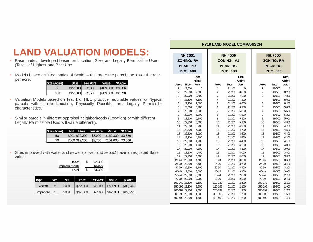
LAND VALUATION MODELS:▪ Base models developed based on Location, Size, and Legally Permissible Uses
(Test 1 of Highest and Best Use.
▪ Models based on “Economies of Scale” – the larger the parcel, the lower the rate per acre.
▪ Valuation Models based on Test 1 of HBU produce equitable values for “typical”parcels with similar Location, Physically Possible, and Legally Permissiblecharacteristics.
▪ Similar parcels in different appraisal neighborhoods (Location) or with different Legally Permissible Uses will value differently.
▪ Sites improved with water and sewer (or well and septic) have an adjusted Base value:
Each Addn'l
Each Addn'l
Each Addn'l
Acres Base Acre Acres Base Acre Acres Base Acre1 22,300 0 1 21,200 0 1 19,500 02 22,300 9,500 2 21,200 8,800 2 19,500 8,2003 22,300 8,400 3 21,200 7,800 3 19,500 7,3004 22,300 7,600 4 21,200 7,100 4 19,500 6,6005 22,300 7,100 5 21,200 6,600 5 19,500 6,2006 22,300 6,700 6 21,200 6,100 6 19,500 5,8007 22,300 6,300 7 21,200 5,800 7 19,500 5,5008 22,300 6,000 8 21,200 5,500 8 19,500 5,2009 22,300 5,800 9 21,200 5,300 9 19,500 5,00010 22,300 5,500 10 21,200 5,100 10 19,500 4,80011 22,300 5,400 11 21,200 4,900 11 19,500 4,70012 22,300 5,200 12 21,200 4,700 12 19,500 4,50013 22,300 5,000 13 21,200 4,600 13 19,500 4,40014 22,300 4,900 14 21,200 4,500 14 19,500 4,20015 22,300 4,700 15 21,200 4,400 15 19,500 4,10016 22,300 4,600 16 21,200 4,200 16 19,500 4,00017 22,300 4,500 17 21,200 4,100 17 19,500 3,90018 22,300 4,400 18 21,200 4,000 18 19,500 3,80019 22,300 4,300 19 21,200 4,000 19 19,500 3,800
20-24 22,300 4,100 20-24 21,200 3,800 20-24 19,500 3,60025-29 22,300 3,800 25-29 21,200 3,600 25-29 19,500 3,40030-39 22,300 3,600 30-39 21,200 3,400 30-39 19,500 3,20040-49 22,300 3,300 40-49 21,200 3,100 40-49 19,500 3,00050-74 22,300 3,000 50-74 21,200 2,800 50-74 19,500 2,70075-99 22,300 2,700 75-99 21,200 2,500 75-99 19,500 2,400
100-149 22,300 2,500 100-149 21,200 2,300 100-149 19,500 2,100150-199 22,300 2,300 150-199 21,200 2,100 150-199 19,500 1,900200-299 22,300 2,100 200-299 21,200 1,900 200-299 19,500 1,700300-399 22,300 1,900 300-399 21,200 1,700 300-399 19,500 1,500400-499 22,300 1,800 400-499 21,200 1,600 400-499 19,500 1,400
ZONING: RANH:3001
PCC: 600PLAN: PD
FY18 LAND MODEL COMPARISON
NH:4000ZONING: A1PLAN: RC PCC: 600
NH:7000ZONING: RAPLAN: RC PCC: 600
Size (Acres) Base Per Acre Value $/Acre50 $22,300 $3,000 $169,300 $3,386
100 $22,300 $2,500 $269,800 $2,698
Size (Acres) NH Base Per Acre Value $/Acre50 3001 $22,300 $3,000 $169,300 $3,386 50 7000 $19,500 $2,700 $151,800 $3,036
Base: $ 22,300 Improvement: 12,000
Total $ 34,300
Type Size NH Base Per Acre Value $/Acre
Vacant 5 3001 $22,300 $7,100 $50,700 $10,140
Improved 5 3001 $34,300 $7,100 $62,700 $12,540

LAND VALUATION PROCESS: HBU TEST 2HIGHEST AND BEST USE
Mass Appraisal Land Modeling is guided by the First Test of Highest and Best Use: TEST 2: Appropriately Supported
3. Financially Feasible4. Maximally Productive
• A use can be Physically Possibly and Legally Permissible, but not beFinancially Feasible to develop to its Maximally Productive use.
• Test 2 of Highest and Best Use guides in the development of SiteSpecific Adjustments – Adjustments to parcels that have similarLocation, Physically Possible, and Legally Permissible attributes, buthave features or challenges that are not “typical”.
• Site Specific Adjustments are developed from sales using Matched PairAnalysis.
• Typical Site Specific Adjustments include Wetlands, Topography, Non-Perc Soils, Restrictive Easements, and Access.

SITE SPECIFIC ADJUSTMENTSWETLANDS
• A Percentage Adjustment is developed based on the impactof the Wetlands to the parent parcel.
• Recorded Plat with Delineated Wetlands is preferred.
• GIS Wetlands Layer, as well as the RMA and RPA Layers,are used to measure the area in the absence of a plat.
• The impact of the Wetlands is determined by the loss ofutility for the affected portion of the property. For example,even though the site may not allow for a building, it may beuseable for recreational purposes.
• Diminished Utility Factors range from -65% to -95% forswampland (underwater, inaccessible, or unuseable).
• The result is a Wetlands Adjustment Factor that is applied tothe entire parcel.

LIMITED ACCESS PARCELS
Parcels A, B, and C are contiguous parcels under the same ownership (persons or entity). Parcel A has State Maintained road frontage.
SCENARIO:

LIMITED ACCESS PARCELS:Other and/or Comments
▪ Would be considered as one parcel if owner requested combination to receive one tax bill. Our frontage/depth table adjustment would be applied.
▪ Depends on whether Parcels B and C are buildable or not.
▪ They would be valued separately. However, the fact that they are all owned by the same person would be taken into account.
▪ They may be included on one parcel record number, but each individual parcel would be given a value based on road frontage or lack of road frontage.
▪ We might combine the 3 parcels into 1 tax record if the owner was agreeable otherwise they would be assessed as 3 parcels.
20.0%
70.0%
10.0%
One Parcel Separate,Individual Parcels
Other (pleasespecify)
12. Would you value Parcels A, B, and C as one parcel, or would you
value them separately?

LIMITED ACCESS PARCELS:Other and/or Comments
▪ Would consider these as residual to Parcel A.
▪ No, we would consider B & C to be excess land to Parcel A if the land is under the same ownership.
▪ No. Not since the same person owns all three parcels.
▪ If each of the three parcels were 10 acres, we would value all at the rate we are using for 30 acres. We would not consider them land locked if all three had the same ownership.
▪ Maybe not landlocked but definitely would be adjusted for access
▪ I would see if there were any deeded easements. I work very hard to not classify land as landlocked. In this case since the land owner owns all 3 parcels, I would not classify it as landlocked.
▪ To my understanding, there is technically no land locked land in the State of Virginia. There may be access issues, but there is no landlocked land.
22.4%
59.2%
18.4%
Yes No Other (pleasespecify)
13. Would you consider Parcel B and/or Parcel C “landlocked”?

LIMITED ACCESS PARCELS:
14. What type of adjustment would you make when valuing Parcel B and/or Parcel C?▪ None
▪ I would reduce the per acre value to show consideration for no road frontage.
▪ No home site value would be placed on B or C. We would value at same rate per acre for all 3 properties.
▪ There would be a discount per acre to arrive at FMV.
▪ Can't give accurate enough number to be quoted - would need to see situation - % downgrade usually.
▪ Percentage adjustment for access.
▪ 25% for B 50% for C.
▪ Possibly access.
▪ They would be valued as "rear" property. Really depends on where they are and how far off the road they are as to the difference in value. We have hard state maintained roads, as well as gravel/dirt state maintained roads.
▪ More than likely the lots would be given a flat value assessment based on the appraisers opinion.

LIMITED ACCESS PARCELS:
14. What type of adjustment would you make when valuing Parcel B and/or Parcel C?
▪ Our adjustment is the fact that the we value them at a lower per acre rate because we are considering them one parcel, even though they are three different parcels. I would reduce the per acre value to show consideration for no road frontage.
▪ Run the excess land rate. Parcel A would have 1st one-acre at homesite rate. Over 1 acre at the excess rate. Hard to apply the proper size adjustment in our system but can be done. There would be a discount per acre to arrive at FMV.
▪ Market-based adjustments for access, visibility, and other characteristics that have impact on value.
▪ It would depend upon access. If there is access to a home site on either B or C, then the prevailing off road home site, taking into account for view shed, would be applied, then a prevailing residual value would be applied to the remainder.25% for B 50% for C.
▪ % of Parcel A
▪ Downward adjustment from parcel A - Both would be of lesser value than A, and depending on size, utility, of C, it would probably carry same value as B.

SITE SPECIFIC ADJUSTMENTS: ACCESS

EXAMPLE: ACCESS NOTES:• One owner purchased five parcels in one deed. Parcels had been
part of the same farm since at least the early 1900’s.
• Other adjustments include Wetlands and Topography. Topographyapplied to some of the subject parcels because the wetlands dividesome of the useable acreage.
• All adjustments made from the Base Value.
• Adjusted value in this example is 13% higher by valuing theindividual parcels when compared to valuing the “Larger Parcel”(one administratively merged parcel).
PARCEL A B C D E TOTAL 1 ParcelSize 48.9554 50 53 13 6 170.955 170.955ACCESS ADJ 0% -35% -35% -55% -55%BASE VALUE 185,900 176,200 182,500 82,500 55,600 682,700 346,400 -OTHER ADJ (18,600) (54,600) (20,000) (20,600) (13,900) (127,700) (34,700)-ACCESS 0 (61,600) (63,900) (45,400) (30,600) (201,500) 0 ADJ VALUE 167,300 60,000 98,600 16,500 11,100 353,500 311,700
DIFFERENCE 13.4%
CLOSING NOTES:
This situation is VERY rare in Prince George County. Most parcels withAccess adjustments have deeded, developed access easements. Thisspecific situation only affects +/-42 Tax Parcels (out of 13,777) and +/-16 property owners (out of 10,940).

OPEN versus TIMBER PARCELS
SCENARIO:
In a rural area, there are two 50-acre parcels that have similar site characteristics, soil productivity, and highest
and best use.Both parcels would qualify for the Land Use Program, if
applicable. The only difference between the two parcels is that one parcel is
open and the second parcel is completely covered in timber.

OPEN versus TIMBER:
Other and/or Comments
▪ In my locality wooded parcels generally sell for a little less that pasture. However, I know there are some localities where timber parcels sell for more based on the type of timber being produced on the parcel.
▪ The parcels would be valued at FMV individually but the land use rate per acre would be applied based on use.
▪ Possibly on a 50 acre parcel the timber parcel might be valued slightly less per acre.
▪ In our area open land and crop land sale higher then wooded land.
▪ We don't make any adjustment between wooded and cleared land.
▪ A little less for timber
31.8%
43.2%
25.0%
Yes No Other (pleasespecify)
15. Would the MARKET VALUE be different for these parcels?

OPEN versus TIMBER:
Other and/or Comments
▪ In some localities we work good standing timberwith good paved road-front very well could be ashigh as open pasture.
▪ Depends on the location in the county. Someopen land is valued higher based on it's locationand sales data.
▪ Depends on where. Timber parcels are highervalue than open farm - but land available fordevelopment in proper zoning would be different.
▪ I thought state law or attorney general opinion orsomething says we are not to value timber.
▪ On an average, parcels with timber is similar invalue as open, cleared land if the timber is viable(not scrub timber). The wooded acreage isvalued, and timber value is added. this combovalue typically is similar in value to cleared openland values on same parcel.
7.1%
76.2%
16.7%
Yes No Other (pleasespecify)
16. Does your locality value parcels with standing timber at a higher MARKET VALUE
rate than open parcels?

OPEN versus TIMBER:
9.3%
90.7%
Yes No
17. Does your locality ADD MARKET VALUE for the standing timber on a parcel? If so, could you share your
additional rate per acre.
22.0%
54.0%
Yes No
18. Does your locality REDUCE the MARKET VALUE if timber is cut and
removed from a parcel?

OPEN versus TIMBER:
9.3%
90.7%
Yes No
17. Does your locality ADD MARKET VALUE for the standing timber on a parcel? If so, could you share your
additional rate per acre.
28.9%
71.1%
Yes No
18. Does your locality REDUCE the MARKET VALUE if timber is cut and
removed from a parcel?

OPEN versus TIMBER:
19. If you answered YES to Question 18, what procedure do you use to reduce the MARKET VALUE? If this is a rate per acre, could you provide that?
▪ $1,000 to $1,500 per acre
▪ Once the clearing is reported to me, I search for comparable size and type parcels that general reassessment valued and use that per acre value. Our values range from $1,200 to $1,800 per acre for cutover property.
▪ Based on %.
▪ 20% cutover adjustment for clear cut only.
▪ 25% reduction per class.
▪ We must be notified in writing and make a site visit to verify - $800.
▪ Range for cutover land is $600+/- to $1,600+/- per acre depending on location, utility, etc.

OPEN versus TIMBER:
20. If you answered YES to Question 18, how long does your locality carry this timbered parcel at a reduced the MARKET VALUE?
▪ Next reassessment.
▪ Until the next reassessment. However, since we have gone to a 6 year cycle, this may have to change.
▪ Max 3 years.
▪ Until marketable timber is on the property.
▪ About 10 years.
▪ The parcel is carried that way until changed during a reassessment.
▪ 10-15 years.
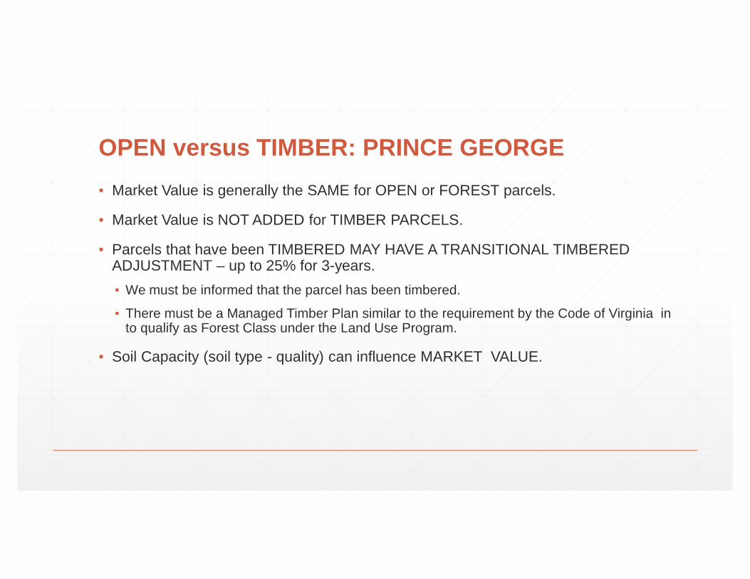
OPEN versus TIMBER: PRINCE GEORGE▪ Market Value is generally the SAME for OPEN or FOREST parcels.
▪ Market Value is NOT ADDED for TIMBER PARCELS.
▪ Parcels that have been TIMBERED MAY HAVE A TRANSITIONAL TIMBERED ADJUSTMENT – up to 25% for 3-years.▪ We must be informed that the parcel has been timbered.
▪ There must be a Managed Timber Plan similar to the requirement by the Code of Virginia in to qualify as Forest Class under the Land Use Program.
▪ Soil Capacity (soil type - quality) can influence MARKET VALUE.

OPEN versus TIMBER: PRINCE GEORGETIMBERED IN 2015
Just Prior to Sale
Prior to Timbering $84,300Clear-Cut Adjustment -25%Revised Value $63,200
Sales Price $64,0005/11/2016
TIMBERED IN 2012No Timber Adjustment
Prior to Timbering $101,200Clear-Cut Adjustment 0%Revised Value $101,200
Sales Price $105,0006/1/2016

LAND USE PROGRAM

LAND USE PROGRAM:
81.0%
19.0%
Yes No
21. Does your locality participate in Virginia's Use-Value Assessment
Program?
28.2%
71.8%
Yes No
22. Does your locality use all 8 of the agricultural soil classes?

LAND USE PROGRAM:
47.1%
52.9%
Yes No
23. Does your locality adopt the Agricultural Rates provided by the
SLEAC?
23.1%
76.9%
Yes No
24. Does your locality use all 3 Forest soil classes?

LAND USE PROGRAM: PRINCE GEORGE

QUESTIONS?