land use and regulation
DESCRIPTION
effect of land use and regulation on water qualityTRANSCRIPT

Land Use And RegulationBy: Ketan Wadodkar
M.Tech 1st yr10519013
Under Guidance of Prof. Indu Mehrotra
Land use is the human use of land. Land use involves the management and modification of
natural environment or wilderness into built environment such as fields, pastures, and settlements.
The United Nations' Food and Agriculture Organization Water Development Division explains that "Land use concerns the products and/or benefits obtained from use of the land as well as the land management actions (activities) carried out by humans to produce those products and benefits."
What is land use?
"'Land use' is a key term in the language of city planning.“ by Albert Guttenberg (1959)
Commonly, political jurisdictions will undertake land use planning and regulate the use of land in an attempt to avoid land use conflicts.
Land use plans are implemented through land division and use ordinances and regulations, such as zoning regulations.
Land use and regulation
Land use and land management practices have a major impact on natural resources including water, soil, nutrients, plants and animals.
Poorly planned development along waterbodies can threaten water quality, aesthetics, wildlife habitat, municipal infrastructure and private property
And in this perticular presentation we are more concentrating about change in water quality due to land use and regulations.
Eg. water bodies in a region that has been deforested or having erosion will have different water quality than those in areas that are forested.
Flood controls can also be achieved through this type of practises.

Infrastructure Protection:◦ vegetated riparian buffers can offer protection from flash
flooding and provide a flood and erosion “insurance policy” for towns.
It is intended to protect:◦ habitat for fish and other aquatic life,◦ protect habitat for wildlife,◦ protect water quality for human uses and for aquatic life,◦ control erosion and limit sedimentation, ◦ reduce the effects of flooding.

Protection of significant marsh/riparian habitat Protection of wetlands Establishment of riparian corridors Management of riparian corridors Modification of riparian vegetation excluding new structures and uses from buffer areas
around fish-bearing lakes, streams and associated wetlands prohibiting vegetation removal or other alteration in those
buffers for uses not permitted in the riparian corridor except under certain circumstances
In details the methods can be adopted as follows:

A naturally vegetated 50-foot-wide riparian buffer on each side of a stream controls soil erosion.
100-foot-wide buffer protects many of the functions associated with healthy riparian habitat.
For lakes a 100 foot vegetated riperian buffer is provided. A wider riperian buffer is provided to a soil which is
more prone to erosion and where significant wild life corridors can be constructed.
Buffers should be provided according to small or large streams and how they are affected with the pollutions.
Riperian buffers:

Fig:

Trap and remove sediment in runoff. Reduce stream bank erosion. Trap and remove phosphorus, nitrogen,
and other nutrients that cause excessive algae blooms and damage to aquatic ecosystems.
Trap and remove other contaminants, such as pesticides, heavy metals and pathogens
Contribute leaves and other energy sources to the stream.
Store flood waters, thereby decreasing damage to property.
Provide habitat for amphibious and terrestrial organisms.
Maintain base flow in stream channels.
Maintain good water quality. Protect channel-forming processes and
channel stability. Protect roads and bridges from erosion. Improve the aesthetic appearance of
stream corridors. Offer recreational and educational
opportunities to residents and tourists Maintain habitat for fish and other
aquatic organisms by moderating water temperatures and providing woody debris.
Ex. Lake Champlain and other Vermont lakes
Enlisted uses of riperian buffers
Interdependence of land, water, ecosystems and socio-economic development.
Integration can be facilitated by formulating and implementing a floodplain land use regulation.◦ restriction so as to ensure hydraulic link between the river
and the floodplain, and the socio-economic and environmental functions of floodplain.
◦ constraint of environmental flow in order to ensure in-stream flow requirement.
◦Programs are required to restore storage function of floodplain and for restoration of wetlands.
Integration of land and water management
Chalakudy river basin with an area of 1525 km2, is a tributary of the Periyar, the largest river in
There are six reservoirs impounded in this basin. Kerala. Porigalkuttu reservior of length of 583m2 . Average annual rainfall in this area is around 3300 mm,
varying from a little over 3000 mm in Chalakudy town to 3700 mm in Poringalkuttu.
Total average annual drainage discharge (1980–2000) is 1421.81 million m3 near Chalakudy town.
Seasonal variation of temperature is within 5°C.
Case study: Chalakundy river basin Kerala

Land use data:
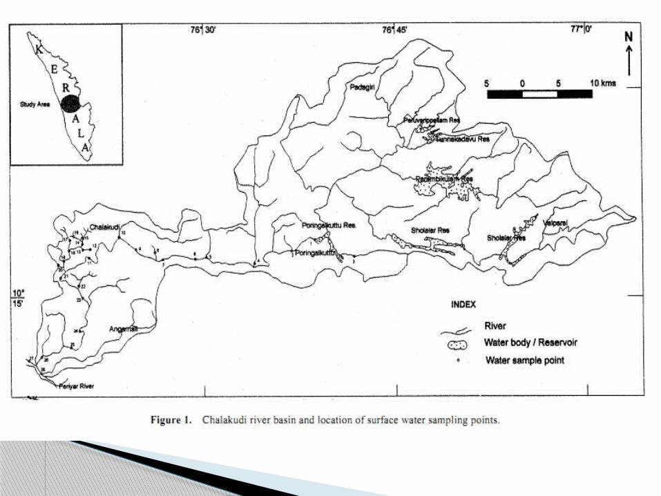

Fig: Physico-chemical characteristics (selected) of surface water samples under different landuse types
This study has brought out that there is definite relationship between landuse and water quality.
Anthropogenic activities are the main contributors to water quality deterioration.
Measures to improve water quality need to address issues of landuse management.
It is expected that the findings in this study will be helpful in this context
conclusions