land and property information in 3d
TRANSCRIPT

Land and Property Information
in 3D
Abbas Rajabifard
Ian Williamson
Mohsen Kalantari
Brian Marwick
Serene Ho
Davood Shojaei
Complex structures

Complex structures
UTS Sydney - Dr Chau Chak Wing BuildingThe Dr Chau Chak Wing Building is the first building in Australia designed by Frank Gehry, one of the world's most influential architects.http://www.uts.edu.au/partners-and-community/initiatives/city-campus-master-plan/projects-progress/dr-chau-chak-wing
ARC-Linkage Project Partners

• Chief Investigators– Prof. Abbas Rajabifard (Project Leader)
– Prof. Ian Williamson
– Dr Tuan Ngo
• Researchers– Dr Mohsen Kalantari (Research Coordinator)
– Prof. Ian Bishop
– Dr Ida Jazayeri (RF)
– Mr. Brian Marwick (SRA)
– Dr. Malcom Park
– Alireza Jamshidi
• Postgraduate Scholars– Mr. Ali Aien
– Mr. Davood Shojaei
– Ms. Serene Ho
– Mr. Sam Amirebrahimi
– Mr. Behnam Atazadeh
– Dr Zhixuan Yang
– Ms Mary Lin
Melb Uni Team
Scope
developer
architect
surveyor
engineer
builderlocal govt
land
registry
referral
authorities
VCAT
agent
civil
HVAC
env
eng…
trade
trade
trade
physical information
legal information
COMMUNITY

Limitations of 2D information
planning
development
management
community
knowledge
architectural
plans
engineering
plans
site survey other
documentssketches subdivision
plans
Objectives of the Project
1. An improved understanding of the problems and issues
associated with incorporating 3D property information into
land administration systems;
2. A specification of the technical, policy, legal and institutional
aspects of a 3D property information and representation
system;
3. Prototype 3D property information and building visualisation
systems, visualisation and modelling

Social
Core
Project focus
Technical
Core
3D Land
and
Property
INSTITUTIONAL
CHALLENGES
• Regulatory
• Social
• Cultural TECHNICAL
CHALLENGES
• Data source
• Data model
• Data
visualisation
• BIM
Project outcomes
STRATEGY
DEVELOPMENT
• Cultural change
• Collaboration
• Adoption
• Implementation
TECHNICAL
TOOLS
• Data model
• Web-based
visualisation
platform
• Specifications
Social
Core
Technical
Core
3D Land
and
Property

Project outcomes
Evaluation of range-based and image-based data sourcing
methods for building 3D models
4 sub-models (modules) 6 sub-models (modules)
1 sub-model (module)
�The 3DCDM model has 11 sub-models (modules).
Project outcomes
3D Cadastral Data Model (3DCDM)

� Physical Information
• interior walls
• exterior walls
• sliding doors
• single-flush doors
• awning windows
• fixed windows
• stairs
• slabs
� Ownership Information
• ownership of property
units
• common properties
Project outcomes
Development of a BIM model of a building to show potential for
managing 3D land and property information (cadastral info)
Project outcomes
3D approach to flood modelling for
planning purposes in urban areas
Some elements of the research
in more detail
Visualisation challenges and prototype
Institutional challenges
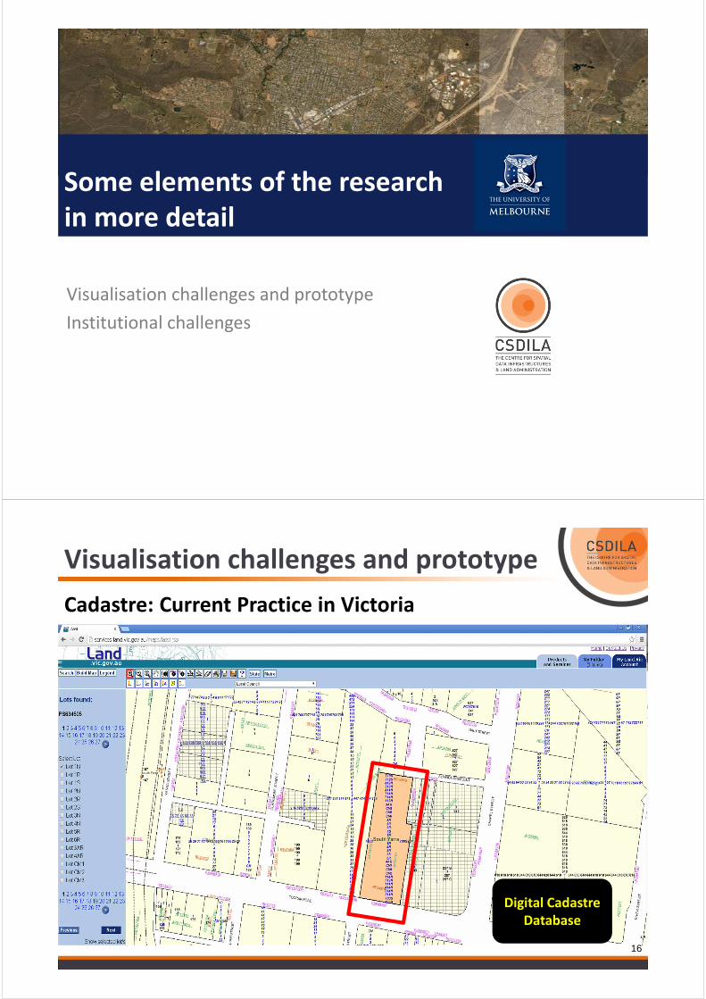
Digital Cadastre
Database
16
Cadastre: Current Practice in Victoria
Visualisation challenges and prototype
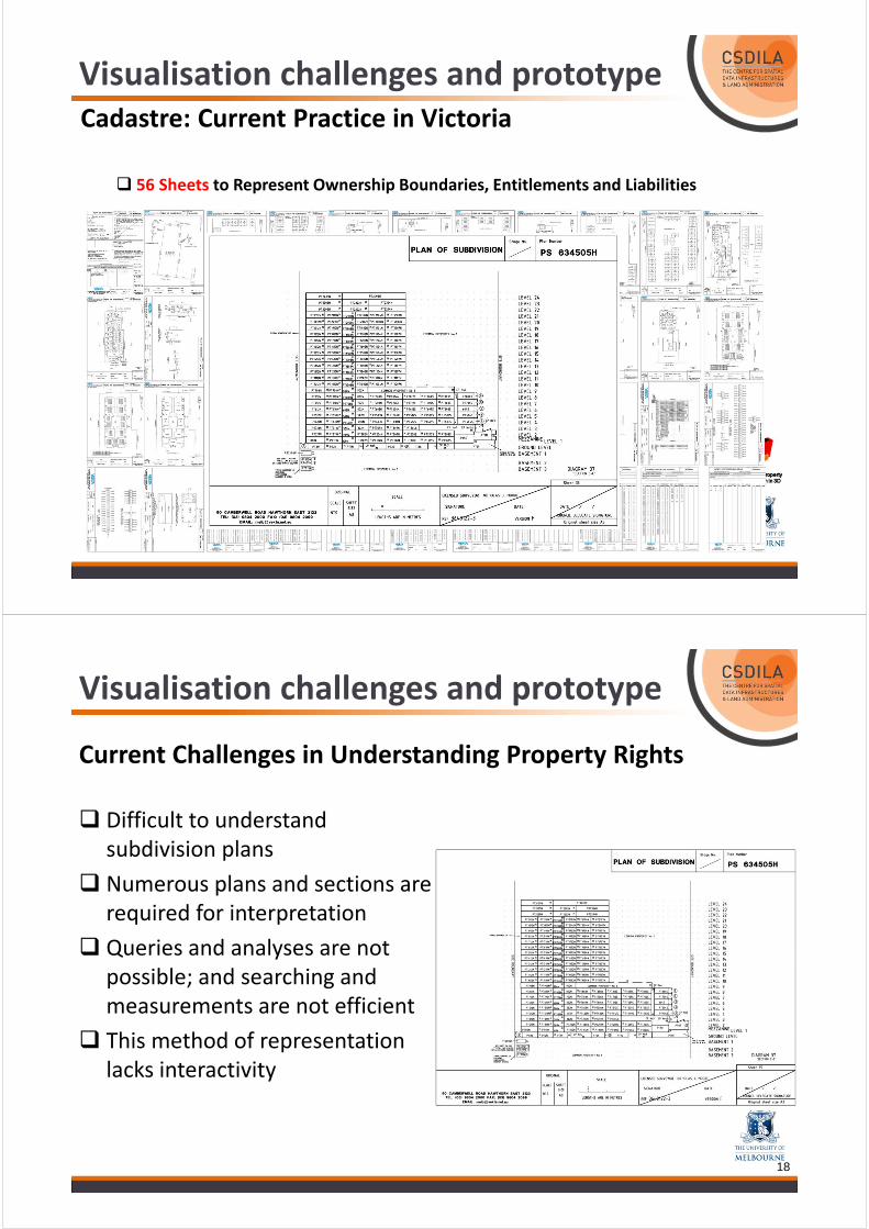
� 56 Sheets to Represent Ownership Boundaries, Entitlements and Liabilities
Cadastre: Current Practice in Victoria
Visualisation challenges and prototype
� Difficult to understand
subdivision plans
� Numerous plans and sections are
required for interpretation
� Queries and analyses are not
possible; and searching and
measurements are not efficient
� This method of representation
lacks interactivity
Current Challenges in Understanding Property Rights
18
Visualisation challenges and prototype
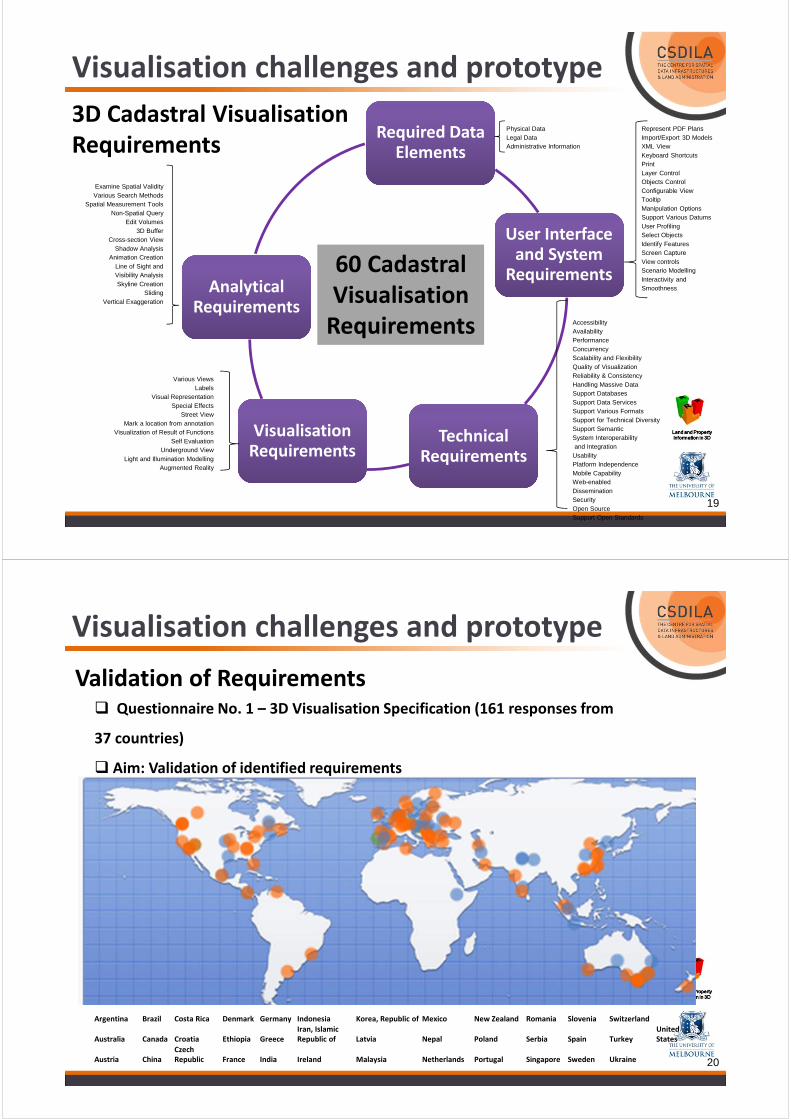
3D Cadastral Visualisation
Requirements
19
Required Data
Elements
Required Data
Elements
User Interface
and System
Requirements
User Interface
and System
Requirements
Technical
Requirements
Technical
Requirements
Visualisation
Requirements
Visualisation
Requirements
Analytical
Requirements
Analytical
Requirements
Physical DataLegal DataAdministrative Information
Represent PDF PlansImport/Export 3D ModelsXML ViewKeyboard ShortcutsPrintLayer Control Objects Control Configurable ViewTooltipManipulation OptionsSupport Various DatumsUser ProfilingSelect ObjectsIdentify FeaturesScreen CaptureView controlsScenario ModellingInteractivity and Smoothness
AccessibilityAvailabilityPerformanceConcurrencyScalability and FlexibilityQuality of VisualizationReliability & ConsistencyHandling Massive DataSupport DatabasesSupport Data ServicesSupport Various FormatsSupport for Technical DiversitySupport SemanticSystem Interoperabilityand Integration
UsabilityPlatform IndependenceMobile CapabilityWeb-enabledDisseminationSecurityOpen SourceSupport Open Standards
Various ViewsLabels
Visual RepresentationSpecial Effects
Street ViewMark a location from annotation
Visualization of Result of FunctionsSelf Evaluation
Underground ViewLight and Illumination Modelling
Augmented Reality
Examine Spatial ValidityVarious Search Methods
Spatial Measurement ToolsNon-Spatial Query
Edit Volumes3D Buffer
Cross-section ViewShadow Analysis
Animation CreationLine of Sight andVisibility AnalysisSkyline Creation
SlidingVertical Exaggeration
60 Cadastral
Visualisation
Requirements
60 Cadastral
Visualisation
Requirements
Visualisation challenges and prototype
Validation of Requirements� Questionnaire No. 1 – 3D Visualisation Specification (161 responses from
37 countries)
� Aim: Validation of identified requirements
20
Argentina Brazil Costa Rica Denmark Germany Indonesia Korea, Republic of Mexico New Zealand Romania Slovenia Switzerland
Australia Canada Croatia Ethiopia Greece
Iran, Islamic
Republic of Latvia Nepal Poland Serbia Spain Turkey
United
States
Austria China
Czech
Republic France India Ireland Malaysia Netherlands Portugal Singapore Sweden Ukraine
Visualisation challenges and prototype
21
Visualisation challenges and prototype
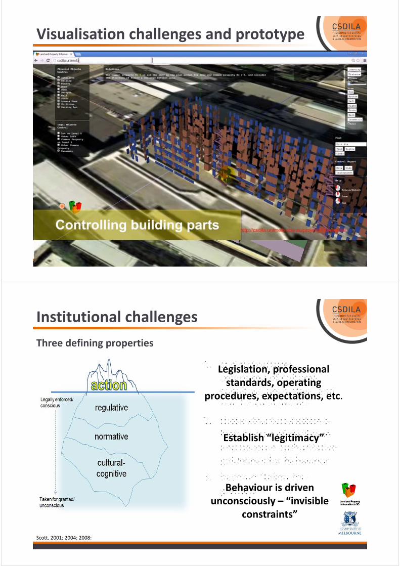
Three defining properties
1. social structures
composed of cultural-
cognitive, normative, and
regulative elements
2. these structures attain a
high degree of resilience
and become authoritative
guidelines for behaviour
3. become “taken-for-
granted”
Scott, 2001; 2004; 2008:
Legislation, professional
standards, operating
procedures, expectations, etc.
Establish “legitimacy”
Behaviour is driven
unconsciously – “invisible
constraints”
Institutional challenges

What does the Plan mean?
Subdivision
Plans
Land
Registry
Surveyors
Community
Strata
Managers
Developers
Institutional challenges
Local
Councils
“core information for development”,
“interaction with stakeholders”
“expediency”,
“due diligence”
“registry”, “guarantee”,
“authoritative”
“managing people”,
“property”
“what do I own?”,
“what can I use?”
“measurement”,
“accuracy”, “licensed”
What does the Plan mean?
Subdivision
Plans
Land
Registry
Surveyors
Community
Strata
Managers
Developers
Institutional challenges
Local
Councils
• Frustrating, inconsistent, ambiguous and limited
• Daunting, yet is the “bible”
• Limited reflection of OC Act
• Problematic, inconsistent quality of plans
• Administering new ownership situations
• 2D good for examination
• Lengthy, resource-intensive, rigid and frustrating
• Ongoing role in clarification
• Inconsistent representation of RRRs
• Inconsistent representation of
RRRs
• Not the right scale for city
management purposes

Legitimacy has been built on…
Dominance of surveying profession
Vertical subdivision less common
Tradition of 2D cognitive/conceptual framing for abstracting building info
2D plan is thesource of information
Process works well …mostly
Longstanding Subdivision Act and registration process
Rigorous information standards due to licensed surveyors
Institutional challenges
Invisible constraints on change
Dominance of surveying profession
Vertical subdivision less common
Tradition of 2D cognitive/conceptual framing for abstracting building info
2D plan is the source of information
Process works well …mostly
Perception that law MUST change first
Who owns the problem?
Perceived difficulty of building an argument for
change
Development process highly routinised
Taken-for-granted practices
Entrenched use of ‘parcel’ as basic unit
Longstanding Subdivision Act and registration process
Rigorous information standards due to licensed surveyors
Institutional challenges
Early Thoughts for Consideration
as input to Roadmap
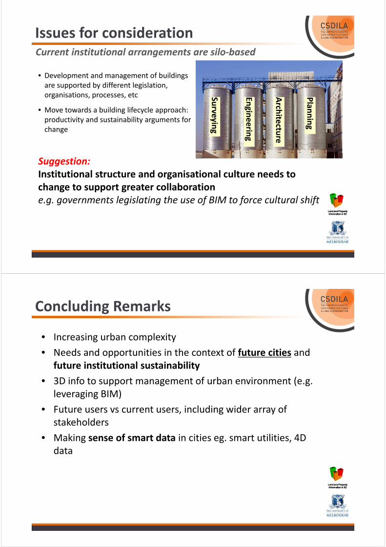
Cadastre 2034 is ALL about institutions!

Issues for consideration
LAND BUILDINGS
subdivision paradigm
Concepts developed for ‘land’ not necessarily appropriate for buildings
• More static entity – not much changes
after registration
• Typically only development, not
necessarily management
• Discrete, separate institutional
arrangements
• Concept of ownership
• Continually changing e.g. continuous
resubdivision/ amalgamation,
swapping lots, etc.
• Requires a collaborative approach to
both development and management
• Requires integrated institutional
arrangements
• Larger number of stakeholders per
development process
Suggestion:
Segment the market: land and buildings as separate processes
Issues for consideration
LAND BUILDINGS
subdivision paradigm
• Parcel as unit of analysis
• Continue to pursue ePlan/LandXML
• Property (lot) as unit of analysis
• Invest in 3D technology appropriate for
representing building information e.g.
Industry Foundation Classes (data
model behind BIM), gbXML (Green
Building XML schema)
• Leverage other visualisation/web
technologies
Cadastre
DCDB
By segmenting market:
Suggestion:
Facilitates parallel pursuit of technological opportunities
without losing current investment in ePlan
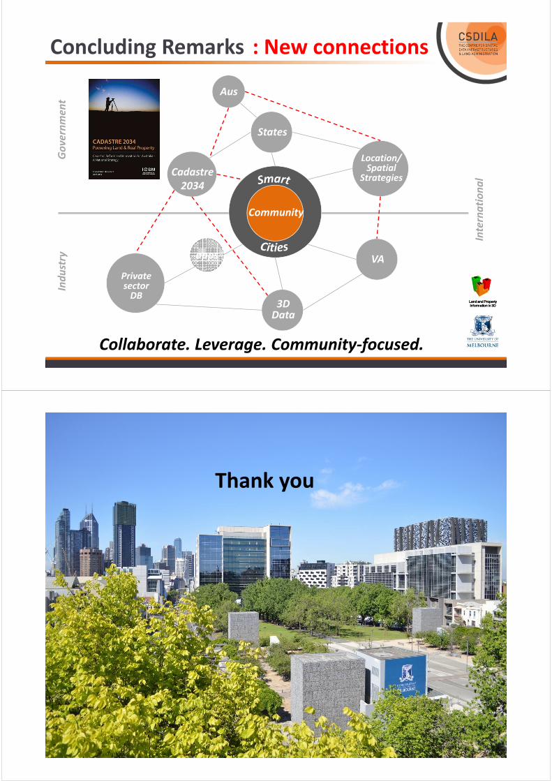
Issues for considerationCurrent institutional arrangements are silo-based
• Development and management of buildings
are supported by different legislation,
organisations, processes, etc
• Move towards a building lifecycle approach:
productivity and sustainability arguments for
change
Suggestion:
Institutional structure and organisational culture needs to
change to support greater collaboration
e.g. governments legislating the use of BIM to force cultural shift
Su
rve
yin
g
En
gin
ee
ring
Arch
itectu
re
Pla
nn
ing
• Increasing urban complexity
• Needs and opportunities in the context of future cities and
future institutional sustainability
• 3D info to support management of urban environment (e.g.
leveraging BIM)
• Future users vs current users, including wider array of
stakeholders
• Making sense of smart data in cities eg. smart utilities, 4D
data
Concluding Remarks
Concluding Remarks
Community
Cadastre
2034
Go
ve
rnm
en
tIn
du
stry
Location/Spatial
Strategies
Aus
Private sector
DB
apps
States
3DData
VA
Collaborate. Leverage. Community-focused.
: New connections
Inte
rna
tio
na
lThank you