l i .t e new mexico bureau - geoinfo.nmt.edu · modem conditions of 0°c occur about 1,000m (3,280...
TRANSCRIPT

L I .T E
A qusrterly publicaiion for educators and the pul)lic-contemporary geological topics, issues and evenls
How rock glacier# move.
This Issue:Earth Briefs---rocks that walk
Have you ever wondered... About CoalMining?
Glossary for Understanding Coal
Current topics in Earth science---highLites
coming soon...teacher training forearthquake safety in schools(back page)
Spring 1995
New Mexico Bureauof
Mines and MineralResources
(NMBM&MR)
Earth BriefsGeologist Makes Headsand Talus of Rock Glaciers
In mountainous parts of New Mexicoand Arizona, relics of near,glacialconditions---rock glaciers--have beendescribed by John Blagbrough(Blagbrough, 1984; 1994), a geologistfrom Albuquerque who began studyingthem in the 1960s using aerial photosand reconnaissance flights. An activerock glacier is a slowly moving mass ofpoorly sorted boulders and’ smallerrocks, which is cemented by interstitialice (ice that forms between rocks andwithin cracks in the rocks). When theice melts away, the rock glaciersbecome inactive. This is the case withthe rock glaciers in New Mexico, whichare no longer moving and are free ofice.
The rock masses originated on steepslopes where diurnal (daily) freeze-thaw cycles (during part of the year)broke up cliffs and large rocks, leavinga sloping pile of loose material called atalus cone or talus sheet. At the base ofthe talus, where temperatures hovernear freezing, interstitial ice caused themass of rocks to creep in a mannersimilar to that of true glaciers, which-are large, continuous sheets of ice.-Tongue-shaped rock g!aciers areelongated, with a greater length thanWidth. These occur at the head of avalley or cirque (a deep glacial cut atthe head of a Valley). Lobate rockglaciers are as wide as (or wider than)they are long, and occur at the base oftalus along valley walls (Blagbrough,1984).
Rock glaciers were formed inalpine areas (mountainous regionslying between timberline and snowline)in south-central and west-central NewMexico and east-central Arizona.The New Mexico and Arizona siteswhere rock glaciers are evident are theCapitan, Carrizo, Gallinas, Magdalena,
New Mexico Bureau of Mines and Mineral Resources 1 Lite Geology, Spring 1995

San Mateo, Mogollon, and EscudillaMountains. The rock glaciers arebelieved to be of late Wisconsin age(30,000-10,000 years before present),which was the most recent glacial stageof the Pleistocene Epoch.
Understanding the conditionsunder which rock glaciers form andmove gives paleoclimatologists a toolfor piecing together the climatic historyof an area. These rock glaciers formedin late Wisconsin climate, which hadpermafrost conditions (mean annualtemperatures at freezing or below) thatfavored interstitial ice development,and temperatures that were lowenough to maintain the ice and allowfor creep. In south-central New Mexico,mean annual temperatures were atabout 0°C (32° F) at the lower limit ofrock glaciers.
Modem conditions of 0°C occurabout 1,000m (3,280 ft) higher elevation than rock glaciers in south-central New Mexico. The modemtemperatures at the lower elevationlimit of rock glaciers are 7.2 to 7.9°C,showing that temperatures were7 to 8°C lower in late Wisconsin time.
To the ,west, elevations of the lowerlimits of rock glaciers are higherthan in south-central New Mexico.This rise may be due to increased snowcover in the western mountain~,because snow insulates the groundand inhibits rock-glaciers’developinent (Blagbrough, 1994).
Sources:Bates, R. L., and Jackson, J. A. (editors),
1980, Glossary of Geology: AmericanGeological Institute, Alexandria, VA, 2ndEdition, 749 pp.
Blagbrough, Ji W., 1984, Fossil rock glacierson Carrizo Mountain, Lincoln County,New Mexico: New Mexico Geology, v. 6,pp. 65--68.
Blagbrough, J. W., 1994, Late Wisconsinclimatic inferences from rock glaciers insouth-central and west-central NewMexico and east-central Arizona; NewMexico Geology, v.16, pp.65-71.
--story by D. Love and S. Welch
Spring 1995, Lite’Geology
Have You Ever Wondered...... About C0al Mining?Gretchen HoffmanSenior Coal Geologist, NMBM&MR
IntroductionIn the Winter 1994 issue of Lite
Geology we learned about coalformation, its ranking system (lignite,subbituminous, bituminous, andanthracite), and, coal qualitydesignations (in terms of heatingvalues and sulfur content).
Although coal-bearing rocks coverone-fifth of New Mexico, most peoplein our state have little direct contactwith coal. Coal" is the third largestsource of revenues in the state from,mineral and energy production, and itis an important source of energy formost New Mexicans. The followingexplores coal production, modemmining techniques, and uses for coal.Boldface terms are defined in theglossary on page 6.
C0al ProductionThe United States produces
approximately one billion tons of coalper year, and the coal industryemploys more than 100,000 workers(Energy Informatiort Administration,December 1994; 1993 figures). At thepresent rate of production, the UnitedStates has more than 250 years ofrecoverable reserves (264.6 billiontons).
Harnessing coal’s energy.
Most of this country’s annualproduction comes.from eastern coalfields, but western coal production hasincreased significantly during the past30 years. Western mines are primarilys~urface operations that are moreefficient than underground mining,generally reducing the cost of westerncoal. The average mine price of coalfrom the Western region is $11.14/toncompared to $20.03/ton and $27.64/ton from the Interior and Appalachianregions (Energy InformationAdministration, December, 1994).Production costs and the demand forlow-sulfur coal to meet environmentalstandards have significantly increasedthe consumption of western coals.Wyoming with its thick beds (average70 ft thick) of low-sulfur coal is theleading coal-producing state (210million tons per year; EnergyInformation Administration,December, 1994). New Mexico ranks12th in the nation, producing 28.3million tons of coal in 1993, a recordhigh for the state (Hatton, 1994).
Production by RankIn 1993, 61% of the total United
States production was bituminouscoal, 29% subbituminous, 9.5% lignite,and 0.5% anthracite (EnergyInformation Administration,December, 1994). Texas and NorthDakota are the leading’ producers oflignite in the United States, where it isprimarily used to generate electricity.North Dakota has the nation’s largestcoal gasification plant, Great PlainsSynfuei,.which converts lignite intogas and creates several by-productssuch as ammonia, sulfur, and liquidnitrogen (Energy InformationAdministration, January 1994).
’Wyoming is the leading producer ofsubbituminous coal (207.9 billion tons,1993) followed by Montana (35.6million tons, 1993). More than half ofNew Mexico’s production is fromsubbituminous coal (16.9 million tons,1993).
Most of the nation’s bituminous coalproduction comes from the
New Mexico Bureau of Mines and Mineral Resources

L
GREAT PLAINS
i
~:’--o
¯ -.... (
o, 490 ml
PACIFIC
COA~
~ AnthraciteBituminous coalLigniteSul:;bituminous coal
O, 400, ml ~ Coal-bearing region
Figure 1---Coal-bearing areas of the United States. Modified from Energy Information Administration, December, 1994.
Appalachian coal fields (Fig. 1).Kentucky and West Virginia are thelargest producing states within thisregion, 156.3 and 130.5 million tons in1993, respectively. Approximately onetenth of the nation’s bituminous coalproduction is from the RockyMountain region, and most of thisoutput is from Utah (21.8 million tons,1993). Less than half of New Mexico’syearly coal production is bituminouscoal (11.3 million tons, 1993). Presentproduction of anthracite" (about 4,000tons) in the United States comes fromthe Appalachian region for homeheating fuel and for coke production.
Mining CoalIn the past, most coal mining was
underground and very labor intensive.
Although surface mining with largemechanized equipment began as earlyas the 1920s, surface production didnot overtake underground output untilthe 1970s. Today, 60% of coalproduced in the United States is fromsurface operations. The remainingproduction is from undergroundmines, primarily in the eastern coalfields. Utah is unusual among westerncoal-producing states because all 15 ofthe operating coal mines areunderground (Energy InformationAdministration, December, 1994).There are 13 underground mines inColorado and New Mexico had oneunderground operation in the Ratonfield as recently as March of 1995.Until the 1960s, all coal mined in NewMexico came from underground mines.
Underground miningPresent underground operations in
the United States are highlymechanized and must comply with theFederal Coal Mine Health and SafetyAct. Ventilation, control of coal dust,and roof stability are major concernsthat are monitored. For allunderground mining the average coalrecovery rate is about 56%. There arethree methods of mining coalunderground: 1) room and pillarwith continuoua mining, or 2)room-and-pillar with conventionalmining , or 3) longwall mining.
in the room and pillar method usingcontinuous mining, the miningmachine breaks the coal from the mineface and transports the coal to ashuttle car that lbads it onto aconveyor belt, which moves the coal to
New Mexico Bureau of Mines and Mineral Resources 3 Life Geology, Spring 1995

the surface (Fig. 2). The continuousmining machine advances about 20 ftinto the coal seam and then backs outso the roof can be bolted to provide
¯ stability¯ This is repeated along themine face, but pillars of coal, generally40 to 80 ft on a side, are left betweenthe paths of the continuous miningmachine for roof stability. At the end ofa mine’s production phase, somepillars may be removed and the roofallowed to collapse. Of all theunderground mines active in theUnited States in 1993, 56% usedcontinuous mining (EnergyInformation Administration, March,1995).
Conventional mining is also aroom-and-pillar method but involvesthe use of explosives to break the coalfrom the mine face. In conventionalmining, the coal is undercut by amachine and holes are drilled into thecoal to pack with explosives. Afterblasting the coal bed, the broken coal isloaded into shuttle cars for delivery tothe conveyor and transported to thesurface. The roof is bolted in theexcavated area and the process isrepeated (Energy InformationAdministration, March 1995). Pillarsare left between the excavated rooms tomaintain stability of the mine roof.Conventional mining includes only11% of underground production in theUnited States.
Longwall mining uses a cuttingmachine operating along a 400- to800-ft-long face of the coal seam. Asthe machine cuts into the coal using arevtllving cylinder with bits, the coalfalls onto a conveyor belt that carriesthe coal to the surface (Fig. 3). Attachedto the Iongwall machine are steel roofsupports that advance as the machinemoves forward, allowing the roofbehind the supports to fall. TheIongwall method has a higher recoveryrate than room and pillar method, butis used in fewer mining applicationsbecause of the need for greater roofstability and seam consistency. TheCimarron underground mine (Fig. 4)near Raton used the Iongwali method.
Figure 2--Continuous mining machine. Coal is cut by rotating cylinder andautomatically loaded into a shuttle car. I’hoto courtesy of Joy Mining Machinery.
Figure 3--Longwall mining machine. A revolving cylinder with tungsten bitsshears off coal by moving back and forth across the coal face. Water is sprayed tokeep coal dust down. Movable supports on left side of photo hold up roof in theworking area. Photo courtesy of Joy Mining Machinery¯
Spring 1995, Life Geology 4 New Mexico Bureau of Mines and Mineral Resources

k.
I!
!I
RioPuerco ’Field
LakeField
o,Mountain
SOCORROJomada
oOField
Cia~dhage
\
", " Railroadi ~ Coal fieldI
¯ Coal-fired power plants1 San Juan Plant-
Public Service Co. of New Mexico2 Four Corners Power Plant-
Arizona Public Service Co.
Transmission Coop.
SANTA FE
~ldan FieldField
SierraBlanca,Field
0 50 mi, J , i t i
Active Mines
12 SanPlataJuanLa)l San Juan Coal Co. of BHP Minerals3 Navajo (BHP Minerals)4 Lee Ranch (Lee Ranch Co. of Hanson Natural
Resources)SMcKinley@Cimarron Underground
ii7 East Ridge,Ancho Road Canyon PiottS~.~& Mid.way9 York Canyon Surface
Figure 4--Map of coal-fired power plants, coal mines, and major coal fields inNew Mexico. From New Mexico Energy, Minerals and Natural ResourcesDepartment, 1994.
Surface miningSurface mining employs a
combination of draglines or shovels,front-end loaders, and trucks. Four ofthe five surface mines in northwestNew Mexico are dragline operations(Fig. 4). Smaller operations or complexmining situations use front-endloaders and trucks. The La Plata Mine(Fig. 4) near the Colorado--New Mexicoborder uses trucks and front-endloaders for removal of overburdenand coal because of the high angle dipof the coal beds. The East Ridge andAncho surface mines near Raton (Fig.4) will also use front-end loaders andtrucks because of the ruggedtopography of the area.
Besides the health and safetyregulations, surface mines today haveto follow strict environmentalregulations during the development,production, and reclamation phases asset I~y the Surface Mining Reclamationand Control Act (SMRCA) of 1977.Federal and State surface miningagencies regularly inspect mines tomake sure the ~ines comply with theseregulations.
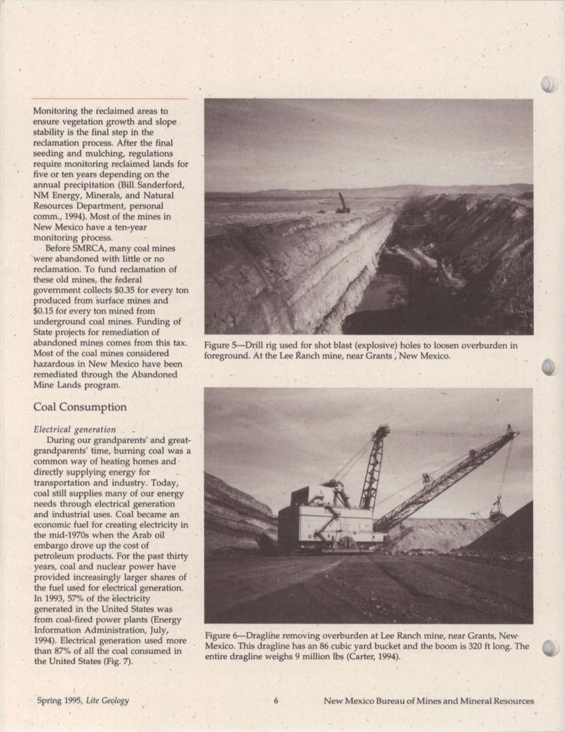
Mining begins by removing andstoring the topsoil for use in thereclamation process. Overburden isdrilled at regular distance intervalsand the drill holes are loaded withexplosives to break up the overburdenfor easier removal (Fig. 5). Draglines shovels (55-,86 yd3 bucket) remove theoverburden exposing the coal (Fig. 6).Smaller (15-30 yd3 bucket) shovels or,front-end loaders scoop up the coaland load it into dump trucks fortransport,to the preparation plant.Overburden goes into the spoil pile tofill the p|t during the reclamationprocess.
Reclamation begins after re’movingthe economic coal from an area in themine. Regrading and contouring tonatural slopes is done before replacingthe topsoil. Planting of nativevegetation and trees is part of thereclamation process to make the landas productive aa it was before mining.
New Mexico Bureau of Mines and Mineral Resources 5 Lite Geology, Spring 1995
Monitoring the reclaimed areas toensure vegetation growth and slopestability is the final step in thereclamation process. After the finalseeding and mulching, regulationsrequire monitoring reclaimed lands forfive or ten years depending on theannual precipitation (Bill Sanderford,NM Energy, Minerals, and NaturalResources Department, personalcomm., 1994). Most of the mines inNew Mexico have a ten-yearmonitoring pi’ocess.
Before SMRCA, many coal mineswere abandoned with little or noreclamation. To fund reclamation ofthese old mines, the federalgovernment collects $0.35 for every tonproduced from Surface mines and$0.15 for every ton mined fromunderground coal mines. Funding ofState projects for remediation ofabandoned mines comes from this tax.Most of the coal mines consideredhazardous in New Mexico have beenremediated through the AbandonedMine Lands program.
Coal Consumption
Electrical generationDuring our grandparents’ and great-
grandparents’ time, burning coal was acommon way of heating homes anddirectly supplying energy fortransportation and industry. Today,coal still supplies many of our energyneeds through electrical generationand industrial uses. Coal became aneconomic fuel for creating electricity inthe mid-1970s when the Arab oilembargo drove up the cost ofpetroleum products. For the past thirtyyears, coal and nuclear power haveprovided increasingly larger shares ofthe fuel used for electrical generation.In 1993, 57% of the ~lectricitygenerated in the United States wasfrom coal-fired power plants (EnergyInformation Administration, July,1994). Electrical generation used morethan 87% of all the coal consumed inthe United States (Fig. 7).
Figure 5---Drill rig used for shot blast (explosive) holes to loosen overburden foreground. At the Lee Ranch mine, near Grants ~ New Mexico.
Figure 6---Draglihe removing overburden at Lee Ranch mine, near Grants, NewMexico. This dragline has an 86 cubic yard bucket and the boom is 320 ft long. Theentire dragline weighs 9 million lbs (Carter, 1994).
Spring 1995, Lite Geology 6 New Mexico Bureau of Mines and Mineral Resources

4,
k.
Residential &Commercial
(0.67%)Other Industrial
(8.09%)
Coke Plants \(3.38%)
Figure 7reUnited States coalconsumption by end-use in 1993.’FromEnergy Information Administration,December, 1994.
Coal usage in New Mexico hasfollowed the national trends. From the1890s to the 1950s, New Mexico coalwas used for home heating, poweringrailroads, and supplying coke to thesteel and copper industries in theSouthwest. With the arrival of dieselengines and use of petroleum productsas a fuel source, coal consumptiondropped to record lows in the 1940sand 1950s.
Beg!nning in the late 1950s, thedemand for electricity in .the Southwestand California steadily increasedbecause of population growth. The lowcost Of coal and expected shortages ofnatural gas for heating prompted theneed for large surface mines and coal-fired power plants. New Mexico coalproduction went from 0.25 million tonsin 1954 to 9.41 million tons in 1974(New Mexico State Mine Inspector,1954, 1974 ) with opening of three largesurface mines, the Navajo, McKinley,and San Juan (Fig. 3).
In 1993, coal-fired powerplantsgenerated 90% of the electricity, in NewMexico. The major generating stationsare the Four Comers (2269 megawatts)and the San Juan (1717 megawatts),
both west of Farmington, and theEscalante (233 megawatts) northwestof Grants (Fig. 4). These plants useabout two-thirds of the coal producedin the state (New Mexico Energy,Minerals and Natural ResourcesDepartment, 1994). Much of theelectricity generated in New Mexicogoes to Arizona, California, and Texas.Most of the remaining coal producedin New Mexico is shipped by train topower plants in Arizona and, as of1993, Wisconsin for electricalgeneration. Of the total energyconsumed in New Mexico, 37% comesfrom coal, 33% from petroleumproducts, and 29% from natural gas(New Mexico Energy Minerals andNatural Resources Department, 1994).
Industry and other usesIndustry and coke plants consume
about 11% of the coal produced in theUnited States (Fig. 6). Coal suppliesenergy for making cement, glass, paperand metal. Today only a small amountof New Mexico coal is used byindustry, at a paper mill in Arizona.Coke is used in the production of ironand steel, and most of this coal comesfrom the eastern United States. Coal isalso used as a chemical feedstock tomake dyes, insecticides, fertilizers,explosives, synthetic fibers, ammonia,food presei’vatives, medicines, andother products. Residential andcommercial uses consume less than 1%of the coal used in this country.
ExportsThe United States exports 74.5
million tons of c0al (EnergyInformation Administration,December~ 1994) primarily from theAppalachian region. Japan, Canada,and Italy were the largest buyers ofU.S. coal in 1993. Other Europeancountries, Brazil, and China alsoimport coal from the United States. Theamount of coal exported is dependenton the econo~lJc climate of other
¯ nations. During the past few years,total coal exports have droppedbecau~ of the slow economic growthoverseas.
Coal will continue to play a majorrole in the generation of electricity. TheClean Air Act regulations will play apart in determining whether newpower stations will be coal-fired andwill increase the market for low--sulfurWestern coal. This will be animportant factor in potential newmarkets for New Mexico coal.
Acknowledgmen tsThe author wishes to thank Kay
Hatton of NMEMNRD, Tom Cliffordand Jim O’Neil of NM Taxation andRevenue, and Don Moseley of BHPMinerals for providing valuableinformation for this project. Thanksalso to Frank Kottlowski and CharlesChapin for their helpful suggestionsand to Kathy Glesener and JanThomas for illustrations.
Sources:Carter, R.A., 1994, Lee Ranch turns to
dragline for increased production;inMerritt, P.C.,Best of COAL--Surfacemining: Maclean Hunter, Chicago, IL, v.1, pp. 13--16.
Energy Information Administration, January1994, State coal profiles: DOE/EIA 0576,pp. 67, 91.
Energy Information Administration, July1994, Annual energy review 1993: DOEEI,~--0384 (93), pp. 1-10, 207-237.
Energy Information Administration,December 1994, Coal industry annual1993: DOE/EIA-0584(93), pp. 28, 30, 60,27-135, 138.
Energy Information Administration, March1995, Longwall mining: DOE/EIA.TR-0588, pp. 1--6.
New Mexico Energy, Minerals, and NaturalResources Department, 1994, Annualresources report, 1994: Energy, Minerals,and Natural Resources, pp. 25, 35-36, 40,44, 83-85.
Hatton, K., July 1994, New Mexico coal factsheet: New Mexico Energy, Minerals, andNatural Resources Department.
New Mexico State Mine Inspector, 1954 and1974, Annual Report of the StateInspector of Mines.
New Mexico Bureau of Mines and Mineral Resources 7 Lite Geology, Spring 1995
Glossary of coal termsGretchen HoffmanSenior Coal Geologist, NMBM&MR
Agglomerate--Collected into a ball ormass; agglomeration.
Anthracite--A rank class of coalsdefined as having more than 86 percentfixed carbon and less than 14 percentvolatile matter on a dry, mineral-matter-freebasis. This rank is divided intosemianthracite, anthracite, and meta-anthracite groups on the basis ofincreasing fixed carbon and decreasingvolatile matter.
Ash--The inorganic residue remainingafter complete incineration of coal.
Bituminous coaI--A rank class of coalsdefined by the ASTM (see rank) having less than 86 percent fixed carbon,and more than 14 percent volatile matterand more than 10,500 Btu/Ib on a moist,mineral-matter-free basis. An overlap ofbituminous and subbituminous heatvalues from 10,500 to 11,500 Btu/lb isdependent on whether an agglomeratebutton with swelling characteristics isformed during volatile matter analyses.There are several divisions ofbituminous Coal. High-volatile C, B,and A are divided by increasing heatvalue. Medium and low-volatilebituminous coals are classified on thebasis of increasing fixed carbon anddecreasing volatile matter.
t
Btu--Btu is British thermal unit. TheBtu is the amount of heat needed toraise the temperature of 1 pound ofwater by 1 degree Fahrenheit.
Chemical feedstock--Raw materialsupplied to a machine or processingplant.
Coke---Material derived from heatingbituminous coal in the absence of air anddriving oft~ the volatile constituents, sothat the fixed carbon and ash are fusedtogether.
Conservation tax--Tax (0.18%) on salesvalue less Federal, State, and Indianroyalties. Revenues from this tax gointo the state’s general fund.
Continuous mining--A form of room-and-pillar mining in which acontinuous mining machine extractsand removes coal from the workingface in one operation; no blasting isrequired.
representative of the value if mineral-matter had been removed and thenatural moisture in the coal retained.Used in determining the rank of coal.
Overburden--Material of any nature,consolidated or unconsolidated, thatoverlies a deposit of useful materials,ores, or coal, especially those depositsthat are mined from the surface.
Conventional mining---The oldestform of room-and-pillar mining whichinvolves cutting the coalbed so that itbreaks easily, when blasted withexplosives or high-pressure air, andthen removing the broken coal.
Dry, mineral-matter-free-basis--Acalculated, analytical value of a coalsample expressed as if total moistureand mineral matter had been removed.
Fixed carbon--The solid residue, otherthan ash, remaining after the volatilematter has been liberated from coalduring combustion.
Lignite-Lowest rank of coal, with lowheat values between 6,300 and 8,300Btu /lb, on a moist, mineral-matter-freebasis.
Longwall mining--An undergroundmining method that can be used atgreater depths than room-and-pillarmethods. A cutting machine is pulledback and forth across a panel of coal400 to 800 feet wide, and the brokencoal is moved by conveyor belt to thesurface. The roof is heldup bymoveable supports that are ad~,ancedas the coal bedis cut away. The roof inthe mined-out area is allowed to fall asthe mining advances.
Mine face--Surface in mine whereexcavation is being done.
Moist, mineral-matter-free basis--Acalculated number based on basicanalytical data--Btu /lb, ash andsulfur--to determine a number
Rank--The classification of coalsaccording to their degree of ¯metamorphism or coalification(maturation) in the natural series fromlignite to anthracite. Rank is defined inthe United States by the AmericanSociety of Testirig and Materials(ASTM) classification based agglomeration characteristics, heat
, values,fixed carbon, and volatile mattercontent.
Recoverable reserves--Oil, gas, coal,and other minerals that can beeconomically recovered after allowingfor environmental, legal, andtechnological controls.
Resources excise tax--Tax (0.75%) onsales value of coal, less sales or
royalties paid to State and Federalgovernments. Revenues from this taxgo into the state’s general fund. Two-thirds of the general fund helpssupport public schools and education.
Room-and-pillar mining--The mostcommon method of undergroundmining in which themine roof issupported mainly by coal pillars left atregular intervals. Rooms are placeswhere the coal is mined; pillars areareas of coal left between the rooms.Room-and-pillar mining is done eitherby conventional or continuous mining.
Severance tax--Tax on number of tonssold, consumed, or transported out ofstate. Revenues from this tax go into theState’s severance tax bonding fund, forbuildings, and other state bonds.Severance tax on coal is $1.17/ton forsurface-mined and $1.13/ton onunderground-mined tonnages.
Spring 1995, Lite Geology 8 New Mexico Bureau of Mines and Mineral Resources

k.
Subbituminous coal--A rank class ofcoals having a heat value content ofmore than8,300 Btu/lb and less than11,500 Btu/lb on a moist, mineral-matter-free basis. This class of coal isdivided by increasing heat value intosubbituminous C, B, and A coalgroups.
Volatile matter----In coal, thoseproducts, exclusive of moisture, givenoff as gas and vapor, determinedanalytically by prescribed methods.
Glossary Sources:American Society of Testing Materials
(ASTM), 1990, Standard classification coals by rank in Annual Book of ASTMStandards--Gaseous fuels; coal and coke:ASTM, Philadelphia, PA, sec. 5, v. 05.05,pp. 193-196.
Energy Information Administration,December 1994, Coal industry annual1993: DOE/EIA-0584(93), pp. 28, 30, 60,138, 259, 263.
Hatton, K., July 1994, New Mexico coal factsheet: New Mexico Energy, Minerals,and Natural Resources Department.
Wood, G.H., Kehn, T.M., Carter, M.D., andCulbertson, W.~., 1983, Coal resourceclassification system of the U.S.Geological Survey: U.S. GeologicalSurvey, Circular 891, 65 pp.
Coal Factsfor
New Mexicq
I ~.: ::"
I"
..~
* One fifth of New Mexico is underlainby coal. Most of the state’s coal islocated in San Juan, Colfax, McKinley,and Catron Counties.
* New Mexico ranked 12th in thenation in coal production in 1993.
¯ New Mexico’s coal productionreached an all-time record high in1993 of 28.3 standard tons of cleancoal, which was up 15.3% from theprevious year.
¯ The yearly payroll for coal miningemployees in New Mexico for 1993was $99.4 million.
¯ Revenues from coal mining collectedby New Mexico for 1993 were:
--$34.7 million (from severance,resources excise, and conser-vation taxes)
---$18.8 million (from grossreceipts taxes)
--$3.4 million (from State landroyalties and rentals)
J
I
iiO
o
New Mexico Bureau of Mines and Mineral Resources 9 Lite Geology, Spring 1995

etoo:l Ioo:3
toixeM well
i
ii
" "’ :i::..:.: ....: ::":"~/"..." .....I c. "’. "" "’." "’"". ’ :’:" 0
:.":.’: :."~.: / ::::1
: .|--$8.4 million (New Mex/cc~s ’~".""Ifederal royalty share) ’.’."".’~".~.I
I t " ’"
¯ The active coal mines in New Mexico"!" "" ""
:are: , I~,York Canyon Surface
I’ Ancho _v
East RidgeRoad CanyonCimarronMcKinley
’ NavajoSan JuanLa PlataLee Ranch
SourceNew Mexico Mineral Industries---
Data 1994: Mining and Minerals Divisionof the New Mexico Ener~, Minerals, andNatural Resomres Department, 2040South Pache~o, Santa Fe, NM 87505.
Published in the, Spring 1995 issue of Life~_,eology: New Mexico Bureau of Mines and
.Mineral Resources, Socorro, NM 87801
O5o
/
Publication sources:Earth in Space is an AGu publicationcreated to keep science teachers andstudents abreast of the changing worldof geophysical research. Each issuecontains articles by leading researchscientists as well as brief reports ofnew findings. The articles demonstrateresearch applications of scientificprinciples and analyses, and useexamples that are interesting toteachers and students. Earth in Spaceis published monthly from Septemberthrough May and is a good way toincrease science literacy byintroducing current geophysicalinformation into the classroom. Earthin Space costs $12.00 per year (nineissues). For ordering information, callthe American Geophysical Union(AGU) at 1-800-966-2481.
On the Rocks is an Earth scienceteacher’s guide that contains 52activities for students in grades 1-8.The activities are divided into sevencategories: Rocks and Minerals; EarthWorks; Water Works; FossilExplorations; Maps, Maps, and MoreMaps; Science Basics; and Geology,Society, and the Environment. On theRocks is published by SEPM (Societyfor Sedimentary Geology), P.O. Box4756, Tulsa, OK 74159-0756. Theprice is $9.75 plus $1.90 for shipping.
What everyone should know about coalis a 15-page booklet that is available,along with other coal educationmaterials, for teachers who write to theAmerican coal Foundation. Pleasespecify grade level, and send yourrequest to American Coal Foundation,1130 Seventeenth St., NW, Suite 220,Washington, DC 20036.
Spring 1995, Life Geology 10 New Mexico Bureau of Mines and Mineral Resources

(,.high
¯ . , . . , . ,
L I T E SF,.ARTH SCIENCE UPDATE
Sources for EarthScience InformationTeachers can receive free materialsincluding curricula, student handouts,and reference ~aterials for schoolresource media centers by contacting:
U.S. Bureau of Mines ,Guy Johnson, Staff EngineerBuilding 20Denver Federal CenterDenver, CO 80225--0086
A free teacher’s packet including aposter, lesson plans, activities, and alist of mineral resource information canbe obtained by calling or writing to:
Mineral Information InstituteJackie Evanger .475 17th Street; Suite 510Denver, CO 80202(303) 297-3226
Information on Earth science programs,projects, reports, products and theirsources is available from:
U.S. Geological SurveyEarth Science Information Center(USGS ESIC)Call 1-(800) USA-MAPS
or in New Mexico, contact:Amy BudgeEarth Science Information CenterEarth Data Analysis CenterUniversity of New MexicoAlbuquerque, NM 87131(505) 277-3622
Information on earthquakes in NewMexico is available by contacting:
Bob ReddenProgram ManagerNew Mexico Earthquake
Preparedness ProgramDepartment of Public SafetyP.O. Box 1628Santa Fe, NM 87504(505) 827-9254
a reminder...BHP Minerals will sponsor a teachers’ .workshop on minerals education onAugust 10, 1995 at San Juan College in Farmington. Learn hands-on activities,tour San Juan coal mine, and come home with lots of classroom materials,-including a rock kit. Registration dedline is July 1. Contact Teri Conrad at BHPMinerals, 300 West,Arrington, Suite 200, Farmington, NM 87401; or call Teri at(505) 327-6587.
\
art about water...This summer, under the Watermarks program, four teams of environmentalartisits will come to New Mexico to communicate about humanity’s relationshipto water. This program is sponsored by the Center for Contemporary Arts (CCA)in Santa Fe. Scheduled exhibits are:
¯ Dominique Mazeaud (Santa Fe) and Ichi Ikeda 0apan): June 9-July ¯ Wittenbom and Biegert (Germany): July 29-August ¯ Mel Chin: (call for dates)¯ Helen Meyer and Newton Harrison: Sept. 22-Nov. 4
Anyone interested may call Liz Rymland at (505) 982-1338, ext. 840.
/./te r-_~po/ogy evolves:Lite Geology began as a small Earth-science publication designed and scaled for ’New Mexico. Our subscription list has grown tremendously during the past twoyears, and now includes a large number of out-of-state readers. In order to keepup with the demand for this public~ition from outside of New Mexico, we will
¯ charge $4.00 per year for out-of-state readers, which covers the cost ofprinting and mailing Lite Geology. If you reside outside of New Mexico and wishto keep your subscription active, please return this form with a check for $4.00.We thank all of our readers for their enthusiastic support, and hope that all of youwill continue to subscribe. If you have questions about your ~ubscription, pleasecall Theresa Lopez at (505) 835-5420. Thanks! --ed.
Lite .Geology*Please send me Life Geology D **($4.00 enclosed for out-of-state subscribers)
Name
Mailing address
City State
How did you hear about Lite Geology?
Are you a teacher?
At what school do you teach?Grade level?Subject(s)
Zip
*For in-state subscribers, please send in this form only once**Beginning with the Fall 1994 issue, out-of-state subscribers will
be charged $4.00 per year to cover printing and mailing costs.
New Mexico Bureau of Mines and Mineral Resources 11 Lite Geology, Spring 1995

comlng soon to a school near you...Earthquake safety training and curricula for grade levels K--6 (Tremor Troop) and
7-12 (Seismic Sleuths) will be available soon for New Mexico teachers. Tremor Troopwas developed by the National Science Teachers Association (NSTA); SeismicSleuths was developed by the American Geophysical Union (AGU). Both programsare sponsored by the Federal Emergency Management Agency (FEMA), and willbe delivered in our state by the New Mexico Earthquake Preparedness Program(NMEPP) and the New Mexico Bureau of Mines and Mineral Resources(NMBM&MR). Teachers who are interested in receiving the training and teachingmaterials may contact either Bob Redden, Program Manager for NMEPP in SantaFe at (505) 827-9254, or Susie Welch, Geologic Extension Service, NMBM&MR Socorro, at (505) 835--5112.
is published quarterly by New MexicoBureau of Mines and Mineral Resources(Dr. Charles E. Chapin, Director and StateGeologist), a division of New Mexico Tech(Dr. Daniel H. Lopez, President).
Purpose: to build Earth science awarenessby presenting educators and the publicwith contemporary geologic topics, issues,and events. Use Life Geology as a sourcefor ideas in the classroom or for publiceducation. Reproduction is encouragedwith proper recognition of the source. Allrights reserved on copyrighted © materialreprinted with permission within this issue.
Ltte Geology Staff InformationEditor: Susan J. WelchGeological Editors: Dr. Dave Love, Dr.
Charles Chapin, and GretchenHoffman
Educational Coordinator: Barbara PoppGraphic Designer: Jan ThomasCartoonist: Jan Thomas with inspiration
from Dr. Peter MozleyEditorial Assistants: Toby Click and Lois
GollmerCreative and Technical Support:
NMBM&MR Staff (Thanks Nancy!)
Mailing AddressNew Mexico Bureau of Mines and MineralResources, Socorro, NM 87801. Phone(505) 835-5420. For subscriptioninformation, please call or write. LiteGeology is printed on recycled paper.
L 1 T E
New Mexico Bureau of Minesand Mineral Resources
Publications OfficeSocorro, NM 87801
address correction requested
~oqma,mU.S. POSTAGE
80CORRO, NEW MEXICOPERMIT NO, I)
Spring 1995, Life Geology 12 New Mexico Bureau of Mines and Mineral Resources