killiney proposed architectural conservation area · killiney – architectural conservation area 2...
TRANSCRIPT

KILLINEY – ARCHITECTURAL CONSERVATION AREA
1
Killiney Proposed Architectural
Conservation Area
Character Appraisal and Recommendations
December 2010

KILLINEY – ARCHITECTURAL CONSERVATION AREA
2
1) INTRODUCTION Many of the towns and villages of Dun Laoghaire-Rathdown contain areas which exhibit a
distinct character and intrinsic qualities, based on their historic built form and layout. This
character is often derived from the cumulative impact of the area‟s buildings, their setting,
landscape and other locally important features developed gradually over time. These
areas are an expression of our culture and our identity and contribute significantly to the
quality of our lives. These areas will continue to develop and change but their special
character is of great value and worthy of protection.
The Planning and Development Act, 2000 for the first time provided the legislative basis
for the protection of such areas, known as Architectural Conservation Areas, or ACAs.
Under Part IV of this ACT, an ACA is defined as a place, area, group of structures or
townscape, taking account of building lines and heights, that :
is of special architectural, historical, archaeological, artistic, cultural, social or
technical interest or value, or,
contributes to the appreciation of protected structures.
A wide variety of areas can be considered for designation as an ACA. For example, an
ACA could be centered on an individual building, or a terrace of houses and it may be rural
or urban. ACA designation forms the basis for policies to preserve or enhance an area and
provides an element of control over the external appearance of buildings, which make a
positive contribution to the character of the area. Planning controls are more extensive
with exempted development limited. Any works that in the opinion of the Planning
Authority would have a material effect on the character of an ACA require planning
permission.
Retaining the special character of an area is best achieved by managing and guiding
change on a wider scale than the individual structure. Hence, the objective of the ACA
designation is to guide change within an area and ensure that future development is
carried out in a manner sympathetic to its special character.
It should be noted that the ACA designation is distinct from protected structures
designation, although protected structures may be located within the ACA area. Protected
Structures are subject to separate procedures and requirements under the 2000 Planning
and Development Act (as amended).

KILLINEY – ARCHITECTURAL CONSERVATION AREA
2
2) AIM OF STUDY The Dun Laoghaire Rathdown County Development Plan 2010-2016, Section 11.3.13
Policy AR10 on Candidate Architectural Conservation Areas states:
“A number of Conservation Areas were identified in the previous County Development
Plan. The Council is committed to assessing these areas to determine if they meet the
requirements and criteria for re-designation as Architectural Conservation Areas.”i
The initiation of the Killiney study arises from the „Second Programme of ACA Formation‟
approved by Dun Laoghaire-Rathdown County Council on the 24th May 2007.
Proposals for the designation of Killiney ACA were first put on display as Draft Variation
No. 14 of the County Development Plan 2004-2010, from 20th April to 28th May 2009. The
Managers Report was brought to Council on 6th July 2009 and following discussion it was
agreed to not adopt the Manager‟s Report and to start the public consultation again to
include an extended area of land bounded by Military Road, Seafield Road and Killiney Hill
Road.
The Department of Environment, Heritage and Local Government guidelines for planning
authorities produced in 2004 entitled „Architectural Heritage Protection Guidelines for
Planning Authorities‟ sets out the recommended approach in designating an ACA. These
guidelines, in conjunction with the policy set out by Dun Laoghaire-Rathdown County
Council, were employed during the setting out of the study aims and objectives.
The primary aim of this study is to:
• identify the special character of Killiney ACA.
• to set out conservation and planning policies which protect its special character
and which will guide future development,
• to inform owners/occupiers and developers of the type of work that would require
planning permission.
The Killiney area has been deemed to have special interest. Accordingly it is proposed to
re-evaluate the existing Conservation Area within its existing boundary to determine the
extent of additions and/or omissions that might be deemed necessary to reconstitute it as
an ACA and, to establish a more comprehensive designation. It is also proposed to
examine the areas adjoining the existing Candidate Architectural Conservation Area to
determine the extent to which it is necessary to make omissions and additions in order to
establish the final boundary.
This report presents the re-evaluation as required by the various legislative enactments
and proposal for its re-adoption as an ACA. It has been prepared by a multidisciplinary
team from the Conservation Division of the Architect‟s Department, and the Economic
Development and Planning Department.

KILLINEY – ARCHITECTURAL CONSERVATION AREA
3
3) THE STUDY AREA From the outset it must be understood that there are two distinct „Killineys‟, one to the
north of the Hill and one to the south. This study area is of the existing Candidate
Architectural Conservation Area and its environs, and the extended area between Military
Road and Seafield Road. The area is located 13.5 km southeast of Dublin City Centre
and 3.7 km south of Dún Laoghaire. It lies to both sides of Killiney Hill Road and is
contained by Victoria Road to the north and the Irish Sea along its eastern boundary with
Seafield Road to the south. Its western boundary runs along back garden boundaries and
generally includes the housing areas around St Georges Avenue, Killiney Avenue, part of
Glenalua Road and Killiney Heath. Significantly the Candidate Architectural Conservation
Area excludes Shanganagh Terrace.
Killiney is a residential area that has an undisputed reputation as being amongst the most
exclusive in the state, with high‐end property values underpinning this exclusivity. The
appeal of the area is certainly the unique architectural and landscape character that
evolved over the last 200 years, notably large classical villas, built mainly in the Victorian
period, set in heavily wooded gardens.
Existing Candidate Architectural Conservation Area
The existing Candidate Architectural Conservation Area boundary is shown in County
Development Plan 2010-2016 Maps 7 & 10, accompanying the Plan and is shown in
Appendix 1 of this report.
Proposed Architectural Conservation Area
The proposed Architectural Conservation Area (ACA) boundary (shown in Appendix 2)
contains a large portion of the present Killiney Townland and smaller parts of the Mount
Mapas and Roches Hill Townlands. The Townland boundary differs from the Parish
boundary. Whereas the existing Candidate Architectural Conservation Area boundary
adequately contains most of the architecture of the nineteenth century that establishes the
essential character of the Killiney Hill area, it is considered essential to include the Killiney
village area which was inextricably linked with activities lower down the hill over its
formative years. Equally the inclusion of Shanganagh Terrace in this ACA, an entity that
makes a direct contribution to the character of the area, is essential. The area between
Military Road and Seafield Road is also now included. However, it is not considered
appropriate to have Killiney Heath included within the ACA, (being a twentieth century
development).

KILLINEY – ARCHITECTURAL CONSERVATION AREA
4
KILLINEY – ARCHITECTURAL CONSERVATION AREA
4) PROTECTED STRUCTURES & RECORDED MONUMENTS
Many structures located within the proposed ACA are included on Dun Laoghaire‐
Rathdown County Council‟s „Record of Protected Structures‟, contained in Appendix C-
Schedule 1 of the County Development Plan 2010-21016. The inclusion of these
structures on the record, affords these structures protection under the Planning and
Development Act 2000 (as amended). Under this Act, the obligation to preserve a
protected structure applies to the structure and any element of that structure which
contributes to its special architectural, historical, archaeological, artistic, cultural, scientific,
social or technical interest.
Record of Protected Structures Location Structure Name Description RPS No.
Killiney Hill Road 1-7 Killiney Hill Cottages House Terrace 1647-1652
Fernside House 1669
Cliff House House 1668
Ilerton (The Neale) House 1664
The Grove Nursing Home* (incorrectly listed in Schedule 1 as being on Strathmore Road
House 1672
Hamp House House 1766
Stonehurst House 1760
Rose Cottage House 1713
Druid Lodge House 1692
Killiney House House and Outbuildings
1661
Templeville House 1890
Martello Tower Tower 1703
Killiney Avenue Clonard Lodge and Entrance Gates
Gate Lodge Entrance Gates
1699
Carrig Brae (formerly Killiney Town Hall)
House 1698
Druid Hill House 1694
Steeplewood House House 1702
Kilmore Avenue Kilmore House House 1685
Marino Avenue East Eirene House 1709
Galleen House 1707
Kildoon House 1718
Killeen House 1721
Saint Leonard House 1716
Summerhill House 1701
Winterslow House 1723
Marino Avenue West Abbeylea (Australian Embassy, formerly Marino)
House 1714
Ard Einin House 1710
Lucca (formerly The Chalet)
House 1706
Military Road Ash Hurst House House 1749
Kilmarnock (formerly The Cenacle)
House 1750
Killacoona (Society of Holy Child Convent)
Original Building 1745
1 Marine Terrace - Lotherien
House Terrace 1736

KILLINEY – ARCHITECTURAL CONSERVATION AREA
5
2 Marine Terrace - Eversley
House Terrace 1735
3 Marine Terrace – Aghern or Roseneath
House Terrace 1734
Mentone House 1737
Abbeylands -Rosscahill House Terrace 1725
Middle Abbeylands House Terrace 1724
Abbeylands East House Terrace 1722
Church Avenue Saint Alphonsus & Saint Columba‟s Church
Church, Presbytery and Ballybrack Old National School
1719
Seafield Road Avonmore House 1759
Seacroft House 1764
The Red House House 1763
Shanganagh Terrace
1 Shanganagh Terrace House Terrace 1742
2 Shanganagh Terrace House Terrace 1741
3 Shanganagh Terrace House Terrace 1740
4 Shanganagh Terrace House Terrace 1739
5 Shanganagh Terrace House Terrace 1738
8 Shanganagh Terrace House Terrace 1733
9 Shanganagh Terrace House Terrace 1732
10 Shanganagh Terrace House Terrace 1731
11 Shanganagh Terrace House Terrace 1728
12 Shanganagh Terrace House Terrace 1727
13 Shanganagh Terrace House Terrace 1726
Station Road Victorian Villa, The Court Hotel
Original Building 1697
Strathmore Road Undercliff House 1681
Saint George‟s Avenue Carrigrenane House 1665
Kenah Hill House 1670
Saint George‟s House 1663
Victoria Road Camelot Gate Lodge (Note: Arch also a Protected Structure)
1646
Ayesha Castle Castle 1659
Vico Road Mount Eagle House and Outbuildings
1644
Protected Structures within the proposed ACA are indicated in solid orange on the County
Development Plan Maps 4, 7 & 10, however, this does not define the full extent of the
protected site. By definition, a protected structure includes the land lying within the
curtilage of the protected structure and other structures within that curtilage and their
interiors. The notion of curtilage is not specifically defined by legislation, but is understood
to be the parcel of land immediately associated with that structure, the landscape setting
within which the structure stands and which contributes to the structures essential
character.

KILLINEY – ARCHITECTURAL CONSERVATION AREA
6
Killiney has a modest archaeological heritage represented by those structures listed in the
table below. These structures are protected under the National Monuments Acts. A
number of structures included in Schedule 2, are also defined as Protected Structures.
These structures are protected under both the National Monuments Acts and the Planning
Acts.
The following table is taken from Appendix C- Schedule 2 Record of Monuments and
Places of the Dún Laoghaire Rathdown County Development Plan 2010‐2016.
Note: The RMP is accompanied by a set of maps on which monuments are designated
by a relevant reference number and denoted by a circle defining a Zone of
Archaeological Potential. ii
Record of Monuments & Places
Map Location RMP No. Classification
May Contain Protected Structure
07 Killiney Hill Road DU026‐011 Martello Tower Yes
07 Killiney Heath DU026‐010 Megalithic Structure Yes
07 Marino Ave West DU026‐013001 Church Yes
07 Marino Ave West DU026‐013002 Graveyard Yes
07 Marino Ave West DU026‐013003 Inscribed Stone
07 Marino Ave West DU026‐013004 Holy Tree Yes
07 Marino Ave West DU026‐013005 Font Yes
07 Marino Ave West DU026‐013006 Cross Yes
07 Marino Ave West DU026‐013007 Cross Yes
07 Marino Ave West DU026‐013008 Ecclesiastical
Enclosure
07 Strathmore Road DU026‐012 Battery Yes

KILLINEY – ARCHITECTURAL CONSERVATION AREA
7
5) SOCIAL DEVELOPMENT As the fundamental objective of the proposed ACA, is to seek to protect the unique
character and special historic values of the designated area; it is therefore necessary to
first determine the historic basis for its selection and the significance of the special
character. An historic review of any area must therefore recollect briefly on the earliest
historic periods as commitments in the landscape, which will invariably have had some
residual effects on the later and more important historic periods.
Ecclesiastical origins
There is archaeological evidence of pre‐
Christian activities in the area, with the
discovery of some ancient artifacts but no
conclusive evidence to their actual origins.
Stone coffins and urns of baked clay were
excavated in the grounds north of Killiney
House, in approximately 1784. A stone
circle on the high ground near the Martello
tower known as The Druids chair is said to
have it origins in a Neolithic portal tomb
later to become a pagan temple, and there
is a suggestion that a ringfort existed near
the old church on Marino Ave West.
However the earliest tangible remains are the ancient church on Marino Ave West.
Whereas the ruins have been dated from the eleventh century, the site is reputed to have
been occupied from the sixth century as a religious settlement dedicated to the Daughters
of Lenin. The name Killiney is derived from the Irish, Cill‐Inion‐Leinin, which translates as
“the church of the daughter of Lenin”. (Lenin was the patron Saint of this site in the 6th
Century). The church site, located on a significant
landscape feature at the junction of the wild
territory to the north and the more fertile
lands to the south, would have been an
ideal habitation site with views over the
Shanganagh Vale to the south and the Irish
Sea to the east. However, the geographical
area the site commanded would not be
considered wealthy in agricultural terms,
with the topography of the Killiney area
behind being wild and stoney.

KILLINEY – ARCHITECTURAL CONSERVATION AREA
8
The circular topographical features surrounding the church are noted as being typical of a
small ecclesiastical enclosure that would certainly have had its origins in an earlier ringfort
type settlement. It is likely that there were clusters of the rudimentary dwellings occupied
by the indigenous people (associated with the religious site) in close proximity, this being
part of the territory of the people of Cualann. It certainly was a feature of sufficient local
importance that it was attached to the Priory of the Holy Trinity (commonly called
Christchurch) with a considerable amount of the surrounding territory nominated to it.
“Before the English invasion, the lands of Killiney had been given to the Priory of
the Holy Trinity, and subsequently they were confirmed to it, with those of Kill‐of‐
the‐ Grange, by the ecclesiastical and lay authorities.”iii
The Medieval Period The Church of St. Lenin, remained in use until the seventeenth century when it became a
ruin, however for in excess of 800 years, it existed as a significant influence on this
locality. Its connection with the Priory of the Holy Trinity (commonly called Christchurch),
endured for that period surviving the 1169 Cambro‐Norman invasion of Ireland that
brought new social and political organisation and the imposition of the feudal system on
the territory subjugated by the invaders. This was a period of much change particularly as
the east coast lands were seized by the invaders and redistributed to subjects of the
crown. The church had a special position where its bishops held land as equals to the
lords of the realm.
“In 1178 the church and town of Killiney were confirmed to the parish of the Church
of the Holy Trinity, by Archbishop O’Toole”.iv
The Priory of the Holy Trinity was endowed with considerable land holdings that included
not only those at Killiney but extended over to Murphystown as far as the foothills of Three
Rock Mountain. The Priory farm was at Kill‐of‐the Grange and was a centre of local
administration and employment.
Referring to the Killiney lands, Ball notes that:
“They were included in the Manor of Kill‐of the‐Grange, and, in spite of their rocky
and sterile character, they were inhabited, in the fourteenth century, by John Milis,
and many cottagers, who were bound to do "divers works" on the home farm of the
Priory, and who contributed fifteen reapers at harvest time.”v
After 1218 Talbot de Malahide became secular overlords of much of south county Dublin,
excepting the lands specifically granted to the Priory. The lands of to the north of Killiney
Hill were in the Parish of Kill and were subsequently let to the Mapas family who
established their main residence at Rochestown House while the lands south of the hill,
excepting the church lands, were granted to the Goodman family, English settlers, who set
up home at Loughlinstown Castle. The significance of this is that this study area lies
entirely within these church lands excepting for the inclusion of a fringe of Mapas land to
the north.
A small settlement existed at the current Killiney village. Its residents would have
supported themselves by seeking casual work from not only the Priory but also the

KILLINEY – ARCHITECTURAL CONSERVATION AREA
9
Goodman and Mapas estates. Residents would have supplemented their incomes by
fishing off the beach at the bottom of the hill. There is no evidence remaining of any
dwellings associated with the ecclesiastical Killiney Church lands further to the south.
Post Medieval consolidation The final acts of integrating Ireland into a British state, the military subjugation and the
displacement of the native elite by a protestant and British landed class, was the catalyst
for a dramatic social and economic change. By the end of the 17th century and during the
mid years of the 18th century a new age of peace and prosperity emerged. The defensive
architecture of the Tower house gradually gave way to lavish and palatial houses in
planned landscape settings, prompted by the Reformation that was transforming Europe.
With repeal of the penal laws and the emergence of a burgeoning professional class The
Hill at Killiney, a wild and wonderful landscape (and being so near to Dublin), was an
obvious target for those wealthy merchants who aspired to the grandeur of such a
picturesque setting. The topography played a significant role in determining the future
landscape.
The direct road from Dalkey to the south traversed the pass between Killiney and Roches
Hill. The road follows the contours along a high ridge as it eases its way past the steeply
falling ground to the south. The first investments of this new age for Killiney were “Lodges”
built on the elevated west side of the road where they could achieve ease of access and at
the same time enjoy the magnificent views over Killiney Bay.
19th Century development The end of the eighteenth century saw a few notable new dwellings established. Samuel
Lewis, in 1837, in his “Topographical Dictionary of Ireland” notes that:
“Killiney and its vicinity are favourite places of residence, and several pretty villas
and rustic cottages have been erected for such as may take up their abode here.”vi
In addition to the principal dwellings, associated with the estate lands to the north and
west of the church lands, were Loftus Hill, (Killiney Castle) Laughlinstown House, and
Ballinclea.
Lewis lists eight significant dwellings on or in the vicinity of the church lands including
Killiney House. These houses would be expected to reflect the architecture of the late
Georgian period and would certainly have elements of structure from eighteenth century
buildings. The following are the houses that represent this early period that are in the
larger geographical area covered by this study. Some are outside the recommended ACA:
Killiney Park, This house was sold for development in 1965 and demolished,
its lands approximate to the present Killiney Heath Estate.

KILLINEY – ARCHITECTURAL CONSERVATION AREA
10
Killiney House – Killiney
Hill Road.
This is possibly the most significant
dwelling on the southern side of the hill.
There is evidence held by the Gaynor
family who were in possession of this
property before the end of the
eighteenth century that suggestes it
was the residence of the principal
landowners of the parish. The house
came into the Gaynor family through
the marriage in 1819 of Anna Maria
Sherwood to Col Bryan Gaynor. Anna
Marie‟s father was a John Sherwood,
probably son of Thomas Sherwood,
who had married Anna Marie Domville,
daughter of Sir Compton Domville in
1787. This must be the same house
that is mentioned in her dowry as
Killiney Manor House with:
“252 acres of townland in Killiney
including the Killiney Manor
House, three villages, castle ruins
and two parish churches”vii
These are most likely the church lands
to the south of the Mapas estate that
are noted by Sherrard in 1787 as being
held by a Mrs Domville, together with
Ballybrack, Shanganagh and Killiney
Villages.
Photographic records show the house
in its evolutionary stages, the earliest
taken from a sepia print in the late
nineteenth century and before the
current façade was built probably
around the turn of the century. There is
a suggestion that this could have been
a coaching house in its early days.
Original House 18th
century Remodelled House 19th century
20th century house

KILLINEY – ARCHITECTURAL CONSERVATION AREA
11
Kilmarnock House, on Military Road, called Haldene Grange in 1897,
Pearson notes:
“situated originally on about nine acres. Dating from about 1830, the original house
was greatly enlarged around I860 by the Right Hon. David Fitzgerald, when a whole
new series of spacious rooms and a grandiose Italianate facade to the front were
added. The hipped roof with its bracketed eaves, projecting porch with its balcony, and
all the stucco enrichments are typical of the work of architect Charles Geoghegan, who
designed the additions. Kilmarnock belonged to the Talbot Crosby family of Ardfert
Abbey, County Kerry, until the 1940s. More recently it was known as the Cenacle
Retreat House, during which period a large residential block was built to the rear"viii.
Druid Cottage – Killiney Hill Road.
Druid Cottage, on Killiney Hill Road, is a bit of a mystery as that name has disappeared
today but was likely the forerunner of one of the present houses near the Druid Circle.
Name changes were often made to reflect the improved circumstances of the structure, a
cottage becoming a house or villa. The most likely candidates for this, are Druid Lodge or
its neighbour Templeville, both of whom are shown to exist prior to 1810 in the vicinity of
the Druid Circle.
Martello Farm, Millitary Road.
Later called Martello House (1837 OS). Whereas this structure started life as a farm
building type enclosure, that was shown on the Roques map in a generally similar position.
The name Martello suggests that it became a significant residence around the time of the
construction of the adjacent military facility (acquiring a related name).
Ballybrack Grove (now Ballybrack House), Millitary Road, and Saintbury,
Kilmore Avenue.
Saintbury is now semi-detached property with Lynwood to its east. Lynwood is
contigouous with the building shown on the 1837 OS map and noted as being Saintbury,
suggesting a name transfer. Ballybrack House is illustrated below.
Ballybrack House Saintbury

KILLINEY – ARCHITECTURAL CONSERVATION AREA
12
Marino (now called Abbey Lea), Killiney Hill Road Lower.
A predecessor of the current house was built around the same time as the Martello Tower,
which is higher up the hill. It was noted on the Tower drawings as „The New Marino‟.
Referring to the present house Pearson notes that:
“A plaque on the wall records the fact that
it was largely rebuilt “this house was built
by Lawrence A. Waldron 1909”. Arts and
Crafts'‐style house with wide‐mullioned
windows which have small leaded panes of
glass. It is roofed with small slates and has
dormer windows. The entrance has
elaborately carved brackets and is built in
the form of a projecting bow. In the garden
there is an attractive octagonal gazebo
with round‐headed windows of coloured
glass. It is now the residence of the
Australian ambassador. The original house
was occupied by a Joshua Cheator, or Abbey Lea
Chaytor, who owned a substantial amount
of land in Killiney.”ix
Killiney Hill Road remained the only north‐south thoroughfare until the Vico Road was
extended in the 19th century and a network of other roads built to improve permeability as
more building sites were opened up. From the middle of the nineteenth century and for the
next fifty years there was an explosion of development works on the Hill. A map analysis in
the following chapter demonstrates how this late 19th century development boom laid
down the landscape pattern that exists today and that is much valued.

KILLINEY – ARCHITECTURAL CONSERVATION AREA
13
6) PHYSICAL DEVELOPMENT Any commitment in respect to the development of the physical landscape is invariably
recorded on maps. Killiney Hill is well represented with a series of records starting from
John Roques Map of 1757, the estate maps of the Deans of Christchurch and the
Mapas Estate through to the series of Ordinance Surveys from 1837 to the modern
1/1000 series. This analysis follows each map of relevance to this study starting from the
earliest, Roques 1757.
JOHN ROQUES MAP – 1757
John Roque‟s map of 1757 shows Killiney as a place largely unchanged since medieval times. The map shows the road that follows the line of the present Killiney Hill Road carrying through to Ballybrack, noted as “Brackens Town” and passing “Killynee” church. There is a property shown to the north of Killiney Hill noted as “Capt Malpas”. There is an obelisk shown on Killiney Hill noted as “Roche‟s Town Obelisk”. A Bath House is shown on the site of the present derelict Tea Rooms on the beach. The map graphically illustratesthe
contrast of landscape character ‐between arable and wilderness (the latter category applying to the totality of the study area). Two buildings are shown a short distance down the hill road from Killiney village. The building to the west approximates the current position of Killiney House, however the other building further down to the east, has no counterpart on the 1837 Ordnance survey map, other than Saintbury which is proportionately much further down the hill. These buildings are not shown on the later Taylor map (1787). It is likely that these buildings are workers cabins that have disappeared over time.
Roques map is misleading in that the Hill Road is shown running directly through
Ballybrack to Loughlinstown. It was well known that this road runs directly to the river ford
at Shanganagh Castle which is confirmed by the arrangement of early walling and field
boundaries.

KILLINEY – ARCHITECTURAL CONSERVATION AREA
14
MATHEWS MAP – 1767
This map was surveyed by T Mathews, the City Surveyor, for the Dean of Christchurch, in
1767. This map provides little information other than confirming the size and boundary of
the church holding that stretched from Hackettsland in the south northward to Roches Hill.
Only one significant building is described, the ancient ruined church.
TAYLOR AND SKINNER MAP – 1787 The Taylor and Skinner map surveyed in 1777 and published in 1787 shows the main road
from Dalkey to Bray as traversing the pass between Loftus Hill and Roches Hill heading
south. This route passes by a house called Mount Druid that is nominated to a Mr Wilson.
This is certainly the same Peter Wilson, mentioned by Ball, as having retired from
business in Dalkey and built "a neat lodge" near the ruined church and in 1785, discovered
stone remains and burying‐place. The site for this house must surely have been near the
Druids circle, however the house named Mount Druid in the 1987 OS map, now called
Calezar, (located opposite the Martello Tower on Killiney Hill Road), does not show on
either the 1810 Longfield Map or the 1837 OS map. This could be of course the result of a
name transfer from an earlier structure further up the hill to the present 19th century house.

KILLINEY – ARCHITECTURAL CONSERVATION AREA
15
THE SHERRARD MAP 1787 (South East part)
The Thomas Sherrard map of 1787, an inventory of the tenancies on the Mapas estate of
the time, is a remarkably accurate record for this period, for the territory north of the
Killiney parish lands. The Mapas family who were the proprietors of Rochestown House for
a number of centuries, built a house on the north western slope of the Hill and called it
Mount Mapas in 1740. This was obviously a speculative venture as it was on the rental
market within a short time. A text in Falkiner‟s “Dublin Journal”, offered:
“Roxborough, formerly called Mount Mapas, containing 150 acres of land enclosed
by a stone wall and a new well‐furnished house of six rooms and two large closets on a floor with offices.”x
The house, which was to eventually evolve into the present Killiney Castle, appears to
have been occupied in 1755 by a Capt Maunsell who before his death in 1765 assigned
his interest to the then Colonel the Hon. Henry Loftus, M.P. for Bannow who, on his
accession to become right Hon. Henry, Lord Viscount Loftus of Ely with interests
elsewhere disposed of the Loftus Hill lease.
In 1778 Killiney Castle was occupied by a Mr. Medlicott, and subsequently by a Mr.
Minchin. The Hill was, in 1790, taken by Lord Clonmell, who built a Deerpark, the southern
boundary of which appears to coincide with that of the former Victoria Castle, (within the
study site).
The Sherrard map shows the site of the present Killiney Village site as divided into
tenanted plots. Plot 50 with four „cabyns‟, a garden shed and meadow, let to Andrew
Mullin. Adjacent, to the north, Widow Curran has Plot 48 with two cabyns and a field while
to the south and lower down the hill, Plot 56 includes the site of the present Killiney
House and was let to Joseph Sherwood with House, offices and fields.

KILLINEY – ARCHITECTURAL CONSERVATION AREA
16
LONGFIELD MAPS ‐ 1810
1 2
These maps are a more detailed version of the Mathews map (made 43 years previous).
The first map is more in the form of field notes while the second is the final presentation
version. These documents can be considered to be highly reliable in that many of its
features such as entrances to houses on the Hill Road are arranged exactly as they are
today. Structures of significance confirmed by this map includes Killiney House, Killiney
Lodge (now demolished) and replaced by Ballycarbery, Merton Lodge, also demolished,
Glenfield probably the forerunner of The Grove, Templeville House, Druid Lodge,
Marino, and Rose Cottage. Other structures appear in the vicinity of Laragh, Clonard
Lodge and Susquevannagh Mews however there is no trace of these on the 1837 survey
and cannot be confirmed as still existing today.
In respect to Templeville, Pearson notes
that:
“This is one of Killiney's few Georgian‐style
houses, and is historically interesting for
once having been used as a church.
Indeed, a curious feature of its chimney
stack is a small, arched opening which may
once have housed a bell. Church services
were held here until the opening of St
Matthias Church, Ballybrack, in 1835. The
house is a five bay, two storey, non‐basement residence with dormer windows.
The interior exhibits typical late georgian
features such as a narrow cornice and six‐paneled doors.”xi
Its next door neighbour Druid Lodge is
certainly of similar vintage and the rear wing
displays all the same Georgian features
internally.
Templeville
Druid Lodge

KILLINEY – ARCHITECTURAL CONSERVATION AREA
17
The Military Road and the defensive features of the Martello Tower (No 7) noted as being
on Tarrong Hillxii, and the Battery (No 8) on the Strand, noted as being near the Lime Kiln,
were completed in 1805.
Martello Tower from Road 19th Century site map
The Taylor Map 1816
The Taylor map of 1816 indicates only significant features such as the military defenses
added in 1803‐5, Killiney Hill Martello Tower and the Strand Road Battery, with the new
Military Road to the south. Also it shows the new Deerpark enclosing most of Killiney Hill
and attributed to the works of John Scott, Lord Clonmel, who leased Killiney Hill in 1790. A
cluster of buildings, the homes of the local workers, are shown in the hollow between the
latter and Rochestown Hill to the west. A further group of buildings are shown at the
intersection of Killiney Hill Road and Military Road and in particular Martello Farm is
shown to the south of Military Road. This was later to develop into the Martello House that
appears on the first edition OS, 1837. The name Carrigmuleen appears, though no
building is marked. A house of this name appears on later maps in the same location.
There would certainly have been more domestic buildings on the middle section of the Hill
Road at this time than are shown on this map.

KILLINEY – ARCHITECTURAL CONSERVATION AREA
18
FIRST EDITION ORDINANCE SURVEY MAP ‐ 1837 Whereas the Roques and Taylor maps can only be relied upon to give an approximate
indication of conditions at the time of surveys, the 1837 Ordinance Survey (OS) first
edition maps provided an exceptionally accurate view of the local landscape as it existed
at that time. These maps and their successors are therefore given precedence over other
records.
Significant about this map and its predecessors is that all development follows the Hill
Road. None of the additional road infrastructure that we have today is present except the
Vico Road. There is no railway at this point, nor any development of the lands adjacent to
the sea. Field boundaries are shown between the road and the sea that appear to indicate
some form of organized agricultural activity. As the land is not really suitable for tillage it is
probable that these features were for the containment of livestock as this was generally
still open country. The record of the death of the Duke of Dorset in 1815 in a hunting
accident is testament to this.
“During the first part of the nineteenth century Killiney was still open country, as the
fatal accident, in 1815, to the Duke of Dorset—the stepson of Lord Whitworth, the
Viceroy of the time—while hunting on its lands,”xiii

KILLINEY – ARCHITECTURAL CONSERVATION AREA
19
All maps agree on the site of the ancient burial ground on Marino Avenue. There is no
dispute either with regard to the early origins and position of Killiney village in the pass
between Killiney and Rochestown Hills. While the OS map indicates the presence of a
Pagan Temple there is no earlier cartographic evidence of the presence of this, however if
it had been an ancient passage grave as alleged, it would have not been given any
importance in earlier survey records.
This first edition Ordinance Survey in 1837 provides information of other significant
residencies that have appeared up to the time of that survey, that straddled the turn of the
century. These are additional dwellings to those mentioned by Lewis, and the foregoing
text. Most significant are:
• Buildings in the Killiney-Ballybrack townlands lower down the Hill includes
Desmond enlarged and now called Padua, Percy Lodge, Rathleigh, Saintville,
Rosetta, including its gate lodge - Martello Cottage, and Marchington now
Evergreen Lodge.
• Buildings in Mount Mapas-Rocheshill townland, in the enlarged study area to
include Killiney village, includes St Helena later called The Peak, Killiney
Cottage, successor to the structures on the Widow Currans plot in 1787, called
Plasnewyyd. Willmount, Ivy Cottage, and Woodbine Cottage, are all built on the
plot that was let to Andrew Mullen and identified in the Sherwood 1787 map.
• Buildings outside the Killiney townland but within the original Conservation Area
includes Victoria Castle, and Mount Eagle. Mount Mapus Cottage, and the
Gate Lodge now Camelot and finally, Derrynane Lodge, later called Glenalua
Lodge, is on the south side of Roches Hill.
The foregoing evidence certainly suggests that the dwelling houses shown on the 1837
map represent the first phase of the transition of the study site into a highly desirable
residential area.
The origins of the first wave of dwelling construction commenced in the study site early in
the second half of the eighteenth century undoubtedly inspired by the high amenity value
of the rugged and picturesque landscape and southern aspect with magnificent views over
the Irish Sea. This metamorphosis was augmented by improved transportation
infrastructure, in particular the new railway that opened up access to the wealthy merchant
classes now emerging from Dublin City, looking for lifestyle improvements.
There is little doubt that this new interest enhanced development values on what was
previously marginal agricultural land that in turn inspired a second wave of development
with the earlier lease holders taking profits by making subdivisions. This has been the
trend up to the present day.

KILLINEY – ARCHITECTURAL CONSERVATION AREA
20
ORDNANCE SURVEY MAP – 1897 (red line boundary refers to the original Candidate
Conservation Area Boundary) During the period between the 1837 and the 1897 surveys, the Killiney Hill landscape
experienced its most dramatic changes. The road pattern that we have today was laid
down and in excess of seventy substantial houses were erected.
Aside from the arrival of the railway, the presence of Robert Warren as the owner of
Killiney Hill estate (at the beginning of the 19th century), is possibly the defining moment
for the development of this whole area. An unprecedented plan to develop the entire
eighteenth century Deerpark was drawn up for him by architects Hoskin & Son around
1840.
Hoskin & Son, drawing

KILLINEY – ARCHITECTURAL CONSERVATION AREA
21
The development proposal subdivided the Deerpark into a variety of terraces and single
dwelling numbering about 160 plots. The proposal would have been a feat of civil
engineering considering the difficult terrain however the project was abandoned when the
lands were sold into public ownership. The only elements of that plan that survive today
are the Victoria Castle, Mount Mapas Cottage and Mount Eagle that were in‐situ before
the plans publication. A fine arch structure was built as part of the gate lodge, now known
as Camelot, on the entrance avenue to these three properties in 1853. This subsequently
linked up with the Vico Road that was constructed parallel to the new railway line.
This extension of the Dun Laoghaire to Dublin railway made the Hill even more accessible
and thereby facilitated further development.
The substantial building period established the architectural character that defines present
day Killiney, a character that is valued and the reason that its protection is considered
important. Rather than examine these dwellings in isolation it is now proposed to continue
this study in respect to the contribution these dwellings give collectively to the character of
the area.
Ayesha Castle 21st C view Ayesha Castle 19th C view

KILLINEY – ARCHITECTURAL CONSERVATION AREA
22
7) CHARACTER APPRAISAL The primary objective of the formation of an ACA is to protect the architecture and
landscape character of an area, because, its distinct character and intrinsic qualities based
on the historic built form and layout is perceived to be of value culturally. The study so far
has provided the basis for making an informed assessment. It gives us a detailed
knowledge of the physical and social evolution of the study area and thereby reveals the
character differentials of the component parts, and permits us to define them as separate
character areas (map of Character Areas shown in Appendix 3)
The final part of the study is to look at each character area and determine the value its
contribution makes to the objectives of the ACA and to conclude if the area should be
included or excluded from the ACA. A study of architectural character requires an
appraisal of the different types of buildings within their setting that helps to build up a
picture of its character identifying the prevailing scale, design and materials of its
buildings. The public realm, and the roadways, present an additional and unique visual
experience that is much valued, that falls into the landscape category rather than
architectural.
The instant impression of Killiney is a place of roads flanked by individual properties in
large heavily wooded gardens surrounded by high stone walls. Killiney is a very private
place with the majority of the most significant buildings within gated enclosures where,
there are very clear boundaries between the public and private areas. This first impression
conceals important architectural characteristics from public view.
There are two obviously distinct territorial
divisions, The Village at the top of the
Hill Road and the general residential
areas lower down. However the study
reveals that there are less obvious
character differentials within these two
main divisions. These are listed and
studied hereafter:
• Killiney Village, • The South East slope • South Village Extension • North Village extension • Glenalua Road • Marino Avenue East • Killiney Heath, • Shanganagh Terrace • Station Road 10. South-East Slope Extension 11-13 20th Century Infill

KILLINEY – ARCHITECTURAL CONSERVATION AREA
23
1. KILLINEY VILLAGE Killiney village lies at the highest point of the Hill Road in the hollow between Killiney and
Roches Hills. Whereas it is not included in the present CACA there is little argument that it
forms an identifiable visual and focal point for the ACA and should therefore be included. It is
the meeting point of a number of communication lines, a place where, besides being at a
roads junction a number of walking routes converge. The pedestrian link through Claremount
Road connecting the two hills, though not well flagged, is particularly important.
The village though unique and distinctive is modest with one shop and one pub. The latter
The Druids Chair, formerly The Victoria Hotel, while being a well known landmark is a rather
modest two storey edifice that has lost most of its 18th century past through suffering
piecemeal modifications to its architectural features.
The village is more extensive than that part visible from the Hill Road. The fine grain that
establishes its essential character extends upwards and to the west along Talbot Road
towards Glenalua Road and Claremont Road. A network of pedestrianised laneways exist to
give an attractive permeability that has its origins in the 18th century, when the site was
subdivided into small plots for the cabins that housed the workers serving the local land
owners. This is a classic estate village setting where the houses of the estate workers cluster
outside the high wall of the grounds of the main house, in this instance Mount Mapas estate,
now Killiney Hill Park.
This character was reinforced during the mid to late 19th century with the construction of the
artisans cottages on the east side of the Hill Road that certainly represented an upturn in the
villages fortunes and economic wellbeing. These redbrick cottages are a most notable and
attractive feature whose visual appeal is threatened by haphazard alteration.
The dominance of traffic and parking submerge any potential of the village to be a most
attractive place. Policies have been recommended in order to safeguard the historic and
aesthetic value of the Village core and the sympathetic replacement of insensitive additions
will be a core policy objective. This area has been recommended for inclusion within the ACA.
2. THE SOUTH EAST SLOPE Central to the ACA are the various large villas and other detached dwellings in large
landscaped gardens that lie on the south east slope of the hill and constitutes the entire
central zone. There is little argument as to the contribution of this group to the establishment
of the ACA.
The overriding character of this area and its visual appeal comes from its physical diversity, a
result of over two centuries of organic growth. There are no formal building lines, no set rules
with regard to plot size, layout or architectural style. The area up to the middle of the twentieth
century was self regulating and the result is a visual expression of the cultural values of the
people whose lives revolved around the immediate area. This area has been recommended
for inclusion within the ACA.

KILLINEY – ARCHITECTURAL CONSERVATION AREA
24
An analysis of the development trends to the present time illustrates the following
observations:
A. The area is exclusively residential,
B. There are a range of plot sizes, that can be classified as follows
i. The largest, Strathmore at 3.5 hectares, (8.85 acres).
ii. A small group of about ten plots, between 1 to 2 hectares, (2.5 to 5 acres), that
includes for example, Mount Eagle, Ayesha Castle, to the north, Summerhill
and Bramblings in the middle and Kilmarnock and Ashurst at the Military
Road end to the south.
iii. A substantial group occupy plots between 0.5 and 1 hectares, (1 to 2.5 acres).
This group includes Mount Mapas House and Gorse Hill at the north,
Carrickmoleen and Fortlands in the middle and Rathleigh and Mentone
again along the Military Road.
iv. There is another substantial group between 0.1 and 0.5 hectares, (0.25 to 1
acres), examples being, Curlews and Kinvarra to the North, Druid Lodge and
Templeville in the middle and Rose Cottage and Winterslow House to the
south.
v. A final group of small dwellings are on plots of less than 0.1 hectares, less than
0.25 acres. Examples being, Woodmancote and Fernside Mews to north,
Padua and Oakdene in the middle, while Lucca and Abbey Lodge lie to the
south.
C. There is a variety of architectural styles, excluding the 6th century church ruins:
i. Georgian,the prime example being Templeville House.
ii. Victorian, there are a wide range of revivalist styles, in particular the Italianate
and Gothic expressions, best examples each being, Illerton and St Georges.
iii. Arts and Crafts, this category is centered on the group of eight houses on
MarinoAve East with other isolated examples such as Druid Lodge on Kiliney
Ave and Carrigreine on St Georges Avenue.
iv. Contemporary, building continues today and recent examples include
PaddockWood and Hendre.
This all demonstrates the diversity of distribution in terms of size and style and the random
nature of site selection, the underlying determinant of both the architectural and landscape
character. It should be noted that some of these sites are outside the recommended ACA.
The spatial quality of the public realm is established by the relatively narrow and winding
nature of the road network with a predominance of high stone boundary walls. Intermittent
and random openings afford glimpses of the landscapes beyond, invariably composed of
roofscapes set amongst a dominating canopy of mature trees. These roads show certain

KILLINEY – ARCHITECTURAL CONSERVATION AREA
25
distinguishing features that are worth separate mention.
Killiney Hill Road Central to the SE slope is the Killiney Hill Road, the original spine that facilitated
communication between Dalkey and Bray. It is a narrow steep winding country road that has
not changed much over many years. The overall visual character is sylvan in nature
punctuated by low density development in a well defined road corridor contained for most of
its length by random stone walling. While some of this walling is of modern construction long
stretches that date back to the 18th century can be identified.
While its overall architectural character is 19th century, this road has a number of earlier
dwellings, mentioned previously, representing the Georgian period that were improved and
restyled with Victorian features. This road certainly represents one of the older historic
landscapes in the county.
With only about two exceptions all the new mid to late 19th century houses happened on the
east of this road built mainly on what was meadow land, while the earlier dwellings stood to
the west, taking advantage of the higher ground achieving spectacular views to the south and
towards the sea. The building types on this road are mixed generally detached villas in a wide
variety of size and forms, in their own grounds. They vary in style from hybrid classical or
Italianate to polychromatic neo‐gothic.
Most notable of these are Illerton, on Killiney Hill Road, (which lies to the south of the old
Deerpark walls, which still retain its importance as a strong feature of the area). Illerton was
built in 1863 for William Bewley. In 1861 The Dublin Builder announced that the architects
Deane and Woodward were designing six new dwelling houses, including Illerton, Alloa,
Undercliff, Cliff House and Fernside.
Other important dwellings include Green Hill, Palermo, South Hill, Sunnybank, Hillside
House, Ashton, The Hall, while Merton Lodge is long gone and replaced by Ballycarbery,
a redbrick late 20th century dwelling in a mock Georgian style. St Annes, a Victorian house
with terraced gardens, occupied in 1860’s by the Du Bedat familyxiv.
Southill St Annes The Hall Ballycarbery
Vico Road The Vico Road traverses the lower slope of what was formerly the 18th Century Deerpark
attached to the Mount Loftus (now Killiney Castle) and was formally opened in 1889. It
connected to the eastern end of the Victoria Road and provided for the first time a circular
route around the Hill. An extension from its junction with Victoria Road meets the midpoint of
Strathmore Road.

KILLINEY – ARCHITECTURAL CONSERVATION AREA
26
Its historic landscape is like much of the road network elsewhere on the hill. It is contained by
stone walls with a woodland canopy beyond affording glimpses of dwellings standing in large
landscaped gardens. A major characteristic is the massive stone buttress wall supporting the
Mapas Cottage where the new road severed it from its gardens lower down the hill and
necessitated the construction of a connecting tunnel beneath.
On the sea side is Temple Hill, designed by George Wilkinson during the Victorian period, a
large house with classical features. Later subdivisions have seen the insertion of Gorse Hill,
Curlews and recently constructed (1990‟s) Mount Eagle Lodge (a linear residential art
gallery). Again, the only real visible interventions are the gateway features that have been
done with reasonable sensitivity to the existing palette of materials.
Temple Hill Gorse Hill Curlews
Victoria Road The Victoria Road started out as a private access to the Robert Warren developments of
Victoria Castle (now Ayesha Castle) and Coburg Lodge (now Mount Eagle) 1830 and 1837
respectively and Mount Mapas Cottage circa 1840. Its historic landscape has been altered in
recent times by the insertion of new gateways, however these have been done reasonably
sensitively.
Contained by a high stone wall on its south and east sides this road is separated from the
Killiney Hill Park by a softer edge of vegetation spilling over a low wall and through railings.
The parks woodland rising to the north is however its dominating landscape feature and sets
this road aside from others on the Hill. In particular, the imposing stone arch that was built as
a gate lodge defines the end of this road and the entrance to the village.
Mapas House Mount Eagle Victoria House East Grove
Strathmore Road Strathmore Road provides a specific purpose that is to connect the top of the hill to the
bottom. Its winding route, has a sharp turn at mid point where it meets the most southerly
point of the Vico Road. It was certainly designed to ease it across the steeply falling ground at
this particular location probably circa 1860‐65 when all the adjacent lands were being
developed. It is strongly contained by stone walls on both sides with virtually the full length of
the south and west sides, that form the boundary to Strathmore, ‐ built for William Henry, a
retired wine merchant, in about 1865xv, now the Canadian Embassy residence, regrettably

KILLINEY – ARCHITECTURAL CONSERVATION AREA
27
much altered with a resulting loss of its original historic values. The eucalyptus plantation on
the Strathmore lands, adjacent to the lower stretch, are a special and significant landscape
element worthy of protection.
The entrances off this road are few. Other than a few back gates to houses further up the hill,
there are only two on the upper half, Belfort (formerly Ardkill) and Archacon. Strathmore
and Templehill are at the junction with The Vico Road, and at the bottom is Frazerbank, The
Anchorage and Undercliff, the latter characterized by its Victorian Gothic features circular
towers and conical roofs in the romantic style practiced by Deane and Woodward, its
architects.
Fraserbank Archacon Undercliffe Strathmore
St Georges Avenue
A steep winding 300 meter long cul‐de‐sac, Georges Avenue is lined on both sides by stone walls covered by untamed hedgerows. This road would have been constructed in place of an old footpath that connected Roches Hill down to the beach. Another overgrown path remains connecting it to the Hill Road beside the entrance to The Grove.
Most notable is Saint Georges, a large Victorian gothic revival style mansion designed and
built by George Ashlin in 1882. Kenah Hill originally called Frankfort, is perched at the top of
the hill among Scots pine trees. It is a very large Italianate house set in an extensive
landscaped garden. Near this is Hendre, Woodbank and Carrigrennane, the latter nominally
of the Arts and Crafts style, dated 1882.
Carrigrennane Kilda Lodge Stone Leigh Woodbank
Marino Avenue West
This cul‐de‐sac is again on the line of what would have been an ancient footpath that afforded access to the old church and beyond it to the footpath connecting down to the beach. A high stone wall contains the south side and a dense hedge along the north side gives almost total obscurity to the dwellings on each side. The only exception is Marino Lodge, a three bay 19th century single storey over basement house with classical features that directly addresses the
road.
At the termination of this road are two of the largest houses in the area, Campanella and
Summerhill, both mid 19th century of Victorian classical style. Also the house that gave its
name to the area, Marino, stood on the site of the current Abbey Lea in 1837. The name

KILLINEY – ARCHITECTURAL CONSERVATION AREA
28
appears to have been transferred to the Greek Embassy at the other side of the avenue when
it was built and the old house was rebuilt in 1909 in the Arts and Crafts style and renamed. To
confuse matters more the 19th century map of the Martello Tower names the adjacent land to
the south east as belonging to the “New Marino” built around the same time as the Martello
Tower. Ardmore (now Weisford) and Abbeylands are other notable 19th century additions
adjacent to Marino Avenue West.
Abbey Lodge Marino Lodge Campanella Lucca
Kilmore Avenue formerly Saintbury Avenue. This is a private road that was originally the avenues to Saintbury and presumably ran
through lands attached to that house. The name obviously changed with the construction of
Kilmore House when it became the dominant dwelling on the avenue. This land was
subsequently subdivided into a range of plots with Kilmore House, Mon Abri, and the semi
detached pair of Lecarrow and Lisnamara being built before the end of the 19th century.
The main characteristics of Kilmore Avenue are like elsewhere in this area, being narrow and
winding with an adjacent woodland canopy through which there are glimpses of dwellings
standing in large landscaped gardens (with some properties fronting directly onto the road).
(Even though there is full public access there is no through traffic, as it is used almost entirely
for access to adjacent dwellings).
Glenmalure Oakdene Kilmore House Liscarrow
Despite the number of 20th century subdivisions and the addition of new entrances the
character of the historic landscape of this area has probably not changed much since the end
19th century. Its soft landscape has obviously densified with the passage of time and is the
most dominant characteristic.
Military Road The Military Road presents a strong linear feature that contrasts with the undulating character
of other roads further up the hill. This layout is a direct result of the need to provide the most
direct link between the existing road network and the shore to aid the construction of
defensive facilities in 1804. It followed the easiest and most direct route from Ballybrack
village, crossing gently falling former meadowland and was the best solution at the time. It is
likely that an earlier track existed on this line to Martello Farm (later Martello House), the farm
settlement that was most likely to have been the centre for agricultural activities for the
immediate area at the turn of the 18th century. This road presented the opportunity to open up

KILLINEY – ARCHITECTURAL CONSERVATION AREA
29
new dwelling sites and shortly after its construction Rathleigh, a plain, five‐bay, two storey
house and Rosetta (later Salerno) were built. These houses were modified late in the 19th
century when they were given their present Victorian facades.
This road is relatively narrow and is still flanked on both sides by long sections of the original
stone walls. As land subdivisions occurred over the following years this wall was breached for
new entrances and sections were removed. Setting aside the linear characteristic, the
appearance of this road differs little from the roads higher up the hill. A hard edge of high
stone walls, (entrances to substantial dwelling sites) and glimpses of these dwellings through
heavily landscaped gardens with a strong mature tree canopy, is its character.
Ballybrack House, Marchington and Kilmarnock were probably present at the new
crossroad with the Hill Road when the Military Road was built. Other significant buildings on
this road includes Killacoona House, a Victorian Tudor styled dwelling now incorporated into
the Holy Child Convent School. Across the road is Mentone, another classic house of the
Victorian period. Ashurst was built in 1861. It was designed by W. H. Lynn in the Victorian
Gothic manner, a time when there was building activity all over the hill.
Kilmarnock Rathleigh Killacoona House Salerno
Killiney Avenue Killiney Avenue is another road that was built in the middle of the 19th Century. It was initially
built as the approach road to a new formal entrance to Killiney Park House. Clustered around
this entrance are Stonehenge, Cloneevin and Druid Hill, the latter built in 1902 in the Art
and Crafts period. This road was probably extended to the south as part of the same
operation that facilitated the construction of Laragh and Clonard, two late victorian classical
styled villas.
Killiney Urban District Council built its new headquarters in 1889, now a private house called
Carrickbrae. This was certainly in response to the establishment of a new sanitary authority
for the area under “the Local Government Board (Ireland) Act, 1872”. Carricmoleen, and St
Maurice were built during this period also. Of interest is the long overgrown avenue that lies
adjacent to Carrigmoleen and runs past Montebello to meet Church Avenue at the south. This
looks as if it was the intended line of a new road to open up further backland development
that never happened. This is a possibility that still exists that needs to be considered with care
not to reverse the current arcadian landscape that lies adjacent.
Carrickbrae Clonard Laragh Stonehenge

KILLINEY – ARCHITECTURAL CONSERVATION AREA
30
3. THE SOUTH VILLAGE EXTENSION This area represents a transition between the dense village centre and the less dense SE
Slope. It is an area with more modest detached housing mainly of 20th century origin that lies
along the Glenalua Road extension and the cul‐de–sac to the north of Killiney House.
Whereas this housing is set on a mixture of plot sizes all are invariably visible from the public
road and are not protected from view by high walls as are those on the SE slope area. With
heavily wooded and landscaped gardens they present a stronger architectural presence to
the public realm. This area has been recommended for inclusion within the ACA.
Glenalua Lodge Reenavanna Blue Ridge Wilmount
This area is dominated by Glenalua Lodge set on an elevated site over Glenalua Road. This
and Wilmount are, the only significant dwellings in this sector remaining with probable origins
in late 18th century. A number of other large dwellings were built in the 20th century, of
particular interest being Reenavanna representing the Modern Movement and the recently
completed Blue Ridge and Knockbo.
4. THE NORTH VILLAGE EXTENSION This area plays a similar role and has a similar character as described for the South Village
Extension with a significant collection of moderately sized plots with 20th century detached
dwellings, heavily landscaped. There are two dwellings present that have possible origins in
the 18th century, The Peak and Stone Cottage, though these are now much modified.
Unfortunately, a further 18th century dwelling of some significance, Plasnewyd, has been
demolished to facilitate a modern housing development. Some elements of the garden enclosures
of this house remain, in particular the walled orchard. These elements contribute to the historic
landscape to a sufficient extent that warrants a degree of protection and inclusion in the ACA.
Another significant building, Mount Prospect is in a derelict state and is worthy for additional
protection. This area has been recommended for inclusion within the ACA.
The Peak Claremont Mount Prospect Stone Cottage
KILLINEY – ARCHITECTURAL CONSERVATION AREA
31
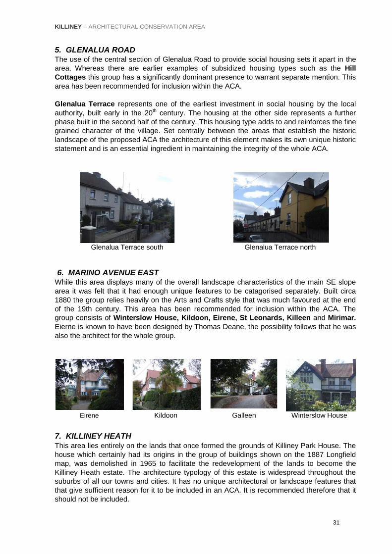
5. GLENALUA ROAD The use of the central section of Glenalua Road to provide social housing sets it apart in the
area. Whereas there are earlier examples of subsidized housing types such as the Hill
Cottages this group has a significantly dominant presence to warrant separate mention. This
area has been recommended for inclusion within the ACA.
Glenalua Terrace represents one of the earliest investment in social housing by the local
authority, built early in the 20th century. The housing at the other side represents a further
phase built in the second half of the century. This housing type adds to and reinforces the fine
grained character of the village. Set centrally between the areas that establish the historic
landscape of the proposed ACA the architecture of this element makes its own unique historic
statement and is an essential ingredient in maintaining the integrity of the whole ACA.
Glenalua Terrace south Glenalua Terrace north
6. MARINO AVENUE EAST While this area displays many of the overall landscape characteristics of the main SE slope
area it was felt that it had enough unique features to be catagorised separately. Built circa
1880 the group relies heavily on the Arts and Crafts style that was much favoured at the end
of the 19th century. This area has been recommended for inclusion within the ACA. The
group consists of Winterslow House, Kildoon, Eirene, St Leonards, Killeen and Mirimar.
Eierne is known to have been designed by Thomas Deane, the possibility follows that he was
also the architect for the whole group.
Eirene Kildoon Galleen Winterslow House
7. KILLINEY HEATH This area lies entirely on the lands that once formed the grounds of Killiney Park House. The
house which certainly had its origins in the group of buildings shown on the 1887 Longfield
map, was demolished in 1965 to facilitate the redevelopment of the lands to become the
Killiney Heath estate. The architecture typology of this estate is widespread throughout the
suburbs of all our towns and cities. It has no unique architectural or landscape features that
that give sufficient reason for it to be included in an ACA. It is recommended therefore that it
should not be included.

KILLINEY – ARCHITECTURAL CONSERVATION AREA
32
No 8 Silvermere No 11 Ronella No 18 Heatherly No 27 San Aida
8. SHANGANAGH TERRACE INCLUDING CHURCH ROAD BEHIND
Shanganagh Terrace is an unusual anomaly in this area. A long terrace of 16 mid Victorian
dwellings presents a strong unique architectural feature that is in complete contrast to the
surrounding hill area. Though it is accessed off the Hill Road this terrace relates better as an
architectural grouping with the church buildings behind and Ballybrack Village. Whereas the
terrace designation comes from the connected form of the buildings these are in fact a series
of separate building projects separated with a single detached dwelling in the centre. This
dwelling, number 8 is reputed to be where Mr Byrne, the developer of the terrace lived in
1845 when work commenced. The initial development consisted of two pairs of modest three
bay semi detached two storey dwellings on the inner side (9‐10 & 12‐14) and the terrace (1‐5)
of single floor over basement storey dwellings at the entrance. A series of infils were then
done with Number 6 followed by the redbrick houses that are of a later gothic style. An
interesting feature are the front gardens severed from their related properties by the road, a
significant and important characteristic. This area has been recommended for inclusion within
the ACA.
Nos 11‐12 No 8 No 7 No 1
The success and appeal of this terrace is in the selection of a site on slightly elevated ground
that gives a southern aspect with views out over the Shanganagh valley. This would have
been quite dramatic at a time before the woodlands in front matured to reduce this impact
somewhat.
Religious establishment played an important role in the activities in this area with a whole strip
of church owned property extending from Ballybrack to the sea. This includes virtually the
whole south side of Military Road, containing Kilmarnock, Ash Hurst and Killacoona House.
Off church Road is Saint Alphonsus & Columba Church which was built in the 1850`s with
its Gothic spire added in about 1870 to the design of George Ashlin. There is also a fine cut
stone gothic style single storey over basement parochial house and parochial hall on the
grounds. Behind is St Columbas, a mid Victorian house from 1857, with classical features

KILLINEY – ARCHITECTURAL CONSERVATION AREA
33
that provides for functions of the RC church. This house is in a particularly remote setting that
gives it an almost rural character.
St Columbas House St Columbas The Lodge Parochial House Church
9. STATION ROAD The architectural character of this area is dominated by the large apartment block that
embraces the original gothic style villa of the former Court Hotel, which was designed in 1865,
by the architect T.N.Deane. The latter is a protected structure and has been recently restored.
This area has little to contribute to the historic landscape of the hill in general other than
the fact that it is situated between the dwellings further up the hill and the sea, and
therefore intrudes into the foreground of the south east aspect of their sites. This aspect
is an important and valuable component of the southeast slope that should be protected.
It is therefore recommended that this area remain within the proposed ACA, in order that
any future development proposals are considered within the context of what the ACA is
aiming to protect. This area has been recommended for inclusion within the ACA.
Court-na-farraige

KILLINEY – ARCHITECTURAL CONSERVATION AREA
34
10. South-East Slope Extension This area contains a number of 19th century dwellings in large landscape gardens of similar
character to the South East Slope area. An analysis of the historic maps shows that the only
structures that existed prior to 1830 were Kilmarnock House and the Martello House and
Cottage. Martello House has been demolished while the cottage still exists intact as Kilmuir.
Kilmarnock exists intact and is a protected structure.
1830 Ordnance Survey Map
1897 Ordnance Survey Map
By the end of the 19th century 9 new houses were developed. They included seven on
Seafield Road - Seacroft, Avonmore Hall, Killiney Lodge, Rathleigh, Red House, Aughnacloy
Inveruisk (now Dun Muire) and 2 on Military Road – Ashurst and Killacoona.
Stonehurst
Avonmore Hall
Ashurst
Killiney Lodge
Aughnacloy
Red House

KILLINEY – ARCHITECTURAL CONSERVATION AREA
35
11-13 20th Century Infill
These three areas contain typical detached modern estate development with moderate sized plots. The predominance of 20th century development that effectively severs the 19th century sites adjacent to Seafield Road from the area of similar character to the north reduces the case in favour of including the whole area in the Killiney ACA. However they are included due to their location and not as a result of their architectural significance.
Bayshore Lane
SE corner
Ash Hurst

KILLINEY – ARCHITECTURAL CONSERVATION AREA
36
8) Architectural Features
1. BUILDING TYPOLOGIES The main characteristic that gives Killiney its special interest is without question the rich
mixture of dwelling types and styles resulting from over two centuries of organic growth. The
main domestic architectural styles from the Georgian period to the present day is represented
in a range of dwellings from the smallest artisans cottages to the larger villas of the
professional and merchant classes. As there is no doubt that the size of a dwelling was
related to the socio‐ economic position of the owners, and that such is the case even today. It
follows therefore that an analysis of the building typology should be ordered on a size basis.
The following categories are deemed to represent a relatively wide cross section of the
dwellings present on the hill, namely:
• Large individual dwellings of the „upper‟ socio‐economic group. • Terrace housing of the 19th century. • Smaller dwellings of the Middle class. • Social housing.
Large individual dwellings The earlier chapters described how the foundations for the 19th century development of the
Hill, the most prolific period, were laid down in the preceding periods. By the second half of
the 19th century new dwellings were under construction all over the Hill. Each house was an
individual project designed to the personal preferences of the owner. Competition was
probably intense, to have the biggest and the best property. While investment dwindled during
the upheavals that led to the formation of the new Irish State, the return to prosperity during
the last quarter of the 20th century has seen an upsurge in the construction of new large
dwellings on the Hill.
A succession of styles are evident and the progression can be followed through Kenah Hill, a
Victorian pile with rendered exterior and classical details, St. Georges, brick Victorian Gothic
dwelling, Druid Hill, an Arts and Crafts property, and Knockbo, recently completed on
Glenalua Road with concrete forms as its dominant feature and minimal detailing.
Kenah Hill St Georges Druid Hill Knockbo
Nineteenth Century Terraces The terraced house type provided a more economic dwelling solution in a place with high land
values. In Killiney the terrace could be seen as an alien form where land was more plentiful. A
small number of terraces were constructed during the 19th century that are probably as a
result of speculative ventures to exploit the high amenity value of the landscape and sea
views, just as the terrace solution was used on other costal sites nearer Dublin centre.

KILLINEY – ARCHITECTURAL CONSERVATION AREA
37
This theory certainly applies to Shanganagh Terrace, Abbeylands and Marine Terrace but is
less applicable to Killiney Hill Cottages that are in a semi urbanised setting and the ambitions
of its constructors was probably to house a socially disadvantaged group such as ex‐
servicemen.
To classify the Killiney terrace as such is in fact a misnomer. As regards to Shanganagh
Terrace, except for Nos 1‐5 the rest are a series of detached and semi‐detached dwellings
joined together through a series of infills. A break in the middle accommodates a single free‐
standing house, No 8. No 8 was likely to have been the first commitment on this site. The
earliest of these houses commenced in 1845 and are generally quite plain with rendered
exteriors and simple classical details. The two red brick late Victorian houses are obvious
discordant later additions.
Abbeylands is in many respects like Shanganagh in its genesis in that it consists of a pair of
semi‐ detached and a single detached dwelling, No 3, and is not strictly a terrace. No 3 was
possibly the home of the developer of No‟s 1 & 2. With a rendered finish and finer classical
details Abbeylands represent a contrast to Marine Terrace (the latter being red brick), with the
rendered terraces generally pre‐dating their red brick counterparts.
Killiney Hill Cottages are an attractive arts and crafts assembly that can be better classified as
a terrace as they were obviously designed as a set piece. Shanganagh Terrace Abbeylands Marine Terrace Killiney Hill Cottages
Smaller dwellings of the „middle class‟ Whereas the prime sites on the southeast slope were almost exclusively developed for large
houses there are some exceptions notably the gate lodges guarding entrances. Clusters of
more modest dwellings were sited around the north and south village fringes. Again there is a
multiplicity of styles, represented by Derryolam and Bramley Cottage, both Tudouresque
Victorian with Treetops and Villa Alto representing the late 20th century.
Derryolam Tree Tops Villa Alto Bramley Cottage

KILLINEY – ARCHITECTURAL CONSERVATION AREA
38
„Social Housing‟. Killiney village of the 19th century was known to be the place where the estate workers of the
Mapas Estate lived. Indeed the 1887 Longfield estate map refers to the cabins located there.
The first Labourers Act of 1883 enabled public authorities for the first time, to replace the
primitive one roomed cabins of the laboring class with more substantial structures. It is certain
that the slate roof semi‐detached single storey cottages on the Hill Road are an early result of
this initiative, and are representative of a type that relied on simple detailing, traditional sash
windows and timber panelled doors.
Later investments in social housing are represented on both sides of Glenalua Road and on
Talbot Road. Elsewhere in the village many small cottages that have very early origins are
inter dispersed between more modern buildings. Two typical examples are Glen Cottage and
Talbot Mews.
Talbot Mews Hill Cottages Glenalua Terrace Glen Cottage
2. PALETTE OF MATERIALS The earliest conclusion of this study points to the predominant characteristic of the proposed
ACA, as seen from the public realm, as being a place dominated by rubble granite walling. To
a lesser degree glimpses of the housing set back from the road displays roofing slates or tiles,
stucco‐facing, other renders and red brick being the main construction materials. This palette
of materials contributes to the localized character of each road, with certain combinations of
these materials associated with certain roads.
Granite walls: Granite is the most common building material used in Killiney owing to the proximity of the
material so close to the surface throughout the area. Most of the older houses, castles,
churches and other structures are built with rendered granite rubble walls. The use of ashlar
masonry to achieve a planned architectural aesthetic occurs on a number of buildings that
includes Ayesha Castle, Mount Eagle, The Victoria Road gateway, St Columbas Church and
its parochial house. Elsewhere cut stone is used mainly on window sills and more decorative
elements such as plinth courses and parapets. Rubble stone walls with brick leveling courses
and brick trims around openings are also recurring themes.
Victoria Road Gate Claremont Road Vico Road Strathmore Road

KILLINEY – ARCHITECTURAL CONSERVATION AREA
39
Common features are the rubble stone retaining walls that are used at numerous locations to
create building platforms. These are particularly noticeable in the village area with a notable
example on Claremont Road. The use of stone to contain paths and staircases such as the
flight below Mount Mapus Cottage on the Vico Road are other important contributors to the
architectural character.
Red brick: Clay brick is a material that has been in use throughout all historic periods being one of the
earliest man made products. It was used extensively in Georgian Ireland, where it was the
main facing material on all important streetscapes of that period. However the economics of
construction dictated that rubble stone walling constituted the bulk of the underlying structure
and brick was reserved for visible locations and other special features. Brick was used
sparingly as bedding courses and for trimming opes, or confined to being a supplementary
decorative material or for use in the construction of chimney stacks.
Only later in the 19th century with the advent of mass production techniques for clay products
did the clay brick come into its own to become a significant component of late Victorian period
architecture. The most notable example of a brick construction in the study area is St
Georges, built in 1882, described by Pearson “as something of a Victorian Gothic
extravaganza”xvi.
Shanganagh Tce Lismellow Ash Hurst Lodge The Peak St Georges
Stucco and Render: The difference in nomenclature between stucco, plaster, and mortar is based more on use
than composition. Until the later part of the 19th century, it was common that the rendering or
plaster coat, which was used inside a building, and stucco, which was used outside, would
consist of the same primary materials: lime and sand. In the later part of the 19th Century,
Portland cement was added with increasing frequency in an attempt to improve its durability.
At the same time, traditional lime plasters were being replaced by gypsum plaster. Traditional
stucco is made of lime, sand, and water. Modern stucco is made of Portland cement, sand
and water with lime added to decrease the permeability and increase the workability.
The use of stucco facing is generally limited to buildings pre‐dating 1860 with sand cement
renders used latterly. It is not possible to determine the period of the facing through casual
observation as many older buildings have been renovated with the modern compositions.
However there are some examples of the older Villa Style houses and cottages where the
original render coats are obviously still extant, Templeville House being the most notable
example. Render finishes are varied from the plain render finish of the early 19th Century
cottages to the pebbledash render of mid 20th Century housing on Glenalua Road. Rendered
roadside boundary walls are a common feature found all over this area.

KILLINEY – ARCHITECTURAL CONSERVATION AREA
40
Templeville House Glenalua Terrace Kilmarnock Hill Cottages
Roofing: There is a wide range of roof finishes on view, which are ordered, in a recognisable historic
sequence. From the 17th Century onwards, slate was the most commonly used roof covering
up to the middle of the 19th Century when the handmade red clay tile, a product of the Arts
and Crafts period, was introduced. The 20th Century saw the introduction of the concrete tile
and fibrous cement slates with sheet metal and synthetic membrane coverings, which were in
favour by the end of that century. While many houses within the proposed ACA retain their
natural slate roofs, the vertically hung tile on the Arts and Crafts period houses, are a rich and
picturesque feature.
Blue Slate Clay Tiles Fibre cement slate Flat roof covering
and concrete tiles
Chimneys and Roofscape The visual richness of the proposed ACA is reinforced by the variation of pitched roof types
punctuated by clusters of chimneys that appear throughout the study area. The flat roof,
which was introduced for the first time through the modern movement houses, is an alien
form. Whereas the flat roof is ideal in situations where the optimum volume of building
accommodation is sought beneath, without imposing on the skyline when viewed from lower
down the hill, when viewed from above, a discordant appearance may be evident.
Attractive view: fine grain

KILLINEY – ARCHITECTURAL CONSERVATION AREA
41
The variety of chimney types are considerable and are an important contributor to the
landscape character. They are in either brick or rendered finish generally with some degree of
ornamentation.
Brick Render
Gardens The landscape settings of the larger houses are an important element in the rich mix that
expresses the Killiney character. Many gardens are concealed from public view but others
can be seen from the public road. Of particular note is Mapas House, though severed by Vico
Road, the totality of the assembly of garden and house is an important historic relationship
that should always remain intact.
Mount Mapas House Lismellow
Windows The considerable range and variety of glazing solutions used adds to the visual richness
of the high level views of the Killiney landscape. The progression of improved glazing
techniques is quite evident with the smaller paned sash windows of the late Georgian
period giving way through a succession of styles to the plate glass solutions of the
contemporary architecture of recent times.
Shanganagh Tce Antsic Lodge Templeville St Leonards Blue Ridge
Doors A wide range of door types again add to the visual richness of the area. The door is a unique
element as it is a symbol of social order. At one end of the economic scale the modest doors
of the terrace housing in the village, contrast with the flamboyant entrances of the larger villas
elsewhere on the hill.

KILLINEY – ARCHITECTURAL CONSERVATION AREA
42
Talbot Road Shanganagh Tce Marchington Parochial House
Gates/Ironwork: Gates are a particularly dominant feature being at the interface between private and public
domains. (There are many examples representing all periods). In particular, examples of
ironwork, particularly wrought iron, may be found throughout the study area. In the 19th
Century wrought‐iron, often decorated with cast‐iron detailing was used for gates and railings.
The finest example of ironwork in the study area is the ornate gates to Montebello at the lower
end of the Killiney Hill Road. In total contrast but nonetheless adding to the areas rich variety,
are the contemporary styled gates at the top of the same road (at Paddock Wood). The Art
Nouveau style gates at Currabinny are quite extrovert in contrast to the classical entrance to
Summerhill.
Currabinny Summerhill Montebello Paddock Wood Other features There are many examples of gazebos and summerhouses in the gardens of the bigger
houses. Such features as the letter box, the viewing towers and special roof features are
evident in the study area.
Gazebo Tower Letterbox

KILLINEY – ARCHITECTURAL CONSERVATION AREA
43
Ornamentation Weathervane Ventilator

KILLINEY – ARCHITECTURAL CONSERVATION AREA
44
9) Implications for Planning & Development In general terms there is a requirement under the Planning & Development Act 2000 to obtain
planning permission for all development works which do not constitute exempted
development. The regulations governing exempted development are set out in the Planning &
Development Regulations 2001, as amended. These regulations set out the classes of
development, which constitute exempted development together with relevant conditions and
limitations.
Section 4 of the Planning and Development Act 2000 also lists developments, which
constitute exempted development, for the purposes of the Act. Section 4(1)(h) is of particular
relevance. It states that the following shall be exempted development for the purposes of the
Act:
“Development consisting of the carrying out of works for the maintenance, improvement or
other alteration of any structure, being works which affect only the interior of the structure or
which do not materially affect the external appearance of the structure so as to render the
appearance inconsistent with the character of the structure or of neighbouring structures”
Where a question arises as to what in a particular case is or is not exempted development,
any person may, under Section 5(1) of the Planning and Development Act 2000, on payment
of the prescribed fee, request in writing from the Planning Authority, a declaration on that
question.
Implications of ACA designation
The objective of the ACA is to protect the special character of an area through the careful
control and management of change. Section 82(1) of the Planning and Development Act 2000
(as amended) indicates that;
“Notwithstanding section 4(1)(h), the carrying out of works to the exterior of a structure
located in an Architectural Conservation area shall be exempted development only if those
works would not materially affect the character of the area”
Owners, occupiers or developers proposing to carry out works within the ACA should
be aware that the normal exemptions from seeking planning permission, do not apply
where the planning authority considers that they will materially affect the character of
the ACA.
Therefore, in its assessment of whether or not works constitute exempted development, the
Planning Authority must have regard to not only the impact on the character of the structure
itself and adjacent structures, as required under Section 4(1)(h), but must now also have
regard to the impact on the overall character of the area, as required under Section 82 (1) and
(2).
The designation of ACA status therefore results in restrictions on certain works to the
exteriors of structures, their settings and plot boundaries. For example, the construction of a
small house extension or a boundary wall within an ACA may require planning permission,
although such works may be exempted development elsewhere.

KILLINEY – ARCHITECTURAL CONSERVATION AREA
45
It is the purpose of this Section of the ACA document to give detailed direction and guidance
on the type of works that do and do not impact on the character of the ACA and therefore will
or will not require planning permission. This list is not a definitive list of all works, in all
circumstances, that require planning permission, but identifies those works, which would
impact on the character of the ACA. It should also be noted that some of the following works
already constitute development regardless of ACA designation and would require planning
permission.
Non‐Protected Structures
Owners and occupiers of non-protected structures located within the Killiney Architectural
Conservation Area should be aware that works which, in the opinion of the Planning Authority,
would materially affect the character of the ACA. will require specific grant of planning
permission. Clearly this will depend on details of each proposal, but it is likely to include the
following:
• Extensions and all new build that impact on the street-facing elevations of buildings, or
would be clearly visible from the public realm.
• The demolition of a structure or part thereof.
• Complete re-pointing in a style or manner other than existing.
• Removal or alteration of original architectural features on the main facades of non-
protected structures including:
o painting of previously unpainted brick or stone surfaces. o rendering of any façade not previously rendered. o The removal of existing render or material finish of a structure and its
replacement with another material or detail, including the removal of any previously rendered/stuccoed surface to expose otherwise inferior stonework underneath.
D. Formation of parking spaces.
E. The removal of the original roofing materials such as natural slate or clay tiles and
their replacement with modern materials such as fibre cement tiles.
F. The removal of existing chimneystacks and early terracotta or clay pots or other
original features of the roofscape.
G. The removal of timber bargeboards and/or their replacement in a material other than
the existing.
The installation of solar panels, roof‐lights or dormer windows on front elevations or on
visible slopes. Where dormer windows are deemed to be permissible, these should fit
in with the character of the structure, be of a modest size and should be constructed of
high quality or appropriate materials.

KILLINEY – ARCHITECTURAL CONSERVATION AREA
46
• New premises and material alterations to existing shopfronts.
• The erection of, or alterations to, externally mounted signs and advertisements,
including banners.
• The provision of awnings, canopies, flags and flagpoles.
• The provision of any security shutters or grilles and associated casings and fittings on
the face of a building or in front of a window display area.
• The erection of communications antennae or support structures for same.
• The removal or alteration of traditional stone walls or railings, including historical plot
boundaries.
The above list is not definitive. Owners/occupiers are advised to consult with the Planning
Authority prior to undertaking any development including any physical works or change of
use. Where there is uncertainty as to a particular case the Planning Authority would advise
that a Section 5 declaration is sought.
Maintenance and repairs, which are of a similar type and material, will generally be exempted
development.
Protected Structures
Owners and occupiers of protected structures are advised that planning permission is
required for all works, which would materially affect the character of a protected structure, or
any element of the structure, including its curtilage, which contributes to its special interest.
Owners and occupiers proposing to carry out any works to a protected structure including
essential repair and maintenance works, are advised to request a declaration from the
Planning Authority under Section 57 of the Planning and Development Act 2000 (as
amended). A declaration issued under this section sets out the type of works the Planning
Authority considers would or would not materially affect the character of the structure or of
any element of that structure, which contributes to its special interest.

KILLINEY – ARCHITECTURAL CONSERVATION AREA
47
10) New Development Works New development should contribute to the visual enhancement and vibrancy of the area
whilst respecting its existing physical character. All new buildings should be to the highest
standards of architectural design. Proposals to demolish structures of architectural merit
within the A.C.A. require planning permission. In general, they will not be permitted unless
the proposed new structure is a positive benefit to the area. The amalgamation of one or
more sites will require sensitive planning and design treatment in order to complement the
fine grain of the established streetscape.
General Policy Objectives
The Council will ensure that development in Killiney ACA will be managed in order
to protect, safeguard and enhance the special character and environmental quality
of the area.
The Council will seek to preserve, protect and enhance the architectural heritage of
Killiney for future generations.
The Council will actively encourage the reinstatement of historically accurate
architectural detailing on buildings of heritage value/interest in accordance with
recognised conservation practice. However, the use of contemporary new-build
extensions will generally be encouraged and materials/finishes used should
complement the character of the area.
The Council will not normally consider the demolition of a structure without
proposals for re-development, and will seek to ensure that demolition if permitted
will be followed by continuous re-development building operation.
The Council will seek to prohibit the demolition of structures that positively
contribute to the character of Killiney ACA, except in exceptional circumstances in
accordance with Policy AR12 of the County Development Plan 2010-2016. Where
demolition of a building/structure/item is considered, within the ACA, one of the key
considerations that will be taken into account is whether the quality of the new
structure will visually enhance and enrich the area.
The designation of Killiney ACA does not preclude the sub-division of dwellings into
apartments, extensions, or for „sensitive infill‟ in accordance with land-use zoning
objective 0/0 of the County Development Plan 2010-2016, or „change of use‟, and
the re-use of existing entrances/maintenance of original boundary walls where
appropriate in order to maintain the essential character of Killiney ACA.
New Build
The Council will seek to ensure that any development including modifications and/or
alterations or extensions affecting structures within the Killiney ACA, are designed
and sited appropriately and are not detrimental to the character of the structure or its
setting and context within the ACA.
The Council will encourage where appropriate the use of non-reflective glazing to
exposed elevations containing a low solid to void ratio (i.e. large extent of glazing
relative to masonry).
In considering all proposals for building/structures, the Council will seek to
encourage the development of new buildings in Killiney ACA in accordance with

KILLINEY – ARCHITECTURAL CONSERVATION AREA
48
County Development Plan Policy as being a stimulus to imaginative, high quality,
passive design, and an opportunity to enhance the ACA generally. In this regard
appropriately scaled new build should have respect for the site/building context,
without imitating earlier styles.
In Killiney Village Character Area 1 (Map of Character Areas shown in Appendix 3),
(generally), the Council will encourage a sensitive design approach to infill/gap sites,
to maintain the overall integrity of the urban grain, whilst also encouraging where
appropriate, contemporary designs that are complementary and/or sympathetic to
their context and scale. Particular regard will be had to roofscape treatment to avoid
large unbroken flat roof spans.
Character Area‟s 11-13 are 20th Century estates which do not contribute to the
architectural character of the ACA. Consequently the Council will adopt a less rigid
approach to development proposals in these areas.
Alterations and Extensions
The Council will seek to encourage appropriately scaled extensions and alterations
to properties within Killiney ACA that are generally sensitive to the main structure
and subsidiary (to the main structure), particularly in the case of protected structures
and positioned generally to the rear or lesser elevation.
All proposals to extend properties within the ACA involving/affecting the roof of a
property particularly those of the Arts and Crafts style shall be carefully and
sensitively considered.
The Council will seek to encourage the retention of original features, including
windows, doors, renders, roof coverings, and other significant features of buildings
and structures within Killiney ACA whether protected structures or otherwise, whilst
simultaneously encouraging a continued diversity of sensitively scaled
contemporary and energy efficient designs.
Internal Alterations: For structures/houses, which are not listed as Protected Structures,
the ACA designation does not prevent internal changes or re-arrangements, provided that
these changes do not impact on the exterior of the structure. However, internal changes
must comply with current building regulations.
Works to the Public Realm
The Council will actively promote the retention of all surviving original kerbing,
paving, and items of street furniture, which contribute to the special character of the
ACA, in line with Policy AR6 of the County Development Plan 2010-2016.
Works to the public realm, such as footpaths, street furniture, parking provision etc,
must have due regard to the special character of the ACA. Design and provision of
traffic control measures, including signage, ramps, renewed surfaces, dished
pavements etc. will be required to consider the Historic Landscape and essential
character of the area as outlined in this document.
New street furniture when being provided will be of high quality reflecting the
character of the ACA.
The Council will encourage the under-grounding of overhead services and the
removal of redundant wiring / lighting cables etc., from building facades in line with
Policy AR9.

KILLINEY – ARCHITECTURAL CONSERVATION AREA
49
Landscape Protection
Reinforce existing character:
The Killiney ACA seeks to protect buildings, structures and items of architectural
interest and will also seek to protect and enhance the spatial quality of Killiney, its
natural environment, groups of trees, boundary treatments and associated
hedgerow planting/periphery planting to individual plots, views and prospects and
other intrinsic aspects of the ACA.
New or replacement planting:
Where boundaries must be repaired or replaced or where new boundaries are
required, the Council will promote the use of materials which are sympathetic to that
existing, including where applicable, hedgerow planting and informal tree planting
etc.
Views and prospects:
The Council will seek to protect from insensitive development, the views and
prospects identified in the current County Development Plan.
The Council will seek to protect views and prospects from Killiney Hill by minimizing
the impact of new developments on the existing roofspaces and will consider where
appropriate, the use of green roof technology, (for example, limited spans/roof
planes and curved or mono-pitched roof sections).
The Council will seek to minimize any negative visual impact of all new structures
within the protected views and prospects and will seek to preserve those structures
of civic/historic and/or architectural interest, which currently punctuate these
prospects/skylines.
Features that detract from the area:
The Council will encourage the appropriate or sympathetic replacement of elements
that detract visually from the built form, that are considered unacceptably intrusive,
where their replacement or substantial alteration would improve the character of the
ACA for example;
The placing underground of all electricity, television and telephone cables within the
ACA, particularly within the Killiney Village-Landscape Area 1 and its environs.
The insensitive repair/replacement/supplementing of boundary treatments.
The removal of inappropriate signage and incongruous surface finishes
Planning Applications – Checklist for developments within Killiney ACA
The Council will not normally consider outline-planning applications within the ACA.
All proposals for new development should enhance the character of the area and
ultimately deliver a consistently high standard of design.
Detailed proposals incorporating drawings of fully rendered elevational treatment
(i.e. detailed sections showing finishes, components etc. where necessary). A colour
and material pallet should also be included.
Potential impact of the proposal upon views and prospects (if applicable) within the
Killiney ACA.
Detailed Landscaping plans and specifications including details on new and/or
replacement planting. This may also include an Aborists report/tree survey.

KILLINEY – ARCHITECTURAL CONSERVATION AREA
50
11) Acknowledgements
The authors appreciation is offered to the following persons who contributed material
for this report: Albie Millerick Former resident Killiney House.
Valerie McCarthy Former Resident Rathleigh.
Derry McCarthy Information about the Village.
Philip Shipman Information about Plasnewyyd.
Cynthia McClenaghan Resident Druid Lodge.
Michael Clarke Proprietor Killiney Stores.
Bridget Aylmer Resident Valparaiso.
Timothy King Resident Shanganagh Terrace.
National Library of Ireland: Maps from the manuscripts section.
Representative Church Body: Maps of the Dean of Christchurch.
End notes:
iDun Laoghaire Rathdown County Development Plan 2010‐2016 Policy AR10, page 109 ii Dun Laoghaire Rathdown County Development Plan 2010‐2016, page 103
iii “A History of the County of Dublin” F E Ball page, 86
iv “A General History of the County of Dublin” John D'Alton, 1838,
page, 898
v “A History of the County of Dublin” F E Ball 1902, Vol 1. FE
Ball page, 86 vi
“A Topographical Dictionary of Ireland” Samuel Lewis, 1838, P 149 vii
Gaynor family paper. viii
“From the mountains to the Sea” P Pearson. 2007. Page 75 ix “From the mountains to the Sea” P Pearson. 2007.
Page 70‐71 x Falkiner’s “Dublin Journal”,
xi“From the mountains to the Sea” P Pearson. 2007. Pearson, page 69
xii Return 30
th June 1804 for towers and Batteries on coast from Bray to Dublin
WO 55 831. xiii
“A History of the County of Dublin” F E Ball page 86 xiv
“From the mountains to the Sea” P Pearson. 2007.
Pearson page 70 xv
“From the mountains to the Sea” P Pearson. 2007.
Pearson page 71
xvi
“From the mountains to the Sea” P Pearson. 2007.Page 74.

KILLINEY – ARCHITECTURAL CONSERVATION AREA
50