kemerton strategic industrial area economic & … area economic & social analysis landcorp...
TRANSCRIPT

Kemerton Strategic Industrial Area
Economic & Social Analysis
LandCorp
January 2012 / December 2012

Author: Syme Marmion & Co Client: LandCorp Name of Document: Kemerton Strategic Industrial Area Economic &
Social Document Version: 2012 Revision
Project Number: P1150
Version Control
Document History and Status
Status Issued To Qty Date Reviewed Approved Draft Landcorp 1 23/12/2011 KH/SM JS
Draft Final 1 Landcorp 1 27/01/2012 KH/SM/MA JS Revised with
2011 Census data
LandCorp Electronic 30/11/2012 JS JS
Report Details Disclaimer Syme Marmion & Co reports and advice are either of a general nature, or for specific circumstances. Syme Marmion & Co is not liable for any loss or damage incurred by any person relying on such reports or advice, except where they are created by Syme Marmion & Co expressly for that person. Nothing in these terms shall be taken as excluding, limiting or modifying any term, condition or warranty implied by any applicable act of parliament that cannot be so affected. To the extent that such a term, condition or warranty is implied, the liability of Syme Marmion & Co for breach of that term, condition or warranty is, where permitted, limited at the option of Syme Marmion & Co, to: • the supplying of the relevant goods or services again; or • the payment of the cost of having the relevant goods or
services supplied again.

Table of Contents
1. Executive Summary ....................................................................................................................... 1
2. Introduction................................................................................................................................... 4 2.1. Background .................................................................................................................................... 4 2.2. Purpose of the Report ..................................................................................................................... 7
3. Regional Context ........................................................................................................................... 8 3.1. Site Location ................................................................................................................................... 8 3.2. Regional Population ....................................................................................................................... 9 3.3. Regional Employment ................................................................................................................... 10 3.4. Regional Economic Growth Scenarios............................................................................................ 11 3.5. Future Strategic and Regional Economic Opportunities ................................................................. 16
4. Demographic Context .................................................................................................................. 21 4.1. Population Growth by Age ............................................................................................................ 21 4.2. Household Formation ................................................................................................................... 22 4.3. Household Income and Expenditure .............................................................................................. 24 4.4. Labour Force ................................................................................................................................ 25 4.5. Travel to Work Patterns ................................................................................................................ 25 4.6. Population Projection Data Sets .................................................................................................... 26 4.7. Workforce .................................................................................................................................... 29 4.8. Demographic Implications ............................................................................................................ 35
5. Economic and Social Context ....................................................................................................... 36 5.1. Kemerton Employment Profile ...................................................................................................... 36 5.2. Kemerton Land Uses ..................................................................................................................... 36 5.3. Employment Self Sufficiency ......................................................................................................... 38 5.4. Employment Self Containment ...................................................................................................... 39 5.5. Employment Forecasts.................................................................................................................. 40 5.6. South West Industrial Land Study.................................................................................................. 41 5.7. Economic and Social Implications .................................................................................................. 42
6. Options Analysis .......................................................................................................................... 43 6.1. Current Planning .......................................................................................................................... 43 6.2. Employment Density ..................................................................................................................... 43 6.3. Potential Employment Impacts ..................................................................................................... 44
7. Development Implications ........................................................................................................... 46
3 Syme Marmion & Co Kemerton Industrial Park

List of Figures Figure 1: Kemerton Strategic Industrial Area Strategic Spatial Placement ........................................................ 3 Figure 2: South West Region Context .............................................................................................................. 4 Figure 3: Key Regional/Stage Linkages............................................................................................................. 8 Figure 4: Kemerton Strategic Industrial Area Location ..................................................................................... 9 Figure 5: South West Region Settlements...................................................................................................... 10 Figure 6: ‘Roads to Export’ Greater Bunbury Infrastructure Investment Plan ................................................. 19 Figure 7: Resource Projects ........................................................................................................................... 20 Figure 8: Estimated Resident Population June 2011 ...................................................................................... 21 Figure 9: Households .................................................................................................................................... 23 Figure 10: Household Type Distribution ........................................................................................................ 23 Figure 11: Gross Weekly Household Income Distribution .............................................................................. 24 Figure 12: Estimate South West Region Unemployment Rate 2008/2010 ..................................................... 25 Figure 13: Proportion of Resident Workforce Employed in LGA ..................................................................... 26 Figure 14: South West Region Population Growth Scenarios ......................................................................... 27 Figure 15: Bunbury Statistical District ............................................................................................................ 28 Figure 16: Bunbury Statistical District Forecast Population ............................................................................ 29 Figure 17: Major Industries of Employment – South West Region 2011 ......................................................... 31 Figure 18: Major Manufacturing and Related Industries of Employment – South West 2011 .......................... 32 Figure 19: Gains in Employment 2006/2011 - Manufacturing Industries South West...................................... 33
List of Tables
Table 1: Regional Development Indicators: South West Region Economy ......................................................... 6 Table 2: Recent Growth, Population and Productivity Performance, Australia and WA................................... 14 Table 3: Summary Age Distribution as at June 2011 ...................................................................................... 22 Table 4: Population Growth Comparison ....................................................................................................... 28 Table 5: Post School Qualifications................................................................................................................ 35 Table 6: Kemerton Industrial Activity, 2006 ................................................................................................... 36 Table 7: Kemerton Strategic Industrial Area Land Uses 2006 ......................................................................... 37 Table 8: Employment Self-Sufficiency............................................................................................................ 38 Table 9: Bunbury Urban Area Resident Workforce, Place of Work by LGA 2011 ............................................. 39 Table 10: Employment Self Containment – Bunbury Statistical Area (SA3) ..................................................... 40 Table 12: Kemerton Strategic Industrial Area Employment Density Scenarios ................................................ 44
4 Syme Marmion & Co Kemerton Industrial Park

1. Executive Summary
The Kemerton Strategic Industrial Area (KSIA) is located approximately 17 kilometres north-east of Bunbury within the Shire of Harvey. It is the largest industrial area in the South West of Western Australia with an industry core of over 2,000Ha, a support industry area of 300Ha, is one of the State’s designated ‘strategic industrial’ areas, and one of only two heavy industrial estates in the South West Region (SWR), the other being at Collie. The KIP is located strategically between the Perth Metropolitan Region and the SWR, is relatively well serviced by water, power and road, is within close proximity to Bunbury Port (potential for containerisation) and provides an important staging post for a wide catchment of processing, refining and export based industries.
Currently the KIP accommodates nine major international and regional tenants in chemical processing, utility and power provision, occupying approximately 300Ha and in future may provide the only suitable location in the region and Bunbury locale for resource and metal processing, additional chemical refining, manufacturing and construction industries and research and development. The KIP is surrounded by a large land buffer of over 5,400Ha. There are currently a number of ‘interim’ uses on site covering approximately 1,600Ha, including grazing and quarrying which are not part of the planned permanent profile of the estate.
Despite the current global financial issues there is some level of certainty about demand for land at the KIP for both strategic heavy and special industries related to export based activity and for heavy and special industries supporting population and urban growth in the region for the following reasons:
• The SWR is a growth area - with a population growth rate twice that of the national average, and one of
the fastest growing populations of regional WA. By 2027, the population is expected to reach 216,000. • Approximately 40% of all current residents live in the Bunbury/Capel/Dardanup area and this profile is
expected to continue into the future, providing a large labour pool with relatively high skill base compared to other non-Metropolitan regions.
• The region’s economy has grown by 81% in the five years to 2010 and an amazing 140% since 1998-99. Despite the GFC, for the past two years, the region’s economy has been growing at an average of 11% per year.
• GRP of the region was $12.4m (2009/10) which is around 6.6% of the GRP of the State. Industrial estates within the region accommodate 17% of all jobs and 6% of manufacturing jobs.
• Mineral processing and manufacturing, two industry sectors likely to be attracted to the KIP, account for approximately 10% of the Gross SW regional product per annum.
• Key regional industry types include mining, manufacturing, retailing, agriculture, food processing, construction, and tourism. Mining activity is concentrated on bauxite, coal, tin, tantalum and spodumene, and mineral sands extraction, with manufacturing focusing on light metals, wood and paper fabrication.
• A high proportion of the region’s industries are export based with an international market profile and supply commodities and produce to key markets in India, China and the rest of Asia. The market demand for the regions product, particularly food and rare resources is expected to grow over the next 50 years.
• Other economic and environmental pressures are likely to encourage the emergence of new specialised industries in the SWR which may require land directly or indirectly at KIP, including renewable energy, waste and resource recycling, high technology logistics and handling industries, agri-industry processing (including red meat, aquaculture, fruit and vegetable and forestry product – spin off service industry potential only at KIP), bio technology and health care technologies.
• The KIP has a clear regional role to provide land to support the growth of regional heavy and strategic export based industry, an industrial estate typically matures over a 50 year time frame and land must be reserved for the long term for growth opportunities.
1 Syme Marmion & Co Kemerton Strategic Industrial Area

• The KIP also has a wider State potential. A study by Sinclair Knight Merz (SKM)1 indicated that KIP and potential estates near Collie (Shotts and Coolangatta) could fulfil a ‘spill over’ function for heavy industry in the future as Kwinana and East Rockingham reached a complete state and as estates at Kewdale and Armadale were under pressure from urban encroachment.
• Furthermore, recently published Industrial Land Strategies for the Perth, Peel and SW Region have identified the general scarcity of supply of heavy and strategic industrial sites, particularly those with large, flat, unencumbered sites. The KIP is a scarce resource and therefore potentially sought after by Trans-National or ‘footloose’ industries seeking a WA location.
• The KIP fits within the strategic economic framework of the state planning process as a site with opportunity to support value added down-stream processing form the regional and state resource based industries.
• The KIP supports the regional economic planning framework by supplying land for greater employment diversity and value added industries associated with regional products and resources.
• For projects that have been identified on the Department of State Development (DSD) candidate list, land for heavy industry in the SWR is very limited and could run out in the next 5-10 years without aggressive forward planning and Government intervention to enable supply. This situation is likely to be exacerbated if key regional drivers and events such as the containerisation of Bunbury Port go ahead and industrial land is still at a 2010 status quo or in limbo. A priority action for Government is to immediately commence and/or finalise the planning and approvals process to release heavy industrial land at KIP.
The value of the KIP can therefore be summarised in terms of capacity to accommodate at least 1,000Ha for potential large strategic, heavy and special industrial uses with a proportionately high export base and additional land for support and service activity. The KIP plays a key role in the industrial and employment framework of the region support and in terms of land for employment growth, of up to 2,250 jobs by 2031 equating to a wages and salaries value of $118m (2008/09 dollars). At 2031, the production value of Kemerton would be at minimum $371m per annum (2009/10 dollars) and is likely to generate additional indirect employment of up to 12,800 persons in WA. Without the KIP functioning at an optimal capacity these values would be lost to other regions within WA, other Australian States and other Countries in the highly competitive global economy.
The important context to the provision of land for strategic and heavy industry is that it is appropriately zoned and ‘valued’ in strategic planning and economic development terms, is protected from urban encroachment, is high on priority lists for servicing, access improvements, freight network upgrade, Bunbury Port links and that planning is integrated into the State’s comprehensive marketing and promotional process so the KIP is ‘project ready’. The map below, taken from ‘Roads to Export”, Greater Bunbury Investment Plan, shows KIP’s strategic spatial placement.
1 Overview of Strategic Industrial areas in the South West of Western Australia, Sinclair Knight Merz, DOIR, February 2004
2 Syme Marmion & Co Kemerton Strategic Industrial Area

Figure 1: Kemerton Strategic Industrial Area Spatial Placement
3 Syme Marmion & Co Kemerton Strategic Industrial Area
2. Introduction
2.1. Background
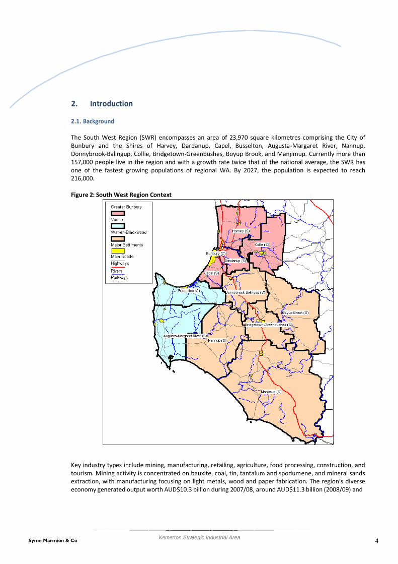
The South West Region (SWR) encompasses an area of 23,970 square kilometres comprising the City of Bunbury and the Shires of Harvey, Dardanup, Capel, Busselton, Augusta-Margaret River, Nannup, Donnybrook-Balingup, Collie, Bridgetown-Greenbushes, Boyup Brook, and Manjimup. Currently more than 157,000 people live in the region and with a growth rate twice that of the national average, the SWR has one of the fastest growing populations of regional WA. By 2027, the population is expected to reach 216,000.
Figure 2: South West Region Context
Key industry types include mining, manufacturing, retailing, agriculture, food processing, construction, and tourism. Mining activity is concentrated on bauxite, coal, tin, tantalum and spodumene, and mineral sands extraction, with manufacturing focusing on light metals, wood and paper fabrication. The region’s diverse economy generated output worth AUD$10.3 billion during 2007/08, around AUD$11.3 billion (2008/09) and
4 Syme Marmion & Co Kemerton Strategic Industrial Area

$12.4 billion in 2009/102. The region’s economy has grown by 81% in the five years to 2010 and an amazing 140% since 1998-99.
For the past two years, the economy has been growing at an average of 11% per year. The region’s wealth is derived particularly from a strong mining sector including mineral extraction, mineral processing and mineral manufacturing - which latest figures show generated around $2.3 billion for the Region. The SWR features heavy industry in Kemerton and Collie as well as general industry in Preston. Small light and some general industrial areas are located in Harvey, Busselton, Collie, and Picton.
The following table taken from the Indicators of Regional Development in WA prepared by the Department of Regional Development and Lands (DRDL) demonstrates the regions comparative economic role.
The indicators show the importance of the SW region in terms of manufacturing compared to other regions. Outside the Metropolitan area, the SW region is second with a value more than twice that of the third region, Peel. The majority of this manufacturing and processing is carried out on the heavy industry estates including Kemerton. The exception is alumina refining which is done at Worsley, however in future, further treatment such as smelting would require land in an estate such as Kemerton.
The table also demonstrates the diversity of the SW region’s income from primary industries, all of which have the additional potential for downstream processing. The State Government, through the Department of State Development, is actively encouraging downstream processing in the region as a means of adding value and employment opportunities to the economic base. These processing activities would require appropriately zoned heavy and special land at industrial estates such as Kemerton in the future.
2 South West regional focus, 2010, South West Development Commission
5 Syme Marmion & Co Kemerton Strategic Industrial Area

Table 1: Regional Development Indicators: South West Region Economy Gross Regional Product (2008-09) Gross Regional Product ($ million) 11,299 Fishing (2008-09)
% of State Total 6.6% Total Catch by Value ($ '000) 6,048 GRP per capita ($) 74,293 % of State Total 2.2% Agriculture (2008-09) Total Catch by Weight (tonnes) 1,273 Total Agricultural Production ($) 624,000,501 % of State Total 5.0%
% of State Total 8.7% Manufacturing (2006-07) Crops & Pastures ($) 348,531,523 Number of Locations 734
% of State Total 6.7% % of State Total 7.4% Livestock Disposals ($) 100,598,734 Number of Employees 7,626
% of State Total 7.6% % of State Total 10.3% Livestock Products (wool, milk, eggs & honey) ($) 174,870,244 Turnover ($ million) 2,731.7
% of State Total 0.7% 4.9% 28.0% % of State Total 6.1% Agricultural Land Area (Ha) 603,133 Building and Construction (2009-10)
% of State Total 0.6% Total Approvals Value ($'000) 873,351 Number of Establishments 2,738 % of State Total 6.7%
% of State Total 21.6% Total Non-Residential Approvals ($'000) 223,129 Mining (2008-09) % of State Total 3.6% Value ($ million) 1,964.6 Residential Building Approvals ($'000) 650,223
% of State Total 2.8% % of State Total 9.3% Forestry (2008-09) Average Residential Building Approval (value) $256,599 Total Production ($ Value) 69,267,000 Retail (2008-09)
% of State Total 74.4% Estimated Retail Turnover ($ millions) 1,605.7 Hardwood Production ($ Value) 36,488,000 % of State Total 6.3%
% of State Total 81.9% Tourism (2007-09) Hardwood Production (tonnes) 464,800 Nº visitors Domestic ('000) 1,440.0
% of State Total 73.8% % of WA Total 22% Softwood Production ($ Value) 32,779,000 Nº visitors International ('000) 104.9
% of State Total 67.5% % of WA Total 10% Softwood Production (tonnes) 641,800 Exp domestic ($ millions) 551.2
% of State Total 63.8% Exp international ($ millions) 69.1 Source: Department of Regional Development and Lands
In addition to the need for heavy industrial land for inherent SW regional industries, land at Kemerton has a wider State potential. A study carried out in 2004 by Sinclair Knight Merz (SKM)3 of the SW corner of WA (including Perth, Peel and SWR) indicated that some heavy manufacturing and service industries in the Armadale and Kewdale locations were under pressure from urban development and other constraints and were attracted to regional locations and some Perth based industries dealing with rural suppliers and markets were also considering relocation to regional estates. A further consideration in the SKM report was that Kemerton and potential estates near Collie (Shotts and Coolangatta) could fulfil a ‘spill over’ function for heavy industry in the future as Kwinana and East Rockingham reached a complete state.
The two prospective heavy industry groups identified in that study that could generate substantial future land requirements beyond Kwinana are Basic Non-Ferrous Metals, Alumina and Aluminium (potential 248 hectares) and possible Iron and Steel industry projects (potential 496 hectares). The favoured locations for these activities identified in the report were the SWR and Mid-West region respectively. The Agricultural Commodities Processing activities estimated in the SKM report to require up to 133 hectares is likely to reflect demand for red meat processing and associated services rather than demand for other potential agri-food precinct activities which may form a synergistic cluster. The total area of land required for agri- food industry inclusive of a broad range of processing and research and development will therefore require more land. The SKM report suggested that agri-processing and the Wood and Paper products group (potential 157 hectares) could be attracted to sites in the South West, Mid-West, Great Southern and Wheatbelt planning regions. Whilst it is unlikely that an agri-food precinct would fit within the profile of a
3 Overview of Strategic Industrial areas in the South West of Western Australia, Sinclair Knight Merz, DOIR, February 2004
6 Syme Marmion & Co Kemerton Strategic Industrial Area

heavy industry park such as Kemerton, if such a precinct did emerge elsewhere in the SW region or Peel region, there would inevitably be potential for spin-off related manufacturing and service industries seeking locations on estates such as Kemerton. The resource, chemical and metal based manufacturing and processing industries identified in the SKM report are entirely in keeping with the Kemerton profile and will quite likely require expansion opportunities in the future, therefore it would be appropriate to consider Kemerton for this purpose and to identify, secure, service and promoted sites accordingly.
Recent programs and promotions to support more diverse employment and wider regional economic benefits are also likely to impact upon demand for land at heavy, special and strategic industrial sites including the Roads to Export bid to Infrastructure Australia for Bunbury Port containerisation and access improvements and the Super Town projects which designates three such locations in the SWR at Collie, Manjimup and Margaret River.
2.2. Purpose of the Report
The purpose of this report is to prepare supporting documentation for the Kemerton Strategic Industrial Area (KSIA) Structure Plan by providing a strategic overview of the economic and social impact of the heavy industrial activity in the SWR. It is the purpose of this study to articulate this opportunity; to quantify and iterate the current and future economic and social value of the KSIA in a local, regional and State context.
This report provides a social and economic analysis to demonstrate the importance of the KIP to both the SWR and State of Western Australia in terms of economic outputs and employment generation and in this respect, will be used to support the rationale for development of the KSIA as described in the Structure Plan.
7 Syme Marmion & Co Kemerton Strategic Industrial Area

3. Regional Context
3.1. Site Location
The KIP is located approximately 17 kilometres north-east of Bunbury within the Shire of Harvey. It is the largest industrial area in the South West of Western Australia and is one of the State’s designated ‘strategic industrial’ areas. The site is located strategically between the Perth Metropolitan region and the SW region and provides an important staging post for a wide catchment of processing, refining and export based industries. The site’s regional economic context is shown below.
Figure 3: Key Regional/Stage Linkages
Source: South West Region Industrial Land Study, LandCorp, 2010
8 Syme Marmion & Co Kemerton Strategic Industrial Area

The site’s local context is shown in more detail in the figure below. This image demonstrates Kemerton’s proximity to the urban centre of Bunbury, industrial precincts near Bunbury and Collie and key access roads.
Figure 4: Kemerton Strategic Industrial Area Location
3.2. Regional Population
The region has experienced high levels of population growth over recent years but this growth has not been evenly distributed. Localities offering sea and/or tree change opportunities such as Busselton and Margaret River have generally had high levels of population growth while inland areas that are mainly reliant on traditional agricultural industries have had lower levels of growth and, in some cases such as Boyup Brook and Manjimup, the population has decreased. Note should also be made of LGAs such as Capel and Dardanup which border the City of Bunbury and which have experienced high percentage growth rates. This is the result of the expansion of Bunbury and consequent spread of the population away from the tightly defined city core into the surrounding catchment in the hinterland, highlighting the importance of the city to the region. The overall population of the region is likely increase to approximately 200-250,000 people over the next 20 years, with approximately 40% of all residents living in the Bunbury/Capel/Dardanup area and 30% living in Augusta/Margaret River-Busselton.
Family groups make up approximately three quarters of all households in the region, roughly in line with the state wide figure. There are some regional variations, with Capel and Dardanup having particularly high percentages of families and City of Bunbury having the highest proportion of lone person and group households. The region has a higher proportion of low income households than the state as a whole, with LGAs such as Boyup Brook, Nannup and Manjimup being particularly notable in this respect.
The KIP is in the Shire of Harvey, which is expected to have a population over 30,000 by 2021, which would edge close to the populations of the City of Bunbury and City of Busselton at that time. Most of the growth
9 Syme Marmion & Co Kemerton Strategic Industrial Area

in Harvey Shire consists of expansion to the greater Bunbury urban area. Whilst this will provide ample employment for high intensity/employment dense industrial activity, it may also add pressure on the regions scarce land resource (particularly in the City of Bunbury) and potentially lead to conflicting industrial and residential land security and infrastructure provision.
The South West Planning Framework provides a future spatial planning scenario which will influence the distribution and expansion of industrial land across the region. Bunbury is the highest order centre in the SWR, and is the largest regional city in Western Australia outside of the Perth-Peel metropolitan area. The Bunbury urban area functions as the commercial and administrative hub of the South-West, supports the region’s only port facility, and is the centre of the region’s rail and road networks. Almost half the people living in the SWR currently live in, or around Bunbury. Many others commute to Bunbury for work from other centres. Bunbury represents 65.2% of the population growth in urban centres in the SWR. Busselton is the sixth largest centre outside of the Perth-Peel metropolitan area and performs as a sub-regional centre for the Busselton-Margaret River region. Two other high order centres that function as sub-regional centres are Manjimup and Collie. A copy of the proposed settlement hierarchy is shown in the map below.
Figure 5: South West Region Settlements
Source: South-West Framework, WAPC, DoP, 2009
3.3. Regional Employment
10 Syme Marmion & Co Kemerton Strategic Industrial Area

The region had a workforce of roughly 62,300 as at 2011, approximately 6% of the State’s labour pool, with a very diverse economy. The main industries for employment are manufacturing (8,200 employees, of which 2,700 are in primary metal manufacturing – for example alumina production and other minerals processing - and wine making and food products manufacturing – 1,000 employees each), construction (7,000 employees) agriculture (3,300 employees), mining (1,700 employees) and those which service the local population, particularly education, grocery retail and hospitals. The stand out from these, in terms of ability to attract money into the region, were accommodation (1,650 employees) and cafes/restaurants and food and beverage services (2,900 employees), reflecting the importance of tourism to the region. The other major export industry in terms of employment was alumina production (1,000 employees). The region is also an important power producer, with this industry employing 680 people. When considering industry in terms of location quotients, the most important activities are coal mining, forestry, wood processing and food/beverage manufacturing.
Compared with the Perth metropolitan area and the State overall, the region has a lower proportion of residents with high level education qualifications than the state as a whole, with 9% having a bachelor degree or higher compared with 13% for Western Australia in total. Approximately 66% of residents have no post school qualifications compared with 64% for the state. However when compared directly to the other regions outside the metropolitan area, the SW has higher qualification and skill levels. An assessment of the WA Regional Indicators prepared by the Department for Regional Development and Local Government4 indicates that in the period 2005-2007 the region is developing a relatively high skill base, with good levels of school retention in years 11 and 12, the highest level of students in vocational learning outside the Perth region and higher level of self-employment (8.4%) than the Perth region (5.9%) which reflects the large number of small businesses in the region.
In terms of labour force mobility, 83% of all employed residents work within the region. There is a large amount of worker travel between Bunbury, Capel, Collie, Dardanup and Harvey while more remote LGAs such as Boyup Brook and Manjimup are more self-contained. Workers in the Shire of Harvey, where Kemerton is located, largely live in Harvey, Bunbury, Dardanup and Waroona (94%), but with around 4% coming from Perth and Peel. This proportion may increase as Kemerton expands. In Collie for example, while around 87% of workers live in the region, over 10% of workers employed in the Shire of Collie (around 775 in number) have Perth and Peel as their place of usual residence.
The value of the south-west lifestyle and as a FIFO base is shown in the statistic that almost 2,100 workers resident in the south-west work in resource areas in the Pilbara and Goldfields.
3.4. Regional Economic Growth Scenarios
Despite the Global Financial Crisis of recent years and unfolding European Crisis, economic forecasts for WA and the SWR are relatively optimistic. In the short run the general consensus is for a more conservative 3- 4% average growth rate per annum over the next 3-5 years. Over the medium to long run, projections become less certain and more complex, however analysts suggest a slow down after 2020, as major projects like Gorgon are bedded in, and an average growth rate of 2.7-3% is forecast for the period 2030- 2050. This level of growth will require Government investment in productivity improvements and new employment initiatives.
WA’s economic fortunes, particularly export markets, are related to the growth markets of China, India and the rest of Asia. Whilst demand for resources and agricultural product will remain relatively strong, the global market share for WA is likely to remain constant rather than increase through to 2050, as competition emerges with exports from China, India, rest of Asia, South America and Central Africa. Even
4 Indicators of Regions, Supplementary Report, 2007 DRDLG
11 Syme Marmion & Co Kemerton Strategic Industrial Area

within WA there will be competition for investment by Government and private sector from other regions, particularly the North West and Mid-West.
The current competitive advantages of the SWR are diverse; large labour pool (relatively highly skilled), access to Port (potential for containerisation), high quality natural resources (minerals, agri-food and fibre, plantation timber, power/energy sources). However continued competitive advantage will only be achieved into the future with effective, integrated, regional economic development policies. The long term industry future may lie less in the extractive industry and related primary processing sector (which has large land take and power requirements) and more with in the knowledge based, innovative and technology industries based on value adding to regional resources and service provision (which may include intensification of activity on existing sites requiring high speed ITC). The potential for current, new and value adding industries in the SWR in the foreseeable future are:
• Coal; carbon capture and storage research and development (Vasse, Margaret River, Collie).
• Heavy Mineral Sands; subject to competition in the global economy and power supply issues, new Titanium Powder processing (TiRO), potential Nano Titanium Dioxide Pigment processing (nano-TiO2) (Kemerton).
• Australia’s only silicon producer, Simcoa, plans an upgrade with a third furnace on line in 2011 and a fourth scheduled for environmental assessment. Silica Sand and Silicon; subject to competitive power prices, would benefit from Bunbury Port containerisation (Kemerton)
• Aluminium; smelter potential is uncertain and may be very long term, however both Alcoa and Worsley are being expanded and Bauxite Resources is undertaking a study of the region in order to site a proposed $1.5billion alumina plant (Kemerton) .
• Spodumene (lithium), Tin, Tantalum and Kaolin; mining and processing subject to global economy, power and freight costs/port containerisation (Greenbushes).
• Bio technology, potential spin off from Agri-food industry, related to science and technology education in Bunbury area – Edith Cowan University, SW Health Campus, Val Lishman Health Research Foundation.
• Agri-food, fibre and forestry; steady and growing international markets for raw and live produce and wine, processing opportunities from new and emerging sectors, high quality healthy meats, processed dairy, sustainable inland aquaculture, apiculture, therapeutic/medicinal/culinary plant products, specialist quality fibres and non-edible animal products, horticulture and related services such as bio- security, agri-biotechnology, sustainable hard wood products and plantation wood chips/fibreboard (Vasse, Margaret River, Scott River, Manjimup, Boyup Brook, Collie, Pemberton and many smaller centres/farming establishments).
• Building Construction and Waste Management; particularly new technologies associated with energy efficiency and affordability ad emerging green/clean industries such as renewable energy research and development and manufacturing and the recycling resource efficiency sector (Picton/Preston, Augusta, Manjimup, Bridgetown, Kemerton, and Collie).
• Logistics and Distribution; emerging as a new industry as urban centres mature and exports grow, related to Bunbury Port and containerisation, requires large lad area (200-250Ha) advanced high speed ITC, potential for HQ logistics functions (Preston/Picton, Bunbury).
• Advanced manufacturing and service industries related to general health care, aged care, personal services and retail goods.
12 Syme Marmion & Co Kemerton Strategic Industrial Area

The emerging industries are often regarded as ‘Special User’ which require project specific rather than general land planning, Kemerton is earmarked as an industrial site capable of accommodating special industrial uses, subject to discrete project based approvals.
WA has benefited from one of the longest periods of sustained economic growth in history. The period 1990 to 2008 leading up the recent GFC saw the GDP growth rate averaging at 4.4% per year. Primarily built on the back of the growing demand for Australian mineral and energy resources from overseas, especially from China, it has lifted the WA economic growth and population growth rates to above the Australian average. Australia’s growth rate was 3.3% per annum over this period. Growth from 2008 to 2009 was effectively zero. Despite the impact of the recent GFC the short to medium term growth prospects are good. Partly this reflects the fact that many economies managed their way through the crisis better than expected based on Government pump priming. More importantly from the WA perspective, it reflects the fact that the growth of China slowed but did not fall anywhere near as much as occurred in other countries. This recent experience has created expectations about future growth performance; in particular that high growth rates will persist.
The drivers and shapers of industrial land use in Australia, and particularly WA, focus on key export driven industries, key linkage industries, and lastly on the population driven industries. The WA industrial property market is closely linked to the fortunes of the state’s mining and resources sector, and other significant export industries. These include the agriculture and food sector, manufacturing (in particular, shipbuilding), and civil engineering and construction. Long-term economic growth in key international markets such as China, India, Japan and Korea will drive growth within these industries and subsequently increase the demand for industrial land.
At a strategic economic level, the main export driven industries in WA are those in the mining and resources sector, and the key markets are China, Japan, Korea and India. By comparison, the key import industries are manufactured goods, in particular motor vehicles and components, and petroleum and fertilisers. These are imported from Asia, the USA and Europe. The Department of State Development and the State Government are currently seeking to capitalise on WA’s strong resources base by trying to attract industries that will establish downstream processing plants.
The recent economic growth performance of WA has been driven by the expansion of the minerals and energy sectors. The prime focus has been extraction for export. However, as with all such expansions, growth generally is enhanced because the primary export growth drives growth in supplying industries and the associated population growth drives growth in population dependent goods and services sectors. Population growth and the expanded domestic market may even allow some import replacement.
Economic growth affects areas differently. Much of the recent uplift in investment in resource extraction and infrastructure has been in the resource rich areas of the North West and more recently the Mid-West, and to a more limited level the South West Region. Yet much of the spin off growth arises down the supply chain and much of this activity (e.g. fabrication, chemical and foodstuffs) is produced in Perth and the SWR. Moreover the services available because of the large population continue make Perth and the SWR attractive places to live. Hence fly in fly out continues to be a preferred organisational arrangement, with substantial numbers of FIFO workers having their home base in the south-west. Perth and the SWR account for the bulk of WA’s population. Over 70% of the State’s population resides in the area and this is not expected to change in future. In fact, its proportion of the total is expected to increase marginally under the higher projections produced by the ABS.
The SWR has experienced high population growth in recent years. Between 2001 and 2009, the estimated resident population in the SWR grew at 3% per annum compared to 2.2% per annum for Perth and 2.1% per annum for the State. This reflects not only the general spinoff from WA’s overall economic performance but
13 Syme Marmion & Co Kemerton Strategic Industrial Area

also the broad attractiveness of the SWR as a place to live. This attractiveness has been enhanced by recent infrastructure investments that have improved its accessibility to the metropolitan area. The SWR has had its own “growth” industries. Most notable have been wine and tourism. There seems little reason to doubt the ongoing relative attractiveness of the SWR as a place to live. However, sustaining its recent high population growth rates requires that it is able to develop sufficient employment opportunities for the growing population. This means continuing growth from existing industries, developing new industries/projects, and attracting firms from elsewhere.
Looking forward, long run economic growth in WA and the SWR will reflect the combination of population growth and productivity; the latter reflected in the growth of GDP per head. The table below shows the recent population growth, GDP growth and GDP per head in Australia and WA. Over the period 1990-2009, WA Gross State Product and Australian Gross Domestic Product grew at 4.42% and 3.41% per annum respectively. WA and Australian population grew at 2.1% and 1.5% per annum respectively while Gross State Product per head and Gross Domestic product per head grew at 2.67% and 2.09% respectively.
Looking at future growth, the focus needs to be the way economic growth, population growth and GDP per head will interact and how that will derive industrial land demand in the SWR.
Table 2: Recent Growth, Population and Productivity Performance, Australia and WA Productivity Australia Population Gross State and
Domestic Product Gross State and Domestic
Product per Capita
GDP per
hour worked
Market sector gross
product per hour worked
GDP per capita
WA Australia WA Australia WA Australia
1990–91 73.1 68.3 1636067 17284036 71860 653582 44238 38066 1991–92 74.3 67.8 1658045 17494664 74004 654988 44928 37671 1992–93 77.5 69.8 1677669 17667093 76726 678796 46006 38609 1993–94 78.6 71.7 1703009 17854738 81925 705725 48505 39743 1994–95 78.2 75.1 73.9 1733787 18071758 87218 736865 50809 41054 1995–96 79.8 77.5 75.9 1765256 18310714 92141 767666 52673 42196 1996–97 82.5 79.9 77.9 1794992 18517564 95611 797605 53701 43307 1997–98 85.0 82.5 80.5 1822668 18711271 101108 832939 55942 44766 1998–99 88.4 86.4 83.8 1849733 18925855 104392 875919 56856 46563 1999–00 88.8 86.4 86.1 1874459 19153380 107264 910518 57612 47832 2000–01 90.5 88.4 86.7 1901159 19413240 107177 928546 56778 48186 2001–02 94.1 92.5 88.8 1926111 19651438 114387 964109 59764 49362 2002–03 94.5 93.6 90.5 1953070 19895435 119110 994575 61473 50311 2003–04 96.7 96.4 93.1 1982637 20127363 126374 1035750 64219 51763 2004–05 97.1 96.3 94.6 2017088 20394791 131783 1065166 65932 52602 2005–06 97.8 97.7 96.2 2059381 20697880 139824 1097866 68633 53446 2006–07 98.9 98.7 98.2 2106119 21015042 147961 1139256 70973 54585 2007–08 100.0 100.0 100.0 2176980 21498540 155449 1181750 72705 55650 2008–09 100.9 101.0 99.1 2245057 21955256 156603 1194496 71052 55195
1990- 1.81% 2.09% 1.77% 1.34% 4.42% 3.41% 2.67% 2.09% 2009 2001- 1.37% 1.68% 1.68% 2.10% 1.55% 4.85% 3.20% 2.84% 1.71% 2009
Source – ABS Australian Demographic Statistics (2009 Cat 3101.0), ABS Australian National Accounts (2010 Cat 5206.0)
14 Syme Marmion & Co Kemerton Strategic Industrial Area

Land demand will be driven by economic growth. As a first approximation the need for industrial land will reflect economic growth. If economic growth is projected to be 3-4% pa then as a first approximation, industrial land demand will grow at 3-4% pa. However this assumes that the mix of industry activities does not change and that land use productivity does not change. If the efficiency with which land is used improves then less industrial land is required to cater for a given rate of economic growth. If land use productivity growth follows the overall expected productivity growth then industrial land demand will essentially follow population growth. For example, using the above data, if population growth is 1.4%pa, productivity growth is 2.6%pa then economic growth is 4%pa. With a constant land use efficiency measured as production or employment per hectare, aggregate land demand grows in line with economic or output growth. However, if land use efficiency increases consistently with the overall productivity growth them aggregate industrial land demand grows in line with the underlying population growth.
Taking the long run projections for WA at 3-4%pa and population growth projection of 1.2%pa (ABS series B) implies productivity of around 1.8% to 2.8%pa. Since 1990, GDP per head has grown at 2.6%pa suggesting a 4%pa economic growth rate may be feasible. However, the period since 1990 has been notable for the major uplift in investment in the capital intensive resource extraction industries, especially gas and iron ore. Maintaining this growth rate over the long run is perhaps unlikely as major resource expansion winds down and output stabilises. The overall output per head growth rate for Australia has been 2%pa. If this reflects a more reasonable long run projection for WA then economic growth of 3.2% to 3.4% is a better estimate of future economic growth. This is consistent with ABARE and the WA Treasury long run projections. For a higher growth rate of, say, 5%pa then either productivity has to be higher, population growth higher, or both. Taking the ABS series ‘A’ projections of 1.4%pa and long run productivity of 3.6%pa would be needed to generate the 5% growth rate and therefore this is unlikely.
Economic growth is being driven by resource industry expansions, tourism appeal and rising global demand for quality South West food, timber and minerals. Large investments are planned and underway in the areas of mining, tourism and infrastructure. The SWR currently accounts for 6.6% of the State’s GRP. Major companies in the region include, BHP Billiton, Worsley Alumina, Iluka, Crystal, Global, Simcoa, Talison Lithium Greenbushes, Transfield Services, Gunns, WA Plantation Resources, Wesfarmers Premier Coal, Bemax Resources, Wespine Industries, Salitage, Leeuwin Estates and Vasse Felix Wines, Goodchild Abattoir and Harvey Fresh.
There are generally two broad categories of industrial activities. The first category is industry that focuses on servicing local and subregional communities and businesses; for example automotive services, storage services, construction material, and human services. The second category includes those operations with markets extending beyond the immediate locality or region. Businesses in this category may be more capital intensive or combine commercial, research and manufacturing operations, or be involved in significant value adding. Large scale storage/logistics centres and traditional heavy industry fall into this category. The businesses in this category rely on inter-regional sales and are grouped together with the exporting industry sector. These regionally/export focussed industries generally require larger sites located in close proximity to major transport corridors. Kemerton is an excellent example of a preferred location.
Strategic Projects Population Driven
• Mainly heavy or special industry types • Export driven, dependant on global economic factors • Land area required specific to project, generally large
scale • Demand occurs at discrete time intervals as investors
decide particular projects are economically viable
• Mainly general and light industry types • Driven by local and regional population growth • Lots sizes and land conditions are generic, small range
of options covers a variety of industries • Demand is incrementally in line with population
growth
15 Syme Marmion & Co Kemerton Strategic Industrial Area

3.5. Future Strategic and Regional Economic Opportunities
Most of the mineral resources in the SWR have a high export value as a commodity and little processing is involved. DSD has consistently identified opportunities to add considerable value to these products through additional processing and has earmarked a number of capital intensive, high output industries for locations such as Kemerton. Industries which may potentially locate in the estate include pulp and paper mill, aluminium smelter, steel plant, and titanium minerals processing5. Some of these major projects were first identified in the late 1990s and may be less likely now, 20 years on, as more competitive international markets have emerged; other assisted locations within WA and interstate have been identified and environmental considerations take priority. For example, a number of potential locations may exist in WA for a steel mill. Steel mills usually locate near sources of Magnetite and Hematite. The milling process is capital intensive and energy intensive. The additional power load required may make the location of a mill in the SWR unfeasible. An iron Hismelt plant exists at Kwinana but is not operating at present; the plant operated on coal imported from Queensland. The Mid West and Pilbara are more likely locations for milling, in particular Oakajee. Reports in 20096 indicated that the Chinese steelmaker, Ansteel, may build WA’s first steel mill at the Oakajee industrial park outside Geraldton. A feasibility study was underway in 2009 by Ansteel and the DSD to identify renewable energy to power the mill, to ensure the sustainability of the project, and to avoid carbon emissions. Similar stories may exist for a smelter and pulp and paper mill.
As the 21st century moves into the second decade many past wish list items are being replaced by more contemporary knowledge based, value adding industries rather than primary or extractive industries which ‘dig, freight and export’. The critical future requirements for the SWR will be affordable and high load energy, ‘fit for purpose’ water supply, increased road and rail freight capacity, Port containerisation and export support/ skills development associated with emerging technologies and environmental challenges.
Some of the main activities being drawn to Greater Bunbury and its surrounding region include:
• Service oriented industries. These include personal services, health and retail industries. These are
allied to resident population demand and tourist trade in Bunbury. While much service oriented industry in Bunbury is seasonal, industries which capitalise on the technological paradigm shift, such as call centres, server parks, software and hi-tech industries may be appropriate. There may be opportunities at Kemerton for high-tech industry spin-off from the ECU annexe. There are also service industry manufacturing opportunities for aged care services with Health and Community Services.
• Building and construction related industries. In the building industry there has been a recent trend for
bigger companies seeking out land in the Bunbury area to supply local business. At the service end of this sector, bulky goods operations have also shown an increasing interest in locating in the area. The renewal of a number of Bunbury’s existing urban areas will be necessary to house the expected population and to provide the quality of life necessary for attracting and retaining knowledge workers. Whilst not fulfilling the primary role of Kemerton, there may be potential for large and relatively heavy industrial industries to locate associated with the major infrastructure projects in the future road, rail and port plans
• Transport companies, Logistics and distribution operations. Storage and logistics including ICT
technology is now considered to be a separate emerging industry required in the SWR to support population and export driven growth. This is driven by locational advantages – Kemerton is close to Bunbury Harbour, is positioned between Perth and the South West and Great Southern regions and also lies on the Forrest and South West Highways. Whilst warehousing and distribution functions are not
5 WA Today.com; It’s a gas as NSW industry comes of age, August 16th 2010, Mathew Murphy 6 Challenges facing the Tantalum industry, 2008, Paul Wallwork, Talison
16 Syme Marmion & Co Kemerton Strategic Industrial Area

appropriate for a heavy industry site like Kemerton, the manufacturing processes associated with the industry such as lifting gear, truck and tyre manufacture and spare parts may be.
• Light and higher technology or ‘advanced’ manufacturing. This is in line with Council’s desire for
Bunbury to be known as a technologically friendly city, with technologically based businesses and creative industries. While many manufacturing operations may have difficulty in finding suitably configured and priced land, there may be potential to target light and high tech manufacturing. Three core areas have potential for manufacturing based industries to be attracted to Kemerton:
° medical industry related manufacturing leveraging the proximity of ECU, the South West Health
Campus and Val Lishman Health Research Foundation - Australia’s only regional medical research foundation;
° manufacturing supporting the Australian Centre for Digital Innovation; innovation and research council and industry research council for SWR.
• Value-adding services on agri-businesses. Employment in agriculture related industries across the
region has fallen from 5,300 to 4,300 in the five years between 2001 and 2006. This is equivalent in proportional terms to the general decline in agriculture employment across the country over this period and potentially indicates that the region is being affected by similar high level issues. The proportional change in agricultural employment across the various LGAs in the region varies considerably. For example, the City of Bunbury has seen the number of agricultural workers drop by 25% (2001 – 204 workers, 2006 – 154 workers) which is most likely the result of on-going urbanisation leading to new employment opportunities in activities servicing the growing populations. However, the sector still employed 8% of the SWR work force as at 2006 and therefore continued to be an important part of the local economy.
Much of the workforce is involved in primary production and there are currently limited value adding activities such as food processing, drying, etc. These higher order activities may provide commercial opportunities for the region and potentially Kemerton. The key issue for any agricultural related industry is supply chain transport linkages from the hinterland to processing storage and export sites.
• State and Federal Government Research Departments and down-stream chemical processing.
Relocation of state and federal government research and development departments, as has been mooted for Bunbury, may assist in achieving critical mass of research activity which in turn attracts specialist industrial activity particularly in the advanced chemical processing industries. These industries will need excellent linkages to Bunbury and Perth.
• Biotechnology opportunities. Biotechnology applications for chemicals and plastics include:
° replacement of hazardous and energy-demanding synthesis processes with enzyme-based processes, improving efficiency;
° processes that allow the use of non-petroleum starting materials, sourced from biological material (from plants and other living organisms);
° new products based on compounds from biological material, often produced with the help of microscopic organisms; and
° bio-factories, where crop plants produce chemicals and plastics.
Internationally, a number of multinational companies are using enzymes and biological starting agents to develop more sustainable products including polymer production, ‘green’ bio degradable cleaning agents, house ware goods and petroleum alternatives for the manufacture of bottles, trays and films for food packaging, plastic cups and plates, shopping bags, catering supplies, and toys and accessories for cars. In Denmark technology is emerging which reduces the need to use potentially toxic chemicals in
17 Syme Marmion & Co Kemerton Strategic Industrial Area

waste treatment and raw material processing, resulting in cheaper production and lower waste emission. Enzymes and naturally derived starches have multiple uses in the fashion, textile and leather industries.
In Australia and potentially within the SWR a number of emerging biotechnologies may have commercial application and potential for industry growth. Bosignal Ltd has identified chemicals from Australian seaweed that prevent bacterial films forming on surfaces. Using this knowledge, Biosignal is developing a range of products, including antibacterial contact lenses. Antimicrobial paints and plastics, and anti- corrosives for the oil and gas industry are additional products being developed in collaborations with Ciba Specialty Chemicals and BHP Billiton.
• The CSIRO has the technology to develop biotechnology-based industrial processes for chemicals and
plastics production using microbes or plants. They can identify the microscopic organisms and enzymes needed to improve the efficiency of existing processes, to develop new processes or to produce chemicals and plastics in plants. A lean algae biofuel project is being pioneered in the NW of WA. These industries will need excellent linkages to Bunbury and Perth.
• Waste management industries. The application of biotechnology through microbes has led to the
generation of industries in bioremediation (Perth Petroleum Services and Spartel Pty in WA) which improve or remove contaminants from soil and water. Technologies being developed in NSW and QLD are capable of managing industrial effluent and potential hazardous waste. In Henderson, near Rockingham, the Waste Recovery Park combines wind power, domestic water transfer station, methane power generation, and Cockburn Recyclables. A similar opportunity may arise and land at Kemerton may be suitable.
• Resource management and efficiency technologies/Green industries. In the context of climate change
and resource efficiencies, industries which focus on renewable energies, water efficiency, green technologies and recycling resources, and the knowledge based research behind them are emerging as a future cluster possibility in the SWR and land at Kemerton may be suitable.
The figure below taken from the Roads to Export document submitted by the Bunbury Wellington Alliance to the Commonwealth Government as part of a bid for Infrastructure Australia funds, demonstrates Kemerton’s strategic importance in the regional supply chain of heavy and special industries.
18 Syme Marmion & Co Kemerton Strategic Industrial Area

Figure 6: ‘Roads to Export’ Greater Bunbury Infrastructure Investment Plan
Source - SWDC, Bunbury-Wellington Economic Alliance, Bunbury Port Authority, Chamber of Minerals and Energy WA, October 2010
19 Syme Marmion & Co Kemerton Strategic Industrial Area
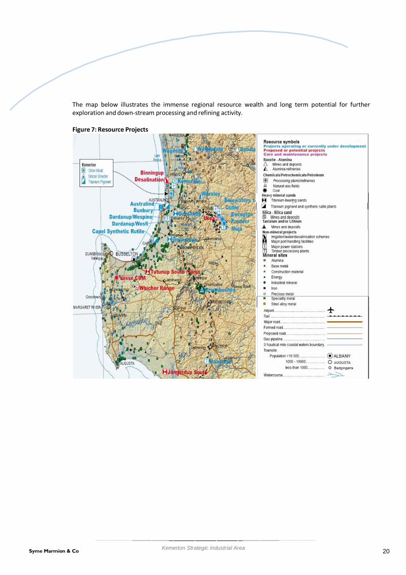
The map below illustrates the immense regional resource wealth and long term potential for further exploration and down-stream processing and refining activity.
Figure 7: Resource Projects
20 Syme Marmion & Co Kemerton Strategic Industrial Area

4. Demographic Context
4.1. Population Growth by Age
The estimated resident populations as at June 2011 of the twelve LGAs making up the SW region are shown in the following chart. The data indicates the varied nature of the region, ranging from the mainly urban populations of Bunbury and Busselton LGAs to the predominately rural Boyup Brook and Nannup. The total population of the region as at June 2011 was 158,615.
Figure 8: Estimated Resident Population June 2011
35,000
30,000
25,000
20,000
15,000
10,000
5,000
-
32,440 31,211
23,685
14,906
12,679 12,219
9,428 9,315
5,406 4,411
1,614 1,301
Source – ABS (2011) Regional Population Growth Australia Cat 3218.0
The table below shows the change in population from 2011 to 2011.
Est Resident Population 2011
Change 2001-2011
Ave Annual Growth Rate
2001-2011
% No. % Bunbury (C) 32,440 6.4 1,947 0.6 Busselton (S) 31,211 35.1 8,112 3.1 Harvey (S) 23,685 28.4 5,233 2.5 Capel (S) 14,906 109.7 7,799 7.7 Dardanup (S) 12,679 41.6 3,724 3.5 Augusta-Margaret River (S) 12,219 19.9 2,032 1.8 Manjimup (S) 9,428 -8.5 -881 -0.9 Collie (S) 9,315 2.7 243 0.3 Donnybrook-Balingup (S) 5,406 15.2 715 1.4 Bridgetown-Greenbushes (S) 4,411 5.3 223 0.5 Boyup Brook (S) 1,614 -1.7 -28 -0.2 Nannup (S) 1,301 6.8 83 0.7
Total 158,615
21 Syme Marmion & Co Kemerton Strategic Industrial Area

It shows the strongest growth in the growth areas around the Bunbury Urban Centre in the Shires of Capel, Dardanup and Harvey, with strong growth in absolute terms also in Busselton. At the 2011 Census the Bunbury Urban Area had a population of 65,600, making it by far the largest urban centre outside of the Perth – Peel region.
The estimated summary age distribution of the populations is shown in the following table.
Table 3: Summary Age Distribution as at June 2011
Median age of Persons
People aged
0–14 years
People aged 15–64 years
People aged 65 years and
over Augusta-Margaret River (S) 39.3 20.3 67.1 12.6 Boyup Brook (S) 43.8 20.3 60.8 18.8 Bridgetown-Greenbushes (S) 45.9 20.5 61.6 17.9 Bunbury (C) 38.7 17.3 67.7 15.0 Busselton (S) 39.7 21.1 62.9 16.0 Capel (S) 34.5 26.6 65.7 7.7 Collie (S) 39.7 19.1 67.8 13.1
Dardanup (S) 35.5 22.4 65.9 11.8
Donnybrook-Balingup (S) 44.5 19.1 65.1 15.8
Harvey (S) 36.9 22.5 66.5 11.1
Manjimup (S) 41.6 21.1 63.5 15.4
Nannup (S) 49.4 16.9 63.8 19.3
Source – ABS (2011) Populations by Age and Sex, Regions of Australia Cat 3235.0
The age distribution data indicates Capel and Dardanup have the lowest median age and Nannup, Bridgetown-Greenbushes, Donnybrook-Balingup and Boyup Brook the highest. Nannup has a high proportion of people aged 45-64 and this trend is replicated, albeit to a lesser degree, in other predominately rural LGAs such as Boyup Brook and Bridgetown-Greenbushes. Bunbury has a high proportion of people aged 15-29 and this is most likely due to migration to the major urban centres for employment.
4.2. Household Formation As at the 2011 Census, there were approximately 56,000 households in the region. The following chart shows the number of households for each LGA at this time.
22 Syme Marmion & Co Kemerton Strategic Industrial Area

Figure 9: Households
14,000
12,000 12,336
10,998
10,000
8,000
7,924
6,000
4,000
2,000
-
4,652 4,288 4,211
3,483 3,272
1,972 1,723
617 518
Source – ABS (2006) Census of Population and Housing
The distribution of the household types is shown in the following chart.
Figure 10: Household Type Distribution
100% 90% 80% 70% 60% 50% 40% 30% 20% 10%
0%
Lone person household
Group household
Other family
One parent family
Couple family with children
Couple without children
Source – ABS (2011) Census of Population and Housing
23 Syme Marmion & Co Kemerton Strategic Industrial Area

Figure 10 indicates that the highest proportion of family households is in Capel LGA which corresponds to the age distribution data in Table 3, indicating a region with a high number of young families. Bunbury has the highest proportion of lone person households and this again corresponds with the age data which shows this region having a high proportion of young adults.
4.3. Household Income and Expenditure
Figure 11 gives a breakdown of the gross weekly household incomes for the twelve LGAs in the region as at the 2011 Census. It also includes a comparison with the overall WA figure. The data indicates that the region generally has more very low income households than WA in total and somewhat less very high income households. Capel again stands out as it has a very low proportion of low income households and a high proportion of high incomes. Collie is also unusual as it has a high proportion of both very high and very low income households compared to other LGAs in the region. Bunbury and Busselton have a slightly higher proportion of low income households compared to the state.
Figure 11: Gross Weekly Household Income Distribution
100% 90% 80% 70% 60% 50% 40% 30% 20% 10%
0%
$3,500 or more
$2,500 - $3,499
$1,500 - $2,499
$1,000 - $1,499
$400 - 999
negative - $399
Source – ABS (2011) Census of Population and Housing
In terms of housing expenditure at the time of the 2011 Census, of those paying a mortgage the LGAs with the highest proportion of household monthly loan repayments under $450 is Boyup Brook, Manjimup and Nannup. Most LGAs have about 5% of households with a monthly mortgage in this range. The majority of monthly loan repayments across all LGAs in the region were between $1,000 and $2,000, with roughly 40% of all households with a mortgage in this group. Augusta/Margaret River and Capel had the highest proportion of monthly loan repayments of over $3,000, at 17% and 15% respectively. The distribution of mortgage repayments in the SWR is broadly similar to WA as a whole, although the state has a slightly higher proportion of monthly repayments greater than $2,000 than the SWR. In total, 18,900 households in the region indicated they paid a mortgage at the time of the Census.
When considering households in rental accommodation there is considerable variation across the region, with the predominantly agricultural communities of Boyup Brook, Bridgetown-Greenbushes, Donnybrook-
24 Syme Marmion & Co Kemerton Strategic Industrial Area

Balingup, Manjimup and Nannup having the majority of rents below $200 per week, while the urban communities around Bunbury (including Capel, Dardanup and Harvey) and Busselton each having the highest proportion of rents in the $200 – $399 per week range. The highest proportion of renters paying over $400 per week is in Capel (16%), Augusta-Margaret River (8%) and Bunbury (8%). In total, some 15,000 households in the SWR indicated that they were paying rent at the time of the Census.
4.4. Labour Force
As at the time of the 2011 Census the region had a labour force of 75,900; over 72,000 residents of the region were employed on either a full or part time basis. The participation rate was approximately 66% and the unemployment rate was 4.7%. On an LGA basis, Capel and Dardanup had the highest labour force participation rate (71%) while Bridgetown/Greenbushes and Nannup had the lowest participation (61%). The unemployment rate across LGAs ranged from 3.9% (Donnybrook-Balingup) to 5.6% (Bunbury).
The following chart provides an estimate of the unemployment rate across the whole region from December 2008 until March 2010, essentially taking the period highly effected by the Global Financial Crisis.
Figure 12: Estimate South West Region Unemployment Rate 2008/2010
Source – DEEWR (2010) Small Area Labour Markets estimates
Although the unemployment rate has increased over this period, it indicates employment in the region was reasonably resilient given the economic circumstances at the time. The unemployment rate for the state had approximately the same start and end points as the SWR over this period but generally exceeded 5% for much of 2009.
4.5. Travel to Work Patterns
The 2011 Census indicated that 83% of the SWR resident work force worked within the region
The following chart shows the proportion of the resident work force for each LGA who are employed in that LGA.
25 Syme Marmion & Co Kemerton Strategic Industrial Area

Figure 13: Proportion of Resident Workforce Employed in LGA
0% 20% 40% 60% 80% 100%
Dardanup (S) Bunbury (C)
Collie (S) Capel (S)
Harvey (S) Donnybrook-Balingup (S)
Nannup (S) Bridgetown-Greenbushes (S)
Boyup Brook (S) Augusta-Margaret River (S)
Busselton (S) Manjimup (S)
Source – ABS (2011) Census of Population and Housing
The data indicates the LGAs that border the City of Bunbury (Dardanup, Capel and Harvey) generally have a low proportion of the resident workforce employed within the LGA. Large proportions of these workers travel to Bunbury for employment, and in the case of Dardanup, Capel and Harvey this equates to 43% (2,580 workers), 45% (3,040 workers) and 32% (3,380 workers) of the resident workforce respectively. Although there are a large number of people travelling to Bunbury from neighbouring LGAs, approximately 2,460 people who live in Bunbury travel to Capel, Collie, Harvey and Dardanup for employment and only 63% of Bunbury’s resident work force are actually employed in the LGA. This implies that if additional industries located at Kemerton there would be the potential to further increase the regional level of employment self-sufficiency and local employment self-containment.
The region is an important FIFO base: almost 2,100 workers resident in the south-west (around 3% of the workforce) work in resource areas in the Pilbara and Goldfields.
4.6. Population Projection Data Sets
The main population forecasting data set available is the WAPC’s WA Tomorrow publication. This series has been recently released. It is based on the 2006 Census data. A consideration with WA Tomorrow is that it is apparent that migration patterns have changed over the past decade and international migration is now having a much larger effect on WA’s population growth than has been the case previously. The Australian Bureau of Statistics has recently published population projections based on the 2006 Census and this includes a more recent analysis of immigration patterns with revision of fertility and mortality rates. This data was prepared for the Department of Health and Aging to assist in planning for health services across the county. It has several caveats attached to it, in particular it does not reflect the local knowledge of demographers based in WA, the fertility rates used in the analysis are quite high and may not be sustainable, and government policy on immigration may change in the future.
26 Syme Marmion & Co Kemerton Strategic Industrial Area

Popu
latio
n
1996
19
97
1998
19
99
2000
20
01
2002
20
03
2004
20
05
2006
20
07
2008
20
09
2010
20
11
2012
20
13
2014
20
15
2016
20
17
2018
20
19
2020
20
21
2022
20
23
2024
20
25
2026
20
27
2028
20
29
2030
20
31
The modelling for this project uses both of these projections and additionally investigates a projection based on the average annual population growth experienced in the various LGAs making up the SWR over the last 13 years as reported in the ABS Estimated Resident Population release. It acts as a useful reference point for other more detailed population forecasting models. The period the Average Annual Growth Rate (AAGR) is based on covers a time when a number of industries that are currently major employers in the SWR, for example wine making, were undergoing a high level of development and consequently producing a large number of employment opportunities. These industries have now largely matured and it is presently difficult to identify industries that could support similar high levels of new employment. It is consequently expected that population growth in the region will not be able to maintain the recent rate of increase. However, in the event that the WA economy were to experience a prolonged and substantial expansion with a spill over to the SWR, this level of growth may still be possible. The following figure gives a graphical representation of these population growth scenarios, along with a comparison with existing population growth in the region.
Figure 14: South West Region Population Growth Scenarios
350,000
300,000
250,000
200,000
ERP
WAT Series A
WAT Series C
WAT Series E
ABS
AAGR
150,000
100,000
50,000
0
Year
Source – ABS, WAPC
A summary of the various projections are given in the following table.
27 Syme Marmion & Co Kemerton Strategic Industrial Area

Table 4: Population Growth Comparison
Projection Estimated Resident
Population as at June 2011 Average Annual Growth
Rate 2010-2031 Projected Population at
2026 / 2031
WA Tomorrow
158,615
(2026) Series A: 214,000 (2026) Series C: 230,000 (2026) Series E: 245,900
ABS/DoHA 1.8% (2031) 230,000
ERP/AAGR 2.6% (2031) 310,000
The above forecasts provide a useful indication of the likely population forecasts for the SW region. However, the most recent forecasts developed for the Bunbury Statistical District by Forecast ID provides a more up to date forecast and for the purposes of this study are considered more relevant to the Kemerton Strategic Industrial Area context. The Bunbury Statistical District is shown on the following map.
Figure 15: Bunbury Statistical District
28 Syme Marmion & Co Kemerton Strategic Industrial Area

The Bunbury Statistical District is the population of the urban centre of Bunbury and ignores local government boundaries. It is made up of all of the City of Bunbury and includes the adjacent urban and rural residential parts of the Shires of Dardanup (Eaton), Harvey (Australind) and Capel (Dalyellup). These boundaries are used for comparing the major urban areas of Australia including capital cities. The population forecast for the Bunbury Statistical District is illustrated below.
Figure 16: Bunbury Statistical District Forecast Population
Source: Forecast ID 2011
The Bunbury Statistical District is forecast to grow from almost 68,000 persons in 2011 to 101,000 persons in 2031. This is a very significant increase over a 20-year period and planning for this increase in population will need to include appropriate employment provision such as that planned in Kemerton. The future workforce employed within the Kemerton Industrial precinct will predominantly reside within the Bunbury Statistical District.
4.7. Workforce
4.7.1. Workforce Employment Profile
The top 20 major industries of employment across the entire region as at the 2011 Census are shown in the following table and chart. The table also shows the LGAs with the highest proportion of employment in that category. The Census employment data has been disaggregated to the 3 digit level of the INDP codes to provide a fine grained indication of the types of work people in the region undertake. The data point highlighted in yellow indicates the industry that has some presence on industrial estates in the region as identified as part of the DoP Industrial Land Survey when the Census data is compared to the ILS WASLUC codes, although not all employment indicated in the Census data necessarily occurs there.
29 Syme Marmion & Co Kemerton Strategic Industrial Area

South West Region – Main Industries of Employment
Industry of Employment (INDP level 3) Total
Employment
Main LGAs for Activity
School Education 3,905 Bunbury 25%, Busselton 19% Cafes, Restaurants and Takeaway Food Services 2,451 Bunbury 37%, Busselton 26% Basic Non-Ferrous Metal Manufacturing 1,730 Collie 96% Supermarket and Grocery Stores 1,664 Bunbury 30%, Busselton 22% Accommodation 1,660 Busselton 37%, Aug- Marg River 18%, Bunbury 15% Hospitals 1,628 Bunbury 61%, Busselton 13% Sheep, Beef Cattle and Grain Farming 1,517 Boyup Brook, Dandaragan 16%, Boyup Brook 15%, Manjimup 13% Building Installation Services 1,406 Bunbury 37%, Collie 23%, Busselton 18% Heavy and Civil Engineering Construction 1,167 Collie 67%, Bunbury 15% Local Government Administration 1,124 Bunbury 24%, Busselton 21% Beverage Manufacturing 1,013 Aug Marg River 38%, Busselton 34% , Harvey 15% Residential Care Services 1,009 Bunbury 42%, Busselton 27% Road Freight Transport 998 Bunbury 41%, Harvey 17% Architectural, Engineering & Technical Services 939 Bunbury 41%, Collie 22% State Government Administration 935 Bunbury 42%, Manjimup 22% Residential Building Construction 926 Bunbury 40%, Busselton 28% Pharmaceutical and Other Store-Based Retailing 924 Bunbury 40%, Busselton 26% Automotive Repair and Maintenance 803 Bunbury 44%, Busselton 18% Fruit and Tree Nut Growing 787 Manjimup 24%, Donnybrook-Balingup 22%, Busselton 21%, Aug
Marg River 20% Allied Health Services 773 Bunbury 39%, Busselton 25%
30 Syme Marmion & Co Kemerton Strategic Industrial Area

Figure 17: Major Industries of Employment – South West Region 2011
4,500
4,000
3,500
3,000
2,500
2,000
1,500
1,000
500
-
Source – ABS (2011) Census of Population and Housing
This chart indicates that industries with a traditional expectation of being located on industrial estates, for example most manufacturing, are not major employers in the overall scheme of the region. The one industry in this list that would be expected to have a presence on industrial estates (alumina production) does not occur on an industrial estate as identified in the Industrial Land Survey.
The top 20 major manufacturing and related industries in the SWR by employment, as indicated by the 2011 Census, are shown in the following chart. Not all of these industries are located on industrial estates. All are suitable or would benefit from the services, efficiency and protection that an industrial zoning provides. A full list of all current industries in the South West with potential for location on a heavy, strategic or special industrial estate is attached as Appendix 1. Clearly at the scale of some of the smaller enterprises a specialised or strategic industrial estate is not required. However at scale it may become essential if the industry is to remain in the South West.
31 Syme Marmion & Co Kemerton Strategic Industrial Area
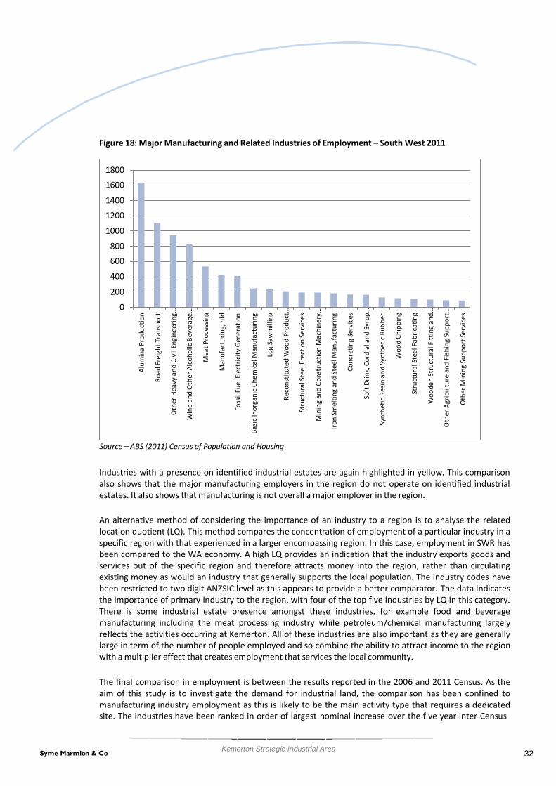
Alum
ina
Prod
uctio
n
Road
Fre
ight
Tra
nspo
rt
Oth
er H
eavy
and
Civ
il En
gine
erin
g…
Win
e an
d O
ther
Alc
ohol
ic B
ever
age…
Mea
t Pro
cess
ing
Man
ufac
turin
g, n
fd
Foss
il Fu
el E
lect
ricity
Gen
erat
ion
Basi
c In
orga
nic
Chem
ical
Man
ufac
turin
g
Log
Saw
mill
ing
Reco
nstit
uted
Woo
d Pr
oduc
t…
Stru
ctur
al S
teel
Ere
ctio
n Se
rvic
es
Min
ing
and
Cons
truc
tion
Mac
hine
ry…
Iron
Smel
ting
and
Stee
l Man
ufac
turin
g
Conc
retin
g Se
rvic
es
Soft
Drin
k, C
ordi
al a
nd S
yrup
…
Synt
hetic
Res
in a
nd S
ynth
etic
Rub
ber…
Woo
d Ch
ippi
ng
Stru
ctur
al S
teel
Fab
ricat
ing
Woo
den
Stru
ctur
al F
ittin
g an
d…
Oth
er A
gric
ultu
re a
nd F
ishi
ng S
uppo
rt…
Oth
er M
inin
g Su
ppor
t Ser
vice
s
Figure 18: Major Manufacturing and Related Industries of Employment – South West 2011
1800
1600
1400
1200
1000
800
600
400
200
0
Source – ABS (2011) Census of Population and Housing
Industries with a presence on identified industrial estates are again highlighted in yellow. This comparison also shows that the major manufacturing employers in the region do not operate on identified industrial estates. It also shows that manufacturing is not overall a major employer in the region.
An alternative method of considering the importance of an industry to a region is to analyse the related location quotient (LQ). This method compares the concentration of employment of a particular industry in a specific region with that experienced in a larger encompassing region. In this case, employment in SWR has been compared to the WA economy. A high LQ provides an indication that the industry exports goods and services out of the specific region and therefore attracts money into the region, rather than circulating existing money as would an industry that generally supports the local population. The industry codes have been restricted to two digit ANZSIC level as this appears to provide a better comparator. The data indicates the importance of primary industry to the region, with four of the top five industries by LQ in this category. There is some industrial estate presence amongst these industries, for example food and beverage manufacturing including the meat processing industry while petroleum/chemical manufacturing largely reflects the activities occurring at Kemerton. All of these industries are also important as they are generally large in term of the number of people employed and so combine the ability to attract income to the region with a multiplier effect that creates employment that services the local community.
The final comparison in employment is between the results reported in the 2006 and 2011 Census. As the aim of this study is to investigate the demand for industrial land, the comparison has been confined to manufacturing industry employment as this is likely to be the main activity type that requires a dedicated site. The industries have been ranked in order of largest nominal increase over the five year inter Census
32 Syme Marmion & Co Kemerton Strategic Industrial Area

period, with alumina production having the largest increase followed by specialised machinery and equipment manufacturing, bakery product manufacturing and various classes of metal fabrication and manufacturing. There is some evidence of growth in some elaborately transformed manufactures, with both specialised machinery and equipment and professional and scientific industry sectors showing growth, between them employing an additional 116 workers.
Figure 19: Gains in Employment 2006/2011 - Manufacturing Industries South West
South-West Region - Main Manufacturing Employment Gains - 2006 - 2011
Employees
0 500 1000 1500
Basic Non-Ferrous Metal Manufacturing Specialised Machinery and Equipment Manufacturing
Bakery Product Manufacturing Fabricated Metal Product Manufacturing, nfd
Basic Ferrous Metal Product Manufacturing Basic Ferrous Metal Manufacturing
Professional and Scientific Equipment Manufacturing Basic Polymer Manufacturing
Other Machinery and Equipment Manufacturing Other Wood Product Manufacturing
Machinery and Equipment Manufacturing, nfd Other Food Product Manufacturing
Cleaning Compound and Toiletry Preparation… Glass and Glass Product Manufacturing
Manufacturing, nfd Seafood Processing
Sugar and Confectionery Manufacturing Wood Product Manufacturing, nfd
Metal Container Manufacturing
Source – ABS (2006 and 2011) Census of Population and Housing
The main sectors of the manufacturing industry showing reductions in employment between 2006 and 2011 have also been investigated and are shown in the graph following. It shows the greatest nominal reductions in log sawmilling and timber dressing, meat product manufacturing and furniture manufacturing.
33 Syme Marmion & Co Kemerton Strategic Industrial Area

Figure 20: Loses in Employment 2006/2011 - Manufacturing Industries South West South-West Region - Main Manufacturing Employment Losses - 2006 - 2011
-250
-200
-150 -100 Employees
-50
0
Log Sawmilling and Timber Dressing
Meat and Meat Product Manufacturing
Furniture Manufacturing
Basic Non-Ferrous Metal Product Manufacturing
Beverage Manufacturing
Cement, Lime, Plaster and Concrete Product…
Printing and Printing Support Services
Clothing and Footwear Manufacturing
Other Fabricated Metal Product Manufacturing
Basic Chemical Manufacturing
Structural Metal Product Manufacturing
Other Manufacturing
Computer and Electronic Equipment Manufacturing
Motor Vehicle and Motor Vehicle Part Manufacturing
Domestic Appliance Manufacturing
Non-Metallic Mineral Product Manufacturing, nfd
Fruit and Vegetable Processing
Natural Rubber Product Manufacturing
Fertiliser and Pesticide Manufacturing
4.7.2. Qualification and Skills Base
The following table shows the post school qualifications of people in the region compared to WA in total.
34 Syme Marmion & Co Kemerton Strategic Industrial Area

Table 5: Post School Qualifications
Postgraduate
Degree
Grad Dip /
Graduate Certificate
Bachelor Degree
Advanced Diploma
/ Diploma
Certificate
Level of education
inadequately described
Level of education
not stated
Not
applicable
Augusta-Margaret River
1%
1%
10%
7%
17%
1%
8%
53%
Boyup Brook 0% 1% 7% 6% 16% 2% 6% 62% Bridgetown- Greenbushes
1%
1%
7%
7%
17%
2%
5%
60%
Bunbury 1% 1% 7% 5% 22% 1% 6% 56% Busselton 1% 1% 8% 6% 18% 2% 6% 57%
Capel 1% 1% 8% 6% 19% 1% 5% 59% Collie 0% 0% 3% 3% 22% 1% 9% 60%
Dardanup (S) 0% 1% 5% 5% 23% 1% 4% 60%
Donnybrook- Balingup
1%
1%
7%
6%
18%
2%
6%
59%
Harvey 1% 1% 6% 5% 19% 1% 6% 60% Manjimup 1% 1% 5% 5% 16% 1% 7% 64%
Nannup 1% 1% 8% 8% 18% 2% 5% 57% Total - Region 1% 1% 7% 6% 20% 2% 6% 58%
Western Australia 2% 1% 10% 7% 16% 2% 8% 54% Source – ABS (2011) Census of Population and Housing
The main points appear to be that the region generally has a lower proportion of people who have post school qualifications and also that the region has a lower proportion of degree level educated population when compared to the state as a whole.
4.8. Demographic Implications
The scenarios outlined above give overall population growth. Of interest for assessing demand for industrial land is the size of the resulting work force. As at 2031, approximately 82% of the total population are likely to be aged 15 or over and therefore potentially part of the work force. This would result in a working age population of between 158,000 and 254,000 in the SWR. Based on the most-likely ABS/DOHA and WA Tomorrow Series C mid series, this number is expected to be around 189,000.
35 Syme Marmion & Co Kemerton Strategic Industrial Area
5. Economic and Social Context
5.1. Kemerton Employment Profile
At the time of the 2006 Industrial Land Use Survey, the Kemerton Strategic Industrial Area employed an estimated 405 persons. These employees were employed in only three Planning Land Use Categories (PLUC), namely manufacturing, Primary and Utilities. The land areas, floorspace and employment by PLUC are shown below.
Table 6: Kemerton Industrial Activity, 2006
PLUC Occupied Land
Area (Ha) Floorspace
(m2)
Employment m2 per
Employee Employees per Hectare
Manufacturing 197.5 26,157 343 76.26 1.737 Primary 1636.6 13,025 50 260.50 0.031 Utilities 80.6 3,825 12 318.75 0.149 TOTAL 1914.6 43,007 405 106.19 0.212
Source: Industrial Land Survey (DoP, 2006)
Presenting the data in this way allows for comparison of intensity by PLUC. The manufacturing industries in Kemerton occupy 197 hectares and employ 343 persons resulting in a land use intensity of 1.737 employees per hectares. The average land use intensity for the site is 0.212 employees per hectare.
By comparison, the Kwinana Beach Industrial area is approximately 1,220 hectares (occupied) and employs just over 3,000 persons (at 2006) and has an average land use intensity of 2.49 employees per hectare. Flynn Drive (Neerabup) has a land use intensity of 1.42 employees per hectare (at 2006).
It is likely that over the longer term the land use intensity will increase at Kemerton. However, this in itself should not be the goal since the site needs to be reserved for strategic industry large lot users and the flow on effects of these industries should include smaller lot users predominantly located in other industrial areas. The Kwinana Beach industrial area intensity provides a guide as to the maximum intensity that could be contemplated at ultimate development. Currently, the employment density at Kwinana is 2.49 employees per hectare.
5.2. Kemerton Land Uses
The Kemerton Industrial Park Strategy Plan indicated the total area of the park was 7,543 hectares, compared with 6,830 hectares identified in the 2006 Industrial Land Use Survey. The 4,870 hectares identified in the survey as uncleared land is likely to represent the buffer area. The strategy report indicated that this area was enlarged to 5,231 hectares and is largely conservation land owned by the Department of Environment and Conservation.
The breakdown of uses and land areas as identified in the 2006 Industrial Land use survey is shown in the following table.
36 Syme Marmion & Co Kemerton Strategic Industrial Area

Table 7: Kemerton Strategic Industrial Area Land Uses 2006 WASLUC
Code
WASLUC Description
Land Area (Ha) Estimated
Floorspace (m2) 2956 Non-Ferrous Metals Nec Smelting & Refining 117.2 16,259 2755 Inorganic Industrial Chemicals Nec Manufacturing 52.7 7,418 2111 Meat Abattoir Operation (Except Poultry And Pet Food) 25.5 2,200 2768 Chemical Products Manufacturing Nec 1.4 230 2884 Mineral Products,Non-Metallic Mfg Nec 0.6 50 8528 Mineral Sands Mining 1,464.1 1,730 9219 Environmental Protection Areas Nec 76.3 0 8565 Sand,Gravel & Soil Quarrying 38.0 0 8141 Pigs 30.8 2,975 8534 Industrial Minerals Nec 17.5 7,540 8219 Other Agricultural Processing Services Nec 9.9 780 1111 Single House 4.9 0 4859 Other Solid Waste Disposal Nec 38.0 278 4841 Sewage Treatment Plants 18.8 317 4812 Electric Generation Plants 17.7 2,830 4811 Electric Transmission Right-Of-Way 5.6 0 4822 Gas Production Plants 0.4 400 9912 Uncleared Land - Unused 4,870.6 0 9911 Cleared Land - Unused 39.7 0
TOTAL 6,829.8 43,007 Source: Industrial Land Survey (DoP, 2006)
A large proportion of the current occupied land is used for mineral sands mining. This is similar to other industrial estates such as Neerabup (Flynn Drive).
37 Syme Marmion & Co Kemerton Strategic Industrial Area

5.3. Employment Self Sufficiency
Employment self-sufficiency measures the quantity of jobs (working population) available in a given area as a proportion of the labour force residing within the area. The following table outlines the employment self- sufficiency by industry type for the South West Region.
Table 8: Employment Self-Sufficiency
South-West Region Basic Community Profile
Worker Population Profile
Employment
Resident Workers Workers Employed Self Sufficiency
Agriculture, forestry & fishing 4,115 3,684 90%
Mining 3,619 1,516 42%
Manufacturing 8,412 7,470 89%
Electricity, gas, water & waste services 1,260 1,188 94%
Construction 9,242 6,795 74%
Wholesale trade 1,685 1,476 88%
Retail trade 8,183 7,428 91%
Accommodation & food services 5,145 4,575 89%
Transport, postal & warehousing 2,644 2,098 79%
Information media & telecommunications 509 500 98%
Financial & insurance services 1,051 986 94%
Rental, hiring & real estate services 1,209 1,140 94%
Professional, scientific & technical services 2,743 2,467 90%
Administrative & support services 2,084 1,519 73%
Public administration & safety 3,418 3,154 92%
Education & training 5,468 5,159 94%
Health care & social assistance 6,678 6,137 92%
Arts & recreation services 582 500 86%
Other services 2,726 2,394 88%
Inadequately described/Not stated 1,561 567 36%
Total 72,334 60,753 84% Source – ABS (2011) Census of Population and Housing
The overall employment self-sufficiency for the Bunbury Statistical District is 84%. This is comparable to the Perth Metropolitan area which has an employment self-sufficiency of around 88%. Only mining has a high number of resident workers compared with local jobs available – this reflects the importance of the region as a FIFO base for Pilbara and Goldfields mining operations.
38 Syme Marmion & Co Kemerton Strategic Industrial Area

5.4. Employment Self Containment
The level of self-containment at local government level is quite high. This is shown in the data in Figure 13 in Section 4.5, which shows the proportion of those living and working in the LGA ranges from 46% (Dardanup to 95% (Manjimup. More detail is given in the table below for the Bunbury Urban Area, the main centre of population in the region. This has a workforce of around 30,600, or 42% of the region’s total. The table shows the place of work of workers resident in the Bunbury Urban Area by industry type. Note that the Bunbury Urban Area includes parts of the Capel, Dardanup and Harvey local government areas. It is noteworthy that 2,652 workers living in the Bunbury urban area work in the Shire of Harvey (including Kemerton) but an almost equivalent number (2,524) work in Collie.
Table 9: Bunbury Urban Area Resident Workforce, Place of Work by LGA 2011
Bunbury Harvey Dardanup Busselton Augusta-
Bunbury Residents, Place of Work > (C) (S) Collie (S) (S) Capel (S) (S) Margaret River (S)
Plac
e of
Res
iden
ce: B
unbu
ry U
rban
Are
a
Agriculture, Forestry and Fishing
Mining
Manufacturing
79 54 4 25 33 4 7 128 44 199 22 91 4
1,282 627 1,173 355 68 7 7 Electricity, Gas, Water and Waste Services 309 40 181 4 10
Construction
Wholesale Trade
Retail Trade
1,609 269 661 150 170 41 7 530 43 5 24 26 4
2,681 287 22 209 58 37 Accommodation and Food Services 1,160 91 24 97 16 11 Transport, Postal and Warehousing
Information Media and Telecommunications
Financial and Insurance Services
714 103 9 80 21 8 248 4 8 8 423 33 9 11 10 12
Rental, Hiring and Real Estate Services 400 42 10 8 12 5 Professional, Scientific and Technical Services
Administrative and Support Services
Public Administration and Safety
780 119 106 46 44 9 401 60 34 20 43 7
1,071 69 32 72 44 21 Education and Training 1,197 435 20 200 334 11
Health Care and Social Assistance
Arts and Recreation Services
Other Services
2,305 161 19 279 62 24 107 37 23 19 3 832 91 4 64 107 7
Inadequately described 134 43 12 15 20 Not stated 4
TOTAL 16,394 2,652 2,524 1,712 1,186 225 21 Source: ABS Census 2011
The employment self-containment for the larger area around Bunbury – the Bunbury Statistical Area (SA3) is shown below.
39 Syme Marmion & Co Kemerton Strategic Industrial Area

Table 10: Employment Self Containment – Bunbury Statistical Area (SA3)
Industry Type – Bunbury SA3 Resident Workforce
Live and Work In
Bunbury SA3
Live in Bunbury SA3 and
Employed
Employment Self -
Containment
Agriculture, Forestry and Fishing 1,254 1,013 81% Mining 2,429 1,183 49%
Manufacturing 6,162 5,208 85% Electricity, Gas, Water and Waste Services 1,007 884 88%
Construction 6,117 3,970 65% Wholesale Trade 983 791 80%
Retail Trade 5,002 4,139 83% Accommodation and Food Services 2,425 1,937 80% Transport, Postal and Warehousing 1,740 1,321 76%
Information Media and Telecommunications 354 305 86% Financial and Insurance Services 664 598 90%
Rental, Hiring and Real Estate Services 690 600 87% Professional, Scientific and Technical Services 1,647 1,372 83%
Administrative and Support Services 1,109 721 65% Public Administration and Safety 2,061 1,781 86%
Education and Training 3,342 2,972 89% Health Care and Social Assistance 4,274 3,572 84%
Arts and Recreation Services 364 275 76% Other Services 1,776 1,477 83%
Inadequately described 518 301 58% Not stated 415 8 2%
TOTAL 44,333 34,428 78% Source: ABS 2011 Census
The Bunbury Statistical Area has an employment self-containment of 78%. That is, of the 44,333 persons living the Bunbury Statistical Area with employment somewhere, 34,428 of these persons are employed within the Bunbury Statistical Area. A number of industries, such as mining, have very low self-containment and reflect characteristics such as Fly in Fly Out arrangements. Other industries with lower self-containment reflect the need to travel outside of urban areas for work.
5.5. Employment Forecasts
As noted in Section 4.8, the working age population in the South West Region is estimated to be between 158,000 and 254,000 by 2031, with a mid-point of around 189,000. The bulk of this increase will be in the Bunbury – Busselton area. At an average participation rate of 61%, this implies a regional labour force of between 96,000 and 155,000 and 115,000 at the mid-point. The labour force is currently around 76,000, indicating an increase of between 20,000 and 79,000 and 39,000 at the mid-point.
Approximately 23% of the employed labour force resident the region is employed in industrial areas. Based on this ratio remaining constant, there is likely to be the requirement for an additional 8,900 jobs (range 4,600 to 18,000) located in industrial areas in the region between 2011 and 2031. These need to be accessible to workers residing in the Bunbury – Busselton area.
40 Syme Marmion & Co Kemerton Strategic Industrial Area

5.6. South West Industrial Land Study
The rationale for the South West Industrial Land Study (SWILS) is to ensure that adequate supply is available to provide for the population growth. The majority of the additional jobs required on industrial land will not be located at Kemerton since it is a strategic industrial area and will not contain industries that employ large numbers of people.
The SWILS sets the planning framework for the general and light industry land requirements and needs to be implemented accordingly so as to protect Kemerton from encroachment by general or light industry uses. It is expected that a small number of uses for general and light industry may need to be located within the Kemerton Strategic Industrial Area to provide adequate on site services to the strategic industry operators.
The SWRILS established that the key influence on the development of Kemerton as a site for strategic and special industries was the ability to provide highly serviced (particularly freight and power), project ready, large, flat sites as unencumbered by constraints as possible. The study concluded that Kemerton was otherwise ideally placed in terms of proximity to port (containerisation potential) and labour supply.
The main heavy strategic growth industries with land requirements were identified as those associated with mineral extraction and natural resources, advanced processing and refining (nano technologies) and some associated manufacturing in the Bunbury-Wellington sub-region. Resource extraction and renewable energy industries emerging in the surrounding sub-regions of Vasse and warren-Blackwood may also increase demand for land at Kemerton. It was also entirely possible that there would also be spin –off from special industries in high technology, agriculture, waste and resource recycling and construction.
Although the study also gave equal consideration to the land requirements of heavy industries identified within the State Heavy Industry Strategy, it was considered that these projects were seeking sites and business opportunities in a highly competitive market and were therefore more likely to be attracted to Kemerton after port containerisation, improvements in the ITC network and a implementation of a rail freight line to Kemerton and were therefore less certain in the short to medium term. The strategic industry stream has been assessed on a project by project basis as each development of this type has individual requirements that can not necessarily be generalised into a numerical model. The types of strategic industries that have been considered include those previously proposed by the DSD and also new opportunities that have been identified. They include:
• Wood/paper mill • Petro chemical plants • Chemical processing • Steel mill • Iron ore processing • Aluminium smelter • Transport/logistics multi-modal • Agri, food and health related manufacturing and processing industries • Fertilizer plant
The total land area required if all these projects were to occur is estimated to be 1,000Ha with almost 3,000 direct jobs and almost 900 indirect jobs. However, a number of these projects, such as the wood and paper mill and steel mill, are judged to have a low probability of commencement as circumstances have changed considerably since their initial proposal.
The SWRILS study concluded that under a regional economic growth scenario of 3-4% and the ongoing development of the inherent regional economic assets including containerisation of the Bunbury Port and
41 Syme Marmion & Co Kemerton Strategic Industrial Area

successful attraction of large strategic industries under the DSD strategy, that the existing ‘developable’ land supply at Kemerton could be consumed within or at least allocated a use even if not fully developed and occupied, within 5- 10 years.7
5.7. Economic and Social Implications
In summary, the Kemerton Strategic Industrial Area will provide an essential economic and social component of the development of the SW region for the next 30-50 years. The KIP provides:
• A long term land supply for strategic heavy and special uses, which is not replicated elsewhere in the
SW region, or at a similar scale within the Perth and Peel regions, these industries are mostly export based and make a major contribution to the Region and State income
• A long term employment focus for skilled, semi-skilled and trade employment for the Bunbury and Wellington sub-region and potentially other adjacent sub regions. The SW has a skilled industrial workforce – Kemerton is appropriately located within the catchment to draw upon the skill base for its strategic/heavy/special/precision uses and there will be long term demand for industrial jobs in industrial areas in the greater Bunbury region
As Kemerton is such an important asset within the Industrial land Portfolio for the State and SW Region it is important that the responsibilities to protect this land for the designated purpose is recognised and administered. The key social and economic objectives for Kemerton must be:
• Retain the existing quantity of zoned land for Strategic and Special Industrial purposes. The region
cannot afford to contract the existing industrial land supply • Protect and Govern land releases at Kemerton to meet demand based on strategic/heavy industry
requirements– not population based light and general industry demand. Demand for up to 4,000 jobs to 2031 on industrial sites in the region may place pressure on Kemerton to perform non-strategic functions.
• Study potential for efficiencies/extensions of existing sites earmarked for development
7 SW Region Industrial Land Study, Stage 1 Demand Analysis, SMCo, 2010
42 Syme Marmion & Co Kemerton Strategic Industrial Area

6. Options Analysis
6.1. Current Planning
The total area of the KIP is 7,543 Ha. The area comprises the following land parcels:
• Core Industry Area – 2,019Ha • Support Industry Area – 293 Ha • Inter industry Buffer Area – 212Ha • Buffer Area – 5,019 Ha
A major consideration of the KIP planning process is to carefully control land uses within the Industry Core and the adjacent Support Industry Area to ensure that the Industry Core does not become constrained by the presence of incompatible land uses in close proximity to the heavy industrial area.
It is expected that the industries that locate in the KIP Industry Core will be those that support existing South West industries and strengthen the economic base of the region by adding value to primary and secondary resources. Future industries in the KIP Industry Core are anticipated to belong to one or more of the following categories:
• Chemical and resource processing (e.g. existing Cristal inorganic chemicals and Simcoa silicon smelter) • High technology (e.g. titanium applications) • Downstream processing (e.g. silicon applications) • Power generation (e.g. gas fired, biomass fired)
Under the Shire of Harvey District Planning Scheme No. 1, the Support Industry Area is identified as “Kemerton Ancillary Industry Zone”. In the Zoning and Development Standards table, the Policy Statement for this zone states: “Industry within this zone shall be ancillary to the heavy industry in the Kemerton Park Industrial zone. Ancillary in this respect means that the proposed development must demonstrate that the major portion of the source material, finished product, or services provided are oriented within the Kemerton area. No industry, wholesale or retain directed to primarily service the wider community will be permitted.”
Therefore any proposed development would be required to be predominantly ancillary to, and necessary to service, the Kemerton heavy industries located within the Core Industry area.
6.2. Employment Density
The Kemerton Strategic Industrial Area is focussed on providing industrial land consistent with the defined purpose as a strategic industrial site. Therefore, employment density is an outcome of the development that is attracted to the site rather than a target. However, it is useful to provide several scenarios for comparison in terms of the ultimate development that may occur on the site in order to estimate the likely employment that the site could generate.
Setting the parameters and density thresholds for this requires assessing other industrial areas and applying assumptions based on actual densities achieved in comparable industrial areas. In terms of the maximum achievable overall employment density for the site, it is likely that the maximum would not exceed 80% of the employment density achieved at Kwinana. Therefore, for the purpose of setting the highest employment density, a ratio of 2.00 employees per hectare is appropriate for the Kemerton Strategic Industrial Area. For the Core Industry area, it is expected that under any scenario that the employment density would be
43 Syme Marmion & Co Kemerton Strategic Industrial Area

less than 1.00 employees per hectare. For the low and medium density scenarios, the ratios achieved at Inner harbour (0.440) and Estuary Drive (0.831) have been applied to the Core Industry land parcel.
A “flow on” employment multiplier of 1.5 has been applied to the employment estimates in the Core Industry area for each scenario to estimate employment within the Support Industry area. Furthermore, it is anticipated that the employment density within the Support Industry area would be less than that achieved in the Halifax Drive/Davenport industrial area which has an employment density of 11.1 employees per hectare. The maximum employment density achievable within the Support Industry area is estimated at 10.24.
The employment density scenarios are outlined in the following table.
Table 11: Kemerton Strategic Industrial Area Employment Density Scenarios Kemerton Scenarios Scenario 1 - Low Density Scenario 2 - Medium Density Scenario 3 - High Density Development Parcel
Land Area (Ha)
Employment
Jobs/Ha
Employment
Jobs/Ha
Employment
Jobs/Ha
Core Industry 2,019 888 0.440 1,678 0.831 2,000 0.991
Support Industry 293 1,332 4.546 2,517 8.590 3,000 10.239
Inter Industry Buffer 212 24 0.113 38 0.179 47 0.222
Buffer Area 5,019 - - - - - -
Total Developable 2,524 2,244 0.889 4,233 1.677 5,047 2.000 Source: Land Use Survey (DoP, 2006) & Syme Marmion & Co Modelling
The resulting employment under the low, medium and high density scenarios is 2,244 jobs, 4,233 jobs and 5,047 jobs respectively. The employment in the Core Industry area for the scenarios is 888 jobs in the low density scenario, 1,678 jobs for the medium density scenario and 2,000 jobs for the high density scenario.
It is unlikely that any scenario other than the low density scenario would be achievable by 2031. The additional employment provision to 2031, based on 405 jobs at 2006 and a capacity of 2,244 jobs at 2031, is 1,839 additional jobs. In terms of industrial land employment required (see section 5.5), this represents 21% of the required forecast industrial jobs for the South-West Region at 2031. Given the difficulty of providing new industrial land in nay location, this is a highly significant contribution.
6.3. Potential Employment Impacts
With an estimated employment on site at 2031 of approximately 2,250 persons, Kemerton will generate significant wages and salaries for the employees. Based on available information from ABS (Estimates of Personal Income for Small Areas) at 2008/2009, wages and salary earners in the Bunbury Statistical District had an average income of $49,298 per annum. If we assume that Kemerton employees will generally have average wages and salaries (occupations will predominantly be labourers, technicians and trades and machinery operators and drivers), the total wages and salaries generated by Kemerton at 2031 will be approximately $118m (in 2008/09 dollars).
In terms of output, the SWR economy generated $12.4 billion in 2009/10. At the time, the SWR employment totalled approximately 75,000 persons resulting in an average output of $165,000 per employee. Applying this average to Kemerton employment of 2,250 persons at 2031 implies $371 million in output (2009/10 dollars) for the year. This is likely to be a minimum since industrial area employees generally have higher output ratios than other sectors. In terms of indirect employment, the Kemerton industrial area will generate additional employment off-site in other areas of the South West, Perth and regional Western Australia. Other studies (Kwinana Industrial
44 Syme Marmion & Co Kemerton Strategic Industrial Area

Area Economic Impact Study, SKM 2002) indicate that the flow on, or indirect employment can be up to 5.72 persons per direct employee.
If we assume an indirect multiplier of up to 5.7, then at 2031 it can be expected that off-site indirect employment will be up to 12,800 persons. This would generate additional output of between up to $2,112m and wages and salaries equivalent to between approximately $627m. If Kemerton develops by 2031 with a similar industry profile to Kwinana, then assuming these indirect employment figures is reasonable.
45 Syme Marmion & Co Kemerton Strategic Industrial Area

7. Development Implications
The Syme Marmion & Co consultant team regard the most likely implications for Kemerton to be:
• Existing SWR industries are less likely to seek sites in Perth metro for expansion, if they cannot expand on land within SWR and to strategic sites such as Kemerton they may move interstate or overseas. Therefore Kemerton fulfils a highly strategic role in a very competitive global market.
• There is a potential Kemerton market for industries seeking large sites with access to freight routes and port, particularly if the port is containerised.
• There is a potential Kemerton market for industries associated with WA mining and resources processing (although much of this is likely to occur closer to main extraction regions in NW and Mid- West) and associated with regional advantages such as resource extraction and processing, agriculture (including meat), tourism, utilities, transport, construction and emerging ‘green’/clean technologies.
• As a preferred location, Kemerton must provide ‘project ready’ land with limited environmental and community constraints with ready access to large labour sources (travel time 20 minutes), Bunbury Port, gas power supply, rail and road freight routes.
• Industrial land at Kemerton needs protection from urban encroachment with adequate buffers. • Industrial land at Kemerton should be safeguarded for heavy and special industrial purposes and not
general, light and commercial uses • Economic values should be given the same consideration as environmental values in a whole of
government policy and in consideration of development applications for Kemerton which has an increasingly unique status.
• Full implementation of all strategic projects earmarked for Kemerton is estimated to require 1,400 hectares of land. Ideally, 30% of the identified demand would be kept in reserve to provide a land bank and enable development ready land to be available and project ready.
• Under a regional economic growth scenario of 3-4% and the ongoing development of the inherent regional economic assets including containerisation of the Bunbury Port and successful attraction of large strategic industries under the DSD strategy, that the existing ‘developable’ land supply at Kemerton could be consumed within or at least allocated a use even if not fully developed and occupied, within 5- 10 years. There is therefore an imperative to make the remainder of the site project ready.
46 Syme Marmion & Co Kemerton Strategic Industrial Area