k&c phase 3 – brief project essentials - jaxa€¦ · · 2012-11-13application of palsar...
TRANSCRIPT
Science Team meeting #18 JAXA RESTEC HQ, Tokyo, November 7-9, 2012
Application of PALSAR for regional assessments of forest disturbance, rice agriculture and wetland habitats.
William SalasApplied GeoSolutions, LLC (AGS)
Durham, NH USA, [email protected]
Team includes: Nathan Torbick, Steve Hagen and Rob Braswell (AGS)Sandra Brown and Nancy Harriss (Winrock International)Jiaguo Qi (MSU)Xiangming Xiao (OU)
K&C Phase 3 – Brief project essentials
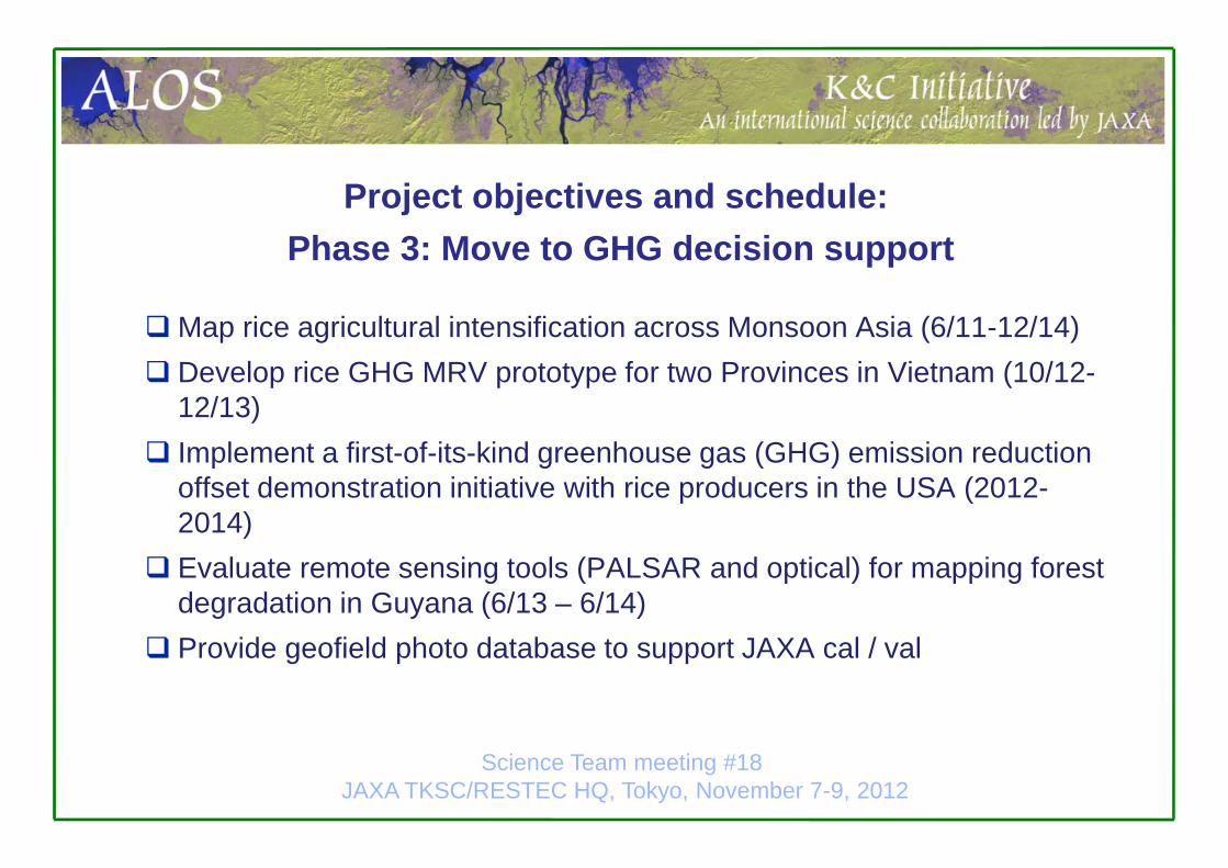
Map rice agricultural intensification across Monsoon Asia (6/11-12/14) Develop rice GHG MRV prototype for two Provinces in Vietnam (10/12-
12/13) Implement a first-of-its-kind greenhouse gas (GHG) emission reduction
offset demonstration initiative with rice producers in the USA (2012-2014)
Evaluate remote sensing tools (PALSAR and optical) for mapping forest degradation in Guyana (6/13 – 6/14)
Provide geofield photo database to support JAXA cal / val
Project objectives and schedule:Phase 3: Move to GHG decision support
Science Team meeting #18 JAXA TKSC/RESTEC HQ, Tokyo, November 7-9, 2012
Ongoing•Quantifying changes in agricultural intensification and expansion in monsoon Asia during 2000-2010 (NASA)•Implementing GHG offset projects in USA rice (USDA)•Prototyping MRV tools for Vietnam at the regional scale (USAID)•India REDD / Guyana Forest Degradation / Mapping mangroves Camau Peninsula, Vietnam and Sunderbans, India (USAID and Winrock/GFC)
Recent/Previous•Developing land cover classification products in monsoon Asia over the period of 2004-2007 through integration of Landsat and ALOS/PALSAR images•Mapping rice and modeling HPAI in Java
K&C Phase 3 – Brief project essentials
Science Team meeting #18 JAXA RESTEC HQ, Tokyo, November 7-9, 2012

Rice Project areas: Monsoon Asia and USAMulti-scale approach
Broad scale: Monsoon AsiaLocal scale: cal / val sites in Bangladesh, China, India, Indonesia, Thailand, Vietnam
Sacramento Valley & Midsouth
Science Team meeting #18 JAXA TKSC/RESTEC HQ, Tokyo, November 7-9, 2012

o Watershed scale: Multitemporal FBS/D used to distinguish rice paddy hydroperiod, cropping intensity, calendar, biomasso Illustrated with HH (Nov, Aug, Feb), 12.5m ground pixel spacing
Phase 2 Example rice products to drive GHG Modeling: Mapping Rice Extent
Mapping HydroperiodMapping Intensity

Care comparing census estimate with PALSAR maps
Phase 2 Example rice products: Regional Mapping
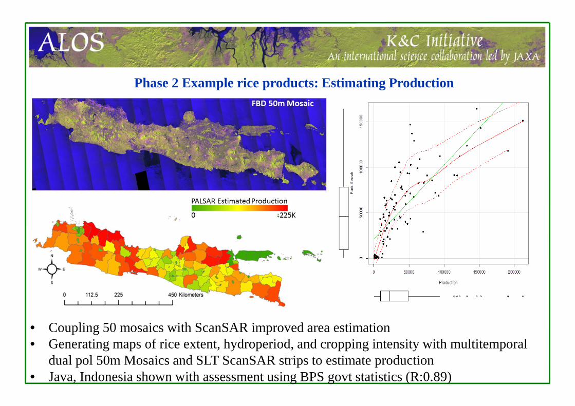
• Coupling 50 mosaics with ScanSAR improved area estimation• Generating maps of rice extent, hydroperiod, and cropping intensity with multitemporal
dual pol 50m Mosaics and SLT ScanSAR strips to estimate production• Java, Indonesia shown with assessment using BPS govt statistics (R:0.89)
Phase 2 Example rice products: Estimating Production

Maps of rice agroecological attributes (extent, hydroperiod, cropping intensity, production) across Monsoon AsiaMaps of rice intensification between 1997 – 2010 in Monsoon AsiaMaps of irrigation patterns, habitat, rice management and GHG emissions for USA riceMRV / Rice maps and GHG emissions for USAMRV prototype system for strategic regions in VietnamMap of cerrado biomass in 1996, 2007, and 2012 for the state of Goiás with associated uncertainty (Hagen)Degradation assessment: Guyana LoggingMaps of carbon and (wetland) forest patterns for India sites (TBD)
Phase 3 Deliverables
Science Team meeting #18 JAXA TKSC/RESTEC HQ, Tokyo, November 7-9, 2012
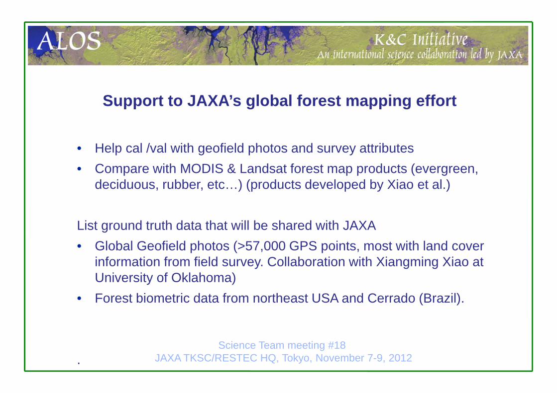
Support to JAXA’s global forest mapping effort
• Help cal /val with geofield photos and survey attributes• Compare with MODIS & Landsat forest map products (evergreen,
deciduous, rubber, etc…) (products developed by Xiao et al.)
List ground truth data that will be shared with JAXA• Global Geofield photos (>57,000 GPS points, most with land cover
information from field survey. Collaboration with Xiangming Xiao at University of Oklahoma)
• Forest biometric data from northeast USA and Cerrado (Brazil).
.Science Team meeting #18
JAXA TKSC/RESTEC HQ, Tokyo, November 7-9, 2012
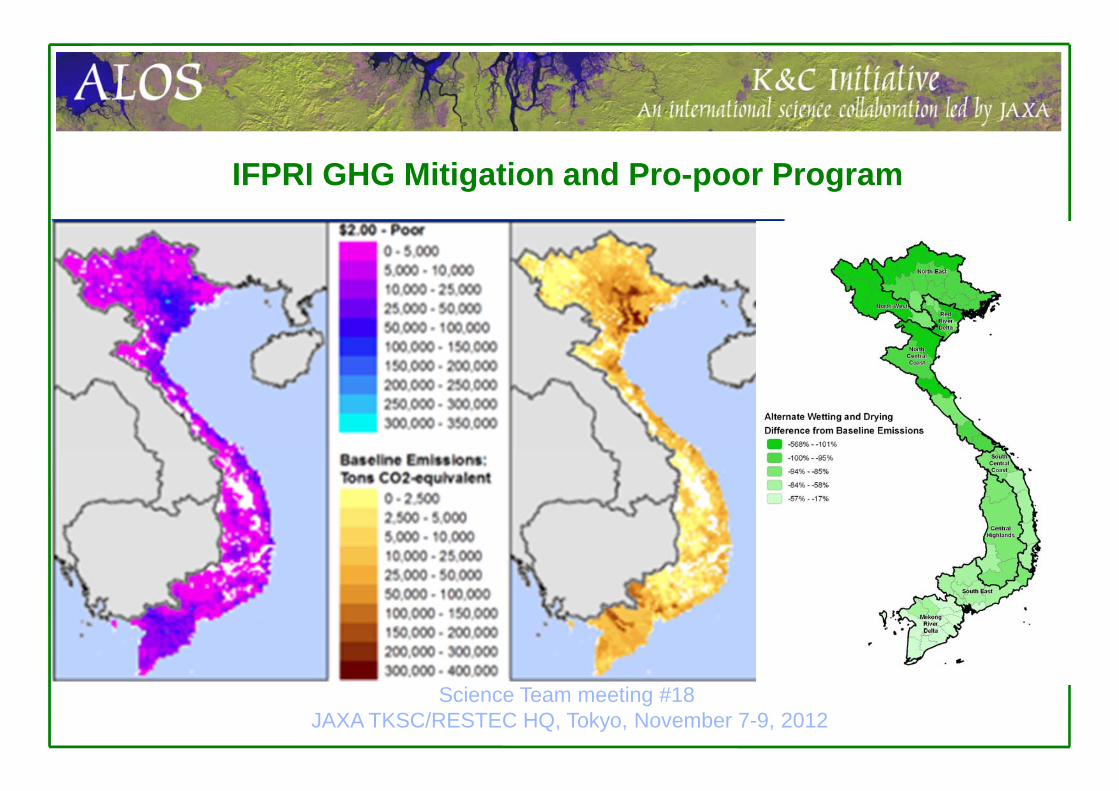
IFPRI GHG Mitigation and Pro-poor Program
Science Team meeting #18 JAXA TKSC/RESTEC HQ, Tokyo, November 7-9, 2012
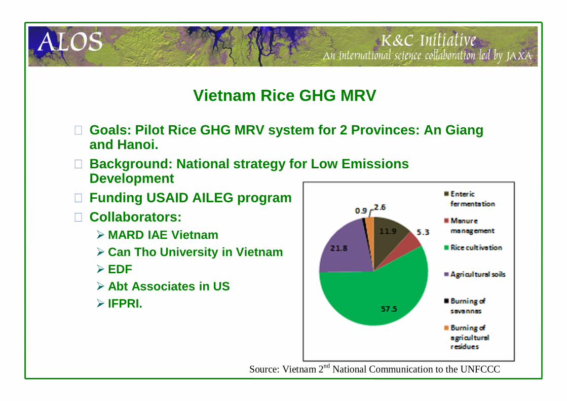
Vietnam Rice GHG MRV
Goals: Pilot Rice GHG MRV system for 2 Provinces: An Giang and Hanoi.Background: National strategy for Low Emissions DevelopmentFunding USAID AILEG programCollaborators: MARD IAE VietnamCan Tho University in Vietnam EDF Abt Associates in US IFPRI.
Source: Vietnam 2nd National Communication to the UNFCCC

Vietnam Rice GHG MRV
Components of Rice GHG MRVRice observatory (multi-sensor, including PALSAR)
Spatial information on extent, cropping cycles, development to drive DNDC
Field sites for measurement of rice GHG (CH4 and N2O): benchmark sites for baseline and mitigation assessment
GIS data server (data on soils, weather, topography) Field survey system on rice management and reference data for
validation of RS products (gps mobile device apps)Modeling system: DNDC model cal/val, includes uncertainty
system.WebGIS Decision Support Tool: data dissemination & visualization
Longer term implementation goal: scale up to national and regional scales

MRV System Framework(open source tools)
GeoNode - A spatial data infrastructure combining several technologies:
PostGIS - GeoSpatial Database Django - web framework for
building website and applications
GeoServer - Map rendering service
GeoNetwork – Metadata catalog GeoExt / OpenLayers / Leaflet
– Client javascript tools for visualization and analysis
– Full-screen web-GIS

MRV Pilot Provinces: An Giang and Hanoi
On-going field studies measuring GHG emissions (CH4 and N2O) with IAE, Can Tho Unversity and EDF VLCRPAssessing water management (MD, AWD)Residue management, biochar amendments Province wide survey of rice management practices 2-3 years of continuous GHG measurement
Outcomes:DNDC validation Stats on mgmtMitigation potentialDevelopment of uncertainty metricsusing MC framework

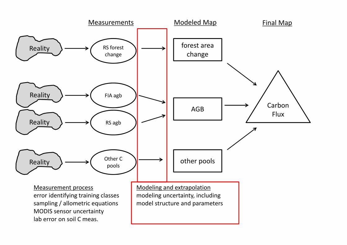
RS forest change
Measurements
FIA agb
RS agb
Other C pools
Modeled Map
forest area change
AGB
other pools
Carbon Flux
Final Map
Reality
Reality
Reality
Reality
Measurement processerror identifying training classessampling / allometric equationsMODIS sensor uncertaintylab error on soil C meas.
Modeling and extrapolationmodeling uncertainty, includingmodel structure and parameters

To propagate uncertainty, why MC framework and not quadrature?
• With Monte Carlo framework, we make fewer assumptions about data distributions
• M.C. allows us to preserve full data distributions (or pdfs) instead of estimating
• Link uncertainty from different sources• Downsides: data and computational intensive.300 million ha of forest x 1 ha pixels x 2 bytes ~ 600 MB / layern ~ 600 to 1000 layers ‐> 360 to 600 GB per data product

Rice GHG Protocol and Verification SystemCAR and ACR rice protocols based on DNDC model with detailed uncertainty quantificationCDM has DNDC based rice methodology Working with CA ARB on development of rice protocol (first compliance protocol). Transparency is key, need to keep project development and verification costs down for a successful ag offsets program (transaction costs must be low otherwise there will not be a market).Google project: Landsat, MODIS, PALSAR, other dataRS based rice extent, wet versus dry seeded system, winter
floodingReduce costs for project developers (eligibility) and validators
(100% coverage of fields with know uncertainties)Science Team meeting #18
JAXA TKSC/RESTEC HQ, Tokyo, November 7-9, 2012

Guyana DegradationCurrent agreement with Norway call for a 500 meter buffer, with 50% loss of carbon due to degradation.Focus: can RS be used to identify degradation, coupled with field surveys (Winrock, GFC)
Science Team meeting #18 JAXA TKSC/RESTEC HQ, Tokyo, November 7-9, 2012
RS Approaches Crown tracing Gap fraction unmixing VIs Will add PALSAR