jurnal geografi media pengembangan ilmu dan profesi
TRANSCRIPT

JURNAL GEOGRAFI VOLUME 14 NO. 2
Page 18
JURNAL GEOGRAFIMedia Pengembangan Ilmu dan
Profesi Kegeografianhttp://journal.unnes.ac.id/sju/index.php/ujet
LAND COVER CHANGES STUDY OF UPSTREAM COKROYASANWATERSHED ON MAXIMUM RETENTION
Hanafi, Fahrudin1; Aksin, Wahid 1
1Departement of Geography, Faculty Of Social Science UNNES
Info Artikel________________Keywords: LandcoverChanges, MaximumRetention, SCS
Abstract___________________________________________________________________This research takes location on upstream of Cokroyasan watershed, especiallyon Bandung weir catchment on Purworejo and Wonosobo District. Researchobjective is knowing maximum retention changes which represented byupstream Cokroyasan watershed curve number, related to land cover dataseries, soil type, rain, and peak flow (Qp). Research data quality controlledwith data survey and overland flow data observed. Thus the relationship ofparticular land cover and watershed responses in generating peak flow can bedetermined.The land covers determine using multispectral classification of Landsat whichdetailed with manual interpretation and Google Earth image. Samplingselection defines by stratified random sampling technique of the smallest unitof land form. Effective rain determines by consistency test of rainfall data,frequency analysis, survey data and curve number composites. The effectiverainfall generate using SCS model (Soil Conservation Service) whichinfluenced by design rainfall, soil type, texture, and land cover.The results showed that within 15 years, the land cover of Bandung weircatchment change significantly. Especially plantation was reduced by 56% or40.76 km2 while the settlements increased 412% to 64.20 Km2, and other landcover changes not significant (2% <). The analysis showed the peak flow in theupstream of Cokroyasan watershed changes on different return period.Although the different can only see on a more than two years return period.This means there was an increase of peak flow (discharge), as a result ofmaximum retention DAS dropped from 16- 18.29 m3/ s.The conclusion of this research indicate that land cover changes that occurwithin 15 years, influence on Curve Number changes, maximum retention,effective precipitation, and peak flow of upstream Cokroyasan watershed.
AbstrakKata kunci: PenutupLahan, RetensiMaksimum, SCS.
Penelitian ini dilaksanakan pada tahun 2016, dan berlokasi pada DASCokroyasan bagian hulu, atau pada hulu Bendung Bandung yang terletak padasebagian Kab. Purworejo dan Wonosobo. Tujuan dari penelitian ini adalahuntuk mengetahui perubahan retensi maksimum yang direpresentasikan dalambentuk Curve Number dari DAS Cokroyasan bagian hulu terhadap datatemporal tutupan lahan, jenis tanah, hujan, dan debit maksimum (Qp).Kualitas data penelitian dikontrol melalui data survey dan pengamatan debitterukur. Dengan demikian hubungan jenis-jenis penutupan lahan tertentu, danrespon DAS dalam menghasilkan debit aliran puncak dapat diketahui.Metode yang digunakan dalam menentukan jenis tutupan lahan adalah denganklasifikasi multispectral dan didetailkan dengan interpretasi manual pada citraLandsat dan citra google earth. Penentuan sampel menggunakan teknikstratified random sampling dengan ukuran kajian terkecil satuan lahan(Pendekatan Bentuk Lahan). Penentuan hujan efektif dengan menggunakananalisis kepanggahan data hujan, analisis frekuensi, hasil survey dan

JURNAL GEOGRAFI VOLUME 14 NO. 2
Page 19
penentuan CN komposit. Besar kecil hujan efektif ditentukan dengan modelSCS (Soil Conservation Service) yang dipengaruhi oleh besar hujan rancangan,jenis tanah, tekstur, dan jenis tutupan lahan.Hasil penelitian menunjukkan bahwa dalam kurun waktu 15 tahun daerahtangkapan Bendung Bandung mengalami perubahan penutup lahan secarasignifikan, khususnya perkebunan berkurang sebesar 56 % atau 40,76 Km2
sedangkan permukiman bertambah 412 % menjadi 64,20 Km2, dan jenispenutup lahan lain berubah secara tidak signifikan (2 %<). Analisismenunjukan adanya perubahan debit maksimum pada DAS Cokroyasan huluuntuk berbagai kala ulang, meskipun perubahan hanya bisa dilihat pada kalaulang lebih dari 2 tahun. Hal ini artinya terjadi peningkatan debit banjirmaksimum, akibat dari kemampuan penyimpanan air DAS turun 16-18,29m3/dt.Kesimpulan dari penelitian ini menunjukkan bahwa perubahan penutup lahanyang terjadi dalam kurun 15 tahun berpengaruh pada perubahan Curve Number,retensi maksimum, hujan efektif, dan banjir maksimal di DAS CokroyasanHulu.
Alamat korespondensi: [email protected]

JURNAL GEOGRAFI VOLUME 14 NO. 2
Page 20
1. INTRODUCTIONWater resources is a basic need such
as drink, bath, wash, and health porpuse(especially sanitation). At a broader level,water resource need is increasingly andrather complex following the developmentneeds, such as irrigation, river flushing,industrial, and energy. Water resource isvery useful on a proportionate but when theamount is less or excess, it will cause aserious problem. Watershed as a system isan objects/stream collection that becomesubsystems, including interaction within.Watershed is a land total and surface waterdelimited by a water boundary (topography)and in a way to contribute to river flow at acertain cross-section (Seyhan, 1990).
The amount of rain falls on awatershed affects the effectiverain/precipitation. Spatio-temporaldistribution of rainfall in the watershed isthe main input into the runoff configuration,further influenced by topography, slope,geology, and land cover.
Topography aspects, geology, andland cover became an indicator of watershedresponse to converse rainfall into evaporate,surface water/ run off, shallow water,groundwater, and evapotranspiration. Onthis process, land cover function impactdirectly on watershed ability of retainingwater, and turn it into runoff.
Cokroyasan watershed as one of the"conservation space" in Central Java, hasbeen the catchment areas and provide ofwater resources for the region within, suchas Purworejo, Magelang, and Wonosobodistrict
However, in line with populationgrowth and the upstream land cover change,the balance between groundwater and runoffbegan to fail. These condition triggeringgreater runoff and became a flood in thedownstream. Since 1998, on Cokroyasanwatershed almost all of the water needs canbe met during the rainy season. But lack ofwater in the dry season. (Triatmodjo, 1998).
The research objectives are : To determine the relation of certain types
of land cover, and the response to runoff.
To determine the maximum retention ofupstream Cokroyasan watershed,through the Curve Number compiled byland cover approach, rainfall andmeasured discharge as a control.
2. METHODSThe research limitation are :
Research location spatially focused onthe catchment of Bendung Bandung(Cokroyasan upstream). Associated withcalibration flood analysis using themeasured flow through AWLR
The land cover data length, rainfall anddischarge data series are on 1995-2015.
The time lapse is annual land cover,because land cover changes is inherentlyslow.
The type of soil, and the texture is nottemporarily generated because soildevelopment is very slow.
Number and samples locationselection using stratified random samplingmethod (Ebdon, 1985) with the smallest unituse is land form. Based on the amount ofland forms, and uniformity of land cover,the chosen sample to soil texture, soil type,and land cover identification take 25location.
Land cover data series obtained bymultispectral classification to distinguish thevariety of land cover through channelspectral response of object (Danoedoro,1996) and be detailed with manualinterpretation of Landsat and google earthimage.
Rainfall data station which used areJrakah stations (1 & 2), Kedungputri,Sawangan, Banyuurip, BPSDA Kutoarjoand BPSDA. While discharge data using aAWLR station of Bandung weir. Doublemass curve method are use to rainfall dataconsistency test. (Triatmodjo, 2009). The

JURNAL GEOGRAFI VOLUME 14 NO. 2
Page 21
results test showed quality data correlationof station is very high, with an average of0.99.
In calculating the maximum dischargerequires Pe (effective rainfall) or excessamount of rain which flow directly into theriver. SCS method use to calculate theeffective rainfall, which is calculated bycomparing the rain depth (P) and; S as themax potential retention groundwater largelydue to infiltration (mm) (Triatmodjo, 2009).
The maximum potential retention iscalculated by CN. Curve number is afunction of watershed characteristics. CNvalue for different types of land cover eitherimpermiable or not to the different types ofsoil texture. (US SCS 1972 Asdak, 2004)
The soil type divided into fourhydrologic soil group: Soil Type A: low runoff potential, high
infiltration. Soil texture is sand (deep)with silty and very small amount clay,also gravel.
Soil Type B: runoff potential is ratherlow, moderate infiltration rate. Mediumtexture (sandy soil).
Soil Type C: runoff potential is ratherhigh, slow infiltration rate if the land iscompletely wet. Medium to fine texture(clay and colloids).
Soil Type D: high runoff potential,infiltration is a very slow. texture clay(clay) with degree of soil shrinkage(swelling) high, land with permanenthigh level groundwater level, a layer ofclay with water-resistant material.(Triatmodjo, 2009).
Flood characteristics analysis werecalculated using synthetic hydrograph SCSmodel, with dimensionless hydrograph. SCSmodel chosen because it has a betteraccuracy than other models such as rationalmodel. (Murtiono, 2008) also provide landcover and soil texture approach.
Hydrograph characteristic comprisestime lag (TL), which is calculated from theCt: time coefficient; L: length of the river
(km). Then, Peak Time (Tp) is calculated byTr: Rain Duration (h) and cross-sectionalarea of the watershed. While Qp or peakdischarge hydrograph unit (m3/s); Rcalculated as precipitation unit (1 mm); Tp,A, and also Time Base (Tb). (Dantje 2011and the US Army, 2000).
3. RESULTS AND DISCUSSIONLandforms Interpretation show that in
the Cokroyasan watershed there are severalfluvial, volcanic and marine landform whichcan be described as follows: Alluvium : generally in alluvial form and
flood plains Coastal Deposit : a young beach shoals
form, old shoals beach, lagoon and swale Peniron Formation : alluvial plain form,
fault scarp, foothills slopes, middle slopeof denudational hill, natural levee, andriver terrace
Sentolo Formation: an isolated hill Volcanic Landform: upper slope of
denudation hill, foot slope of thevolcano.
Based on land form, soil sample takenin numerous position of Cokroyasanwatershed. The survey shows some of soiltypes found in the research area amongother associations gray alluvial, humic gleyassociations, associations latosol, reddishbrown, yellow red latosol complex,konsosiation alluvial hidromorf,konsosiation regosol brown and gray regosolkonsosiation. Soil type is related with soiltexture which can be transfor intohidrologyc coil type.
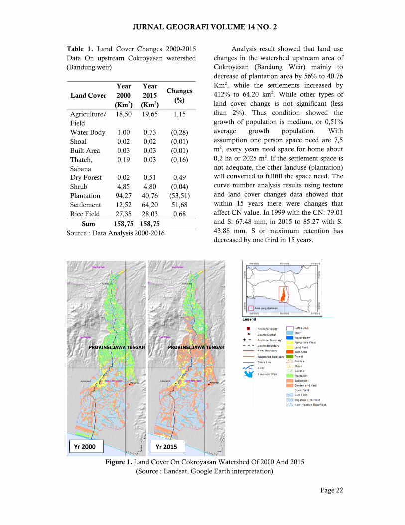
Field survey also take land coversample, which is used to acuration test ofmultispectral classification and visualinterpretation. By comparing the results of2000-2015 land cover data in the upstreamCokroyasan watershed (Bandung weir) canbe seen on following table.
JURNAL GEOGRAFI VOLUME 14 NO. 2
Page 22
Table 1. Land Cover Changes 2000-2015Data On upstream Cokroyasan watershed(Bandung weir)
Land CoverYear2000
(Km2)
Year2015
(Km2)
Changes(%)
Agriculture/Field
18,50 19,65 1,15
Water Body 1,00 0,73 (0,28)Shoal 0,02 0,02 (0,01)Built Area 0,03 0,03 (0,01)Thatch,Sabana
0,19 0,03 (0,16)
Dry Forest 0,02 0,51 0,49Shrub 4,85 4,80 (0,04)Plantation 94,27 40,76 (53,51)Settlement 12,52 64,20 51,68Rice Field 27,35 28,03 0,68
Sum 158,75 158,75Source : Data Analysis 2000-2016
Analysis result showed that land usechanges in the watershed upstream area ofCokroyasan (Bandung Weir) mainly todecrease of plantation area by 56% to 40.76Km2, while the settlements increased by412% to 64.20 km2. While other types ofland cover change is not significant (lessthan 2%). Thus condition showed thegrowth of population is medium, or 0,51%average growth population. Withassumption one person space need are 7,5m2, every years need space for home about0,2 ha or 2025 m2. If the settlement space isnot adequate, the other landuse (plantation)will converted to fullfill the space need. Thecurve number analysis results using textureand land cover changes data showed thatwithin 15 years there were changes thataffect CN value. In 1999 with the CN: 79.01and S: 67.48 mm, in 2015 to 85.27 with S:43.88 mm. S or maximum retention hasdecreased by one third in 15 years.
Figure 1. Land Cover On Cokroyasan Watershed Of 2000 And 2015(Source : Landsat, Google Earth interpretation)
Yr 2000 Yr 2015

JURNAL GEOGRAFI VOLUME 14 NO. 2
Page 23
In the hydrological analysis, to get aspecific return period flood forecast requiresan input of rain data, which further asdesign rainfall. This relates to the effectiverainfall or excess amount of rain which flowdirectly into the river. Design rainfall usedas a design discharge data which can beselected through the frequency analysis, butusually rain detailed parameters areunknown. Input of frequency analysis isdaily maximum rainfall on years ofcatchment area of Bandung weir.
Average depth of rainfall data madeusing the polygon method Thissen withmaximum rainfall years 1995-2015 datainput. Average rainfall maximum ofBandung weir catchment shown in the tablebelow.Table 2. Daily Maximum Rainfall Data ofUpstream Cokroyasan Watershed (BandungWeir)
Years
DailyMaximumRainfall
Data
Years
DailyMaximumRainfall
Data1997 91.0 2006 149.41998 115.9 2007 193.21999 123.0 2008 230.62000 263.4 2009 137.22001 101.3 2010 174.82002 103.1 2011 161.22003 167.6 2012 139.22004 223.7 2013 200.72005 188.5 2014 133.1
2015 209.3
Hydrological analysis study not onlyon event condition, but also consider a
frequency or periodical event. On statisticsis referred to as a probability. distributionprobability is a major patterns in thestatistical analysis design flood returnperiod, where each type of distribution havedifferent characteristics in the data loop.
The data used as input frequencyanalysis can be divided into partial durationseries is when data is less than 10 years, andthe annual maximum series when the data isat least 10 years is long enough. Somecontinuous probability analysis that can betested include the normal distribution, log-normal, Gumbel and log-Pearson III.(Triatmodjo, 2009)
The data used as frequency analysisinput can be divided into partial durationseries when data is less than 10 years, andthe annual maximum series when the data isat least 10 years. Continuous probabilityanalysis that can be tested are the normaldistribution, log-normal, Gumbel and log-Pearson III. (Triatmodjo, 2009) Followingtable describe design rainfall testdistribution.
Table 3. Results of Design Rainfall Distribution Test of weir Bandung (Cokroyasan upstream)
P(x >= Xm) T Karakteristik Debit (m3/dt) Menurut ProbabilitasnyaProbabilitas Kala-Ulang NORMAL LOG-NORMAL GUMBEL LOG-PEARSON III
XT KT XT KT XT KT XT KT
0,5 2, 159,617 0, 152,034 -0,151 151,361 -0,164 153,438 0,0280,2 5, 201,917 0,842 199,707 0,798 195,778 0,719 200,166 0,8490,1 10, 224,029 1,282 230,309 1,407 225,185 1,305 228,843 1,262
0,067 15, 235,062 1,501 247,291 1,744 241,777 1,635 244,341 1,464
0,04 25, 247,608 1,751 268,126 2,159 262,342 2,044 262,969 1,6910,02 50, 262,84 2,054 295,796 2,709 289,907 2,592 287,088 1,9620,01 100, 276,541 2,326 323,117 3,253 317,269 3,137 310,244 2,201
0,001 1000, 314,934 3,09 413,876 5,059 407,68 4,936 382,975 2,851
JURNAL GEOGRAFI VOLUME 14 NO. 2
Page 24
From the distribution analysis,calculate design rainfall on 2, 5, 10, 25, 50,100, and 1000 years. The distribution resultstest, the giving a different result. For the chisquare test results are to use normaldistribution, while according to KolgorovSmirnov test is best used Log Pearson IIIdistribution. Furthermore, to be used isKolgorov Smirnov test results, because quitewell at data distributing with n less than 50.(Justel, 1997).
Design rainfall used as a designdischarge selected through the frequencyanalysis, but usually rain detailedparameters are unknown. The parameters inquestion is IDF (Intensity, duration,frequency) and distribution patterns. Severalmethods can be used to obtain characteristichourly rainfall include: Tadashi Tanimoto,Mononobe, or ABM (Alternate BlockMethod). (Triatmodjo, 2009)
In this research, distribution of hourlyrainfall using alternating Block Methodbecause this model accommodates rainfalldata at successive intervals. Data input fromthe results of frequency analysis with theLog Pearson III distribution.
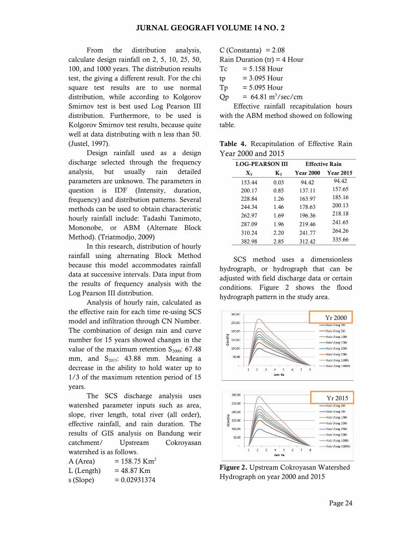
Analysis of hourly rain, calculated asthe effective rain for each time re-using SCSmodel and infiltration through CN Number.The combination of design rain and curvenumber for 15 years showed changes in thevalue of the maximum retention S2000: 67.48mm, and S2015: 43.88 mm. Meaning adecrease in the ability to hold water up to1/3 of the maximum retention period of 15years.
The SCS discharge analysis useswatershed parameter inputs such as area,slope, river length, total river (all order),effective rainfall, and rain duration. Theresults of GIS analysis on Bandung weircatchment/ Upstream Cokroyasanwatershed is as follows.A (Area) = 158.75 Km2
L (Length) = 48.87 Kms (Slope) = 0.02931374
C (Constanta) = 2.08Rain Duration (tr) = 4 HourTc = 5.158 Hourtp = 3.095 HourTp = 5.095 HourQp = 64.81 m3/sec/cm
Effective rainfall recapitulation hourswith the ABM method showed on followingtable.
Table 4. Recapitulation of Effective RainYear 2000 and 2015
LOG-PEARSON III Effective Rain
XT KT Year 2000 Year 2015
153.44 0.03 94.42 94.42
200.17 0.85 137.11 157.65
228.84 1.26 163.97 185.16
244.34 1.46 178.63 200.13
262.97 1.69 196.36 218.18
287.09 1.96 219.46 241.65
310.24 2.20 241.77 264.26
382.98 2.85 312.42 335.66
SCS method uses a dimensionlesshydrograph, or hydrograph that can beadjusted with field discharge data or certainconditions. Figure 2 shows the floodhydrograph pattern in the study area.
Figure 2. Upstream Cokroyasan WatershedHydrograph on year 2000 and 2015
Yr 2000
Yr 2015

JURNAL GEOGRAFI VOLUME 14 NO. 2
Page 25
To analyse the maximum flood depththat occured, then calculated by correctionfactor and area of watershed. The results ofthe SCS discharge model calculation withvarious time and year 2000-2015 shown thefollowing table.Table 5. Discharge Changes Analyse
The return period analysis showedthat there is a significant difference betweenpair years data, especially from 5 yearsreturn periode. For better comparison, thepair data must included baseflow,unfortunately this research cannot facilitatethe series data.
In the future, this research continuedwith spatial analysis which need rivertopographic addition data to obtainedflooded area. Flood prone on each timeperiode can be analyst using Geohec ras, orRas mapper and this analysis result as aninput.
4. CONCLUSIONS Land cover changes dominant are
plantation, 56% plantation area decreaseto 40,76 km2, settlement increased 412%to 64,20 Km2. While other land coverchanges not significant (2% <).
In 15 years there is a maximum retentionreduction. Year 2000, CN: 79.01 and S:67.48 mm, while on 2015 to 85.27 withS: 43.88 mm. Storing capability ofmaximum retention decrease about 1/3within 15 years.
Maximum (peak) discharge changesoccur on various time period, but canonly be seen on a of more than 2 yearstime period. Meaning that on maximumflood discharge, watershed storagecapability decreased 16-18,29 m3/s.
The land cover changes that occurinfluence Curve Number change,maximum retention, effective rain, andmaximum (peak) flood in UpperCokroyasan watershed.
5. REFERENCESAsdak, C., 2004. Hidrologi dan pengelolaan
daerah aliran sungai. Gadjah MadaUniversity Press. (Revisi)
Dantje, K. Natakusumah Dkk, 2011,“Prosedur Umum Perhitungan HidrografSatuan Sintetis dengan CaraITB dan Beberapa Contoh Penerapannya”,Jurnal Teknik Sipil ITB, Vol. 18 No. 3Desember 2011
Danoedoro, P., 1996. Pengolahan CitraDigital Teori dan Aplikasinya dalamBidang Penginderaan Jauh. FakultasGeografi, Universitas Gadjah Mada.Yogyakarta
Ebdon, David,1985, “Statistics In Geography-Second Edition”, Blackwell PublishersLtd
Justel, A., Peña, D. and Zamar, R., 1997. Amultivariate Kolmogorov-Smirnov test ofgoodness of fit. Statistics & ProbabilityLetters, 35(3), pp.251-259.
Murtiono, U.H., 2008. Kajian Model EstimasiVolume Limpasan Permukaan, DebitPuncak Aliran, Dan Erosi Tanah DenganModel Soil Conservation Service (Scs),Rasional Dan Modified Universal Soil LossEquation (MUSLE)(Studi Kasus Di DasKeduang, Wonogiri).Publikasi Ilmiah,UMS
Seyhan, E.F., 1990. Dasar-dasar Hidrologi,Penerjemah Ir. Sentot Subagyo, GadjahMada University Press, Yogyakarta.
Triatmodjo, B., 2009. Hidrologi terapan. BetaOffset, Yogyakarta.
ReturnPeriode(Years)
Qp (m3/s)Year. 2000
Qp (m3/s)Year. 2015
2 94.49 94.495 127.73 143.7310 148.65 165.1515 160.06 176.8025 173.87 190.8650 191.86 209.13
100 209.23 226.741000 264.23 282.52

JURNAL GEOGRAFI VOLUME 14 NO. 2
Page 26
Triatmodjo, B., 1998. Pengembangansumberdaya air di das BogowontoCokroyasan. In Forum Teknik (Vol. 22,No. 1998)
US Army Corps Of Engineering, 2000,“Hydrologic Modelling System HEC-HMSTechnical Reference Manual”, InstituteFor Water Resources, HydrologicEngineering Center.