journal of asian earth sciencesusers.clas.ufl.edu/kmin/publications/wang et al. (2016, jaes).pdf2....
TRANSCRIPT

Journal of Asian Earth Sciences 129 (2016) 243–253
Contents lists available at ScienceDirect
Journal of Asian Earth Sciences
journal homepage: www.elsevier .com/locate / jseaes
Full length Article
Quaternary channel-focused rapid incision in the Phung Chu-Arun Riverin Central Himalaya: Implications for a Quaternary capture event
http://dx.doi.org/10.1016/j.jseaes.2016.08.0171367-9120/� 2016 Elsevier Ltd. All rights reserved.
⇑ Corresponding author at: School of Earth Sciences, Center for Global Tectonics,China University of Geosciences, Wuhan, China.
E-mail address: [email protected] (A. Wang).
An Wang a,b,c,⇑, Kyoungwon Min c, Guocan Wang a,b
a School of Earth Sciences, Center for Global Tectonics, China University of Geosciences, Wuhan, Chinab State Key Laboratory of Geological Processes and Mineral Resources, China University of Geosciences, Wuhan, ChinacDepartment of Geological Sciences, University of Florida, Gainesville, FL, USA
a r t i c l e i n f o
Article history:Received 24 May 2016Received in revised form 18 August 2016Accepted 22 August 2016Available online 24 August 2016
Keywords:Phung Chu-Arun RiverCentral HimalayaChannel topographyApatite fission track datingApatite (U-Th)/He dating
a b s t r a c t
The Phung Chu-Arun River, one of the few major trans-Himalaya rivers, consists of a large drainage areacaptured in the northern slope of the Himalaya, and provides a key to understand tectonic, surface pro-cesses and their interplay in topographic development of the Himalaya. In this study, we carried out ther-mochronologic and topographic analysis along the Phung Chu-Arun River in Central Himalaya to revealits incision development. Apatites from a downstream section along its major tributary yield very youngfission track and (U-Th)/He ages of 0.8–1.5 Ma. These cooling ages, combined with previously reporteddata for higher elevations, reveal an abrupt change of the slope in the age-elevation plot suggesting anaccelerated channel incision initiated at between �1.5 and 2.5 Ma. The age-elevation relationship yieldsa high apparent exhumation rate (AER) of �2.6–3.8 mm/a during Quaternary, which is spatially focusedalong the mainstream of the Kharta-Chentang reaches and the associated nearby tributaries. Topographicanalysis suggests that this channel-focused incision acceleration was probably facilitated by a Quaternarycapture event in upper drainage of the palaeo Arun River. This capture event greatly enhanced the effec-tive discharge draining southward, causing an accelerated incision wave along the mainstream and tribu-taries of the palaeo Arun River. Furthermore, thrusting at physiographic transition zone is also required tosustain high channel gradient and the long-term rapid incision. Channel morphology presenting commonknick points in major tributaries suggests that the drainage basin in Ama Drime Range area likely remainin pre-steady state adjustment of this capture event.
� 2016 Elsevier Ltd. All rights reserved.
1. Introduction
It remains a mystery that how Himalaya sustains its high topo-graphic front while remain under a long-term, rapid surfacedenudation. A range of chronologic data (Herman et al., 2010;Huntington et al., 2006; Streule et al., 2012; Thiede et al., 2004;Whipp et al., 2007) and erosion data (Burbank et al., 2012; Galyand France-Lanord, 2001; Garzanti et al., 2007) indicate a rapidregional denudation at �1–2 mm/a in the Himalaya (Thiedeet al., 2005; Thiede and Ehlers, 2013; Wobus et al., 2003). Indeed,the Himalaya topographic front would have been completelyeroded within 3–5 Myr if there was no tectonic force.
One possible explanation for the high topography is that thefocused surface denudation has been tectonically compensatedby corresponding rapid rock uplift (Beaumont et al., 2001; Koons
et al., 2002; Zeitler et al., 2001). In this model, the rock uplift mightbe dynamically sustained though a positive feedback betweensurface process and thermally-weakened deep crustal rocks(Beaumont et al., 2001; Willett, 1999). For example, the Pliocene-Quaternary exhumation of the Ama Drime Range was suggestedto be enhanced by denudation of the Arun River gorge (Jessupet al., 2008). An alternative model suggests that the high topogra-phy has been maintained by a protective effect of surfaceprocesses, such as glacial damming developed at high altitudes,which prohibits rivers from headward incision (Korup andMontgomery, 2008; Owen, 2008). In this case, a northwarddecrease in bedrock denudation is required to maintain the highrelief across the Himalayan topographic front.
Across the Himalaya, only a limited number of rivers have suc-cessfully dissected through the orogenic divide, capturing signifi-cant drainage areas of the northern slope. These trans-Himalayarivers occur as a key to understanding the nature and developmentof geomorphic system of the Himalaya, where its erosional topog-raphy results from an interplay between tectonic input and
244 A. Wang et al. / Journal of Asian Earth Sciences 129 (2016) 243–253
erosional output (Beaumont et al., 2001; Hodges et al., 2004;Zeitler et al., 2001). However, the erosional developments of thesetrans-Himalaya rivers remain poorly understood. In this study, weperformed (U-Th)/He and fission track dating as well as topo-graphic analysis for the Phung Chu-Arun River to investigate itsincision development and its topographic implications for theHimalaya.
2. Geology and topography of the Phung Chu area
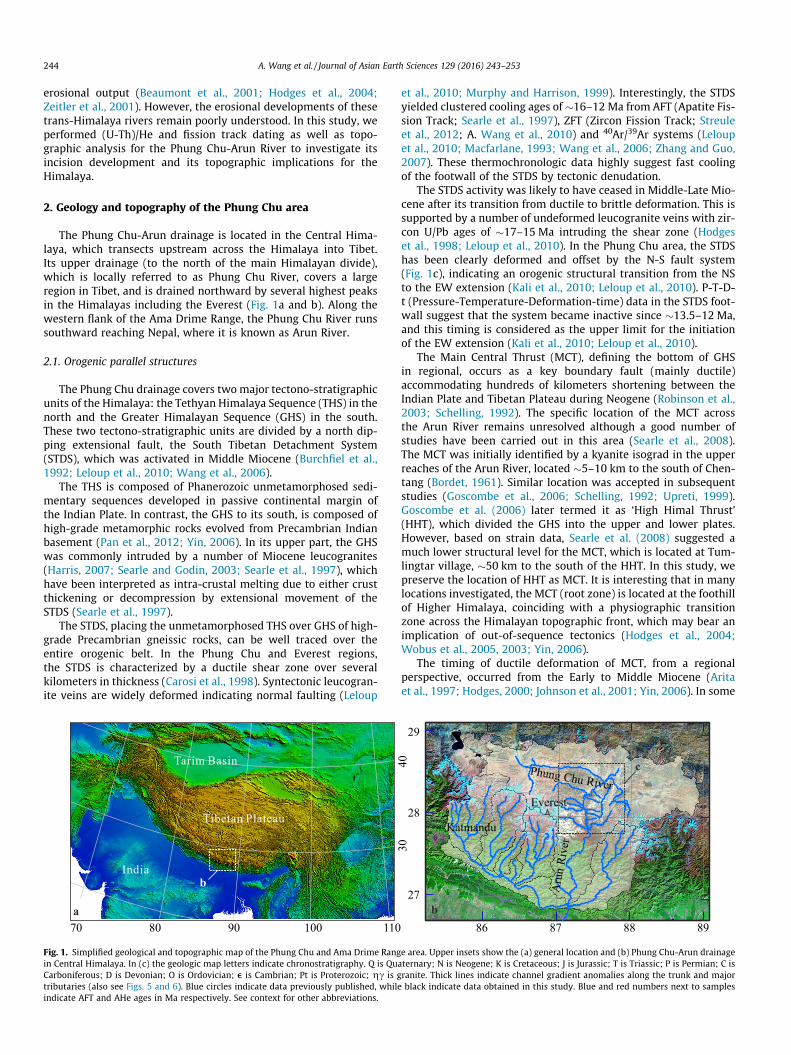
The Phung Chu-Arun drainage is located in the Central Hima-laya, which transects upstream across the Himalaya into Tibet.Its upper drainage (to the north of the main Himalayan divide),which is locally referred to as Phung Chu River, covers a largeregion in Tibet, and is drained northward by several highest peaksin the Himalayas including the Everest (Fig. 1a and b). Along thewestern flank of the Ama Drime Range, the Phung Chu River runssouthward reaching Nepal, where it is known as Arun River.
2.1. Orogenic parallel structures
The Phung Chu drainage covers two major tectono-stratigraphicunits of the Himalaya: the Tethyan Himalaya Sequence (THS) in thenorth and the Greater Himalayan Sequence (GHS) in the south.These two tectono-stratigraphic units are divided by a north dip-ping extensional fault, the South Tibetan Detachment System(STDS), which was activated in Middle Miocene (Burchfiel et al.,1992; Leloup et al., 2010; Wang et al., 2006).
The THS is composed of Phanerozoic unmetamorphosed sedi-mentary sequences developed in passive continental margin ofthe Indian Plate. In contrast, the GHS to its south, is composed ofhigh-grade metamorphic rocks evolved from Precambrian Indianbasement (Pan et al., 2012; Yin, 2006). In its upper part, the GHSwas commonly intruded by a number of Miocene leucogranites(Harris, 2007; Searle and Godin, 2003; Searle et al., 1997), whichhave been interpreted as intra-crustal melting due to either crustthickening or decompression by extensional movement of theSTDS (Searle et al., 1997).
The STDS, placing the unmetamorphosed THS over GHS of high-grade Precambrian gneissic rocks, can be well traced over theentire orogenic belt. In the Phung Chu and Everest regions,the STDS is characterized by a ductile shear zone over severalkilometers in thickness (Carosi et al., 1998). Syntectonic leucogran-ite veins are widely deformed indicating normal faulting (Leloup
Tarim Basin
India
Tibetan Plateau
a
b
1009070 80 110
Fig. 1. Simplified geological and topographic map of the Phung Chu and Ama Drime Rangin Central Himalaya. In (c) the geologic map letters indicate chronostratigraphy. Q is QuaCarboniferous; D is Devonian; O is Ordovician; e is Cambrian; Pt is Proterozoic; gc is gtributaries (also see Figs. 5 and 6). Blue circles indicate data previously published, whileindicate AFT and AHe ages in Ma respectively. See context for other abbreviations.
et al., 2010; Murphy and Harrison, 1999). Interestingly, the STDSyielded clustered cooling ages of �16–12 Ma from AFT (Apatite Fis-sion Track; Searle et al., 1997), ZFT (Zircon Fission Track; Streuleet al., 2012; A. Wang et al., 2010) and 40Ar/39Ar systems (Leloupet al., 2010; Macfarlane, 1993; Wang et al., 2006; Zhang and Guo,2007). These thermochronologic data highly suggest fast coolingof the footwall of the STDS by tectonic denudation.
The STDS activity was likely to have ceased in Middle-Late Mio-cene after its transition from ductile to brittle deformation. This issupported by a number of undeformed leucogranite veins with zir-con U/Pb ages of �17–15 Ma intruding the shear zone (Hodgeset al., 1998; Leloup et al., 2010). In the Phung Chu area, the STDShas been clearly deformed and offset by the N-S fault system(Fig. 1c), indicating an orogenic structural transition from the NSto the EW extension (Kali et al., 2010; Leloup et al., 2010). P-T-D-t (Pressure-Temperature-Deformation-time) data in the STDS foot-wall suggest that the system became inactive since �13.5–12 Ma,and this timing is considered as the upper limit for the initiationof the EW extension (Kali et al., 2010; Leloup et al., 2010).
The Main Central Thrust (MCT), defining the bottom of GHSin regional, occurs as a key boundary fault (mainly ductile)accommodating hundreds of kilometers shortening between theIndian Plate and Tibetan Plateau during Neogene (Robinson et al.,2003; Schelling, 1992). The specific location of the MCT acrossthe Arun River remains unresolved although a good number ofstudies have been carried out in this area (Searle et al., 2008).The MCT was initially identified by a kyanite isograd in the upperreaches of the Arun River, located �5–10 km to the south of Chen-tang (Bordet, 1961). Similar location was accepted in subsequentstudies (Goscombe et al., 2006; Schelling, 1992; Upreti, 1999).Goscombe et al. (2006) later termed it as ‘High Himal Thrust’(HHT), which divided the GHS into the upper and lower plates.However, based on strain data, Searle et al. (2008) suggested amuch lower structural level for the MCT, which is located at Tum-lingtar village, �50 km to the south of the HHT. In this study, wepreserve the location of HHT as MCT. It is interesting that in manylocations investigated, the MCT (root zone) is located at the foothillof Higher Himalaya, coinciding with a physiographic transitionzone across the Himalayan topographic front, which may bear animplication of out-of-sequence tectonics (Hodges et al., 2004;Wobus et al., 2005, 2003; Yin, 2006).
The timing of ductile deformation of MCT, from a regionalperspective, occurred from the Early to Middle Miocene (Aritaet al., 1997; Hodges, 2000; Johnson et al., 2001; Yin, 2006). In some
b
c4030
Everest
Katmandu
Phung Chu River
reviRnur
A27
28
29
86 87 88 89
e area. Upper insets show the (a) general location and (b) Phung Chu-Arun drainageternary; N is Neogene; K is Cretaceous; J is Jurassic; T is Triassic; P is Permian; C isranite. Thick lines indicate channel gradient anomalies along the trunk and majorblack indicate data obtained in this study. Blue and red numbers next to samples

Fig. 1 (continued)
A. Wang et al. / Journal of Asian Earth Sciences 129 (2016) 243–253 245
localities, a Late Miocene-Pliocene activation was proposed basedon chronologic data (Catlos et al., 2004; Harrison et al., 1997). Inaddition, brittle deformation has also been commonly identifiedwithin MCT zone (Searle et al., 2008; Searle and Godin, 2003).
2.2. Ama Drime Horst
In structure, the Ama Drime Range corresponds to an active NShorst (Figs. 1c and 2) accommodating the EW extension in Hima-laya (Jessup et al., 2008; Kali et al., 2010). Its western bounding
fault, the Kharta Fault (KF), developed a fault valley extending�60 km from Moguo at the northern tip of the Ama Drime Rangeto its southern at Kharta (Fig. 1c). Surface ruptures, which extendalong the foot of many giant triangular facets with heights of�1.6–2 km (Fig. 2c and d), widely offset Quaternary morainesand alluvial fans developed at foothill. In southern segment ofthe Kharta valley, the KF ruptured a second strand, showing anen echelon pattern of dextral step (Fig. 1c). This western strandextends SW into the Higher Himalaya and phases out at high alti-tudes, showing a southward attenuation in fault throw.

Yo Ri Gorge Kharta Valley
Kharta fault
a b
c d
Kharta FaultDinggye Fault
Moguo Valley
Fig. 2. Surface rupture, fault scarp of (a) Kharta fault and (b) Dinggye fault, which offset foothill Quaternary alluvial and glacial deposits. (c) A glacial valley in the Khartavalley, indicated by dashed curve, dissects in the triangular facet and hangs high above the current valley. Heights of these giant triangular facets are estimated to be �1.6–2 km. Note that topographic exposure of these giant triangular facets is not solely due to normal faulting, but requires rapid incision at the fault valley. (d) The Yo Ri gorge, ananomaly course, has been locally trapped in the uplifting footwall of Ama Drime Range, while both its upstream and downstream are in flat fault valley. Note that thetopographic dam between the upstream Moguo valley and the downstream Kharta valley is only �400 m.
246 A. Wang et al. / Journal of Asian Earth Sciences 129 (2016) 243–253
The eastern range-flanking active fault, Dinggye Fault (DF),extends straight in SSW and ruptures foothill Quaternary glacialdeposits (Figs. 1c and 2b). The surface rupture of DF dies out south-ward in Higher Himalaya at similar latitude as the KF.
Along both flanks of the Ama Drime Range, ductile shear zoneswere developed, in which S-C fabrics, grain tails and lineations arecommon, and suggest consistent ductile deformation of dip-slipnormal sense without apparent oblique slip components (Jessupet al., 2008; Kali et al., 2010; Langille et al., 2010). These ductileshear zones are crosscut by high-angle brittle deformation associ-ated with the KF and DF. The ductile and brittle deformations areconsidered as a coherent extensional structure developing thehorst structure at different crustal level (Jessup et al., 2008; Kaliet al., 2010; Kapp et al., 2008).
The NS normal faulting in the Ama Drime area was initiatedprior to �11 Ma, following the ductile deformation and rapid cool-ing between �17 and 12 Ma in the STDS (Leloup et al., 2010, 2009;Murphy and Harrison, 1999; Wang et al., 2010, 2006). There are lit-tle direct constraints on the magnitude of displacement of thesenormal faults. Assuming the STDS as a pre-deformational marker,horizontal offsets by the KF and the DF are �15 km and �35 km,respectively (Kali et al., 2010; Leloup et al., 2010), which indicatesan apparent less partition in extension along the KF.
2.3. Ama Drime Range topography
The horst structure of the NS-trending Ama Drime Range ischaracterized by a couple of normal faults, which appear conju-gate. The topography, in contrast, presents an asymmetrical pat-tern (Figs. 1c and 3), which implies an apparent contrast insurface erosion between the eastern flank and the western flank.In its western flank, EW glacial and fluvial valleys are relatively
longer and wider, and are almost evenly spaced. In contrast, mostvalleys in the eastern flank are short and narrow displaying anapparent weaker surface erosion (Fig. 1c). As a result, the westernflank of the Ama Drime Range is much wider (�22 km) than theeastern (<5 km).
The differential erosion is also manifested in the swath topo-graphic profile across the Ama Drime Range, which show apparentcontrasts in relief and minimum topography between the rangeflanks (Fig. 3). It is interesting that the maximum topographic line(Fig. 3), represented by EW ridges, presents an overall flat trendacross the majority of the range, implying an EW symmetricaltopographic pattern. This topographic flat trend is consistent withthe main divide of the Ama Drime Range striking NS. These topo-graphic highs share similar elevations of �6 ± 0.5 km. The overallconsistent elevations of these topographic highs and the symmet-rical pattern are compatible with a low-relief topography of thepalaeo Ama Drime Range (possibly analogous to the topographyin hinterland of Tibetan Plateau), which was dissected and destruc-ted by a young channel incision event, and transformed into thecurrent high relief topography.
3. Methods
3.1. Apatite Fission Track (AFT)
Apatite fission track dating was performed at the State Key Lab-oratory of Geological Processes and Mineral Resources in ChinaUniversity of Geosciences. Samples were prepared following thestandard external detector method (Hurford and Green, 1983).Apatite grains were mounted in epoxy and polished to makescratch-free surfaces, and the mount was etched in 5 N HNO3 atroom temperature for 21 s. Thermal neutron irradiation was car-

0 20 40 60 80
4
5
6
7
2
3
1
0
Alti
tude
(km
)
Phung Chu River
Divide of Ama Drime Range(Northern tip)
Dinggye faultKharta fault
Topographic reliefMinimum topography
Mean topography Main divideMaximum topography
Horizontal distance (km)
West East
Fig. 3. EW swath topographic profile across the Ama Drime Range. See Fig. 1 for location. Note that the maximum topographic line shows an approximate symmetricalpattern within the Ama Drime Range, where its central segment indicated by dark area fluctuates at around �6000 m. This is contrasted to the minimum topographic lineshowing asymmetrical pattern, which indicate that the western flank of the Ama Drime Range is favored by erosion. The relief between the maximum and the minimumtopography, an approximate proxy for local erosion magnitude, strengthens downstream and peaks at near the Kharta fault over 2 km. The NS-striking main divide of the AmaDrime Range indicated by dashed line is plotted for comparison.
A. Wang et al. / Journal of Asian Earth Sciences 129 (2016) 243–253 247
ried out at the China Institute of Atomic Energy with a nominalneutron fluence of 8 � 1015 cm�2, which was monitored by CN5standard glasses mounted at ends of each sample column. A zetavalue of 331.11 ± 11.52 was obtained using the Durango apatitestandard from multi-irradiated sample columns. Fission trackswere counted under a Zeiss Axioplan 2 microscope at a magnifica-tion of 1000.
3.2. Apatite (U-Th)/He (AHe)
Apatite (U-Th)/He dating was performed at University of Flor-ida. All apatite grains were examined under a binocular stereomi-croscope at a magnification of 160 to avoid samples withsignificant inclusions. Alpha ejection (FT) factor for each grainwas calculated based on measured linear dimensions (Farleyet al., 1996). Single or multiple apatite grains were wrapped in Pttubes, and heated using a diode laser under high vacuum. The
Age0 2 4 6
2.0
2.5
3.0
3.5
4.0
4.5
5.0
5.5
6.0
)mk(
edutitlA
0.63 ± 0.09
0.78 ± 0.08 km/Ma
P34
P35
P37
P40P42
MJAD1
MJAD10
MJAD13
MJAD14
MJAD28MJAD29
MJAD30MJAD36
2
~0.45 km/MaUnderneath ST
0.29 ± 0.06 km/MaR = 0.98
2.5 ± 1.6 km/MaR = 0.85
3.8 ± 1.6 km/MaR = 0.92
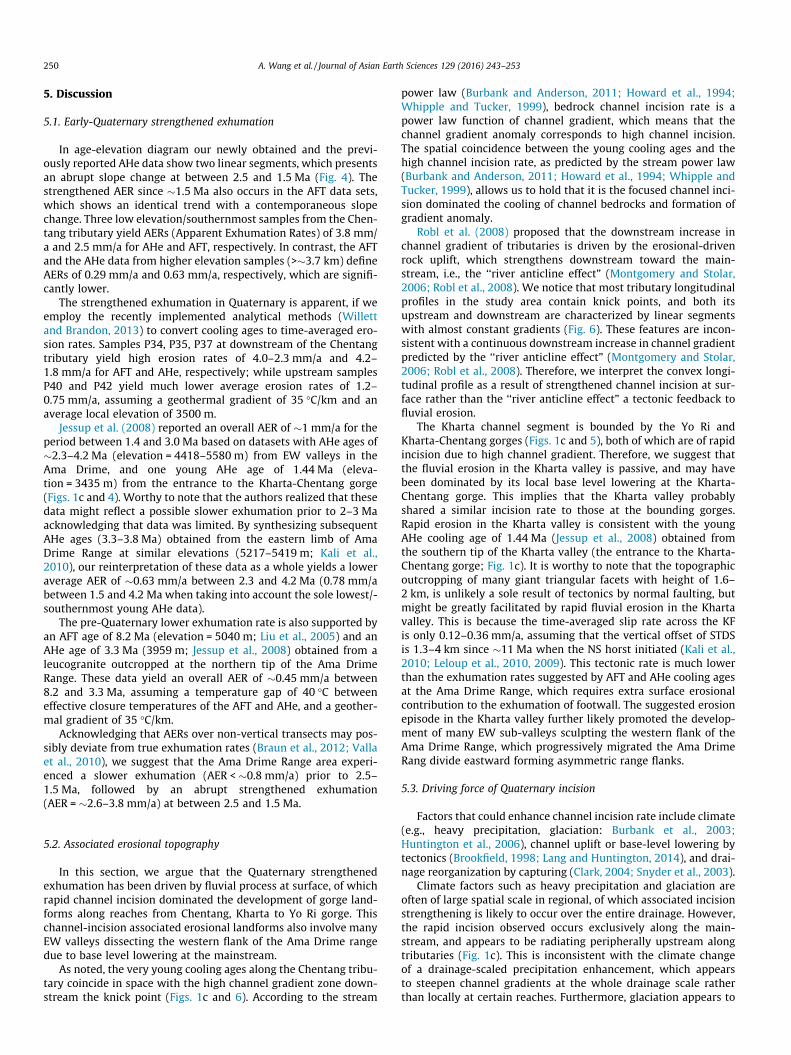
Fig. 4. Age-elevation plot of AFT and AHe data in the Phung Chu and Ama Drime Range aavoid possible misleading in AER analysis over large horizontal space. Solid and short da(2010). Note that exhumation of these sampled rocks is a combined result of two exhum
extracted gas was purified and spiked with 3He, followed by iso-topic measurements using a quadrupole mass spectrometer. Allthe samples were re-extracted at least once to ensure completedegassing. The degassed sample packets were spiked and dissolvedin 5% nitric acid at 120 �C overnight. The sample solutions’ U-Th-Sm isotopic compositions were measured using an Element2 ICP-MS.
3.3. Channel morphology processing
For topographic analysis, we used the data from ASTER GlobalDigital Elevation Model (2nd version released in 2011). These datahave an average precision of 2.4 arc-sec in horizontal and 15 m invertical, with substantial quality improvements compared to theprevious version (Tachikawa et al., 2011). Processing of channellongitudinal profiles was carried out using the software packageof Arc Hydro on the platform of ArcGIS.
AFT(this study)AHe (this study)AFT (Liu et al., 2005)AHe (Jessup et al., 2008)AHe (Kali et al., 2010)
AFT AER (this study)
AHe AER (this study)
(Ma)8 10 12 14
Din
ggye
Fau
lt
km/Ma
P44
3536-1580-1
DS
rea. AERs indicated by slope coefficients are interpreted based on local transects toshed lines are reinterpreted AERs for AHe data of Jessup et al. (2008) and Kali et al.ational scenarios. See context for details.

248 A. Wang et al. / Journal of Asian Earth Sciences 129 (2016) 243–253
4. Results
4.1. Thermochronology
4.1.1. Apatite Fission Track (AFT)Six samples collected on valley bottom along the Chentang
tributary yielded AFT ages between 1.1 and 13.6 Ma(Figs. 1c and 4; Table 1). These ages generally increaseupstream/northward, which represent a positive correlationwith elevation. The sample P44, which is located in the hang-ing wall of DF, yielded an exceptionally older age than others.This may be due to a lower erosion rate in hanging wall thanin footwall of normal fault. Therefore, the sample P44 isexcluded from the exhumation-rate calculation for the AmaDrime Range. It is worthy to note that all samples to itssouth are essentially unaffected by the normal faulting ofDF. (1) Surface rupture along the DF terminates to the northof the sample P42, and faulting-associated triangular facets dieout in concert. This indicates an overall southward attenuationin fault throw to the north of sample P42. (2) Field investiga-tion along the upper reaches of the Chentang tributary iden-tified no evidence of active faulting. (3) These young coolingages are much younger than the timing of KF and DF whichinitiated in the middle Miocene. Thus samples to the south ofP44 most likely preserve a complete and original exhumation
Table 1Samples information and AFT data resultsa.
Sample Latitude (�) Longitude (�) Ele (m) N qS/Ns q
P44 28.0553 87.6919 4654 14 3.43E5/397 4P42 27.9399 87.6408 4354 15 8.89E4/113 4P40 27.9032 87.5816 4165 15 2.18E4/24 1P37 27.9120 87.5275 3771 17 4.76E4/89 5P35 27.8757 87.4582 2933 21 6.96E4/102 1P34 27.8522 87.4473 2553 21 2.60E4/71 4
a N is number of grains analyzed. qs is spontaneous track density (cm�2); Ns is numbetracks; qd is track density on fluence monitor (cm�2); Nd is tracks counted on fluence mprobability. Ages (Ma) are determined using the Zeta method and calculated using the cwith 1r error. See context for other lab parameters and processes.
Table 2Apatite (U-Th-Sm)/He data results.
Sample Na FTb 4He (fmol) U (ppm) Th (ppm)
P44 1 0.84 61.48 46.0 1.61 0.87 121.77 57.6 1.81 0.87 187.70 77.0 4.3
P42 1 0.90 165.87 46.0 3.51 0.92 590.81 73.2 9.91 0.86 17.20 41.6 2.5
P40 1 0.87 11.41 9.8 4.61 0.84 3.22 12.4 3.01 0.82 59.06 28.1 26.8
P37 1 0.85 7.39 72.3 4.51 0.84 2.10 30.0 0.53 0.78 7.21 99.0 4.7
P35 1 0.82 3.99 86.4 1.52 0.78 5.38 103.1 11.03 0.76 7.54 98.4 3.8
P34 1 0.85 5.55 46.4 2.41 0.85 1.90 27.5 2.01 0.85 4.87 48.2 2.5
a Number of apatite grains analyzed in a single packet.b Alpha recoil correction factor calculated from linear dimensions of each grain.c Analytical errors added 4% relative error by alpha correction factor.d Standard deviation.e For samples P40 and P42, which are poor in age replication, minimum age packet is
information of Ama Drime Range rather than NS faulting ofthe KF and the DF.
4.1.2. Apatite (U-Th)/He (AHe)The AHe ages (Table 2) range from 0.8 to 13.2 Ma, and show a
similar positive correlation with elevation (Fig. 4). Samples P40and P42 yielded dispersed ages ranging from 2.8 to 26.0 Ma and4.9 to 11.2 Ma, respectively. This may be due to unidentifiedhigh-U-Th inclusions, U-Th zonation, or He implantation from out-side of the grains. Considering that these ages are older than theirAFT ages, and are apparently in odd with existing AHe ages athigher elevations in the Ama Drime range (Jessup et al., 2008;Kali et al., 2010), we precluded these ages from apparent exhuma-tion rate (AER) calculation. AHe ages of P34, P35 and P37 are inter-nally consistent within their uncertainties, and cope well withtheir AFT ages, suggesting that they can provide more reliable con-straints for documenting exhumational processes.
Sample P44 in the hanging wall of DF yields an average age of13.2 ± 0.7 Ma, which is slightly younger than its AFT age of13.6 ± 0.9 Ma. These ages are consistent with a number of MiddleMiocene cooling ages obtained at equivalent structural locationsat the top of GHS and below STDS in Central Himalaya(Macfarlane, 1993; Searle et al., 1997; Wang et al., 2010, 2006),which indicate syntectonic denudation by the STDS (Wang et al.,2010, 2006).
i/Ni qd/Nd U (ppm) P(v2) (%) Age Ma ± 1r
.77E6/5518 1.139E6/3776 50.9 ± 1.9 2.9 13.6 ± 0.9
.68E6/5952 1.123E6/3751 50.7 ± 1.8 70.6 3.5 ± 0.4
.59E6/1750 1.115E6/3738 17.3 ± 0.9 65.5 2.5 ± 0.6
.82E6/10,872 1.099E6/3713 64.5 ± 2.0 73.1 1.5 ± 0.2
.16E7/16,975 1.091E6/3701 129.2 ± 3.7 75.0 1.1 ± 0.1
.04E6/11,048 1.083E6/3688 45.4 ± 1.4 98.4 1.2 ± 0.2
r of spontaneous tracks; qi is induced track density (cm�2); Ni is number of inducedonitor. U ± 2r is the average uranium concentration (ppm). P(v2) is Chi-squared
omputer program and equations by Brandon (1992). All listed ages are pooled ages
Sm (ppm) Age (Ma) 1rc (Ma) Mean SDd
207.2 12.4 0.3 13.2 0.7265.7 13.8 0.3297.2 13.2 0.3237.4 9.7 0.3 4.9e 0.3258.3 11.2 0.3243.5 4.9 0.1
251.6 5.8 0.2 2.8e 0.2248.1 2.8 0.1136.1 26.0 0.7
300.2 1.2 0.03 1.1 0.1242.7 1.2 0.03442.9 1.0 0.03
214.4 0.8 0.02 1.0 0.2282.3 0.8 0.02263.9 1.2 0.03
224.7 0.8 0.02 0.8 0.1191.0 0.6 0.02240.7 0.8 0.02
given as reference. See context for details.

A. Wang et al. / Journal of Asian Earth Sciences 129 (2016) 243–253 249
4.2. Channel morphology
4.2.1. MainstreamThe longitudinal profile of the Phung Chu-Arun River main-
stream shows multiple channel segments with contrasting channelgradient anomalies (Fig. 5). The upstream-most high-gradientanomaly is located at the Yo Ri gorge, which connects upstreamthe Moguo valley and downstream the Kharta valley. Both theMoguo and the Kharta segments are characterized by flat braidedchannels with lower channel gradient. An unusual aspect of theYo Ri gorge, as has long been noticed, is its planar course, whichis locally trapped in erosional-resistant footwall of the KF forminga sharp bedrock relief over �1.5 km (Armijo et al., 1986; Kali et al.,2010; Wager, 1937). Note that the relief of the topographic barrierbetween the Moguo and the Kharta valley is only <400 m (Fig. 2d),which is much less than that in the Yo Ri gorge. Apparently, thispeculiar gorge course is inconsistent with a formation of upstreamprogression by headward incision, but may imply a capture event(Armijo et al., 1986).
The second high-gradient anomaly coincides with the Kharta-Chentang gorge, which covers a longitudinal length of �50 km(Figs. 1c and 5). Both its upstream (the Kharta fault valley) and
0 50 100 1500
1
2
3
4
5
Alti
tude
(km
)
Kharta-Chentang g
Kharta
Yo Ri gorge
Gadong
3.5%
Moguo valley Kharta valley
Chentang
Longitudinal
Fig. 5. Longitudinal profile of the Phung Chu-Arun River. Histogram indicates local chPercentage numbers indicate average channel gradients of specified zones. Note that the Kgradient, indicated by short dashed line. Dashed circle marks an apparent deficiency inchannel uplift, in which gradient anomaly forms in uplifting wall (modified from Brookzone predicts the location of fault.
Alti
tude
(km
)
Longitudinal D0
2.0
2.5
3.0
3.5
4.0
4.5
5.0
5.5
T7
T8T9
T10
8.1%
5.0%
3.6%
5.0%
5.1%
West
Phung Chu
1020304050
Fig. 6. Longitudinal profiles of major tributaries of the Phung Chu River. Circles mark inspecified segments of tributary, which are indicated by dashed lines. See Fig. 1c for loca
downstream reaches are characterized by lower channel gradient.It is interesting that the lower break in channel gradient, marking amajor physiographic transition in the Arun River, coincides withthe location of the MCT (Figs. 1c and 5). This coincidence simplyimplies an active tectonic significance if it is no accident.
4.2.2. TributariesAs is consistent with previous observations (Robl et al., 2008),
tributaries developed along the Phung Chu River show an interest-ing style in channel longitudinal profile. Most of these tributariesshow a convex pattern, which means that channel gradientsincrease downstream overall (Fig. 6). This is contrasted withgraded channel longitudinal profiles, which in order to maintaina constant erosion rate along longitudinal profile, channel gradi-ents attenuate downstream due to the effect of downstream accu-mulation in discharge (Brookfield, 1998; Burbank and Anderson,2011). Note that in first order, most of these tributaries consist oflinear segmented reaches. These reaches have almost constantchannel gradients, instead of a gradual change in gradient, whichindicate apparent existence of knick points. Segments downstreamknick points show high average gradients of 6.5–8.1%, which aresignificantly higher than those upstream of 1.4–5.0%.
200 250 3000
1
2
3
4
5
6
)%(
tnei
darg
lenn
a hC
orge
DEM data deficiency
1.8%
MCT
Distance (km)
Original channel
Fault
Adjustment to faulting
1
1 2
annel gradient, of which high-anomaly zones are indicated by shaded rectangle.harta-Chentang anomaly zone is characterized by an approximate constant channel
DEM data. Top-right inset illustrates the response of channel longitudinal profile tofield, 1998). Note that the downstream boundary of the channel gradient anomaly
istance (km)10 20 30 40 50
1.4%T2
T6
T1
7.0%7.9%
T3: 2.0%6.7%T4: 2.6%6.5%
T5: 9.8% 2.2%9.6% 5.0%
East
Ama Drime Range
River
60
terpreted knick points. Percentage numbers indicate average channel gradients fortions of labelled tributaries.
250 A. Wang et al. / Journal of Asian Earth Sciences 129 (2016) 243–253
5. Discussion
5.1. Early-Quaternary strengthened exhumation
In age-elevation diagram our newly obtained and the previ-ously reported AHe data show two linear segments, which presentsan abrupt slope change at between 2.5 and 1.5 Ma (Fig. 4). Thestrengthened AER since �1.5 Ma also occurs in the AFT data sets,which shows an identical trend with a contemporaneous slopechange. Three low elevation/southernmost samples from the Chen-tang tributary yield AERs (Apparent Exhumation Rates) of 3.8 mm/a and 2.5 mm/a for AHe and AFT, respectively. In contrast, the AFTand the AHe data from higher elevation samples (>�3.7 km) defineAERs of 0.29 mm/a and 0.63 mm/a, respectively, which are signifi-cantly lower.
The strengthened exhumation in Quaternary is apparent, if weemploy the recently implemented analytical methods (Willettand Brandon, 2013) to convert cooling ages to time-averaged ero-sion rates. Samples P34, P35, P37 at downstream of the Chentangtributary yield high erosion rates of 4.0–2.3 mm/a and 4.2–1.8 mm/a for AFT and AHe, respectively; while upstream samplesP40 and P42 yield much lower average erosion rates of 1.2–0.75 mm/a, assuming a geothermal gradient of 35 �C/km and anaverage local elevation of 3500 m.
Jessup et al. (2008) reported an overall AER of �1 mm/a for theperiod between 1.4 and 3.0 Ma based on datasets with AHe ages of�2.3–4.2 Ma (elevation = 4418–5580 m) from EW valleys in theAma Drime, and one young AHe age of 1.44 Ma (eleva-tion = 3435 m) from the entrance to the Kharta-Chentang gorge(Figs. 1c and 4). Worthy to note that the authors realized that thesedata might reflect a possible slower exhumation prior to 2–3 Maacknowledging that data was limited. By synthesizing subsequentAHe ages (3.3–3.8 Ma) obtained from the eastern limb of AmaDrime Range at similar elevations (5217–5419 m; Kali et al.,2010), our reinterpretation of these data as a whole yields a loweraverage AER of �0.63 mm/a between 2.3 and 4.2 Ma (0.78 mm/abetween 1.5 and 4.2 Ma when taking into account the sole lowest/-southernmost young AHe data).
The pre-Quaternary lower exhumation rate is also supported byan AFT age of 8.2 Ma (elevation = 5040 m; Liu et al., 2005) and anAHe age of 3.3 Ma (3959 m; Jessup et al., 2008) obtained from aleucogranite outcropped at the northern tip of the Ama DrimeRange. These data yield an overall AER of �0.45 mm/a between8.2 and 3.3 Ma, assuming a temperature gap of 40 �C betweeneffective closure temperatures of the AFT and AHe, and a geother-mal gradient of 35 �C/km.
Acknowledging that AERs over non-vertical transects may pos-sibly deviate from true exhumation rates (Braun et al., 2012; Vallaet al., 2010), we suggest that the Ama Drime Range area experi-enced a slower exhumation (AER < �0.8 mm/a) prior to 2.5–1.5 Ma, followed by an abrupt strengthened exhumation(AER = �2.6–3.8 mm/a) at between 2.5 and 1.5 Ma.
5.2. Associated erosional topography
In this section, we argue that the Quaternary strengthenedexhumation has been driven by fluvial process at surface, of whichrapid channel incision dominated the development of gorge land-forms along reaches from Chentang, Kharta to Yo Ri gorge. Thischannel-incision associated erosional landforms also involve manyEW valleys dissecting the western flank of the Ama Drime rangedue to base level lowering at the mainstream.
As noted, the very young cooling ages along the Chentang tribu-tary coincide in space with the high channel gradient zone down-stream the knick point (Figs. 1c and 6). According to the stream
power law (Burbank and Anderson, 2011; Howard et al., 1994;Whipple and Tucker, 1999), bedrock channel incision rate is apower law function of channel gradient, which means that thechannel gradient anomaly corresponds to high channel incision.The spatial coincidence between the young cooling ages and thehigh channel incision rate, as predicted by the stream power law(Burbank and Anderson, 2011; Howard et al., 1994; Whipple andTucker, 1999), allows us to hold that it is the focused channel inci-sion dominated the cooling of channel bedrocks and formation ofgradient anomaly.
Robl et al. (2008) proposed that the downstream increase inchannel gradient of tributaries is driven by the erosional-drivenrock uplift, which strengthens downstream toward the main-stream, i.e., the ‘‘river anticline effect” (Montgomery and Stolar,2006; Robl et al., 2008). We notice that most tributary longitudinalprofiles in the study area contain knick points, and both itsupstream and downstream are characterized by linear segmentswith almost constant gradients (Fig. 6). These features are incon-sistent with a continuous downstream increase in channel gradientpredicted by the ‘‘river anticline effect” (Montgomery and Stolar,2006; Robl et al., 2008). Therefore, we interpret the convex longi-tudinal profile as a result of strengthened channel incision at sur-face rather than the ‘‘river anticline effect” a tectonic feedback tofluvial erosion.
The Kharta channel segment is bounded by the Yo Ri andKharta-Chentang gorges (Figs. 1c and 5), both of which are of rapidincision due to high channel gradient. Therefore, we suggest thatthe fluvial erosion in the Kharta valley is passive, and may havebeen dominated by its local base level lowering at the Kharta-Chentang gorge. This implies that the Kharta valley probablyshared a similar incision rate to those at the bounding gorges.Rapid erosion in the Kharta valley is consistent with the youngAHe cooling age of 1.44 Ma (Jessup et al., 2008) obtained fromthe southern tip of the Kharta valley (the entrance to the Kharta-Chentang gorge; Fig. 1c). It is worthy to note that the topographicoutcropping of many giant triangular facets with height of 1.6–2 km, is unlikely a sole result of tectonics by normal faulting, butmight be greatly facilitated by rapid fluvial erosion in the Khartavalley. This is because the time-averaged slip rate across the KFis only 0.12–0.36 mm/a, assuming that the vertical offset of STDSis 1.3–4 km since �11 Ma when the NS horst initiated (Kali et al.,2010; Leloup et al., 2010, 2009). This tectonic rate is much lowerthan the exhumation rates suggested by AFT and AHe cooling agesat the Ama Drime Range, which requires extra surface erosionalcontribution to the exhumation of footwall. The suggested erosionepisode in the Kharta valley further likely promoted the develop-ment of many EW sub-valleys sculpting the western flank of theAma Drime Range, which progressively migrated the Ama DrimeRang divide eastward forming asymmetric range flanks.
5.3. Driving force of Quaternary incision
Factors that could enhance channel incision rate include climate(e.g., heavy precipitation, glaciation: Burbank et al., 2003;Huntington et al., 2006), channel uplift or base-level lowering bytectonics (Brookfield, 1998; Lang and Huntington, 2014), and drai-nage reorganization by capturing (Clark, 2004; Snyder et al., 2003).
Climate factors such as heavy precipitation and glaciation areoften of large spatial scale in regional, of which associated incisionstrengthening is likely to occur over the entire drainage. However,the rapid incision observed occurs exclusively along the main-stream, and appears to be radiating peripherally upstream alongtributaries (Fig. 1c). This is inconsistent with the climate changeof a drainage-scaled precipitation enhancement, which appearsto steepen channel gradients at the whole drainage scale ratherthan locally at certain reaches. Furthermore, glaciation appears to

A. Wang et al. / Journal of Asian Earth Sciences 129 (2016) 243–253 251
drive rapid erosion at high altitudes where glacial and periglaciallandforms prevail. The spatial coupling between the young coolingages and the high channel gradient suggests a fluvial dynamic forchannel incision instead of glaciation related erosion in high alti-tudes. Therefore, we conclude that climate change is not the dom-inating force for the observed incision rate change, although it is amost common factor enhancing surface erosion in Quaternary.
We propose that the Quaternary rapid incision was most likelydriven in potential by tectonic movements, and was facilitated by aQuaternary capture event. According to the channel gradientresponse to faulting (Fig. 5 inset), the high channel gradient zoneof the Kharta-Chentang gorge (Figs. 1c and 5) can be simplyexplained by an active thrust fault lying around the MCT, wherechannel gradient leaps greatly upstream. By southward thrustingalong this out-of-sequence fault, the rapid incision and high chan-nel gradient can be well tectonically maintained over long term.This suggestion is supported by a growing number of ther-mochronologic and topographic data, as well as field evidence,indicating active thrusting in the Central Himalaya, at the foothillof Higher Himalaya along strike coinciding the physiographic tran-sition zone (Harrison et al., 1997; Hodges, 2000; Hodges et al.,2001; Huntington et al., 2006; Wobus et al., 2005, 2003). Indeed,without such a tectonic compensation, the Himalaya topographicfront could not maintain its high relief and would have disap-peared within 2 Myr at a given incision rate of �2 mm/a.
We notice that the abrupt incision rate hike (between �1.5 and2.5 Ma) appears occurred long after the onset of the out-of-sequence thrusting in regional, which is dated as late Miocene-Pliocene inferred from thermochronologic data and modelingresults (Catlos et al., 2004; Harrison et al., 1997). If the timing ofout-of-sequence tectonics is correct, then an addition triggeringforce is required for the incision rate hike. Recognizing that thepeculiar course of the Yo Ri gorge is unlikely formed by a normalheadward incision progression, but might reflect a capture event(Armijo et al., 1986), we suggest that the Quaternary incisionwas greatly facilitated by a capture event, rather than solely drivenby tectonics of thrusting at the physiographic transition zone. Inthis capture event, large drainages previously draining the Tibetwas redirected to the Arun River, reaches at and below the Yo Rigorge subjected strengthened incision due to a significant increasein effective discharge and sediment load. This can be envisagedfrom the fact that the current drainage area upstream the Moguo(EW stream dominated) is 2.2 � 104 km2, which is 1.9 times ofits downstream (NS stream dominated). This suggestion is sup-ported by the 1.44-Ma young AHe age obtained at the southern-most/lowest of the Kharta valley, and is consistent with theerosional landforms developed along the reaches between Chen-tang and Yo Ri gorge, indicating recent rapid incision. Note thatit is possible that the NS-striking faulting at along the KF mighthave played some constructive roles in developing this captureevent.
In summary, thermochronologies, channel morphology and ero-sional landforms in the Ama Drime Range suggest that the PhungChu-Arun River experienced a strengthened channel incision epi-sode particularly along its mainstream since �1.5–2.5 Ma. ThisQuaternary channel-focused rapid incision is proposed as a com-bined result of channel uplift by tectonics and drainage reorganiza-tion by capture. In this case, the timing of the incision accelerationpoints to the capture event, rather than the initiation of the out-of-sequence thrusting in regional. We notice that such a young cap-ture event is not rare among major trans-Himalaya rivers. At pre-sent, several trans-Himalaya rivers have successfully dissectedthrough the main Himalaya divide into Neogene-Quaternary gra-bens previously belonging to Tibetan drainage. For example, tothe west of the Everest, the Gyirong basin with sequence lastingat least to 1.7 Ma is dissected by the Trishuli River (Wang et al.,
1996). Coincidentally, both the Zhada (Saylor et al., 2010, 2009)and the Thakkhola-Mustang basins (Adhikari and Wagreich,2011; Colchen, 1999) remained closed until Quaternary, when theywere finally incorporated into the Ganges drainage. These youngcapture events favor that the Himalaya topographic front repre-sents a dynamic result between active tectonics and surfacedenudation, and that the majority drainages of trans-Himalaya riv-ers remain in topographic pre-steady state adjustment.
6. Conclusions
The Phung Chu-Arun River, one of the major trans-Himalayarivers, consists of a large drainage captured from the northernslope of the Himalaya. Apatite fission track and (U-Th)/He dataprovide cooling and exhumation histories during Pliocene-Quaternary, and suggest an abrupt increase of fluvial incision rateoccurred at �1.5–2.5 Ma with a four-fold increase in apparentexhumation rate.
Topographic analysis suggests that the Quaternary rapid inci-sion is spatially focused along channels in reaches downstreamthe Yo Ri gorge. Cooling ages, channel morphology and associatederosional landforms favor that this Quaternary rapid incision mostlikely reflects a Quaternary capture event at the Yo Ri gorge. Sus-tained out-of-sequence thrusting at the physiographic transitionzone (near the MCT) is required to serve as a long-term potentialforce maintaining high channel gradient and rapid incision acrossthe Higher Himalaya.
Acknowledgements
This work was supported by the China Geological Survey Insti-tute [grant numbers 1212011121261, 1212010610103]; and theNatural Science Foundation of China [grant numbers 40902060,41202144]. We express special appreciation to Yanyuan Liu, Jiang-wei Wei, Pengfei Jiang and Wenyuan Zhang who provided assis-tance in field investigation and in apatite (U-Th)/He analysis. Weare also grateful to two anonymous reviewers whose suggestionswell improved this paper.
References
Adhikari, B.R., Wagreich, M., 2011. Provenance evolution of collapse graben fill inthe Himalaya—the Miocene to Quaternary Thakkhola-Mustang Graben (Nepal).Sed. Geol. 233, 1–14. http://dx.doi.org/10.1016/j.sedgeo.2010.09.021.
Arita, K., Dallmeyer, R.D., Takasu, A., 1997. Tectonothermal evolution of the LesserHimalaya, Nepal: constraints from 40Ar/39Ar ages from the Kathmandu Nappe.Island Arc 6, 372–385.
Armijo, R., Tapponnier, P., Mercier, J.L., Han, T.L., 1986. Quaternary extension insouthern Tibet: field observations and tectonic implications. J. Geophys. Res. –Solid Earth 91, 13803–13872. http://dx.doi.org/10.1029/JB091iB14p13803.
Beaumont, C., Jamieson, R.A., Nguyen, M.H., Lee, B., 2001. Himalayan tectonicsexplained by extrusion of a low-viscosity crustal channel coupled to focusedsurface denudation. Nature 414, 738–742.
Bordet, P., 1961. Recherches géologiques dans l’Himalaya du Népal, région duMakalu, expéditions françaises a l’Himalaya 1954–1955. Centre National de laRecherche Scientifique (C.N.R.S.), Paris, p. 275.
Brandon, M.T., 1992. Decomposition of fission-track grain-age distributions. Am. J.Sci. 292, 535–564.
Braun, J., van der Beek, P., Valla, P., Robert, X., Herman, F., Glotzbach, C., Pedersen, V.,Perry, C., Simon-Labric, T., Prigent, C., 2012. Quantifying rates of landscapeevolution and tectonic processes by thermochronology and numerical modelingof crustal heat transport using PECUBE. Tectonophysics 524–525, 1–28. http://dx.doi.org/10.1016/j.tecto.2011.12.035.
Brookfield, M.E., 1998. The evolution of the great river systems of southern Asiaduring the Cenozoic India-Asia collision: rivers draining southwards.Geomorphology 22, 285–312.
Burbank, D.W., Anderson, R.S., 2011. Tectonic Geomorphology. John Wiley & Sons,Ltd., Chichester, UK, pp. 285–289. http://dx.doi.org/10.1002/9781444345063.
Burbank, D.W., Blythe, A.E., Putkonen, J., Pratt-Sitaula, B., Gabet, E.J., Oskin, M.,Barros, A., Ojha, T.P., 2003. Decoupling of erosion and precipitation in theHimalayas. Nature 426, 652–655. http://dx.doi.org/10.1038/nature02187.

252 A. Wang et al. / Journal of Asian Earth Sciences 129 (2016) 243–253
Burbank, D.W., Bookhagen, B., Gabet, E.J., Putkonen, J., 2012. Modern climate anderosion in the Himalaya. C.R. Geosci. 344, 610–626. http://dx.doi.org/10.1016/j.crte.2012.10.010.
Burchfiel, B.C., Chen, Z., Hodges, K.V., Liu, Y., Royden, L.H., Deng, C., Xu, J., 1992. TheSouth Tibetan Detachment System, Himalayan Orogen: extension contem-poraneous with and parallel to shortening in a collisional mountain belt. Spec.Pap. – Geol. Soc. Am. 269, 1–41. http://dx.doi.org/10.1130/SPE269-p1.
Carosi, R., Lombardo, B., Molli, G., Musumeci, G., Pertusati, P.C., 1998. The SouthTibetan detachment system in the Rongbuk valley, Everest region. Deformationfeatures and geological implications. J. Asian Earth Sci. 16, 299–311.
Catlos, E.J., Dubey, C.S., Harrison, T.M., Edwards, M.A., 2004. Late Miocenemovement within the Himalayan Main Central Thrust shear zone, Sikkim,north-east India. J. Metamorph. Geol. 22, 207–226. http://dx.doi.org/10.1111/j.1525-1314.2004.00509.x.
Clark, M.K., 2004. Surface uplift, tectonics, and erosion of eastern Tibet from large-scale drainage patterns. Tectonics 23, TC1006. http://dx.doi.org/10.1029/2002TC001402.
Colchen, M., 1999. The Thakkhola-Mustang graben in Nepal and the late Cenozoicextension in the Higher Himalayas. J. Asian Earth Sci. 17, 683–702.
Farley, K.A., Wolf, R.A., Silver, L.T., 1996. The effects of long alpha-stopping distanceson (U-Th)/He ages. Geochim. Cosmochim. Acta 60, 4223–4229. http://dx.doi.org/10.1016/S0016-7037(96)00193-7.
Galy, A., France-Lanord, C., 2001. Higher erosion rates in the Himalaya: geochemicalconstraints on riverine fluxes. Geology 29, 23–26.
Garzanti, E., Vezzoli, G., Andò, S., Lavé, J., Attal, M., France-Lanord, C., DeCelles, P.,2007. Quantifying sand provenance and erosion (Marsyandi River, NepalHimalaya). Earth Planet. Sci. Lett. 258, 500–515. http://dx.doi.org/10.1016/j.epsl.2007.04.010.
Goscombe, B., Gray, D., Hand, M., 2006. Crustal architecture of the Himalayanmetamorphic front in eastern Nepal. Gondwana Res. 10, 232–255. http://dx.doi.org/10.1016/j.gr.2006.05.003.
Harris, N., 2007. Channel flow and the Himalayan-Tibetan orogen: a critical review.J. Geol. Soc. 164, 511–523.
Harrison, T.M., Ryerson, F.J., LeFort, P., Yin, A., Lovera, O.M., Catlos, E.J., 1997. A LateMiocene-Pliocene origin for the Central Himalayan inverted metamorphism.Earth Planet. Sci. Lett. 146, E1–E7.
Herman, F., Copeland, P., Avouac, J.-P., Bollinger, L., Mahéo, G., Le Fort, P., Rai, S.,Foster, D., Pêcher, A., Stüwe, K., Henry, P., 2010. Exhumation, crustaldeformation, and thermal structure of the Nepal Himalaya derived from theinversion of thermochronological and thermobarometric data and modeling ofthe topography. J. Geophys. Res. 115, B06407. http://dx.doi.org/10.1029/2008JB006126.
Hodges, K., Bowring, S., Davidek, K., Hawkins, D., Krol, M., 1998. Evidence for rapiddisplacement on Himalayan normal faults and the importance of tectonicdenudation in the evolution of mountain ranges. Geology 26, 483–486.
Hodges, K.V., 2000. Tectonics of the Himalaya and southern Tibet from twoperspectives. Geol. Soc. Am. Bull. 112, 324–350.
Hodges, K.V., Hurtado, J.M., Whipple, K.X., 2001. Southward extrusion of Tibetancrust and its effect on Himalayan tectonics. Tectonics 20, 799–809.
Hodges, K.V., Wobus, C., Ruhl, K., Schildgen, T., Whipple, K., 2004. Quaternarydeformation, river steepening, and heavy precipitation at the front of the HigherHimalayan ranges. Earth Planet. Sci. Lett. 220, 379–389. http://dx.doi.org/10.1016/S0012-821X(04)00063-9.
Howard, A.D., Dietrich, W.E., Seidl, M.A., 1994. Modeling fluvial erosion on regionalto continental scales. J. Geophys. Res. – Solid Earth 99, 13971–13986.
Huntington, K.W., Blythe, A.E., Hodges, K.V., 2006. Climate change and Late Plioceneacceleration of erosion in the Himalaya. Earth Planet. Sci. Lett. 252, 107–118.http://dx.doi.org/10.1016/j.epsl.2006.09.031.
Hurford, A.J., Green, P.F., 1983. The zeta age calibration of fission-track dating.Chem. Geol. 41, 285–317.
Jessup, M.J., Newell, D.L., Cottle, J.M., Berger, A.L., Spotila, J.A., 2008. Orogen-parallelextension and exhumation enhanced by denudation in the trans-HimalayanArun River Gorge, Ama Drime Massif, Tibet-Nepal. Geology 36, 587. http://dx.doi.org/10.1130/G24722A.1.
Johnson, M.R.W., Oliver, G., Parrish, R.R., Johnson, S.P., 2001. Synthrustingmetamorphism, cooling, and erosion of the Himalayan Kathmandu Complex,Nepal. Tectonics 20, 394–415.
Kali, E., Leloup, P.H., Arnaud, N., Mahéo, G., Liu, D., Boutonnet, E., Van der Woerd, J.,Liu, X., Liu-Zeng, J., Li, H., 2010. Exhumation history of the deepest centralHimalayan rocks, Ama Drime range: key pressure-temperature-deformation-time constraints on orogenic models. Tectonics 29, TC2014. http://dx.doi.org/10.1029/2009TC002551.
Kapp, P., Taylor, M., Stockli, D., Ding, L., 2008. Development of active low-anglenormal fault systems during orogenic collapse: insight from Tibet. Geology 36,7–10. http://dx.doi.org/10.1130/G24054A.1.
Koons, P.O., Zeitler, P.K., Chamberlain, C.P., Craw, D., Meltzer, A.S., 2002. Mechanicallinks between erosion and metamorphism in Nanga Parbat, Pakistan Himalaya.Am. J. Sci. 302, 749–773.
Korup, O., Montgomery, D.R., 2008. Tibetan plateau river incision inhibited byglacial stabilization of the Tsangpo gorge. Nature 455, 786–789. http://dx.doi.org/10.1038/nature07322.
Lang, K.A., Huntington, K.W., 2014. Antecedence of the Yarlung-Siang-BrahmaputraRiver, eastern Himalaya. Earth Planet. Sci. Lett. 397, 145–158. http://dx.doi.org/10.1016/j.epsl.2014.04.026.
Langille, J.M., Jessup, M.J., Cottle, J.M., Newell, D., Seward, G., 2010. Kinematicevolution of the Ama Drime detachment: insights into orogen-parallel
extension and exhumation of the Ama Drime Massif, Tibet-Nepal. J. Struct.Geol. 32, 900–919. http://dx.doi.org/10.1016/j.jsg.2010.04.005.
Leloup, P.H., Kali, E., Arnaud, N., Mahéo, G., Boutonnet, E., Liu, X., Liu, D., Li, H., Liu-Zeng, J., 2009. Miocene (�12 Ma) transition from E-W to N-S syn-convergencenormal faulting in the central Himalayas (Ama Drime range). EGU Gen.Assembly 2009 (11), 9690.
Leloup, P.H., Mahéo, G., Arnaud, N., Kali, E., Boutonnet, E., Liu, D., Liu, X., Li, H., 2010.The South Tibet detachment shear zone in the Dinggye area time constraints onextrusion models of the Himalayas. Earth Planet. Sci. Lett. 292, 1–16. http://dx.doi.org/10.1016/j.epsl.2009.12.035.
Liu, D., Li, D., Yang, W., Wang, X., Zhang, J., 2005. Evidence from fission track ages forthe tectonic uplift of the Himalayan orogen during late Cenozoic. Earth Sci.-J.China Univ. Geosci. 30, 147–152 (In Chinese with English Abstract).
Macfarlane, A.M., 1993. Chronology of tectonic events in the crystalline core of theHimalaya, Langtang National Park, central Nepal. Tectonics 12, 1004–1025.http://dx.doi.org/10.1029/93TC00916.
Montgomery, D.R., Stolar, D.B., 2006. Reconsidering Himalayan river anticlines.Geomorphology 82, 4–15. http://dx.doi.org/10.1016/j.geomorph.2005.08.021.
Murphy, M.A., Harrison, T.M., 1999. Relationship between leucogranites and theQomolangma detachment in the Rongbuk Valley, south Tibet. Geology 27, 831–834.
Owen, L.A., 2008. Geomorphology: how Tibet might keep its edge. Nature 455, 748–749.
Pan, G., Wang, L., Li, R., Yuan, S., Ji, W., Yin, F., Zhang, W., Wang, B., 2012. Tectonicevolution of the Qinghai-Tibet Plateau. J. Asian Earth Sci. 53, 3–14. http://dx.doi.org/10.1016/j.jseaes.2011.12.018.
Robinson, D.M., DeCelles, P.G., Garzione, C.N., Pearson, O.N., Harrison, T.M., Catlos, E.J., 2003. Kinematic model for the Main Central thrust in Nepal. Geology 31, 359–362.
Robl, J., Stüwe, K., Hergarten, S., 2008. Channel profiles around Himalayan riveranticlines: constraints on their formation from digital elevation model analysis.Tectonics 27, TC3010. http://dx.doi.org/10.1029/2007TC002215.
Saylor, J., DeCelles, P., Gehrels, G., Murphy, M., Zhang, R., Kapp, P., 2010. Basinformation in the High Himalaya by arc-parallel extension and tectonicdamming: Zhada basin, southwestern Tibet. Tectonics 29, TC1004. http://dx.doi.org/10.1029/2008TC002390.
Saylor, J.E., Quade, J., Dettman, D.L., DeCelles, P.G., Kapp, P.A., Ding, L., 2009. The lateMiocene through present paleoelevation history of southwestern Tibet. Am. J.Sci. 309, 1–42. http://dx.doi.org/10.2475/01.2009.01.
Schelling, D., 1992. The tectonostratigraphy and structure of the eastern NepalHimalaya. Tectonics 11, 925–943.
Searle, M.P., Godin, L., 2003. The South Tibetan detachment and the ManasluLeucogranite: a structural reinterpretation and restoration of the Annapurna-Manaslu Himalaya, Nepal. J. Geol. 111, 505–523.
Searle, M.P., Law, R.D., Godin, L., Larson, K.P., Streule, M.J., Cottle, J.M., Jessup, M.J.,2008. Defining the Himalayan main central thrust in Nepal. J. Geol. Soc. 165,523–534.
Searle, M.P., Parrish, R.R., Hodges, K.V., Hurford, A., Ayres, M.W., Whitehouse, M.J.,1997. Shisha Pangma leucogranite, south Tibetan Himalaya: field relations,geochemistry, age, origin, and emplacement. J. Geol. 105, 295–318.
Snyder, N.P., Whipple, K.X., Tucker, G.E., Merritts, D.J., 2003. Channel response totectonic forcing: field analysis of stream morphology and hydrology in theMendocino triple junction region, northern California. Geomorphology 53, 97–127. http://dx.doi.org/10.1016/S0169-555X(02)00349-5.
Streule, M.J., Carter, A., Searle, M.P., Cottle, J.M., 2012. Constraints on brittle fieldexhumation of the Everest-Makalu section of the Greater Himalayan sequence:implications for models of crustal flow. Tectonics 31, TC3010. http://dx.doi.org/10.1029/2011TC003062.
Tachikawa, T., Hato, M., Kaku, M., Iwasaki, A., 2011. Characteristics of ASTER GDEMversion 2. In: Geoscience and Remote Sensing Symposium, pp. 3657–3660.http://dx.doi.org/10.1109/IGARSS.2011.6050017.
Thiede, R.C., Arrowsmith, J.R., Bookhagen, B., McWilliams, M.O., Sobel, E.R., Strecker,M.R., 2005. From tectonically to erosionally controlled development of theHimalayan orogen. Geology 33, 689. http://dx.doi.org/10.1130/G21483.1.
Thiede, R.C., Bookhagen, B., Arrowsmith, J.R., Sobel, E.R., Strecker, M.R., 2004.Climatic control on rapid exhumation along the Southern Himalayan Front.Earth Planet. Sci. Lett. 222, 791–806. http://dx.doi.org/10.1016/j.epsl.2004.03.015.
Thiede, R.C., Ehlers, T.A., 2013. Large spatial and temporal variations in Himalayandenudation. Earth Planet. Sci. Lett. 371–372, 278–293. http://dx.doi.org/10.1016/j.epsl.2013.03.004.
Upreti, B.N., 1999. An overview of the stratigraphy and tectonics of the NepalHimalaya. J. Asian Earth Sci. 17, 577–606.
Valla, P.G., Herman, F., van der Beek, P.A., Braun, J., 2010. Inversion ofthermochronological age-elevation profiles to extract independent estimatesof denudation and relief history – I: theory and conceptual model. Earth Planet.Sci. Lett. 295, 511–522. http://dx.doi.org/10.1016/j.epsl.2010.04.033.
Wager, L.R., 1937. The Arun River drainage pattern and the rise of the Himalaya.Geogr. J. 89, 239. http://dx.doi.org/10.2307/1785796.
Wang, A., Garver, J.I., Wang, G.-C., Smith, J.A., Zhang, K., 2010. Episodic exhumationof the Greater Himalayan Sequence since the Miocene constrained by fissiontrack thermochronology in Nyalam, Central Himalaya. Tectonophysics 495,315–323. http://dx.doi.org/10.1016/j.tecto.2010.09.037.
Wang, F., Li, S., Shen, X., Zhang, J., Yan, G., 1996. Formation, evolution andenvironmental changes of the Gyirong Basin and uplift of the Himalaya. Sci.China (Ser. D) 39, 401–409.

A. Wang et al. / Journal of Asian Earth Sciences 129 (2016) 243–253 253
Wang, Y., Li, Q., Qu, G., 2006. 40Ar/39Ar thermochronological constraints on thecooling and exhumation history of the South Tibetan Detachment System,Nyalam area, southern Tibet. Geol. Soc. Lond. Spec. Publ. 268, 327–354. http://dx.doi.org/10.1144/GSL.SP.2006.268.01.16.
Whipp Jr., D.M., Ehlers, T.A., Blythe, A.E., Huntington, K.W., Hodges, K.V., Burbank, D.W., 2007. Plio-Quaternary exhumation history of the central NepaleseHimalaya: 2. Thermokinematic and thermochronometer age predictionmodel. Tectonics 26, TC3003. http://dx.doi.org/10.1029/2006TC001991.
Whipple, K.X., Tucker, G.E., 1999. Dynamics of the stream-power river incisionmodel: implications for height limits of mountain ranges, landscape responsetimescales, and research needs. J. Geophys. Res. 104. 17661–17–674.
Willett, S.D., 1999. Orogeny and orography: the effects of erosion on the structure ofmountain belts. J. Geophys. Res. – Solid Earth 104, 28957–28981.
Willett, S.D., Brandon, M.T., 2013. Some analytical methods for convertingthermochronometric age to erosion rate. Geochem. Geophys. Geosyst. 14,209–222. http://dx.doi.org/10.1029/2012GC004279.
Wobus, C., Heimsath, A., Whipple, K., Hodges, K., 2005. Active out-of-sequencethrust faulting in the central Nepalese Himalaya. Nature 434, 1008–1011.http://dx.doi.org/10.1038/nature03454.
Wobus, C.W., Hodges, K.V., Whipple, K.X., 2003. Has focused denudation sustainedactive thrusting at the Himalayan topographic front? Geology 31, 861–864.
Yin, A., 2006. Cenozoic tectonic evolution of the Himalayan orogen as constrainedby along-strike variation of structural geometry, exhumation history, andforeland sedimentation. Earth Sci. Rev. 76, 1–131. http://dx.doi.org/10.1016/j.earscirev.2005.05.004.
Zeitler, P.K., Meltzer, A.S., Koons, P.O., Craw, D., Hallet, B., Chamberlain, C.P., Kidd, W.S., Park, S.K., Seeber, L., Bishop, M., 2001. Erosion, Himalayan geodynamics, andthe geomorphology of metamorphism. GSA Today 11, 4–9.
Zhang, J., Guo, L., 2007. Structure and geochronology of the southern Xainza-Dinggye rift and its relationship to the south Tibetan detachment system. J.Asian Earth Sci. 29, 722–736. http://dx.doi.org/10.1016/j.jseaes.2006.05.003.