joint research centre - inspire · joint research centre inspire in rdf: increasing semantic ......
TRANSCRIPT

The European Commission’sscience and knowledge service
Joint Research Centre
INSPIRE in RDF:
increasing semantic
interoperability for European
geospatial data?
Lorena Hernández, Robin Smith, Michael Lutz, Mónica López Potes,
Bart van Leeuwen, José Enrique Soriano and Clemens Portele
INSPIRE Conference 2017
2
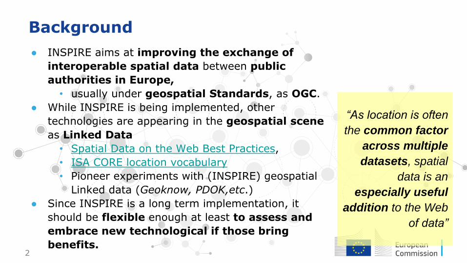
Background
● INSPIRE aims at improving the exchange of
interoperable spatial data between public
authorities in Europe,
• usually under geospatial Standards, as OGC.
● While INSPIRE is being implemented, other
technologies are appearing in the geospatial scene
as Linked Data
• Spatial Data on the Web Best Practices,
• ISA CORE location vocabulary
• Pioneer experiments with (INSPIRE) geospatial
Linked data (Geoknow, PDOK,etc.)
● Since INSPIRE is a long term implementation, it
should be flexible enough at least to assess and
embrace new technological if those bring
benefits.
“As location is often
the common factor
across multiple
datasets, spatial
data is an
especially useful
addition to the Web
of data”

3
ARe3NA work on Linked Data
Phase 1 - Study on "RDF & PIDs for INSPIRE”● Identifying recommendations for a common
methodology to encode RDF INSPIRE● governance issues of Persistent identifiers ● tools supporting RDF transformation
Phase 2 - Application● Draft guidelines for representing INSPIRE in RDF● Draft vocabularies● Two pilots assessing the feasibility and
correctness of the former
Metadata
Data
GeoDCAT-AP Specification + Sandbox

4
The guidelines and vocabulary development
● The status of this activity is draft
● A formal review by the EC and Member State
representatives (MIG) will be done.
● The guidelines could eventually become an
additional encoding for geospatial data exchange
in Europe building upon the existing infrastructure
● Produced by Interactive Instruments and PWC
● Goal: keeping the INSPIRE interoperability in the
Linked Data world
● Open process by calling to comment on them

5
Guidelines for the RDF encoding of spatial
data - Why new guidelines?
Schemas conversion rules
Converting INSPIRE applications
schemas to an OWL ontology
Topics: types, properties, associations,
constraints
To conform to:
Instance conversion rules
How spatial objects are
converted to RDF resources
Topics: resource identifiers, encoding
geometry, encoding metadata, etc.
Regulation 1089/2010
6/
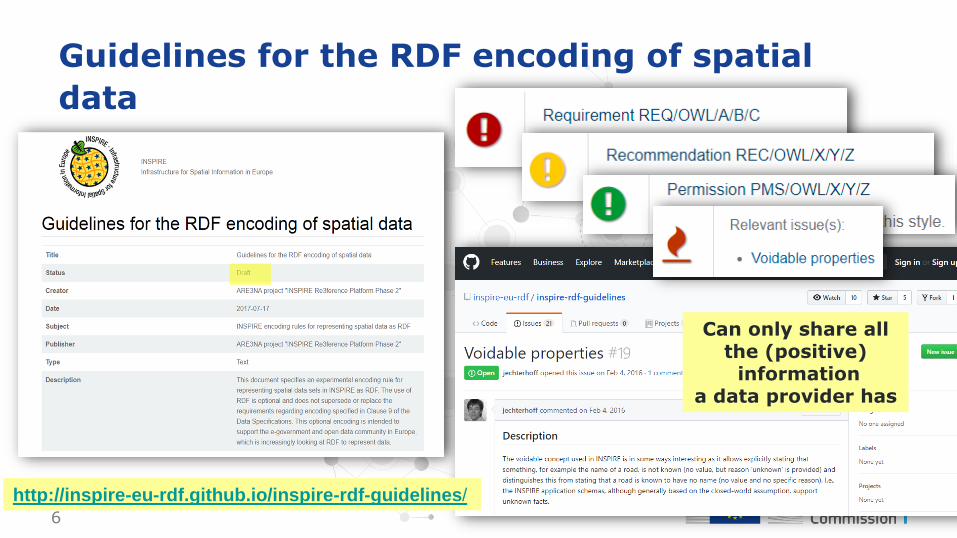
Guidelines for the RDF encoding of spatial
data
http://inspire-eu-rdf.github.io/inspire-rdf-guidelines/
Can only share all the (positive)
information a data provider has

7
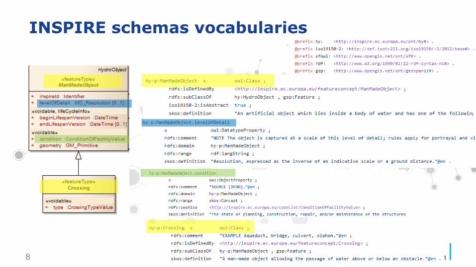
The INSPIRE RDF Vocabularies (schemas)
8
INSPIRE schemas vocabularies
9
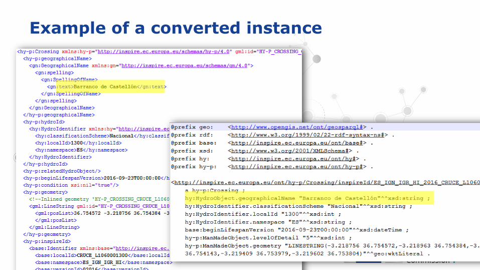
Example of a converted instance
10
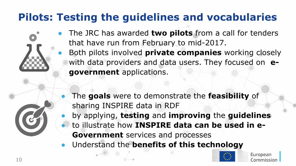
Pilots: Testing the guidelines and vocabularies
● The JRC has awarded two pilots from a call for tenders
that have run from February to mid-2017.
● Both pilots involved private companies working closely
with data providers and data users. They focused on e-
government applications.
● The goals were to demonstrate the feasibility of
sharing INSPIRE data in RDF
● by applying, testing and improving the guidelines
● to illustrate how INSPIRE data can be used in e-
Government services and processes
● Understand the benefits of this technology

11
Pilot 1Improving the information position of emergency
responders with Linked INSPIRE Data
12
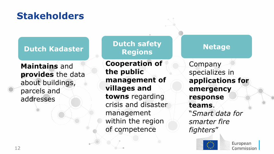
Stakeholders
Dutch KadasterDutch safety
RegionsNetage
Maintains and provides the data about buildings, parcels and addresses
Cooperation of the public management of villages and towns regarding crisis and disaster management within the region of competence
Company specializes in applications for emergency response teams.“Smart data for smarter fire fighters”
13
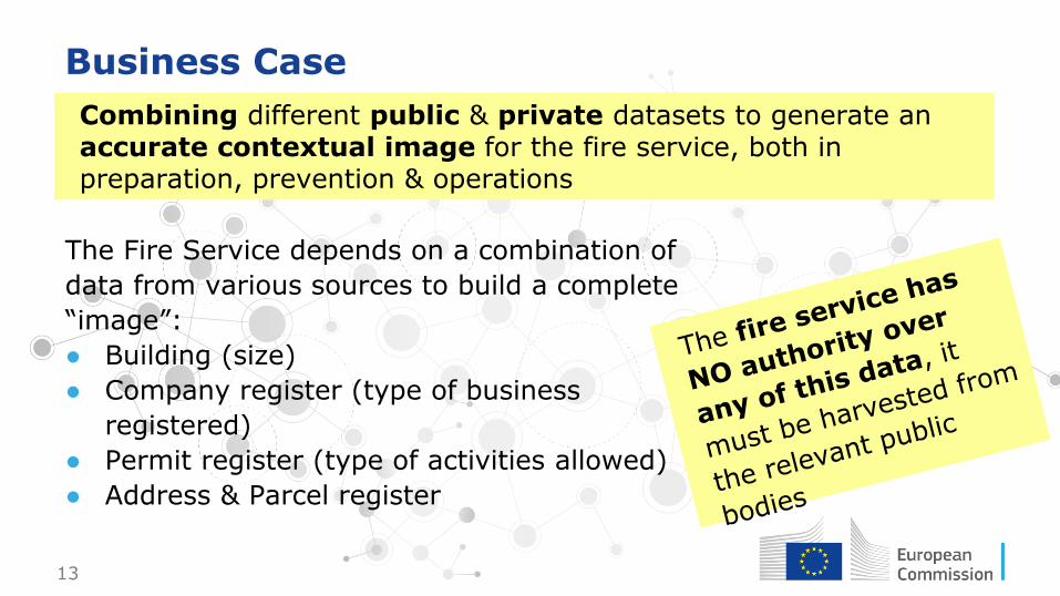
Business Case
Combining different public & private datasets to generate an accurate contextual image for the fire service, both in preparation, prevention & operations
The Fire Service depends on a combination of
data from various sources to build a complete
“image”:
● Building (size)
● Company register (type of business
registered)
● Permit register (type of activities allowed)
● Address & Parcel register

14
Process to provide INSPIRE RDF services
Step 1
Step 2
Step 3
Step 4
Step 5
Step 6
Convert data to RDF both INSPIRE ad non-INSPIRE
Create authoritative identifiers in INSPIRE datasets
Relate all registrations to their respective identifiers
Mashup between various INSPIRE themes
Data from various registration on the current object
Metadata references to the source of the data
15
Issues encountered and challenges
● Excess of triples for one city only
● Mix of INSPIRE and non-INSPIRE themes
● An object for them as a “dwelling” could be represented at
different levels in different INSPIRE themes; building, facilities,
addresses etc.
16
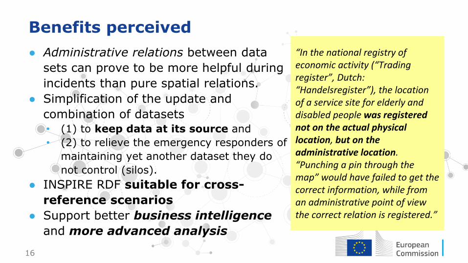
Benefits perceived
● Administrative relations between data
sets can prove to be more helpful during
incidents than pure spatial relations.
● Simplification of the update and
combination of datasets• (1) to keep data at its source and
• (2) to relieve the emergency responders of
maintaining yet another dataset they do
not control (silos).
● INSPIRE RDF suitable for cross-
reference scenarios
● Support better business intelligence
and more advanced analysis
“In the national registry of economic activity (“Trading register”, Dutch: “Handelsregister”), the location of a service site for elderly and disabled people was registered not on the actual physical location, but on the administrative location. “Punching a pin through the map” would have failed to get the correct information, while from an administrative point of view the correct relation is registered.”

17
Pilot 2Serve Hydrographical Data with the Linked Data
reusable by interested Public Administrations

18
Stakeholders & Business Case
CNIG (Centro Nacional de Información Geográfica)
Guadalquivir River Basin Agency
Andalusia Regional Government Corporate GIS
Guadaltel
• Promotes and markets the products of the Spanish National Geographic Institute
• Data Provider: INSPIRE Hydrography datasets / Publish RDF services
• Manages the Guadalquivir River Basin
• Incorporate RDF services in internal business processes
• Provision of horizontal tools and services for Andalusian Regional Government
• Spread INSPIRE RDF guidelines and tools
• Consultancy, SDI and Corporate GIS solutions provider
• Solution developer for RDF spatial data integration

19
Process to provide INSPIRE RDF services
Step 1
Step 2
Step 3
Step 4
Step 5
Step 6
Provide existing information from CNIG converting INSPIRE hydrography physical data model to RDF format.
Identify and harvest National INSPIRE data via public WFS services
Match hydrography dataset attributes against INSPIRE data model
Match hydrography dataset attributes against INSPIRE RDF vocabularies
ETL process translating from INSPIRE hydrography datasets to INSPIRE RDF
Publish RDF produced data
20
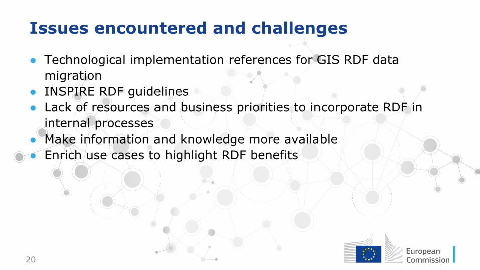
Issues encountered and challenges
● Technological implementation references for GIS RDF data
migration
● INSPIRE RDF guidelines
● Lack of resources and business priorities to incorporate RDF in
internal processes
● Make information and knowledge more available
● Enrich use cases to highlight RDF benefits
21
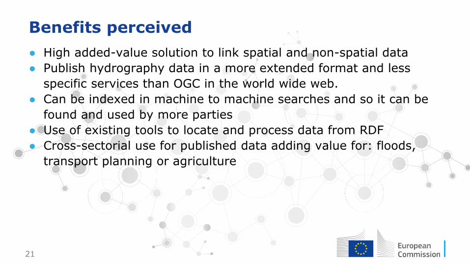
Benefits perceived
● High added-value solution to link spatial and non-spatial data
● Publish hydrography data in a more extended format and less
specific services than OGC in the world wide web.
● Can be indexed in machine to machine searches and so it can be
found and used by more parties
● Use of existing tools to locate and process data from RDF
● Cross-sectorial use for published data adding value for: floods,
transport planning or agriculture

22
Additional outcomes of the pilots
https://www.youtube.com/watch?v=EVhSa3Rb1EQ
Webinar Documentation
Workflows to be included in
INSPIRE in practice
Interviews from 5 stakeholders
Detailed Virtuoso migration guidelines
24
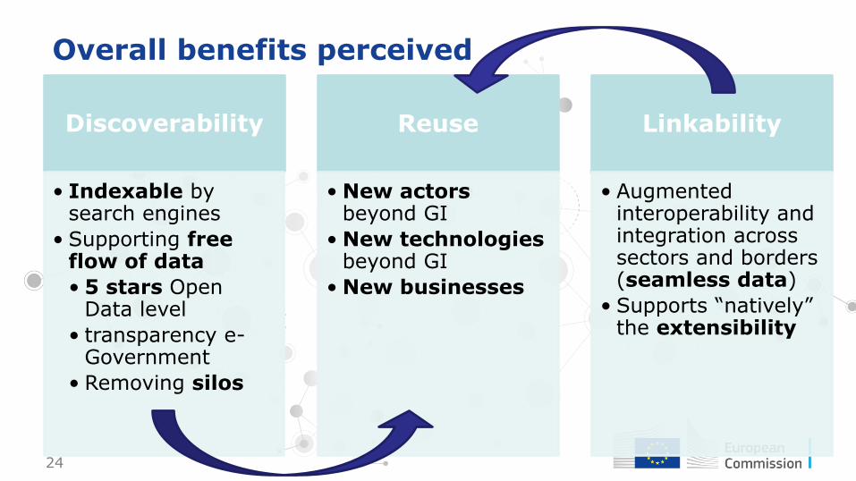
Overall benefits perceived
Discoverability
• Indexable by search engines
• Supporting free flow of data
• 5 stars Open Data level
• transparency e-Government
• Removing silos
Reuse
• New actorsbeyond GI
• New technologiesbeyond GI
• New businesses
Linkability
• Augmented interoperability and integration across sectors and borders (seamless data)
• Supports “natively” the extensibility

25
Conclusion
● The benefits look promising, but the biggest
challenge is the change of mindset in the
institutions (lack of priorities, resources).
● W3C has already has recognised the value of
spatial Linked Data.
● If INSPIRE finally endorses this new exchange
format, it would symbolize a willingness to:
• adapt to changes by embracing cutting-edge
technologies
• boosting semantic interoperability of
geospatial data at an pan European extent
• Betting for innovation
INSPIRE data models
offer a unique
opportunity for
creating
semantically rich
and agreed
descriptions of
geographical features
in a consistent way
across Europe.
26This work is licensed under a Creative Commons Attribution 4.0 International License
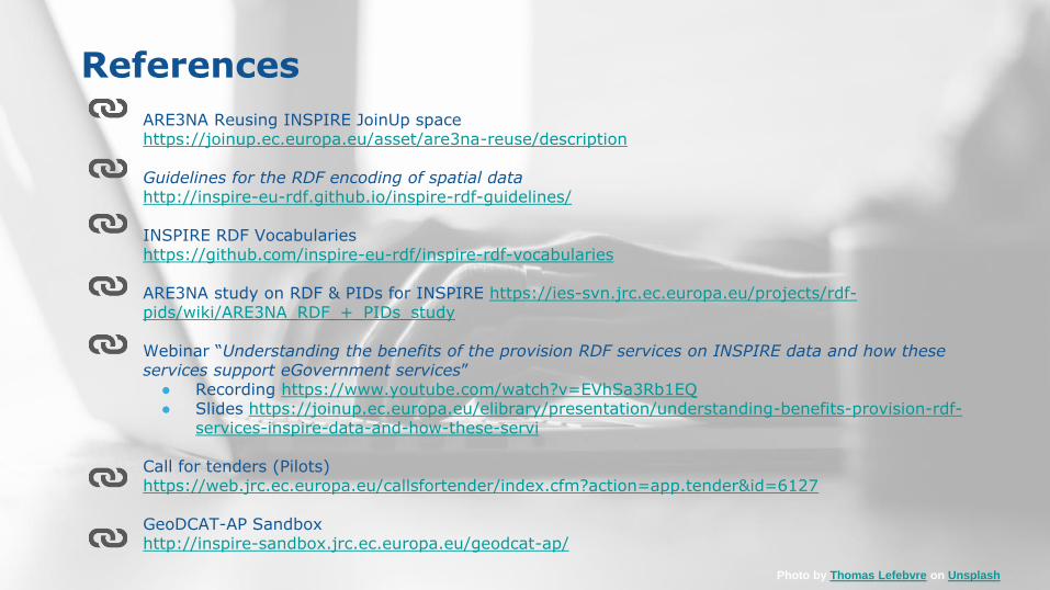
References
Photo by Thomas Lefebvre on Unsplash
ARE3NA Reusing INSPIRE JoinUp spacehttps://joinup.ec.europa.eu/asset/are3na-reuse/description
Guidelines for the RDF encoding of spatial datahttp://inspire-eu-rdf.github.io/inspire-rdf-guidelines/
INSPIRE RDF Vocabularieshttps://github.com/inspire-eu-rdf/inspire-rdf-vocabularies
ARE3NA study on RDF & PIDs for INSPIRE https://ies-svn.jrc.ec.europa.eu/projects/rdf-pids/wiki/ARE3NA_RDF_+_PIDs_study
Webinar “Understanding the benefits of the provision RDF services on INSPIRE data and how these services support eGovernment services”
● Recording https://www.youtube.com/watch?v=EVhSa3Rb1EQ● Slides https://joinup.ec.europa.eu/elibrary/presentation/understanding-benefits-provision-rdf-
services-inspire-data-and-how-these-servi
Call for tenders (Pilots)https://web.jrc.ec.europa.eu/callsfortender/index.cfm?action=app.tender&id=6127
GeoDCAT-AP Sandboxhttp://inspire-sandbox.jrc.ec.europa.eu/geodcat-ap/
27
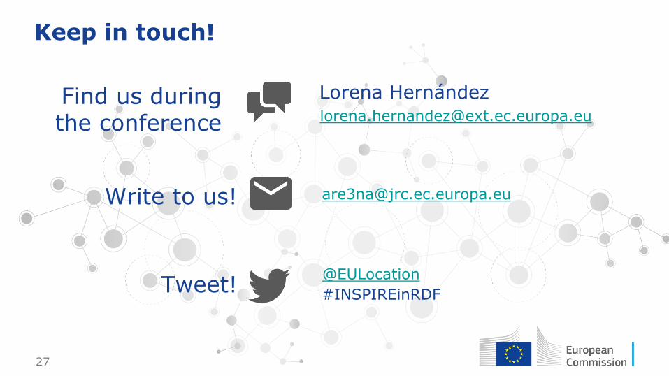
Keep in touch!
#INSPIREinRDF
@EULocation
Tweet!
Write to us!
Find us during the conference
Lorena Herná[email protected]

28
Photo by Matt Jones on Unsplash

29
Stay in touch
•EU Science Hub: ec.europa.eu/jrc
•Twitter: @EU_ScienceHub
•Facebook: EU Science Hub - Joint Research Centre
•LinkedIn: Joint Research Centre
•YouTube: EU Science Hub