jica報告書pdf版(jica report pdf) - the master …this report compiles the results of the study,...
TRANSCRIPT

Japan International Cooperation Agency (JICA) Ministry of Regional Municipalities, Environment and Water Resources (MRMEWR) The Sultanate of Oman
THE MASTER PLAN STUDY ON
RESTORATION, CONSERVATION AND MANAGEMENT OF MANGROVE
IN THE SULTANATE OF OMAN
Final Report
Vol. 2 Technical Specification of Afforestation, Conservation and Management
July 2004
Pacific Consultants International Appropriate Agriculture International Co., Ltd
No.
04-035
JR
G E

Japan International Cooperation Agency (JICA) Ministry of Regional Municipalities, Environment and Water Resources (MRMEWR) The Sultanate of Oman
THE MASTER PLAN STUDY ON
RESTORATION, CONSERVATION AND MANAGEMENT OF MANGROVE
IN THE SULTANATE OF OMAN
Final Report
Vol. 2 Technical Specification of Afforestation, Conservation and Management
July 2004
Pacific Consultants International Appropriate Agriculture International Co., Ltd

The exchange rate applied in this study is R.O.1=JPY275.9 (As of January 2004)

PREFACE
In response to a request from the Government of the Sultanate of Oman, the Government of Japan decided to conduct the study to develop the master plan for restoration, conservation and management of mangrove in the Sultanate of Oman. JICA selected and dispatched the study team headed by Mr. Tadashi Kume of Pacific Consultants International and consisting of Pacific Consultants International and Appropriate Agriculture International Co., Ltd. to Oman between June 2002 and July 2004. It is with great pleasure that I acknowledge the close collaboration between the Ministry of Regional Municipalities, Environment and Water Resources and the JICA study team, which resulted in the formulation of the master plan. I strongly wish that this master plan, formulated with under the strong initiative of the Ministry of Regional Municipalities, Environment and Water Resources, will contribute to the restoration, conservation and management of mangroves in the Sultanate of Oman. Finally, I wish to express my sincere appreciation to all the officials concerned of the Government of Oman for their cooperation and support extended to the team. July 2004 Etsuo Kitahara Vice President Japan International Cooperation Agency

Mr. Etsuo KITAHARA July 2004 Vice President Japan International Cooperation Agency Tokyo, Japan
Letter of Transmittal Dear Sir, We are pleased to formally submit herewith the Final Report of “The Master Plan Study on Restoration, Conservation and Management of Mangrove in the Sultanate of Oman.”
This report compiles the results of the study, which was conducted from June 2002 through July 2004 by the study team organized by Pacific Consultants International and Appropriate Agriculture International Co., Ltd. under the contract with JICA.
The study team compiled this report, which proposed the future conservation and management scenario and master plan up to 2024, and short-term, medium-term, and long-tem action plans up to 2006, 2009, and 2014 respectively, through close consultations with officials of the Ministry of Regional Municipalities, Environment and Water Resources and other authorities concerned.
We would like to express our sincere gratitude and appreciation to the officials of your agency and the JICA advisory committee. We also would like to send our great appreciation to all those who extended their kind assistance and co-operation to the study team, in particular to the Ministry of Regional Municipalities, Environment and Water Resources and regional officials concerned.
We hope that the master plan will be able to contribute significantly to the development of the mangrove conservation and management system in Oman.
Very truly yours,
Tadashi KUME Team Leader, The Master Plan Study on Restoration, Conservation and Management of Mangrove in the Sultanate of Oman

Abbreviations
CAD Computer-Aided Design COD Chemical Oxygen Demand DG Director General DO Dissolved Oxygen EEZ Exclusive Economic Zone EIA Environmental Impact Assessment GCC Gulf Co-operation Council GIS Geographical Information System GOJ Government of Japan GOO Government of Oman GPS Geographical Positioning System HTML Hypertext Makeup Language IUCN International Union for the Conservation of Nature and Natural
Resources (The World Conservation Union) JICA Japan International Cooperation Agency MAF Ministry of Agriculture and Fisheries MCI Ministry of Commerce and Industry MD Ministerial Decision MPCZMS Marine Pollution and Coastal Zone Management Section MPEC Mangrove Plantation Experimental Centre MRMEWR Ministry of Regional Municipalities, Environment and Water
Resources NR Nature Reserve QEIC Qurm Environmental Information Centre RA Recreation Area RD Royal Decree RDA Recreational Development Area ROPME Regional Organisation for the Protection of the Marine EnvironmentRTK Real Time Kinematics of Oman SQU Sultan Qaboos University SR Scenic Reserve UAE United Arab Emirates UNESCO United Nations Educational, Scientific and Cultural Organisation

English Spelling of Place-names in the Report
There were some difficulties in writing in English the Arabic names for the Region/Governorate, Wilayat, Locality and Study Sites. One place was spelled in different ways in official documents and maps in Oman. In order to avoid any misunderstanding, all the names in English have been standardised based on discussion between the JICA Study Team and the Omani Counterpart team. The "Socio-Economic Atlas, Ministry of Development, Information & Documentation Centre, November 1996" provided by the Ministry of National Economy has been used for the names of the Region/Governorate, Wilayat, Locality, while the “Map of the Sultanate of Oman” prepared by NSA (National Survey Authority) has been used for the Study Site names as follows:
Governorate/Region Wilayat Locality Study Site Zone
1. Mutrah Murtafaat Al Qurm 5. Khawr Qurm 5. Muscat Al Khayran 6. Bandar Khayran
1. Governorate of Muscat
6. Qurayyat 7. Qurayyat
Muscat
3. Shinas Tarif Al Makhamrah 1. Khawr Shinas 4. Liwa Harmul 2. Khawr Harmul/Nabr
Al Sawadi As Sahil 3. Khawr Sawadi
2. Al Batinah Region
12. Al Barka Al Haradi 4. Khawr Haradi
Batinah
Sur 8. At Tina 9. Batah
1. Sur
Ras Al Had 10. Khawr Quq 11. Khawr Hajar - East Shore
Sharqiyah 6. Ash Sharqiyah Region
11. Masirah 12. Wadi Muraysis Wusta 7. Al Wusta Region Falam 13. Filim - Eastern Beach
2. Muhut Jazirat Muhut 14. Mahawt Island
18. Khawr Dahariz 19. Khawr Balid 20. Khawr Kabir
1. Salalah
21. Khawr Saghir 3. Taqah Taqah 17. Qurm Taqah
15. Al Demer Beach
8. Governorate of Dhofar
4. Mirbat 16. Khawr Rowri Dhofar

Composition of the Reports
This report presents all results of the studies conducted during the studies in Japan and Oman. The Report consists of the following:
• Volume 1: Main Report • Part 1: Master Plan Study
• Part 2: Appendix
• Volume 2: Technical Specifications of Afforestation, Conservation and Management

THE MASTER PLAN STUDY ON RESTORATION, CONSERVATION AND MANAGEMENT OF MANGROVE IN THE SULTANATE OF OMAN
i
Final Report Vol.2 Technical Specification of
Afforestation, Conservation and Management
Table of Contents
Preface Letter of Transmittal Abbreviations English Spelling of the Place-name in the Reports Composition of the Reports
Page
1. Technical Specifications of Sites ..................................................................... 1-1
2. Technical Guideline for Afforestation ............................................................ 2-1

Chapter 1: Technical Specifications of Sites

THE MASTER PLAN STUDY ON RESTORATION, CONSERVATION AND MANAGEMENT OF MANGROVE IN THE SULTANATE OF OMAN
1-1
1. Technical Specifications of Sites Technical specifications of the following sites are provided in this chapter. Each technical specification is provided in a format prepared by the JICA study team.
• Batinah Zone
• Khawr Shinas
• Khawr Harmul/ Nabr
• Khawr Sawadi
• Khawr Haradi
• Khawr Qurm
• Sharqiyah Zone
• Bandar Khayran
• Qurayyat
• At Tina
• Batah
• Khawr Quq
• Khawr Hajar – East Shore
• Wusta Zone
• Wadi Muraysis
• Filim – Eastern Beach
• Mahawt Island
• Dhofar Zone
• Al Demer Beach
• Khawr Rowri
• Qurm Taqah
• Khawr Dahariz
• Khawr Balid
• Khawr Kabir
• Khawr Saghir

Technical Specification for Khawr Shinas

TECHNICAL SPECIFICATION FOR KHAWR SHINAS
Shinas-1
1. SITE DESCRIPTION
1.1 Location Governorate/ Region Al Batinah Wilayat Shinas Distance from the Centre of Wilayat
5 km
Nearest Locality Tarif Al Makhamrah Fame of the Site/ Distinctive Features
None
Facilities in the Site Public park Features of Surrounding Areas South of Shinas town, approximately 2 km east of the National
Highway. Clarke (IUCN, 1986) recommended that this site should be included as one of the country’s National Nature Reserve. The khawr is about 6 km long with a northern and southern arm.
1.2 Natural Conditions Climate Zone Batinah Zone General Terrain Flat plain Soil
Khawr Shinas lies on flat alluvial plain at northern Batinah coastwhere Wadi Fayd and Wadi Bid’ah meet at the sea. Soils in the mouth of khawrs show sandy through soil layers, deep (more than 100cm), soft and aerobic conditions. Groundwater levels are almost 70cm from soil surface. In the midstream of south khawr, soils under vegetation are relatively silty in surface but sandy in subsurface. The depth of fine textured surface is much deeper in upper khawr. The soils under mangroves in these areas are always saturated and under anaerobic condition. The soils in inmost khawr are clayey, deep and soft through the layers. Muddy and cloudy stagnant water covers this area. The mangroves situated on these soils have developed many aspiratory roots. The data of soil Eh shows also anaerobic condition with low mV values (negative values) in the layers of subsurface soil. Salinities of ground water in south khawr were ranging from 4.3 to 5.6%. According to the results of traversed survey for soil depth in north khawr, soils of this khawr are basically deep. Shallow soils are observed in some shore areas with hard rock bed. Subsurface soil near water way shows dark colour with anaerobic condition and always saturated. Soils are much silty and clayey in upper khawr, and sandy near the mouth of khawr. Salinities of ground water in northern khawr were ranging from 5.1 to 7.6%. Details are shown in attached table “Attachment 4: Soil Profile in Khawr Shinas” and “Attachment 9: Soil Profile of Samples in Khawr Shinas”.
Water The salinities of surface water in both of north and south khawrs were ranging from 3.7 to 4.8% (July 2002). The water was clear in lower water channels and dull in upper water channels. DO in water was ranging from 2.6 to 5.2mg/l. Lower values of DO were basically observed on stagnant water. There was no significant constraint on the values of COD (less than 4mg/l). Details are shown in attached table “Attachment 5: Surface Water Quality in Khawr Shinas”.

TECHNICAL SPECIFICATION FOR KHAWR SHINAS
Shinas-2
Fauna
Abundant small fish and crustaceans occur in the water channels of the mangroves. The crabs Eurycarcinus and Metopograpsus were recorded as particularly numerous by the channel (Salm & Jensen, 1991). They reported heavy recreational fishing for the mud crab, Scylla serrata; as many as 20 crabs may be caught in a night. During this study, Uca inversa was recorded on muddy sand, bordering the landward edge of the mangroves. Large mud snails, Terebralia palustris, were found in the shade. Other crabs were abundant among the mangroves and on the channel edge (Uca annulipes, Perisesarme guttatum, Metopograpsus thukuhar, Eurycarcinus orientalis, Nasima dotilliforme, Serenella leachii). The small species of mud snail, Cerithidea cingulata and Cerithium scabrida were common. Oysters (Saccostrea cucullata), Nerites (Nerita albicalla) and barnacles (Balanus amphitrite) were found on the mangrove trunks and aerial roots. At the northwest arm of Khawr Shinas, mangroves are smaller and scattered. Animals included Fiddler crabs (Uca inversa), lantern shells (Laternula erythraensis) and Dosinia alta. Hermit crabs (Diogenes sp) were common on the surface. Over 10 years, 99 water bird species have been recorded for this site. Evans (1994) records significant numbers (>1% of world population) of Great Black-headed and Yellow-legged Gulls. The endemic Arabian collared kingfisher is recorded here, which is the closest site in Oman to its breeding site at Khawr Kalba on the border with Fegeira. The rare Sykes’s Warbler is also recorded at this site.
Flora
Khawr Shinas is surrounded by Sabkha, salt tolerant plants of the coastal plain. In an outer zone, furthest from the khawr, Salsola imbricata dominated, with Juncus rigidus growing in dry watercourses. Nearer the khawr on sand and beach rock, Suaeda vermiculata and Cyperus conglomerata form about 10% plant cover. In wet sand nearest to the mangroves, a dense growth (about 50% cover) of Arthrocnemum macrostachyum forms a narrow zone. Along the north west arm of the khawr a zone of Arthrocnemum, Suaeda vermiculata and Zygophyllum qatarense forms a band of vegetation about 5 – 8 m wide along the edge. Dune vegetation included Halopyrum mucronatum.
Impacts from the Surrounding Areas
Pressure of development
1.3 Socio-economic Situation Population of the Wilayat (2001)
53 thousand
Population of the Nearest Locality (1993)
0.6 thousand
Main Economic Activities Fishery and agriculture, potential for apiculture Infrastructure Near Shinas town, access road constructed to the site Main Usage People in the Wilayat uses for recreational activities. Its biological
diversity is distinctive. Community Interference with the Area
Developing the area as a municipal park. Some trees are planted and, a part of bank of watercourse is fixed by rocks and soil.
Cultural Significance None

TECHNICAL SPECIFICATION FOR KHAWR SHINAS
Shinas-3
1.4 Legal Setup and Development Plans Land Ownership and Land Use Designation
Nature Reserve (NR) and Recreational Development Area (RDA)
Development Plans in the Site and the Surrounding Area
Municipal Park Development Plan
Existing Conservation Proposal
None
2. PROGRAMME AND PROJECT
2.1 Prerequisite Legal Setup for Land Use Control
Set a distinct boundary of NR and RDA (see 4.2 Required Action for Conservation and Management)
Facility Development Control No permanent structure in NR, except hide for bird watching, sign and information boards, and boardwalk or pedestrian bridge. Footpath should be designated but not paved. No permanent commercial buildings such as restaurants, hotels, shops and mechanised amusement facilities in the park development area. Basic activities in this park are relaxation and picnicking. Partial lighting for safety only. Utilities lines (water and electricity should be at a minimum) and setback at 150 m from the edge of Mangrove.
Others None
2.2 Description of Programmes Facility Development Programme
(1) Nursery construction, (2) Visitor service and information facilities development.
Restoration and Afforestation Programme
(3) Mangrove planting project, (4) Watercourse bank restoration project.
Monitoring Programme (5) Mangrove monitoring project (6) Soil and water monitoring project (7) Fauna and flora monitoring project (8) Pollution monitoring project (9) Monitoring project on legal setup and development plans
Public Awareness Programme It will include an educational programme for school children and conservation campaign for residents of the Wilayat. Required materials and facilities are (10) Pamphlets and posters distributed to the residents, (11) Information boards describing significance of the natural environment.
2.3 Implementation Mechanism Projects Responsible
Agencies Implementing
Body/ Agencies Related
Agencies (1) Temporary Nursery construction MRMEWR MRMEWR (2) Visitor service and information facilities development. MRMEWR Wilayat Shinas MCI (3) Mangrove planting project MRMEWR Wilayat Shinas (4) Watercourse bank restoration MRMEWR Wilayat Shinas (5) Mangrove Monitoring Project MRMEWR Wilayat Shinas (6) Soil and Water Monitoring Project MRMEWR Wilayat Shinas (7) Fauna and Flora Monitoring Project MRMEWR MRMEWR/ Omani
Institute for Birds

TECHNICAL SPECIFICATION FOR KHAWR SHINAS
Shinas-4
Projects Responsible Agencies
Implementing Body/ Agencies
Related Agencies
(8) Pollution Monitoring Project MRMEWR Wilayat Shinas/ MRMEWR
(9) Monitoring Project on Legal Setup and Development Plans
(10) Pamphlets and posters distributed to the residents MRMEWR MRMEWR MOE (11) Information boards MRMEWR MRMEWR MOE
2.4 Implementation Schedule Project No. 1 st 2 nd 3 rd 4 th 5 th 6th 7th 8th 9 th 10 th
(1) (2) (3) (4) (5) (6) (7) (8) (9) (10) (11)
3. IMPLEMENTATION PLAN
3.1 Restoration and Afforestation
3.1.1 Existing Mangrove Area Location and Area Bank of southern part of the lagoon is covered by the mangrove. Total
area of mangrove vegetation is 53 ha approximately. (Figure 2 Location Map)
Conditions of Existing Mangrove
Good condition near mouth of lagoon and midstream of southern channel. Some trees stand decayed around upper stream. As elevation and salinity increase at the landward side, the trees become smaller. There is some water stress in crowded smaller trees inland as the upper branches die. Tall trees reached 8m in height. New mangrove seedlings are intruding into narrow backyard of midstream at sea side, backyard of downstream of northern water channel and some extending area of right bank of northern water channel. Trees at parking area have been damaged by the soil of reclamation. There is no area for extending mangrove landward because of surrounding sabkha. Many seeds are observed after flowering season. Some trees are cut for firewood.

TECHNICAL SPECIFICATION FOR KHAWR SHINAS
Shinas-5
3.1.2 Plantation Area Tidal Condition Normal Wave and Wind Calm in summer, drifted sand damages seaward fringe. Flood Every 5 to 10 years Water Salinity and pH Salinity; 4.1 ~ 4.4 %, pH; 8.3 ~ 8.5 (Attachment 5: Surface Water
Quality in Khawr Shinas) Soil Conditions The areas of sandy and deep soils on the north khawr will be suitable
land for new plantation. Some young mangrove plants exist and potential area will follows on upper shore of this vegetation. The tidal area about 400m long along north khawr from existing mangrove will be high potential area for plantation. In upper area of this khawr, soils are more fine-textured and some firm layers are observed. Shallow beach rocks are observed in some places. Surveyed data is in the “Attachment 4: Soil Profile in Khawr Shinas” of this technical specification.
Potential Area Both banks along north khawr. See “Figure 3 Planting Map”.
Table 3.1 Location and Areas of Potential Planting Area(s)
Designated Area Area (ha) Area-1 (1) in Figure 3 1.6 Area-2 (2) in Figure 3 0.9
3.1.3 Planting Schedule Total Planting Area 2.5 ha Planting Season and Timing January ~ February Seed/ Seedlings Supply Source and Location
Seed from existing mangrove in Shinas Seedling from temporary nursery to be constructed in Shinas
Planting Method Start from downstream of landward shore. And shift to upper khawr. After finishing on landward shore, move to seaward shore. Start from downstream and move to upper khawr. Detailed technical guidelines should refer to the “Technical Guideline for Afforestation” attached with this technical specification.
Table 3.2 Planting Schedule
Year 1 st 2 nd 3 rd 4 th 5 th 6th 7th 8th 9 th 10 th Total Planting area-1 Planting area-2
Table 3.3 Seeds/ Seedling Supply Schedule
Year 1st 2nd 3rd 4th 5th 6th 7th 8th 9th 10th Total Season/ time Jan,
Feb Jan, Feb
Jan, Feb
Jan, Feb
Jan, Feb
Planting area (ha) (1)/(2) (1)/(2) (1)/(2) (1)/(2) (1)/(2) Number of seed/ seedling (thousands)
5 5 5 5 5 25

TECHNICAL SPECIFICATION FOR KHAWR SHINAS
Shinas-6
3.1.4 Conservation Area Area of Land Use Park Development Area
3.1.5 Required Action for Conservation and Management Inspection Daily observation by the management body, 2 to 4 times of inspection
by MRMEWR (Mangrove Information Centre) Cleaning Management Body Replantation of Seedlings Growing Bad, Dead or Washed Away
MRMEWR (Mangrove Information Centre) for 5 years after plantation.
Service for Associated Facilities
Regularly by Management Body
Patrol and Enforcement Daily ordinary patrol by a police office of Wilayat is required, and the management body regularly inspects facilities conditions and littering and waste disposal to the ground and water in NR areas.
Restoration and Rehabilitation Work
The mangrove plantation work in the planting area described in the previous section is necessary. The pedestrian bridge is reconstructed to improve the water environment in the existing mangrove area (Figure 4 Proposed Pedestrian Bridge in Khawr Shinas).
Facilities Required for the Conservation and Management Activities
Directional signs along the highway and entrance to the access road(s), guide signs in the reserve, and information boards in the NR area can be seen in the area to explain the significance of the reserve and major flora and fauna. Plant Nursery not only for this site but also for mangrove planting site in the vicinity is required. Footpath and boardwalk for observation of wildlife as well as mangrove are also necessary.
3.2 Monitoring
3.2.1 Mangrove Monitoring Method ・Existing mangrove:
Select and label trees for monitoring. Monitor Mangrove by using the attached “Attachment 1: Field Monitoring Sheet for Mangrove”.
・Planting mangrove: First 4 years: tree height, canopy X:Y After 4 years: follow the monitoring sheet.
Frequency ・Existing mangrove: Every 2 years ・Planting mangrove: First 4 years: annual monitoring After the first 4 years: every 2 years
Monitoring Target ・Existing mangrove: 1) Sh-OT1: Coordinate Easting 446981 /Northing 2734528 2) Sh-OT4: Coordinate Easting 447346 /Northing 2733847 3) Sh-OT5: Coordinate Easting 447300 /Northing 2733405 4) Sh-OT14: Coordinate Easting 446662 /Northing 2733487 5) Sh-OT15: Coordinate Easting 446710 /Northing 2733548

TECHNICAL SPECIFICATION FOR KHAWR SHINAS
Shinas-7
• Planting mangrove: Select 20 trees at random and monitor them. Trees to be selected
should have distinct characteristics such as (PV) locating at the panoramic view point, (EF) locating at the edge of existing forest stretch, (OT) outstanding tree (size, shape, history, health, etc.) and (RP) a tree stand at remarkable point.
Baseline Data Base line data of tentatively selected trees are listed in “Attachment 2: List of the Observed Points in Khawr Shinas”.
3.2.2 Soil and Water Monitoring Method Monitor soil and water in and around mangrove vegetation by using
attached table “Attachment 3: Field Monitoring Sheet for Soil and Water (Khawr Shinas)”.
Frequency Soil: (New plantation area) Before plantation and Every two years after the new plantation (Existing mangrove area) Every 2 Years Water: Every year (Outflow water at low tide should be measured.)
Monitoring Target Attachment 3 Baseline Data See attached table “Attachment 4: Soil Profile in Khawr Shinas” and
“Attachment 5: Surface Water Quality in Khawr Shinas”.
3.2.3 Fauna and Flora Monitoring Method Monitor fauna and flora by using the attached “Attachment 6: Field
Monitoring Sheet for Fauna and Flora and Pollution”. For the observation of birds, an institute that is studying birds in Oman can be the best institute to take a part of the monitoring work by sub-contract basis.
Frequency At least twice a year Monitoring Target Attachment 6 Baseline Data The result of field reconnaissance of fauna and flora is shown in
“Attachment 7: Result of Field Reconnaissance of Fauna and Flora and Pollution in Khawr Shinas”.
3.2.4 Pollution (garbage and waste) Monitoring Method Monitor pollution by using the attached “Attachment 6: Field
Monitoring Sheet for Fauna and Flora and Pollution”. Water Quality and Soil Sample Tests should be carried out by MRMEWR.
Frequency At least twice a year Monitoring Target Attachment 6 Baseline Data See “Attachment 7: Result of Field Reconnaissance of Fauna and
Flora and Pollution in Khawr Shinas”.
3.2.5 Change on Legal Setup and Development Plans Frequency At least once a year Monitoring Target Land Ownership, Land Use Designation, Development Plans in the Site
and Surrounding Area

TECHNICAL SPECIFICATION FOR KHAWR SHINAS
Shinas-8
Figure 1 Key Map

TECHNICAL SPECIFICATION FOR KHAWR SHINAS
Shinas-9
Figure 2 Location Map

TECHNICAL SPECIFICATION FOR KHAWR SHINAS
Shinas-10
Attachment 1: Field Monitoring Sheet for Mangrove (Khawr Shinas)
Mangrove Observation Recors
1) Identification No.
2) Location by GPS (WGS 84, UTM)Easting:
Northing:
3) Photograph No.
4) Observation of tree size and shape a) Tree Height (cm)b) Trunk diameter near botto m (cm)C) Live branches at the position about 1.3m off the center of tree bottom (painted)
Branch/ limb diameter measured in cm1 2 3 4
5 6 7 8
9 10
5) Obsrevation of tree history, helth and environmenta) History
Tree shape: Sign of cut in the past:
b) Health Nodes with leaves:
Inter-node length:Leaf length:Leaf color:
Looks / die back:
C) EnvironmentSoil depth / texture:
Surface water Salinity:Ground level:
Position:
Note:
Memo:(specific information or data significant for the tree willbe written here)
Records
b) Trunk diameter near bottom (cm) c) Live branches at the position about 1.3m off the centre of tree bottom (painted)
5) Observation of tree history, health and environment
c) Environment
Leaf colour:

Shinas-11
TECHNICAL SPECIFICATION FOR KHAWR SHINAS
Att
achm
ent 2
: Lis
t of t
he O
bser
ved
Poin
ts in
Kha
wr
Shin
as
12
34
56
78
910
Shin
asSh
-OT1
128
Jul.
'02
4469
8127
3452
8sh
inas
tree1
a &
1b
452
4719
1515
1212
109
99
7Sh
inas
Sh-O
T228
Jul.
'02
4470
0127
3453
154
215
Shin
asSh
-OT3
28 Ju
l. '0
244
7085
2734
442
465
15Sh
inas
Sh-O
T42
28 Ju
l. '0
244
7346
2733
847
shin
astre
e2a
& 2
b68
520
1714
129.
58.
5Sh
inas
Sh-O
T53
28 Ju
l. '0
244
7300
2733
405
shin
astre
e3b
788
1513
99.
58
77
5Sh
inas
Sh-O
T628
Jul.
'02
32Sh
inas
Sh-O
T728
Jul.
'02
4472
7127
3322
678
925
2015
156
Shin
asSh
-OT8
28 Ju
l. '0
244
7128
2733
319
830
3627
17Sh
inas
Sh-O
T928
Jul.
'02
4467
1827
3418
8Sh
inas
Sh-O
T10
29 Ju
l. '0
244
6807
2733
895
575
2117
6Sh
inas
Sh-O
T11
29 Ju
l. '0
244
6818
2733
849
650
2219
1716
1512
Shin
asSh
-OT1
229
Jul.
'02
4467
6527
3380
353
632
Shin
asSh
-OT1
329
Jul.
'02
4466
4927
3373
960
427
199
Shin
asSh
-OT1
44
29 Ju
l. '0
244
6662
2733
487
shin
astre
e4a
& 4
b49
520
1716
1313
1210
9Sh
inas
Sh-O
T15
529
Jul.
'02
4467
1027
3354
8sh
inas
tree5
a &
5b
466
1915
119
98.
58
8Sh
inas
Sh-O
T16
29 Ju
l. '0
244
6674
2733
616
615
Shin
asSh
-OT1
729
Jul.
'02
4470
9227
3345
250
034
3326
Shin
asSh
-OT1
829
Jul.
'02
4470
5527
3344
295
0Sh
inas
Sh-O
T19
18 D
ec. '
0244
6198
2739
037
535
713
1210
167
712
Kha
wr
Tre
eN
umbe
rD
ate
ofO
bser
vatio
nM
onito
ring
Tre
esR
emar
ksEa
stin
gN
orth
ing
Trun
kne
arbo
ttom
Coo
rdin
ate
(UT
M)
Phot
o N
umbe
rH
eigh
t(c
m)
Dia
met
er (c
m)
Live
bra
nche
s at t
he p
ositi
on a
bout
1.3
m o
ff th
ece
nter
of t
ree
botto
m (D
BH
: Dia
met
er B
reat
h H
eigh
t)
Live
bra
nche
s at t
he p
ositi
on a
bout
1.3
m o
ff th
e ce
ntre
of t
ree
botto
m
(DB
H: D
iam
eter
Bre
ast H
eigh
t)

TECHNICAL SPECIFICATION FOR KHAWR SHINAS
Shinas-12
Attachment 3: Field Monitoring Sheet for Soil & Water (Khawr Shinas)
Location Date / time: / ,200 : Recorder General Condition in plantation area:
(garbage, rubbish, leaf, alga, crab, shell, etc) (1) Soil Condition New planted area
( ) New planted area
( ) Exist. Mangrove①
young seedlings Exist. Mangrove②
Dense bush Easting 446950 446730 Coordinate Northing. 2734510 2733710
Surface condition 0-10cm 30-40cm Soil
Texture 50-60cm 0-10cm 30-40cm Soil
Colour 50-60cm Root development Depth of surface humus
GWL* (cm) pH Free
water Salinity (%) Soil colour by Munsell notation, GPS*:by UTM of WGS84 GWL: Ground water level
(2) Surface Water Quality (Observation time: : ) Khawr mouth
③ Mid khawr ④at bridge
Upstream Khawr⑤
Sea water ⑥
Easting 447365 447172 446710 447510 Coordinate Northing. 2734190 2733227 2733380 2734120 Surface waste pH Salinity (%) Temperature (C) DO (mg/l) Turbidity / Colour
●Soil ○ Water
12
3
5 4
6
Location of monitoring

Shinas-13
TECHNICAL SPECIFICATION FOR KHAWR SHINAS
Att
achm
ent 4
: Soi
l Pro
file
in K
haw
r Sh
inas
East
ing
Nor
thin
gD
epth
(cm
)pH
Salin
it y(%
)Su
rfac
e(0
-30c
m)
Sub-
surf
ace
(30-
60cm
)D
eep
laye
r(>
90cm
)Su
r fac
e (
0-30
cm)
Sub-
surf
ace
(30-
60cm
)Su
rfac
eSu
b-su
rfac
e
1In
ner e
nd o
f kha
wr i
n so
uth
bran
ch44
6711
2737
018
Cla
yey
Cla
yey
Loam
y to
Sand
Yel
low
ish
gray
-gr
ayG
rayi
sh o
live
tobl
ack
Loos
eLo
ose
2Sa
lt m
arsh
nea
r the
edg
e of
inne
rm
angr
ove
4467
3127
3330
8Lo
amy
Loam
yLo
amy
toSa
ndy
Gra
yish
yel
low
oran
ge-o
live
brow
n
Oliv
e br
own-
dull
yello
wis
hbr
own
Ver
y fir
mFi
rm to
fria
ble
3M
idst
ream
of k
haw
r in
sout
hw
ater
cha
nnel
4467
3227
3371
443
7.1
5.6
Loam
yLo
amy
sand
B
row
nish
bla
ckD
ark
oliv
e gr
ay-
blac
kV
ery
fria
ble
Loos
e
4M
idst
ream
of k
haw
r in
sout
hw
ater
cha
nnel
4471
6927
3321
4C
laye
y to
loam
ysa
ndsa
ndD
ark
oliv
eO
live
blac
k-bl
ack
Ver
yfr
iabl
eV
ery
fria
ble
5M
angr
ove
bush
at t
erra
ce in
mid
stre
am o
f sou
th w
ater
cha
nnel
4475
2427
3361
934
7.1
4.7
Sand
Sand
Sand
Dar
k gr
ayis
h-da
rk g
reen
ish
gray
Dar
k gr
eeni
shgr
ayFi
rm to
fria
ble
Fria
ble
6M
idst
ream
of s
outh
wat
er c
hann
el5m
beh
ind
from
wat
er c
ours
e44
7507
2733
656
Sand
Sand
Sand
Bro
wni
sh b
lack
-da
rk g
reen
ish
gray
Dar
k ol
ive
brow
n-br
owni
shbl
ack
--
7M
outh
of k
haw
r on
sout
h w
ater
chan
nel
4474
7527
3391
460
7.5
4.3
Sand
Sand
Loam
yD
ark
oliv
ebr
own
Dar
k ol
ive
brow
n-ol
ive
blac
kLo
ose
Ver
yfr
iabl
e
8N
ear t
he e
nd o
f man
grov
eve
geta
tion
on n
orth
kha
wr W
ater
cour
se o
n no
rth k
haw
r (1)
4469
5527
3459
970
7.6
5.5
Sand
Sand
Sand
Oliv
e br
own
Oliv
e bl
own-
brow
nish
bla
ckFr
iabl
eFr
iabl
e
9W
ater
cou
rse
on n
orth
wat
erch
anne
l (2)
4468
7227
3493
248
7.5
5.1
Sand
ySa
ndSa
ndD
ark
gray
ish
Dar
k gr
ayis
h-bl
ack
Firm
Firm
tofr
iabl
e
10W
ater
cou
rse
on n
orth
wat
erch
anne
l(3)
4468
7227
3502
446
7.6
7Sa
ndSa
ndSa
ndB
row
nish
bla
ckbl
ack
Firm
Firm
11W
ater
cou
rse
on n
orth
wat
erch
anne
l (4)
4467
7227
3533
865
7.3
7.6
Sand
Sand
Loam
yD
ark
oliv
ebr
own
Yel
low
ish
gray
Ver
yfr
iabl
e to
fria
ble
Ver
yfr
iabl
e
12W
ater
cou
rse
on n
orth
wat
erch
anne
l (5)
4466
0427
3556
070
7.5
5.6
Loam
ySa
ndSa
ndG
ray
Gra
yish
oliv
eV
ery
fria
ble
tofr
iabl
e
Ver
yfr
iabl
e
Har
dnes
s
Cor
e sa
mpl
e
Cor
e sa
mpl
e
Soil
Col
or
Satu
rate
d by
surf
ace
wat
er
Satu
rate
d by
surf
ace
wat
er
Coo
rdin
ate
(UTM
)G
roun
d W
ater
Prof
ileN
o.
Text
ure
Loca
tion
Soil
Col
our
Yel
low
ish
grey
-gr
ey
Gre
yish
yel
low
or
ange
-oliv
e br
own
Dar
k gr
eyis
h-da
rk
gree
nish
gre
y
Bro
wni
sh
blac
k-da
rk
gree
nish
gre
y
Dar
k gr
eyis
h
Gre
y
Dar
k ol
ive
grey
- b
lack
Gre
yish
oliv
e to
bl
ack
Dar
k gr
eeni
sh
grey
Gre
yish
oliv
e
Yel
low
ish
grey
Dar
k gr
eyis
h -
blac
k

Shinas-14
TECHNICAL SPECIFICATION FOR KHAWR SHINAS
Att
achm
ent 5
: Sur
face
Wat
er Q
ualit
y in
Kha
wr
Shin
as
Eas
ting
Nor
thin
g
1K
haw
r be
ach
4475
0927
3411
7C
lear
8.1
3.7
--
--
2K
haw
r E
ntra
nce
4473
6627
3419
0C
lear
8.0
3.8
35.0
5.22
--
3So
uth
khaw
r, I
nner
kha
wr
4474
4127
3393
3C
lear
8.0
3.9
35.0
5.13
--
4So
uth
khaw
r, m
idst
ream
nea
r m
outh
4474
0727
3384
1C
lear
7.8
3.9
35.1
4.41
2<
1
5So
uth
khaw
r, 1
50m
dow
n fr
om b
ridg
e44
7440
2733
785
+8.
03.
935
.05.
25-
-
6So
uth
khaw
r, 5
0m d
own
from
bri
dge
4473
5427
3325
0±
7.9
3.9
34.0
3.36
0-2
-
7So
uth
khaw
r, m
idst
ream
4467
3227
3371
4C
lear
7.9
4.0
3.06
2-4
< 1
8So
uth
khaw
r, s
tagn
ant s
urfa
ce w
ater
at
dive
rsio
n po
int
4466
9827
3356
7++
7.9
4.2
32.8
3.03
--
9So
uth
khaw
r, e
nd o
f kha
wr
4467
1427
3338
2++
8.0
4.1
35.5
4.82
--
10So
uth
khaw
r, m
idst
ream
at t
ribu
tary
4468
0027
3384
3+
8.0
4.0
33.3
2.59
2<
1
11N
orth
kha
wr,
nea
r fo
rk w
ith s
outh
kha
wr
4471
2327
3446
9C
lear
8.4
4.0
34.1
4.20
--
12N
orth
kha
wr,
nea
r m
angr
ove
edge
4470
0527
3465
4C
lear
8.3
4.1
34.6
3.65
--
13N
orth
kha
wr,
mid
stre
am (
1)44
6905
2734
931
Cle
ar8.
54.
133
.54.
27-
-
14N
orth
kha
wr,
mid
stre
am (
2)44
6705
2735
357
+8.
34.
333
.92.
96-
-
15N
orth
kha
wr,
mid
stre
am (
3)44
6555
2735
996
±8.
34.
433
.24.
50-
< 1
16N
orth
kha
wr,
mid
stre
am (
4)44
6305
2736
465
-8.
34.
8-
--
-
17K
haw
r be
ach
--
Cle
ar8.
13.
632
.7-
--
18So
uth
Kha
wr
at b
ridg
e44
7234
2733
194
-8.
03.
633
.710
.50
--
19N
orth
kha
wr
near
man
grov
e ed
ge44
6885
2735
026
Cle
ar8.
94.
036
.29.
25-
-
20N
orth
kha
wr
near
sch
ool
4467
3127
3530
5C
lear
8.7
4.4
36.5
8.7
--
Obs
erva
tion
Dat
e: 2
7 Ju
ly 2
002
for
sam
ple
No.
1-16
, 13
May
200
3 fo
r sa
mpl
e N
o.17
-20
No.
Loc
atio
nC
oord
inat
e (U
TM
)C
olor/
Vis
ibili
tyD
O(m
g/l)
CO
D(m
g/l)
NO
3(m
gNO
3 /l)pH
Salin
ity(%
)T
empe
ra-
ture
(C
)C
olou
r/ V
isib
ility

TECHNICAL SPECIFICATION FOR KHAWR SHINAS
Shinas-15
Attachment 6: Field Monitoring Sheet for Fauna and Flora and Pollution (Khawr Shinas)
Pollution: Evidence of: solid waste (garbage), liquid waste, oil Water quality: clear/muddy/green/salinity Fishing: nets, etc
Domestic/feral animals:
Vegetation: (Species and condition) Mangroves: Arthrocnemum zone: Suaeda vermiculata/Cyperus conglomeratus: Surrounding sandy area: Dune vegetation: Evidence of: grazing, cutting, flowering, seeds:
Animals: Snails: Terebralia, Cerithidea, Cerithium, Nerita, Umbonium Bivalves: Saccostrea, Dosinia, Laternula Crabs: Landward fringe: Uca inversa/annulipes Among trees: Metopograpsus, Perisesarma, Eurycarcinus, Macrophthalmus In channel: Thalamita, Portunus On beach: Ocypode
Other comments:
Location Date Time Tide Recorder
Bird count: species numbers Expected birds: Gulls, Terns, Herons, Waders, Characteristic species: White-collared Kingfisher/Sykes’s Warbler

TECHNICAL SPECIFICATION FOR KHAWR SHINAS
Shinas-16
Field Monitoring Sheet for Fauna and Flora and Pollution Sample (1)
Location Shinas Date 21.9.02 Time 16.00 Tide Low; 1.1m Recorder N V Clarke Bird count: species 18 numbers 173 Gulls 50 on sea beach (Caspian, Slender-billed, Sooty Gulls) Terns 90 on sea beach (Sandwich, Lesser Crested, Swift Terns) Herons 16 (Western Reef, Grey Herons, Great White Egret, Little Egret) Waders 17 (Kentish, Sand, Grey Plover, Curlew, Redshank, Common
Sandpiper, Turnstone) Conspicuous species: Egyptian Vulture Characteristic species: White-collared Kingfisher/Sykes’s Warbler – not seen
Pollution: Evidence of: solid waste (garbage), liquid waste, oil. none Water quality: clear/muddy/green/salinity clear Fishing: nets few
Domestic/feral animals: goats, camels
Vegetation: Outer zone, furthest from the khawr, Salsola imbricata. Dry water courses, Juncus rigidus. Dry edges of khawr, Suaeda vermiculata, Cyperus conglomeratus about 10% cover. Wet sand nearest to the mangroves, Arthrocnemum macrostachyum about 50% cover. Along the north west arm of the khawr, Arthrocnemum macrostachyum, Suaeda vermiculata and Zygophyllum qatarense. Dune vegetation included Halopyrum mucronatum. Evidence of: grazing, cutting, flowering, seeds: none
Animals: Landward Edge of mangroves: Fiddler crabs (Uca spp) In mangroves: mangrove crabs (Uca lactea annulipes, Perisesarme guttatum, Nasima
dotilliforme, Serenella leachii and Eurycarcinus orientalis), large mudsnails (Terebralia).
Channel Edge of mangroves: mud crabs (Macrophthalmus depressus), mangrove crab (Metopograpsus thukuhar), small mudsnails (Cerithidea cingulata and Cerithium scabrida), oysters (Saccostrea cucullata), nerites (Nerita albicalla) and barnacles (Balanus amphitrite).
Channel: small fish, hermit crabs (Diogenes sp) and shrimps (Palaemon), bivalve shells (Laternula erythraensis, Dosinia alta). Bivalves were abundant in the channel bed of the northern arm (Dosinia alta, Modiolinae, Lanternula erythraensis, Umbonium vestiarium).
Other comments: Local Municipality developed picnic/parking, encroaching on mangrove edge. Footbridge narrows channel and needs repair.
Attachment 7: Result of Field Reconnaissance of Fauna and Flora and Pollution in Khawr Shinas

TECHNICAL SPECIFICATION FOR KHAWR SHINAS
Shinas-17
Field Monitoring Sheet for Fauna and Flora and Pollution Sample (2)
Location Shinas Date 12/07/03 Time 12.00 Tide Mid tide Recorder N V Clarke
Bird count: species 9 numbers 55 Herons (Western Reef), Waders (Curlew, Red wattled Plover), Gulls and Terns on sea beach, Characteristic species: White-collared Kingfisher/Sykes’s Warbler – not seen
Pollution: Evidence of: solid waste Old building materials dumped next to khawr Water quality: clear/muddy clear Fishing: nets few
Domestic/feral animals: goats, camels
Vegetation: Outer zone, furthest from the khawr, Salsola imbricata. Dry water courses, Juncus rigidus. Dry edges of khawr, Suaeda vermiculata, Cyperus conglomeratus. Wet sand nearest to the mangroves, Arthrocnemum macrostachyum. Along the north west arm of the khawr, Arthrocnemum macrostachyum, Suaeda vermiculata, Zygophyllum qatarense, Cornulaca monacantha. Dune vegetation included Halopyrum mucronatum. Mangroves with seeds. Young trees colonising the west arm. Large trees follow the eastern channel but further inland they become smaller and die back occurs caused by water stress.
Animals: Landward Edge of mangroves: Fiddler crabs (Uca inversa) In mangroves: crabs (Uca annulipes, Perisesarme guttatum, Nasima dotilliforme,
Serenella leachii and Eurycarcinus orientalis), large mudsnails (Terebralia palustris) common.
Channel Edge of mangroves: crabs (Metopograpsus thukuhar, Macrophthalmus depressus). Small mudsnails (Cerithidea cingulata and Cerithium scabrida), Oysters (Saccostrea cucullata), Nerites (Nerita albicalla) and barnacles (Balanus amphitrite)
Channel: small fish, hermit crabs (Diogenes sp)and shrimps (Palaemon), bivalve shells (Laternula erythraensis, Dosinia alta. Bivalves were abundant in the channel bed of the northern arm (Dosinia alta, Modiolinae, Lanternula erythraensis, Umbonium vestiarium).
Other comments: Potential mangrove planting along western arm. Local Municipality developed picnic/parking, encroaching on mangrove edge. Footbridge too narrow for channel and needs repair/replacement.

TECHNICAL SPECIFICATION FOR KHAWR SHINAS
Shinas-18
Attachment 8: Site Photos (Khawr Shinas)
General Condition
Mangrove at midstream of south water channel New mangrove vegetation
Mangrove Vegetation
Healthy mangrove trees at channel Standing dead trees on midstream of southern khawr
Soil Condition
Soil beside water channel under mangrove bush (Profile No. 4)
Open tidal zone in on north water channel (Profile No. 9)

Shinas-19
TECHNICAL SPECIFICATION FOR KHAWR SHINAS
(Kha
wr S
hinas
, Pro
file N
o.4)
Loca
tion
Mids
tream
of kh
awr in
south
wate
r cha
nnel
Co-o
rdina
te (U
TM)
Easti
ng: 4
4717
5
North
ing: 2
7329
48
Phys
iogra
phic
posit
ion
Lowe
r ter
race
To
pogr
aphy
Sl
ope
Soil C
lassif
icatio
n Ty
pic F
luvaq
uents
Pa
rent
mater
ial
Alluv
ial
depo
sits
Depth
of fr
ee
water
No
t dete
rmine
d
Vege
tation
/ ma
ngro
ve
Mang
rove
vege
tation
Ob
serva
tion o
f cor
e sam
ple*1
De
scrip
tion o
f soil
profi
le *2
) A
0-24
cm
Dark
olive
(5Y
4/3),
very
friable
, silty
clay
with
angu
lar
block
y stru
cture
and s
ticky
cons
isten
cy; fe
w fai
nt da
rk oli
ve
(7.5Y
4/3)
mott
le; m
any m
edium
and s
mall r
oots;
clea
r sm
ooth
boun
dary
C 24
-51c
m Da
rk oli
ve (5
Y 4/3
), ve
ry fria
ble, s
ilty lo
am w
ith su
b-an
gular
blo
cky s
tructu
re an
d stic
ky co
nsist
ency
; man
y sma
ll and
fin
e roo
ts; gr
adua
l smo
oth bo
unda
ry
C 51
-80c
m Bl
ack (
5Y 2/
1), fr
iable
coar
se sa
nd w
ith m
assiv
e stru
cture
an
d non
-stick
y con
sisten
cy; m
any m
edium
and s
mall r
oots;
dif
fused
, smo
oth bo
unda
ry C
80-9
0cm
Blac
k (5Y
2/1)
, friab
le co
arse
sand
with
mas
sive s
tructu
re
and n
on-st
icky c
onsis
tency
; few
small
root
*1: D
escri
ption
s of s
tructu
re an
d bou
ndar
y are
estim
ated f
rom
limite
d obs
erva
tion o
f cor
e sam
ple.
*2: T
extur
e was
clas
sified
at fie
ld by
visu
al an
d tou
ching
obse
rvatio
n.
(Kha
wr S
hinas
, Pro
file N
o. 9)
Lo
catio
n W
ater c
ourse
on no
rth w
ater c
hann
el (2
) Co
-ord
inate
(UTM
) Ea
sting
: 446
878
N
orthi
ng: 2
7346
65
Phys
iogra
phic
posit
ion
Lowe
r ter
race
To
pogr
aphy
Fla
t
Soil C
lassif
icatio
n Ty
pic P
samm
aque
nts
Pare
nt ma
terial
Al
luvial
depo
sit
Depth
of fr
ee
water
48
cm
Vege
tation
/ ma
ngro
ve
No ve
getat
ion
Desc
riptio
n of s
oil pr
ofile
*2)
C 0-
11cm
Da
rk gr
eyish
yello
w (2
.5YR
4/2) f
riable
loam
y san
d with
sin
gle gr
ain st
ructu
re an
d non
-stick
y con
sisten
cy; fe
w sh
ell
fragm
ent; g
radu
al sm
ooth
boun
dary
C 11
-26c
m Da
rk gr
eyish
yello
w (2
.5Y 4/
1.5) f
irm lo
amy s
and m
assiv
e sin
gle gr
ain st
ructu
re an
d non
-stick
y con
sisten
cy; g
radu
al sm
ooth
boun
dary
C
26-3
9cm
Dark
grey
ish ye
llow
(2.5Y
4/1.5
) fria
ble lo
amy s
and w
ith
mass
ive st
ructu
re an
d non
-stick
y con
sisten
cy; c
lear w
avy
boun
dary
C 39
-67c
m Bl
ack (
2.5Y
2/1),
friable
, coa
rse sa
nd w
ith m
assiv
e stru
cture
an
d non
-stick
y con
sisten
cy; c
ommo
n she
ll fra
gmen
t *1
: Des
cripti
ons o
f stru
cture
and b
ound
ary a
re es
timate
d fro
m lim
ited o
bser
vatio
n of c
ore s
ample
. *2
: Tex
ture w
as cl
assif
ied at
field
by vi
sual
and t
ouch
ing ob
serva
tion.
Att
achm
ent 9
: Soi
l Pro
file
of S
ampl
es in
Kha
wr
Shin
as

Technical Specification for Khawr Harmul & Nabr

TECHNICAL SPECIFICATION FOR KHAWR HARMUL/ NABR
Harmul/ Nabr-1
1. SITE DESCRIPTION
1.1 Location Governorate/ Region Al Batinah Wilayat Liwa Distance from the Centre of Wilayat
This site is located at north of village of Liwa, 30 km north of Sohar (the capital of Northern Al Batinah Region).
Nearest Locality Harmul Fame of the Site/ Distinctive Features
None
Facilities in the Site Some picnic facilities are provided. Features of Surrounding Areas At Liwa there are two khawrs close to each other. Khawr Harmul to the
east is open to the sea, but the western arm is mostly dry and no longer connects to the smaller, now dry Khawr Nabr to the west. On the beach side, the mangroves are partly buried in sand.
1.2 Natural Conditions Climate Zone Batinah Zone General Terrain Flat plain Geological Features From the mouth of Khawr Harmul a channel extends southeastwards,
parallel to the shore, for about 5 km. Mangrove growth follows the main channel and also extends inland where three or four smaller channels connect to the khawr.
History of Geological Change No data Soil Khawr Harmul & Nabr are located on a flat alluvial plain formed at the
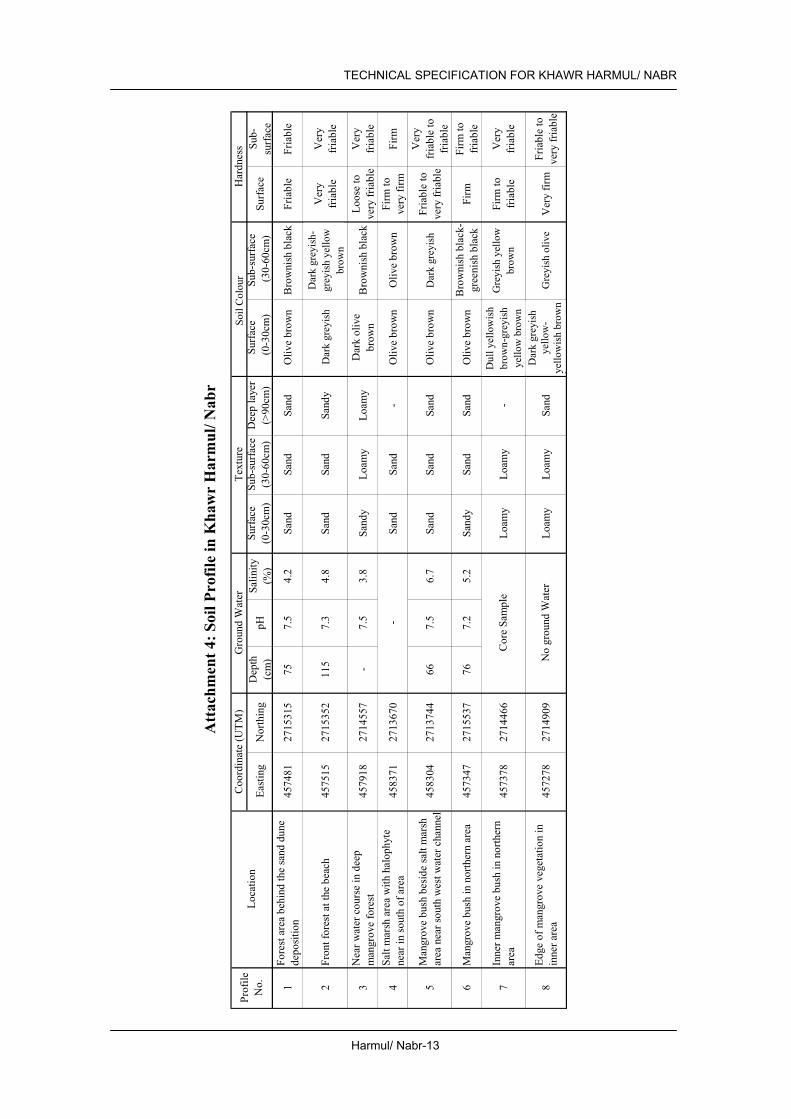
mouths of Wadi Fizh on north and Wadi Bani Umar al Gharbi on south. Seawater only flows into southern Khawr Harmul from khawr mouth. In previous times, Harmul khawr was connected to Khawr Nabr, but connecting water channel is dried up at present. This khawr has been strongly affected by the sand sedimentation at beach side due to the shifting sand from beach. Soils at mouth of khawr are sandy. Deep (about 50cm) sand sedimentations are observed on top. No free water was observed at 100cm depth. Along the meandering channel of khawr under dense mangrove bush, loamy soils with dark greyish colour through layers are observed. Also at inner flat areas under scarce mangrove bushes, loamy surface soils and sandy subsurface soils are observed. Salinities of ground water were ranging from 4.2 to 6.7%. Details are shown in attached table “Attachment 4: Soil Profile in Khawr Harmul/ Nabr” and “Attachment 9: Soil Profile of Samples in Khawr Harmul/ Nabr”.
Water The waters in meandering water channels were murky. Salinities of surface water were ranging from 3.5 to 4.0% (July 2002). DO in water was ranging from 1.9 to 6.0mg/l. Lower values of DO (1.9mg/l) were observed on swamp water. There was no significant constraint on the values of COD (less than 4mg/l). Details are shown in attached table “Attachment 5: Surface Water Quality in Khawr Harmul/ Nabr”.

TECHNICAL SPECIFICATION FOR KHAWR HARMUL/ NABR
Harmul/ Nabr-2
Fauna On the landward side of the mangroves in wet sand fiddler crabs (Uca inversa) were found. In the mangroves, the mud snail Terebralia palustris was common, but crabs seemed to be scarce. Three crabs (Perisesarme guttatum, Metapograpsus thukuhar, Eurycarcinus orientalis) were collected. In the khawr channel below the picnic site, small hermit crabs (Diogenes) were common and swimming crabs (Thalamita crenata, Thalamita sp) were seen. The snails, Terebralia, and Cerithidea cingulata were common on the surface, while the bivalves, Dosinia alta and Laternula arseneoides occurred in small numbers buried in the sand. The sand pyramids and burrows of the ghost crab (Ocypode saratan) were abundant on the sea beach. A total of 24 fish species was recorded during the environmental monitoring of the Sohar Port development. Evans (1994) records the significant numbers (>1% of world population) of Black-headed and Yellow-legged Gulls. The Arabian collared kingfisher visits this mangrove site and may be more numerous than at Shinas. The other speciality of the Liwa mangroves is Sykes’s Warbler, which breeds in small numbers (Erikson et al, 2001). Wading birds and seabird species use this inlet and 108 birds were counted belonging to 13 species. Turtle nesting activity was reported by Salm & Jensen (1991) near the mangroves. The deliberate killing and accidental drowning of sea turtles in gill nets reported along the Batinah coast is not sustainable.
Flora The mangroves at Khawr Harmul branch in two main directions from the channel mouth. The main growth follows the permanent water channel to the southeast. To the north west, the water channel is shallow and is only flooded at high tide. Here mangroves have become covered by sand on the beach side and many appear to be dying. On the landward side mangrove trees follow minor watercourses joining the main khawr. In general the mangroves are young trees although the forest has been in existence for a long time. Surrounding sand flats supported salt-tolerant plants, (Cornulaca monacantha, Suaeda vermiculata (= fruticosa, Miller & Cope 1996) and Cyperus conglomeratus). Small depressions behind the mangroves were filled with the grass Aeluropus lagopoides, while a patch of Halocnemum strobilaceum occurred near the road. The central large open areas on the landward side between mangroves channels were either bare sand or supported small succulent shrublets of Arthrocnemum macrostachyum, which reached up to 30% plant cover. This plant was in poor condition (winter 2003) becoming smaller the further away from the mangroves with very short branches and appeared very dry.
Impacts from the Surrounding Areas
Deposition of sediment is occurring at the channel mouth, which may be related to the Sohar Port development. Waste material was observed at the site by Salm, and presumably dumped from the nearest village, Sahi Harmul.
1.3 Socio-economic Situation Population of the Wilayat (2001) 108 thousand Population of the Nearest Locality (1993) 2.7 thousand Main Economic Activities Commerce, industry, fishery and agriculture Infrastructure Access road to the picnic area.

TECHNICAL SPECIFICATION FOR KHAWR HARMUL/ NABR
Harmul/ Nabr-3
Main Usage Used for recreational activities for people in surrounding areas and visitors interested in mangrove forest and natural environment in Oman. Biological diversification is distinctive.
Community Interference with the Area Housing development at northern part, recreational development in the south.
Cultural Significance There are the historical remains of forts
1.4 Legal Setup and Development Plans Land Ownership and Land Use Designation None Development Plans in the Site and the Surrounding Area Picnic ground. Existing Conservation Proposal None
2. PROGRAMME AND PROJECT
2.1 Prerequisite Legal Setup for Land Use Control
Designate the Nature Reserve (NR) and Recreational Development Area (RDA) and set a distinct boundary of NR and RDA (see 4.2 Required Action for Conservation and Management)
Facility Development Control No permanent structure in NR, except hide for bird watching, sign and information boards, and boardwalk or pedestrian bridge. Footpath should be designated but not paved. No permanent commercial buildings such as restaurants, hotels, shops and mechanised amusement facilities in the park development area. Basic activities in this park are relaxation and picnicking. Partial lighting for safety only. Utilities lines (water and electricity should be at a minimum) and setback at 150 m from the edge of Mangrove.
2.2 Description of Programmes Facility Development Programme
(1) Visitor service and information facilities development (Figure 4 Proposed Pedestrian Bridge at Khawr Harmul/ Nabr).
Restoration and Afforestation Programme
(2) Mangrove maintenance project
Monitoring Programme (3) Mangrove monitoring project (4) Soil and water monitoring project (5) Fauna and flora monitoring project (6) Pollution monitoring project (7) Monitoring project on legal setup and development plans
Public Awareness Programme It will include an educational programme for school children and conservation campaign for residents of the Wilayat. Required materials and facilities are (8) Pamphlets and posters distributed to the residents, (9) Information boards describing significance of the natural environment.

TECHNICAL SPECIFICATION FOR KHAWR HARMUL/ NABR
Harmul/ Nabr-4
2.3 Implementation Mechanism Projects Responsible
Agencies Implementing
Body/ Agencies Related
Agencies (1) Visitor service and information facilities development. MRMEWR Wilayat Liwa MCI (2) Mangrove maintenance project MRMEWR Wilayat Liwa (3) Mangrove Monitoring Project MRMEWR Wilayat Liwa (4) Soil and Water Monitoring Project MRMEWR Wilayat Liwa (5) Fauna and Flora Monitoring Project MRMEWR MRMEWR/ Omani
Institute for Birds
(6) Pollution Monitoring Project MRMEWR Wilayat Liwa/ MRMEWR
(7) Monitoring Project on Legal Setup and Development Plans
MRMEWR MRMEWR
(8) Pamphlets and posters distributed to the residents MRMEWR MRMEWR MOE (9) Information boards MRMEWR MRMEWR MOE
2.4 Implementation Schedule Project
No. 1 st 2 nd 3 rd 4 th 5 th 6th 7th 8th 9 th 10 th
(1) (2) (3) (4) (5) (6) (7) (8) (9)
3. IMPLEMENTATION PLAN
3.1 Restoration and Afforestation
3.1.1 Existing Mangrove Area Location and Area Banks of water channel at Khawr Harmul and northern stretch along the coastline
are covered by mangrove. Total area of mangrove vegetation is 56 ha approximately. (Figure 2 Location Map)
Conditions of Existing Mangrove
Mangrove had been damaged by various activities including cutting of branches and feeding of leaves. But mangroves are now under protection and in good condition along main water channel of southern extending water channel. Many trees are standing decayed at surrounding landward borders of northern channel and beachfront. Heavy sand sedimentation on mangrove vegetation areas at beachfronts. Tallest trees reach a modest 6 to 7 metres height. No more natural regenerations although young trees common. There is no extending for mangrove at landward area because of surrounding Sabkha. Flowerings were observed but the trees along water channel will produce seeds. Trees at parking area have been damaged by the soil of reclamation. The changing of khawr mouth by sand shifting may have an effect on the growing of trees. Some trees are cut for firewood. Much garbage in and around mangrove vegetation at surrounding landward borders.

TECHNICAL SPECIFICATION FOR KHAWR HARMUL/ NABR
Harmul/ Nabr-5
3.1.2 Plantation Potential Area Tidal Condition Normal: Disturbed (Deposition of sediment is occurring at the channel
mouth) Wave and Wind Calm in summer, drifted sand will close mouth of site Flood Every 5 to 10 years Water Salinity and pH Salinity; 3.5 ~ 4.3 %, pH; 7.5 ~ 8.2 (“Attachment 5: Surface Water
Quality in Khawr Harmul/ Nabr”) Soil Conditions Heavy sedimentation area in beach, landed mangrove area, sandy soil
along beach, silty surface soil in inner course of site. Surveyed data is in the “Attachment 4: Soil Profile in Khawr Harmul/ Nabr” of this technical specification.
Potential Area N/A
3.1.3 Conservation Area Area of Land Use Park Development Area
3.1.4 Required Action for Conservation and Management Inspection Daily observation by management body, 2 to 4 times of inspection by
MRMEWR (Mangrove Information Centre) Cleaning Management Body Replantation of Seedlings Growing Bad, Dead or Washed Away
MRMEWR (Mangrove Information Centre) for 5 years after plantation.
Service for Associated Facilities
Regularly by Management Body
Patrol and Enforcement Daily ordinary patrol by a police office of Wilayat is required, and the management body regularly inspects facilities conditions and littering and waste disposal to the ground and water in NR areas.
Restoration and Rehabilitation Work
The mangrove plantation work in the planting area described in the previous section is necessary. The pedestrian bridge is reconstructed to improve the water environment in the existing mangrove area (Figure 4: Proposed Pedestrian Bridge at Khawr Harmul/ Nabr).
Facilities Required for the Conservation and Management Activities
Directional signs along the highway and entrance to the access road(s), guide signs in the reserve, and information boards in the NR area can be seen in the area to explain the significance of the reserve and major flora and fauna. Footpath and boardwalk for observation of wildlife as well as mangrove are also necessary.
3.2 Monitoring
3.2.1 Mangrove Monitoring Method Label trees for monitoring. Monitor mangrove by using the attached
“Attachment 1: Field Monitoring Sheet for Mangrove”. Frequency Existing mangrove:
Every 2 years

TECHNICAL SPECIFICATION FOR KHAWR HARMUL/ NABR
Harmul/ Nabr-6
Monitoring Target Existing mangrove: 1) Nb-OT1: Coordinate Easting 457068 /Northing 2716022 2) Hr-OT1: Coordinate Easting 457525 /Northing 2715273 3) Hr-OT7: Coordinate Easting 457796 /Northing 2714669 4) Hr-OT11: Coordinate Easting 458131 /Northing 2713976
Baseline Data Baseline data and monitoring trees are listed in “Attachment 2: List of the Observed Points in Khawr Harmul & Nabr”.
3.2.2 Soil and Water Monitoring Method Monitor soil and water in and around mangrove vegetation by using
attached table “Attachment 3: Field Monitoring Sheet for Soil and Water (Khawr Harmul/ Nabr)”.
Frequency Soil: (Existing mangrove area) Every 2 Years Water; Every year (Outflow water at low tide should be measured.)
Monitoring Target Attachment 3 Baseline Data See attached table “Attachment 4: Soil Profile in Khawr Harmul/
Nabr” and “Attachment 5: Surface Water Quality in Khawr Harmul/ Nabr”.
3.2.3 Fauna and Flora Monitoring Method Monitor fauna and flora by using the attached “Attachment 6: Field
Monitoring Sheet for Fauna and Flora and Pollution.” For the observation of birds, an institute that is studying birds in Oman can be the best institute to take a part of the monitoring work by sub-contract basis.
Frequency At least twice a year Monitoring Target Attachment 6 Baseline Data The result of field reconnaissance of fauna and flora is shown in
“Attachment 7: Result of Field Reconnaissance of Fauna and Flora and Pollution in Khawr Harmul/ Nabr”.
3.2.4 Pollution (garbage and waste) Monitoring Method Monitor pollution by using the attached “Attachment 6: Field
Monitoring Sheet for Fauna and Flora and Pollution.” Water Quality and Soil Sample Tests should be carried out by MRMEWR.
Frequency At least twice a year Monitoring Target Attachment 6 Baseline Data See “Attachment 7: Result of Field Reconnaissance of Fauna and
Flora and Pollution in Khawr Harmul/ Nabr”.
3.2.5 Change on Legal Setup and Development Plans Frequency Monitoring Target Land Ownership, Land Use Designation, Development Plans in the Site
and Surrounding Area

TECHNICAL SPECIFICATION FOR KHAWR HARMUL/ NABR
Harmul/ Nabr-7
Figure 1 Key Map

TECHNICAL SPECIFICATION FOR KHAWR HARMUL/ NABR
Harmul/ Nabr-8
Figure 2 Location Map

TECHNICAL SPECIFICATION FOR KHAWR HARMUL/ NABR
Harmul/ Nabr-9
Figure 3 Planting Map

TECHNICAL SPECIFICATION FOR KHAWR HARMUL/ NABR
Harmul/ Nabr-10
Attachment 1: Field Monitoring Sheet for Mangrove (Khawr Harmul/ Nabr)
Mangrove Observation Recors
1) Identification No.
2) Location by GPS (WGS 84, UTM)Easting:
Northing:
3) Photograph No.
4) Observation of tree size and shape a) Tree Height (cm)b) Trunk diameter near botto m (cm)C) Live branches at the position about 1.3m off the center of tree bottom (painted)
Branch/ limb diameter measured in cm1 2 3 4
5 6 7 8
9 10
5) Obsrevation of tree history, helth and environmenta) History
Tree shape: Sign of cut in the past:
b) Health Nodes with leaves:
Inter-node length:Leaf length:Leaf color:
Looks / die back:
C) EnvironmentSoil depth / texture:
Surface water Salinity:Ground level:
Position:
Note:
Memo:(specific information or data significant for the tree willbe written here)
Records
b) Trunk diameter near bottom (cm) c) Live branches at the position about 1.3m off the centre of tree bottom (painted)
5) Observation of tree history, health and environment
c) Environment
Leaf colour:

Harmul/ Nabr-11
TECHNICAL SPECIFICATION FOR KHAWR HARMUL/ NABR
Att
achm
ent 2
: Lis
t of t
he O
bser
ved
Poin
ts in
Kha
wr
Har
mul
/ Nab
r
12
34
56
78
910
Nab
rH
b-O
T11
30 Ju
l.'02
4570
6827
1602
2liw
atre
e1a
& 1
b42
213
1210
76
Nab
rH
b-O
T230
Jul.'
0245
7147
2715
926
411
Nab
rH
b-O
T330
Jul.'
0245
7455
2715
442
313
Har
mul
Hr-O
T12
30 Ju
l.'02
4575
2527
1527
3liw
atre
e2a
& 2
b44
526
258
55
Har
mul
Hr-O
T230
Jul.'
0245
8127
2714
484
350
Har
mul
Hr-O
T330
Jul.'
0245
8045
2714
435
563
35H
arm
ulH
r-OT4
30 Ju
l.'02
57.5
Har
mul
Hr-O
T530
Jul.'
0245
7782
2714
660
622
3522
12H
arm
ulH
r-OT6
30 Ju
l.'02
4577
9327
1470
0H
arm
ulH
r-OT7
330
Jul.'
0245
7796
2714
669
liwat
ree3
b54
322
1610
8H
arm
ulH
r-OT8
30 Ju
l.'02
4583
6127
1382
867
915
Har
mul
Hr-O
T930
Jul.'
0245
8108
2713
718
566
277
Har
mul
Hr-O
T10
30 Ju
l.'02
4581
4527
1396
756
220
1913
11H
arm
ulH
r-OT1
14
30 Ju
l.'02
4581
3127
1397
6liw
atre
e4a
& 4
b66
044
2815
127
66
5.5
Kha
wr
Tre
eN
umbe
rM
onito
ring
Tre
esD
ate
ofO
bser
vatio
nR
emar
ksEa
stin
gN
orth
ing
Trun
kne
arbo
ttom
Live
bra
nche
s at t
he p
ositi
on a
bout
1.3
m o
ff th
ece
nter
of t
ree
botto
m(D
BH
: Dia
met
er B
reat
h H
eigh
t)
Coo
rdin
ate
(UT
M)
Phot
o N
umbe
rH
eigh
t(c
m)
Dia
met
er (c
m)
Live
bra
nche
s at t
he p
ositi
on a
bout
1.3
m o
ff th
e ce
ntre
of t
ree
botto
m
(DB
H: D
iam
eter
Bre
ast H
eigh
t)

TECHNICAL SPECIFICATION FOR KHAWR HARMUL/ NABR
Harmul/ Nabr-12
Attachment 3: Field Monitoring Sheet for Soil & Water (Khawr Harmul/ Nabr)
Location Date / time: / ,200
: Recorder
General Condition in plantation area:
(garbage, rubbish, leaf, alga, crab, shell, etc)
(1) Soil Condition Existing
Mangrove ① Existing
Mangrove ② Easting 458300 457500 Coordinate Northing 2714100 2715350
Surface condition 0-10cm
30-40cm Soil Texture 50-60cm
0-10cm 30-40cm Soil
Colour 50-60cm Root development Depth of surface humus
GWL* (cm) pH Free
water Salinity (%) Soil colour by Munsell notation, GPS*:by UTM of WGS84 GWL: Ground water level
(2) Surface Water Quality (Observation time: : ) Upstream Khawr③ Sea water ④ Khawr mouth⑤
Easting 458710 458800 457910 Coordinate Northing 2713540 2713600 2714850 Surface waste pH Salinity (%) Temperature (C) DO (mg/l) Turbidity / Colour
●Soil ○ Water
4 2
3 5
1
Location of monitoring
Harmul/ Nabr-13
TECHNICAL SPECIFICATION FOR KHAWR HARMUL/ NABR
Att
achm
ent 4
: Soi
l Pro
file
in K
haw
r H
arm
ul/ N
abr
East
ing
Nor
thin
gD
epth
(cm
)pH
Salin
it y(%
)Su
rfac
e(0
-30c
m)
Sub-
surf
ace
(30-
60cm
)D
eep
laye
r(>
90cm
)Su
r fac
e (
0-30
cm)
Sub-
surf
ace
(30-
60cm
)Su
rfac
eSu
b-su
rfac
e
1Fo
rest
are
a be
hind
the
sand
dun
ede
posi
tion
4574
8127
1531
575
7.5
4.2
Sand
Sand
Sand
Oliv
e br
own
Bro
wni
sh b
lack
Fria
ble
Fria
ble
2Fr
ont f
ores
t at t
he b
each
4575
1527
1535
211
57.
34.
8Sa
ndSa
ndSa
ndy
Dar
k gr
ayis
hD
ark
gray
ish-
gray
ish
yello
wbr
own
Ver
yfr
iabl
eV
ery
fria
ble
3N
ear w
ater
cou
rse
in d
eep
man
grov
e fo
rest
4579
1827
1455
7-
7.5
3.8
Sand
yLo
amy
Loam
yD
ark
oliv
ebr
own
Bro
wni
sh b
lack
Loos
e to
very
fria
ble
Ver
yfr
iabl
e
4Sa
lt m
arsh
are
a w
ith h
alop
hyte
near
in so
uth
of a
rea
4583
7127
1367
0Sa
ndSa
nd-
Oliv
e br
own
Oliv
e br
own
Firm
tove
ry fi
rmFi
rm
5M
angr
ove
bush
bes
ide
salt
mar
shar
ea n
ear s
outh
wes
t wat
er c
hann
el45
8304
2713
744
667.
56.
7Sa
ndSa
ndSa
ndO
live
brow
nD
ark
gray
ish
Fria
ble
tove
ry fr
iabl
e
Ver
yfr
iabl
e to
fria
ble
6M
angr
ove
bush
in n
orth
ern
area
4573
4727
1553
776
7.2
5.2
Sand
ySa
ndSa
ndO
live
brow
nB
row
nish
bla
ck-
gree
nish
bla
ckFi
rmFi
rm to
fria
ble
7In
ner m
angr
ove
bush
in n
orth
ern
area
4573
7827
1446
6Lo
amy
Loam
y-
Dul
l yel
low
ish
brow
n- g
rayi
shye
llow
bro
wn
Gra
yish
yel
low
brow
nFi
rm to
fria
ble
Ver
yfr
iabl
e
8Ed
ge o
f man
grov
e ve
geta
tion
inin
ner a
rea
4572
7827
1490
9Lo
amy
Loam
ySa
ndD
ark
gray
ish
yello
w-
yello
wis
h br
own
Gra
yish
oliv
eV
ery
firm
Fria
ble
tove
ry fr
iabl
e
Har
dnes
sPr
ofile
No.
Loca
tion
Coo
rdin
ate
(UTM
)G
roun
d W
ater
Cor
e Sa
mpl
e
No
grou
nd W
ater
Text
ure
Soil
Col
or
-
Soil
Col
our
Dar
k gr
eyis
hD
ark
grey
ish-
gr
eyis
h ye
llow
br
own
Dar
k gr
eyis
h
Dul
l yel
low
ish
brow
n-gr
eyis
h ye
llow
bro
wn
Dar
k gr
eyis
h ye
llow
- ye
llow
ish
brow
n
Gre
yish
yel
low
br
own
Gre
yish
oliv
e

Harmul/ Nabr-14
TECHNICAL SPECIFICATION FOR KHAWR HARMUL/ NABR
Att
achm
ent 5
: Sur
face
Wat
er Q
ualit
y in
Kha
wr
Har
mul
/ Nab
r
East
ing
Nor
thin
g
1Sw
amp
wat
er b
ehin
d kh
awr m
outh
4576
4927
1490
8++
7.8
4.3
30.6
1.86
2-4
< 1
2M
id st
ream
of t
ribut
ary
of so
uth
khaw
r45
7935
2714
538
++7.
53.
833
2.38
--
3M
id st
ream
of s
outh
kha
wr n
ear
open
spac
e45
8371
2713
762
++7.
53.
633
.82.
762-
4<
1
4Fr
ant o
f par
king
are
a45
8692
2713
577
+8.
23.
734
.16.
03-
-
5N
ear k
haw
r mou
th45
7919
2714
852
±8.
24.
033
4.91
-<
1
6M
idst
ream
of s
outh
kha
wr (
1)45
8104
2714
593
Cle
ar8.
23.
534
5.06
--
7M
idst
ream
of s
outh
kha
wr (
2)45
8255
2714
279
±8.
23.
533
.85.
03-
-
8M
idst
ream
of s
outh
kha
wr (
3)45
8423
2714
002
±7.
93.
835
.24.
852
-
9Sw
amp
wat
er n
ear s
abkh
a45
7933
2713
837
++7.
84.
033
.54.
932-
4<
1
10In
ner k
haw
r nea
r sou
th w
adi
4580
5127
1399
6++
8.0
4.0
33.9
5.23
2-
11M
outh
of k
haw
r45
7877
2714
975
Cle
ar8.
03.
9-
--
-
12Fr
ont o
f par
ting
area
4587
1027
1353
6+
8.4
3.9
36.6
7.9
--
13B
ack
side
of m
angr
ove
at so
uth
(1)
4579
6427
1380
9+
7.9
3.9
33.6
3.9
--
14B
ack
side
of m
angr
ove
at so
uth
(2)
4581
6727
1408
0+
8.3
3.8
35.7
6.6
--
15St
agan
at w
ater
4574
0827
1488
5+
8.3
4.5
35.0
6.6
--
Obs
erva
tion
Dat
e: 2
July
, 200
2 fo
r Sam
ple
No.
1-10
, 13
May
200
3 fo
r sam
ple
No.
11-1
5
CO
D(m
g/l)
NO
3(m
gNO
3 /l)N
o.Lo
catio
nC
oord
inat
e (U
TM)
Col
or/
Vis
ibili
typH
Salin
ity(%
)Te
mpe
ra-
ture
(C)
DO
(mg/
l)
Fron
t of p
arki
ng a
rea
Col
our/
Vis
ibili
ty

TECHNICAL SPECIFICATION FOR KHAWR HARMUL/ NABR
Harmul/ Nabr-15
Attachment 6: Field Monitoring Sheet for Fauna and Flora and Pollution (Khawr Harmul/ Nabr)
Location Khawr Harmul & Nabr, Liwa Date Time Tide Recorder Bird counts: species: numbers Expected birds: Gulls, Terns, Herons, Waders, Osprey Characteristic species: White-collared Kingfisher/Sykes’s Warbler Pollution: Evidence of: solid waste (garbage), liquid waste, oil. Water quality: clear/muddy/green/salinity Fishing: Domestic/feral animals: Vegetation: Mangroves: Arthrocnemum zone: Suaeda vermiculata/Cyperus conglomeratus: Surrounding sandy area: Dune vegetation: Evidence of: grazing, cutting, flowering, seeds: Animals: Snails: Terebralia, Cerithidea, Bivalves: Dosinia, Laternula Crabs: Landward fringe: Uca Among trees: Metopograpsus, Perisesarma, Eurycarcinus, In channel: Thalamita, Portunus On beach: Ocypode Other comments:

TECHNICAL SPECIFICATION FOR KHAWR HARMUL/ NABR
Harmul/ Nabr-16
Attachment 7: Result of Field Reconnaissance of Fauna and Flora and Pollution in Khawr Harmul/ Nabr
Field Monitoring Sheet for Fauna and Flora and Pollution Sample (1) Location Khawr Harmul & Nabr, Liwa Date 24/9/2002 Time 16.00 Tide Low tide of 1.1m Recorder N.V. Clarke Bird counts: species: 18 numbers 108 Gulls 6, Terns 80, Herons 5, Waders 16, Osprey 1 Characteristic species: White-collared Kingfisher/Sykes’s Warbler - not seen Pollution: Evidence of: solid waste (garbage), liquid waste, oil none Water quality: clear/muddy/green/salinity clear water but high temperatures recorded Fishing: nets none Domestic/feral animals: dog tracks Vegetation: Surrounding sand flats support salt-tolerant plants typical of coastal plain. Juncus rigidus in watercourses. On drier shelly sand Cornulaca monacantha. On more consolidated ground, often with beach rock, Suaeda vermiculata and Cyperus conglomeratus dominate with a patch of Halocnemum strobilaceum. Depressions behind the main mangrove channel were filled with the grass Aeluropus lagopoides. The central large open areas between mangroves channels were either bare sand or supported small succulent shrublets of Arthrocnemum macrostachyum, which reached up to 30% plant cover. This plant was in poor condition becoming smaller the further away from the mangroves with very short branches and appearing dried out. Older mangrove trees had branches cut from previous years but no recent cutting. Invertebrates: The animals living on and in the substrate were sampled. On the landward side of the mangroves in wet sand across from the picnic site, fiddler crabs (Uca inversa) were found. The burrow density was about 15/m2. In the mangroves, the mud snail Terebralia palustris was common, but crabs seemed to be scarce. Two crabs (Metopograpsus thukuhar, Eurycarcinus orientalis) were collected. In the khawr channel below the picnic site, small hermit crabs were common and one Thalamita crenata was seen. The snails, Terebralia, and Cerithidea cingulata were common on the surface, while the bivalves, Dosinia alta and Laternula arseneoides occurred in small numbers in the sand. Towards the mouth, mangrove snails decreased and ghost crabs (Ocypode saratan) were numerous. Other comments: To the north west, the water channel is shallow and is only flooded at high tide. Here mangroves have become covered by sand on the beach side and many appear to be dying. Increased deposits of sand on the beach may be related to Sohar Port development.

TECHNICAL SPECIFICATION FOR KHAWR HARMUL/ NABR
Harmul/ Nabr-17
Field Monitoring Sheet for Fauna and Flora and Pollution Sample (2) Location Khawr Harmul & Nabr, Liwa Date 12/07/03 Time 13.00 Tide mid tide Recorder N.V. Clarke Bird counts: species: 7 numbers 30 1 Night Heron, Waders (7 Whimbrel), Gulls and Terns on the beach Characteristic species: White-collared Kingfisher - 2 seen
Sykes’s Warbler - not seen Pollution: Evidence of: solid waste (garbage), liquid waste, oil none Water quality: clear/muddy/green/salinity clear water Fishing: nets none Domestic/feral animals: dog tracks Vegetation: Surrounding sand flats support salt-tolerant plants typical of coastal plain. Juncus rigidus in watercourses. Cornulaca monacantha on drier shelly sand. On more consolidated ground, often with beach rock, Suaeda vermiculata and Cyperus conglomeratus dominate. A patch of Halocnemum strobilaceum occurred near the road. Depressions behind the main mangrove channel were filled with the grass Aeluropus lagopoides. The central large open areas between mangroves channels were either bare sand or supported small succulent shrublets of Arthrocnemum macrostachyum, which reached up to 30% plant cover. This plant was in poor condition becoming smaller the further away from the mangroves with very short branches and appearing dried out. Evidence of previous cutting of branches. Trees are generally small and ground level is high. Trees are healthy on the east but no new seedlings on the west side of the khawr. Animals: On the landward side of the mangroves in wet sand, fiddler crabs (Uca inversa) were found. In the mangroves, the mud snail Terebralia palustris was common, but crabs seemed to be scarce. Two crabs (Metopograpsus thukuhar, Eurycarcinus orientalis) were collected. Another fiddler crab (Uca annulipes) occurred among the mangroves. In the khawr channel small hermit crabs were common and swimming crabs (Thalamita sp) were seen. The snails, Terebralia, and Cerithidea cingulata were common on the surface, while the bivalves, Dosinia alta and Laternula arseneoides occurred in small numbers in the sand. Towards the mouth, mangrove snails decreased and ghost crabs (Ocypode saratan) were numerous. Other comments: To the north west, the water channel is shallow and is only flooded at high tide. Here mangroves have become covered by sand on the beach side and many appear to be dying. Increased sedimentation may be due to the Sohar Port development.

TECHNICAL SPECIFICATION FOR KHAWR HARMUL/ NABR
Harmul/ Nabr-18
Attachment 8: Site Photos (Khawr Harmul/ Nabr)
General Condition
Mangrove along water channel at parking area Mangrove and garbage at landward edge
Mangrove Vegetation
Healthy mangrove along water channel Standing dead trees at landward edge
Soil Condition
Front forest at the beach (Profile No. 2)
Inner mangrove bush in northern area (Profile No. 7)

Harmul/ Nabr -19
TECHNICAL SPECIFICATION FOR KHAWR HARMUL/ NABR
(Kha
wr H
armu
l-Nab
r, Pr
ofile
No. 2
) Lo
catio
n Fr
ont fo
rest
at the
beac
h Co
ordin
ate (U
TM)
Easti
ng: 4
5752
1 N
orthi
ng: 2
7150
87
Phys
iogra
phic
posit
ion
Coas
tal du
ne
Topo
grap
hy
Undu
lating
So
il Clas
sifica
tion
Typic
Tor
ripsa
mmen
ts Pa
rent
mater
ial
Marin
e dep
osit
Depth
of fr
ee
water
11
5cm
Vege
tation
/ ma
ngro
ve
Mang
rove
vege
tation
Desc
riptio
n of s
oil pr
ofile
C 0-
55cm
Da
rk gr
eyish
yello
w (2
.5Y 4/
2), v
ery f
riable
, coa
rse sa
nd
with
single
grain
stru
cture
and n
on-st
icky c
onsis
tency
; se
dimen
tation
by si
fting s
and;
grad
ual ir
regu
lar bo
unda
ry (se
dimen
tation
by si
fting s
and)
C
55-7
7cm
Olive
brow
n (2.5
Y 4/3
), fria
ble, c
oarse
sand
with
mas
sive
struc
ture a
nd no
n-sti
cky c
onsis
tency
; few
small
roots
; few
shell
frag
ment;
clea
r, wa
vy bo
unda
ry
C 77
-85c
m Du
ll yell
owish
brow
n (10
YR 4/
2.5),
friable
, coa
rse sa
nd
with
mass
ive st
ructu
re an
d non
-stick
y con
sisten
cy; m
any
dark
olive
brow
n (7.5
YR 3/
2) an
d oliv
e bro
wn (7
.5YR
4/4)
mottle
s; few
small
root;
grad
ual w
avy b
ound
ary
C 85
-103
cm
Grey
ish ol
ive (5
Y 4/2
), fria
ble, lo
amy s
and w
ith m
assiv
e str
uctur
e and
non-
stick
y con
sisten
cy; m
any g
rey (
5Y
3.5/1)
and o
live b
rown
(7.5Y
R 4/4
) mott
les; fe
w sm
all
root;
man
y she
ll fra
gmen
t C
103-
120c
m Bl
ack (
10Y
2/1),
loamy
sand
(by a
uger
) *1
: Des
cripti
ons o
f stru
cture
and b
ound
ary a
re es
timate
d fro
m lim
ited o
bser
vatio
n of c
ore s
ample
. *2
: Tex
ture w
as cl
assif
ied at
field
by vi
sual
and t
ouch
ing ob
serva
tion
(Kha
wr H
armu
l-Nab
r, Pr
ofile
No. 7
) Lo
catio
n Inn
er m
angr
ove b
ush i
n nor
thern
area
Co
ordin
ate (U
TM)
Easti
ng: 4
5738
3 N
orthi
ng: 2
7142
02
Phys
iogra
phic
posit
ion
Lowe
r ter
race
To
pogr
aphy
Fla
t
Soil C
lassif
icatio
n Ty
pic F
ulvaq
uents
Pa
rent
mater
ial
Alluv
ial de
posit
De
pth of
free
wa
ter
77cm
Vege
tation
/ ma
ngro
ve
Mang
rove
vege
tation
Ob
serva
tion o
f cor
e sam
ple *1
De
scrip
tion o
f soil
profi
le A
0-8c
m Gr
eyish
olive
(5Y
5/3),
firm, s
ilty lo
am w
ith w
eak,
sub-
angu
lar
block
y stru
cture
and s
lightl
y stic
ky co
nsist
ency
; gra
dual
boun
dary
C 8-
34cm
Da
rk gr
eyish
yello
w (5
Y 4/2
), fria
ble, s
ilty cl
ay lo
am w
ith
weak
, sub
-ang
ular b
locky
stru
cture
and s
ticky
cons
isten
cy;
grad
ual w
avy b
ound
ary
C
34-5
3cm
Dark
grey
ish ye
llow
(5Y
4/2),
very
friable
, silty
clay
loam
with
ma
ssive
bloc
ky st
ructu
re an
d stic
ky co
nsist
ency
; man
y br
own (
7.5YR
4/6)
mott
le; cl
ear,
wavy
boun
dary
C 53
-65c
m Da
rk gr
eyish
yello
w (5
Y 4/2
), fria
ble, lo
amy s
and w
ith
mass
ive bl
ocky
stru
cture
and s
lightl
y stic
ky co
nsist
ency
; ma
ny bl
ack (
N 2/0
) and
brow
n (7.5
YR 4/
3) m
ottles
; few
shell
fra
gmen
t; clea
r, wa
vy bo
unda
ry C
65-9
4cm
Blac
k (N
2/0),
coar
se sa
nd w
ith fr
iable,
mas
sive s
tructu
re
and n
on-st
icky c
onsis
tency
; man
y she
ll fra
gmen
ts *1
: Des
cripti
ons o
f stru
cture
and b
ound
ary a
re es
timate
d fro
m lim
ited o
bser
vatio
n of c
ore s
ample
. *2
: Tex
ture w
as cl
assif
ied at
field
by vi
sual
and t
ouch
ing ob
serva
tion
Att
achm
ent 9
: Soi
l Pro
file
of S
ampl
es in
Kha
wr
Har
mul
and
Nab
r

Technical Specification for Khawr Sawadi

TECHNICAL SPECIFICATION FOR KHAWR SAWADI
Sawadi-1
1. SITE DESCRIPTION
1.1 Location Governorate/ Region Al Batinah Wilayat Sawadi Distance from the Centre of Wilayat
The centre of Wilayat is Barka located 10 km east of the site.
Nearest Locality Al Sawadi As Sahil. A village of Sawadi al Batha is the residential area located at the north-west of the site.
Fame of the Site/ Distinctive Features
Ras as Sawadi is a well known beach resort in Oman because of its proximity to Muscat and its base for one of the most popular diving spots of coral reef in Oman.
Facilities in the Site None Features of Surrounding Areas This site is located north of Al Sawadi town approximately 10 km north
of the National Highway. Ras as Sawadi and an old fort are situated on top of the islet.
1.2 Natural Conditions Climate Zone Batinah Zone General Terrain Flat plain Geological Features This tidal inlet is a site chosen for planting of some mangrove
seedlings. Soil Khawr Sawadi has a wide tidal area along two meandering khawrs.
Halophyte vegetation in surrounding salt marsh area are observed but few halophytes are observed on high elevation areas in the khawr. There is no wadi inflow into this khawr. Soils are deep with aerobic condition. Textures are almost sandy in all layers except on water channel. Some areas on middle and upper water channels show relatively silty surface layers but sandy in subsurface with anaerobic conditions. Accumulations of organic matter in the surface are observed in some places. The eroded banks are relatively high in topography. These soils are deep and very soft, but relatively steep. On the other hand, the soils of deposited banks have soft and deep surface layers and gentle slope. The soils upstream, which is the southern parts of mapping area, have more reddish colour than the areas downstream. Many mottles in the subsurface at these areas were also observed. Salinities of ground water ranged from 3.5 to 8.1%. Salinities of groundwater at terraces and deposited banks of the upper khawr were relatively high. Details are shown in attached table “Attachment 4: Soil Profile in Khawr Sawadi” and “Attachment 9: Soil Profile of Samples in Khawr Sawadi”.
Water Seawater intrudes frequently into all water channels and circulation of seawater was good. Water was clear. Salinities of surface water were ranging from 4.0 to 4.7%. Values of DO were more than 5mg/l. There was no significant constraint on the values of COD (less than 2mg/l). Details are shown in attached table “Attachment 5: Surface Water Quality in Khawr Sawadi”.

TECHNICAL SPECIFICATION FOR KHAWR SAWADI
Sawadi-2
Fauna On the wet sandy bank, bordering the khawr channel, the hermit crab (Coenobita scaevola) and the large ghost crab (Ocypode rotundata) were found. On the lower bank, small ocypodid crabs (Scopimera scabricauda) form small burrows surrounded by sand feeding balls. In the khawr channel nearby, small hermit crabs (Diogenes) were very abundant using small horn shells (Cerithidea cingulata) for protection. The small snail, Umbonium vestiarium, was fairly common. Sediment samples from the channel contained revealed burrowing callianassid shrimps, isopods (Eurydice), amphipods, bivalves (Dosinia contracta), nereid worms and several tube-forming annelids. Wading birds and seabird species use this inlet and 51 birds were counted belonging to 12 species. An area near the mouth of the tidal inlet was chosen for experimental planting of mangrove seedlings.
Flora Khawr Sawadi is surrounded by a large sandy plain with salt tolerant plants. Three species were recorded: Halopeplis perfoliata, Limonium stocksii and Cornulaca monacantha. Seagrasses and filamentous algae grew in the channel near the mouth.
Impacts from the Surrounding Areas
If the nearby rocky islands at Ras Sawadi are included in the site, it becomes a good site for guests to see wildlife at the nearby hotel. The breeding birds on the island (Western Reef Heron and Sooty Falcon) and the site need to be protected from any disturbance.
1.3 Socio-economic Situation Population of the Wilayat (2001)
77 thousand
Population of the Nearest Locality (1993)
4.0 thousand
Main Economic Activities Fishery, agriculture and tourism Infrastructure Paved access road constructed to the beach and car park at Sawadi cape
for tourists. Main Usage The site is in the proposed A’ Sawadi tourism development zone.
Khawr Sawadi is expected to be a nature conservation and eco-tourism area, which attracts tourists to visit this zone.
Community Interference with the Area
Developing the area as a resort area for tourism. Khawr Sawadi may be included in a part of the tourism development.
Cultural Significance None
1.4 Legal Setup and Development Plans Land Ownership and Land Use Designation
Nature Reserve (NR)
Development Plans in the Site and the Surrounding Area
Sawadi Tourism Development Plan (see figure shown below)
Existing Conservation Proposal
Studies by the IUCN (1986-1992) recommended this popular resort area to be managed as Ras Sawadi National Recreation Area and Scenic Reserve. The reserve boundaries included the khawr, the surrounding sabka and the beaches, as well as the group of 7 rocky offshore islands located just off the main land. The proposed reserve has the greatest concentration of nesting reef herons in the capital area, a major nesting site for sooty falcons and important coral habitat around the islands.

TECHNICAL SPECIFICATION FOR KHAWR SAWADI
Sawadi-3
2. PROGRAMME AND PROJECT
2.1 Prerequisite Legal Setup for Land Use Control
Designate NR. Set a distinct boundary of NR (see 4.2 Required Action for Conservation and Management)
Facility Development Control No permanent structure in NR, except hide for bird watching, sign and information boards, and boardwalk or pedestrian bridge. Footpath should be designated but not paved. No permanent commercial buildings such as restaurants, hotels, shops and mechanised amusement facilities in the park development area. Basic activities in this park are relaxation and picnicking. Partial lighting for safety only. Utilities lines (water and electricity should be at a minimum) and setback at 150 m from the edge of Mangrove.
2.2 Description of Programmes Facility Development Programme
(1) Nursery construction (2) Visitor service and information facilities development.
Restoration and Afforestation Programme
(3) Mangrove planting project
Monitoring Programme (4) Mangrove monitoring project (5) Soil and water monitoring project (6) Fauna and flora monitoring project (7) Pollution monitoring project (8) Monitoring project on legal setup and development plans
Public Awareness Programme It will include an educational programme for school children and conservation campaign for residents of the Wilayat. Required materials and facilities are (9) Pamphlets and posters distributed to the residents, (10) Information boards describing significance of the natural environment.
2.3 Implementation Mechanism
Projects Responsible Agencies
Implementing Body/
Agencies Related
Agencies (1) Visitor service and information facilities development MRMEWR Wilayat Sawadi MCI (2) Mangrove maintenance project MRMEWR Wilayat Sawadi (3) Mangrove Monitoring Project MRMEWR MRMEWR (4) Soil and Water Monitoring Project MRMEWR MRMEWR (5) Fauna and Flora Monitoring Project MRMEWR MRMEWR/
Omani Institute for Birds
(6) Pollution Monitoring Project MRMEWR Wilayat Sawadi/ MRMEWR
(7) Monitoring Project on Legal Setup and Development Plans MRMEWR MRMEWR (8) Pamphlets and posters distributed to the residents MRMEWR MRMEWR MOE (9) Information boards MRMEWR MRMEWR MOE

TECHNICAL SPECIFICATION FOR KHAWR SAWADI
Sawadi-4
2.4 Implementation Schedule Project
No. 1 st 2 nd 3 rd 4 th 5 th 6th 7th 8th 9 th 10 th (1) (2) (3) (4) (5) (6) (7) (8) (9)
3. IMPLEMENTATION PLAN
3.1 Restoration and Afforestation
3.1.1 Existing Mangrove Area Location and Area No natural mangrove vegetation. Halophytes are growing on
surrounding khawr. Seedlings were transplanted at the shore near mouth of khawr in March 2001 and February 2003. The area of new plantation near the mouth of khawr is 1.5 ha. (Figure 2 Location Map)
Conditions of Existing Mangrove
The mangrove trees are in healthy condition and approximately 70 to 80% of trees are surviving. There are some damages by floating algae. Mangroves at lower intertidal zone are much healthier than those at higher zone. Tallest trees are almost reaching 1.5m and average height is 0.9m. New aerial roots are developing. There are many potential areas for new plantation.
3.1.2 Plantation Area Tidal Condition Normal: Normal tidal condition, flood on a huge tidal flat. Wave and Wind Calm in summer, but drifted green algae spoil seedlings; damages in
seaward fringe. Flood Every 5 to 10 years Water Salinity and pH Salinity; 4.1 ~ 4.7%, pH; 8.2 ~ 8.5 (“Attachment 5: Surface Water
Quality in Khawr Sawadi”) Soil Conditions Sandy soil with aerobic condition at whole area. The soils in this khawr
are deep and sandy in texture at almost all of areas. Surveyed data is in the “Attachment 4: Soil Profile in Khawr Sawadi” of this technical specification.
Potential Area Many places on shores. See “Figure 3 Planting Map”. There are many places suitable for plantation. Particularly the areas on deposited banks along the water channels have high potential areas. These areas have very gentle slope and coarse sand texture.

TECHNICAL SPECIFICATION FOR KHAWR SAWADI
Sawadi-5
Table 3.1 Location and Areas of Potential Planting Area(s)
Designated Area Area (ha) Area-1 (1) in Figure 3 3.1 Area-2 (2) in Figure 3 1.0 Area-3 (3) in Figure 3 1.5 Area-4 (4) in Figure 3 1.4 Area-5 (5) in Figure 3 1.8 Area-6 (6) in Figure 3 1.6
Note: see Figure 3.2
3.1.3 Planting Schedule Total Planting Area 10.4 ha Planting Season and Timing January ~ February Seed/ Seedlings Supply Source and Location
Plant Nursery will be constructed in the site by a private investor of the tourism development. At the initial stage it is supplied from the Nursery of MRMEWR at Qurm and Shinas
Planting Method Start from area (1) near present plantation area along west water channel. After the area is completed (1), move to area (4) along east water channel. Then move to area (2) along west water channel. Area (1), area (5), area (6) and area (3) will follow. Detailed technical guidelines should refer to the “Technical Guideline for Afforestation” attached with this technical specification.
Table 3.2 Planting Schedule
Year 1 st 2 nd 3 rd 4 th 5 th 6th 7th 8th 9 th 10 th Total Planting area-1 Planting area-2 Planting area-3 Planting area-4 Planting area-5 Planting area-6
Table 3.3 Seeds/ Seedling Supply Schedule
Year 1 st 2 nd 3 rd 4 th 5 th 6th 7th 8th 9 th 10 th Total Season/ time Jan, Feb Jan, Feb Jan, Feb Jan, Feb Jan, Feb Jan, Feb Jan, Feb Jan, Feb Jan, Feb Jan, Feb Planting area (ha) 1.04 1.04 1.04 1.04 1.04 1.04 1.04 1.04 1.04 1.04 Number of seeds/ seedlings (thousands)
10.4 10.4 10.4 10.4 10.4 10.4 10.4 10.4 10.4 10.4
3.1.4 Conservation Area Area of Land Use Resort development area

TECHNICAL SPECIFICATION FOR KHAWR SAWADI
Sawadi-6
3.1.5 Required Action for Conservation and Management Inspection Daily observation by management body, 2 to 4 times of inspection by
MRMEWR (Mangrove Information Centre) Cleaning Wilayat or Private sector Replantation of Seedlings Growing Bad, Dead or Washed Away
MRMEWR (Mangrove Information/ Management Centre) and/or private investor for 5 years after plantation.
Service for Associated Facilities Regularly by Wilayat or private sector Patrol and Enforcement Daily ordinary patrol by a police office of Wilayat is required, and the
management body regularly inspects facilities conditions and littering and waste disposal to the ground and water in NR areas.
Restoration and Rehabilitation Work
The mangrove plantation work in the planting area described in the previous section is necessary.
Facilities Required for the Conservation and Management Activities
Directional signs along the highway and entrance to the access road(s), guide signs in the reserve, and information boards in the NR area can be seen in the area to explain the significance of the reserve and major flora and fauna. Footpath and boardwalk for observation of wildlife as well as mangrove are also necessary.
3.2 Monitoring
3.2.1 Mangrove Monitoring Method Select and label trees for monitoring. Monitor mangrove by using the
attached “Attachment 1: Field Monitoring Sheet for Mangrove”. Frequency Planting mangrove:
First 4 years: annual monitoring After 4 years: every 2 years
Monitoring Target Planting mangrove: Select 20 trees at random and monitor them.
Baseline Data No natural mangrove in the khawr
3.2.2 Soil and Water Monitoring Method Monitor soil and water in and around mangrove plantation by using
attached table “Attachment 3: Field Monitoring Sheet for Soil and Water (Khawr Sawadi)”
Frequency Soil: (New plantation area) Before plantation and Every two years after plantation Water; Every year (Outflow water at low tide should be measured.)
Monitoring Target Attachment 3 Baseline Data See attached table “Attachment 4: Soil Profile in Khawr Sawadi”
and “Attachment 5: Surface Water Quality in Khawr Sawadi”

TECHNICAL SPECIFICATION FOR KHAWR SAWADI
Sawadi-7
3.2.3 Fauna and Flora Monitoring Method Monitor fauna and flora by using the attached “Attachment 6: Field
Monitoring Sheet for Fauna and Flora and Pollution”. For the observation of birds, an institute that is studying birds in Oman can be the best institute to take a part of the monitoring work by sub-contract base.
Frequency At least twice a year Monitoring Target Attachment 6 Baseline Data The result of field reconnaissance of fauna and flora is shown in
“Attachment 7: Result of Field Reconnaissance of Fauna and Flora and Pollution in Khawr Sawadi”.
3.2.4 Pollution (garbage and waste) Monitoring Method Monitor pollution by using the attached “Attachment 6: Field
Monitoring Sheet for Fauna and Flora and Pollution”. Water Quality and Soil Sample Tests should be carried out by MRMEWR.
Frequency At least twice a year Monitoring Target Attachment 6 Baseline Data See “Attachment 7: Result of Field Reconnaissance of Fauna and
Flora and Pollution in Khawr Sawadi”
3.2.5 Change on Legal Setup and Development Plans Frequency At least once a year Monitoring Target Land Ownership, Land Use Designation, Development Plans in the
Site and Surrounding Area

TECHNICAL SPECIFICATION FOR KHAWR SAWADI
Sawadi-8
Figure 1 Key Map

TECHNICAL SPECIFICATION FOR KHAWR SAWADI
Sawadi-9
Figure 2 Location Map

TECHNICAL SPECIFICATION FOR KHAWR SAWADI
Sawadi-10
Figure 3 Planting Map (Aerial Photo)
Figure Potential Area for Mangrove Plantation in Khawr Sawadi (On Aerial Photo)

Sawadi-11
TECHNICAL SPECIFICATION FOR KHAWR SAWADI
Figu
re
Pote
ntia
l Are
a fo
r M
angr
ove
Plan
tatio
n
in K
haw
r Sa
wad
i

TECHNICAL SPECIFICATION FOR KHAWR SAWADI
Sawadi-12
Figure 4 Proposed Tourism Development Plan
Figure 5 Proposed Ras Sawadi National Recreation Area and Scenic Reserve

TECHNICAL SPECIFICATION FOR KHAWR SAWADI
Sawadi-13
Attachment 1: Field Monitoring Sheet for Mangrove (Khawr Sawadi)
Mangrove Observation Recors
1) Identification No.
2) Location by GPS (WGS 84, UTM)Easting:
Northing:
3) Photograph No.
4) Observation of tree size and shape a) Tree Height (cm)b) Trunk diameter near botto m (cm)C) Live branches at the position about 1.3m off the center of tree bottom (painted)
Branch/ limb diameter measured in cm1 2 3 4
5 6 7 8
9 10
5) Obsrevation of tree history, helth and environmenta) History
Tree shape: Sign of cut in the past:
b) Health Nodes with leaves:
Inter-node length:Leaf length:Leaf color:
Looks / die back:
C) EnvironmentSoil depth / texture:
Surface water Salinity:Ground level:
Position:
Note:
Memo:(specific information or data significant for the tree willbe written here)
Records
b) Trunk diameter near bottom (cm) c) Live branches at the position about 1.3m off the centre of tree bottom (painted)
5) Observation of tree history, health and environment
c) Environment
Leaf colour:
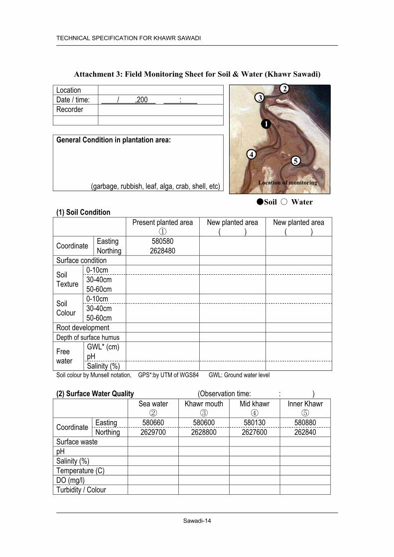
TECHNICAL SPECIFICATION FOR KHAWR SAWADI
Sawadi-14
Attachment 3: Field Monitoring Sheet for Soil & Water (Khawr Sawadi)
Location Date / time: / ,200 : Recorder
General Condition in plantation area:
(garbage, rubbish, leaf, alga, crab, shell, etc)
(1) Soil Condition Present planted area
① New planted area
( ) New planted area
( ) Easting 580580 Coordinate Northing 2628480
Surface condition 0-10cm 30-40cm
Soil Texture 50-60cm
0-10cm 30-40cm
Soil Colour 50-60cm Root development Depth of surface humus
GWL* (cm) pH
Free water Salinity (%) Soil colour by Munsell notation, GPS*:by UTM of WGS84 GWL: Ground water level
(2) Surface Water Quality (Observation time: : ) Sea water
② Khawr mouth
③ Mid khawr
④ Inner Khawr
⑤ Easting 580660 580600 580130 580880 Coordinate Northing 2629700 2628800 2627600 262840
Surface waste pH Salinity (%) Temperature (C) DO (mg/l) Turbidity / Colour
●Soil ○ Water
2 3
4 5
1
Location of monitoring

Sawadi-15
TECHNICAL SPECIFICATION FOR KHAWR SAWADI
Att
achm
ent 4
: Soi
l Pro
file
in K
haw
r Sa
wad
i
East
ing
Nor
thin
gD
epth
(cm
)pH
Salin
ity(%
)Su
rfac
e(0
-30c
m)
Sub-
surf
ace
(30-
60cm
)D
eep
laye
r(>
90cm
)Su
rfac
e (
0-30
cm)
Sub-
surf
ace
(30-
60cm
)Su
rfac
eSu
b-su
rfac
e
1D
epos
ited
bank
at m
idst
ream
on
wes
t wat
er c
hann
el58
0508
2628
057
16-
-Sa
ndSa
ndSa
ndD
ark
oliv
eO
live
blac
kFr
iabl
eFr
iabl
e
3M
idst
ream
bet
wee
n w
est a
nd e
ast
wat
er c
hann
el58
0571
2627
972
-7.
46.
5Sa
ndSa
ndSa
ndD
ark
oliv
eD
ark
oliv
eV
ery
fria
ble
Ver
yfr
iabl
e
4Lo
wer
kha
wr b
ed a
t mid
stre
am o
nw
est w
ater
cha
nnel
5805
4326
2801
4-
8.5
3.5
Sand
Sand
Sand
Oliv
e bl
ack
Oliv
e bl
ack-
blac
kV
ery
fria
ble
Firm
tove
ry fi
rm
5Er
oded
ban
k at
mid
stre
am o
n ea
stw
ater
cha
nnel
5808
6926
2782
028
7.5
6.4
Sand
Sand
Sand
Dar
k ol
ive
-V
ery
fria
ble
-
6Lo
wer
kha
wr b
ed a
t mid
stre
am o
nea
st w
ater
cha
nnel
5808
8226
2784
5Sa
ndSa
ndSa
ndO
live
blac
k-bl
ack
Oliv
e bl
ack
--
7D
epos
ited
band
at m
idst
ream
on
east
wat
er c
hann
el58
0995
2627
890
-7.
55
Sand
Sand
Sand
Dar
k gr
ayis
hye
llow
Gra
yFr
iabl
eV
ery
fria
ble
8D
epos
ited
bank
at u
pper
stre
am o
nea
st w
ater
cha
nnel
5810
1626
2796
353
7.5
5.8
Sand
Sand
Sand
Gra
yish
oliv
eO
live
gray
Fria
ble
Ver
yfr
iabl
e
9Er
oded
ban
k at
dow
ner s
tream
of
east
wat
er c
hann
el58
1031
2627
819
307.
25.
5Sa
ndSa
ndSa
ndG
rayi
sh o
live
Oliv
e bl
ack
Fria
ble
-
10K
haw
r bas
in a
t bra
nch
lago
on o
nea
st w
ater
cha
nnel
5810
4826
2766
021
7.3
5.9
Sand
Sand
Sand
Gra
yish
oliv
e-ol
ive
blac
kO
live
blac
kFr
iabl
e to
very
fria
ble
-
11Er
oded
ban
k at
the
fork
to b
ranc
hla
goon
on
east
wat
er c
hann
el58
1014
2627
792
Sand
ySa
ndSa
ndO
live
blac
k-bl
ack
Gra
yish
oliv
eLo
ose
tove
ry fr
iabl
eFr
iabl
e
12Te
rrac
e at
mid
stre
am o
n ea
st w
ater
chan
nel
5808
8026
2774
157
7.6
7.2
Sand
Sand
Sand
Gra
yish
oliv
eD
ark
oliv
eLo
ose
Ver
yfr
iabl
e
13D
epos
ited
bank
at i
nner
mid
stre
amon
eas
t wat
er c
hann
el58
0660
2627
617
-7.
18.
1Sa
ndSa
ndSa
ndG
ray
Gra
yFr
iabl
e-
14Te
rrac
e at
mid
stre
am b
etw
een
wes
tan
d ea
st w
ater
cha
nnel
5805
3426
2766
466
7.5
6.5
Sand
Sand
Sand
Dar
k ol
ive
Dar
k ol
ive
Ver
yfr
iabl
eV
ery
fria
ble
15Er
oded
ban
k at
inne
r mid
stre
am o
nw
est w
ater
cha
nnel
5803
2026
2768
474
7.6
6.6
Sand
Sand
Sand
Oliv
e br
own
Dar
k gr
ayis
hye
llow
Loos
eLo
ose
16D
epos
ited
bank
at i
nner
mid
stre
amon
wes
t wat
er c
hann
el58
0254
2627
717
497.
56.
5Sa
ndSa
ndSa
ndO
live
brow
nO
live
blac
kFr
iabl
eV
ery
fria
ble
20K
haw
r bed
at d
eepe
st e
nd o
n w
est
wat
er c
hann
el58
1114
2627
605
567.
65.
6Sa
ndSa
ndSa
ndG
rayi
sh o
live
Bro
wn
Ver
yfr
iabl
eV
ery
fria
ble
21N
ear t
he fo
rk to
upp
er st
ream
on
east
wat
er c
hann
el58
0419
2627
398
637.
56.
5Sa
ndSa
ndSa
ndO
live
brow
nO
live
brow
n-br
own
Fria
ble
Fria
ble
22R
iver
ban
k ne
ar c
onflu
ence
of
wes
t and
eas
t wat
er c
hann
el a
tup
per b
ranc
h57
9809
2627
229
627.
76.
8Sa
ndSa
ndSa
ndB
row
nB
row
nFr
iabl
eV
ery
fria
ble
23D
eep
end
bank
at u
pstre
am o
nw
est w
ater
cha
nnel
5809
6226
2756
890
7.5
5.3
Sand
Sand
Sand
Bro
wn
Bro
wn
Fria
ble
Fria
ble
Prof
ileN
o.
Coo
rdin
ate
(UTM
)G
roun
d W
ater
Text
ure
Loca
tion
- -
Har
dnes
sSo
il C
olor
Soil
Col
our
Dar
k gr
eyis
h ye
llow
Gre
yish
oliv
e
Gre
yish
oliv
e
Gre
yish
oliv
e-ol
ive
blac
k
Gre
yish
oliv
e
Gre
y
Gre
yish
oliv
e
Dep
osite
d ba
nk a
t mid
stre
am o
n ea
st w
ater
cha
nnel
G
rey
Oliv
e gr
ey
Gre
yish
oliv
e
Gre
y
Dar
k gr
eyis
h ye
llow

Sawadi-16
TECHNICAL SPECIFICATION FOR KHAWR SAWADI
Att
achm
ent 5
: Sur
face
Wat
er Q
ualit
y in
Kha
wr
Saw
adi
East
ing
Nor
thin
g
1So
uth-
wes
t edg
e of
kha
wr
5794
5126
2746
7C
lear
8.2
4.5
--
0-2
-
257
9808
2627
377
Cle
ar8.
44.
7-
-0-2
-
3
fro
m u
pstre
am o
f wes
t57
9892
2627
432
Cle
ar8.
54.
4-
-0-2
-4
kha
wr t
o do
wns
tream
5799
9426
2745
1C
lear
8.3
4.4
--
0-2
-
558
0062
2627
489
Cle
ar8.
44.
5-
-0
-
658
0129
2627
600
Cle
ar8.
54.
4-
--
-
7
M
outh
of k
haw
r58
0598
2628
802
Cle
ar8.
23.
9-
-0
-
8N
orth
edg
e of
new
pla
ntat
ion
5805
8326
2848
8C
lear
8.2
4.0
-5.
20-
-
9B
esid
e of
pan
el o
f new
pla
ntat
ion
5807
3626
2839
7C
lear
8.4
4.0
36.1
5.12
--
1058
0805
2628
194
Cle
ar8.
44.
136
.25.
42-
-
11
fro
m d
owns
tream
of w
est
5805
5126
2813
7C
lear
8.5
4.1
36.3
6.71
--
12
k
haw
r to
upst
ream
5801
2926
2760
0C
lear
8.5
4.2
35.8
5.15
--
1358
0062
2627
470
Cle
ar8.
54.
235
.75.
35-
-
1457
9825
2627
377
Cle
ar8.
54.
335
.15.
90-
-
1557
9586
2627
468
Cle
ar8.
54.
334
.75.
26-
-
1657
9400
2627
467
Cle
ar8.
54.
135
.75.
70-
-17
Sout
h-w
est e
dge
of k
haw
r57
9246
2627
577
Cle
ar8.
44.
135
.95.
59-
-
18Se
a w
ater
5806
6126
2968
8C
lear
8.3
3.9
--
--
19M
outh
of k
haw
r58
0734
2628
877
Cle
ar8.
44.
035
.95.
20-
-
20N
ear p
lant
atio
n58
0711
2628
410
Cle
ar7.
93.
929
.27.
72-
-
21Ea
st k
haw
r dow
nstre
am58
0731
2627
810
Cle
ar7.
94.
430
.47.
78-
-
22M
outh
of k
haw
r58
0625
2628
819
Cle
ar8.
13.
829
.77.
40-
-O
bser
vatio
n D
ate:
23
July
200
2 fo
r sam
ple
No.
1-7,
25
July
200
2 fo
r sam
ple
No.
8-19
, 13
May
for s
ampl
e 20
-22
No.
Loca
tion
Coo
rdin
ate
(UTM
)C
olor/
Vis
ibili
tyC
OD
(mg/
l)N
O3
(mgN
O3 /l)
pHSa
linity
(%)
Tem
pera
-tu
re (C
)D
O(m
g/l)
Col
our/
Vis
ibili
ty

TECHNICAL SPECIFICATION FOR KHAWR SAWADI
Sawadi-17
Attachment 6: Field Monitoring Sheet for Fauna and Flora and Pollution (Khawr Sawadi)
Location: Khawr Sawadi Date: Time: Tide: Recorder: Pollution: Evidence of: solid waste (garbage), liquid waste, oil. Water colour: clear/muddy/green Fishing: Domestic/feral animals: Bird Count: (excluding sea beach and rocky point):
Species numbers Expected winter birds: Caspian, Black-headed Gulls; Swift, Sandwich, Lesser Crested Terns; Western Reef Heron, Grey Heron, Greater & Lesser Sand Plovers; Kentish Plover, Curlew, Godwit, Redshank, Greenshank, dunlin, Terek Sandpiper Expected summer birds: Gulls and Terns, herons, waders Vegetation: Coastal sands: Halopeplis perfoliata, Limonium stocksii, Cornulaca monacantha Beach: Halopyrum mucronatum Invertebrates: Sand bank: Intertidal zone: Channel: Other comments

TECHNICAL SPECIFICATION FOR KHAWR SAWADI
Sawadi-18
Attachment 7: Result of Field Reconnaissance of Fauna and Flora and Pollution in Khawr Sawadi
Field Monitoring Sheet for Fauna and Flora and Pollution Sample (1) Location: Khawr Sawadi Date: 07/09/02 Time: 16.00-18.00 Tide: 1.1 m at 16.00 Recorder: N V Clarke Pollution: Evidence of: solid waste (garbage), liquid waste, oil. - none Water quality: clear/muddy/green - clear Fishing: - none Domestic/feral animals: - none seen but village nearby Bird Count: (excluding sea beach and rocky point): Species 14 numbers 51 Caspian Gulls 12, Sandwich Terns 15, Western reef and Grey Herons 9, Waders 15, Vegetation: Dry shelly sand around the Khawr supported Halopeplis perfoliata, Limonium stocksii, and Cornulaca monacantha. Nearer the water, Halopeplis became dominant. Invertebrates: Sand bank with large ghost crab (Ocypode rotundata), and hermit crab (Coenobita scaevola). Small burrowing crab lower down on sand bank (Scopimera crabricauda). Channel with hermit crabs (Diogenes sp) and burrowing shrimps (Callianassid), isopods, amphipods, bivalve (Dosinia contracta), snails (Cerithidea cingulata, Umbonium vestiarium), nereid and tube-building annelids. Other comments Mangrove seedlings planted near the mouth. As the mangroves grow the crab fauna is expected to increase.

TECHNICAL SPECIFICATION FOR KHAWR SAWADI
Sawadi-19
Attachment 8: Site Photos (Khawr Sawadi)
General Condition
Shore of west khawr Shore of east khawr
Mangrove Vegetation
Transplantation area (November 2003) Transplantation area (July 2002)
Soil Condition
Deposited bank at midstream on west water channel (Profile No. 1)
Midstream between west and east water channel (Profile No. 3)

Sawadi-20
TECHNICAL SPECIFICATION FOR KHAWR SAWADI
(K
hawr
Saw
adi, P
rofile
No.
1)
Loca
tion
Depo
sited
bank
at m
idstre
am on
wes
t wate
r cha
nnel
Coor
dinate
(UTM
) Ea
sting
: 580
508
No
rthing
: 262
8057
Ph
ysiog
raph
ic po
sition
Lo
wer t
erra
ce
Topo
grap
hy
Flat
Soil C
lassif
icatio
n Ty
pic P
samm
aque
nts
Pare
nt ma
terial
Al
luvial
depo
sit
Depth
of fr
ee
water
16
cm
Vege
tation
/ ma
ngro
ve
No ve
getat
ion
Obse
rvatio
n of c
ore s
ample
*1
Desc
riptio
n of s
oil pr
ofile
*2)
C 0-
37cm
Da
rk oli
ve (5
Y 4/4
), fria
ble, c
oarse
sand
with
sing
le gr
ain
struc
ture a
nd no
n-sti
cky c
onsis
tency
; few
shell
frag
ment;
cle
ar, s
mooth
boun
dary
C 37
-77c
m Ol
ive bl
ack (
5Y 3/
1), fr
iable,
coar
se sa
nd w
ith m
assiv
e str
uctur
e and
non-
stick
y con
sisten
cy; fe
w sh
ell fr
agme
nt;
abru
pt sm
ooth
boun
dary
C 77
-81c
m Gr
eyish
olive
(5Y
4/2),
firm, c
oarse
sand
with
mas
sive
struc
ture a
nd no
n-sti
cky c
onsis
tency
; man
y she
ll fra
gmen
ts; ab
rupt
smoo
th bo
unda
ry C
81-9
0cm
Dark
olive
(5Y
4/3),
friable
, coa
rse sa
nd w
ith m
assiv
e str
uctur
e and
non-
stick
y con
sisten
cy; m
any s
hell f
ragm
ents
*1
: Des
cripti
ons o
f stru
cture
and b
ound
ary a
re es
timate
d fro
m lim
ited o
bser
vatio
n of c
ore s
ample
. *2
: Tex
ture w
as cl
assif
ied at
field
by vi
sual
and t
ouch
ing ob
serva
tion
(Kha
wr S
awad
i, Pro
file N
o.3)
Loca
tion
Mids
tream
betw
een w
est a
nd ea
st wa
ter ch
anne
l Co
ordin
ate (U
TM)
Long
itude
: 580
571
Nor
thing
: 262
7972
Ph
ysiog
raph
ic po
sition
Lo
wer t
erra
ce
Topo
grap
hy
Flat
Soil C
lassif
icatio
n Ty
pic P
samm
aque
nts
Pare
nt ma
terial
Al
luvial
depo
sit
Depth
of fr
ee
water
Su
rface
wate
r
Vege
tation
/ ma
ngro
ve
No ve
getat
ion
Desc
riptio
n of s
oil pr
ofile
*2)
C 0-
26cm
Da
rk oli
ve (5
Y 4/4
), ve
ry fria
ble, c
oarse
sand
with
sing
le gr
ain st
ructu
re an
d non
-stick
y con
sisten
cy; fe
w sh
ell
fragm
ent; d
iffuse
d, sm
ooth
boun
dary
C 26
-42c
m Da
rk oli
ve (5
Y 4/4
), fria
ble, c
oarse
sand
with
mas
sive
struc
ture a
nd no
n-sti
cky c
onsis
tency
; man
y she
ll fra
gmen
t; cle
ar, s
mooth
boun
dary
C 42
-75c
m Da
rk oli
ve (5
Y 4/3
), ve
ry fria
ble, c
oarse
sand
with
mas
sive
struc
ture a
nd no
n-sti
cky c
onsis
tency
; man
y lar
ge sh
ell
fragm
ents
*1
: Des
cripti
ons o
f stru
cture
and b
ound
ary a
re es
timate
d fro
m lim
ited o
bser
vatio
n of c
ore s
ample
. *2
: Tex
ture w
as cl
assif
ied at
field
by vi
sual
and t
ouch
ing ob
serva
tion
Att
achm
ent 9
: Soi
l Pro
file
of S
ampl
es in
Kha
wr
Saw
adi

Technical Specification for Khawr Haradi

TECHNICAL SPECIFICATION FOR KHAWR HARADI
Haradi-1
1. SITE DESCRIPTION
1.1 Location Governorate/ Region Al Batinah Wilayat Barka Distance from the Centre of Wilayat
5 km
Nearest Locality This site is located at the west end of Haradi village. Fame of the Site/ Distinctive Features
None
Facilities in the Site Sports ground Features of Surrounding Areas Surrounding areas are residential and public facilities. No mangrove
tree exists.
1.2 Natural Conditions Climate Zone Batinah Zone General Terrain Flat plain Geological Features Near Barka, this khawr is closed by a sandbar and only opens to the sea
after flood events from the wadi. The khawr receives seawater from very high tides over the sand bar.
History of Geological Change No data Soil Khawr Haradi is located on the mouth of Wadi Haradi but no flooding
has occurred for decades. Soils on the wadi bed have a relatively firm structure and loamy texture in the upper khawr, and change to sandy in the lower khawr. Soils of the wadi bed near the mouth are always saturated and under anaerobic conditions with stagnant water. Soils on upper terrace of embankment are relatively silty with aerobic conditions. Khawr mouth is closed by beach sand deposition but seawater flows into khawr occasionally during spring tide. Details are shown in attached table “Attachment 4: Soil Profile in Khawr Haradi” and “Attachment 9: Soil Profile Samples in Khawr Haradi”.
Water Stagnant water had extremely high salinity (more than 10%). Groundwater is not observed in soil profile except the area of khawr mouth.
Fauna A few fiddler crabs (Uca inversa) occupy the small area of wet sand along the edges of the water. A band of wet sand about 5 m width contained about 15 burrows/m2. Birds numbered 73 belonging to 10 species, (Gulls 40, herons 3, and waders 30) were seen in small numbers. Goats are numerous in the area.
Flora The khawr is very sparsely vegetated with salt tolerant shrubs at the edges (Suaeda vermiculata, Halopeplis perfoliata). The sea beach supports limited dune grass, Halopyrum mucronatum. There is no mangrove and may not have adequate freshwater inflow to allow planting to take place.
Impacts from the Surrounding Areas
The houses, roads and gardens around the khawr may have changed freshwater drainage patterns. A recharge dam has reduced water flow and the sediments are saline. There is no mangrove and there may not be adequate freshwater inflow to allow planting to take place

TECHNICAL SPECIFICATION FOR KHAWR HARADI
Haradi-2
1.3 Socio-economic Situation Population of the Wilayat (2001)
78 thousand
Population of the Nearest Locality (1993)
2.8 thousand
Main Economic Activities Fishery, agriculture and livestock firming Infrastructure Housing, sports ground and school are located near the site. Main Usage Used for public open space for communities. No permanent structures
should be built. Football field and playground to be utilized. Community Interference with the Area
To use as a municipality park/ open space
Cultural Significance None
1.4 Legal Setup and Development Plans Land Ownership and Land Use Designation Open space Development Plans in the Site and the Surrounding Area Municipal Park Existing Conservation Proposal None
2. PROGRAMME AND PROJECT
2.1 Prerequisite Legal Setup for Land Use Control
Municipal park. Set a distinct boundary for the park (see 4.2 Required Action for Conservation and Management)
Stakeholder Coordination None Facility Development Control No permanent structure in the site. No permanent commercial
buildings such as restaurants, hotels, shops and mechanised amusement facilities in the park development area. Basic activities in this park are relaxation and sports. Partial lighting for safety only.
2.2 Description of Programmes Facility Development Programme
(1) Visitor service and information facilities development.
Restoration and Afforestation Programme
None
Monitoring Programme (2) Pollution monitoring project (3) Monitoring project on legal setup and development plans
Public Awareness Programme It will include an educational programme for school children and conservation campaign for residents of the Wilayat. Required materials and facilities are (4) Pamphlets and posters distributed to the residents.

TECHNICAL SPECIFICATION FOR KHAWR HARADI
Haradi-3
2.3 Implementation Mechanism Projects Responsible
Agencies Implementing
Body/ Agencies
Related Agencies
(1) Visitor service and information facilities development. MRMEWR Wilayat Barka MCI (2) Pollution Monitoring Project MRMEWR Wilayat Barka/
MRMEWR
(3) Monitoring Project on legal setup and development plans MRMEWR MRMEWR (4) Pamphlets and posters distributed to the residents MRMEWR MRMEWR MOE
2.4 Implementation Schedule Project
No. 1 st 2 nd 3 rd 4 th 5 th 6th 7th 8th 9 th 10 th
(1) (2) (3) (4)
3. IMPLEMENTATION PLAN
3.1 Restoration and Afforestation
3.1.1 Existing Mangrove Area Location and Area There are no mangrove trees in this site (Figure 2 Location Map). Conditions of Existing Mangrove
N/A
3.1.2 Potential Plantation Area Tidal Condition Normal: closed saline swamp with limited inflow at High Tide Wave and Wind Protected by sandbar Flood Every 5 to 10 years Water Salinity and pH Salinity; 3.8 %, pH 7.9; (“Attachment 5: Surface Water
Quality in Khawr Haradi”) Soil Conditions Black and silty surface soil near surface stagnant water, sandy soil near
beach and along the site, and silty soil at banked area, humic stagnant water on the surface. The surveyed data is in “Attachment 4: Soil Profile in Khawr Haradi” of this technical specification.
Potential Area N/A
3.1.3 Conservation Area Area of Land Use None

TECHNICAL SPECIFICATION FOR KHAWR HARADI
Haradi-4
3.1.4 Required Action for Conservation and Management Inspection Daily observation by the Park management body, 2 to 4 times
of inspection by MRMEWR (Mangrove Information Centre) Cleaning Park Management Body Replantation of Seedlings Growing Bad, Dead or Washed Away
MRMEWR (Mangrove Information Centre) for 5 years after plantation.
Service for Associated Facilities Regularly by the Park Management Body Patrol and Enforcement Daily ordinary patrol by a police office of Wilayat is required,
and the park management body regularly inspects facilities conditions and littering and waste disposal to the ground and water in both NR and Park areas.
Restoration and Rehabilitation Work N/A Facilities Required for the Conservation and Management Activities
N/A
3.2 Monitoring
3.2.1 Soil and Water Monitoring Method Monitor soil and water by using attached table “Attachment 3: Field
Monitoring Sheet for Soil and Water (Khawr Haradi)”. Frequency Every year Monitoring Target Attachment 3 Baseline Data See attached table “Attachment 4: Soil Profile in Khawr Haradi”
and “Attachment 5: Surface Water Quality in Khawr Haradi”.
3.2.2 Fauna and Flora Monitoring Method Monitor fauna and flora by using the attached “Attachment 6: Field
Monitoring Sheet for Fauna and Flora and Pollution.” For the observation of birds, an institute that is studying birds in Oman can be the best institute to take a part of the monitoring work by sub-contract base.
Frequency At least twice a year Monitoring Target Attachment 6 Baseline Data The result of field reconnaissance of fauna and flora is shown in
“Attachment 7: Result of Field Reconnaissance of Fauna and Flora and Pollution in Khawr Haradi”.
3.2.3 Pollution (garbage and waste) Monitoring Method Monitor pollution by using the attached “Attachment 6: Field
Monitoring Sheet for Fauna and Flora and Pollution”. Water Quality and Soil Sample Tests should be carried out by MRMEWR.
Frequency At least twice a year Monitoring Target Attachment 6 Baseline Data See “Attachment 7: Result of Field Reconnaissance of Fauna and
Flora and Pollution in Haradi”

TECHNICAL SPECIFICATION FOR KHAWR HARADI
Haradi-5
3.2.4 Change on Legal Setup and Development Plans Frequency At least once a year Monitoring Target Land Ownership, Land Use Designation, Development Plans in the Site
and Surrounding Area

TECHNICAL SPECIFICATION FOR KHAWR HARADI
Haradi-6
Figure 1 Key Map

TECHNICAL SPECIFICATION FOR KHAWR HARADI
Haradi-7
Figure 2 Location Map

Haradi-8
TECHNICAL SPECIFICATION FOR KHAWR HARADI
Figu
re 3
Pl
antin
g M
ap
1680
-06
EP
EP
EPE
P
2xE
P
1680
-06FR
OM16
80-05
PITC
H
POND
STAR
TPO
NDEN
D
POND
STAR
TPO
NDEN
D
MO
VE2
M2X
EP
TRA
NS
MO
VE
B2M
1XE
P1
XEP
PITC
H
BAR
KASC
ALE
1:20
00
262
2000
N
262
2200
N
262
200
0N
262
220
0N
4
1 23
56
7
Wat
eran
alys
isSo
ilpr
ofile
Figu
rePo
tent
ialA
rea
for
man
grov
epl
anta
tion
inK
haw
rH
arad
i
No
pote
ntia
lare
afo
rman
grov
epl
anta
tion

TECHNICAL SPECIFICATION FOR KHAWR HARADI
Haradi-9
Attachment 1: Field Monitoring Sheet for Mangrove (Khawr Haradi)
Mangrove Observation Recors
1) Identification No.
2) Location by GPS (WGS 84, UTM)Easting:
Northing:
3) Photograph No.
4) Observation of tree size and shape a) Tree Height (cm)b) Trunk diameter near botto m (cm)C) Live branches at the position about 1.3m off the center of tree bottom (painted)
Branch/ limb diameter measured in cm1 2 3 4
5 6 7 8
9 10
5) Obsrevation of tree history, helth and environmenta) History
Tree shape: Sign of cut in the past:
b) Health Nodes with leaves:
Inter-node length:Leaf length:Leaf color:
Looks / die back:
C) EnvironmentSoil depth / texture:
Surface water Salinity:Ground level:
Position:
Note:
Memo:(specific information or data significant for the tree willbe written here)
Records
b) Trunk diameter near bottom (cm) c) Live branches at the position about 1.3m off the centre of tree bottom (painted)
5) Observation of tree history, health and environment
c) Environment
Leaf colour:

Haradi-10
TECHNICAL SPECIFICATION FOR KHAWR HARADI
Att
achm
ent 2
: Soi
l Pro
file
in K
haw
r H
arad
i
Easti
ngN
orth
ing
Dep
th(c
m)
pHSa
linit y
(%)
Surfa
ce(0
-30c
m)
Sub-
surfa
ce(3
0-60
cm)
Dee
p la
yer
(>90
cm)
Sur fa
ce (
0-30
cm)
Sub-
surfa
ce (3
0-60
cm)
Surfa
ceSu
b-su
rface
1N
ear m
outh
of k
haw
r, be
side
ofsta
gnan
t wat
er a
t low
er k
haw
r59
3872
2622
146
2-
>10
Sand
yLo
amy
Sand
Blui
sh b
lack
Oliv
e bla
ckLo
ose
Loos
e to
very
friab
le2
Low
er te
rrace
at l
eft b
ank
of lo
wer
khaw
r59
3872
2622
109
Sand
ySa
ndy
tolo
amy
Sand
Yel
low
ishbr
own
- oliv
ebr
own
Yel
low
ishbr
own
--
3Be
ach
sand
at t
he b
each
5938
7126
2218
3Sa
ndSa
ndSa
ndO
live
gray
Gra
yish
oliv
e-
-
4In
ner k
haw
r nea
r bea
ch59
3923
2622
073
50Sa
ndy
toLo
amy
Sand
Sand
Oliv
e br
own-
blac
kO
live
blac
kLo
ose
Fria
ble
5Lo
wer
terra
ce a
t lef
t ban
k of
uppe
r kha
wr
5937
9026
2168
4Sa
ndy
Loam
yLo
amy
Dul
l yel
low
ishbr
own-
oliv
ebr
own
Oliv
e bro
wn-
oliv
e ye
llow
Firm
Firm
6W
adi b
ed a
t ups
tream
nea
r brid
geat
pav
ed ro
ad59
4079
2621
594
Loam
yLo
amy
Loam
yY
ello
wish
brow
n-ol
ive
blac
kG
rayi
sh o
live
Fria
ble
tove
ry fi
rmV
ery
firm
7W
adi b
ed a
t dow
nstre
am n
ear
brid
ge a
t un-
pave
d ro
ad59
4027
2621
852
Sand
Sand
Sand
Dar
k gr
ayish
yello
wD
ark
gray
ishye
llow
-bro
wn
Ver
y fir
m(-8
cm)
Loos
e
No
grou
nd w
ater
No
grou
nd w
ater
No
grou
nd w
ater
No
grou
nd w
ater
Core
sam
ple
no m
easu
rem
ent
No
grou
nd w
ater
Har
dnes
sSo
il Co
lor
Prof
ileN
o.
Coor
dina
te (U
TM)
Gro
und
Wat
erTe
xtur
eLo
catio
nSo
il C
olou
r
Yel
low
ish b
row
n - o
live
brow
n
Oliv
e gr
ey
Gre
yish
oliv
e
Gre
yish
oliv
e
Dar
k gr
eyish
ye
llow
-bro
wn
Dar
k gr
eyish
ye
llow

TECHNICAL SPECIFICATION FOR KHAWR HARADI
Haradi-11
Attachment 7: Result of Field Reconnaissance of Fauna and Flora and Pollution in Khawr Haradi
Field Monitoring Sheet for Fauna and Flora and Pollution Sample (1) Location Khawr Haradi, Barka Date 24/9/2002 Time 08.30 Tide non-tidal Recorder N.V. Clarke Bird counts: Gulls (40), reef herons (3) and waders (30) were seen in small numbers. Pollution: Evidence of: Solid waste (garbage), liquid waste, oil
Disturbance due to development and urban fringe effects Water quality: clear/muddy/green/salinity dry Fishing: none but boats nearby Domestic/feral animals: Goats are numerous in the area. Vegetation: The khawr is very sparsely vegetated with salt tolerant shrubs at the edges (Suaeda vermiculata, Halopeplis perfoliata). The sea beach supports small areas of the dune grass, Halopyrum mucronatum. Evidence of: grazing, cutting, flowering, seeds none Invertebrates: A few fiddler crabs (Uca inversa) occupy the limited wet sand areas along the edges of the water. A band of wet sand about 5 m width contained about 15 burrows/m2. Ghost crabs on the beach.

TECHNICAL SPECIFICATION FOR KHAWR HARADI
Haradi-12
Attachment 8: Site Photos (Khawr Haradi)
General Condition
Upper khawr Khawr near beach
Soil Condition
Lower terrace at left bank of upper khawr (Profile No. 5)
Wadi bed at upstream near bridge at paved road (Profile No. 6)

Haradi-13
TECHNICAL SPECIFICATION FOR KHAWR HARADI
(K
hawr
Har
adi, P
rofile
No.5
) Lo
catio
n Lo
wer t
erra
ce at
left b
ank o
f upp
er kh
awr
Coor
dinate
(UTM
) Ea
sting
: 594
034
No
rthing
: 262
1431
Ph
ysiol
ogic
posit
ion
Uppe
r ter
race
To
pogr
aphy
Un
dulat
ing sl
ope
Soil C
lassif
icatio
n Ty
pic U
stiflu
vents
Pa
rent
mater
ial
Alluv
ial de
posit
De
pth of
free
wa
ter
No w
ater in
profi
le
Vege
tation
/ ma
ngro
ve
Bush
(un-
identi
fied p
lants)
Desc
riptio
n of s
oil pr
ofile
*2)
AC
0-24
cm
Dull y
ellow
ish br
own (
10YR
5/4)
, com
pact,
loam
y san
d wi
th we
ak, s
ub-a
ngula
r bloc
ky st
ructu
re an
d non
-stick
y co
nsist
ency
; few
mediu
m siz
e roo
ts; gr
adua
l smo
oth
boun
dary
C 24
-35c
m Ol
ive br
own (
2.5Y
4/3) s
and w
ith m
assiv
e stru
cture
and
non-
stick
y con
sisten
cy; c
lear,
smoo
th bo
unda
ry C
35-4
2cm
Olive
brow
n (2.5
Y 4/4
), mo
dera
tely c
ompa
ct, co
arse
sand
wi
th ma
ssive
stru
cture
and n
on-st
icky c
onsis
tency
; clea
r, sm
ooth
boun
dary
C 42
-69c
m Ol
ive ye
llow
(5Y
6/3),
silty
loam
with
sub-
angu
lar bl
ocky
str
uctur
e and
sligh
tly st
icky c
onsis
tency
; com
mon o
live
yello
w (5
Y 6/3
) mott
le; gr
adua
l wav
y bou
ndar
y C
69-8
5cm
Grey
ish ye
llow
(5Y
5/3),
comp
act, s
ilty lo
am w
ith
sub-
angu
lar bl
ocky
stru
cture
and s
ticky
cons
isten
cy;
comm
on ye
llowi
sh br
own (
10YR
5/6)
mott
le *1
: Des
cripti
ons o
f stru
cture
and b
ound
ary a
re es
timate
d fro
m lim
ited o
bser
vatio
n of c
ore s
ample
. *2
: Tex
ture w
as cl
assif
ied at
field
by vi
sual
and t
ouch
ing ob
serva
tion
(Kha
wr H
arad
i, Pro
file N
o. 6)
Lo
catio
n W
adi b
ed at
upstr
eam
near
bridg
e at p
aved
road
Co
ordin
ate (U
TM)
Easti
ng: 5
9406
9
Nor
thing
: 262
1339
Ph
ysiol
ogic
posit
ion
Wad
i bed
To
pogr
aphy
Fla
t So
il Clas
sifica
tion
Ustic
Tor
rifluv
ents
Pare
nt ma
terial
Al
luvial
depo
sit
Depth
of fr
ee
water
No
wate
r in pr
ofile
Vege
tation
/ man
grov
e No
vege
tation
De
scrip
tion o
f soil
profi
le *2
) A
0-8c
m Ye
llowi
sh br
own (
2.5Y
5/3),
loamy
sand
with
wea
k, su
b-an
gular
stru
cture
and s
lightl
y stic
ky co
nsist
ency
; clea
r, sm
ooth
boun
dary
C 8-
21cm
Ol
ive bl
ack (
5Y 3/
2), c
ompa
ct, si
lty lo
am w
ith su
b-an
gular
blo
cky s
tructu
re an
d stic
ky co
nsist
ency
; clea
r, sm
ooth
boun
dary
C 21
-38c
m Da
rk oli
ve (5
Y 4/3
), co
mpac
t, silty
loam
with
sub-
angu
lar
block
y stru
cture
and s
ticky
cons
isten
cy; g
radu
al sm
ooth
boun
dary
C 38
-60c
m Gr
eyish
olive
(5Y
4/2),
comp
act, s
ilty lo
am w
ith su
b-an
gular
blo
cky s
tructu
re an
d stic
ky co
nsist
ency
; gra
dual
smoo
th bo
unda
ry C
60-8
2cm
Grey
ish ol
ive (5
Y 5/2
), mo
dera
tely c
ompa
ct, si
lty lo
am w
ith
sub-
angu
lar bl
ocky
stru
cture
and s
ticky
cons
isten
cy;
comm
on fa
int br
own (
7.5YR
4/4)
mott
le; cl
ear,
wavy
bo
unda
ry C
82-1
00cm
Gr
eyish
olive
(5Y
5/2),
comp
act, s
andy
loam
with
wea
k, su
b-an
gular
bloc
ky st
ructu
re an
d slig
htly s
ticky
cons
isten
cy;
comm
on fa
int du
ll bro
wn (7
.5YR
5/4) m
ottle
*1: D
escri
ption
s of s
tructu
re an
d bou
ndar
y are
estim
ated f
rom
limite
d obs
erva
tion o
f cor
e sam
ple.
*2: T
extur
e was
clas
sified
at fie
ld by
visu
al an
d tou
ching
obse
rvatio
n
Att
achm
ent 9
: Soi
l Pro
file
of S
ampl
es in
Kha
wr
Har
adi