january 9 2014 - wilmont shopper
TRANSCRIPT

Sensing Through the Continent: Towards MonitoringMigratory Birds Using Cellular Sensor Networks
David Anthony †, William P. Bennett, Jr.†, Mehmet C. Vuran †, Matthew B. Dwyer †,Sebastian Elbaum †, Anne Lacy ‡, Mike Engels ‡, Walter Wehtje §
†Department of Computer Science and EngineeringUniversity of Nebraska - Lincoln, Lincoln, NE
{danthony,wbennett,mcvuran,dwyer,elbaum}@cse.unl.edu‡International Crane Foundation, Baraboo, WI
{anne, engels}@savingcranes.org§The Crane Trust, Wood River, NE
ABSTRACTThis paper presents CraneTracker, a novel sensor platformfor monitoring migratory birds. The platform is designed tomonitor Whooping Cranes, an endangered species that con-ducts an annual migration of 4, 000 km between southernTexas and north-central Canada. CraneTracker includes arich set of sensors, a multi-modal radio, and power controlcircuitry for sustainable, continental-scale information deliv-ery during migration. The need for large-scale connectivitymotivates the use of cellular technology in low-cost sensorplatforms augmented by a low-power transceiver for ad-hocconnectivity. This platform leads to a new class of cellularsensor networks (CSNs) for time-critical and mobile sensingapplications. The CraneTracker is evaluated via field testson Wild Turkeys, Siberian Cranes, and an on-going alphadeployment with wild Sandhill Cranes. Experimental evalu-ations demonstrate the potential of energy-harvesting CSNsfor wildlife monitoring in large geographical areas, and re-veal important insights into the movements and behaviorsof migratory animals. In addition to benefiting ecologicalresearch, the developed platform is expected to extend theapplication domain of sensor networks and enable future re-search applications.
Categories and Subject DescriptorsC.2.1 [Computer-Communication Networks]: Wirelesscommunication
General TermsExperimentation
KeywordsWireless sensor networks, cellular, tracking
Permission to make digital or hard copies of all or part of this work forpersonal or classroom use is granted without fee provided that copies arenot made or distributed for profit or commercial advantage and that copiesbear this notice and the full citation on the first page. To copy otherwise, torepublish, to post on servers or to redistribute to lists, requires prior specificpermission and/or a fee.IPSN’12, April 16–20, 2012, Beijing, China.Copyright 2012 ACM 978-1-4503-1227-1/12/04 ...$10.00.
1. INTRODUCTIONThe Whooping Crane (Grus americana) is one of the
most endangered bird species native to North America. Asof spring 2011, there are only 575 birds in existence, withno more than 279 individuals in the Aransas-Wood BuffaloPopulation (AWBP). The AWBP is the only wild migratorypopulation and the source of the nearly 300 birds that are incaptivity or have been released in efforts to re-establish thespecies in Wisconsin, Florida and Louisiana [9]. These birdsconduct an annual migration of 4, 000 km (∼2,500 miles)between southern Texas and north-central Canada, duringwhich they travel as much as 950 km/day (∼600 miles/day).Tracking and monitoring the cranes during migration revealspotential causes of mortality, and the impact of changinghabitat on bird behaviors. This knowledge is of prime im-portance to conservation efforts.
Migratory bird tracking has many system, hardware, andsoftware design challenges. The tracking devices must belightweight and compact so that bird behaviors are not im-pacted. The extremely high mobility during migration cre-ates severe challenges in maintaining communication linkswith the birds. Moreover, it is very difficult to recapturea bird once the device is attached. Hence, a tracker mustoperate reliably under unpredictable environmental condi-tions during the deployment. The weight and mission du-ration requirements also impose significant challenges to en-ergy management. Furthermore, due to the lack of existingquantitative measurements on crane behavior, detailed fieldmeasurements are needed to establish a baseline for compar-ison in later experiments. Finally, the endangered status ofWhooping Cranes necessitates extensive evaluations of thesystem on other “proxy” animals prior to deployment on thetarget species.
Wireless sensor networks (WSNs) have been playing an in-creasing role in wildlife monitoring [11, 14, 17, 19, 20]. Theirlight weight, low cost, and communication capabilities are adesirable combination for scientists seeking to analyze ani-mal behavior. However, existing solutions have focused ontracking animals in much smaller geographic areas than thecranes’ habitat. The data is not considered time-sensitive,and there is no restriction on the upper bound of the com-munication delay. In contrast, ecologists studying cranes re-quire the data within 24 hours so that field observations canbe made, and causes of death determined. Furthermore, thecranes’ migratory paths are unpredictable, which makes it
SMS
Gateway
Visualization
802.15.4
Gateway
Sandhill M
igra
tion P
ath
LegendGSM Basestation
802.15.4 Basestation
Whooping Crane
Wintering Grounds
Breeding Grounds
Migration Bounds
Sandhill Crane
backend
REST
REST
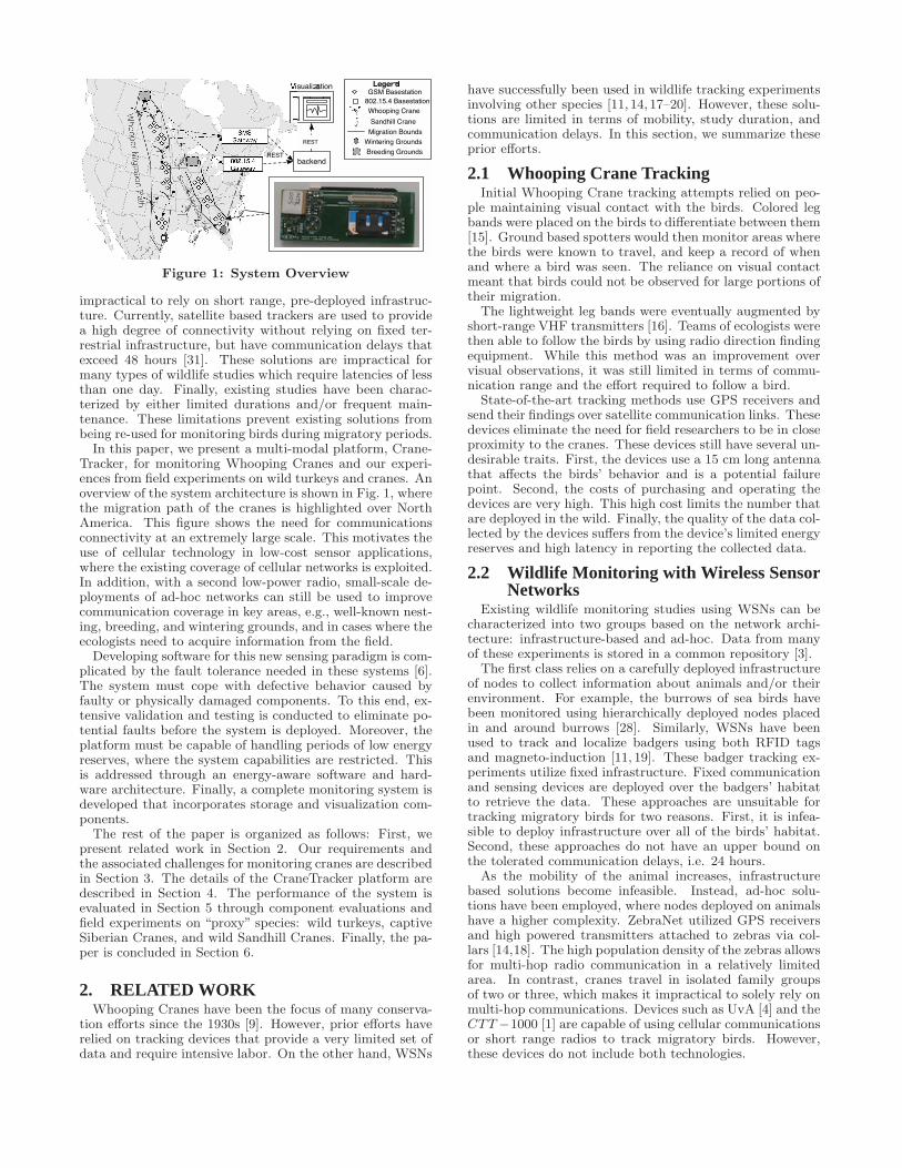
Figure 1: System Overview
impractical to rely on short range, pre-deployed infrastruc-ture. Currently, satellite based trackers are used to providea high degree of connectivity without relying on fixed ter-restrial infrastructure, but have communication delays thatexceed 48 hours [31]. These solutions are impractical formany types of wildlife studies which require latencies of lessthan one day. Finally, existing studies have been charac-terized by either limited durations and/or frequent main-tenance. These limitations prevent existing solutions frombeing re-used for monitoring birds during migratory periods.In this paper, we present a multi-modal platform, Crane-
Tracker, for monitoring Whooping Cranes and our experi-ences from field experiments on wild turkeys and cranes. Anoverview of the system architecture is shown in Fig. 1, wherethe migration path of the cranes is highlighted over NorthAmerica. This figure shows the need for communicationsconnectivity at an extremely large scale. This motivates theuse of cellular technology in low-cost sensor applications,where the existing coverage of cellular networks is exploited.In addition, with a second low-power radio, small-scale de-ployments of ad-hoc networks can still be used to improvecommunication coverage in key areas, e.g., well-known nest-ing, breeding, and wintering grounds, and in cases where theecologists need to acquire information from the field.Developing software for this new sensing paradigm is com-
plicated by the fault tolerance needed in these systems [6].The system must cope with defective behavior caused byfaulty or physically damaged components. To this end, ex-tensive validation and testing is conducted to eliminate po-tential faults before the system is deployed. Moreover, theplatform must be capable of handling periods of low energyreserves, where the system capabilities are restricted. Thisis addressed through an energy-aware software and hard-ware architecture. Finally, a complete monitoring system isdeveloped that incorporates storage and visualization com-ponents.The rest of the paper is organized as follows: First, we
present related work in Section 2. Our requirements andthe associated challenges for monitoring cranes are describedin Section 3. The details of the CraneTracker platform aredescribed in Section 4. The performance of the system isevaluated in Section 5 through component evaluations andfield experiments on “proxy” species: wild turkeys, captiveSiberian Cranes, and wild Sandhill Cranes. Finally, the pa-per is concluded in Section 6.
2. RELATED WORKWhooping Cranes have been the focus of many conserva-
tion efforts since the 1930s [9]. However, prior efforts haverelied on tracking devices that provide a very limited set ofdata and require intensive labor. On the other hand, WSNs
have successfully been used in wildlife tracking experimentsinvolving other species [11, 14, 17–20]. However, these solu-tions are limited in terms of mobility, study duration, andcommunication delays. In this section, we summarize theseprior efforts.
2.1 Whooping Crane TrackingInitial Whooping Crane tracking attempts relied on peo-
ple maintaining visual contact with the birds. Colored legbands were placed on the birds to differentiate between them[15]. Ground based spotters would then monitor areas wherethe birds were known to travel, and keep a record of whenand where a bird was seen. The reliance on visual contactmeant that birds could not be observed for large portions oftheir migration.
The lightweight leg bands were eventually augmented byshort-range VHF transmitters [16]. Teams of ecologists werethen able to follow the birds by using radio direction findingequipment. While this method was an improvement overvisual observations, it was still limited in terms of commu-nication range and the effort required to follow a bird.
State-of-the-art tracking methods use GPS receivers andsend their findings over satellite communication links. Thesedevices eliminate the need for field researchers to be in closeproximity to the cranes. These devices still have several un-desirable traits. First, the devices use a 15 cm long antennathat affects the birds’ behavior and is a potential failurepoint. Second, the costs of purchasing and operating thedevices are very high. This high cost limits the number thatare deployed in the wild. Finally, the quality of the data col-lected by the devices suffers from the device’s limited energyreserves and high latency in reporting the collected data.
2.2 Wildlife Monitoring with Wireless SensorNetworks
Existing wildlife monitoring studies using WSNs can becharacterized into two groups based on the network archi-tecture: infrastructure-based and ad-hoc. Data from manyof these experiments is stored in a common repository [3].
The first class relies on a carefully deployed infrastructureof nodes to collect information about animals and/or theirenvironment. For example, the burrows of sea birds havebeen monitored using hierarchically deployed nodes placedin and around burrows [28]. Similarly, WSNs have beenused to track and localize badgers using both RFID tagsand magneto-induction [11, 19]. These badger tracking ex-periments utilize fixed infrastructure. Fixed communicationand sensing devices are deployed over the badgers’ habitatto retrieve the data. These approaches are unsuitable fortracking migratory birds for two reasons. First, it is infea-sible to deploy infrastructure over all of the birds’ habitat.Second, these approaches do not have an upper bound onthe tolerated communication delays, i.e. 24 hours.
As the mobility of the animal increases, infrastructurebased solutions become infeasible. Instead, ad-hoc solu-tions have been employed, where nodes deployed on animalshave a higher complexity. ZebraNet utilized GPS receiversand high powered transmitters attached to zebras via col-lars [14,18]. The high population density of the zebras allowsfor multi-hop radio communication in a relatively limitedarea. In contrast, cranes travel in isolated family groupsof two or three, which makes it impractical to solely rely onmulti-hop communications. Devices such as UvA [4] and theCTT−1000 [1] are capable of using cellular communicationsor short range radios to track migratory birds. However,these devices do not include both technologies.

The use of GSM modems has been considered for moni-toring seals [17, 20]. Similar to the previous work, no strictbounds are considered on when the data is to be delivered.Recently, smartphones with on-board sensors have been uti-lized for large-scale tracking applications [27]. However,these solutions are heavy and consume too much power tooperate unattended for years.We employ a hybrid architecture for monitoring cranes
that relies on global infrastructure (cellular networks) duringmigration, and short range, ad-hoc networks in breeding andnesting grounds.
2.3 ReliabilityIn our previous work, we have examined the use of simu-
lation and aspect-oriented programming in testing an olderversion of the platform [6]. This prior work examined thedifficulties in testing systems that are deployed for extendedperiods in difficult to reproduce environmental conditions.Aspect-oriented programming techniques were adapted toTinyOS for run-time monitoring in simulations. We utilizedthis technology in this work on a newer platform that hasgreater capabilities, complexity, and fault-tolerance whencompared to the prior system.Accordingly, a low-cost sensor platform is developed that
augments existing sensor network solutions with a cellularmodem. To the best of our knowledge, this is the first studythat aims to monitor migratory animals in such large areaswith a device capable of exploiting both infrastructure andad-hoc based networking, with a combination of GPS andcompass based sensors.
3. BACKGROUNDTracking and monitoring Whooping Cranes during migra-
tion is essential for conservation efforts since the majority ofmortalities occur during this period. Moreover, continuousmonitoring of cranes is important to reveal the impacts ofchanging habitat on bird behaviors. Characterizing cranebehaviors can lead to accurate estimations of a bird’s en-ergy needs. These estimates can reveal relationships be-tween habitat usage and population. In this section, wepresent the requirements and the challenges encountered formonitoring cranes.
3.1 RequirementsWorking with ecologists with experience in maintaining
the crane population, we developed goals and requirementsfor a new tracker. The key requirements are briefly listed.A detailed description and rationale for them will then bepresented.
• Weight: < 120 grams
• GPS: 2 samples per day
• Location Accuracy: < 10m desired, < 25m acceptable
• Compass: 0.5Hz sampling rate
• Communication Latency: < 24 hours
Migration tracking: During migration, the birds arehighly mobile and highly unpredictable in terms of theirpaths and nightly roost sites. Timely location informationcan be used to locate the cranes’ roosts during migrationand can create insights into how the birds choose these in-termediate stops. Knowledge of a bird’s location can also
be used to determine whether or not it has perished, andwhether to use field personnel to ascertain a cause of death.
To support this research, at least one location must be pro-vided by the GPS during the day, and one during the night.It is desirable, but not necessary, for the GPS location tobe accurate with 10 meters of the true position so detailedhabitat monitoring can be conducted. GPS measurementsthat are within 25 meters of the true position are desired fortracking the birds during migration and determining mo-bility patterns. Such insights into the birds’ travel habitsare of great importance to ecologists because they can helpmeasure the effects of habitat changes and other human de-velopment on the birds’ behavior and migration patterns.Gaining knowledge into the real world performance of theGPS solution will enable more efficient power managementand data sampling algorithms.
Reduced latency: Many open research questions re-garding the cranes, such as when and how they die duringmigration, require timely data to be sent during migrations.If information on a crane’s location and behavior is delayed,it may be impossible to locate the crane in the wild to con-duct field observations, or if necessary, recover the corpse.Existing, state of the art, satellite based solutions frequentlyhave communication delays exceeding 48 hours [31]. Therequirements for this project specify an ideal delay require-ment of less than 24 hours during migration.
Bird movement characterization: Collecting infor-mation on how the cranes move is another important stepin ensuring their survival. Their flight behavior is not wellquantified, because the existing data comes from qualitativeand opportunistic visual observations. While on the ground,information about their movements such as foraging, roost-ing, and preening help characterize their energy usage andcan lead to the development of time-energy budgets for thecranes. A greater understanding of their behavior is impor-tant because it may expose changes in the birds’ behaviorcaused by climate or habitat change. Movement data canbe used to determine whether or not a bird is alive. If thebird is dead, then field personnel can retrieve the corpse forfurther study. To collect behavioral data, the compass mustbe sampled faster than 0.5Hz. The studies presented in thispaper sampled the compass at 1Hz for 10 seconds, with 4hours in between sampling periods.
Long-term operation: Gathering statistically valid mo-vement and behavior data from migratory birds requiresmulti-year operation, during which an individual can be ob-served for several migration cycles. To prevent any impacton the behavior, it is not desirable to re-capture a craneafter a tracker has been mounted. Consequently, the har-nesses are designed to eventually wear out and detach fromthe birds within several years. During the time a tracker ison a bird, it is expected to function properly without outsideintervention.
Flexible operation: Multi-year and continuous moni-toring of the same bird can reveal important insights intobehavior over its lifetime. There are very few prior studiesof this type, which leads to a lack of baseline data. Thus,at this point, the best data collection policy for ecologists isto get all the raw data in order to establish a baseline forfuture experiments. Further complicating data collection isthe wide variety of environmental conditions the trackerswill encounter. This makes it hard to optimize system op-eration since input space is largely unknown. The trackershould be flexible, so that its operation can be revised basedon experimental results. This allows for more advanced fil-

tering and data collection schemes to be implemented in thefuture.Backpack Mounting: State-of-the-art Whooping Cra-
ne tracking systems use a leg-band design. There are sev-eral drawbacks with such a design. First, the added weightcan unbalance the bird, and add drag, which makes it moredifficult to fly. More importantly, there has been anecdo-tal evidence that a leg-band can adversely affect copulationwhich is unacceptable for conservation efforts. Instead, abackpack mounting design is employed, which is evaluatedwith Siberian and Sandhill Cranes.
3.2 ChallengesMonitoring migratory birds during migration faces several
challenges, some of which are common to wildlife monitoringplatforms (e.g., weight limits) and some of which are morespecific to cranes (e.g., extreme mobility during migration).In the following, we summarize these challenges.Weight and Size Restrictions: Using guidelines de-
veloped for other birds, a device and all supporting equip-ment must weigh less than 2% of a crane’s bodyweight [30].An average crane weighs 6kg. The equipment used to attachthe device to the cranes weighs approximately 10 grams, sothe device itself must weigh less than 110 grams.These requirements are very restrictive when compared to
many efforts. For example, the collars used to track zebrasin ZebraNet [14] weigh over 1.1kg. A tracking experimentwith badgers faced weight requirements similar to cranes[19] (105g), but the mission duration was much shorter (3months) and the trackers used a lower power sensor. Forcranes, ecologists have recommended that the tracker be nolarger than 19.5cm long, 2.5cm tall, and 6.5cm wide. Thisallows the tracker to be attached to the bird as a backpackwithout affecting the bird. The weight and size restrictionsplace a significant restriction on the type of battery to beincluded and makes energy harvesting a necessity for thesystem.Mobility: Whooping Cranes travel as much as 950 km
per day, and can move 4, 000 km over the course of migra-tion. Along with their rapid movement, the birds travelas family groups instead of in large flocks. Hence, it isextremely difficult to predict flight paths, stopover points,and flight durations during migration. This unpredictabil-ity makes maintaining communication links with the birdsa major challenge. Placing ad-hoc infrastructure along mi-gration flyways is a near impossibility. On the other hand,cranes use the same region for breeding and wintering foryears. These locations are ideal spots for ad-hoc communi-cation.Unattended Operation: The required mission dura-
tion is 5 to 7 years, which is significantly longer than exist-ing tracking efforts [19, 20], which run for weeks or months.Since trackers cannot be accessed once harnessed to a wildbird, the system should be self-sustainable in terms of energyresources during this time. In addition, the software shouldoperate without any errors despite the device being exposedto many unknown conditions. This makes it extremely desir-able for the device to have a runtime that lasts for multiplemigration periods. Moreover, the software must be able tocope with low voltage conditions or physical damage.Unknown Behaviors: The lack of quantitative mea-
surements on crane behavior makes the design of a sens-ing scheme highly challenging. Lacking solid baseline datamakes it difficult to develop effective sensing or communica-tion routines to record the relevant aspects of crane behav-ior. Developing software that can handle these conditions is
Iris
RF230 RadioAtmega1281
Processor
Flash
Memory
CraneTracker
GP
IO
AD
C
UA
RT
UA
RT
I2C
3.3
V
GSM GPS Compass
GPIO GPIO GPIOSwitch Switch Switch
AD
C
AD
C
Battery
Charge
Management
Solar
State
Monitor
Battery
State
Monitor
2.9V
Threshold
Detector
3.3V
Regulator
SPI SPI
3.3V
BatterySolar
(a)
Cr neManager
Stor ge
SPIUARTI2C
802.15.4GPSCompass
(b)
Figure 2: CraneTracker (a) hardware and (b) soft-ware architectures.
a difficult task because not all possible environmental condi-tions can be recreated in a controlled environment. The longterm nature of wildlife tracking means that some softwarefaults may manifest very slowly and be difficult to exposeprior to deployment.
Endangered Status: Whooping Cranes are a federallyendangered species. Hence, any potential new technology tostudy them is highly scrutinized. The platforms developedfor studying Whooping Cranes must first be tested on other“proxy” species before being accepted by the U. S. Fish andWildlife Services. Once the platform has been accepted, itcan be used for monitoring the AWBP Whooping Cranes.
4. CRANE TRACKERTo address the challenges discussed in Section 3.2, and
achieve the requirements listed in Section 3.1, a crane mon-itoring system is developed. The system consists of twomajor components: (1) The CraneTracker that is attachedto the cranes and monitors their movement throughout thecontinent and (2) the back-end components that are usedto store, analyze, and visualize the collected data. Next, wedescribe in detail the CraneTracker platform, system devel-opment, and evaluation tools. A more detailed descriptionof these components is available in [7].
4.1 OverviewCraneTracker consists of a family of integrated hardware
software components, which are illustrated in Figs. 2(a) and2(b), respectively. The hardware architecture consists ofan Iris mote and a custom sensor board with a rich set ofsensors, modem, and power control circuitry. The softwarearchitecture was built on top of TinyOS and includes sensorand communication drivers, and storage, power, and overallsystem management. This system overcomes the challengesenumerated in Section 3 through:
• Weight and Size Restrictions: careful selection and

integration of hardware components into the customboard (Sections 4.2 and 4.3), and a custom built en-closure (Section 4.6).
• Mobility: integrated multi-modal communications wh-ich includes an Iris mote with an 802.15.4 compatibletransceiver and a GSM modem, and support to han-dle holes in coverage through temporary data storage(Sections 4.2 and 4.5).
• Unattended operation: integrated energy harvestingthrough a solar panel, and power control sub-systemto maximize data capture and battery recharge oppor-tunities (Sections 4.4 and 4.5)
• Unknown behaviors: integrated multi-sensing capabil-ities with GPS, GSM, 3D acceleration, magnetometer,and temperature sensors delivering data to the scien-tists on the fly (Sections 4.3 and 4.5)
• Endangered status: incremental deployments on tur-keys, Siberian Cranes, and Sandhill Cranes (Sections5.2, 5.3 and 5.4).
4.2 Multi-Modal CommunicationAs discussed in Section 2, short-range multi-hop commu-
nication schemes are insufficient for maintaining connectiv-ity in a highly mobile sensor network. On the other hand,well-known breeding and wintering grounds provide an op-portunity for establishing ad-hoc communication with thecranes. Additionally, ecologists seek time critical informa-tion while in the field. This unique requirement calls for amulti-modal communication scheme.For a long-range communication solution, two alternatives
exist: satellite and cellular communication. Satellite tech-nology was avoided because of the drawbacks listed in Sec-tion 2.1. Cellular communication is desirable because thenecessary infrastructure is already deployed throughout themigration path. The experiments also reveal that this in-frastructure enables the trackers to communicate in flight.Moreover, the operating cost is significantly lower than thatof satellite systems.Two main technologies exist when choosing the cellular
device: CDMA and GSM. GSM technology is used for thisproject because its widespread international adoption willenable future experiments in a wide variety of locations. AGE865 cellular module from Telit is used for the GSM func-tionality [29]. This module has several appealing featuresfor this project. First, it only weighs 3.5g. Second, it usesUART lines to interface to a microcontroller. This interfaceis very common in microcontrollers, and is simple to imple-ment. Third, it supports domestic and international GSMbands, which means it can be deployed to many places inthe world. Lastly, it is controlled through standard AT com-mands [5], which allows future versions of the platform touse alternative modules and technologies.The GSM module requires careful power supply design.
While the rest of the platform components operate at 3.3V,the GSM has a normal operating voltage of 3.4V to 4.2V [29].According to the datasheet, the module consumes an averageof 240mA during a voice call, and up to 420mA if the GPRSfunctionality is used. Testing on the CraneTracker showedthe module used an average of 64mA while sending a textmessage. The current consumption of the GSM while asso-ciating with the cellular tower and sending repeated SMSmessages is shown in Fig. 3. Although not shown in Fig. 3,
0 2 4 6 8 10
x 104
0
0.2
0.4
0.6
0.8
1
Cur
rent
(A
)
Time (ms)
Association
Figure 3: GSM current while sending SMS
under certain circumstances, the peak power demand of theGSM can reach 2A.
To communicate between the Iris mote and the GSMmod-ule, a GSM driver is developed for TinyOS [2]. Using stan-dard AT commands, a subset of the commands needed toestablish communication with the cellular network and sendan SMS is implemented. Additional information, such as thecellular tower used for the connection, is fetched through theinterface as well. By tracking which cellular towers the sys-tem associates with, the GSM module also provides coarsegrain localization.
Despite its extensive coverage, cellular infrastructure isfocused on covering human population needs. Given theremote areas the cranes travel to, cellular coverage can oc-casionally be missing. Occasional holes in coverage duringmigration can be compensated for with a storage mechanismas will be explained in Section 4.5. However, in breeding andwintering locations, cranes generally use the same locationsover several years. If cellular coverage is lacking at this par-ticular location, long-term storage may not be sufficient tostore all of the recorded information. Since the locations ofbreeding and wintering grounds are well known, it is feasi-ble to deploy short-range base stations at these locations.Thus, the CraneTracker utilizes the 802.15.4 compatible ra-dio located on the Iris mote. The radio utilizes single-hopcommunications with the default protocols implemented byMemsic [21] in MoteWorks. This radio will be used in futureexperiments once the mobility patterns and family dynam-ics of the cranes are better explored. The resulting networkarchitecture is shown in Fig. 1, where the two modes of com-munication are illustrated.
4.3 Multi-modal SensingSensing components were selected to provide information
about the bird, the environment, and the system. The sens-ing requirements specify position information, movement in-formation, ambient solar power, temperature, and batteryvoltage.
The GPS sensor is a PA6B module manufactured by Glob-alTop Technologies [12]. The selection of this receiver isbased on multiple factors including power consumption, chipweight, antenna weight, size, channels, sensitivity, positionaccuracy, durability and time-to-first-fix (TTFF). The se-lected GPS module has a quick TTFF (34s cold start), lowenergy consumption (43mA), and small size (16mm x 16mmx 6mm) [12]. In addition to these characteristics, the mod-ule features an integrated patch antenna, which makes itcompact and easy to integrate into the tracker. The GPSinterfaces to the host microcontroller through UART lines.The NMEA 0183 protocol is used to communicate informa-

tion such as the location, altitude, speed, and course overground of the bird. This data is then used to track wherethe bird has traveled, where it is heading, and whether ornot the bird is still alive.To characterize the bird movements and behaviors an HM-
C6343 solid-state compass, which includes a three dimen-sional accelerometer and magnetometer, and temperaturesensor in a single package, is selected [13]. The solid-statecompass provides a yaw accuracy of 2o and pitch and roll ac-curacy of ±1o between 0o-15o and a ±2o accuracy between15o-60o. The compass communicates this information overthe I2C interface. The default TinyOS I2C implementationwas replaced with an interrupt-driven component to correcttiming problems between the compass and microcontroller.To provide baseline data of crane movements, our strategyhas been to obtain raw data from the cranes for this work.Environmental data is collected through the temperature
sensor in the compass and through the solar panel. To inferthe intensity of ambient light through the solar panel, thevoltage and current are recorded from the panel. In additionto bird-specific and environmental data, information aboutthe system performance is also desired. To this end, thesolar panel and battery are monitored as a part of the powercontrol component which is described next.
4.4 Energy Harvesting and Power ControlTo maximize the lifetime of the device, a flexible solar
panel from PowerFilm [26] is used to recharge a lithiumpolymer battery. The solar panel specification states it iscapable of providing 50mA at 4.8V. A lithium polymer bat-tery is used because its high energy density minimizes theweight of the device, while allowing it to run for extendedperiods when solar energy is not available. The use of alithium polymer battery complicates the power supply ofthe system, as it must be recharged using specific routinesto maximize the battery lifetime and to avoid damaging thebattery. Over- and under-discharging the battery must alsobe avoided, as this will also damage the battery.An overview of the circuit that implements these opera-
tions is shown in Fig. 2(a). The power provided by thesolar panel is used as the input to a charge management cir-cuit [24]. The voltage and current supplied by the solar panelis monitored and logged by the mote as well. The outputfrom the charge management circuit is used to charge thebattery. The battery voltage and discharge current are alsomonitored by the microcontroller to profile the energy con-sumption of the device and enable power-aware operation.The battery state is monitored by a dedicated IC [25], whichenables a 3.3V linear regulator [22] when the battery is suf-ficiently charged. This linear regulator is used to power thecomponents which are unable to cope with the 4.2V that thebattery can potentially supply. The power to the individualcomponents is controlled by an IC switch, which provides alow-complexity method of disabling the devices [23].The separation of software from system control enables
the system to recover from unforeseen software errors. Theusefulness of this approach is empirically supported throughthe deployments, where the system is able to recover froman unknown error state, as will be discussed in Section 5.4.
4.5 Data ManagementThe 512 kB of flash memory on the Iris is used to store in-
formation before being transmitted to a base station. Datais organized into sensor records, as shown in Fig. 4(a). Therecords stored in flash are divided into compass and GPSrecords that are prefixed with a common header. The stored
Co
mpa
ss R
eco
rd
GP
S R
ecord
Hours
Minutes
Date
Latitude
Longitude
Altitude
Speed
…...
Compass Sample 1Compass Sample 1
Type
Voltage and Current
Time
Sto
rag
e H
ea
de
r
Record Sequence Number
Compass Sample 10
GS
M H
ea
de
r Message Sequence Number
Tower Information
Signal Quality
(a)
(b) (c)
Figure 4: (a) Packet format (b) CraneTracker en-closure designs (b) and (c).
data is organized into a FIFO circular queue that can holdup to 16, 912 records. In the event that the queue fills with-out data being transmitted, the oldest data in the system isoverwritten first. This behavior is motivated by the expectedcommunication patterns. The data collected during migra-tion periods is of greater interest than the data that is col-lected during wintering and roosting periods. However, thewintering and roosting periods will probably experience thelongest periods of communication silence, due to the lack ofcellular coverage and difficulties in placing short range basestations near the birds. Thus, during these times, the buffermay fill with less interesting data, that will be overwrittenas part of the FIFO process.
When the data is transmitted, a second header is pre-pended to the data that contains information for detectingdropped packets and logging information on the cellular con-nectivity. The data is transmitted according to the FIFOprotocol, where the oldest data is transmitted first. Thisgreatly simplifies the implementation of the storage mech-anism. However, in some cases, this behavior can be un-desirable, as during migration it is more interesting to seethe recent locations of the birds. Investigating trade-offs instorage and data retrieval policies, e.g. LIFO, is left as afuture work once sufficient data about tracker behavior iscollected.
As illustrated in Fig. 2(b), at the highest level of the sys-tem, a software manager is implemented that schedules whensensors and communication devices are used. The manageris power-aware and monitors the battery voltage before acti-vating a component. Consequently, the system avoids wast-ing power by using components that will not be able to oper-ate effectively. This improves the chances that future taskswill have enough power to run.

4.6 Enclosure DesignTo fulfill the durability and environmental protection re-
quirements, several harness and enclosure designs were eval-uated.Based on the feedback from ecologists, a backpack ap-
proach is used. This allows the tracker to be mounted neara bird’s center of gravity, and minimize the effect on copu-lation. In addition, a backpack design has potential benefitsto system design since exposure to the sun and movementmonitoring accuracy increases when compared to a leg band.Three designs were used in field tests including a hard plasticenclosure, a pouch, and flexible plastic tubing.The turkey tests used hard plastic enclosures, with the
solar panel attached to the outside. These are too bulky forthe cranes. The second design is used in short-term field ex-periments with captive cranes (Fig. 4(b)), where the trackeris retrieved within a day. The pouches were made from heat-sealable Oxford cloth that is waterproof and easy to prepare.The final enclosure design is inspired by an outdated VHF
transmitter package, which operated for three years on acrane, that used heatshrink tubing. A transparent heatshrink is used to enclose all components and still allow forsolar recharging. A high strength plastic welder is used tobond the ends of the tubing. These enclosures are testedby submerging them in water, freezing, physical stress, andexposure to weather. A functioning mote is kept inside theenclosure during the tests to make sure it is unharmed. Thisplastic tubing approach is extremely durable, and passes allof these tests. The final unit is shown in Fig. 4(b) andFig. 4(c) on a Sandhill Crane and is used in on-going alphaexperiments that will be explained in Section 5.4.
4.7 Fault Detection and ToleranceTo maximize the chance of a mission’s success, the sys-
tem must be fault tolerant. Additionally, the system soft-ware should undergo thorough testing and verification. Inour previous work, we presented work on testing the systemsoftware on an earlier platform [6]. We utilized these tech-niques in the current design. Next, we will present the newfault-tolerant features of the updated platform.The first area of fault tolerance is in the communication
scheme. The combination of GSM and short-range radio en-ables the tracker to continuing operating when one methodis damaged or unable to communicate. Second, the GPSand compass can redundantly sense some of the informationabout the cranes, such as whether they are alive or dead.Finally, the hardware provides fault tolerance for the soft-ware. In cases where a software fault leaves the system ina high energy consumption state, the hardware is capableof removing power and rebooting the system after too muchenergy has been consumed.
5. EVALUATION AND DISCUSSIONThe CraneTracker has been extensively evaluated via com-
ponent evaluations, controlled system experiments and on-going field experiments. Through component evaluations,the individual hardware components are characterized andthe associated software components are validated. Con-trolled system experiments provide insight to the operationof the whole system and allows us to tailor the operationparameters.Due to the endangered status of Whooping Cranes, the
platform has been tested on “proxy” species that share sim-ilar habitat or similar characteristics with the WhoopingCranes. Preliminary platforms were evaluated on Wild Tur-
keys (Meleagris gallopavo), which share habitat with thecranes and provide a convenient method of testing manyaspects of the platform because of their abundant popu-lation and low mobility. These experiments also allowedus to evaluate the latency of the cellular interface in thewild. Once successful, system evaluations have been con-ducted with captive Siberian Cranes (Grus leucogeranus), aclose cousin of Whooping Cranes. These experiments wereconducted at the International Crane Foundation (ICF), inBaraboo, Wisconsin, where the captive cranes are held inpens. The backpack design, ad-hoc communication, and thecompass monitoring capabilities are tested on these craneswith short-term experiments. The final experiments con-sist of alpha deployments with wild Sandhill Cranes (Gruscanadensis) - another abundant cousin of Whooping Cranes- where the system is fully tested in a realistic environment.At the time of this writing, five trackers have been placedon wild Sandhill Cranes. Two of the birds have completedmigrations from Wisconsin to Indiana and Florida.
5.1 Preliminary EvaluationsCharacterization of performance at the component level
was performed to validate the system design. In Fig. 5(a), ahigh level view of the system’s power consumption is shown.The details of this analysis are not discussed due to spacelimitations. As can be observed, power consumption pro-file of CraneTracker is fundamentally different than tradi-tional WSNs, where the energy consumption for sensors isgenerally neglected. In contrast, the compass on the Crane-Tracker uses approximately the same amount of power as themicrocontroller, and the GPS uses significantly more. Fur-thermore, the GSM consumes by far the most power. Thepower usage of the different components calls for energy-aware management of all the parts of the system.
Initial system-wide evaluations were performed by driv-ing approximately 160km through an area commonly usedby the Whooping Cranes during their migration. These ex-periments provide insights into the communication delays ofthe system and the accuracy of the measured results. Thecommunication delay over the duration of the experiment isfound to be only 6.07 minutes (σ = 1.53 min). As shownin Section 5.4, this latency is optimistic since well coveredhighways are used, but shows significant improvements com-pared to the 48 hour satellite tracker delays.
The experiment also reveals the localization accuracy ofGSM. Over the course of 160 km, 18 base stations were seenand each base station provided an estimate of the mote’slocation. Using the GPS sensor as a baseline, it is observedthat the error has a relatively large variance, where 50%of the error is less than 4 km and the maximum error isbounded by 14 km, which is useful for coarse localizationin case of GPS failures. The satisfactory results with con-trolled experiments motivated the evaluation of the systemon animals as explained next.
5.2 Field Experiments with Wild TurkeysField observations reveal that 2/3 of the Whooping Cra-
nes’ migration is spent foraging and roosting in habitat verysimilar to wild turkeys’. To evaluate the tracking accu-racy, communication performance, power consumption, andrecharge performance in a limited area, field experimentswere performed with wild turkeys. These initial experimentsdemonstrated the viability of cellular-based sensing for re-mote and time critical wild bird monitoring.
In the experiments, two sets of data are used: (1) Turkeytracker: A tracker is attached to the back of a captured

MCU Compass GPS GSM0
10
20
30
40
50
60
70C
urre
nt (
mA
)
Component
(a)
0 50 100 150 200 250 3000
0.1
0.2
0.3
0.4
0.5
0.6
0.7
0.8
0.9
1
CD
F
Distance Error (m)
TurkeyBazov (July ’11)Bazov (Sep ’11)
(b)
27/04 29/04 01/05 03/05 05/05 07/05 09/053.5
3.6
3.7
3.8
3.9
4
4.1
Vol
tage
(V
)
Date (dd/mm)
ControlWild Turkey
Deployment
(c)
Figure 5: (a) Power consumption of platform components, (b) CDF of GPS error, (c) Battery voltage ofcontrol and turkey tracker.
hen and the hen is released for monitoring for a week. (2)Control: A stationary control mote is placed in the openwithin 1 km of the hen’s habitat. This mote consists of thesame hardware and software as attached to the capturedturkey.The collected data includes 480 SMS messages, 105 GPS,
and 9, 170 compass-related data over a period of 10 days.The system provides 100% reliability, where the turkey trac-ker sent SMS messages every 4 hours except for 9 cases,where the missing SMS was received in the following com-munication window, i.e., with a 4-hour delay.System Evaluation: In Fig. 5(b) the CDF of the GPS
location error for the experimental evaluations is shown. Forthe turkey experiment, the accuracy is evaluated by placinga tracker at a known position, and comparing the reportedlocation to the known location. A large portion of this erroris caused by operating mode of the GPS. In this trial, theGPS was turned off immediately after it acquired a fix inorder to save power. This is insufficient time for the errorin the GPS receiver to converge to its lower bound. Thistruncation contributes to the GPS error, along with the non-ideal environmental conditions.The position of the wild turkey was acquired every 4 hours
during the 10 day release, where the turkey was success-fully monitored in a 2km x 1km area using the cellular com-munication capabilities of the tracker. The location datais divided into sets based on the time of day (night, earlymorning, morning, early afternoon, and afternoon) as illus-trated in Fig. 6. The roosting location of the turkey canbe clearly observed by the congregated fixes during night,early morning, and afternoon (see zoomed-in graph). It isobserved that most of the movement occurred during earlymorning and afternoon when the bird was feeding with thebird moving as far as 1 km over a 4 hour period.In Fig. 5(c), the recharge performance is depicted, where
the deployment time is indicated by a vertical line. The con-trol mote clearly outperforms the turkey tracker because itwas placed directly under the sun. Although self-sustaining,the turkey tracker results in a lower recharge rate due tothe woodland habitat, where the turkey spends most of itstime. Moreover, Fig. 6 yields evidence that the wild turkeywas in woodland coverage during mid-day, when the sun ex-posure is at its peak. Both data sets provide insight intohow the CraneTracker will perform during a crane migra-tion. The control set represents conditions similar to flight,when cranes are known to migrate up to 8.8 hours a day.This allows the device with sufficient time to recharge un-
der direct sunlight. In contrast, the turkey data provides alower bound on the energy regeneration performance on theground.
Ecological Observations: Even though it was not ourprimary goal, the turkey tracker data also provides impor-tant insight into turkey behavior. Turkeys spend up to95% of the day feeding and are able to move at a rate of200 m/hr during feeding periods [10]. The collected datasupports these conjectures. The locations during the nightand afternoon correspond to the hen’s brooding and nestingarea. The other GPS positions are probable feeding areas,in which the turkey is found in the rest of the day. GPSpositions from one day are also connected in Fig. 6, whereobserved movements of up to 1 km over a 4 hour periodfall closely into the 200 m/hr observations [10]. The closeagreement of the collected data with the observed behav-iors of wild turkeys provide an additional validation to theplatform operation.
5.3 Captive Siberian Crane ExperimentsTo evaluate the performance on a real crane in a semi-
controlled environment, the CraneTracker was tested in July2011 with three captive Siberian Cranes: A. Wright, Bazov,and Hagrid, held in separate pens of 10m x 10m. A softwater-resistant pouch was used to harness the instrumentsto the captured Siberian Cranes as shown in Fig. 4(b) fora day. During the experiments, GPS and GSM communi-cation capabilities as well as compass accuracy were tested.The ecologists also observed the impacts of backpack harnesstechnique on the cranes.
−0.2 0 0.2 0.4 0.6−1
−0.8
−0.6
−0.4
−0.2
0
0.2
0.4
0.6
0.8
1
y (k
m)
x (km)
Night (8PM−4AM)Early Morning (4AM−8AM)Morning (8AM−12PM)Early Afternoon (12PM−4PM)Afternoon (4PM−8PM)
−40 −20 0 20 40−100
−80
−60
−40
−20
0
y (m
)
x (m)
Figure 6: Turkey positions (lines connect consecu-tive fixes for one day).

15/11 17/11 19/11 21/11 23/11 25/11 27/110
1000
2000
Time
Alti
tude
AS
L(m
)
Altitude (m)Speed (km/h)
15/11 17/11 19/11 21/11 23/11 25/11 27/110
100
200
Spe
ed (
km/h
)
WI DPT
FL ARV
(a)
24/09 04/10 14/10 24/10 03/11 13/11 23/11 03/120
50
100
150
200
Time
Ene
rgy
(mW
)
24/09 04/10 14/10 24/10 03/11 13/11 23/11 03/123.6
3.8
4
4.2
4.4
Vol
tage
(V
)
WI DPT FL ARV
Battery VoltageSolar Power
(b)
19/09 24/09 29/09 04/10 09/100
50
100
150
200
Time
Ene
rgy
(mW
)
19/09 24/09 29/09 04/10 09/103.6
3.8
4
4.2
4.4
Vol
tage
(V
)
Battery VoltageSolar Power
(c)
10−4
10−2
100
102
0
0.2
0.4
0.6
0.8
1
CD
F
Distance (km)
NeighborFamily
(d)
Figure 7: (a) SH-Chick altitude and speed. Solar power and battery voltage for (b) SH-Chick and (c)JB-Female. (d) Distance between SH-Chick and family and neighbors.
0 5000 10000 15000 20000−20
−15
−10
−5
0
5
10
15
20
Sample
Acc
eler
atio
n (m
/s2 )
xyz
Rain Begin Rain End
Figure 8: Three-axis acceleration readings from aSiberian Crane.
System Evaluation: With A. Wright and Bazov, thetracker was programmed with a 4 hour duty cycle. Duringeach cycle an attempt was made to acquire a GPS fix andthe compass was sampled. After the sensors were sampled,an attempt was made to send the data using the GSM. A.Wright incapacitated the device immediately after deploy-ment by hitting a fence.With Bazov, over 27 hours, a GPS fix ratio of 97% was
achieved out of 135 attempts. Fig. 5(b) shows the CDF ofthe GPS error for Bazov, assuming that the bird was locatedin the center of the pen. The results show that 58% of theerrors are less than 25m. To improve the accuracy, the GPSsampling scheme is updated so that at every attempt, 10GPS fixes are acquired before firing a success event. Withthis update, the experiments were repeated in September2011 with Bazov in the same pen. As shown in Fig. 5(b),this update improves the accuracy of GPS so that 81% of theerrors are less than 25m. In this experiment, a large portionof the errors are due to the bird moving around the cage,and not staying in the center (±7m). These movementscontribute to the errors in the figure. The remainder ofthe errors are due to environmental factors, and the GPSnot operating for an extended time period to minimize theenergy consumption. The distribution of errors satisfied theecologists working on the project, and the quality of datamet their needs.To evaluate the compass accuracy on a crane, Hagrid was
monitored by a closed-circuit camera system and compassreadings were collected at a high rate of 10Hz for 30 sec ev-ery 3 minutes using the Iris mote’s radio. Data from thecompass was collected over 4 hours and 21, 882 records were
received. A part of the results is shown in Fig. 8, where thethree dimensions of acceleration are shown before, during,and after a heavy rain. During the rain, the crane was ob-served to stand still, which can be observed on the markedarea of the graph. Moreover, during the experiment, theresearcher logging data was able to determine movementswithout actually seeing the bird. The movements were con-firmed by another researcher observing the crane through avideo camera. Such strong correlation between accelerome-ter readings and crane behaviors motivate the utility of thecompass for developing and validating energetics models forcranes [8] and further study on the collected compass datais left for future work.
Lessons Learned: During the experiments at the site,heading, pitch, and roll were inconsistent even though com-ponent tests were successful in other locations. This erro-neous behavior was confirmed with all compass units avail-able as well as an alternate inertial measurement unit and asmartphone. Unfortunately, the compound sits on a densemagnetic field due to a moraine that affects sensitive mag-netic electronic readings. This behavior highlights the sig-nificant fluctuations sensors may experience during a longmigration that encompasses several states.
5.4 Wild Sandhill Crane DeploymentsThe wildlife experiments with CraneTracker have been
conducted with alpha deployments on five Sandhill Cranes.The cranes are captured in the wild by trained profession-als and released to the wild after necessary measurementsare taken and the trackers are attached. Five cranes fromthree families have participated in the experiments. Thecranes are designated JB-Male and JB-Female; SH-Femaleand SH-Chick; and BB-Female. The two letter prefix iden-tifies the crane’s family, and the suffix is the crane’s gender.Relevant information about the trackers is summarized inTable 1. The trackers will be left on the cranes for a year toobserve their migration.
The software follows a schedule such that the system wakesup, collects a GPS fix, gathers 10 compass samples over 10seconds, and then attempts to communicate with both the802.15.4 radio and the GSM, and sleeps for 4 hours 5 min-utes. The GPS fix is recorded after acquiring 10 valid fixes,which is found to improve the location accuracy as discussedin Section 5.3. To prevent excessive energy consumption,the GPS is turned off if a fix was not acquired within 5 min-utes. The 4-hour 5 minute sampling interval and 10-secondcompass sampling duration was recommended by the ecolo-gists. The sampling interval was selected so that the sam-pling times shift in time and in long-term, information fromeach time of day is collected.
System Evaluation: Fig. 10 shows the migration

10−2
100
102
0
0.1
0.2
0.3
0.4
0.5
0.6
0.7
0.8
0.9
1
Delay (h)
CD
F
SH−ChickSH−FemaleJB−FemaleBB−Female
(a)
10−2
100
102
0
0.1
0.2
0.3
0.4
0.5
0.6
0.7
0.8
0.9
1
Delay (h)
CD
F
SH−ChickSH−FemaleJB−FemaleBB−Female
(b)
24/09 26/09 28/09 30/09 02/10 04/10 06/102.8
3
3.2
3.4
3.6
3.8
4
4.2
4.4
Time (s)
Vol
tage
(V
)
Max−V
Nominal−V
SC
Min−V
C
B
A
(c)
Figure 9: (a) CDF of delay (comm.+queue), (b) CDF of communication delay, (c) Low-voltage recovery.
Table 1: Experiment SummaryName Exp. Duration (days) # SMS # Fixes Distance Traveled (km) Comments
JB-Male 13 0 0 - Failed to rechargeJB-Female 41 2, 795 208 20 UnknownSH-Female 29 525 468 4.3 Fell offSH-Chick 66 1, 890 330 1, 725 OperationalBB-Female 121 2, 213 468 603 Operational
paths taken by SH-Chick and BB-Female during the fallof 2011. SH-Chick completed the migration to the southernhabitat in Florida, while BB-Female chose to halt the migra-tion in Indiana. This figure demonstrates the unpredictabil-ity of the cranes, and the extreme geographic distances thedevices operate over.Experimental results from the birds confirm the viability
of using the cellular network for monitoring during migra-
Figure 10: Migration paths of SH-Chick (whitemarker) and BB-Female (black marker)
tion. During the migration, SH-Chick recorded 330 totalGPS locations. Of these 330 locations, the bird’s velocityindicated that in 12 of them it was flying. During theseflying periods, SH-Chick communicated 10 times. These re-sults show that the tracker is capable of maintaining a highdegree of connectivity during all phases of the bird’s life cy-cle.
Fig. 7(a) shows the altitude and speed of SH-Chick overthe course of the migration. Naturally, there is a strongcorrelation between the speed and altitude of the bird, asthe cranes are capable of flying much faster than walking.This figure also illustrates the difficulty in monitoring thecranes. They are capable of achieving high speeds whilein the air, and flight periods comprise a surprisingly smallportion of the actual migration process.
In Fig. 7(b) and Fig. 7(c), the battery voltage and thesolar power collected by the monitoring circuit is shown forJB-Female and SH-Chick. These figures show that thereis a close correlation between the monitored solar powerand the battery recharge rate and solar power levels higherthan 20mW leads to a recharge. Below this power level, therecharge circuitry is unable to utilize the power to rechargethe battery. Accordingly, the readings can be used for adap-tive operations, where the battery levels are predicted basedon solar power.
The differences in recharging behavior between differentbirds is due to their location. In the breeding grounds, wherethe cranes spend most of their time, the birds are often invegetation. This vegetation can obscure the solar panel.It can be observed that JB-Female has a lower rechargerate but the battery levels are above the critical thresholdof 3.65V. As shown in Fig. 7(b), during migration (16/11-28/11), the device is capable of recharging the battery in amatter of days.
The power control circuit prevents the battery from drain-ing below a minimum energy level, in order to prevent dam-age to the battery. This results in a sustainable albeit poten-tially intermittent operation. The collected information willprovide insight into suitable sampling ranges and adaptiveoperation to reach a continuous sustainable operation.
−89.585 −89.575 −89.565 −89.555 −89.54943.64
43.66
43.68
43.7
Longitude
Latit
ude
NightEarly MorningMorningEarly AfternoonAfternoon
(a)
−89.575 −89.5745 −89.574 −89.5735 −89.57343.653
43.6535
43.654
43.6545
43.655
43.6555
43.656
Longitude
Latit
ude
NightEarly MorningMorningEarly AfternoonAfternoon
(b)
−15 −10 −5 0 5 100
0.2
0.4
0.6
0.8
1
Acceleration−Z (m/s2)
CD
F
NightMorningAfternoon
(c)
−10 −5 0 5 100
0.2
0.4
0.6
0.8
1
Acceleration−X (m/s2)
CD
F
NightMorningAfternoon
(d)
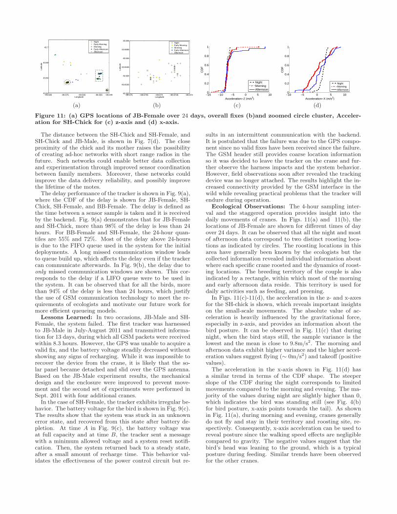
Figure 11: (a) GPS locations of JB-Female over 24 days, overall fixes (b)and zoomed circle cluster, Acceler-ation for SH-Chick for (c) z-axis and (d) x-axis.
The distance between the SH-Chick and SH-Female, andSH-Chick and JB-Male, is shown in Fig. 7(d). The closeproximity of the chick and its mother raises the possibilityof creating ad-hoc networks with short range radios in thefuture. Such networks could enable better data collectionand experimentation through improved sensor coordinationbetween family members. Moreover, these networks couldimprove the data delivery reliability, and possibly improvethe lifetime of the motes.The delay performance of the tracker is shown in Fig. 9(a),
where the CDF of the delay is shown for JB-Female, SH-Chick, SH-Female, and BB-Female. The delay is defined asthe time between a sensor sample is taken and it is receivedby the backend. Fig. 9(a) demonstrates that for JB-Femaleand SH-Chick, more than 98% of the delay is less than 24hours. For BB-Female and SH-Female, the 24-hour quan-tiles are 55% and 72%. Most of the delay above 24-hoursis due to the FIFO queue used in the system for the initialdeployments. A long missed communication window leadsto queue build up, which affects the delay even if the trackercan communicate afterwards. In Fig. 9(b), the delay due toonly missed communication windows are shown. This cor-responds to the delay if a LIFO queue were to be used inthe system. It can be observed that for all the birds, morethan 94% of the delay is less than 24 hours, which justifythe use of GSM communication technology to meet the re-quirements of ecologists and motivate our future work formore efficient queueing models.Lessons Learned: In two occasions, JB-Male and SH-
Female, the system failed. The first tracker was harnessedto JB-Male in July-August 2011 and transmitted informa-tion for 13 days, during which all GSM packets were receivedwithin 8.3 hours. However, the GPS was unable to acquire avalid fix, and the battery voltage steadily decreased withoutshowing any signs of recharging. While it was impossible torecover the device from the crane, it is likely that the so-lar panel became detached and slid over the GPS antenna.Based on the JB-Male experiment results, the mechanicaldesign and the enclosure were improved to prevent move-ment and the second set of experiments were performed inSept. 2011 with four additional cranes.In the case of SH-Female, the tracker exhibits irregular be-
havior. The battery voltage for the bird is shown in Fig. 9(c).The results show that the system was stuck in an unknownerror state, and recovered from this state after battery de-pletion. At time A in Fig. 9(c), the battery voltage wasat full capacity and at time B, the tracker sent a messagewith a minimum allowed voltage and a system reset notifi-cation. Then, the system returned back to a steady state,after a small amount of recharge time. This behavior val-idates the effectiveness of the power control circuit but re-
sults in an intermittent communication with the backend.It is postulated that the failure was due to the GPS compo-nent since no valid fixes have been received since the failure.The GSM header still provides coarse location informationso it was decided to leave the tracker on the crane and fur-ther observe the harness impacts and the system behavior.However, field observations soon after revealed the trackingdevice was no longer attached. The results highlight the in-creased connectivity provided by the GSM interface in thewild while revealing practical problems that the tracker willendure during operation.
Ecological Observations: The 4-hour sampling inter-val and the staggered operation provides insight into thedaily movements of cranes. In Figs. 11(a) and 11(b), thelocations of JB-Female are shown for different times of dayover 24 days. It can be observed that all the night and mostof afternoon data correspond to two distinct roosting loca-tions as indicated by circles. The roosting locations in thisarea have generally been known by the ecologists but thecollected information revealed individual information aboutwhere each specific crane roosted and the dynamics of roost-ing locations. The breeding territory of the couple is alsoindicated by a rectangle, within which most of the morningand early afternoon data reside. This territory is used fordaily activities such as feeding, and preening.
In Figs. 11(c)-11(d), the acceleration in the z- and x-axesfor the SH-chick is shown, which reveals important insightson the small-scale movements. The absolute value of ac-celeration is heavily influenced by the gravitational force,especially in z-axis, and provides an information about thebird posture. It can be observed in Fig. 11(c) that duringnight, when the bird stays still, the sample variance is thelowest and the mean is close to 9.8m/s2. The morning andafternoon data exhibit higher variance and the higher accel-eration values suggest flying (∼ 0m/s2) and takeoff (positivevalues).
The acceleration in the x-axis shown in Fig. 11(d) hasa similar trend in terms of the CDF shape. The steeperslope of the CDF during the night corresponds to limitedmovements compared to the morning and evening. The ma-jority of the values during night are slightly higher than 0,which indicates the bird was standing still (see Fig. 4(b)for bird posture, x-axis points towards the tail). As shownin Fig. 11(a), during morning and evening, cranes generallydo not fly and stay in their territory and roosting site, re-spectively. Consequently, x-axis acceleration can be used toreveal posture since the walking speed effects are negligiblecompared to gravity. The negative values suggest that thebird’s head was leaning to the ground, which is a typicalposture during feeding. Similar trends have been observedfor the other cranes.

6. CONCLUSIONS AND FUTURE WORKWe have presented our work on developing and evaluat-
ing a tracking platform for Whooping Cranes, which presentunique challenges in their mobility and extremely low popu-lation size. The developed cellular sensor network platformseeks to provide more detailed data on these birds’ behavior.CraneTracker’s design aims to provide multi-modal sensingand multi-modal communication capabilities that allow re-liable and time-critical monitoring on a continental scale.Field experiments illustrate the low-delay in communica-tion, which motivates the use of a GSM modem as a sec-ond communication device. Finally, the extreme rarenessof the birds necessitates an extended testing plan on moreabundant species.In the future, we will investigate the potential of the
802.15.4 radio in our device. Given the close proximity ofthe family members during the migration, the short rangeradio can create multihop networks. These networks mayallow for more efficient energy management, and the use ofone of the family members to act as a gateway to the cel-lular network. Furthermore, the radio can be used in thenesting and wintering grounds, where the cellular service isnot prevalent.In the near future, the platform will be deployed on ex-
tended missions with captive-rearedWhooping Cranes. The-se trials will provide the opportunity to evaluate the perfor-mance of the sensors and communication mechanisms underconditions more comparable to those that the AWBP expe-riences. Given successful field tests, the devices can then bedeployed to the Whooping Crane population. The collecteddata from the Whooping Cranes will be used to identify andprotect critical habitat areas for this iconic bird species.
7. ACKNOWLEDGMENTSThis work was supported, in part, by the National Sci-
ence Foundation under CAREER Award CNS-0953900 andAward CNS-0720654; and by the National Aeronautics andSpace Administration under grant number NNX08AV20A.
8. REFERENCES[1] CTT-1000. http://celltracktech.com/, Feb. 2012.[2] Cyber-Physical Networking Laboratory.
http://cpn.unl.edu, Feb. 2012.[3] Movebank. http://www.movebank.org, Feb. 2012.[4] UvA Bird Tracking System. http://www.uva-bits.nl,
Feb. 2012.[5] 3GPP. AT command set for User Equipment (UE),
10.6.0 ed., Dec. 2011.[6] Anthony, D., and et al. Simulating and Testing
Mobile Wireless Sensor Networks. In Proc. ACMMSWIM ’10 (Bodrum, Turkey, Oct. 2010), pp. 49–58.
[7] Anthony, D., and et al. CraneTracker100 PlatformDescription. Tech. rep., University of Nebraska -Lincoln, Feb. 2012. http://cpn.unl.edu/?q=node/768.
[8] Bartelt, P. E., and et al. Modeling amphibianenergetics, habitat suitability, and movements ofwestern toads, Anaxyrus (=Bufo) boreas, acrosspresent and future landscapes. Ecological Modelling221 (2010), 2675–2686.
[9] Canadian Wildlife Service and U.S. Fish andWildlife Service. International recovery plan forthe whooping crane. Tech. rep., Albuquerque, NewMexico, 2007.
[10] Dickson, J. G. The Wild Turkey: Biology andManagement. National Wild Turkey Federation (U.S.),United States. Forest Service, 1992.
[11] Dyo, V., and et al. Evolution and sustainability ofa wildlife monitoring sensor network. In Proc. ACMSenSys ’10 (Zurich, Switzerland, Nov. 2010),pp. 127–140.
[12] GlobalTop Technology. PA6B Datasheet.[13] Honeywell. HMC6343 3-Axis Compass with
Algorithms.[14] Juang, P., and et al. Energy-Efficient Computing
for Wildlife Tracking: Design Tradeoffs and EarlyExperiences with ZebraNet. SIGPLAN Not. 37 (Oct.2002), 96–107.
[15] Kuyt, E. Banding of juvenile Whooping Cranes anddiscovery of the summer habitat used by nonbreeders.In Proc. 1978 Crane Workshop (Rockport, Texas,Dec. 1979), pp. 109–111.
[16] Kuyt, E. Aerial radio-tracking of Whooping Cranesmigrating between Wood Buffalo National Park andAransas National Wildlife Refuge, 1981-1984. Tech.rep., Canadian Wildlife Service, 1992.
[17] Lindgren, A., and et al. Seal-2-Seal: Adelay-tolerant protocol for contact logging in wildlifemonitoring sensor networks. In Proc. of IEEE MASS’08 (Atlanta, Georgia, Sep. 2008), pp. 321–327.
[18] Liu, T., and et al. Implementing software onresource-constrained mobile sensors: experiences withImpala and ZebraNet. In Proc. of ACM MobiSys ’04(Boston, MA, 2004), pp. 256–269.
[19] Markham, A., and et al. Revealing the hidden livesof underground animals using magneto-inductivetracking. In Proc. of ACM SenSys ’10 (Zurich,Switzerland, Nov. 2010), pp. 281–294.
[20] McConnell, B., and et al. Phoning Home- A NewGSM Mobile Phone Telemetry System ToCollect-Mark Recapture Data. Marine MammalScience 20 (2004), 274–283.
[21] Memsic Corporation. Memsic Inc.http://www.memsic.com/, Feb. 2012.
[22] Micrel, Inc. MIC5301 Datasheet.[23] Micrel, Inc. MIC94060 Datasheet.[24] Microchip Technology, Inc. MCP73831 Datasheet.[25] Microchip Technology, Inc. TC54 Datasheet.[26] PowerFilm, Inc. MPT4.8-75 Datasheet.[27] Priyantha, B., and et al. LittleRock: Enabling
Energy-Efficient Continuous Sensing on MobilePhones. IEEE Pervasive Computing 10 (2011), 12 –15.
[28] Szewczyk, R., and et al. An Analysis of a LargeScale Habitat Monitoring Application. In Proc. ACMSenSys ’04 (Baltimore, MD, Nov. 2004), pp. 214–226.
[29] Telit Wireless Solutions. GE865.[30] USGS. Methods for Attaching Radio Transmitters to
Passerines and Associated Impacts to their Behavior.http://www.npwrc.usgs.gov/resource/wildlife/telemtry/passerin.htm, Feb. 2012.
[31] Wehtje, W. Aransas Wood Buffalo PopulationRadio-Marked Whooping Crane Fall 2010 MigrationReport. April 2011.