islandergo: a gps-based navigator for tamucc on android ...sci.tamucc.edu/~cams/projects/530.pdf ·...
TRANSCRIPT
IslanderGo: A GPS-based Navigatorfor TAMUCC on Android platform
GRADUATE PROJECT REPORT
Submitted to the Faculty ofthe Department of Computing SciencesTexas A&M University-Corpus Christi
Corpus Christi, Texas
In Partial Fulfillment of the Requirements for the Degree ofMaster of Science in Computer Science
By
Nikitha PendyalaSpring 2018
Committee Members
Dr. Longzhuang LiCommittee Chairperson
Dr. Ajay K. KatangurCommittee Member

ii
ABSTRACT
A university may be very large having multiple campuses and numerous build-
ings. Over time, new buildings are built making it difficult for new students, faculty,
and visitors to find an office or location in the university. Likewise, some departments
may be relocated in the campus which is a problem for existing students and faculty
as well. There are no facilities available to easily locate administrative buildings,
departments, library, food court, etc. in the campus from user’s current location. To
address this issue, location-based services can be used, due to their profound ben-
efits and usage in real-life applications. Based on this study, a Global Positioning
System (GPS) based navigation system for Texas A&M University-Corpus Christi
(TAMUCC) campus is developed. This Google Map based application on Android
platform recognizes specific location, destination, and suggests the best possible way
to reach the desired destination thus making it easy to navigate buildings within the
campus. Also, this application can be used to broadcast events on the campus map
which can reduce the need of physical posters. Consequently, this application helps
navigating around the TAMUCC campus in a more convenient and timely way.

iii
TABLE OF CONTENTS
CHAPTER Page
ABSTRACT . . . . . . . . . . . . . . . . . . . . . . . . . . . . . . . . . . . . ii
TABLE OF CONTENTS . . . . . . . . . . . . . . . . . . . . . . . . . . . . . iii
LIST OF FIGURES . . . . . . . . . . . . . . . . . . . . . . . . . . . . . . . . v
1 BACKGROUND AND RATIONALE . . . . . . . . . . . . . . . . . . . . 1
1.1 Global Positioning System (GPS) . . . . . . . . . . . . . . . . . . . . 2
1.2 Android . . . . . . . . . . . . . . . . . . . . . . . . . . . . . . . . . . 2
1.3 Android Studio . . . . . . . . . . . . . . . . . . . . . . . . . . . . . . 3
1.4 Google Maps . . . . . . . . . . . . . . . . . . . . . . . . . . . . . . . 3
1.5 Related work . . . . . . . . . . . . . . . . . . . . . . . . . . . . . . . 4
1.6 Solution: IslanderGo . . . . . . . . . . . . . . . . . . . . . . . . . . . 6
1.6.1 Functionalities of the proposed application . . . . . . . . . . . 6
2 SYSTEM DESIGN . . . . . . . . . . . . . . . . . . . . . . . . . . . . . . 8
2.1 Software Requirements . . . . . . . . . . . . . . . . . . . . . . . . . . 8
2.2 System Architecture . . . . . . . . . . . . . . . . . . . . . . . . . . . 9
2.2.1 Modules Description . . . . . . . . . . . . . . . . . . . . . . . . 11
2.2.1.1 View/UI . . . . . . . . . . . . . . . . . . . . . . . . . . . 11
2.2.1.2 REST Service . . . . . . . . . . . . . . . . . . . . . . . . 11
2.2.1.3 Shortest Path Algorithm . . . . . . . . . . . . . . . . . . 11
2.2.1.4 Ray casting algorithm . . . . . . . . . . . . . . . . . . . 12
2.2.1.5 Apache Tomcat . . . . . . . . . . . . . . . . . . . . . . . 12
2.2.1.6 JSON . . . . . . . . . . . . . . . . . . . . . . . . . . . . 12
2.2.1.7 SQLite . . . . . . . . . . . . . . . . . . . . . . . . . . . . 13
2.2.1.8 Amazon Web Services . . . . . . . . . . . . . . . . . . . 13
2.2.1.9 Google Maps API . . . . . . . . . . . . . . . . . . . . . . 13
2.2.1.10Google Places API . . . . . . . . . . . . . . . . . . . . . 13
2.2.1.11Google Geolocation API . . . . . . . . . . . . . . . . . . 14
2.3 Use Case Diagram . . . . . . . . . . . . . . . . . . . . . . . . . . . . 14
2.4 Class Diagram . . . . . . . . . . . . . . . . . . . . . . . . . . . . . . . 16

iv
CHAPTER Page
2.5 User Interface . . . . . . . . . . . . . . . . . . . . . . . . . . . . . . . 18
2.5.1 Login Screen . . . . . . . . . . . . . . . . . . . . . . . . . . . . 19
2.5.2 Registration Screen . . . . . . . . . . . . . . . . . . . . . . . . 20
2.5.3 Home Screen . . . . . . . . . . . . . . . . . . . . . . . . . . . . 21
2.5.4 Menu . . . . . . . . . . . . . . . . . . . . . . . . . . . . . . . . 22
2.5.5 Admin Interface . . . . . . . . . . . . . . . . . . . . . . . . . . 23
3 SYSTEM IMPLEMENTATION . . . . . . . . . . . . . . . . . . . . . . . 25
3.1 Setting required permissions . . . . . . . . . . . . . . . . . . . . . . . 25
3.2 MD5 Hashing of account passwords . . . . . . . . . . . . . . . . . . . 26
3.3 To find location of a user . . . . . . . . . . . . . . . . . . . . . . . . . 27
3.4 Ray Casting Algorithm . . . . . . . . . . . . . . . . . . . . . . . . . . 28
3.5 Fetch Google routes . . . . . . . . . . . . . . . . . . . . . . . . . . . . 29
3.6 Recording Routes . . . . . . . . . . . . . . . . . . . . . . . . . . . . . 30
3.7 Velocity Finder . . . . . . . . . . . . . . . . . . . . . . . . . . . . . . 31
3.8 Distance calculation . . . . . . . . . . . . . . . . . . . . . . . . . . . 32
3.9 A* Search Algorithm . . . . . . . . . . . . . . . . . . . . . . . . . . . 33
4 EVALUATION AND RESULTS . . . . . . . . . . . . . . . . . . . . . . . 34
4.1 Registration page . . . . . . . . . . . . . . . . . . . . . . . . . . . . . 34
4.2 Login page . . . . . . . . . . . . . . . . . . . . . . . . . . . . . . . . . 35
4.3 Search . . . . . . . . . . . . . . . . . . . . . . . . . . . . . . . . . . . 36
4.3.1 Record Routes . . . . . . . . . . . . . . . . . . . . . . . . . . . 37
4.3.2 Routes History . . . . . . . . . . . . . . . . . . . . . . . . . . . 38
4.3.3 Events . . . . . . . . . . . . . . . . . . . . . . . . . . . . . . . 39
4.3.4 Information . . . . . . . . . . . . . . . . . . . . . . . . . . . . . 40
4.3.5 Settings . . . . . . . . . . . . . . . . . . . . . . . . . . . . . . . 40
4.3.6 Logout . . . . . . . . . . . . . . . . . . . . . . . . . . . . . . . 41
4.4 Validating Events . . . . . . . . . . . . . . . . . . . . . . . . . . . . . 41
4.5 Validating Information . . . . . . . . . . . . . . . . . . . . . . . . . . 42
5 CONCLUSION AND FUTURE WORK . . . . . . . . . . . . . . . . . . . 44
5.1 Conclusion . . . . . . . . . . . . . . . . . . . . . . . . . . . . . . . . . 44
5.1.1 Future Work . . . . . . . . . . . . . . . . . . . . . . . . . . . . 44
REFERENCES . . . . . . . . . . . . . . . . . . . . . . . . . . . . . . . . . . . . . 46

v
LIST OF FIGURES
FIGURE Page
1 System Architecture of IslanderGo . . . . . . . . . . . . . . . . . . . 10
2 Use Case diagram for User in IslanderGo Application . . . . . . . . . 15
3 Use Case diagram for Admin . . . . . . . . . . . . . . . . . . . . . . 16
4 Class diagram of the application . . . . . . . . . . . . . . . . . . . . 17
5 Welcome Screen . . . . . . . . . . . . . . . . . . . . . . . . . . . . . 18
6 Login screen . . . . . . . . . . . . . . . . . . . . . . . . . . . . . . . 19
7 Registration screen . . . . . . . . . . . . . . . . . . . . . . . . . . . . 20
8 Home screen . . . . . . . . . . . . . . . . . . . . . . . . . . . . . . . 21
9 Menu screen . . . . . . . . . . . . . . . . . . . . . . . . . . . . . . . . 22
10 Admin screen for Events . . . . . . . . . . . . . . . . . . . . . . . . . 23
11 Admin screen for information . . . . . . . . . . . . . . . . . . . . . . 24
12 Setting permissions in AndroidManifest.xml file . . . . . . . . . . . . 25
13 MD5 Hashing Algorithm . . . . . . . . . . . . . . . . . . . . . . . . . 26
14 finding last available location of user . . . . . . . . . . . . . . . . . . 27
15 Ray Casting algorithm to find users current location with respect
to nearest building . . . . . . . . . . . . . . . . . . . . . . . . . . . . 28
16 Fetching Google routes . . . . . . . . . . . . . . . . . . . . . . . . . . 29
17 Recording operations . . . . . . . . . . . . . . . . . . . . . . . . . . . 30
18 Velocity finder to find users velocity while recording . . . . . . . . . . 31
vi
19 Distance calculations . . . . . . . . . . . . . . . . . . . . . . . . . . . 32
20 To find nearest point to fetch routes . . . . . . . . . . . . . . . . . . 33
21 Test case with empty field . . . . . . . . . . . . . . . . . . . . . . . . 34
22 Test case using same email id . . . . . . . . . . . . . . . . . . . . . . 34
23 Test case with empty field . . . . . . . . . . . . . . . . . . . . . . . . 35
24 Test case with invalid credentials . . . . . . . . . . . . . . . . . . . . 35
25 Search screen before selecting destination . . . . . . . . . . . . . . . 36
26 Search screen when destination is selected . . . . . . . . . . . . . . . 36
27 During recording . . . . . . . . . . . . . . . . . . . . . . . . . . . . . 37
28 Route recorded . . . . . . . . . . . . . . . . . . . . . . . . . . . . . . 37
29 Routes History . . . . . . . . . . . . . . . . . . . . . . . . . . . . . . 38
30 Events list . . . . . . . . . . . . . . . . . . . . . . . . . . . . . . . . . 39
31 Event indicated with color change . . . . . . . . . . . . . . . . . . . . 39
32 Information list . . . . . . . . . . . . . . . . . . . . . . . . . . . . . . 40
33 Settings Screen . . . . . . . . . . . . . . . . . . . . . . . . . . . . . . 41
34 Test case with adding an event with no time . . . . . . . . . . . . . . 42
35 Test case for empty field . . . . . . . . . . . . . . . . . . . . . . . . . 43

1
CHAPTER 1
BACKGROUND AND RATIONALE
With the increase in technological advancements, mobile devices have pro-
gressed significantly with respect to performance parameters including memory ca-
pacities, advanced processing power etc. Within this context, the industry of geolo-
cation using mobile devices has been enormously growing in the last decade. In fact,
Location-based services (LBS) use real-time geolocation data from a mobile device
or smart-phone to provide information, entertainment, and security [16][13].
In general, Location-based services (LBS) provide personalized services to the
mobile users according to their current location. LBS uses Geographical Information
System (GIS) to provide all the valuable features and indeed, people can track their
current location and navigate from one location to another easily. Location can
be traced via many technologies like cell identification, GPS, various radio-location
systems, accelerometers, and electronic compass etc[9]. Out of all, GPS is the most
accurate technique in measuring coordinates of a location[1] [15]. The navigation
becomes easier with the help of Google Maps on GPS enabled mobile devices. GPS
application allows users to search for a destination based on their current location.
However, it shows significant performance only in outdoor environments.
Likewise, universities involve complex structure of buildings and pathways
which is difficult for new students, faculty, and visitors to search for places. In
fact, even most of the students who are familiar with the campus find it difficult to
understand the entire picture of campus buildings in detail. There are many appli-
cations and commercial devices that provide driving directions and navigation such
as Waze Navigator, Google Maps, Garmin Navigation devices, but their capabilities
2
are limited on a university campus [14].
Timely information is important in today’s life. For example, traffic informa-
tion, information about accidents, road maintenance are known in advance. Similarly,
for a Digital campus, timely information plays crucial role like where and when a
soccer match will be played, place, time and topic of a seminar etc. These features
are unavailable in any of the existing navigation applications. Therefore, its impor-
tant to have a campus navigation application which can be accessed through mobile
devices for navigation purpose and also for broadcasting various events taking place
on the campus. In later sections, GPS is discussed in detail followed by Android,
Android studio and Google maps.
1.1 Global Positioning System (GPS)
Global Positioning System is a network of orbiting satellites that sends precise
details of the position of objects space in relevance to earth. The signals are obtained
by GPS receivers and are used to interpolate the exact location, speed and time of
any object/vehicles position. The GPS receivers must receive the signals from at least
four satellites in an orbit. Each of the satellites will transmit the microwave signals
to the GPS receiver in order to receive the distance between them. The triangulation
technique is then used to increase the accuracy of the position estimation.
1.2 Android
Android mobile is the most popular in the smart phone market as it is an open
source mobile operating system based on Linux with java support[4]. Android is a
software stack for mobile devices that includes an operating system, middleware, and
key applications which is developed and maintained by Google. It is one of the most

3
used mobile operating systems in todays world. As it is an open source operating
system, developers most likely prefer android over iOS to develop applications. In
contrast, iOS is specific only to the iPhone users and is not an open-source platform.
Many versions of android have been released to date, each having several updates.
Each new version is named after a dessert, going in alphabetical order: cupcake
(Version 1.5) followed by Donut (Version 1.6), clair (Version 2.0 2.1), Froyo (Version
2.2), Gingerbread (Version 2.3), Honeycomb (Version 3.0 3.2), Ice Cream Sandwich
(Version 4.0), Jelly Bean (Version 4.1- 4.3), KitKat (Version 4.4), Lollipop (Version
5.0 5.1), Marshmallow (6.0-6.0.1), Nougat (7.0 7.1.1) and latest version being Oreo
(8.0-8.1). The system as such comes with many built-in APIs and because of it being
open source, various applications are being developed depending on the needs and
are being put on the Play Store for everyone to use[4].
1.3 Android Studio
Android Studio is Android’s official integrated development environment (IDE)
based on IntelliJ IDEA and available for download on Windows, macOS and Linux.
It is built for Android to accelerate development and help in building the highest-
quality applications for every Android device. It offers tools custom-tailored for
Android developers, including rich code editing, debugging, testing, and profiling
tools.
1.4 Google Maps
Google Maps is a web mapping service developed by Google which is also avail-
able both on android and iOS platform. It offers satellite imagery, street maps, 360
panoramic views of streets (Street View), real-time traffic conditions (Google Traf-
4
fic), and route planning for traveling by foot, car, bicycle, or public transportation[5].
The Google Maps application on Android and iOS have many features, including
turn-by-turn navigation and public transit information.
1.5 Related work
Trend of location based navigation with the help of Google Map in android
platform is growing faster. An application named Guide-My-Tour [17] has been
developed by the researchers. This map indicates and tracks a users current location
and heading direction. It can be zoomed in and out, or rotated in any direction.
It combines a traditional paper map image of a locality with a satellite map image.
While user walking information updated regularly following the user movement.
A Campus Assistant Application is designed and developed for Boca Raton
Campus of Florida Atlantic University on Android Platform [3]. The application
provides facility to choose starting and destination location and it gives shortest
driving and walk able path and it also provides suitable parking lots for the user.
The application provides rerouting if the user departs from the projected path. They
have designed a Map Editor tool to edit and manage campus maps. Another research
team added contextual information in the path of destination from users current
location for more assistance of user with this application.
An application named Mobile Campus was designed and developed for SRM
University campus [2]. This campus tour guide application will work on NFC (Near
field communication) enabled smart phones on Android platform. It can be used by
visitors, students and parents. This application includes basic functionality.
A comprehensive guiding and navigation services on Smart Phone has been
developed for 2013 Taiwan Lantern Festival [12]. This application provides guidance
5
and navigation service with a custom map, not simple Google map. This application
gives content information of 3D animation which is a digitized version of a water
painting. It converts public map onto custom map in graphic format. The custom
map is stored in KMZ format, which is a compressed format of KML files. When the
visitor is interested in the POI (Point of Interest), he/she may activate the guiding
service.
A map navigation system is developed to solve travelling salesman problem
on android using Google map and Google GeoCoder API [7]. A campus spatial in-
formation service system is developed using Google map. The System is mainly the
combination of Google Maps and MySQL database. The system provides facility of
interactive information such as the picture, description, link and the useful measure-
ment tool. User can add his POI and information about POI to database and it
provides option of taking feedback from user.
A useful model for the future digital campus of Wuhan University of Technol-
ogy is implemented [8]. This is a kind of GIS based campus navigation system. The
system is mainly developed for school teachers and students. It integrates schools
teaching resources, infrastructure, services and other information using GIS technol-
ogy and thus provides digital and intelligent information services to teachers and
students.
A location based nearest ATM search is developed by a research team. Its
an application of GPS based location tracking service [6]. In this application, a new
algorithm for location tracking has been proposed and implemented. NFC has some
shortcomings like it works in a distance of 4cm or less.
In order to overcome such limitations, the proposed application is designed in
such a way that user can get event information from any distance, any place. All of

6
the existing system follows complex mechanism for storing and updating of locations
which is resolved in this application. It provides a very rich and customized menu
option to find location and shortest path from current location.
1.6 Solution: IslanderGo
As mentioned above, the primary intend of this application is to effectively
navigate and know information on timely basis in a University. To enumerate, a
GPS based navigation system for TAMUCC campus is developed on android plat-
form. This application senses users current location, allows user to search for any
destination and provides directions/navigation with an optimal path from source to
destination by using A* search algorithm [11]. Recording functionality can be used
to record paths which are alternate to existing paths. Also, it can be used to display
information about various buildings and can also broadcast various events that take
place on the campus.
1.6.1 Functionalities of the proposed application
• IslanderGo application effectively recognizes user’s current location on campus
to pave the way for better navigation on a campus environment.
• Allows user to search for any destination on campus and provides best possible
path from source to destination.
• User can record paths which are alternate to existing paths. This recorded
path can be used by all the users using the application.
• This application returns more comprehensive information about the indicated
buildings such as its name, description including short history, contact details,

7
working hours etc.
• Helps broadcasting various events that take place on the campus which reduces
the need of physical posters.

8
CHAPTER 2
SYSTEM DESIGN
2.1 Software Requirements
The following system requirements are necessary to develop this application.
1. Operating System
• Windows (or)
• Macintosh OS X
2. Database
• Amazon Web Services: Amazon Web Services (AWS) is a web service
and cloud computing resource provided by Amazon. It is an on-demand
computing platform. AWS provides huge computing capacity faster and
cheaper to many client companies.
• MySQL: MySQL is an open-source relational database management sys-
tem. It was established in May 1995 to provide various database opera-
tions. It acts as a support for various applications where data retrieval
plays a key role.
3. Integrated Development Environment
• Android Studio 2.3: Android Studio provides Gradle based support, Lint
tools for performance analysis, rich layout editor for drag-and-drop UI
components and an Android Virtual Device emulator.

9
• Spring Tool Suite: The Spring Tool Suite is an Eclipse-based development
environment that is customized for developing Spring applications. It
provides a ready-to-use environment to implement, debug, run, and deploy
any Spring applications. Also, the Spring Tool suite supports application
targeting to local, virtual and cloud-based servers.
4. Programming Language
• JAVA SE 8: Java is a general-purpose computer programming language
that is an object oriented. It is platform independent that works on
Java Virtual Machine (JVM). It includes features of Lambda Expressions,
Annotations and Date and Time API.
5. Hardware
• 1GB RAM
• 4GB Internal storage
• Dual-core processor
• A mobile phone with android operating system version 5.0 or greater.
2.2 System Architecture
The system architecture of the application is shown in figure 1. The applica-
tion comprises of the android user interface, SQLite database management system,
Shortest path algorithm, REST services, JSON, MySQL database and Amazon Web
Services.
In this application, the web server is implemented using REST web service
and JSON parser is used for parsing web service. JSON objects are sent across
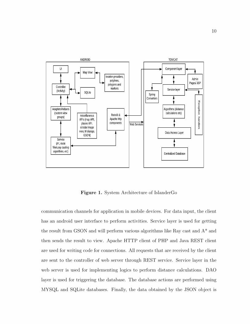
10
Figure 1. System Architecture of IslanderGo
communication channels for application in mobile devices. For data input, the client
has an android user interface to perform activities. Service layer is used for getting
the result from GSON and will perform various algorithms like Ray cast and A* and
then sends the result to view. Apache HTTP client of PHP and Java REST client
are used for writing code for connections. All requests that are received by the client
are sent to the controller of web server through REST service. Service layer in the
web server is used for implementing logics to perform distance calculations. DAO
layer is used for triggering the database. The database actions are performed using
MYSQL and SQLite databases. Finally, the data obtained by the JSON object is
11
displayed in the user interface of Android.
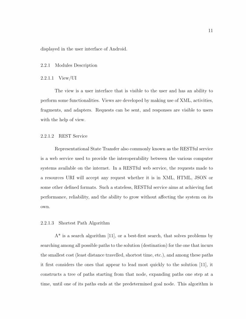
2.2.1 Modules Description
2.2.1.1 View/UI
The view is a user interface that is visible to the user and has an ability to
perform some functionalities. Views are developed by making use of XML, activities,
fragments, and adapters. Requests can be sent, and responses are visible to users
with the help of view.
2.2.1.2 REST Service
Representational State Transfer also commonly known as the RESTful service
is a web service used to provide the interoperability between the various computer
systems available on the internet. In a RESTful web service, the requests made to
a resources URI will accept any request whether it is in XML, HTML, JSON or
some other defined formats. Such a stateless, RESTful service aims at achieving fast
performance, reliability, and the ability to grow without affecting the system on its
own.
2.2.1.3 Shortest Path Algorithm
A* is a search algorithm [11], or a best-first search, that solves problems by
searching among all possible paths to the solution (destination) for the one that incurs
the smallest cost (least distance travelled, shortest time, etc.), and among these paths
it first considers the ones that appear to lead most quickly to the solution [11], it
constructs a tree of paths starting from that node, expanding paths one step at a
time, until one of its paths ends at the predetermined goal node. This algorithm is
12
implemented in this application to determine the best path from the set of recorded
routes and the routes obtained from google maps.
2.2.1.4 Ray casting algorithm
Ray casting algorithm [10] is used to find whether the point (user) is inside
or outside a simple polygon (building). It works on testing how many times a ray,
starting from the point and going in any fixed direction, intersects the edges of the
polygon. If the point is on the outside of the polygon the ray will intersect its edge
an even number of times. If the point is on the inside of the polygon then it will
intersect the edge an odd number of times [10]. This is how we identify if the user is
inside/outside a building and to which building is his current location closest to.
2.2.1.5 Apache Tomcat
Apache Tomcat also known as Tomcat Server, is an open source Java Servlet
Container developed by the Apache Software Foundation. This is used to implement
several Java Enterprise Edition specifications including Java Servlets, Java Server
Pages and Web Sockets. It works on HTTP web server technology.
2.2.1.6 JSON
JSON, JavaScript Object Notation, is an open standard format that is used
to transmit the data in the form of key-value pairs. It is the most common data
format used for asynchronous browser/server communication.

13
2.2.1.7 SQLite
SQLite is a relational database management system. In contrast to many
other database management systems, SQLite is not a clientserver database engine.
Rather, it is embedded into the end program for faster retrieval of data.
2.2.1.8 Amazon Web Services
Amazon Web Services (AWS) is a subsidiary of the leading online shopping
company, Amazon.com. It offers a high-level Cloud Computing platform. Their
services can be used for various services such as computing, analytics, deployment
and mobile developer tools.
2.2.1.9 Google Maps API
The Google Maps JavaScript API lets developers to customize maps with their
own content and imagery for display on web pages and mobile devices. The Google
Maps JavaScript API features four basic map types (road-map, satellite, hybrid,
and terrain) which can be modified using layers and styles, controls and events, and
various services and libraries.
2.2.1.10 Google Places API
The Google Places Web Service is a service that returns information about a
”place”: an establishment, a geographic location, or prominent point of interest using
an HTTP request. Place requests specify locations as latitude/longitude coordinates.
Two basic place requests are available: a Place Search request and a Place Details
request.

14
2.2.1.11 Google Geolocation API
The Google Maps Geolocation API returns a location and accuracy radius
based on information about cell towers and WiFi nodes that the mobile client can
detect. The current location of a user can be detected using this.
2.3 Use Case Diagram
A use case diagram shows the user interaction with the application system.
The use case diagram shown in figure 2 represents the typical cases seen in the
application. Overall it is used to describe functionalities of the system in the form
of a graphical overview. The oval shapes show the features that are provided to the
user.
Any user can use the application once they register successfully by providing
basic information like Name, E-mail etc. The login functionality allows users to login
into the application with the help of username/email and password which are set by
the user during registration. The logout functionality is available to the user after
they login. The user needs to grant permission to access user’s location and media
files. User has access to more comprehensive information about the indicated build-
ings such as its name, description including short history, contact details, working
hours etc with the information functionality. The search functionality displays a
list of all buildings on the campus, so a user can choose the destination. Once the
destination is set, all the available google routes and recorded routes are fetched.
Recording functionality can be used to record specific routes which are alternate to
existing paths. Three best routes are calculated from these set of routes using A*
search algorithm and displayed to the user.

15
Figure 2. Use Case diagram for User in IslanderGo Application
The use case diagram for the functionalities of admin are represented in fig-
ure 3. Admin can add/update/delete building information based on the changes
made, admin can also add/update/delete events happening in the campus. All this
information will be displayed to the user through the application interface.

16
Figure 3. Use Case diagram for Admin
2.4 Class Diagram
Figure 4 describes the structure of the system by making use of classes of the
system, their attributes, methods, and relation between the objects.

17
Figure 4. Class diagram of the application
18
2.5 User Interface
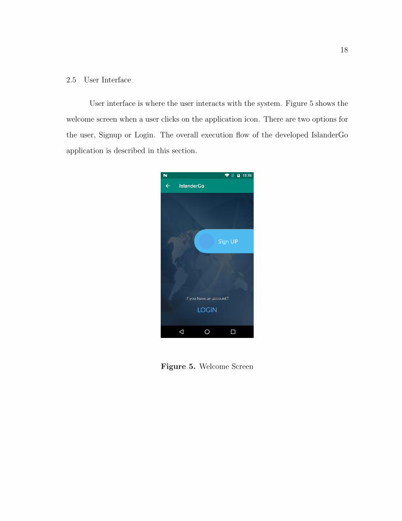
User interface is where the user interacts with the system. Figure 5 shows the
welcome screen when a user clicks on the application icon. There are two options for
the user, Signup or Login. The overall execution flow of the developed IslanderGo
application is described in this section.
Figure 5. Welcome Screen

19
2.5.1 Login Screen
The login screen is used for user authentication to prevent unauthorized ap-
plication use. Figure 6 shows the users login screen. The user must login with the
email and password set during registration to login to the application. When user
logins with the right credentials, access is granted to the application.
Figure 6. Login screen

20
2.5.2 Registration Screen
Figure 7 shows the required fields for registering a new user in the application.
If the user is using the application for the first time, the user needs to register in
the application by providing basic details such as Name, Email id and set unique
username and password combination.
Figure 7. Registration screen

21
2.5.3 Home Screen
Figure 8 shows the main screen/first screen when the user logs into the appli-
cation. The Home Screen shows a detailed campus map of the university. It displays
all the buildings on the campus which are responsive to touch. If a user touches on
specific building , he can see list of options like information, and routes to reach that
building.
The float button at the bottom right corner, helps to refresh the current
location of a user and sets the source field. When a destination is picked, it is shown
in the destination field. The hamburger button on the upper left corner displays the
menu of the application.
Figure 8. Home screen

22
2.5.4 Menu
Figure 9 shows some of the functionalities of the application. At the top of
the menu, the username of the user is displayed and all the functionalties are listed
below. Search displays a list of all the buildings on the campus from where a user
can choose a destination. Record Routes allows user to record alternate paths from
a source to destination. Routes History displays statistics of recorded routes by the
user. Events contain the information and place of the event, change in color of the
building indicates an event. In the information icon, more details about the buildings
are provided. Settings is useful to provide users with functionalities to switch map
type, and to monitor their search history.
Figure 9. Menu screen

23
2.5.5 Admin Interface
Administrator can add, update, or delete any event in the IslanderGo web page
as shown in fig 10. As soon as administrator updates an event, it gets displayed in the
events list of the user interface. Similarly, administrator can also add, update and
delete information about the buildings on campus which is displayed in information
screen as shown in figure 11.
Figure 10. Admin screen for Events

24
Figure 11. Admin screen for information

25
CHAPTER 3
SYSTEM IMPLEMENTATION
3.1 Setting required permissions
Figure 12 shows the permissions that are to be set from the AndroidMani-
fest.xml file. This application requires internet to connect to web server, location
access to track the accurate location of the user and to write and read to external
storage for obtaining and storing the building information.
Figure 12. Setting permissions in AndroidManifest.xml file

26
3.2 MD5 Hashing of account passwords
The most important security aspect of the application lies with securing the
account passwords of the users. To secure these passwords, MD5 Hashing algorithm
is implemented to store the passwords in the database as shown in figure 13. The
MD5 hashing algorithm is a one-way cryptographic function that accepts a message
of any length as input and returns as output a fixed-length digest value to be used
for authenticating the original message.
Figure 13. MD5 Hashing Algorithm
27
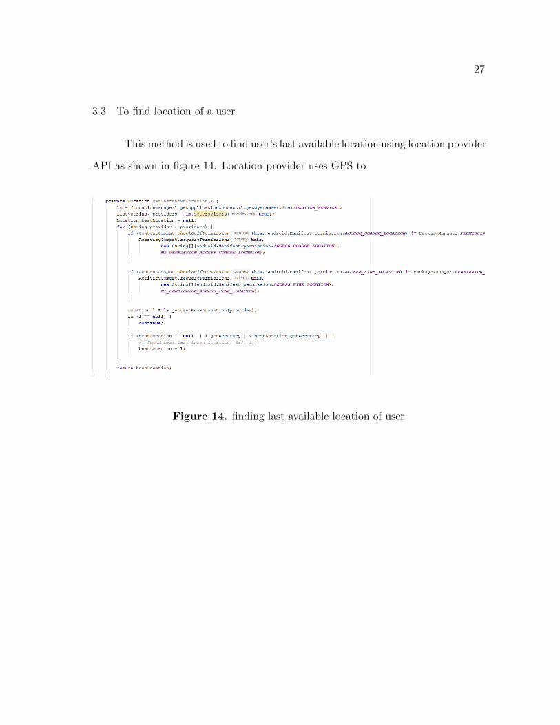
3.3 To find location of a user
This method is used to find user’s last available location using location provider
API as shown in figure 14. Location provider uses GPS to
Figure 14. finding last available location of user

28
3.4 Ray Casting Algorithm
Ray casting algorithm is used to find whether the point (user) is inside or
outside a simple polygon (building). It works on testing how many times a ray,
starting from the point and going in any fixed direction, intersects the edges of the
polygon. If the point is on the outside of the polygon the ray will intersect its edge
an even number of times. If the point is on the inside of the polygon then it will
intersect the edge an odd number of times. This is how we identify if the user is
inside/outside a building and to which building is his current location closest to and
display this as a toast to user as shown in figure 15.
Figure 15. Ray Casting algorithm to find users current location with respect to
nearest building

29
3.5 Fetch Google routes
The following figure 16 illustrates how Places API is called to fetch the avail-
able Google routes.
Figure 16. Fetching Google routes

30
3.6 Recording Routes
As shown in figure 17 is a utility code for recording operations. User’s point
of location will be captured for every three seconds. These points will be processed
further for various calculations and will be saved in the server.
Figure 17. Recording operations

31
3.7 Velocity Finder
It is important to find velocity of a user during recording so it can be used to
compare againt the Google provided average walking velocity to find optimum paths.
In order to find the velocity of the moving object, we divide the change in position
by the change in time with respect to the direction moved as shown in figure 18.
Figure 18. Velocity finder to find users velocity while recording
32
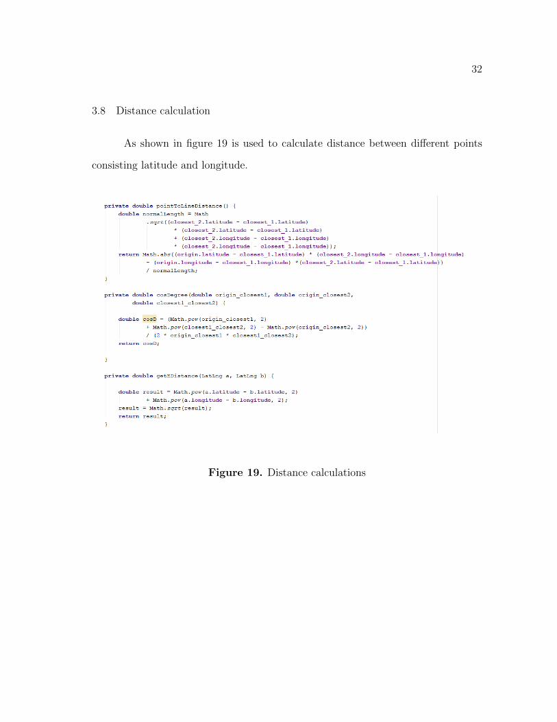
3.8 Distance calculation
As shown in figure 19 is used to calculate distance between different points
consisting latitude and longitude.
Figure 19. Distance calculations

33
3.9 A* Search Algorithm
A* is a search algorithm used to determine the best paths from the set of
recorded routes and the routes obtained from Google maps as shown in figure 20.
Figure 20. To find nearest point to fetch routes
34
CHAPTER 4
EVALUATION AND RESULTS
This chapter includes testing of all the functionalities and validation of the
application in various scenarios.
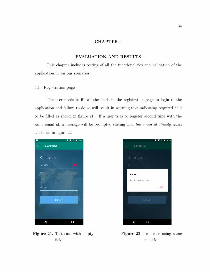
4.1 Registration page
The user needs to fill all the fields in the registration page to login to the
application and failure to do so will result in warning text indicating required field
to be filled as shown in figure 21 . If a user tries to register second time with the
same email id, a message will be prompted stating that the email id already exists
as shown in figure 22.
Figure 21. Test case with empty
field
Figure 22. Test case using same
email id
35
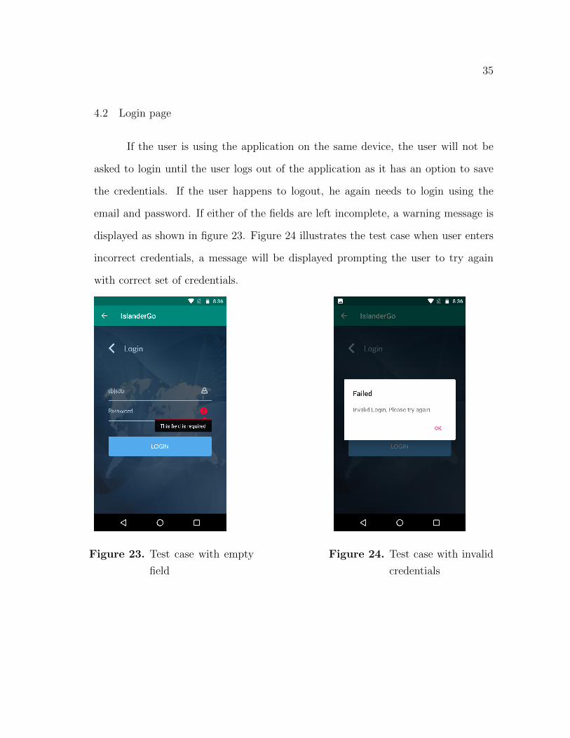
4.2 Login page
If the user is using the application on the same device, the user will not be
asked to login until the user logs out of the application as it has an option to save
the credentials. If the user happens to logout, he again needs to login using the
email and password. If either of the fields are left incomplete, a warning message is
displayed as shown in figure 23. Figure 24 illustrates the test case when user enters
incorrect credentials, a message will be displayed prompting the user to try again
with correct set of credentials.
Figure 23. Test case with empty
field
Figure 24. Test case with invalid
credentials

36
4.3 Search
Search displays a list of all the buildings on the campus as shown in figure 25,
so a user can easily choose the destination from there. If the user is sure about the
destination, he can directly type in the field at the top, or the user can pick from the
list of buildings by clicking on the search button next to the building name. Once
the destination is set, three best routes are suggested to the user along with the time
required for each route as shown in figure 26. User can pick any one of the three
routes and start walking towards the destination.
Figure 25. Search screen before
selecting destination
Figure 26. Search screen when
destination is selected
37
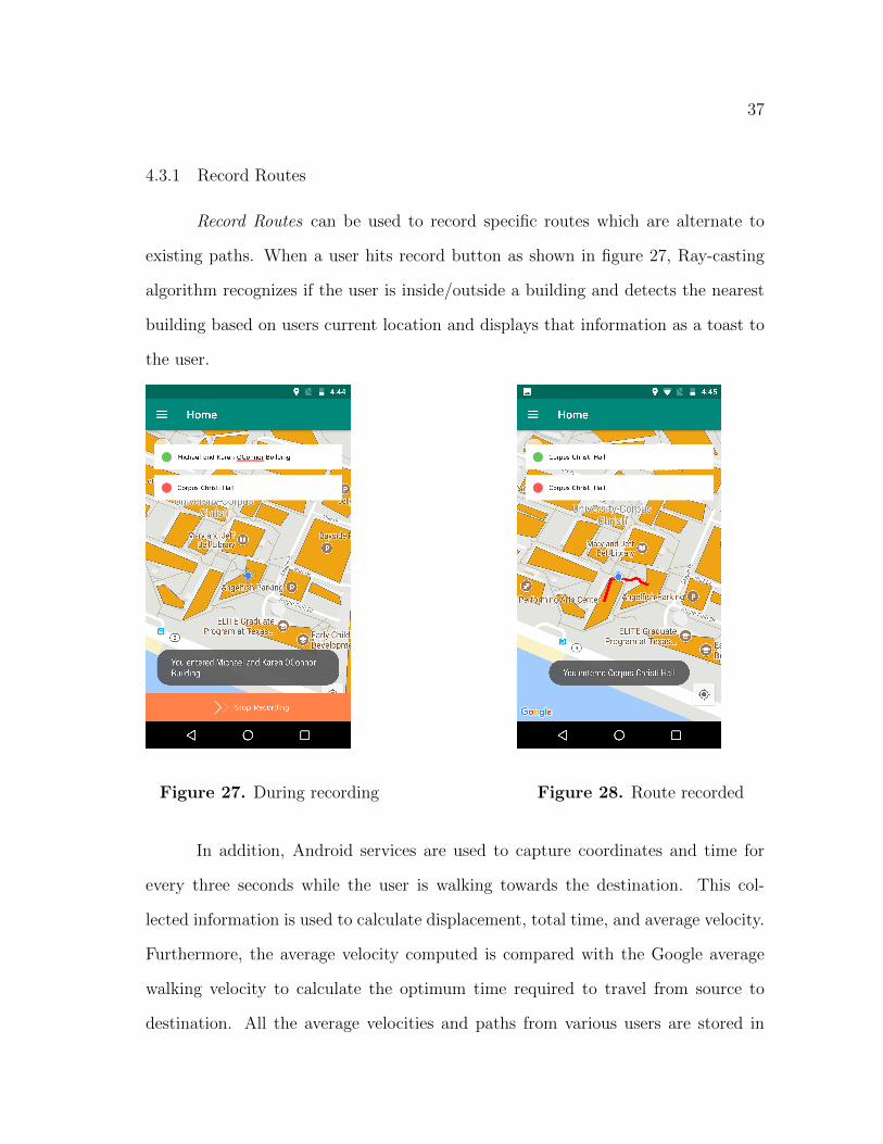
4.3.1 Record Routes
Record Routes can be used to record specific routes which are alternate to
existing paths. When a user hits record button as shown in figure 27, Ray-casting
algorithm recognizes if the user is inside/outside a building and detects the nearest
building based on users current location and displays that information as a toast to
the user.
Figure 27. During recording Figure 28. Route recorded
In addition, Android services are used to capture coordinates and time for
every three seconds while the user is walking towards the destination. This col-
lected information is used to calculate displacement, total time, and average velocity.
Furthermore, the average velocity computed is compared with the Google average
walking velocity to calculate the optimum time required to travel from source to
destination. All the average velocities and paths from various users are stored in

38
Android file using Android file API. The recorded path is displayed to the user once
the user hits stop recording as shown in figure 28 and the data is uploaded to the
server using MIME type so it can be useful to all the other users as well.
4.3.2 Routes History
When a user records routes, all the routes will be displayed to the user in the
form of a list in the Routes History as shown in figure 29. This provides the user
with a feature to monitor their recorded routes and navigate using that route. The
user can also delete the set of recorded routes. The option to delete recorded routes
is provided in the settings screen of the user interface.
Figure 29. Routes History

39
4.3.3 Events
Any event taking place on the campus can be broadcasted in the developed
application which can reduce the need of physical posters. As shown in fig 31,
a change in color of the building indicates that an event is taking place in that
particular building. If the user clicks on that building, more information regarding
the event can be found.
If the user wants to know about events which had already happened or the
events which will take place in future, they can go to the Events screen which displays
a list of all events that are scheduled for the day and also retains information of the
events that took place earlier as shown in figure 30.
Figure 30. Events list
Figure 31. Event indicated with
color change

40
4.3.4 Information
The information screen provides more comprehensive information about the
indicated buildings such as its name, description including short history, contact
details, working hours etc as shown in figure 32. This feature helps new students,
visitors to know more about the college as well as reduces number of tour guides on
campus.
Figure 32. Information list
4.3.5 Settings
The settings screen has options to clear users search query history, and to
delete all routes history. The user has an option to switch map type to Satellite,
Hybrid and Roadmap. Figure 33 shows the Settings screen.

41
Figure 33. Settings Screen
4.3.6 Logout
The user can click on log out button present in the menu to logout of the
application.
4.4 Validating Events
Admin has the privileges to add, update and delete events in the web page
of the application. Admin needs to fill in all the fields of the Event page like Event
name, building, date and time. If one of the fields is left empty, it will result in
failure and a warning text will be prompted asking the admin to fill the required
fields as shown in figure 34.
42
Figure 34. Test case with adding an event with no time
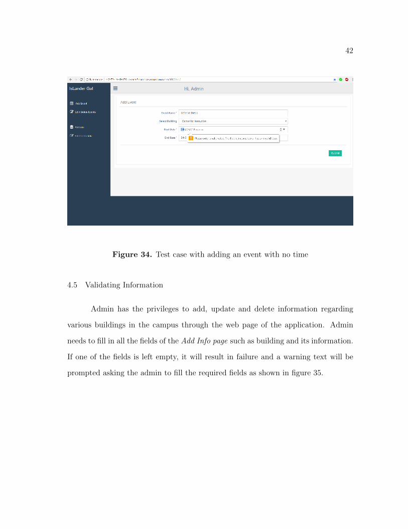
4.5 Validating Information
Admin has the privileges to add, update and delete information regarding
various buildings in the campus through the web page of the application. Admin
needs to fill in all the fields of the Add Info page such as building and its information.
If one of the fields is left empty, it will result in failure and a warning text will be
prompted asking the admin to fill the required fields as shown in figure 35.

43
Figure 35. Test case for empty field

44
CHAPTER 5
CONCLUSION AND FUTURE WORK
5.1 Conclusion
IslanderGo is an application developed for Android devices. It is a Global Po-
sitioning System (GPS) based navigation system for Texas A&M University-Corpus
Christi (TAMUCC) campus. This Google Map based application provides more com-
prehensive information of any building in the campus, recognizes current location of
a user, allows user to search for any destination in the campus, and suggests the
best possible way to reach the desired destination thus making it easy to navigate
from building to building within the campus. Also, this application can be used to
display event information and updates on the map view of the application which can
reduce the need of physical posters. Consequently, the developed application helps
navigating around the TAMUCC campus in a more convenient and timely way.
5.1.1 Future Work
By adding the following functionalities, this application can be improved fur-
ther.
• Audio Controls: If speech activated control is added to this application, visually
impaired people can be benefited. Frequent audio alerts on changing location
can direct them to proper locations. This can reduce their stress for searching
a place or to reach any place.
• Multimedia based Advertisements: Rich multimedia-based advertisements like
audio/video promotion of any event can be added in the map with proper
45
location of the event.
• Warning system: Helps broadcasting/receiving alert texts during emergency
situations on campus, based on user’s current location.
• Improved search list: Buildings can be categorized and grouped into the re-
spective departments which helps a prospective student to take a campus tour
at his field of interest at ease.

46
REFERENCES
[1] Bhatia, S., and Hilal, S. A new approach for location based tracking.
International Journal of Computer Science Issues (IJCSI) 10, 3 (2013).
[2] Bhattacharya, S., and Panbu, M. Design and development of mobile
campus, an android based mobile application for university campus tour guide.
International Journal of Innovative Technology and Exploring Engineering 2, 3
(2016), 25–29.
[3] Cardei, M., Zankina, I., Cardei, I., and Raviv, D. Campus assistant
application on an android platform. In Southeastcon, 2013 Proceedings of IEEE
(2013), IEEE, pp. 1–6.
[4] contributors, W. Android (operating system) — wikipedia, the free ency-
clopedia, 2018. [Online; accessed 5-February-2018].
[5] contributors, W. Google maps — wikipedia, the free encyclopedia, 2018.
[Online; accessed 5-February-2018].
[6] Gugapriya, A., Vaitheki, J., and Kaviyarasi, S. Mobile banking with
location tracking of nearest atm center using gps. IJITR 1, 3 (2013), 253–255.
[7] Helshani, L., et al. An android application for google map navigation sys-
tem, solving the travelling salesman problem, optimization throught genetic
algorithm. Proceedings of FIKUSZ 2015 (2015), 89.
[8] Huang, J., Zhan, Y., Cui, W., Yuan, Y., and Qi, P. Development of a
campus information navigation system based on gis. In Computer Design and

47
Applications (ICCDA), 2010 International Conference on (2010), vol. 5, IEEE,
pp. V5–491.
[9] Jana, S., and Chattopadhyay, M. An event-driven university campus
navigation system on android platform. In Applications and Innovations in
Mobile Computing (AIMoC), 2015 (2015), IEEE, pp. 182–187.
[10] Kim, I.-S., Lee, W.-K., and Hong, Y.-D. Simple global path planning
algorithm using a ray-casting and tracking method. Journal of Intelligent &
Robotic Systems 90, 1-2 (2018), 101–111.
[11] Li, D., Liu, M., Zhang, J., and Cheng, E. An improved a* algorithm ap-
plicable for campus navigation system. In Network and Information Systems for
Computers (ICNISC), 2015 International Conference on (2015), IEEE, pp. 588–
591.
[12] Lin, H.-T. The comprehensive guiding and navigation services on smart
phones. In Computer Science and Engineering Conference (ICSEC), 2013 In-
ternational (2013), IEEE, pp. 97–102.
[13] Mena, A., Rivera, J., Teran, D., Tapia, F., Fuertes, W., Aules,
H., and Toulkeridis, T. Interactive geo-location based service application
as pervasive computing through mobile devices. In Electrical, Electronics En-
gineering, Information and Communication Technologies (CHILECON), 2017
CHILEAN Conference on (2017), IEEE, pp. 1–6.
[14] Premchaiswadi, W., Kungcharoen, K., and Chompukaew, S. Devel-
opment of gps-based navigator for kasetsart university, kamphaeng saen campus.

48
In ICT and Knowledge Engineering (ICT&KE), 2016 14th International Con-
ference on (2016), IEEE, pp. 71–76.
[15] Prez-Montoro, M., and Codina, L. Chapter 2 - the basis of navigation. In
Navigation Design and SEO for Content-Intensive Websites, M. Prez-Montoro
and L. Codina, Eds. Chandos Publishing, 2017, pp. 11 – 63.
[16] Rao, B., and Minakakis, L. Evolution of mobile location-based services.
Communications of the ACM 46, 12 (2003), 61–65.
[17] Silapachote, P., Srisuphab, A., Satianrapapong, R., Kaewpijit, W.,
and Waragulsiriwan, N. A context-aware system for navigation and infor-
mation dissemination on android devices. In 2013 IEEE International Confer-
ence of IEEE Region 10 (TENCON 2013), pp. 1–4.