investigatingthedynamicsofarockglacierusingterrestriallase ... · xi. international conference on...
TRANSCRIPT
XI. INTERNATIONAL CONFERENCE ON PERMAFROST | 20.-24. JUNE 2016
Investigating the dynamics of a rock glacier using terrestrial laser scanning,time-lapse photography, in-situ GPS measurements and satellite SAR inter-ferometry: Ritigraben rock glacier, Switzerland.
Robert Kenner1, Marcia Phillips2, Jan Beutel3, Philippe Limpach4, Jessica Papke5, Andreas Hasler6, &Hugo Raetzo7
1WSL Institute for Snow and Avalanche Research SLF, Switzerland2WSL Institute for Snow and Avalanche Research SLF, Switzerland3ETH Zürich, Computer Engineering and Networks Laboratory, Switzerland4ETH Zürich, Institute of Geodesy and Photogrammetry, Switzerland5Department of Geography, University of Leicester, United Kingdom6SensAlpin GmbH, Switzerland7Federal Office for the Environment FOEN, Switzerland
Ritigraben rock glacier is located above Grächenin the southwestern Swiss Alps and it creeps intothe top of the steep Ritigraben gully, where debrisflows have been triggered in the past (Stoffel et al.2005). Borehole temperature measurements carriedout since 2002 in this ice-rich permafrost feature showthat an intra-permafrost seasonal talik has formedregularly since 2006 at a depth of 11-12 m, causedby snow melt and precipitation flowing through theice-rich permafrost in summer (Zenklusen Mutter andPhillips, 2012).We used terrestrial laser scanning, mono-plotting
of time-lapse photography, an in-situ GPS deviceand satellite SAR interferometry (InSAR) to invest-igate the dynamics of the rock glacier and possibleinfluences of the seasonal talik. These measurementsystems complement one another in terms of temporaland spatial resolution, as well as accuracy.
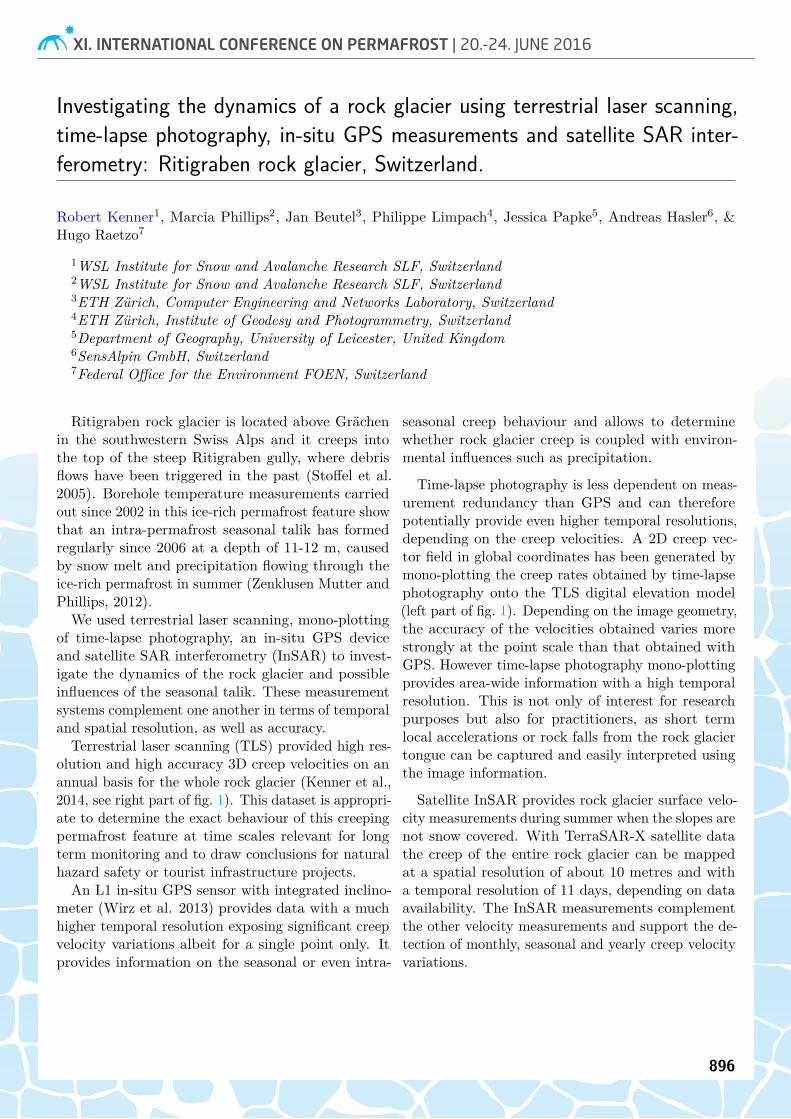
Terrestrial laser scanning (TLS) provided high res-olution and high accuracy 3D creep velocities on anannual basis for the whole rock glacier (Kenner et al.,2014, see right part of fig. 1). This dataset is appropri-ate to determine the exact behaviour of this creepingpermafrost feature at time scales relevant for longterm monitoring and to draw conclusions for naturalhazard safety or tourist infrastructure projects.An L1 in-situ GPS sensor with integrated inclino-
meter (Wirz et al. 2013) provides data with a muchhigher temporal resolution exposing significant creepvelocity variations albeit for a single point only. Itprovides information on the seasonal or even intra-
seasonal creep behaviour and allows to determinewhether rock glacier creep is coupled with environ-mental influences such as precipitation.
Time-lapse photography is less dependent on meas-urement redundancy than GPS and can thereforepotentially provide even higher temporal resolutions,depending on the creep velocities. A 2D creep vec-tor field in global coordinates has been generated bymono-plotting the creep rates obtained by time-lapsephotography onto the TLS digital elevation model(left part of fig. 1). Depending on the image geometry,the accuracy of the velocities obtained varies morestrongly at the point scale than that obtained withGPS. However time-lapse photography mono-plottingprovides area-wide information with a high temporalresolution. This is not only of interest for researchpurposes but also for practitioners, as short termlocal accelerations or rock falls from the rock glaciertongue can be captured and easily interpreted usingthe image information.
Satellite InSAR provides rock glacier surface velo-city measurements during summer when the slopes arenot snow covered. With TerraSAR-X satellite datathe creep of the entire rock glacier can be mappedat a spatial resolution of about 10 metres and witha temporal resolution of 11 days, depending on dataavailability. The InSAR measurements complementthe other velocity measurements and support the de-tection of monthly, seasonal and yearly creep velocityvariations.
896

XI. INTERNATIONAL CONFERENCE ON PERMAFROST | 20.-24. JUNE 2016
Figure 1: Creep rates of rock glacier Ritigraben calculated from time lapse photography (left) and laser scan (right).
References:Wirz, V., Beutel, Jan., Buchli, B., Gruber S.,
Limpach, P., 2013. Temporal characteristics of dif-ferent cryosphere-related slope movements in highmountains. Landslide Science and Practice, Berlin,Heidelberg, p. 383-390.Kenner, R., Bühler, Y., Delaloye, R., Ginzler, C.,
Phillips, M., 2014. Monitoring of high alpine mass
movements combining laser scanning with digital air-borne photogrammetry. Geomorphology, 206(0), 492-504.
Zenklusen Mutter, E., Phillips, M., 2012. Thermalevidence of recent talik formation in Ritigraben rockglacier: Swiss Alps, 10th International Conference onPermafrost, Salekhard, Russia, pp. 479-483.
897