international workshop on seismic analysis in t; 7th...
TRANSCRIPT
1
SC/BES/DRE/2008/1 Paris, France. June 2008
Original: English
REDUCTION OF EARTHQUAKE LOSSES IN
THE SOUTH ASIA REGION - RELSAR -
Seventh International Workshop on Seismic Analysis in the
South Asia Region
Workshop Report
Thimphu, Bhutan
2-5 June 2008
Contact: [email protected]
2
Foreword In many countries of the Asia region, disasters caused by natural and environmental hazards continue to exact a heavy toll in terms of the loss of human lives and the destruction of economic and social infrastructure. With population growth in the coastal areas of countries concerned, expanding public and private infrastructure, and continuing trends towards urbanization and industrialization, the risks from great disasters are expected to increase over the coming years and decades. Among the numerous natural disasters that the countries of Asia have experienced, earthquakes have historically had great impacts. It is necessary to mobilize scientific knowledge and technological know-how to assess earthquake hazards and to strengthen disaster mitigation measures. To this end, regional collaboration needs to be encouraged. Since 1999, the United Nations Educational, Scientific and Cultural Organization (UNESCO) and the United States Geological Survey (USGS) have been cooperating with scientific and engineering organizations in the South Asia region under the programme: Reduction of Earthquake Losses in the South Asia Region (RELSAR). The purpose of the Programme is to provide a platform for examining regional approaches to improve seismic data and earthquake risk mitigation. A number of collaborative activities have taken place under this initiative. These activities have included six workshops that have been held since the start of the Programme in 1999. UNESCO, USGS, and the Department of Geology and Mines, Ministry of Economic Affairs, organized a workshop in Thimphu, Bhutan, 2 – 5 June 2008, on Seismic Analysis in the South Asia Region. The present report provides an overview of the outcome of this workshop. This workshop and its follow-up should be seen in the context of the implementation by the countries concerned of the Hyogo Framework for Action 2005-2015, which was adopted at the World Conference on Disaster Reduction held in Kobe, Japan, in January 2005 and convened within the International Strategy for Disaster Reduction. UNESCO thanks the USGS for its cooperation in the RELSAR implementation and for the production of this report. The commitment and hospitality of the Bhutan Department of Geology and Mines and their management and staff have made the meeting a successful event. UNESCO wishes to express its gratitude all those who have contributed to the success of the workshop and is especially grateful to Dorji Wangda, Director General, and Dowchu Dukpa, Senior Geophysicist, for their support of the workshop. The content of this report does not necessarily reflect the views of UNESCO. June 2008 Badaoui Rouhban
Chief Section for Disaster Reduction Natural Sciences Sector UNESCO, Paris
3
Seventh International Workshop on Seismic Analysis in the South Asia Region
Thimphu, Bhutan
2-5 June 2008
Executive Summary The Asia-Pacific region has the highest level of seismicity on the planet. It is also the setting for many of the largest earthquakes. A recently published catalogue for earthquakes with magnitude greater than 8.0 in the period 1904-1992 lists fifty-four earthquakes worldwide, of which thirty-eight occurred in the Asia-Pacific region. The high seismic risk in the region was recently emphasized by the September 1999 magnitude 7.4 earthquake in central Taiwan that caused more than 1,000 deaths and billions of U.S. dollars in damage, by the 26 January 2001 magnitude 7.5 Bhuj earthquake in India, by the 26 December 2004 magnitude 9.0 earthquake and accompanying tsunami that killed more than 200,000 people, by the 8 October 2005 magnitude 7.6 Muzaffarabad (Pakistan) earthquake that caused more than 87,000 deaths, and by the 12 May 2008 magnitude 7.9 earthquake in Sichuan province of China that killed more than 69,000 people. The majority of earthquakes in the Asia region are related to regions of plate convergence where one tectonic plate slides beneath another plate (subduction zones). In addition to generating large earthquakes, plate subduction often gives rise to volcanism. However, large earthquakes are not always associated with subduction zones. Faults where horizontal motion takes place (strike-slip faults) also generate devastating earthquakes. Strike-slip faults in China and Mongolia are responsible for numerous destructive earthquakes, often with magnitudes between 6.0 and 7.5 and occasionally greater than 8.0. In response to this risk, most nations have increased the number and quality of seismic stations used to monitor earthquake activity. The optimal use of these data for regional earthquake monitoring is a major challenge that will require the exchange of data, software, and expertise among the interested nations. The Bhutan 2008 Workshop To focus on the high risk Himalayan region, UNESCO, USGS, and the Department of Geology and Mines, Ministry of Economic Affairs, organized a workshop in Thimphu, Bhutan, 2-5 June 2008 on Seismic Analysis in the South Asia Region. The Keynote Addresses were presented by Sujit Dasgupta: Short-Listing of earthquake source zones in the Himalaya: Constraints from pattern recognition of spatio-temporal seismicity clusters and by Walter Mooney (presented by Keith Nakanishi): Seismicity and Tectonics of Bhutan and its Environs. In the technical sessions, participants presented fifteen papers on recent developments in Himalayan tectonics, national seismic networks, the 2003 Mw 6.0 Bam Earthquake, attenuation of coda waves in Northeastern India, attenuation of Intensities in the Mw 7.6 Balakot, Muzaffarabad (Pakistan) Earthquake of 8 October 2005, the 8 October 2005
4
Kashmir-Hazara (Pakistan) Earthquake, precursor studies in Northeast India, geology and tectonic setting of Bhutan, intensity distribution and impact of Kaghan Valley (Pakistan) Earthquake of February 14, 2004, seismic landscape in West Bengal-Bhutan-Assam Himalaya foothills, earthquake risk reduction, Western Eurasia and North Africa (WENA) model, evidence for seismicity in the lower crust and upper mantle in the Nepal Himalaya, implication for the rheology of the lithosphere, and stress regime in Bhutan Himalaya through stress tensor inversion. In the data processing sessions, the digital datasets were combined and processed as though it was a single network. The dataset was chosen to include three regions, one in the western part of the Himalayas, close to Pakistan, China, India and Nepal, the second set was chosen to be in the central part of the Himalayas, along the Nepal and India borders and the third set was chosen to be in the eastern part of the Himalayas including India, China, Nepal and Bhutan. As in previous RELSAR meetings involving data processing, data formatting was again an issue that had to be dealt with. The participants identified the P-wave onsets on as many stations as possible and used these to determine the origin times and hypocenter locations. The global IASP91 travel time tables were used in the inversion for the hypocenter.
5
Introduction Seismicity of the Asia region
The Asia-Pacific region has the highest level of seismicity on the planet. It is also the setting for many of the largest earthquakes. A recently published catalogue for earthquakes with magnitude greater than 8.0 in the period 1904-1992 lists fifty-four earthquakes worldwide, of which thirty-eight occurred in the Asia-Pacific region. The high seismic risk in the region was recently emphasized by the September 1999 magnitude 7.4 earthquake in central Taiwan that caused more than 1,000 deaths and billions of U.S. dollars in damage, by the 26 January 2001 magnitude 7.5 Bhuj earthquake in India, by the 26 December 2004 magnitude 9.0 earthquake and accompanying tsunami that killed more than 200,000 people, by the 8 October 2005 magnitude 7.6 Muzaffarabad (Pakistan) earthquake that caused more than 87,000 deaths, and by the 12 May 2008 magnitude 7.9 earthquake in Sichuan province of China that killed more than 69,000 people. The majority of earthquakes in the Asia region are related to regions of plate convergence where one tectonic plate slides beneath another plate (subduction zones). In addition to generating large earthquakes, plate subduction often gives rise to volcanism. Large earthquakes are not always associated with subduction zones. Faults where horizontal motion takes place (strike-slip faults) also generate devastating earthquakes. A well-known example in the United States is the San Andreas Fault, where the Pacific plate slides northward with respect to the North American plate. Strike-slip faults in China and Mongolia are responsible for numerous destructive earthquakes, often with magnitudes between 6.0 and 7.5 and occasionally greater than 8.0. The Tangshan, China, earthquake of July 1976, occurred on a strike-slip fault and resulted in over 240,000 deaths according to the China Earthquake Administration (CEA). The tectonic plate carrying India is slowly slipping under the Asian plate at a rate of approximately two meters per century causing the rise of the Himalayan Mountains and is the source of great seismic strain along the mountain range. Some researchers believe that seismic stresses could break free and cause a massive earthquake of magnitude eight or more in the near future placing the capital cities of Bangladesh, Bhutan, India, Nepal and Pakistan as well as numerous other large cities and more than 50 million people at risk. Most of the population lives in buildings that offer little resistance to collapse from earthquakes. At least one earthquake of magnitude greater than 8.0 is overdue along the seismically active front of the Himalayas. In response to this risk, most nations have increased the number and quality of seismic stations used to monitor earthquake activity. The optimal use of these data for regional monitoring is a major challenge that will require the exchange of data, software, and expertise among the interested nations. RELSAR Workshops The United Nations Educational, Scientific and Cultural Organization (UNESCO), the U.S. Geological Survey (USGS), and earth science organizations in the South Asia Region have sponsored a series of workshops on reducing earthquake losses. In September 2001, UNESCO, the USGS, and the Islamic Educational, Scientific and
6
Cultural Organization, in cooperation with the Nepal Department of Mines and Geology, held the First International Workshop on Seismic Analysis in the South Asia Region in Kathmandu. The China Earthquake Administration (CEA) hosted the Second International Workshop on Seismic Analysis in the South Asia Region in Kunming, China, 13-16 May 2002 and the third workshop in the series was held in Columbo, Sri Lanka, 30 September – 3 October 2003. The Geological Survey of Bangladesh and the Bangladesh Atomic Energy Commission co-hosted the Fourth International Workshop on Seismic Analysis in the South Asia Region. The Fifth International Workshop on Seismic Analysis in the South Asia Region was co-hosted by the China Earthquake Administration and the Earthquake Administration of Shaanxi Province and was held in Xi’an, China, 13 – 16 November 2005. The Sixth International Workshop on Seismic Analysis in the South Asia Region was co-hosted by the Coordinating Committee for Geoscience Programmes in East and Southeast Asia (CCOP), the Thai Department of Mineral Resources, and the Thai Department of Meteorology in Chiang Mai, Thailand, 4 – 7 December 2006. Participants from Afghanistan, Bangladesh, China, France, India, Iran, Nepal, Pakistan, Sri Lanka, the United Kingdom, and the United States have attended these workshops. The Bhutan 2008 Workshop Workshop Proceedings Opening session The Welcoming Address was presented by Dorji Wangda, Director General, Department of Geology and Mines, Ministry of Economic Affairs. The Opening Address was presented by Dasho Sonam Tshering, Secretary, Ministry of Economic Affairs (Chief Guest) who emphasized the importance of earthquake studies in the region. Additional welcoming remarks were made by Nicholas Rossellini, Resident Representative, UNDP, and by Frederick Simon, UNESCO/USGS. Keynote Addresses The Keynote Addresses were presented by Sujit Dasgupta: Short-Listing of earthquake source zones in the Himalaya: Constraints from pattern recognition of spatio-temporal seismicity clusters and by Walter Mooney (presented by Keith Nakanishi): Seismicity and Tectonics of Bhutan and its Environs. Sujit Dasgupta: Short-Listing of earthquake source zones in the Himalaya: Constraints from pattern recognition of spatio-temporal seismicity clusters The Himalayan collisional convergent margin has been visited by large earthquakes:
• Shillong (1897, M 8.7) • Kangra (1905, M 8.0) • Assam (1950, M 8.6) • West Nepal – India (1980, M 6.5) • Dharamsala (1986, M 5.7)
7
• Bihar-Nepal (1988, M 6.6) • Uttarkashi (1991, M 6.6) • Chamoli (1999, M 6.8) • Kashmir (2005, M 7.7)
The plate convergence rate (Bettinelli et al. 2006), the differential shortening rate (Banerjee and Burgmann 2002; Jade et al. 2007; Bettinelli et al. 2006; Feldl and Bilham 2006; Chen et al. 2004), and the average slip deficit (Bilham and Ambraseys 2005, Bilham and Wallace 2005) from GPS observations indicate possibility of many future earthquakes in the Himalayas. A number of authors have inferred the recurrence of large future earthquakes in the Himalayan tectonic domain:
• Four large earthquakes (M 8.6) (Bilham and Ambraseys, 2005; Bilham and Wallace, 2005) along the arc
• At least two large earthquakes (M > 8.0) in the areas west of Kathmandu in Nepal (Bettinelli et al., 2006)
• Earthquakes (Mw > 8.6, rupture length 400 km) in the area of seismic gaps at western and central Himalayas and eastern Nepal (Feldl and Bilham, 2006).
The object of this study is to:
• Define spatio-temporal clusters of earthquakes through ‘point density’ and ‘moving time window’ analysis
• Delineate possible source zones of recurrent earthquakes • Derive maximum rupture lengths of individual clusters • Prognosticate maximum size of the earthquake of each cluster
Seismicity was diffused and no visible clusters were observed when looking at 4401earthquake events (Mb>= 4) from 1964 to 2006. Using filtering techniques (Mb>= 4.5), 1266 events appear to be clustered at places. The areal extent of spatio-temporal clusters defined through point density and moving time–distance windows (t=35 days, ‘distance’ = 100 ± 20 km) identified 22 clusters and 53 temporal FMA sequences. At eight of the clusters (Kashmir, Kangra, Garhwal, Kumaun-West Nepal, East Nepal, Sikkim, Bomdila, Eastern Syntaxis), the cluster characteristics include:
• Earthquakes of FMA/MA/FM sequences and independent events • Independent events are more frequent than the temporal events • The magnitude of independent events range from 4.5 – 6.1 • Many earthquakes are from depths >= 45 Km • Seismic Vulnerability in decreasing order
1. Kangra Cluster: There were two large historical events (1555, M=7.6; 1905, M=7.8). The last independent moderate event occurred on 26.4.86 (M=5.5). In the case of a total rupture, an earthquake of Mw=8.2 can be expected. 2. East Nepal Cluster: There were two great historical events (1833, M=7.7 and 1934, M=8.1). A recent disastrous earthquake occurred in 1988 (M=6.1) at the intersection of MFT/MBT/MCT with WPF/EPF/MSRMF. 3. Garhwal Cluster: There was one great historical event (1803, M=8.1) and two recent disastrous events (Uttarkashi and Chamoli) at the intersection of MBT/MCT with MDF.
8
4. Kumaun-West Nepal Cluster: There were two large historical events (1720, M=7.5 and 1916, M=7.3) at the intersection of MBT/MCT with GBF. There were only moderate events in the recent past. Seismic Vulnerability of Inter-cluster Zones
• The inter-cluster zone between Kangra and Garhwal, zone of interaction between the Ropar fault and MBT-MCT, generated the M=6.4 Bashahr earthquake in February 1906. There have been only six events since 1964 and temporal quiescence of approximately15 years.
• The inter-cluster zone between Bomdila and Eastern Syntaxis yielded the July 1947 earthquake (M=7.3) and temporal quiescence of approximately 13years in the North Eastern Himalaya adjacent to the very thickly populated Brahmaputra basin in Assam. This area has been accumulating strain for a long time.
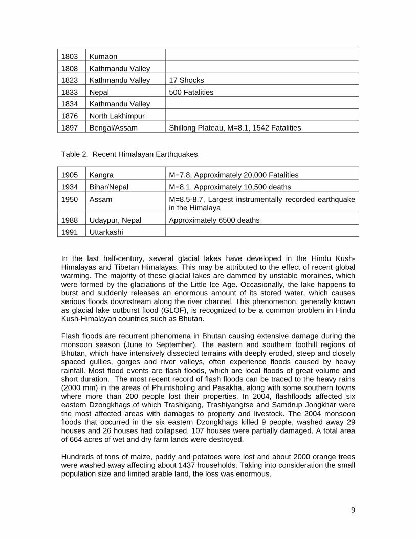
These source zones are a threat to bounce back and produce large earthquakes (>M 7.8) any time in near future. Walter Mooney (presented by Keith Nakanishi): Seismicity and Tectonics of Bhutan and its Environs Bhutan is a mountainous country, where mountains and hills occupy most of the land. The country is vulnerable to various hazards due to fragile geological conditions, great elevation differences, and steep sloping terrain. The regional seismic hazard map indicates that Bhutan and the surrounding environs are in a hazardous region. Tables 1 and 2 list the historical and recent earthquakes. Much of Bhutan is subjected to massive landslides during the rainy season. These landslides destroy agricultural land in eastern Bhutan and cut off road communication between Thimphu and other cities. Apart from earthquakes, landslides and river erosion, the mountainous region is also quite susceptible to disastrous hazards due to glacial lake outburst floods (GLOFs). The area above an elevation of 4,000 m is mostly covered by snow and ice throughout the year. These glaciers, as well as glacial lakes, are the sources of the headwaters of many great rivers in the region. Most of these lakes are located in the down valleys close to the glaciers. They are formed by accumulation of a huge amount of water from the melting of snow and ice cover and by blockage of end moraines. The sudden break of the moraine may generate a discharge of large volumes of water and debris causing flooding. Table 1. Historical Himalayan Earthquakes 1255 Kathmandu Valley
1408 Kathmandu
1505 Southern Tibet
1555 Srinagar 600 Fatalities 1767 Kathmandu Valley 21 Shocks
9
1803 Kumaon
1808 Kathmandu Valley
1823 Kathmandu Valley 17 Shocks 1833 Nepal 500 Fatalities 1834 Kathmandu Valley
1876 North Lakhimpur
1897 Bengal/Assam Shillong Plateau, M=8.1, 1542 Fatalities Table 2. Recent Himalayan Earthquakes 1905 Kangra M=7.8, Approximately 20,000 Fatalities 1934 Bihar/Nepal M=8.1, Approximately 10,500 deaths 1950 Assam M=8.5-8.7, Largest instrumentally recorded earthquake
in the Himalaya 1988 Udaypur, Nepal Approximately 6500 deaths 1991 Uttarkashi In the last half-century, several glacial lakes have developed in the Hindu Kush-Himalayas and Tibetan Himalayas. This may be attributed to the effect of recent global warming. The majority of these glacial lakes are dammed by unstable moraines, which were formed by the glaciations of the Little Ice Age. Occasionally, the lake happens to burst and suddenly releases an enormous amount of its stored water, which causes serious floods downstream along the river channel. This phenomenon, generally known as glacial lake outburst flood (GLOF), is recognized to be a common problem in Hindu Kush-Himalayan countries such as Bhutan. Flash floods are recurrent phenomena in Bhutan causing extensive damage during the monsoon season (June to September). The eastern and southern foothill regions of Bhutan, which have intensively dissected terrains with deeply eroded, steep and closely spaced gullies, gorges and river valleys, often experience floods caused by heavy rainfall. Most flood events are flash floods, which are local floods of great volume and short duration. The most recent record of flash floods can be traced to the heavy rains (2000 mm) in the areas of Phuntsholing and Pasakha, along with some southern towns where more than 200 people lost their properties. In 2004, flashfloods affected six eastern Dzongkhags,of which Trashigang, Trashiyangtse and Samdrup Jongkhar were the most affected areas with damages to property and livestock. The 2004 monsoon floods that occurred in the six eastern Dzongkhags killed 9 people, washed away 29 houses and 26 houses had collapsed, 107 houses were partially damaged. A total area of 664 acres of wet and dry farm lands were destroyed. Hundreds of tons of maize, paddy and potatoes were lost and about 2000 orange trees were washed away affecting about 1437 households. Taking into consideration the small population size and limited arable land, the loss was enormous.
10
Climate change also had an effect in the Himalayas. The warming in the last three decades has been between 0.15 - 0.6 °C per decade. Several studies show that most of glaciers in Himalaya are shrinking at accelerated rates in recent decades resulting in melting glaciers, growing glacial lakes, and glacial lakes outburst floods (GLOFs). Glacial lakes have been rapidly forming on the surface of the debris-covered glaciers in this region during the last few decades. USGS researchers have found a strong correlation between increasing temperatures and glacial retreat in this region. The great majority of the world’s glaciers appear to be declining at rates equal to or greater than long-established trends. Glaciers in the Himalaya are wasting at alarming and accelerating rates, and as shown by the widespread, rapid growth of lakes on the glacier surfaces. Glacial lakes are formed by accumulation of water from the melting of snow and ice cover and by blockage of end moraines. The sudden break of a moraine may generate the discharge of large volumes of water and debris causing GLOFs. The growth of such lakes exceeds the limitations of natural barriers to contain them, and the failure of natural dams leads to catastrophic flooding downstream. Such floods are becoming more common in the Himalaya, and have already led to the loss of property and lives. Glaciers in the Bhutan Himalaya shrunk approximately eight percent between 1963 to 1993:
• Raphstreng glacier retreated 42 m/yr from 1968 to 2001 • Luggye glacier retreated 57 m/yr from 1988 to 1998 • Lake Chubda Tsho increased by 0.027 km2/yr from 1968 to 2001
Technical Sessions In previous workshop reports, detailed notes on the presentations were included. In this workshop, all of the papers were presented using PowerPoint™ and most are included on the CD that accompanies this report. Therefore, only limited notes are included in this report. In addition to the presentations, this report is also available on the CD. The Final Agenda is given in Annex B. In addition to contributed papers by participants, the workshop focused on the processing of selected events along the Himalayan Front using SEISAN. The event list is given in Table 3. Participants were requested to send full waveform data for these events prior to the workshop so that any formatting problems could be resolved. Presentations The technical session was opened by Lars Ottemoller who gave a one-day lecture on the Introduction to SEISAN and processing of selected events. Participants presented fifteen papers on topics including:
• National seismic networks • The 2003 Mw 6.0 Bam Earthquake • Attenuation of Coda waves in Northeastern India • Attenuation of Intensities in the Mw 7.6 Balakot, Muzaffarabad (Pakistan)
Earthquake of 8 October 2005 • The 8 October 2005 Kashmir-Hazara (Pakistan) Earthquake
11
• Precursor studies in Northeast India • Geology and tectonic setting of Bhutan • Intensity distribution and impact of Kaghan Valley (Pakistan) Earthquake
of February 14, 2004 • Himalayan tectonics and great earthquakes • Seismic Landscape in West Bengal-Bhutan-Assam Himalaya Foothills • Efforts in earthquake risk reduction: Examples from South Asia • A review of the Western Eurasia and North Africa (WENA) model • Evidence for Seismicity in the Lower Crust and Upper mantle in the Nepal
Himalaya, implication for the Rheology of the Lithosphere • Stress regime in Bhutan Himalaya through stress tensor inversion
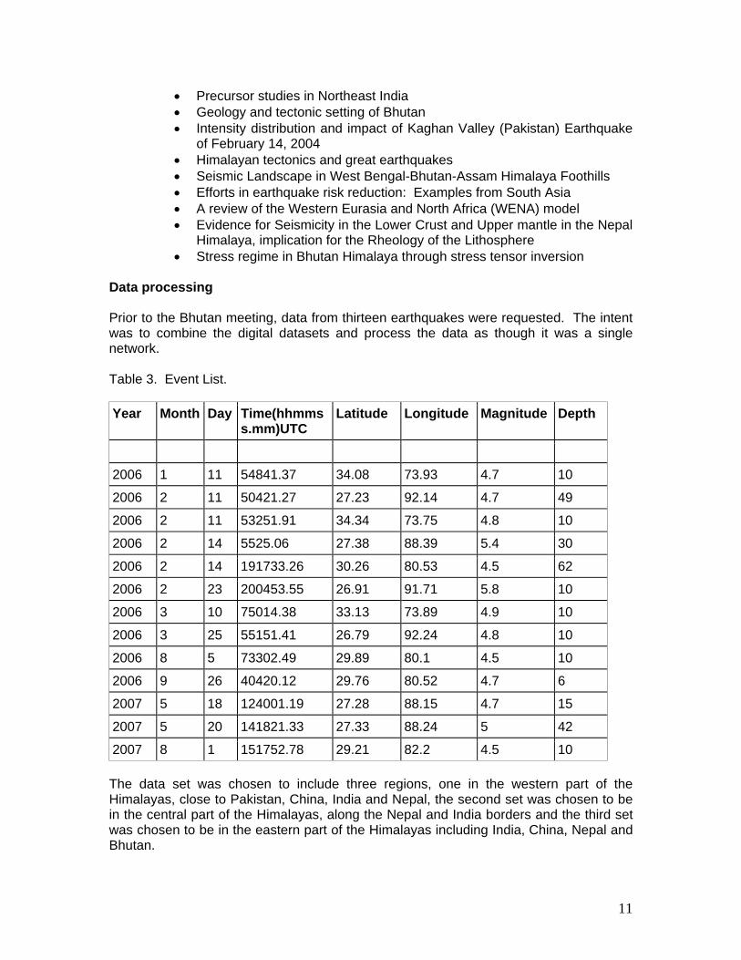
Data processing Prior to the Bhutan meeting, data from thirteen earthquakes were requested. The intent was to combine the digital datasets and process the data as though it was a single network. Table 3. Event List. Year Month Day Time(hhmms
s.mm)UTC Latitude Longitude Magnitude Depth
2006 1 11 54841.37 34.08 73.93 4.7 10
2006 2 11 50421.27 27.23 92.14 4.7 49
2006 2 11 53251.91 34.34 73.75 4.8 10
2006 2 14 5525.06 27.38 88.39 5.4 30
2006 2 14 191733.26 30.26 80.53 4.5 62
2006 2 23 200453.55 26.91 91.71 5.8 10
2006 3 10 75014.38 33.13 73.89 4.9 10
2006 3 25 55151.41 26.79 92.24 4.8 10
2006 8 5 73302.49 29.89 80.1 4.5 10
2006 9 26 40420.12 29.76 80.52 4.7 6
2007 5 18 124001.19 27.28 88.15 4.7 15
2007 5 20 141821.33 27.33 88.24 5 42
2007 8 1 151752.78 29.21 82.2 4.5 10 The data set was chosen to include three regions, one in the western part of the Himalayas, close to Pakistan, China, India and Nepal, the second set was chosen to be in the central part of the Himalayas, along the Nepal and India borders and the third set was chosen to be in the eastern part of the Himalayas including India, China, Nepal and Bhutan.

12
Many organizations contributed data including the Pakistan Meteorological Department, the Micro Seismic Study Program (Pakistan Atomic Energy Commission), the National Geophysical Research Institute (India), the Northeast Institute of Science and Technology (CSIR, India), and the National Seismological Center (Nepal). In addition, data from the Global Seismic Network (GSN) were also used. The contributed data came in the following formats: SUDS, GCF, SEISAN, SEED, GSE and a proprietary format. SEISAN could be read directly and there were format converters in SEISAN for SUDS, GCF, and SEED. GSE formatted data was converted using SAC into SAC files and then SAC files were then read by SEISAN. The propriety format was converted to ASCII and then SEISAN was used to convert the files. Participants divided into several small groups and the data was processed by each group. The waveforms were grouped by event date/time and by networks. An overview of the available data for the 13 events is as follows: Table 4.
Year Month Day Time(hhmmss.mm)UTC
PMD MSSP-BB
MSSP -SP
NGRI
GSN NEIST
NepalNSC
fmt SUDS GCF SEISAN
SEED SEISAN
GSE
1 2006 1 11 54841.37 + + + + + 2 2006 2 11 50421.27 - + + + + 3 2006 2 11 53251.91 + + - + + 4 2006 2 14 5525.06 - + - + + + 5 2006 2 14 191733.26 + + - + + 6 2006 2 23 200453.55 + + + + + 7 2006 3 10 75014.38 + + + + + 8 2006 3 25 55151.41 - + - - + 9 2006 8 5 73302.49 + + + + + 10 2006 9 26 40420.12 + + + + + 11 2007 5 18 124001.19 - + + + + + 12 2007 5 20 141821.33 + + + + + 13 2007 8 1 151752.78 - - - + +
The participants identified the P-wave onsets on as many stations as possible and used these to determine the origin times and hypocenter locations. The global IASP91 travel time tables were used in the inversion for the hypocenter. The groups faced some problems when trying to combine data from the various networks, which was probably explained by timing problems. It was, therefore, not always possible to improve locations, although this is generally expected. This would probably be less of an issue if data were exchanged more regularly, as one would be more aware of potential
13
problems. The results from the data analysis are included with the data that will be distributed on a CD. The summary evaluation of the analysis were that events 1, 4, and 13 located well, events 3 and 12 located with high residuals, events 2,5,6,7,9,10,11 needed to have locations fixed but had good residuals, and event 8 could not be analyzed due to lack of data. The data processing session was successful, however, the need for data with better azimuthal coverage was apparent. Any future activity of this type should insure that contributions from all regional networks are available. A training course in SEISAN would also be very useful and welcomed.

14
Fieldtrip Introduction A field excursion was conducted to examine the physiography and geology in the areas between Thimphu and the Punakha region. These districts host some of the spectacular snow-clad peaks glacial lakes of the Great Himalayan Ranges. The high peaks in the region are Zongphu and Takaphu. The Sinachum La, Thuble La, Domle La and Yale La are prominent passes leading to Lingshi and Goyak on the Bhutan-Tibet border. In the east, a major river flows south. Between Shodug Zumb and Barishong, the Wang Chu River flows toward the east. A southwesterly deflection in the river course occurs at Simtokha and many V-shaped youthful streams feed the Wang Chu. North of Simtokha, gentle hill slopes and flat-topped terraces on either side of the Wang Chu have aptly become the site for Thimphu, the capital of Bhutan. The Punakha Dzong is characterized by the Mochu River flowing from the north-northwest to the south-southeast and the Phochu River flowing from the north-northeast to the south-southwest. Dangerous glacial lakes such as Rapstreng Tso, Thorthormi Tso and Lugye Tso occur at the source of the Phochu River which sometimes causes devastating flooding downstream. The Dochu La connects the Thimphu District with Wangdiphodrang. The Dochu La hill ranges from a prominent water divide between the Wang Chu and the Mo Chu rivers. Drainage patterns in the area are sub-dendritic to trellis. The Wang Chu River descends from ‘U’-shaped glacial valleys in the Lingshi and Yale La areas. Geology The rock assemblages found in the Bhutan Himalaya range in age from Precambrian to Tertiary. The present understanding of the geology is due to the pioneering works of Nautiyal et al. (1964), Gansser (1964, 1983), Ganesan et al. (1977) and the Geological Survey of India, Special Publication No 30 (1995). A brief account of the rock sequences, presented along different belts from north to south, is given below. Higher Himalayan Belt Rocks belonging to the Tethyan sequence, ranging in age from Late Precambrian to Late Jurassic/Early Cretaceous, are found in this belt. The Tethyan rocks are exposed in four isolated sectors: i) in the northern Higher Himalayan range, skirting Bhutan – China border around Tom La, Bodu La and the upper reaches of Kuru Chu; ii) near Lingshi in the west; iii) the Black Mountain sector in central Bhutan; and iv) the Sakteng sector in the east. The first two sectors are the southern extension of the Tethyan belt of Tibet while the latter two form independent occurrences. The lower most unit of this sequence is Chekha Formation which is successively overlain by Pele La and Tang Chu groups. The Chekha Formation, comprising mica schist, quartzite, marble and diamictite, unconformably rests over the granitic complex of Thimphu Group. At many places the contact is faulted. The Pele La Group is dominantly composed of quartzite, phyllite and carbonate. The basal part of this group is characterized by the occurrence of andesite, andesitic basalt and acid volcanics. The
15
Tang Chu Group is dominated by carbonate sequence. The fossil records in these Tethyan sequences is meager and of these not many are age specific and thus it is not possible to fix exact ages of various formations – only broad age assignments are feasible. Central Himalayan Belt This belt exposes rocks belonging to the Thimphu Group which can broadly be divided into three formations. The lower most is the Sure Formation which is overlain to the north by the Naspe and Takhtsang formations. The contact between the former two and the latter one is considered to be thrusted. The Sure Formation is dominated by granitic gneiss with minor occurrences of schist. The Naspe Formation comprises a thick sequence of kyanite-staurolite-garnet bearing mica schist with intercalations of impure dolomitic marble. The Takhtsang Formation is constituted of high grade gneiss and schist. The rocks of the Thimphu Group are found to be thrusted over the Lesser Himalayan package along the Thimphu Thrust (= MCT). This group of rocks is equivalent to Darjeeling Crystallines in the west and the Sela Group in the east. Lesser Himalayan Belt The rock sequences of this belt range in age from Precambrian to Late Miocene- Pleistocene. The northern most package, occurring just below the Thimphu Group, is designated as the Shumar Formation, while the southern-most is the Siwalik Group. The intervening area is occupied by rocks of the Buxa Group and the Duri and Setikhola formations. In the Shumar Formation, the dominant constituents are mica schist and quartzite with intercalations of marble. At places, tectonic slivers of granitic rocks are present. The Buxa Group is mainly represented by phyllite, chlorite/mica schist, quartzite and dolomite. Major rock types in the Duri Formation are diamictite, phyllite, and siltstone and quartize. Setikhola Formation comprises sandstone, siltstone, shale and coal. Siwalik Group is dominantly composed of sandstone, shale, siltstone and conglomerate. Intrusives The Thimphu Group and the Tethyan Sequence have been intruded by leucogranite. The leucogranite is made up of plagioclase, alkali feldspar, quartz, mica, and tourmaline. Petrochemical studies by Gansser (1983) reveal that these leucogranites are per aluminous, S-type, related to continent collision and evolved in the major Himalayan orogenic event during the Miocene (25-10 million years ago). Structure The overall structural pattern depicts the geometry of a fold-thrust belt with southerly propagating thrust front. As in other sectors of the Himalaya, this part is also composed of a family of related thrust faults in which the northern most is designated as Thimphu Thrust and the southern most is the Main Boundary Thrust. Within the intervening area other major tectonic discontinuities are the Shumar and Buxa thrusts. Within the Lesser Himalayan package, the presence of several minor thrusts is manifested by the tectonic imbrications amongst different formations. In addition to these thrust sheets, the other
16
most conspicuous structural feature is the tectonic windows that expose the footwall rocks of the Thimphu Thrust around Paro, Sambe Dzong and Chukha areas of western Bhutan. Two sets of megascopic folds with associated structures are present. One set has E-W trending axial trace and in the other it is N-S trending. The former and the latter are resultant of translation of the thrust sheets over the frontal and lateral ramps, respectively. Metamorphism Distribution of metamorphic mineral assemblages exhibits presence of divergent metamorphic zones on either side of the axial zone of the Thimphu Group. In the Lesser Himalaya, the metamophism increases gradually from lower to upper tectonic levels. The upper most part of the Shumar Formation, occupying the highest tectonic level in the Lesser Himalayan belt, is characterized by the quartz + muscovite + biotite + garnet ± chlorite ± garnet. The Thimphu Group exhibits overall amphibolite grade assemblage. However a distinct difference in assemblage is observed between the upper and lower units of this group. The lower Sure Formation is characterized by the presence of muscovite, biotite, garnet, staurolite and kyanite with occasional sillimanite. While in the upper Takhtsang Formation, sillimanite is common and in some sections muscovite is absent. Within the Tethyan rocks the grade decreases from upper to lower level. Development of biotite and garnet is common within the Chekha Formation. Results and Conclusions Presentations
1. The technical session was opened by Lars Ottemoller who gave a one-day lecture on the Introduction to SEISAN and processing of selected events.
2. Participants presented fifteen papers on topics including:
• National seismic networks • The 2003 Mw 6.0 Bam Earthquake • Attenuation of Coda waves in Northeastern India • Attenuation of Intensities in the Mw 7.6 Balakot, Muzaffarabad (Pakistan)
Earthquake of 8 October 2005 • The 8 October 2005 Kashmir-Hazara (Pakistan) Earthquake • Precursor studies in Northeast India • Geology and tectonic setting of Bhutan • Intensity distribution and impact of Kaghan Valley (Pakistan) Earthquake
of February 14, 2004 • Himalayan tectonics and great earthquakes • Seismic Landscape in West Bengal-Bhutan-Assam Himalaya Foothills • Efforts in earthquake risk reduction: Examples from South Asia • A review of the Western Eurasia and North Africa (WENA) model • Evidence for Seismicity in the Lower Crust and Upper mantle in the Nepal
Himalaya, implication for the Rheology of the Lithosphere • Stress regime in Bhutan Himalaya through stress tensor inversion

17
Data processing
1. The digital datasets were combined and processed as though it was a single network. The data set was chosen to include three regions, one in the western part of the Himalayas, close to Pakistan, China, India and Nepal, the second set was chosen to be in the central part of the Himalayas, along the Nepal and India borders and the third set was chosen to be in the eastern part of the Himalayas including India, China, Nepal and Bhutan. Many organizations contributed data including the Pakistan Meteorological Department, the Micro Seismic Study Program (Pakistan Atomic Energy Commission), the National Geophysical Research Institute (India), the Northeast Institute of Science and Technology (CSIR, India), and the National Seismological Center (Nepal). In addition, data from the Global Seismic Network (GSN) were also used.
2. As in previous RELSAR meetings involving data processing, data formatting was
again an issue that had to be dealt with. The contributed data came in the following formats: SUDS, GCF, SEISAN, SEED, GSE and a proprietary format. SEISAN could be read directly and there were format converters in SEISAN for SUDS, GCF, and SEED. GSE formatted data was converted using SAC into SAC files and then SAC files were then read by SEISAN. The propriety format was converted to ASCII and then SEISAN was used to convert the files.
3. The participants identified the P-wave onsets on as many stations as possible
and used these to determine the origin times and hypocenter locations. The global IASP91 travel time tables were used in the inversion for the hypocenter.
4. There were some problems when trying to combine data from the various
networks, which was probably explained by timing problems. It was, therefore, not always possible to improve locations, although this is generally expected. This would probably be less of an issue if data were exchanged more regularly, as one would be more aware of potential problems. The results from the data analysis are included with the data that is distributed on the DVD.
5. The data processing session was successful, however, the need for data with
better azimuthal coverage was apparent. The summary evaluation of the analysis were that events 1, 4, and 13 located well, events 3 and 12 located with high residuals, events 2,5,6,7,9,10,11 needed to have locations fixed but had good residuals, and event 8 could not be analyzed due to lack of data.
6. Any future activity of this type should insure that contributions from all regional
networks are available.
7. A training course in SEISAN would also be very useful and welcomed.
18
Annex A
Seventh International Workshop on Seismic Analysisin the South Asia Region
Thimphu, Bhutan
2-5 June 2008 Participant list
Wangchuk Bida Department of Geology and Mines Ministry of Economic Affairs Thimphu, Bhutan Tel: 94 112 725 750 Fax: [email protected] Saurabh Baruah Seismologist Head, Geoscience Division Northeast Institute of Science and Technology (CSIR) Jorhat, Assam, India 785006 Tel.: 91 986 425 3284 Fax: 91 376 237 0011 [email protected]. Indra Kumar Chhetri Senior Engineering Geologist Department of Geology and Mines Ministry of Economic Affairs Thimphu, Bhutan Tel.: 94 112 322879 Fax: [email protected]
Sujit Dasgupta Director Geological Survey of India (GSI) 27 J.N. Road Kolkata 700 016 India Tel: 91 33 2286 1676 Fax: 91 33 2286 1656 [email protected] Amod Mani Dixit Executive Director National Society for Earthquake Technology (NSET) 1133 Devkota Sadak, Mahadevsthan, Baneshwor, Kathmandu, Nepal GPO Box: 13775, Kathmandu, Nepal Tel.: 977-1-4474192, 977-1-4493233 Fax: 977-1-4490943 [email protected], [email protected] Lhachey Dema Disaster Management Division Ministry of Home and Cultural Affairs Thimphu, Bhutan Tel.: Fax: [email protected]
19
Yeshi Dorji Specialist (Geologist) Department of Geology and Mines Ministry of Economic Affairs Thimphu: Bhutan Tel.: Fax: [email protected] Dowchu Dukpa Senior Geophysicist Geological Survey of Bhutan Department of Geology and Mines Ministry of Trade and Industry Post Box # 173 Thimphu, BHUTAN Tel: 975-2-323096/322879 Fax: 975-2-326134 [email protected] Megan P. Flanagan Seismologist P.O. Box 808, L-205 Lawrence Livermore National Laboratory Livermore, CA 94551, USA Tel: 1-925-422-3945 Fax: 1-925-423-4077 [email protected] Anton S. Jayakody Geologist Geological Survey and Mines Bureau No. 4 Gallo Road Dehiwala, Sri Lanka Tel: 94 112 725 750 Fax: [email protected] Phuntsho Norbu Engineeering Geologist Department of Geology and Mines Ministry of Economic Affairs Thimphu: Bhutan Tel.: 975 1774 1683 (mobile) [email protected]
J.R. Kayal CSIR Emeritus Professor School of Oceanographic Studies Jadanpur University Kolkata 700032, India Tel: 91 33 2467 0064 Fax: 91 33 2286 1774 Mobile: 91 9830675424 [email protected], [email protected] C. Satya Murthy Seismology Division National Geophysical Research Institute Hyderabad 500007, Andhra Pradesh, India Tel.: 91 2343 4700 Ext. 2424, 91 9848 352758 (Mobile) Fax: [email protected], [email protected] Keith Nakanishi Seismologist 1644 Frankfurt Way Livermore, CA 94550, USA Tel.: 1 925 455 1380 Fax: [email protected] Lars Ottemoller Seismologist British Geological Survey Murchison House, West Mains Road Edinburgh EH9 3LA Tel.: 44 131 650 0224 Fax: [email protected] Muhammad Qaisar Director Micro Seismic Study Programme (MSSP) Pakistan Atomic Energy Commission (PAEC) P.O. Nilore, Islamabad, Pakistan Tel: 92-51-929-0276 Fax: 92-51-220-7675 [email protected]

20
Muhammad Rafiq Director, Regional Meteorological Centre Pakistan Meteorological Department Kyber Road Peshawar, Pakistan Tel.: 92 91-9210190, 92 91 921 0228 (R) Fax: 92 91 921 0223 [email protected] Sudhir Rajaure Seismologist National Seismological Centre Department of Mines and Geology Lainchaur, Kathmandu, Nepal Tel: 977-1-4410141; 977-1-4282376 (Home); Mobile: 977-974 110 7805 Fax: 977-1-4412056 [email protected], [email protected] Chado Rinchen Geological Survey of Bhutan Department of Geology and Mines Ministry of Economic Affairs Post Box # 173 Thimphu, Bhutan Tel: 975 232096 Fax: [email protected] Doley Tshering Head, Environment UNDP Tel.: 975 2 334571 Fax: [email protected]
Abdul Hakim Shafiq Member of Seismic ASG Ministry of Mines Kabul, Afghanistan Tel.: 937 993 13159 Fax: [email protected] Muhammad Daud Shah Chief Engineer Micro Seismic Study Programme (MSSP) Pakistan Atomic Energy Commission (PAEC) P.O Nilore, Islamabad Pakistan Tel: 92-51-220-7396 Fax: [email protected] Frederick O. Simon UNESCO Consultant 11813 Stuart Mill Road Oakton, VA 22124-1227, USA Tel. 1 703 620 2772 Fax 1 703 620 3043 [email protected] Jigme Tenzin Engineer Standards and Quality Control Authority Ministry of Works and Human Settlement Thimphu, Bhutan Tel.: 975-2-325104 Fax: 975-2-323712 [email protected] Tashi Tenzin Geologist Department of Geology and Mines Ministry of Economic Affairs Thimphu, Bhutan Tel.: 975 17714933 Fax: 975 2 323013 [email protected]
21
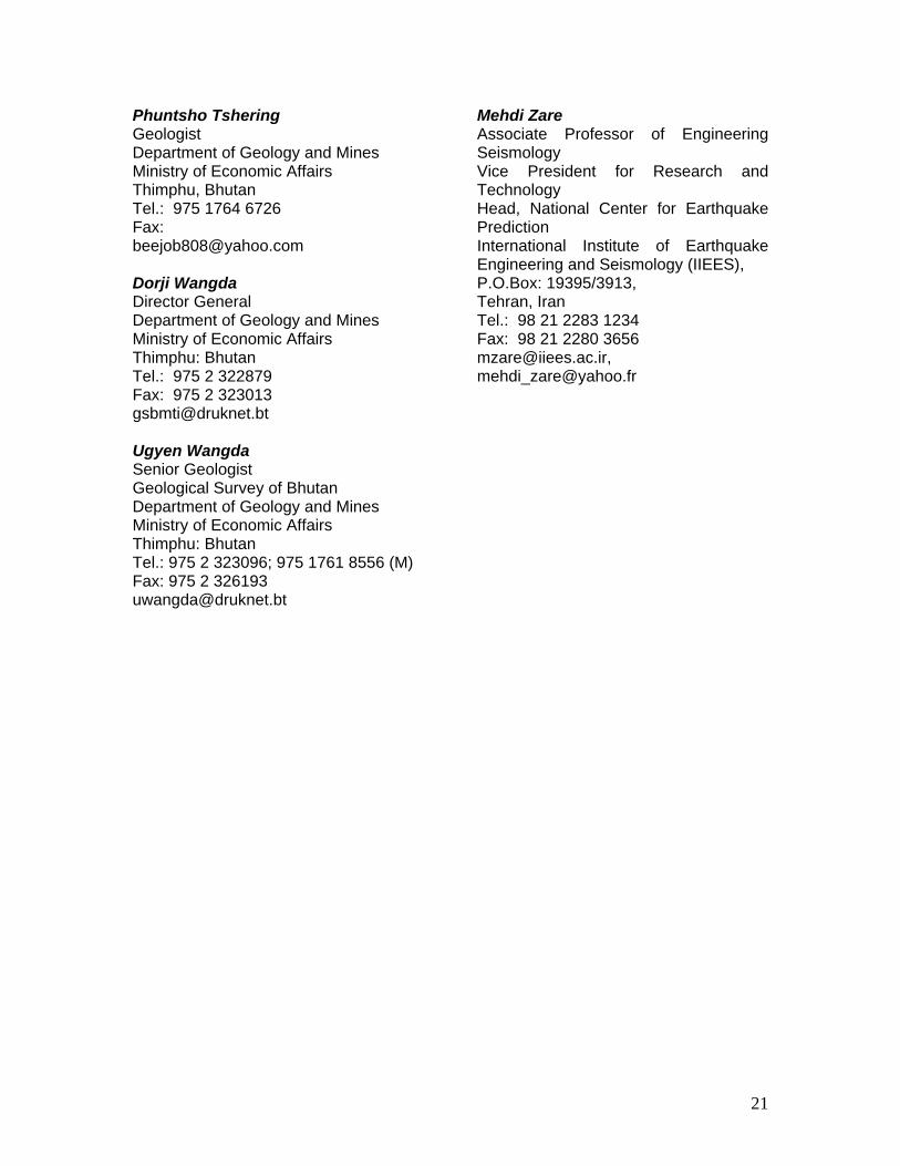
Phuntsho Tshering Geologist Department of Geology and Mines Ministry of Economic Affairs Thimphu, Bhutan Tel.: 975 1764 6726 Fax: [email protected] Dorji Wangda Director General Department of Geology and Mines Ministry of Economic Affairs Thimphu: Bhutan Tel.: 975 2 322879 Fax: 975 2 323013 [email protected] Ugyen Wangda Senior Geologist Geological Survey of Bhutan Department of Geology and Mines Ministry of Economic Affairs Thimphu: Bhutan Tel.: 975 2 323096; 975 1761 8556 (M) Fax: 975 2 326193 [email protected]
Mehdi Zare Associate Professor of Engineering Seismology Vice President for Research and Technology Head, National Center for Earthquake Prediction International Institute of Earthquake Engineering and Seismology (IIEES), P.O.Box: 19395/3913, Tehran, Iran Tel.: 98 21 2283 1234 Fax: 98 21 2280 3656 [email protected], [email protected]
22
Annex B
Seventh International Workshop on Seismic Analysisin the South Asia Region
Thimphu, Bhutan
2-5 June 2008
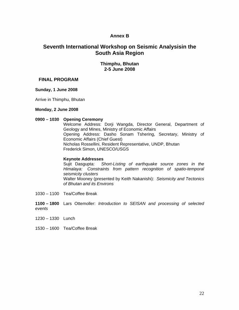
FINAL PROGRAM Sunday, 1 June 2008 Arrive in Thimphu, Bhutan Monday, 2 June 2008 0900 – 1030 Opening Ceremony
Welcome Address: Dorji Wangda, Director General, Department of Geology and Mines, Ministry of Economic Affairs Opening Address: Dasho Sonam Tshering, Secretary, Ministry of Economic Affairs (Chief Guest) Nicholas Rossellini, Resident Representative, UNDP, Bhutan
Frederick Simon, UNESCO/USGS Keynote Addresses
Sujit Dasgupta: Short-Listing of earthquake source zones in the Himalaya: Constraints from pattern recognition of spatio-temporal seismicity clusters Walter Mooney (presented by Keith Nakanishi): Seismicity and Tectonics of Bhutan and its Environs
1030 – 1100 Tea/Coffee Break 1100 – 1800 Lars Ottemoller: Introduction to SEISAN and processing of selected events 1230 – 1330 Lunch 1530 – 1600 Tea/Coffee Break

23
Tuesday, 3 June 2008 0830 – 1030 Data Processing of selected events 1030 – 1100 Tea/Coffee Break 1100 – 1230 Solicited Papers
M. Daud Shaw and M. Qaisar: Seismic network in Pakistan: Expansion and upgradation Mehdi Zare: Bam Earthquake of 2003, Mw6.0; A Possible Long-Period due to Directivity and Fling Saurabh Baruah, Devajit Hazarika and J R Kayal: Attenuation of Coda waves in Northeastern India
1230 – 1330 Lunch 1330 – 1530 Data Processing of selected events 1530 – 1600 Tea/Coffee Break 1600 – 1700 Solicited papers
Mehdi Zare, Sepideh Karimi-Paridari, Mona Lisa: An Investigation on the Attenuation of Intensities in the Balakot, Muzaffarabad (Pakistan) Earthquake of 8 October 2005, Mw 7.6
Muhammad Rafiq: Kashmir-Hazara Earthquake, 8 October 2005 J. R. Kayal: Precursor studies in Northeast India Dowchu Dukpa: Geology and tectonic setting of Bhutan 1930 – Workshop dinner hosted by DGM Wednesday, 4 June 2008 0800 – 1800 Fieldtrip
24
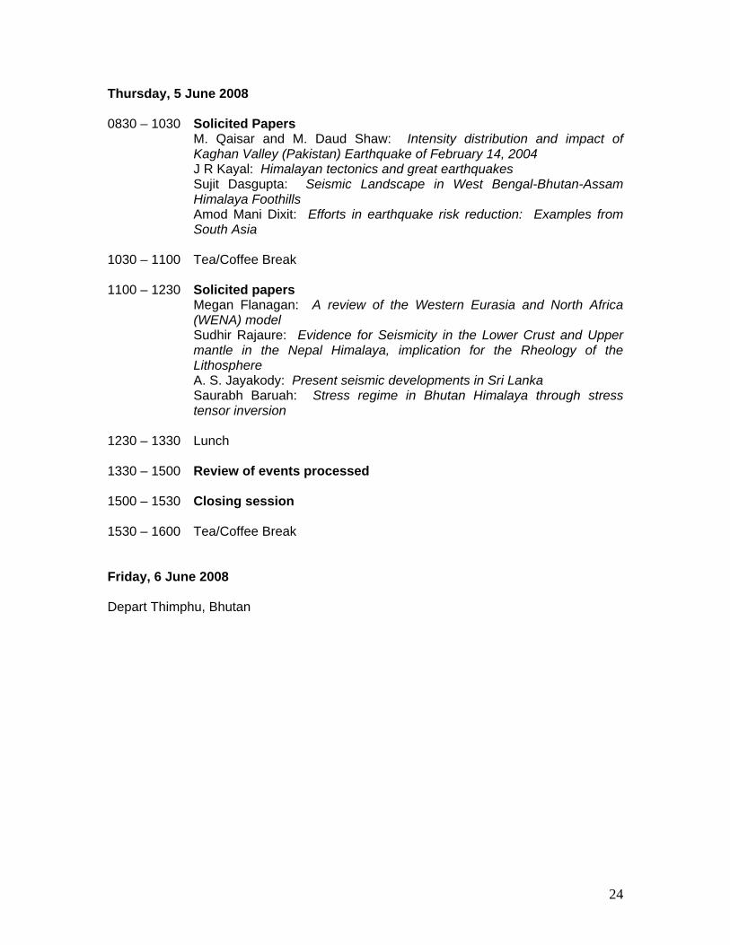
Thursday, 5 June 2008 0830 – 1030 Solicited Papers
M. Qaisar and M. Daud Shaw: Intensity distribution and impact of Kaghan Valley (Pakistan) Earthquake of February 14, 2004 J R Kayal: Himalayan tectonics and great earthquakes Sujit Dasgupta: Seismic Landscape in West Bengal-Bhutan-Assam Himalaya Foothills Amod Mani Dixit: Efforts in earthquake risk reduction: Examples from South Asia
1030 – 1100 Tea/Coffee Break 1100 – 1230 Solicited papers
Megan Flanagan: A review of the Western Eurasia and North Africa (WENA) model Sudhir Rajaure: Evidence for Seismicity in the Lower Crust and Upper mantle in the Nepal Himalaya, implication for the Rheology of the Lithosphere
A. S. Jayakody: Present seismic developments in Sri Lanka Saurabh Baruah: Stress regime in Bhutan Himalaya through stress tensor inversion
1230 – 1330 Lunch 1330 – 1500 Review of events processed 1500 – 1530 Closing session 1530 – 1600 Tea/Coffee Break Friday, 6 June 2008 Depart Thimphu, Bhutan