interim local rural strategy...wanneroo considered a draft local rural strategy (lrs) prepared by...
TRANSCRIPT
i
INTERIM LOCAL RURAL STRATEGY
JULY 2000

ii
CONTENTS
1. AIMS AND PURPOSE OF THE LOCAL RURAL STRATEGY .................................................. 8
2. FUTURE OF WANNEROO AS AN IMPORTANT AGRICULTURAL AREA .......................... 9
3. PROTECTION OF AGRICULTURAL USES............................................................................... 10
4. MANAGEMENT OF AGRICULTURAL USES............................................................................ 13
5. DELINEATION OF PROPOSED ZONE BOUNDARIES............................................................ 15
5.1. EAST LANDSDALE AREA................................................................................................................... 155.2. MARY STREET RURAL AREA, WANNEROO ........................................................................................ 155.3. NICHOLAS/ELLIOT ROAD RURAL AREA, WANNEROO ........................................................................ 155.4. GRISKER ROAD, WANNEROO ............................................................................................................ 155.5. GOLFVIEW PLACE AREA, GNANGARA............................................................................................... 165.6. BENMUNI, JAMBANIS, BADGERUP, TRICHET ROADS PRECINCT, WANNEROO..................................... 165.7. RURAL RESOURCE ZONED LAND SOUTH OF CAPORN STREET, WANNEROO........................................ 165.8. AREA EAST OF LAKE MARIGINIUP..................................................................................................... 175.9. MARIGINIUP TOWNSITE.................................................................................................................... 175.10. ZIATUS, SPENCE, PINJAR ROAD "TRIANGLE", PINJAR........................................................................ 175.11. LAKE PINJAR AREA AND NEARBY PLANNING POLICY AREA 4 AREAS ................................................ 175.12. AREA GENERALLY SITUATED BETWEEN WANNEROO ROAD AND LAKE NEERABUP - PLANNING POLICY
AREA NO. 5 ...................................................................................................................................... 185.13. NOWERGUP AREA............................................................................................................................. 195.14. CARABOODA AREA .......................................................................................................................... 195.15. RURAL AREAS AT CARABOODA (WEST OF WANNEROO ROAD) AND EGLINTON - PLANNING POLICY
AREA NO. 2 ...................................................................................................................................... 205.16. TWO ROCKS RURAL AREAS - PLANNING POLICY AREA NO. 1 ............................................................ 205.17. DUNDEBAR ROAD AREA ................................................................................................................... 21
6. SPECIAL RURAL ZONES.............................................................................................................. 22
7. TWO HOUSES ON A RURAL LOT............................................................................................... 23
8. GNANGARA LAND USE AND WATER MANAGEMENT STRATEGY - PLANNINGPOLICY AREAS NO. 4 AND 6* .................................................................................................... 24
9. WETLANDS AND ENVIRONMENTAL MANAGEMENT AREAS.......................................... 25
10. BUSHPLAN (AND BUSHLAND PROTECTION GENERALLY) .............................................. 26
11. BASIC RAW MATERIALS............................................................................................................. 27
12. BUFFER AREAS .............................................................................................................................. 28
13. LANDSCAPE ENHANCEMENT - SCENIC DRIVES ................................................................. 29
14. RURAL SUBDIVISION POLICY................................................................................................... 30
15. HERITAGE ....................................................................................................................................... 33
16. BUSHFIRE PROTECTION............................................................................................................. 34

iii
17. SPECIAL RESIDENTIAL ZONES................................................................................................. 35
18. PLANNING POLICY AREA NO. 3 (PPA NO. 3) - CAVES AND KARSTIC AREAS.............. 36
APPENDICES
Appendix 1 Proposed City of Wanneroo District Planning SchemeNo. 2 Provisions for Rural Zones
Appendix 2 Policy on Subdivision of Rural Zoned Land
FIGURES
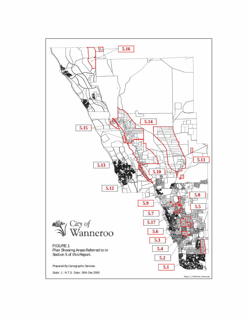
Figure 1 Plan Showing Areas Referred to in Section 5. of Report
Figure 2 Interim Local Rural Strategy Plan

1
INTRODUCTION AND EXECUTIVE SUMMARY
Background
At their meeting of 13 July 1999, the former Joint Commissioners of the City ofWanneroo considered a Draft Local Rural Strategy (LRS) prepared by its consultanton this project, Mr Tim Auret (of Belingwe Pty Ltd). It was resolved that thePlanning Policy component of the Draft LRS be adopted as a draft Planning Policypursuant to sub clause 5.11 (b)(i) of City of Wanneroo Town Planning Scheme No 1(TPS 1). The draft Policy and the Draft LRS as a whole (which in addition to thedraft Policy, includes proposed scheme provisions and ‘Actions’ to be undertaken bythe City), was then advertised for public submissions from 16 July 1999 to 27 August1999.
It should be noted that proposed District Planning Scheme No 2 (DPS 2) was re-advertised for public submissions concurrent with the advertising of the Draft LRS.This was seen as desirable as the two plans were generally mutually supportive inrespect to their proposals for the City’s rural area.
In particular, in granting approval for the re-advertising of DPS 2, the Hon Ministerfor Planning had required that the Council make a number of modifications to it:
• The replacement of the Rural zone with Rural Resource and General Rural zonesaimed at giving higher priority to the protection of agricultural uses in the areawhich had been identified in State strategies and policies as being of State andregional significance;
• The removal of provisions which enabled Council to approve a second dwellingon a rural lot.
The Draft LRS provided the basis for the delineation of the Rural Resource andGeneral Rural zones. It also tied in with proposed DPS 2 provisions which referred toregard having to be had for a Local Rural Planning Policy.
The Draft LRS was advertised by means of:
• Advertisements placed in the local newspaper;• A letter being sent to all landowners in the rural area;• Media releases.
Two public meetings were held:
• One on 2 August 1999, dealing with the part of the rural area situated south ofFlynn Drive and Neaves Road;
• Another on 9 August 1999, dealing with the northern part of the rural area.

2
Both meetings were well attended and included participation by Mr Auret as well asrepresentatives of the Ministry for Planning, Department of EnvironmentalProtection, Agriculture WA and the Waters and Rivers Commission.
At the conclusion of the submission period, 211 submissions had been received.
The submissions were summarised and assessed in the 'Report on Submissions' (dated24 July 2000)*.
It may be noted that the Report on Submissions includes considerable informationrelating to DPS 2. As advised earlier, there is substantial over-lap between the DraftLRS and proposed DPS 2. Of the 205 submissions received on DPS 2, approximatelytwo thirds of these related to rural issues. The former Joint Commissionersconsidered the DPS 2 submissions at their meeting of 9 November, 1999. The reporton DPS2 was adopted and referred to the WAPC for consideration. The WAPC hasmade its recommendations on the Scheme and these are currently with the Ministerfor Planning.
The Report on LRS Submissions includes, where appropriate, information regardingthe City’s assessment and decisions made in its consideration of the DPS2submissions.
The Council in considering the submissions made on the LRS, sought to obtainadditional information and to seek clarification of submissions where appropriate.The following activities were undertaken:
• A number of briefings were given to Council by administrative staff on thecontents of the submissions. A bus tour of most of the rural area was undertaken.
• A Forum was held on 24 May, 2000, with representatives of key governmentagencies and industry groups;
• Two meetings of a ‘hearings’ or ‘deputations’ nature were held to enable peoplewho made written submissions to expand upon those submissions if they wished.These meetings were held on 7 and 8 June, 2000;
* The Report on Submissions may be viewed on the City's web site www.wanneroo.wa.gov.au.

3
Content of the Report on Submissions
The Report comprises two main sections:
• Assessment of main issues raised in submissions – Section 2
This section generally follows the structure of the Draft LRS. Every proposal ofthe Draft LRS is covered, including proposed scheme provisions, PlanningPolicies and Actions.
Under each subject heading, further summaries are provided of the submissionswhich are relevant to that subject; the relevant Draft LRS proposals are stated infull; an assessment made of those proposals in light of the submissions received;and finally a determination made.
• Schedule of submissions following advertising – Table 1
This provides the name and address of each submitter and the land which is thesubject of their submission; a summary of each submission; a brief comment anddetermination in respect to each submission. The summaries, comments anddeterminations are generally cross-referenced to Section 2 of the Report.
Overview of Council's Assessment and Determinations
The Draft LRS and proposed DPS 2 set out to be quite strict and rigid in respect toseeking achievement of the State Government’s objective of protection of the area’sagricultural industries. In considering the submissions on DPS 2, it was decided thatthe proposed zoning-land use controls were too inflexible and greater latitude neededto be provided for uses to be carried out in the area which would enhance itseconomic, social and environmental resources, while still having regard for the area’sagricultural industries.
Similarly with the Draft LRS, it has been considered that some ‘freeing up’ of theLRS proposals needs to occur. For example, subdivision needs to be able to betterrespond to issues such as groundwater restrictions and environmental constraints, butwithin a planning framework which works towards a known and desired outcome.
The main determinations contained in the Report on Submissions, with particularattention to proposed changes to the Draft LRS, are as follows (the numbers inbrackets referring to the corresponding section number in this Interim Local RuralStrategy report):
1. The LRS should include a ‘vision’ statement (1.).

4
2. The rural area should be regarded as an important long-term agricultural area andthe possibility should be investigated of the area being the subject of an Act ofParliament to enhance those long-term prospects (2.).
3. The State Government should be requested to modify the Gnangara Mound publicwater supply schemes with a view to allowing additional groundwater to bereallocated to rural producers (2.).
4. The proposed DPS 2 rural zones and associated provisions (as currently proposed,ie including provision for flexibility in land uses which can be accommodated)should be retained, subject to the following changes being made:
a) inclusion in the General Rural zone provisions of a requirement forproposed rural living lots to be the subject of provision of memorials on titleand written acknowledgments concerning the nature and legitimacy ofnearby existing and future resource use.
b) modification of the Special Rural zone provisions to:
i) include the corresponding Draft LRS scheme provisions; ii) include provision for places of worship, community buildings and places
of education as ‘A’ uses (ie. uses Council has discretion to permit, subjectto advertising for submissions). (3.)
5. Planning approval should not be required for rural uses, other than where a newrural use is proposed. That is, changes from one type of agricultural operation toanother (where buildings, works etc are not involved) will not require PlanningApproval as there has been no change in ‘rural’ use. However, improvements tocurrent approvals and referrals procedures currently undertaken by the Water andRivers Commission (through well licensing), Agriculture WA and the Departmentof Environmental Protection should be sought (4.).
6. A committee comprising representatives of the City and key government agenciesand other appropriate bodies and industry representatives should be established toprovide advice on and promote the development of Wanneroo’s agriculturalindustries (4.).
7. A new policy should be included in the LRS to the effect that in WaterManagement Areas where available supplies of groundwater above 1500 cubicmetres per annum are fully committed or fully overdrawn, Council will giveproper consideration to rezoning applications to a more appropriate use (4.).
8. The East Landsdale rural precinct should be shown on the LRS Map as an areasubject to continuing investigation (5.1).

5
9. The southern proposed Rural Resource area of some 600 hectares (betweenLenore Road and Sydney Road) should retain that designation (5.3 to 5.6).
10. The proposed Rural Resource area between Dundebar Road and Belgrade Roadshould be changed to General Rural (5.17).
11. The proposed Rural Resource area (of about 420 hectares) which generallysurrounds Lake Mariginiup should be modified to exclude the land between WadeStreet and Mariginiup Road. The Mariginiup Townsite should also be excluded(5.8, 5.9).
12. In respect to the land between Wanneroo Road and Lake Neerabup (PlanningPolicy Area [PPA] 5): there should not be a moratorium on certain types ofsubdivision; a Rural Community zoning should be regarded as the mostappropriate form of zoning and subdivision for that area (5.12).
13. The Carabooda/Nowergup Rural Resource area should have removed from it theland immediately east of Bernard Road, the land bounded by Bernard Road andWanneroo Road, and the land between Lake Carabooda and Karoborup Road(5.14).
14. For the land at Pipidinny and Eglinton (PPA2): there should not be a moratoriumon any further subdivision but rather the City’s current rural subdivision policyshould continue to apply; appropriate mechanisms to facilitate the enhancement ofthe area’s natural attributes should be developed, in consultation with thelandowners (5.15).
15. The existing Two Rocks Rural Community Zone land should be designated assuch on the LRS Map (5.16).
16. Criteria and guidelines should be prepared (for inclusion in the LRS) to assistapplicants and the City in the preparation and assessment of proposals for SpecialRural and Rural Community zoning (6.).
17. Two houses should be able to be approved on a rural lot (subject to compliancewith necessary requirements). (7.).
18. Rural living (through Special Rural or Rural Community zoning) should, where itis able to facilitate effective bushland protection, be able to occur in areas ofregionally or locally significant bushland (10.).
19. The LRS provisions regarding buffer areas should be strengthened (12.).
20. The LRS provisions regarding scenic drives should be of a more general natureand the prescriptive proposals (eg regarding lot size and number of dwellings

6
permitted on a lot) deleted. Bernard Road and the ‘Chittering Valley Way’ touristdrive (Pinjar Road and Neaves Road) should be included as scenic drives (13.).
21. The Rural Subdivision Policy proposed in the Draft LRS should be adopted,subject to a number of minor modifications being made. For lots which aresubject to subdivision pressure (to lot sizes below the policy minimum) arisingfrom groundwater availability problems or environmental constraints, aframework for dealing with such proposals should be adopted which essentiallyentails such subdivision being dealt with through either Special Rural or RuralCommunity zoning of the subject land. Further consideration should also begiven as to whether ‘special cases’ may exist where subdivision may be supportedunder current zoning, but still subject to appropriate controls (14.).
22. The City’s rural areas should be recognised as part of the City’s heritage (15.).
23. The LRS should include a provision to the effect that Special Residential zonesare generally not considered an appropriate form of development in the rural area.More intensive forms of subdivision should generally be pursued through theSpecial Rural or Rural Community zoning provisions (17.).
Implementation of the LRS
The LRS was originally intended to be implemented by means of scheme provisions(which is already in fact occurring through DPS 2), a Planning Policy under clause5.11 of TPS 1 (which would subsequently become a Local Planning Policy underDPS 2), and the undertaking by the City of certain specified ‘Actions’.
Although the Report on Submissions has been prepared, referring to the retention,deletion or modification of Planning Policies, the adequacy of that mechanism is nowconsidered to require review. It is now evident that for the LRS to be effectivelyimplemented, its provisions should have a status which will enable this. PlanningPolicies under the scheme are not of a high status as a planning mechanism orinstrument. They do not involve any other body in the process of preparation andadoption, and Council is only required to have regard for them (and is specifically notbound by them). They are especially of limited status when it comes to appeals beingdetermined.
One of the determinations in the Report on Submissions mentioned above is that thepossibility of an Act of Parliament forming part of the implementation strategy beinvestigated. At the more detailed level, a mechanism which may be more suitablethan a Planning Policy is a Structure Plan prepared under the relevant provisions ofthe scheme. Such Structure Plans, to a large degree, have similar force and effect asthe scheme itself.
The conversion of the Planning Policies into Structure Plan provisions would meanthat a Draft Structure Plan would need to be prepared and adopted and released for

7
public submissions. Such a further round of public consultation on this matter maybe appropriate anyway, considering the high level of community and agency interestin the project.
The matter of how the LRS should best be implemented is now being furtherinvestigated and in the meantime, to provide some guidance for the area, the variousdeterminations made in the Report of Submissions have been adopted as an InterimLocal Rural Strategy for the City’s rural areas.
Council Decision
At its meeting of 11 July 2000, it was resolved that Council:
1. Adopts the Report on Submissions.
2. Requires that a report be presented to Council regarding the mostappropriate mechanism(s) which should be used for the implementation ofthe Local Rural Strategy.
3. Prior to the determination of the mechanism(s) which shall be used toimplement the Local Rural Strategy, adopts as its Interim Local RuralStrategy, the various determinations which are contained in the Report onSubmissions.
4. As a matter of Council policy, has due regard to the Interim Local RuralStrategy adopted pursuant to 3. above, in its consideration of all matterswhich come before it which relate to the rural area.
Interim Local Rural Strategy
This document presents in a consolidated form the various Council determinationswhich have been adopted by Council as its Interim Local Rural Strategy. Shouldfurther information and details be sought on the matters dealt with in this document,reference should be made to the Draft Local Rural Strategy (July 1999) and theReport on Submissions (24 July 2000).

8
1. AIMS AND PURPOSE OF THE LOCAL RURAL STRATEGY
ACTION
A1. That Council, in the preparation of the final Local Rural Strategy (LRS),replaces the 'aims' and 'purpose section of the Draft LRS with sectionsgenerally structured as follows:
• Purpose
- to provide a vision for the rural area- to establish the measures necessary for the achievement of that vision
• Aim (to generally tie in with DPS2 aims)
• Principles
• Vision:
A possible Vision statement being: The long term sustainable development ofhorticulture and other productive uses of the rural area in support of the localeconomy and the social fabric of the community. Also see Action A15.1.

9
2. FUTURE OF WANNEROO AS AN IMPORTANT AGRICULTURAL AREA
POLICIES
P2.1 Within the agricultural resource areas*, the Council regards agriculture(horticulture) as the highest and best use of the land.
P2.2 Council regards agriculture (horticulture) in the agricultural resourceareas as the preferred long term use.
(* 'Agricultural resource areas' are basically the areas designated as Rural Resource on Figure 2,excepting those areas which have been designated as Rural Resource due to their significance as abasic raw material resource area).
ACTIONS
A2.1 That Council investigate the possible implementation of the relevantelements of the LRS through an Act of Parliament, aimed at giving thearea the highest possible level of protection as a rural area.
A2.2 That Council request the State Government to support the continueddevelopment of Wanneroo as an important and valuable agriculturalproduction area by directing the Water Corporation to reduce its currentand planned use of water from Gnangara Mound which may otherwise beavailable to agricultural producers in Wanneroo. This should includereview of the appropriateness of proceeding with the continuation of theproposed Water Corporation wellfields immediately to the east of theNowergup and Carabooda localities.
A2.3 The potential for horticulture in the Rural Resource Zone be re-evaluatedfrom time to time (say 5 years or with each review of the Town PlanningScheme) with regard to the availability of groundwater based on theimpending urbanisation within some water management areas and thepotential for the transfer of water rights.

10
3. PROTECTION OF AGRICULTURAL USES
POLICIES
P3.1 When considering applications for Planning Approval in the rural area,Council shall have regard to the zone objectives and other schemeprovisions relating to the various rural zones applying to that area underCouncil's town planning scheme.
P3.2 No conflicting, or potentially conflicting, land uses should be permittedwithin agricultural areas, unless it can be demonstrated to the satisfactionof the Council that there will be no conflict, and unless the TownPlanning Scheme is amended.
P3.3 Potentially incompatible uses, such as rural living, should not bepermitted in the Rural Resource Zone unless it can be demonstrated to thesatisfaction of Council there is no potential for adverse impacts to thecarrying out of the priority resource use.
P3.4 The Council should require that all applications for rural residentialzoning and subdivision should be made within the context of an approvedstructure plan. The onus should be on the proponent to produce such astructure plan as contemplated in Part 9 of proposed District PlanningScheme No. 2.
ACTIONS
A3.1 That four rural zones be incorporated into Council's town planningscheme:
a) Rural Resourceb) General Ruralc) Special Rurald) Rural Community
The recommended delineation of these zones is shown on Figure 2.
A3.2 Subject to A3.3 and A3.4 below, the scheme provisions for the zonesreferred to in A3.1 should accord with the DPS2 provisions proposed bythe former Joint Commissioners in November 1999 (see Appendix 1),noting that this includes provision for a degree of flexibility in respect tothe range of uses which may be permitted in the rural area.
A3.3 That the proposed scheme provisions for the General Rural zone bemodified to include the following clause:

11
“(c) Where a lot is approved for rural living in a General Rural Zone andthe lot is located within 500 metres of a Rural Resource Zone, or within500 metres of an existing rural resource, the applicant will seek to ensurethat memorials are placed on the lot title requiring the applicant, or apurchaser of a subdivided lot, to acknowledge in writing, at the time ofapproval of the applicant’s rural living proposal, or purchase of the lot,the nature and legitimacy of a nearby existing or future resource use andaccepts its potential to create noise, dust and odour.”
A3.4 That the proposed scheme provisions relating to the Special Rural Zonebe modified to:
i) include the following proposals contained in 4.1.3 of the Draft LocalRural Strategy:
The suggested objectives for the Special Rural Zone are:
a) To identify areas for rural living to occur without adverse impact tothe environment or rural character.
b) To accommodate the demand for rural living lifestyles.
The following suggested policies should apply in the Special Rural Zone:
a) In addition to the provisions of Clause 3.18 of the City of WannerooTown Planning Scheme No. 2 (as advertised) the Council shouldconsider applications for rezoning and subdivision for rural livingwith the General Rural Zone in the context of the policies andobjectives in Parts 2 & 3 and the Special Control Areas in Part 4 ofthe Local Rural Strategy report.
b) Where a Special Rural Zone is proposed to be located in, or within500 metres of, a Rural Resource Zone, or within 500 metres of anexisting rural resource in the General Rural Zone, the proponentshould be made to ensure that memorials are placed on all Lot titlesrequiring the purchaser of a subdivided lot to acknowledge inwriting, at the time of the purchase of the lot, the nature andlegitimacy of any nearby existing or future resource use and acceptsits potential to create noise, dust and odour.
c) A similar written acknowledgment should be required that eachprospective purchaser is aware that the Waters and RiversCommission imposes constraints on ground water abstraction,generally limit the amount to 1500 cubic metres per annum, enoughfor domestic uses.
d) The Council should not initiate or support any rezoning orsubdivision application for special rural zones where suchcommitment in writing from the proponent does not accompany theapplication.

12
e) A copy of written assurances should be kept in a permanent registerby the Council which should be made available for publicinformation.
f) Copies of all written acknowledgments, made pursuant to b) and c)above should also be kept in the permanent register.
ii) include the following additional zone objective:
"To accommodate applications for places of worship, communitybuildings, and places of education as 'A' uses";
iii)make places of worship, community buildings, and places of educationas 'A' uses in the Zoning Table.
A3.5 That the horticultural areas with the best prospects for continued orexpanded use be incorporated into the Rural Resource Zone in the City ofWanneroo Town Planning Scheme with appropriate provisions to ensureits protection from incompatible uses or subdivision.
A3.6 That productive and potentially productive rural land be defined as aresource in the Town Planning Scheme.
A3.7 That Council seeks an amendment to DPS2 to implement A3.3, A3.4,A3.5 and A3.6.

13
4. MANAGEMENT OF AGRICULTURAL USES
POLICIES
P4.1 In considering applications for Planning Approval for agricultural uses,the onus should be on the applicant to demonstrate to the Council'ssatisfaction that best farming practice and ongoing management will beused to eliminate or minimise offsite impacts. The Council should seekthe advice of Agriculture WA and the Environmental ProtectionAuthority in considering complex development applications foragriculture.
P4.2 In Water Management Areas where available supplies of groundwaterabove 1500 cubic metres per annum are fully committed or alreadyoverdrawn, Council will give proper consideration to rezoningapplications to a more appropriate use.
ACTIONS
A4.1 That Council adopt the following approach in respect to PlanningApproval requirements (for proposals which do not involve constructionof buildings or similar works) in the Rural Resource and General Ruralzone areas:
a) Agricultural uses shall be considered a ‘rural’ use, andconsequently changes in types of agriculture shall not beconsidered a change in use and therefore Planning Approval shallnot be required.
b) Agricultural uses proposed to be undertaken on land which iscurrently not being used for any purpose shall be considered‘development’ and consequently require prior Planning Approval.This includes extensions of existing uses onto adjacent unusedland.
c) Notwithstanding a) above, where the land concerned falls within aPlanning Control Area, the City shall consult with the Ministry forPlanning in determining whether a change in agricultural useshould be considered ‘development’ or not.
A4.2 That Council seeks to have the Water and Rivers Commission (WRC)‘Application Kit for New Horticultural Development’ expanded toprovide a role for Agriculture WA to be able to advise applicantsregarding opportunities for improving their farming practices.

14
A4.3 That the City of Wanneroo Town Planning Scheme provisions beamended to be consistent with the approach regarding Planning Approvalrequirements described in A4.1 above.
A4.4 That to assist prospective horticulturalists, the Council acquire anddisplay maps updated from time to time by the Water and RiversCommission, showing the status of water availability in the differentcatchment management zones.
A4.5 That Council request the Department of Environmental Protection andAgriculture WA to prepare guidelines for best practice for horticultureand intensive agriculture. This especially applies in the EnvironmentalManagement Areas identified as part of the Gnangara Land Use andWater Management Strategy.
A4.6 That Council review the outcome of A4.1 and A4.2 above 1 yearfollowing the implementation of those proposals.
A4.7 That Council establishes a committee comprising representatives of theCity and relevant agencies and bodies to promote the development ofWanneroo's agricultural industries.

15
5. DELINEATION OF PROPOSED ZONE BOUNDARIES
Many of the submissions received on the Draft LRS argued for a change in proposedzone boundaries to place the land of interest within another zone. Most of thesesubmissions were able to be grouped according to the particular area to which theyrelated. The resulting submission groupings (or precincts) are shown on Figure 1.
This section of this report details the policies and actions adopted by Council inrespect to each precinct.
5.1. EAST LANDSDALE AREA
ACTION
A5.1 That Council modify Map 1 of the LRS to delete the General Ruraldesignation over the East Landsdale area and replace it with a designationindicating that this area is subject to continuing investigation.
5.2. MARY STREET RURAL AREA, WANNEROO
ACTION
A5.2 That Mary Street precinct be shown as General Rural on Map 1 of theLRS.
5.3. NICHOLAS/ELLIOT ROAD RURAL AREA, WANNEROO
ACTION
A5.3 That the Nicholas/Elliot Road precinct be shown as Rural Resource onMap 1 of the LRS, subject to Policy P5.3.
POLICY
P5.3 Notwithstanding Action 5.3, in the Nicholas/Elliot road precinct, whereavailable supplies of groundwater above 1500 cubic metres per annumare fully committed or already overdrawn, Council will give properconsideration to rezoning applications to a more appropriate use.
5.4. GRISKER ROAD, WANNEROO
ACTION
A5.4 That the Grisker Road precinct be shown as Rural Resource on Map 1 ofthe LRS, subject to Policy P5.4.

16
POLICY
P5.4 Notwithstanding Action A5.4, in the Grisker Road precinct, whereavailable supplies of groundwater above 1500 cubic metres per annumare fully committed or already overdrawn, Council will give properconsideration to rezoning applications to a more appropriate use.
5.5. GOLFVIEW PLACE AREA, GNANGARA
ACTION
A5.5 That the Golfview Place precinct be shown as Rural Resource on Map 1of the LRS, subject to Policy P5.5.
POLICY
P5.5 Notwithstanding Action A5.5, in the Golfview Place precinct, whereavailable supplies of groundwater above 1500 cubic metres per annumare fully committed or already overdrawn, Council will give properconsideration to rezoning applications to a more appropriate use.
5.6. BENMUNI, JAMBANIS, BADGERUP, TRICHET ROADS PRECINCT,WANNEROO
ACTION
A5.6 That the Benmuni, Jambanis, Badgerup, Trichet Roads precinct be shownas Rural Resource on Map1 of the LRS, subject to Policy P5.6.
POLICY
P5.6 Notwithstanding Action A5.6, in the Benmuni, Jambanis, Badgerup,Trichet Road precinct, where available supplies of groundwater above1500 cubic metres per annum are fully committed or already overdrawn,Council will give proper consideration to rezoning applications to a moreappropriate use.
5.7. RURAL RESOURCE ZONED LAND SOUTH OF CAPORN STREET,WANNEROO
ACTION
A5.7 That the precinct proposed to be zoned Rural Resource situated south ofCaporn Street Wanneroo be shown as Rural Resource on Map 1 of theLRS, subject to Policy P5.7.

17
POLICY
P5.7 Notwithstanding Action A5.6, in the precinct proposed to be zoned RuralResource situated south of Caporn Street, Wanneroo, where availablesupplies of groundwater above 1500 cubic metres per annum are fullycommitted or already overdrawn, Council will give proper considerationto rezoning applications to a more appropriate use.
5.8. AREA EAST OF LAKE MARIGINIUP
ACTIONS
A5.8.1 That the area between Wade Street and Mariginiup Road be changedfrom Rural Resource to General Rural on Map 1 of the LRS.
A5.8.2 That DPS2 be amended consistent with Action A5.8.1.
5.9. MARIGINIUP TOWNSITE
ACTIONS
A5.9.1 That an Urban type of designation be shown for the Mariginiup townsiteon Map 1 of the LRS.
A5.9.2 That Council seek an amendment to the MRS to zone the MariginiupTownsite Urban.
A5.9.3 That Council, upon completion of the MRS amendment referred to inAction A5.9.2, initiates an amendment to DPS2 to provide for aresidential type of zoning of the Mariginiup townsite.
5.10. ZIATUS, SPENCE, PINJAR ROAD "TRIANGLE", PINJAR
ACTION
A5.10 That the Ziatus Spence, Pinjar Road 'triangle', Pinjar, be shown asGeneral Rural on Map 1 on the LRS.
5.11. LAKE PINJAR AREA AND NEARBY PLANNING POLICY AREA 4AREAS
ACTIONS
A5.11.1 That Council shows Pt Lot 4 Ziatus Road as General Rural on Map 1 ofthe LRS.

18
A5.11.2 That Council shows Swan loc 2130 Cecil Road as General Rural on Map1 of the LRS.
A5.11.3 That Council intercede on behalf of landowners affected by proposals forgroundwater protection for prompt and fair compensation.
POLICIES
P5.11.1 Council recognises the importance of the Lake Pinjar area and nearbyPlanning Policy Area 4 areas to the public water supply for the existingand future community of the Metropolitan Region.
P5.11.2 Council supports the recommendations for groundwater resourceprotection contained in the Gnangara Land Use and Water ManagementStrategy.
P5.11.3 Council will not support an application for any land use or subdivisionthat does not accord with the Gnangara Land Use and Water ManagementStrategy.
5.12. AREA GENERALLY SITUATED BETWEEN WANNEROO ROAD ANDLAKE NEERABUP - PLANNING POLICY AREA NO. 5
ACTION
A5.12. That the area generally situated between Wanneroo Road and LakeNeerabup be shown as General Rural on Map 1 of the LRS.
POLICIES
P5.12.1 Council does not support Special Residential zoning of this area. Rather,Council seeks an alternative, dynamic planning approach to this area.
P5.12.2 Council supports the limited development of uses that are compatiblewith and can exploit, the rural character and scenic attractions of this areasuch as farm stay tourist accommodation and the like.
P5.12.3 Council requires that any application for a residential or other sensitivebuilding in this area includes a geotechnical survey to demonstrate, to itssatisfaction, that the building site is not subject to karstic formations or indanger of subsidence.
P5.12.4 In its consideration of any application for planning approval in this areaCouncil shall look favourably on proposals which include the re-establishment of trees and other natural vegetation.
19
P5.12.5 Council requires the proponent of any development in this area todemonstrate that stormwater drainage and other environmental issues canbe managed, especially with regard to the quality of water in LakeNeerabup.
P5.12.6 Council considers Rural Community zoning to be the most appropriatefuture zone for this area, aimed at accommodating a form of subdivision,use and management of the area which carefully responds to a detailedassessment of the area’s natural, social and economic attributes. Suchassessment and planning should be undertaken on as comprehensive abasis as possible (ie. over large portions, if not all, of the area concerned),and should consider means for achieving equitable sharing of costs andbenefits between all owners including land-pooling arrangements, ratherthan each landowner developing on an individual basis.
5.13. NOWERGUP AREA
ACTION
A5.13 That Council retains as Rural Resource designation on Map 1 of the LRS,those portions of the Nowergup locality which were proposed for thatdesignation by the Draft LRS, subject to Policy P5.13.
POLICY
P5.13 Notwithstanding Action A5.13, in the portion of the Nowergup localitydesignated as Rural Resource, where available supplies of groundwaterabove 1500 cubic metres per annum are fully committed or alreadyoverdrawn, Council will give proper consideration to rezoningapplications to a more appropriate use.
5.14. CARABOODA AREA
ACTIONS
A5.14.1 That Council retains as Rural Resource designation on Map 1 of the LRS,those portions of the Carabooda locality which were proposed for thatdesignation by the Draft LRS, except for those areas proposed for changeas referred to in A5.14.2 and A5.14.3 below, and subject to Policy P5.14.
A5.14.2 That the land east of Bernard Road, and the land between Bernard Road(north) and Bernard Road (south), be shown as General Rural on Map 1of the LRS.
A5.14.3 That the land between Lake Carabooda and Karoborup Road be shown asGeneral Rural on Map 1 of the LRS.

20
A5.14.4 That Council initiates amendments to DPS2 (when gazetted) to make thezoning changes to that scheme required pursuant to Actions A5.14.2 andA5.14.3 above.
POLICY
P5.14 Notwithstanding Action 5.14.1, in the portion of the Carabooda localitydesignated as Rural Resource, where available supplies of groundwaterabove 1500 cubic metres per annum are fully committed or alreadyoverdrawn, Council will give proper consideration to rezoningapplications to a more appropriate use.
5.15. RURAL AREAS AT CARABOODA (WEST OF WANNEROO ROAD) ANDEGLINTON - PLANNING POLICY AREA NO. 2
ACTIONS
A5.15.1 That Planning Policy Area 2 be shown as General Rural on Map 1 of theLRS.
A5.15.2 That Council develop appropriate mechanisms to facilitate theenhancement of this area’s natural attributes in consultation with thelandowners and relevant agencies, and to include consideration of:
- conservation covenants.- landowner applications for rezoning to Special Rural or Rural
Community (with possible opportunities for further subdivision),subject to detailed site analysis.
POLICY
P5.15 Council's current subdivision policy should continue to apply to this area.
5.16. TWO ROCKS RURAL AREAS - PLANNING POLICY AREA NO. 1
ACTIONS
A5.16.1 That Council show the eastern parcel of the subject Two Rocks land asGeneral Rural on Map 1 of the LRS.
A5.16.2 That Council modifies Map 1 of the LRS to show lots 201 and 202Breakwater Drive, Two Rocks as 'Existing Rural Community Zone'.
A5.16.3 That Council determines its strategy for the eastern parcel of the subjectTwo Rocks land following finalisation of the Gnangara Land Use andWater Management Strategy.
21
A5.16.4 That Council monitor the success of the new Rural Community Zone inthe far north of the Saint Andrews Estate as a model in place of, or inaddition to, the traditional approach to Special Rural zone subdivision.
5.17. DUNDEBAR ROAD AREA
ACTION
A5.17 That Council modifies Map 1 of the Draft LRS to show the DundebarRoad/Belgrade Road area and Lot 3 Franklin Road as General Ruralinstead of Rural Resource, and seeks to modify DPS2 accordingly.
22
6. SPECIAL RURAL ZONES
ACTIONS
A6.1 That Council does not designate new Special Rural areas in the LRS butrather adopts the approach of requiring that proponents of such rezoningsundertake the necessary detailed site analysis and planning as part of theirrezoning application. The LRS may however, in some cases, providesome initial indicative comment as to whether particular areas may havegood prospects for such rezoning.
A6.2 Includes in the LRS, criteria or guidelines to assist applicants and the Cityin the preparation and assessment of proposals for Special Rural andRural Community zoning.
23
7. TWO HOUSES ON A RURAL LOT
ACTION
A7. That Council seek inclusion of provisions in DPS2 to allow for amaximum of two grouped dwellings to be built on a rural lot, and thatthese provisions stipulate a minimum lot size requirement of 2 hectares,except for those areas which fall within the existing and future catchmentareas of the Gnangara Mound public water supply schemes, where aminimum lot size of 4 ha be applied.

24
8. GNANGARA LAND USE AND WATER MANAGEMENT STRATEGY -PLANNING POLICY AREAS NO. 4 AND 6*
POLICY
P8. The Gnangara Land Use and Water Management Strategy (GLUWMS)identifies rural living (in special rural zones) as a preferred land use in thepockets of privately owned P2 (groundwater protection) land in eastWanneroo. However, to meet the water quality objectives the Council, ininitiating amendments for Rural Living Zones, should set conditionswhich:
• Prohibit clearing (except for reasonable building envelopes etc) andpromote revegetation (even as a condition of rezoning and/orsubdivision.
• Keep lot sizes to a minimum 2 hectare average size based on landcapability and suitability assessment.
• Make the use of Health Department approved on-site effluent disposalsystems compulsory.
• Require drainage and nutrient management plans incorporating bestpractice management.
• Protect landscape features, significant wetlands and vegetation andother significant environmental values.
ACTIONS
A8.1 All applications for development in the P1 (groundwater protection) areashould be referred to the Western Australian Planning Commission fordetermination.
A8.2 The P2 areas should be included in Planning Policy Areas in the GeneralRural zone in Council's Town Planning Scheme subject to the policiesderived from GLUWMS.
Planning Policy Area No. 6 - Priority 1 & 2 Groundwater Protection Areas
A8.3 The Council act in accordance with the Actions A8.1 and A8.2 and PolicyP8 of the Interim Local Rural Strategy.
(*Also see sections 5.11 and 5.16 of this Interim Local Rural Strategy which include policies andactions relevant to GLUWMS).

25
9. WETLANDS AND ENVIRONMENTAL MANAGEMENT AREAS
ACTIONS
A9.1 Until the Environmental Protection Authority produces managementguidelines to enable the Council to assess planning applications for newintensive rural uses which have the potential to cause significant nutrientpollution to the groundwater, they shall be referred to the Department ofEnvironmental Protection for assessment.
A9.2 That the Council promote the protection the protection of wetlands,especially those designated as ‘Conservation’ category. Developmentslocated in Environmental Management Areas, which could impact ongroundwater or wetlands, or which drain into wetlands, shall be referredto the Department of Environmental Protection for assessment.
A9.3 Applications for subdivision and development, other than for dwellings orrelated uses, within or adjacent to, or which drain into the area boundariesas defined for the wetlands which comprise System 6 Reserve M8, shallbe referred to the Department of Environmental Protection forassessment.
A9.4 That Council request the Waters and Rivers Commission to ensure thatfor proposals which will not require submission to the City for PlanningApproval, they will be referred by the Commission to the Department ofEnvironmental Protection as part of the procedure for well licensing.
26
10. BUSHPLAN (AND BUSHLAND PROTECTION GENERALLY)
POLICIES
P10.1 In addition to the protection of regionally significant bushland throughPerth's Bushplan, the Council should promote the retention of all otherremnant bushland in the Rural Zones of the City, by imposing appropriateconditions of planning approval on all development which would impacton vegetation.
P10.2 The Council should request the Western Australian Planning Commissionimpose appropriate conditions of subdivision on all development, whichcould impact on vegetation.
P10.3 The Council should not support subdivision or development of any ruralarea identified as being a linkage corridor between protected bushlandcomplexes unless it can be demonstrated to the satisfaction of the Counciland the Department of Environmental Protection that the proposalminimises disruption to ecological linkage corridors.
P10.4 The Council should consider entering into conservation covenants withprivate owners of land with high conservation value. For example,subject to contractual arrangements for an agreed conservationmanagement plan which may include forgoing all or some developmentrights in the interests of conservation the variable rate of privately ownedland could be reduced down to say, 25% of the rate currently applied tothe Urban Farmland. (Based on the Shire of Serpentine-Jarrahdale model– and depending on the degree to which development rights areforegone).
P10.5 The Council may support applications for rural living zoning orsubdivision within areas of regionally or locally significant bushland*:
i) where it is considered that such rezoning or subdivision provides asuitable means for achieving effective bushland protection for the landconcerned.
ii) where the lots concerned comprise of singular portions of significantbushland, and land with no bushland significance, of a minimum of 1hectare of each portion. In such cases subdivisions will be consideredwhen Council concludes that the subdivision will lead to retention ofbushland areas.
(* At present, areas of 'locally significant bushland' are still to be determined.)

27
11. BASIC RAW MATERIALS
POLICIES
P11.1 Until time as Perth’s Bushplan is finalised and potential conflicts betweenbush conservation and basic raw materials extraction are resolved theconservation objectives for areas of regionally significant bush inBushplan should prevail over basic raw materials extraction.
P11.2 Within the Rural Resource Zone where basic raw materials are thedesignated resource, the Council should not permit conflicting land uses,such as rural residential, to impinge on existing or future limestonequarrying or sand extraction operations.
P11.3 The onus should be on proponents of applications for extractive licensesto demonstrate, to the Council’s satisfaction, that best practice andprogressive rehabilitation will be used to eliminate or minimise on-siteand off-site impacts.
P11.4 The Council should apply conditions, or recommend to the Department ofMinerals and Energy as the case may be to apply conditions, to extractivelicenses and permits requiring rehabilitation in accordance with agreedfinished level plans. The finished levels and manner of rehabilitationshould be compatible with the intended subsequent use of the land. In theNowergup area the storage and replacement of topsoil should be acondition to allow subsequent horticulture where appropriate. Councilcan, and should, require bonds to ensure rehabilitation work is carriedout.
ACTIONS
A11.1 The basic raw materials priority areas and basic raw materials keyextraction areas be designated as resources in a Rural Resource Zone inthe Town Planning Scheme.
A11.2 The Council should actively promote best practice in quarrying andrehabilitation.

28
12. BUFFER AREAS
POLICY
P12 When considering applications for planning approval the Council musthave regard to the State Industrial Buffer Policy and any other applicablebuffer policy, especially in areas where conflicts are likely to occur.
ACTIONS
A12.1 That Council further investigates Action A2.5/1* of the draft LRS inrespect to the practicality and legal implications involved.
A12.2 That Council includes in the LRS provision for referrals to DEP wherebuffer policies require this.
A12.3 That Council includes in the LRS the proposals made by Kim Valenti &Associates regarding:
• preparation of guidelines regarding ‘acceptable management’ of anyoffsite impacts.
• express statements regarding intentions of buffers.
• placing of onus on proponents regarding proving of satisfactoryaddressing of buffer issues.
• provision of a procedure regarding giving of notice regardingproposals, rights to comment and proper consideration of all availableevidence.
(*'A2.5/1 To assist proponents and the initial assessment of planning applications the Council shouldprepare a map showing all existing generic or agreed buffers which apply in the rural areas. Such amap should be updated from time to time and should be available for public display').
29
13. LANDSCAPE ENHANCEMENT - SCENIC DRIVES
POLICIES
P13.1 Council's Landscape Enhancement Area Policy of 1980 is re-endorsed.(See Policy No. TP12 (item 4.4.11) of Council's Policy Manual).
P13.2 The following roads shall be regarded as scenic drives and are to be thesubject of special consideration in respect to rezoning, development,subdivision and building proposals which are received for land near tothem. The basic aim shall be to protect and enhance the rural landscapecharacter of land which is readily visible from those roads.
Scenic Drives:
• Wanneroo Road north of Joondalup Drive;• Gibbs/Karaborup Roads;• Lenore/Franklin/Rousset Roads (especially if extended to Neaves
Road);• Bernard Road;• Pinjar Road (between Caporn Street and Clarkson Avenue);• Neaves Road.
ACTIONS
A13.1 That the proposals relating to the Roadside Conservation Committee asoutlined in Submission No. 68* on the Draft LRS be incorporated into theLRS.
A13.2 That Council includes in the LRS a provision for attention to be given toappropriate signage for scenic drives, particularly where heavy trucktraffic may be involved.
(*Submission no. 68 stated: " A3.2/1 identifies scenic roads within the district. Thiscould be enhanced by utilising the Roadside Conservation Committees (RCC) methodof surveying road reserves for roadside conservation values. This should beinvestigated and assessed for use by the City. The RCC also has a method ofidentifying high conservation values roads with distinctive signs as ‘Flora Roads’.Roadside Management Plans should be considered for identified high conservationvalue roads. The Roadside Conservation Committee is also able to provide a genericCode of Practice with regard to roadside conservation and these could be incorporatedin the Cities planning process, policies and strategies.")

30
14. RURAL SUBDIVISION POLICY
POLICIES
P14.1 The City of Wanneroo Rural Subdivision Policy is re-endorsed subject tothe following modifications:
a) The boundary of the 20 hectare limit subdivision policy area is revisedin accordance with the Rural Resource Zone (north of Flynn Drive) inthe City of Wanneroo Town Planning Scheme. Subdivision below 20hectares should not generally be supported because it would tend toundermine the rural resource objectives unless it can be shown how, inspecial cases, this would not be the case. Where subdivision below 20hectares is to be supported, a minimum lot size of 8 hectares should beapplied.
b) The so-called ‘Brown Sands’ (4 hectare) policy area be revised to:
• Include all the area between the Rural Resource Zone andWanneroo Road, north of Flynn drive – and be subject to thepolicies in sections 13 and 18 of this report.
• Be removed from the Rural Resource Zone north of Flynn Drive.
c) The boundaries of the market gardening (4 hectare) policy areas beamended to exclude areas zoned Urban, Industry and Rural Living inthe City of Wanneroo Town Planning Scheme. The boundary shouldfollow the proposed Rural Resource zones.
d) The policy for the eastern fringe area is retained, but is applied to theGeneral Rural Zone, with the exception of the areas discussed in e)below, and should also be subject to the policies in the Local RuralStrategy. The areas shown as light green on Figure 3.2 of the DraftLRS are to have a minimum 4 ha lot size applied except for the lightgreen area shown in the general vicinity of the south-east corner ofLake Pinjar, where the Council’s current subdivision policy provisionsare to continue to apply.
e) There should be no further subdivision in the recommended PlanningPolicy Area 4 for the reasons given in Part 4 of the Draft LRS.
f) The PPA2 (Pipidinny-Eglinton) area to be subject to the provisions ofthe current City rural subdivision policy provisions insofar as theyrelate to that area. (see 5.15).

31
g) Current Rural land on the south east corner of Flynn Drive andWanneroo Road being dealt with in the same manner as the land onthe north side of Flynn Drive. (It has inadvertently been shown ‘red’on Figure 3.2 of the Draft LRS).
h) The eastern pocket of PPA1 to be treated the same as PPA4, that is, nofurther subdivision to be supported.
i) It includes the current policy provisions regarding ‘limestone areas’and flood-secure vehicle accessways.
(The modified subdivision policy is included in Appendix No. 2)
P14.2 Adopts the framework outlined in the Report on Submissions (under theheading of Groundwater Availability – Environmental Constraints*) fordealing with subdivision applications which are sought due to issuesassociated with limited groundwater availability and/or environmentalconstraints.
ACTION
A14 In addition to P14.2 above, requires that further consideration be given tothe matter of how possible ‘special cases’ (ie. subdivision withoutrezoning) may be handled, having regard for the matters raised in thissection of this report.
(*" Groundwater Availability – Environmental Constraints
Many submissions have argued that subdivision should be permitted where groundwater is limitedand/or where environmental constraints (eg. impacts on adjacent wetlands) preclude most forms ofagriculture. (See g) above). Those issues, as well as the issue of lot size and its implications forviability of agricultural uses, have been dealt with in some detail in previous sections of this report.(See 2.2 and 2.3 of this report).
It is considered that the issues of groundwater availability and environmental constraints do constitutea reasonable argument for subdivision and that a proper framework for facilitating such subdivisionshould be provided.
Support of Rural Resource and General Rural zoned lots for further subdivision simply on the basis ofciting of these circumstances is generally not considered a suitable framework because:
• it will not necessarily enable land management controls to be introduced over the new lots. Suchcontrols will be needed to ensure that the land is indeed only used for rural living purposes (whichis generally what is initially proposed); landscape improvement measures are promoted (eg.retention/restoration of bushland); measures taken to reduce likelihood of subsequent objectionsregarding agricultural uses in the area; prevention of pressure for further subdivision into evensmaller lots etc.

32
• it will be likely to be undertaken on an ad hoc, piecemeal basis, whereas desirably, it should occurwithin the framework of a broader structure plan for the area concerned, which is prepared havingregard for all relevant issues (including buffer requirements) in the area.
• the circumstances involved are likely to apply to a substantial portion of the rural area andtherefore these circumstances alone could predispose that large area for subdivision.
A suitable framework for facilitating such subdivision is provided through the use of the Special Ruraland Rural Community zones. In the past, these zones have tended to be only applied on a reasonablybroad basis and single-lot (ie. say 4 ha) rezonings were generally not supported. It may be appropriatethat a new approach is taken whereby single lot rezonings may be supported, however theDevelopment Guide Plan may still need to apply (at least in indicative terms) over a suitably broadarea to demonstrate how the lot’s subdivision may properly fit into a wider context.
The additional change in approach which could be made to accommodate this single-lot zoning is todeal with subsequent applications from nearby lots as additions to the existing Special Rural/RuralCommunity zone, rather than a new zone (with separate zone number and Special Provisions having tobe included in the scheme text). A review of current administration fees applicable to schemeamendments may be appropriate for such cases.")

33
15. HERITAGE
POLICIES
P15.1 The Council shall promote the conservation of places of recognisedheritage significance within the rural area.
P15.2 The rural areas themselves shall be recognised as part of the City'sheritage.
ACTION
A15 That Council includes the matter of heritage value of the rural area in thevision statement to be prepared for the LRS.

34
16. BUSHFIRE PROTECTION
POLICIES
P16.1 The Council shall recommend to the Western Australian PlanningCommission that any rural subdivision, especially rural residentialsubdivision, adjacent an area of conservation bushland, has a frontageroad between any development and the bush, both as firebreak and fire-fighting vehicle access.
P16.2 The Council takes account of the principles contained in the publicationPlanning for Better Bushfire Protection 52 1988 into consideration of anyapplication for planning approval.
P16.3 The Council should ensure the proper maintenance of rural properties forfire protection, such as the maintenance of firebreaks and the periodicreduction of fuel.
P16.4 Where bushfires are a potential hazard, subdivision, land use anddevelopment proposals should demonstrate, to the satisfaction of theCouncil, that proper bushfire protection measures will be implementedand maintained, including;
(a) escape routes from bushfires;(b) firebreaks or strategic firebreaks accessible to fire fighting vehicles;(c) water supplies for fire fighting;(d) low fuel areas around dwelling houses having regard to local wind
and topographical conditions;(e) fire resistant buildings (AS3959).
ACTION
A16 The Council, in conjunction with the Bushfire Fire Service, shouldpromote bushfire prevention through public education programmes.

35
17. SPECIAL RESIDENTIAL ZONES
POLICIES
P17.1 The planning requirements for Special Residential Zones should be thesame as for urban residential areas, namely subject to a structure planwhich defines densities appropriate to planning intentions for the area, aswell as any special management provisions such as controls of clearing ofvegetation.
P17.2 The servicing requirements for Special Residential Zones should be thesame as for urban residential areas.
ACTION
A17 That Council includes in the LRS a Planning Policy to the effect thatSpecial Residential Zones are generally not considered an appropriateform of development in the rural area as they are more of anurban/residential character than a rural character. More intensive formsof subdivision in the rural area should therefore generally be pursuedthrough the Special Rural or Rural Community Zoning provisions.

36
18. PLANNING POLICY AREA NO. 3 (PPA NO. 3) - CAVES AND KARSTICAREAS
POLICIES
P18.1 The Council adopts the following policy objectives for caves and karsticarea:
i) to identify and survey all caves which are discovered to assess theirconservation value.
ii) to conserve significant caves.*iii)to introduce land use and groundwater management practices in the
groundwater catchments of significant caves which are compatiblewith conservation objectives for the caves.
iv)to protect life and property by keeping habited and other sensitivebuildings off active karstic areas.
v) to protect the landscape attributes of the areas.
P18.2 The Council protect the landscape attributes of PPA No. 3
P18.3 The Council promote the preservation and study of caves.
P18.4 In the parts of PPA No. 3 where caves are a high probability, the Councilrequire that any application for rezoning, subdivision or planningapproval must be supported by surveys and study.
P18.5 The Council require quarry operators to take reasonable steps to surveyfor and to protect caves identified as being significant.
P18.6 Quarrying activity be restricted or prevented if significant caves were tobe destroyed in the process.
P18.7 Subject to P18.1 - P18.6 and the other Policies contained in this InterimLRS, Council supports rural living (includes both Special Rural andRural Community types of zoning) in PPA No. 3.
ACTION
A18 That Council include in the LRS provisions to better acknowledge thesignificance of fauna associated with karstic landforms, and inclusion ofrelated management measures (with DEP being requested to assist in thepreparation of these measures).

37
(* A cave shall be considered significant,
(a) if it has a ceiling area approaching the size of a small house (approx. 100 sq. metres); or(b) if it has a ceiling less than 3 metres below the surface; or(c) if it has fauna, fossil material, historic connections, or decoration; or(d) if it bottoms at the natural long-term water table level, whether at present dry, or not).

APPENDICES


Rural_Zone_Lot_Sizes.apr
Lands Subject of Item 1 of Policy
Lands Subject of Item 7 of Policy
Lands Subject of Item 6 of Policy
Lands Subject of Item 5 of Policy
Lands Subject of Item 4 of Policy
Lands Subject of Item 3 of Policy
Lands Subject of Item 2 of Policy
LEGEND
SUBDIVISION OF RURAL ZONED LAND POLICY
Prepared By Cartographic Services
Scale : 1 : N.T.S. Date : 19th Dec 2000
PLAN No: 1 : MINIMUM LOT SIZES ( JULY 2000 )

LEGEND
PLAN No:2 : FEATURES REFERRED TO IN POLICY ( JULY 2000 )Prepared By Cartographic Services
Scale 1 : N.T.S Date : 20th Dec 2000
SUBDIVISION OF RURAL ZONED LAND POLICY
Limestone Resource Area(Based on WAPC Basic Raw Materials Policy 2000)
Interim Local Rural Strategy Special PlanningPolicy Area No:3 - Caves and Karstic Areas
Spearwood (Brown) Sands Soil Unit within Area Subject of item 4 of Policy.
System 6 Area M8Scenic Drives
Rural_Zone_Referred_Features.apr

FIGURES
Prepared By Cartographic Services
Scale : 1 : N.T.S. Date : 30th Dec 2000
FIGURE 1Plan Showing Areas Referred to inSection 5 of this Report.
Figure_1_Referred_Areas.apr
5.16
5.15
5.11
5.14
5.10
5.8
5.55.9
5.7
5.17
5.6
5.3
5.12
#
#
#
#
#
#
#
#
#
#
##
#
#
#
#
#
#
5.2
5.1
5.4
#
#
5.14
5.13

LEGEND
Existing Rural Community Zone
Public Purposes ReservesParks & Recreation / Conservation
Existing Special Residential ZoneExisting Special Rural ZoneRecommended Rural Resource ZoneRecommended General Rural Zone
Planning Policy Area - Caves & Karstic
Scenic Drives
Rural Strategy Study Area
East Landsdale Area - Subject to Continuing Investigation.
City of Wanneroo
INTERIM LOCAL RURAL STRATEGY
Prepared By Cartographic Services
Scale : 1 : N.T.S. Date : 30th Dec 2000
FIGURE 2
Interim_Rural_Strategy.apr
Planning Policy Area ( PPA )
PPA 1
PPA 4
PPA 4
#
#
#
#
#
#
#
#
#
#
PPA 2
PPA 6
PPA 5
#
#
#
#
#
#