interglacial complex and solcomplex
TRANSCRIPT
Cent. Eur. J. Geosci. • 2(1) • 2010 • 32-40DOI: 10.2478/v10085-009-0038-z
Central European Journal of Geosciences
Interglacial complex and solcomplex
Research Article
Wolfgang Schirmer∗
Heinrich Heine University Düsseldorf, Department of Geology,D-40225 Düsseldorf, Germany
Received 8 August 2009; accepted 31 October 2009
Abstract: All younger Pleistocene interglacials form interglacial complexes. The term interglacial complex is a short termfor a tight complex of interglacials, interstadials and breviglacials, separating a complex of warm periods fromthe long glacial periods (euglacials). In the terrestric environment the interglacial complexes are representedby soil clusters (solcomplexes). Therein which occur interglacial and interstadial soils of different types in theloess environment separated by thin beds of loess or loess derivates (breviglacials). This article considers themutilation and simulation of solcomplexes. Frequently, fossil solcomplexes present themselves as diminishedto a few soils or to one single soil. This mutilation of solcomplexes can be due to soil convergence (soils ofdifferent warm periods – interglacials, interstadials – merge to form optically one soil), syn-solcomplex erosionor post-solcomplex erosion and sometimes to soil disguise. Conversely solcomplexes may be simulated bynarrowing of soils which belong to different interglacial complexes and moreover by soil divergence (splittingof a soil of one single warm period by an interlayer of rock) or by reworked soil sediment.
Keywords: euglacial • breviglacial • soil convergence • soil divergence • syn-solcomplex erosion • post-solcomplex erosion
© Versita Warsaw
1. Introduction
In many outcrops in the terrestric environment two thick
glacial sedimentary bodies are separated by only one sin-
gle fossil soil marking an interglacial period. In the loess
environment it is often a Bt horizon. On the other hand
we know that all the younger Pleistocene interglacial pe-
riods are represented as complexes of interglacial and
interstadial soils or beds. Thus, these warm complexes
always should appear as concurrent soil clusters (solcom-
plexes). Indeed, they are found in special places. But
mostly they appear more or less reduced. This study deals
∗E-mail: [email protected], Mailing address: 91320 Wolken-stein 24, Germany.
with the sedimentological processes occuring during and
after the deposition of solcomplexes, processes that lead
to reduction of solcomplexes, but also with processes that
simulate solcomplexes. This sedimentological treatment
mainly uses examples from the solcomplexes of the Rhine
loess record (Figure 1), the stratigraphy, dating and anal-
ysis of which has been previously published in both Ger-
man and English [1–10].
2. Definitions
To aid understanding some terms such as soil convergence,
soil divergence and interglacial complex respective sol-
complex are defined.
Soil convergence happens when soils of different warm
periods (interglacials, interstadials) merge to form
32
Wolfgang Schirmer
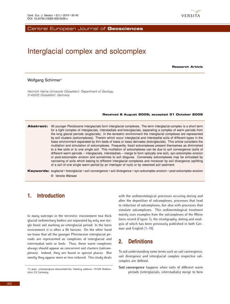
Figure 1. The Rhein loess record. ED = Eben Discordance, Fm. = Formation, HD = Hesbaye Discordance, KD = Keldach Discordance,MD = Mülgau Discordance, WD = Wetterau Discordance.Legend for Figures 1, 2, 4 and 5.
33
Interglacial complex and solcomplex
optically one soil.
Soil divergence happens when soil formation from one
and the same period is interrupted by any inter-
layer of rock (hard rock or soft rock) and continues
its formation on top of this interlayer.
Interglacial complex An early record showing that inter-
glacials in loess deposits are developed as soil
clusters was given by Kukla et al. in 1961 [11]. In
1969 Kukla [12] recorded from Cervený kopec close
to Brno that each of the last nine interglacials had
developed as a soil complex. In 1970 he showed
that these solcomplexes correlate to clusters of
warm peaks of deep sea sediments [13], nowadays
this is common knowledge.
Later, soil clusters (solcomplexes) representing
an interglacial complex were frequently found. The
solcomplexes of the Rhine loess record (Figure 1)
comprise 2-4 Bt horizons accompanied by humus
zones and sometimes gelic gleysols. Interglacial
soils alternate with interstadial soils. The deposits
separating the single fossil soils of a solcomplex
represent loess or loess derivates. This means,
warm periods of different kinds (interglacials as
well as interstadials) are separated by shorter
cold periods, so-called breviglacials sensu Schirmer
1999 [1, 4]. These breviglacials may be accom-
panied by erosional processes that commonly are
smooth enough to save parts of the whole solcom-
plex. This contrasts with the long cold periods, the
euglacial periods, during which redeposition and
erosion is strong enough to remodel the morphol-
ogy to a great extent.
From this follows: An interglacial solcomplex is
a cluster of preferably terrestric and minor semiter-
restric soils which are comprised of at least one
interglacial period, but sometimes two or more, and
a range of interstadial periods. These warm periods
are separated by thin loess layers representing bre-
viglacials. As a whole the solcomplex with its soils
and breviglacial loesses forms a long period of qui-
escence of the landscape. Neither thick essential
accumulation nor greater erosion occurs during the
long period of duration of such a solcomplex [1, 4].
It is known that spreading of loess deposits occurs
predominantly in depressions, downslope or hollow
positions that shows a climate development more
differentiated than in plateau position. In addition,
those locations tend to remain more protected from
erosion than other morphological positions.
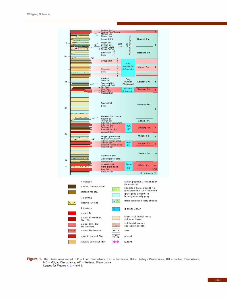
Figure 2. Scheme of mutilation of a solcomplex by convergence,syn-solcomplex erosion and post-solcomplex erosion.The scheme is shown on the example of the Ahr inter-stadial solcomplex (OIS 3) (brown) of the Rhine loessrecord which is sandwiched between the Keldach Forma-tion and the Hesbaye Formation. HD = Hesbaye Discor-dance, OIS = Oxigene Isotope Stage, R1-R5 = RemagenSoils, S1-S4 = Sinzig Soils, blue numbers 5-17 = affilia-tion to Greenland Interstadials 5-17. The loesses of theKeldach Formation (OIS 4) below and the Hesbaye For-mation (OIS 2) on top of the Ahrgau Formation (OIS 3)are not shown differentiatedly. Legend see Figure 1.
3. Mutilation of solcomplexes
3.1. Mutilation of solcomplexes in general
From the knowledge that younger interglacial periods al-
ways exist as interglacial solcomplexes it follows that
in cases where we find an isolated fossil Bt horizon
within a loess section it represents a mutilated interglacial
complex. This mutilation may result from different pro-
cesses [9] (see Figure 2):
1. The mutilation may be an optical phenomenon
where the solcomplex, elsewhere spread, has simply
been converged to optically one soil due to thinning
of the sediment interlayer (soil convergence).
2. In other cases, during breviglacial periods erosional
processes may have removed some limbs of the
solcomplex formed shortly before (syn-solcomplex
truncation). May be, erosion removed the whole
early solcomplex developed up to this stage (total
syn-solcomplex erosion).
3. A third case is the postdepositional truncation of
the solcomplex after its very end at the beginning
of the next euglacial period (post-solcomplex trun-
34

Wolfgang Schirmer
cation). Also here the whole solcomplex may be
eroded (total post-solcomplex erosion).
3.2. Rhein loess record and mutilation of itssolcomplexes
The following characters of a solcomplex are shown in
the example of the Rhein loess record (Figure 1). It ex-
hibits four well differentiated interglacial solcomplexes at-
tributed to OIS 5, 7, 9 and possibly 11. Each solcomplex
shows an individual character concerning the composition
of its different soil types [2–4]. In addition, the last glacial
is biparted by an interstadial solcomplex, the Ahr Sol-
complex that can incontestably be attributed to the OIS
3 [2, 3]. All three above mentioned cases of mutilation oc-
cur with these solcomplexes. For locations see Figure 3.
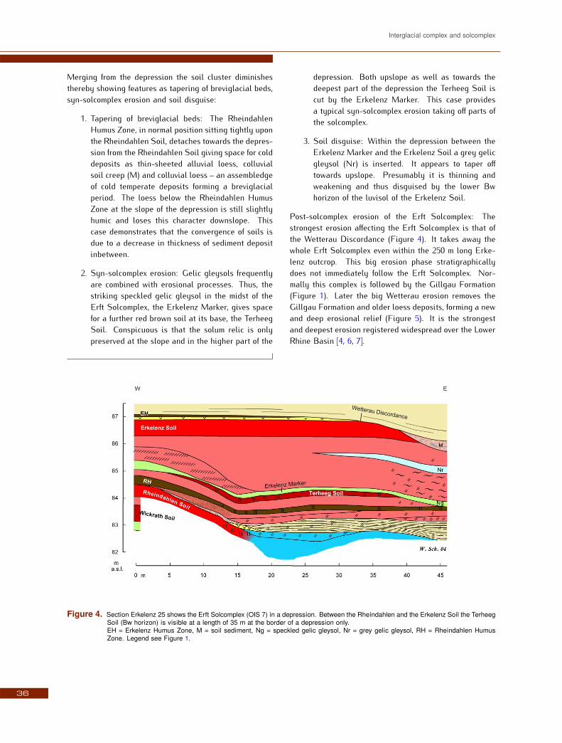
3.2.1. Erft Solcomplex (OIS 7)
In the loess pit of the brickyard Gillrath in Erkelenz (Fig-
ure 4) the solcomplex, allocated to OIS 7 interglacial com-
plex, the Erft Solcomplex, reduces from a eight-membered
solcomplex within a depression to a six-membered at the
slope. In his most complete form the Erft Solcomplex con-
sists of a soil cluster of eight eye-catching soils: the red
Wickrath Soil (Btw horizon), the red Rheindahlen Soil
(Bt) merging towards the depression to a gley (Cr), the
grey brown Rheindahlen Humus Zone (Ah), the red brown
Terheeg Soil (Bw), the light grey Erkelenz Marker (speck-
led gelic gleysol, Ng; not a dust storm marker sensu G.
Kukla), a blue grey gelic gleysol (Nr), the red Erkelenz
Soil (Bt) and the grey brown Erkelenz Humus Zone (Ah).
The stagnic soils (E-Btg) that occur on top of the Bt hori-
zons are disregarded. Outside the depression this soil
cluster reduces to six soils (see Figure 1 and Figure 4 left
edge); the Terheeg Soil and the grey gelic gleysol (Nr)
fade away.
Figure 3. Location map for the mentioned localities of the Rhine loess record.
35
Interglacial complex and solcomplex
Merging from the depression the soil cluster diminishes
thereby showing features as tapering of breviglacial beds,
syn-solcomplex erosion and soil disguise:
1. Tapering of breviglacial beds: The Rheindahlen
Humus Zone, in normal position sitting tightly upon
the Rheindahlen Soil, detaches towards the depres-
sion from the Rheindahlen Soil giving space for cold
deposits as thin-sheeted alluvial loess, colluvial
soil creep (M) and colluvial loess – an assembledge
of cold temperate deposits forming a breviglacial
period. The loess below the Rheindahlen Humus
Zone at the slope of the depression is still slightly
humic and loses this character downslope. This
case demonstrates that the convergence of soils is
due to a decrease in thickness of sediment deposit
inbetween.
2. Syn-solcomplex erosion: Gelic gleysols frequently
are combined with erosional processes. Thus, the
striking speckled gelic gleysol in the midst of the
Erft Solcomplex, the Erkelenz Marker, gives space
for a further red brown soil at its base, the Terheeg
Soil. Conspicuous is that the solum relic is only
preserved at the slope and in the higher part of the
depression. Both upslope as well as towards the
deepest part of the depression the Terheeg Soil is
cut by the Erkelenz Marker. This case provides
a typical syn-solcomplex erosion taking off parts of
the solcomplex.
3. Soil disguise: Within the depression between the
Erkelenz Marker and the Erkelenz Soil a grey gelic
gleysol (Nr) is inserted. It appears to taper off
towards upslope. Presumably it is thinning and
weakening and thus disguised by the lower Bw
horizon of the luvisol of the Erkelenz Soil.
Post-solcomplex erosion of the Erft Solcomplex: The
strongest erosion affecting the Erft Solcomplex is that of
the Wetterau Discordance (Figure 4). It takes away the
whole Erft Solcomplex even within the 250 m long Erke-
lenz outcrop. This big erosion phase stratigraphically
does not immediately follow the Erft Solcomplex. Nor-
mally this complex is followed by the Gillgau Formation
(Figure 1). Later the big Wetterau erosion removes the
Gillgau Formation and older loess deposits, forming a new
and deep erosional relief (Figure 5). It is the strongest
and deepest erosion registered widespread over the Lower
Rhine Basin [4, 6, 7].
Figure 4. Section Erkelenz 25 shows the Erft Solcomplex (OIS 7) in a depression. Between the Rheindahlen and the Erkelenz Soil the TerheegSoil (Bw horizon) is visible at a length of 35 m at the border of a depression only.EH = Erkelenz Humus Zone, M = soil sediment, Ng = speckled gelic gleysol, Nr = grey gelic gleysol, RH = Rheindahlen HumusZone. Legend see Figure 1.
36
Wolfgang Schirmer
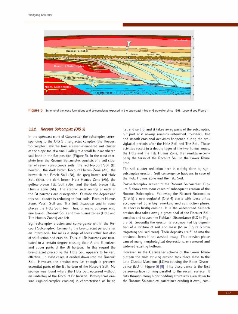
Figure 5. Scheme of the loess formations and solcomplexes exposed in the open-cast mine of Garzweiler since 1998. Legend see Figure 1.
3.2.2. Rocourt Solcomplex (OIS 5)
In the opencast mine of Garzweiler the solcomplex corre-
sponding to the OIS 5 interglacial complex (the Rocourt
Solcomplex), shrinks from a seven-membered soil cluster
at the slope toe of a small valley to a small four-membered
soil band in the flat position (Figure 5). In the most com-
plete form the Rocourt Solcomplex consists of a soil clus-
ter of seven conspicuous soils: the red Rocourt Soil (Bt
horizon), the dark brown Rocourt Humus Zone (Ah), the
brownish red Pesch Soil (Bt), the grey-brown red Holz
Soil (Bht), the dark brown Holz Humus Zone (Ah), the
yellow-brown Titz Soil (Btw) and the dark brown Titz
Humus Zone (Ah). The stagnic soils on top of each of
the Bt horizons are disregarded. Outside the depression
this soil cluster is reducing to four soils. Rocourt Humus
Zone, Pesch Soil and Titz Soil disappear and in some
places the Holz Soil, too. Thus, in many outcrops only
one luvisol (Rocourt Soil) and two humus zones (Holz and
Titz Humus Zones) are left.
Syn-solcomplex erosion and convergence within the Ro-
court Solcomplex: Commonly the breviglacial period after
an interglacial luvisol is a stage of loess influx but also
of solifluction and erosion. Thus, all Bt horizons are trun-
cated to a certain degree missing their A and E horizon
and upper parts of the Bt horizon. In this regard the
breviglacial preceding the Holz Soil appears to be very
effective. In most cases it eroded down into the Rocourt
Soil. However, the erosion was flat enough to preserve
essential parts of the Bt horizon of the Rocourt Soil. No
section was found where the Holz Soil occurred without
an underlay of the Rocourt Bt horizon. Breviglacial ero-
sion (syn-solcomplex erosion) is characterised as being
flat and soft [6] and it takes away parts of the solcomplex,
but part of it always remains untouched. Similarly flat
and smooth erosional activities happened during the bre-
viglacial periods after the Holz Soil and Titz Soil. These
acivities result in a double layer of the two humus zones,
the Holz and the Titz Humus Zone, that readily accom-
pany the torso of the Rocourt Soil in the Lower Rhine
area.
The soil cluster reduction here is mainly done by syn-
solcomplex erosion. Soil convergence happens in case of
the Holz Humus Zone and the Titz Soil.
Post-solcomplex erosion of the Rocourt Solcomplex: Fig-
ure 5 shows two main cases of subsequent erosion of the
Rocourt Solcomplex. Following the Rocourt Solcomplex
(OIS 5) a new euglacial (OIS 4) starts with loess influx
accompanied by a big reworking and solifluction phase.
Its effect is firstly erosion. It is the widespread Keldach
erosion that takes away a great deal of the Rocourt Sol-
complex and causes the Keldach Discordance (KD in Fig-
ure 5). Secondly the erosion is accompanied by deposi-
tion of a mixture of soil and loess (M in Figure 5 from
migrating soil sediment). Their deposits are filled into the
erosional forms if not washed away. This erosion phase
caused many morphological depressions, or renewed and
widened existing hollows.
However, in the Garzweiler scheme of the Lower Rhine
plateau the most striking erosion took place close to the
Late Glacial Maximum (LGM) causing the Eben Discor-
dance (ED in Figure 5) [8]. This discordance is the first
palaeo-surface running parallel to the recent surface. It
cuts through many older bedding structures even down to
the Rocourt Solcomplex, sometimes eroding it away com-
37

Interglacial complex and solcomplex
pletely.
Thus, post-solcomplex erosion combined with euglacial
conditions is much more effective and destructive than syn-
solcomplex erosion. It creates completely new landscape
shapes and takes away total loess formations [1].
3.2.3. Ahr Solcomplex (OIS 3)
The interstadial Ahr Solcomplex which is appointed to
the OIS 3 interstadial complex (Figure 1, 2) should be
regarded together with this group of interglacial solcom-
plexes. Figure 2 that above served as scheme of mutilation
processes presents in its middle part the Schwalbenberg
section south of Bonn. This profile is the most detailed
loess-soil record of OIS 3 existing up to now in Central
Europe. Though it is not an interglacial solcomplex it
should be treated as an early stage of an interglacial com-
plex that could not fully develop [5]. The largest vertical
spread of this solcomplex exhibits eight calcaric cambisols
at the Schwalbenberg. Their ages range from roughly 60
to 30 ka BP dated by 14C and TL [2, 3]. It presents three
soil groups: The Lower Remagen Soils (Remagen 1 and 2
Soils), the Upper Remagen Soils (R3-R5) and the Sinzig
Soils (S1-S3). In Figure 2 a virtual Sinzig Soil 4 is added.
As the Ahr Solcomplex at the Schwalbenberg – from the
amount of soils, their intensity, their grouping to four Bond
cycles, and direct datings – shows detailed correspon-
dence to the Greenland Interstadials (GIS) 6-17 [2, 3, 9]
one could expect a missing Sinzig Soil 4 corresponding
to GIS 5 which would have been eroded in the recent
Schwalbenberg section.
Figure 2 shows the following features:
Most spread development of the solcomplex happens in a
former depression.
Convergence is shown towards upslope of each the Lower
Remagen Soils, the Upper Remagen Soils and the Sinzig
Soils. Nine soils may converge into three soil bands. Cur-
rently there is no information on whether these three soil
bands converge at any place. Therefore Figure 2 avoids
drawing this. Convergence of this solcomplex elsewhere
is also known towards downslope [14].
Towards the depression there occurs syn-solcomplex ero-
sion both on top of the Lower (R1-R2) and Upper Remagen
Soils (R3-R5). On top of the Sinzig Soils (S1-S4), re-
spectively at the base of the Hesbaye-Formation (OIS 2)
post-solcomplex erosion starts. This is the strongest ero-
sion shown in this section. It takes off parts or the whole of
the Ahrgau Formation (OIS 3). It produces the widespread
Hesbaye-Discordance (HD in Figure 2).
Post-solcomplex erosion takes away first the Sinzig soils
or their converged soil band, followed by the Upper Rema-
gen and finally the Lower Remagen Soils, respectively
their converged soil bands. This means that the possibil-
ity of preservation is lower for the younger soils of the
complex, and higher for the older soils. Moreover, soils in
general withstand erosion somewhat better than the loess
layers inbetween.
The strongest soils of the Ahr Solcomplex are the soils
Remagen 2 (R2 in Figure 2), Remagen 3 (R3) and Sinzig 1
(SI) equivalent to GIS 14, 12 and 8 [2, 3, 9]. This means
the stronger soils settle in the middle of the Ahr Solcom-
plex, not in the lowest and uppermost part of it. This
is visible in the Schwalbenberg section [9] as well as in
the Nussloch section south of Heidelberg where Bibus et
al. [15] state within a cluster of five brown soils the mid-
dle one (their WB 4 soil) to be the strongest soil. While
in Nussloch a diminution of the Ahr Solcomplex to five
soils is visible, elsewhere in central Europe there are pre-
served three soils, e. g. [16, 17], two soils (Figure 5, right
edge, and e. g. [18]) or even one soil. In cases of one
preserved soil – for example the Lohne Soil in the Rhine-
Main area, e. g. [18, 19] – it remains questionable which
soil of the eight-membered solcomplex has been preserved
at the place described, and whether this one soil is al-
ways the same soil among the variety of members of the
whole solcomplex. In all these cases the diminution of
soils within the Ahr Solcomplex occurs by convergence, by
syn-solcomplex truncation and also post-solcomplex trun-
cation.
This initial solcomplex of OIS 3, the Ahr Solcomplex, high-
lights that the last glacial undoubtly is biparted into two
separate euglacial periods. Thus, the last glacial ought to
be divided into an OIS 4 glacial and an OIS 2 glacial – the
latter is the real Weichselian or Würmian glacial – sepa-
rated by the Ahr Interstadial Complex [5].
4. Simulation of solcomplexes
4.1. Soil neighbourhood due to erosionalphases
Solcomplexes, however, may also be simulated. During
periods of euglacial loess deposition enormous rework-
ing and erosion activity produces deeply carving uncon-
formities. Due to those discordances luvisols of different
interglacial periods may lie in a tight neighbourhood sim-
ulating solcomplexes. Thus, by subdividing a loess stack,
evidencing these discordances is as important as recogniz-
ing fossil soils. Therefore large walls to be cleaned are
necessary to follow fossil soils as well as discordances,
which both are a testament to the former landscape sur-
faces.
38

Wolfgang Schirmer
4.2. Soil divergence
Another case of simulating solcomplexes is soil divergence
in contrast to soil convergence. Soil divergence happens
when soil formation in a distinct warm period is inter-
rupted by an event that covers the soil with a rock deposit,
e. g. volcanic rock, flood deposit, colluvium, talus deposit,
debris flow deposit. After this event soil formation contin-
ues. Finally, both soils framing the event belong to the
same warm period and thus they may simulate a solcom-
plex.
4.3. Soil sediment
Reworking of soils may simulate autochthonous soils. Fig-
ure 4 and 5 show reworked soil sediment (M) each in the
beginning of a new cold phase. This preferably happens
after the end of a solcomplex during the early phase of
a new euglacial. Figure 5 shows the soil sediment (M ma-
terial) during the early Keldach Formation infilled into the
erosional hollow form of the Keldach Discordance. More-
over, the Eben Discordance (also in the same Figure 5)
presents a reworked layer at its base with reworked soil
material, known as the Kesselt Layer. Figure 4 shows soil
sediment originating from the Erkelenz Soil in connection
with the Wetterau Discordance.
Reworked soil deposits occur also in breviglacial phases,
although only to a minor extent. Figure 4 presents an ex-
ample of soil sediment reworked from the Rheindahlen
Soil creeping downslope to the small valley bottom ex-
posed.
5. Conclusion
Interglacial periods in the younger Pleistocene occur as
clusters of warm periods (interglacials and interstadials)
intersected by short cold periods (breviglacials). These
clusters of warm periods containing one or more inter-
glacials are called interglacial complexes. In the ter-
restric environment it is rare for interglacial complexes
to be found fully developed with all warm and cold mem-
bers known so far. Its preservation needs more sediment
input than output during a breviglacial. Favoured places
are mainly depressions or lee positions. Outsite favoured
places the interglacial complexes are mutilated sometimes
down to one single soil or are even completely eroded. The
same applies to the single interstadial complex, known up
to now, the Ahr Interstadial complex of OIS 3.
Consequently, much discussion has been raised about
what happened in-between a full and reduced solcomplex
and how to connect the residual members of the solcom-
plex.
Lack of sediment input results in the merging of soils from
different soil forming periods. Thus, the solcomplex seems
to be reduced. In-between the full and reduced solcomplex
happened mutilation of the complex that comprises soil
convergence, syn-solcomplex erosion or post-solcomplex
erosion, sometimes soil disguise.
As a consequence, in case a warm period complex is rep-
resented by one soil only it has to be considered that:
1. this soil represents only one member of the whole
cluster,
2. it might represent some merged members of the
cluster,
3. it need not to represent the same one soil from this
cluster exposed in the next outcrop.
Of course, there is a certain probability for the preserva-
tion of the strongest soil of a group due to better resis-
tance from erosion for its higher clay content and density.
There is also a chance for better preservation for the basal
soils of a group because of their greater distance to the
erosional front.
Moreover, identifying certain members of a solcomplex by
dating is very difficult, because the tight time sequence of
the members of a solcomplex lies mostly within the toler-
ance of the dating values.
A separate topic is that solcomplexes may be simulated.
Finding a solcomplex in small outcrops it has to be proved
whether the tight lying soils origin from different solcom-
plexes. The neighbourhood of soils might be due to an ero-
sional event which simulates a solcomplex of soils that in
fact belong to different solcomplexes. Another issue of
simulating solcomplexes is soil divergence. An interca-
lation of a deposition during the ongoing process of soil
formation can simulate a solcomplex, where indeed the
lower and upper soil separated by the intercalation be-
long to the same soil formation.
All these contingencies point out that for a reliable strati-
graphical context a large outcrop is essential. The Rhine
loess record has been established mainly in opencast
mines or large brickyards.
Acknowledgements
Thanks are due to two unknown reviewers and for editorial
improvement of the English style.
39

Interglacial complex and solcomplex
References
[1] Schirmer W., Kaltzeiten und Warmzeiten im Löß. In:
Becker-Haumann R., Frechen M. eds.: Terrestrische
Quartärgeologie, 81–100, Logabook, Köln, 1999, (in
German, with extented English abstract)
[2] Schirmer W., Rhein loess, ice cores and deep-sea
cores during MIS 2-5, Zeitschrift der deutschen geol.
Gesellschaft, 2000, 151(3), 309-332
[3] Schirmer W., Eine Klimakurve des Oberpleistozäns
aus dem rheinischen Löss, Eiszeitalter und Gegen-
wart, 2000, 50, 25-49, (in German)
[4] Schirmer W., Compendium of the Rhein loess se-
quence. In: Ikinger A., Schirmer W. eds., Loess units
and solcomplexes in the Niederrhein and Maas area,
Terra Nostra, 2002(1), 8-23, 102-104
[5] Schirmer W., Frühes Würm/Weichsel im Rahmen der
Glazial-Interglazial-Gliederung, Terra Nostra, 2002
(6), 314-321, (in German)
[6] Schirmer W., Stadien der Rheingeschichte, In:
Schirmer W. ed., Landschaftsgeschichte im Europäi-
schen Rheinland, GeoArchaeoRhein, 2003, 4, 21-80,
(in German)
[7] Schirmer W., Zur reliktischen Erhaltung älterer Lösse.
In: Schirmer W. ed.: Landschaftsgeschichte im Eu-
ropäischen Rheinland, GeoArchaeoRhein, 2003, 4,
153-154, (in German)
[8] Schirmer W., Die Eben-Zone im Oberwürmlöss zwi-
schen Maas und Rhein. In: Schirmer, W. ed.:
Landschaftsgeschichte im Europäischen Rheinland,
GeoArchaeoRhein, 2003, 4, 351-416, (in German)
[9] Schirmer W., Terrestrischer Klimagang des MIS 3.
In: DEUQUA meeting, 30 August-3 September 2004,
Nijmegen, the Netherlands, Abstract volume, 74, Vrije
Universiteit, Amsterdam, 2004 (in German)
[10] Schirmer W. et al., Rhein Traverse. In: Schirmer W.
ed., Quaternary field trips in Central Europe, 1, 475-
558, Pfeil, München, 1995.
[11] Kukla J., Ložek V, Záruba Q., Zur Stratigraphie der
Lösse in der Tschechoslowakei, Quartär, 1961, 13, 1-
29, Taf 1-3, (in German)
[12] Kukla J., Die zyklische Entwicklung und absolute
Datierung der Löß-Serien. In: Demek J., Kukla J. eds.,
Periglazialzone, Löss und Paläolithikum der Tsche-
choslowakei, 75-95, Abb. 27-32, Czech. Akad. Sci,
Brno, 1969, (in German)
[13] Kukla J., Correlation between loesses and deap-sea
sediments, Geol. Fören. Stockholm Förhandl., 1970,
92, 148-180
[14] Schellmann G., Fluviale Geomorphodynamik im jün-
geren Quartär des unteren Isar- und angrenzenden
Donautales, Düsseldorfer geogr. Schriften, 1990, 29,
VII+131, (in German)
[15] Bibus E., Frechen M., Kösel M., Rähle W., Das jung-
pleistozäne Lössprofil von Nussloch (SW-Wand) im
Aufschluss der Heidelberger Zement AG, Eiszeitalter
und Gegenwart, 2007, 56(4), 227-255, (in German)
[16] Zöller L., Nehring F., Solifluktions, Löss und Bo-
denbildungszyklen seit dem letzten Interglazial im
Niederwesterwald, Berichte zur deutschen Lan-
deskunde, 2002, 76(2/3), 115-130, (in German)
[17] Terhorst B., Ottner F., Poetsch T., Herr T., Kellner
A., Rähle W., Jungpleistozäne Deckschichten auf der
Hochterrasse bei Altheim (Innviertel/Oberösterreich),
Tübinger geowiss. Arbeiten, 2003, D 9, 47-86, (in Ger-
man)
[18] Semmel A., 50 years of refined stratigraphy of Wür-
mian loess in Germany. In: Zöller L., Semmel A.: 175
years of loess research in Germany – long records
and „unconformities“, Earth Sci., 2001, 54, 23-28
[19] Rösner U., Die Mainfränkische Lößprovinz. Sedi-
mentologische, pedologische und morphodynamische
Prozesse der Lößbildung während des Pleistozäns in
Mainfranken, Erlanger geogr. Arbeiten, 1990, 51, 306
p., 27 encl., 24 photos, (in German)
40