initial study mitigated negative declaration round … draft is-mnd round hill levee... · initial...
TRANSCRIPT

INITIAL STUDY MITIGATED NEGATIVE DECLARATION
ROUND HILL LEVEE REMOVAL PROJECT
February 2005
State of California
DEPARTMENT OF PARKS AND RECREATION

•
MITIGATED NEGATIVE DECLARATION
PROJECT: ROUND HILL LEVEE REMOVAL PROJECT LEAD AGENCY: California Department of Parks and Recreation AVAILABILITY OF DOCUMENTS: The Initial Study for this Mitigated Negative Declaration is available for review at:
Santa Cruz District Headquarters California Department of Parks & Recreation
Henry Cowell Redwoods State Park 303 Big Trees Park Road Felton, CA 95018
• Half Moon Bay State Beach
95 Kelly Avenue Half Moon Bay, CA 94019
• Half Moon Bay Library
620 Correas Street Half Moon Bay, CA 94019
• California State Parks website
www.parks.ca.gov/default.asp?page_id=980
PROJECT DESCRIPTION Pescadero State Beach has been altered by the construction of dikes, levees, and channels built to drain or protect agricultural land. California State Parks has been working for the past two decades to re-create the functioning marsh ecosystem. Previous projects have removed levees, breached portions of levees, excavated channels and constructed ponds in an effort to enhance habitat values for several sensitive species. State Parks proposes to remove about 700 linear feet of levee from the bank of Pescadero Creek near Round Hill, restoring the creek bank to a more natural height. The project will begin to restore the adjacent five-acre fallow field to a natural riparian floodplain. This project will directly benefit several sensitive species. All material excavated and deposited will be used on site. Levee spoils will be used to create upland berms that will enhance habitat and topographic diversity of the field, and form basking habitat for the endangered San Francisco garter snake. This project is designed to improve foraging habitat for the San Francisco garter snake by creating diverse habitat types, including habitat for frogs. We will create frog habitat by removing nonnative vegetation in the fallow field, replanting appropriate species, and creating one or more seasonal ponds in the
Round Hill Levee Removal Pescadero State Beach California Department of Parks & Recreation
field. The ponds will collect rainwater from upland areas in normal rainfall years, plus overbank flows during high water years.
Only native plant materials from local genetic sources will be used for revegetation. All work will be carefully monitored during construction to minimize any potential short-term impacts associated with restoration. The project includes a strong monitoring component, to ensure the success of the restoration project and allow adaptive management. A copy of the Initial Study/Mitigated Negative Declaration is attached. Questions or comments regarding this Initial Study/Mitigated Negative Declaration may be addressed to:
Victor S. Roth, Jr. California Department of Parks and Recreation 303 Big Trees Park Road Felton, CA 95018 (831) 335-6394 fax
Pursuant to Section 21082.1 of the California Environmental Quality Act, the California Department of Parks and Recreation (DPR) has independently reviewed and analyzed the Initial Study and Negative Declaration for the proposed project and finds that these documents reflect the independent judgment of DPR. DPR, as lead agency, also confirms that the project mitigation measures detailed in these documents are feasible and will be implemented as stated in the Negative Declaration. _________________________________________ __________________ Date District Superintendent _________________________________________ __________________ Date Environmental Coordinator
Round Hill Levee Removal IS/MND Pescadero State Beach California Department of Parks and Recreation
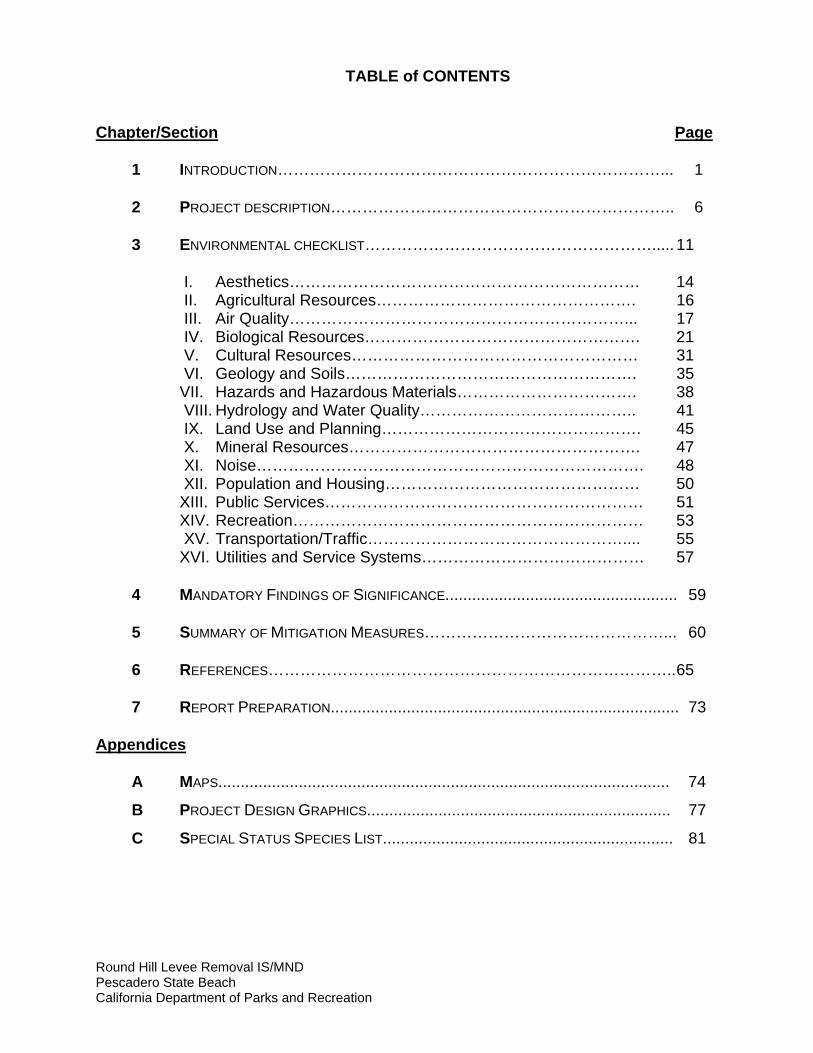
TABLE of CONTENTS
Chapter/Section Page 1 INTRODUCTION………………………………………………………………... 1 2 PROJECT DESCRIPTION……………………………………………………….. 6 3 ENVIRONMENTAL CHECKLIST………………………………………………..... 11 I. Aesthetics………………………………………………………… 14 II. Agricultural Resources…………………………………………. 16 III. Air Quality………………………………………………………... 17 IV. Biological Resources……………………………………………. 21 V. Cultural Resources……………………………………………… 31 VI. Geology and Soils………………………………………………. 35 VII. Hazards and Hazardous Materials……………………………. 38 VIII. Hydrology and Water Quality………………………………….. 41 IX. Land Use and Planning…………………………………………. 45 X. Mineral Resources………………………………………………. 47 XI. Noise………………………………………………………………. 48 XII. Population and Housing………………………………………… 50 XIII. Public Services…………………………………………………… 51 XIV. Recreation………………………………………………………… 53 XV. Transportation/Traffic………………………………………….... 55 XVI. Utilities and Service Systems…………………………………… 57 4 MANDATORY FINDINGS OF SIGNIFICANCE.................................................... 59 5 SUMMARY OF MITIGATION MEASURES………………………………………... 60 6 REFERENCES………………………………………………………………….. 65 7 REPORT PREPARATION.............................................................................. 73 Appendices A MAPS..................................................................................................... 74
B PROJECT DESIGN GRAPHICS.................................................................... 77
C SPECIAL STATUS SPECIES LIST................................................................. 81

2 Round Hill Levee Removal IS/MND Pescadero State Beach California Department of Parks & Recreation
CHAPTER 1 INTRODUCTION
1.1 INTRODUCTION AND REGULATORY GUIDANCE The Initial Study/Mitigated Negative Declaration (IS/MND) has been prepared by the California Department of Parks and Recreation (DPR) to evaluate the potential environmental effects of the proposed Round Hill Levee Removal Project at Pescadero State Beach, San Mateo County, California. This document has been prepared in accordance with the California Environmental Quality Act (CEQA), Public Resources Code §21000 et seq., and the State CEQA Guidelines, California Code of Regulations (CCR) §15000 et seq. An Initial Study is conducted by a lead agency to determine if a project may have a significant effect on the environment [CEQA Guidelines §15063(a)]. If there is substantial evidence that a project may have a significant effect on the environment, an Environmental Impact Report (EIR) must be prepared, in accordance with CEQA Guidelines §15064(a). However, if the lead agency determines that revisions in the project plans or proposals made by or agreed to by the applicant mitigate the potentially significant effects to a less-than-significant level, a Mitigated Negative Declaration may be prepared instead of an EIR [CEQA Guidelines §15070(b)]. The lead agency prepares a written statement describing the reasons a proposed project will not have a significant effect on the environment and, therefore, why an EIR need not be prepared. This IS/MND conforms to the content requirements under CEQA Guidelines §15071. 1.2 LEAD AGENCY The lead agency is the public agency with primary approval authority over the proposed project. In accordance with CEQA Guidelines §15051(b)(1), "the lead agency will normally be an agency with general governmental powers, such as a city or county, rather than an agency with a single or limited purpose." The lead agency for the proposed project is DPR. The contact person for the lead agency is:
Joanne Kerbavaz, Senior Resource Ecologist California Department of Parks & Recreation San Mateo Coast Sector 95 Kelly Avenue Half Moon Bay, CA 94019 (650) 726-8805

3 Round Hill Levee Removal IS/MND Pescadero State Beach California Department of Parks & Recreation
All inquiries regarding environmental compliance for this project, including comments on this environmental document should be addressed to:
Victor S. Roth, Jr. California Department of Parks and Recreation 303 Big Trees Park Road Felton, CA 95018 (831) 335-6394 fax
Submissions must be in writing and postmarked or received by fax no later than March 31, 2005. The originals of any faxed document must be received by regular mail within ten working days following the deadline for comments, along with proof of successful fax transmission. Fax submissions must include full name and address.

4 Round Hill Levee Removal IS/MND Pescadero State Beach California Department of Parks & Recreation
1.3 PURPOSE AND DOCUMENT ORGANIZATION The purpose of this document is to evaluate the potential environmental effects of the proposed Round Hill Levee Removal Project at Pescadero State Beach. Mitigation measures have also been incorporated into the project to eliminate any potentially significant impacts or reduce them to a less than significant level. This document is organized as follows: • Chapter 1 - Introduction This chapter provides an introduction to the project and describes the purpose and
organization of this document. • Chapter 2 - Project Description This chapter describes the reasons for the project, scope of the project, and project
objectives. • Chapter 3 - Environmental Setting, Impacts, and Mitigation Measures This chapter identifies the significance of potential environmental impacts, explains
the environmental setting for each environmental issue, and evaluates the potential impacts identified in the CEQA Environmental (Initial Study) Checklist. Mitigation measures are incorporated, where appropriate, to reduce potentially significant impacts to a less than significant level.
• Chapter 4 - Mandatory Findings of Significance This chapter identifies and summarizes the overall significance of any potential
impacts to natural and cultural resources, cumulative impacts, and impact to humans, as identified in the Initial Study.
• Chapter 5 - Summary of Mitigation Measures This chapter summarizes the mitigation measures incorporated into the project as a
result of the Initial Study. • Chapter 6 - References This chapter identifies the references and sources used in the preparation of this
IS/MND. • Chapter 7 - Report Preparation This chapter provides a list of those involved in the preparation of this document. 1.4 SUMMARY OF FINDINGS Chapter 3 of this document contains the Environmental (Initial Study) Checklist that identifies the potential environmental impacts (by environmental issue) and a brief discussion of each impact resulting from implementation of the proposed project.

5 Round Hill Levee Removal IS/MND Pescadero State Beach California Department of Parks & Recreation
Based on the IS and supporting environmental analysis provided in this document, the proposed Round Hill Levee Removal Project will result in less than significant impacts for the following issues: aesthetics, agricultural resources, air quality, biological resources, cultural resources, geology and soils, hazards and hazardous materials, hydrology and water quality, land use and planning, mineral resources, noise, population and housing, public services, recreation, transportation/traffic, and utilities and service systems. In accordance with §15064(f) of the CEQA Guidelines, a MND shall be prepared if the proposed project will not have a significant effect on the environment after the inclusion of mitigation measures in the project. Based on the available project information and the environmental analysis presented in this document, there is no substantial evidence that, after the incorporation of mitigation measures, the proposed project will have a significant effect on the environment. It is proposed that a Mitigated Negative Declaration be adopted in accordance with the CEQA Guidelines.

6 Round Hill Levee Removal IS/MND Pescadero State Beach California Department of Parks & Recreation
CHAPTER 2 PROJECT DESCRIPTION
2.1 INTRODUCTION This Initial Study/Mitigated Negative Declaration (IS/MND) has been prepared by the California Department of Parks and Recreation (DPR) to evaluate the potential environmental effects of the proposed Round Hill Levee Removal Project at Pescadero State Beach, located in the town of Pescadero, San Mateo County, California. The proposed project will remove about 700 linear feet of levee from Round Hill, restoring the creek bank to a more natural height. The project will begin to restore the adjacent five-acre fallow field to a natural riparian floodplain. This project will directly benefit several sensitive species. 2.2 PROJECT LOCATION Pescadero State Beach is located on the central California coast, 17 miles south of Half Moon Bay in San Mateo County. This park unit contains sandy beaches and coastal dunes. The state beach also contains Pescadero Marsh Natural Preserve, a coastal wetland complex that includes a lagoon at the confluence of Pescadero and Butano Creeks, fresh and brackish water marshes, and brackish water ponds. The Round Hill levee project is located in an upland area bordering Pescadero Creek, and is outside of the natural preserve boundaries. Public facilities are limited to day use. 2.3 BACKGROUND AND NEED FOR THE PROJECT Past and current human activities have altered the habitat values of Pescadero State Beach. These activities include conversion of land to agricultural use, deposition of sediment in the lagoon and marsh channels, construction of levees, and diversions of water upstream. One of DPR’s management objectives in Pescadero State Beach, as listed in its General Plan, is to convert abandoned agricultural land to a natural state. The current levee near Round Hill separates Pescadero Creek from its floodplain, thus preventing its natural function. (For more information on the General Plan, read Chapter 3, Section IX, Land Use and Planning.) Riparian corridors and their adjacent floodplains are rich in biodiversity and provide many ecosystem services. Some of their values include:
• Protecting banks from erosion • Filtering sediments and pollutants from water • Providing quality living conditions for fish and wildlife • Creating corridors for wildlife migration
• Harboring endangered species

7 Round Hill Levee Removal IS/MND Pescadero State Beach California Department of Parks & Recreation
• Providing aesthetic values (USDA 1989, Barbour 1993)
It is estimated that in California, 25% of all mammals, 80% of amphibians, and 40% of reptiles depend on riparian ecosystems. An estimated 135 bird species depend on or prefer this ecosystem (USDA 1989). High diversity and primary productivity is largely linked to the water source inherent in a riparian habitat. Many animals that normally utilize other habitats still regularly visit riparian corridors for food, water, and shelter. Additionally, riparian systems are a prime example of an ecotone, or area where two different habitats mesh together (in this case, aquatic and terrestrial). In an ecotone, the needs of a wide range of organisms can be met (Schoenherr 1995). Flooding provides a critical ecosystem function by depositing nutrient-rich sediment and recharging groundwater systems (Keller 1977). Pescadero State Beach offers valuable habitat for many species of plants, fish, and wildlife. Waterfowl and shorebirds are seasonally abundant. The lagoon, wetlands and creeks are habitat for several sensitive species, including the State and Federally endangered San Francisco garter snake (SFGS), Federally threatened California red-legged frog (CRLF), Federally endangered tidewater goby, and Federally threatened steelhead. In particular, this project is being undertaken as a recovery action for the endangered San Francisco garter snake. According to the U.S. Fish and Wildlife Service’s San Francisco Garter Snake Recovery Plan (1985 p. 28),
“An essential step in the recovery of the San Francisco garter snake is to protect all populations of the snake and the habitats upon which the species depends. . . . A population of San Francisco garter snakes of undetermined size is known from Pescadero Marsh Natural Preserve. Protection of this population is essential to the recovery effort.”
DPR is partnering with the USFWS to ensure this project improves recovery potential for this endangered snake. 2.4 PROJECT OBJECTIVES The intent of this project is to remove about 700 linear feet of the levee near Round Hill, thus restoring the natural bank along this stretch of Pescadero Creek. The proposed project is expected to: • Restore riparian habitat. • Restore natural floodplain connectivity. • Enhance foraging and burrowing habitat for the endangered San Francisco garter
snake. • Enhance habitat for threatened California red-legged frogs. • Improve native plant cover. • Reduce nonnative plant cover.

8 Round Hill Levee Removal IS/MND Pescadero State Beach California Department of Parks & Recreation
2.5 PROJECT DESCRIPTION The project consists of the removal of about 700 linear feet of levee, restoring a more natural bank height along this section of Pescadero Creek. When the project is completed, the creek should overtop this area about every 2.5 years, restoring natural connectivity to the floodplain. This project aims to improve foraging habitat for the endangered San Francisco garter snake by creating diverse habitat types, including habitat for frogs. We will create frog habitat by removing nonnative vegetation in the fallow field, and creating one or more seasonal ponds in the field. The ponds will collect rainwater from upland areas in normal rainfall years, plus overbank flows during high water years. Spoils from the removed levee will be used onsite to create uplands that can form basking and burrowing habitat for the San Francisco garter snake. Vegetation trimmed from the levee will be piled to create snake cover. Nonnative invasive plants will be removed from the riparian corridor and restored floodplain, and native species will be planted. For four to six weeks prior to earth moving, the project impact area will be delineated with snake exclusion fencing. One-way funnels will allow snakes to passively leave the project area. San Francisco garter snakes emerge from hibernation in March. The project area does not currently have ponds; therefore active snakes are likely to leave the fenced project area to forage. Using USFWS-approved biologists and methods, San Francisco garter snake monitoring, including live trapping, will occur within the fenced area before earth moving takes place. Trapped snakes will be measured, marked, and released immediately outside the project area. This will allow DPR to monitor snake use in the area and to collect data on population structure. Trapping will further ensure that snakes have been excluded from the project site. Biological monitors will be on site during all construction activities. If San Francisco garter snakes are seen during earth moving, approved personnel will carefully move any San Francisco garter snakes outside the fenced project impact area. Work will stop while the appropriate officials at CDFG and USFWS are contacted. The actual use of heavy equipment for earth moving should take no longer than a month. Proposed Project Schedule
April 2005 Install exclusion fencing around construction footprint of

9 Round Hill Levee Removal IS/MND Pescadero State Beach California Department of Parks & Recreation
site. April-May 2005 Monitor SFGS population in and adjacent to project site. June 2005 Vegetation removal and burrow excavation within
construction footprint, if required. June-July 2005 Earth moving. Levee removal. Frog pond excavation.
Construction of upland basking sites. Use trimmed trees and existing levee cribbing to stabilize uplands and as piles for basking habitat. Initiation of revegetation efforts.
August 2005 Project hiatus coincides with birth season of SFGS. Sept/Oct 2005 Continued revegetation of site as needed. April and Sept. 2007 Monitor SFGS and CRLF populations, pond and upland
usage. April and Sept. 2010 Monitor SFGS and CRLF populations, pond and upland
usage. 2.6 PROJECT CONSTRUCTION Construction for this project is expected to begin in June 2005 and will take approximately one month to complete. If construction is delayed for any reason, it will be scheduled for another time outside of both the rainy season and the birth season for the San Francisco garter snake. During this time the state beach will remain open, although the areas of the site under active construction will be restricted to authorized personnel only. Work will normally occur Monday through Friday, 8 a.m. to 5 p.m., unless permission is granted by the construction supervisor and the Park Superintendent for other hours. Heavy equipment, such as excavators, graders, bulldozers, and dump trucks, will be used during construction. Most equipment will be transported to the site and remain until the associated work is completed. This equipment will be staged in the park office parking lot on Water Lane, near existing park equipment, or along the service road between the office and the project site. Staging areas for the project will be within Pescadero State Beach boundaries. 2.7 VISITATION TO PESCADERO STATE BEACH There are no official counts of visitors to Pescadero State Beach. In 2003, 328,029 visitors used the three parking lots that serve the coastal portion of Pescadero State Beach. Park staff estimate two-thirds of visitors spend their time at the beach. Those who enter the marsh tend to congregate along its western edge, which has maintained trails. Very few visitors go through the project site, and park staff estimate their numbers are probably much fewer than 1% of total visitors. There is no anticipated impact from the project on the level of visitation at Pescadero State Beach. 2.8 CONSISTENCY WITH LOCAL PLANS AND POLICIES

10 Round Hill Levee Removal IS/MND Pescadero State Beach California Department of Parks & Recreation
This plan is consistent with local plans and policies. For more information, see Chapter 3, Section IX, Land Use and Planning. 2.9 DISCRETIONARY APPROVALS DPR has approval authority for implementation of projects within the boundaries of Pescadero State Beach. However, the following permits and consultations also may be required before work can begin: • Section 7 Consultation from U.S. Fish and Wildlife Service • Consultations with the California Department of Fish and Game, NOAA Fisheries,
and the Army Corps of Engineers • Streambed Alteration Agreement • Coastal Development Permit 2.10 RELATED PROJECTS Additional projects to remove levees and restore floodplains may occur in other portions of the state beach; however, no additional projects are currently anticipated.

11 Round Hill Levee Removal IS/MND Pescadero State Beach California Department of Parks & Recreation
CHAPTER 3 ENVIRONMENTAL CHECKLIST
PROJECT INFORMATION
1. Project Title: Round Hill Levee Removal 2. Lead Agency Name & Address: California Department of Parks and Recreation 3. Contact Person & Phone Number: Joanne Kerbavaz, Senior Resource Ecologist
(650) 726-8805 4. Project Location: Pescadero State Beach, San Mateo County 5. Project Sponsor Name & Address: California Department of Parks and Recreation Santa Cruz District 303 Big Trees Park Road Felton, CA 95018 6. General Plan Designation: Public Recreation 7. Zoning: Planned Agricultural Development 8. Description of Project: Refer to Chapter 2, Section 2.5 of this document
9. Surrounding Land Uses & Setting: Refer to Chapter 3 of this document (Section IX, Land Use Planning)
10. Approval Required from Other Refer to Chapter 2, Section 2.9 Public Agencies

12 Round Hill Levee Removal IS/MND Pescadero State Beach California Department of Parks & Recreation
1. ENVIRONMENTAL FACTORS POTENTIALLY AFFECTED:
The environmental factors checked below would be potentially affected by this project, involving at least one impact that is a "Potentially Significant Impact", as indicated by the checklist on the following pages.
Aesthetics Agricultural Resources Air Quality Biological Resources Cultural Resources Geology/Soils Hazards & Hazardous Materials Hydrology/Water Quality Land Use/Planning Mineral Resources Noise Population/Housing Public Services Recreation Transportation/Traffic Utilities/Service Systems Mandatory Findings of None
Significance
DETERMINATION On the basis of this initial evaluation: I find that the proposed project COULD NOT have a significant effect on the environment and a NEGATIVE DECLARATION will be prepared. I find that, although the original scope of the proposed project COULD have had a Significant effect on the environment, there WILL NOT be a significant effect because Revisions/mitigations to the project have been made by or agreed to by the applicant. A MITIGATED NEGATIVE DECLARATION will be prepared. I find that the proposed project MAY have a significant effect on the environment and an ENVIRONMENTAL IMPACT REPORT or its functional equivalent will be prepared. I find that the proposed project MAY have a "potentially significant impact" or "potentially significant unless mitigated impact" on the environment. However, at least one impact has been adequately analyzed in an earlier document, pursuant to applicable legal standards, and has been addressed by mitigation measures based on the earlier analysis, as described in the report's attachments. An ENVIRONMENTAL IMPACT REPORT is required, but it must analyze only the impacts not sufficiently addressed in previous documents. I find that, although the proposed project could have had a significant effect on the environment, because all potentially significant effects have been adequately analyzed in an earlier EIR or Negative Declaration, pursuant to applicable standards, and have been avoided or mitigated, pursuant to an earlier EIR, including revisions or mitigation measures that are imposed upon the proposed project, all impacts have been avoided or mitigated to a less-than-significant level and no further action is required. ____________________________________________ ___________________________ Date Environmental Coordinator

13 Round Hill Levee Removal IS/MND Pescadero State Beach California Department of Parks & Recreation
EVALUATION OF ENVIRONMENTAL IMPACTS 1. A brief explanation is required for all answers, except "No Impact", that are adequately supported by the
information sources cited. A "No Impact" answer is adequately supported if the referenced information sources show that the impact does not apply to the project being evaluated (e.g., the project falls outside a fault rupture zone). A "No Impact" answer should be explained where it is based on general or project-specific factors (e.g., the project will not expose sensitive receptors to pollutants, based on a project-specific screening analysis).
2. All answers must consider the whole of the project-related effects, both direct and indirect, including off-site,
cumulative, construction, and operational impacts. 3. Once the lead agency has determined that a particular physical impact may occur, the checklist answers
must indicate whether that impact is potentially significant, less than significant with mitigation, or less than significant. "Potentially Significant Impact" is appropriate when there is sufficient evidence that a substantial or potentially substantial adverse change may occur in any of the physical conditions within the area affected by the project that cannot be mitigated below a level of significance. If there are one or more "Potentially Significant Impact" entries, an Environmental Impact Report (EIR) is required.
4. A "Mitigated Negative Declaration" (Negative Declaration: Less Than Significant with Mitigation Incorporated)
applies where the incorporation of mitigation measures, prior to declaration of project approval, has reduced an effect from "Potentially Significant Impact" to a "Less Than Significant Impact with Mitigation." The lead agency must describe the mitigation measures and briefly explain how they reduce the effect to a less than significant level.
5. Earlier analyses may be used where, pursuant to the tiering, program EIR, or other CEQA process, an effect
has been adequately analyzed in an earlier EIR (including a General Plan) or Negative Declaration [CCR, Guidelines for the Implementation of CEQA, § 15063(c)(3)(D)]. References to an earlier analysis should:
a) Identify the earlier analysis and state where it is available for review. b) Indicate which effects from the environmental checklist were adequately analyzed in the earlier
document, pursuant to applicable legal standards, and whether these effects were adequately addressed by mitigation measures included in that analysis.
c) Describe the mitigation measures in this document that were incorporated or refined from the earlier
document and indicate to what extent they address site-specific conditions for this project.
6. Lead agencies are encouraged to incorporate references to information sources for potential impacts into the checklist or appendix (e.g., general plans, zoning ordinances, biological assessments). Reference to a previously prepared or outside document should include an indication of the page or pages where the statement is substantiated.
7. A source list should be appended to this document. Sources used or individuals contacted should be listed in
the source list and cited in the discussion. 8. Explanation(s) of each issue should identify: a) the criteria or threshold, if any, used to evaluate the significance of the impact addressed by each
question and b) the mitigation measures, if any, prescribed to reduce the impact below the level of significance.

14 Round Hill Levee Removal IS/MND Pescadero State Beach California Department of Parks & Recreation
ENVIRONMENTAL ISSUES
I. AESTHETICS.
ENVIRONMENTAL SETTING
Pescadero State Beach is located on the central California coast, 17 miles south of Half Moon Bay in San Mateo County. This park unit contains sandy beaches and coastal dunes. The state beach also contains Pescadero Marsh Natural Preserve, a coastal wetland complex that includes a lagoon at the confluence of Pescadero and Butano Creeks, fresh and brackish water marshes, and brackish water ponds. The Round Hill levee project is located in an upland area bordering Pescadero Creek, and is outside of the natural preserve boundaries. The project takes place along a sparsely visited section of Pescadero Creek, near the state beach’s eastern boundary. The creek itself boasts a thick cover of riparian vegetation, including native alders and willows. The levee delineates a border between the riparian corridor and an abandoned agricultural field. This field contains scrub and nonnative vegetation. The Visual Resources Component of the 1998 Local Coastal Program Policies for San Mateo County calls for the preservation of scenic resources and views. Most of the provisions apply to new development, not habitat restoration as the project proposes. However, the LCP Visual Resources Component does include provisions for the protection of “Vegetative Forms,” which is defined in the LCP as “naturally occurring or introduced vegetation that grows in the Coastal Zone.” The applicable LCP policies include the following:
8.9 Trees a. Locate and design new development to minimize tree removal.… d. Protect trees specifically selected for their visual prominence and
their important scenic or scientific qualities.… 8.10 Vegetative Cover
Replace vegetation removed during construction with plant materials (trees, shrubs, ground cover) which are compatible with surrounding vegetation and is suitable to the climate, soil, and ecological characteristics of the area.
LESS THAN POTENTIALLY SIGNIFICANT LESS THAN SIGNIFICANT WITH SIGNIFICANT NO IMPACT MITIGATION IMPACT IMPACTWOULD THE PROJECT:
a) Have a substantial adverse effect on a scenic vista?
b) Substantially damage scenic resources, including, but not limited to, trees, rock outcroppings, and historic buildings within a state scenic highway?
c) Substantially degrade the existing visual character or quality of the site and its surroundings?

15 Round Hill Levee Removal IS/MND Pescadero State Beach California Department of Parks & Recreation
d) Create a new source of substantial light or glare which would adversely affect day or nighttime views in the area? DISCUSSION
a) The project site is located in a rarely visited portion of the state beach. Any scenic vistas will only be improved with the removal of a built levee and the expansion of native vegetation. Further, the project is consistent with applicable policies of the Visual Resources Element of the San Mateo County Local Coastal Program Policies in that the proposed project minimizes tree removal, and all vegetation removed during will be replaced with native vegetation. No adverse impact.
b) Highway One is a state scenic highway, but this project does not take place within view of
it. No impact. c) By removing the neglected levee and restoring the abandoned agricultural field to historic
floodplain, the project will mitigate some of the traces of human impact, thus enhancing the visual character of the site and improving the quality of the surroundings. The project will help this area more fully blend into the natural and wild setting that is prevalent throughout the rest of the state beach. No adverse impact.
d) No light sources will be installed at the project site. The brief construction period will take
place during the day. No impact.

16 Round Hill Levee Removal IS/MND Pescadero State Beach California Department of Parks & Recreation
II. AGRICULTURAL RESOURCES. ENVIRONMENTAL SETTING
Some areas of Pescadero State Beach, including the project area, were formerly used for agricultural purposes; agricultural use was halted before the state purchased the land. Land adjoining the state beach to the southeast is privately owned and is still used for agricultural purposes. The state beach itself has a planning designation of "Recreation" and is zoned "Planned Agricultural District." LESS THAN POTENTIALLY SIGNIFICANT LESS THAN SIGNIFICANT WITH SIGNIFICANT NO IMPACT MITIGATION IMPACT IMPACT
WOULD THE PROJECT*: a) Convert Prime Farmland, Unique Farmland, or Farmland of Statewide Importance (Farmland), as shown on the maps prepared pursuant to the Farmland Mapping and Monitoring Program of the California Resources Agency, to non-agricultural use?
b) Conflict with existing zoning for agricultural use or a Williamson Act contract?
c) Involve other changes in the existing environment which, due to their location or nature, could result in
conversion of Farmland to non-agricultural use? * In determining whether impacts to agricultural resources are significant environmental effects, lead agencies
may refer to the California Agricultural Land Evaluation and Site Assessment Model (1997), prepared by the California Department of Conservation as an optional model for use in assessing impacts on agricultural and farmland.
DISCUSSION
a-c) As noted in the Environmental Setting above, Pescadero State Beach is zoned “Recreation” and does not support any agricultural operations or farmland. This habitat restoration project contains no component that will interfere with the use of or result in the conversion of agricultural land to a non-agricultural use. Although some land adjoining the park is used for agricultural purposes, as defined by the United States Department of Agriculture land inventory and monitoring criteria, as modified for California, this project will have no effect on any category of California Farmland, conflict with any existing zoning for agricultural use or Williamson Act contract, or result in the conversion of farmland to non-agricultural use. No impact.
17 Round Hill Levee Removal IS/MND Pescadero State Beach California Department of Parks & Recreation
III. AIR QUALITY. ENVIRONMENTAL SETTING
Pescadero State Beach is located in San Mateo County, within the southwestern portion of the San Francisco Bay Area Air Basin (SFBAAB), and falls under the jurisdiction of the Bay Area Air Quality Management District (BAAQMD) and United States Environmental Protection Agency (US EPA) Region IX. The San Francisco Bay Area Air Basin is characterized by cool summers, mild winters, and infrequent rainfall. The atmospheric processes often combine to restrict the ability of the atmosphere to disperse air pollution. Frequent dry periods occur during the winter when ventilation (rapid horizontal movement of air and injection of clean air) and vertical mixing are low, and pollutant levels build up. During rainy periods, however, ventilation and vertical mixing are usually high, leading to low levels of air pollution. Both the State and Federal governments have established health-based Ambient Air Quality Standards (AAQS) for six air pollutants: carbon monoxide (CO), nitrogen dioxide (NO2), ozone (O3), lead (Pb), suspended particulate matter (PM10, or particulate matter less than 10 microns in diameter), and sulfur dioxide (SO2). These six pollutants are known to have adverse effects on human health and the environment. In addition, the State has set standards for sulfates, hydrogen sulfide (H2S), vinyl chloride (VC), and visibility-reducing particles (VRPs). The Bay Area Air Quality Management District (BAAQMD) measures five air pollutants in San Mateo County at a test site in Redwood City. These are: ozone, carbon monoxide, nitrogen dioxide, sulfur dioxide, and suspended particulate matter (PM10). The major pollutants of concern in the San Francisco Bay Area Air Basin include ozone (O3), suspended particulate matter (PM10), and carbon monoxide (CO). San Francisco Bay Area Air Basin Air Quality Designations An area is designated in attainment if the state or federal standard for the specified pollutant was not violated at any site during a three-year period. An area is designated in nonattainment if there was at least one violation of a state or federal standard for the specified pollutant within the area boundaries. An area is designated unclassified if the data are incomplete and do not support a designation of attainment or nonattainment. Ozone Ozone results from a chemical reaction that takes place in the atmosphere between nitrogen dioxide and reactive organic gases under the photochemical influence of sunlight. While ozone in the upper atmosphere is beneficial and helps reflect radiation away from the Earth’s surface, it is an irritant to people’s eyes and lungs when it exists in the lower atmosphere. The SFBAAB continues to experience violations of both the State and Federal ozone standards and these violations pose challenges to State and local air pollution control agencies (ARB Almanac, 2003). California’s standards for ozone are more stringent than Federal standards. The California standard for ozone is 0.09 parts per million (ppm) compared to the federal standard of 0.12 ppm. Emissions of ozone precursors have generally decreased in the

18 Round Hill Levee Removal IS/MND Pescadero State Beach California Department of Parks & Recreation
SFBAAB for both mobile and stationary sources, despite a significant increase in vehicle miles traveled (VMT), and overall ozone concentrations have decreased slightly for 1999, 2000, and 2001 (ARB Almanac 2003). San Mateo County experiences relatively few days on which ozone levels exceed State or Federal standards (Community Assessment, 2001). According to the 2002 Bay Area Air Pollution Summary, the Redwood City test station did not record any days that exceeded either the State or Federal ozone standards (ARB Almanac, 2003). However, the County’s cleaner air may be largely due to prevailing winds that carry pollution elsewhere (Community Assessment, 2001). As of 2002, the SFBAAB was in nonattainment with respect to State and Federal standards for ozone. Particulate Matter (PM10) Particulate matter (PM10) is a major air pollutant consisting of tiny solid or liquid particles of soot, dust, smoke, fumes, or mists. The size of the particles (10 microns or smaller, about 0.0004 inches or less) allows them to enter the air sacs deep in the lungs where they may be deposited and result in adverse health effects. Smoke, composed of carbon and other products of incomplete combustion, is the most obvious form of particulate pollution. PM10 also causes visibility reduction. PM10 levels are reported as 24-hour average concentrations in µg/m3 (weight of particles in micrograms per one cubic meter of air). California’s standards for particulate matter are more stringent than Federal standards. The California standard for suspended particulate matter is 30 micrograms per cubic meter (µg/m3) compared to the Federal standard of 50 µg/m3). The annual mean concentration of PM10 in the SFBAAB has been declining since 1988 (ARB Almanac, 2003). San Mateo County has not exceeded the Federal standard for PM10 in the past decade. According to the 2002 Bay Area Pollution Summary, the Redwood City test station recorded just one day above the State PM10 standard (ARB Almanac, 2003). As of 2002, the SFBAAB was in nonattainment with respect to State standards for PM10 and unclassified with respect to Federal standards. Carbon Monoxide (CO) Local air monitoring stations determined that the State and Federal CO AAQS were not exceeded in San Mateo County during the last 10 years. Because there were no violations of the state or federal CO standard during a continuous three-year period, the BAAQMD granted attainment status in 1995 for CO.
Other Pollutants The SFBAAB is in attainment with California standards for sulfates and unclassified for hydrogen sulfide (CARB Area Designations Maps/State and National, 2002). According to the California Air Resources Board (2002), all areas in the State are either in attainment or unclassified under state standards for nitrogen dioxide, sulfur dioxide, lead, and visibility reducing particles. All areas in the State are either in attainment or unclassified for federal standards for nitrogen dioxide and sulfur dioxide. LESS THAN POTENTIALLY SIGNIFICANT LESS THAN SIGNIFICANT WITH SIGNIFICANT NO

19 Round Hill Levee Removal IS/MND Pescadero State Beach California Department of Parks & Recreation
IMPACT MITIGATION IMPACT IMPACT
WOULD THE PROJECT*: a) Conflict with or obstruct implementation of the applicable air quality plan or regulation?
b) Violate any air quality standard or contribute substantially to an existing or projected air quality violation?
c) Result in a cumulatively considerable net increase of any criteria pollutant for which the project region is in non-attainment under an applicable federal or state ambient air quality standard (including releasing emissions which exceed quantitative thresholds for ozone precursors)?
d) Expose sensitive receptors to substantial pollutant concentrations (e.g., children, the elderly, individuals with compromised respiratory or immune systems)?
e) Create objectionable odors affecting a substantial number of people? * Where available, the significance criteria established by the applicable air quality management or air pollution control district
may be relied on to make these determinations. DISCUSSION
a) The proposed project will occur at Pescadero State Beach, located in San Mateo County. Work proposed by this project, and any associated emissions, will not conflict with or obstruct the implementation of any applicable air quality management plan. No impact.
b, c) The proposed project will not emit air contaminants at levels that, by themselves, will
violate any local, state, or federal ambient air quality standard, or contribute to a permanent or long-term increase in any air contaminant. However, project construction could generate short-term emissions of fugitive dust (PM10) and involve the use of equipment that could emit ozone precursors (i.e., reactive organic gases [ROG] and nitrogen oxides, or NOx). Construction-related emissions are generally short-term in duration, but may still cause adverse air quality impacts. Increased emissions of PM10, ROG, and NOx could contribute to existing nonattainment conditions and interfere with achieving the projected attainment standards. Consequently, without mitigation, construction emissions could be considered a potentially significant short-term adverse impact.
The BAAQMD has identified a set of PM10 control measures for construction activities, including “Basic Measures” to be implemented at all construction sites regardless of size, and “Enhanced Measures” to be implemented at construction sites greater than four acres, where PM10 emissions are generally higher (BAAMD CEQA Guidelines – Assessing the Air Quality Impacts of Projects and Plans, 1999). The size of the construction site for this project will be less than three acres.

20 Round Hill Levee Removal IS/MND Pescadero State Beach California Department of Parks & Recreation
The BAAQMD does not require construction emissions to be quantified. With the implementation of adequate control measures, air quality impacts associated with construction are considered to be less than significant. Therefore, implementation of the following mitigation measure will reduce potential air quality impacts to a less than significant level.
MITIGATION MEASURE AIR-1 BASIC CONTROL MEASURES
• Project manager will assess active construction areas daily for excessively dusty conditions. If particulate matter is visibly blowing more than 1,000 feet from the project site, a water truck will be brought in to suppress dust.
d) As noted in Discussion III(b,c) above, project construction has the potential to generate dust and equipment exhaust emissions. The construction phase of the proposed project is expected to take approximately one month to complete. During this time, the park will remain open to public access with the exception of areas immediately surrounding construction work. Visitors utilizing the areas immediately adjacent to construction operations may be exposed to increased pollutant concentrations (e.g. dust, vehicle exhaust); however, very few visitors use the project area and its immediate vicinity. The project is not located near any known sensitive receptors, such as a school, hospital, or residential area. The nearest residences are about one-half mile away on Water Lane, adjacent to agricultural fields that are regularly tilled. Use of trails and facilities at Pescadero State Beach is a discretionary act; therefore, visitors with conditions that make them sensitive to these emissions will have the option of avoiding the area altogether or remaining in portions of the state beach that will be upwind or protected from blowing dust or other emissions. Emission reductions, as indicated in Mitigation Measure AIR-1 above, and the availability of areas a sufficient distance from construction activities to limit public exposure to emissions, will reduce the possibility of adverse impact to a less than significant level. e) The proposed work will not result in the long-term generation of odors. Construction-related
emissions may result in a short-term generation of odors, including diesel exhaust and fuel vapors. Some park visitors and personnel might consider these odors objectionable. However, because construction activities will be short-term and odorous emissions will dissipate rapidly in the air with increased distance from the source, visitor exposure to these odors will be extremely limited [see (d) above]. Potential odor impacts will be less than significant.

21 Round Hill Levee Removal IS/MND Pescadero State Beach California Department of Parks & Recreation
IV. BIOLOGICAL RESOURCES. ENVIRONMENTAL SETTING Pescadero State Beach is located on the central California coast, 17 miles south of Half Moon Bay in San Mateo County. This park unit contains sandy beaches and coastal dunes. The state beach also contains Pescadero Marsh Natural Preserve, a coastal wetland complex that includes a lagoon at the confluence of Pescadero and Butano Creeks, fresh and brackish water marshes, and brackish water ponds. The Round Hill levee project is located in an upland area bordering Pescadero Creek, and is outside of the natural preserve boundaries. These highly diverse habitats meet the needs of many different species. The state beach includes designated critical habitat for the Federal threatened California red-legged frog (Rana aurora draytonii) and is a target unit for the recovery of the Federal and State endangered San Francisco garter snake (Thamnophis sertalis tetrataenia). Several other sensitive species are found in this unit and will be discussed further in this chapter. The project site is a relatively disturbed area due to levee building and historical agricultural use. Important natural habitats immediately adjacent to the project site include the riparian zone along Pescadero Creek. Vegetation Vegetation within the project site includes two distinct vegetation series (= plant community), as defined by the Sawyer/Keeler-Wolf (1995) classification system. These are a willow riparian woodland and weedy herb shrubland. Special-Status Species Sensitive biological resources that occur or potentially occur on the proposed project site are discussed in this section. Sensitive biological resources include the plants and animals that have been given special recognition by federal, state, or local resource agencies and organizations. Also considered are habitats that are listed as critical for the survival of a listed species or have special value for wildlife, and plant communities that are unique or of limited distribution. Specific information on the biological resources is provided along with potential impacts to those resources from the proposed levee removal. The U.S. Fish and Wildlife Service (USFWS) provided an official list of sensitive species that may be present in the project area or may be affected by the project (July 2004). Sensitive species includes Threatened and Endangered plant and wildlife species, and California Species of Special Concern (species that receive protection because of declining populations, limited ranges, and/or continuing threats that make them vulnerable to extinction). All sensitive species and their habitats were evaluated for potential impacts by this project. A query of the California Department of Fish and Game’s Natural Diversity Data Base (CNDDB 2004) was conducted for locations of sensitive species and habitats within the San Gregorio 7.5-minute USGS quadrangle map. Special-status plant species potentially occurring in the San Gregorio

22 Round Hill Levee Removal IS/MND Pescadero State Beach California Department of Parks & Recreation
quadrangle map were derived from the California Native Plant Society’s (CNPS) Inventory of Rare and Endangered Plants of California (v6-04b, online version, 2004). THREATENED AND ENDANGERED SPECIES AND SPECIES OF SPECIAL CONCERN The CNDDB, CNPS, and U.S. Fish and Wildlife Service have identified the following species as occurring or potentially occurring in the USGS quadrangle encompassing the proposed project site and adjacent habitats. Eight special-status plant species, ten wildlife species, three stream corridors, and one plant community appear on the species lists for the San Gregorio USGS quadrangle map. Plant Species Potentially Occurring Within the Project Area Coast rock cress (Arabis blepharophylla) – This USFWS species of local concern and CNPS List 4 species occurs on rocky outcrops and grassy slopes in the north Coast Ranges into the San Francisco Bay Area. A perennial herb, it blooms February-April. This species has not been documented on the state beach, and is unlikely to be found in the project site due to lack of habitat. Coastal marsh milkvetch (Astragalus pycnostachyus var. pycnostachyus) – This CNPS List 1B species and USFWS species of concern occurs on the central coast of California, and is found in coastal marshes and seeps. It blooms May-August. This species is present in the state beach and has been surveyed and mapped. The closest colonies are about 1500 feet away from the project site. Large-leaved filaree (Erodium macrophyllum) – This CNPS List 2 species occurs in central western California below 3500 feet. It is found on open sites in grassland and shrubland, and blooms March-May. This species has not been documented in the state beach and is unlikely to be found at the project site. Fragrant fritillary (Fritillaria liliacea) – This CNPS List 1B species and USFWS species of concern occurs in central western California. It is found in cismontane woodlands, coastal prairies, coastal scrub, and valley and foothill grassland. It requires heavy soils and moist areas, and blooms February-April. It has not been documented on the state beach and is unlikely to be found at the project site. San Francisco gumplant (Grindelia hirsutula var. maritima) – This CNPS List 1B species and USFWS species of concern occurs in coastal bluff scrub, coastal scrub, and valley and foothill grassland. This small gumplant blooms August-September. It requires sandy or serpentine soil, which is not present in the project area. This species has not been documented on the state beach and is unlikely to be found at the project site due to lack of habitat. Large-flowered linanthus (Linanthus grandiflorus) – This CNPS List 1B species occurs in coastal bluff scrub, dunes, and prairies, generally in sandy soil. It is thought to be extirpated in the San Gregorio quadrangle. This species is unlikely to be found near the project site due to lack of habitat. It has not been documented on the state beach.

23 Round Hill Levee Removal IS/MND Pescadero State Beach California Department of Parks & Recreation
Rose linanthus (Linanthus rosaceus) – This CNPS List 1B species and USFWS species of concern occurs in coastal bluff scrub. It is thought to be extirpated in the San Gregorio quadrangle. It has not been documented on the state beach and is unlikely to be found at the project site. Marsh microseris (Microseris paludosa) – This CNPS List 1B species and USFWS species of local concern is found in closed-cone coniferous forest, cismontane woodlands, coastal scrub, and valley and foothill grassland. Found along the central coast, it is thought to be extirpated in the San Gregorio quadrangle. It has not been documented on the state beach and is unlikely to be found at the project site. Animal Species Potentially Occurring Within the Project Area Anadromous salmonid species: Steelhead (Oncorhynchus mykiss) – a Federal Threatened species and a California Species of Special Concern, and coho salmon (O. kisutch) – a Federal Threatened species, spawn and live in streams before migrating to the open ocean. Spawning is usually done in spring (February-June), nearly always on gravel stream riffles. Both species require cool clear water. These species feed mainly on aquatic invertebrates. Pescadero Creek is adjacent to the project site and supports anadromous fish. Nearby Butano Creek, which flows into Pescadero Creek downstream from the project site, also supports these anadromous species. A robust riparian plant community helps these species by shading the water and preventing sediment from entering the stream. Tidewater goby (Eucyclogobius newberryi) – A Federal Endangered species and a California Species of Concern that occurs in brackish water habitats. While these fish can survive the high salinities of the ocean, they are weak swimmers that need protection from ocean currents and winter storm flows. The species is found in shallow lagoons and lower stream reaches. They are generally found in water less than 1 meter deep, although they have been observed as deep as 2.3 m. This species appears to be annual, and individuals nest during spring through summer. Males dig vertical nests 10 to 20 cm in clean, coarse sand. Salinities of 5 ppt to 10 ppt are needed for egg development. Tidewater gobies feed on aquatic invertebrates (DOI 1994, NatureServe 2004). The project area is more than 1,000 feet from the zone of tidal influence and more than 3000 feet from the confluence of Pescadero Creek and the Pescadero Lagoon where the tidewater goby is found. California red-legged frog (Rana aurora draytonii) – A Federal Threatened species and a California Species of Concern that occurs in lowlands and foothills in still or slow moving water with dense shoreline vegetation. These frogs disperse between aquatic breeding sites and have been found up to one mile from water. If water is not available in summer, red-legged frogs can find shelter under rocks, logs, burrows, or other cover. They breed from November through April in calm water with salinity below 4.5 ppt. Tadpoles hatch within two weeks. These larval frogs can survive salinity up to 7 ppt, and nearly all of them will metamorphose into adult

24 Round Hill Levee Removal IS/MND Pescadero State Beach California Department of Parks & Recreation
frogs by the end of September. Their diet is mostly composed of various invertebrates, although they may eat vertebrates such as tree frogs or even mice. Bullfrogs are known competitors and predators. The state beach contains designated critical habitat for the California red-legged frog. Potentially suitable upland habitats occur within the project site. Aquatic habitats near the project site include Pescadero Creek (~100 feet) and the East Delta marsh (~300 feet). The Recovery Plan for the California red-legged frog designates Pescadero Marsh Natural Preserve as a core area for focused recovery efforts (USFWS 2002). San Francisco garter snake (Thamnophis sertalis tetrataenia) – A Federal and California Endangered species, found largely in San Mateo County. This species commonly uses standing open water such as ponds and marshes as well as seasonal water bodies. Emergent and bank-side vegetation are typically used for foraging, basking, and cover. Upland habitats such as grassy or scrubby hillsides with rodent burrows are also used for basking, cover, and nesting. Mating occurs in spring or fall, and young are born live during the first three weeks of August. These reptiles are inactive during the cool winter season. Tadpoles are the most common prey, and small fish such as stickleback are also eaten. San Francisco garter snakes have been observed near the project site, which is adjacent to suitable upland and basking habitat. Protection of the San Francisco garter snake at Pescadero Marsh Natural Preserve is identified as a primary objective in the Recovery Plan for the San Francisco Garter Snake (USFWS 1985). Western pond turtle (Clemmys marmorata) – A California Species of Concern that requires slow moving streams or pond habitats as well as upland sites. Western pond turtles may use aquatic sites year-round in mild climates, and they move to upland sites to lay eggs, usually in open, grassy areas. Females lay eggs from April through mid-August, and the eggs incubate 80 to 126 days (Lovich). This species is a dietary generalist, mainly eating invertebrates. Potential aquatic habitat for the western pond turtle is found in Pescadero Creek. Potential upland burrowing and nesting habitat may occur within the project site. Western snowy plover (Charadrius alexandrinus nivosus) – A Federal Threatened species and a California Species of Concern that occurs on sandy beaches, salt pond levees, and shores of large alkali lakes. This shorebird needs sandy, gravelly, or friable soils for nesting. This species is not likely to be found near the project site due to lack of suitable habitat. Great blue heron (Ardea herodias) -- While this species itself is not listed as sensitive, its rookeries are. A rookery has been observed in the large Eucalyptus grove along North Marsh, the closest point of which is about ¼ mile away from the project site. Any equipment will be brought in from the opposite direction, not near the rookery. The project will have no impact on the great blue heron rookery.
25 Round Hill Levee Removal IS/MND Pescadero State Beach California Department of Parks & Recreation
Saltmarsh common yellowthroat (Geothlypis trichas sinuosa) – This species requires thick, continuous cover down to water surface for foraging, and tall grasses, tule patches, or willows for nesting. Marshes are primary habitat, with riparian corridors acting as migration or other habitat. This species has been observed in riparian woodlands along Butano Creek within the state beach. Its diet includes insects, spiders, and caterpillars. Pescadero State Beach supports more individuals in winter than during summer breeding season. The breeding season begins in April. They nest from early May to mid-July. Nests are usually placed in emergent vegetation over open water. At Pescadero State Beach, saltmarsh common yellowthroats tend to nest in willow stands that have a thick undergrowth of herbaceous plants. Breeding habitat throughout the state varies. It includes woody swamp, brackish marsh, and freshwater marsh. The common factor is moisture. They choose to nest in areas that have standing water or are very wet, which will support abundant insect life through summer (Foster, 1977). This project will improve foraging and nesting habitat for this species. California brackishwater snail (Tryonia imitator) – This species inhabits coastal lagoons, estuaries, and salt marshes. It is found only in permanently submerged areas in a variety of sediment types, and is able to withstand a wide range of salinities. A small population was found at the mouth of Butano and Pescadero Creeks in 1980. Another was found in a ditch between Butano Creek, Delta Marsh, and East Delta Marsh in 2004. There is no appropriate habitat for this species in the project site. SENSITIVE NATURAL COMMUNITIES Sensitive natural communities are plant or aquatic communities that are regionally uncommon or unique, unusually diverse, or of special concern to local, state, and federal agencies. Removal or substantial degradation of these plant communities constitutes a significant adverse impact under CEQA. The CNDDB record search produced a list of four sensitive natural communities for the San Gregorio 7.5-minute USGS quadrangle map: Northern California Coast California Roach/Stickleback/Steelhead Stream, North Central Coast Steelhead/Sculpin Stream, Sacramento-San Joaquin Coastal Lagoon, and Valley Needlegrass Grassland. Natural Communities Potentially Occurring Within the Project Area Northern California Coast California Roach/Stickleback/Steelhead Stream – This community is found along the entire reach of Pescadero Creek, from its headwaters to its confluence with Butano Creek downstream of the project area. Species known to occupy this freshwater system include steelhead, coho salmon, pacific lamprey, California roach, threespine stickleback, and prickly and riffle sculpin. North Central Coast Steelhead/Sculpin Stream – Species known to occupy this freshwater system include steelhead, pacific lamprey, threespine stickleback, and sculpin species. While these species are found in Pescadero Creek, the more inclusive Northern California Coast

26 Round Hill Levee Removal IS/MND Pescadero State Beach California Department of Parks & Recreation
California Roach/Stickleback/Steelhead Stream classification is used for this stream. Sacramento-San Joaquin Coastal Lagoon – This community is found in the lower reaches of Pescadero and Butano Creeks near the ocean. Species known to occupy this brackish marsh system are tidewater goby, steelhead, coho salmon, threespine stickleback, pacific lamprey, and prickly and riffle sculpin. Valley Needlegrass Grassland – This community is not found at Pescadero State Beach. WETLANDS AND WATERS OF THE UNITED STATES The U.S. Army Corps of Engineers (USACE) defines wetlands as lands that are inundated or saturated by surface or groundwater at a frequency and duration sufficient to support, and under normal circumstances do support, a prevalence of vegetation typically adapted for life in saturated soil conditions. Typically, USACE jurisdictional wetlands meet three criteria: they have hydrophytic vegetation, hydric soils, and wetland hydrology. Waters of U.S. are defined as all waters used in interstate or foreign commerce, waters subject to the ebb and flow of the tide, all interstate waters including interstate wetlands and all other waters such as: intrastate lakes, rivers, streams, mudflats, sandflats, wetlands, sloughs, prairie potholes, wet meadows, playa lakes, and natural ponds. Waters of the U.S. are under the USACE jurisdiction. The California Coastal Commission defines wetlands as all “lands which may be covered periodically or permanently with shallow water…” (Section 30121, Coastal Act). The presence of only one of the three wetland parameters (i.e., soils, vegetation, or hydrology) that are needed to meet the USACE definition of a wetland is needed to meet the criteria for a Coastal Commission wetland. There are both Coastal Commission defined wetlands and USACE wetlands and waters of the U.S. at Pescadero State Beach. However, no wetlands will be impacted by the proposed project. Neither the levee nor the impacted area of the agricultural field meets any of the three wetland criteria. An 1854 map of marsh by the U.S. Coast Survey (Appendix A) shows that the project area was upland even before human efforts to drain the field for agriculture. The project area is above tidal influence and does not meet any of the additional criteria for waters of the U.S. LESS THAN POTENTIALLY SIGNIFICANT LESS THAN SIGNIFICANT WITH SIGNIFICANT NO IMPACT MITIGATION IMPACT IMPACT
WOULD THE PROJECT: a) Have a substantial adverse effect, either directly or through habitat modification, on any species identified as a sensitive, candidate, or special status

27 Round Hill Levee Removal IS/MND Pescadero State Beach California Department of Parks & Recreation
species in local or regional plans, policies, or regulations, or by the California Department of Fish and Game or the U.S. Fish and Wildlife Service?
b) Have a substantial adverse effect on any riparian habitat or other sensitive natural community identified in local or regional plans, policies, or regulations, or by the California Department of Fish and Game or the U.S. Fish and Wildlife Service?
c) Have a substantial adverse effect on federally protected wetlands, as defined by §404 of the Clean Water Act (including, but not limited to, marsh, vernal pool, coastal, etc.) through direct removal, filling, hydrological interruption, or other means?
d) Interfere substantially with the movement of any native resident or migratory fish or wildlife species or with established native resident or migratory wildlife corridors, or impede the use of native wildlife nursery sites?
e) Conflict with any local policies or ordinances protecting biological resources, such as a tree preservation policy or ordinance?
f) Conflict with the provisions of an adopted Habitat Conservation Plan, Natural Community Conservation Plan, or other approved local, regional, or state habitat conservation plan?
DISCUSSION
a) a) (i) There are eight CNPS listed plant species that have reported occurrences within the San Gregorio USGS 7.5-minute quadrangle. Based on plant habitat requirements, past agricultural use, and staff familiarity with the site, the listed plant species are not expected to occur in the project area. Although the likelihood of sensitive plants occurring in the project area is low, the following mitigation measures will be implemented to reduce potential impacts to less than significant.
MITIGATION MEASURE BIO-1 CNPS LISTED PLANT SPECIES
• Surveys will be conducted during the appropriate blooming months (or when species can be unmistakably identified) for all CNPS listed plant species that could potentially occur within the project area.
• All occurrences of CNPS listed species found within the project area will be mapped on project maps and flagged on the ground.
• In the event of significant unavoidable impacts to CNPS listed species as a result of project implementation, DPR will mitigate losses of habitat or individuals at a ratio of 3:1 through habitat enhancement for these species within Pescadero State Beach (or as agreed upon in conjunction with the California Department of Fish and Game).
a) (ii) San Francisco garter snakes and California red-legged frogs are known to occupy
habitats within 1,000 feet of the project site. Western pond turtles and saltmarsh common

28 Round Hill Levee Removal IS/MND Pescadero State Beach California Department of Parks & Recreation
yellowthroats may occur in or near the project site. Construction activities could result in impacts to San Francisco garter snakes, California red-legged frogs, western pond turtles, and saltmarsh common yellowthroats. The following mitigation measures will reduce any potential impact to less than significant.
MITIGATION MEASURE BIO-2 SAN FRANCISCO GARTER SNAKE, CALIFORNIA RED-LEGGED FROG, WESTERN POND TURTLE, AND SALTMARSH COMMON YELLOWTHROAT • For four to six weeks before construction begins, the area within the construction
footprint will be fenced with snake-exclusion fencing. One-way funnels will allow snakes and frogs to leave the project area. San Francisco garter snakes emerge from hibernation in March. The project area does not currently have ponds; therefore active snakes are likely to leave the fenced project area to forage. Trapping will further ensure that snakes have been excluded from the project site. Exclusion fencing will also prevent western pond turtles from entering the project area to nest or burrow.
• Using USFWS-approved biologists and methods, San Francisco garter snake monitoring, including live trapping, will occur within the fenced area before earth moving takes place. Trapped snakes will be measured, marked, and released immediately outside the project area. This will allow DPR to monitor snake use in the area and to collect data on population structure.
• At least seven days prior to the onset of activities, the names and credentials will be submitted to the USFWS (Service) of biologists who will act as Service-approved biologist and biological monitor, who will conduct activities specified in the following measures.
• At least seven days prior to the start of work, a preconstruction survey for San Francisco garter snakes, California red-legged frogs, Western pond turtles, and saltmarsh common yellowthroats will be conducted in the construction area. If any of these species is found, the biologist will contact the Service and request guidance on any additional conservation measures or authorizations that may be needed. Measures may include delaying work temporarily.
• If required by USFWS or CDFG, vegetation will be removed and burrows will be excavated within the construction footprint. USFWS-approved biological monitor(s) will be on site during all construction activities.
• A training session will be conducted for all personnel involved in the construction of the project. This training will take place prior to the initiation of the project and will include a description of the San Francisco garter snake, California red-legged frog, Western pond turtle, and saltmarsh common yellowthroat. Also discussed will be their habitats, the conservation measures that are being implemented for these species, and the physical boundaries within which the project must be accomplished. The training will include instruction in the appropriate protocol to follow in the event that a San Francisco garter snake, California red-legged frog, Western pond turtle, or saltmarsh common yellowthroat is found on site. Brochures, books, and briefings may be used in the training session and qualified personnel will be on hand to answer any questions.
• A Service-approved biologist will be present at the work site until instruction of workers has taken place and any sensitive habitat has been disturbed. After these activities have occurred, DPR will designate one or more persons to serve as biological monitors for on-site compliance with all conservation measures. The Service-approved biologist

29 Round Hill Levee Removal IS/MND Pescadero State Beach California Department of Parks & Recreation
will ensure that this individual receives training in the identification of San Francisco garter snakes, California red-legged frogs, Western pond turtles, and saltmarsh common yellowthroats. In the event that any of these species are encountered in the project area during project construction by anyone, the State Representative will put work on hold at that specific location and contractors will be redirected to other tasks. If work is stopped, the Service shall be notified within one workday by the Service-approved biologist or the on-site biological monitor.
• The biological monitor will inspect the construction site each morning to ensure compliance by the contractor and to ensure that San Francisco garter snakes, California red-legged frogs, Western pond turtles, and saltmarsh common yellowthroats are not in the project area.
• Rocks, logs, or other habitat features that are moved during construction will be done so with the monitor present, and will be replaced in adjacent suitable habitat, and/or stockpiled for use in habitat restoration portions of the project.
• The number of access routes, the size of the staging area, and the total area of activity will be limited to the minimum necessary to achieve the project goal. Routes and boundaries will be clearly demarcated and approved by the biological monitor, and these areas shall be outside sensitive areas to the maximum extent feasible. The contractor will keep all equipment within the designated staging areas and work areas. The contractor will obtain approval from the on-site biological monitor to go outside designated areas.
• The use of vehicles and heavy equipment will be restricted to the access road and fenced areas within the project site where snakes have been excluded and burrows have been excavated.
(iii) Pescadero Creek is adjacent to the project site and supports anadromous fish. Two
other sensitive species are found downstream: the tidewater goby and the California brackishwater snail. Implementation of Mitigation Measures Geo-1, Hazmat-1, and HYDRO-1, which include provisions for the protection of water quality, will lower the potential impacts to a less than significant level.
b) The project will not have a substantial adverse effect on any riparian habitat or other
sensitive community, including the Northern California Coast California Roach/Stickleback/Steelhead Stream, North Central Coast Steelhead/Sculpin Stream, and Sacramento-San Joaquin Coastal Lagoon. Implementation of Mitigation Measures Geo-1, Hazmat-1, and HYDRO-1, which includes provisions for the protection of water quality, will lower the potential impacts to a less than significant level.
c) This project will not have a substantial adverse effect on federally protected wetlands,
through direct removal, filling, hydrological interruption, or other means. d) Through implementation of Mitigation Measure BIO-2, potential impacts to movements,
migration, or nursery sites of the San Francisco garter snake, California red-legged frog, western pond turtle, and saltmarsh common yellowthroat will be reduced to less than significant.
30 Round Hill Levee Removal IS/MND Pescadero State Beach California Department of Parks & Recreation
e,f) This project does not conflict with any local ordinances, adopted conservation plans, or policies. No impact.

31 Round Hill Levee Removal IS/MND Pescadero State Beach California Department of Parks & Recreation
V. CULTURAL RESOURCES. ENVIRONMENTAL SETTING
Information about the historic environmental setting of the San Francisco Bay area and peninsula coast indicates that the native people lived in a landscape of great ecological diversity. Their environment brought them within close proximity to marine, sandy beach, rocky shore, tidal and freshwater marsh, grassland prairie, and oak grassland savanna, riparian, chaparral, mixed hardwood, and evergreen forest habitats, which frequently converged in geographically narrow areas. The mosaic distribution of environmental zones and productive biological communities gave a significant advantage to the ancestral Ohlone Indians by enabling them to formulate alternative subsistence strategies such as co-harvesting, long-term storage, and exchange systems. Enhancing vegetal productivity through the application of fire, along with institutionalized leadership roles and kinship/alliance systems served to ameliorate episodes of scarcity, and the effects of resource over-exploitation (Basgall 1987; Bean and Lawton 1973; Bean and King 1974; Blackburn and Anderson 1993; Chagnon 1970; Fages 1937; Lewis 1973; Milliken 1983; Simons 1992). Kinship data derived from Spanish Mission records show that coastal communities ultimately assimilated into the larger Bay Shore alliance network (King 1994; Milliken 1983, 1991). At the time of first European contact in the fall of 1769, a small tribal community called the Quiroste controlled the vicinity of Pescadero and Año Nuevo. This group was one of over fifty politically autonomous tribal groups composing what ethnographers have called the Costanoan cultural division (Levy 1978). This term was derived from the Spaniards’ designation of the coastal tribes as costeños, meaning coastal people. Brown (1994) has discussed the later popularity of the term Ohlone, which is currently used to describe those tribes from the Big Sur coast northward to San Francisco, and inland from Livermore southward to Soledad. The descendants of the Mission Period Native Americans of the Ohlonean cultural sphere usually refer to themselves collectively as the Ohlone, or by the newly organized band names that are emerging as the descendants regroup into "revitalized" communities (Leventhal, Field, Alvarez, and Cambra 1994). Early explorers noted that the people seasonally relocated from the coastal terrace to residential locations in the nearby Santa Cruz Mountains (Palou, Vol. 3 in Bolton 1926; Crespi in Stanger and Brown 1969). In 1769, while visiting a large village near Point Año Nuevo, Father Juan Crespi commented that in its center was a "very large grass-roofed house, round like a half-orange, which by what we saw of it inside, could hold everyone in the whole village” (Crespi in Stanger and Brown 1969). Although most ethnohistoric accounts of the Ohlone describe pole framed dwellings thatched with tule reeds, Miguel Costanso observed that the village near Año Nuevo contained about 200 people who lived in small, pyramidal shaped split wood structures that surrounded the large house (Stanger and Brown 1969). Five years later, the Rivera expedition observed that near this same village "was planted a high pole, this being the monument used by the heathen for the sepulchers of the chief men of the village” (Bolton 1926). Native life ways began to quickly transform after the arrival of the Spaniards. The Presidio of San Francisco and Mission Dolores were established in 1776 with the purpose of managing

32 Round Hill Levee Removal IS/MND Pescadero State Beach California Department of Parks & Recreation
the native population and converting them to Christianity. Mission Santa Clara and the early Pueblo of San Jose de Guadalupe were established in 1777 and Spanish influence was soon extended to the coastal Quiroste Ohlone people who were brought into Mission Santa Clara from the “San Bernardino District.” Even later, with the establishment of Mission Santa Cruz in 1797, Quiroste conversions were still occurring—an indication they were still maintaining some sort of indigenous community organization. Ultimately the goal was to bestow Spanish citizenship on the Indian neophytes and use them to create agricultural communities and thus prepare Upper California for colonization. Between the years of 1779 and 1805 several thousand coastal Ohlone were brought into the missions, but soon thereafter most died upon exposure to foreign diseases, abuse and malnutrition (Cook 1976; Milliken 1991). The vicinity of Año Nuevo State Reserve was referred to as "el Rancho Del Punta de Año Nuevo” and Pescadero Marsh was known as “Rancho San Antonio.” Both areas functioned as pasture lands for Mission Santa Cruz (Stanger 1963). The need to acquire pasturage lead to the reach of Mission Santa Cruz up as far as “Rancho San Gregorio” to the north of Pescadero, where by 1810 a sheep ranch was established. Some surviving Quiroste members are noted as having been employed at the mission cattle ranches as late as 1823. During the 1820s, after the Mexican Revolution divested Spain of its title to the lands, more settlers moved into the coastal area as ranches continued to expand. Former mission lands were parceled out to petitioners among the citizenry and military as the new regime sought to “secularize” the mission system. In 1833, Rancho San Antonio was granted to Juan Jose Gonzales, a former foreman at Mission Santa Cruz. Interestingly, he was assisted in acquiring the lands by the padres from the mission during its secularization. His new grant was titled “el Rancho Pescadero” (or Ranch at the Fishing Place) and consisted of approximately 3,282 acres. His adobe house was near Pescadero Creek at the site of the present town of Pescadero. Eventually, the mission ranch at Año Nuevo and the lands between the point and Rancho Pescadero were partitioned into two land grants; one was referred to by the same name and the other was called Rancho Butano, which was granted to Ramona Sanchez in 1838. Between 1840 and 1850, increasing numbers of American settlers arrived on the coast and encroached on the large Mexican ranchos as they set up small communities focused on the newly developed logging industry. After the Mexican-American War ended in 1848, the Treaty of Guadalupe Hidalgo guaranteed the property rights of the Mexican ranchers, but Congress later required that individual Mexican land grants be approved by a United States Land Commission through judicial proceedings. After California Statehood in 1850, many of the Hispanic ranchers lost title to their lands, and like the Indians before them, lost their property (Harlow 1989). Bartlett Weeks, who had arrived in Santa Cruz two years before the Gold Rush, was the first American settler at Pescadero. He soon sold his property to Alexander Moore whose house still stands close to town. By 1860 Pescadero was a prosperous town surrounded by farms, lumber mills and interestingly, was becoming a popular summer resort frequented by people from San Francisco. Pescadero Creek became a favorite fishing stream for sports anglers. By 1884 a published description of coast side hotels spoke highly of Pebble Beach where visitors

33 Round Hill Levee Removal IS/MND Pescadero State Beach California Department of Parks & Recreation
crowded to collect water polished agates and opals. A hotel established by John Coburn near the mouth of the Creek adjacent to the marsh upset the local town’s people who were restricted from trespassing to gain access to the beach. This lead to a legal conflict, which Coburn eventually won. Nonetheless, his hotel lost popularity and ultimately burned to the ground, and the court later reversed its decision. Construction of Highway 1 removed remnants of the once famous hotel. Agriculture, logging, and fishing continued to dominate the area’s development and many of the levees constructed in the marsh date to the 1920s and 30s. By 1958, Pescadero Beach was acquired by the state from San Mateo County. A field survey of the project site was conducted by State Parks Archaeologist Mark Hylkema on June 21, 2004. The existing levee was examined, and a pedestrian survey of the area of potential affects (APE) was done to look for evidence of prehistoric archaeological materials (i.e., shell, bone chipped stone, burned rocks, etc.) as well as historic artifacts (i.e, glass, ceramics, metal, masonry, etc.). The density of vegetation covering the ground surface made it difficult to adequately investigate the larger APE; however, examination of patches of open ground surface and extensive tailings from rodent burrowing provided a means to evaluate presence/absence conditions. No surface indicators of archaeological materials were found; however, given the alluvial conditions of the terrain, it is possible that buried cultural deposits exist at greater depths (Hylkema 2004b). Because of this possibility, a qualified archaeologist will be present during the excavation phase of the project to monitor earth removal activities. LESS THAN POTENTIALLY SIGNIFICANT LESS THAN SIGNIFICANT WITH SIGNIFICANT NO IMPACT MITIGATION IMPACT IMPACT
WOULD THE PROJECT: a) Cause a substantial adverse change in the significance of a historical resource, as defined in §15064.5?
b) Cause a substantial adverse change in the significance of an archaeological resource, pursuant to §15064.5?
c) Disturb any human remains, including those interred outside of formal cemeteries? DISCUSSION
a) There are no significant historical resources on the project site. The only potentially historic feature noted during the survey was the levee. Given the condition of the levee and its apparent modification over time, it is determined that it does not retain sufficient structural integrity or historical significance to qualify as eligible for the National Register or the California Register of Historic Resources. Any value it might have as a contributing element to any potentially historic landscape that might be proposed can be

34 Round Hill Levee Removal IS/MND Pescadero State Beach California Department of Parks & Recreation
retained by the existing documentary record (i.e., aerial photographs, maps, land plats, etc).
b-c) A surface archaeological survey did not find any evidence of archaeological resources
or human remains. There is, however, a small possibility of finding subsurface cultural resources. Implementation of Mitigation Measure GEO-1 below will reduce possible impacts to a less than significant level.
MITIGATION MEASURE CULT-1
• A qualified archaeologist will be present during the excavation phase of the project to monitor earth removal activities. In the unlikely event that significant archaeological resources are encountered during project development, all excavation work at the location of the find will temporarily cease so the project archaeologist can evaluate the find and provide appropriate management recommendations.

35 Round Hill Levee Removal IS/MND Pescadero State Beach California Department of Parks & Recreation
VI. GEOLOGY AND SOILS. ENVIRONMENTAL SETTING
Topography The project site at Pescadero State Beach is located adjacent to Pescadero Creek. The site is a levee that raised the existing bank about three feet. The levee is currently about 10 feet above sea level. The northeastern border of the project site is Pescadero Creek. The site is above the reach of tidal influence in the marsh. The southwestern edge of the project site is an old floodplain that slopes almost imperceptibly into the east delta marsh, which drains into Butano Creek. Its elevation ranges from about 8 to 5.5 feet.
Nearby to the northwest is Round Hill, a 90-foot high hill covered in coastal scrub. Another upland area adjacent to the site is 40-foot high Nunziatti Hill, found on the southeast portion of the project area.
Geology Pescadero State Beach is located in the California Coast Range Geomorphic Province, a northwest-trending chain of mountains that formed primarily due to movement along the San Andreas Fault and associated faults. Regionally, the igneous, metamorphic, and sedimentary basement rocks are part of the Jurassic to Cretaceous age Salinian Block, a tectonic block bounded to the east by the San Andreas Fault. These rocks originated some 350 miles to the south and began moving north during the Miocene (26 to seven million years ago) as the San Andreas Fault was activated. The Salinian Block (Pacific Plate) continues to move in a relative northerly direction along the northeast trending San Andreas Fault Zone.
The project site is located on an alluvial floodplain, which is underlain by the 13-20 million year old Monterey Formation. Soils According to the USDA soil survey map (USDA 1961) the project site is underlain by Botella loam, nearly level, imperfectly drained. Permeability is moderate to moderately slow, runoff is very slow, and the erosion hazard is listed as none. Water-holding capacity is high, fertility is high, and workability is categorized as fairly easy. This type of soil takes in water at a slow rate when thoroughly wetted and has moderate shrink-swell behavior. It has a moderate allowable soil pressure and a moderate rating for road location. Soil limitation is rated slight for water retention impoundments (such as ponds) and moderate for embankment areas. It is categorized as a fair source of road fill. The levee itself is mapped as artificial fill with highly variable content (BGC 1988). DPR staff speculates the levee was created with material from the adjacent field.
Seismicity The project site is located in the seismically active Central California Coast region. The closest major active (Holocene to Recent) fault, which runs less than a mile from the project site, is the San Gregorio Fault, which is considered a segment of the San Andreas Fault. Pescadero State Beach is about 13 miles west of the San Andreas Fault.

36 Round Hill Levee Removal IS/MND Pescadero State Beach California Department of Parks & Recreation
LESS THAN POTENTIALLY SIGNIFICANT LESS THAN SIGNIFICANT WITH SIGNIFICANT NO IMPACT MITIGATION IMPACT IMPACTWOULD THE PROJECT: a) Expose people or structures to potential substantial adverse effects, including the risk of loss, injury, or death involving: i) Rupture of a known earthquake fault, as delineated on the most recent Alquist-Priolo Earthquake Fault Zoning Map, issued by the State Geologist for the area, or based on other substantial evidence of a known fault? (Refer to Division of Mines and Geology Special Publication 42.) ii) Strong seismic ground shaking? iii) Seismic-related ground failure, including liquefaction? iv) Landslides? b) Result in substantial soil erosion or the loss of topsoil?
c) Be located on a geologic unit or soil that is unstable, or that would become unstable, as a result of the project and potentially result in on- or off-site landslide, lateral spreading, subsidence, liquefaction, or collapse?
d) Be located on expansive soil, as defined in Table 18-1-B of the Uniform Building Code (1997), creating substantial risks to life or property?
e) Have soils incapable of adequately supporting the use of septic tanks or alternative waste disposal systems, where sewers are not available for the disposal of waste water?
f) Directly or indirectly destroy a unique paleontological resource or site, or unique geologic feature? DISCUSSION
a) The project site is located within the seismically active Central California coastal region, within the San Gregorio Fault Zone. The chance of the rupture of a known earthquake fault, strong seismic ground-shaking, or seismic-related ground failure is possible in this area. This project will not increase the risk to structures because no structures are planned. The project will not increase the risk to visitors or employees in a seismic event. No impact.
b) A temporary increase in erosion may occur during the phases of this project during
earth-moving activities, even though site soils are listed as having no erosion potential

37 Round Hill Levee Removal IS/MND Pescadero State Beach California Department of Parks & Recreation
(USDA, 1961). Implementation of Mitigation Measure GEO-1 below will reduce soil erosion or loss of topsoil by the proposed project to a less than significant level.
MITIGATION MEASURE GEO-1 EROSION CONTROL
• Best management practices (BMPs) will be used in all areas to control soil and surface water runoff during earthmoving activities. Grading and excavation activities should not be planned during the rainy season (October 31 to May 1), but if storms are anticipated during construction or if construction must occur during winter months, “winterizing” will occur, including the covering (tarping) of any stockpiled soils and the use of temporary erosion control methods to protect disturbed soil. Temporary erosion control measures (BMPs) must be used during all soil disturbing activities and until all disturbed soil has been stabilized (recompacted, revegetated, etc.) These BMPs will include, but not be limited to, the use of silt fences, straw bales, or straw or rice coir rolls, to prevent soil loss and siltation into nearby water bodies.
• Permanent BMPs for erosion control will consist of properly compacting disturbed areas and revegetation of appropriate disturbed soil areas with native species using plant material collected locally, where possible. Otherwise, if local seed is not available, a weed-free native mixture shall be used. Final design plans will include BMP measures to be incorporated into the project.
c-e) This project will not affect visitors or employees beyond the construction period. Any
geological hazards occurring at the project site will be natural in origin. No structures, utilities, or people will be affected. No impact.
f) This project will not destroy any paleontological or geological features. No impact.
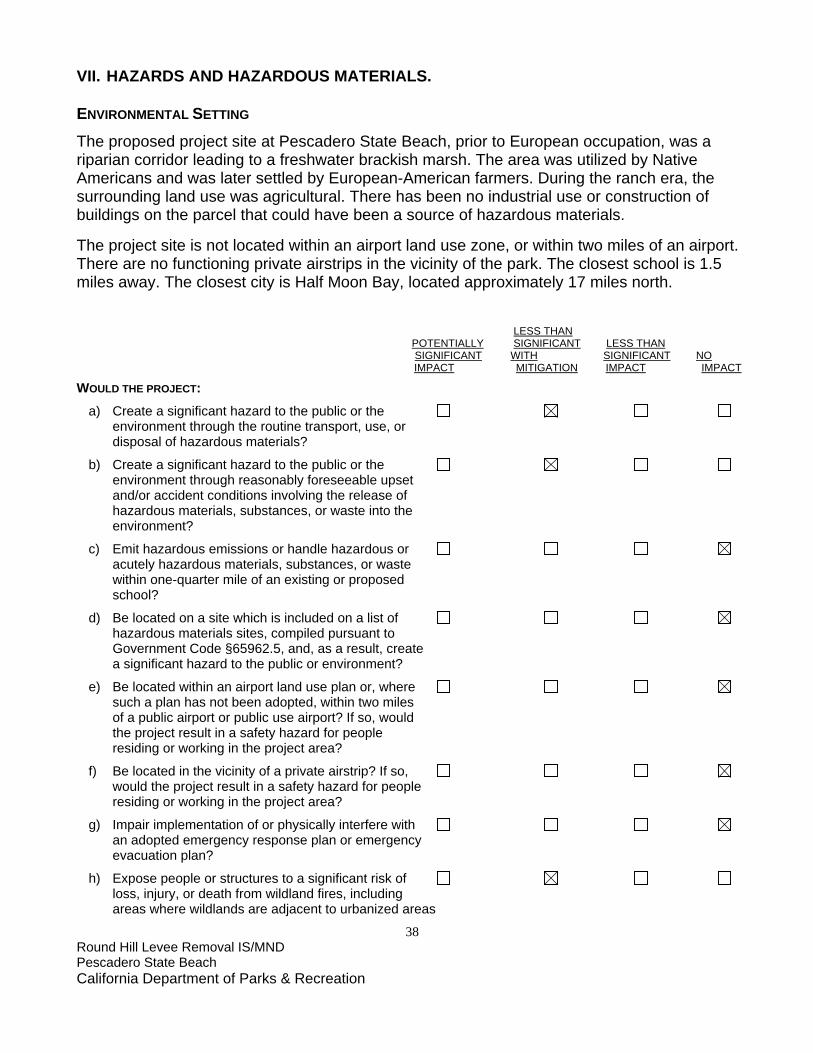
38 Round Hill Levee Removal IS/MND Pescadero State Beach California Department of Parks & Recreation
VII. HAZARDS AND HAZARDOUS MATERIALS. ENVIRONMENTAL SETTING
The proposed project site at Pescadero State Beach, prior to European occupation, was a riparian corridor leading to a freshwater brackish marsh. The area was utilized by Native Americans and was later settled by European-American farmers. During the ranch era, the surrounding land use was agricultural. There has been no industrial use or construction of buildings on the parcel that could have been a source of hazardous materials. The project site is not located within an airport land use zone, or within two miles of an airport. There are no functioning private airstrips in the vicinity of the park. The closest school is 1.5 miles away. The closest city is Half Moon Bay, located approximately 17 miles north.
LESS THAN POTENTIALLY SIGNIFICANT LESS THAN SIGNIFICANT WITH SIGNIFICANT NO IMPACT MITIGATION IMPACT IMPACT WOULD THE PROJECT: a) Create a significant hazard to the public or the environment through the routine transport, use, or disposal of hazardous materials?
b) Create a significant hazard to the public or the environment through reasonably foreseeable upset and/or accident conditions involving the release of hazardous materials, substances, or waste into the environment?
c) Emit hazardous emissions or handle hazardous or acutely hazardous materials, substances, or waste within one-quarter mile of an existing or proposed school?
d) Be located on a site which is included on a list of hazardous materials sites, compiled pursuant to Government Code §65962.5, and, as a result, create a significant hazard to the public or environment?
e) Be located within an airport land use plan or, where such a plan has not been adopted, within two miles of a public airport or public use airport? If so, would the project result in a safety hazard for people residing or working in the project area?
f) Be located in the vicinity of a private airstrip? If so, would the project result in a safety hazard for people residing or working in the project area?
g) Impair implementation of or physically interfere with an adopted emergency response plan or emergency evacuation plan?
h) Expose people or structures to a significant risk of loss, injury, or death from wildland fires, including areas where wildlands are adjacent to urbanized areas

39 Round Hill Levee Removal IS/MND Pescadero State Beach California Department of Parks & Recreation
or where residences are intermixed with wildlands?
DISCUSSION
a) Construction activities will require the use of certain potentially hazardous materials, such as fuels, oils, or other fluids associated with the operation and maintenance of vehicles and equipment. These materials generally are contained within vessels engineered for safe storage. Large quantities of these materials will not be stored at or transported to the construction site. Spills, upsets, or other construction-related accidents could result in a release of fuel or other hazardous substances into the environment. The following mitigation will reduce the potential for adverse impacts from these incidents to a less than significant level.
MITIGATION MEASURE HAZMAT-1 SPILL PREVENTION
• All equipment will be inspected by the contractor for leaks immediately prior to the start of construction, and regularly inspected thereafter until equipment is removed from park premises.
• The contractor(s) will prepare an emergency Spill Prevention and Response Plan prior to the start of construction and maintain a spill kit on-site throughout the life of the project. This plan will include a map that delineates construction staging areas, where refueling, lubrication, and maintenance of equipment may occur. Areas designated for refueling, lubrication, and maintenance of equipment shall be at least 100 feet from Pescadero Creek. In the event of any spill or release of any chemical in any physical form at the project site or within the boundaries of Pescadero State Beach during construction, the contractor will immediately notify the appropriate DPR staff (e.g., project manager, supervisor, or State Representative).
• Equipment will be cleaned and repaired (other than emergency repairs) outside the park boundaries. All contaminated water, sludge, spill residue, or other hazardous compounds will be disposed of outside park boundaries, at a lawfully permitted or authorized destination.
b) Mitigation Measure Hazmat-1 will reduce the potential for adverse impacts to a less than
significant level.
c) As noted in the Environmental Setting, there are no schools in the general vicinity of the project or within one-quarter mile of the proposed project site. There will be no impact from this project.
d) No part of Pescadero State Beach, including the project site, is included on a list of
hazardous materials sites compiled pursuant to Government Code §65962.5. No area within the project site is currently restricted or known to have hazardous materials present. There will be no impact from this project.
e,f) Pescadero State Beach is not located within an airport land use plan, within two miles of a
public airport, or in the vicinity of a functioning private air strip. There will be no impact from this project.

40 Round Hill Levee Removal IS/MND Pescadero State Beach California Department of Parks & Recreation
g) All construction activities associated with the proposed project will occur within the
boundaries of Pescadero State Beach and work will not restrict access to, cause delays to, or block any public road. There will be no impact from this project.
h) The project work location is in a vegetated area. While coastal fog keeps fire danger low
even during the dry season, fires could occur under certain conditions when dry offshore winds are present. Heavy equipment can get very hot with extended use; this equipment will sometimes be in close proximity to vegetation. Improperly outfitted exhaust systems or friction between metal parts and/or rocks could generate sparks, resulting in a fire. Implementation of Mitigation Measure HAZMAT-2 below will reduce the potential for adverse construction impacts from this project to a less than significant level.
MITIGATION MEASURE HAZMAT-2 CONSTRUCTION FIRE MANAGEMENT
• A fire safety plan will be developed by the contractor and approved by DPR prior to the start of construction.
• Spark arrestors or turbo-charging (which eliminates sparks in exhaust) and fire extinguishers will be required for all heavy equipment.
• Construction crews will be required to park vehicles away from flammable material, such as dry grass or brush. At the end of each workday, heavy equipment will be parked over mineral soil, asphalt, or concrete to reduce the chance of fire.
• Fire suppression equipment will also be available and located on park grounds.

41 Round Hill Levee Removal IS/MND Pescadero State Beach California Department of Parks & Recreation
VIII. HYDROLOGY AND WATER QUALITY. ENVIRONMENTAL SETTING
Pescadero State Beach contains Pescadero Marsh Natural Preserve, a coastal wetland complex that includes a lagoon at the confluence of Pescadero and Butano Creeks, fresh and brackish water marshes, and brackish water ponds. The Round Hill levee project is located in an upland area bordering Pescadero Creek, and is outside of the natural preserve boundaries. Watershed The Pescadero-Butano watershed is the largest coastal watershed between the Golden Gate and the San Lorenzo River. The watershed’s two principal streams, Pescadero Creek and Butano Creek, have their confluence in Pescadero Marsh. These two perennial streams drain 81 square miles of the Santa Cruz Mountains and the coastal valleys, hills, and terraces around the town of Pescadero (ESA 2004). The California Department of Water Resources (DWR) defines the area for groundwater purposes as the Pescadero Valley groundwater basin (DWR 2003). Flooding The project area is located entirely within the FEMA 100-year floodplain. An important goal of the project is to reconnect Pescadero Creek with its historical floodplain. Rather than using a levee to artificially constrain high flows to the creek channel, high water will be allowed to redistribute over the abandoned agricultural field. Flooding provides a critical ecosystem function by depositing nutrient-rich sediment and recharging groundwater systems (Keller 1977). The project area is located entirely within State Park property, and there are no structures near the project area that will be affected by a restored floodplain. There are no other property owners downstream to be affected by this project. Upstream landowners will also be unaffected or potentially marginally benefited by this project. Removing this portion of the levee will be sufficient to allow the channel to overflow about every 2 to 2.5 years in high water events. There will not be enough material removed from the creek bank to divert Pescadero Creek. Project construction will take place during summer when flooding concerns are absent. The project site is not within a tsunami hazard zone (CDPR 1978). Water Quality The Central Coast Regional Water Quality Control Board (CCRWQCB) regulates water quality in the region and provides water quality standards and management criteria as required by the Clean Water Act. These standards and criteria are presented in the 1994 Water Quality Control Plan (Basin Plan) for the Central Coast Basin (CCRWQCB, 1994). The Basin Plan identifies the beneficial uses and water quality objectives for the Central Coast region. The three surface water bodies adjacent to the project site are Pescadero

42 Round Hill Levee Removal IS/MND Pescadero State Beach California Department of Parks & Recreation
Creek, Butano Creek, and the Pacific Ocean. Beneficial uses for Pescadero Creek are listed in the following table: Beneficial Use Pescadero Creek Municipal and Domestic Supply X Agricultural Supply X Water Contact Recreation X Non-Contact Water Recreation X Wildlife Habitat X Cold Freshwater Habitat X Warm Freshwater Habitat X Migration of Aquatic Organisms X Spawning, Reproduction and/or Early Development for Fish
X
Rare, Threatened, and Endangered Species* X *Potential Species: Steelhead, Coho Salmon, California Red-Legged Frog, Western Pond Turtle, San Francisco Garter Snake, Tidewater Goby, California Brackishwater Snail LESS THAN POTENTIALLY SIGNIFICANT LESS THAN SIGNIFICANT WITH SIGNIFICANT NO IMPACT MITIGATION IMPACT IMPACT
WOULD THE PROJECT: a) Violate any water quality standards or waste discharge requirements?
b) Substantially deplete groundwater supplies or interfere substantially with groundwater recharge, such that there would be a net deficit in aquifer volume or a lowering of the local groundwater table level (e.g., the production rate of pre-existing nearby wells would drop to a level that would not support existing land uses or planned uses for which permits have been granted)?
c) Substantially alter the existing drainage pattern of the site or area, including through alteration of the course of a stream or river, in a manner which would result in substantial on- or off-site erosion or siltation?
d) Substantially alter the existing drainage pattern of the site or area, including through alteration of the course of a stream or river, or substantially increase the rate or amount of surface runoff in a manner which would result in on- or off-site flooding?
e) Create or contribute runoff water which would exceed the capacity of existing or planned stormwater drainage systems or provide substantial additional sources of polluted runoff?
f) Substantially degrade water quality?
g) Place housing within a 100-year flood hazard area,

43 Round Hill Levee Removal IS/MND Pescadero State Beach California Department of Parks & Recreation
as mapped on a federal Flood Hazard Boundary or Flood Insurance Rate Map, or other flood hazard delineation map?
h) Place structures that would impede or redirect flood flows within a 100-year flood hazard area?
i) Expose people or structures to a significant risk of loss, injury, or death from flooding, including flooding resulting from the failure of a levee or dam?
j) Result in inundation by seiche, tsunami, or mudflow?
DISCUSSION
a) The project site is bordered by vegetation, which will act to capture any dislodged sediment. Earthmoving will take place in summer months, when sediment is highly unlikely to move due to the absence of rain. Regardless, the BMPs described below will be implemented to prevent release of sediment to surface waters. Other impacts to water quality could result from releases of fuels or other fluids from vehicles and equipment during the construction process. These activities could result in a violation of water quality standards and waste discharge requirements. Mitigation Measure HYDRO-1 will control releases of pollutants in water runoff. A plan to prevent, contain, and clean up any spills (Spill Prevention and Response Plan) will be used to mitigate for any impacts to water quality. Implementation of Mitigation Measure GEO-1 will provide Best Management Practices (BMPs) to control erosion and runoff during the project construction and post-construction. Implementation of Mitigation Measure HAZMAT-1 will mitigate for impacts to water quality from possible pollutants (fuels and other vehicle fluids released from vehicles and heavy equipment during construction). These mitigation measures will reduce the potential for impacts to a less than significant level.
MITIGATION MEASURE HYDRO-1 WATER QUALITY
• The contractor will provide a Spill Prevention and Response plan as part of the construction contract.
b) The project will not involve any increase in water use, and it will not deplete any local
aquifer. No impact. c) High level flows only will be affected by this project. Any siltation impacts will be less than
significant. Post-construction BMPs to reduce sediment-laden runoff are specified in Mitigation Measure GEO-1.
d) An essential component of this project is to reconnect Pescadero Creek with its historic
floodplain. Occasional onsite flooding is an intended consequence of this project, and should not be mitigated for. Less than significant impact.
e) There are no existing or planned stormwater drainage systems in or downstream of the
project area. This project will not create or contribute runoff water that will exceed the

44 Round Hill Levee Removal IS/MND Pescadero State Beach California Department of Parks & Recreation
capacity of existing or planned stormwater drainage systems. No substantial additional sources of polluted runoff are expected from this project, provided soil erosion BMPs are followed, and a Spill Prevention and Response Plan is in place for vehicle fluid spills. Implementation of Mitigation Measure HYDRO-1 will reduce this impact to less than significant.
f) This project has the potential to substantially degrade water quality if BMPs to control soil
erosion and runoff or release of vehicle or equipment fluids are not in place during construction. If Mitigation Measure HYDRO-1 listed above is implemented, then no substantial degradation of water quality will occur.
g) This project does not involve housing or any developments. No impact. h) This project will remove a structure that has impeded and redirected flood flows. Allowing
Pescadero Creek to reconnect with its historic floodplain is an intended consequence that should not be mitigated for. The project site is entirely within the 100-year flood hazard area, so no flood maps will need to be redrawn.
i) This project should have no effect on local flooding concerns. There are no inhabited
structures at or downstream of the project site. It is possible that upstream flooding concerns may be marginally reduced as water spreads out over the floodplain. No impact.
j) No mudflows are expected to occur at the project site due to the low relief topography.
Although the project is located in an area that could be inundated by either a seiche or a tsunami, there are no structures to be damaged, and earth movement should be no more significant than other areas of the state beach. Therefore, there is no risk from this project.

45 Round Hill Levee Removal IS/MND Pescadero State Beach California Department of Parks & Recreation
IX. LAND USE AND PLANNING.
ENVIRONMENTAL SETTING
Pescadero State Beach is located on the central California coast, 17 miles south of Half Moon Bay in San Mateo County. This park unit contains sandy beaches and coastal dunes. The state beach also contains Pescadero Marsh Natural Preserve, a coastal wetland complex that includes a lagoon at the confluence of Pescadero and Butano Creeks, fresh and brackish water marshes, and brackish water ponds. The Round Hill levee project is located in an upland area bordering Pescadero Creek, and is outside of the natural preserve boundaries. Facilities at the State Beach include three paved parking lots with vault toilets. Two additional unpaved parking lots are located in the state beach: one at the boat launch area, and another at the ranger station. Two interpretive signs and displays are located near the beach side of the state beach. Public facilities are restricted to day use. DPR developed a General Plan for Pescadero State Beach in 1979 to facilitate long-range planning at the park and to establish guidelines for the long-term use, management, and development. The General Plan (p. 40) calls for the protection of wetland and riparian areas; protection of the marsh from anthropogenic sedimentation; and restoration and establishment of the natural ecosystems in the formerly cultivated lands immediately adjacent to the wetlands of the marsh. The San Mateo County General Plan has several resource goals and objectives that will be met through this project. These include the protection of sensitive habitats, and the conservation, enhancement, protection, maintenance and management of vegetative, water, fish and wildlife resources. Pescadero State Beach is designated Public Recreation in the County’s General Plan (GP). The GP describes land uses associated with the Public Recreation designation as: Recreation uses including but not limited to publicly owned park and recreation facilities such as playgrounds, parks, golf courses, and natural preserves. According to San Mateo County Planning Department personnel, Pescadero State Beach has a zoning designation of Planned Agricultural District (PAD). Per section 6350 of the County’s zoning regulations, the purpose of the Planned Agricultural District is to: 1) preserve and foster existing and potential agricultural operations in San Mateo County in order to keep the maximum amount of prime agricultural land and all other lands suitable for agriculture in agricultural production, and (2) minimize conflicts between agricultural and non-agricultural land uses. Pescadero State Beach is located entirely within the coastal zone and is subject to the provisions of the San Mateo County Local Coastal Program (LCP). The LCP calls for the protection of sensitive habitats, including riparian corridors and habitats that support rare, endangered, and unique species. The LCP designates Pescadero Marsh as a high priority resource management project. It specifies that DPR shall manage Pescadero Marsh in a manner to maximize its wildlife potential. Allowed uses within habitats of rare and endangered species include research, and fish and wildlife management to restore damaged habitats and
46 Round Hill Levee Removal IS/MND Pescadero State Beach California Department of Parks & Recreation
to protect and encourage the survival of rare and endangered species. Although the project area is outside the boundaries of Pescadero Marsh Natural Preserve, the project still meets conditions of allowed uses. The State beach is located within the appeal jurisdiction of the California Coastal Commission (CCC). LESS THAN POTENTIALLY SIGNIFICANT LESS THAN SIGNIFICANT WITH SIGNIFICANT NO IMPACT MITIGATION IMPACT IMPACT
WOULD THE PROJECT: a) Physically divide an established community?
b) Conflict with the applicable land use plan, policy, or regulation of any agency with jurisdiction over the project (including, but not limited to, a general plan, specific plan, local coastal program, or zoning ordinance) adopted for the purpose of avoiding or mitigating an environmental effect?
c) Conflict with any applicable habitat conservation plan or natural community conservation plan? DISCUSSION
a) The proposed project will not introduce a new land use nor substantially alter existing land uses at the site. The project will be located entirely within the boundaries of Pescadero State Beach and will not divide an established community because none exists within the boundaries of the state beach. No impact.
b) The project will not involve any new construction at the site. The project will not result in a
conversion of agricultural lands, or conflict with lands used for agricultural purposes. This habitat restoration project is consistent with all applicable state and local land use plans, policies, and regulations, including the applicable provisions of the San Mateo County General Plan, Local Coastal Program, Zoning Regulations, and the Pescadero State Beach General Plan. DPR is working closely with the California Department of Fish and Game and U.S. Fish and Wildlife Service to ensure this habitat restoration project meets its biological goals and legal criteria. In addition, with certification of this Mitigated Negative Declaration and implementation of the mitigation measures herein, the project will be in compliance with CEQA. No impact.
c) There is no habitat conservation plan or natural community conservation plan that includes
this California State Park unit. There is no impact.

47 Round Hill Levee Removal IS/MND Pescadero State Beach California Department of Parks & Recreation
X. MINERAL RESOURCES. ENVIRONMENTAL SETTING
No significant mineral resources have been identified within the boundaries of the project area at Pescadero State Beach. Mineral resource extraction is not permitted under the Resource Management Directives of the Department of Parks and Recreation. LESS THAN POTENTIALLY SIGNIFICANT LESS THAN SIGNIFICANT WITH SIGNIFICANT NO IMPACT MITIGATION IMPACT IMPACT
WOULD THE PROJECT: a) Result in the loss of availability of a known mineral resource that is or would be of value to the region and the residents of the state?
b) Result in the loss of availability of a locally important mineral resource recovery site delineated on a local general plan, specific plan, or other land use plan? DISCUSSION
a) The project will not result in the loss of availability of a known mineral resource because no known mineral resources exist within the project boundary. No impact.
b) The project will not result in the loss of availability of a locally important mineral resource
recovery site because none exist within the project boundary. No impact.

48 Round Hill Levee Removal IS/MND Pescadero State Beach California Department of Parks & Recreation
XI. NOISE. ENVIRONMENTAL SETTING
The project area at Pescadero State Beach is isolated and quiet. Visitor and staff usage here is very low. The existing noise environment is primarily influenced by natural sounds (wind, birds, etc.) and occasional noises from larger vehicles using Pescadero Road more than a half mile away. The nearest sensitive receptors are residences about a half mile away on Water Lane, some of which use farm equipment on their property. The closest school is about 1.5 miles away. The closest airport is at Half Moon Bay, about 20 miles north of Pescadero State Beach. LESS THAN POTENTIALLY SIGNIFICANT LESS THAN SIGNIFICANT WITH SIGNIFICANT NO IMPACT MITIGATION IMPACT IMPACT
WOULD THE PROJECT: a) Generate or expose people to noise levels in excess of standards established in a local general plan or noise ordinance, or in other applicable local, state, or federal standards?
b) Generate or expose people to excessive groundborne vibrations or groundborne noise levels?
c) Create a substantial permanent increase in ambient noise levels in the vicinity of the project (above levels without the project)?
d) Create a substantial temporary or periodic increase in ambient noise levels in the vicinity of the project, in excess of noise levels existing without the project?
e) Be located within an airport land use plan or, where such a plan has not been adopted, within two miles of a public airport or public use airport? If so, would the project expose people residing or working in the project area to excessive noise levels?
f) Be in the vicinity of a private airstrip? If so, would the project expose people residing or working in the project area to excessive noise levels? DISCUSSION
a) Heavy equipment, along with vehicle traffic, will operate during construction. Construction noise levels at and near the project area will fluctuate, depending on the type and quantity of construction equipment operating at any given time. Depending on the specific construction activities being performed, short-term increases in ambient noise levels could result in speech interference near the project site and annoyance to visitors. As a result, construction-generated noise will be considered to have a potentially significant short-term impact to any noise-sensitive receptors, such as park visitors. Implementation of the following mitigation measure will reduce those potential impacts to less than significant.

49 Round Hill Levee Removal IS/MND Pescadero State Beach California Department of Parks & Recreation
MITIGATION MEASURE NOISE-1
• Construction activities will generally be limited to daylight hours, between 8 a.m. and 5 p.m., Monday through Friday, unless permission is granted by the Construction Supervisor and the Park Superintendent for other hours.
• Internal combustion engines used for any purpose at the job site will be equipped with a muffler of a type recommended by the manufacturer. Equipment and trucks used for construction will utilize the best available noise control techniques (e.g., engine enclosures, acoustically attenuating shields or shrouds, intake silencers, ducts, etc.) whenever feasible and necessary.
Because of the remote location of the site and general absence of neighbors, conflicts with
the County noise ordinance are not anticipated. Construction is expected to take less than one month to complete. Once the construction is complete, no increase in noise is anticipated. Less than significant impact with implementation of Mitigation Measure NOISE-1.
b) Construction activity will not involve the use of explosives, pile driving, or other intensive
construction techniques that could generate significant ground vibration or noise. Minor vibration immediately adjacent to excavating equipment will only be generated on a short-term basis. Therefore, groundborne vibration or noise generated by the project will have a less than significant impact.
c) Once the proposed project is completed, all related construction noise will cease. Nothing
within the scope of the proposed project will result in a substantial permanent increase in ambient noise levels. Therefore, no significant impact to permanent ambient noise levels is anticipated.
d) See Discussion XI (a, c) above. Less than significant impact with implementation of
Mitigation Measure NOISE-1. e) As noted in the Environmental Setting above, the nearest airport is more than 20 miles
away. No impact. f) The proposed project site is not located in the vicinity of a known private airstrip. No impact.

50 Round Hill Levee Removal IS/MND Pescadero State Beach California Department of Parks & Recreation
XII. POPULATION AND HOUSING ENVIRONMENTAL SETTING
There is no housing within the boundaries of Pescadero State Beach. The state beach is both a local and regional recreational resource, used by the local population as well as tourists, but does not offer business or residential opportunities within its boundaries. LESS THAN POTENTIALLY SIGNIFICANT LESS THAN SIGNIFICANT WITH SIGNIFICANT NO IMPACT MITIGATION IMPACT IMPACT
WOULD THE PROJECT: a) Induce substantial population growth in an area, either directly (for example, by proposing new homes and businesses) or indirectly (for example, through extension of roads or other infrastructure)? b) Displace substantial numbers of existing housing, necessitating the construction of replacement housing elsewhere? c) Displace substantial numbers of people, necessitating the construction of replacement housing elsewhere?
DISCUSSION
a-c) The project does not have a housing or infrastructure component. All work will take place within the confines of the state beach boundaries. No new public or private projects are anticipated to be initiated as a result of this habitat restoration project. No impact.

51 Round Hill Levee Removal IS/MND Pescadero State Beach California Department of Parks & Recreation
XIII. PUBLIC SERVICES. ENVIRONMENTAL SETTING DPR provides law enforcement services within units of the State Park System. State Park Peace Officers with law enforcement authority patrol the park in vehicles and on foot; enforce the public resource code, and guard against misuse of park property and resources. San Mateo County Sheriff's Department and the California Highway Patrol provide backup law enforcement services at Pescadero State Beach. The California Department of Forestry and Fire Protection (CDF) provides fire protection services for the state beach. The CDF station is located on Pescadero Road off State Route 1, immediately adjacent to the state beach boundary and about a mile from the project site. There are no schools within a mile of the state beach. There are several other state parks located in the surrounding area, including Pomponio State Beach immediately to the north on Highway One, and San Gregorio State Beach less than five miles to the north on Highway One. Bean Hollow State Beach is about three miles to the south. All three of these state beaches are open for day use only. Butano State Park is located inland, approximate seven miles to the southeast, and allows overnight camping. San Mateo County Memorial Park is seven miles to the east and also offers day use and camping.
LESS THAN POTENTIALLY SIGNIFICANT LESS THAN SIGNIFICANT WITH SIGNIFICANT NO IMPACT MITIGATION IMPACT IMPACT
WOULD THE PROJECT: a) Result in significant environmental impacts from construction associated with the provision of new or physically altered governmental facilities, or the need for new or physically altered governmental facilities, to maintain acceptable service ratios, response times, or other performance objectives for any of the public services:
Fire protection?
Police protection?
Schools?
Parks?
Other public facilities? DISCUSSION
a) The proposed project will not result in an increase of visitation to the park, and the level of required fire or police services will not change as a result of the project. Use of construction equipment around potentially flammable vegetation presents a potential for

52 Round Hill Levee Removal IS/MND Pescadero State Beach California Department of Parks & Recreation
temporarily increased fire risk. Implementation of Mitigation Measure HAZMAT-2, combined with support from State Park Rangers and Lifeguards, will reduce the possibility for an impact to fire protection services.
Project construction will not affect police protection or require new levels of protection. No impact. The project does not result in any change of use or introduce any new use at the park that will affect existing schools or require additional schools or school personnel. No impact. The project will only affect the little-used Round Hill area, which is commonly accessed from the levee. A temporary closure will be in effect during construction. After construction the area will be reopened to visitor use. During seasonal flooding/high water, the creek bank may be inaccessible to visitors.
The proposed project will have no impact on other public services.

53 Round Hill Levee Removal IS/MND Pescadero State Beach California Department of Parks & Recreation
XIV. RECREATION. ENVIRONMENTAL SETTING
Pescadero State Beach is located on the central California coast, 17 miles south of Half Moon Bay in San Mateo County. This park unit contains sandy beaches and coastal dunes. The state beach also contains Pescadero Marsh Natural Preserve, a coastal wetland complex that includes a lagoon at the confluence of Pescadero and Butano Creeks, fresh and brackish water marshes, and brackish water ponds. The Round Hill levee project is located in an upland area bordering Pescadero Creek, and is outside of the natural preserve boundaries. The bulk of visitors spend their time at the beach. Those who enter the marsh tend to congregate along its western edge, which has maintained trails. The marsh is a popular destination for short hikes and interpretive walks, and environmental education groups lead school field trips here. Bird watching, fishing, and kayaking are other popular activities. Facilities at the state beach include three paved parking lots with vault toilets. Two additional unpaved parking lots are located in the state beach: one at the boat launch area, and another at the ranger station. Two interpretive signs and displays are located near the beach side of the state beach. Very few visitors go through the project site. There are several other recreation resources within ten miles of Pescadero State Beach. These include Pomponio, San Gregorio, and Bean Hollow State Beaches; Butano State Park; and San Mateo County Memorial Park. LESS THAN POTENTIALLY SIGNIFICANT LESS THAN SIGNIFICANT WITH SIGNIFICANT NO IMPACT MITIGATION IMPACT IMPACT
WOULD THE PROJECT: a) Increase the use of existing neighborhood and regional parks or other recreational facilities, such that substantial physical deterioration of the facility would occur or be accelerated?
b) Include recreational facilities or require the construction or expansion of recreational facilities that might have an adverse physical effect on the environment? DISCUSSION
a, b) The proposed project will not affect recreational use at Pescadero State Beach. The site itself is not a destination, and visitors could be directed around any temporary closures. The project will not change visitor use patterns in a manner that will result in increased levels of use of recreational facilities at Pescadero State Beach or any other park or recreational facility in the area. The project will not displace any existing recreational facilities, or result in the need for the construction or expansion of existing recreational facilities. No impact.

54 Round Hill Levee Removal IS/MND Pescadero State Beach California Department of Parks & Recreation

55 Round Hill Levee Removal IS/MND Pescadero State Beach California Department of Parks & Recreation
XV. TRANSPORTATION/TRAFFIC. ENVIRONMENTAL SETTING
ROADS AND HIGHWAYSRegional access to the project site is via State Route 1, a two-lane highway on a northwest-southeast alignment. State Route 1 at the project site is designated as a State Scenic Highway, from the Santa Cruz County line south of the state beach to the southern city limit of Half Moon Bay, north of the park. From Highway One, vehicles will take Pescadero Creek Road to Water Lane. Expected construction traffic will be less than 4-5 vehicles a day, making 1-2 trips. Construction and staging activities for the proposed project will take place entirely within the park boundaries. No lane or road closures are anticipated. The proposed project will not change the Level of Service on State Route 1. In addition, no parking will change as a result of the project. PUBLIC TRANSIT Public transit service within the County of San Mateo is provided by the San Mateo County Transit District (SamTrans). Route 15 provides limited service from Half Moon Bay to the city of Pescadero, within walking distance of the state beach. This bus line runs weekdays only, with two morning and two evening bus runs providing service in each direction. In 2001 the County of San Mateo adopted Countywide Transportation Plan 2010, which includes policies for improving transportation within the County. It seeks to increase capacity of and demand for transit systems, and a decrease in traffic congestion.
BICYCLE AND PEDESTRIAN ACCESSBicyclists may use State Route 1. Because of the remote nature of the state beach, bicycle and pedestrian access is minimal for all but local users. LESS THAN POTENTIALLY SIGNIFICANT LESS THAN SIGNIFICANT WITH SIGNIFICANT NO IMPACT MITIGATION IMPACT IMPACT
WOULD THE PROJECT: a) Cause a substantial increase in traffic, in relation to existing traffic and the capacity of the street system (i.e., a substantial increase in either the number of vehicle trips, the volume to capacity ratio on roads, or congestion at intersections)?
b) Exceed, individually or cumulatively, the level of service standards established by the county congestion management agency for designated roads or highways?
c) Cause a change in air traffic patterns, including either an increase in traffic levels or a change in location, that results in substantial safety risks?

56 Round Hill Levee Removal IS/MND Pescadero State Beach California Department of Parks & Recreation
d) Contain a design feature (e.g., sharp curves or a dangerous intersection) or incompatible uses (e.g., farm equipment) that would substantially increase hazards?
e) Result in inadequate emergency access?
f) Result in inadequate parking capacity?
g) Conflict with adopted policies, plans, or programs supporting alternative transportation (e.g., bus turnouts, bicycle racks)?
DISCUSSION
a, b)All construction-related activities associated with the project will occur within Pescadero State Beach. Construction trips will normally occur Monday through Friday, while peak hour traffic volumes have occurred on weekends. Construction vehicles will access the project site from Pescadero Creek Road and Water Lane. The addition of 4-5 vehicles (e.g., crew pickups and equipment haulers) making 1-2 trips daily will not constitute a substantial increase in traffic volume for the highway or surface roads, result in significant additional congestion, or exceed service standards. No impact.
c) The project site is not located within an airport land use plan, within two miles of a public
airport, or in the vicinity of a private air strip, and does not serve as a normal reporting point for air traffic in the area. Nothing in the proposed project will in any way affect or change existing air traffic patterns in the area. Therefore, no impact will occur as a result of this project.
d) No portion of the project design or implementation contains any element that will increase
hazards to traffic or other forms of transportation. No impact. e) All construction activities associated with the project will occur within the boundaries of
Pescadero State Beach. No emergency access will be affected. No impact. f) This project is not expected to increase the number of visitors to the project area. It will not
make any changes to existing parking areas. No impact. g) This project will not result in any changes regarding alternative transportation. The project
does not conflict with San Mateo County's Countywide Transportation Plan 2010. No impact.

57 Round Hill Levee Removal IS/MND Pescadero State Beach California Department of Parks & Recreation
XVI. UTILITIES AND SERVICE SYSTEMS. ENVIRONMENTAL SETTING A DPR well provides water service to staff facilities at Pescadero State Beach, and drinking water is trucked through a commercial service. Sewage treatment for staff is provided via leach fields. There is no public access to water or restrooms at the ranger station. The three beach parking lots along Highway One have vault toilets, which are serviced by DPR staff. DPR staff also manages the collection and disposal of the park’s refuse. Pacific Gas and Electric (PG&E) supplies electricity and SBC supplies phone service. The project does not require access to or any change in existing utilities at the state beach. LESS THAN POTENTIALLY SIGNIFICANT LESS THAN SIGNIFICANT WITH SIGNIFICANT NO IMPACT MITIGATION IMPACT IMPACT
WOULD THE PROJECT: a) Exceed wastewater treatment restrictions or standards of the applicable Regional Water Quality Control Board?
b) Require or result in the construction of new water or wastewater treatment facilities or expansion of existing facilities?
Would the construction of these facilities cause significant environmental effects?
c) Require or result in the construction of new storm water drainage facilities or expansion of existing facilities?
Would the construction of these facilities cause significant environmental effects?
d) Have sufficient water supplies available to serve the project from existing entitlements and resources or are new or expanded entitlements needed?
e) Result in a determination, by the wastewater treatment provider that serves or may serve the project, that it has adequate capacity to service the project’s anticipated demand, in addition to the provider’s existing commitments?
f) Be served by a landfill with sufficient permitted capacity to accommodate the project’s solid waste disposal needs?
g) Comply with federal, state, and local statutes and regulations as they relate to solid waste? DISCUSSION

58 Round Hill Levee Removal IS/MND Pescadero State Beach California Department of Parks & Recreation
a) Pescadero State Beach is within the jurisdiction of the Central Coast Regional Water Quality Control Board (CCRWQCB). The project will be in compliance with all applicable water quality standards and waste discharge requirements. (See Mitigation Measure HAZMAT-1 regarding potential impacts from accidents, spills, or upset.) No impact.
b, c, d) The proposed project does not include developing or expanding facilities. There is no
water development component related to this project. No impact. e, f) Wastewater treatment services are provided by DPR personnel with DPR-owned facilities.
The proposed work will not increase the park’s wastewater or solid waste disposal needs. No impact.
g) This project will comply with all federal, state, and applicable local statutes and regulations
as they relate to solid waste. No impact.

59 Round Hill Levee Removal IS/MND Pescadero State Beach California Department of Parks & Recreation
CHAPTER 4 MANDATORY FINDINGS OF SIGNIFICANCE
LESS THAN POTENTIALLY SIGNIFICANT LESS THAN SIGNIFICANT WITH SIGNIFICANT NO IMPACT MITIGATION IMPACT IMPACT
WOULD THE PROJECT: a) Does the project have the potential to degrade the quality of the environment, substantially reduce the habitat of a fish or wildlife species, cause a fish or wildlife population to drop below self-sustaining levels, threaten to eliminate a plant or animal community, reduce the number or restrict the range of a rare or endangered plant or animal? b) Have the potential to eliminate important examples of the major periods of California history or prehistory?
c) Have impacts that are individually limited, but cumulatively considerable? (“Cumulatively considerable” means the incremental effects of a project are considerable when viewed in connection with the effects of past projects, other current projects, and probably future projects?)
d) Have environmental effects that will cause substantial adverse effects on humans, either directly or indirectly? DISCUSSION
a) This project is being undertaken as a recovery effort for sensitive species in the state beach. Implementation of Mitigation Measures Bio-1 and BIO-2, GEO-1, HAZMAT-1, AND HYDRO-1, which include provisions for the protection of sensitive species and water quality, will lower the risk to a less than significant level.
b) No examples of California history or prehistory will be eliminated by this project. No impact. c) The cumulative effects of habitat restoration projects in Pescadero State Beach should
improve habitat values. No negative impact. d) This project is a habitat restoration project that should not directly or indirectly affect
humans. No impact.

60 Round Hill Levee Removal IS/MND Pescadero State Beach California Department of Parks & Recreation
CHAPTER 5 SUMMARY OF MITIGATION MEASURES
The following mitigation measures will be implemented by DPR as part of the Round Hill Levee Removal Project. AESTHETICS • NO MITIGATION MEASURES NEEDED AGRICULTURAL RESOURCES • NO MITIGATION MEASURES NEEDED AIR QUALITY
MITIGATION MEASURE AIR-1 BASIC CONTROL MEASURES • Project manager will assess active construction areas daily for excessively dusty
conditions. If particulate matter is visibly blowing more than 1,000 feet from the project site, a water truck will be brought in to suppress dust.
BIOLOGICAL RESOURCES
MITIGATION MEASURE BIO-1 CNPS LISTED PLANT SPECIES • Surveys will be conducted during the appropriate blooming months (or when species
can be unmistakably identified) for all CNPS listed plant species that could potentially occur within the project area.
• All occurrences of CNPS listed species found within the project area will be mapped on project maps and flagged on the ground.
• In the event of significant unavoidable impacts to CNPS listed species as a result of project implementation, DPR will mitigate losses of habitat or individuals at a ratio of 3:1 through habitat enhancement for these species within Pescadero State Beach (or as agreed upon in conjunction with the California Department of Fish and Game).
MITIGATION MEASURE BIO-2 SAN FRANCISCO GARTER SNAKE, CALIFORNIA RED-LEGGED FROG, WESTERN POND TURTLE, AND SALTMARSH COMMON YELLOWTHROAT • For four to six weeks before construction begins, the area within the construction
footprint will be fenced with snake-exclusion fencing. One-way funnels will allow snakes and frogs to leave the project area. San Francisco garter snakes emerge from hibernation in March. The project area does not currently have ponds; therefore active snakes are likely to leave the fenced project area to forage. Trapping will further ensure that snakes have been excluded from the project site. Exclusion fencing will also prevent western pond turtles from entering the project area to nest or burrow.
• Using USFWS-approved biologists and methods, San Francisco garter snake monitoring, including live trapping, will occur within the fenced area before earth moving takes place. Trapped snakes will be measured, marked, and released immediately

61 Round Hill Levee Removal IS/MND Pescadero State Beach California Department of Parks & Recreation
outside the project area. This will allow DPR to monitor snake use in the area and to collect data on population structure.
• At least seven days prior to the onset of activities, the names and credentials will be submitted to the USFWS (Service) of biologists who will act as Service-approved biologist and biological monitor, who will conduct activities specified in the following measures.
• At least seven days prior to the start of work, a preconstruction survey for San Francisco garter snakes, California red-legged frogs, Western pond turtles, and saltmarsh common yellowthroats will be conducted in the construction area. If any of these species is found, the biologist will contact the Service and request guidance on any additional conservation measures or authorizations that may be needed. Measures may include delaying work temporarily.
• If required by USFWS or CDFG, vegetation will be removed and burrows will be excavated within the construction footprint. USFWS-approved biological monitor(s) will be on site during all construction activities.
• A training session will be conducted for all personnel involved in the construction of the project. This training will take place prior to the initiation of the project and will include a description of the San Francisco garter snake, California red-legged frog, Western pond turtle, and saltmarsh common yellowthroat. Also discussed will be their habitats, the conservation measures that are being implemented for these species, and the physical boundaries within which the project must be accomplished. The training will include instruction in the appropriate protocol to follow in the event that a San Francisco garter snake, California red-legged frog, Western pond turtle, or saltmarsh common yellowthroat is found on site. Brochures, books, and briefings may be used in the training session and qualified personnel will be on hand to answer any questions.
• A Service-approved biologist will be present at the work site until instruction of workers has taken place and any sensitive habitat has been disturbed. After these activities have occurred, DPR will designate one or more persons to serve as biological monitors for on-site compliance with all conservation measures. The Service-approved biologist will ensure that this individual receives training in the identification of San Francisco garter snakes, California red-legged frogs, Western pond turtles, and saltmarsh common yellowthroats. In the event that any of these species are encountered in the project area during project construction by anyone, the State Representative will put work on hold at that specific location and contractors will be redirected to other tasks. If work is stopped, the Service shall be notified within one workday by the Service-approved biologist or the on-site biological monitor.
• The biological monitor will inspect the construction site each morning to ensure compliance by the contractor and to ensure that San Francisco garter snakes, California red-legged frogs, Western pond turtles, and saltmarsh common yellowthroats are not in the project area.
• Rocks, logs, or other habitat features that are moved during construction will be done so with the monitor present, and will be replaced in adjacent suitable habitat, and/or stockpiled for use in habitat restoration portions of the project.
• The number of access routes, the size of the staging area, and the total area of activity will be limited to the minimum necessary to achieve the project goal. Routes and

62 Round Hill Levee Removal IS/MND Pescadero State Beach California Department of Parks & Recreation
boundaries will be clearly demarcated and approved by the biological monitor, and these areas shall be outside sensitive areas to the maximum extent feasible. The contractor will keep all equipment within the designated staging areas and work areas. The contractor will obtain approval from the on-site biological monitor to go outside designated areas.
• The use of vehicles and heavy equipment will be restricted to the access road and fenced areas within the project site where snakes have been excluded and burrows have been excavated.
CULTURAL RESOURCES
MITIGATION MEASURE CULT-1 • A qualified archaeologist will be present during the excavation phase of the project to
monitor earth removal activities. In the unlikely event that significant archaeological resources are encountered during project development, all excavation work at the location of the find will temporarily cease so the project archaeologist can evaluate the find and provide appropriate management recommendations.
GEOLOGY AND SOILS
MITIGATION MEASURE GEO-1 EROSION CONTROL • Best management practices (BMPs) will be used in all areas to control soil and surface
water runoff during earthmoving activities. Grading and excavation activities should not be planned during the rainy season (October 31 to May 1), but if storms are anticipated during construction or if construction must occur during winter months, “winterizing” will occur, including the covering (tarping) of any stockpiled soils and the use of temporary erosion control methods to protect disturbed soil. Temporary erosion control measures (BMPs) must be used during all soil disturbing activities and until all disturbed soil has been stabilized (recompacted, revegetated, etc.) These BMPs will include, but not be limited to, the use of silt fences, straw bales, or straw or rice coir rolls, to prevent soil loss and siltation into nearby water bodies.
• Permanent BMPs for erosion control will consist of properly compacting disturbed areas and revegetation of appropriate disturbed soil areas with native species using plant material collected locally, where possible. Otherwise, if local seed is not available, a weed-free native mixture shall be used. Final design plans will include BMP measures to be incorporated into the project.
HAZARDS AND HAZARDOUS MATERIALS

63 Round Hill Levee Removal IS/MND Pescadero State Beach California Department of Parks & Recreation
MITIGATION MEASURE HAZMAT-1 SPILL PREVENTION • All equipment will be inspected by the contractor for leaks immediately prior to the start
of construction, and regularly inspected thereafter until equipment is removed from park premises.
• The contractor(s) will prepare an emergency Spill Prevention and Response Plan prior to the start of construction and maintain a spill kit on-site throughout the life of the project. This plan will include a map that delineates construction staging areas, where refueling, lubrication, and maintenance of equipment may occur. Areas designated for refueling, lubrication, and maintenance of equipment shall be at least 100 feet from Pescadero Creek. In the event of any spill or release of any chemical in any physical form at the project site or within the boundaries of Pescadero State Beach during construction, the contractor will immediately notify the appropriate DPR staff (e.g., project manager, supervisor, or State Representative).
• Equipment will be cleaned and repaired (other than emergency repairs) outside the park boundaries. All contaminated water, sludge, spill residue, or other hazardous compounds will be disposed of outside park boundaries, at a lawfully permitted or authorized destination.
MITIGATION MEASURE HAZMAT-2 CONSTRUCTION FIRE MANAGEMENT
• A fire safety plan will be developed by the contractor and approved by DPR prior to the start of construction.
• Spark arrestors or turbo-charging (which eliminates sparks in exhaust) and fire extinguishers will be required for all heavy equipment.
• Construction crews will be required to park vehicles away from flammable material, such as dry grass or brush. At the end of each workday, heavy equipment will be parked over mineral soil, asphalt, or concrete to reduce the chance of fire.
• Fire suppression equipment will also be available and located on park grounds. HYDROLOGY AND WATER QUALITY
MITIGATION MEASURE HYDRO-1 WATER QUALITY • The contractor will provide a Spill Prevention and Response plan as part of the
construction contract. LAND USE AND PLANNING • NO MITIGATION MEASURES NEEDED MINERAL RESOURCES • NO MITIGATION MEASURES NEEDED NOISE
MITIGATION MEASURE NOISE-1 • Construction activities will generally be limited to daylight hours, between 8 a.m. and 5

64 Round Hill Levee Removal IS/MND Pescadero State Beach California Department of Parks & Recreation
p.m., Monday through Friday, unless permission is granted by the Construction Supervisor and the Park Superintendent for other hours.
• Internal combustion engines used for any purpose at the job site will be equipped with a muffler of a type recommended by the manufacturer. Equipment and trucks used for construction will utilize the best available noise control techniques (e.g., engine enclosures, acoustically attenuating shields or shrouds, intake silencers, ducts, etc.) whenever feasible and necessary.
POPULATION AND HOUSING • NO MITIGATION MEASURES NEEDED PUBLIC SERVICES • NO MITIGATION MEASURES NEEDED RECREATION • NO MITIGATION MEASURES NEEDED TRANSPORTATION/TRAFFIC • NO MITIGATION MEASURES NEEDED UTILITIES AND SERVICE SYSTEMS • NO MITIGATION MEASURES NEEDED

65 Round Hill Levee Removal IS/MND Pescadero State Beach California Department of Parks & Recreation
CHAPTER 6 REFERENCES
Project Description Barbour, Michael, Bruce Pavlik, Frank Drysdale, and Susan Lindstrom. 1993. California’s Changing Landscapes: Diversity and Conservation of California Vegetation. California Native Plant Society: Sacramento, CA. Keller, E. A. 1977. “The Fluvial System: Selected Observations.” In Riparian Forests in California: Their Ecology and Conservation. Anne Sands, Editor. Institute of Ecology, Publication No. 15, California Department of Fish and Game: Davis, CA. Schoenherr, Allan A. 1995. A Natural History of California. University of California Press: Berkeley, CA. USDA Forest Service. 1989. Proceedings of the California Riparian Systems Conference. Pacific Southwest Forest and Range Experiment Station. General Technical Report PSW-110. PSFRES: Berkeley, CA. Aesthetics San Mateo County. 1998. Local Coastal Program, Environmental Services Agency, Planning and Building Division, San Mateo County, California. Internet address: www.co.sanmateo.ca.us/vgn/images/portal/cit_609/10073428lcp_1098.pdf Agricultural Resources California Department of Parks and Recreation. 1979. San Mateo Coast Area General Plan. San Mateo County. 1986. General Plan Policies. Department of Environmental Management, Planning and Building Division, San Mateo County, California. Internet address: www.co.sanmateo.ca.us/vgn/images/portal/cit_609/10073472gp_polis.pdf San Mateo County. 1999. Zoning Regulations. Department of Environmental Management, Planning and Building Division, San Mateo County, California. Internet address: www.co.sanmateo.ca.us/vgn/images/portal/cit_609/9441580Zregs-wp.pdf Air QualityBay Area Air Quality Management District, 1999. BAAQMD CEQA Guidelines – Assessing the Air Quality Impacts of Projects and Plans, San Francisco, California. Internet address: www.baaqmd.gov/publications/guides/pln/ceqa/ceqaguid.pdf Bay Area Air Quality Management District (BAAQMD), 2003.

66 Round Hill Levee Removal IS/MND Pescadero State Beach California Department of Parks & Recreation
Internet address: www.baaqmd.gov California Air Resources Board (CARB), 2003. Area Designation Maps/State and National (2002 Designations). Internet address: www.arb.ca.gov/desig/adm/adm.htm California Air Resources Board, Planning and Technical Support Division. 2003. The 2003 Almanac of Emissions and Air Quality. Internet address: www.arb.ca.gov/aqd/almanac/almanac03/pdf/almanac2003all.pdf Healthy Community Collaborative of San Mateo County. 2001. 2001 Community Assessment – Health and Quality of Life in San Mateo County. Internet address: www.plsinfo.org/healthysmc/pdf/CommNeedsAssess2001final.pdf Biological Resources California Department of Fish and Game (DFG). 1998. California Salmonid Stream Habitat Restoration Manual, Third Edition. California Department of Fish and Game, Sacramento, CA.
California Department of Fish and Game (DFG). 2001. The Status of Rare, Threatened, and Endangered Animals and Plants of California. Annual Report for 2000. California Department of Fish and Game, Sacramento, CA. California Department of Fish and Game (DFG). 2004. California Native Diversity Data Base (CNDDB). California Department of Parks and Recreation. 1978. Pescadero State Beach Inventory of Features. California Native Plant Society (CNPS). 2004. Inventory of Rare and Endangered Plants (online edition, v6-04b). Rare Plant Scientific Advisory Committee. California Native Plant Society. Sacramento, CA. Accessed on May 7, 2004. Internet address: http://www.cnps.org/inventory. Corelli, T. and Chandik, Z. 1995. The Rare and Endangered Plants of San Mateo and Santa Clara County. Monocot Press: Half Moon Bay, CA. Crump, D. E. Jr. 2001. “Western Pond Turtle (Clemmys marmorate pallida): Nesting Behavior and Habitat Use.” Master’s Thesis, San Jose State University. Davis, C. J. 1998. “Western Pond Turtle (Clemmys marmorate pallida): Winter Habitat Use and Behavior.” Master’s Thesis, San Jose State University. Department of the Interior. 1994. “Endangered and Threatened Wildlife and Plants: Determination of Endangered Status for the Tidewater Goby.” Federal Register, Vol. 59, No.

67 Round Hill Levee Removal IS/MND Pescadero State Beach California Department of Parks & Recreation
24, Feb. 2, 1994, pp-5494-5500. Foster, M.L. 1977. Status of Salt Marsh Yellowthroat (Geothlypis trichas sinuosa) in the San Francisco Bay Area, California, 1975-76. California Department of Fish and Game. Internet address: http://www.dfg.ca.gov/hcpb/info/bm_research/bm_pdfrpts/77_04.pdf Gaines, David. A. 1977. “The Valley Riparian Forests of California: Their Importance to Bird Populations.” In Riparian Forests in California: Their Ecology and Conservation. Anne Sands, Editor. Institute of Ecology, Publication No. 15, California Department of Fish and Game: Davis, CA. Hickman, J.C. Ed. 1993. The Jepson Manual: Higher Plants of California. University of California Press. Berkeley, CA. Holland, D.C. 1994. “The Western Pond Turtle: Habitat and History.” Final Report prepared for the U.S. Department of Energy, Bonneville Power Administration: Portland, OR. Holland, V. L. and David J. Keil. 1996. California Vegetation. Kendall/Hunt Publishing Co: Dubuque, IA. Jennings, M. R. 1992. “Final Report of Preliminary Studies on Habitat Requirements of the San Francisco Garter Snake (Thamnophis sirtalis tetrataenia) at Pescadero Marsh and Theodore J. Hoover Natural Preserves.” California Academy of Sciences: San Francisco, CA. Keel, P., McGinnis, S. M., and L. Smith. 1991. “Habitat Requirements and Population Estimate for the San Francisco Garter Snake (Thamnophis sirtalis tetrataenia) at Ano Nuevo State Reserve, San Mateo County, California.” A Study Conducted for the California Department of Parks and Recreation: Sacramento, CA. Kellogg, M. G. 1980. “Status of the California Brackishwater Snail, Tryonia imitator, in Central California.” Inland Fisheries Endangered Species Program, Special Publication 80-3. California Department of Fish and Game: Sacramento, CA. Knight, Allen W. and Richard L. Bottorff. 1984. “The Importance of Riparian Vegetation to Stream Ecosystems.” In California Riparian Systems: Ecology, Conservation, and Productive Management. Richard E. Warner and Kathleen M. Hendrix, Editors. University of California Press: Berkeley, CA. Lovich, J. Unknown date. Western Pond Turtle Clemmys marmorata. On Bureau of Land Management website. Internet address: http://www.ca.blm.gov/pdfs/cdd_pdfs/clemmys1.PDF Mayer, Kenneth E. and William F. Laudenslayer, Jr., Editors. 1988. A Guide to Wildlife Habitats of California. California Department of Forestry and Fire Protection: Sacramento, CA. Menges, T. 1998. Common Yellowthroat (Geothlypis trichas). In The Riparian Bird

68 Round Hill Levee Removal IS/MND Pescadero State Beach California Department of Parks & Recreation
Conservation Plan: a strategy for reversing the decline of riparian-associated birds in California. California Partners in Flight. http://www.prbo.org/calpif/htmldocs/riparian_v-2.html. McGinnis, S. M., Keel, P., and E. Burko. 1987. “The Use of Upland Habitats by Snake Species at Ano Nuevo State Reserve.” A Report Prepared for the California Department of Parks and Recreation: Sacramento, CA. McGinnis, S. M. 1984. “The Current Distribution and Habitat Requirements of the San Francisco Garter Snake (Thamnophis sirtalis tetrataenia) in Coastal San Mateo County.” Final Report of Work Conducted Under Interagency Agreement C-673, prepared for the California Department of Fish and Game. Munz, P. A. 1973. A California Flora and Supplement. University of California Press: Berkeley, CA. NatureServe. 2004. NatureServe Explorer: An online encyclopedia of life [web application]. Version 4.0. NatureServe, Arlington, Virginia. Available http://www.natureserve.org/explorer. (Accessed: September 30, 2004 ). Reese, D. A. and Welsh, H. H. 1997. Use of Terrestrial Habitat by Western Pond Turtles, Clemmys marmorata, Implications for Management. In Proceedings: Conservation, Restoration and Management of Tortoises and Turtles. An International Conference. Pp. 352-357. Held 1997 by the New York Turtle and Tortoise Society. Internet address: http://www.fs.fed.us/psw/rsl/projects/wild/reese/reese3.pdf Reis, D. K. 1999. “Habitat Characteristics of California Red-Legged Frogs (Rana aurora draytonii): Ecological Differences between Eggs, Tadpoles, and Adults in a Coastal Brackish and Freshwater System.” Master’s Thesis, San Jose State University. San Mateo County. 1998. Local Coastal Program, Environmental Services Agency, Planning and Building Division, San Mateo County, California. Internet address: www.co.sanmateo.ca.us/vgn/images/portal/cit_609/10073428lcp_1098.pdf Sawyer, John and T. Keeler-Wolf. 1995. A Manual of California Vegetation. California Native Plant Society, Sacramento, CA. Taylor, D. W. 1978. “The California Brackish-Water Snail, Tryonio imitator. Report Prepared for U.S. Army Corps of Engineers, Contract DACW09-78-M-1169. U.S. Fish and Wildlife Service. 2002. Recovery Plan for the California Red-legged Frog (Rana aurora draytonii). Portland, Oregon. U.S. Fish and Wildlife Service. 1985. Recovery Plan for the San Francisco Garter Snake (Thamnophis sirtalis tetrataenia). Portland, Oregon. Wharton, J. C. 1989. “Ecological and Life History Aspects of the San Francisco Garter Snake

69 Round Hill Levee Removal IS/MND Pescadero State Beach California Department of Parks & Recreation
(Thamnophis sirtalis tetrataenia).” Master’s Thesis, San Francisco State University. Cultural Resources Basgall, Mark E. 1987. “Resource intensification among hunter-gatherers: Acorn economies in prehistoric California.” Research in Economic Anthropology 9:21-52. Bean, Lowell J., and Thomas F. King. 1974. “Antap: California Indian political and economic organization.” Ballena Press Anthropological Papers 2. Menlo Park, CA. Bean, Lowell J., and Harry W. Lawton. 1973. “Some explanations for the rise of cultural complexity in Native California with comments on proto-agriculture and agriculture.” In patterns of Indian burning in California: ecology and ethno-history, by Henry Lewis. Ballena Press Anthropological Papers 1 Pp. v-xlvii. Ramona, CA. Blackburn, Thomas C., and Kat Anderson, editors. 1993. Before the wilderness: Environmental management by Native Californians. Ballena Press Anthropological Papers No. 40. Thomas C. Blackburn, series editor. Menlo Park, CA: Ballena Press. Bolton, Herbert E. 1926. Historical memoirs of New California by Fray Francisco Palou, O.F.M. Vols. 1-4. University of California Press, Berkeley. Brown, Alan K. 1994. “The European contact of 1772 and some later documentation.” In The Ohlone past and present: Native Americans of the San Francisco Bay region. Lowell John Bean editor. Ballena Press Anthropological Papers, No. 42. Menlo Park, CA. Chagnon, Napoleon A. 1970. “Ecological and adaptive aspects of California shell money.” Annual Reports of the University of California Archaeological Survey 12:1-15. Los Angeles. Cook, Sherburn F. 1976. The Population of California Indians, 1769-1770. University of California Press, Berkeley. Fages, Pedro. 1937. A historical, political, and natural description of California (November 20, 1775). H. E. Priestly, translator. University of California Press. Berkeley. Harlow, Neal. 1989. California Conquered: The Annexation of A Mexican Province 1846-1850. University of California Press, Berkeley. Hylkema, Mark. 2004a. Site assessment by State Parks Archaeologist. Hylkema, Mark. 2004b. Negative Archaeological Survey Report, Round Hill Levee Removal Project. California State Parks, Santa Cruz, CA. King, Chester. 1994. “Central Ohlone ethnohistory.” In The Ohlone past and present: Native Americans of the San Francisco Bay region. Lowell John Bean editor. Ballena Press

70 Round Hill Levee Removal IS/MND Pescadero State Beach California Department of Parks & Recreation
Anthropological Papers, No. 42. Menlo Park, CA. Lewis, Henry T. 1973. “Patterns of Indian burning in California: Ecology and ethnohistory.” Lowell Bean editor. Ballena Press Anthropological Papers No. 1. Ramona, CA. Leventhal, Alan. 1993. “A reinterpretation of some Bay Area shell mound sites: A view from the mortuary complex from CA-ALA-329, the Ryan Mound.” MA thesis. San Jose State University. Levy, Richard. 1978. Costanoian. In, Handbook of North American Indians; Volume 8, California. Smithsonian Institution, Washington DC. Milliken, Randall T. 1983. “The spatial organization of human populations on Central California's San Francisco Peninsula at the Spanish arrival.” MA thesis, Sonoma State University. Milliken, Randall T. 1991. “An ethnohistory of the Indian people of the San Francisco Bay area from 1770 to 1810.” PhD. dissertation, University of California, Berkeley. Simons, Dwight D. 1992. Prehistoric mammal exploitation in the San Francisco Bay area. Essays on the prehistory of maritime California. Terry L. Jones, ed. Center for Archaeological Research at Davis 10. University of California at Davis. Stanger, Frank M. 1963. South from San Francisco, San Mateo County, California: Its History and Heritage. San Mateo County Historical Association Books. Stanger, F. M., and A. K. Brown. 1969. Who Discovered the Golden Gate? Publications of the San Mateo County Historical Association. Viollis, Frank Salvatore. December 1979. “The Evolution of Pescadero Marsh.” Master’s Thesis, San Francisco State University. Geology and Soils Bergolar Geotechnical Consultants (BGC). 1988. Geotechnical Report: Pescadero Marsh. Report for the Office of the State Architect. Job. No. 1251.005. California Department of Parks and Recreation. 1978. Pescadero State Beach Inventory of Features. U.S. Department of Agriculture (USDA). 1961. Soil Survey, San Mateo Area, California. Viollis, Frank Salvatore. December 1979. “The Evolution of Pescadero Marsh.” Master’s Thesis, San Francisco State University. Hazards and Hazardous Materials

71 Round Hill Levee Removal IS/MND Pescadero State Beach California Department of Parks & Recreation
California Department of Parks and Recreation. 1979. San Mateo Coast Area General Plan. Viollis, Frank Salvatore. December 1979. “The Evolution of Pescadero Marsh.” Master’s Thesis, San Francisco State University. Hydrology and Water Quality California Department of Parks and Recreation. 1978. Pescadero State Beach Inventory of Features. Central Coast Regional Water Quality Control Board (CCRWQCB). 1994. Water Quality Control Plan for the Central Coast Basin. Internet address: http://www.waterboards.ca.gov/sanfranciscobay/basinplan.htm Cook, W. H. 1999. Proposal for the Implementation of Preferred Alternatives of the California Department of Parks and Recreation Pescadero Marsh Hydrological Enhancement Plan. Department of Water Resources (DWR). 2003. California’s Groundwater, Bulletin 118, Update 2003. Internet address: http://www.groundwater.water.ca.gov/bulletin118/index.cfm Environmental Science Associates. 2004. “Pescadero-Butano Watershed Assessment. Final Report.” Environmental Science Associates, San Francisco, CA. Keller, E. A. 1977. “The Fluvial System: Selected Observations.” In Riparian Forests in California: Their Ecology and Conservation. Anne Sands, Editor. Institute of Ecology, Publication No. 15, California Department of Fish and Game: Davis, CA. Swanson Hydrology & Geomorphology. 2001. Report from Hydraulic Study of Lower Pescadero Creek. Swanson Hydrology & Geomorphology, Santa Cruz, CA. Williams, J. 1990. Pescadero Marsh Natural Preserve Hydrological Enhancement Plan. Philip Williams & Associates, Ltd. Land Use and Planning California Department of Parks and Recreation. 1979. San Mateo Coast Area General Plan. San Mateo County. 1986. General Plan Policies. Department of Environmental Management, Planning and Building Division, San Mateo County, California. Internet address: www.co.sanmateo.ca.us/vgn/images/portal/cit_609/10073472gp_polis.pdf San Mateo County. 1998. Local Coastal Program, Environmental Services Agency, Planning and Building Division, San Mateo County, California. Internet address: www.co.sanmateo.ca.us/vgn/images/portal/cit_609/10073428lcp_1098.pdf

72 Round Hill Levee Removal IS/MND Pescadero State Beach California Department of Parks & Recreation
San Mateo County. 1999. Zoning Regulations. Department of Environmental Management, Planning and Building Division, San Mateo County, California. Internet address: www.co.sanmateo.ca.us/vgn/images/portal/cit_609/9441580Zregs-wp.pdf Recreation California Department of Parks and Recreation. 1979. San Mateo Coast Area General Plan. Department of Parks and Recreation, California State Parks website, Pescadero State Beach. Internet address: http://www.parks.ca.gov/default.asp?page_id=522 Keel, Paul. California State Parks, Supervising Ranger, personal communication, 2004. Transportation/Traffic Caltrans, The California Scenic Highway System. Internet address: www.dot.ca.gov/hq/LandArch/scenic/cahisys.htm County of San Mateo, Environmental Services Agency. 2001. Countywide Transportation Plan, Executive Summary. Internet address: www.co.sanmateo.ca.us/smc/department/home/0,,5557771_5558931_12037069,00.html San Mateo County Transit District. Internet address: www.samtrans.com Utilities and Service Systems Keel, Paul. California State Parks, Supervising Ranger, personal communication, 2004.

73 Round Hill Levee Removal IS/MND Pescadero State Beach California Department of Parks & Recreation
Report Preparation CALIFORNIA DEPARTMENT OF PARKS AND RECREATION
JOANNE KERBAVAZ, SENIOR RESOURCE ECOLOGIST MARK HYLKEMA, ARCHAEOLOGIST CHRISTAL NIEDERER, ENVIRONMENTAL SERVICES INTERN

APPENDIX A
MAPS ____________________________________


Project Area

APPENDIX B
PROJECT DESIGN GRAPHICS ____________________________________
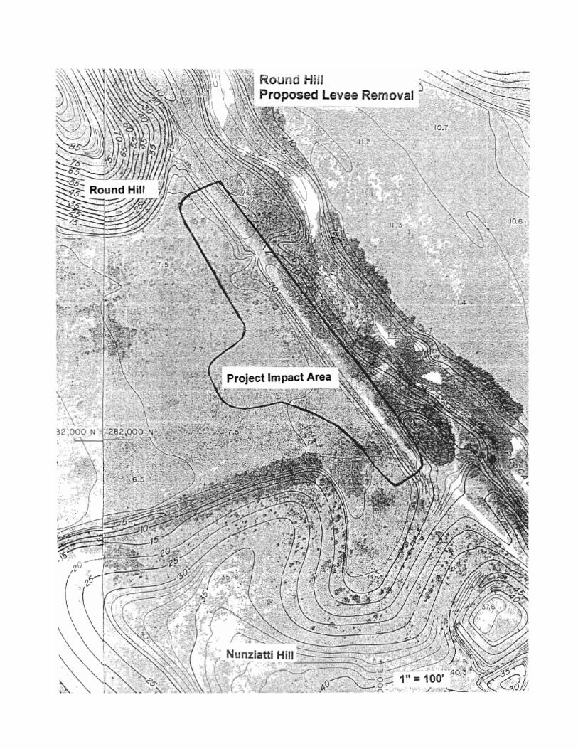
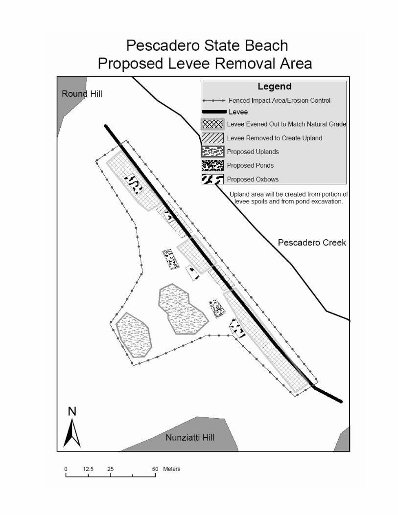


APPENDIX C
SPECIAL STATUS SPECIES LIST ____________________________________
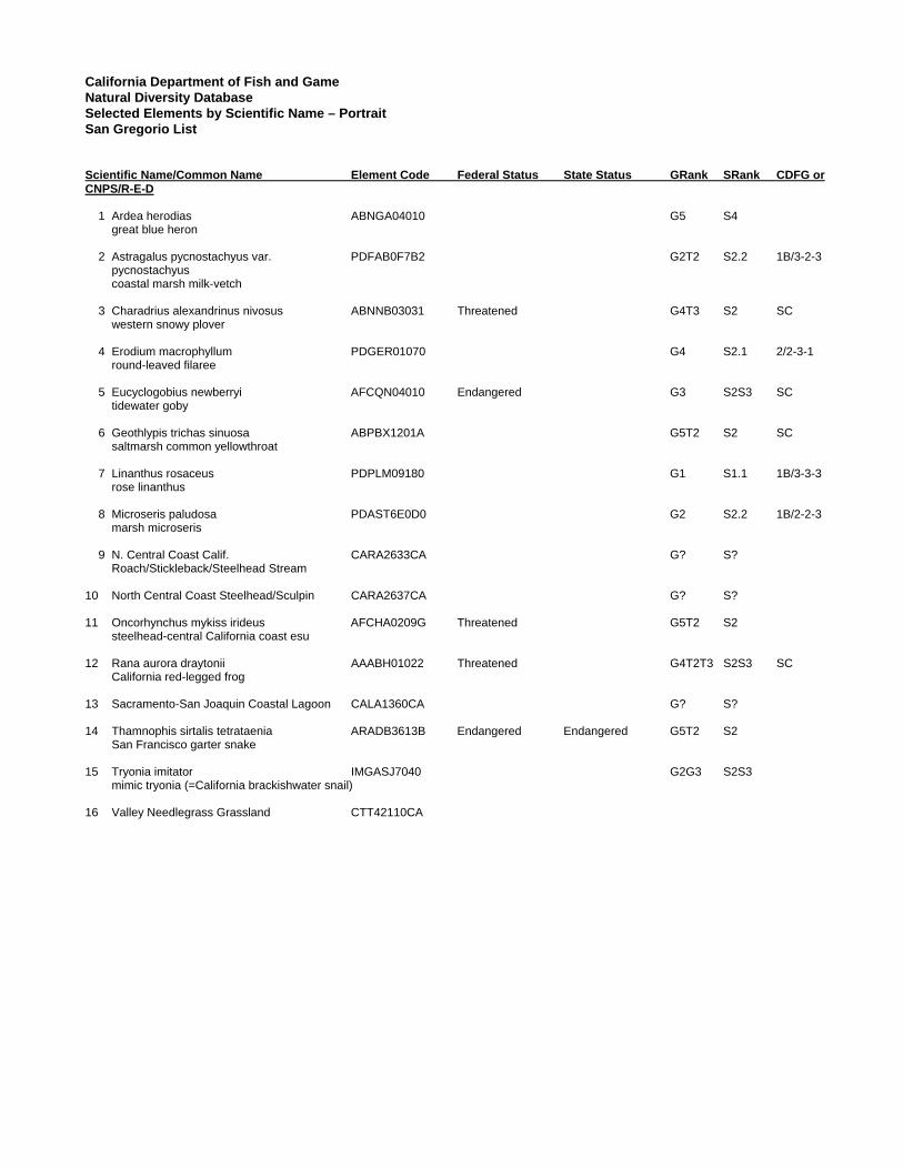
California Department of Fish and Game Natural Diversity Database Selected Elements by Scientific Name – Portrait San Gregorio List Scientific Name/Common Name Element Code Federal Status State Status GRank SRank CDFG or CNPS/R-E-D
1 Ardea herodias ABNGA04010 G5 S4 great blue heron 2 Astragalus pycnostachyus var. PDFAB0F7B2 G2T2 S2.2 1B/3-2-3 pycnostachyus coastal marsh milk-vetch 3 Charadrius alexandrinus nivosus ABNNB03031 Threatened G4T3 S2 SC western snowy plover 4 Erodium macrophyllum PDGER01070 G4 S2.1 2/2-3-1 round-leaved filaree 5 Eucyclogobius newberryi AFCQN04010 Endangered G3 S2S3 SC tidewater goby 6 Geothlypis trichas sinuosa ABPBX1201A G5T2 S2 SC saltmarsh common yellowthroat 7 Linanthus rosaceus PDPLM09180 G1 S1.1 1B/3-3-3 rose linanthus 8 Microseris paludosa PDAST6E0D0 G2 S2.2 1B/2-2-3 marsh microseris 9 N. Central Coast Calif. CARA2633CA G? S? Roach/Stickleback/Steelhead Stream
10 North Central Coast Steelhead/Sculpin CARA2637CA G? S? 11 Oncorhynchus mykiss irideus AFCHA0209G Threatened G5T2 S2 steelhead-central California coast esu 12 Rana aurora draytonii AAABH01022 Threatened G4T2T3 S2S3 SC California red-legged frog 13 Sacramento-San Joaquin Coastal Lagoon CALA1360CA G? S? 14 Thamnophis sirtalis tetrataenia ARADB3613B Endangered Endangered G5T2 S2 San Francisco garter snake 15 Tryonia imitator IMGASJ7040 G2G3 S2S3 mimic tryonia (=California brackishwater snail) 16 Valley Needlegrass Grassland CTT42110CA

Key to Global and State Ranking
Global Ranking (G)
G1 Less than 6 viable elements occurrences (populations for species) OR less than 1,000 individuals OR less than 809.4 hectares (ha) (2,000 acres [ac]).
G2 6 to 20 element occurrences OR 809.4 to 4,047 ha (2,000 to 10,000 ac). G3 21 to 100 element occurrences OR 3,000 to 10,000 individuals OR 4,047 to 20,235 ha (10,000 to 50,000 ac).
G4 Apparently secure; this rank is clearly lower than G3 but factors exist to cause some concern (i.e. there is some threat, or somewhat narrow habitat).
G5 Population or stand demonstrably secure to ineradicable due to being commonly found in the world.
GH All sites are historic; the element has not been seen for at least 20 years, but suitable habitat still exists.
GX All sites are extirpated; this element is extinct in the wild.
GXC Extinct in the wild; exists in cultivation.
G1Q The element is very rare, but there is a taxonomic question associated with it.
Subspecies Level Subspecies receive a T-rank attached to the G-rank. With the subspecies, the G-rank reflects the condition of the entire species, whereas the T-rank reflects the global situation of just the subspecies or variety. For example: Thamnophis sirtalis tetrataenia. This animal is ranked G5T2. The G-rank refers to the whole species range (i.e., Thamnophis sirtalis, whereas the T-rank refers only to the global condition of ssp. Tetrataenia.
State Ranking (S)
S1 Less than 6 element occurrences OR less than 1,000 individuals OR less than 809.4 ha (2,000 ac). S1.1 = very threatened
S1.2 = threatened S1.3 = no current threats known
S2 6 to 20 element occurrences OR 3,000 individuals OR 809.4 to 4,047 ha (2,000 to 10,000 ac). S2.1 = very threatened
S2.2 = threatened S2.3 = no current threats known..
S3 21 to 100 element occurrences OR 3,000 to 10,000 individuals OR 4,047 to 20,235 ha (10,000 to 50,000 ac). S3.1 = very threatened
S3.2 = threatened S3.3 = no current threats known
S4 Apparently secure within California; this rank is clearly lower than S3 but factors exist to cause some concern (i.e., there is some threat, or somewhat narrow habitat). NO THREAT RANK.
S5 Demonstrably secure to ineradicable in California. NO THREAT RANK.
SH All California sites are historic; the element has not been seen for at least 20 years, but suitable habitat still exists.
SX All California sites are extirpated; this element is extinct in the wild.

California Native Plant Society (CNPS) Inventory of Rare and Endangered Plants San Gregorio Quadrangle CNPS CA CNPS R-E-D State Federal Scientific Name Common Name List Code Listing Listing Astragalus pycnostachyus var. pycnostachyus coastal marsh milk-vetch 1B 3-2-3 None None Erodium macrophyllum round-leaved filaree 2 2-3-1 None None Fritillaria liliacea fragrant fritillary 1B 2-2-3 None None Grindelia hirsutula var. maritima San Francisco gumplant 1B 2-2-3 None None Linanthus rosaceus rose linanthus 1B 3-3-3 None None Microseris paludosa marsh microseris 1B 2-2-3 None None Key to CNPS Rare Plant Lists 1A Presumed Extinct in California 1B Rare or Endangered in California and Elsewhere 2 Rare or Endangered in California, More Common Elsewhere 3 Need More Information 4 Plants of Limited Distribution Key to CNPS R-E-D Code Rarity (R) 1 Rare, but found in sufficient numbers and distributed widely enough that the potential for extinction is low at this time. 2 Distributed in a limited number of occurrences, occasionally more if each occurrence is small. 3 Distributed in one to several highly restricted occurrences, or present in such small numbers that it is seldom reported. Endangerment (E) 1 Not endangered. 2 Endangered in a portion of its range. 3 Endangered throughout its range. Distribution (D) 1 More or less widespread outside California. 2 Rare outside California. 3 Endemic to California.