infrastructure servicing report - home - vpa · infrastructure servicing report 100 pattersons...
TRANSCRIPT

INFRASTRUCTURE SERVICING REPORT
100 PATTERSONS ROAD, CLYDE NORTH
19 SEPTEMBER 2013
BW REF: 1201253
Beveridge Williams Melbourne Office 1 Glenferrie Road Malvern VIC 3144
PO Box 61 Malvern 3144
Tel: (03) 9524 8888 Fax: (03) 9524 8899
www.beveridgewilliams.com.au

DOCUMENT CONTROL DATA
Beveridge Williams
Melbourne Office
1 Glenferrie Road
Malvern VIC 3144
PO Box 61
Malvern VIC 3144
Tel: (03) 9524 8888
Fax: (03) 9524 8899
www.beveridgewilliams.com.au
Title Infrastructure Servicing Report – 100 Pattersons Road, Clyde North
Author Chris White
Checked Simon Watts
Project Manager
Simon Watts
Synopsis Report into the availability of services to the proposed Residential Development of a 66.6 hectares property in Pattersons Road, Clyde North.
Reference: 1201253
Client: National Pacific Properties Pty Ltd
Revision Table
Rev Description Date Authorised
0 Internal Draft for review/comment prior to finalisation 8 August 2013 CLW
1 Final for issue 19 Sept 2013 CLW
Distribution Table
Date Version Distribution
23/08/2013 0 Mark Fleming, Simon Watts
19/09/13 1 Planning Permit Application
Copyright Notice
© Copyright – Beveridge Williams & Co P/L
Users of this document are reminded that it is subject to copyright. This document should not be reproduced, except in full and with the permission of Beveridge Williams & Co Pty Ltd.

Beveridge Williams 1
CONTENTS
1 EXECUTIVE SUMMARY ....................................................................................... 2
1.1 FINDINGS .................................................................................................................. 2
2 INTRODUCTION ................................................................................................. 4
2.1 INTRODUCTION ........................................................................................................ 4
2.2 SITE LOCATION ......................................................................................................... 4
2.3 ASSUMPTIONS AND LIMITATIONS ........................................................................... 6
3 SERVICES ........................................................................................................... 7
3.1 INVESTIGATION ........................................................................................................ 7
3.2 ROAD ........................................................................................................................ 7
3.3 SEWER ...................................................................................................................... 8
3.4 ELECTRICITY .............................................................................................................. 9
3.5 GAS ......................................................................................................................... 10
3.6 TELECOMMUNICATIONS (FIBRE OPTIC) ................................................................. 10
3.7 WATER .................................................................................................................... 10
3.8 RECYCLED WATER .................................................................................................. 11
3.9 STORMWATER DRAINAGE...................................................................................... 11
4 CONCLUSION ................................................................................................... 13
APPENDICES
APPENDIX A. SOUTH EAST WATER LAND SERVICING ADVICE – WATER SUPPLY
APPENDIX B. SEWERAGE STRATEGY PLAN, CLYDE NORTH
APPENDIX C. MELBOURNE WATER CATCHMENT PLAN
APPENDIX D. TELSTRA ASSETS PLAN

Beveridge Williams 2
1 EXECUTIVE SUMMARY
This report discusses the availability of services to the proposed residential development of a 66.6 hectare property on the south side of Pattersons Road, Clyde North, between Berwick Cranbourne Road and Tuckers Road.
1.1 Findings
Road Available
Pattersons Road is proposed to become a primary arterial road under the Draft PSP Urban Structure Plan, while Tuckers Road will become a secondary arterial road.
Pattersons Road is currently only a sealed rural standard road and Tuckers Road is an unsealed gravel road, and both will require upgrading to arterial standard.
The draft Clyde Creek PSP proposes a connector street adjacent to the western boundary of the subject site, running from north of Pattersons Road to Ballarto Road in the south.
Sewer
(South East Water)
Not currently available. External works are required.
SEW indicate that ultimately the catchment will discharge to future treatment plant / pumping station approximately 7 km south-east of the subject site. There are no immediate plans for construction.
A long term interim alternative is the construction of a sewer pump station in Pattersons Road and rising main discharging to the Cranbourne East Pump Station approximately 3km to the west. This has current spare capacity of up to 10,000 lots.
Electricity
(SP Ausnet)
Available. Some upgrades required.
Overhead HV power lines are present in both Pattersons and Tuckers Roads fronting the site. It is considered that the current supply in the area should be sufficient to support the development, subject to timing. There will be some upgrades required, and some relocation works due to likely road widening works. Undergrounding of the existing supply along Pattersons Road and Tuckers Road may be required by Council
Gas
(Envestra/APA Group) Available
Envestra/APA Group has advised that gas supply is available to this area. Contributions will be subject to timing and extent of external works and cannot be confirmed until a formal application has been received.
Telecommunications
(NBN) Available The subject site is within the NBN Co footprint

Beveridge Williams 3
Potable Water
(South East Water)
Available with External Works Required.
No assets are present on either Pattersons Road or Tuckers Road. The nearest available supply is located at the intersection of Pattersons Road & Berwick-Cranbourne Road and a main would have to be extended. SEW has indicated that water supply could be provided for this area from the Thompson Road Pressure Reducing Station located in Thompsons Road.
Supply would be subject to the construction of works including 300mm to 375mm dia potable watermains along Berwick – Cranbourne Road, 450mm dia potable watermains along Thompsons Road from Berwick – Cranbourne Road to the Thompsons Road PRS and upgrading of the Thompsons Road PRS
Re-use Water
(South East Water) Not Available
The proposed development is within the mandated recycled area but a decision on implementation has not yet been made. An allowance should be made for the construction of a recycled water reticulated system within the development.
Main Drainage
(Melbourne Water)
Not available
Works required
The subject site is located within the draft Clyde Creek PSP. Clyde Creek traverses to the north east and east of the site. The Melbourne Water Interim Drainage Scheme rates show that water quality works are included in the scheme.
There are proposed Melbourne Water drainage Scheme works within the site, including wetlands, retarding basins and waterways. The developer will be required to construct the waterway and undertake associated landscaping works. These works are reimbursable by Melbourne Water.
Preliminary drainage outfall point is the north east corner of the development. There are currently no Council drainage assets servicing the property.

Beveridge Williams 4
2 INTRODUCTION
2.1 Introduction
Beveridge Williams has been commissioned by National Pacific Pty Ltd (the Developer) to prepare a report concerning the provision of the necessary infrastructure required to service the proposed development for a proposed Residential Estate located at 100 Pattersons Road, Clyde North.
The site, 100 Pattersons Road, Clyde North, is bounded by Pattersons Road (north), farm land to the south and west (currently proposed for further development into residential housing), and Tuckers Road (east). The site has a road frontage of approximately 830 metres on Pattersons Road and 800m on Tuckers Road. The site is approximately rectangular in shape and covers an area of approximately 66.64 ha. The location of the site is below.
2.2 Site Location
The site, 100 Pattersons Road, Clyde North, is bounded by Pattersons Road (north), farm land to the south and west and Tuckers Road (east). The site is approximately 50 kilometres south-east of the Melbourne CBD.
Figure 1: Location Plan Not to scale
The site is located within an area being developed from agricultural/rural uses to residential dwellings.

Beveridge Williams 5
The site lies within the proposed Clyde Creek Precinct Structure Plan area (1054) and at the time of writing this report the land is designated for future residential development (Zoned UGZ – Urban Growth Zone). The site is covered by a Land Subject to Inundation Overlay in the north east corner, for the Clyde Creek waterway.
Figure 2: Site Context Not to scale
It should be noted that the PSP boundaries and names are preliminary at this stage and subject to change. The subject area is just south east of the completed and approved Cranbourne East PSP to the west while the land to the west, south and east of the subject area are within the same Clyde Creek PSP.
The site is dominated by market gardens with the exception of one paddock which contains a dwelling and market garden infrastructure including storage and equipment sheds. Two large dams which are utilised for irrigation purposes are also located on the site. The largest dam is located in proximity to Clyde Creek which passes through the north-eastern corner of the site. Clyde Creek has been extensively modified to capture water from the creek and re-divert it into the dam.
There is a ridgeline running east to west across the centre of the site, and a second, smaller drainage line runs through the southern section of the property. The drainage channel has also been significantly modified to divert water into the dam located on the southern half of the site
The parcel is situated approximately 825 m east of the Clyde-Five ways / Berwick-Cranbourne Road intersection which will both serve as main arterial roads, providing access to Melbourne via the Monash Freeway to the north and the South Gippsland Highway to the east. The future Clyde Major Activity Centre is located approximately 1.6 km south of the subject site.
There are nearby developments to the west, called Selandra Rise Estate and Pasadena Estate, that are well established.

Beveridge Williams 6
2.3 Assumptions and Limitations
This project has been scoped and undertaken as a desktop study to provide preliminary advice on the servicing works required for the vicinity of this property. There are limitations to the level of detail provided given the nature of this review. Desktop studies are reliant upon information made available from service authorities; with assumptions of the accuracy and completeness of the information provided. Further assessment and confirmation of details provided will be necessary during the planning and design stages.
There are currently proposals for residential developments on a number of properties in the PSP 1053 and 1054 areas east of Berwick Cranbourne Road and Clyde – Five Ways Road however the Clyde Creek PSPs have not been finalised at the time of writing. It may be assumed that it will follow the guidelines set out in the Cranbourne East PSP with regards to land zoning and identification of major infrastructure required, however this cannot be confirmed at this time. The Cranbourne East PSP describes the basic land use for the majority of the parcels as conventional residential, with an average of 13 dwellings per developable hectare.
The current Casey Planning Scheme Zones in the area of these properties are shown below (Fig 3).
Figure 3 – Planning Scheme Zones Not to scale

Beveridge Williams 7
3 SERVICES
3.1 Investigation
Our investigation into the availability of services included obtaining written and verbal information relating to existing services in the area along with requirements to service the area. A number of service authority responses have been received however due to the status of the proposed PSPs in the area the advice received has been of a preliminary nature. Our servicing advice is based on our knowledge of the region and likely requirements of authorities.
3.2 Road
Beveridge Williams has been involved in the GAA consultation in relation to the development of PSP areas 1053 and 1054. The road network has been taken into consideration of the PSP in regard to the development plan in Figure 4.
Figure 4: Indicative Subdivision Plan Not to scale
Pattersons Road will ultimately be developed as a 6 lane primary arterial road but in the interim it will have to be upgraded from the current gravel road to a sealed 2 way carriageway from Berwick-Cranbourne Road to Tuckers Road. Tuckers Road is classified as a secondary arterial road, and will be dual carriageway 4 lanes wide ultimately. At the present time, it is only a gravel road that will have to be upgraded to a sealed 2 way carriageway across the development frontage.

Beveridge Williams 8
The arterial roads will require road reserve widening and this is expected to occur on the eastern and southern sides of the existing road reserve boundaries. Intersection treatments will require widening to allow for turning lanes, and the extent of the treatments will be determined in preliminary functional road designs.
The Indicative Development Plan for the subject site an allowance of 2.283 ha for the widening of Pattersons Road along the northern frontage.
In the interim, as the arterial road network will only consist of a single carriageway, and Beveridge Williams sought City of Casey advice, as the controlling road authority, for the development of the intersections into the estate and for the Pattersons Road and Tuckers Road intersection.
For the entrance road intersection (Stage 1) on Pattersons Road, a T-intersection incorporating left and right hand turn lanes would be acceptable to City of Casey. The entrance road itself is to be based upon the ultimate location with a median strip approach in anticipation of a fully signalised intersection with slip lanes.
For Tuckers Road, the same treatment as per Pattersons Road would be acceptable.
The Pattersons Road / Tuckers Road intersection is viewed as requiring a roundabout in the interim based upon a single carriageway while a fully signalised intersection is viewed for the ultimate condition with dual carriageways.
Discussions concerning DCP reimbursements for the construction of Pattersons Road and Tuckers Road have been held with the City of Casey, and they have indicated that it is likely that the works on Pattersons and Tuckers Road would be DCP funded.
The draft Clyde Creek PSP proposes a connector street adjacent to the western boundary of the subject site, running from north of Pattersons Road to Ballarto Road in the south.
There are no Public Acquisition Overlays included in the current Casey Planning Scheme which affect this site.
3.3 Sewer
South East Water (SEW) is the responsible authority for sewer services in the area. SEW has provided land servicing advice for this area and indicated that ultimately the catchment will discharge to future treatment plant / pumping station approximately 6.7km south-east of the subject site. There are no immediate plans for construction of these facilities.
A long term interim alternative proposed is for the construction of a sewer pump station in Pattersons Road and rising main discharging to the Cranbourne East Pump Station approximately 3km to the west. The Cranbourne East Pump Station has a spare capacity currently estimated at approximately 10,000 lots.
A preliminary sewer strategy for the Clyde North area has been prepared by Beveridge Williams, and a copy of this plan is attached as Appendix B. This plan currently does not show the 100 Pattersons Road site as part of the first catchment (Catchment 3A), but preliminary assessment has shown that much of the site could be controlled by the proposed pump station in Pattersons Road.
Sewering the subject site from a pump station in Pattersons Road would require a deep sewer to be installed through the central ridge. This sewer would be about 8-9m deep, and this would require boring.
A further option would be to move the pump station location from Pattersons Road to the low point in Tuckers Road. The ground level is about the same as for the site in Pattersons Road, and should allow control of the whole subject site and possibly more of the catchment south of the ridge and Schreurs’ site than the Pattersons Road location.

Beveridge Williams 9
3.4 Electricity
From a site inspection there appear that there should be adequate infrastructure for development of the area, with overhead HV electricity lines in both Pattersons Road and Tuckers Road.
SP AusNet has provided advice that the current supply in the area will be sufficient to support development in this area but that upgrading works will be required depending on timing and staging of developments.
Overhead HV power lines in Pattersons Road Overhead HV power lines in Tuckers Road
It is also likely that there will be some relocation works necessary along both roads due to the road widening required to bring the roads up to arterial standard as per the draft PSP.
SP AusNet has advised that there is a good feeder-rated overhead line in Tuckers Road but the infrastructure along Pattersons Road has rural conductor on poles and would need to be upgraded to supply the first stages of the estate. This external work would be at developer cost.
Under SP AusNet’s supply policy guidelines, the Developer will be required to pay for the cost of extending/upgrading the power supply if required. SP AusNet currently rebates the developer contribution for low voltage (LV) works at a rate of $980 per lot while the rebate available for high voltage (HV) works correlates directly to the construction costs incurred. There are existing assets on the properties that will need to be removed at the Developers expense.
To develop the site, SP Ausnet would require the developer to provide a number of electrical substations requiring reserves to accommodate the infrastructure. The cost of the sub stations and internal high voltage works will be reimbursable, within the HV rebate, but the provision of land for sub-station reserves is not.
In recent planning permits issued, City of Casey has stipulated that electricity supply should be underground across the development frontage, as well as internally. As only one Power Company is involved, SP AusNet has stated that the City of Casey planning permit will dictate the requirements of the location of electricity power lines. The cost of undergrounding power is at the rate of approximately $200/m, and the line in Pattersons Road may therefore need to be undergrounded by the development to the north (MacDonald’s)
If development is delayed for any significant length of time, SP AusNet have stated that, with other developments due to proceed as well, further augmentation works to the electricity network would be required. It may be in the interests of the Client to seek cost sharing arrangements with other Developers in this case.
Further advice indicates that kiosk reserves would be required for every 110 - 125 lots. The standard reserve area is 8m x 4.2m wide, but occasionally a 5m wide reserve is required. Design and construction of URD estates can be undertaken using Accredited Service Providers, rather than having SP AusNet carry out this service.

Beveridge Williams 10
3.5 Gas
Envestra/APA Group has advised that gas supply is available to this area but will be subject to an evaluation once a formal application has been received. The servicing strategy for Envestra/APA Group will be dependent upon where the Development starts.
APA Group has advised that there is an existing 100mm high pressure gas main running along Tuckers Road with natural gas, as shown in the DBYD information provided shown right.
There is existing gas supply to the Selandra Rise Estate and the Pasadena Estate to the west.
Envestra will be able to service the development with natural gas but for Stage one, a supply main will be required to be constructed along Pattersons Road, and a contribution from the developer may be required as Envestra as indicated a shortfall in funding may occur. A detailed cost would be provided once a formal application has been made.
3.6 Telecommunications (Fibre Optic)
Telecommunications could be provided by NBN Co. The site is within the NBN Co servicing footprint, and the number of lots within the development exceeds the minimum number for which NBN Co. will service.
Alternatively, the developer may wish to supply telecommunications via another provider. That is a feasible option for the developer, which will require a commercial decision to be made at the time of development.
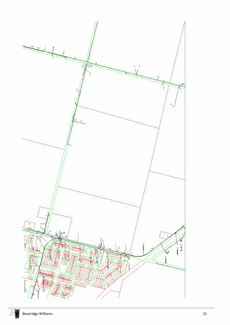
There is existing Telstra optic fibre cabling in Berwick Cranbourne Road west of the site, but limited Telstra assets in Pattersons Road and Tuckers Road. Dial Before You Dig Telstra information is shown in Appendix D.
3.7 Water
No assets are present on either Pattersons Road or Tuckers Road. The nearest available supply is located at the intersection of Pattersons Road and Berwick-Cranbourne Road and a main would have to be extended.
South East Water is the responsible authority for water assets in the area and they have provided advice to indicate that water supply could be provided from the Thompson Road Pressure Reducing Station located in Thompsons Road
Supply the area including the subject property would be subject to the construction of the following proposed works:
300mm to 375mm dia potable watermains along Berwick – Cranbourne Road and Pattersons Road
950m of 450mm dia potable watermains along Thompsons Road from Berwick – Cranbourne Road to the Thompsons Road PRS
Upgrading of the Thompsons Road PRS
Refer to Appendix A for South East Water’s previous land servicing advice plan for the water supply requirements for this area.
Existing 100mm HP Gas Main

Beveridge Williams 11
3.8 Recycled Water
At this stage, South East Water has not confirmed whether a dual water supply network is to be adopted for servicing the Casey Growth Precinct, but the proposed development is within the mandated recycled area and advice has been provided on the basis of a dual system being required. Consequently an allowance should be made for the construction of a recycled water reticulated system within the development.
Prior to recycled water being available, recycled water mains are to be 'charged' with potable water. Water restrictions in place for potable water will also apply to recycled water until such time recycled water is provided.
3.9 Stormwater Drainage
Melbourne Water is the catchment management authority for the subject site and the properties are within a new Greenfield Scheme for Clyde Creek. At this stage it is a scheme boundary only, they only have interim rates and there are no details of infrastructure in the scheme.
A Stormwater Management Plan (SWMP) Report has been prepared by Beveridge Williams. The Report provides an overall drainage management strategy and an interim drainage management strategy for the proposed residential development. This strategy can be implemented and all of Melbourne Water and Council’s development requirements in relation to stormwater drainage can be achieved, in accordance with the Proposed Draft Precinct Structure Plan and with no net effect on the downstream properties.
There is a proposed Melbourne Water drainage channel required through the north east corner of the site, on Clyde Creek, and through the southern portion of the site, along Station Creek. The developer will be required to construct the waterways, retarding basins and wetlands and undertake associated landscaping works. These works are reimbursable by Melbourne Water, and preliminary layouts are shown in Figure 5 below.
Figure 5: Ultimate Wetland and Retarding Basins Not to scale

Beveridge Williams 12
There are currently no Council drainage assets servicing the property, as shown on the information provided by Council, below.
The existing Clyde Creek waterway is shown as a Melbourne Water “Open Drainage Channel”, as is the section of Station Creek downstream of Tuckers Road, as shown on the information provided by DBYD (see right)..
The relevant section of Melbourne Water’s Clyde Creek Developer Services Scheme (No. 2370) is shown in Appendix C.
The interim rates applicable shown on the Melbourne Water web site are $60,000/ha Hydraulic, and $11,000/ha Water Quality. There is also a warning that interim rates should not be relied upon for development feasibility purposes as the final rate may be significantly higher.

Beveridge Williams 13
4 CONCLUSION
The subject site is located within the Urban Growth Boundary as of September 2012 and has been preliminarily identified as part of the Clyde Creek PSP 1054.
The GAA has advised that the PSP for the area is due for finalisation this year. The service authorities are aware of progress within the area and are planning to address the upcoming demand for services.
The extension of all services can be achieved through known and proven techniques. The area is suitable for development as proposed and the only concern is the ability of South East Water to provide services in a timely manner. South East Water is working on servicing strategies currently, and we feel confident that the development will be able to be supplied in the required timeframe.
Through traditional delivery models, developers are required to fund the infrastructure up front and be reimbursed at a later time. Road, drainage, electricity, gas and sewerage infrastructure will require significant investment, and the demand for the services will exist from the outset, while collection of funds from traditional means such as DCP levies and drainage scheme levies will mean funds will not be able to be collected and distributed quickly. Service authorities need to turn their attention to this issue now to avoid blockages to efficient development of the area.
Beveridge Williams confirms that the extension of all services for development of the site at 100 Pattersons Road can be achieved through known and proven techniques and standard agreements with service providers and recommends that the site is suitable for residential development as proposed from a servicing perspective.
BEVERIDGE WILLIAMS & CO PTY LTD
Prepared by
Approved for issue by
Chris White
Principal Engineer
Simon Watts
Project Manager

Beveridge Williams 14
APPENDIX A. South East Water Land Servicing Advice – Water Supply

Beveridge Williams 15
100 Pattersons Road

Beveridge Williams 16
APPENDIX B. Sewerage Strategy Plan, Clyde North
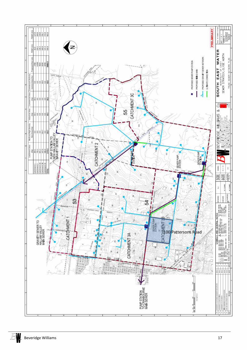
Beveridge Williams 17
100 Pattersons Road

Beveridge Williams 18
APPENDIX C. Melbourne Water Catchment Plan
Clyde Creek Drainage Scheme (Interim)

Beveridge Williams 19

Beveridge Williams 20
APPENDIX D. Telstra Assets Plan
Beveridge Williams 21